updated june 2021 - nc
TRANSCRIPT

Updated June 2021

N.C. Resilient Coastal Communities Program
This program handbook was written and funded in collaboration by

N.C. Resilient Coastal Communities Program
Table of Contents Introduction 1
How to Use this Handbook 3
Phase 1: Community Engagement and Risk / Vulnerability Assessment 4
Step 1: Develop a Community Action Team 4
Step 2: Set Vision and Goals 6
Step 3: Review Existing Plans & Efforts 7
Step 4: Develop a Community Engagement Strategy 9
Step 5: Map Critical Assets & Natural Infrastructure 12
Step 6: Conduct Risk & Vulnerability Assessment 14
A. Identify and Map the Hazards 15
B. Assess Vulnerability 20
C. Estimate Risk 19
Phase 2: Planning, Project Identification, and Prioritization 20
Step 1: Identify a Suite of Potential Solutions 20
Step 2: Consolidate and Prioritize Projects 25
Resilience Strategy 28
N.C. Resilient Coastal Communities Program
Introduction Building resilience to natural hazards is vital for communities to help maintain quality of life, healthy growth, durable systems, and conservation of resources for present and future generations; however, a number of barriers to developing resilience to coastal risks exist, including economic and capacity constraints that have been exacerbated in recent times.
Building more resilient communities requires careful, thorough planning efforts using sound, locally-relevant data. The N.C. Division of Coastal Management’s (DCM) Resilient Coastal Communities Program (RCCP) aims to address this need through technical and financial assistance to advance coastal resilience efforts throughout the 20 coastal counties in North Carolina.
This program handbook provides guidance to communities and program partners for the completion of Phases 1 and 2 of the Program.
Program Objectives The objectives of the N.C. Resilient Coastal Communities Program include:
● Address barriers to coastal resilience in North Carolina at the local level, such as limitedcapacity, economic constraints, and social inequities;
● Assist communities with risk and vulnerability assessments and developing a portfolio ofplanned and prioritized projects;
● Advance coastal resilience projects to shovel-readiness, or ready for implementation; and● Link communities to funding streams for project implementation.
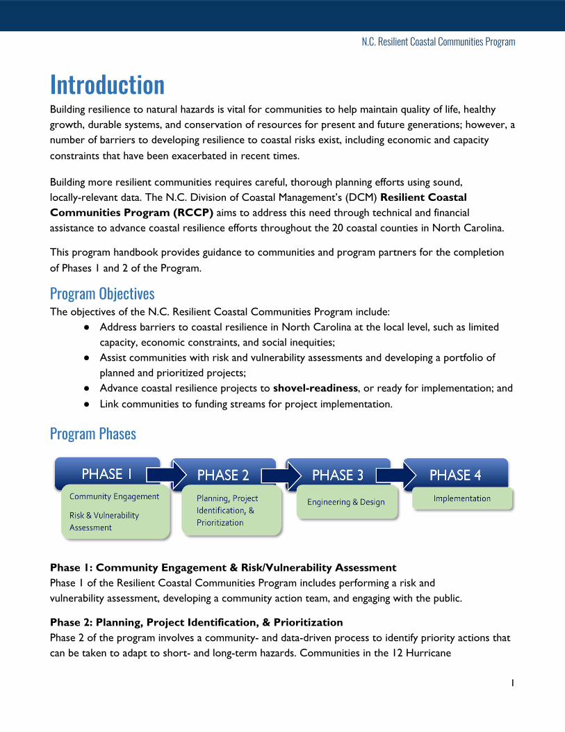
Program Phases
Phase 1: Community Engagement & Risk/Vulnerability Assessment Phase 1 of the Resilient Coastal Communities Program includes performing a risk and vulnerability assessment, developing a community action team, and engaging with the public.
Phase 2: Planning, Project Identification, & Prioritization Phase 2 of the program involves a community- and data-driven process to identify priority actions that can be taken to adapt to short- and long-term hazards. Communities in the 12 Hurricane
1

N.C. Resilient Coastal Communities Program
Florence-declared counties (see map on page 20) are required to include at least one natural/nature-based or hybrid solution, and communities in the remaining 8 counties are encouraged to do so.
Phase 3: Engineering & Design Phase 3 is the engineering, design and permitting of the prioritized projects. Grants will be available for communities who successfully completed Phases 1 and 2 to develop projects that are shovel-ready.
Phase 4: Project Implementation Phase 4 grants will be available for communities who successfully completed Phases 1, 2, and 3 for implementation of a shovel-ready project(s), and must include a natural or nature-based component.
Phases 1 & 2 Objectives Participating communities will accomplish the following objectives in Phases 1 and 2:
● Perform a data- and community-driven risk and vulnerability assessment.● Develop a portfolio of well-planned and prioritized solutions to address risks.
Advancing to Phases 3 & 4 Once communities complete Phases 1 and 2, they become eligible for Phase 3 funding for project engineering and design, and Phase 4 implementation funding. Communities may receive credit towards completion of Phases 1 and 2 of the RCCP for previous or ongoing work which aligns with program requirements. Localities wishing to complete the requirements of the RCCP outside of the grant program must work with program coordinators to illustrate how their efforts fulfill the requirements outlined in this program handbook.
Deliverables The main deliverable of this effort will include a Resilience Strategy, including two major components:
1. Risk & Vulnerability Assessment Report: Details the quantitative and qualitative riskassessment performed, which will evaluate the vulnerability of critical assets, natural infrastructure,and vulnerable populations to a number of hazards, including flooding (rainfall, tidal and riverine),storm surge, sea level rise, and other locally-relevant hazards.2. Project Portfolio: Outlines a series of options aimed at reducing exposure, reducingsensitivity, and increasing adaptive capacity to flooding and other hazards. A combination of policy,nonstructural, hybrid, and structural approaches should be considered.
2

N.C. Resilient Coastal Communities Program
How to Use this HandbookPurpose The purpose of this program handbook is to provide guidance to program participants in completing Phases 1 and 2 of the N.C. Resilient Coastal Communities Program. Important existing data, tools, and resources are incorporated throughout the program handbook to assist with the process and specific program requirements are identified.
Audience There are several audiences for this program handbook, including:
1. Contractors providing technical assistance to participating communities;2. Localities selected to receive direct technical assistance services through the RCCP, or wishing
to complete the requirements of the RCCP by their own means; and3. Community Action Team participants.
Some sections of this handbook may not be applicable to each audience, but are intended to provide assistance with completion of program requirements. Local governments wishing to receive credit for previous efforts and/or to complete the requirements of the RCCP by their own means must contact RCCP program coordinators to discuss this process.
Program Contacts Please direct questions related to the Resilient Communities Program and this handbook to any of the following contacts at DCM:
Program Email: [email protected] Samantha Burdick, Coastal Resilience Coordinator: [email protected] Mackenzie Todd, Coastal Resilience Specialist: [email protected]
Before Getting Started DCM’s Coastal Community Resiliency Guide should be reviewed prior to getting started, as it lays out the steps and includes many technical resources that can help guide communities through this process.
3
N.C. Resilient Coastal Communities Program
Phase 1: Community Engagement and Risk / Vulnerability AssessmentIn Phase 1, participating communities will develop a Community Action Team, stakeholder engagement strategy, and conduct a risk and vulnerability assessment focused on disadvantaged populations and
critical assets. Phase 1 of the Resilient Coastal Communities Program includes the following key steps:
Step 1: Develop a Community Action Team Create an Action Team of diverse, knowledgeable stakeholders to work actively with contractors through Phases 1 and 2 of the program.
Step 2: Set Vision and Goals Develop a community-specific vision and goals for this program to ensure these values and priorities are considered during the entirety of the process.
Step 3: Review Existing Local Plans & EffortsDraw from existing resources and augment as necessary to fulfill requirements of this program. Previously completed work may count as credit towards completion of program requirements.
Step 4: Develop a Community Engagement Strategy Develop a strategy for engaging key community stakeholders and the public during the risk and vulnerability assessment and program development process.
Step 5: Map Critical Assets and Natural Infrastructure Map the natural infrastructure and critical assets selected by Community Action Teams to include in the risk assessment.
Step 6: Conduct a Risk and Vulnerability Assessment Build upon existing work to complete a qualitative and quantitative risk assessment, with involvement from the Community Action Team, NCEM, and the public.
Step 1: Develop a Community Action Team To begin the Risk & Vulnerability component of Phase 1, communities will create a Community Action Team of key stakeholders to provide targeted input and champion the effort. Building relationships, trust, and shared understanding among key stakeholders is a foundation for implementing resilience action. The Community Action Team should be developed by the contractor working with communities through a review of key stakeholders in the jurisdiction.
4

N.C. Resilient Coastal Communities Program
Building a multi-disciplinary Community Action Team with expertise in planning and community development, hazard mitigation, utility management, engineering, the community’s economy, engaging with vulnerable and underrepresented populations, and nature-based solutions will ensure a more holistic process.
Some critical questions to ask when selecting members include:
Community Action Team members may include municipal/county managers, planners, elected officials, utility managers, community and economic developers, business community representatives, disaster recovery coalitions/groups, councils of government (COGs), state and federal land managers, non-governmental organizations (NGOs), private organizations, community or faith leaders, and others working with the community on resilience planning.
Useful tools for developing your Community Action Team include:
● Stakeholder Participation Guidance - NOAA● North Carolina Volunteer Organizations Active in Disaster
5
Stakeholder Groups Potential Individuals to Invite
● Who holds key decision-making power?● Who holds community trust or is seen as a
leader?● Who is especially impacted by flooding?● Who is often underrepresented in
decision-making?● What industries are most important or have
the greatest ability to help or hinderimplementation?
● Who represents the stakeholder groups’interests?
● Who will be able to support two-waycommunication between resilience effortsand the stakeholder group?
● Who has time and interest to participate?
N.C. Resilient Coastal Communities Program
Step 2: Set Vision and Goals Enhancing community resilience should be driven by local values and priorities. Your team and the stakeholders involved need to develop a community-specific vision and set of goals to establish the local context for this program and guide subsequent steps. Your community vision and goals may draw from existing sources of information such as:
● Previously identified goals or vision statements developed by the community as part of otherplanning or budget processes; or
● Natural hazard events such as hurricanes, or trends such as increased flooding frequency; or● Community demographics such as particularly vulnerable or disadvantaged populations.
Vision: The vision is an aspirational statement for where the community wants to be in the future (e.g., in the next 10 or more years), particularly in relation to coastal hazards.
Goals: Specific, measurable goals will help the community identify steps that can be taken to achieve the vision. Resilience goals can relate to preparedness, recovery, community engagement, construction and restoration, etc.
If a community resilience vision and goals do not already exist, the Community Action Team should prepare a draft for leadership and public review.
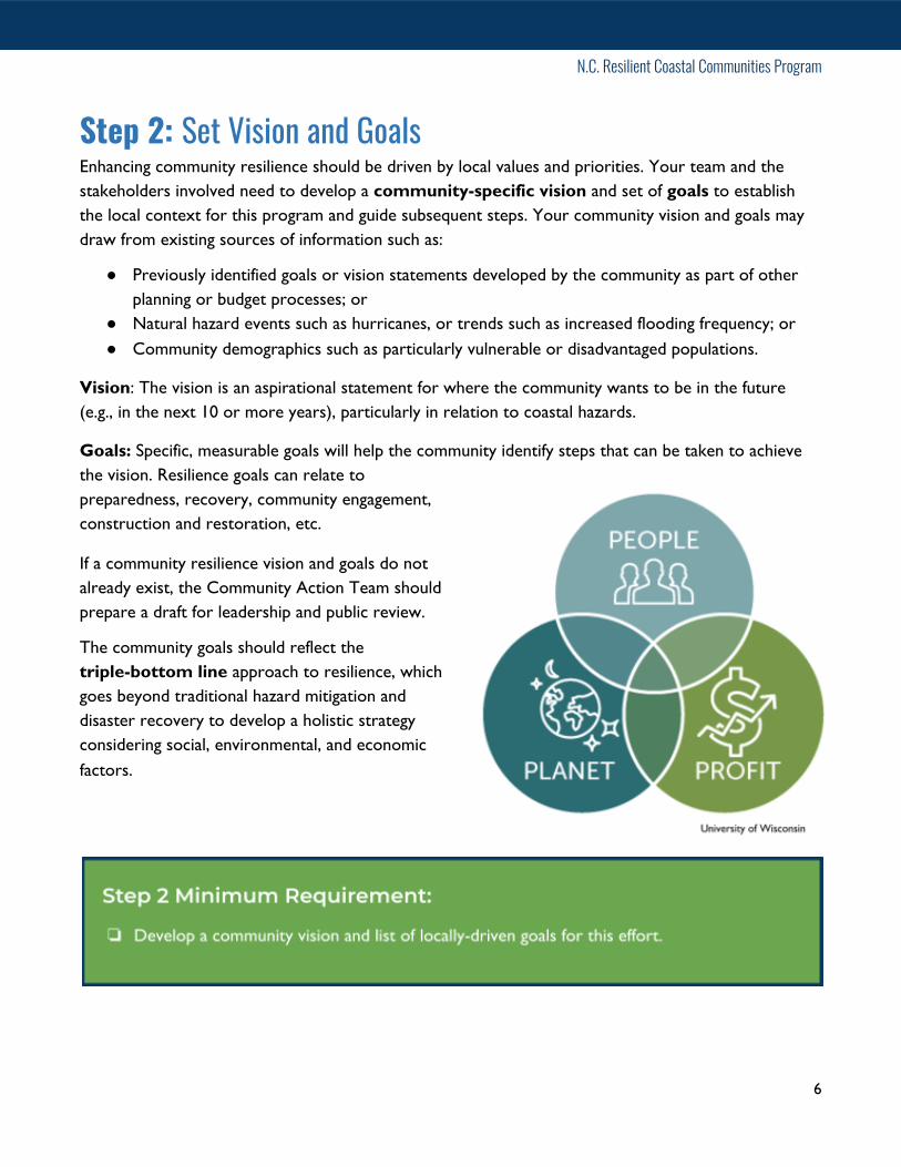
The community goals should reflect the triple-bottom line approach to resilience, which goes beyond traditional hazard mitigation and disaster recovery to develop a holistic strategy considering social, environmental, and economic factors.
6

N.C. Resilient Coastal Communities Program
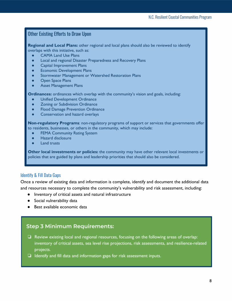
Step 3: Review Existing Plans & Efforts Rather than re-create work that has already been completed, it is advisable to draw from existing resources and augment as necessary to meet community-driven goals.
After forming your Community Action Team, conduct a review of existing plans, ordinances, policies, and programs to identify work that has already been completed. Begin with an inventory of relevant resources, then compile information on the following key areas:
● Critical assets and natural infrastructure● Social vulnerability● Risk assessments● Resilience-related projects
If the community wishes to do so, land use/development projections may also be considered and later included in the risk assessment.
Building Upon Hazard Mitigation PlansYour community's most recent hazard mitigation plan should contain a baseline vulnerability and risk assessment which can serve as the first reference point for conducting an enhanced assessment that considers additional factors and the local context. Review the local or regional hazard mitigation plan applicable to your community for overlap in the key areas listed above.
● 2020 Albemarle Regional Hazard Mitigation Plan:Chowan, Camden, Perquimans, Pasquotank, Gates,and Hertford Counties
● 2020 Outer Banks Regional Hazard Mitigation Plan:Currituck and Dare Counties
● 2020 Pamlico Sound Regional Hazard MitigationPlan:Carteret, Craven, Pamlico, and Beaufort Counties
● 2016 Southeastern North Carolina RegionalHazard Mitigation Plan:Brunswick, New Hanover and Pender Counties(2021 to include Onslow County)
● 2020 Draft Northeastern NC Regional HazardMitigation Plan: Bertie, Hyde, Tyrrell, andWashington Counties.
7
N.C. Resilient Coastal Communities Program
Identify & Fill Data Gaps Once a review of existing data and information is complete, identify and document the additional data and resources necessary to complete the community’s vulnerability and risk assessment, including:
● Inventory of critical assets and natural infrastructure● Social vulnerability data● Best available economic data
8

N.C. Resilient Coastal Communities Program
Step 4: Develop a Community Engagement Strategy Getting from resilience planning to action requires jointly created ideas, buy-in, and commitment from a diverse group of stakeholders. Inclusivity in the planning process, particularly by involving vulnerable and historically underrepresented members of the community, is key to account for a diverse range of community perspectives.
To ensure participation from public stakeholders, a community engagement strategy must be developed to outline a plan for engaging communities during the risk and vulnerability assessment (Step 5) and project planning, prioritization, and selection (Phase 2). The community engagement process willwork towards the following:
● Promoting representation and equitable outcomes for marginalizedcommunities and vulnerable populations;
● Building trust, relationships, and partnerships;● Providing feedback and validation of the Risk & Vulnerability
Assessment developed by the Community Action Team; and● Assisting with prioritizing projects for Phases 3 and 4 of the Program.
The public engagement process is often as valuable than the deliverable that gets developed. Engaging stakeholders in the process can foster new or enhanced relationships, learning, and connections. Raising awareness about risks and vulnerabilities specific to a community often spurs
interest in and support for efforts to reduce those risks and vulnerabilities. Your team may need to adjust your stakeholder engagement strategy as you collect and synthesize information or receive feedback about different activities throughout the process.
Vulnerable populations may be especially vulnerable to disasters due to age, poverty, race, disability, language, or other factors, and often fare the worst in the face of climate hazards. These populations may or may not be disproportionately exposed to climate hazards, but they have limited means to cope with climate stressors or disasters.
9

N.C. Resilient Coastal Communities Program
Check out the following community engagement and outreach tools to assist with developing your engagement strategy:
● Equitable Adaptation Legal & Policy Toolkit - Georgetown Climate Center● Guide to Expanding Mitigation: Making the Connection to Equity - FEMA● Stakeholder Engagement Guide - San Francisco Adapting to Rising Tides● Guide to Equitable, Community-Driven Climate Preparedness Planning - Urban Sustainability
Directors Network
10

N.C. Resilient Coastal Communities Program
Step 5: Map Critical Assets & Natural InfrastructureThe Community Action Team will select critical assets and natural infrastructure to include within the risk and vulnerability assessment . Mapping of critical assets and natural infrastructure will be done using ArcGIS Online.
FEMA’s Community Lifelines framework is a good starting point for considering which critical assets and natural infrastructure to include in your risk and vulnerability assessment. A community lifeline “enables the continuous operation of critical government and business functions and is essential to human health and safety or economic security” (FEMA 2020).
11

N.C. Resilient Coastal Communities Program
Gather and organize data for each asset chosen using the following template:
12

N.C. Resilient Coastal Communities Program
Step 6: Conduct Risk & Vulnerability Assessment A key component of this effort includes a risk and vulnerability assessment, which will evaluate risks to a community’s vulnerable populations and critical assets from a number of coastal and climate hazards, including flooding (rainfall, tidal and riverine), storm surge, sea level rise, and other locally-relevant hazards.
All risk and vulnerability assessments will follow a set of guidelines outlined in this program handbook to ensure consistency, attentiveness to important factors, use of best available data, and specificity required to make informed planning and management decisions. The methods used to conduct the risk and vulnerability assessment are flexible and left up to the contractor and community, so long as the deliverables meet program requirements.
As discussed in Step 3, local or regional hazard mitigation plans will serve as the primary basis for the risk and vulnerability assessment for this program. Program participants will build upon this assessment to create a more localized risk assessment with actionable data. If communities have already gone beyond the assessment performed in their hazard mitigation plan, those resources may also be included and built upon in this process.
Identify Data Gaps After reviewing local and regional plans and policies, your team should identify the gaps in data and information necessary to complete the risk and vulnerability assessment.
NCEM Webinar North Carolina Emergency Management’s Floodplain Mapping Program houses relevant resources that may be included within this risk and vulnerability assessment. Trained staff in the NCEM Floodplain Mapping Program will host a webinar for program participants to discuss available high-resolution spatial data that can be accessed for the risk and vulnerability assessments that goes beyond what your hazard mitigation plan requires. This data may include the following:
● 10-, 25-, 50-, 100- and 500-year floodplains:○ Water surface elevation.
● Storm surge data:○ 100 and 500yr floodplains.○ Enhanced risk products for coastal areas including the plus 1-, 2- and 3-ft flood extents,
and VE zones.
13

N.C. Resilient Coastal Communities Program
● Historic flood extents.
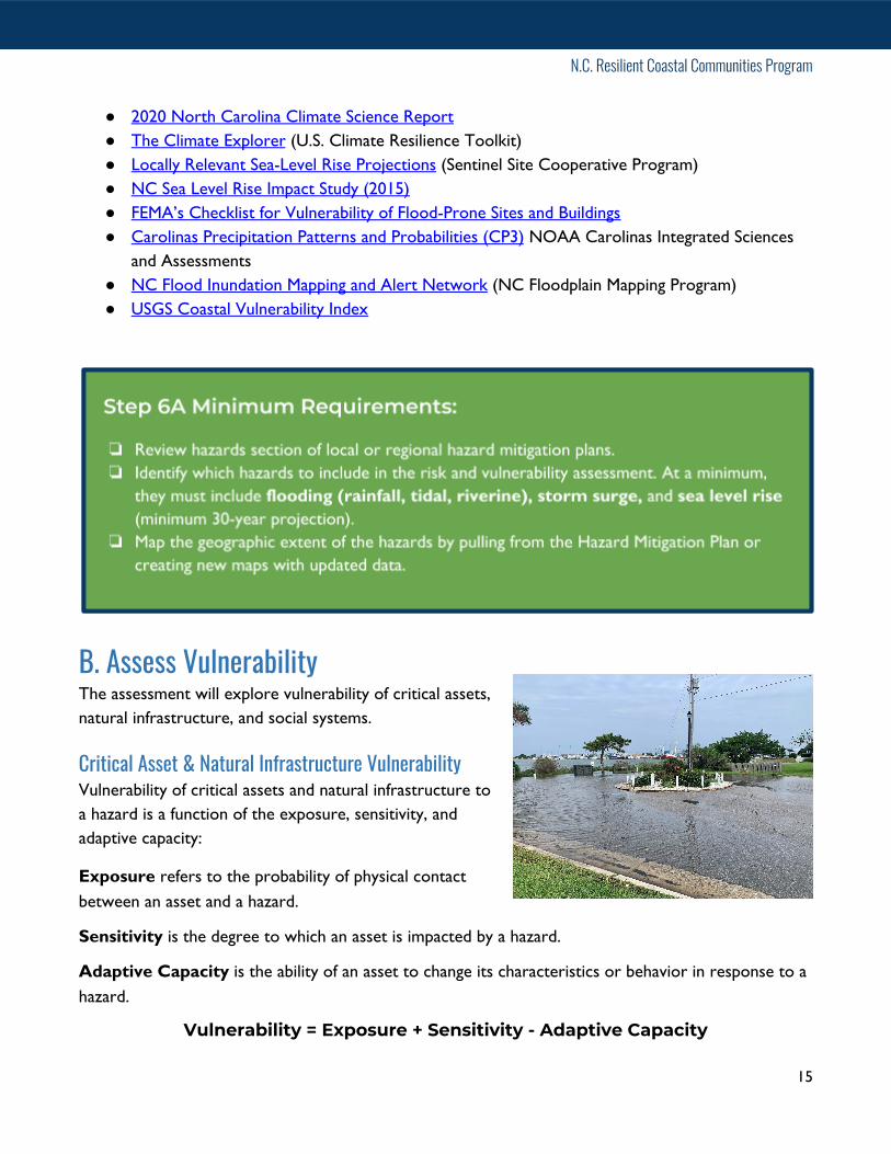
Risk & Vulnerability Assessment Steps: A. Identify and Map the HazardsB. Assess VulnerabilityC. Estimate Risk
A. Identify and Map the HazardsThe vulnerability assessment will begin with a review of the assessment done within the Hazard Mitigation Plan. Data and analysis should be extracted for your community, and augmented by the Community Action Team to fill in any missing information. Expand upon your Hazard Mitigation Plan’s vulnerability assessment to include:
● Hazards chosen by the Community Action Team in Step A, including flooding (rainfall, tidal andriverine), storm surge, and other locally-relevant hazards;
● Critical assets and natural infrastructure, as identified in Step B;● Sea level rise (minimum 30-year projection). NCEM’s plus one-foot Water Surface Elevation
can serve as a proxy for 30 years of sea level rise.
Map the geographic extent of the hazards either by extracting existing maps from the Hazard Mitigation Plan, or by creating new maps using updated data.
Natural hazard types and event history in each community are typically documented in hazard mitigation plans, but often lack information about the climate stressors that may be affecting them.
The following provides suggestions for identifying these hazards in the planning area: ● Review existing studies, reports, and plans related to
hazards in the planning area.○ Review your regional or local Hazard Mitigation
Plan for information on hazards affecting theplanning area.
○ Review the N.C. Climate Science Report.● Document the disaster declaration history of the
community for the last 30 years.● Interview your Community Action Team and
stakeholders about local hazards.
The following tools are useful for identifying and mapping locally-relevant hazards: ● NOAA's Storm Events Database● NC Emergency Management Digital Elevation Models (DEMs)
14
N.C. Resilient Coastal Communities Program
● 2020 North Carolina Climate Science Report● The Climate Explorer (U.S. Climate Resilience Toolkit)● Locally Relevant Sea-Level Rise Projections (Sentinel Site Cooperative Program)● NC Sea Level Rise Impact Study (2015)● FEMA’s Checklist for Vulnerability of Flood-Prone Sites and Buildings● Carolinas Precipitation Patterns and Probabilities (CP3) NOAA Carolinas Integrated Sciences
and Assessments ● NC Flood Inundation Mapping and Alert Network (NC Floodplain Mapping Program)● USGS Coastal Vulnerability Index
B. Assess VulnerabilityThe assessment will explore vulnerability of critical assets, natural infrastructure, and social systems.
Critical Asset & Natural Infrastructure Vulnerability Vulnerability of critical assets and natural infrastructure to a hazard is a function of the exposure, sensitivity, and adaptive capacity:
Exposure refers to the probability of physical contact between an asset and a hazard.
Sensitivity is the degree to which an asset is impacted by a hazard.
Adaptive Capacity is the ability of an asset to change its characteristics or behavior in response to a hazard.
Vulnerability = Exposure + Sensitivity - Adaptive Capacity
15

N.C. Resilient Coastal Communities Program
Social Vulnerability To assess the vulnerability of populations and social systems, build upon the CDC’s Social Vulnerability Index (SVI) outlined in your local or hazard mitigation plan. Ground-truth existing data in this index and add community knowledge to supplement and expand upon this vulnerability index.
The factors assessed in the CDC social vulnerability index include: socioeconomic status (income, political power, prestige), gender, race and ethnicity, age, employment loss, residential property, renters, occupation, family structure, education, medical services and access, social dependence, and special-needs populations. These inputs then result in maps of four categories of social vulnerability (shown below), including socioeconomic status, household composition, race/ethnicity/language, and housing/transportation. For further clarification, check out these FAQs and CDC’s Social Vulnerability Index.
16

N.C. Resilient Coastal Communities Program
Vulnerability Index Use your team’s judgement and any available data to estimate each asset’s vulnerability to combined hazards. To do so, develop a vulnerability index, which combines exposure, sensitivity, and adaptive capacity to estimate cumulative vulnerability for critical assets and natural infrastructure. Estimate the following for each asset:
1) Exposure: Use the asset and hazard maps developed in Parts A and B to determine theoverlap between asset locations and hazard impact areas. Rank overall exposure to hazardsincluded in this assessment from 0-3.
2) Sensitivity: Evaluate the degree to which an asset is impacted cumulatively by hazards in thisassessment. Rank from 0-3.
3) Adaptive Capacity: Assess an asset’s ability to cumulatively adapt to all hazards in thisassessment. Rank from 0-3.
Once a score has been developed for each of the three metrics of vulnerability, calculate a cumulative vulnerability score and organize using the following template:
17

N.C. Resilient Coastal Communities Program
C. Estimate RiskThe Community Action Team must determine what levels of risk call for actions to reduce that risk and increase resilience. The table below is an example of how you can quantitatively estimate risk by listing sectors, number of critical assets within that sector that are at risk and the estimated cost of damages.
Hazard Mitigation Plans contain risk assessments that used NCEM’s iRISK data for building footprints, building values, and other data on critical facilities. These data can be extracted, expanded to include additional critical assets and natural infrastructure, and updated with current economic data. It will be useful to have a good understanding of the locations of vulnerable populations that may need targeted assistance, including where there may be clusters that allow for neighborhood-scale strategies.
Use the following template to document risk estimates:
18
N.C. Resilient Coastal Communities Program
Phase 2: Planning, Project Identification, and PrioritizationIn Phase 2, the contractor will work with the Community Action Team and community members to identify, plan, and prioritize a combination of policy, nonstructural, structural, and hybrid actions, including the use of natural and nature-based solutions (NNBS). These projects and actions will be organized within a portfolio. Developing this portfolio includes the following key steps:
1. Identify a Suite of Potential Solutions2. Consolidate and Prioritize Projects
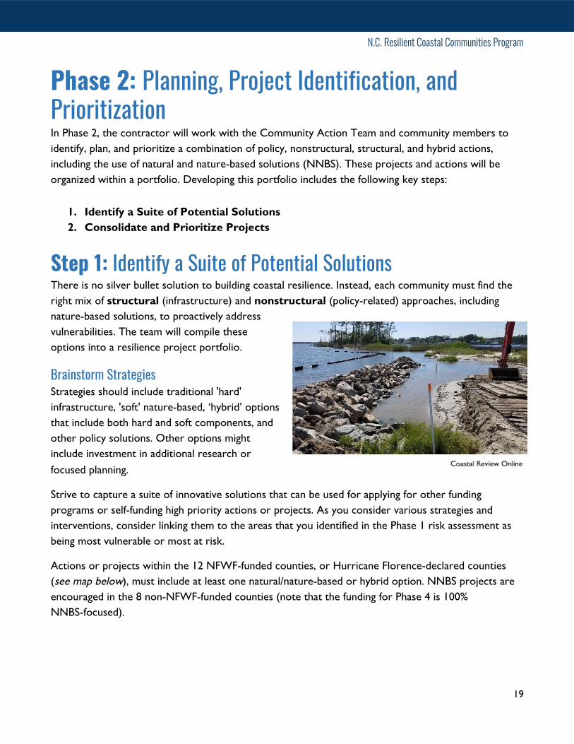
Step 1: Identify a Suite of Potential Solutions There is no silver bullet solution to building coastal resilience. Instead, each community must find the right mix of structural (infrastructure) and nonstructural (policy-related) approaches, including nature-based solutions, to proactively address vulnerabilities. The team will compile these options into a resilience project portfolio.
Brainstorm Strategies Strategies should include traditional 'hard' infrastructure, 'soft' nature-based, ‘hybrid’ options that include both hard and soft components, and other policy solutions. Other options might include investment in additional research or focused planning.
Strive to capture a suite of innovative solutions that can be used for applying for other funding programs or self-funding high priority actions or projects. As you consider various strategies and interventions, consider linking them to the areas that you identified in the Phase 1 risk assessment as being most vulnerable or most at risk.
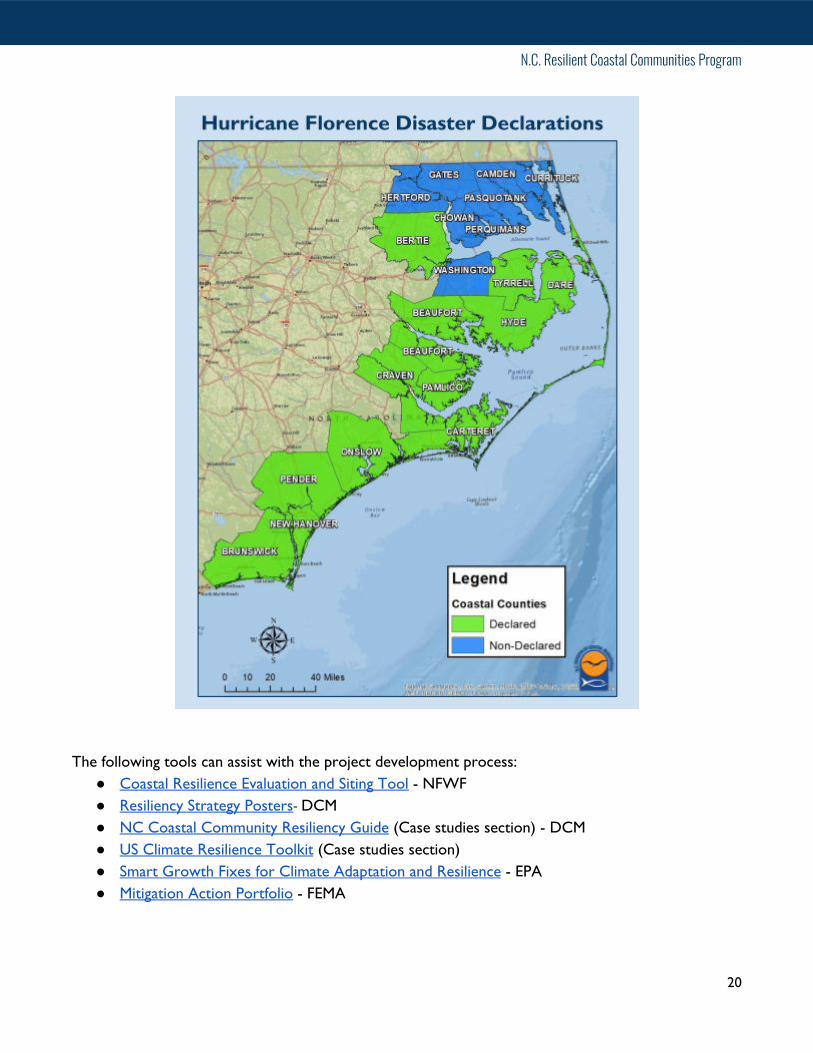
Actions or projects within the 12 NFWF-funded counties, or Hurricane Florence-declared counties (see map below ), must include at least one natural/nature-based or hybrid option. NNBS projects are encouraged in the 8 non-NFWF-funded counties (note that the funding for Phase 4 is 100% NNBS-focused).
19
N.C. Resilient Coastal Communities Program
The following tools can assist with the project development process: ● Coastal Resilience Evaluation and Siting Tool - NFWF● Resiliency Strategy Posters - DCM● NC Coastal Community Resiliency Guide (Case studies section) - DCM● US Climate Resilience Toolkit (Case studies section)● Smart Growth Fixes for Climate Adaptation and Resilience - EPA● Mitigation Action Portfolio - FEMA
20

N.C. Resilient Coastal Communities Program
Drilling Down By Topic After your team identifies potential adaptation strategies at a broad scale, communities may need to dig deeper into specific topics like those below for additional project development guidance.
Natural/Nature-based and Hybrid Solutions The more we can do to protect and enhance natural protective functions, the greater long-term benefits we'll see in hazard mitigation, environmental quality, and economic prosperity. Natural/nature-based solutions (NNBS) refers to a suite of strategies which consider and enhance the natural landscape’s ability to provide ecosystem services like flood reduction and wave dampening. Natural infrastructure (aka green infrastructure) refers to ecosystems or natural systems, including wetlands, forests, beaches, dunes, and rivers or streams. Conserving or restoring existing forests and wetlands are examples of projects that incorporate natural infrastructure. Hybrid solutions incorporate traditional, or “grey”, infrastructure with natural, or green, infrastructure.
Explore the following resources for guidance on developing natural/nature-based and hybrid solutions:
● Building Community Resilience with Nature-Based Solutions -FEMA
● Green Infrastructure Toolkit - Georgetown Climate Center● Naturally Resilient Communities● Green Infrastructure Effectiveness Database NOAA● Green Infrastructure Protective Services Animation - NOAA● Green Infrastructure Practices & Benefits Matrix - NOAA● Green Growth Toolbox - NC Wildlife Resources Commission● Climate Ready Estuaries Synthesis of Adaptation Options - EPA● Coastal Plain - NC Model Natural Resources Conservation
Ordinance and Incentives Guide - NC Wildlife ResourcesCommission
● Integrating Green and Gray: Creating Next GenerationInfrastructure - World Bank Group
● Green Infrastructure Benefits Handout - NOAA Digital Coast● Green Infrastructure Protective Services Animation NOAA● Amending Land Use Codes for Natural Infrastructure Planning NOAA
21

N.C. Resilient Coastal Communities Program
Floodplain/Stormwater Management Flooding is North Carolina's most common and costly natural hazard threat. Consider a number of flood mitigation and stormwater management measures during project development.
The following resources may be useful: ● Adapting Stormwater Management for
Coastal Floods - NOAA● Watershed Restoration Planning - NC
Coastal Federation ● Peer-to-Peer- Case Study: Sharing Stories
and Improving Discussions AboutFloodplain Buyouts - NOAA
● Low-Impact Development for the NorthCarolina Coast Fact Sheet - NC CoastalFederation
National Flood Insurance Program Community Rating System Identifying potential actions and projects within this effort which overlap with FEMA’s National Flood Insurance Program Community Rating System (CRS) will have an added benefit for the community.
If your community is a CRS program participant, the following resources can help to maximize CRS points:
● Digital Coast Partner Tools for the Community Rating System -NOAA
● Coastal Resilience app Case Studies - TNC● CRS Green Guide - Association of State Floodplain Managers
Tip: Connect to a network of participating CRS communities, including the Outer Banks CRS Users Group and Southeast CRS Users Group.
Pre- and Post-Disaster Recovery and Redevelopment The value of planning for a disaster beforehand is the resulting improvement of communication, response time, and utilization of funding and other disaster recovery resources. The period of disaster recovery also offers an opportunity to invest recovery funds into long-term resilience.
Explore the following to learn more about how to integrate resilience into recovery and redevelopment:
● Pre-Disaster Recovery Planning Guide for Local Governments - FEMA
22

N.C. Resilient Coastal Communities Program
● Planning for Post-Disaster Recovery: Next Generation - APA● Post-Disaster Recovery Briefing Papers - APA● Model Pre-Event Recovery Ordinance - APA● Disaster Recovery and Redevelopment
Planning Guide - Georgia Department ofNatural Resources
● Post-Disaster Redevelopment Planning Guideand Addressing Adaptation Addendum -Florida Department of Economic Opportunity
● Floodplain Buyouts: An Action Guide for LocalGovernments on How to MaximizeCommunity Benefits, Habitat Connectivity, andResilience - Environmental Law Institute andUNC Institute for the Environment
23
N.C. Resilient Coastal Communities Program
Step 2: Consolidate and Prioritize Projects After brainstorming potential adaptation strategies with the community, it's time for the team to evaluate and prioritize actions. To do so, complete the following steps:
● Evaluate strategies and their feasibility (including cost-benefit estimation)● C onsolidate and prioritize strategies
As outlined in the community engagement strategy from Phase 1 Step 4, communities should host an Open House or other public forum to allow for feedback during this step to ensure transparency and continue to build community support around resilience planning.
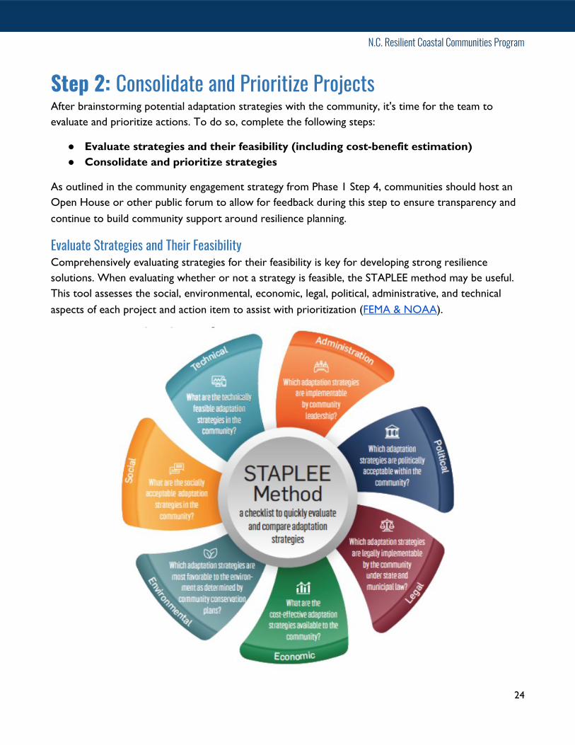
Evaluate Strategies and Their Feasibility Comprehensively evaluating strategies for their feasibility is key for developing strong resilience solutions. When evaluating whether or not a strategy is feasible, the STAPLEE method may be useful. This tool assesses the social, environmental, economic, legal, political, administrative, and technical aspects of each project and action item to assist with prioritization ( FEMA & NOAA).
24

N.C. Resilient Coastal Communities Program
The cost or the economic case for different strategies or actions must be considered when developing resilience strategies. An informal cost-benefit analysis should be used to review proposed adaptation actions. Ratings of high, medium, or low can be assigned to the anticipated costs and the benefits associated with each action based on general criteria that are established by the community. Make sure to explore and identify potential funding mechanisms for project or action item implementation.
Benefit/cost ratings could include criteria such as:
Explore the following tools and resources to include: ● Assessing the Feasibility of Adaptation Options - NOAA● Colorado Prioritization Tool● What Will Adaptation Planning Cost? An Economic Framework for Coastal Community
Infrastructure - NOAA● A Guide to Assessing Green Infrastructure Costs and Benefits for Flood Reduction - NOAA● Funding & Assistance for Coastal Resilience - DCM
Prioritize, describe, and consolidate strategies Narrow down potential actions from suggested criteria below and select priority actions based on community feedback on the following aspects of potential projects:
● Advances prior efforts● Technical soundness● Potential co-benefits, e.g. provides a recreational amenity, contributes to local economy,
preserves a habitat, strengthens resilience to non-climate stressors like pandemic● Likely positive benefit-cost ratio
25

N.C. Resilient Coastal Communities Program
● Social equity● Long-term impact● Identifiable sources of funding● Capacity to implement
Organize information for each project in the portfolio using the following template:
26

N.C. Resilient Coastal Communities Program
Resilience Strategy The main deliverable for Phases 1 and 2 of the Resilient Coastal Communities Program is a Resilience Strategy consisting of a combination of the deliverables developed throughout this process. Having a planning document like this helps to provide clarity of purpose, attract funding, and provide a more direct path to implementation. The Resilience Strategy is also designed to be integrated into existing local plans and ordinances.
Document Organization The Resilience Strategy deliverable will include the following sections and deliverables: Vision & Goals
❏ List of community vision and set of goals❏ Description of process for developing vision and goals
Community Action Team Report ❏ Meeting agendas, minutes, and list of participants❏ Description of process for developing Community Action Team
Stakeholder Engagement Strategy ❏ Plan for engagement with the community during the risk assessment and project development
processes
Review of Existing Local & Regional Efforts ❏ Inventory of relevant plans, ordinances, policies, and programs
Risk and Vulnerability Assessment Report ❏ Report documenting process and products for the following steps:❏ Mapping assets, natural infrastructure and vulnerable populations❏ Assessing vulnerability❏ Estimating risk
Project Portfolio ❏ Portfolio detailing a minimum of five shovel-ready priority projects and action items.
Additional Files ❏ Provide mapping products and excel spreadsheets generated from the risk and vulnerability
assessment in zipped folder or using a file sharing link.
27