union county 2050 comprehensive plan
TRANSCRIPT

UNION COUNTY 2050 COMPREHENSIVE
PLANAPPROVED BY THE UNI ON C OUNT Y 20 50 C OORD INATING
C OMMI TTEE ON FEBR UA RY 23, 2021

A. Thanks and Acknowledgements......................................B. Executive Summary.................................................................C. Introduction and Background............................................
i. Motivation to Update Plan............................................ii. Changes from Previous Plan.......................................iii. Plan Development Process..........................................iv. Demographics........................................................................
D. Input Process.................................................................................i. Committee Input..................................................................ii. Public Input...............................................................................
E. Developing a Vision of Union County...........................F. Selecting a Scenario.................................................................
i. Committee Input.................................................................ii. Public Input...............................................................................iii. Preferred Scenario............................................................
G. Plan Recommendations.........................................................i. Future Land Use Plan.......................................................ii. Infrastructure..........................................................................
1. Schools..................................................................................2. Transportation................................................................3. Water and Sewer.........................................................4. Parks and Recreation................................................5. Emergency Services..................................................
iii. Environment.............................................................................1. Stormwater.......................................................................2. Trees and Open Spaces..........................................3. Well and Septic Systems........................................4. Historic Preservation..................................................
iv. Business Development....................................................v. Municipal Solid Waste.......................................................vi. Economic Development..................................................vii. Community Connections................................................viii. Agriculture.................................................................................ix. Municipal Coordination.....................................................
H. Plan Review for Approval......................................................I. Conclusion.........................................................................................
1589910131719192026273437404145454649515253545556585960616263677482
Contents

1
THANKS AND ACKNOWLEDGEMENTS

2
Union County 2050 is a citizen-led plan. Hundreds of residents provided their input through the three phases of the plan, and dozens of residents served on the six different committees that evaluated information and input to develop a vision, preferred scenario, and overall comprehensive plan. The Union County Board of Commissioners sincerely thanks them for their diligent work over the 14 months they committed to completing this plan. A special thanks goes to Archie Morgan, who served as the chairman for the coordinating committee, and personally presented updates and plan recommendations to the board of commissioners. The following people served on these boards at the beginning of the plan development process in 2019.
Planning BoardBoard of County Commissioners
Planning Staff
Municipal Coordination Subcommittee
Don Fisher, Chairman
Russell Wing, Vice-Chairman
Charles Griffin
Patrick Harrison
Robert McNally
Everette Medlin
Kristoffer Patrick
Louis Philippi
Jonathan Thomas
Jerry Simpson, Chairman
Dennis Rape, Vice-Chairman
Frank Aikmus
Richard Helms
Stony Rushing
Lee Jenson, Planning Director
Jim King, Senior PlannerZoning Administrator
Bjorn Hansen, Senior PlannerLong Range Planning
Emma Lane, Planner
Janet Wolfe, Planner
Amy Griffin, Administrative Assistant
Brian Hawkins, Stormwater Engineer
Brandi Deese, Indian Trail
Ed Humphries, Fairview
Cheri Clark, Lake Park
Sonya Gaddy, Unionville
Frank Deese, Marshville
Rohit Ammanamanchi, Marvin
Vicki Brooks, Mineral Springs
Larry Faison, Monroe
Lynne Hair, Stallings
Blair Israel, Waxhaw
Robyn Byers, Wesley Chapel
Brad Sellers, Wingate
Lisa Thompson, Weddington

3
Coordinating Committee
Citizen Subcommittee
Archie Morgan, Chairman
Andrew Baucom
Phillip Hilton Brooks
Brenda Burns
Chris Duggan
Max Gouge
Darren Greene
Renee Hartis
Baxter Starnes
Duane Wingo
Archie Morgan, Chairman
Richard F. Ali
Wendy Hartzoge
Scarlett Hollingsworth
Karen Izzo
Michelle Jefferys
Bob Morgan
Sarah Montecalvo
Brent Michael
Scott Roberts
Jim Theriault
Julie Thomas
Agriculture Subcommittee
Business and DevelopmentSubcommittee
Andrew Baucom, Chairman
Allan Baucom
Thomas Cable
Dale Cochran
Scott Ewers
H. Charles Griffin
Brad Hargett
Barry Kelly
Jason McBride
Lillian Melamedas
Kathie Lamar Price
Mark Tilley
Renee Hartis, Chairwoman
Brandon Derrick
JoAnna Dougan
Bill Durham
Kathy McCarthy
Pat Kahle
Bryan Linton
Lauren Moss
Sharelle Quick
Brian Simpson
Jason Walle

4
Infrastructure SubcommitteeEnvironmental Subcommittee
Darren Greene, Chairman
Ben Bailey
Ron Brown
Timothy Gibbs
Carrie Hoefferle
Margaret Holt
Christina May
Robert McNally
Louis Phillipi
Linda Robinson
Gary Salek
Chris Duggan, Chairman
William Apodaca
Tom Cross
Russell Flagg
David Lambert
John Martin
Loretta D. Melancon
Terry Sholar
Mark H. Sullivan
Randol Tilghman
Marilyn Wells
Morgan Woolner

EXECUTIVE SUMMARY
5

6
In the past 30 years Union County has added over 150,000 residents and is projected to add nearly the same amount in the next 30 years. Based on the impacts and changes over the previous 30 years, Union County has adopted a new comprehensive plan that takes an active position to address issues created or exacerbated by growth, while establishing clear guidance on where and how future growth should occur. This plan was created during the unprecedented COVID-19 pandemic, and its impacts on how people work, attend school, and shop have highlighted Union County’s advantages as well as weaknesses. Many workers who previously endured long commutes to downtown Charlotte are now able to work from home, which makes Union County’s quiet neighborhoods, excellent schools, and lower taxes an even bigger draw for growth. Conversely, people now realize the need for outdoor recreation and reliable broadband internet. The conclusion drawn from the COVID-19 crisis and regional growth analysis is that Union County will continue to grow, and the mandate for Union County 2050 is to determine where and how that growth should occur.
The Union County 2050 comprehensive plan reflects the work of dozens of community leaders, and input from hundreds of residents. The County is home to many engaged and talented people, and over 60 residents dedicated more than a year of their time to identify areas of concern, learn about options to address those concerns, consider the tradeoffs, and select strategies to include in this plan. The committee members and the public identified traffic congestion, development density, rural character, agri-business, flooding, safe drinking water, and broadband internet access as areas of concern. Some of these issues can be addressed at little to no cost to the County through revising development regulations. Other issues, such as transportation or broadband internet, will require committing funds. The Coordinating Committee overseeing this plan development agreed that Union County should commit funds to addressing these issues.
Union County 2050 supports the individual visions of the County's 14 municipalities, which are home to more than 70% of the County’s residents. The County looks forward to partnering with the municipalities on initiatives to address mutual areas of concern. A quarter-cent sales tax, expected to generate more than $5 million per
The committee members and the public identified traffic congestion, developmental density, rural character, agri-business, flooding, safe drinking water, and broadband internet access as areas of concern.

7
year, is recommended as the revenue source for many of the new initiatives, including increased transportation and recreation investments, but the County would likewise support individual municipal visions by not approving rezonings in “donut” areas surrounded by one or more municipalities. The voters of Union County will have the final say on whether to invest in such improvements, as a quarter-cent sales tax increase would require voter approval through a referendum.
Meeting the vision of Union County in 2050 will require sustained commitment by Union County, its municipalities, and outside partners. For example, the two transportation planning organizations representing Union County would need to pass resolutions supporting a future interstate designation for US 74. The North Carolina Department of Transportation is expected to continue to be a reliable partner in applying for transportation grants and implementing mutually supported projects to address congestion and safety.
The Union County Planning Board and Board of Commissioners have considered the observations, community input, analysis, and recommendations in this plan and support its implementation. Union County 2050 is truly a comprehensive plan. This plan makes recommendations to address public health, environmental protection, infrastructure, and economic development in meaningful and reasonable ways. Union County has effectively engaged its residents in innovative ways over the course of the year long process, and the recommendations found in this plan reflect that input.
This plan makes recommendations to address public health, environmental protection, infrastructure, and economic development in meaningful and reasonable ways.
INTRODUCTION
8

9
A comprehensive plan is the official adopted statement for future development of a community. Union County 2050 analyzes existing conditions and emerging trends in the County, describes the process for gathering public input on future goals, establishes a vision for future development, and outlines steps for achieving that vision. The Plan will serve as the foundation for making land use and public investment decisions for the next nearly 30 years.
The Union County Board of Commissioners determined in early 2019 that the current Union County Comprehensive Plan, adopted in 2014, needed to be updated. This decision was motivated by significant changes in the County since the former plan was adopted in 2014, and is consistent with North Carolina planning legislation (Chapter 160D) advising that comprehensive plans must be “reasonably maintained.”
The 2014 Union County Comprehensive Plan was developed between 2012 and 2014, as Union County and the rest of the nation were recovering from the Great Recession, and reflected a 20-year horizon. At the same time, Union County developed a transportation plan that supported the comprehensive plan recommendations. The County was wrestling with a tax base heavily skewed towards residential, while paying off tens of millions of dollars in school bonds used to pay for multiple new elementary, middle, and high school facilities. In the previous decade, Union County had been the fastest growing county in North Carolina, and there was concern about accommodating and paying for the impacts of growth. Some notable accomplishments resulting from the plan are:
• Pedestrian requirements along many roads as a part of the development process
• Critical intersection program to prioritize transportation investments
• Allowing conditional rezonings to facilitate commercial development approvals
The 2050 Comprehensive Plan process began several months before the COVID-19 pandemic struck the nation, changing many daily routines and assumptions about how a community should operate. A downturn in economic activity affected the nation, although Union County’s position as a suburban and exurban part of the Charlotte metropolitan region began to be seen as an advantage as people were asked to work from home more frequently, and "Baby Boomers" accelerated their plans to retire from higher cost and denser areas.
When the 2014 plan was developed, the County was still recovering from the recession, and development was slow. By 2019, Union County had gained over 20,000 residents and recession recovery was complete. During the 2014 planning process, the County recognized the need to accommodate a range of housing types. The resulting land use plan identified areas for “mixed-residential” development, meaning the County would consider rezonings for higher density and attached housing developments. Developers responded to this new plan, and rezoning applications increased from one or two per year to one or two per month. At the same time the North Carolina legislature reduced the ability of municipalities to use extra-territorial jurisdiction (ETJ) and annexations to guide development on their periphery. The result was frequent requests to rezone to more intensives uses on the edges of municipalities. Municipal leaders and residents frequently spoke at public hearings in opposition to developments. The County Commissioners wanted to determine a better way for planned growth to reflect municipal desires, so they initiated the process with a growth summit in the summer of 2019.
The 2014 Plan
Motivation to Update the 2014 Plan

1 0
The County Commissioners started the comprehensive planning process with a two-day county retreat, held August 28-29, 2019, at the Union County Agricultural Center. Each of the 14 municipalities was invited to present their respective visions and desired outcomes of a County comprehensive plan. Twelve of the 14 municipalities presented to the Commissioners, with the input confirming the importance of County decisions on the ability of the municipalities to achieve their aspirations. Water and sewer was reported as the most critical concern, but approved developments on the edge of their municipalities was frequently mentioned. Input was also captured in a survey sent to each of the municipalities in advance of the retreat. The survey results highlighted a trend of multiple municipalities looking to develop their downtowns and other public spaces, responding to changing residential housing demands, and addressing stormwater concerns.
The Planning Department proposed a one-year schedule for updating the plan, with a robust citizen oversight role. The plan would be guided by citizens appointed to five focus areas, along with municipal staff serving as liaisons on a sixth subcommittee. This Municipal Subcommittee allowed the County to provide the municipalities with current details of the plan, as well as to provide a forum for the municipalities to provide updates on their respective plans. The focused work of the subcommittees would be presented and discussed by the Coordinating Committee.
CoordinationCommittee
Municipal and County Planning StaffSubcommittee
EnvironmentalSubcommittee
AgricultureSubcommittee
CitizensSubcommittee
Developer andBusiness
Subcommittee
InfrastructureSubcommittee
Union County 2050 Plan Development Process

1 1
A representative from each of the five focus areas, plus five direct appointees would serve on the Coordinating Committee. This committee would balance the input and issues identified by each of the subcommittees and make the final decisions at key milestones throughout the process.
Union County 2050 reflects a 30-year planning horizon that corresponds to the regionally adopted housing and jobs projections used in transportation planning and other multi-county initiatives. This allows the County to take advantage of growth allocation outputs that reflect continuing development trends based on the current development pressure and land use patterns in Union County and elsewhere in the region.
The plan process was divided into three phases – visioning, scenario planning, and plan development.
Together these three phases allowed the committee members, general public, and county commissioners to engage in the process and provide effective input and guidance and then see the impacts of their decisions on the next phase of the process.
Visioning - the first four months of the process involved subcommittee, Coordinating Committee, and public input into what would describe an ideal Union County in 2050. The adopted vision served as the guide to help determine an appropriate range of alternative scenarios to consider evaluating in the second phase of the process, as well as what strategies would be appropriate to consider in the plan development phase of the process.
Scenario Planning – the second four months allowed the subcommittees, Coordinating Committee, and the public to consider several versions of Union County in 2050 that achieved the adopted vision in different ways. These scenarios provided residents and committee members options from a range of land use changes, regulatory tools, and new programs to address identified issues.
Plan Development – once a scenario was selected, the subcommittees and Coordinating Committee were tasked with developing the range of goals and strategies to help make the scenario a reality.
1.
2. 3.

1 2

1 3
Due to a combination of proximity to Charlotte and quality of life factors, Union County has attracted residents and businesses for many years. Just 25 years ago the population was less than 100,000 people, and population growth and density were concentrated along the US 74 corridor. This urban core extended to Monroe, the County seat. After I-485 opened in southern Mecklenburg County, growth pressures in Union County broadened and accelerated, peaking in the early 2000s. The County population grew by over 7,500 people per year during this ten-year period. Due to the nearly universal zoning designations for large lot residential development, low taxes, as well as well-regarded public schools, Union County was an ideal location for families. Thousands of single-family homes on large (half acre and larger) lots were built in western Union County for affluent newcomers, who were often moving here from higher priced areas elsewhere in the country. As of 2018, over 40 percent of all housing units in the County were built since 2000, and 86 percent of all dwelling units were single-family detached homes. While an “east versus west” dynamic had always existed in Union County, the dynamics were exacerbated when tens of thousands of people moved into new subdivisions in the western parts of the County, yet continued to work and socialize in Mecklenburg County.
Union County is expected to continue its rapid pace of growth through 2050. Recently adopted demographic projections for use in the regional travel demand model (Metrolina Model) established a projection of 47,000 additional residents per decade through 2050. This model is used to project future travel and traffic volumes based on demographic inputs, which is used to prioritize future transportation projects. If correct, this growth will result in Union County being home to approximately 386,000 people (Mecklenburg County’s population in 1978). Due to demographic changes, the nature of future housing demand may be very different from what Union County has experienced in the past. For example, the population is aging. In 2018 Union County had over 27,000 residents 65 or older, a 69% increase over ten years. Retirees are far more likely to prefer townhomes and multifamily housing over detached single-family houses. This trend has been demonstrated by recent rezoning requests for age-targeted and age-restricted residential developments, often with a mix of small-lot detached, and townhome units.
Demographics and Growth

1 4

1 5
In addition to aging, Union County is becoming more diverse. In 1990 more than 99% of the county’s residents could be classified as white or black. Only 462 residents were of Hispanic origin. In 2018 (according to the 2014-2018 American Community Survey), 93% of the population could still be classified as white or black, but the Hispanic population grew to over 25,000, or 50 times larger. In the same timeframe the Asian population increased from 180 to over 6,000 residents, or over 30 times larger. These dramatic increases in Hispanic and Asian populations have broadened the perspectives and demands of the housing market. They may, for example, have a higher expectation of multi-generational housing. Nine percent of the County’s population were born outside of the United States. Finally, approximately 10,000 residents of Union County do not speak English at home, or speak it fluently. Union County’s residents have diverse backgrounds and perspectives, and may demand living patterns different than what is currently available in the county.
In 2020 Union County can still be considered a county split into groups of newcomers and natives. Nearly half (46%) of 2018 residents weren’t born in North Carolina, which is double the percentage from 1990 (25%). Newcomers and natives are not evenly distributed across the County. West of NC 16 in the Marvin and Waxhaw area, fewer than 5% of residents have lived in their home for 30 years or more. In the Fairview, Mineral Springs, Unionville, and communities south of Monroe the share is in excess of 20%. Areas in the west are home to some of the wealthiest clusters of neighborhoods in the entire state and are comprised primarily of professionals who moved here from elsewhere. Other areas in the eastern and southern parts are largely stable, with little growth and home to families with long ties to the land. These are dramatic differences, and the fact that there are large swaths of the county where “everyone just moved here,” or “our family has lived in this area for generations” leads to differences in perspectives that can undermine support for countywide initiatives, particularly ones that are perceived to only benefit one side of the county.
Wealth is not broadly distributed throughout the County. The 2018 mean family income was over $113,000 per year, although one quarter of all households live on less than $50,000 per year. Almost the same number of households (21%) earned more than $150,000 per year. Nine percent of Union County residents, and 12% of children, live in poverty. Housing values are a proxy for wealth, and the map of median house values shows there are two census tracts in the county where the median home value is more than three times that of the three lowest census tracts.
Many of the County’s workers are employed in high-paying professions, and live in two earner households. 66% of all children live in homes where both parents work. Forty percent of workers are employed in management, business, science, or arts occupations. Another 23% work in sales or other office occupations. These professional and other high-wage occupations are possible because more than 33% of all adults 25 or older have college degrees or higher, while only 10% have less than a high school diploma.

1 6

1 7
INPUT PROCESS

1 8

1 9
The subcommittees and Coordinating Committee met monthly throughout 2020, for a total of over 60 meetings. Meetings generally began with a guest speaker on an issue of interest to the committee. (As examples, the Environment Subcommittee heard from Union County’s Stormwater Engineer and Public Health Director. The Business and Development Subcommittee heard from Union County’s Economic Development Director.) This was followed by a focus on visioning, scenarios, and content for the plan. The meeting format resulted in engaged committees armed with relevant information and regular opportunities to provide input into the process.
Although few citizens took advantage of the opportunities, the public was invited to participate in committee meetings and provide input into the development of Union County 2050 throughout the process. The roles of the committees, along with rosters, meeting locations and points of contact, were available on the project web site. Each of the subcommittee and committee meetings was advertised and open to the public, and each citizen-led committee had a public comment period on the agenda.
Union County also organized public meetings during key project milestones when draft visions, scenarios, and the overall plan were available for feedback. A total of nine public meetings were held during these three phases.
The first round of public feedback was in March 2020, when the public was asked to comment on four distinct visions of Union County in 2050. A total of 180 residents participated in-person and online between March 2-29, 2020. The text of the four visions and the approved vision can be found on p. 31.
From June 26 to July 24, 2020, the County received input on three possible scenarios to implement the vision. In addition to a robust social media and online presence to present information and solicit feedback, Union County held three in-person meetings in Indian Trail, Mineral Springs, and Wingate. A total of 187 residents provided feedback in person and online.
Union County staff was available to present to any community groups that requested an overview of the plan process and work to date. Staff presented to a community group in Jackson Township, multiple municipalities, and one homeowners association over the course of the plan development.
Committee Input
Public Involvement

DEVELOPING A VISION OF
UNION COUNTY
2 0

2 1
A vision for Union County was adopted by the Coordinating Committee on May 26, 2020, after a month of public engagement, as well as numerous meetings of the subcommittees. The subcommittees, Coordinating Committee, and the public had four distinct visions to choose from. The visions were based on over 200 pieces of input from the subcommittees and included observations of the impacts of the visions to help the committee members and the public understand their benefits and limitations. The four visions considered by the public and the committees are as follows.
Union County in 2050 is a place defined by vibrant municipal cores, clearly designated commercial and employment nodes, a range of housing types, and protected rural and agricultural character. Residents and employers in the county can expect:
• Clear boundaries between municipalities
• Consistent guidance on where new growth is supported
• Upgraded arterial corridors between activity centers
• Awareness and support for agricultural activities in the rural parts of the county
• A range of employment and development opportunities in areas well-served by infrastructure
• Alternatives to driving in the municipal cores
County staff and committee members reviewed the implications of this vision. The list of impacts is below.
• Supports municipalities
• May require extending water and sewer service to serve targeted growth areas, at a financial hardship for Union County Public Works
• May require more concerted effort from municipalities to guide growth
• Reliance on R/RA-40 zoning may not result in agricultural protection
• Opportunity to improve downtowns
• Reduced growth in rural areas
• Municipal ability to implement their own goals and visions
• May result in less commercial and employment if not supported by municipal plans
• May increase traffic impacts if growth patterns are counter to transportation network improvements
Union County in 2050 is a place defined by efficiently provided services, limited development where capacity is not present, and deliberate consideration of where to expand capacity. Residents and employers in the county can expect:
• Lowest possible utility rates
Visioning Process
1. Supporting Municipalities
2. Infrastructure

2 2
• Upgraded arterial corridors where utilities are present
• A range of land uses, growth, and higher density where utilities are present
• Preserved and well-defined rural areas
• Convenient accessibility between retail, residential, and employment land uses.
County staff and committee members assessed the implications of this vision. The list of impacts is below.
• Maximum efficiency for water, sewer, and transportation systems
• Reduced development in rural areas
• May blur lines between municipalities in western part of county
• Does not support extensions of utilities for prospective development
• Ability to control location of high-density growth
• Clear priorities for road widening projects
• May conflict with municipal visions or citizen sentiments about growth
• May require additional local funds to implement road widenings in an acceptable timeframe
• Requires denying developments that fall outside of proscribed criteria
Union County in 2050 is a place defined by a range of housing types, increased commercial options, and a predictable development process. Residents and employers in the county can expect:
• Increased housing options in areas where people want to live
• A market driven range of land uses
• Convenient accessibility between retail, residential, and employment land uses
• Increased employment opportunities, such as office and industrial development
• A more streamlined development process
County staff and committee members assessed the implications of this vision. The list of impacts is below.
• Reflects market demands for housing type and location
• Opportunity for cooperative partnerships with developers to address infrastructure issues in areas of high demand
• May impact an excessive number of roads
• Does not achieve coordination goals of visioning input
• Increased tax base due to non-residential development
3. Market Driven

2 3
• Increased potential for landowners to sell land
• May result in more sprawling development patterns into rural areas
• May undermine municipal plans and increase conflict with the county
• Requires resisting area resident opposition to new development where proposed
Union County in 2050 is a place defined by connections, where local governments work together, travel between places is safe and reliable, and developed areas work together. Residents and employers in the county can expect:
• Walking and bicycle connections between activity nodes
• Retail and employment options in designated areas throughout the county
• Increased capacity to address stormwater and other multi-jurisdictional issues
• Preserved and well-defined rural areas
• Convenient accessibility between retail, residential, and employment land uses
• Consistent aesthetics along corridors
• Enhanced community connections for arts, agriculture, and recreation
• Increased opportunities for community events and initiatives
County staff and committee members assessed the implications of this vision. The list of impacts is below.
• Meets vision input of coordinated efforts
• Increased capacity and commitment to meet collective challenges, like stormwater, environmental stewardship, and walking networks
• Increased recreation opportunities
• May require increased taxes to pay for programs and initiatives
• Transportation alternatives in the urbanizing areas
• Can shorten average trip length
• Requires cooperation and blending of multiple local governments’ visions
• Requires sustained commitment
A total of 180 residents provided input on the four visions, using a survey available both online and during public meetings. The survey asked the same questions of all four visions:
4. Cooperative
Public Comment Results
1. Would you like to live in this vision of Union County?
2. Is this vision feasible?
3. Is this vision not how you see Union County in the future?

2 4
The public was then asked to provide written responses on how they could improve each of the four visions. At the end of the survey, the public could choose a “most supported” as well as a “least supported” vision. They were asked for specific input on their rankings. Finally, the respondents were asked for some demographic information:
1. Zip Code
2. How long have you lived in Union County
3. Age
2 5
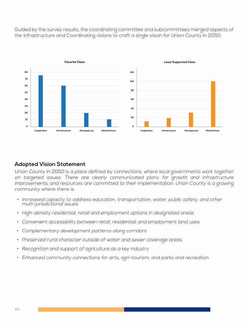
Guided by the survey results, the coordinating committee and subcommittees merged aspects of the Infrastructure and Coordinating visions to craft a single vision for Union County in 2050.
Union County in 2050 is a place defined by connections, where local governments work together on targeted issues. There are clearly communicated plans for growth and infrastructure improvements, and resources are committed to their implementation. Union County is a growing community where there is:
• Increased capacity to address education, transportation, water, public safety, and other multi-jurisdictional issues
• High-density residential, retail and employment options in designated areas
• Convenient accessibility between retail, residential, and employment land uses
• Complementary development patterns along corridors
• Preserved rural character outside of water and sewer coverage areas
• Recognition and support of agriculture as a key industry
• Enhanced community connections for arts, agri-tourism, and parks and recreation
Cooperation Infrastructure Municipal Led Market Driven
40
50
60
70
80
30
20
10
0
Favorite Vision
Cooperation Infrastructure Municipal Led Market Driven
80
100
120
60
40
20
0
Least Supported Vision
Adopted Vision Statement

2 6
SELECTING A SCENARIO

2 7
With assistance and input from committee members, Planning staff developed multiple scenarios in support of the adopted vision. Input was provided through a questionnaire addressing land use types, activities to address transportation, stormwater, open space retained through new development, recreation, and schools. (A majority of committee members responded to the survey.)
For each land use category, the subcommittee and committee members were asked whether the uses should or should not be allowed in the county, if they should only be allowed in certain locations based on conditions, or if the land uses should only be allowed inside of municipalities. Very few members said these land uses should only occur within municipalities, although higher-density residential development was supported only under certain conditions. These conditions included water and sewer, proximity to commercial areas, and access to major roads and interchanges.
The default zoning and land use plan recommendations in the current Union County Comprehensive Plan are for approximately one unit per acre. The view of the agricultural subcommittee is that residential development at this density is inconsistent with agricultural areas and that lot sizes should be larger than one acre. The overall perspective of the committee members was slightly in favor of larger lot sizes to preserve rural character.
There was broad support for non-residential development, as well as a recognition of the tax base imbalance in the County - as a relatively small percentage of the tax base comes from non-residential development. The subcommittee and committee members did not want to rely on municipalities to accommodate such development, with over 90% supporting commerical development in unincorporated Union County. While support for non-residential development was strong, survey respondents recognized the need for conditions similar to those for high-density residential. This provided significant justification for mixed-use nodes at specific locations on the land use map.
Developing and Comparing Scenarios
Should apartments and condominiums (multi-story development) be allowed in unincorporated Union County?
Should townhouses and other types of attached development be allowed in unincorporated Union County?
Should higher-density single-family residents (smaller than half-acre lots) be allowed in unincorporated Union County?
Are one-acre lots appropriate for rural areas designated for agriculture?
Should office, commercial, and retail uses be allowed in unincorporated Union County?
1.
2.
3.
4.
5.

2 8
Union County allows public, private, and charter schools by right in unincorporated areas and does not play a role in the siting of new schools. While this does not present a problem with Union County Public Schools, a number of charter and private schools have opened in recent years. These sites use significantly less land than a UCPS school of similar enrollment, allowing them to develop on parcels without adequate road access, buffering, or stormwater mitigation. These schools make limited use of busing, and therefore have an intense impact on the nearby road network during drop-off and pick-up times. Over four-fifths (82 percent) of committee members support the County requiring special use permits or other approvals to allow a school on a particular site.
Stormwater is a high-profile issue in Union County. The 2018 Hurricane Florence event closed over 70 roads in Union County, some at more than one place as shown in the map below. Entire neighborhoods were inaccessible. Many of these same roads were again closed in 2020 when a heavy storm impacted the County. Only the City of Monroe and the Town of Indian Trail own and maintain their own stormwater infrastructure. The County and the remaining municipalities rely on property owners and neighborhood associations to install and maintain infrastructure.
Regulatory Changes
Hurricane Florence Road Closures
Should Union County designate areas for new schools, including public/private/charter schools? Should Union County implement a stormwater program that would allow the county to inspect and require maintenance of private stormwater facilities?
1.
2.

2 9
Despite the significant impact from flooding, support from the citizen-led committees was divided – as many supported as did not support. The Agricultural Subcommittee, which represents large landowners, was particularly against the proposed stormwater strategies. The broad concept of flooding, and diffused cause from any one property and the effect invariably felt downstream from that property, is frustrating for both residents and decision makers. Organizing a countywide response is challenging due to the large number of decision makers and relatively small impact any one development has on the overall system.
The subcommittee and coordinating committee members also provided feedback on these proposed initiatives.
Union County has funded a short-line water extension program for several years to help residents served by wells with high levels of arsenic or other dangerous substances. This is a very popular program, with 94% of committee members supporting this program into the future.
Consistent with both the “cooperative” and “supporting municipalities” themes from the visioning phase of the Union County 2050 development process, nearly four-fifths (78%) of committee members felt that Union County, in cooperation with municipalities, should start building greenways, parks, and other community meeting spaces. Sales tax revenue was a frequently mentioned strategy and source to pay for such improvements.
Three-quarters (75%) of committee members support proactively extending water and sewer lines into areas identified for high-density development. This desire was also expressed by multiple municipalities at the August 2019 summit. By having utilities available, the towns could better realize their goals for revitalized downtowns or otherwise guide growth in a manner consistent with their respective visions. Union County Public works is operated as an enterprise fund and does not take taxpayer funds to provide its services. Rate payers solely fund the system. Committee members were divided on whether rate-payers, the municipalities, or Union County would pay for these extensions.
Initiatives
Strongly Supported Initiatives(Greater than 60% Support)
Proactively extend water and sewer lines into areas identified for higher density development.
Raise revenues to influence and accelerate road widenings and upgrades.
Continue funding a short-line water extension program to address unsafe drinking water.
Implement mandatory well inspection programs for new and existing homes as part of the land transfer process.
Implement a stormwater utility that would allow the county to repair and upgrade stormwater facilities.
In cooperation with municipalities, build greenways, parks, and other community gathering places.
1.
2.
3.
4.
5.
6.

3 0
Nearly the same percentage (71%) felt Union County should raise revenues to influence and accelerate road widenings and upgrades. The revenues considered would not result in widespread improvements funded solely by the county – the most popular strategy, a quarter-cent sales tax, would only raise $5 million per year. This is still a significant increase from the $100,000 per year provided as local match for intersection projects. Vehicle registration fees were also popular as a funding source, but property taxes were not supported
Opinions on minimum lot sizes for agricultural areas were mixed, ranging from less than an acre up to ten acres. More than half of respondents agreed that one-acre lots were too small for areas designated for agriculture.
More than half also agreed that Union County should implement a program to purchase development rights in prime agricultural and environmentally sensitive areas.
None of the six initiatives were considered unsupported when evaluated by all 63 committee members. Some initiatives did have significantly less support from individual subcommittees, however.
• The Agriculture Subcommittee was much less supportive of high-density residential development, stormwater regulations, and local transportation funding.
• The Citizens Subcommittee was less supportive of stormwater regulations.
Based on the results of this survey and feedback from the committees, three scenarios were developed for comment by the public.
Divided Opinion (Between 40-60% Support)
Limited Support (Less Than 40% Support)
94% of committee members feel the short line water extension program should continue in the future.
71% of committee members support Union County raising additional funds for road improvements.
Existing Land Use Plan: Limited change Administrative Scenario: Revised land use map, additional development regulations, no new programs Advancement Scenario: Includes the revised land use map, additional development regulations, and new programs.
1.
2.
3.

3 1
The following three scenarios were developed between May and June of 2020, with each of them released for public feedback between June 25 and July 24, 2020.
The first scenario is based on the 2014 Union County Comprehensive Plan’s land use map. The higher density residential districts in this land use plan reflect water and sewer utility coverage areas. The County made land use recommendations for the small pockets of unincorporated Union County surrounded by municipal areas, which reflected the loss of extra territorial jurisdiction (ETJ) for many municipalities based on changes in state law.
There are no new initiatives or programs proposed in this scenario. Existing initiatives, such as the short line water extension program and the $100,000 annual commitment for transportation projects, would continue. The County would process rezonings for new development by referring to this map for guidance. The County would continue support and advocacy for agriculture as a critical industry in Union County, including advocating for broadband internet access into rural areas.
Scenarios Developed for Public Feedback
Existing Land Use Plan Scenario
Existing Land Use Plan

3 2
The Administrative Scenario updates the land use map and proposes additional regulations. Proposed changes to development requirements would affect where new subdivisions would be supported, but designated commercial areas and employment corridors and nodes would remain the same. The County would continue support and advocacy for agriculture as a critical industry in Union County, including advocating for broadband internet access into rural areas.
Under this scenario, there are no new programs, such as building new parks, that would require tax increases. Union County would maintain its $100,000 per year commitment to transportation projects, but this limits the County to contributing to one intersection project per year.
Stormwater issues are addressed by increasing regulations on new developments - requiring larger stormwater detention basins, as well as increased and more frequent buffers along streams. Unsafe wells are addressed by requiring inspections of wells installed for new homes before they are given a certificate of occupancy. Neither of these initiatives would require a tax increase.
The land use map reflects a development pattern based on a wide range of input from the public, subject matter experts on a range of topics, and committee members. The single-family and higher density residential areas are more focused when compared with the existing land use plan. Townhouses and apartments would only be supported along NC 16 at key intersections and immediately adjacent to commercial nodes.
• Low Density Residential and Agriculture: The areas in the southern and eastern parts of the county are recommended for low density residential and agricultural uses. To help preserve the rural character, subdivision developments will need to set aside open space on the road frontage and/or important environmental features. Where water and/or sewer is present, smaller lot sizes are supported, but with significant open space requirements.
• Single-Family Residential: This land use was recommended for areas in western and northern Union County where utilities were present. Overall density for developments in such areas is no more than two units per acre. Townhouses and other types of multi-family developments are not supported in these areas unless in close proximity to commercial areas. If there are no water or sewer utilities present, typical density will be one unit per acre. Where such utilities are present, smaller lot sizes would be supported at a higher density.
• Higher Density Residential: These areas are located along or adjacent to major corridors where utilities are present or projected to be available. Higher density residential is supported here, including apartments, townhouses, and small lot single-family.
• Commercial development (office and retail) is located at specific nodes at key intersections throughout the county. These nodes vary in size based on local market demands. Larger nodes would support shopping centers with anchor tenants and “big boxes.” Rural and neighborhood nodes would be appropriate for smaller, more local business uses. Higher density residential immediately adjacent to such nodes is often appropriate.
• Industrial and other more intense commercial uses are focused on existing industrial parks and areas, such as near the airport or Monroe. US 74, US 601, and NC 75 are likewise identified as employment corridors, meaning that such uses would be supported along the corridor, assuming that traffic, noise, environmental and similar concerns could be adequately mitigated and addressed.
Management Scenario

3 3
• In addition to traditional land use categories such as residential and commercial, this scenario proposes a new “Transition Zone.” These are unincorporated areas surrounded by a municipality, commonly called “donut holes.” Union County would not approve new development requiring a rezoning in these areas - new development requiring rezonings should occur as part of an annexation into the adjacent municipality. Small area plans may be necessary where two or more municipalities border a transition zone.
The Advancement scenario uses the same land use plan from the Management Scenario but includes revised regulations and new initiatives to implement the overall comprehensive plan. The scenario responds to input from the community on issues of concern, such as safe drinking water, recreation, and transportation. This plan would include the following initiatives to implement the vision of Union County in 2050:
• Increasing transportation investments from $100,000 to aproximately $5 million, based on a quarter-cent sales tax, which would require approval via a voter referendum
• Partnerships with municipalities to build new parks, trails, and greenways, also funded with proceeds from a quarter-cent sales tax
• Increased stormwater regulations to reduce the intensity and volume of runoff from new construction
• Mandatory well inspections for both new and existing homes to inform potential homebuyers with the status of the safety of drinking water
• Continued county-funded initiatives to address unsafe wells, including short line water extensions and in-house water filtration systems
• Establish a task force to identify strategies to address litter
• Support and advocacy for agriculture as a critical industry in Union County, including committing resources to expanding broadband internet into both urban and rural areas.
Advancement Scenario
Land Use Map for Administrative
and Advancement Scenarios

3 4
In an effort to raise awareness of the plan and to gather feedback, Union County held a public comment period (both in-person and online) on the three scenarios from June 26 through July 24, 2020. The County, committee members, and municipalities shared announcements and links on social media. The County also emailed links and meeting information through the County employee newsletter and to interested residents.
County planning staff presented the scenarios to six municipal governing boards and one homeowners association. The County also held three in-person meetings, which were attended by a total of 18 people. The most common way residents participated in the process was online, with over 4,200 people visiting the project web site to review the scenarios. A total of 187 people completed the survey, the majority of them online.
Response rates varied by township, length of residence in Union County, and age. Township response rates are in line with their share of the county’s population, with the exception of New Salem (no responses) and Vance, which has approximately the same population as Monroe and Sandy Ridge.
Results of Public Feedback

3 5
Based on the 187 responses to the survey, the Advancement Scenario was preferred by the public. The residents of the two most populous townships, Monroe and Sandy Ridge, expressed the most support for the Advancement Scenario, as did residents aged 60 or older. There was no pattern to opposition to the scenario.
Comments from survey:
• While looking at some of the other issues I feel that the issue of flooding would only get worse if the other issues got priority. The advanced scenario addresses the flooding issue with a higher priority.
• While it does increase cost, it addresses most areas I am concerned about.
• It is more realistic for the future. I like the idea of the transition zones. Although I don’t like the idea of more taxes, the sales tax increase is the best way to fund in my opinion.
• Too much growth for already congested areas
• This will include a number of burdensome regulations and requirements. The One example given about wells will drive up the transaction costs for selling a home and provide undue burden.
• I would like to keep the area low density. If I wanted higher density I would have moved to Charlotte.
Union County organized a mid-plan summit with the Board of Commissioners, Planning Board, and the 14 municipalities. More than 70 people attended the event at the Union County Agriculture Center on August 6, 2020. Archie Morgan, chairman of the Coordinating Committee, presented an overview of the work to date and explained the next steps in the process.
All participating municipalities provided comments and feedback on the work to date, as well as their preferences for scenarios and specific strategies. The representatives thanked the County for including the municipalities in the plan development process. Twelve of the 14 municipalities were present and provided comments. Among those expressing a preference, there was unanimous support for the Advancement Scenario.

3 6

3 7
Between August 28 and September 25, 2020, the five sub-committees and the Coordinating Committee reviewed and voted on the proposed scenarios, regulations, and new programs identified through the plan development process. The results of the sub-committee votes were presented to the Coordinating Committee at their September 22 meeting, where they were asked to vote on a scenario and bundle of regulatory changes and new initiatives to address issues identified in Union County. Because only five members were present at the meeting, missing members were allowed to vote by email through September 25. Four of the five remaining members voted, meaning the results reflect the votes of nine of the 10 Coordinating Committee members.
The Coordinating Committee determined that a specific item must have at least two-thirds (67%) support from the committee in order to be included in the plan. This percent was determined to be a compromise between only including a small number of items with a high (80+%) level of support and using a simple majority, as that may include ideas that do not have a broad base of support. The Committee chose this level without knowing what impact this would have on which proposals would ultimately make it into the Plan, as half the members would be voting remotely after the September 22 meeting.
The Coordinating Committee was unanimous in supporting the new land use plan, with 78% supporting the Advancement Scenario. This scenario was explicit in detailing new programs and initiatives that would cost Union County money to implement. It was selected over the Management Scenario, which would limit changes to regulations that would affect new development only.
The Coordinating Committee voted to include all proposed regulatory changes into Union County 2050.
• Increasing stormwater regulations to accommodate larger storms and to apply the standards to nearly all new developments, excluding those developing new homes on 40,000 square foot or larger lots
• Requiring well tests with the results available for any new home with well service before a certificate of occupancy is provided
• Allowing residential subdivisions in areas designated for rural or agricultural uses to cluster lots on smaller lots sizes if water and/or sewer service is present. There would be no increase in overall yield under this arrangement.
• Increasing open space requirements for major subdivisions (more than 8 lots) in areas designated for rural or agricultural uses, with a requirement of approximately 20% preserved open space, to be applied to streams, wetlands, mature forest, or the entrance to the neighborhood.
Coordinating Committee Scenario Selection
Minimum Support to be Included in the Plan
Scenario and Land Use Plan
Regulatory Changes

3 8
• Establishing minimum site standards for new schools. These standards would not exceed or replace guidelines or requirements set by the State of North Carolina, but would establish minimum road access, buffering, and separation from conflicting uses such as heavy industrial in order to reduce traffic, lighting, or economic development impacts on nearby properties.
• Closing donut holes. The Union County Board of Commissioners would be asked to pass a resolution committing to not approve upzonings in islands of unincorporated Union County designated in the land use plan. Interested property owners would be directed to the appropriate municipality to propose annexation into their community.
The Coordinating Committee voted to include half (four of eight) of the new programs and initiatives considered in the scenario process. Implementing these programs will take money, but address high priority issues identified by residents in the county.
• Establish a rural water authority to make the eastern and southern parts of the county eligible for state and federal grants to reduce the cost of short line water extensions for unsafe wells.
• Fund transportation projects through a county-wide quarter-cent sales tax. This would require county commission approval to place on a ballot, and then receive approval from the voters.
• Establish a litter task force to identify effective strategies and programs to address litter in Union County.
• Working with internet providers to expand broadband internet service in underserved areas of the county.
The voting process was transparent, and a set of supported regulatory changes and new programs was identified in just a few weeks. The resulting list is a balance of urban and rural considerations, and can make meaningful impacts on larger issues, such as transportation, preserving rural character, broadband internet access, safe drinking water, and litter.
New Programs and Initiatives
Overall Results

3 9

4 0
PLAN RECOMMENDATIONS

4 1
With the understanding that Union County cannot address all issues, the following recommendations answer three questions: is there an identified issue, is there an effective strategy, and is it a feasible strategy?
The recommendations are organized by topic with background information and results of citizen and stakeholder input on identified issues. The report then lists potential strategies, with explanations of why certain ones were not ultimately included in the plan recommendations. The strategies that answered yes to the three questions listed above are included in the appropriate subject area. The strategies are presented in the following format:
Many people use “land use plan” and “comprehensive plan” interchangeably to describe the planning process. A land use plan is just that – a guidance for a series of land use recommendations to encompass the study area. A land use plan does not make recommendations on the underlying conditions that impact what land uses are and are not appropriate in certain areas. A comprehensive plan makes land use recommendations, but also makes recommendations to the infrastructure systems, policies and regulatory environment that impact and influence appropriate land development.
The Future Land Use Plan discusses a range of considerations on how to impact systems and policies that help determine what land uses are appropriate in a particular area. This section of the plan looks at what land uses were considered, and what was ultimately recommended for adoption. The following land use districts are found in the 2014 land use plan component of the comprehensive plan. These categories carry over into the 2050 comprehensive plan with limited changes to the range of uses, but with more changes on where these districts are located.
While Union County has seen dramatic growth, the amount of growth permitted and processed by the Union County Planning Department is much less than that total. Since 2000 only 30 percent of the more than 37,000 housing units permitted in the county were in unincorporated Union County. The Union County 2050 Comprehensive Plan should therefore not be considered a land use plan for the entire county. While the recommendations cover a majority of the land mass in Union County, the recommendations will affect a minority of future developments, as much of the growth in the County occurs within municipalities.
Plan Recommendations
Future Land Use Plan
Strategy 1
Issue: What is currently happening in the county that needs to be addressed?
Strategy: What should be done to address the issue?
How: How to address the issue?
Who: Who is the lead agency or department?

4 2

4 3
The map associated with a future land use plan is the most visible representation of the County’s vision of the future. However, one map with a range of colors for different land use categories masks myriad details that make the different land use types interact with the least amount of conflict. This is because the land use map cannot depict the buffers, stormwater systems, sidewalks, tax structure, road ownership, fire coverage, and other considerations that make a community work. Despite these limitations, a land use plan and corresponding map are very powerful tools to inform property owners and developers about supported land uses in specific areas.
In addition to the land use map, the text associated with the future land use plan will provide guidance as inevitable unique situations arise. For instance, when a “mixed-residential” district, would apartments be allowed anywhere within that district, or would higher density uses like apartments be restricted to that zone and also be required within that zone to be adjacent to commercial areas? This section of the plan addresses such issues to hopefully provide sufficient guidance to the public, property owners, and developers so that all parties have an equal understanding of the types of uses recommended for specific areas. Unfortunately since this plan encompasses nearly 30 years of recommendations, it is not strictly focused on preserving all current land uses. This may cause conflict as proposed higher intensity land uses are supported as a corridor is widened and utilities become available.
Rural Residential: Rural residential areas are those parts of the county expected and intended to retain an agricultural or low density residential pattern. For purposes of this plan, low density means either a lot size or a development density of no more than one unit per acre. To help preserve rural character, major subdivision developments (those resulting in more than eight lots) will be required to set aside open space along road frontage or surrounding important environmental features. Where water and/or sewer service is available, smaller lot sizes are supported, but with significant open space requirements to result in the overall density of no more than one unit per acre.
Single-Family Residential: Single-family development is recommended in the more populated parts of the county. Overall density for developments is no more than two units per acre. Townhouses and other types of multi-family development are not supported in these areas unless in close proximity to commercial areas. When there is no water or sewer utility infrastructure present, typical density allowed will be one unit per acre. Where such utilities are present, smaller lot sizes would be supported to yield two units per acre. Mixed Residential: Small lot residential, townhouses, and apartments are recommended in these parts of Union County. These areas have access to major roads, utilities, and easy access to existing or proposed commercial nodes, and are therefore appropriate for high density development. Commercial: Commercial development is identified at key intersections throughout Union County. These intersections are identified on the map, and reflect a balanced perspective of adjacent residential development, utility availability, and road access. These different types of commercial nodes are described below:
Rural centers: Rural Centers function as small scale civic and commercial centers for rural areas of the County. These Centers are clusters of low-density, non-residential uses located at a crossroads of two or more major or minor thoroughfares. Appropriate uses include
4 4
convenience stores, civic buildings, gas stations and others. Rural Centers provide limited commercial and community services while still maintaining the rural nature of the community.
Neighborhood Centers: Neighborhood Centers are located near concentrations of existing or planned residences, in areas with access to major thoroughfares and utilities and where not in competition with existing centers. These Centers incorporate commercial uses that serve the surrounding neighborhoods, including grocery stores, retail establishments, restaurants and services. Typical Neighborhood Centers range from 30,000 square feet to 125,000 square feet of retail space, and have a service area of one-to-two miles. Key characteristics of a Neighborhood Center include an interconnected street system that provides access to shopping, services, housing and amenities, and a well-connected pedestrian and bicycle network.
Small Community Center: A Small Community Center typically serves a larger population and includes 125,000 square feet to 400,000 of square feet of leasable space. The typical trade area of a Community Center is three to-six miles. Small Community Centers should be anchored by a commercial use such as a grocery store or retailer. Large Community Center: A Large Community Center serves a greater population and includes 400,000- 650,000 square feet of leasable space. A Large Community Center typically has more than one large retailer as anchor and should also include between 15 – 40 businesses that include general merchandise stores, restaurants and convenience services.
Employment Corridors: Employment Corridors have access to transportation infrastructure such as railways, airports and major roads, and have available land within a close proximity to similar uses. Employment Corridors connect employment nodes and other large job centers throughout the County and neighboring counties. A variety of employment uses may be appropriate along these corridors. Dependent on location and adjacent facilities, development uses that may be appropriate include distribution, logistics, aeronautics, industrial and agri-business. Connectivity and roadway capacity should be prioritized in these areas to encourage opportunities for job growth.
Employment Centers: Employment Centers facilitate employment growth in key areas that have access to transportation and adequate utility infrastructure and existing viable employment and available land suitable for employment. Uses encouraged near these centers include, but are not limited to, light industrial, warehouse, office, research, tech-flex and technology. Employment Centers should incorporate a limited amount of supporting commercial uses, such as restaurants and convenience retailers to serve employees, as well as multifamily residential uses including conveniently-located apartments. However, these uses should only be situated where not in conflict with existing employment land uses and should not be built in such a way as to jeopardize the use of those lands most suitable for office or industrial development.
Clustering Lots
School Siting
Increased Open Space Requirements
Transition Zones
Strategies

4 5
A key difference between a land use plan and a comprehensive plan is the interplay of land use recommendations and the infrastructure necessary to support the land use patterns depicted in the plan. The preferred land use plan will inform the supporting infrastructure systems about where growth is supported. The ideal focus areas for future growth will be those areas with infrastructure capacity and supported by land use planning recommendations.
The following sections of the document will describe the status of various infrastructure systems, such as transportation, schools, water and sewer, parks and recreation, and emergency management.
Despite projections of tens of thousands of new residents in Union County over the next decade, Union County Public Schools does not project construction of any new schools solely for overcrowding in the next ten years, although it is developing plans to upgrade or replace old facilities. Several new charter and private schools have been built in the western parts of Union County since 2017, which adds capacity where student enrollment may continue to increase. Overcrowded schools are a reality in some areas of the County, but UCPS recognizes that the time between a crowded school and actually opening a new school to address that issue could be a decade. By that point an area may “age out” and the overcrowding issues may have lessened. Therefore, the decision to commit to a new school is not one to take lightly. New schools cost tens of millions of dollars, and represent a significant financial commitment that must address a need that extends beyond years and into decades.
Alternatively, this comprehensive planning process explored the impacts of school siting decisions on land use and transportation. A recommendation in the Administrative and Assertive scenarios is to change schools from a “by right” land use to a “conditional use”, which means that the Union County Zoning Board of Appeals would consider a new school (private, charter, or public) and consider its use on a particular piece of land. The board would consider transportation and land use impacts to determine if a school was appropriate for that location.
Infrastructure
Schools
School Siting Broadband Internet
Strategies

4 6
TransportationIn 2017 the Union County Board of Commissioners committed $100,000 to a roundabout project at the dangerous intersection of Rocky River, Parkwood School, and NC 200. This was the first time that Union County committed county funds to a road project. Union County, like all other 99 counties in North Carolina, does not own roads. Yet despite this lack of direct responsibility, Union County is heavily involved in the transportation planning process and regularly coordinates with the NCDOT, regional transportation planning organizations, and the county’s municipalities to cooperatively plan and implement improvements to the transportation system. Union County 2050 will help establish priorities on the use of limited funds, activities the County will look to undertake to increase the capacity of the county to help implement an improved system, and ways that the county can guide growth to best utilize the system we have. Transportation in Union County consists of more than just roads, although for the 91 percent of residents who drive to work alone by themselves or with others, the road network is of utmost importance. Union County Transportation is the county-run demand-response public transportation system that serves all of Union County. This public transportation system mainly serves the elderly and disabled to take them to medical appointments, but the general public is eligible for trips.
Transportation PlanningMuch of Union County, including all 14 municipalities, is represented by the Charlotte Regional Transportation Planning Organization (CRTPO). The remainder of the county is served by the Rocky River Rural Planning Organization (RRRPO). Together these organizations serve as a forum for transportation needs to be identified, prioritized, and funded, primarily by the North Carolina Department of Transportation (NCDOT). CRTPO is responsible for developing a 20-30 year fiscally-constrained plan, called a Metropolitan Transportation Plan (MTP), which identifies what transportation projects can feasibly be funded and implemented in the next 20-30 years. The current MTP extends to 2045, although the 2050 plan will be complete in 2022. Based on the current 2045 MTP, the road projects expected to be built over that timeframe are listed on the following page.
There are several high-profile projects in the county that are currently not in the MTP, although the county and municipalities support them for the future:
• Waxhaw Parkway: This is a multi-lane project from north of Waxhaw east to NC 75, and would serve as a bypass for downtown Waxhaw.
• Marshville Bypass: This is a multi-lane project on the south side of Marshville and would serve as a bypass for downtown Marshville.
There are dozens of intersection-scale projects funded throughout Union County that are not included in the MTP. These projects are short-term projects that are identified, funded, and built typically within a five-year timeframe. The emphasis on intersection projects will continue for the foreseeable future and currently serves as the upper limit of influence for most municipalities and the County. Despite these fiscal limits, the County should continue to advocate for improved road connections to the rest of the region. These improvements include interstate designation for the US 74 and Monroe Expressway corridor, as well as connection to I-77 in York County.

4 7
Despite successful economic development projects surrounding the Charlotte-Monroe Airport, Union County is still a bedroom community where people drive to work. Approximately 40,000 workers travel out of the county each day. Of that total, 35,000 travel to Mecklenburg County. Significantly less than one percent take public transportation from Union County, and only 10 percent carpool, meaning many thousands of vehicles travel along the 15 roads into Mecklenburg County. Between a quarter and a third of all trips on these roads connecting the two counties can be attributed to Union County residents commuting to their Mecklenburg County jobs, with an even higher percentage at the AM and PM rush hours. This breakdown in commuting patterns inside and out of Union County can be seen in the maps on the next page.
Commuting
Union County and the municipalities play little to no role in the identification of maintenance projects on NCDOT facilities. The NCDOT establishes multi-year bridge replacement and road rehabilitation plans based on technical assessments of infrastructure health.

4 8
Interstate Access
School Siting
Transportation Investments
Transition Zones
Strategies
Coordinate Rezonings and Road Widenings

4 9
Union County Public Works and the City of Monroe are the only two providers of water and sewer service in Union County. Union County Public Works meets the needs of nearly 50,000 customers for clean, great-tasting, drinking water throughout unincorporated Union County and 13 of the 14 municipalities within the County. UCPW also provides wholesale water supply to the Town of Wingate and has a water sales agreement with the City of Monroe to sell up to 2 million gallons per day to the City as part of their long-term water supply strategy.
Potable Water: Union County has worked to address water supply and reliability concerns by creating connections to additional raw water sources. The largest initiative is the Yadkin Regional Water Supply Project (YRWSP). In the past several years this project has made significant progress towards securing a long-term, sustainable water supply for Union County. The project will reduce the County’s dependence on the Catawba River and support economic growth within Union County and neighboring regions. The YRWSP is separated into two projects: the intake facility and raw water pipeline and the water treatment plant and finished water pipeline. Union County selected the progressive design-build method to deliver the projects. A route for the raw water and finished water pipeline has been identified and right-of-way acquisition has begun.
The intake facility will house mechanical and electrical equipment to pump water from Lake Tillery in Norwood to the water treatment plant. The facility is planned to house up to five 1,250 horsepower vertical turbine pumps and three 50 horsepower vertical turbine pumps. However, installation of these pumps will occur in phases, as water demand increases in the future.
The raw water pipeline will transport water from the intake and pump station on Lake Tillery to the water treatment plant east of Unionville. The finished water pipeline will connect the water treatment plant to the existing Union County water distribution pipe network and will transport clean or ‘finished’ water to the network. The Union County water distribution network is the existing network of pipes that currently serves water to Union County water customers.
Water and Sewer

5 0
Waste Water: Wastewater is used water. It includes substances such as human waste, food scraps, oils, soaps and chemicals. In homes, this may be water from sinks, showers, bathtubs, toilets, washing machines and dishwashers. Businesses and industries also contribute their share of used water that must be cleaned. If wastewater is not properly treated, then the environment and human health can be negatively impacted. These impacts include harm to fish and wildlife populations, oxygen depletion, restrictions on recreational water use, restrictions on fish and shellfish harvesting and contamination of drinking water. Wastewater generated by Union County’s 36,000 customers is conveyed through a collection system comprised of over 585 miles of gravity lines with pipe diameters ranging from four inches to 48 inches. There are also more than 68 pump stations in the system, with over 75 miles of force mains that pump wastewater to our treatment facilities in areas that will not flow by gravity. The County currently owns and operates five wastewater treatment plants within the County, termed Water Reclamation Facilities (WRF). The Facilities each treat wastewater from specific drainage areas within the County. Union County currently has a total of 8.2 million gallons per day (MGD) of wastewater treatment capacity with these facilities and contracts with the Cities of Monroe and Charlotte for an additional 5.65 MGD of treatment capacity to serve eastern Union County and the Six-Mile Creek basin, respectively.
Utility Impact on Land Planning: Water and sewer access play a significant role in attractiveness to development, and the Union County 2050 Comprehensive Plan recognizes this influence without making inappropriate land use recommendations for the sole purpose of accommodating utility access.. Instead of supporting rezonings to allow higher-density developments due to the availability of water and sewer, the Unified Development Ordinance (UCO) should be amended to allow smaller lot sizes to take advantage of utilities, but with no overall increase in density through traditional subdivision rules. Undisturbed land would remain as open space, preserving rural character and environmental features. Conversely, Union County Public Works does not oppose capacity expansion or installation of new lines to assist municipalities in support of economic development or land planning efforts. The cost of these system expansions would be the responsibility of the municipalities.
Clustering Lots
Well Testing
Establish Rural Water Authority
Transition Zones
Strategies

5 1
Union County Parks & Recreation manages three parks. The largest and most well known is Cane Creek, a reservoir, camping area, and recreation resource south of Waxhaw, drawing residents from throughout the region. Fred Kirby Park near Lake Park and Jesse Helms Park near Wingate are smaller, but still well used. The County relies on three recreation associations to organize sports leagues. Piedmont, Waxhaw, Weddington-Wesley Chapel, and Porter Ridge athletic associations are each home to active youth organizations. Several municipalities also maintain parks and recreation departments that organize leagues.
According to Union County Parks and Recreation leadership, the most frequently requested amenity for the department is trails and greenways. This was reflected in the visioning and scenario comparison phases of the community outreach process. Outside of existing park facilities, the county has not accepted maintenance responsibility for trails or other facilities built as part of any neighborhood. In addition, the County has not committed to building trails or greenways identified in the Carolina Thread Trail, County Multi-Modal Plan, or Parks and Recreation Master Plan. Individual municipalities have built such facilities in recent years, and based on recent COVID-19 distancing requirements, trails and greenways have been in high demand.
The committees did not consider where new parks should be located but did discuss whether to recommend additional funding and commitments be made to develop new facilities. This expanded role for the County was supported as a partnership with municipalities. This would allow the additional capacity to be located where more people live, as well as leverage municipal funding to pay for additional facilities. This partnership will ideally result in multi-jurisdictional trails and similar amenities, based on municipal plans and initiatives.
Parks and Recreation
Clustering Lots Increased Open Space Requirements
Strategies
5 2
Emergency Services in Union County encompasses emergency management, a series of 17 volunteer fire departments, and the sheriff’s department. Each of these services has been affected by the County’s dramatic rise in population. As population grows, the capacity of the fire departments as well as the sheriff’s department must grow as well.
The Union County Sheriff’s Office (UCSO) provides a full range of law enforcement services, including patrol, jail, civil process, criminal investigation and animal services. The current jail houses on average 230 inmates. The Union County jail is almost at capacity, often having to transfer inmates to other county jails in the region. In addition to jail, under contract with the municipalities, the USCO also provides one or more officers to Lake Park, Marvin, Weddington, Wesley Chapel, and Indian Trail. UCSO also has an on-duty deputy in almost every school (with a near-term goal of being in every school), as well as a volunteer off-duty program for deputies in churches during services.
The Emergency Management Department works with other entities and the public to guarantee Union County is prepared to protect itself against, respond to, and recover from various types of disasters. As the other departments have grown, Emergency Management has also seen changes in the last few years. The County uses Salamander, a program that tracks personnel locations and statuses, to ensure the safety of employees in the field. This allows for the emergency management team to track any team in the field and ensure their safety while responding to crises. Another system that has just been rolled out by this department is the Everbridge system. This is an emergency broadcasting system that announces updates to the whole county. The system can be set up to “ping” certain zip codes, certain locations, or the entire county depending on the situation.
The Union County Fire Marshal’s Office has a primary responsibility of enforcing the North Carolina Fire Prevention Code that requires commercial occupancies be inspected on an arranged schedule depending on the occupancy type. In addition, the Fire Marshal’s Office handles safety concerns reported by the public and reviews building plans and fire protection equipment. During the building process, we work closely with our Building Code Enforcement Division. The Fire Marshal’s Office also conducts investigations into the origin and cause of fires. During investigations the Fire Marshal’s Office works with several different agencies that include the Sheriff’s Office, local Police Departments, North Carolina State Bureau of Investigation and the Bureau of Alcohol, Tobacco, Firearms and Explosives. The Fire Marshal’s Office also oversees the 17 volunteer fire departments in the county. In presentations to the Infrastructure Committee, the chairman of the association of the fire departments throughout the county explained the impact of different types of land uses and densities on fire response requirements, with higher density and taller buildings requiring many more personnel and sophisticated equipment.
Emergency Services
Stormwater
Transportation Invesments
Broadband Internet
Establish Rural Water Authority
Transition Zones
Strategies

5 3
Union County recognizes that a healthy environment is important to a healthy community. However, when developing a comprehensive plan, receiving input for “protecting the environment” can be a public mandate loaded with meaning and misunderstanding. The environment at its most broad definition would include the air, ground, water, subsurface, and all living creatures within it. All modern human activities impact the environment in some way. Existing state and federal environmental regulations will continue to factor in transportation planning and land development processes to protect air, water, and land and the flora and fauna within it. The question for all residents of Union County to consider is what value to assign to the environment, and what restrictions or requirements they are willing to impose upon themselves to preserve or enhance the natural resources of the county. The County also understands that opinions on environmental regulations vary throughout the County. The following recommendations are based on research, presentations, and committee members’ expertise. Preserving wetlands can reduce the impact of flooding. Shade provided by mature trees can reduce air conditioning costs. Cleaning trash and debris from the road reduces the incidence of roadkill and car-animal crashes. Union County 2050 undertook a comprehensive look at environmental issues in the county, as defined by a subcommittee of 12 residents, as well as public input as a part of the year-long plan development process, in order to identify areas of concern, research effective strategies to address those concerns, and then confirm local willingness to support implementation of proposed strategies.
Based on research, presentations from subject matter experts, community input, and committee member input, the following issues were presented to the public in one or more scenarios for public comment.
• Lowering density for major subdivisions in rural areas to increase buffers along streams and wetlands
• Requiring major subdivisions (more than eight lots) and all commercial development greater than one acre to provide on-site detention
• Establishing a litter task force
• Requiring well inspections for new and existing homes as part of the land transfer process
• Continuing the short line water extension program to take homes with unsafe well water off of wells
• Initiate in-home water filtration and remediation program to subsidize treatment programs as a substitute where providing short line water extensions is not feasible
Environment
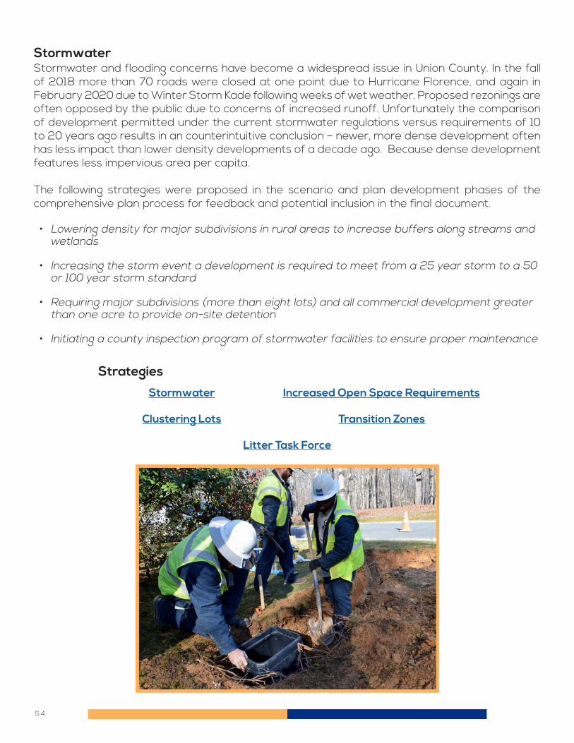
5 4
StormwaterStormwater and flooding concerns have become a widespread issue in Union County. In the fall of 2018 more than 70 roads were closed at one point due to Hurricane Florence, and again in February 2020 due to Winter Storm Kade following weeks of wet weather. Proposed rezonings are often opposed by the public due to concerns of increased runoff. Unfortunately the comparison of development permitted under the current stormwater regulations versus requirements of 10 to 20 years ago results in an counterintuitive conclusion – newer, more dense development often has less impact than lower density developments of a decade ago. Because dense development features less impervious area per capita.
The following strategies were proposed in the scenario and plan development phases of the comprehensive plan process for feedback and potential inclusion in the final document.
• Lowering density for major subdivisions in rural areas to increase buffers along streams and wetlands
• Increasing the storm event a development is required to meet from a 25 year storm to a 50 or 100 year storm standard
• Requiring major subdivisions (more than eight lots) and all commercial development greater than one acre to provide on-site detention
• Initiating a county inspection program of stormwater facilities to ensure proper maintenance
Clustering Lots
Stormwater
Litter Task Force
Increased Open Space Requirements
Transition Zones
Strategies

5 5
Union County and its municipalities have access to a professional forester, who is housed within the agricultural extension office. The urban forester presented information for the benefit of the Environmental Subcommittee. He advised the committee on the benefits of trees, how to accommodate trees into site plans, and what current regulations and trends are at odds with the professed objectives of the current comprehensive plan. Trees do not tolerate disturbed ground, so the intent of preserving large trees immediately adjacent to new development frequently results in trees dying after a period of time.
In addition, large lot subdivisions with larger contiguous stands of preserved trees may also suffer as individual property owners cut down trees or otherwise modify their property. Areas intended to remain undisturbed or otherwise serve a natural function should be placed into common areas or dedicated to a lands conservancy as a conservation easement. These areas should be contiguous with similarly protected lands on adjacent properties in order to provide a larger natural area, and provide an opportunity for any trail networks.
The following strategies were proposed in the scenario and plan development phases of the comprehensive plan process for feedback and potential inclusion in the final document:
Trees and Open Space
• Lowering density for major subdivisions in rural areas to increase buffers along streams and wetlands
• Increasing cluster flexibility in residential areas to meet market demands for smaller lots while not exceeding density recommendations in the plan.
Clustering Lots
Litter Task Force
Increased Open Space Requirements
Strategies

5 6
Over 80 percent of new development is served by public water and sewer service, but that still leaves tens of thousands of Union County residents who rely on septic service and/or well water. Union County has a high percentage of wells testing positive for unhealthy concentrations of arsenic, manganese, and other harmful substances. Union County has one of the highest concentrations of arsenic in North Carolina. Providing safe drinking water to those residents is a frequently mentioned demand of Union County. Less frequently mentioned, but no less important, are older homes (1970s and earlier) on smaller lots and served by failing septic fields. These lots are too small to locate a replacement drain field, so the residents can be faced with high costs to dig up and replace the septic field. At the extreme end of this situation, these homes could be declared uninhabitable.
Unfortunately the Union County Public Works department has limited funds to pay for water and sewer extensions to take such homes off of well and septic service. The department does not receive funds from Union County property taxes; the system is run as an “enterprise fund,” meaning that only rate payers support the system. If new capacity is added that does not result in a sufficient number of customers to pay for the extension, then the costs are subsidized by existing rate payers. Analysis of completed and proposed short line extensions concluded the cost to take one home off of a well was between $40,000 and $50,000. This amount was seen by the relevant subcommittees and coordinating committee as an unsustainable amount of money to pay per unit to use as the only way to address unsafe drinking water.
An alternative strategy is to establish a grant program for residents to receive a reimbursement for fifty percent of the cost of remediation, whether that is lining the well to eliminate contaminated water from entering the well, installing a filtration system to remove contaminants, or some combination of systems necessary to address identified issues. Homeowners would need to have a well test confirming the issues with their water before they could begin work and confirm eligibility to receive a rebate from the county. The cost of such a program is dependent on the number of wells and the cost of remediation for each well, but the estimate is approximately $24 million, which is based on assuming 20% of the county’s roughly 80,000 households use well water,
Well and Septic Systems

5 7
resulting in 16,000 wells. Assuming half require treatment means 8,000 wells. At an average cost of $3,000 per well, assuming a 50% County reimbursement, this program has an upper estimate of $24 million. While this concept was seen as useful, it was not included in the comprehensive plan as a strategy due to concerns over improving private property, the regulatory hurdles to become eligible to implement such a program, and the need to focus on the short-line water extension program.
The total cost to the County in any given year will be a function of what percent of residents choose to participate, and the capacity of the private sector to perform such work. The program may need to be funded over several years in order to not overwhelm contractors performing the work. However based on committee members concerns over private property owner responsibility and difficulty over receiving approval for such a program, this strategy was not involved in the plan recommendations at this time.
The following strategies were proposed in the scenario and plan development phases of the comprehensive plan process for feedback and potential inclusion in the final document:
• Requiring well inspections for new and existing homes as part of the land transfer process
• Continuing the short line water extension program to take homes with unsafe well water off of wells
• Initiate in-home water filtration and remediation program to subsidize treatment programs where short line water extensions were not feasible.
Well Testing Establish Rural Water Authority
Increased Open Space Requirements
Strategies

5 8
Union County was incorporated in 1842 and retains knowledge of its roots. History is a strong factor in a community’s sense of place. However, with the understanding that a rapidly growing population may pose a threat, the County has taken steps to preserve its history. The County currently has 55 County-designated landmarks, two County-designated historic districts, six historic landmarks designated by the National Register of Historic Places (NRHP), and six NRHP-designated historic districts.
There are two groups that oversee historic preservation in the county. The Monroe Historic District Commission is in charge of overseeing the downtown historic district in Monroe. All other landmarks and districts in the County are under the purview of the Union County Historic Preservation Commission, which is tasked with monitoring existing properties and evaluating and designating new properties. Nationally, there are grants and tax credits available to help with the financial cost of owning a designated historic building. These programs can help with the cost of maintenance, restoration, or any project that enhances the integrity of the building. A state-wide program that is also a great incentive for owning a historic building is a tax deferment program. Taxes taken by the state on a locally designated property are taken at 50% of the value of the land, which reduces the taxes on the property. These programs can be applied for by homeowners with the help of the historic preservation commissions.
Historic Preservation

5 9
Business DevelopmentThe role of residential and commercial development in the local economy was a key consideration in the development of Union County 2050. A dedicated subcommittee comprised of local business leaders and concerned residents was created to focus on the issues related to growth and the economy. A significant percent of Union County’s economic activities is related to residential and commercial development. Realtors, brokers, general contractors, builders, and related supporting industries employ thousands of people in Union County. Maintaining a stable and predictable development environment helps both land owners and developers. A well thought-out and implemented comprehensive plan can accomplish that goal.
The following strategies were proposed in the scenario and plan development phases of the comprehensive plan process for feedback and potential inclusion in the final document:
• Supporting complementary land use rezonings near commercial nodes, such as high-density residential
• Supporting commercial rezonings at appropriate locations, such as along major roads near population centers
• Allowing cluster developments in more residential zones in order to reduce infrastructure costs and disturbances to the environment
• Providing a predictable development process, particularly for rezonings
Clustering Lots
Transportation Investments
Interstate Access
School Siting
Transition Zones
Broadband Internet
Strategies

6 0
The Union County Public Works Solid Waste Division operates facilities for the disposal of municipal solid waste, more commonly known as garbage, construction and demolition (C&D) debris, yard waste, recyclables, and waste materials which are banned from landfills in North Carolina. These facilities are located at the County’s Solid Waste Management Center and are designed to serve the needs of commercial haulers that collect garbage and recyclables from residents and businesses within the community, as well as to provide accommodation to individuals to dispose of these materials. The Division currently operates five residential waste and recycling drop-off sites located throughout Union County to provide a convenient location for residents that do not utilize curbside collection programs to dispose of their garbage, recyclables, used motor oil, and electronics, such as computers and TVs.
Municipal Solid Waste (MSW), maintains robust volumes which is indicative of a strong economy and continued population growth in the County. There were 83,686 tons of MSW delivered into the system in FY18, which was the third-highest volume on record. The heightened levels also reflect the ease of use in the County’s six residential waste and recycling drop-off sites, as well as strong relationships with commercial haulers who utilize the County’s transfer station for MSW drop off.
Like MSW, Construction and Demolition (C&D) tonnage is an indicator of growth and favorable economic conditions. This sector of waste continues to grow at an astounding rate. In FY18, 34,990 tons were delivered into the system. This marks more than a 350% increase in tonnage since FY14, the highest annual volume on record.
Union County has recognized the impact of trash services on the environment, particularly in litter accumulation on the sides of roads. Union County recently approved a differential rate structure to impose higher fees on loads brought in without a covering to reduce litter blown out of the back of vehicles. This strategy has reduced the incidence of unsecured loads being brought to the county landfill, but with sustained growth projected in the county, vigilance is necessary. Volunteer groups such as Union County Litterbusters play a key role in advocating for litter clean-up, which benefits public safety, aesthetics, and wildlife. In support of this advocacy role, a strategy considered in the comprehensive plan process was to appoint a litter task force, which would identify additional strategies for addressing litter in Union County.
Municipal Solid Waste
Litter Task Force Transition Zones
Strategies

6 1
Economic development in Union County is overseen by the Monroe-Union County Economic Development agency. This joint initiative focuses and directs efforts of the county and its municipalities to retain, attract, and grow businesses in four main areas: precision manufacturing, agri-business, logistics, and commercial development. The following strategies were proposed in the scenario and plan development phases of the comprehensive plan process for feedback and potential inclusion in the final document:
• Advocating for interstate status for US 74 and the Monroe Expressway to increase attractiveness of land for industrial development
• Supporting utility extensions in targeted areas, consistent with municipal plans for revitalization or commercial development
• Supporting commercial and industrial rezoning requests in areas consistent with the comprehensive plan
Economic Development
School Siting
Interstate Access
Litter Task Force
Transportation Invesments
Transition Zones
Broadband Internet
Strategies

6 2
A sense of community and acceptance of diversity was a surprising need identified among committee members during the visioning process. More than two-thirds of all Union County residents live within a municipality, so the idea of civic engagement for such a large and populous county can become nebulous without appropriate definitions. More than half (eight of 14) of the municipalities in Union County were created since 1980, so it could be said these municipalities already had a significant amount of engagement to successfully complete the incorporation process. The counter to this perspective is that these newly incorporated communities are also in the fast-growing western side of the county and therefore have to continuously re-engage with newcomers, with the notable exceptions of Hemby Bridge, Fairview, Mineral Springs, and Unionville.
During the planning process, several issues requiring collective action were identified: transportation, stormwater, and trails. Moving the needle on any of these issues cannot occur without a broad base of support and commitment, both financial and political. Unfortunately, public consensus on these issues may be difficult to reach, given the differing perspectives of residents, both long-term residents and newcomers, throughout the County.
Other issues identified in Union County 2050 may not take money, but they do require political commitment. Allowing higher density residential or commercial rezonings in appropriate areas, choosing between student redistricting versus building new school capacity, implementing enhanced protections for wetland and environmentally sensitive areas, or changes to the Unified Development Ordinance (UDO) for the county does not necessarily impose a large cost on Union County, but does require making choices. Having the support of county residents makes these decisions more acceptable and durable.
What does an engaged and cohesive community look like? Is it a high voting turnout rate? Is it the percent attending a community event in the last year? Is it awareness of current events in
Community Connections

6 3
their municipality? Or is it a sense of engagement – that the residents feel they can and should participate in the action of improving Union County? To help foster connections, the following strategies were proposed in the scenario and plan development phases of the comprehensive plan process for feedback and potential inclusion in the final document:
• Developing parks, trails and community gathering places in cooperation with municipalities
• Support rezonings for higher density residential in immediate proximity to commercial nodes
• Support water and sewer line extensions to support municipal revitalization and economic development initiatives
• Establish transition zones for islands of unincorporated Union County so that any new development requiring a rezoning would be consistent with municipal plans and be annexed into the municipality.
Litter Task Force Broadband Internet
Transition Zones
Strategies

6 4
Union County is one of North Carolina’s most important agricultural centers. Despite being home to nearly a quarter-million people, Union County is still the third-most agriculturally productive county in the state, with a half-billion dollars in annual sales (Source: Monroe – Union County Economic Development). Approximately half of all land (over 186,000 acres) in Union County was used for agricultural activities in 2017. This is down seven percent in just five years.
Despite this loss of land, Union County still is the number four county in the state for value of agricultural products sold. This productivity ranges from crop production (#1 in both soybeans and wheat) to cattle (#10) and poultry (#1 in egg layers, #2 in broilers, and #4 in turkeys). In addition to growing and raising crops and livestock, Union County is home to several animal processing plants, grain silos, and related industries.
Union County wishes to protect this industry and land use as a reflection of the county’s heritage, as well as a critical as a critical aspect of the local economy. The conflict is how to protect these uses from encroaching residential development while not diminishing the opportunity for farmers to comfortably retire by selling land at prices warranted by residential development pressures.
The following strategies were proposed in the scenario and plan development phases of the comprehensive plan process for feedback and potential inclusion in the final document:
• Advocating for, or even financially supporting, expansions of high-speed internet into rural areas with high levels of agricultural activity
• Advocating for interstate status for US 74 and the Monroe Expressway to support agri-business development
• Continuing the short line water extension program to take homes with unsafe well water off of wells
• Initiate in-home water filtration and remediation program to subsidize treatment programs in lieu of short line water extensions.
• Lowering density for major subdivisions in rural areas to preserve rural character
Clustering Lots
Increased Open Space Requirements
Interstate Access
Establish Rural Water Authority
Transportation Investments
Broadband Internet
Strategies
Agriculture

6 5

6 6
Approximately three-quarters of all development currently occurs within Union County’s 14 municipalities. These municipalities and their visions vary greatly--from rural oriented municipalities with large lot requirements exceeding those of the county to urbanized municipalities with multi-family development, and industrial and commercial areas. Residents expect development in unincorporated Union County to blend with each of these 14 municipal visions and development standards. The following strategies were proposed in the scenario and plan development phases of the comprehensive plan process for feedback and potential inclusion in the final document:
• Support parks, trails and community gathering places in cooperation with municipalities
• Fund transportation projects in cooperation with municipalities
• Support water and sewer line extensions to support municipal revitalization and economic development initiatives
• Establish transition zones for islands or smaller nearly surrounded portions of unincorporated Union County so that any new development requiring a rezoning would be consistent with municipal plans and be annexed into the municipality
• Reduce extent of higher-density land use districts adjacent to municipalities
Municipal Coordination
Strategies
Stormwater
Transition Zones
Interstate Access
Broadband Internet
School Siting
Transportation Investments
Litter Task Force
Coordinate Rezonings and Road Widenings
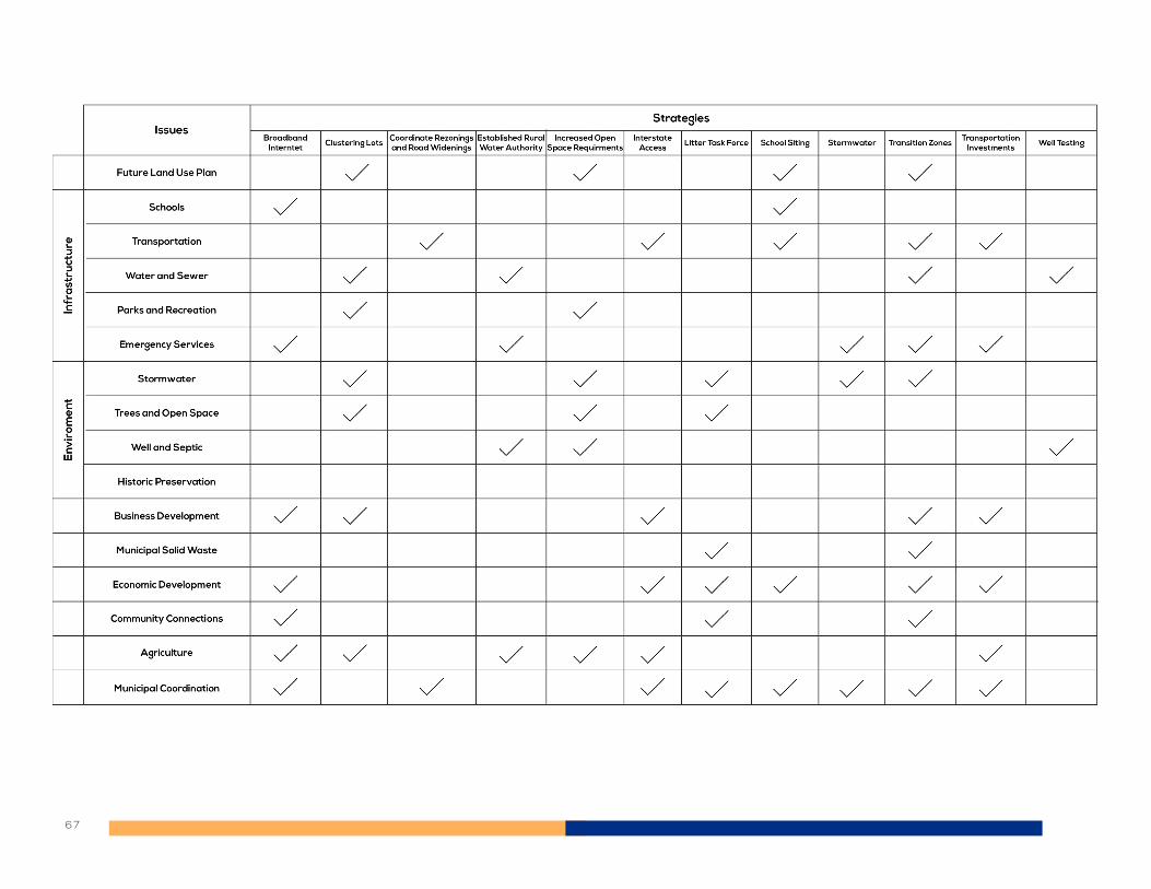
6 7

6 8
BROADBAND INTERNET
Issue: Reliable high-speed internet has become an essential utility service for working from home and distance learning, as well as for agri-business operations. Internet service is provided by private businesses, meaning that service won’t be provided in certain areas if they cannot make money from the investments. These gaps in service are affecting educational equity and economic development in Union County.
Strategy: Union County will engage with private service providers on the issues with high speed internet coverage gaps in the county, what is needed to close the gaps, and how to apply for state and federal grants to apply to upgrades to the network where such investments will otherwise not occur. Union County will also work with the school system on ways to provide internet service for students who are better served by remote learning. These initiatives will require local funding, and Union County will need to determine the appropriate revenue source to pay for these commitments.
How: Engage NC Broadband Infrastructure Office and private telecom companies on grants and network plans for expansion to increase coverage. Who: Union County Public Schools, Union County
CLUSTERING LOTS
Issue: Water and sewer service is available in parts of Union County identified for rural residential and agricultural uses. Serving large-lot residential developments with water and sewer requires excessive infrastructure to build and maintain.
Strategy: Allow residential developments in areas designated for rural residential land uses to build on smaller lot sizes to take advantage of available utilities. This clustering of lots would not increase overall lot yield.
How: Amend the Union County Unified Development Ordinance to allow smaller lot sizes where water and/or sewer service is available. The resulting lots would still meet development standards for setbacks and other applicable concerns, and would demonstrate a reduction of infrastructure (roads, water lines, sewer lines) necessary to serve the lots compared to the status quo. An example would be a 20 acre parcel zoned R-40, but with water and sewer access. The developer could choose to still develop 20 lots, but do so on only five acres of land but creating quarter acre lots. The remaining 15 acres would remain undeveloped. Who: Union County Public Works and Planning Departments
Jump to Table of Contents

6 9
COORDINATE REZONINGS AND ROAD WIDENINGS
Issue: Union County has multiple high priority road improvements that are committed projects, but construction has been delayed due to funding shortfalls. These projects were funded because of existing capacity and safety deficiencies. New development is proposed along many of these roads, further adding to congestion and safety problems.
Strategy: Union County will deny rezoning requests for projects that exacerbate peak hour congestion for roads funded for improvement through the current North Carolina Department of Transportation Statewide Transportation Improvement Program (STIP). Rezonings will need to either contribute funds to accelerate the schedule of the relevant transportation projects or else wait until the affected project has been completed.
How: The Union County Planning Department would evaluate traffic impacts for proposed rezonings and determine if the traffic from the project will primarily use a segment of road or intersection funded for improvement. If the peak traffic impacts coincide with AM or PM peak traffic periods for the road or intersection, the Planning Department would recommend denial, and the Board of Commissioners would deny the rezoning or otherwise require delaying construction of the project until the road improvements were complete. Union County would encourage affected municipalities to enact similar policies. Who: Union County Planning Department and Board of Commissioners
ESTABLISH RURAL WATER AUTHORITY
Issue: Union County is not eligible for many grant programs through the US Department of Agriculture or other agencies to extend water service due to low poverty and relatively high overall development density. The County therefore pays for the cost of short-line extensions for unsafe wells by charging higher rates for its customers.
Strategy: Rural water authorities, with a service area consisting only of rural low-density areas, can be created to provide such service and be eligible for such state and federal grants to help pay for the projects. The new authority would not be a stand-alone separate system from the existing Union County Public Works network, but would extend areas where service may feasibly be provided.
How: Union County would establish a rural water authority, identify its service area, and transfer ownership of any infrastructure from the existing Union County Public Works network. Utility service billing would occur for any customers on this system, with treated water purchased from the most efficient and appropriate providers. This authority would be overseen by Union County Public Works.
Who: Union County Public Works
Jump to Table of Contents

7 0
INCREASED OPEN SPACE REQUIREMENTS
Issue: Residential developments with R-40 and RA-40 (40,000 square foot lots) zoning do not protect rural character or environmental features.
Strategy: Increase open space requirements to preserve undisturbed land at entrance to development and/or environmental features such as wetlands or mature tree stands to reduce impact from new development and preserve rural character.
How: Amend Unified Development Ordinance regulations for major subdivisions (eight or more lots) with 40,000 square foot lots without water or sewer service to require 20% of the overall development set aside as increased setbacks from main roads or environmental features.
Who: Union County Planning Department and Urban Forester
INTERSTATE ACCESS
Issue: Union County is considered “remote” for industrial and commercial development purposes because it does not have an interstate running through it. The NCDOT and the Charlotte Regional Transportation Planning Organization (CRTPO) have recently approved a vision for US 74 that recommends upgrades to bring the corridor to a freeway status to Wilmington. This would support a future interstate designation for the corridor.
Strategy: The US Department of Transportation has established a process for interstate designation, which would require all affected municipalities, counties, and transportation planning organizations to pass resolutions of support for such a designation. The NCDOT could then pass a similar resolution and submit a designation request to the American Association of State Highway and Transportation Officials (AASHTO), who approves such requests.
How: Union County would work with the municipalities and affected transportation planning organizations to format and pass such resolutions, and urge the NCDOT to commit to the same position. Who: Union County Planning Department and Board of Commissioners
Jump to Table of Contents

7 1
STORMWATER
Issue: Union County encounters frequent and increasingly severe flooding events and runoff onto adjacent properties as development occurs.
Strategy: Expand the types of developments required to build stormwater detention facilities, and build the capacity for retaining runoff from larger storms.
How: Amend the Union County Unified Development Ordinance to require all commercial and residential developments design stormwater infrastructure to accommodate the 50 year storm. Who: Union County Planning Department
SCHOOL SITING
Issue: K-12 schools (public, private, or charter) are allowed as a by right use in all zoning districts in unincorporated Union County. This flexibility has resulted in schools being built on smaller parcels of land, with compromises on appropriate vehicular access, buffering, and proximity from conflicting uses..
Strategy: Establish minimum standards for road access, lot size, and buffering from conflicting uses that must be met for a school to be permitted at a specific location.
How: Amend Unified Development Ordinance to establish minimum road frontage, lot size, and distance from existing industrial and related land uses to minimize conflict and impact from school development. Who: Union County Planning Department
Jump to Table of Contents

7 2
LITTER TASK FORCE
Issue: Litter along quiet rural secondary roads and higher volume arterials impacts public safety, the environment, and the perception of Union County to outsiders.
Strategy:There is no one silver bullet to solve a litter issue. Materials may fly out of the back of vehicles, be inappropriately discarded by unscrupulous trash haulers, or accumulate in streams from run-off during storm events. These issues and potential activities would be researched and evaluated by a task force, who would present findings and recommendations to the Board of Commissioners for their use.
How: The Board of Commissioners would appoint a task force of citizens to research the issue, with support from County staff. This task force would be directed to develop strategies to address litter and present the recommendations. Who: Union County Solid Waste and Planning Department
TRANSITION ZONES
Issue: Many Union County municipalities have irregular boundaries. This has resulted in numerous pockets of unincorporated land nearly or completely surrounded by adjacent municipalities. Providing municipal services to these areas is complex, and development proposals often create conflict between the county and adjacent municipalities, who often have different plans for future land uses in these areas.
Strategy: Identify these “donut areas” and establish a policy of Union County to not approve rezonings that would increase density or intensity of uses. The property owners would be advised to propose development to the adjacent municipality for rezoning and annexation.
How: Establish a transition zone designation in the land use map and pass a resolution establishing the policy of the Union County Board of Commissioners to not approve “upzoning” in these transition zones.
Who: Union County Planning Department and Board of Commissioners
Jump to Table of Contents

7 3
TRANSPORTATION INVESTMENTS
Issue: Union County does not own or maintain roads. Despite this lack of responsibility, traffic congestion and safety was the number one issue expressed in the public input phases of the plan development. The County has recognized it cannot simply advocate for more money from the local transportation planning agencies and the North Carolina Department of Transportation (NCDOT) – it must provide additional funding to help implement high-priority projects. The County currently provides $100,000 per year in local match assistance for intersection-scale projects, but much more money is needed to make substantial progress on this issue. Additionally, there are regional plans for extending the light rail network to Matthews and into Union County. This new service would require local funding to implement and operate.
Strategy: Union County would invest several million dollars per year in local match for intersection, road widening, and other road projects administered by the NCDOT or municipalities. If the light rail transit service develops into a viable service for Union County, the funds from a quarter-cent sales tax may be eligible for use, depending on the local cost requirements to implement this extension of service. Projects within municipalities would be eligible for County funds, so long as the municipality is at least matching the County commitment and the projects come from adopted plans.
How: Union County funds for these projects would come from a quarter-cent sales tax, which would require voter approval. The Board of Commissioners would vote to place the issue on the ballot for consideration by Union County voters. The Board is advised to adopt a resolution establishing what activities it wishes to fund with the proceeds of the tax.
Who: Union County Planning Department and Board of Commissioners
WELL TESTING
Issue: Union County has a high percent of wells testing positive for contamination, including E. Coli, coliform, Manganese, and Arsenic. These contaminants affect human health and are a common concern for residents relying on well water.
Strategy: Raise awareness of the status of drinking water in new homes using wells by requiring the results of any tests be provided to the buyer before a certificate of occupancy is issued. The decision on requiring repairs or remediation will be left to the buyer.
How: Amend the Union County Unified Development Ordinance and permitting process to require documentation that well testing has occurred and the results have been received by the buyer of the home. A certificate of occupancy will not be granted until such documentation has been provided.
Who: Union County Building Code Enforcement and Environmental Health Departments
Jump to Table of Contents

DRAFT PLAN REVIEW RESULTS
7 4

7 5
The Coordinating Committee released the draft plan document for public comment on November 24, 2020. The comment period ran through December 18, and included a range of in-person, virtual, and on-demand outreach efforts. The key outreach tool was a two minute video explaining the plan development process and recommendations, narrated by the Coordinating Committee chairman. Over 40 residents attended one of these meetings, and nearly 1,000 people visited the project web site. A total of 98 residents provided their feedback. The residents of Sandy Ridge Township provided two-thirds of all comments, despite being only one-quarter of the county population. The overall theme of feedback was that respondents were not satisfied with the plan, primarily due to continued land use recommendations for single-family residential development at up to two units per acre for areas with utility access, and higher density and commercial development at key intersections. Their concerns centered on traffic congestion and higher density development, particularly when compared to Marvin, Mineral Springs, Weddington, or Wesley Chapel. Many respondents from Sandy Ridge Township wanted the County to grant additional transition zone designation, or even ETJ, to much of the unincorporated land to help keep future development consistent with the plans for those municipalities. The responses to the question of “Does the plan adequately address your most important issue?” shows that nearly half of respondents did not feel it did. This percentage was similar for only the residents of Sandy Ridge Township, indicating a broad dissatisfaction with the recommendations. Finally, a recently formed association called WUMA – Western Union Municipal Alliance requested an extension of the comment period to allow residents additional time to comment.
Draft Plan Review Results
What is the most important to address in the County's comprehensive plan?
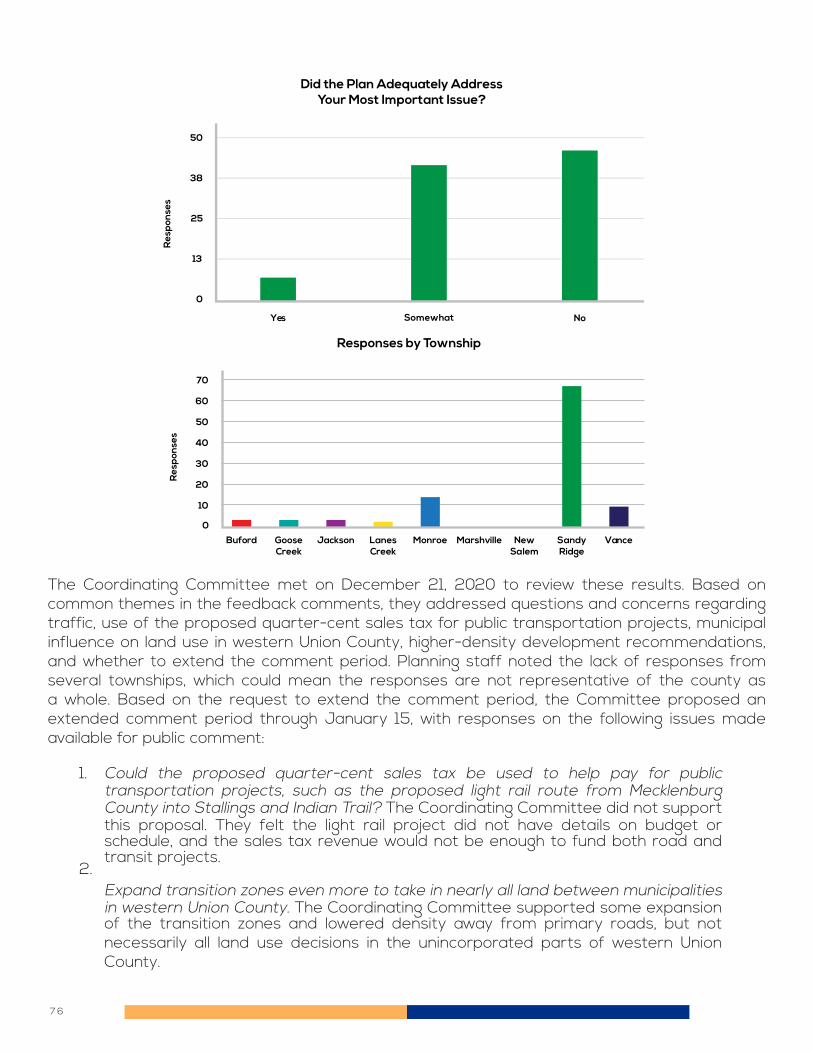
7 6
The Coordinating Committee met on December 21, 2020 to review these results. Based on common themes in the feedback comments, they addressed questions and concerns regarding traffic, use of the proposed quarter-cent sales tax for public transportation projects, municipal influence on land use in western Union County, higher-density development recommendations, and whether to extend the comment period. Planning staff noted the lack of responses from several townships, which could mean the responses are not representative of the county as a whole. Based on the request to extend the comment period, the Committee proposed an extended comment period through January 15, with responses on the following issues made available for public comment:
Could the proposed quarter-cent sales tax be used to help pay for public transportation projects, such as the proposed light rail route from Mecklenburg County into Stallings and Indian Trail? The Coordinating Committee did not support this proposal. They felt the light rail project did not have details on budget or schedule, and the sales tax revenue would not be enough to fund both road and transit projects.
Expand transition zones even more to take in nearly all land between municipalities in western Union County. The Coordinating Committee supported some expansion of the transition zones and lowered density away from primary roads, but not necessarily all land use decisions in the unincorporated parts of western Union County.
1.
2.
Responses by Township
Res
pon
ses
0
Buford JacksonGooseCreek
MonroeLanesCreek
VanceSandyRidge
NewSalem
Marshville
60
70
10
20
30
40
50
Did the Plan Adequately AddressYour Most Important Issue?
Res
pon
ses
Yes Somewhat No
50
38
25
13
0

7 7
The following graphs are the results of the extended comment period, and reflect the positions of the more than 260 residents who submitted a comment form. The issues addressed by the Coordinating Committee were included in the online comment form, with the public able to provide their level of support for the above Coordinating Committee responses. A total of 263 residents provided feedback on these revisions, with a significantly more representative response from throughout the county, as well as better reflecting the views of residents who have lived in Union County for more than just a few years. The overall result was positive, with 94 percent responding “yes” or “somewhat” to the question of whether they supported the plan with the proposed changes.
Enact a policy to deny rezonings that add traffic until funded road projects are completed. NC 16, NC 84, Monroe Road, and many other smaller projects continue to be delayed. Multiple residents have commented that new development should not be permitted until the road improvements are complete, which could be five to 10 years from now. The Coordinating Committee strongly supported this proposal, and would like the municipalities to enact similar policies.
Eliminate all multi-family (apartments and townhouses) land uses from the land use map in western Union County. Multiple residents from Sandy Ridge Township felt that higher density was incompatible with the current development pattern, and would add too much traffic and students, as well as harm the natural environment. The Coordinating Committee felt the new land use map already significantly reduces the amount of land for such land uses, and they are limited to key intersections along current or future multi-lane roads. Such development would not be supported until the road widening are complete, however.
3.
4.
Can the Quarter-Cent Tax be Used forthe Proposed Light Rail Route?
Res
pon
ses
Only Use the moneyfor Road Projects
The money should go to the best transportation projects,
regardless of mode
The money should beavailable for the
light rail route
160
120
140
20
40
60
80
100
0

7 8
Enact a Policy to Deny Rezonings That AddTraffic Until Funded Road Projects are Complete
Res
pon
ses
I agree - thesewidenings are alreadyneeded, so why permit
more development?
I mainly agree - but only todelay residential development.
We should still support commericialand industrial development
I disagree - development is a large part of our
economy and the delays are not their fault
0
160
180
120
140
20
40
60
80
100
Expand Transition Zones Even More to TakeIn Nearly All Land Between Municipalities
Res
pon
ses
I agree - expandingthe transition
zones makes sense
I’m mixed - the doughnuthole transition zones in
the map make sense, butnot more than that
I disagree - anydevelopment should
be annexed intoa municipality
I disagree - property owners should have the right to
rezone and develop in the County if it is consistent
with the Countyland use plan
80
90
60
70
10
20
30
40
50
0

7 9
Eliminate All Multi-Family (Apartments and Townhomes)Land Uses From the Land Use Map in Western Union County
Res
pon
ses
I agree with the Coordinating Committee - as long as the
roads are widened, it isappropriate to plan for some
higher density residential
I mixed - I’m fine with somehigher density residential,
but only inside themunicipalities
I disagree - there should onlybe large-lot single-familyresidential developmentin western Union County
0
160
120
140
20
40
60
80
100
What Township Do You Live In?
Res
pon
ses
0
Buford JacksonGooseCreek
MonroeLanesCreek
VanceSandyRidge
NewSalem
Marshville
80
90
60
70
10
20
30
40
50
The five subcommittees also reviewed the proposed responses at their January 2021 meetings, and provided their own perspectives. They were not provided the preliminary results of the community feedback as part of their meeting materials, so the feedback is solely based on subcommittee member perspectives. The results of these meetings, as well as the final conclusion of the Coordinating Committee, are shown in the table on the following page.
If the Propsed Changes were Made, Do YouSupport the Comprehensive Plan
Res
pon
ses
Yes Somewhat No
160
120
140
20
40
60
80
100
0

8 0

8 1
These changes are reflected in the Union County 2050 Comprehensive Plan report, and were seen as an improvement on the initial plan recommendations due to the round of feedback and response for the comprehensive plan report. The Coordinating Committee approved these new and revised strategies at its January 26, 2021 meeting. The document reflecting these changes was approved by the Coordinating Committee at its February 23, 2021 meeting. This action signified the conclusion of 14 months of diligent work by the 60 plus members of the five subcommittees and Coordinating Committee.

CONCLUSION
8 2

8 3
Union County 2050 was developed during unprecedented times. The plan development process began in mid-2019, when working or attending school from home was not common, and public engagement was still primarily conducted through face-to-face meetings. As the end of this planning process in early 2021, much of how the world works is different, but many of the issues relating to growth remain. Availability of the internet is now central to education, working, and commerce. The value of personal interactions has been highlighted, and public health is a community concern. Despite these changes, and perhaps even because of these changes, Union County remains an attractive place to live and raise a family.
The work of dozens of County residents over more than a year resulted in a broadly supported vision of a cooperative Union County. There was a recognition that addressing some existing issues, such as transportation and safe drinking water, would require additional funding commitments. Other issues, such as stormwater and inconsistent development patterns along corridors, are best addressed through the development process. The residents recognized that higher-density development isn’t appropriate everywhere in the county, and that rural character and a thriving agriculture industry is central to what makes Union County special. Residential housing options are needed in the county, and higher-density development should not be avoided when it allows developers and communities to create active, attractive destinations. The public, municipalities, and subcommittee members all aided in informing the Coordinating Committee on how they would like to implement the vision of Union County 2050. Hundreds of residents provided feedback on the various land use maps, regulatory changes, and new programs identified by the Coordinating Committee as feasible options. The results were clear – a new land use map with more focused high-development areas, coupled with more control by municipalities over “donut” areas, was needed. The feedback and eventual strategies included in the plan also reflected a recognition that addressing some issues would take money. Transportation, broadband internet, safe drinking water, and litter task force strategies were included in the plan. These recommendations each received strong support from the Coordinating Committee, which reflected a broad range of constituencies in the county.
By 2050, Union County will be home to over 370,000 residents. The recommendations found within this plan will help to create a home for those residents that is safe, resilient, efficient, and distinctive. Tens of millions of dollars will be invested in locally-supported transportation projects. Excess stormwater runoff and flooding will be prevented through new programs. Public health will be enhanced through safe drinking water. Walkable mixed-use destinations will be supported through land use and infrastructure decisions. Agriculture will continue to thrive. And Union County will continue to be known as a place that celebrates individual efforts and rewards hard work, while balancing being an active part of a thriving urban region in the scenic Southern Piedmont.
Conclusion

8 4
