uas atm airspace assessment - eurocontrol.int · to offer solutions where possible. the outcome of...
TRANSCRIPT

UAS ATM Airspace Assessment
Discussion Document

UAS ATM Airspace Assessment
Discussion Document
European Organisation for the Safety of the Air Navigation (EUROCONTROL) Directorate of European Civil-Military Aviation (DECMA) Aviation Cooperation and Strategies Division (ACS) Edition: 1.2 Edition date: 27th November 2018
UAS ATM Airspace Assessment
Edition: 1.2 3
DOCUMENT CONTROL
DISCLAIMER
© 2018 European Organisation for the Safety of Air Navigation (EUROCONTROL).
This Report makes use of information provided to EUROCONTROL by third parties.
All third party content was obtained from sources believed to be reliable and was accurately
reproduced in the report at the time of printing. However, EUROCONTROL specifically does not make
any warranties or representations as to the accuracy, completeness, or timeliness of such information
and accepts no liability or responsibility arising from reliance upon or use of the same. The views
expressed in this report do not necessarily reflect individual or collective opinions or official positions
of EUROCONTROL Member States.
Note
This document has been developed by EUROCONTROL in partnership with the European Aviation
Safety Agency (EASA) through several webinars. The authors would like to thank the participants in
these webinars for their precious contributions.
Intellectual property rights and reprint rights apply.
CONTACT PERSON
Name Unit E-mail
Peter Hullah DECMA/RTD/PPU [email protected]
DOCUMENT CHANGE RECORD
Edition No. Edition Date Reason for Change
1.2 27/11/2018 Initial Release
DOCUMENT APPROVAL
Name Role Unit
Paul Bosman Head of Division DECMA/ACS
Mike Lissone UAS ATM Integration Manager DECMA/ACS

UAS ATM Airspace Assessment
Edition: 1.2 4
TABLE OF CONTENTS
EXECUTIVE SUMMARY ............................................................................................................................ 6
1 Introduction .................................................................................................................................... 7
1.1 Intended Audience .................................................................................................................. 7
1.2 Organisation of this document ............................................................................................... 7
2 The problem .................................................................................................................................... 8
2.1 Current airspace assessment concepts and rules ................................................................... 8
2.2 Airspace assessment and Specific Operational Risk Analysis (SORA) ..................................... 9
2.3 The requirement for additional airspace assessment guidelines ......................................... 11
2.3.1 Ground Risk ................................................................................................................... 12
2.3.2 Air risk ........................................................................................................................... 12
2.3.3 Threat-related ............................................................................................................... 12
3 Proposal for new airspace assessment guidelines ........................................................................ 14
3.1 Introduction .......................................................................................................................... 14
3.1.1 The background to the guidelines ................................................................................ 14
3.1.2 The role of the guidelines ............................................................................................. 14
3.1.3 The scope of the guidelines .......................................................................................... 15
3.2 Preparation for an airspace assessment ............................................................................... 15
3.2.1 Ground risks .................................................................................................................. 16
3.2.2 Air risks .......................................................................................................................... 16
3.2.3 Aviation-related areas and volumes ............................................................................. 16
3.2.4 Non-aviation-related areas and volumes...................................................................... 17
3.2.5 Communication Navigation and Surveillance systems ................................................. 17
3.3 Performing the assessment .................................................................................................. 17
3.3.1 Phasing of assessments ................................................................................................. 18
3.4 Implementation .................................................................................................................... 19
3.4.1 Geo-awareness: geo-fencing, geo-caging and geo-restriction ..................................... 19
3.4.2 Websites and APPs ........................................................................................................ 19
3.4.3 Definition of responsibilities ......................................................................................... 19
3.4.4 CNS ................................................................................................................................ 20
3.4.5 Other technologies and data ........................................................................................ 20
4 Conclusions ................................................................................................................................... 22
5 References .................................................................................................................................... 23
Appendix 1 Current examples of airspace zoning ............................................................................ 24
Definitions, Acronyms and Abbreviations ............................................................................................ 25
UAS ATM Airspace Assessment
Edition: 1.2 5
LIST OF FIGURES
Figure 1 - Schematic representation of the SORA concept .................................................................. 10
LIST OF TABLES
Table 1 - Airspace Encounter Categories and Air-Risk Classes ............................................................. 11
Table 2 - Definitions, acronyms, and abbreviations ............................................................................. 26

UAS ATM Airspace Assessment
Edition: 1.2 6
EXECUTIVE SUMMARY
The many activities for which unmanned air systems (UAS) are used – from military through
commercial to leisure – can be performed by pilots who are not necessarily aware of the rules of the
air. They can therefore pose a serious safety threat if they fly over or near crowds or urban landscapes,
or close to roads or airports. UAS can also pose a very dangerous physical or economic security threat
should they fly near sensitive areas.
It is necessary, therefore, to determine which zones of airspace UAS may be permitted to fly in and
which they should be excluded from.
This document provides a basis for discussion on airspace assessment for integrating UAS into air-
traffic management (ATM), following a workshop and a series of webinars organised by
EUROCONTROL in collaboration with the European Aviation Safety Agency (EASA).
An airspace assessment involves taking a critical look at a certain airspace volume (including the CTR)
to identify the types of operation that will be conducted in that airspace, and examining the associated
air and ground risks.
There are several elements in an overall airspace assessment, including a possible re-design of the
airspace, CNS requirements, geo-fencing requirements, and possibly re-assigning a different airspace
classification. The outcome will define the areas and levels of air and ground risk as mentioned in the
JARUS Specific Operational Risk Assessment (SORA).
The UAS airspace assessment recommended here has many similarities with the existing methodology
for airspace design. It will be used in the first assessment that will be conducted in the CTR of RIGA.
The outcome of this will be used to further fine tune the initial approach and provide input for the
development of a UAS Airspace Assessment manual.

UAS ATM Airspace Assessment
Edition: 1.2 7
1 INTRODUCTION
This is one of a collection of three documents created to provide guidelines on distinct points raised
in the 1st UAS-ATM Integration Workshop organised at EUROCONTROL Brussels in April 2017. The
purpose of this workshop was to discuss how to integrate Unmanned Aircraft Systems (UAS) -
colloquially called "drones" - including Remotely-Piloted Aircraft Systems (RPAS), into the airspace in
a safe, secure and environmentally friendly manner. This will not only allow the harmonious
development of an industry that should bring growth and jobs, it will also help save lives by
substituting for manned aircraft in dangerous operations and assisting in emergency situations
through their ability for rapid deployment. Of course maintaining the safety of the airspace is the
major concern.
The three distinct points for which guidelines were considered necessary are:
• Flight rules;
• Airspace assessment (this document);
• A common altitude reference system.
Following on from the above-mentioned workshop, a series of webinars were organised in the first
half of 2018 to enable interested stakeholders to express their points of view on these questions and
to offer solutions where possible. The outcome of these discussions, presented here, is a proposal for
guidelines on airspace assessment that will be included in the yet to be agreed joint
EUROCONTROL/EASA UAS ATM Operational Concept document and will be taken into account in the
Concept of Operations produced by the on-going CORUS project.
1.1 INTENDED AUDIENCE
This document is primarily for use by stakeholders wishing to implement an airspace assessment or
its results. This can include civil aviation authorities, Air Navigation Service Providers (ANSPs), and
Unmanned Traffic Management (UTM) system providers. It should also provide useful background
information for users wanting to understand the impact of such assessments - drone operators,
manned aircraft operators, drone manufacturers, etc. However, it is hopefully written in a way that is
also accessible to any layman interested the problems related to integrating UAS into the airspace.
1.2 ORGANISATION OF THIS DOCUMENT
After this introduction, section 2 specified the problem statement and any specificities to this
problem, together with background information. Section 3 provides a set of recommendations for
discussion towards final airspace assessment guidelines with conclusions given in section 4.

UAS ATM Airspace Assessment
Edition: 1.2 8
2 THE PROBLEM
UAS are being used, and will be used more in the future, for many different activities, some state
(military - reconnaissance, attack etc.; land and marine border surveillance; policing - crowd
surveillance etc.; environmental protection and fire lookout; pollution detection etc.; search, rescue
and disaster relief), some commercial (agriculture - crop spraying etc.; inspection of infrastructure -
pipelines; bridges etc.; prospection - land analysis; archaeology; surveying; mapping etc.; cargo
delivery; aerial photography; broadcasting & cinema) and many for leisure.
The pilots of these UAS (especially those flying for leisure) are not necessarily aware of the rules of
the air and a good many are probably not even aware that rules of the air exist. They can therefore
pose a serious safety threat if they fly over or near crowds or urban landscapes, or close to roads or
airports. However, the EU implementing act and delegated act that are proposed to be adopted in the
coming months will address these issues. A safety promotion campaign being proposed at EU and
national levels will help raise awareness of these issues.
Additionally, UAS can pose a very dangerous physical or economic security threat should they fly of
sensitive areas such as power stations, military bases, government buildings, airports etc. The above-
mentioned implementing act envisages the setting-up of zones by NAAs to limit these risks.
The questions related to the risk of accident involving another user of the same airspace - helicopters,
hang-gliders, parachutists, etc. - are covered in the Flight Rule Guidelines.
It is necessary, therefore, to determine which zones of airspace UAS may be permitted to fly in and
which they should be excluded from.
2.1 CURRENT AIRSPACE ASSESSMENT CONCEPTS AND RULES
Article 1 of the Chicago Convention [ICAO, 2009] affirms that:
"every state has complete and exclusive sovereignty over the airspace above its territory".
The management of this airspace (other than for exclusively military matters) and the provision of air
navigation services for this airspace are usually delegated by the state to an ANSP.
In general, a state's airspace is organised into many blocks, each of which is assigned one of 6 possible
airspace classes [ICAO, 2012], depending on the requirements placed on the aircraft flying in that block
and the services provided to these aircraft. There are also zones that are forbidden to certain types of
aircraft for military or civil reasons (e.g. aircraft are not permitted to fly below 6,500ft above the city
of Paris without prior authorisation [JORF, 2017]).
Any modification to these blocks, the aircraft allowed, or any other changes to the functioning of the
Air Traffic Services provided in Europe must be in conformity with Commission Implementing
Regulation (EU) 2017/373 [EU, 2017]. Article ATS.OR.200 of this requires that ANSPs must have a
safety management system in place that includes:
"(2) Safety risk management
(i) A process to identify hazards associated to its services which shall be based on a combination of reactive, proactive and predictive methods of safety data collection.

UAS ATM Airspace Assessment
Edition: 1.2 9
(ii) A process that ensures analysis, assessment and control of the safety risks associated with identified hazards.
(iii) A process to ensure that its contribution to the risk of aircraft accidents is minimised as far as is reasonably practicable.
"(3) Safety assurance
(i) Safety performance monitoring and measurement means to verify the safety performance of the organisation and validate the effectiveness of the safety risk controls.
(ii) A process to identify changes which may affect the level of safety risk associated with its service and to identify and manage the safety risks that may arise from those changes. "
In addition, the Flexible Use of Airspace (FUA) regulation requires EU member states to ensure that a
safety assessment - including hazard identification, risk assessment and mitigation - is conducted
within the context of a safety management process, in order to maintain or enhance existing safety
levels, prior to introducing any changes to FUA operation.
At present, a risk-based airspace assessment is performed in accordance with these rules and with the
Acceptable Means of Compliance/Guidance Material (AMC/GM) to them [EASA, 2017] whenever
enhancements are made to a state's existing airspace structure. This includes any modification to
which areas of that state's airspace are assigned one of the 6 ICAO airspace classes, and any change
to areas managed under civil-military FUA.
None of these requirements were developed with the question of UAS in mind. However, Article 8
(Pilotless aircraft) of the Chicago Convention states that:
"... Each contracting state undertakes to ensure that the flight of such aircraft without a pilot in regions open to civil aircraft shall be so controlled as to obviate danger to civil aircraft."
The ANSP must, therefore, ensure that unmanned aircraft are not a danger to other aircraft. In states
where airspace has not been delegated to an ANSP, the state maintains this duty in this airspace. It is
also necessary that such UAs are also not a danger to people, structures or security.
Thus the basic tenet still holds; the responsible authority/ANSP must perform a risk assessment and
identify possible hazards when allowing UAS to fly in a given sector of the airspace. In most cases this
will mean assessing airspace to define areas where specific types of UA may or may not fly.
Many of the activities described above, and appropriate rules for their operation, have already been
envisaged in EASA Opinion 01/2018 [EASA, 2018], which also foresees setting-up no-drone zones or
limited-drone zones to alleviate some of the risk mentioned here.
2.2 AIRSPACE ASSESSMENT AND SPECIFIC OPERATIONAL RISK ASSESSMENT (SORA)
The Joint Authorities on Rulemaking for Unmanned Systems (JARUS) has developed guidelines on
performing a Specific Operational Risk Assessment (SORA) [JARUS, 2017]. EASA intends to adopt the
final version of the SORA, which will be available in early 2019, as an Acceptable Means of Compliance
for the risk assessment required from operators in the Specific category.
UAS can pose a serious safety and security threat. There is a real need to ensure that they only fly in
areas of airspace and in certain conditions in a way that will ensure the safety, security, privacy of

UAS ATM Airspace Assessment
Edition: 1.2 10
people, property and state apparatus to the greatest extent possible. The environmental impact
should also be minimised.
A SORA provides a method for minimising this: especially those aspects that concern the safety of
people or of property through assessments of ground risks and air risks.
A SORA looks at these risks from the operator’s perspective. It proposes a means of evaluating risks
and mitigations to enable an authority to authorise a given operation. It analyses whether the
operator has ensured all that is required to conduct a safe flight, i.e. it deals with the pilot, the aircraft,
the airspace, and people and infrastructure on the ground.
The SORA concept is based around the idea of the “hazard” that a UAS operation could become “out
of control”, which the guidelines consider in its widest sense of its being conducted outside of its
approved conditions. It looks at the “threats” that could cause this loss of control and the impacts (or
“harms” as it calls them) that it could have. The risks of these “harms” occurring are divided into
ground risk and air risk. SORA enables the operator to specify the barriers and mitigations to these
threats and impacts that have been put in place to minimise these risks. This is shown in Figure 1.
For the ground risk, ground risk classes are assigned and barriers that can mitigate the death and
destruction on the ground are identified. The final lethality of the ground risk can then be determined.
If the operation in question is BVLOS over a populated area with a UA of 3m or more, or VLOS over a
populated area with a UA of 8m or more, the ground risk is so great that the SORA is not an appropriate
tool for ensuring safety.
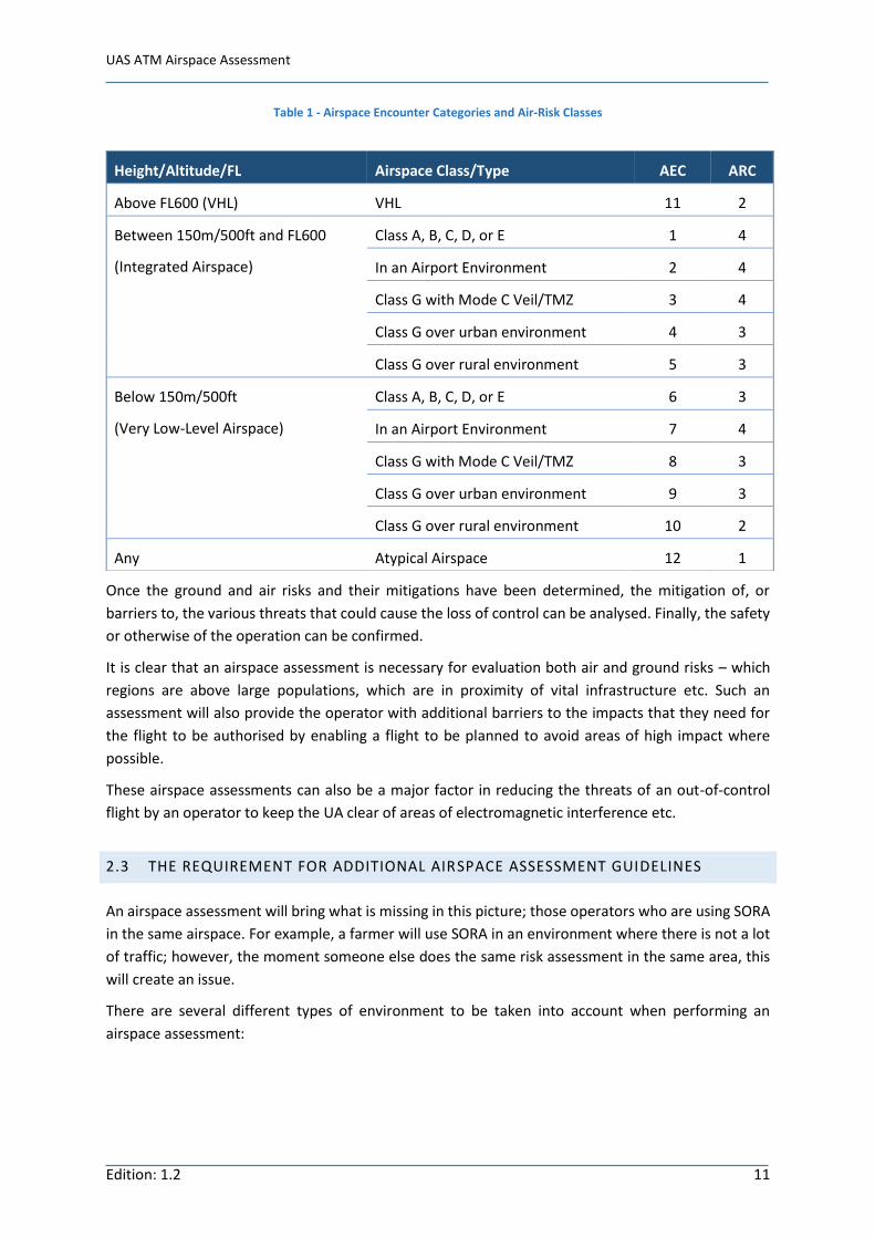
Similarly, the perceived level of air risk – the risk of a mid-air collision - is incorporated though an
Airspace Encounter Category (AEC) for a given region of airspace. The SORA method assigns an Air-
Risk Class (ARC) ranging from 1 (low risk) to 4 (high risk) to these AECs – see Table 1 – based on three
factors: the rate of proximity, dependent on the number of aircraft assumed to be in the airspace; the
geometry of the aircraft, use of specific routes etc., in the airspace; dynamics, or how fast aircraft
travel in the airspace. Measures can be proposed to reduce these impacts.
Threat 1
Threat 2
Threat 3
Threat n
Barriers to
Threat 1
Barriers to
Threat 2
Barriers to
Threat 3
Barriers to
Threat n
Air deaths
Ground
deaths
Damage to critical
Infrastructure
Barriers to
Air deaths
Barriers to
Ground deaths
Barriers to
infrastructure
damage
Ground risks
Hazard
(UAS Out
of Control)
Air risk
Figure 1 - Schematic representation of the SORA concept
UAS ATM Airspace Assessment
Edition: 1.2 11
Table 1 - Airspace Encounter Categories and Air-Risk Classes
Once the ground and air risks and their mitigations have been determined, the mitigation of, or
barriers to, the various threats that could cause the loss of control can be analysed. Finally, the safety
or otherwise of the operation can be confirmed.
It is clear that an airspace assessment is necessary for evaluation both air and ground risks – which
regions are above large populations, which are in proximity of vital infrastructure etc. Such an
assessment will also provide the operator with additional barriers to the impacts that they need for
the flight to be authorised by enabling a flight to be planned to avoid areas of high impact where
possible.
These airspace assessments can also be a major factor in reducing the threats of an out-of-control
flight by an operator to keep the UA clear of areas of electromagnetic interference etc.
2.3 THE REQUIREMENT FOR ADDITIONAL AIRSPACE ASSESSMENT GUIDELINES
An airspace assessment will bring what is missing in this picture; those operators who are using SORA
in the same airspace. For example, a farmer will use SORA in an environment where there is not a lot
of traffic; however, the moment someone else does the same risk assessment in the same area, this
will create an issue.
There are several different types of environment to be taken into account when performing an
airspace assessment:
Height/Altitude/FL Airspace Class/Type AEC ARC
Above FL600 (VHL) VHL 11 2
Between 150m/500ft and FL600
(Integrated Airspace)
Class A, B, C, D, or E 1 4
In an Airport Environment 2 4
Class G with Mode C Veil/TMZ 3 4
Class G over urban environment 4 3
Class G over rural environment 5 3
Below 150m/500ft
(Very Low-Level Airspace)
Class A, B, C, D, or E 6 3
In an Airport Environment 7 4
Class G with Mode C Veil/TMZ 8 3
Class G over urban environment 9 3
Class G over rural environment 10 2
Any Atypical Airspace 12 1

UAS ATM Airspace Assessment
Edition: 1.2 12
2.3.1 GROUND RISK
2.3.1.1 PEOPLE
Population-related
• Permanently or cyclic populated areas (cycle < 1 day)
• Dense areas (city centre streets, etc.)
• Sensitive areas (schools, hospitals, etc.)
• Occasional or seasonal events (concerts, stadiums, beaches, etc.)
Security-related
• Military barracks
• Summits
• VIP protection
2.3.1.2 INFRASTRUCTURE
Industry-related
• Permanent and non-permanent industrial sites
• Chemical and Nuclear sites
• Laboratories
• Windfarms, power stations
• Cranes
Transport-related
• Airports, aerodromes and identified take-off and landing sites, model-flying sites
• Roads and highways
• Harbours
• Rail
Security-related
• Military areas
2.3.1.3 ENVIRONMENT-RELATED
• Animal Reservations
2.3.2 AIR RISK
• High probability of traffic (hospitals, etc.)
• Seasonal or permanent recreational activities (base jump, flying suits, kite surf, etc.)
• Localised events (hotels water jets, geysers, etc.)
• Airports, aerodromes and identified take-off and landing sites, model-flying sites
2.3.3 THREAT-RELATED
• Electro-magnetic wave-emitting sites (radars, high-voltage lines, solar farms, etc.)
• GNSS-outage forecast areas

UAS ATM Airspace Assessment
Edition: 1.2 13
The role of an airspace assessment is to determine which areas of airspace are to be assigned to which
classes of airspace. However, whereas traditional airspace classes are categorised based on the
services provided to pilots in those airspaces, in the case of UAS the categorisation will also be a
function of where those UAS are allowed to fly, what equipage they need to fly there, etc.
These guidelines must define the new classes of airspace and provide an indication of how an airspace
assessor should allocate areas to these classes.

UAS ATM Airspace Assessment
Edition: 1.2 14
3 PROPOSAL FOR NEW AIRSPACE ASSESSMENT GUIDELINES
3.1 INTRODUCTION
3.1.1 THE BACKGROUND TO THE GUIDELINES
The requirement for the safe integration of drones into the European airspace means that airspace
assessments, which will enable common and harmonised rules and scenarios, are essential. They will
also enable operations at a local level and at low altitudes where not all the dangers/obstacles are
provided by aeronautical maps.
Airspace assessment is not a new subject and these guidelines have been produced in the light of
lessons learnt from "traditional" airspace assessment.
3.1.1.1 EASA CATEGORIES
EASA has defined three drone categories (Open, Specific and Certified) [EASA, 2015] and these are
useful segregators of assessments. However, it is quite clear that knowledge of regulation, airspace
structure, etc. is different for users of the Open category (e.g. toys) than those of the Specific and
Certified categories whose operators may need to be trained. And while EASA is developing standard
scenarios for the Specific category, regular (recreational) drone operators will generally only want a
very simple overview of where/when they can fly. They will either be scared off if rules are too
complicated, or they will simply go and fly illegally. To some extent, this can be compensated by a
safety promotion campaign or, as has happened in other areas, users could be provided with a tool to
highlight the rules that concern them.
The main issue, therefore, is how to communicate information to the user. The regulations that result
from the use of these guidelines must be tailored depending on the target audience. A common
solution such as a unified application or database could alleviate this problem.
3.1.2 THE ROLE OF THE GUIDELINES
These guidelines are a means for the states to understand what is involved in an “Airspace
Assessment”. For example, if an operator wants to conduct a Specific Operational Risk Assessment
(SORA) [JARUS, 2017] they have to understand where the air risks lie and also be aware of the ground
risks. These are the results of an “Airspace Assessment”.
An airspace assessment by the state both enables the open category to fly safely, perhaps with the
help of a mobile app, and provides important static and dynamic data input to enable the specific
category to perform a SORA. This document both enhances, therefore, the SORA process and gives an
overarching airspace perspective.
These guidelines are designed to help the responsible authorities take good decisions by listing areas
that must be taken into consideration and risks that may be encountered when assessing airspace for
use by drones. They provide a means (methodology) for avoiding these risks. However, the perception
and use of drones is different in different countries, although the EU rules soon to be adopted will

UAS ATM Airspace Assessment
Edition: 1.2 15
bring a degree of harmonisation. It is essential, therefore, that these guidelines not limit those who
want to do more than others.
These guidelines and the airspace assessments produced by following them are highly related to flight
rules and the guidelines for these should also be consulted.
3.1.3 THE SCOPE OF THE GUIDELINES
Drone access to a given zone is generally dependent on the airspace zone flown in, the area overflown,
the drone’s equipage/type, its operator’s qualifications, and the type of operation to be conducted.
These guidelines cover airspace assessments for all airspace below 150m (500ft) and all types of drone
flight. They cover the airspace inside CTRs as well as in general Class G airspace. However, the ground
(mountains, fields, forests, ground elevation) and the buildings, facilities, etc. that man has placed on
it are as important as the airspace and will greatly determine where assessments should be carried
out. Environmental and social aspects such as noise and privacy are included, as well as questions
concerning liability. Weather is an important factor.
These guidelines consider that current ICAO airspace classifications will remain in force and that
standard definitions of CTR hold. However, some member states are discussing changing the lower
boundary of a CTR structure from ground level to 500ft AGL, making the lower part class G. This could
affect UAS airspace classification and should be taken into account by the responsible authorities.
It should not be forgotten, however, that manned VLL operations can occur everywhere, not only in
the vicinity of helipads or airports. The current airspace limitations on VFR flights may also apply to
UAS depending on the structure of the airspace.
It is difficult to envisage a common, standard rule engine that covers all flights and all airspace; these
guidelines will aid the responsible authority in producing the right rules for a given combination.
3.2 PREPARATION FOR AN AIRSPACE ASSESSMENT
When preparing an airspace assessment it is important to take all the factors that come into play
during this analysis into account. These include:
• Ground risks
o obstacles, buildings, etc.
• Air risks
o uncontrolled airports, paragliders, gliders, known areas for GA
• Critical aviation-related areas and volumes
o Airports
arrival and departure routes (SIDs and STARs), sensitive areas
o Helipads
• Critical non-aviation-related areas and volumes
o Critical industry
o Military facilities (airbases, shooting ranges, etc.)

UAS ATM Airspace Assessment
Edition: 1.2 16
o Protected VIP zones
• CNS
o areas where CNS can be impacted
These are each handled separately in the following subsections.
In looking at these factors, it is important to take every possible use of drones into account. For
example, whilst it is considered important that drones not fly over nuclear power plants, military
based or inside airports, the operators of these facilities may wish to contract drones for inspection
and other legitimate purposes. Even areas of natural beauty may require drones for forest surveillance
at some times. No zones can therefore be truly considered drone-free zones.
3.2.1 GROUND RISKS
Ground-related risk are both areas where the ground, or obstacles on it, may be a risk to drone flights,
and also areas where drones may be a risk, or a threat, to the ground and people or critical
infrastructure on it.
In the former, attention needs to be paid to sharp relief, cliffs; to isolated tall buildings; to the
boundaries between rural and urban areas; and to electricity pylons and cables, for example.
In the latter case, unauthorised drones may pose a threat to airports and aerodromes; military
installations; nuclear facilities; critical infrastructure such as bridges, dams, telecommunications
centres; areas of natural beauty; schools, hospitals, and other public buildings. They must also be kept
clear of cities and towns, and crowds.
3.2.2 AIR RISKS
The airspace below 150m (500ft) is not empty, even in areas far from aerodromes. Many other users
share the airspace and this use must be taken into account. In many cases these other users may be
anywhere in the airspace. This is the case for general aviation, gliders, etc. On the other hand, there
are areas where such use is likely to be more prevalent: around, and on departure/arrival paths of,
uncontrolled airports; near hospitals equipped for air ambulances; near areas used as start points by
paragliders or balloonists; etc.
Other users of the airspace need to be aware of drone flights in their vicinity and vice-versa. When
preparing an airspace assessment, such questions as what interface is needed between drone
operators and GA; how a glider pilot would be made aware of a planned drone operation along the
cliff where he is intending ridge soaring; need to be answered. In most cases, all users will need to
inform a central system where they will be flying. The means of disseminating this information –
nowadays most likely through one or more cloud-based mobile apps - should be included in an
airspace assessment.
3.2.3 AVIATION-RELATED AREAS AND VOLUMES
In general, an airport vicinity is defined by the CTR around it and most authorities forbid the use of
drones in this zone. It is clear, however, that there are parts of this CTR where operators would want

UAS ATM Airspace Assessment
Edition: 1.2 17
to fly drones for specific applications such as runway inspections, bird control, and weather
measurement. It would appear logical, therefore, to redefine the CTR to include areas that are defined
as a “No-Fly Zone” and areas where UAs could be operated with ATC coordination. Even the no-fly
zones could be opened up to drone flight if the runway is closed to normal traffic, for example.
Since operations in these zones would be carried out in tight coordination with the ATC provider at
the airport in question, it is evident that there is no need to respect a general limitation to 150m
(500ft); the operational envelope should be agreed between the relevant parties as should the
services that ATC will provide to the drone operator, the separation standards to be applied etc.
When assessing airspace around an airport, it is important to consider whether it just has an ILS
approach or whether VOR or NDB approaches should be included. The missed approach segment also
needs to be considered. If there is also VFR traffic at the airport, VFR routes should be assessed in a
similar way.
3.2.4 NON-AVIATION-RELATED AREAS AND VOLUMES
Drone activity may pose a threat to military installations; nuclear facilities; critical infrastructure such
as bridges, dams, telecommunication centres; areas of natural beauty; schools, hospitals, and other
public buildings. They must also be kept clear of cities and towns, and crowds.
The protection of VIPs (both physical safety and private life) has to be taken into account in the
airspace assessment. Some states are very concerned about privacy because of the specific population
they host.
3.2.5 COMMUNICATION NAVIGATION AND SURVEILLANCE SYSTEMS
Radio frequency is a very important aspect of modern life and especially of drone operations.
Communication, navigation and surveillance all rely heavily on the ability of radio waves to travel
unimpeded between the drone, its ground control station/pilot, satellites, and navigation beacons etc.
Should interference be encountered, this can cause: loss of the drone’s command and control (C2)
link leading to contingency procedures being undertaken; loss of GNSS data leading to the drone’s
losing height and position information; loss of ADS-B coverage meaning that air-traffic management
loses awareness of the drone’s position with respect to other traffic; and other problems.
It is important, therefore, that areas that could be responsible for a loss of radio cover, whether from
high-power transmission nearby or owing to ground features or buildings that might interrupt the
signal, be taken into account when assessing the suitability of airspace for drone use.
3.3 PERFORMING THE ASSESSMENT
An airspace assessment defines a set of attributes for each volume of airspace: the ILS protected zone;
the area above a power station; open country below 500ft; etc. Right of access to any airspace zone
is then limited to aircraft that meet certain criteria. For example, a drone could be used to test an
airport’s ILS by flying in the protected zone when required; however most drones would be
permanently excluded from this zone for obvious reasons.
UAS ATM Airspace Assessment
Edition: 1.2 18
Performing an airspace assessment starts with building a “reference scenario”. This is the baseline of
the operations within the volume being assessed. It will look at inputs from the AIP, airspace users,
ATC, and all other relevant parties that conduct or support operations. It is important to identify areas
for improvement and to maintain the same levels of safety.
The assessment:
• builds a real time perspective of what and how operations are conducted and what
requirements are set to enable safe operations (CNS, ATS etc.);
• defines the geo-fencing requirements to ensure existing operations are not negatively
impacted;
• assigns the airspace encounter categories and air-risk classes, based on the reference scenario.
This is followed by the airspace design phase. Here the drone operations envisaged are included. Once
this part is finalised procedures must be developed to support the intended operations, with or
without support of a UTM system. It is important in this phase to determine the technical airspace
requirements on all airspace users in this assessed airspace volume.
The assessment requires quite some time and effort. The reference scenario is also an important
baseline for the validation. The validation, generally conducted using a real time simulation
environment, will assess several scenarios against the reference scenario, ensuring that the intended
operations do not pose new safety concerns.
A UAS airspace design manual, based on the results of the airspace assessment that will be conducted
in the RIGA CTR in early 2019, will be produced during 2019.
3.3.1 PHASING OF ASSESSMENTS
The European Union’s U-Space initiative describes an environment that should allow the whole drone
framework, including economics, incubators, and smart cities, to grow; traffic is a very small part of
this. U-Space is a framework of services, regulations and capabilities that will be introduced in four
phases over the period 2019-2030. While it would be good to have all airspace assessments available
from the start in order to avoid repeating the work involved, it is highly unlikely that this will be
possible. It is more likely that the development of Unmanned Traffic Management (UTM) - and with
it, airspace assessment - will be linked to the U-space service blocks.
People generally need time to accept new technology in their everyday lives, otherwise it can have a
negative impact. In addition, an immature technology may lead to accidents and misconduct, creating
different types of problem. It is considered, therefore, that UAS technology should initially be
introduced into specifically designed areas, e.g. controlled airspace areas and corridors. As people get
used to seeing UAs operating in these specific areas, and become more comfortable and confident
with the technology, the operators and regulators can increase the area allocated to them. This will
give the technology time to develop further, especially in the fields of sensors, navigation, monitoring
and networks. Technological improvements in automation and decentralisation will also bring about
new types of airspace control that will seamlessly take UAS into account. It is possible that, in the near
future, a different type of airspace control could be created for UAS, where the control system would
operate in a more automated and decentralised manner than is the case today.
UAS ATM Airspace Assessment
Edition: 1.2 19
3.4 IMPLEMENTATION
3.4.1 GEO-AWARENESS: GEO-FENCING, GEO-CAGING AND GEO-RESTRICTION
The draft EU implementing and delegated acts envisage geo-awareness and other features for the
design of certain drones. Geo-awareness gives rise to the ability to create “geo-fences” that a drone
must stay one side of, of through which their passage may be controlled. Geo-fencing applications are
becoming available that are capable of preventing drones from approaching restricted areas, such as
airports, or on the contrary, ensuring that they do not fly outside of a given authorised area.
Such systems could be used to restrict access to certain areas of sensitive airspace (geo-restriction) or
to create “dronodromes” where, for example, novice open category users could play without
interfering with other airspace users (geo-caging). Deciding which of these will apply to a given
airspace zone is one of the major tasks of airspace assessment.
As this technology improves, with quantitative measures and precision methods based on reliable
error margins and manned aviation data, errors can be reduced and safe operational areas can be
mapped. However, these areas should not be fixed. Based on these technological advances, the
relevant authority could decide to re-define security limits, allowing drones to operate closer to
airports for example.
3.4.2 WEBSITES AND APPS
The casual, open-category UAS user does not have a thorough knowledge of airspace elements, and
does not need to know all of the complicated rules of the air. They need a means that makes it clear
for them what they can do given a certain operation, based on these complicated rules. They need a
simple means of obtaining information - for example a mobile app or a web site; often the same
product is available in both formats.
These apps can give users the possibility of validating a flight at a given location, so that they
immediately know whether such a flight is legal and possible. They can provide an overview of all
traffic in their vicinity and alert pilots to drone traffic, manned aviation traffic and no drone zones,
given instructions to the pilot if necessary. They can give real-time global situational awareness
showing a tracked drone on one map. They can be produced in versions rebranded to take the
specificities of a local ANSP into account.
Several countries – Poland, France, Spain – as well as several private companies already provide apps
with some or more of these services.
3.4.3 DEFINITION OF RESPONSIBILITIES
Whenever regulations are defined, and airspace assessment is no exception, the rights and
responsibilities of the different players also need to be. Many of these are covered in the flight-rules
guidelines. However, it is pertinent to cover some of these aspects here for completeness.
The 4D typology of an airspace assessment, and the data that accompany it, could be developed and
updated by any of several different organisations: an EU agency; member-state administrations; or a

UAS ATM Airspace Assessment
Edition: 1.2 20
private company. However, both the assessment and the data bring responsibility and liability, which
could be on the developer, the publisher, or the owner of the final information.
Not all obstacles can be identified and published as the result of an assessment, so a drone must be
able to rely on its own sensors to stay clear of trees, masts, etc. and this can be considered the
operator’s responsibility. Additionally, buildings cause local wind turbulence in VLL, and MET in
general is not good enough for UAS flights; the operator must bear responsibility for the decision to
fly, and the performance of the flight. This operator should also be considered responsible for ensuring
that they respect any changes in official airspace assessments.
UAS operations can interact with other ATS/CNS providers whose responsibilities and liabilities are
defined in its contract with its authorising administration. In the case of UTM via an app, the developer
of the app may also have to accept some share of responsibility for the information given to the
operator.
(In the USA, the Federal Aviation Authority is responsible for the basic infrastructure of the whole
management of drones below VFR level - both the flight planning and the cloud services. Apps that
the operator interacts with sit on top of this FAA backbone. It is not yet known whether such a concept
will also be used in Europe.)
3.4.4 CNS
It is unlikely that ATM surveillance will be able to operate in VLL the way it does for manned aircraftː
UAS will need to be able to self-separate using e-identification (eID), required for certain drones by
the draft EU rules, and detect-and-avoid technologies to exchange information between themselves,
and thus not rely on ground-based systems and connectivity for separation. This ability will largely
depend on the level of CNS capabilities available in a given airspace zone.
An example of these capabilities is navigation using EGNOS - a good solution for operating in high risk
zones. Here the system monitors the GPS signal itself, alerting for deviations/outages, thus providing
better quality, as well as higher accuracy information. European GNSS solutions (EGNOS and Galileo)
should be used as much as possible for eID, geo-fencing and tracking/surveillance. Such solutions also
enable communication and surveillance over sea.
Mobile network coverage is another major enabler of CNS requirements for drones. The tracking
capabilities and the navigational aspects (geo-fencing for instance) that can be offered could be very
important here in the near future as networks evolve from 3G and 4G to 5G.
A classification for these capabilities, similar to the airspace classification used in manned aviation
(e.g. “VLL airspace classes”), could be defined for UAS in the future and may then be integrated into
airspace assessments.
3.4.5 OTHER TECHNOLOGIES AND DATA
It is likely that different solutions, depending on the capabilities of the UAS involved, will be available
in the future. Novel 3D structures that model new UAS environments (e.g. densely populated urban),
attribute risk (static and dynamic) as well as generating route topologies should become available.

UAS ATM Airspace Assessment
Edition: 1.2 21
A cluster structure such as grid minimum off-route altitudes (MORA), used today for clearing
obstacles, could simplify the process of airspace assessment.
NOTAM content related to airspace assessment could be inserted automatically into the UAS airspace
database. However, there is a need to be able to specify positions more precisely than currently in
NOTAMs for dynamic obstacles, i.e. using 6 decimal places (≈ 0.11m).
UAS operations will probably require the AIS format to be changed and this implies making an addition
to AIXM in order to cater for UAS-relevant data.
In general, it is likely to be necessary to rethink attitudes towards easier distribution of airspace data
to the general public and UAS users, e.g. the concept of “open data”. As part of this, dynamic data
should include the areas where Open category UAVs are actually flying (not just where they might be
flying).

UAS ATM Airspace Assessment
Edition: 1.2 22
4 CONCLUSIONS
At its simplest, an airspace assessment involves taking a critical look at a certain airspace volume
(including the CTR) to identify the types of operation that will be conducted in that airspace, and
examining the associated air and ground risks.
There are several elements in an overall airspace assessment, including a possible re-design of the
airspace, CNS requirements, geo-fencing requirements, and possibly re-assigning a different airspace
classification. As stated above, the outcome will define the areas and levels of air and ground risk as
mentioned in the SORA.
An airspace assessment has many similarities with the existing methodology for airspace design and
covers the following phases:
• Airspace analysis
o Airspace users
o Airspace structure
o CNS
• Identification of positive and negative aspects
• Identification of required UAS operations
• Design of airspace
o Airspace volume
o Routes
o Geo-fencing
o CNS requirements
• Safety approach and safety case
• Development of supporting procedures
• Validation (simulation)
• Implementation
• Feedback loop and improvements
This methodology will be used in the first assessment that will be conducted in the CTR of RIGA. The
outcome of this will be used to further fine tune the initial approach and provide input for the
development of a UAS Airspace Assessment manual.

UAS ATM Airspace Assessment
Edition: 1.2 23
5 REFERENCES
EASA, 2015. Technical Opinion - Introduction of a regulatory framework for the operation of drones. European Aviation Safety Agency, Cologne. Available at https://www.easa.europa.eu/sites/default/files/dfu/Introduction%20of%20a%20regulatory%20framework%20for%20the%20operation%20of%20unmanned%20aircraft.pdf
EASA, 2017. Acceptable Means of Compliance (AMC) and Guidance Material (GM) to Commission Implementing Regulation (EU) 2017/373. Initial issue 8th March 2017. European Aviation Safety Agency, Cologne. Available at https://trainingzone.eurocontrol.int/doc/LEX/Regulations/2017-373-AMC-GM/content.htm
EASA, 2018. Opinion 01/2018 "Unmanned aircraft system (UAS) operations in the ‘open’ and ‘specific’ categories". European Aviation Safety Agency, Cologne. Available at https://www.easa.europa.eu/sites/default/files/dfu/Opinion%20No%2001-2018.pdf
EU, 2017. Commission Implementing Regulation (EU) 2017/373 of 1 March 2017 laying down common requirements for providers of air traffic management/air navigation services and other air traffic management network functions and their oversight. Available at http://eur-lex.europa.eu/legal-content/EN/TXT/PDF/?uri=CELEX:32017R0373&from=EN
ICAO, 2009. Convention on International Civil Aviation of 7 December 1944. Doc 7300 Ed. 9. ICAO, Montréal. Available at https://www.icao.int/publications/Documents/7300_9ed.pdf
ICAO, 2012. Annex 11 to the Convention on International Civil Aviation of 7 December 1944; Air Traffic Services Chapter 2, Section 2.6. ICAO, Montréal. Available for purchase at https://www.icao.int/
JARUS, 2017. Guidelines on Specific Operations Risk Assessment (SORA). Joint Authorities for Rulemaking of Unmanned Systems. Available at http://jarus-rpas.org/sites/jarus-rpas.org/files/jar_doc_06_jarus_sora_v1.0.pdf
JORF, 2017. Journal Official de la République Française no. 0215 du 14 septembre 2017. Arrêté du 12 septembre 2017 portant création d'une zone interdite temporaire, identifiée ZIT Paris (Paris), dans la région d'information de vol de Paris. Legifrance. Available at https://www.legifrance.gouv.fr/eli/arrete/2017/9/12/ARML1724359A/jo/texte
SJU, 2018. Blue print on U-space. SESAR Joint Undertaking, Brussels. Available at https://www.sesarju.eu/sites/default/files/documents/reports/U-space%20Blueprint%20brochure%20final.PDF

UAS ATM Airspace Assessment
Edition: 1.2 24
APPENDIX 1 CURRENT EXAMPLES OF AIRSPACE ZONING
Examples of zoning maps are already available from several countries:
• Denmark provides a zoning map at https://www.droneluftrum.dk
• Poland provides one at http://ai.pansa.pl/dron/. Some of the zones indicated on this map are
implemented in the drones' own geo-fencing hardware, e.g. a no-fly zone near the National
Stadium in Warsaw, though these are sometimes not based on state-authorised data.
• The Netherlands has a static drone map in place, and a dynamic drone map information is
currently being produced. The Netherlands defines a "no drone zone" as an area near a
harbours, industry, cranes, populated areas, electromagnetic radiating sources, gliding sites and
hospitals etc. However, this is very hard to communicate to drone users, since it is quite
complicated. They are looking at UTM as a means of informing all types of user using one source
of verified information.
• The FAA has produced UAS Facility Maps that can be found at http://uas-
faa.opendata.arcgis.com/datasets?keyword=uasfm.
• ANS CR are currently trying to define a similar grid for UAS operations within CTRs, with
maximum allowable altitudes as a function of terrain altitude and the minimum altitude of
airport protection zones.
Maps such as these have brought several problems to light; for example, it is difficult to get roads,
towns, rails, and people onto the map. The UAS operator still needs, therefore, to evaluate the local
circumstances before flying.
U-Space Services Implementation Monitoring Report
Edition 1.2 25
DEFINITIONS, ACRONYMS AND ABBREVIATIONS
Term Definition
ACAS Airborne collision avoidance system
ADS-B Automatic dependent surveillance-broadcast
AFUA Advanced Flexible Use of Airspace
AGL Above ground level
AIM Aeronautical information management
AIRAC Aeronautical information regulation and control
AIS Aeronautical information service
AMC Airspace management cell
ANS Air navigation service
ANSP Air navigation service provider
ASBU Aviation systems block upgrades
ATC Air traffic control
ATCO Air traffic control officer
ATM Air traffic management
ATZ Aerodrome traffic zone
BRLOS Beyond radio line of sight
BVLOS Beyond visual line of sight
C2 Command and control link
CAA Civil aviation authority
CEF Connecting Europe facility
CFR Code of Federal Regulations
CNS Communications, navigation, surveillance
COM Communications technology
CONOPS Concept of operations
CPDLC Controller pilot datalink communication
CTR Control zone
D&A / DAA Detect and avoid
DTM Drone traffic management
EAD European aviation database
EASA European aviation safety agency
EC European commission
ECAC European civil aviation conference
EDZ Exclusive drone zone
EOC Essential operational change
eIDAS Electronic Identification and Trust Services
EU European union
EVLOS Extended visual line of sight
FCC Flight control computer
FIS Flight information service
FL Flight level
FLARM Flight alarm
FOC Full operational capability
FPL Flight plan
FUA Flexible Use of Airspace
GA General aviation
GANP Global air navigation plan
GIS Geographic information system
GRA Generic risk assessment
HALE High-altitude long endurance

U-Space Services Implementation Monitoring Report
Edition 1.2 26
HIRAT High-intensity radio transmissions
HFR High-level flight rules
IBAF Integrated briefing automated facility
ICAO International civil aviation organisation
IFR Instrument flight rules
JARUS Joint Authorities on Rulemaking for Unmanned Systems
LDZ Limited drone zone
LFR Low-level flight rules
LSSIP Local Single Sky implementation
MASPS Minimum aviation system performance standards
MATZ Military aerodrome traffic zones
MET Meteorological
MOPS Minimum operational performance specification
MoT Ministry of Transport
NDZ No drone zone
NOTAM Notice to Airmen
RCC Rescue coordination centre
RLOS Radio line-of-sight
RPA Remotely piloted aircraft
RPAS Remote piloted aircraft system
SERA Standard European rules of the air
SESAR Single European sky ATM research
SID Standard instrument departure
SIM Subscriber identification module
SJU SESAR joint undertaking
SORA JARUS standard operational risk assessment
SRA Strategic risk assessment
STAR Standard terminal arrival route
sUAS Small unmanned aircraft system
TDD Traffic dynamic data
TMA Terminal area
TRA Tactical risk assessment
TSD Traffic static data
UAS Unmanned aircraft system
UAV Unmanned aerial vehicle
UIR Upper information region
UTM Unmanned traffic management
UTMS Unmanned traffic management system
VFR Visual flight rules
VHL Very high level VLL Very low level
VLOS Visual line of sight
Table 2 - Definitions, acronyms, and abbreviations