u. s. geological survey, trace elements memorandum report
TRANSCRIPT

\(200)
U. S. Geological Survey,Trace elements memorandum report
no. 360, 1952.


UNITED STATES GEOLOGICAL SURVEY
TEM-360
ByR. M. Moxham
This preliminary report it released without editorial and technical review for conformity with official standards and nomenclature, to make the information available to interested organizations and to stimulate the search for uranium deposits.
July 1952
Prepared by the Geological Survey for the UNITED STATES ATOMIC ENERGY COMMISSION Technical Information Service, Oak Ridge, Tennessee

GEOLOGY AND MINERALOGY
In an effort to save you.'and your government time and money, this report has been reproduced 'direct from copy as submitted to :the;,Technical Information Service.
AEC, Oak Ridge, Tenn.-W26676
CONTENTS
.eeo»oooeooo«ooooe 000090 6' :-. . . , . . . . . , ........ .,...,- ; - ,.'('---
Radioactivity measurements.. e o 0 ..°»«»<> <> *.» <> 0 .. e.. * o .. 8
Extent of coverage O oo*oo*oo«oo«oe««ooe«o»e«oo»ooo«» 10
Interpretation of radioactivity anomalies«o« 0 «*oo.oo 11
LOCatiOn Of anOinalieS ooooo. 00000000000000000000.000 13
Rock Corral area.. o .«.« * '. <,.« . .., »» 0 <> «, 0 o o <,. ? «»<> e «o o 18
General geology. '.. ' . 9 »o« ' 0 «o 0 » J o o«. 000*0. o o«'<» o« 13
Previous investigations.» 9 .... .,;.. ..«.o«<,o.o ..*.<> o 0 « . 19
Occurrence of radioactivity anomaliesoooo..ooe..ooo«<, 20
Interpretation df anomalies..;;.... 0 «. «,' ' *' ' ' . bo»e,o'o« 21
Searles Station area 0 .. 0 o.' o»V 0 « 0 «, O.oV <> 0 o »e o ««,«o <»«. «o 22
aoo«o»««eooo«ooe900»* « » 2.2. ' "i v "! .', - i '
Occurrence of radioactivity anomalies. e<, 0 ooo c «oooooo 22
Soledad area»o.o.»o««o*oa»o«o«oo«eo»o«oo»*«<>eo«ooo0ooe*eo 23
General geOlOgy « «oooooooo*oooe<»oooao«*«eo»ooooeooe«« 23
Previous investigations.*e»*"ooe-*o^ooeooeo.oojio«.«»e«oi » 24
Occurrence of radioactivity anomalies.. 0 .o 0 0 0 o 0 «« 0 o 24
" ill t>0 xanK. arOae ooo.ooooavaeoeoo... OAO. ..000000000000*090 *~S
o.oooooooooeooooooooo»«« 25

Page
Previous investigations................................... .26
Occurrence of radioactivity anomalies...................... 26
Harvard Hills area............................................. 28
Summary...'........... ̂ .'.....,............'...................... 28
References............'................................«>........ 30
ILLUSTRATIONS
Figure 1. Index map of southern California...................... 72. Block diagram of scintillation detection
equipment...................................a....... 93. Airborne radioactivity survey in the Rock
Corral area, San Bernardino County, California. 0 ...o 31 1 h." Airborne radioactivity survey in the Searles
Station area, Kern County, California.............o. 325. Airborne radioactivity survey in the Soledad
area, Kern County, California....................... 35' 6. Index map of the White Tank area, showing the
area surveyed 0 ..000.00.0.<........0.000.00 ...0000.00000 277. Airborne radioactivity survey in the White Tank
area, San Bernardino and Riverside counties,
TABLE
Table 1. Airborne radioactivity anomalies in the Mojave Desert, California. .' .......,..,.',

AIRBORNE RADIOACTIVITY SURVEYS IN THE MOJAVE DESERT REGION, KERN,
RIVERSIDE, AND SAN BERNARDINO COUNTIES,. CALIFORNIA* . ....
R. Mo Moxham , .
ABSTRACT* ; ' : " "'^ "
Airborne radioactivity surveys in the Mojave Desert region, Kern,
Riverside, and San Bernardino counties were made in five areas recom-'
mended as favorable for the occurrence of radioactive raw materials i
(1) Rock Corral area, San Bernardino County. '
(2) Searles Station area, Kern County 0
(3) Soledad-area, Kern County . ' .
White Tank area, Riverside and San Bernardino counties,
Harvard Hills area, San Bernardino County '. r '
Anomalous radiation was detected in all but 'the Harvard Hills area, "The
radioactivity anomalies detected in the Rock Corral area are of the
greatest amplitude yet recorded by the airborne equipment over '
natural sources. The activity is apparently attributable to thorium-
bearing minerals associated with roof pendants of crystalline metamorphic
rocks in a granitic intrusive,, In the Searles Station, Sbledad, and
White Tank areas, several radioactivity anomalies of medium amplitude
were recorded, suggesting possible local concentrations of radioactive
minerals. . ' ... ' - - ' ' . ;
is report concerns work don© on behalf of the Division of Raw
Materials of the U 0 S 0 Atomic Energy Commission,,

INTRODUCTION
The airborne radioactivity surveys in the Mojave Desert region,
California, were made on March 21 and 22, 1952, by the U, S 0 Geological
Survey as part of a cooperative program with the U. S 0 Atomic Energy
Commission, The following five areas (figo 1) in Kern, Riverside, and
San Bernardino counties were surveyed:
1. The Rock Corral area of about 80 square miles in the south western part of San Bernardino County is on the northeast flank of the San Bernardino Mountains, approximately 50 miles northeast of the city of San Bernardino 0 . .
2« The Searles.Station area of about 28 square miles is in the northeastern part of Kern County. Searles Station, which lies a few miles east of the"surveyed.area, is on the Southern Pacific Railroad about 8 miles north of the town of Randsburg.
3. The Soledad area of about 50 square miles is in the south western part of Kern County, a short distance south of the town of Mojave,
4» The White Tank area of about 30 square miles is on the boundary between San Bernardino and Riverside counties. White Tank, a spring and watering station, is in the south-central part of the area» The town of Twentynine Palms is. at the northwest corner of the area.
5« The Harvard Hills area of about 12 square miles is in the west-central portion of San Bernardino County,, Harvard Siding in the western part of the area is on the Union Pacific Railroad approximately 21 miles east of Barstow.
The Surveys were made with scintillation detection equipment
mounted in a. Douglas DC-3 aircraft. A nominal 500-foot flight level
was maintained during all traverses, and the distance of the aircraft
from the ground was measured and continuously recorded with a radar
altimeter. Aerial photographs were used for pilot guidance, and the
flight path of the aircraft was recorded by a gyrostabilized continuous-
strip film camera.

120°
EVA DAI N Y 0
KERN oBakersfield
SEARLES STATION AREA
! HARVARD HILLS AREA
SAN
ROCK CORRAL AREA
WHITE TANK AREA }^.^- /O/ oSan Bernardino
' rot-
R S I D E
SAN DIEGO IMPERIAL
EX ICOI20 II6C
FIGURE I. INDEX MAP OF SOUTHERN CALIFORNIA
Figure 1
J

The areas surveyed were recommended by D« F. Hewett of the c : >,..5;.' ' :
Geological .Survey based on his knowledge and reconnaissance of ..the]...... Vl -
Mojave Desert region; G. W. ^'alker gave advice on the specific areas' ;
to be surveyed. Acknowledgment is .made to F« J. Davis, P. ¥ Reinhardt,;
and T.. J. Bortner, all of the Health Physics Division^ Oak Ridge ;,
National Laboratory, for the design, development 9 'and flight operation .
of the scintillation detection equipment* J, L0 Meuschke.,of-the :
Geological Survey prepared the pre-flight.data and'supervised the'flight?
operations.. . , .; .'''-'... V .. ] ' ' .'. '. ..;,...., ' './''. .:' .'.:A'-. :.:.;"'.. .. . ; ' -\ ' />
, .. ' RADIOACTIVITY MEASUREMENTS ^ .' ; ^'> ' ' > ;
All radioactivity measurements were made using scintillation
detection equipment developed ;by the Oak'-Ridge National Laboratory,:
Division of Health Physics, in cooperation with the Geological Survey, (
The components of the scintillation detection equipment are shown in
figure 2. ' ' " . .. ' .-:-. '' .... .... . . -."'. . - : - ------
The radiation detectors proper are 2-inch thick by 4-inch
diameter crystals of thallium-activated sodium iodide* Six such ;
crystals are used, in two groups of three, each* - Standard,RCA 5819.','.*' -r '' .' ' ' 'l " V' " '
photomultiplier tubes collect the scintillations from the crystals
and feed the resultant pulses into the amplification stages,,

HIGH VOLTAGE
RADAR ALTIMETER
CRYSTAL (No I)
TIMER
ALTITUDECONTROL
PRE AMPLIFIER
LINEAR AMPLIFIER
COUNT RATE RECORDER
E-A
RECORDER
BLOCK DIAGRAM OF SCINTILLATION DETECTION EQUIPMENT
Figure 2

10
The count rate recorder is a new development and is essentially
similar to a scaling circuit,. The incoming signal is measured over a
one-second period and is recorded in the following one-second period.
A continuous record is provided by two channels in the recorder which
alternately measure and record the gamma radiation intensity. This)' " -" ' *' ' ' '' ; ^- " ' ' ' "' <."' - * « > « ' ' » ^-* - « " " - " ^
' development is a-considerable improvement over the usual coutitirig-rate :;
^meter .(Stead,.; 1951). ... .._ . ',: J ' v .!.L. ... } i. ...,".; '.:: l.;^:!'_;.,'
Automatic correction of the radiation intensity for variation inlj'*.. »!..- i.', rj*.* JU . . " J . ; .,.. - ,* ..... ^ ..--,,. j..,'.-- - . ,»-
'i- ' ' ' i , ' ' v ' !distance'of the aircraft above the^gro'und is; achieved by using the
'fadar-'altimeter output to modify the "out put'of the count rate recorder*
\ - ; :v » '-' J - ; ;. v Extent of coverage;I . ;«- ";'. :^;"/': : .- ' . .'(-. '""'", ;/'.» : ' > .}; T'.-.' r i-i : ' 7 ./A S ' - - At' a nominal 500-foot'flight level, 'the width of ''the-zone- -- -' '
-from-which radioactivity is measured is at least 1,400 feet. Thus,
. at-,quarter-mile spacing of flight lines or 1,320-°foot intervals, the
entire area should be adequately covered.
In order to complete the Mojave Desert surveys in the allotted
time, ..it. was neces'sary/:in '-some instances to us^e .a ;flight'"'lirie -Spacing of
half a mile, or 2,640v :feeV; ; ^This^ preliminary flight pattern did not
give full coverage of the areas surveyedj but, with proper orientation
of the flight lines with respect to the geologic conditions, the coverage
was sufficient to delineate the grosser features of the radiation
intensity pattern. Where significant anomalous radiation was detected,
intermediate flight lines were subsequently flown so that the final
flight-line pattern in areas of interest had an approximate quarter mile

n
0r 1,320-foot.spacing, giving complete 9overage. . ....-,...
Interpretation of radioactivity anomalies
The interpretation of radioactivity anomalies is based on the
observed 'response of the scintillation"detection' equipment under controlled
conditions, both for point and broad sources of radiation,, The data
which have been acquired during previous airborne surveys and experi
mental flights indicate'that point sources of radiation of moderate..' : i,.'.
intensity, such as a few milligrams of radium or vein networks, mine
dumps, and other localized concentrations of small area! extent, tend
to produce anomalies of medium amplitude and of relatively'short duration,
usually less than'16 seconds at 500 feet above the groundo Broad
sources of'weakly radioactive materials, such as outcrops' of granitic
stocks", tend to produce broader anomalies of medium amplitude of more
than l6-second duration.' & point source of intense radiation, such
as several grains' of radium, increases'both the duration width and
the amplitude (height)'of ah anomaly; such a point "source will produce
an anomaly of more than 16-second duration with an amplitude much greater
than that produced by a broad source "of weakly radioactive materials»
Thus, a radioactivity anomaly'is arbitrarily defined in terms of
width and -amplitude of' the anomaly0 : ' We1 cahnot interpret the anomaly in
terms of either the radioactive content or the actual surface distribution
of the radioactive 'materials causing the anomaly. Actually, the size

(area under curve) of an anomaly is proportional to the product of grade
in percent uranium times the area over which that grade is exposed«
Based on measurements over known sources supported by theoretical cal
culations, the grade in percent uranium multiplied by the area in square
yards is a constant of about 20$ that is, a 1.0 .percent uranium ore
exposed over 20 square yards would produce the same anomaly as 0.1
percent ore over 200 square yards, or 0*01 percent over 2,000 square
yards.
The radioactivity anomalies described herein have been classified .
for practical purposes by width, with four categories defined by the
duration of an anomaly in seconds, and by amplitude, with two categories
defined by multiples of the range of variation of radiation measurements
for the area adjacent to the anomaly Range is herein defined as the
extreme limits of variation (approximating three times the standard
deviation of individual measurements) about the average level of radia- ,
tion measurements adjacent to the. anomaly 0 Multiples of range are
measured from the average level of measurement adjacent to the anomaly
projected through the area of the anomaly,,
The four categories for width of anomaly are:
Designation Map symbol Hidth (duration in seconds)
! Sharp* peak ~~T~ less than 8 seconds
2» Peak ^ S-16 seconds
vV3. Broad peak ^^ 16-32 seconds
4. Very broad peak Q 32 seconds
13
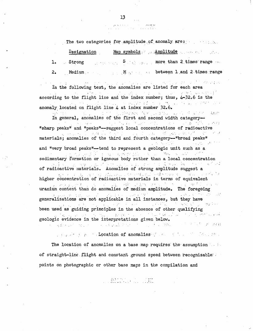
..The two categories for-amplitude .,pf anomaly, are:; :;./.>..
Designation Map symbols.. r :,, Amplitude . , -v. > . ; -.-.
1. ... Strong S : , . ;> , more, than 2. times'range >
2. Medium.,- . ; ,H . ,; -. : between 1 .and 2-times-range
In the following text, the anomalies are listed for each area
according to the flight line and the index number; thus, 4-32 0 6 is the
anomaly located on flight line 4- at index number 32«6.
In general, anomalies of the first and second width category
"sharp peaks" and "peaks 11 suggest local concentrations of radioactive,. ..-. .'.' -.-i -" ' ' v ' . ' . - ' . ' '- : ..' '-' - ' ' ' " ' ' ' '
materials; anomalies of the third and fourth category "broad peaks"'.' '.' ' . ' ; ' ' ' ' "
and "very broad peaks" tend to represent a geologic unit such as a
sedimentary formation or igneous body rather than a local concentration
of radioactive materials 0 Anomalies of strong amplitude suggest a
higher concentration of radioactive materials in terms of equivalent
uranium content than do anomalies of medium amplitude,. The foregoing
generalizations are not applicable in all instances $ but they have
been used as guiding principles in the absence of other qualifying
geologic evidence in the interpretations given below.
. :-, :' " ! r ' .Location of anomalies : r ' ' ' ." -.. : : .
The location of anomalies on a base map requires' the assumption . :
of straight-line. flight and constant ground speed between recognizable: :
points on photographic or other base maps in the compilation and

plotting of flight data. Thus, if the distance between such points is
large, the error in estimated location midway between, the points may
be considerable,, A- second factor introducing error in estimated
location is the small variable lag in recording attributable to
imperfections of linkage among the different instruments in the aircraft,
Adjustment for a consistent and uniform lag in recording has been made,
but some additional error in location is inevitably introduced by the_...'( . . .
small variable lag, probably not exceeding 200 feet along the flight
line. The error in estimated location of anomalies resulting from
these two factors may be several hundred feet in the direction of the
flight path of the aircraft,
A third and by far the most important factor introducing error
in the estimated location of an anomaly is the indeterminate position
of the radioactive material causing the anomaly in the plane normal
to the flight path of the aircraft The location of a given anomaly
may be estimated to within a few feet in respect to the ground point
vertically below the aircraft. However, because the scintillation
detection system will easily "see" a source at an air distance of as! i.'. ' . '
much as 1,000 feet, the true ground position of the source detected at
a nominal 500-foot flight level may be as much as 850 feet from the
estimated or apparent location on either side of the flight line in a
direction normal to the'flight line. In investigating the nature of

ibhe radioactive material causing'an anomaly, it .is.advisable to .examine'
the area within a radius of 1,000 feet from the estimated location of..' : ": ' ' ' :.'' . ''- ' ; .r!l
the anomaly. _ .. :: '-: :. "!.:. ; ..--.' .1 ' '- '- ' l \*l ;. :'
Lacking suitable base-maps 'in the Rock Corral and Searles Station
areas, it was necessary to plot the anomalies on planime'tric maps . . > '."
traced from uncontrolled photomosaics, so that considerable distortion
in horizontal position may be expectedo^ The''true geographic locations
of the anomalies can not be determined from these compilations but <
sufficient details of the planimetry have been shown to-permit location'.'. "*'" u ,'.' ' . .1
with respect to recognizable features of the topography^ drainage, ^
culture. '' .' : : ' - < '
All anomalies detected during the surveys of the various areas
are listed in Table 1, which gives the flight line, index number,
anomaly width and amplitude, and remarks.

16
Table 1. -Airborne radioactivity anomalies in the Mojave Desert, California.
FlightLine Number Width Amplitude Remarks
23.3 : . .34;
44 444- 31.5 Very broad peak S off scale5 . .555666677788889910111112 7A 7A 7A 7A 7A 7A 6A 6A 6A 6A 6Aa
IndexNumber
AnomalyWidth Amplitude
Rock Corral .area
46.362,363.379*7U.515.5.19-2024.52731.554-861.564e2
73.3-74.209192129.357.364.568.223*535.237.339.274.376o547-4901.501.922.487.892.493.897.802.606.924.32830.431.835.839.9
Sharp peak .. . .do.
Broad peakSharp peakVery broad peak
do.do.
PeakSharp peakVery broad peak
do.Broad peakVery broad peak
do.do.
Very broad peakPeak .; . . .Very broad peak
do.Sharp peak
do.Very broad peakSharp peakPeakBroad peakVery broad peak
do.do.
PeakVery broad peak'Broad peakPeak
do.Very broad peakSharp peak
do«Very broad peakSharp peakBroad peak
do<>Very broad peakPeakVery broad peak
, , MM. s-MSSs ..MM :S
-.:. S. ....
MMS
, s . ss . ..<MM .MSMMMMMMMMMMMMMMMSMS ;SSMM

Flight Line
5A 5A 5A-5A 4A 4A 4A 3A 3A 2A- 2A
4A3A'2A
3321
3566
IndexNumber
' '".'' '' ". '
46.153:: ,54.5 ..58.8, ....76-7889,-: .- ;-. .91.5-93.2
.01.3 .. , .15-15.825*8 ' i42.7
46.9 - ::'29.218,2 .17.7
i / "i . .99 74.2 ' :
44.348.215.6
- ;-' ' -
52.825ol32.4 '-' 32.6
:; .Anomaly ,-,Width Amplitude
Rock Corral area
Very broad peak. - ' .dO.- ".-. .'.. ".-, '
Peak':. ' -dO. .' : <"". . if.>'
Very broad peakv " do.- . -..- ,.;, : ' ;
do., Broad : peak u. . -.. ,
Very broad peak- .- .dO... - ;.- ;, ,.-:
f ^... d° R ,,, ., ., ,Searles Station;
Peak .: ' ;!; ::-,:. ;>>.;Broad peakVery, .broad . peakSharp peakPajaV r cJoJl . .1 , ..
do."Sharp peak'-.' /.-. : ..
Soledad area
Peak- ' do. . :
do.
WMte Tank area
Sharp peakPeak
; Sharp peak ;do.
(Cont'di
S: -..S, ; .-
S. s
S -S - -:-.
S : --M., -.
S ;-. M -V -" M
area-j ;,- .
-'.-M.-::.
M: .M- :: :.
M ' < M""T' .'
M,. . Mr/:r ,'"' : '"' : ' (-
M :'M
M
.. . .-
MM
M"
M
Remarks
.o££ scale
off scale

18 ,'
EOCK CORRAL AREA
... . General. Geplogy . , ": / . .
A reconnaissance map of the geology of the northwestern part of ' !. -. .
the Rock Corral area, showing the major features, has been made (Yaughan,
1922).. No-geologic mapping has been done'In the eastern.part of the .area.
The oldest rocks in the Rock Corral area are schist's, gneiss, arid
meta-sediments of probable pre-Cambrian age.. Vaughan has mapped several
outcrop areas of these units west of .Rock Corral.which-is at the extreme'. '; '_ \ ' ' ' I '' ' .:
west end of the surveyed .''area. In more recent investigations Hewett.'
has found other areas of crystalline metamorphic rocks, as yet unmapped,
in the immediate vicinity of Rock1- Corral.. : ,
The schist, gneiss, and meta-sediments have been .intruded by acidic
rocks, which occupy the major portipn. of the: Rock Corral ..area. Several
periods of intrusion have: been recognized but. the two principal lithologic
types are quartz monzonite, which in much -of. the area -is porphyritic or
coarsely crystalline, and the Cactus granite, a gray-colored, uniformly
coarse-grained rock. The Cactus granite is Cretaceous in agej the quartz
monzonite is pre-Cactus in age but a more specific age assignment has
not been made.
Pegmatites and fine-grained -acidic .-dikes have been found in
numerous places. . ... - -.
In the extreme southeastern part of the. area there., are remnants
of basaltic lavas which were extruded during.Quaternary time. The general
distribution of the flows as plateau remnants is indicated on fig. 3 by
topographic form lines.

19
Unconsolidated deposits of Quaternary age,, comprising fanglomerate,
glacial till, alluvium, terrace deposits, and detritus, mantle the.
bedrock in many parts of the area, particularly the ; northern.and, western
partso . :..,' ,. . > . -,-, ' . i v *. ..-:
No mining.of significance has been ; dpne.,in this. area*. .Several. ,
gold prospects, have been found but nothing of : commercial,interest is;. r- .
known, . ... \
Prospecting for radioactive ore has been parried on in <..the Rock
Corral.area.since the discovery of small masses of, thoriurarbearing .
rock in 19A9o . .Claims, have been, staked on - several prospects about ,. ; ... ..
2 miles east of Rock Corralo At least one, shipment, ofr .ore .has been
made for testing purposes but-no further production has been attempted*
\
Previous,Investigations
A' reconnaissance of the Rock Corral area was made early in 1952 by
Walker and Baumgardner<, Radiometric traverses by car were made along
most of the passable roads in the area, and anomalous radiation was
detected at several localities«
Hewett, Walker and Baumgardner later examined some.of the occurrences
of thorium-bearing rocks which had been reported by' prospectors^(Trace
Elements Monthly Report, February 1952, p0 ' 19) <> It was found that the
radioactive minerals, including apatite, zircon, and monazite, were
associated with small patches of biotite-rich roof pendants (?) in
quartz monzonite porphyry.

20
' ' Occurrence'of radioactivity anomalieis
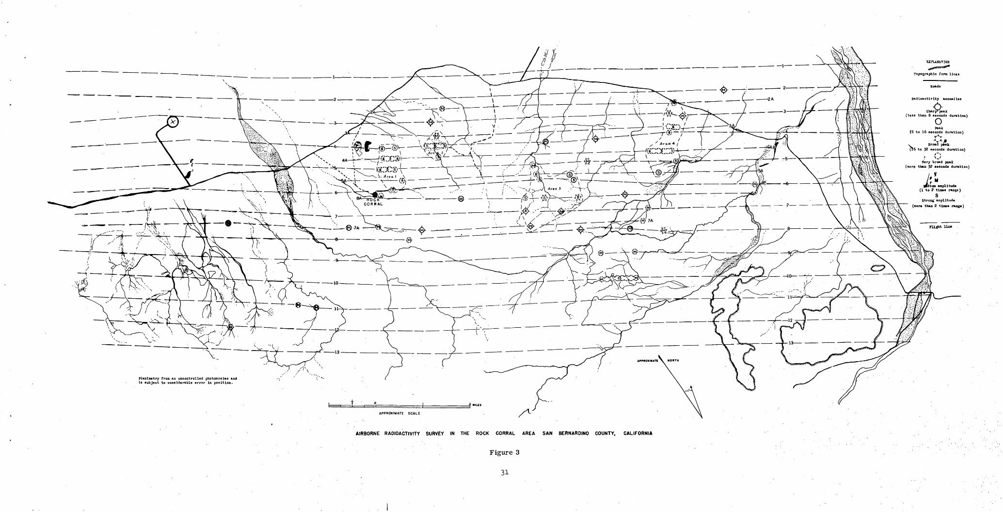
The radiation pattern in the Rock Corral area includes anomalies' of
the greatest intensity yet recorded, by the airborne-scintillation
detection equipment over natural sources. Anomalous radiation, detected
in many parts of the Rock Corral area," occurs mainly in four small areas
which lie to the northeast and. east of "Rock Corral and are shown on
figure 3. -
Anomalies classified as "strong" occur in these four areas, out
lined by dashed lines ; on : figure 3V approximately 3/2 mile northeast
(Area 1), 1 mile northeast (Area 2), 2 1/2 miles east (Area 3), and
4- miles east (Area 4)? of Rock Corral, ' -
' The anomalies'of greate'st amplitude in the Rock Corral area are
in Area 4. The peak intensity of anomalies 4A-76 and 4 31«5 exceeded
the maximum limit of the E-A recorder 0 Both are relatively wide,
exceeding 32 seconds in duration. ,
One very broad anomaly, 5A-53, which also exceeded the maximum,
limit of the recorder, was detected in the northern portion of Area 3j
and other strong anomalies ranging .from average to very broad in width
were also found in this area*
Strong, very broad anomalies were detected in Areas 1 and 2 but
in general their amplitudes are somewhat less than those in Areas
3 and 4» . , .

21
Several sharp anomalies of medium amplitude were found north and
south of the principal areas described above
Interpretation of .anomalies ; .-, - ....;
It seems unlikely that the anomalous radiation in the Rock Corral
area is due solely to the mass effect of disseminated accessory minerals
in the granitic rock which underlies most of the area. If such were the
case, it would seem logical to expect a higher level of average radiation
rather than the abrupt changes which were recorded., There seems to be
no correlation between the occurrence of the anomalies and the known
distribution of the Cactus granite intrusives, so that the increase in
radiation intensity is apparently associated with either the pre-Cactus
quartz monzonite or the pre-Cambrian metamorphic rocks 0. . ' ; ' .''.... .'.'.. 3 ''.''
The previous work of "Hewett and Vlaiker has shown that radioactive
minerals are associated with roof pendants of pre-Cambrian rock in
the quartz monzonite. No geologic maps are available showing the areal
distribution of the roof-pendants, but the aerial photos of the region
suggest they are present in the areas of anomalous radiation<> It seems
likely that the pendants may be responsible, at least to some degree,
for the increased radiation level. . .
In many places the anomalies appear to be over or near-.stream valleys,
which suggests the possibility of local concentrations of .radioactive-
accessory minerals on the surface of.the alluvium in intermittent
drainages. This might be a. plausible explanation for anomalies 7A-87»8
and 2-46.3 which are a considerable distance away from any bedrock
discernible on the aerial photos of the region.
22
SEARLES STATION AREA
General geology
The rocks of the Searles Station area range in age from Paleozoic
to Miocene (fig. 4). The oldest units, which crop out in the south
western part of the area, are composed of marine limestones, chert,
clay shales, and sandstones of Paleozoic age. The Paleozoic strata
abut against the Garlock fault on the south; to the north and east
they have been intruded by the Atolia quartz monzonite of Jurassic age
which occupies the central and northern part of the Searles Station
area. In the southwestern part of the area, non-marine clay,
sandstone, and conglomerate of the Rosamond formation of Miocene age
overlie the undifferentiated Paleozoic sediments.
The area is noted chiefly for gold mining although both silver
and tungsten are important commodities in the region immediately to
the south. Torbernite and autunite are reported to have been found in
a rhyo-dacite at Summit Diggings (6 miles north of Randsburg) which is
about 2 1/2 miles east of the southeast corner of the surveyed area0
Occurrence of radioactivity anomalies
Seven anomalies were detected in the Searles Station areaj their
locations are shown on figure 4 0 All the anomalies in the area occur
within the outcrop area of the Atolia quartz monzonite. Anomalies
1-74-.2 and 3-17.7 are sharp peaks; 4A-4-6.9* 3-14»l, and 2-99 are peaks;
3A-29»2 is a broad peak; 2A-18..2 is a very broad peak$ All are of medium

amplitude,- .-:,_: .;.: ,-. ; i;;-. ;. ..-,,;" ...,;..- : v-". ; .' .r - - - v / *:; ! "'I ,,
..,.. .Anomalies 3-14,|l> 2?99, and 1-74 «> 2 -are rather, .close.ly, grouped, ..in-. :.
an area about 2 miles due west of Laurel Peak; the others occur in,
widely., separated areas, both to the north ^.nd south^.. ff ... .,. , ,.,, y
In the absence -of qualifying geologic :data, -it. seems adyisa^le. t.o.
regard the sharp peaks and peaks as indicative of possible concentrations. . \j .. .,. .' ' . .' . '.!.".. .. ' '
of radioactive materials; the broad and very broad peaks suggest
differentiates in the quartz monzonite of somewhat higher radioactivity
cropping out over a relatively large area0
....... _. , SOLBDAD
General geology :.;
The major, part of the... .bedrock,, in the .Soledad ar; ea is; -quart z ; iiionzonite ' ** - '* k r~ * ' i . . '.. . ./ ' ; « .. - * ,. -.*
of upper Jurassic age, (fig.- 5)..- The _. plulbonic /rocks rfprm- : the> basemeitLt ;...;-
on which later .sediments, and e.xtrus.ives'.were ; deppsitecU, -The younger m?
rocks , members . of the .Rosamond formation . of . Miocene :age.j, . comprise, ,. chiefly
non-marine arkpsic sandstone, .conglomerates,, boulder, beds, chert,: 'tuffs;,
breccias, flows, and intrusive bodies of dacite =and basalt CSimpson, 1934-) «
The rocks described. above ; are .exposed i,n the Rqsampnd Hills, a
fault block which rises, above the level of. the Quaternary .alluvium,- of
the adjacent .desert plains and. valleys e . ,. -,..-. , , ,- \ ,.= -. j ;
Numerous fault s; have been observed in .the Soledad area* .Probably ;:
the most significant of these is the Rosamond fault which forms .the- .
southern boundary of the Rosamond Hills, This is a normal fault, dipping
steeply to the south, and with an estimated minimum vertical displacement

of 800 feeto There is some evidence that the fault has exercised some
control over ore deposition in" the western part of the area, (Simpson,
p. 406V : "- ' : - ' " ' ' :
The area is noted 'primarily ifor ; lode gold mining,- particularly in
the' southern and western portion of the Rosamond Hills,
Previous investigations
An autunite deposit has been located about 5 miles northwest of
Rosamond, approximately 100 yards west of the Tropico-Mojave road, at
an elevation of 2,775 feet (point A, fig. 5)» The site was examined
briefly by F. M. Chace (1950) who did not' consider the deposit of
economic interest at that time* -
' ' The autunite is disseminated through'a l-^foot thickness of "
tuffaceous sandstone of the Rosamond formation,' which crops out along
the base of a cliff, ' The mineralized zone v/as traced for a lateral *''
.-distance of about 40 feet and for approximately ̂ 20 feet up the dip0
Insufficient work was done at that time to determine the precise extent
and potentialities of the deposito '
Occurrence of radioactivity anomalies
Three anomalies were recorded in the Soledad area (figo 5).
Anomalies 2-44«3 and 4A-15«6 are about 4 miles northeast of Willbw
Springs* Anomaly 2-^4^02 is approximately 2' 1/2 miles northeast of
Willow Springs. ' '

The autunite deposit previously found in this area (point A,
fig* 5) lies almost directly beneath flight line 7 but no radioactivity
anomaly was detected. Apparently the distribution of radioactive material
at this particular place is not substantially greater than indicated
by Chace's brief investigation.
Two of the recorded anomalies, 2-4A<>3 and 4A-15»6, are about 2 1/4
and 1 1/2 miles due west of point A, respectively, and are within the
same geologic formation 0 Both are classified as peaks of,medium
amplitude and are thought to indicate possible local concentrations of
radioactive material. The''proximity to a known ; autunite occurrence and
the similarity of the geologic setting are at'least ;so suggestive 0
Inoinaly 2-4B. 2,"classified-as a peafk of medium'amplitude, is'
situated'in an entirely'different" geologic environment', being near" a" ""''
fault, contact .'between'' Jurassic- quartz' monzonite and -a dacite flow of 1 ' "
Miocene age. As. neither the quartz monzonite-nor the dsicite flows' ' '' ' '
exhibited anomalous radiation elsewhere, concentration of radioactive
material seems to be indicated at this locality,; -' - ' ' -'"
WHITE TANK AREA
General geology
The southern part of the White Tank area, which is of primary
interest, is underlain chiefly by igneous and metamorphic rocks ranging
in'age from pre-Cambrian to Jurassic 0 The oldest is" the Pinto gneiss
which occupies most of-the'eastern and'southern parts of the- area,v
26
Locally, the Pinto formation contains bands of meta-sediments, but for
the most part it is composed of metamorphic facies of granitic and
gabbrc dioritic rocks 0 To the northwest the Pinto rocks were intruded
during the Jurassic period by the White Tank monzonite 0 On the southern
border of the surveyed area, Quaternary alluvial deposits occupy a basin
south of a prominent fault scarp (Miller, 1938)
The region is noted principally for its past gold production,.
No mining activity has been reported for several years e
Previous investigations .
A brief reconnaissance of the.central part of the area was made
by Wyant (1949)« Radioactive minerals derived from the White Tank
monzonite were found in moderate, concentration on the surface of the
alluvium near Live ;0ak Tankc A small radioactivity anomaly -was found
by ground surveys about 2.6 miles north of Live Oak Tank and was
attributed to thorium-bearing accessory minerals associated with a
pegmatite in the Pinto gneiss 0 . .
Figure 6, an index map of the White Tank area, shows the general
orientation of the flight lines. The area of particular interest,
which includes roughly the southern half of the region, is shown in
figure 7o
Occurrence of radioactivity anomalies.
Anomalies 3H520 8, 6-32c 4., 6~32.6, and 5-25.1 were recorded by the
airborne equipment in an area 3 to 4 miles south of White Tank. Their

x±
[*Nm PCRN**P<NO CQ.~RlV6R5IPe CO-
TREEV NATIONAL MONUMENT
/
INDEX MAP OF THE WHITE TANK AREA SHOWING THE AREA SURVEYED
10 Milt.
Scale
Figure 6

locations are shown on figure 7.
Anomalies 3-52.8, 6-32.4-> and 6-32*6 are classified as sharp peaks
of,medium amplitudej anomaly 5-25*1 is a peak of medium amplitude. The
shape of the anomalies suggests a'localized concentration'of moderately-. ' ...... .
radioactive material. | <
The. concentration of radioactive materials in the alluvium near
Live Oak Tank, previously investigated by Myaht, was not detected by*
the airborne survey, nor was any anomalous radiation recorded over the
White Tank monzonite .north of Live Oak Tank.
HARVARD. HILLS AREA. ' j'.
The Harvard Hills area, shown on figure 1, has been examined
briefly by- Walker-(Trace Elements Monthly Report, Feb, '1952, '-..:"...>
p. 19). It was found that ; ."' . .. .'..' ' . i.
autunite and carnotite (?) occur on joint and 1 fracture surfaces^in a sequence of low dipping bedded tuffs, chert, marly sandstone, and sandy limestone. (The) layered rocks are part of the Barstow formation of Miocene age . (.''
They found that the deposit is not of present economic interest../ - .
The airborne radioactivity.records of the Harvard Hills area do
not indicate any radiation anomalies, and therefore, the compilation
of data and the preparation of a base map have not been undertaken,
SUMMARY
The airborne radioactivity surveys of five areas in the Mojave
Desert region located significant anomalous radiation in four areas.
The radioactivity anomalies in the "Rock Corral area" have the greatest

amplitude as yet recorded over natural sources, and may reflect con
centration of thorium-bearing minerals occurring in pre-Cretaceous
intrusive rocks or roof pendants of pre-Cambrian metamorphic rocks« In
the-Searles Station, Soledad, and White Tank-areas, sever'al"radio
activity anomalies of medium amplitude were recorded, suggesting possi-' '. '.
ble local concentrations of radioactive'materials. /' '" ..''.!
The amplitude of the anomalies in the Rock Corral area warrants .
immediate investigation to determine the natiire of the" radioactive
materials causing the anomalies and to appraise the .potentialities .o£. ;
the area as a possible source of uranium or thorium,; . " ..'''-" . ' ' , - . » ' . ' :.' .. ;. '';' ' ! ':' ' ',-.,. '. ' '
The existing geologic .data suggest that the. activity in the ...
Rock Corral area may be'due almost entirely to thpfium rather ..than
uranium, but other geologic data.for the, region, particularly for
the Soledad area where torbernite occurs, indicate .that uranium is
also present* ,. . ,
Photographic base maps, on approximately ls40,CPQ scale, have
been compiled showing the flight lines and radioactivity anomalies.
These maps should provide an adequate base for preliminary field
examination.
The objectives of ,a field examination scheduled to start in late
May or early June of this year, are to determine the nature of the
radioactive materials causing the anomalies, to appraise the potentialities
of the area, and to relate the amplitude and width of the radioactivity
anomalies to the surficial distribution of the source materials for the
purpose of developing a better interpretation of airborne radioactivity
anomalies.

30
California Division of Mines s Mineral Commodities of California, Bull. 156, 1950. ; , ; . ; , -
Chace, F« M,, An autunite deposit.in the Rosamond Hills, Kern County, California: Ue S'. Geol. Survey Trace Elements Memorandum Rept» 136, August 1950. , . . . , . . . , '.
Hulin, C, I)., Geology and ore deposits of the Randsburg quadrangle, California: Calif. State Min. Bureau, Bull0 95, 1925.
Miller, W. Jo, Pre-Cambrian and associated rocks near Twenty-nine Palms, California: Geol, Spc. Amer., Bull 4-9 $ pp« 417-446, March 1938.
Simpson, E. Do, Geology and mineral deposits of the Elizabeth Lake quadrangle, California: Calif0 Divp of Mines, Jour* of Mines and Geol*, State Mineralogists Rept«, vol<, 30, no. 4, October 1934*
Stead, F. W., Airborne radioactivity survey in the vicinity of Grants, McKinley, and Valencia counties, New Mexico? U. S. Geol. .Survey, Trace Elements' Memorandum Rept. 161, July 1951*
Vaughan, F. W., Geology of San Bernardino Mountains north of San Gorgonio Pass: Univ. of California, Geol. Sciences.Bull. 13, no. 9, pp. 319-411, December 1922.
Wyant, De G., Live Oak Tank area, Joshua Tree National Monument,Riverside County, California? U. S. Geol. Survey, Trace Elements Memorandum ReptV'. 14> June 1949»
EXPLAKATICN
^ tfUJH m ntf0""
Topographic fora lints
Roads
Badioactlvlty anomalies
Sharpfpeak(less than 8 seconds duration)
oPeak
(3 to 16 seconds duration)
v Broad peak. (t6 to 32 seconds duration)
t~\I V_/
Very -broad peai (more than 32 ceeond* duration)
Planimetry from an uncontrolled phptomosiao and is subject to considerable error in position.
AIRBORNE RADIOACTIVITY SURVEY IN THE ROCK CORRAL AREA SAN BERNARDINO COUNTY, CALIFORNIA
Figure 3
31

T I 1 4A 5 5A 6
Exact location of anomaly unknown. Probable location between points A and A',
EXPLANATION
Alluvium
S3 r |Rosamond1 Formation \ °(clay, mudstone and! =
conglomerate) ) o
Atolia quartz monzonite
Limestone, chert / « and clay J 5
Fault
Flight lines
Radioactivity anomalies
OSharp peak
(less than 8 seconds duration)
OAverage peak
(8 to 16 seconds duration)
Broad peak (16 to 32 seconds duration)
Medium amplitude (1 to 2 times range)
I h-
Railroad
rRoads
Geology by Hulin, 1925, supplemented by information inferred from aerial photos.
Geologic boundaries are approximate.
pKnlaetry from unoontrolled photomoeiao and is subject to oon«id»r»bl« error in position.
AIRBORNE RADIOACTIVITY SURVEY IN THE SEARLES STATION AREA, KERN COUNTY, CALIFORNIA
APPROXIMATE SCALE
Figure 4

U)uo
NtdluB Mplltud* (1 to 2 tlMi nine*)
BBM from Aniy Bn(liM«ri Boiaaoad and Willow Sprln(«
AIRBORNE RADIOACTIVITY SURVEY IN. THE SOLEOAO AREA, KERN COUNTY CALIFORNIA
1000 tOO 0 1000______40XTM1
CONTOUR INTERVAl 100 FEET
Gvology by Hullo, 1925 «nd fron CkllfornU Stet* Oeolofieal Survvy *?.
Figure 5

U)
EXPLANATION .
Pinto gneiss
ftadioaotivity anomalies
(less than 8 seconds duration)
(8 to lo seconds duration)
Madiurn amplitude (1 to 2 times range)
Base from Army Engineers Pinkham Wells and Pinyon Wells quadrangles, 19^7
Geology by Miller, 1938 from California State Geological Survey map.(Geological boundaries are approximate)
AIRBORNE RADIOACTIVITY SURVEY IN THE WHITE TANK AREA,
SAN 0ERNARDINO AMD RIVERSIDE COUNTIES, CALIFORNIA
AKNUAI MAGNETIC CHANCE 2'WESTERLYCONTOUR INTERVAL 50 FEET
DATUM IS MEAN SEA LEVEL (1929 ADJ.)
Figure 7