a geological note on a probable footwall imbricate stack ... · a geological note on a probable...
TRANSCRIPT

Current Research (2004) Newfoundland Department of Mines and EnergyGeological Survey, Report 04-1, pages 171-185
A GEOLOGICAL NOTE ON A PROBABLE FOOTWALL IMBRICATESTACK (POSSIBLE DUPLEX) TO THE GRAND LAKE THRUST, HARRYS
RIVER MAP SHEET (NTS 12B/09), WESTERN NEWFOUNDLAND
I. KnightRegional Geology Section
ABSTRACT
An imbricate stack (possible beheaded duplex) that developed in Grenvillian basement and the immediately overlyingrocks of the Early Cambrian Labrador Group, occurs in the immediate footwall to the Grand Lake Thrust. The imbricate stackis exposed in a narrow, incised, boulder-strewn stream (a tributary of Trout Brook) that empties off the northwestern edge ofthe Long Range Mountains, just southwest of Hare Hill. The hanging wall to the stack comprises crystalline Grenvillian rocksof the Long Range terrane. The imbricate stack lies east of, and probably structurally against, polydeformed Cambrian toOrdovician carbonate shelf rocks of the southwestern extension of the Blue Pond thrust stack.
The Grenvillian crystalline rocks consist of green granitic gneiss cut by pink granite veins and mafic dykes. The coverrocks assigned to the Labrador Group comprise a basal unit, approximately 28 m thick, of metaquartzite, sandstone and minorphyllite, which is correlated with the Bradore Formation. It is overlain by about 10 m of white, pink and cream, coarsely crys-talline, banded limestone marble that is characterized by folds and green to light-grey, chloritic and sericitic folia partings.This unit is equated with the Devils Cove Member of the Forteau Formation. It is, in turn, overlain by polydeformed and reces-sively weathering, pencil-grey phyllites, typical of the lower part of the Forteau Formation. These rocks compare closely to asuccession of metasediments lying unconformably upon Grenvillian basement that was mapped previously in the hanging wallof the Grand Lake Thrust, a few kilometres north of Grand Lake.
The imbricate stack, which is approximately 500 m wide and can be traced for up to 1.6 km along strike, consists of atleast 4 panels that repeat the stratigraphy. The leading thrusts are east-dipping and west-verging. The thrust planes are most-ly sharp and planar, although a strongly mylonitic psammite enclosing west-verging carbonate augen and folds characterizesone of the thrust zones. A possible pop-up bounded by both east- and west-dipping faults occurs in the inner part of the stack.A basal décollement between the basement and the cover is preserved in the innermost panel. There is still some doubt aboutthe position of both the floor of the stack and its northwestern leading edge.
The imbricate stack is host to a broad rusty-weathering alteration zone and to vein-hosted galena and pyrite/marcassitemineralization in the basal sedimentary cover and the underlying basement rocks. The alteration zone assayed a few percentPb and less than 1 percent Zn and appeared to have no anomalous gold and only a few ppm of silver. Nonetheless, the alter-ation and mineralization is located in the same stratigraphic and structural setting to gold mineralization known in the SopsArm area of White Bay.
INTRODUCTION
The Harrys River map sheet (NTS 12B/09), east of theTrans-Canada Highway, is geologically dominated by twoterranes separated by the Grand Lake Thrust (Williams,1985; Williams and Cawood, 1989), also called the GrandLake fault (Currie et al., 1986; Currie and van Berkel, 1992;Figure 1). To the east of the fault is a terrane of mostly crys-talline basement rocks of Grenvillian age that are overlain
by late Proterozoic to Early Cambrian metasedimentaryrocks of the Mount Musgrave Group and Fleur de LysSupergroup and are intruded by red leucocratic granite ofthe Hare Hill complex (Williams, 1985; Currie et al., 1986;Currie and van Berkel, 1992; Williams and Cawood, 1989;Cawood and Van Gool, 1994). West of the fault, Cambro-Ordovician shelf rocks are deformed in the Blue Pond thruststack (BPTS), a complex, polydeformed, multipanelled,thrust stack mapped and defined northwest of Grand Lake
171

CURRENT RESEARCH, REPORT 04-1
172
Figure 1. Simple regional geological map of the central part of western Newfoundland showing the location of the footwallimbricate stack to the Grand Lake Thrust (large arrow) in the Harrys River map area (NTS 12B/09). A, B, and C are locali-ties discussed in the text. A - north of Grand Lake (Knight, 1997), B - Crash Hill (Knight, 2003), C - Indian Head Range(Knight and Boyce, 2000).

I. KNIGHT
by Knight (1996, 1997; Figure 1). Mapping indicates thatthe BPTS is emplaced above slaty rocks of the Goose Tick-le Group and fine-grained broken sedimentary formations ofpartly allochthonous origin. The stack extends fromPinchgut Lake southwestward for 20 km to south of GrandLake, where it is truncated by a Carboniferous unconformi-ty and by Quaternary glacial gravels at the northeast marginof the St. Georges Bay lowlands (I. Knight, unpublisheddata, 2002; Williams and Cawood, 1989). The BPTS con-sists almost exclusively of structural panels, detached frombasement, of Middle Cambrian to Middle Ordovician car-bonate strata of the Port au Port, St. George and Table Headgroups. Deformation and metamorphism increases acrossthe stack from its northwestern foreland edge southeastwardto the Grand Lake Thrust (GLT). Apart from a narrow sliv-er of Penguin Cove Formation at the sole of one thrust, norocks, co-eval with the Labrador Group occur in the stack.
The GLT is shown on a number of maps (Williams,1985; Currie et al., 1986; Currie and van Berkel, 1992;Williams and Cawood, 1989) as an important linear struc-ture that separates the two geological terranes described.Some maps trace the fault northeast to link with the CornerBrook Lake thrust (Williams and Cawood, 1989). Currieand van Berkel (1992, see also Currie et al., 1986) called thesouthern portion of the fault the Grand Lake fault and,showed it demarcating the contact of the older Steel Moun-tain subzone to the southeast (includes Grenvillian basementrocks and Fleur de Lys Supergroup supracrustals) from theHumber Platform subzone to the northwest. The latter sub-zone is essentially the BPTS. Later mapping of the area,immediately north of Grand Lake, by Cawood and Van Gool(1994) failed to define a linear fault but instead shows abasement cored belt of supracrustal cover rocks locallyoverlain by the carbonate shelf sequence. Knight (1997)defined a non-linear, unnamed thrust in the same area imme-diately northeast of Grand Lake. There, the thrust followsthe topography and separates Grenvillian basement with athin cover of metamorphosed Labrador Group to the south-east, from the lower Paleozoic carbonate shelf rocksdeformed in the BPTS to the northwest.
Mapping of Cawood and Van Gool (1994) in the areanear Corner Brook Lake showed the Corner Brook Lakethrust as separate from the old demarcation of the GrandLake Thrust/Corner Brook Lake thrust. Instead, the thrustwas shown as an imbricate zone of thrust slices that repeat-ed basement and cover in the Corner Brook Lake area only.Cawood and Van Gool (1994) also proposed a new faultcalled the Humber River fault to demarcate the contactbetween their Corner Brook Lake belt (essentially the SteelMountain subzone of Currie and van Berkel, 1992) and theirCarbonate belt, which was later mapped as the BPTS byKnight (1997).
Nonetheless, in spite of the uncertainty about the valid-ity and linearity of the GLT north of Grand Lake, the fault,and hence the terrane contact of Proterozoic basement withthe BPTS in the area southwest of Grand Lake, appears to belinear even if broadly sinuous (see Figure 3). For clarity, thefault discussed in this article will continue to be called theGLT.
A few kilometres north of Grand Lake, Proterozoicbasement is overlain by chlorite-grade metasedimentaryrocks of the Labrador Group that occur in the hanging wallof the GLT (Knight, 1996, 1997). The cover rocks in thisarea were mapped either as the Grand Lake group byWilliams and Cawood (1989) or the Breeches Pond Forma-tion of the Fleur de Lys Supergroup by Cawood and VanGool (1994). However, Knight (1997) definitively mappedGrenvillian granitic gneisses overlain unconformably bybasal Labrador Group stratigraphy in the immediate hangingwall to the GLT, just under 2 km north of Grand Lake.There, the basal units of the Labrador Group include locallypebbly, quartz-rich psammites and pelites (Bradore Forma-tion), a banded chloritic marble unit (Devils Cove Member,Forteau Formation) and dark-grey phyllite/slate (lowerForteau Formation). The metasedimentary rocks trendnorth-northeast and are overturned, younging to the north-west. They are in faulted contact with carbonate rocks of theBPTS to the northwest.
This same succession of granitic basement and overly-ing cover rocks is described here in this article (Figure 2)from an area, about 8 km southwest of Grand Lake, where itlies adjacent to the most southwesterly exposures of theBPTS. The rocks outcrop in a west-flowing tributary streamof Trout Brook, which eventually joins with Harrys River afew kilometres east of Black Duck. Unlike the strata northof Grand Lake, which occur as a single structural unit, thesuccession in the tributary is repeated by several thrusts toform a small imbricate stack that outcrops along the brookfor a hundreds metres or so.
THE IMBRICATE STACK
Rocks involved in the imbricate stack include Protero-zoic crystalline rocks of Grenvillian age (Currie and vanBerkel, 1992) and overlying lower Paleozoic metasedimen-tary cover rocks of the Labrador Group. Fine-grained chlo-rite and sericite in the Devils Cove Member suggest that therocks were probably metamorphosed at least to sub-green-schist grade. Proterozoic basement rocks consist of greengranite gneiss having folded pink granite sills, intruded bymafic dykes and coarse-grained quartz and pink feldsparporphyry veins. Chlorite and epidote occur in the gneissesand granitic veins. The basement is also host to mineralizedbreccia, veins and clots described later.
173

CURRENT RESEARCH, REPORT 04-1
174
Figure 2. Correlation of sections through the lower part of the Labrador Group between the imbricate stack and Indian HeadRange. The stratigraphy of the Cambro-Ordovician shelf of western Newfoundland are shown to the left. GT - Goose TickleGroup.
I. KNIGHT
The lower Paleozoic cover rocks of the LabradorGroup, preserved in the stack, consist of three units. At thebase, and lying above the basement with structural detach-ment, is a succession of white- to reddish- to grey-weather-ing psammitic rocks that include metaquartzite, metasand-stone, granular conglomerate and minor phyllite. Theserocks compare to the Bradore Formation described in theneighbouring basement terrane north of Grand Lake(Knight, 1997). Both these sections are similar to the for-mation in the Crash Hill area of the North Brook Anticlinenear Black Duck (Knight, 2003), although quartz-rich sand-stones dominate the stack section compared to the mixedarkose to quartz arenite succession at Crash Hill.
The Bradore Formation is approximately 28 m thickand consists of a basal quartzite, 15 m thick, which is over-lain by a grey phyllite (1 m thick) cut by quartz-feldsparveins. This is in turn overlain by 5 m of grey metaquartzite.At this level, the formation hosts a 1 m bed of granular sand-stone to small-pebble conglomerate, consisting of roundedblue-grey quartz grains. It underlies an upper 6 m bed offine-grained, grey sandstone and some calcareous sandstoneat the very top of the formation.
The sandstones are abruptly overlain by a unit of band-ed, sericitic and chloritic, coarsely crystalline carbonate.The unit, which is about 10 m thick, is hard, recrystallized,calcitic marble displaying a planar, centimetre-thick band-ing separated by millimetre-partings of sericite and chlorite.The marble, which weathers straw-yellow to orange, variesbetween white, cream, pink and yellowish on fresh surfaces.It is correlated with the Devils Cove Member of the ForteauFormation (see Knight, 1997 and 2003 for comparison toneighbouring outcrops in the region). The banded nature ofthe limestone and micaceous partings suggest that original-ly the marble was a fine-grained, clean, ribbon limestone,alternating with shale partings, characteristic of a more dis-tal shelf setting. It appears to be similar to the unit north ofGrand Lake (Knight, 1997) but is in marked contrast to thenodular, fine-grained to grainy spectrum of lithofacies seenat Crash Hill in the North Brook Anticline (Knight, 2003).
Immediately overlying the marble, there is a successionof polydeformed, dark-grey phyllites and slates that are cor-related with the lower shale interval of the Forteau Forma-tion. Strongly weathered outcrops of the dark-grey phyllites,occur along the banks of the tributary stream and in verticalgullies high above the stream bed, just downstream of thecomplex. Bedding is seen locally in the phyllites as colourbands on cleavage planes and as shale with quartzite lami-nae in rootless isoclinal folds.
DIMENSIONS OF THE IMBRICATE STACK ANDITS BOUNDING GEOLOGY
The imbricate stack probably extends no more than 1.6km along strike (i.e., northwest to southeast) and is less than500 m in width (Figure 3). The southwestern end of thestack is obscured by forest and gravel deposits but mappingin the area, combined with airphoto interpretation, suggeststhat it is structurally cut out by the merging of the floorthrust with the GLT. Similarly, the floor thrust to the stackprobably merges to the northeast with the GLT because thestack and its relevant stratigraphy is absent 700 m to thenortheast in the nearest brook, which is also physicallyincised. There, vertically dipping, shaly ribbon limestonesof the Reluctant Head Formation (Figures 2 and 3) are jux-taposed against Grenvillian gneisses, which are intruded bynarrow mafic dykes. The Proterozoic gneiss forms a mas-sive upland fronted by a northwest-facing scarp over whichthe brook plunges into a deep gorge eroded into the ribbonlimestones. No more than fifty metres separates the gneissand ribbon rock, and although the contact is not exposed,there is insufficient space to accommodate the thick succes-sion of Labrador Group strata known to occur elsewhere inwestern Newfoundland. This implies a faulted contact in thebrook. Ribbon limestones of the Reluctant Head Formationare mapped at the sole of several of the more eastern thrustslices in the BPTS (Knight, 1997) where they stratigraphi-cally underlie a thick dolostone sequence of the Petit JardinFormation, Port au Port Group.
The imbricate stack appears to lie in the footwall to theGLT, which is most probably steeply east-dipping (see crosssection, Williams and Cawood, 1989). Granitic gneissesintruded by mafic dykes and the Hare Hill Granite lie in thehanging wall.
The floor of the imbricate stack is less certain. It may bethe foremost leading thrust exposed in the stream bed. Alter-natively, it may lie to the west of the exposed stack itself,buried by Quaternary gravels. In this case, the floor thrustmay lie below outcrops of Forteau Formation phyllite thatoutcrop just downstream of the gorge. Traced both to thenortheast and southwest, the phyllites appear to be cut outbetween the GLT and the BPTS. This fault, therefore,merges with the GLT along strike in either direction andmay be the leading edge of the floor thrust of the stack. Inaddition, mapping of the BPTS in the immediate area westof the imbricate stack, indicates that both the sole thrust of,and the footwall to, the BPTS strike south to a branch pointthat essentially coincides with the branch point of the floorfault of the imbricate stack and the GLT (Figure 3).
175

CURRENT RESEARCH, REPORT 04-1
176
Figure 3a and b. Geological maps of thestream that hosts the postulated footwallimbricate thrust stack, Grand Lake Thrust.GT - Goose Tickle Group, includes DanielsHarbour Member; TH - Undivided TableHead Group; SG - Undivided St. GeorgeGroup; PJ-B - Undivided Petit Jardin andBerry Head formations; RH - ReluctantHead Formation; FF - Forteau Formation,phyllite; B+DC - Undivided Bradore For-mation and Devils Cove Member; G -Grenvillian basement. Note: contours infee above sea level.
I. KNIGHT
STRUCTURE
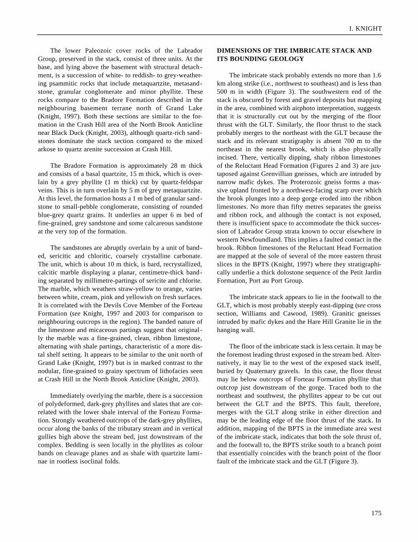
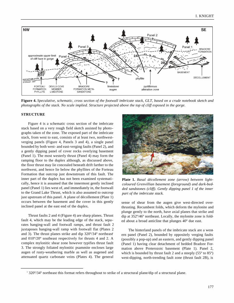
Figure 4 is a schematic cross section of the imbricatestack based on a very rough field sketch assisted by photo-graphs taken of the zone. The exposed part of the imbricatestack, from west to east, consists of at least two, northwest-verging panels (Figure 4, Panels 3 and 4), a single panelbounded by both west- and east-verging faults (Panel 2), anda gently dipping panel of cover rocks overlying basement(Panel 1). The most westerly thrust (Panel 4) may form theramping floor to the duplex although, as discussed above,the floor thrust may lie concealed beneath drift farther to thenorthwest, and hence lie below the phyllites of the ForteauFormation that outcrop just downstream of this fault. Theinner part of the duplex has not been examined systemati-cally, hence it is assumed that the innermost gently inclinedpanel (Panel 1) lies west of, and immediately in, the footwallto the Grand Lake Thrust, which is also assumed to outcropjust upstream of this panel. A plane of décollement (Plate 1)occurs between the basement and the cover in this gentlyinclined panel at the east end of the duplex.
Thrust faults 2 and 4 (Figure 4) are sharp planes. Thrustfault 4, which may be the leading edge of the stack, sepa-rates hanging-wall and footwall ramps, and thrust fault 2juxtaposes hanging-wall ramp with footwall flat (Plates 2and 3). The thrust planes strike and dip 320º/34º northeast1
and 010º/20º southeast respectively for thrusts 4 and 2. Acomplex mylonitic shear zone however typifies thrust fault3. The strongly foliated mylonitic psammite encloses largeaugen of rusty-weathering marble as well as augened andattenuated quartz carbonate veins (Plates 4). The general
sense of shear from the augen give west-directed over-thrusting. Recumbent folds, which deform the mylonite andplunge gently to the north, have axial planes that strike anddip at 352º/46º northeast. Locally, the mylonite zone is fold-ed about a broad anticline that plunges 40º due east.
The hinterland panels of the imbricate stack are a west-ern panel (Panel 2), bounded by oppositely verging faults(possibly a pop-up) and an eastern, and gently dipping panel(Panel 1) having clear detachment of bedded Bradore For-mation above Proterozoic basement (Plate 1). Panel 2,which is bounded by thrust fault 2 and a steeply (55º to 85º)west-dipping, north-trending fault zone (thrust fault 2B), is
177
1 320º/34º northeast this format refers throughout to strike of a structural plane/dip of a structural plane.
Figure 4. Speculative, schematic, cross section of the footwall imbricate stack, GLT, based on a crude notebook sketch andphotographs of the stack. No scale implied. Structure projected above the top of cliff exposed in the gorge.
Plate 1. Basal décollement zone (arrow) between light-coloured Grenvillian basement (foreground) and dark-bed-ded sandstones (cliff). Gently dipping panel 1 of the innerpart of the imbricate stack.

CURRENT RESEARCH, REPORT 04-1
either a westward-tilted block of Labrador Group havinghighly altered basement rocks in the east or a panel in whichaltered basement occurs beneath anticlinally folded BradoreFormation. Only the western limb of the anticline isexposed. The basal Cambrian unconformity or structural
décollement is obscured by alteration. The basement rocksare finely brecciated and micro-veined as well as rusty-weathering due to the presence of pyrite. Kinematic indica-tors in the eastern bounding fault define eastward overthrustof its hanging wall.
178
Plate 2. East-dipping thrust plane of thrust fault no. 4(arrow), which forms the foremost thrust in the exposed partof the imbricate stack. Bradore Formation metasandstonesoccur above and below the fault.
Plate 3. East-dipping thrust fault no. 2 (arrow) placing Bradore Formation metasandstone above recessively weathering phyl-lites of the Forteau Formation.
A
Plate 4. A large augen (A) of orange-weathering marblewithin a foliated, mylonitic psammite. The mylonite isbroadly folded. Attenuated orange carbonate veins are indi-cated by the arrow. Trekking stick (arrow) for scale.

I. KNIGHT
The most easterly panel 1 dips gently at 345º/20º north-east steepening somewhat locally near the contact withpanel 2 to 260º/32º northwest. The basal décollement sur-face appears to be inclined approximately 325º/28º north-east. Bedding parallel shortening is accommodated abovethe décollement by west-verging, flat to low-angle thruststhat cut the well-bedded psammitic rocks in the hangingwall of the décollement with possible east-vergent struc-tures, locally superimposed. Both thrust sets ramp gentlyaway from the décollement zone. Fractures associated withnarrow breccias are also common in the décollement hang-ing wall.
Brecciated to fractured granitic gneiss intruded bymafic dykes characterizes the Proterozoic basement in thefootwall of the décollement. Folded pink granitic veins, 10cm wide, cut the gneiss and appear to trend essentially sub-parallel to the detachment. Sawn surfaces of the graniteveins show coarse quartz and pink feldspar crystals cut byclosely spaced imbricate fractures, prior to the growth ofchlorite and epidote. Minor east-trending, subvertical faultscut the basement and are associated with mineralized veins,imbricate fractures and breccias.
Exposed in the footwall to thrust fault 4, there is asteeply west-dipping succession of rocks that include thebanded marble of the Devils Cove Member (Plate 5) over-lying psammites of the top of the Bradore Formation, andoverlain itself by phyllitic rocks of the Forteau Formation.Banding in the footwall outcrop is uniformally dipping at65º to 85ºNW on a strike of 250º. However, the stream bednear, and downstream of the outcrop, is strewn with verylarge marble boulders, which exhibit impressive disharmon-ic folding, as well as tight, to more open folds with limbthinning of bands, thickening of micaceous partings in foldnoses, and local initiation of mineral-band transposition.Whether these boulders come from the footwall or fromhanging-wall outcrops obscured high in the tree-coveredsides of the stream gully is not known. It is also uncertainwhether the banding is ribbon bedding or is a transposedbanding associated with an earlier deformation. Transposedbedding is a common feature of ribbon carbonates associat-ed with thrust stacks in western Newfoundland where it issuperimposed on rocks of the Reluctant Head Formation inthe Goose Arm and Old Man Pond area of the Goose Armthrust stack (Knight and Boyce, 1991; Knight, 1994) as wellas in the BPTS itself.
179
A
B
Plate 5. Moderately west-dipping banded marble of the Devils Cove Member, footwall of the thrust stack. Inset A shows blockof folded marble. Inset B shows fresh surface of marble.
CURRENT RESEARCH, REPORT 04-1
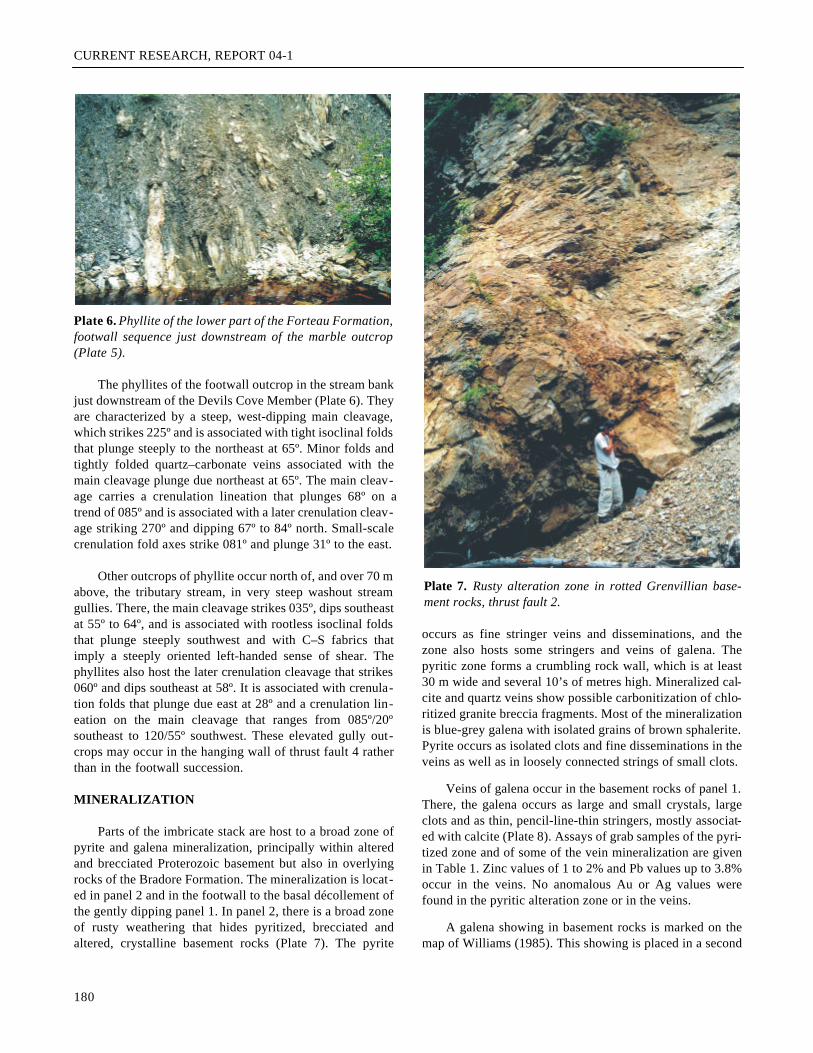
The phyllites of the footwall outcrop in the stream bankjust downstream of the Devils Cove Member (Plate 6). Theyare characterized by a steep, west-dipping main cleavage,which strikes 225º and is associated with tight isoclinal foldsthat plunge steeply to the northeast at 65º. Minor folds andtightly folded quartz–carbonate veins associated with themain cleavage plunge due northeast at 65º. The main cleav-age carries a crenulation lineation that plunges 68º on atrend of 085º and is associated with a later crenulation cleav-age striking 270º and dipping 67º to 84º north. Small-scalecrenulation fold axes strike 081º and plunge 31º to the east.
Other outcrops of phyllite occur north of, and over 70 mabove, the tributary stream, in very steep washout streamgullies. There, the main cleavage strikes 035º, dips southeastat 55º to 64º, and is associated with rootless isoclinal foldsthat plunge steeply southwest and with C–S fabrics thatimply a steeply oriented left-handed sense of shear. Thephyllites also host the later crenulation cleavage that strikes060º and dips southeast at 58º. It is associated with crenula-tion folds that plunge due east at 28º and a crenulation lin-eation on the main cleavage that ranges from 085º/20ºsoutheast to 120/55º southwest. These elevated gully out-crops may occur in the hanging wall of thrust fault 4 ratherthan in the footwall succession.
MINERALIZATION
Parts of the imbricate stack are host to a broad zone ofpyrite and galena mineralization, principally within alteredand brecciated Proterozoic basement but also in overlyingrocks of the Bradore Formation. The mineralization is locat-ed in panel 2 and in the footwall to the basal décollement ofthe gently dipping panel 1. In panel 2, there is a broad zoneof rusty weathering that hides pyritized, brecciated andaltered, crystalline basement rocks (Plate 7). The pyrite
occurs as fine stringer veins and disseminations, and thezone also hosts some stringers and veins of galena. Thepyritic zone forms a crumbling rock wall, which is at least30 m wide and several 10’s of metres high. Mineralized cal-cite and quartz veins show possible carbonitization of chlo-ritized granite breccia fragments. Most of the mineralizationis blue-grey galena with isolated grains of brown sphalerite.Pyrite occurs as isolated clots and fine disseminations in theveins as well as in loosely connected strings of small clots.
Veins of galena occur in the basement rocks of panel 1.There, the galena occurs as large and small crystals, largeclots and as thin, pencil-line-thin stringers, mostly associat-ed with calcite (Plate 8). Assays of grab samples of the pyri-tized zone and of some of the vein mineralization are givenin Table 1. Zinc values of 1 to 2% and Pb values up to 3.8%occur in the veins. No anomalous Au or Ag values werefound in the pyritic alteration zone or in the veins.
A galena showing in basement rocks is marked on themap of Williams (1985). This showing is placed in a second
180
Plate 6. Phyllite of the lower part of the Forteau Formation,footwall sequence just downstream of the marble outcrop(Plate 5).
Plate 7. Rusty alteration zone in rotted Grenvillian base-ment rocks, thrust fault 2.

I. KNIGHT
tributary stream off Trout Brook approximately 1 km north-east of the showing in the imbricate stack. A preliminarysearch of this stream found no mineralization in either base-ment rocks or structurally underlying rocks of the ReluctantHead Formation.
DISCUSSION
STRATIGRAPHY AND FACIES
The stratigraphy in the rock of the imbricate stackexposed in the incised tributary stream of Trout Brook,southwest of Grand Lake, includes sedimentary rocksbelonging to the lower part of the Labrador Group. The stra-ta consist of Bradore Formation and Forteau Formation, ofwhich the latter is divided into the basal Devils Cove Mem-ber carbonate and an overlying sequence of polydeformedphyllites. It is one of only a few localities in the southeast-ern edge of the external Humber (tectonostratigraphic) Zonein western Newfoundland to provide exposure of the basalCambrian unconformity and its immediately overlyingstratigraphy. Another locality is in the narrow belt of lowerPaleozoic shelf rocks near Coney Arm in White Bay (Kerrand Knight, this volume). These localities vary somewhatfrom more westerly occurrences such as the classic roadsidelocality in Gros Morne National Park (James et al., 1988),and the recently described locality in the Indian Head Rangeto the northwest of Grand Lake (Knight and Boyce, 2000;Knight, 2003) although they also share some common fea-tures (see below). The unconformity and its cover are alsowell exposed along the eastern side of Canada Bay (Knightand Saltman, 1980; Knight, 1987) but there, their characteris unique within western Newfoundland. For instance, theunconformity is locally underlain by Neoproterozoic riftfacies of the Lighthouse Cove Formation and it is character-ized by a sub-unconformity paleo-regolith. Also, the overly-ing Bradore Formation consists of tens of metres of fluvial
arkosic sandstones overlain by marine sandstones that aresimilar to the rocks at Indian Head, Gros Morne and ConeyArm (Knight, 1987).
The lithofacies of the Labrador Group preserved in thestack suggest that the succession occupies a more distalposition on the ancient Iapetan margin than the Indian Headoccurrences. The Bradore Formation is almost exclusivelyquartz arenite with minor shale interbeds, locally, and a sin-gle bed of clean small quartz-pebble conglomerate. Thissuggests a well-sorted and clean nearshore marine sandbody similar to the unit north of Grand Lake (Knight, 1997)but in contrast to the mixed arkose and quartz arenite (flu-vial to shore) seen 20 km to the northwest at Crash Hill(Knight, 2003) and the Indian Head Range (Knight andBoyce, 2000; see Figure 2). The quartz arenites, however,appear to lie in the same facies belt as the Bradore Forma-tion in White Bay, 175 km along strike to the northeast (Kerrand Knight, this volume), and the exposures of Bradore For-mation, in Gros Morne (James et al. , 1988). At all of theselocalities, the formation is only 10 to 20 m thick in contrastto the section beneath Port au Port Peninsula (see Knightand Boyce, 2000) and most of the Great Northern Peninsu-la sections of northern Newfoundland, where it averagesabout 150 m thick and is dominated by arkosic fluvial sedi-mentary rocks (Knight, 1991; Knight and Cawood, 1991).
The Devils Cove Member limestone is a persistentregional marker, both for foreland sections such as the GreatNorthern Peninsula, where it is essentially pristine, althoughlocally dolomitized, and metamorphosed hinterland sectionssuch as near Grand Lake. Everywhere it is mapped, it is afew metres to 15 m thick. However, the fine-grained, rib-bon-bedded nature of the member with its accompanyingshale partings in the Grand Lake area contrasts to the nodu-lar parted fine-grained limestone overlain by grainstone inits nearest counterpart 20 km to the northwest at Crash Hilland Indian Head Range (Knight, 2003; Knight and Boyce,2000). This suggests a more distal shelf setting in the GrandLake area for this basal transgressive Early Cambrian car-bonate.
STRUCTURE
The incised tributary stream of Trout Brook provides anopportunistic window into a small imbricate stack thatformed west of the GLT, as mapped by Williams andCawood (1989). It is probable that, if not for the stream, thestack would be completely hidden by thick forest over-growth on the steep, generally poorly exposed hillsides inthe foothills to the spine of the southern Long Range Moun-tains. Even if not concealed, however, the only rocks likelyto occur in the high ground of the foothills are phylliticrocks of the Forteau Formation that occur structurally and
181
Plate 8. Galena–calcite vein cutting Grenvillian basementbelow décollement of panel 1.
CURRENT RESEARCH, REPORT 04-1
stratigraphically above the rocks involved in the stack and inwhich the structural clarity, afforded by the gorge section,would be obscured. Incised stream beds, a few kilometres tothe northeast, indicate that the stack is areally of limiteddimensions in that direction. To the southwest, it also likelypinches out structurally as the floor thrust reaches a branchpoint with the GLT. However, this relationship is covered byQuaternary gravels and forest and its limits are extrapolatedbased on the projection of other thrusts and geological ter-ranes of the BPTS into the immediate area.
Still other uncertainties remain to be clarified by addi-tional field work. Of these uncertainties, the most pressingand least easy to resolve will be the position of the north-western leading edge of the stack. Two interpretations arepossible based on the available knowledge of the area. Thefirst and simplest model picks thrust fault 4, which outcropsat the entrance to the gorge, as the leading edge of the com-plex. The most westerly exposures in the stream section,which include the top of the Bradore Formation, the DevilsCove Member carbonate and the Forteau Formation phyl-lites, would then occupy the footwall to the stack. Thiswould imply that the phyllites would be overlain by rocks ofthe Penguin Cove Formation and then the outcroppingReluctant Head Formation. However, mapping suggests thata fault separates the phyllites from the deformed carbonates
of the BPTS, implying that unless the fault is a later fault(see below), this model is probably unlikely.
The second model extrapolates that the floor of thestack lies beneath the Forteau Formation phyllites seendownstream of the gorge. In this model, the frontal thrust orleading edge of the structure is hidden to the west beneaththe gravels and floodplain of the tributary system. The struc-tural termination of the stack and the Forteau Formationphyllites only a few hundred metres to the northeast betweenhanging wall Grenvillian basement, and footwall ReluctantHead Formation ribbon carbonates of the BPTS suggeststhat this interpretation may be valid. This is the modeladopted in Figure 4.
If model 2 is correct (i.e., the leading edge of the stackis now hidden to the west and the stack is limited by a lead-ing edge branch line that merges the floor thrust of the stackwith the GLT), it is possible to argue that the floor thrust isthe frontal expression of the GLT. If so, then the leadingedge branch line of the GLT lies west of the thrust as it isdrawn on the map of Williams and Cawood (1989) and thestack is in the hanging wall to the GLT. This is more inaccord with the map relationships north of Grand Lake(Knight, 1996, 1997) than with the generally straight,steeply dipping structure mapped by Williams and Cawood
182
Table 1. Geochemical analyses of grab samples from the mineralized alteration zone, Grand Lake Thrust
UTM UTM Map Mo Cr P Zn Pb Co Ni FeSample # Easting Northing Sheet Zone NAD ppm ppm ppm ppm ppm ppm ppm %
K-02-41C-1 413099 5385052 12B/09 21 27 0 17 494 22 10 15 10 3.60K-02-41C-2 413099 5385052 12B/09 21 27 1 22 1985 41 17 61 23 9.94K-02-41C-3A 413099 5385052 12B/09 21 27 2 21 521 21 26 8 7 1.81K-02-41C-3B 413099 5385052 12B/09 21 27 2 25 534 29 24 7 13 2.60K-02-41C-4 413099 5385052 12B/09 21 27 0 14 150 11 4 3 7 2.79K-02-41C-5 413099 5385052 12B/09 21 27 4 30 72 5521 37119 5 17 1.76K-02-41C-6 413099 5385052 12B/09 21 27 4 3 53 14278 37945 7 14 4.88K-02-41C-7 413099 5385052 12B/09 21 27 3 14 76 10173 38358 6 18 2.23
Ca Nb Cu Na Zr Dy Sc Y Al Mn Sr La Ce BaSample # % ppm ppm % ppm ppm ppm ppm % ppm ppm ppm ppm ppm
K-02-41C-1 0.57 13 42 0.55 132 3.0 4.1 18 2.33 139 34 20 45 1226K-02-41C-2 1.20 37 40 0.66 220 6.4 9.4 41 4.28 506 65 20 56 91K-02-41C-3A 4.10 37 20 0.68 387 8.8 9.2 59 6.53 508 101 47 85 256K-02-41C-3B 1.04 35 19 0.77 353 11.8 10.5 66 8.34 170 88 100 171 349K-02-41C-4 0.18 9 107 0.49 98 0.6 2.3 7 1.28 49 13 7 19 184K-02-41C-5 25.15 7 403 0.04 5 77.5 5.7 315 0.39 1853 87 300 598 42K-02-41C-6 25.84 9 250 0.02 7 71.4 1.6 309 0.18 2239 66 265 520 42K-02-41C-7 25.18 6 717 0.30 7 76.4 4.3 318 0.69 1835 111 276 559 79

I. KNIGHT
(1989), which is interpreted to be a thrust overprinted bylater deformation. Both sections appear to have roughly sim-ilar structural and metamorphic character that support acommon structural history. Thus, regardless of which modelis better suited to the geology, the map relationships suggestthat the GLT had an early history when the imbricate thruststack was formed and a later one, when it was reactivated tobreak through its trailing edge and form a straighter, pene-trative fault.
The map relationships are also open to another inter-pretation that invokes interference by a later, high-anglefault with the imbricate stack and its footwall. The later,high-angle fault would have juxtaposed rocks of the BPTSto the west against different parts of the imbricate complex.In some places, the high-angle fault would mark the contactbetween the phyllites to the east and the BPTS to the west,and at others the contact between BPTS and Grenvillianbasement. The later, high-angle fault may displace the foot-wall of the stack in model 1, or displace or replace the lead-ing edge and the floor thrust of the complex, as outlined inmodel 2.
A décollement probably occurs at the contact of thecover rocks and the Proterozoic basement based on the rela-tionships exposed in the hinterland thrust panels. Since the
elevation of the stream is higher in these inner panels andthe décollement is hidden at depth in the outer panels, thefloor of the stack must be deeper towards the foreland, sug-gesting that the complex as a whole has been tilted to thewest. This is compatible with reactivation of the GLT afterthe imbricate stack had formed
The décollement probably formed early in the forma-tion of the stack and was the fundamental discontinuity thatallowed bedding parallel shortening of the cover sequencethat marks the west-verging stack. The architectural geome-try of the stack plus the folding of an early foliated psam-mitic mylonite encasing large carbonate augen of the DevilsCove Member, as in panel 3 indicates that the stack propa-gated forward and northwestward. Panel 2 could be a pop-up structure that accommodated shortening of the hangingwall to the décollement. However, since it involves base-ment rocks as seen within the alteration zone and must cutrather than use the basal décollement plane, this implies thatthe east-verging eastern-bounding fault was activated laterin the history of the stack and the fault-bounded panel 2 isnot a true pop-up (see Butler, 1982; Park, 1989).
Based on the internal geometry of the thrust panels andthe interpretation of the branch points as limiting the lateralextent of the stack both to the northeast and southwest, it ispossible that the stack is actually an erosional remnant (i.e.,the lower part) of a truncated or partly unexposed duplexrather than an imbricate stack. If it is in fact a duplex, poorexposure of the polydeformed, phyllitic rocks of the ForteauFormation at higher structural levels of the complex mayhide the roof thrust, which would be the diagnostic feature.Rootless folds in some of the outcrops high above the gorgemay support this idea.
The phyllitic rocks of the lower Forteau Formation pre-serve a northeast-trending main cleavage and a later crenu-lation cleavage that strike essentially due east. Co-axialfolds with the main cleavage plunge both northeast andsouthwest. Crenulation lineations and folds associated withthe crenulation cleavage plunge consistently to the east.Recent mapping of the southwestern end of the BPTS (I.Knight, unpublished data, 2002) indicates the presence ofboth of these cleavages with essentially the same disposi-tions as those mapped in the imbricate stack. However, themain cleavage in the BPTS is axial planar to folds, whichdeform its thrusts. The main cleavage also postdates folia-tions and folds related to the D1 thrusts. This suggests thatthe main cleavage is at least a D2 structure and the crenula-tion cleavage a D3 structure. The preservation of D2 and D3
structures in rocks associated with the imbricate stack sug-gests that the stack itself was deformed by the D2/D3 events.This plausibly implies that it formed during earlier D1 west-verging thrusting that regionally affects the lower Paleozoic
183
Table 1. Geochemical analyses of grab samples from themineralized alteration zone, Grand Lake Thrust
Mg Cd Ti V Be% ppm ppm ppm ppm
0.37 0.1 3146 42 0.61.53 -0.2 7023 56 1.10.19 0.0 8262 59 1.10.31 0.0 8857 67 1.50.12 -0.1 1954 45 0.50.40 12.6 183 23 0.00.26 40.9 97 19 -0.10.32 23.5 153 22 0.0
Li K As Au Agppm ppm ppm ppb ppm
9.9 1.69 8 -5 0.331.3 2.85 28 -5 0.412.6 5.50 7 -5 0.38.9 6.25 6 -5 0.44.1 0.62 1 -5 0.28.2 0.18 7 -5 6.25.2 0.17 37 15 9.36.3 0.24 7 15 4.8

CURRENT RESEARCH, REPORT 04-1
shelf and foreland basin stratigraphy and formed largeregional thrust stacks such as the Blue Pond, Goose Arm andthe Canada Bay-Hare Bay thrust stacks (Knight and Salt-man, 1980; Knight, 1986, 1987, 1994, 1997; Knight andBoyce, 1991). All these stacks deformed structurally overly-ing Taconian allochthonous rocks of the Humber Arm, OldMan Pond and the Hare Bay allochthons. These formed theroof complexes that were broadly folded and locally steep-ened by the construction of the underlying stack culmina-tions.
MINERALIZATION
The pyrite–galena–sphalerite mineralization associatedwith a broad rusty alteration zone in the Grenvillian base-ment and the basal Bradore Formation is comparable in itsstratigraphic association with mineralization currently beingstudied in the White Bay area (Kermode Resources, 2002;Kerr and Knight, this volume; Kerr, this volume). Also, it hasan analogous structural setting to the White Bay mineraliza-tion in that it lies adjacent to an important fault, the GLT (cf.Doucer’s Valley fault complex of Smyth and Schillereff,1982). Gold is present in both basement and cover rocks inthe White Bay area but appears to be absent in the imbricatestack showings.
The mineralization postdates the formation of the stacksince it occurs on both sides of the basal décollement but itmay possibly predate the east-verging fault that uplifts thebasement and cover and exposes the main rusty alterationzone of panel 2. Consequently, even though the exposedarea of the mineralization is limited to the 1st and 2nd pan-els of the inner part of the stack, this may be an artifact ofthe westward deepening of the structure and mineralizationcould also lie concealed beneath the forward part.
ACKNOWLEDGMENTS
The imbricate stack was found during a brief visit to thestream gorge in 2002. Robert Small provided able fieldassistance. Steve Colman-Sadd read and improved the man-uscript. Chemical analyses were provided through the Gov-ernment Laboratory under the supervision of Chris Finch.
REFERENCES
Butler, R.W.H.1982: The terminology of structures in thrust belts.Journal of Structural Geology, Volume 4, pages 239-245.
Cawood, P.A. and Van Gool, J.A.M.1994: Geology of the Corner Brook Lake region, Cor-ner Brook, Newfoundland. Geological Survey of Cana-da, Open File 2830, scale 1:50 000.
Currie, K.L. and van Berkel, J.T.1992: Geology, southern Long Range Mountains, New-foundland, Geological Survey of Canada, Map 1815A,scale 1:100 000.
Currie, K.L., van Berkel, J.T., Piasecki, M.A.J. and Martin,J.C.
1986: Geology, Harrys River (12B/9E) and part of Lit-tle Grand Lake (12A/5) map areas, southern LongRange, Newfoundland. Open File 1406, map with mar-ginal notes, Geological Survey of Canada, Departmentof Energy, Mines and Resources, Government of Cana-da, Ottawa, Canada.
James, N.P., Knight, I., Stevens, R.K. and Barnes, C.R.1988: Sedimentology and paleontology of an EarlyPaleozoic continental margin, western Newfoundland.Field trip guidebook B1, Annual meeting of GeologicalAssociation of Canada, Minerological Association ofCanada, and Canadian Society of Petroleum Geologists,121 pages.
Kermode Resources Ltd.2002 : News Release, Friday, August 30th, 2002.
Kerr, A. This volume: An overview of sedimentary-rock-hostedgold mineralization in western White Bay (NTS maparea 12H/15).
Kerr, A. and Knight, I.This volume: A preliminary report on the stratigraphyand structure of Cambrian and Ordovician rocks in theConey Arm area, western White Bay (NTS 12H/15).
Knight, I.1986: Ordovician sedimentary strata of the Pistolet Bayand Hare Bay area, Great Northern Peninsula, New-foundland. In Current Research. Newfoundland Depart-ment of Mines and Energy, Mineral Development Divi-sion, Report 86-1, pages 147-160.
1987: Geology of the Roddickton (12I/16) map area. InCurrent Research. Newfoundland Department of Minesand Energy, Geological Survey, Report 87-1, pages343-357.
1991: Geology of the Cambro-Ordovician rocks in thePort Saunders (NTS 12I/11), Castors River (NTS12I/15), St. John Island (NTS 12I/14) and Torrent River(NTS 12I/10) map areas. Newfoundland Department ofMines and Energy, Geological Survey, Report 91-4, 138pages.
184

I. KNIGHT
1994: Geology of the Cambrian-Ordovician platformalrocks of the Pasadena map area (NTS 12H/4). In Cur-rent Research. Newfoundland Department of Mines andEnergy, Geological Survey Branch, Report 94-1, pages175-186.
1996: Geological map of parts of the Little Grand Lake(12A/12), Corner Brook (12A/13), Georges Lake(12B/16) and Harrys River (12B/9) map areas. New-foundland Department of Natural Resources, Geologi-cal Survey, Map 95-20, scale 1:50 000, Open File NoNFLD/2604
1997: Geology of Cambro-Ordovician carbonate shelfand co-eval off-shelf rocks, southwest of Corner Brook,western Newfoundland. In Current Research. New-foundland Department of Mines and Energy, Geologi-cal Survey, Report 97-1, pages 211-235.
2002: Mineralized alteration zone and new dimension-stone showings southwest of Corner Brook, westernNewfoundland. Newfoundland and Labrador Depart-ment of Mines and Energy, Geological Survey, OpenFile 12B/09/0470, 13 pages.
2003: Geology of the North Brook Anticline, HarrysRiver map area (NTS 12B/09). In Current Research.Newfoundland and Labrador Department of Mines andEnergy, Geological Survey, Report 03-1, pages 51-71.
Knight I. and Boyce W.D1991: Deformed Lower Paleozoic platform carbonates,Goose Arm–Old Man’s Pond. In Current Research.Newfoundland Department of Mines and Energy, Geo-logical Survey Branch, Report 91-1, pages 141-153.
2000: Geological notes on the Cambro-Ordovicianrocks of the Phillips Brook anticline, north ofStephenville. In Current Research. NewfoundlandDepartment of Mines and Energy, Geological Survey,Report 2000-1, pages 197-215.
Knight, I. and Cawood, P.A.1991: Paleozoic geology of western Newfoundland: anexploration of a deformed Cambro-Ordovician passivemargin and foreland basin, and Carboniferous succes-sor basin. A field-based short course for industry, June1991, Centre for Earth Resources Research, Depart-ment of Earth Sciences, Memorial University of New-foundland, St. John’s. Part 1, 229 pages.
Knight, I. and Saltman, P.1980: Platformal rocks and geology of the Roddicktonmap area, Great Northern Peninsula. NewfoundlandDepartment of Mines and Energy, Mineral Develop-ment Division, Report 80-1, pages 10-28.
Park, R.G.1989: Foundations of Structural Geology. 2nd edition,Blackie, Glasgow and London, 148 pages.
Smyth, W.R. and Schillereff, H.S.1982: The pre-Carboniferous geology of southwestWhite Bay. In Current Research. NewfoundlandDepartment of Mines and Energy, Mineral Develop-ment Division, Report 82-1, pages 78-98.
Williams, H.1985: Geology, Stephenville map area, Newfoundland.Geological Survey of Canada, Map 1579A, scale 1: 100000.
Williams H. and Cawood, P.A.1989: Geology, Humber Arm Allochthon, Newfound-land. Geological Survey of Canada, Map 1678A, scale1: 250 000.
185