typical section - illinois department of transportation section cta blue line eastbound i-90 2 lanes...
TRANSCRIPT

Typical Section
CTA BLUE LINE
EASTBOUND I-90
2 LANESEB I-90
SHOULDERAND CONCRETE
BARRIER
CONSTRUCT CONSTRUCTCONSTRUCTRESURFACE
1 LANECUMBERLAND
FLYOVER
3 LANESEB I-190
INSIDE SHOULDER
I - 190 to Cumberland Conceptual Design
2 LANE EXITSB CUMBERLAND AVE.
CONSTRUCT
Eastbound: with CD Road
(SEE WB 1-90ALTERNATIVE) KEYMAP
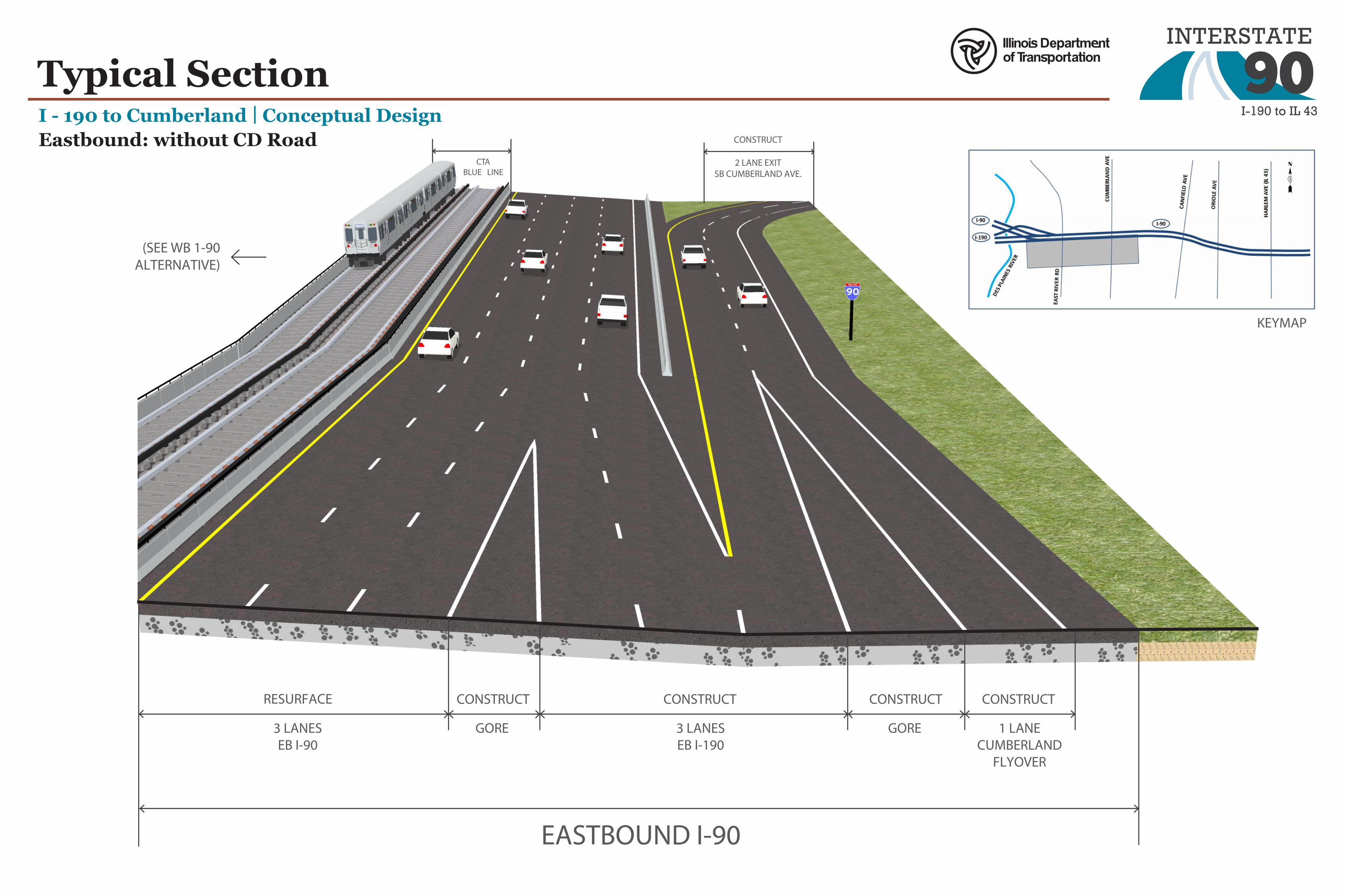
Typical SectionI - 190 to Cumberland Conceptual Design
CTABLUE LINE
EASTBOUND I-90
3 LANESEB I-90
GORE
CONSTRUCT CONSTRUCTCONSTRUCTRESURFACE
1 LANECUMBERLAND
FLYOVER
3 LANESEB I-190
GORE
CONSTRUCT
2 LANE EXITSB CUMBERLAND AVE.
CONSTRUCTEastbound: without CD Road
(SEE WB 1-90ALTERNATIVE)
KEYMAP

Typical SectionI - 190 to Cumberland Conceptual Design
CTA BLUE LINE
WESTBOUND I-90
RECONSTRUCTRECONSTRUCT
RAMP / GORETO WB I-190
RESURFACE
3 EXISTING LANESWB I-90 INSIDE
SHOULDER
1 LANEENTRANCE
SOUTHBOUNDCUMBERLAND
AVE.
CONSTRUCT
CD ROAD
WB I-90 / I-190
MAINLINE
WB I-90
(SEE EB 1-90ALTERNATIVE)
Westbound: with CD Road
KEYMAP

Typical Section
CTA BLUE LINE
WESTBOUND I-90
RECONSTRUCT
GORETO WB I-190
WIDEN AND RESURFACE RESURFACE
1 LANEENTRANCE
SOUTHBOUNDCUMBERLAND
AVE.
CONSTRUCT
3 EXISTING LANESWB I-90 INSIDE
SHOULDER
I - 190 to CumberlandWestbound: without CD Road
Conceptual Design
(SEE EB 1-90ALTERNATIVE)
KEYMAP

Evaluation of Reasonable Alternatives
PWG Meeting #2:
Eastbound: Stakeholders preferred the alternative
without CD road, since it improves access to
Cumberland Ave southbound exit, but does not require
reduced shoulders through the Cumberland CTA
Station area
Westbound: Stakeholders preferred the CD road
alternative, since it improves weaving conditions at
the Cumberland Ave interchange and does not impact
the pedestrian bridge at the Cumberland CTA Station
Meets Purpose? Improves safety? Improves traffic operations? Impacts?
Eastbound: CD Road
Yes, separates NB and SB Cumberland exiting traffic from I-90/I-190 traffic. Adds additional capacity east of Cumberland to Harlem.
Yes, additional capacity helps reduce the high number of rear-end and sideswipe crashes caused by traffic congestion. However, reduced width shoulders are necessary along Cumberland CTA Station, providing less space for emergency needs.
Yes: CD Road simplifies merging of I-90 and I-190, separates Cumberland interchange traffic from mainline
Reduced width shoulders necessary along Cumberland CTA Station
Eastbound: No CD Road (Alternative carried forward)
Yes, separates NB and SB Cumberland exiting traffic from I-90/I-190 traffic. Adds additional capacity east of Cumberland to Harlem.
Yes, weaving to SB Cumberland eliminated with CD road. Additional capacity helps reduce the high number of rear-end and sideswipe crashes caused by traffic congestions. Shoulders at Cumberland CTA Station remain at existing width for emergency needs.
Yes, SB Cumberland interchange traffic is separated from mainline traffic.
Westbound: CD Road (Alternative carried forward)
Yes, separates Cumberland and I-190 traffic from I-90. Adds capacity from Harlem to I-190.
Yes, CD road separates high volume of traffic and allows SB Cumberland entrance weave with a lower through volume.
Yes, Cumberland interchange traffic and I-190 traffic are separated from I-90 through traffic.
Westbound: No CD Road
Yes, adds capacity from Harlem to I-190. Yes, additional capacity helps reduce the high number of rear-end and sideswipe crashes caused by traffic congestion.
Yes, additional lane provides more capacity and helps to improve SB Cumberland to WB I-90 weave from existing.
Would impact the pedestrian bridge at the CTA Cumberland Station
Evaluation criteria
Purpose:
To provide an improved
transportation system along I-90
Needs:
Improve safety and improve
traffic operations

Preferred Alternative Typical SectionI - 190 to Cumberland Proposed Design
CTABLUE LINE
EASTBOUND I-90
3 LANESEB I-90
GORE
CONSTRUCT CONSTRUCTCONSTRUCTRESURFACE
1 LANECUMBERLAND
FLYOVER
3 LANESEB I-190
GORE
CONSTRUCT
2 LANE EXITSB CUMBERLAND AVE.
CONSTRUCT
CTA BLUE LINE
WESTBOUND I-90
RECONSTRUCTRECONSTRUCT
RAMP / GORETO WB I-190
RESURFACE
3 EXISTING LANESWB I-90
1 LANEENTRANCE
SOUTHBOUNDCUMBERLAND
AVE.
CONSTRUCT
CD ROAD
WB I-90 / I-190
MAINLINE
WB I-90
KEYMAP

CTA BLUE LINE3 EXISTING LANESWB I-90
RESURFACE3 EXISTING LANES
EB I-90
RESURFACE ADDADDOUTSIDE
SHOULDERAUXILIARY
LANEOUTSIDE
SHOULDERAUXILIARY
LANEINSIDE SHOULDER
INSIDE SHOULDER
Typical SectionCanfield to Harlem Proposed Design
EXISTING RIGHT-OF-WAYWIDTH VARIES
WB I-90 EB I-90
KEYMAP
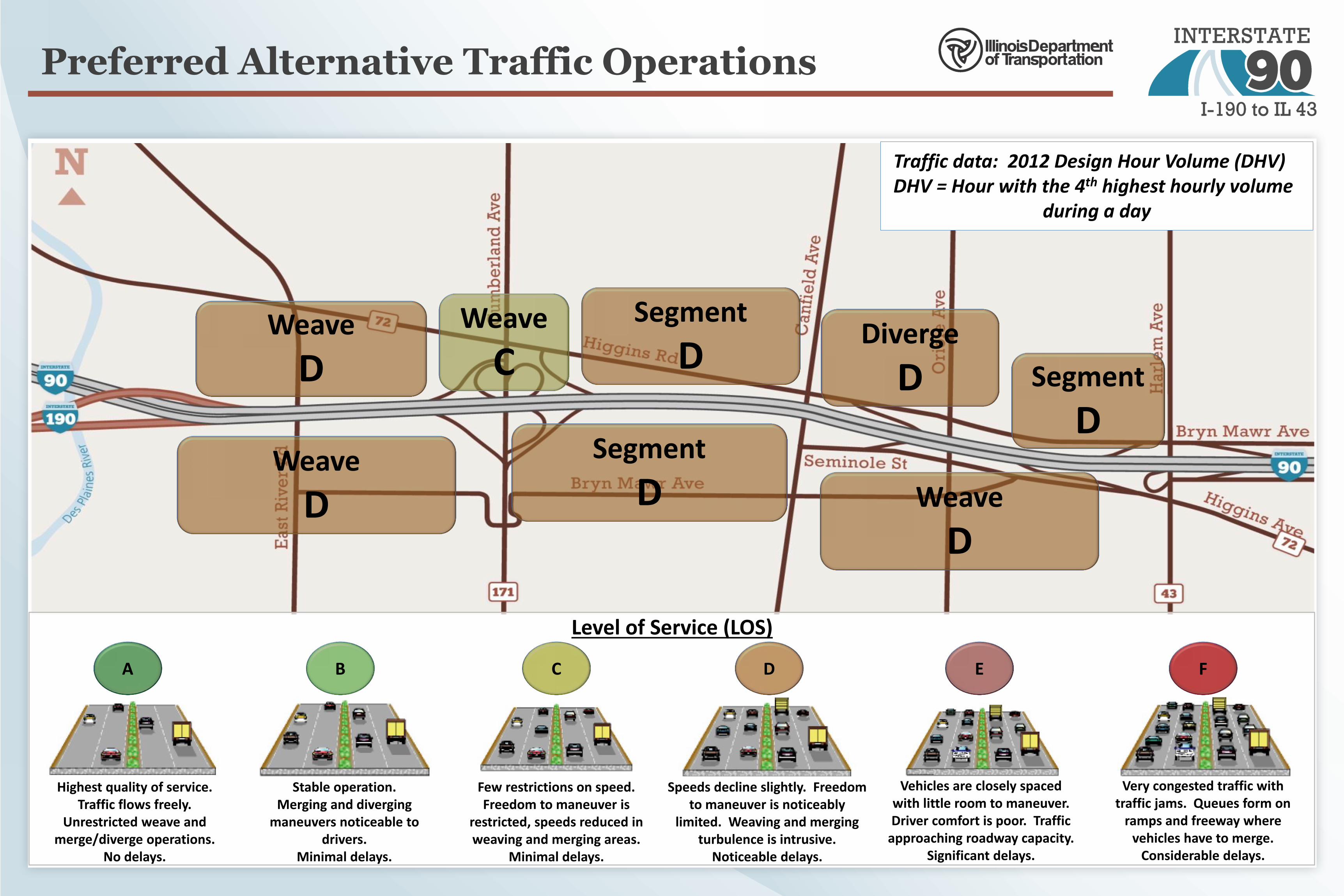
Preferred Alternative Traffic Operations
Weave
C
Weave
D
Level of Service (LOS)
Highest quality of service. Traffic flows freely.
Unrestricted weave and merge/diverge operations.
No delays.
Diverge
D Segment
D
Segment
D Weave
D
Segment
D
Traffic data: 2012 Design Hour Volume (DHV) DHV = Hour with the 4th highest hourly volume
during a day
A E C B F D
Stable operation. Merging and diverging
maneuvers noticeable to drivers.
Minimal delays.
Few restrictions on speed. Freedom to maneuver is
restricted, speeds reduced in weaving and merging areas.
Minimal delays.
Speeds decline slightly. Freedom to maneuver is noticeably
limited. Weaving and merging turbulence is intrusive.
Noticeable delays.
Vehicles are closely spaced with little room to maneuver. Driver comfort is poor. Traffic
approaching roadway capacity. Significant delays.
Very congested traffic with traffic jams. Queues form on
ramps and freeway where vehicles have to merge.
Considerable delays.
Weave
D

Preferred Alternative – Weaving Diagrams
Eastbound Existing Conditions
Eastbound Preferred Alternative
Westbound Existing Conditions
Westbound Preferred Alternative
EB I-90
EB I-190
EB I-90
Ramp to SB Cumberland
Ramp to NB Cumberland
I-90 to SB Cumberland:
2 lane changes I-190 to I-90::
1 lane change I-90 to NB Cumberland::
1 lane change
EB I-90
EB I-190
I-190 to SB Cumberland:
NO lane changes
I-190 to I-90::
NO lane changes
EB I-90
Ramp to SB Cumberland
Ramp to NB Cumberland
Cumberland Flyover ramp from Jane Addams Memorial Tollway
I-90 to NB Cumberland::
1 lane change
Ramp from SB Cumberland
Ramp from NB Cumberland
WB I-190
WB I-90 WB I-90
I-90 to I-190::
NO lane changes Cumberland ramps to I-90:
1 lane change
Ramp from SB Cumberland
Ramp from NB Cumberland
WB I-190
WB I-90 WB I-90
CD Road to I-190
I-90 to I-190::
NO lane changes Cumberland ramps to I-90:
2 lane changes
No
ise
Mo
nit
ori
ng Determined Common Noise
Environments (CNEs), which are areas that have the same activity category, similar exposure to noise and similar topography
Measured existing noise
Noise levels are based on these factors: speed, distance from highway, percentage of trucks, topography
Measurements taken at 11 field sites
Traf
fic
No
ise
Mo
del
Modeled predicted noise levels due to Preferred Alternative
18 Common noise environments
Determined areas where predicted noise levels approach, meet or exceed the NAC
Explored abatement measures for the areas identified above
Ab
atem
ent Abatement measures must
be feasible and reasonable
Any receptor receiving a 5 dB(A) reduction from a noise barrier is a benefited receptor
Achieve at least 5 dB(A) noise reduction for at least one impacted receptor
Achieve 8 dB(A) noise reduction for at least one benefited receptor
Cost effective: $24,000 - $37,000 per benefited receptor or $25/square foot
Solic
it V
iew
po
ints
Solicit viewpoints from tenants and property owners that would benefit (experience a noise reduction of 5 dB(A) or more) from abatement measures
33% response rate per wall is the goal
50% or more of the responses must be favorable to recommend the abatement measure for inclusion in the project
Noise Analysis
Typical noise barrier wall
IDOT Policy follows FHWA Noise Abatement Criteria (NAC)
An impact occurs when the predicted noise levels approach, meet or exceed the NAC for exterior uses:
66 dB(A)
•Residential
•Schools
•Parks & Playgrounds
•Cemeteries
72 dB(A)
•Offices
•Hotels
•Restaurants
Noise Analysis Process:
Types of noise abatement: • Noise barrier walls • Traffic management measures • Alteration of horizontal and/or
vertical alignment • Buffer zones • Noise insulation
Noise barrier walls are the only viable abatement measure for the I-90 Improvements Study
Common Outdoor Sound Levels
Common Indoor Sound Levels
120
110
100
90
80
70
60
50
40
30
20
10
Inside subway train
Food blender at 3ft
Garbage disposal at 3ft
Very loud speech at 3ft Vacuum cleaner at 10ft
Normal speech at 3ft Large business office quiet speech at 3ft
Dishwasher next room
Large conference room (background)
Library Bedroom at night
Concert hall (background) Broadcast / recording studio Threshold of hearing
Jet flyover at 1000ft Train horn at 1000ft Gas lawnmower at 3ft
Diesel truck at 50ft
Freight train at 100ft
Noisy urban daytime Lawnmower at 100ft
Commercial area Heavy traffic at 300ft
Quiet urban nighttime Quiet suburban nighttime Quiet rural nighttime
dB(A)
")!(
!( !(
! !
!
§̈¦190
§̈¦90
City of Chicago
City of Chicago
N18-2 N18-3
N18-1FS-11
KENNEDY
EAST
RIV
ER
DES P
LAIN
ESRI
VER
OB NORTHWESTIB NORTHWEST
KENNEDY
CNE 18CNE 17
Source: Esri, DigitalGlobe, GeoEye, i-cubed, USDA, USGS, AEX, Getmapping, Aerogrid, IGN, IGP, swisstopo, and the GIS User Community
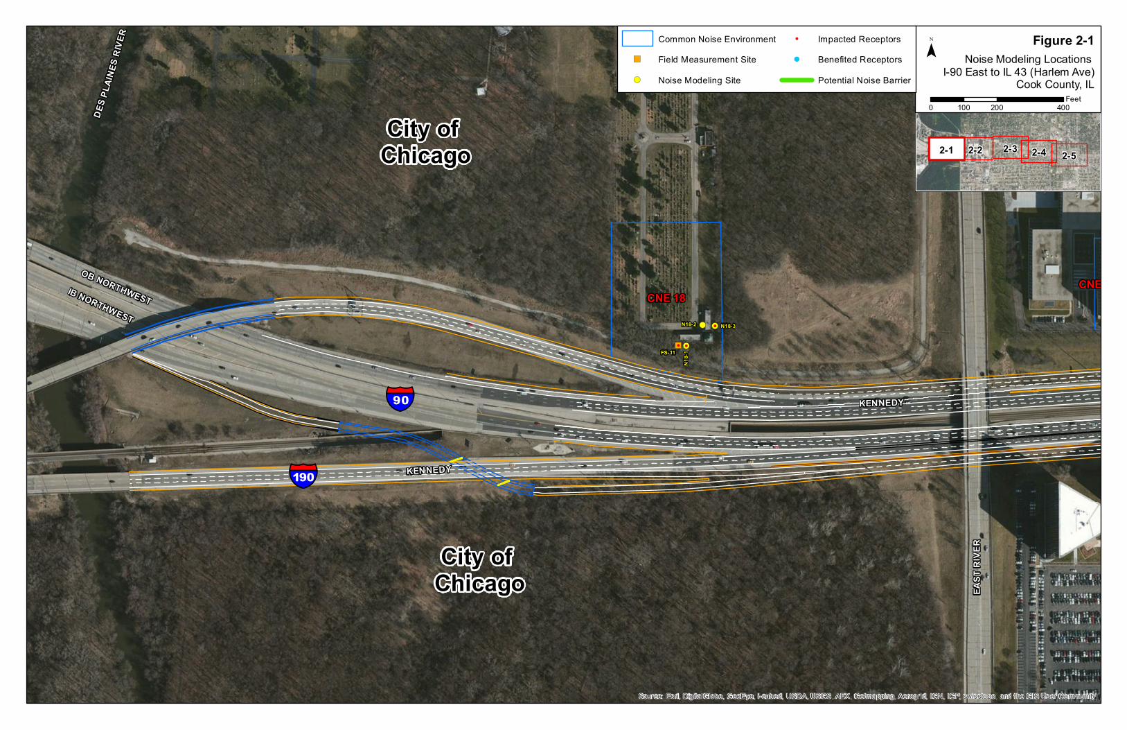
2-52-1 2-2 2-3 2-4
Noise Modeling Locations I-90 East to IL 43 (Harlem Ave)
Cook County, IL
Figure 2-1¯Common Noise Environment
") Field Measurement Site!( Noise Modeling Site
! Impacted Receptors! Benefited Receptors
Potential Noise Barrier
0 200 400100Feet
!(
!(
!(
!
§̈¦90
City of Chicago
City of Chicago
N1-1
N17-1
KENNEDY
HIGGINS
EAST
RIV
ER
CUMB
ERLA
ND
KENNEDY
CNE 1
CNE 17
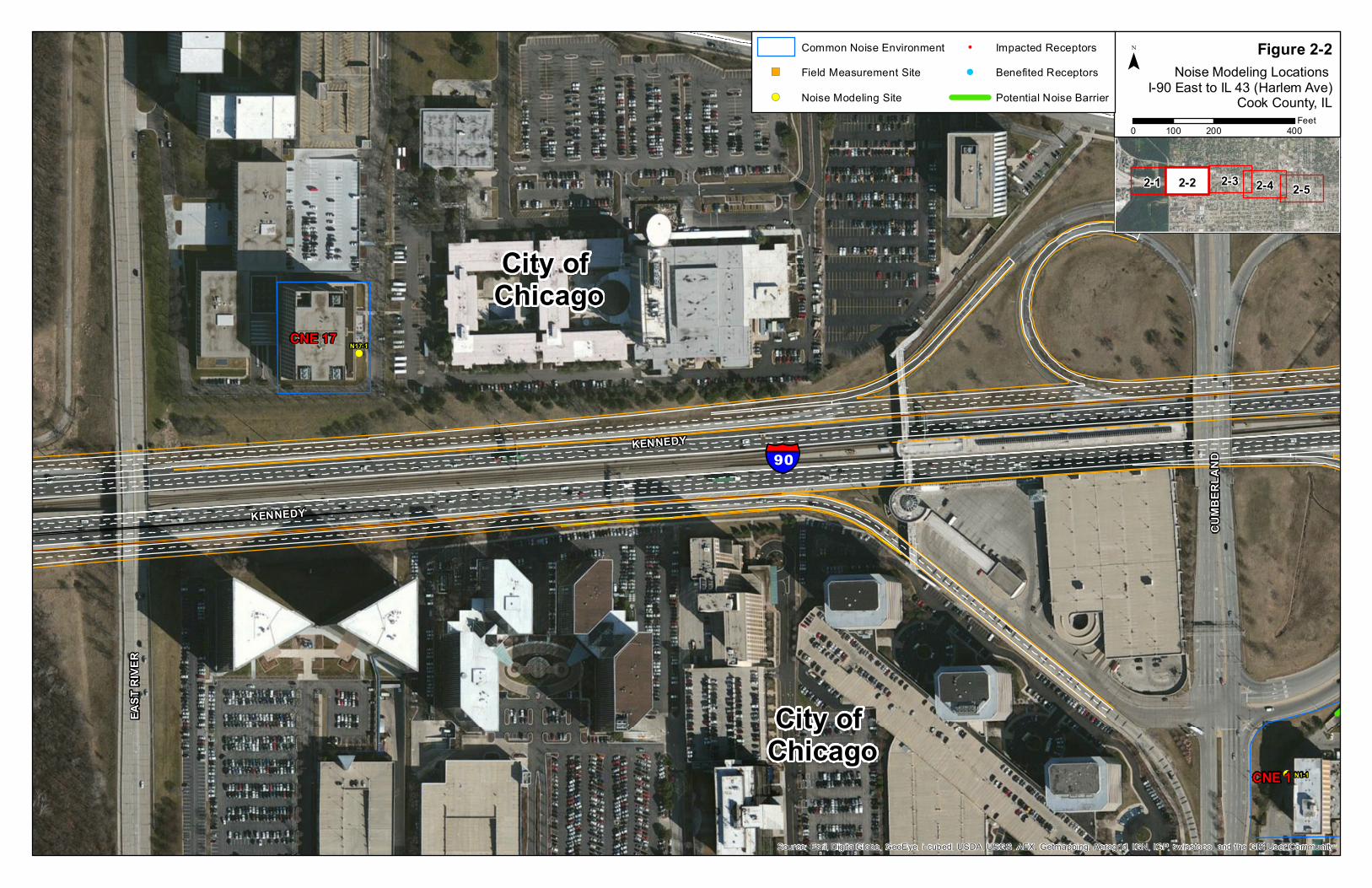
Source: Esri, DigitalGlobe, GeoEye, i-cubed, USDA, USGS, AEX, Getmapping, Aerogrid, IGN, IGP, swisstopo, and the GIS User Community
2-52-1 2-2 2-3 2-4
Noise Modeling Locations I-90 East to IL 43 (Harlem Ave)
Cook County, IL
Figure 2-2¯Common Noise Environment
") Field Measurement Site!( Noise Modeling Site
! Impacted Receptors! Benefited Receptors
Potential Noise Barrier
0 200 400100Feet

!(
!(!(
!(
!(
!(
!( !(
!(
!(
!(
!(
!(!(
!(
!(
!(
!(
!(
!( !(
!(
!(
!(
!(
!(
!( !(
!(
!( !(
!(
!(!(
!(
!( !(
!(
!( !(
!(
!( !(
!(
!( !(
!(
!(
")
!(
!(
!(
!(
!(
!(
!(
!( !(
!(
!(
!(
!(!(
!(
!(
!( !(
!(
!(
!(
!( !(
!(
!(
!(
!(
!(
!(!(
!(
!(
!(
!(
!(
!(
!(
!(
!(
!(
!(
!(
!(
!(
!(
!(
!(
!(
!(
!(
!(
")
!(
!(
!(
!(
!(
!(!(
!(
!(
")!(!(!(!(!(
!(!(!(!(!(
!(!(!(!(!(
!(!(!(!(!(
!(!(!(!(!(
!(
!(!(
!!
!
!
!
! !
!
!
!
!
!!
!
!
!
!
!
! !
!
!
!
!
! !
!
! !
! !
!
!
!
! !
!
! !
!
!
!
!
!
!
!
!
!
!
!
!
!!
!
!
!
!!
!
!
!
!
!
!
!!!
!
!!!
!
!!!
!
!!!
!
!!
!
!
!
!
!!
!
!
!
!
!
!
!
!!
!!
!
!!
§̈¦90
City of Park Ridge
City of Park Ridge
City of Chicago
NB6
NB1
FS-9
N6-4
N5-1
N4-9N4-8N4-7
N4-6N4-5
N4-4N4-3
N4-2
N4-1
N3-3
N3-2
N3-1
FS-1
N2-9N2-8
N2-7N2-6
N2-5
N2-4
N2-3
N2-2
N2-1
N1-1
N16-2 N16-1
N15-1N14-9N14-8N14-7
N14-6
N14-5N14-4N14-3N14-2
N14-1
FS-10
N13-9
N13-8
N13-7
N13-6
N13-5
N13-4
N13-3
N13-2
N13-1
N12-1
N6-17
N6-16
N4-20N4-19
N4-18
N4-17
N4-16N4-15N4-14
N4-13N4-12
N4-11N4-10
N2-47
N2-46
N2-45N2-44
N2-43
N2-42N2-41
N2-40
N2-39N2-38
N2-37
N2-36N2-35
N2-34
N2-33N2-32
N2-31
N2-30N2-29
N2-28
N2-27N2-26
N2-25
N2-24
N2-23
N2-22
N2-21
N2-20N2-19
N2-18
N2-17
N2-16
N2-15
N2-14
N2-13N2-12
N2-11
N2-10
N14-25N14-24N14-23N14-22
N14-2
1
N14-20N14-19N14-18N14-17 N14-13
N13-28
N13-27N13-26
N13-25
N13-24
N13-23
N13-22
N13-21
N13-20
N13-19
N13-18
N13-17
N13-16
N13-15
N13-14
N13-13
N13-12
N13-11
N13-10
N14-1
6
N14-15N14-14
N14-12
N14-1
1
N14-10
HIGGINS
KENNEDY
SERBIAN
SEMINOLE
REDW
OOD
OSAGE
FAIR
VIEW
SEMINOLE
KENNEDY
OSAG
E
CNE 2
CNE 13
CNE 4CNE 3
CNE 5
CNE 1
CNE 15
ORAN
GE
CANF
IELD
CNE 14
CNE 16
CNE 12
Source: Esri, DigitalGlobe, GeoEye, i-cubed, USDA, USGS, AEX, Getmapping, Aerogrid, IGN, IGP, swisstopo, and the GIS User Community
2-52-1 2-2 2-3 2-4
Noise Modeling Locations I-90 East to IL 43 (Harlem Ave)
Cook County, IL
Figure 2-3¯Common Noise Environment
") Field Measurement Site!( Noise Modeling Site
! Impacted Receptors! Benefited Receptors
Potential Noise Barrier
0 200 400100Feet

!(
!(
!(
!(
!(!(
!(
!(
!( !(
!(
!(
!(
!( !(
!(
!(
!(
!(
!(
!( !(!(
!(
!(!(!(!(!(!(!(
!(
!(!( !(
!(
!(
!(
!(
!(
!(
!(
!(
!(
") !(
!(
!(!(
!(
!(
!(
!(!(
!(
!(
!(
!(!(
!(
!(
!(
!(
!(
!(
!(
!(
!(
!(!(
!(
!(
!(
!(
!(
!(
!(
!(
!(
!( !( !( !( !( !(
!(!( !(
!(!(
!(")
!( !(
!( !(!(
!(
!( !(
!(!(!(!( !(
!(
!(
!(
!(
!(
!( !(
!(
!(!(!(
!(!(
!(
!(!(
!(!(
!(
!(
!(
!(!(!(
!(
!(
!(
!( !(
!(
!(
") !(
!(
!(
!(
!(
!(
!(
!(
!(
!(
!(
!(
!(
!(
!(
!(!(
!(
!(
!(!(
!(
!(
!(
")
!(
!( !(
!(
!(
!(
!(
!(
!(
!(
!(!(
!(!(!(!(!(!(!(!(!(
!(!(
!(
!(
!(
!(!(
!(!(
!(!(
!(
!(
!(!(
!(!(!(!(!(!(!(
!(!(!(!(!(
!(!(!(!(!(
!(!(!(!(!(!(!(!(!(!(!(
!(
!(!(!(!(!(!(!(
!(
!(
!(
!(
!(
!(
!(
!(
!(
!(
!(
!(
!(
!(
!(
")
!
!
!
!!
!
!
!
!!
! !
!
!
!
!
!
!
!
!
!
!
!
!
!
!
!
!
!
!
!
!
!
!
!
!
!
!
!
!! !
!!
! !!
! !
!!
! !
!!!
!!
!
!!
!
!!
!
!!
!
!
!
!!
!!!!
!!!!!
!
!
!
!
!!
!!!
!
!!!
!!
!
!
!
!
!
!
!
!
!
!
!!
!
!
!!
!
! ! !
!
!
!
!
!
!
!!
!!
! !
!
!
!
!
!
!!
!
!
!
!
!!
!!
!!!
!!
!
!!
!
!!
!
§̈¦90
City of Chicago
City of Park Ridge
City of Chicago
City of Chicago
NB5
NB6 NB5
NB2NB2
NB1
NB3
NB4FS-9
FS-8
FS-7
N8-3
N8-2N8-1
FS-3
N7-9
N7-8
N7-7
N7-6
N7-5
N7-4
N7-3
N7-2
N7-1
FS-2
N6-9
N6-8
N6-7N6-6N6-5
N6-4N6-3
N6-2
N6-1
N5-1
N4-9
N4-8N4-7
N4-6
N13-9
N13-8
N13-7
N13-6
N13-5
N13-4
N13-3
N13-2
N13-1
N12-1
N11-1
N10-9
N10-8
N10-7
N10-6
N10-5
N10-4N10-3
N10-2N10-1
N9-99
N9-98
N9-97
N9-96
N9-95
N9-94
N9-93
N9-92
N9-91N9-89
N9-88N9-87
N9-86N9-85N9-84
N9-83
N9-82
N9-81
N9-80
N9-79 N9-78
N9-77
N9-76
N9-75
N9-74N9-73
N9-72N9-71
N9-70
N9-69
N9-68
N9-67
N9-66
N9-65
N7-38N7-37
N7-36
N7-35 N7-26
N7-24N7-23
N7-22N7-21
N7-20N7-19
N7-18
N7-17N7-16N7-15
N7-14
N7-13N7
-12N7-11
N7-10
N6-60
N6-59N6-58
N6-57
N6-56
N6-55
N6-54N6-53
N6-51
N6-50
N6-49
N6-48N6-47N6-46
N6-45
N6-44
N6-43
N6-42N6-41
N6-40
N6-39
N6-38
N6-37N6-36
N6-35
N6-34
N6-33
N6-32N6-31
N6-30
N6-29
N6-28
N6-27N6-26
N6-25
N6-24
N6-23
N6-22
N6-21N6-20
N6-19N6-18N6-17
N6-16N6-15
N6-14
N6-13
N6-12
N6-11
N6-10
N4-20N4-19
N4-18
N4-17
N4-16N4-15N4-14
N4-13
N4-12
N4-11N4-10
N13-12
N13-11
N13-10 N10-75
N10-74 N10-73 N10-72 N10-71 N10-70 N10-69 N10-68
N10-67
N10-66
N10-65N10-64N10-63
N10-62
N10-61N10-60
N10-59
N10-58N10-57
N10-56
N10-55N10-54N10-53N10-52
N10-51
N10-50N10-49N10-48N10-47
N10-46
N10-45
N10-42N10-41
N10-40 N10-39
N10-38 N10-37N10-36
N10-35
N10-34 N10-33N10-32
N10-31N10-30
N10-29
N10-28
N10-27
N10-26
N10-25N10-24
N10-23
N10-22
N10-21
N10-20
N10-19
N10-18
N10-17
N10-16
N10-15
N10-14
N10-13 N10-12
N10-11
N10-10
N9-105
N9-104N9-103
N9-102
N9-101
N9-100
N10-4.2N10-3.2 N10-2.2
N10-1.2
N7-20.2
N7-25
N10-44N10-43
KENNEDY
ORIO
LE
HIGGINS
BRYN MAWR
CANF
IELD
OLIVE
OZAN
AM
OZAR
K
VICTORIA
OVER
HILL
ARDMOREROSEDALE
OLEANDER
SERBIAN
OTTA
WA
OLCOTT
SEMINOLE
KENNEDY
ARDMORE
HIGGINS
OZAR
K
OVER
HILL
ARDMORE
SEMINOLE
VICTORIA
OTTA
WA
SEMINOLE
CNE 6
CNE 10
CNE 9
CNE 7
CNE 4
CNE 13
CNE 8
CNE 5
ORAN
GE
GREGORY
CNE 11
CNE 12
Source: Esri, DigitalGlobe, GeoEye, i-cubed, USDA, USGS, AEX, Getmapping, Aerogrid, IGN, IGP, swisstopo, and the GIS User Community
2-52-1 2-2 2-3 2-4
Noise Modeling Locations I-90 East to IL 43 (Harlem Ave)
Cook County, IL
Figure 2-4¯Common Noise Environment
") Field Measurement Site!( Noise Modeling Site
! Impacted Receptors! Benefited Receptors
Potential Noise Barrier
0 200 400100Feet

!(
!( !(!(
!(
!(")
!( !(
!( !(!(
!( !(!(!(!( !(
!(!( !(
!(
!( !(!(
!(
!(
!(
!(
!(!(
!(
!(
!(
!(!( !(
")
!( !( !( !( !( !( !( !( !( !( !(
!(!( !( !( !( !(
!(
!(
!(
!(
!(
!(
!(!( !(
!( !(
!(
!(
!(
!(!(!(!(!(!(!(!(!(!(!(!(!(!(!(
!(
!(
!(!(!(!(!(!(!(!(")!(!(!(!(!(!(!(!(!(!(!(!(!(
!(!(!(!(!(!(!(!(!(!(
!(!(!(!(!(!(
!(!(!(!(!(!(!(
!(
!(
!(!(
!(
")
!(
!(
!(
!(
!(!(
!(
!(
!(
!(
!(
!(
!(
!(
!(
!(!(!(
!(!(
!(
!(!(
!(!(
!(
!(
!(
!(!(!(
!(
!(
!(
!( !(
!(
!(
") !(
!(
!(
!(
!(
!(
!! !
!!
! !!
! !
!!
! !
!! !
!!!!!!!!!!!!!!!!!!!!!!!
!
!
!
!
!!
!
!
!
!
!
!!!
!!
!
!!
!
!!
!
!!
!!
! !
!
!
!
!
!
!
!!! !!! !!!!
!!!!!!!!!!!!!!!!!!!!!!!!!!!!!
!!
!
!
!
!!
§̈¦90N7-79.1, .2, .3, .4, & .5
N7-80.1, .2, .3, .4, & .5
City of Chicago
City of Chicago
NB4
NB3
NB4
FS-7
FS-6
N9-9FS-5N9-8
N9-7N9-6
N9-5N9-4N9-3N9-2
N9-1
N8-3
N8-2
FS-4
FS-3
N9-93
N9-92
N9-91
N9-90
N9-89
N9-88N9-87
N9-86N9-85N9-84
N9-83
N9-82
N9-81
N9-80
N9-79 N9-78
N9-77
N9-76
N9-75
N9-74N9-73
N9-72N9-71
N9-70
N9-69
N9-68
N9-67
N9-66
N9-65
N9-64
N9-63N9-62
N9-61
N9-60
N9-59
N9-58
N9-57
N9-56
N9-55N9-54N9-53N9-52
N9-51
N9-50
N9-49
N9-48 N9-47
N9-46
N9-45
N9-44
N9-43N9-42N9-41
N9-40
N9-39N9-38
N9-37 N9-36 N9-35 N9-34 N9-33 N9-32
N9-31 N9-30 N9-29 N9-28 N9-27 N9-26 N9-25 N9-24 N9-23 N9-22
N9-21N9-20N9-19N9-18
N9-17N9-16N9-15N9-14N9-13
N9-12N9-11N9-10
N7-77
N7-76
N7-75
N7-74N7-73
N7-72N7-71N7-70
N7-69
N7-68
N7-67
N7-66
N7-65
N7-64
N7-63N7-62N7-61N7-60N7-59N7-58
N7-57N7-56
N7-55
N7-54N7-53
N7-52
N7-51
N7-50
N7-49
N7-48
N7-47
N7-46N7-45N7-44
N7-43N7-42
N7-41N7-40
N7-39
N7-38N7-37
N7-36
N7-35
N7-34
N7-33N7-32
N7-31N7-30
N7-29N7-28
N7-27N7-26
N7-24N7-23
N7-20N7-19
N7-18
N7-17N7-16N7-15
N7-14
N7-13N7
-12
N7-20.2
N7-25
N7-78.1, .2, .3, .4, & .5
HIGGINS
KENNEDY
HARL
EM
BRYN MAWR
OLIVE
ARDMORE
ODEL
L
NEVA
OKET
O
GREGORY
TALCOTT
OLCOTT
SEMINOLE
OCTA
VIA
MONT
CLA
RE
OSCE
OLA
OCON
TO
CTA BU
S TU
RN
KENNEDY HARLEM AV
NOTT
INGHA
M
GREGORY
HIGGINS
KENNEDY HARLEM AVOK
ETO
SEMINOLE
BRYN MAWR
NEVA
OLCO
TT
KENNEDY
ODEL
L
OCTA
VIA
OSCE
OLA
CNE 9
CNE 7
CNE 8
ROSEDALE
WEST CIRCLE
Source: Esri, DigitalGlobe, GeoEye, i-cubed, USDA, USGS, AEX, Getmapping, Aerogrid, IGN, IGP, swisstopo, and the GIS User Community
2-52-1 2-2 2-3 2-4
Noise Modeling Locations I-90 East to IL 43 (Harlem Ave)
Cook County, IL
Figure 2-5¯Common Noise Environment
") Field Measurement Site!( Noise Modeling Site
! Impacted Receptors! Benefited Receptors
Potential Noise Barrier
0 200 400100Feet

Temporary Construction Impacts
What types of temporary construction impacts can be
expected?
• Temporary ramp closures
• Milling and resurfacing work (lane closures) at night
• Construction of the CD road and auxiliary lane during
the daytime
• Reconstruction of the East River Road bridge (detours
will be posted)
• Temporary closure of the Des Plaines River trail on the
East River Road bridge during reconstruction of the
bridge
• No impacts to the Cumberland CTA Station pedestrian
bridge are anticipated
A work zone Transportation Management Plan (TMP) has
been developed to maintain safety and mobility within
the construction zone.
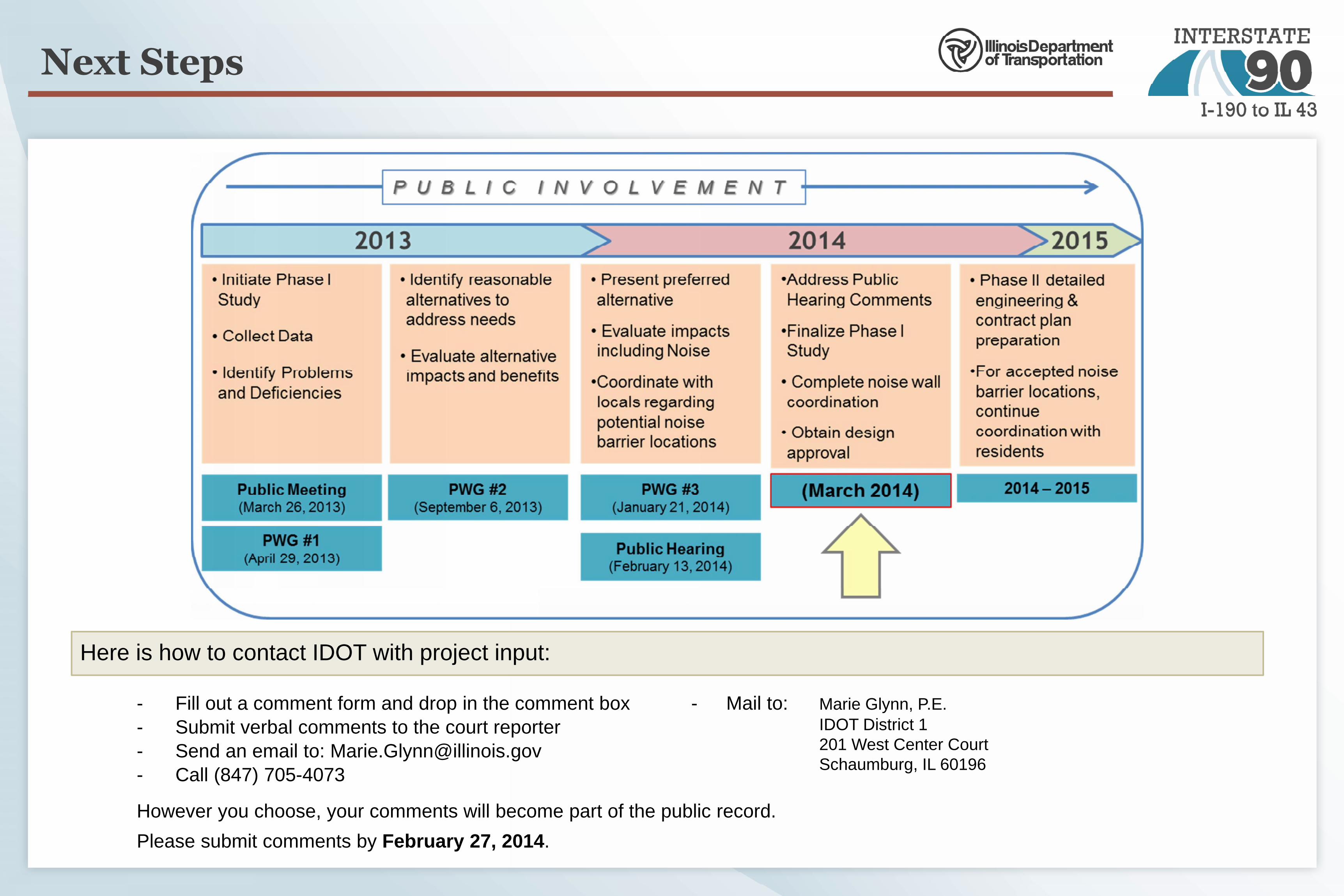
Next Steps
Here is how to contact IDOT with project input:
- Fill out a comment form and drop in the comment box- Submit verbal comments to the court reporter- Send an email to: [email protected] Call (847) 705-4073
However you choose, your comments will become part of the public record.
Please submit comments by February 27, 2014.
- Mail to: Marie Glynn, P.E.IDOT District 1201 West Center CourtSchaumburg, IL 60196