turkey tornado report - weather risk management · antalya airport (ltai) was hit by a tornado...
TRANSCRIPT
Brief Weather Analysis of Tornado at Antalya Airport, Turkey 26 Jan 2019
John Dutcher

�2 Contact Us www.wxriskmanagement.com
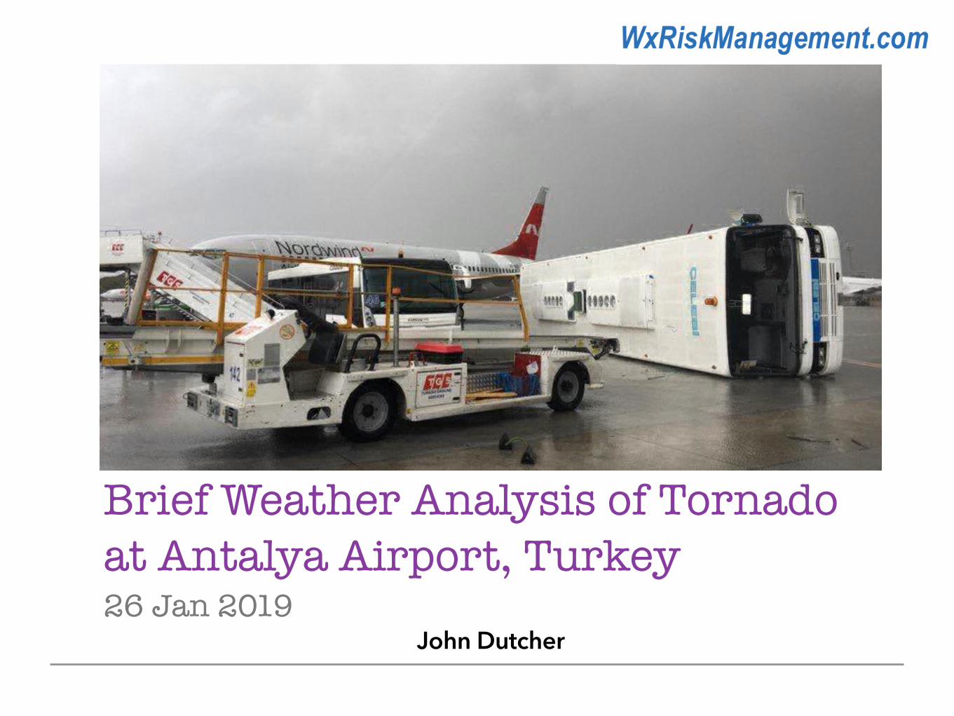
Antalya Airport (LTAI) was hit by a tornado causing considerable damage, destroying airport vehicles and structures, and moving several airplanes. The tornado damaged aircraft, ground equipment and injured 12 passengers waiting to board an aircraft via airstairs.
It was a part of a severe weather outbreak in the region, with at least 5 tornadoes and severe thunderstorms with very large hail. Major damage was also reported in Antalya city centre.
A number of tornadoes (reports of 5) hit Antalya, Turkey on Saturday 26 January 2019.


�4 Contact Us www.wxriskmanagement.com
26 Jan 2019 - 00Z
Surface Analysis A frontal system was positioned to the west of Antalya, Turkey.
Image: Dutcher, 2019
METAR LTAI 260020Z 21019G29KT 9999 -TSRA SCT015CB BKN025 13/09 Q1008 NOSIG=
SPECI LTAI 260002Z 18020G31KT 150V220 9999 -TSRA SCT015CB BKN025 15/10 Q1007 NOSIG RMK RWY18C 19 015 G 2 9 K T 16 0 V 2 4 0 R W Y 3 6 R 16 0 2 3 K T R W Y 18 L 16019G29KT=
�5 Contact Us www.wxriskmanagement.com
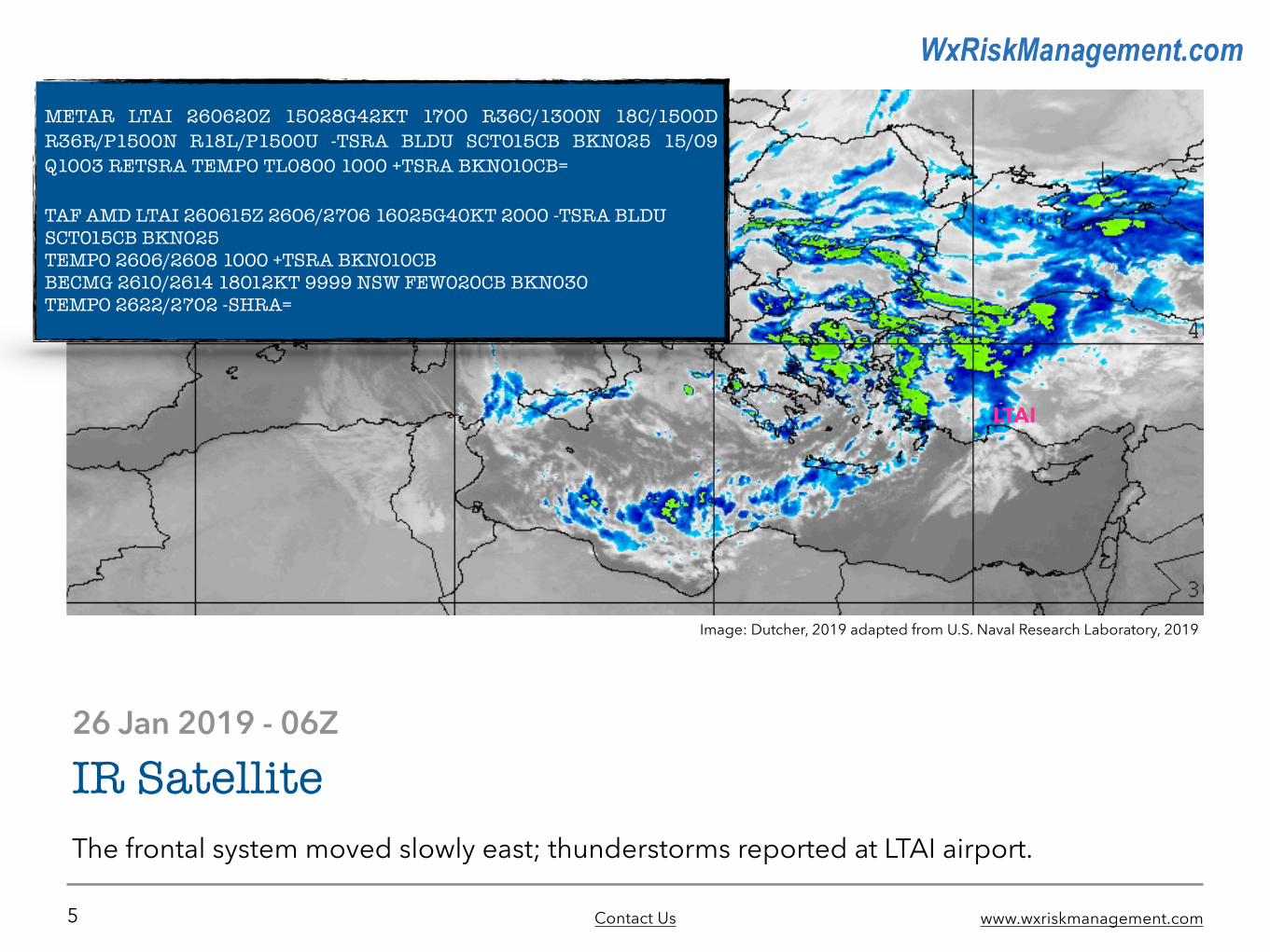
26 Jan 2019 - 06Z
IR Satellite The frontal system moved slowly east; thunderstorms reported at LTAI airport.
Image: Dutcher, 2019 adapted from U.S. Naval Research Laboratory, 2019
LTAI
METAR LTAI 260620Z 15028G42KT 1700 R36C/1300N 18C/1500D R36R/P1500N R18L/P1500U -TSRA BLDU SCT015CB BKN025 15/09 Q1003 RETSRA TEMPO TL0800 1000 +TSRA BKN010CB=
TAF AMD LTAI 260615Z 2606/2706 16025G40KT 2000 -TSRA BLDU SCT015CB BKN025 TEMPO 2606/2608 1000 +TSRA BKN010CB BECMG 2610/2614 18012KT 9999 NSW FEW020CB BKN030 TEMPO 2622/2702 -SHRA=

�6 Contact Us www.wxriskmanagement.com
GFS Model - MSLP & Precipitation Forecast26 Jan 2019 - 06Z
GFS Model - 850mb Height & Wind Forecast26 Jan 2019 - 06Z
Low-Level Analysis
Images: TropicalTidbits.com, 2019
The frontal system and associated deep low pressure system approaching Antalya, Turkey was supported by a closed low at the 850mb level (5000 ft) located over Greece. This closed low produced a strong southern flow.
GFS Forecast for 06Z showed south-southeast flow in the order of 50 knots over Antalya, Turkey. This low-level jet (LLJ) served to supply warm moist air at low levels under the cold air aloft.
The LLJ contributed significantly to both the instability and increased low-level shear necessary for the development of strong tornadoes. In these conditions, mass low-level convergence resulted, serving to intensify the upward vertical velocities.
LTAILTAI

�7 Contact Us www.wxriskmanagement.com
GFS Model - 250mb Height Forecast 26 Jan 2019 - 06Z
GFS Model - 500mb Height & Vorticity Forecast
Upper Level Analysis
Images: TropicalTidbits.com, 2019
Upper level features serve to support and drive weather at the surface. Therefore the 500mb (18,000ft) and the 250mb (34,000ft) GFS forecast charts were reviewed. A 500mb cold-core low was positioned over Greece and the Balkans.
The frontal system and associated deep low pressure system approaching Antalya, Turkey was further supported by a sharp long wave trough positioned over the Ionian Sea south of Italy, extending further northeastwards towards Bulgaria. A well-developed upper-level jet and upper-level divergence in the left-front sector, close to Antalya, Turkey were also present.
This upper air pattern supports strong upper-level cold air advection, and allows for significant vertical wind shear to extend down through the convective layer. These upper features maintained a favourable synoptic environment for tornadic events.
LTAI LTAI

�8 Contact Us www.wxriskmanagement.com
Image: Dutcher, 2019 adapted from Plymouth State Weather Center, 2019
>70 = Mesocyclone development possible
Total-Totals of 52–58 could indicate
moderate thunderstorms and a
few tornadoes
700–500mb Lapse Rate of 7.25 C/km
Bulk Richardson Number (BRN) of 0.1
These figures and dynamics suggest possibility of severe weather development, including
intense thunderstorms and tornadoes.
Weather Balloon Sounding
• Nearby sounding shows an unstable environment, with low-level wind shear.
• Relatively low CAPE amounts of 8 J/km.
• Increased moisture in the lower levels up to around 700mb (10,000ft) and dry air in mid-levels above 500mb (18,000).

�9 Contact Us www.wxriskmanagement.com
Our Meteorology Courses Include: • 3 Day - Meteorology for Air Safety Investigations (METI)• 5 Day - Aviation Weather Risk Management (AWRM) • 5 Day - Applied International Aviation Meteorology (AIAM)
• 1 Day - Meteorology Refresher (REMET)
Thank You!
Investigation Services also available (URL).
A full-service aviation safety, quality & weather risk management one-stop-shop.
We offer more than just expert consulting and tailoured service solutions; we are internationally experienced IATA qualified instructors
who also teach for some of the top aviation training institutes and authorities.