tu to ria l ellipsoid , g eoid , gr a vit y, g eodes y, an ...jowa/praktikum09/geoid... · suc h an...
TRANSCRIPT

GEOPHYSICS, VOL. 66, NO. 6 (NOVEMBER-DECEMBER 2001); P. 1660–1668, 4 FIGS., 3 TABLES.
Tutorial
Ellipsoid, geoid, gravity, geodesy, and geophysics
Xiong Li! and Hans-Jurgen Gotze‡
ABSTRACTGeophysics uses gravity to learn about the den-
sity variations of the Earth’s interior, whereas classicalgeodesy uses gravity to define the geoid. This differencein purpose has led to some confusion among geophysi-cists, and this tutorial attempts to clarify two points ofthe confusion. First, it is well known now that gravityanomalies after the “free-air” correction are still locatedat their original positions. However, the “free-air” re-duction was thought historically to relocate gravity fromits observation position to the geoid (mean sea level).Such an understanding is a geodetic fiction, invalid andunacceptable in geophysics. Second, in gravity correc-tions and gravity anomalies, the elevation has been usedroutinely. The main reason is that, before the emergenceand widespread use of the Global Positioning System(GPS), height above the geoid was the only height mea-
surement we could make accurately (i.e., by leveling).The GPS delivers a measurement of height above theellipsoid. In principle, in the geophysical use of gravity,the ellipsoid height rather than the elevation should beused throughout because a combination of the latitudecorrection estimated by the International Gravity For-mula and the height correction is designed to removethe gravity effects due to an ellipsoid of revolution. Inpractice, for minerals and petroleum exploration, use ofthe elevation rather than the ellipsoid height hardly in-troduces significant errors across the region of investi-gation because the geoid is very smooth. Furthermore,the gravity effects due to an ellipsoid actually can becalculated by a closed-form expression. However, its ap-proximation, by the International Gravity Formula andthe height correction including the second-order terms,is typically accurate enough worldwide.
INTRODUCTION
Geophysics has traditionally borrowed concepts of gravitycorrections and gravity anomalies from geodesy. Their uncrit-ical use has sometimes had unfortunate results. For example,the “free-air” reduction was historically interpreted by geode-sists as reducing gravity from topographic surface to the geoid(mean sea level). This interpretation is a useful fiction forgeodetic purposes, but is completely inappropriate for geo-physics. In geophysics, gravity is used to learn about the den-sity variations of the Earth’s interior. In geodesy, gravity helpsdefine the figure of the Earth, the geoid. This difference in pur-pose determines a difference in the way to correct observeddata and to understand resulting anomalies.
Until a global geodetic datum is fully and formally accepted,used, and implemented worldwide, global geodetic applica-
Published on Geophysics Online May 31, 2001. Manuscript received by the Editor August 9, 2000; Revised manuscript received February 26, 2001.!Fugro-LCT Inc., 6100 Hillcroft, 5th Floor, Houston, Texas 77081. E-mail: [email protected].‡Freie Universitat Berlin, Institut fur Geologie, Geophysik and Geoinformatik, Malteserstraße 74-100, D-12249 Berlin, Germany. E-mail: [email protected]" 2001 Society of Exploration Geophysicists. All rights reserved.
tions require three different surfaces to be clearly defined. Theyare (Figure 1): the highly irregular topographic surface (thelandmass topography as well as the ocean bathymetry), a geo-metric or mathematical reference surface called the ellipsoid,and the geoid, the equipotential surface that mean sea levelfollows.
Gravity is closely associated with these three surfaces. Grav-ity corrections and gravity anomalies have been traditionallydefined with respect to the elevation. Before the emergenceof satellite technologies and, in particular, the widespreaduse of the Global Positioning System (GPS), height abovethe geoid (i.e., the elevation) was the only height measure-ment we could make accurately, namely by leveling. TheGPS delivers a measurement of height above the ellipsoid.Confusion seems to have arisen over which height to use ingeophysics.
1660

Correctly Understanding Gravity 1661
This tutorial explains the concepts of, and relationshipsamong, the ellipsoid, geoid, gravity, geodesy, and geophysics.We attempt to clarify the way to best compute gravity correc-tions given GPS positioning. In short, h, the ellipsoid heightrelative to the ellipsoid, is the sum of H , the elevation relativeto the geoid, and N , the geoid height (undulation) relative tothe ellipsoid (Figure 2):
h = H + N . (1)
The geoid undulations, gravity anomalies, and gravity gradientchanges all reflect, but are different measures of, the densityvariations of the Earth. The difference between the geophys-ical use of gravity and the geodetic use of gravity mirrors thedifference between the ellipsoid and the geoid.
ELLIPSOID
As a first approximation, the Earth is a rotating sphere. As asecond approximation, it can be regarded as an equipotentialellipsoid of revolution.
According to Moritz (1980), the theory of the equipotentialellipsoid was first given by P. Pizzetti in 1894. It was furtherelaborated by C. Somigliana in 1929. This theory served asthe basis for the International Gravity Formula adopted at theGeneral Assembly of the International Union of Geodesy andGeophysics (IUGG) in Stockholm in 1930. One particular el-lipsoid of revolution, also called the “normal Earth,” is the onehaving the same angular velocity and the same mass as the ac-tual Earth, the potentialU0 on the ellipsoid surface equal to thepotential W0 on the geoid, and the center coincident with thecenter of mass of the Earth. The Geodetic Reference System1967 (GRS 67), Geodetic Reference System 1980 (GRS 80),
FIG. 1. Cartoon showing the ellipsoid, geoid, and topographicsurface (the landmass topography as well as the oceanbathymetry).
FIG. 2. The elevation H above the geoid, the ellipsoid heighth, and the geoid height (undulation) N above the ellipsoid.
and World Geodetic System 1984 (WGS 84) all are “normalEarth.”
Although the Earth is not an exact ellipsoid, the equipoten-tial ellipsoid furnishes a simple, consistent and uniform refer-ence system for all purposes of geodesy as well as geophysics:a reference surface for geometric use such as map projec-tions and satellite navigation, and a normal gravity field onthe Earth’s surface and in space, defined in terms of closedformulas, as a reference for gravimetry and satellite geodesy.The gravity field of an ellipsoid is of fundamental practical im-portance because it is easy to handle mathematically, and thedeviations of the actual gravity field from the ellipsoidal “theo-retical” or “normal” field are small. This splitting of the Earth’sgravity field into a “normal” and a remaining small “disturb-ing” or “anomalous” field considerably simplifies many prob-lems: the determination of the geoid (for geodesists), and theuse of gravity anomalies to understand the Earth’s interior (forgeophysicists).
Although an ellipsoid has many geometric and physical pa-rameters, it can be fully defined by any four independent pa-rameters. All the other parameters can be derived from thefour defining parameters. Table 1 lists the two geometric pa-rameters of several representative ellipsoids. Notice how theparameters differ, depending on the choice of ellipsoid.
One of the principal purposes of a world geodetic system isto supersede the local horizontal geodetic datums developedto satisfy mapping and navigation requirements for specific re-gions of the Earth. A particular reference ellipsoid was used tohelp define a local datum. For example, the Australian Nationalellipsoid (Table 1) was used to define the Australian GeodeticDatum 1966. At present, because of a widespread use of GPS,many local datums have been updated using the GRS 80 orWGS 84 ellipsoid.
GRS 80 and WGS 84
Modern satellite technology has greatly improved determi-nation of the Earth’s ellipsoid. As shown in Table 1, the semi-major axis of the International 1924 ellipsoid is 251 m largerthan for the GRS 80 or WGS 84 ellipsoid, which represents thecurrent best global geodetic reference system for the Earth.
WGS 84 was designed for use as the reference system for theGPS. The WGS 84 Coordinate System is a conventional terres-trial reference system. When selecting the WGS 84 ellipsoidand associated parameters, the original WGS 84 DevelopmentCommittee decided to adhere closely to the IUGG’s approachin establishing and adopting GRS 80.
GRS 80 has four defining parameters: the semimajor axis(a= 6 378 137 m), the geocentric gravitational constant of the
Table 1. Examples of different reference ellipsoids and theirgeometric parameters.
Semimajor axis Reciprocal ofEllipsoid name (a in meters) flattening (1/ f )
Airy 1830 6 377 563.396 299.324 964 6Helmert 1906 6 378 200 298.3International 1924 6 378 388 297Australian National 6 378 160 298.25GRS 1967 6 378 160 298.247 167 427GRS 1980 6 378 137 298.257 222 101WGS 1984 6 378 137 298.257 223 563
1662 Li and Gotze
Earth including the atmosphere (GM = 3 986 005 ! 108 m3/s2),the dynamic form factor (J2 = 108 263 ! 108) of the Earth ex-cluding the permanent tidal deformation, and the angular ve-locity (! = 7 292 115 ! 10"11 rad/s) of the Earth (Moritz, 1980).
Besides the same values of a and ! as GRS 80, thecurrent WGS 84 (National Imagery and Mapping Agency,2000) uses both an improved determination of the geocen-tric gravitational constant (GM = 3 986 004.418 !108 m3/s2)and, as one of the four defining parameters, the reciprocal(1/ f = 298.257 223 563) of flattening instead of J2. This flat-tening is derived from the normalized second-degree zonalgravitational coefficient (C2,0) through an accepted, rigorousexpression, and turned out slightly different from the GRS 80flattening because the C2,0 value is truncated in the normal-ization process. The small differences between the GRS 80ellipsoid and the current WGS 84 ellipsoid have virtually nopractical consequence.
APPROXIMATE CALCULATION OF THEORETICALGRAVITY DUE TO AN ELLIPSOID
The theoretical or normal gravity, or gravity reference field,is the gravity effect due to an equipotential ellipsoid of rev-olution. Approximate formulas are used widely even thoughwe can calculate the exact theoretical gravity analytically. Ap-pendix A gives closed-form expressions as well as approximateones. In particular, equation (A-2) (see Appendix A) estimatesin a closed form the theoretical gravity at any position on,above, or below the ellipsoid.
The International Gravity Formula
The conventionally used International Gravity Formula isobtained by substituting the parameters of the relevant ref-erence ellipsoid into equation (A-3). Helmert’s 1901 GravityFormula, and International Gravity Formulas 1930, 1967, and1980, correspond respectively to the Helmert 1906, Interna-tional 1924, GRS 67, and GRS 80 ellipsoids. For example, the1980 International Gravity Formula is (Moritz, 1980)
"1980 = 978 032.7(1 + 0.005 302 4 sin2 #
" 0.000 005 8 sin2 2#) mGal, (2)
where # is the geodetic latitude.The resulting difference between the 1980 International
Gravity Formula and the 1930 International Gravity Formulais
"1980 " "1930 = "16.3 + 13.7 sin2 # mGal,
where the main difference is due to a change from thePotsdam gravity reference datum used in the 1930 formula tothe International Gravity Standardization Net 1971 (IGSN71)reference.
The first term of the International Gravity Formula is thevalue of gravity at the equator on the ellipsoid surface. Unfor-tunately, in the 1930s, no one really knew what it was. The mostreliable estimate at that time was based on absolute gravitymeasurements made by pendulums at the Geodetic InstitutePotsdam in 1906. The Potsdam gravity value served as an ab-solute datum for worldwide gravity networks from 1909 until
1971. In the 1960s, new measurements across continents madeby precise absolute and relative gravity meters became the net-work of IGSN71 still in use today. A mean difference betweenthe Potsdam datum and the IGSN71 reference has been foundto be 14 mGal (Woollard, 1979).
Similarly, we can compare the 1967 formula to the 1980 for-mula in use today. The difference between the two is relativelysmall:
"1980 " "1967 = 0.8316 + 0.0782 sin2 # mGal.
The height correction
The International Gravity Formula estimates the changewith latitude on the ellipsoid surface of theoretical gravitydue to an ellipsoid. The height correction accounts for thechange of theoretical gravity due to the station’s being locatedabove or below the ellipsoid at ellipsoid height h. Historically,this height correction has been called the “free-air” correctionand thought to be associated with the elevation H , not theellipsoid height h. In geodesy, the “free-air” correction wasinterpreted fictitiously as a reduction to the geoid of gravityobserved on the topographic surface. This has given rise toconfusion in geophysics (e.g., Nettleton, 1976, 88).
As a second approximation, the height correction is given inequation (A-4). For the GRS 80 ellipsoid, we have
$gh2 = "h " " = "(0.308 769 1 " 0.000 439 8 sin2 #)h
+ 7.2125 ! 10"8h2 mGal. (3)
However, in exploration geophysics, a first-order formula iswidely used, rather than this second approximation.
The famous 0.3086 correction factor
For the International 1924 ellipsoid, the second approxima-tion of the height correction is (Heiskanen and Moritz, 1967,80)
$gh2 = "(0.308 77 " 0.000 45 sin2 #)h + 0.000 072h2.
Ignoring the second-order term and setting # = 45#, we obtainthe first approximation of the height correction
$gh1 = "0.3086h mGal. (4)
This is just the famous, routinely used, approximate height cor-rection. Again, in exploration geophysics, it is commonly calledthe (first-order) “free-air” correction and is used with the ele-vation H rather than the ellipsoid height h.
Errors of approximate formulas
For the GRS 80 ellipsoid, as a first approximation equa-tions (2) and (4) are combined to predict the theoretical gravityat a position above (or below) the ellipsoid. The result is
" 11980 = "1980 + $gh1. (5)
A second approximation is a combination of equations (2) and(3):
" 21980 = "1980 + $gh2. (6)
Correctly Understanding Gravity 1663
These two approximate formulas can be compared to the valuegiven by the closed-form formula (A-2). The two differencesare denoted as
!g1 = " 11980 ! " (7)
and
!g2 = " 21980 ! " . (8)
For an ellipsoid height of 3000 m, differences versus latitudesare given in Table 2. Table 3 shows differences versus ellipsoidheights at 45" latitude.
Because the differences !g2 shown in Tables 2 and 3 aresmaller than typical exploration survey errors, equation (A-4),together with the International Gravity Formula, produces asufficiently accurate approximation of the exact theoreticalgravity value worldwide. This equation includes the second-order ellipsoid height terms. For the GRS 80 ellipsoid, equa-tion (A-4) becomes equation (3).
GEOID
The geoid is a surface of constant potential energy that co-incides with mean sea level over the oceans. This definition isnot very rigorous. First, mean sea level is not quite a surface ofconstant potential due to dynamic processes within the ocean.Second, the actual equipotential surface under continents iswarped by the gravitational attraction of the overlying mass.But geodesists define the geoid as though that mass were alwaysunderneath the geoid instead of above it. The main functionof the geoid in geodesy is to serve as a reference surface forleveling. The elevation measured by leveling is relative to thegeoid.
GEODESY: CONVERSION OF GRAVITY TO GEOID
Originally, geodesy was a science solely concerned withglobal surveying, with the objective of tying local survey nets to-gether by doing careful surveying over long distances. Geode-sists tell local surveyors where their positions are with respectto the rest of the world. That includes determining the elevationabove sea level.
Why should gravity enter into geodesy?
Many geodetic instruments use gravity as reference. Clearly,mean sea level serves as a reference surface for leveling, andthe elevation is relative to mean sea level. In theory, mean sea
Table 2. Differences !g1 in equation (7) and !g2 in equation (8) of theoretical gravity in equation (A-2) and the two approxi-mations in equations (5) and (6) at an ellipsoid height of 3000 m and different geodetic latitudes.
latitude 0" 15" 30" 45" 60" 75" 90"
!g1 (mGal) !0.114 !0.192 !0.411 !0.728 !1.079 !1.363 !1.474!g2 (mGal) 0.028 0.038 0.061 0.073 0.052 0.009 !0.013
Table 3. Differences !g1 in equation (7) and !g2 in equation (8) of theoretical gravity in equation (A-2) and the two approxi-mations in equations (5) and (6) at geodetic latitude of 45"" and different ellipsoid heights.
height (m) 10 100 500 1000 2000 3000 4000 5000 6000
!g1 (mGal) 0.044 0.040 0.006 !0.068 !0.326 !0.728 !1.276 !1.968 !2.805!g2 (mGal) 0.045 0.046 0.050 0.055 0.064 0.073 0.081 0.089 0.096
level could be determined by regular observations at perma-nent tidal gauge stations. However, one can not very accuratelydetermine the elevation at a location far away from and nottightly tied to an elevation datum defining mean sea level. Inpractice, the geoid replaces mean sea level as a reference sur-face for leveling. When we level, what we really measure arethe elevations above (or below) the geoid. When geodesists orsurveyors say a surface is horizontal, they really mean that itis a surface of constant gravitational potential. So, geodesistshave always had to measure gravity—in addition to relativepositions—which is why gravity historically was regarded aspart of geodesy.
The very early gravity work with pendulum equipment wasfor geodetic purposes alone. Pierre Bouguer was probably thefirst to make this kind of observation when he led the expedi-tions of the French Academy of Sciences to Peru in 1735–1743.Geophysical use of gravity observations started much later.The first use for geological investigation may have been whenHugo de Boeckh, who was at that time the Director of theGeological Survey of Hungary, asked Baron Roland vonEotvos to do a torsion balance survey over the then one-welloil field of Egbell (Gbely) in Slovakia. This survey was carriedout in 1915–1916 and showed a clear maximum over the knownanticline (Eckhardt, 1940).
Geodesists determine the Earth’s figure (i.e., the geoid) intwo steps. First, they reduce to the geoid the gravity, observedon the actual Earth’s surface. Second, from the reduced gravity,they calculate the geoid undulations (i.e., the deviations fromthe ellipsoid surface).
The free-air reduction: An historical concept and requirementof classical geodesy
Gravity is measured on the actual surface of the Earth. Inorder to determine the geoid, the masses outside the geoidmust be completely removed or moved inside the geoid by thevarious gravity corrections, and gravity must be reduced ontothe geoid. Geodesists need the elevation H relative to the geoidwhen they derive the geoid from gravity.
For a reduction of gravity to the geoid, they need the verticalgradient of gravity, #g/#H . Note that H # a, the semimajoraxis of the ellipsoid. If gs is the observed value on the surfaceof the Earth, then the value gg on the geoid may be obtainedas a Taylor series expansion. Neglecting all but the linear term,geodesists obtain
gg = gs + F,

1664 Li and Gotze
where
F = ! !g!H
H " !0.3086H mGal. (9)
Equation (9) continues to be called the “free-air” effect.Geodesists have assumed that there are no masses above thegeoid, or that such masses have been removed beforehand, sothat this reduction is as though it were done in “free air”. Itis so called because, after removal of the topography by thecomplete Bouguer reduction, the gravity station is left hangingin “free air” (Heiskanen and Moritz, 1967, 131).
In classical geodesy, geodesists employed the fiction that the“free-air” reduction condensed the topographic masses andlowered the station onto the geoid, whereby the geoid becamea bounding surface of the terrestrial masses, and gravity gg wason the geoid (Heiskanen and Moritz, 1967, 145). Therefore,Stokes’ formula can be used to calculate geoid undulationsfrom gravity. Unfortunately, geophysicists have often misun-derstood and misused this geodetic philosophy.
Calculating geoid undulations from gravity
After estimating gg, gravity on the geoid, geodesists canthen derive the geoid. For a simplification, we take as examplethe spherically symmetric, rotating Earth. The derivation fromgravity to the geoid consists of three substeps (Wahr, 1997, 104–108). First, calculate "g, the angular-dependent component ofgg , by the following relation:
gg " GMa2
! 23#2a + "g.
Then solve!"V!r
+ 2a
"V = !"g
to find "V , the angular-dependent component of the gravita-tional potential. Finally, the geoid shape is given by the Brunsformula
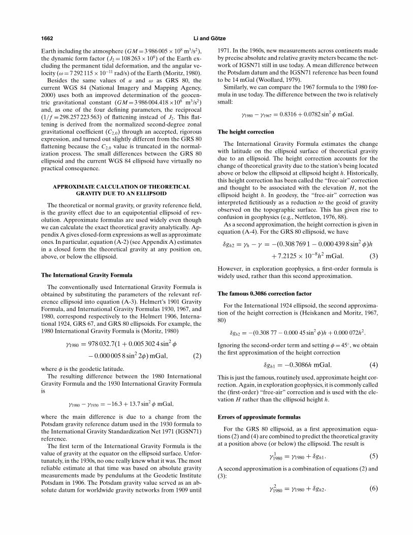
FIG. 3. The 15# $ 15# global geoid undulations produced by EGM96 (Lemoine et al., 1998). The undulations range from !107 m to85 m. Black lines indicate coast lines.
"r = "V$
,
where $ is the theoretical gravity on the surface of the sphericalearth and "r is the departure of the geoid from a sphere.
In general and in practice, the geoid undulations are denotedby N . They are the departure from an ellipsoid and can becalculated using Stokes’ formula. Details can be found in bookson physical geodesy (e.g., Heiskanen and Moritz, 1967; Wahr,1997).
Geoid model
Equation (1) connects h (the ellipsoid height relative to theellipsoid), N (the geoid undulation relative to the ellipsoid),and H (the elevation relative to the geoid) (Figure 2).
The geoid undulations range worldwide from !107 m to85 m relative to the WGS 84 ellipsoid. The primary goal ofgeodesy is to develop a geoid model, which is then used toconnect the three values. Given N , we can compute H or hfrom the other. For example, when we use GPS as a posi-tioning tool, we measure the ellipsoid height h. The eleva-tion H can be estimated by equation (1) if we have a geoidmodel.
In general, the global or large-scale features of the geoidare expressed by a spherical harmonic expansion of the grav-itational potential. Its higher terms are well defined by theground gravity data, and the lower terms by the satellite track-ing data. The Earth Gravitational Model 1996 (EGM96) is oneof the latest global models. It is complete through degree andorder 360. The EGM96 global geoid undulations are shown inFigure 3, and have an error range of ±0.5 to ±1.0 m worldwide(Lemoine et al., 1998). The U.S. National Imagery and MappingAgency recommends that it be used together with the WGS 84reference ellipsoid (National Imagery and Mapping Agency,2000).

Correctly Understanding Gravity 1665
Short-wavelength geoid undulations
The relation between spherical harmonic degree n and wave-length ! of geoid undulations is:
! = 2"Rn
! 40 000 000n
, (10)
where R= 6 371 000 m is the average radius of the Earth.EGM96 extends to degree and order 360 and thus has the short-est spatial wavelength of 111 km.
At present, there exists no published truly global geoidmodel that extends beyond degree 360 (i.e., contains a wave-length of shorter than 111 km). Several empirical relations havebeen established to estimate how the expected power of globalgravity and geoid signals drops off with an increase in degreeof the spherical harmonic model (Kaula, 1966; Tscherning andRapp, 1974; Jekeli, 1978). All these relations estimate that theglobal rms geoid undulation signals are less than 2 cm and20 cm, when the wavelengths of undulations are 10 km and100 km, respectively.
In a local area or nationwide, a high-resolution and accu-rate geoid model may be derived. The GEOID99 model is thelatest one for the United States. The geoid grid with a cellsize of 1 arcminute (about 2 km) is known as a hybrid geoidmodel, combining many millions of gravity and elevation pointswith thousands of control points (i.e., GPS ellipsoid heightson leveled bench marks). For the conterminous United States,when comparing the GEOID99 model back to the same controlpoints, the rms difference is 4.6 cm. Its resolution may be be-tween 10 and 20 km (Smith and Roman, 2001). For most of geo-physical exploration purposes, simple height conversions withGEOID99 in the conterminous United States can be sufficient.
CORRECTLY INTERPRETING THE FREE-AIR REDUCTION
Heiskanen and Moritz (1967, chapter 8) defined physicalgeodesy to be “classical” or “conventional” before M. S. Molo-densky proposed his famous theory in the 1940s, and “modern”thereafter. Distinguished from Stokes’ formula, Molodensky’stheory says that the physical surface of the Earth can be deter-mined without using the density required, for example, by theBouguer correction. Heiskanen and Moritz (1967, section 8.3“Molodensky’s Problem”, 293) clearly wrote:
The normal gravity on the telluroid [a variant of thegeoid–authors] is computed from the normal gravityat the ellipsoid by the normal free-air reduction, butnow applied upward . . . Therefore the new free-airanomalies have nothing in common with a free-airreduction of actual gravity to sea level, except thename. This distinction should be carefully kept inmind.
And on page 241,
If, as is usually done, the normal free-air gradient#$ /#h! 0.3086 mGal/m is used for the free-air re-duction, then the free-air anomalies refer, strictlyspeaking, to the Earth’s physical surface (to groundlevel) rather than to the geoid (to sea level) . . .How-ever, this distinction is insignificant and can be ig-nored in most cases, so that we may consider %g assea-level anomalies.
In geodesy, this distinction is insignificant and can be ig-nored in most cases because the reduction (downward contin-uation) to sea level affects relatively short-wavelength anoma-lies, which are less significant in determination of the geoid. Thegeoid reflects very-long-wavelength density variations. This isparticularly true in a determination of regional or global geoidundulations. But in exploration geophysics, we are interestedjust in short-wavelength anomalies. The distinction is impor-tant for us. Furthermore, it has led to an astonishing level ofconfusion among geophysicists.
In exploration geophysics, Naudy and Neumann (1965) ex-plicitly noted that the free-air and Bouguer gravity anoma-lies refer to the observation station. Many algorithms [e.g., theequivalent source technique of Dampney (1969)] have beendeveloped to continue gravity from an undulating observationsurface to a horizontal plane. Regardless, even in the 1980s,some publications still referred the free-air anomaly to sea leveland incorrectly suggested that the measured vertical gravitygradient should be better used to reduce observed gravity tosea level. For example, Gumert (1985) wrote, “The free-air fac-tor varies significantly with horizontal position and can affectthe reduction of observed gravity data. Land gravity measure-ments made at varying elevation in an area of rugged topog-raphy, processed using the standard accepted free-air factor,can produce highly erroneous maps.” Again, “Airborne grav-ity gives the ability to fly multi-level lines in a survey area tocompute the free-air factor to apply to the data.”
The height (or improperly, “free-air”) correction should bemade using a consistent, worldwide theoretical standard, thatis, one defined by an ellipsoid. The use of local or measuredvalue is inconsistent with the objective of looking for anomaliesrelative to a universal model of the earth’s gravity and is unableto continue observed gravity to any common level.
SATELLITE ALTIMETER GRAVITY: AN EXAMPLEOF CONVERTING GEOID INTO GRAVITY
The primary task of geodesy is to determine the geoid fromthe observed gravity. However, we can go in the other direc-tion, as well: we can convert the observed geoid into a grav-ity anomaly. Satellite altimeter gravity (also called satellite-derived gravity) is such a process.
In satellite altimetry, two very precise distance measure-ments are made so that the topography of the ocean surface(i.e., the geoid) is derived. First, the ellipsoid height h is mea-sured by tracking the satellite from a globally distributed net-work of lasers and/or Doppler stations. Second, the height ofthe satellite above the closest ocean surface (i.e., the eleva-tion H) is measured with a microwave radar altimeter. Asdemonstrated in equation (1), the difference between thesetwo heights is just the geoid undulation N . In practice, altimeterdata, collected by different satellites over many years, are com-bined to achieve a high data density and to average out sea sur-face disturbing factors such as waves, winds, tides, and currents.
The geoid relatively reflects deeply buried density variations.In order to enhance small-scale features, the high-precisiongeoid is converted into gravity anomaly. The gravity anomalycan be computed by using inverse Stokes’ formula (the geoid-to-gravity method) or by taking the derivatives of the geoid andusing Laplace’s equation (the slope-to-gravity method; e.g., seeSandwell and Smith, 1997). In the real world, the conversion

1666 Li and Gotze
algorithms are sophisticated, based on laws of physics, geome-try, and statistics.
Anyway, there is a simple relationship between gravityanomaly and geoid undulation. For two-dimensional anoma-lies, an anomaly in geoid with a wavelength ! and amplitudeN , the associated gravity anomaly "g is given by
"g = 2#$ N!
, (11)
where $ = 980 000 mGal, the average gravity of the Earth. Thisformula can be derived in the Fourier domain by followingthe work of a determination of gravity anomalies from a gridof geoid undulations (Haxby et al., 1983). Equation (11) saysthat the bump in the geoid associated with a 10-mGal gravityanomaly and a wavelength of 10 km is just 16 mm. This indi-cates how precise the geoid must be in order to derive gravityanomalies useful for exploration geophysics. A number of in-dependent studies (Green et al., 1998; Yale et al., 1998) showthat satellite altimeter gravity has an accuracy of about 5 mGaland resolution of about 20 km.
GEOPHYSICS: STATION GRAVITY ANOMALY RELATIVETO THE ELLIPSOID
Equations (4) and (9) appear to be the same. Actually, theyhave two important differences. First, h in equation (4) is theellipsoid height, but H in equation (9) the elevation. Second,equation (4) accounts for the change of theoretical gravitydue to the ellipsoid with the ellipsoid height, whereas equa-tion (9) represents an historical endeavor of reducing gravityfrom the Earth’s surface to the geoid. These two differences [i.e.,equations (4) and (9)] distinguish geophysics from (classical)geodesy. In geophysics, we should follow equation (4) and itsimplications.
Gravity anomaly is a station anomaly
The geophysical use of gravity is to learn about the Earth’sinterior. We need to remove the effects of the Earth’s irregular(nonellipsoidal) surface. In principle, this means that we shouldcompare the observed gravity to that of ellipsoidally-producedtheoretical gravity values at each observation station. Theirdifference is just the gravity anomaly. The free-air anomaly isthe difference between the observed gravity, without terrain-related corrections, and the theoretical gravity. The completeBouguer anomaly is the difference between the observed grav-ity with the complete Bouguer correction (the Bouguer slab,curvature, and terrain corrections) and the theoretical gravity.Both the free-air and Bouguer gravity anomalies are located atthe gravity station. We must conduct a continuation process inorder to obtain the gravity responses on the geoid or anothersurface/level. As an example, in a continuation to sea level ofthe ground Bouguer gravity anomaly in the Central Andes, thecorrection value can reach 30% of the maximum magnitude ofthe station anomalies (Li and Gotze, 1996).
The ellipsoid height, or the elevation plus the geoid
In geophysics, the gravity anomaly is the difference be-tween the observed gravity and the theoretical gravity pro-duced by the ellipsoid. The geophysical gravity anomaly canbe calculated simply by using the ellipsoid height h insteadof the elevation H in positioning and in all necessary correc-
tions/reductions. In particular, it is not appropriate to estimatethe elevation from the ellipsoid height determined by GPS andthen use the elevation for corrections/reductions. The extrastep produces less reasonable and less significant results.
Traditionally, geophysicists use the elevation as the verticalposition of the gravity station and the topographic model. Theelevation is used in all the corrections including the height cor-rection and the complete Bouguer correction (the Bouguerslab, curvature, and terrain corrections). Rigorously speaking,in addition we should correct observed gravity for the geoidshape. The gravity effects due to the geoid undulations arecalled the indirect effects (Chapman and Bordine, 1979). Liand Gotze (1996) explained the details of estimating the indi-rect effects. For example, the indirect effect %gih caused by theroutine height correction is
%gih = !0.3086N mGal. (12)
Thus, the indirect effect on the free-air gravity anomaly can beup to 30 mGal worldwide.
However, the amplitude of geoid undulations with a wave-length below 10 km is usually smaller than 10 cm, and theamplitude for a wavelength of 100 km is widely smaller than1 m. Approximately, an elevation change of 10 cm results in achange in computed Bouguer anomaly value of 0.02 mGal, and1 m results in a change of 0.2 mGal. In practice, at short wave-lengths (say, less than 100 km), we don’t need to correct for thegeoid undulations because the geoid is very smooth, with littlepower at those wavelengths. In petroleum exploration and inparticular in minerals exploration, by ignoring the geoid cor-rections (i.e., the indirect effects) one is unlikely to introduceany important relative errors across the region of investigation.
Use of geoid, gravity, and gravity gradient
The geoid undulations, gravity anomalies, and gravity gradi-ent changes all are due to the density variations of the Earth’sinterior, and are transformable from one to another. The wave-lengths that the gravity gradient, gravity, and geoid dominateor concentrate range gradually from short (tens of meters) tolong (thousands of kilometers). The geoid undulations are usedto study the global or very regional problems such as the man-tle convection. On the contrary, the gravity gradient is betterused to investigate short wavelength effects for engineering,environmental, or mining problems.
SUMMARY
Geodesy uses gravity to determine the geoid. Geodesistsmust reduce the observed gravity from the actual surface ofthe Earth to the geoid (mean sea level). In the gravity cor-rections/reductions, geodesists use the elevation instead of theellipsoid height.
Geophysics uses gravity to study the Earth’s interior. Thegravity anomaly is the difference between the observed gravityand the theoretical gravity predicted from the ellipsoid. Thegravity anomaly is located at the observation station after theheight correction and other routine corrections/reductions areapplied. In principle, the ellipsoid height should be used inpositioning and in all data corrections/reductions. In practiceand in minerals and petroleum exploration, use of the elevationrather than the ellipsoid height hardly introduces significanterrors because the geoid is very smooth. However, it should

Correctly Understanding Gravity 1667
not be recommended as a routine procedure to derive the ele-vation from the ellipsoid height determined by GPS and thenuse the elevation for corrections/reductions.
The theoretical gravity on, above, and below the ellipsoidsurface can be calculated by a closed-form formula. Its approx-imation by the International Gravity Formula and the heightcorrection including the second-order terms is typically accu-rate enough worldwide.
ACKNOWLEDGMENTS
A part of this work was finished when X.L. worked as a re-search fellow at Freie Universitat Berlin, financially supportedby the Alexander von Humboldt Stiftung. Writing of this tuto-rial has been largely stimulated by the discussions at the gravityand magnetic user group grvmag-l during May and June 2000.Comments from and discussions with Richard O. Hansen andMaurice D. Craig were helpful in improving the tutorial. Wealso thank associate editor David A. Chapin and reviewersAlan T. Herring and Dhananjay N. Ravat for their valuablesuggestions and comments.
REFERENCES
Chapman, M. E., and Bordine, J. H., 1979, Considerations of the indi-rect effect in marine gravity modeling: J. Geophys. Res., 84, 3889–3892.
Dampney, C. N. G., 1969, The equivalent source technique: Geophysics,34, 39–53.
Eckhardt, E. A., 1940, A brief history of the gravity method of prospect-ing for oil: Geophysics, 5, 231–242.
Green, C. M., Fairhead, J. D., and Maus, S., 1998, Satellite-derived gra-vity: Where we are and what’s next: The Leading Edge, 17, 77–79.
Gumert, W. R., 1985, Advantages of continuous profiling airbornegravity surveys: Proceedings of the International Meeting on Po-tential Fields in Rugged Topography, Institut de Geophysique, Uni-versite de Lausanne, 16–18.
Haxby, W. F., Karner, G. D., LaBrecque, J. L., and Weissel, J. K.,1983, Digital images of combined oceanic and continental data setsand their use in tectonic studies: EOS, 64, 995–1004.
Heiskanen, W. A., and Moritz, H., 1967, Physical geodesy: W. H.Freeman and Co.
Jekeli, C., 1978, An investigation of two models for the degree variancesof global covariance functions: Ohio State University, Departmentof Geodetic Science and Surveying, Report 275.
Kaula, W. M., 1966, Theory of satellite geodesy: Blaisdell PublishingCo.
Lakshmanan, J., 1991, The generalized gravity anomaly: Endoscopicmicrogravity: Geophysics, 56, 712–723.
Lemoine, F. G., et al., 1998, The development of the joint NASA GSFCand National Imagery and Mapping Agency (NIMA) geopotentialmodel EGM96: Technical Paper NASA/TP-1998-206861.
Li, X., and Gotze, H.-J, 1996, Effects of topography and geoid on grav-ity anomalies in mountainous areas: The Central Andes as an ex-ample: Institut fur Geologie, Geophysik und Geoinformatik, FreieUniversitat Berlin.
Moritz, H., 1980, Geodetic Reference System 1980: BulletinGeodesique, 54, 395–405.
National Imagery and Mapping Agency, 2000, Department of DefenseWorld Geodetic System 1984: Its definition and relationship withlocal geodetic systems: Technical Report NIMA TR8350.2, ThirdEdition.
Naudy, H., and Neumann, R., 1965, Sur la definition de l’anomalie deBouguer et sec consequences pratiques: Geophy. Prosp., 13, 1–11.
Nettleton, L. L., 1976, Gravity and magnetics in oil prospecting:McGraw-Hill Book Co.
Sandwell, D. T., and Smith, W. H. F., 1997, Marine gravity anomaly fromGeosat and ERS-1 satellites: J. Geophys. Res., 102, 10039–10054.
Smith, D. A., and Roman, D. R., 2001, GEOID99 and G99SSS:One arc-minute models for the United States: J. Geodesy, inpress.
Tscherning, C. C., and Rapp, R. H., 1974, Closed covariance expres-sion for gravity anomalies, geoid undulations, and deflections of thevertical implied by anomaly degree variance models: Ohio StateUniversity, Department of Geodetic Science and Surveying, Report208.
Wahr, J., 1997, Geodesy and gravity: Class notes: Samizdat Press.Woollard, G. P., 1979, The new gravity system—Changes in interna-
tional gravity base values and anomaly values: Geophysics, 44, 1352–1366.
Yale, M. M., Sandwell, D. T., and Herring, A. T., 1998, What are thelimitations of satellite altimetry?: The Leading Edge, 17, 73–76.
APPENDIX ATHEORETICAL GRAVITY DUE TO AN ELLIPSOID
The theoretical gravity is the gravity effect due to an equipo-tential ellipsoid of revolution. Approximate formulas are usedwidely. In fact, we can calculate the theoretical gravity at anyposition on, above, or below the ellipsoid surface using closed-form expressions.
Closed-form expression: Gravity on the surface of the ellipsoid
The theoretical gravity on the surface of the ellipsoid is givenbytheformulaofSomigliana(HeiskanenandMoritz,1967,76):
! = !e1 + k sin2 "
!1 ! e2 sin2 "
, (A-1)
where
k = b!pa!e
! 1;
e ="a2 ! b2
a2is the first eccentricity;
and a and b are the semimajor and semiminor axes of the ellip-soid, respectively; !e and !p are the theoretical gravity at theequator and poles, respectively; and " is the geodetic latitude.
Closed-form formula: Gravity above and below the surface ofthe ellipsoid
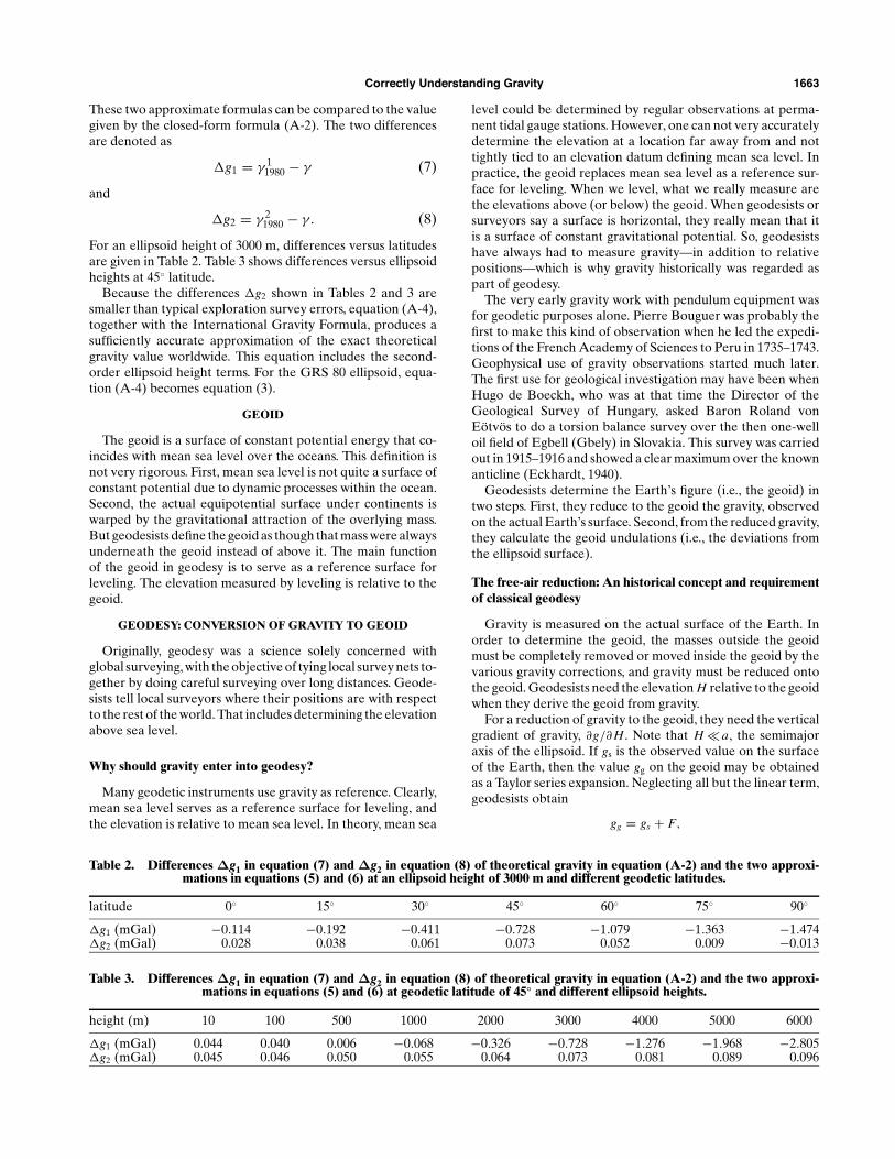
The theoretical gravity at any ellipsoid height h andany geodetic latitude " (Figure A-1) can also be given by aclosed-form formula. Starting from the general formula ofHeiskanen and Moritz (1967, 67–71), Lakshmanan (1991) de-rived the formula and published a result containing typo-graphic errors. Li and Gotze (1996) repeated the derivationand corrected the errors, obtaining
! = 1W
#GM
b"2 + E2 + #2a2Eq "
(b"2 + E2)q0
$12
sin2 $ " ! 16
%
! #2b" cos2 $ "&, (A-2)

1668 Li and Gotze
where
E =!a2 ! b2 is linear eccentricity,
W =
"b"2 + E2 sin2 ! "
b"2 + E2 ,
q " = 3#
1 + b"2
E2
$#1 ! b"
Etan!1 E
b"
$! 1,
q0 = 12
%#1 + 3b2
E2
$tan!1 E
b! 3b
E
&,
b" =!r ""2 ! E2 cos2 ! ",
cos ! " =
"12
+ R2
!'
14
+ R2
4! D
2,
FIG. A-1. A station above an ellipsoid surface. The ellipsoidhas the semimajor axis a and semiminor axis b. The position ofstation P relative to the ellipsoid is defined by ellipsoid heighth and geodetic latitude ". The angle ! is called the reducedlatitude.
and R= r ""2/E2, D= d ""2/E2, r ""2 = r "2 + z"2, d ""2 = r "2 ! z"2, r " =a cos ! + h cos ", z" = b sin ! + h sin ", and tan ! = b/a tan ".
Approximate formula for the latitude correction
The conventional latitude correction is a second-order seriesexpansion of equation (A-1) (Heiskanen and Moritz, 1967, 77):
# = #e
#1 + f # sin2 " ! 1
4f4 sin2 2"
$, (A-3)
with
f # = #p ! #e
#e(gravity flattening),
f4 = !12f 2 + 5
2f m,
f = a ! ba
(flattening of the ellipsoid),
and
m = $2a2bGM
.
Approximate formula for the height correction
The height correction accounts for the change of theoret-ical gravity due to the station being located above or belowthe ellipsoid at ellipsoid height h. As a second approximation(Heiskanen and Moritz, 1967, 79), a Taylor series expansionfor the theoretical gravity above the ellipsoid with a positivedirection downward along the geodetic normal to the referenceellipsoid is
#h = #
%1 ! 2
a(1 + f + m ! 2 f sin2 ") h + 3
a2h2
&.
The difference #h ! # (i.e., the height correction) is
#h !# = !2#e
a
%1+ f +m+
#52m!3 f
$sin2 "
&h+ 3#e
a2 h2.
(A-4)
See ERRATA for this Figure

Errata 997
To: “Ellipsoid, geoid, gravity, geodesy, and geophysics,” X. Li and H. -J. Götze (Geophysics, 66, 1660-1668).
The authors thank Dr. Nico Sneeuw of the University ofCalgary for pointing out a graphical error. The reduced lati-tude ! was incorrectly defined in Figure A-1, which shouldbe replaced by the figure shown below. However, thisgraphical error was not introduced into the derivation of theclosed-form expression for the theoretical gravity due to an
ellipsoid. All the formulae given in Appendix A are correct.There is also a typographic error in the dynamic form
factor J2, in the first paragraph on page 1662.
J2 = 108 263 x 10-8 not 108 263 x 108.
Figure A-1. A station above a reference ellipsoid surface. The reference ellipsoid has a semi-major axis a and a semi-minoraxis b. The position of station P relative to the reference ellipsoid is defined by ellipsoid height h and geodetic latitude ". Theellipsoid through point P has the same linear eccentricity as the reference ellipsoid. The reduced latitude ! is a geocentric lat-itude of point Q, which is the vertically projected point, on a sphere of radius a, of station P’s normal projection on the refer-ence ellipsoid surface.
GEOPHYSICS, VOL. 67, NO. 3 (MAY-JUNE 2002); DOI 10.1190/1.1489656 031203GPY