trancat fifth framework programme 1998 - 2002 energy, environment and sustainable development...
Post on 21-Dec-2015
215 views
TRANSCRIPT
TRAN CAT
Fifth Framework Programme1998 - 2002
ENERGY, ENVIRONMENT AND SUSTAINABLE DEVELOPMENT
TRANSCAT meetingWarsaw, Poland – 2.-3.10.2003
WP 3.1 – UML Model
Presented by
Vladimír Maršík - VSB-TU Ostrava
TRANSCAT

TRAN CAT
Fifth Framework Programme1998 - 2002
ENERGY, ENVIRONMENT AND SUSTAINABLE DEVELOPMENT
Task 3.1 - UML Model
Development of UML model for TRANSCAT DSS
• Why UML– Object oriented analysis and design of the system is recent standard
– UML is standard language for OOA and OOD
– using UML is recommended also in implementation documents for WFD
• Why Case Tool– Case tool enable us to apply the formal object oriented analysis and design
methodology effectively.
– The larger a project, the more important it is to use a CASE tool
– After Analysis phase can Design phase continue in the same environment
• Why Enterprise Architect– Cheap, flexible, support full UML standard
– Repository in Access or MS SQL database -> Multiuser
– Evidence of changes,

TRAN CAT
Fifth Framework Programme1998 - 2002
ENERGY, ENVIRONMENT AND SUSTAINABLE DEVELOPMENT
•Questionaries
•End-user specifications docs
•Data groups docs
•WFD
•National level legislation
•End-user interviews
•HTML documentation
•Text documentation
•Summary tables
Analytic stage•Requirements•Business process•Use Cases•Class diagram
Design stage•Class model•Component d.•Deployment d.
repository
Task 3.1 - UML Model
•Documentation
•Parts of program code
•Database

TRAN CAT
Fifth Framework Programme1998 - 2002
ENERGY, ENVIRONMENT AND SUSTAINABLE DEVELOPMENT
Class Model
Double click on a hyper link to activate it
Requirements
Identification of users (stakeholders)
Transcat overview
UML Internet Links
UML Tutorial Pages
OMG Home Page
UML modelpreliminary version
Business Process Model
Task 3.1 - UML Model
Under developement !
We have analysed broad range of activities in water management, but not in the big detail.

TRAN CAT
Fifth Framework Programme1998 - 2002
ENERGY, ENVIRONMENT AND SUSTAINABLE DEVELOPMENT
Transcat DSS
Database
decision-maker
User Enquiry
operator
Modelling and simulation
Management
Model data
Goal
Map generation
Map composition
Autorization
Data management and model management
«supply»
«output»
«supply»
«supply»
«supply»
«supply»
«supply»
«goal»
«output»
Business Process Model
The business process model lets you model the main business activities. A 'Process' describes something a business does as part of its normal activity; focusing mainly on the inputs, outputs, goals and key events that drivethe process.

TRAN CAT
Fifth Framework Programme1998 - 2002
ENERGY, ENVIRONMENT AND SUSTAINABLE DEVELOPMENT
Transcat DSS
ChoiceInteligence Design
Any decision-making process can be structured into three major phases:
o intelligence - is there a problem or an opportunity for change?
o this phase requires an exploratory analysis of the decision situation;
o GIS can play a vital role at the initial stage of spatial decision-making
o design - what are the decision alternatives?
o a formal model is typically used to support a decision maker in generating the set of alternatives;
o choice - which alternative is best?
Task 3.1 - UML Model
Decision-making process

TRAN CAT
Fifth Framework Programme1998 - 2002
ENERGY, ENVIRONMENT AND SUSTAINABLE DEVELOPMENT
Main requirements Functional requirements
System requirements
3.1 Software architecture
2.1 Visualisation of data
2.2 Querying
2.3 Analysis/calculation
2.4 Modelling
1.1 Goal
1.2 Main focus
1.3 Modular structure
1.4 DSS bases
3.2 Main subsystems
Name:Package:Version:Author:
RequirementsFormal Requirements1.0Vladimir Marsik
Requirements
Requirements in UML are modeled as structured 'Comments'.
Requirements compose a job description for the analyst. They base a managment perspective of future system.
Name:Package:Version:Author:
RequirementsFormal Requirements1.0Vladimir Marsik
Task 3.1 - UML Model

TRAN CAT
Fifth Framework Programme1998 - 2002
ENERGY, ENVIRONMENT AND SUSTAINABLE DEVELOPMENT
Stakeholders
(from Stakeholders)
Activ ities
+ EIA
+ FEES
+ FLOOD PROTECTION, FLOOD MEASUREMENTS
+ FORESTERY
+ HYDROENGINEERING STRUCTURES
+ INVESTMENTS AND ENTEPRENEURS
+ LAND USE PLANNING
+ RESEARCH ACTIVITIES
+ SURFACE AND GROUNDWATER CONDITION
+ WATER CONDITIONS AND WATER SOURCES PROTECTION
+ WATER COURSES HANDLING
+ WATER HANDLING
+ WATER LAW OBSERVANCE SUPERVISION AND PENALTY ADMINISTRATION
+ WATER PLANNING
+ WATERSHED MANAGEMENT
Class Model
+ Basic spatial types
+ Detailed GIS Data model
+ Documents
+ WFD GIS Data model
(from Logical View)
DependenceInteraction
Name:Package:Version:Author:
Transcat overviewUse Case Model1.0Vladimir Marsik
Transcat overviewUse Case Model
Task 3.1 - UML Model

TRAN CAT
Fifth Framework Programme1998 - 2002
ENERGY, ENVIRONMENT AND SUSTAINABLE DEVELOPMENT
Stakeholders
Benefitors
+ Citizens
+ Commercial planners
+ Entrepreneur (polluter)
+ Experts-in-charge
+ Fire brigade
+ Forestry management companies
+ NGOs
+ Police
+ Private commercial subjects
+ Real-estate-owners
+ Research and education bodies
+ Various development agencies
+ Various interest groups
End-Users
+ Armed forces
+ Central-Government
+ County-authorities
+ Court-of-justice
+ Environmental-inspection
+ Hydrometeorological-institute
+ Mining authorities
+ Ministry of Agriculture
+ Ministry of Development
+ Ministry of Environment
+ Municipal authorities
+ Public energy enterprise
+ Speciální stavební úřad vodohospodářský
+ Water law authorities
+ Watershed-manager
Actorsclassification
Task 3.1 - UML Model

TRAN CAT
Fifth Framework Programme1998 - 2002
ENERGY, ENVIRONMENT AND SUSTAINABLE DEVELOPMENT
Permitting procedures
Approv al
Statement
Water law records
Surface water treatment permit
Groundwater handling permit
Waste water discharge permitting
Certain activ ities permitting
Construction permit for
hydroengineering structures
Municipal authorities
(from End-Users)
County-authorities
(from End-Users)
Diversion, accumulation, fishbreeding
Diversion, accumulation, groundwater level reduction withdrawal
Pollution sources under 10 000 equivalent citizensPollution sources over 10 000 equivalent citizens, waste water containing dangerous/ very dangerous matters
Tree planting in inundation areas, sand excavation from water channel, water channel changes
Constructions, terrain levelling in inundation areas, constructions on water channel estates, in water source protection zones
Constructions affecting water balance, surface and groundwater quality and quantity, natural mineral water treatment
Record of Ministry of agriculture and Ministry of environment decisions
Fire brigade
(from Benefitors)
Record into real estate cadastre
protection zones etc.
Groundwater handling permit for entrepreneur
Mining authorities
(from End-Users)
Main water discharge
{CZ, GR}
{CZ,GR}
{CZ,GR}
{CZ,GR}
{CZ,GR}
{CZ,GR}
{CZ,GR}
{CZ,GR}Water handlingUse Case Model
The Use Case Model describes the proposed functionality of the system.A Use Case represents a discrete unit of interaction between a user (human or machine)and the system. A Use Case is a single unit of meaningful work. Each Use Case has a description which describes the functionality that will be built in the proposed system.
Name:Package:Version:Author:
Transcat overviewUse Case Model1.0Vladimir Marsik
TRAN CAT
Fifth Framework Programme1998 - 2002
ENERGY, ENVIRONMENT AND SUSTAINABLE DEVELOPMENT
…
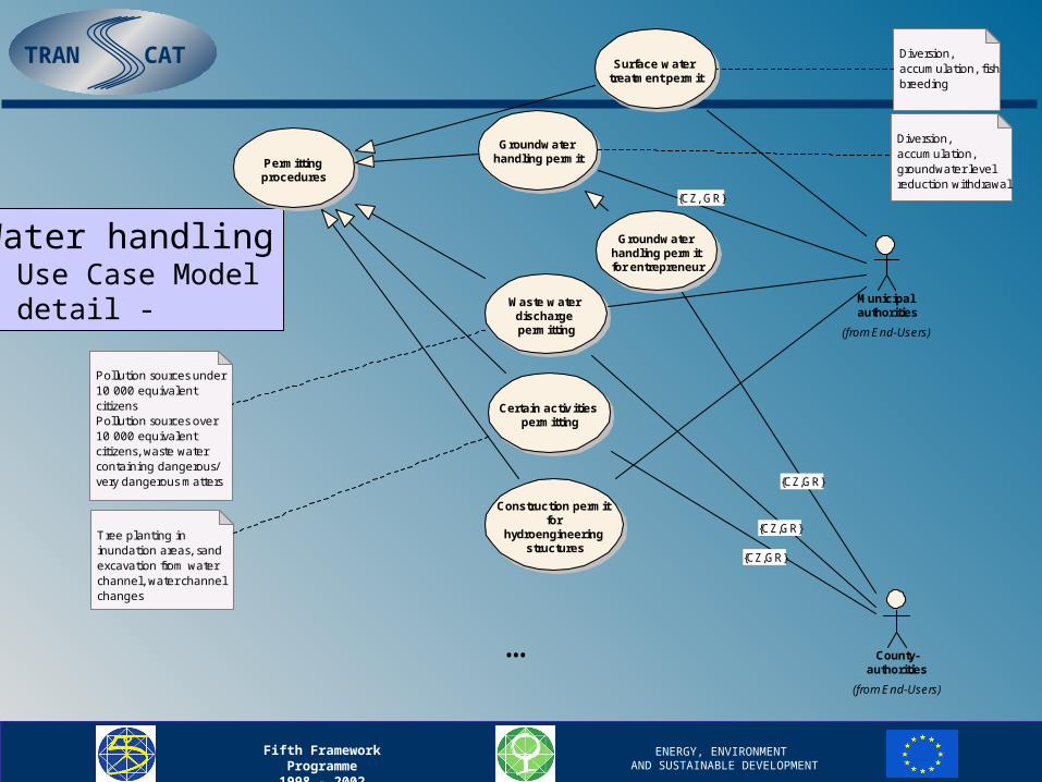
Water handling Use Case Model- detail -
Permitting procedures
Surface water treatment permit
Groundwater handling permit
Waste water discharge permitting
Certain activ ities permitting
Construction permit for
hydroengineering structures
Municipal authorities
(from End-Users)
County-authorities
(from End-Users)
Diversion, accumulation, fishbreeding
Diversion, accumulation, groundwater level reduction withdrawal
Pollution sources under 10 000 equivalent citizensPollution sources over 10 000 equivalent citizens, waste water containing dangerous/ very dangerous matters
Tree planting in inundation areas, sand excavation from water channel, water channel changes
Groundwater handling permit for entrepreneur
{CZ, GR}
{CZ,GR}
{CZ,GR}
{CZ,GR}

TRAN CAT
Fifth Framework Programme1998 - 2002
ENERGY, ENVIRONMENT AND SUSTAINABLE DEVELOPMENT
Inundation areas demarcation
Limitations in enhanced
inundation areas
Flood emergency plans
Flood emergency plans (muni)
Flood emergency plans (county)
Flood emergency plans (watershed)
Flood emergency plans (central)
Water stage limits for flood emergency activities, flood emergency committees, flood emergency plans
Flood forecasting and warning
serv ice
Flood emergency activ ities
Flood documentation
and assessment
Rainfall information, water stage, possibil i ties of flood occurrence
County-authorities
(from End-Users)
Municipal authorities
(from End-Users)
Watershed-manager
(from End-Users)
Ministry of Env ironment
(from End-Users)
Hydrometeorological-institute
(from End-Users)
Central-Gov ernment
(from End-Users)
Public energy
enterprise
(from End-Users)
{CZ,GR}
{CZ,GR}
{CZ,GR}
{CZ,GR}
{CZ,GR}
FLOOD PROTECTION, FLOOD MEASUREMENTS
Use Case Model

TRAN CAT
Fifth Framework Programme1998 - 2002
ENERGY, ENVIRONMENT AND SUSTAINABLE DEVELOPMENT
The Logical View contains packages for classes, user interface elements and the data model (relational tables).
Class Model
+ Basic spatial types
+ Detailed GIS Data model
+ Documents
+ WFD GIS Data model
The class model describes the logical objects in the system and their relationships. It is a rigorous model used to define the structure and construction of the system in a manner such that code may be written to implement the system.
Name:Package:Version:Author:
Logical ViewLogical View1.0Vladimir Marsik
Logical View(packages)
Task 3.1 - UML Model
TRAN CAT
Fifth Framework Programme1998 - 2002
ENERGY, ENVIRONMENT AND SUSTAINABLE DEVELOPMENT
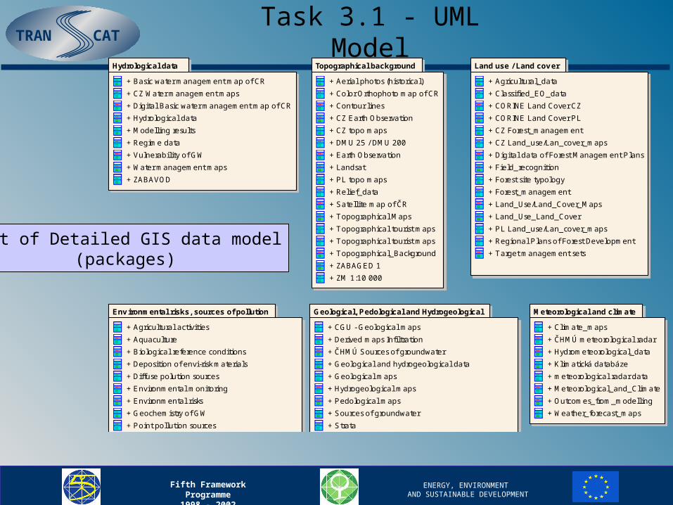
Hydrological data
+ Basic water management map of CR
+ CZ Water management maps
+ Digital Basic water management map of CR
+ Hydrological data
+ Modelling results
+ Regime data
+ Vulnerabil ity of GW
+ Water management maps
+ ZABAVOD
Topographical background
+ Aerial photos (historical)
+ Color Orthophoto map of CR
+ Contour l ines
+ CZ Earth Observation
+ CZ topo maps
+ DMU 25 / DMU 200
+ Earth Observation
+ Landsat
+ PL topo maps
+ Relief_data
+ Satellite map of ČR
+ Topographical Maps
+ Topographical tourist maps
+ Topographical tourist maps
+ Topographical_Background
+ ZABAGED 1
+ ZM 1:10 000
Land use / Land cov er
+ Agricultural_data
+ Classified_EO_data
+ CORINE Land Cover CZ
+ CORINE Land Cover PL
+ CZ Forest_management
+ CZ Land_use/Lan_cover_maps
+ Digital data of Forest Management Plans
+ Field_recognition
+ Forest site typology
+ Forest_management
+ Land_Use/Land_Cover_Maps
+ Land_Use_Land_Cover
+ PL Land_use/Lan_cover_maps
+ Regional Plans of Forest Development
+ Target management sets
Env ironmental risks, sources of pollution
+ Agricultural activities
+ Aquaculture
+ Biological reference conditions
+ Deposition of envi-risk materials
+ Diffuse polution sources
+ Environmental monitoring
+ Environmental risks
+ Geochemistry of GW
+ Point pollution sources
+ Pollution sources
+ Territorial planning
Geological, Pedological and Hydrogeological
+ CGU - Geological maps
+ Derived maps Infi ltration
+ ČHMÚ Sources of groundwater
+ Geological and hydrogeological data
+ Geological maps
+ Hydrogeological maps
+ Pedological maps
+ Sources of groundwater
+ Strata
+ superficial deposits
Meteorological and climate
+ Climate_maps
+ ČHMÚ meteorological radar
+ Hydrometeorological_data
+ Klimatická databáze
+ meteorological radar data
+ Meteorological_and_Climate
+ Outcomes_from_modelling
+ Weather_forecast_maps
Protected/Limited zones
+ AOPK files
+ Biocenters
+ CZ Biocenters
+ Protected zones maps
+ Protected_Limited zones
+ USES layers
Socio-economic
+ Administrative_Boundaries
+ Cadastral_data
+ Census data
+ CZ Administrative_Boundaries
+ Employee and unemployment
+ Selected enterprises
+ Socio-economic
+ Traffic accessibil ity
Technical facility/equipment
+ Meteorological stations
+ Technical facil ity
+ Technical facil ity maps
Part of Detailed GIS data model(packages)
Task 3.1 - UML Model

TRAN CAT
Fifth Framework Programme1998 - 2002
ENERGY, ENVIRONMENT AND SUSTAINABLE DEVELOPMENT
Land_Use_Land_Cov er
Field_recognition
Agricultural_data
«spatial_raster»Classified_EO_data
Forest_management
Land_Use/Land_Cov er_Maps
«spatial_poly»CORINE Land Cov er CZ
«spatial_poly»CORINE Land Cov er PL
Target management
sets
Digital data of Forest
Management Plans
Regional Plans of Forest
Dev elopment
Forest site typology
CZ Forest_management
PL Land_use/Lan_cov er_maps
CZ Land_use/Lan_cov er_maps
«CZ_part»
«CZ_part» «PL_part»
Land use / Land coverClass model

TRAN CAT
Fifth Framework Programme1998 - 2002
ENERGY, ENVIRONMENT AND SUSTAINABLE DEVELOPMENT
WFD GIS Data model(packages)
Required map compositions
+ Chemical Status of Surface Water Bodies
+ Competent Authorities
+ Ecological Status and Ecological Potential of Surface Water Bodies
+ Groundwater Bodies
+ Groundwater Monitoring Network
+ Groundwater Status
+ Map composition
+ Monitoring Network for SWB
+ Protected Areas
+ RBD-Overview
+ Status of protected areas
+ SWB – categories
+ SWB – types
Monitoring network
+ Groundwater level monitoring network
+ Groundwater monitoring stations
+ Investigative monitoring sites
+ Monitoring sites drinking water abstraction points
+ Monitoring stations
+ Operational monitoring network chemical
+ Operational monitoring sites
+ Reference monitoring sites
+ Surface monitoring stations
+ Surveillance monitoring network chemical
+ Surveillance monitoring sites
Status information of surface and groundwater bodies and protected areas
+ Bad status or potential causes
+ Chemical status
+ Chemical status of GWB
+ Ecological potential
+ Ecological status
+ FreshwaterEcologicalStatus
+ GWStatus
+ PhysicoChemicalClassification
+ Pollutant trend
+ Quantative status of GWB
+ Status of protected area
+ SWStatus
Basic information and characteristics of RBD
+ Bird protection areas
+ District of competent autorities
+ Drinking water protection area
+ Economically significant aquatic species protection area
+ Ecoregions
+ Habitat protection areas
+ Main Rivers
+ Nutrition-sensitive areas
+ Protected area
+ Recreational waters
+ River basin
+ River basin district
+ River sub-basin
+ Types of SWB
RIVER BASIN MANAGEMENT PLANS
+ Competent authorities
+ Contact points and procedures
+ Economic analysis
+ Environmental objectives
+ General description
+ General description for groundwaters
+ General description for surface waters
+ mapy umístění a hranic vodních útvarů
+ Monitoring networks
+ Programme measures
+ Protected areas
+ Register of any more detailed programmes
+ RIVER BASIN MANAGEMENT PLAN
+ Significant pressures and impact
+ Summary of the public information
WFD Feature classes
+ Artificial recharge
+ Impact of human activity
+ Water abstraction
+ Water body
+ Groudwaters
+ Surface waters
Task 3.1 - UML Model
TRAN CAT
Fifth Framework Programme1998 - 2002
ENERGY, ENVIRONMENT AND SUSTAINABLE DEVELOPMENT
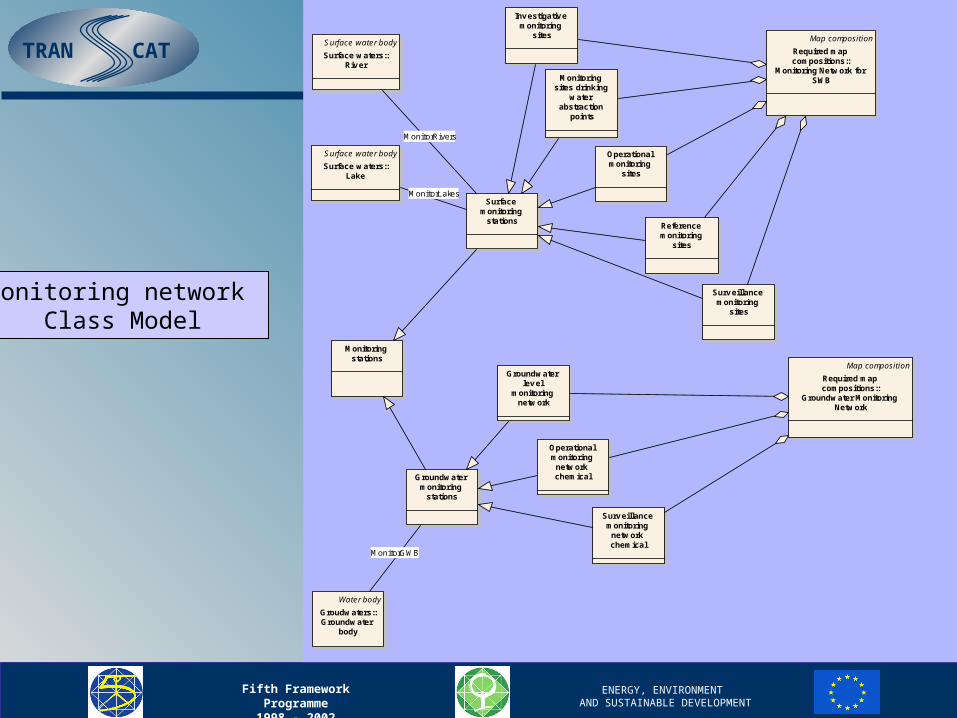
Investigative monitoring
sites
Monitoring sites drinking
water abstraction
points
Operational monitoring
sites
Reference monitoring
sites
Surveillance monitoring
sites
Map composition
Required map compositions::
Monitoring Network for SWB
Map composition
Required map compositions::
Groundwater Monitoring Network
Groundwater level
monitoring network
Operational monitoring
network chemical
Surveillance monitoring
network chemical
Surface monitoring
stations
Groundwater monitoring
stations
Monitoring stations
Surface water body
Surface waters::River
Surface water body
Surface waters::Lake
Water body
Groudwaters::Groundwater
body
MonitorLakes
MonitorGWB
MonitorRivers
Monitoring network Class Model

TRAN CAT
Fifth Framework Programme1998 - 2002
ENERGY, ENVIRONMENT AND SUSTAINABLE DEVELOPMENT
• Text document
Task 3.1 - UML Model
• HTML pages
UML model report generated in the form of

TRAN CAT
Fifth Framework Programme1998 - 2002
ENERGY, ENVIRONMENT AND SUSTAINABLE DEVELOPMENT
Thank you for your attention.
Vladimír Maršík
Institute of Geoinformatics
VSB-Technical University of Ostrava
Czech Republic
[email protected] http://gis.vsb.cz/transcat
Task 3.1 - UML Model