training session on integrating gis and remote sensing...
TRANSCRIPT
VT-P185-SLD-002-E-01-00 – Training VtPace in NARA, Colombo, Sri-Lanka on 02-06 October 2017 page 1
Training session on integrating GIS and
remote sensing data into Web portals
Serge RIAZANOFFDirector
[email protected]://www.visioterra.fr
[email protected]://www-igm.univ-mlv.fr/~riazano/

VT-P185-SLD-002-E-01-00 – Training VtPace in NARA, Colombo, Sri-Lanka on 02-06 October 2017 page 2

VT-P185-SLD-002-E-01-00 – Training VtPace in NARA, Colombo, Sri-Lanka on 02-06 October 2017 page 3
Table of contents
Presentation of the trainer – VisioTerra, UPEM
Session 1 – Available data (2D_layer_stack)
q Copernicus servicesq Sentinel
q Other data
Session 2 – VtPaceq Presentation of PACe projectq Presentation of the portalq Image processing technicsq Functionalities
Session 3 – Themes of interest in Sri-Lankaq Theme 1 – Oil spillsq Theme 2 – Mariculture farmsq Theme 3 – Upwelling q Theme 4 – Monitoring around oil wells

VT-P185-SLD-002-E-01-00 – Training VtPace in NARA, Colombo, Sri-Lanka on 02-06 October 2017 page 4
Presentation of the trainer - VisioTerra
Director of VisioTerra
Founded in 20047 engineers
Champs-sur-Marne campus
5 business lines• software development• cartographic production• communication• studies• education
14 rue Albert EinsteinCité Descartes
Champs-sur-MarneFrance
www.visioterra.fr

VT-P185-SLD-002-E-01-00 – Training VtPace in NARA, Colombo, Sri-Lanka on 02-06 October 2017 page 5
Presentation of the trainer – University Paris-Est (UPEM)
Associated professor
Since 1993
On-line courses• computer sciences• image processing• algorithmic• remote sensing• radar• fusion• DEM
Lectures+ tutorials+ examinations+ correction
Courses ESA of Jean-Paul RUDANT
http://www-igm.univ-mlv.fr/~riazano/

VT-P185-SLD-002-E-01-00 – Training VtPace in NARA, Colombo, Sri-Lanka on 02-06 October 2017 page 6
Table of contents – Section 1
Session 1 – Available dataq Copernicus programme
§ Service component§ Space component
q Copernicus services§ CMEMS – Marine service§ EMSA - European Maritime Security Agency§ Others: Land, atmosphere, climate, emergency, risk
q Sentinel§ Sentinel-1 – Radar§ Sentinel-2 – HR optical§ Sentinel-3 – MR optical + altimeter
q Other data§ GPM – Global Precipitation Measurement§ CGMW – Commission for the Geological Map of the World

VT-P185-SLD-002-E-01-00 – Training VtPace in NARA, Colombo, Sri-Lanka on 02-06 October 2017 page 7
Copernicus programme - Overview
http://www.copernicus.eu

VT-P185-SLD-002-E-01-00 – Training VtPace in NARA, Colombo, Sri-Lanka on 02-06 October 2017 page 8
Copernicus services - Stakeholders
ECMWFMercator
Ocean EEA + JRC ECMWF JRC EMSA + JRC
EEA – European Environment Agency
JRC – Joint Research Center
ECMWF – European Centre for Medium-Range Weather Forecasts
Mercator Ocean – French institutes (CNRS + IFREMER + IRD + Météo France + SHOM)
EMSA – European Maritime Safety Agency
FRONTEX – European boarder and coast guard agency
http://www.copernicus.eu
VT-P185-SLD-002-E-01-00 – Training VtPace in NARA, Colombo, Sri-Lanka on 02-06 October 2017 page 9
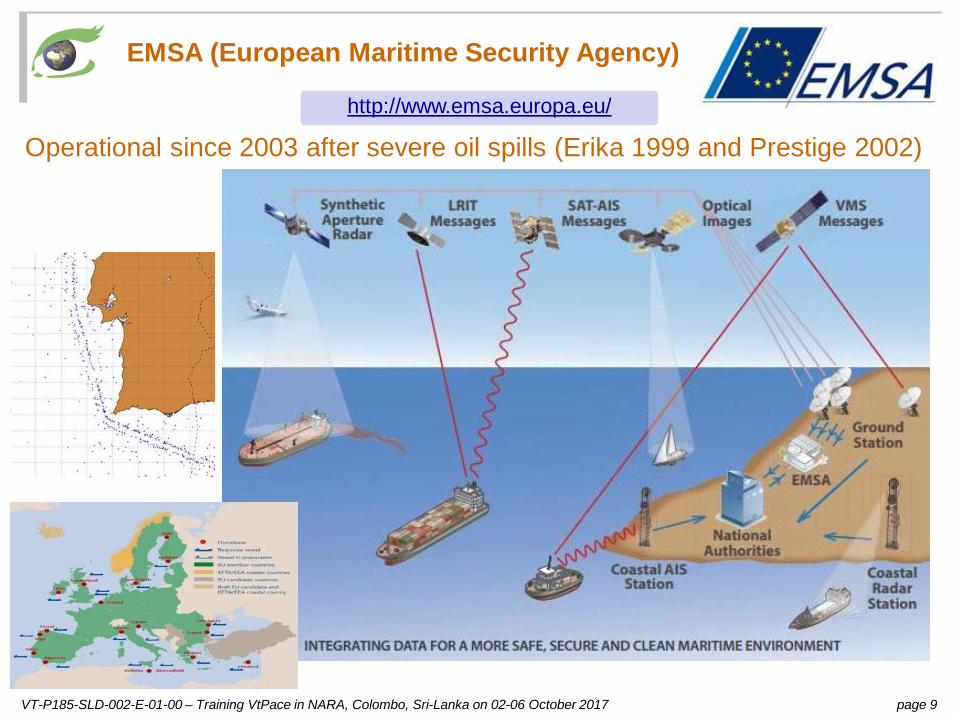
EMSA (European Maritime Security Agency)
Operational since 2003 after severe oil spills (Erika 1999 and Prestige 2002)http://www.emsa.europa.eu/

VT-P185-SLD-002-E-01-00 – Training VtPace in NARA, Colombo, Sri-Lanka on 02-06 October 2017 page 10
CMEMS (Copernicus Marine Environment Monitoring Service)
https://www.mercator-ocean.fr/solutions-expertises/produits-references-mercator-ocean/Products seen in VtPace (2D_layer_stack)
31 Oct. 2016
30 Nov. 2016
31 Dec. 2016
31 Jan. 2017
28 Feb. 2017
31 March 2017
30 April 2017
31 May 2017
30 June 2017
31 July 2017
30 Aug. 2017
30 Sep. 2017
Sea current velocity [0 m/s ; 1.5 m/s] 2D_animation 3D_animation
Sea surface temperature [27° ; 31°] 2D_animation 3D_animation
Chlorophyll (ACRI) [0 mg/m3 ; 3 mg/m3] 2D_animation 3D_animation

VT-P185-SLD-002-E-01-00 – Training VtPace in NARA, Colombo, Sri-Lanka on 02-06 October 2017 page 11
GPM (Global Precipitation Measurement) – per day, month
https://www.nasa.gov/mission_pages/GPM/main/index.htmlOctober
2016November
2016December
2016January
2017February
2017March 2017
April2017
May2017
June2017
July2017
August2017
September 2017
IMERG precipitations [0 mm ; 177 mm] 2D_animation 3D_animation
Precipitations - Mean height per month8 mm / day
4 mm / day
0 mm/ day
Precipitations - Height sum per day (mm)35 mm
25 mm
15 mm
5 mm
25 May 2017
Final run are not yet defined for 2017. ⇒ Animations are running year 2016.

VT-P185-SLD-002-E-01-00 – Training VtPace in NARA, Colombo, Sri-Lanka on 02-06 October 2017 page 12
GPM (Global Precipitation Measurement) – per half-hour (30’)
25 May 201700:00 01:00 02:00 03:00 04:00 05:00 06:00 07:00 08:00 09:00 10:00 11:00
12:00 13:00 14:00 15:00 16:00 17:00 18:00 19:00 20:00 21:00 22:00 23:00
IMERG precipitations [0 mm/h ; 10 mm/h] 2D_animation 3D_animation
Precipitations – Half-hourlyover Sri-Lanka only
25 mm / h
20 mm / h
15 mm / h
10 mm / h
5 mm / h

VT-P185-SLD-002-E-01-00 – Training VtPace in NARA, Colombo, Sri-Lanka on 02-06 October 2017 page 13
Observation from satellites
n+1
revolutionn
n+2
N
satellite
n+3
n+4
geostationary satellite heliosynchronous satellite

VT-P185-SLD-002-E-01-00 – Training VtPace in NARA, Colombo, Sri-Lanka on 02-06 October 2017 page 14
Sentinel-1 – HR Radar
Instrument• C-SAR (Synthetic Aperture Radar)
Modes• IW (Interferometry Wide Swath) – swath=240km – GSD=10m• EW (Extended Wide Swath) – swath=400km – GSD=40m• SM (Stripmap) – swath=80-100km – GSD=6-10m
Polarization• Single: Vertical (V) or horizontal (H)• Dual: VV,VH (V emission, V or H reception) or HH, HV (H emission, V or H reception)
https://sentinel.esa.int/web/sentinel/missions/sentinel-1Sentinel-1
Series of 3 scenes acquired on 21.09.2017 00:24:24 GMTin descending orbit (left)
2D-view-left
Series of 3 scenes acquired on 21.09.2017 12:49:54 GMTin ascending orbit (right)
2D-view-right
12 days cyclelaunch 1st data
S1A 03.04.2014 03.10.2014S1B 22.04.2016 26.09.2016
+6 days phase

VT-P185-SLD-002-E-01-00 – Training VtPace in NARA, Colombo, Sri-Lanka on 02-06 October 2017 page 15
Sentinel-2
Sentinel-2 – HR optical
https://sentinel.esa.int/web/sentinel/missions/sentinel-2
Bay of Kachchativu (North) on 18.09.2017 04:56:51 GMTOne tile (100km x 100km).
2D-view-left
East coast of Sri-Lanka on 27.07.2017 05:06:01 GMT5x3 tiles (tile D1 highlighted).
2D-view-right
Instrument• MSI (Multi-Spectral Instrument) - optical
13 Bands• VIS (visible): 2,3,4 (10m)• Red edge: 5,6,7 (20m)• NIR (Near Infrared): 8 (10m) 8A (20m)• SWIR (Shortwave infrared): 11,12 (20m)• Absorption (used for atmospheric corrections): 1,9,10 (60m)
10 days cyclelaunch 1st data
S2A 23.06.2015 27.06.2015S2B 07.03.2017 ??.??.????
+5 days phase

VT-P185-SLD-002-E-01-00 – Training VtPace in NARA, Colombo, Sri-Lanka on 02-06 October 2017 page 16
Sentinel-2 MSI – Spectral bands
MSI radiometry values: https://earth.esa.int/web/sentinel/technical-guides/sentinel-2-msi/msi-instrumentMSI 10m, 20m, 60m groups: https://earth.esa.int/web/sentinel/user-guides/sentinel-2-msi/resolutions/spatialLandsat heritage: https://landsat.gsfc.nasa.gov/wp-content/uploads/2015/06/Landsat.v.Sentinel-2.png
10m – Visible, NIR (10m)
20m – Red edge, NIR (20m), SWIR
60m – Absorption bands
cirruswater vapouraerosols
400 900 1400 1900 2400 10 000 11 000 12 000 13 000

VT-P185-SLD-002-E-01-00 – Training VtPace in NARA, Colombo, Sri-Lanka on 02-06 October 2017 page 17
Sentinel-3
Sentinel satellites (S3)
Instruments• OLCI (Ocean Land Colour Instrument) – optical
o 21 bands [0.4-1.02] µmo GSD = 300mo swath width = 1270 km
• SLSTR (Sea and Land Surface Temperature Radiometer)o 9 bands [0.55-12] µm, NADIR + backwardo GSD = 500m (VIS, SWIR), 1 km (MWIR, TIR)o swath width = 1420 km (NADIR), 750 km (backward)
• SRAL (SAR Radar Altimeter)o Range measurement: Ku-band (13.575 GHz) and C-band (5.41 GHz)o Sampling rate: 1 Hz (≈850m) and 10 Hz (≈85m)
https://sentinel.esa.int/web/sentinel/missions/sentinel-3
27 days cyclelaunch 1st data
S3A 16.02.2016 18.10.2016S3B ??.??.2018
+?? days phase
Sri-Lanka seen by:
OLCI on 30.09.2017 09:30:04 GMT.
2D-view-left
SLSTR on01.10.2017 16:28:18 GMT.
2D-view-middle
SRAL on29.09.2017 04:35:48 GMT.
2D-view-right

VT-P185-SLD-002-E-01-00 – Training VtPace in NARA, Colombo, Sri-Lanka on 02-06 October 2017 page 18
Sentinel-3 OLCI – Spectral bands
OLCI bands function: https://sentinel.esa.int/web/sentinel/user-guides/sentinel-3-olci/resolutions/radiometricEnvisat MERIS heritage (https://sentinel.esa.int/web/sentinel/user-guides/sentinel-3-olci/overview/heritage)
Band λ centre (nm) Width (nm) FunctionOa1 400 15 Aerosol correction, improved water constituent retrievalOa2 412.5 10 Yellow substance and detrital pigments (turbidity)Oa3 442.5 10 Chlorophyll absorption max., biogeochemistry, vegetationOa4 490 10 High Chlorophyll , other pigmentsOa5 510 10 Chlorophyll , sediment, turbidity, red tideOa6 560 10 Chlorophyll reference (Chlorophyll minimum)Oa7 620 10 Sediment loadingOa8 665 10 Chlorophyll (2nd Chlorophyll absolute max.), sediment, yellow substance / vegetation
Oa9 673.75 7.5 For improved fluorescence retrieval and to better account for smile together with the bands 665 and 680 nm
Oa10 681.25 7.5 Chlorophyll fluorescence peak, red edgeOa11 708.75 10 Chlorophyll fluorescence baseline, red edge transitionOa12 753.75 7.5 O2 absorption / clouds, vegetationOa13 761.25 2.5 O2 absorption band / aerosol correctionOa14 764.375 3.75 Atmospheric correctionOa15 767.5 2.5 O2A used for cloud top pressure, fluorescence over landOa16 778.75 15 Atmos. corr./aerosol corr.Oa17 865 20 Atmos. corr./aerosol corr., clouds, pixel co-registration
Oa18 885 10 Water vapour absorption reference band. Common reference band with SLSTR instrument. Vegetation monitoring
Oa19 900 10 Water vapour absorption/vegetation monitoring (maximum reflectance)Oa20 940 20 Water vapour absorption, atmosphere / aerosol correction
Oa21 1 020 40 Atmosphere / aerosol correction
bands absent in the previous Envisat / MERIS instrument

VT-P185-SLD-002-E-01-00 – Training VtPace in NARA, Colombo, Sri-Lanka on 02-06 October 2017 page 19
Sentinel infrastructures https://sentinel.esa.int/web/sentinel/sentinel-data-access
collaborative missions
Copernicus Open Access Hub (COA) https://scihub.copernicus.eu/
https://scihub.copernicus.eu/dhus

VT-P185-SLD-002-E-01-00 – Training VtPace in NARA, Colombo, Sri-Lanka on 02-06 October 2017 page 20
Table of contents – Session 2
Session 2 – VtPaceq Presentation of PACe project
§ Scope§ History
q Presentation of the portal§ Deriving from VtWeb§ The main panels / services
q Image processing technics§ Geometry transforms§ Global radiometry transforms § Convolutive filtering
q Functionalities§ Basemaps, elevations, 2D/3D§ Data selection and preparation, Layer stack§ Data sharing by hyperlooks§ Export in KML, KMZ, GeoTIFF, JPEG

VT-P185-SLD-002-E-01-00 – Training VtPace in NARA, Colombo, Sri-Lanka on 02-06 October 2017 page 21
Presentation of PACe
Ø Project coordinator: Annukka PEKARINEN
Ø SummaryThe main issues PACe project is responding to is the lack of knowledge concerning the cetacean popula-tions of the world and specifically the lack of spatial data for ecosystem based management initiatives. Themovements and status of regional and seasonal populations and the factors that direct the populationdistribution in Sri Lankan waters are largely unknown. A few scientific visual surveys have been undertakenin Sri Lanka during last ten years but comprehensive mapping of whale populations in this area is missing.
Ø Objectivesq To produce basic data on cetacean populations to improve knowledge on cetacean biodiversity,
abundance and important habitats, to be used for management purposes.q In addition to regular scientific reports and articles, spatial data on cetacean populations and their
important habitats is produced and distributed among general public and professionals in oceanmanagement.
q Management procedures suitable for the study area will also be proposed.
Ø Project timelineq 03.12.2013 – Kick-off meeting in University of Ruhuna.q March 2014 to May 2016 – Field works (passive acoustic monitoring, visual survey and oceanography work).q 07.11.2014 – 1st steering committee in VisioTerra, Champs-sur-Marne, France.q 26.11.2015 – 2nd steering committee in WMU, Malmö, Swedenq 13.01.2017 – Final steering committee in WMU, Malmö, Swedenq 02-06.10.2017 – Training VtPace – Extension until end 2017.

VT-P185-SLD-002-E-01-00 – Training VtPace in NARA, Colombo, Sri-Lanka on 02-06 October 2017 page 22
Presentation of VtPace portal
VtPace (http://visioterra.net/VtPace) derives from VtWeb (http://visioterra.org/VtWeb) – video

VT-P185-SLD-002-E-01-00 – Training VtPace in NARA, Colombo, Sri-Lanka on 02-06 October 2017 page 23
Image processing – Geometry transforms
S1 level 1B
S2 level 1C
O Y
X
Z
ϕ
λ
Z
Y
X
méridien de Greenwich
Equateur
P
he
a
b
N
bi-linear interpolation
per facet
projection change
observation geometry
projection geometry
geographic coordinates reference system

VT-P185-SLD-002-E-01-00 – Training VtPace in NARA, Colombo, Sri-Lanka on 02-06 October 2017 page 24
Image processing – Distributions and statistics
∑∑−
=
−
=
××
=1
0
1
0),(1 M
i
N
jjiR
NMm
[ ]∑∑−
=
−
=
−××
=1
0
1
0
2),(1 M
i
N
jmjiR
NMV
( ) ( )21
0
1
0
2),(1 mjiRNM
VM
i
N
j−×
×== ∑∑
−
=
−
=
σ
m = 81.243 m = 59.202σ = 19.546 σ = 11.888
2550 2550
H(r)
r
H(r)
r
m = 75.445σ = 55.984
2550
H(r)
r
SPOT XS1 and XS3 (Roissy, France) Landsat TM1 (San-Remo, Italy)
background pixels and image pixels
mean, variance and standard deviation
image histogram

VT-P185-SLD-002-E-01-00 – Training VtPace in NARA, Colombo, Sri-Lanka on 02-06 October 2017 page 25
Image processing – Global radiometry transform
source image
215
17
17
i ’
i
i ’’
j j ’ j ’’
LUT
215216
…
255
214
…
17 5818
16
0
…
127
destination image
127
58
58
i ’
i
i ’’
j j ’ j ’’
thresholding linear stretching

VT-P185-SLD-002-E-01-00 – Training VtPace in NARA, Colombo, Sri-Lanka on 02-06 October 2017 page 26
Image processing – Automatic stretching
0r
H(r)
0 255
1674
pixel number
∑ ==
255
0)(
rrHN
αs : saturation percentage
Ns = N x αs : number of saturated pixels
255
0
fs(r)
a
r
H(r)
b0 255
number of right saturated pixels
∑ ==
255 )(br
rHNr
number of left saturated pixels
∑ ==
a
rl rHN0
)(
VT-P185-SLD-002-E-01-00 – Training VtPace in NARA, Colombo, Sri-Lanka on 02-06 October 2017 page 27
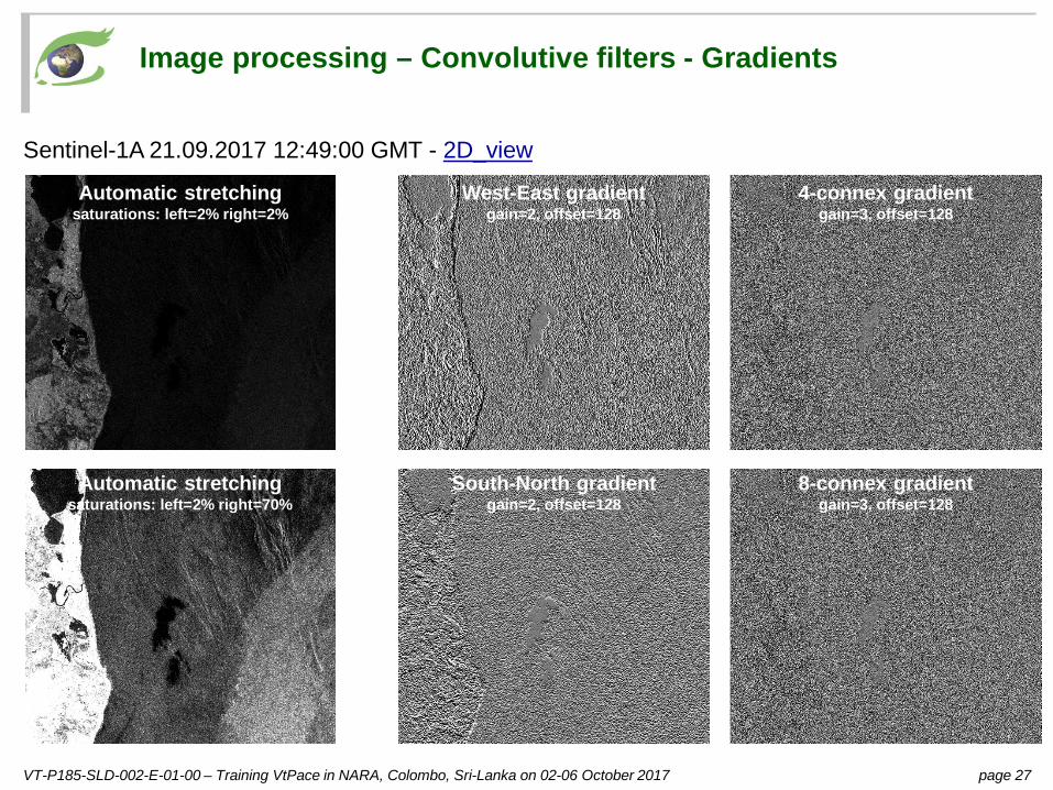
Image processing – Convolutive filters - Gradients
Sentinel-1A 21.09.2017 12:49:00 GMT - 2D_view
4-connex gradientgain=3, offset=128
8-connex gradientgain=3, offset=128
West-East gradientgain=2, offset=128
South-North gradientgain=2, offset=128
Automatic stretchingsaturations: left=2% right=2%
Automatic stretchingsaturations: left=2% right=70%

VT-P185-SLD-002-E-01-00 – Training VtPace in NARA, Colombo, Sri-Lanka on 02-06 October 2017 page 28
Image processing – Convolutive filters – Edge enhancement
Sentinel-2A 18.09.2017 - 2D_view_top Sentinel-1A 21.09.2017 - 2D_view_bottom
Contrast enhancementgain=10
Contrast enhancementgain=5
Contrast enhancementgain=3
Contrast enhancementgain=1
Automatic stretchingsaturations: left=2% right=2%
Automatic stretchingsaturations: left=2% right=70%

VT-P185-SLD-002-E-01-00 – Training VtPace in NARA, Colombo, Sri-Lanka on 02-06 October 2017 page 29
Table of contents
Session 3 – Themes of interest in Sri-Lankaq Theme 1 – Oil spills
§ Winds around Sri-Lanka seen by Radar§ Processing of Radar images to observe offshore objects
q Theme 2 – Mariculture farms§ Colour compositions§ Edge enhancement
q Theme 3 – Upwelling§ Step 1 – Looking for black patterns in Radar images§ Step 2 – Checking the wind strength and direction § Step 3 – Checking with other CMEMS products
q Theme 4 – Monitoring around oil wells§ Looking for “bright patterns” around the well position

VT-P185-SLD-002-E-01-00 – Training VtPace in NARA, Colombo, Sri-Lanka on 02-06 October 2017 page 30
Winds around Sri-Lanka seen by Radar
Sentinel-1 05.06.2017 12:49:24 vs. ECMWF 10W 05.06.2017 12:00 2D_view 2D_animation

VT-P185-SLD-002-E-01-00 – Training VtPace in NARA, Colombo, Sri-Lanka on 02-06 October 2017 page 31
Theme 1 – Oil spill (Thandiyadi)
Sentinel-1A 21.09.2017 12:49:00 GMT - 2D_view
6.7 km

VT-P185-SLD-002-E-01-00 – Training VtPace in NARA, Colombo, Sri-Lanka on 02-06 October 2017 page 32
Theme 2 – Mariculture farm (Trincomalee)
AOI – Sentinel-2 17.06.2017 - 2D_view

VT-P185-SLD-002-E-01-00 – Training VtPace in NARA, Colombo, Sri-Lanka on 02-06 October 2017 page 33
Theme 3 – Upwelling seen from Radar data
Sentinel-1 scenes with upwelling candidates in zone 1 (north-east) and zone 2 (south)

VT-P185-SLD-002-E-01-00 – Training VtPace in NARA, Colombo, Sri-Lanka on 02-06 October 2017 page 34
Theme 3 – Upwelling seen from Radar data (+checking meteo.)
Sentinel-1 19.10.2014 00:25:08 GMT in zone 2 - 2D_view (see also zone1)

VT-P185-SLD-002-E-01-00 – Training VtPace in NARA, Colombo, Sri-Lanka on 02-06 October 2017 page 35
Theme 3 – Upwelling from CMEMS - Sea salinity and currents30.09.2017 - CMEMS / Mercator “Ocean sea water salinity” and
“Surface water velocity and direction” 2D_view
“Sri Lankan coastal waters areinfluenced by the salty Arabian seaand the lightly salted water of theBay of Bengal.” (Yéelen OLIVE)

VT-P185-SLD-002-E-01-00 – Training VtPace in NARA, Colombo, Sri-Lanka on 02-06 October 2017 page 36
Theme 3 – Upwelling from CMEMS – SST and currents01.08.2017 - CMEMS / Mercator
“Ocean sea water potential temperature” and “Surface water velocity and direction” 2D_stack
“Flows along the eastern andwestern coasts of Sri Lanka aresouthward, and converge along thesouthern coast. As the surface wateris flowing offshore, there is adivergence of water on the coast,which results in a coastal upwelling.Upwellings bring cold, nutrient richand oxygen poor water on thesurface, this is the reason why wecan use temperature data to seeupwellings.” (Yéelen OLIVE)

VT-P185-SLD-002-E-01-00 – Training VtPace in NARA, Colombo, Sri-Lanka on 02-06 October 2017 page 37
Theme 3 – Upwelling from CMEMS - Chlorophyll01.08.2017 - CMEMS / ACRI
“Ocean color chlorophyll” 2D_stack
During the summer monsoon (end of May to early October) :
⇒ upwelling along the southern coast of Sri Lanka
“The nutrient-rich water brought tothe surface by the upwellingenhanced a high primary production(bloom of microalgae), as microalgaeabsorb nutrients to grow. Chlorophylla is a pigment used by microalgae forthe photosynthesis. This pigmentreflects green/yellow lights that arevisible from satellite.The microalgae bloom is probablyfollowed by a zooplanktonic bloom,as zooplankton feeds on microalgae.”(Yéelen OLIVE)

VT-P185-SLD-002-E-01-00 – Training VtPace in NARA, Colombo, Sri-Lanka on 02-06 October 2017 page 38
Theme 3 – Upwelling from CMEMS - Chlorophyll21.09.2017 - CMEMS / ACRI
“Ocean color chlorophyll” 2D_stack
“The presence of blue whalesthroughout the year in the area maybe explained by this strongproductivity.Unfortunately, the major shippingroute of south Sri Lanka passesthrough this area of highproductivity, where consistent highdensities of blue whales have beenindicated.” (Yéelen OLIVE)

VT-P185-SLD-002-E-01-00 – Training VtPace in NARA, Colombo, Sri-Lanka on 02-06 October 2017 page 39
Sentinel-1A 10.06.2017 00.32.51 GMT - 3D_view
Theme 4 – Monitoring around oil wells“Oil platforms are large metallic structures thatare usually clearly detected in the Radar imagesbut nothing is observed around the locations ofthe five (5) oil wells given by NARA.”