town planning scheme amendment request · town planning scheme amendment request kelmscott 2...
TRANSCRIPT
OUR REF: 8349 17/06/2015
TOWN PLANNING SCHEME AMENDMENT REQUEST LOT 200 (NO. 4) CHURCH STREET KELMSCOTT

TOWN PLANNING SCHEME AMENDMENT REQUEST KELMSCOTT 8349_15JUN01R_FINAL_JH 17/06/2015
DOCUMENT CONTROL
Printed 07 July 2015
Version File Name Prepared by Approved by Date
1 8349_15jun01R_cc Camille Clarke Jeremy Hofland 6 July 2015
This report has been authorised by;
Jeremy Hofland Senior Planner Camille Clarke Planner Jamie Baxter Quality Control
CONTACT PERTH OFFICE p 9221 1991 e [email protected] w rowegroup.com.au a 3/369 Newcastle Street, Northbridge 6003
Although all care has been taken on the compilation of this document Greg Rowe Pty Ltd and all parties associated with its preparation disclaim any responsibility for any errors or omissions. The right is reserved to change this document at any time. This document does not constitute an invitation, agreement or contract (or any part thereof) of any kind whatsoever. Liability is expressly disclaimed by Greg Rowe Pty Ltd for any loss or damage which may be sustained by any person acting on this document.
© 2015 Greg Rowe Pty Ltd All Rights Reserved. Copyright in the whole and every part of this document belongs to Greg Rowe Pty Ltd and may not be used, sold, transferred, copied or reproduced in whole or in part in any manner or form or in or on any media to any person without the prior written consent of Greg Rowe Pty Ltd.

TOWN PLANNING SCHEME AMENDMENT REQUEST KELMSCOTT 8349_15JUN01R_FINAL_JH 17/06/2015
CONTENTS
01 Introduction ............................................................................................ 1
02 Description of Site .................................................................................. 2
2.1 Location ...................................................................................................................... 2
2.2 Cadastral Information ................................................................................................. 2
2.2.1 Easement for Sewerage Purposes .................................................................. 2
2.2.2 Easement 63663/1966 ..................................................................................... 2
2.2.3 Restrictive Covenant J959691 ......................................................................... 2
2.3 Existing Improvements ............................................................................................... 2
03 Site Analysis ........................................................................................... 3
3.1 Topography ................................................................................................................. 3
3.2 Acid Sulphate Soils ..................................................................................................... 3
3.3 Vegetation ................................................................................................................... 3
3.4 Heritage ...................................................................................................................... 3
3.4.1 European Heritage .......................................................................................... 3
3.4.2 Aboriginal Heritage ......................................................................................... 3
04 Servicing ................................................................................................. 4
4.1 Sewer .......................................................................................................................... 4
4.2 Water ........................................................................................................................... 4
4.3 Roads .......................................................................................................................... 4
4.4 Gas .............................................................................................................................. 4
4.5 Electricity .................................................................................................................... 4
4.6 Summary ..................................................................................................................... 4
05 Town Planning Considerations ............................................................. 5
5.1 Zoning ......................................................................................................................... 5
5.1.1 Metropolitan Region Scheme .......................................................................... 5
5.1.2 City of Armadale Town Planning Scheme No. 4 .............................................. 5
5.1.3 Land Use Permissibility ................................................................................... 5
5.2 City of Armadale Local Planning Policies ................................................................... 6
5.2.1 Local Planning Policy 5.1 – Highway Development ......................................... 6

TOWN PLANNING SCHEME AMENDMENT REQUEST KELMSCOTT 8349_15JUN01R_FINAL_JH 17/06/2015
5.3 Development Control Policy 5.1 Regional Roads (Vehicle Access) ............................ 6
06 Description of Proposed Scheme Amendment ..................................... 7
6.1 Overview ...................................................................................................................... 7
6.2 Purpose of Amendment .............................................................................................. 7
6.2.1 Intended uses .................................................................................................. 7
6.2.2 Use class permissibility................................................................................... 8
6.3 Proposed Provisions within Schedule 3 of TPS4 ........................................................ 9
6.4 Consistency with Objectives of District Centre Zone ................................................ 10
07 Justification for Proposed Amendment .............................................. 11
7.1 Consistency with intent of the Restricted Use zone ................................................. 11
7.2 Service provision within the Town Centre ................................................................ 11
7.3 Indicative Development Plans .................................................................................. 12
7.3.1 Convenience Store with Fast Food Outlet ..................................................... 12
7.3.2 Convenience Store with Medical Centre and Pharmacy ............................... 12
7.3.3 Summary of Indicative Development Plans .................................................. 13
7.4 Traffic and Access ..................................................................................................... 13
08 Conclusion ............................................................................................ 14
FIGURES
1. Regional Location
2. Local Location
3. Site Location
4. MRS Zoning Plan
5. TPS4 Zoning Plan
ATTACHMENTS
1. Certificate of Title and Survey Plan
2. Indicative Development Plan: Convenience Store with Fast Food Outlet
3. Indicative Development Plan: Convenience Store with Medical Centre & Pharmacy
4. Traffic Report by Shawmac
TOWN PLANNING SCHEME AMENDMENT REQUEST KELMSCOTT 8349_15JUN01R_FINAL_JH 17/06/2015 1
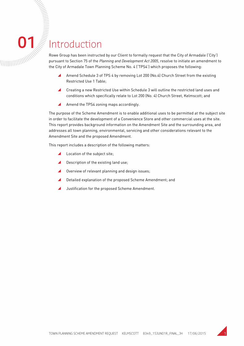
01 Introduction Rowe Group has been instructed by our Client to formally request that the City of Armadale (‘City’) pursuant to Section 75 of the Planning and Development Act 2005, resolve to initiate an amendment to the City of Armadale Town Planning Scheme No. 4 (‘TPS4’) which proposes the following:
Amend Schedule 3 of TPS 4 by removing Lot 200 (No.4) Church Street from the existing Restricted Use 1 Table;
Creating a new Restricted Use within Schedule 3 will outline the restricted land uses and conditions which specifically relate to Lot 200 (No. 4) Church Street, Kelmscott; and
Amend the TPS4 zoning maps accordingly.
The purpose of the Scheme Amendment is to enable additional uses to be permitted at the subject site in order to facilitate the development of a Convenience Store and other commercial uses at the site. This report provides background information on the Amendment Site and the surrounding area, and addresses all town planning, environmental, servicing and other considerations relevant to the Amendment Site and the proposed Amendment.
This report includes a description of the following matters:
Location of the subject site;
Description of the existing land use;
Overview of relevant planning and design issues;
Detailed explanation of the proposed Scheme Amendment; and
Justification for the proposed Scheme Amendment.
TOWN PLANNING SCHEME AMENDMENT REQUEST KELMSCOTT 8349_15JUN01R_FINAL_JH 17/06/2015 2
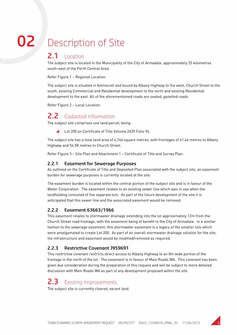
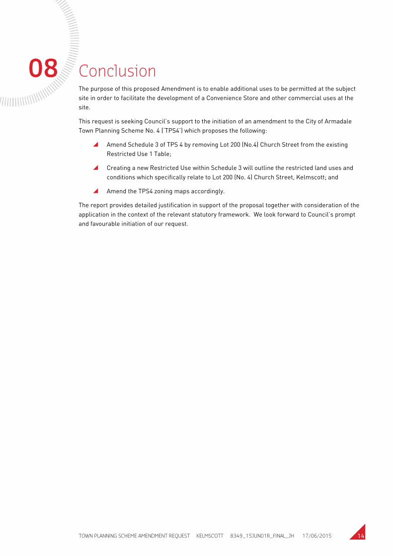
02 Description of Site 2.1 Location The subject site is located in the Municipality of the City of Armadale, approximately 25 kilometres south-east of the Perth Central Area.
Refer Figure 1 – Regional Location.
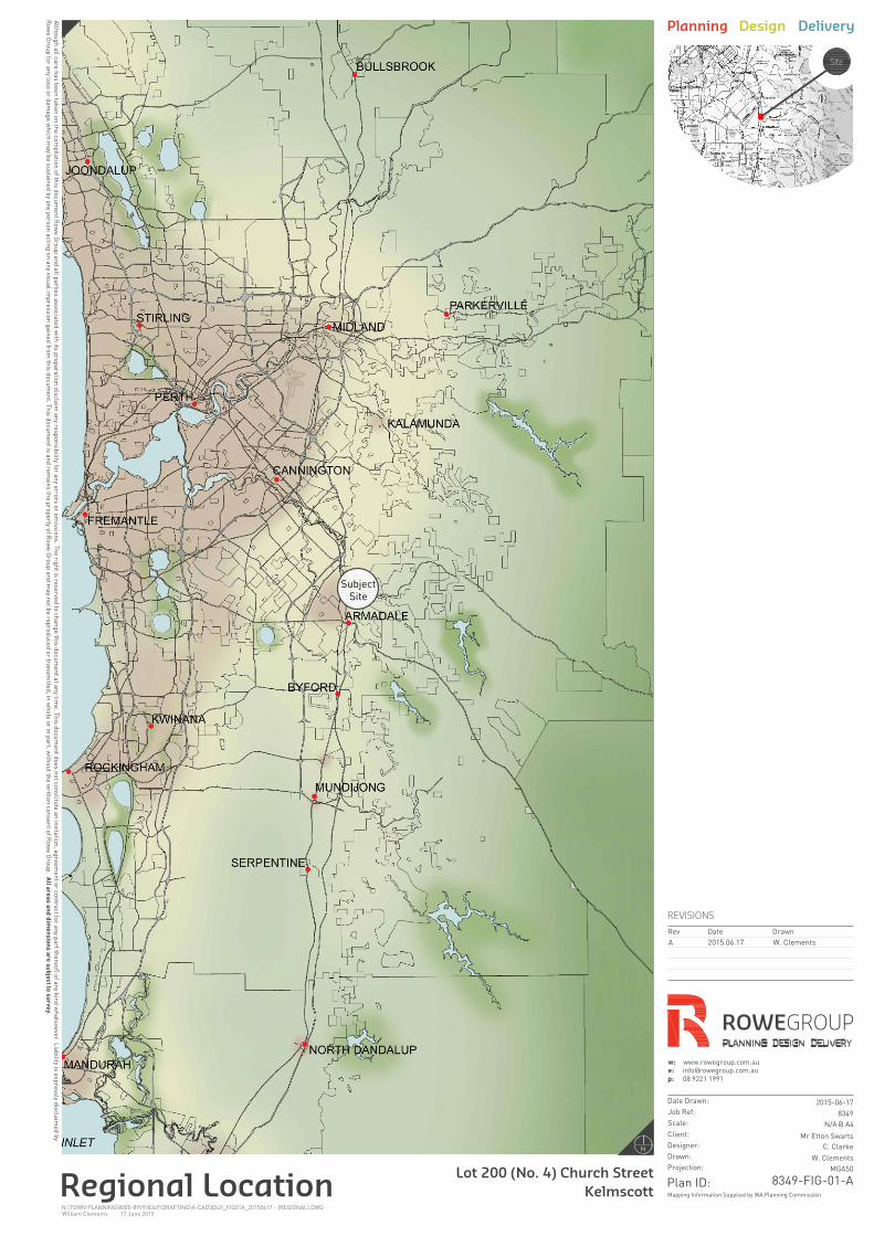
The subject site is situated in Kelmscott and bound by Albany Highway to the west, Church Street to the south, existing Commercial and Residential development to the north and existing Residential development to the east. All of the aforementioned roads are sealed, gazetted roads.
Refer Figure 2 – Local Location.
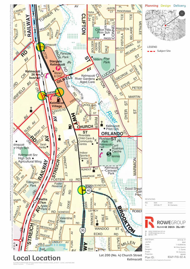
2.2 Cadastral Information The subject site comprises one land parcel, being:
Lot 200 on Certificate of Title Volume 2639 Folio 94.
The subject site has a total land area of 4,746 square metres, with frontages of 61.46 metres to Albany Highway and 54.58 metres to Church Street.
Refer Figure 3 – Site Plan and Attachment 1 – Certificate of Title and Survey Plan.
2.2.1 Easement for Sewerage Purposes As outlined on the Certificate of Title and Deposited Plan associated with the subject site, an easement burden for sewerage purposes is currently located at the site.
The easement burden is located within the central portion of the subject site and is in favour of the Water Corporation. The easement relates to an existing sewer line which was in use when the landholding consisted of five separate lots. As part of the future development of the site it is anticipated that this sewer line and the associated easement would be removed.
2.2.2 Easement 63663/1966 This easement relates to stormwater drainage extending into the lot approximately 12m from the Church Street road frontage, with the easement being of benefit to the City of Armadale. In a similar fashion to the sewerage easement, this stormwater easement is a legacy of the smaller lots which were amalgamated to create Lot 200. As part of an overall stormwater drainage solution for the site, the infrastructure and easement would be modified/removed as required.
2.2.3 Restrictive Covenant J959691 This restrictive covenant restricts direct access to Albany Highway to an 8m wide portion of the frontage in the north of the lot. The easement is in favour of Main Roads WA. This covenant has been given due consideration during the preparation of this request and will be subject to more detailed discussion with Main Roads WA as part of any development proposed within the site.
2.3 Existing Improvements The subject site is currently cleared, vacant land.

TOWN PLANNING SCHEME AMENDMENT REQUEST KELMSCOTT 8349_15JUN01R_FINAL_JH 17/06/2015 3
03 Site Analysis 3.1 Topography The subject site is a relatively flat site which lies approximately 23m above sea level.
3.2 Acid Sulphate Soils The subject site has a ‘Class 2’ classification relating to acid sulphate soils (ASS). There is a moderate to low risk of ASS occurring within 3m of the natural soil surface, but a moderate to high risk of ASS beyond 3m of natural soil surface.
3.3 Vegetation The subject site is currently free of any vegetation. Remnant vegetation currently exists directly to the south and east of the subject site.
3.4 Heritage
3.4.1 European Heritage A review of the City of Armadale’s Municipal Heritage Inventory indicates that the subject site is not identified as a site with European heritage significance.
3.4.2 Aboriginal Heritage A desktop investigation of the subject site was undertaken using the Department of Aboriginal Affairs online mapping system. The investigation indicated that the subject site is not identified as the site of Aboriginal heritage significance.
TOWN PLANNING SCHEME AMENDMENT REQUEST KELMSCOTT 8349_15JUN01R_FINAL_JH 17/06/2015 4
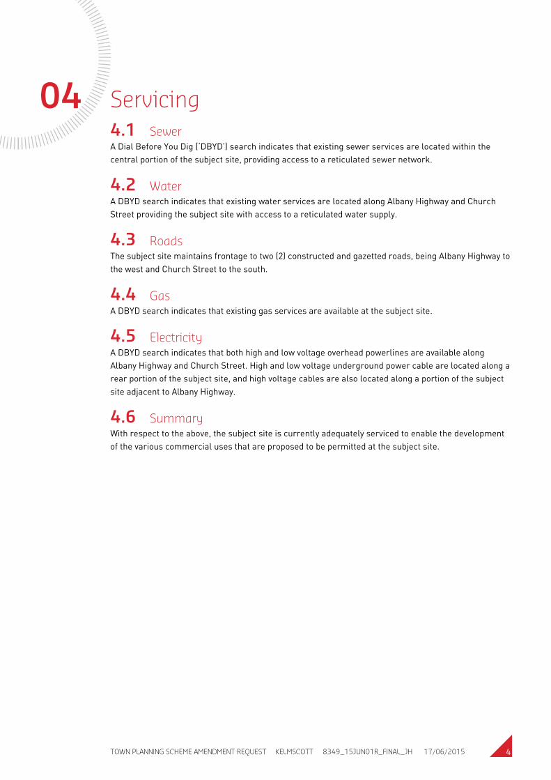
04 Servicing 4.1 Sewer A Dial Before You Dig (‘DBYD’) search indicates that existing sewer services are located within the central portion of the subject site, providing access to a reticulated sewer network.
4.2 Water A DBYD search indicates that existing water services are located along Albany Highway and Church Street providing the subject site with access to a reticulated water supply.
4.3 Roads The subject site maintains frontage to two (2) constructed and gazetted roads, being Albany Highway to the west and Church Street to the south.
4.4 Gas A DBYD search indicates that existing gas services are available at the subject site.
4.5 Electricity A DBYD search indicates that both high and low voltage overhead powerlines are available along Albany Highway and Church Street. High and low voltage underground power cable are located along a rear portion of the subject site, and high voltage cables are also located along a portion of the subject site adjacent to Albany Highway.
4.6 Summary With respect to the above, the subject site is currently adequately serviced to enable the development of the various commercial uses that are proposed to be permitted at the subject site.
TOWN PLANNING SCHEME AMENDMENT REQUEST KELMSCOTT 8349_15JUN01R_FINAL_JH 17/06/2015 5
05 Town Planning Considerations 5.1 Zoning
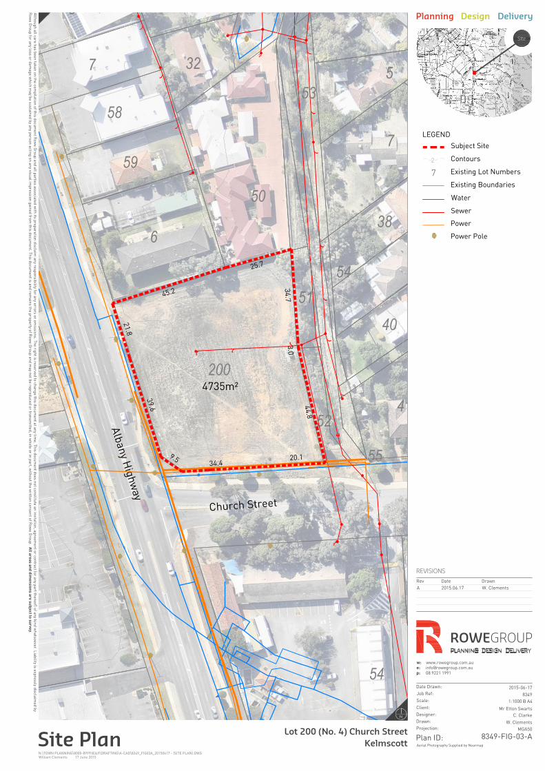
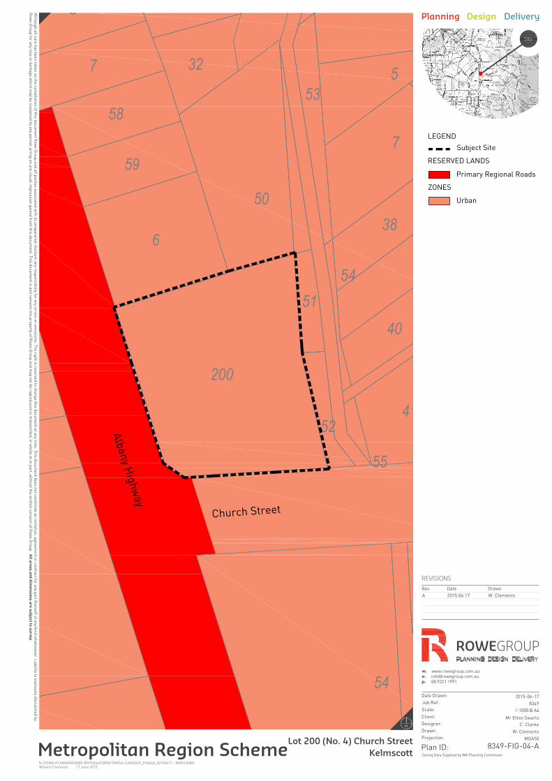
5.1.1 Metropolitan Region Scheme Under the provisions of the Metropolitan Region Scheme (‘MRS’), the subject site is zoned “Urban”. Land to the west of the subject site is reserved as “Primary Regional Road”.
Refer Figure 4 - MRS.
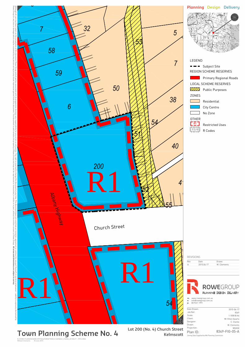
5.1.2 City of Armadale Town Planning Scheme No. 4 Under the provisions of Town Planning Scheme No. 4 (‘TPS4’), the subject is zoned “District Centre”.
The objectives for the “District Centre” zone, as stated in TPS4, are as follows:
a) To provide for an extended range of shopping, commercial and community services to meet the weekly needs of neighbourhood groupings, and contribute towards the employment needs of the local workforce.
b) To ensure the design and landscaping of development provides a high standard of safety and amenity and contribute towards a sense of place and community within the service area.
The subject site is further identified as “Restricted Use” meaning that the permissible uses at the subject site have been modified from what is outlined within the TPS4 Zoning Table for the “District Centre”. The relevant zoning map indicates that the subject site is within the “Restricted Use” 1 (‘R1’) area.
The permissible land uses for the R1 area are outlined within Schedule 3 of TPS4.
Refer Figure 5 - Zoning Plan.
5.1.3 Land Use Permissibility Based on the provisions within Schedule 3 of TPS4 the following uses are all ‘X’ uses within the R1 “District Centre” Zone, meaning that they are not permitted at the subject site:
Amusement Parlour;
Auction Mart;
Car Park;
Cinema/Theatre;
Commercial Vehicle Parking;
Convenience Store;
Fast Food Outlet;
Liquor Store – Small;
Liquor Store – Large;
Lunch Bar;
Market;
TOWN PLANNING SCHEME AMENDMENT REQUEST KELMSCOTT 8349_15JUN01R_FINAL_JH 17/06/2015 6
Motor Vehicle Repair;
Motor Vehicle Wash;
Night Club;
Restricted Premises;
Service Station;
Shop;
Small Bar; and
Tavern
5.2 City of Armadale Local Planning Policies
5.2.1 Local Planning Policy 5.1 – Highway Development The purpose of the City’s Local Planning Policy 5.1 (‘LPP5.1’) is to control the development of land along all Primary Distributor Roads in the interests of maintaining and improving their efficiency and safety.
The relevant clauses of LPP5.1 state as follows:
4.1 - No development will be permitted on properties fronting a Primary Distributor Road, nor on roads likely to achieve this status, unless they are permissible (“P” uses) under the zoning table in the Town Planning Scheme or there is an alternative means of access from a lower order road.
4.2 - The City may give consideration to discretionary uses (“D” and “A” uses) in a zone but these uses will only be approved on the basis that they would not compromise the objectives of the zone and are, in the opinion of the City equal or lesser traffic generators than uses permitted (“P” uses) in the zone.
4.3 - The City may require cross easements and reciprocal rights of carriageway agreements where appropriate.
The subject LPP has been given due consideration within the proposed Scheme Amendment, as detailed elsewhere in this document.
5.3 Development Control Policy 5.1 Regional Roads (Vehicle Access) The Western Australian Planning Commission (‘WAPC’) Development Control Policy 5.1 Regional Roads (Vehicle Access) (‘DC5.1’) outlines the principles to be applied when considering proposals for vehicle access to or from developments abutting Regional Roads. As the subject site is located adjacent to Albany Highway which is a ‘Primary Regional Road’ the provisions of DC5.1 are applicable.
Clause 3.3.1 of DC5.1 notes that the policy intends to minimise the creation of new driveways from regional roads and rationalise existing access arrangements. Clause 3.3.2 states that where alternative access is or could be made available from side or rear streets or from rights of way, no access shall be permitted unless special circumstances apply.
Vehicle access for the site is to consist of a vehicle entry from Albany Highway with vehicles to exit the site onto Church Street. These arrangements have been the subject of discussion with relevant staff from Main Roads WA with support being obtained from the authority.
TOWN PLANNING SCHEME AMENDMENT REQUEST KELMSCOTT 8349_15JUN01R_FINAL_JH 17/06/2015 7
06 Description of Proposed Scheme Amendment 6.1 Overview This Scheme Amendment seeks Council’s support to initiate an amendment to the City of Armadale TPS4 to:
Amend Schedule 3 of TPS 4 by removing Lot 200 (No.4) Church Street from the existing Restricted Use 1 Table;
Create a new Restricted Use within Schedule 3 will outline the restricted land uses and conditions which specifically relate to Lot 200 (No. 4) Church Street, Kelmscott; and
Amend the TPS4 zoning maps accordingly.
The existing and proposed zoning of the subject site is illustrated in the Scheme Amendment Map contained in Attachment 2 of this report. Details on the proposed amendment are provided below.
6.2 Purpose of Amendment The purpose of this proposed Scheme Amendment is to amend the land uses that are permissible at the subject site in order to facilitate the development of a Convenience Store and other commercial uses at the site.
6.2.1 Intended uses It is intended that the following land uses as defined within TPS 4 would be capable of approval on the subject site:
Convenience Store: means premises –
a) Used for the retail sale of convenience goods commonly sold in supermarkets, delicatessens or newsagents, or the retail sale of petrol and those convenience goods;
b) Operated during hours which include, but may extend beyond, normal trading hours; c) Which provide associated parking; and d) The floor area which does not exceed 300 square metres net lettable area.
Fast Food Outlet: means premises used for the preparation, sale and serving of food to customers in a form ready to be eaten without further preparation, primarily off the premises, but does not include a lunch bar.
Liquor Store-Small means any land or buildings the subject of a liquor store licence granted under the provisions of the Liquor Control Act 1988 (as amended) where the net leasable area does not exceed 300m2
Lunch bar: means premises or part of premises used for the sale of takeaway food (in a form ready to be consumed without further preparation) within industrial or commercial areas;
Motor Vehicle Wash: means premises where the primary use is the washing of motor vehicles.

TOWN PLANNING SCHEME AMENDMENT REQUEST KELMSCOTT 8349_15JUN01R_FINAL_JH 17/06/2015 8
Service Station: means premises used for –
- The retail sale of petroleum products, motor vehicle accessories and goods of an incidental/convenience retail nature; and
- The carrying out of greasing, tyre repairs and minor mechanical repairs to motor vehicles,
- but does not include premises used for transport depot, panel beating, spray painting, major repairs or wrecking.
Shop: means premises used to sell foods by retail, hire goods, or provide services of a personal nature (including a hairdresser or beauty therapist) but does not include a showroom or fast food outlet; liquor store – small or liquor store – large.
6.2.2 Use class permissibility It is intended that all additional uses to be facilitated through this amendment (with the exception of the Convenience Store use) would be considered in accordance with the use class permissibility as described within the Zoning Table for the District Centre zone. The permissibility for each use is detailed below:
Fast Food Outlet – to be a ‘D’ use;
Liquor Store - Small – to be a ‘P’ use;
Lunch Bar – to be a ‘P’ use;
Motor Vehicle Wash – to be a ‘D’ use;
Service Station – to be an ‘D’ use;
Shop – to be a ‘P’ use;
Presently the use class for the Convenience Store and Service Station uses is an ‘A’ use within the District Centre zone. As part of this Scheme Amendment, we request that the uses be included as a ‘D’ use. These uses have the following meanings within the City’s TPS No.4:
‘D’ means that the use is not permitted unless the City has exercised its discretion by granting planning approval;
‘A’ means that the use is not permitted unless the City has exercised its discretion by granting planning approval after giving special notice in accordance with clause 9.4;
The intent of the ‘A’ use classification is that public advertising of the use be a mandatory component of any consideration of an application for the use. It is our view that as part of the proposed amendment to modify the Restricted Use controls which relate specifically to the site, surrounding property owners and the broader community will be advised of the intended use of the site during the public consultation process associated with the Scheme Amendment. An indicative development plan for the site is to be made available for comment in association with the Scheme Amendment, which will provide the opportunity for interested parties to obtain information of the overall development as part of this process.
Given the above, it is considered that the requirement for additional consultation at the Development Approval stage represents unnecessary duplication of the process and would result in further delays to the ultimate development of the site in its intended form.
TOWN PLANNING SCHEME AMENDMENT REQUEST KELMSCOTT 8349_15JUN01R_FINAL_JH 17/06/2015 9
The proposed ‘D’ use classification for the site would not prevent Council from seeking public comment on any development proposal submitted for the Convenience Store or Service Station use, should aspects relating to the proposed design justify such action. For the reasons noted above we believe that the ‘D’ use is the most appropriate classification for this use on the site and seek Council’s support accordingly.
6.3 Proposed Provisions within Schedule 3 of TPS4 As previously mentioned within this Amendment, the proposed uses that are to be Not Permitted (“X”) uses at the subject site will be outlined within Schedule 3 of TPS4, together with the amended use classification of “D” for the Convenience Store and Service Station uses. This Amendment proposes to update and amend the details within Schedule 3 of TPS4 with the changes shown in bold and italic font:
No. Description of Land
Land Use Conditions
R11 Part of the Kelmscott District Centre Zone being Lot 200 (No. 4) Church Street, Kelmscott
The District Centre Zone – Restricted Use Area (R) acknowledges that the location and accessibility characteristics of the Albany Highway and Church Street frontage allow consideration of applications for a range of mixed business uses which represent the function and objectives for the District Centre zone.
The following uses potentially permissible in the retail commercial core of the District Centre zone shall be uses that are Not Permitted (X) in the Restricted Use Area:
- Amusement Parlour
- Auction Mart
- Car Park
- Cinema/Theatre
- Commercial Vehicle Parking
- Liquor Store (Large)
- Market
- Motor Vehicle Repair
- Restricted Premises
- Small Bar
- Tavern
Notwithstanding the use classifications within the District Centre zone, within this Restricted Use Area the uses of ‘Convenience Store’ and ‘Service Station’ shall each be considered as a ‘D’ use.
11.1 In determining any planning application for development approval the City shall have regard to the compatibility of proposed uses with the existing and potential uses of the site.
11.2 Where proposed development interfaces with existing or proposed residential development, special design consideration shall be required for the screening, separation or noise attenuation of adjacent premises.
11.3 The City may impose conditions and require proposed developments to specifically address the following issues:
- A high quality unified architectural design and overall development of the site that reflects a level of integration and consistency with the surrounding built environment;
- Vehicular access to the site including access to/from Albany Highway which shall be to the satisfaction of Main Roads Western Australia;
- The amalgamation of lots or provision of reciprocal rights of access where appropriate;
- The screening and/or landscaping of car parking areas from adjacent residential uses;
- The precluding of overnight accommodation of animals in respect to Veterinary Centres;
- Interface with adjacent parks and recreation reservations abutting the Canning River;
- The retention of existing on-site trees or significant vegetation.
11.4 The development of “Shop” floorspace is to be limited to use by a Pharmacy in conjunction with the development of a Medical Centre on the site.
TOWN PLANNING SCHEME AMENDMENT REQUEST KELMSCOTT 8349_15JUN01R_FINAL_JH 17/06/2015 10
The conditions as noted within 11.1 – 11.3 within the R1 zoning are maintained within the new Restricted Use without modification. Condition 11.4 removes the reference to the permissibility of an ancillary kiosk Shop, with the new condition seeking to limit the use of “Shop” within the site to a Pharmacy in association with a Medical Centre.
6.4 Consistency with Objectives of District Centre Zone The objectives of the “District Centre” zone are noted within Clause 4.2.6 of the City’s TPS No.4 and are detailed below:
a) To provide for an extended range of shopping, commercial and community services to meet the weekly needs of neighbourhood groupings, and contribute towards the employment needs of the local workforce.
b) To ensure the design and landscaping of development provides a high standard of safety and amenity and contributes towards a sense of place and community within the service area.
The existing District Centre zoning of the site is to remain unchanged, however the proposed amendments to the Restricted Use zoning applicable to the site are consistent with the objectives for the “District Centre” zone. This is as the additional uses to be capable of approval within the site will provide specific shopping, commercial and community services to meet the needs of the local community, and contribute to the employment needs and the local workforce of the area. In addition, the provision of additional uses which are not presently available on the eastern side of Albany Highway will be developed to a high standard of design and safety which will contribute towards the sense of place of the community and local area.
Based on the above, the proposed Scheme Amendment is consistent with the objectives of the “District Centre” zone.
TOWN PLANNING SCHEME AMENDMENT REQUEST KELMSCOTT 8349_15JUN01R_FINAL_JH 17/06/2015 11
07 Justification for Proposed Amendment 7.1 Consistency with intent of the Restricted Use zone The City’s application of the Restricted Use R1 provisions is intended to maintain the central retail Town Centre functions to the west of Albany Highway.
The proposed uses which would be capable of approval on site as a result of the proposed Scheme Amendment are listed below:
Convenience Store;
Fast Food Outlet;
Liquor Store - Small;
Lunch Bar;
Motor Vehicle Wash;
Service Station; and
Shop (for the development of a Pharmacy associated with a Medical Centre).
The inclusion of the above uses is not considered to undermine the intent of the Restricted Use zoning, as the development of key activities within the Town Centre will still remain prohibited on the site, such as retail development, Market, Small Bar, Tavern and Liquor Store – Large.
The proposed Amendment to the Restricted Use provisions over the subject site is consistent with the City’s intent as it will allow for the limited expansion of the range of uses to accommodate predominantly car-based activities, on a site which incorporates desirable characteristics in terms of its size and corner location, providing for vehicle movements to a secondary street.
7.2 Service provision within the Town Centre The intent of the proposed Scheme Amendment is the development of a Convenience Store offering the sale of fuel together with a small scale retail premises providing convenience items over the southern portion of the site, together with a number of specific commercial uses which may include a Fast Food Outlet.
Within the Kelmscott Town Centre there are presently two Service Stations offering the sale of fuel, as follows:
Caltex – south-western corner of Albany Highway and Denny Avenue; and
BP – 2907 Albany Highway.
With respect to the above, both sites are located on the western (northbound) side of Albany Highway. The location of the above sites do not facilitate convenient access for motorists travelling in a southbound direction, with entry to the Caltex requiring motorists to access the Kelmscott Shopping Centre which is undesirable during peak shopping periods, whilst the BP site does not incorporate any slip lane or traffic control methods which would enable safe entry to and exit from the site.
TOWN PLANNING SCHEME AMENDMENT REQUEST KELMSCOTT 8349_15JUN01R_FINAL_JH 17/06/2015 12
There are presently no facilities offering the sale of fuel on the eastern (southbound) side of Albany Highway. A BP Service Station was previously located on the eastern side opposite Streich Avenue however this has been closed for a considerable period of time. The result of this is that along the southern side of Albany Highway, fuel and associated convenience items are only available in Gosnells (approximately 6.5km north of the site) or in Armadale (approximately 5km south of the site).
Similarly, drive-through takeaway food options are catered for within the Town Centre with McDonalds and KFC on the northbound side of Albany Highway, with no similar developments on the southbound side. The nearest premises on the southbound side would be available in Gosnells (approximately 5.5km north of the site) or in the Armadale City Centre (approximately 5km south of the site).
The proposed Scheme Amendment will cater for the demands of residents and others travelling from the north, providing fuel, takeaway food and other items for those persons returning home from work at the end of the day in a safe and convenient manner.
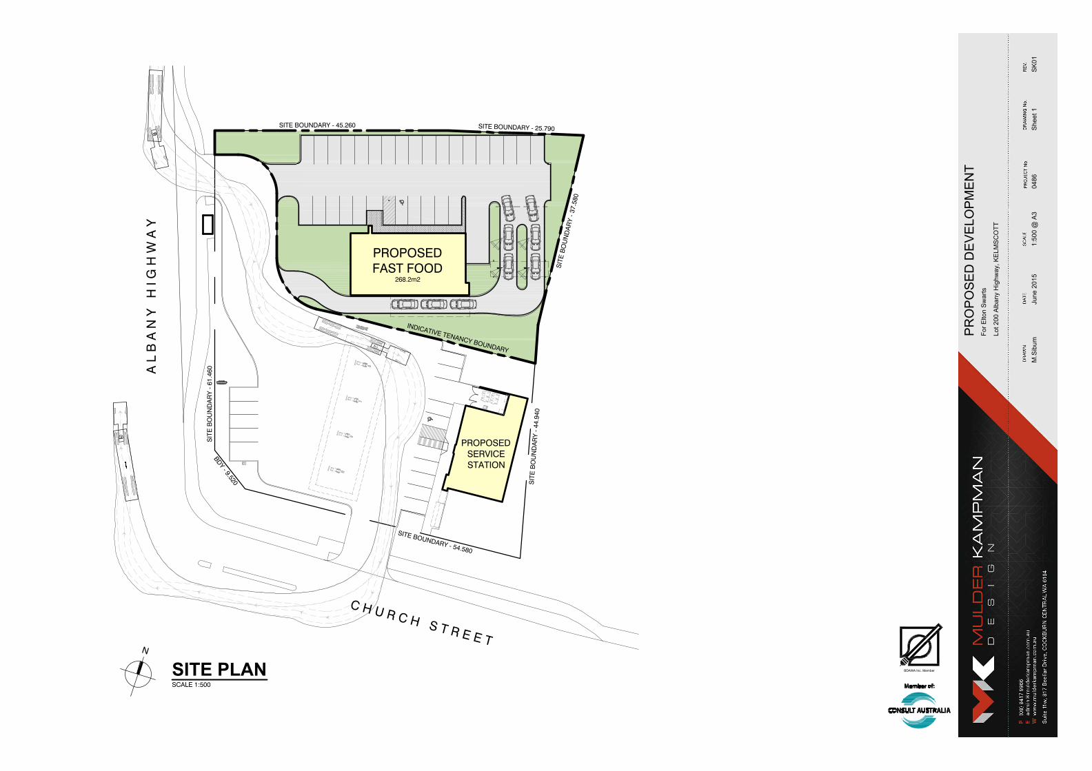
7.3 Indicative Development Plans To assist with illustrating the likely development form for the site, a number of indicative development plans have been prepared for the site. Both indicative plans propose the development of the southern portion of Lot 200 as a Convenience Store, with a potential Fast Food Outlet with drive-through component or a Medical Centre with associated Pharmacy also being considered. These plans are described below:
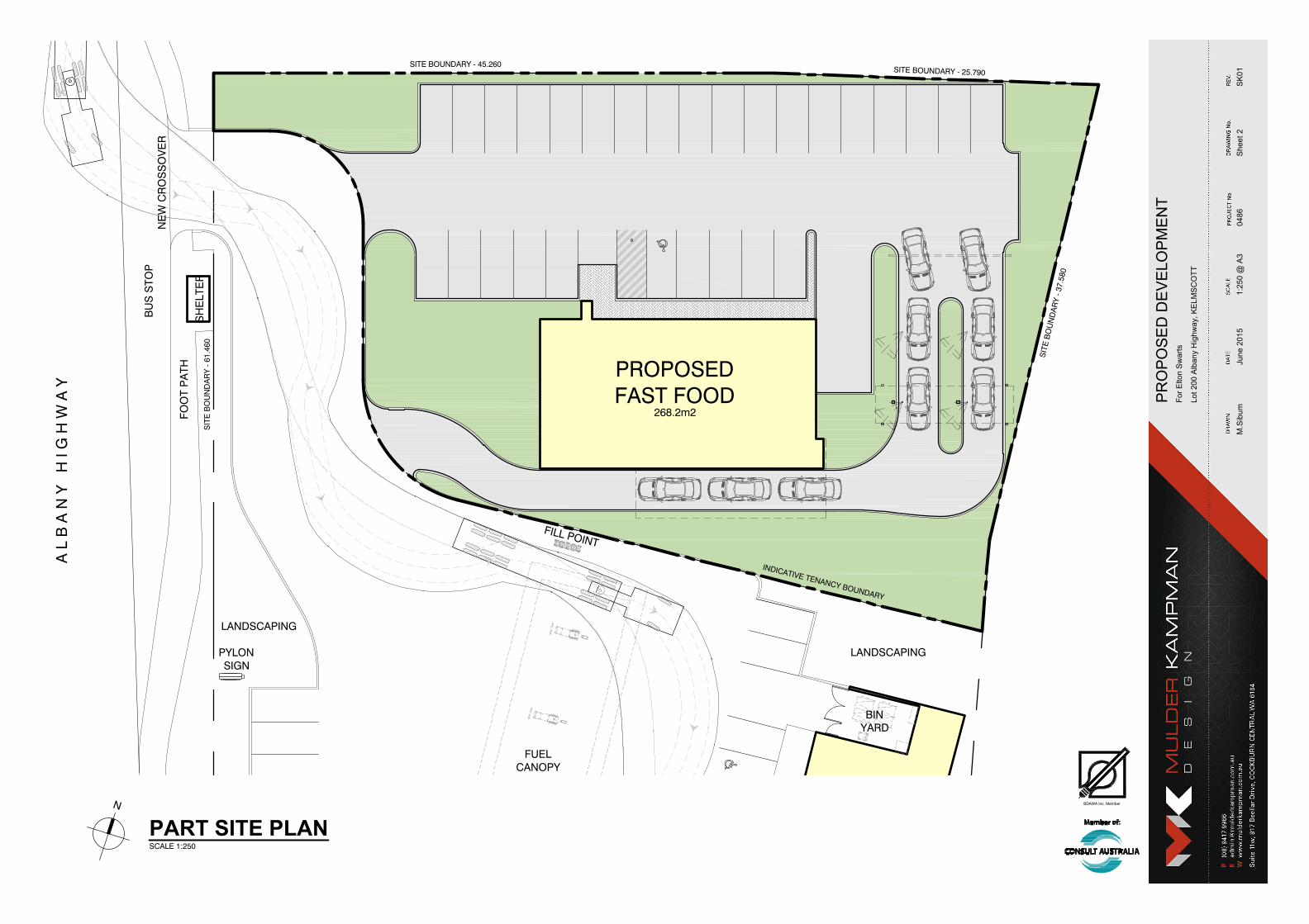
7.3.1 Convenience Store with Fast Food Outlet This option incorporates the following:
A Convenience Store over the southern portion of Lot 200, consisting of four pumps with a canopy above and an associated convenience store with a maximum floor area of 300m2 Gross Floor Area adjacent to the eastern side boundary;
A left-in entry from Albany Highway located to the north of this frontage, providing access for customers and fuel tankers;
A full entry/exit crossover to Church Street;
A Fast Food Outlet consisting of a 268m2 restaurant set back approximately 20m from the northern side boundary with customer car parking located within this setback;
A dual-lane drive through located adjacent to the eastern boundary, accessed through the customer carpark.
These plans are included in Attachment No.2.
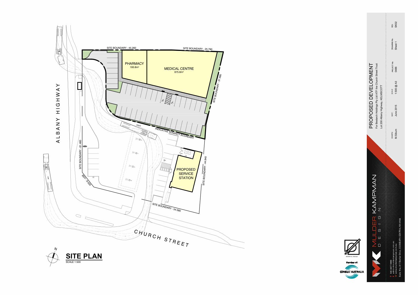
7.3.2 Convenience Store with Medical Centre and Pharmacy This option incorporates the following:
A Convenience Store over the southern portion of Lot 200, consisting of four pumps with a canopy above and an associated convenience store with a maximum floor area of 300m2
Gross Floor Area adjacent to the eastern side boundary;
A left-in entry from Albany Highway located to the north of this frontage, providing access for customers and fuel tankers;
A full entry/exit crossover to Church Street;
TOWN PLANNING SCHEME AMENDMENT REQUEST KELMSCOTT 8349_15JUN01R_FINAL_JH 17/06/2015 13
Medical Centre adjacent to the northern side boundary with a floor area of 675m2
A Pharmacy with a setback of approximately 20m, incorporating a floor area of 193m2;
Customer car parking to the immediate south of the Medical Centre.
These plans are included in Attachment No.3.
7.3.3 Summary of Indicative Development Plans The indicative development plans provide a demonstration of how the potential uses could function on the site, particularly with respect to vehicle access and movement within the site. It must be noted that the plans are provided as a guide at this stage, and would be subject to more detailed consideration as part of any Development Application for the site once the Scheme Amendment proposal has suitably progressed.
7.4 Traffic and Access A Transport Impact and Parking assessment has been prepared in association with this request by Shawmac Consulting Civil and Traffic Engineers. The findings of the assessment are that the potential development associated with the proposed Scheme Amendment request will have minimal impact on the operation of the adjacent road network, with the anticipated traffic volumes being able to be accommodated within the practical capacity of the road network.
The Traffic Report by Shawmac is included as Attachment No. 4.
TOWN PLANNING SCHEME AMENDMENT REQUEST KELMSCOTT 8349_15JUN01R_FINAL_JH 17/06/2015 14
08 Conclusion The purpose of this proposed Amendment is to enable additional uses to be permitted at the subject site in order to facilitate the development of a Convenience Store and other commercial uses at the site.
This request is seeking Council’s support to the initiation of an amendment to the City of Armadale Town Planning Scheme No. 4 (‘TPS4’) which proposes the following:
Amend Schedule 3 of TPS 4 by removing Lot 200 (No.4) Church Street from the existing Restricted Use 1 Table;
Creating a new Restricted Use within Schedule 3 will outline the restricted land uses and conditions which specifically relate to Lot 200 (No. 4) Church Street, Kelmscott; and
Amend the TPS4 zoning maps accordingly.
The report provides detailed justification in support of the proposal together with consideration of the application in the context of the relevant statutory framework. We look forward to Council’s prompt and favourable initiation of our request.

FIGURES
Alth
ou
gh
a
ll ca
re
h
as b
ee
n ta
ke
n o
n th
e co
mp
ila
tio
n o
f th
is d
ocu
me
nt R
ow
e G
ro
up
a
nd
a
ll p
artie
s a
sso
cia
te
d w
ith
its p
re
pa
ra
tio
n d
iscla
im
a
ny re
sp
on
sib
ility fo
r a
ny e
rro
rs o
r o
missio
ns. T
he
rig
ht is re
se
rve
d to
ch
an
ge
th
is d
ocu
me
nt a
t a
ny tim
e. T
his d
ocu
me
nt d
oe
s n
ot co
nstitu
te
a
n in
vita
tio
n, a
gre
em
en
t o
r co
ntra
ct (o
r a
ny p
art th
ere
of) o
f a
ny k
in
d w
ha
tso
eve
r. L
ia
bility is e
xp
re
ssly d
iscla
im
ed
b
y
Ro
we
G
ro
up
fo
r a
ny lo
ss o
r d
am
ag
e w
hich
m
ay b
e su
sta
in
ed
b
y a
ny p
erso
n a
ctin
g o
n a
ny visu
al im
pre
ssio
n g
ain
ed
fro
m th
is d
ocu
me
nt. T
his d
ocu
me
nt is a
nd
re
ma
in
s th
e p
ro
pe
rty o
f R
ow
e G
ro
up
a
nd
m
ay n
ot b
e re
pro
du
ce
d o
r tra
nsm
itte
d, in
w
ho
le
o
r in
p
art, w
ith
ou
t th
e w
ritte
n co
nse
nt o
f R
ow
e G
ro
up
. A
ll a
re
as
a
nd
d
im
en
sio
ns
a
re
s
ub
je
ct to
s
urv
ey.
Mapping Information Supplied by WA Planning Commission
Plan ID:
REVISIONS
Rev Date Drawn
A 2015.06.17 W. Clements
Planning Design Delivery
Regional Location
@ A4
2015-06-17
8349
N/A
Mr Etton Swarts
C. Clarke
W. Clements
MGA50
8349-FIG-01-A
N:\TOWN PLANNING\8000-8999\8349\DRAFTING\A-CAD\8349_FIG01A_20150617 - (REGIONAL).DWG
17 June 2015William Clements
Date Drawn:
Job Ref:
Scale:
Client:
Designer:
Drawn:
Projection:
w: www.rowegroup.com.au
p: 08 9221 1991
Lot 200 (No. 4) Church Street
Kelmscott
ROWEGROUP
Site
Subject
Site
N
Subject Site
LEGEND
Alth
ou
gh
a
ll ca
re
h
as b
ee
n ta
ke
n o
n th
e co
mp
ila
tio
n o
f th
is d
ocu
me
nt R
ow
e G
ro
up
a
nd
a
ll p
artie
s a
sso
cia
te
d w
ith
its p
re
pa
ra
tio
n d
iscla
im
a
ny re
sp
on
sib
ility fo
r a
ny e
rro
rs o
r o
missio
ns. T
he
rig
ht is re
se
rve
d to
ch
an
ge
th
is d
ocu
me
nt a
t a
ny tim
e. T
his d
ocu
me
nt d
oe
s n
ot co
nstitu
te
a
n in
vita
tio
n, a
gre
em
en
t o
r co
ntra
ct (o
r a
ny p
art th
ere
of) o
f a
ny k
in
d w
ha
tso
eve
r. L
ia
bility is e
xp
re
ssly d
iscla
im
ed
b
y
Ro
we
G
ro
up
fo
r a
ny lo
ss o
r d
am
ag
e w
hich
m
ay b
e su
sta
in
ed
b
y a
ny p
erso
n a
ctin
g o
n a
ny visu
al im
pre
ssio
n g
ain
ed
fro
m th
is d
ocu
me
nt. T
his d
ocu
me
nt is a
nd
re
ma
in
s th
e p
ro
pe
rty o
f R
ow
e G
ro
up
a
nd
m
ay n
ot b
e re
pro
du
ce
d o
r tra
nsm
itte
d, in
w
ho
le
o
r in
p
art, w
ith
ou
t th
e w
ritte
n co
nse
nt o
f R
ow
e G
ro
up
. A
ll a
re
as
a
nd
d
im
en
sio
ns
a
re
s
ub
je
ct to
s
urv
ey.
Mapping Information Supplied by Streetsmart
Plan ID:
REVISIONS
Rev Date Drawn
A 2015.06.17 W. Clements
Planning Design Delivery
Local Location
@ A4
2015-06-17
8349
1:10,000
Mr Etton Swarts
C. Clarke
W. Clements
MGA50
8349-FIG-02-A
N:\TOWN PLANNING\8000-8999\8349\DRAFTING\A-CAD\8349_FIG02A_20150617 - (LOCAL LOCATION).DWG
17 June 2015William Clements
Date Drawn:
Job Ref:
Scale:
Client:
Designer:
Drawn:
Projection:
w: www.rowegroup.com.au
p: 08 9221 1991
Lot 200 (No. 4) Church Street
Kelmscott
ROWEGROUP
Site
N
22
24
6
53
Church Street
52
55
23
5
54
32
200
7
50
21
8
40
58
20
A
lb
a
n
y H
ig
h
w
a
y
23
59
54
41
7
38
51
9
.
5
3
9
.6
2
1
.8
4
5
.2
2
5
.7
34
.7
3.0
44
.8
20.1
34.4
4735m²
Subject Site
2
7
Contours
Existing Lot Numbers
Water
Sewer
Existing Boundaries
LEGEND
Power Pole
Power
Alth
ou
gh
a
ll ca
re
h
as b
ee
n ta
ke
n o
n th
e co
mp
ila
tio
n o
f th
is d
ocu
me
nt R
ow
e G
ro
up
a
nd
a
ll p
artie
s a
sso
cia
te
d w
ith
its p
re
pa
ra
tio
n d
iscla
im
a
ny re
sp
on
sib
ility fo
r a
ny e
rro
rs o
r o
missio
ns. T
he
rig
ht is re
se
rve
d to
ch
an
ge
th
is d
ocu
me
nt a
t a
ny tim
e. T
his d
ocu
me
nt d
oe
s n
ot co
nstitu
te
a
n in
vita
tio
n, a
gre
em
en
t o
r co
ntra
ct (o
r a
ny p
art th
ere
of) o
f a
ny k
in
d w
ha
tso
eve
r. L
ia
bility is e
xp
re
ssly d
iscla
im
ed
b
y
Ro
we
G
ro
up
fo
r a
ny lo
ss o
r d
am
ag
e w
hich
m
ay b
e su
sta
in
ed
b
y a
ny p
erso
n a
ctin
g o
n a
ny visu
al im
pre
ssio
n g
ain
ed
fro
m th
is d
ocu
me
nt. T
his d
ocu
me
nt is a
nd
re
ma
in
s th
e p
ro
pe
rty o
f R
ow
e G
ro
up
a
nd
m
ay n
ot b
e re
pro
du
ce
d o
r tra
nsm
itte
d, in
w
ho
le
o
r in
p
art, w
ith
ou
t th
e w
ritte
n co
nse
nt o
f R
ow
e G
ro
up
. A
ll a
re
as
a
nd
d
im
en
sio
ns
a
re
s
ub
je
ct to
s
urv
ey.
Aerial Photography Supplied by Nearmap
Plan ID:
REVISIONS
Rev Date Drawn
A 2015.06.17 W. Clements
Planning Design Delivery
Site Plan
@ A4
2015-06-17
8349
1:1000
Mr Etton Swarts
C. Clarke
W. Clements
MGA50
8349-FIG-03-A
N:\TOWN PLANNING\8000-8999\8349\DRAFTING\A-CAD\8349_FIG03A_20150617 - (SITE PLAN).DWG
17 June 2015William Clements
Date Drawn:
Job Ref:
Scale:
Client:
Designer:
Drawn:
Projection:
w: www.rowegroup.com.au
p: 08 9221 1991
Lot 200 (No. 4) Church Street
Kelmscott
ROWEGROUP
Site
N
6
53
Church Street
52
55
5
54
32
200
7
50
8
40
58
A
lb
a
n
y H
ig
h
w
a
y
59
54
41
7
38
51
Subject Site
LEGEND
RESERVED LANDS
Primary Regional Roads
ZONES
Urban
Alth
ou
gh
a
ll ca
re
h
as b
ee
n ta
ke
n o
n th
e co
mp
ila
tio
n o
f th
is d
ocu
me
nt R
ow
e G
ro
up
a
nd
a
ll p
artie
s a
sso
cia
te
d w
ith
its p
re
pa
ra
tio
n d
iscla
im
a
ny re
sp
on
sib
ility fo
r a
ny e
rro
rs o
r o
missio
ns. T
he
rig
ht is re
se
rve
d to
ch
an
ge
th
is d
ocu
me
nt a
t a
ny tim
e. T
his d
ocu
me
nt d
oe
s n
ot co
nstitu
te
a
n in
vita
tio
n, a
gre
em
en
t o
r co
ntra
ct (o
r a
ny p
art th
ere
of) o
f a
ny k
in
d w
ha
tso
eve
r. L
ia
bility is e
xp
re
ssly d
iscla
im
ed
b
y
Ro
we
G
ro
up
fo
r a
ny lo
ss o
r d
am
ag
e w
hich
m
ay b
e su
sta
in
ed
b
y a
ny p
erso
n a
ctin
g o
n a
ny visu
al im
pre
ssio
n g
ain
ed
fro
m th
is d
ocu
me
nt. T
his d
ocu
me
nt is a
nd
re
ma
in
s th
e p
ro
pe
rty o
f R
ow
e G
ro
up
a
nd
m
ay n
ot b
e re
pro
du
ce
d o
r tra
nsm
itte
d, in
w
ho
le
o
r in
p
art, w
ith
ou
t th
e w
ritte
n co
nse
nt o
f R
ow
e G
ro
up
. A
ll a
re
as
a
nd
d
im
en
sio
ns
a
re
s
ub
je
ct to
s
urv
ey.
Zoning Data Supplied by WA Planning Commision
Plan ID:
REVISIONS
Rev Date Drawn
A 2015.06.17 W. Clements
Planning Design Delivery
Metropolitan Region Scheme
@ A4
2015-06-17
8349
1:1000
Mr Etton Swarts
C. Clarke
W. Clements
MGA50
8349-FIG-04-A
N:\TOWN PLANNING\8000-8999\8349\DRAFTING\A-CAD\8349_FIG04A_20150617 - (MRS).DWG
17 June 2015William Clements
Date Drawn:
Job Ref:
Scale:
Client:
Designer:
Drawn:
Projection:
w: www.rowegroup.com.au
p: 08 9221 1991
Lot 200 (No. 4) Church Street
Kelmscott
ROWEGROUP
Site
N
6
53
Church Street
52
55
5
54
32
200
7
50
8
40
58
A
lb
a
n
y H
ig
h
w
a
y
59
54
41
7
38
51
R1
R1R1
Subject Site
LEGEND
REGION SCHEME RESERVES
Primary Regional Roads
LOCAL SCHEME RESERVES
ZONES
No Zone
City Centre
Residential
OTHER
Restricted Uses
R1
R Codes
Public Purposes
Alth
ou
gh
a
ll ca
re
h
as b
ee
n ta
ke
n o
n th
e co
mp
ila
tio
n o
f th
is d
ocu
me
nt R
ow
e G
ro
up
a
nd
a
ll p
artie
s a
sso
cia
te
d w
ith
its p
re
pa
ra
tio
n d
iscla
im
a
ny re
sp
on
sib
ility fo
r a
ny e
rro
rs o
r o
missio
ns. T
he
rig
ht is re
se
rve
d to
ch
an
ge
th
is d
ocu
me
nt a
t a
ny tim
e. T
his d
ocu
me
nt d
oe
s n
ot co
nstitu
te
a
n in
vita
tio
n, a
gre
em
en
t o
r co
ntra
ct (o
r a
ny p
art th
ere
of) o
f a
ny k
in
d w
ha
tso
eve
r. L
ia
bility is e
xp
re
ssly d
iscla
im
ed
b
y
Ro
we
G
ro
up
fo
r a
ny lo
ss o
r d
am
ag
e w
hich
m
ay b
e su
sta
in
ed
b
y a
ny p
erso
n a
ctin
g o
n a
ny visu
al im
pre
ssio
n g
ain
ed
fro
m th
is d
ocu
me
nt. T
his d
ocu
me
nt is a
nd
re
ma
in
s th
e p
ro
pe
rty o
f R
ow
e G
ro
up
a
nd
m
ay n
ot b
e re
pro
du
ce
d o
r tra
nsm
itte
d, in
w
ho
le
o
r in
p
art, w
ith
ou
t th
e w
ritte
n co
nse
nt o
f R
ow
e G
ro
up
. A
ll a
re
as
a
nd
d
im
en
sio
ns
a
re
s
ub
je
ct to
s
urv
ey.
Zoning Data Supplied by WA Planning Commision
Plan ID:
REVISIONS
Rev Date Drawn
A 2015.06.17 W. Clements
Planning Design Delivery
Town Planning Scheme No. 4
@ A4
2015-06-17
8349
1:1000
Mr Etton Swarts
C. Clarke
W. Clements
MGA50
8349-FIG-05-A
N:\TOWN PLANNING\8000-8999\8349\DRAFTING\A-CAD\8349_FIG05A_20150617 - (TPS).DWG
18 June 2015William Clements
Date Drawn:
Job Ref:
Scale:
Client:
Designer:
Drawn:
Projection:
w: www.rowegroup.com.au
p: 08 9221 1991
Lot 200 (No. 4) Church Street
Kelmscott
ROWEGROUP
Site
N

ATTACHMENT 1 CERTIFICATE OF TITLE AND SURVEY PLAN

LANDGATE COPY OF ORIGINAL NOT TO SCALE
www.landgate.wa.gov.au
JOB 48024342Mon Jun 15 14:49:46 2015
REGISTER NUMBER
200/DP48710 ~
WESTERN ~ AUSTRAIJA
DTJPT.TCATE DATE DUPLICATE ISSLED EDITION
1 20/11/2006
RECORD OF CERTIFICATE OF TITLE VOLUME FOLIO
UNDER THE TRANSFER OF LAND ACT 1893
The person described in the first schedule is the registered proprietor of an estate in fee simple in the land described below subject to the reservations, conditions and depth lin1it contained in the original grant (if a grant issued) and to the limitations, interests, encumbrances and notifications shown in the second schedule.
2639
REGISTRAR OF TITLES
LOT 200 ON DEPOSITED PLAN 48710 LAND DESCRIPTION:
REGISTERED PROPRIETOR: (FIRST SCHEDULE)
DALY & SHAWPTYLTD OF UNIT L 19 KEATES ROAD, ARMADALE (AF J959692 ) REGISTERED 20 OCTOBER 2006
LIMITATIONS, INTERESTS, ENCUMBRANCES AND NOTIFICATIONS: (SECOND SCHEDULE)
L 63663/1966 EASEMENT TO SHIRE OF ARMADALE- KELMSCOTT. SEE DEPOSITED PLAN 48710 REGISTERED Ll.l966.
94
2. EASEMENT BURDEN CREATED UNDER SECTION 167 P. & D. ACT FOR SEWERAGE PURPOSES TO CITY OF ARMADALE SEE DEPOSITED PLAN 48710
3. J959691 RESTRICTIVE COVENANT TO COMMISSIONER OF MAIN ROADS REGISTERED 20.10.2006.
4. *M639992 MORTGAGE TO COMMONWEALTH BANK OF AUSTRALIA REGISTERED 16.5.2014.
Warning: A current search of the sketch of the land should be obtained where detail of position, dimensions or area of the lot is required. * Any entries preceded by an asterisk may not appear on the current edition of the duplicate certificate of title. Lot as described in the land description may be a lot or location.
---------------------------------------------------END OF CERTIFICATE OF TITLE--------------------------------------------------
STATEMENTS: The statements set out below are not intended to be nor should they be relied on as substitutes for inspection of the land
and the relevant documents or for local government, legal, surveying or other professional advice.
SKETCH OF LAND: PREVIOUS TITLE: PROPERTY STREET ADDRESS: LOCAL GOVERNMENT AREA:
DP48710. 133-85A 1326-228, 1313-951, 114-115A 4 CHURCH ST, KELMSCOTT. CITY OF ARMADALE.
NOTE 1: DUPLICATE CERTIFICATE OF TITLE NOT ISSUED AS REQUESTED BY DEALING K655266
Landgate

LAN
DG
ATE
CO
PY
OF O
RIG
INA
L NO
T TO S
CA
LE
www.landgate.w
a.gov.au
JOB
48024342M
on Jun 15 14:49:46 2015
rs:u ::::J a. c.c s:u ... CD
EDIVER
~ < ~ -.J ~
AMENDMENT
Cf2 ©" ~0
0.. ,...
~
~ § ~
~
~ ~-
142'2'20"
~ " <o
..0
'®'\!: .;>
<;:'.
o;!e, ,' ,., 270'
~, '/..._/&'\
~~' /W r.e,., ,' ~~~ "4 ,' ,' "/ej-'~~;'1.~·
01tu1:1 'f'Cf.;
BY
6 D 2506
(SP 3091)
45.26
'N
" I ',
gQ' (,:, '',,,,
SIGNATURE
"' ;: t
DATE I LOT NUMBER
200
19 D 20102
~ ~">
1'0'~~~~~
'',,,sv ',,!~~, ',,',,, ',,',,, \
51 P8915
200 4746m2
$<;($6'
srJi>~~l'
Jq'< ',, ',, q
',,f6',9of. ',
~ -:::, ~
~ "" ....
',,~~~.v
~'!J·1''f ~
52 P8915
I FORMER PI/TENURE ON PLANIDIA TITLE
I LOT22 D 20102 1326-228
I LOT23 D 20102 133-85A
LOT60 D 33050 114-115A
LOT61 D 33050 1313-951
TYPE. . FR~_E;l:10W.
PURPOSE ... SUSDNJSION.
PLAN OF
LOT 200 & EASEMENT
DISTRICT .......... CANNING DOLA FILE
TOWNSITE.
LOCAL AUTHORITY. . .... C:ITY. OF ARMAPALE_ LOCALITY . . ... KELMSC.OTI ..
_CJ• ""'C ·.
~; ~
-
S.S.A. NO
FORMER TENURE QJ1! FIELD BOOK
I SEE TABLE INDEX .. BG 34(2) 22.06, 23.06.
I SCALE 1 : 500 ON A3 SHEET ALL DISTANCES ARE IN METRES
PUBLIC.
10
COMPILED
COMPILED FROM D 20102 D 33050 p 8915
DATE
PROPERTY PEOPLE SURVEYING SUITE 918 HARVEST TERRACE PO BOX 1531 WEST PERTH 6872 TEL 9322 3833 FAX 9226 4874 Email: [email protected],au
JOB #05/5185
LODGED TYPE OF VALIDATION
/1::'1:0.({>_.: FULL AUDIT
FEEPAIO $.234•00 LEGAL !'!.SCHOFIELD COMPONENT
DOCKET 17 27-05/2 PLAN I DIAGRAM
CERTIFIED .-.... -_.fl...f'~--:7}f ASSESSNo. CORRECTV//@_:Y~_;; · '.3?10~~~- FS.C. ~/. .9. tJ$
IN ORDER FOR DEALINGS
SUBJECT TO
..,.f,.e.c_ /.~7.p<r4. ..?k.~-~7. .. .r/~. /4.-f!.Q.&.p('.~.r~-.d,.
SURVEYOR'S CERTIFICATE.· Reg 54 !,CLIFF KEMP hereby certify that this plan is accurate and is a correct representation of the-(a) *survey; and/or (b) *calculations from measurements,
[*daleteifinapplicableJ
undertaken for the purposes of this plan and that it complies with the relevant written law(s) in relation to which it is lodged
. t!/f . .?........ ,,jtr},2a.0 LICENS~VEYOR DATE
SURVEY FIRM
PROPERTY PEOPLE SURVEYING
APPROVED BY WESTERN AUSTRALIAN PLANNING COMMISSION
FILE . . 12970.1.
-····~····························· ..... . DELEGATED UNDER S.16 P. & D. Act 20D5
DATE -~~;,;Q~ ... oia~~>ot-!Me-1\11'
(;} \~ z . # DEPARTMENT OF ~ ..., LAND INFORMATION
'?tv p..us
INTERESTS AND NOTIFICATIONS I~~~;~--~~-1 INSPECTOR OF P & SURVEYS DATE I I I BENEFIT TO I COMMENTS AUTHORIZED LAND OFFICER I I
DEPOSITED PLAN
48710 SUBJECT PURPOSE STATUTORY REFERENCE ORIGIN LAND BURDENED
® EASEMENT (DRAINAGE) SECTION 33(a) OF THE P.W.A. DOC 63663/1966
® EASEMENT (SEWERAGE) SECTION 167 OF P & D. ACT (REGUlATION 6) THIS PlAN
®-© RESTRICTNE COVENANT SECTION 129BA OF THE TL.A. ooc}J"WW~f ®-® RESTRICTIVE COVENANT SECTION 129BAOF THE TL.A. ooc
lOT200
LOT200
LOT200
LOT200
CITY OF ARMADALE
WATER CORPORATION
MAIN ROADS
MAIN ROADS
RESTRICTION OF ACCESS TO ALBANY HIGHWAY
RESTRICTION OF ACCESS TO ALBANY HIGHWAY
APPROVED
~of,o lo6 INSPECTOR OF PLANS & SURVEYS AUTHORISED LAND OFFICER
DATE
SHEET
EDITION
. OF .... 1 VERSION ... .1...
ATTACHMENT 2 INDICATIVE DEVELOPMENT PLAN: CONVENIENCE STORE WITH FAST FOOD OUTLET
LX
PULSE
LX
PULSE
LX
PULSE
LX
PULSE
A L
B A
N Y
H
I G
H W
A Y
C H U R C H S T R E E T
SITE BOUNDARY - 45.260 SITE BOUNDARY - 25.790
SIT
E B
OU
ND
AR
Y - 3
7.58
0
SIT
E B
OU
ND
AR
Y -
44.9
40SITE BOUNDARY - 54.580
SIT
E B
OU
ND
AR
Y -
61.4
60
BDY - 9.520
INDICATIVE TENANCY BOUNDARY
PROPOSEDFAST FOOD
268.2m2
PROPOSEDSERVICESTATION
BDAWA Inc. Member
Lot 200 A
lbany H
ighw
ay, K
ELM
SC
OT
T
For E
lton S
warts
PR
OP
OS
ED
D
EV
EL
OP
ME
NT
SK
01
Sheet 1
0486
1:500 @
A
3June 2015
M.S
ibum
SCALE 1:500
SITE PLAN
N
LX
PULSELX
PULSE
A L
B A
N Y
H
I G
H W
A Y
SITE BOUNDARY - 45.260SITE BOUNDARY - 25.790
SIT
E B
OU
ND
AR
Y - 3
7.58
0
SIT
E B
OU
ND
AR
Y -
61.4
60
BU
S S
TOP
FOO
T P
ATH
SH
ELT
ER
LANDSCAPING
FUELCANOPY
PYLONSIGN
LANDSCAPING
INDICATIVE TENANCY BOUNDARY
NE
W C
RO
SS
OV
ER
FILL POINT
BINYARD
PROPOSEDFAST FOOD
268.2m2
BDAWA Inc. Member
Lot 200 A
lbany H
ighw
ay, K
ELM
SC
OT
T
For E
lton S
warts
PR
OP
OS
ED
D
EV
EL
OP
ME
NT
SK
01
Sheet 2
0486
1:250 @
A
3June 2015
M.S
ibum
SCALE 1:250
PART SITE PLAN
N
ATTACHMENT 3 INDICATIVE DEVELOPMENT PLAN: CONVENIENCE STORE WITH MEDICAL CENTRE AND PHARMACY
LX
PULSE
LX
PULSE
LX
PULSE
LX
PULSE
A L
B A
N Y
H
I G
H W
A Y
C H U R C H S T R E E T
SITE BOUNDARY - 45.260 SITE BOUNDARY - 25.790
SIT
E B
OU
ND
AR
Y - 3
7.58
0
SIT
E B
OU
ND
AR
Y -
44.9
40SITE BOUNDARY - 54.580
SIT
E B
OU
ND
AR
Y -
61.4
60
BDY - 9.520
INDICATIVE TENANCY BOUNDARY
MEDICAL CENTRE675.6m²
PROPOSEDSERVICESTATION
PHARMACY193.8m²
BDAWA Inc. Member
Lot 200 A
lbany H
ighw
ay, K
ELM
SC
OT
T
For B
estarch H
oldings P
ty Ltd A
TF
the C
hurch S
treet T
rust
PR
OP
OS
ED
D
EV
EL
OP
ME
NT
SK
02
Sheet 1
0486
1:500 @
A
3June 2015
M.S
ibum
SCALE 1:500
SITE PLAN
N

PYLONSIGN
LANDSCAPING
LX
PULSELX
PULSE
A L
B A
N Y
H
I G
H W
A Y
SITE BOUNDARY - 45.260SITE BOUNDARY - 25.790
SIT
E B
OU
ND
AR
Y - 3
7.58
0
SIT
E B
OU
ND
AR
Y -
61.4
60
BU
S S
TOP
FOO
T P
ATH
SH
ELT
ER
LANDSCAPING
FUELCANOPY
INDICATIVE TENANCY BOUNDARY
NE
W C
RO
SS
OV
ER
FILL POINT
BINYARD
191.9606m2
675.6m²
193.8m²
OPTIONALBUILDING AREA
MEDICAL CENTREPHARMACY
BDAWA Inc. Member
Lot 200 A
lbany H
ighw
ay, K
ELM
SC
OT
T
For B
estarch H
oldings P
ty Ltd A
TF
the C
hurch S
treet T
rust
PR
OP
OS
ED
D
EV
EL
OP
ME
NT
SK
02
Sheet 2
0486
1:250 @
A
3June 2015
M.S
ibum
SCALE 1:250
PART SITE PLAN
N

ATTACHMENT 4 TRAFFIC REPORT BY SHAWMAC