town of raymond new hampshire - snhpc · the planning board and conservation commission of the town...
TRANSCRIPT
TOWN OF DEERFIELD, NEW HAMPSHIRE
OPEN SPACE PLAN August 2010


Town of Deerfield, New Hampshire
Open Space Plan
August 2010
Prepared by the Southern New Hampshire Planning Commission
and the Deerfield Open Space Committee
The 2006 draft was funded in part by a grant from the New Hampshire Department of Environmental Services under the Regional Environmental Planning Program. The 2010 update was funded in part by the I-93 Community Technical Assistance Program (CTAP) under NHDOT.


Deerfield Open Space Plan August 2010
i
Acknowledgements
The Planning Board and Conservation Commission of the Town of Deerfield wish to thank the following individuals for volunteering their time and energy
to complete the Deerfield Open Space Plan:
Deerfield Open Space Committee 2006
Erick Berglund, Jr.
Brenda Eaves
Tom Foulkes
Katherine Hartnett
Linda Lee
Rob Mathews
Judy Muller
Diane Thompson
Wendy Schorr
Deerfield Open Space Committee 2010
Erick Berglund, Jr.
Tom Foulkes
Katherine Hartnett
Kevin Verville
Will Draper
Anne Deely
Phil Bilodeau
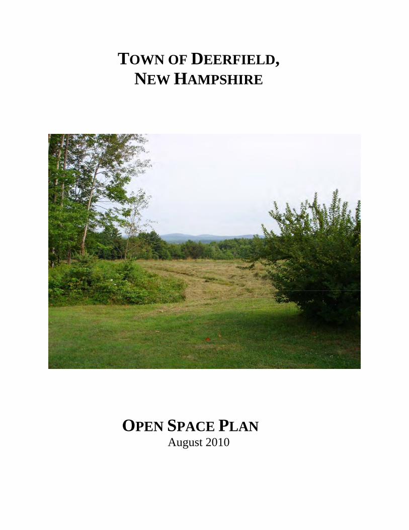
Cover photo of Kay Williams Field courtesy of the Deerfield Conservation Commission.
Deerfield Open Space Plan August 2010
ii
2006 Draft: Special thanks to Ms. Haley Peckett, SNHPC Intern, for her outstanding assistance with this project, and to
Dave Doran, Deerfield resident, for his excellent editing and technical assistance.
Through the 2009-2010 Deerfield Open Space Plan update process, the Deerfield Open
Space Committee has developed the following Town Charge:
Deerfield Open Space Committee Town Charge The Deerfield Open Space Committee shall update and develop an open space plan that identifies an open space network known as the “Green Infrastructure.” This network consists of high natural resource value land areas, and the connections between them. These lands are considered to be the most important for protection from residential, commercial and industrial growth to preserve the Town’s natural and cultural resources, agricultural character and quality of life. This plan will aid the town in making the best decisions when considering new open space lands to protect. In subsequent efforts, the Committee shall, in collaboration with other Town Boards, Commissions and staff, undertake other tasks aimed at implementing the protection of the lands identified.
Important Note
It is extremely important to note that landowners whose land falls within the green infrastructure are free to dispose of their land as they see fit, consistent with applicable laws and regulations. Inclusion of land within the green infrastructure is not an indication that the Town of Deerfield has any legal interest in the land or has any intention of taking the land for a public purpose.

Deerfield Open Space Plan August 2010
iii
DEERFIELD OPEN SPACE PLAN
TABLE OF CONTENTS Page
Acknowledgements....................................................................................................................i Table of Contents.................................................................................................................... iii Overview.................................................................................................................................vii Goals and Key Actions ............................................................................................................ix
Section 1: Open Space: Benefit or Burden? FAQs and Myths .................................................1 Section 2: Background and Introduction ...................................................................................4
• Defining Rural Character.......................................................................................................4 • Determining Future Character ...............................................................................................6 • Functions of Open Space .......................................................................................................6 • Deerfield’s Regional Setting and History ..............................................................................6 • History of Deerfield Land Protection and DOSC..................................................................8
Section 3: —The Cost of Sprawl--Population Growth, Sprawl, and Smart Growth Choices: How they Affect Open Space Protection .....................................................................9
• Population Growth in New Hampshire and Deerfield...........................................................9 • The Costs of Sprawl...............................................................................................................9 • Economic Consequences of Sprawl.....................................................................................11 • Smart Growth Solutions and Principles...............................................................................12
Section 4: The Economic Benefits of Open Space...................................................................14
• Who Pays for Land Protection? ..........................................................................................14 • Long-term Benefits ..............................................................................................................15 • Does Open Space Pay? ........................................................................................................16 • Water--Quantity, Quality, Supply, and Flood Control ........................................................16 • Funding Land Conservation.................................................................................................17
Section 5: Social Benefits of Open Space ................................................................................18 • Connecting Resource Lands ................................................................................................18 • Open Space and Recreation .................................................................................................18 • Aesthetics.............................................................................................................................20

Deerfield Open Space Plan August 2010
iv
• Air Quality ...........................................................................................................................20 • Water Supply .......................................................................................................................20 • Water Quantity.....................................................................................................................21
Section 6: Ecological Benefits ....................................................................................................22
• The Importance of Biodiversity ...........................................................................................22 • Rare Species and Natural Communities ..............................................................................22 • Wildlife Crossings ..............................................................................................................23 • Water Quality and Quantity .................................................................................................24
Section 7: Priorities for Deerfield ..............................................................................................25
• Criteria for Acquisition and Protection of Open Space .......................................................25 • Co-occurrence .....................................................................................................................26
Section 8: Implementation Strategies........................................................................................34
• Summary of Recommendations...........................................................................................34 • Voluntary Land Protection...................................................................................................35
Conservation Subdivision Option Conservation Easements
• Regulatory Land Protection .................................................................................................37 o Conservation Subdivision Requirement o Growth Management Ordinance
• Property Owner Education...................................................................................................38 • Purchase ...............................................................................................................................38
o Outright Purchase o Bargain Sale o Acquisition of Conservation Easements
• Combining Strategies...........................................................................................................38 • Applying Open Space Priorities to Zoning Ordinances.......................................................38 • Frequently Asked Questions about Regulatory Measures ...................................................39 • Potential Schedule and Costs for Implementation ...............................................................41 • Cooperation with Conservation Agencies ...........................................................................41 • Outreach and Landowner Contact .......................................................................................41 • Action Plan for Implementation...........................................................................................42
Appendix A: Existing Plans and Programs ..............................................................................47
• Map 1: Natural Resources Co-occurrence Analysis ............................................................48 • Map 1A: Soil Condition Specialists Co-occurrence Analysis .............................................49 • Map1B: Water Quality Specialists Co-occurrence Analysis ...............................................50 • Map 1C: Forest Continuity Specialists Co-occurrence Analysis.........................................51

Deerfield Open Space Plan August 2010
v
• Map 2: Wildlife Connectivity Model...................................................................................52 • Map 3: Green Infrastructure.................................................................................................53 • Map 4: Parcels within the Green Infrastructure...................................................................54 • Map 5: Important Agricultural Soils....................................................................................55 • Map 6: Hydric Soils .............................................................................................................56 • Map 7: South facing Steep Slopes .......................................................................................57 • Map 8: High Elevation.........................................................................................................58 • Map 9: Aquifer Transmissivity............................................................................................59 • Map 10: Potentially Favorable Gravel Well Areas..............................................................60 • Map 11: Sanitary Radii ........................................................................................................61 • Map 12: Drinking Water Protection Areas ..........................................................................62 • Map 13: National Wetland Inventory ..................................................................................63 • Map 14: Undeveloped Riparian Zones ................................................................................64 • Map 15: Open/Agricultural/Disturbed Land Cover.............................................................65 • Map 16: Unfragmented Blocks............................................................................................66 • Map 17: Wildlife Action Plan 2006.....................................................................................67 • Map 18: NH Wildlife Habitat Land Cover ..........................................................................68 • Map 19: Quality of Life / Scenic Views ..............................................................................69 • Map 20: Possible Conservation Zones Based on Identified Hazard Zones .........................70 • Map 21: Natural Services Network......................................................................................71 • Map 22: Wildlife Action Plan 2010.....................................................................................72 • Existing Plans and Maps Related to Open Space in Deerfield ............................................73 • Town Maps and Deerfield Conservation Commission Annual Reports • Deerfield Forest Stewardship Program • Maintenance Responsibilities • Open Woodlands • Lakes and Ponds in Deerfield • FEMA Flood Insurance Study • Town of Deerfield Master Plan • Changes in Land Use
Appendix B: Soil Types and Open Space .....................................................................................80
• Prime and Unique Farmland • Farmland of Statewide Importance • Steep Slopes • Sand and Gravel Operations
Deerfield Open Space Plan August 2010
vi
Appendix C: Hydrological Features..............................................................................................82 • Watershed Boundaries • Floodplains • Wetlands • Aquifers • Potential Nonpoint Pollution Sources
Appendix D: Community Conservation Assistance Program Work Plan ................................87 Appendix E: Deerfield Conservation Lands.................................................................................94 Appendix F: About Tax Benefits, Funding, Easements ..............................................................98
• Tax Benefits From Donating Conservation Easements Appendix G: Further Implementation Strategies, Programs, and Funding Sources...............100
• Implementation Strategies • State land protection programs and funding • Federal land protection programs and funding • Contact information for land trust associations
Appendix H: Glossary of Common Open Space Terms..............................................................110 Appendix I: Population Growth rates in Southern New Hampshire, 1980-2004 .....................111 Appendix J: Selected New Hampshire Statutes Related to Open Space ...................................112 Appendix K: Legal Definition of Agriculture ..............................................................................118 Appendix L: Bio-Timber Inventory ..............................................................................................120 Appendix M: Transfer of Development Rights: TDR .................................................................122 Appendix N: 2004 Open Space Planning Maps ...........................................................................124
Index of Maps: 1. Base Map 2. Development Constraints 3. Generalized Land Use 4. Historic Sites 5. Habitat Feature 6. Wetlands and Riparian Zones 7. Unfragmented Lands 8. Lands of Special Importance 9. Co-Occurrence 10. Conservation Lands 11. Agricultural Lands
Bibliography ..................................................................................................................................136

Deerfield Open Space Plan August 2010
vii
Overview Open space planning in New Hampshire is an ongoing activity led mainly by conservation commissions and planning boards. Volunteers from the Town of Deerfield have created this Open Space Plan, with an initial draft in 2006, and this update in 2010:
• To outline the benefits of open space, • To explain the need for both land protection and changes in land use practices, • To prioritize criteria for land preservation within a larger green infrastructure, and • To identify voluntary and regulatory strategies to a maintain healthy and functional
green infrastructure network as the town continues to grow. Between 1990 and 2008, Deerfield has grown from a population of 3,124 to 4,366, an increase of almost 40%. The population is projected to increase to 5,204 by 2015, an increase of 19% (NH OEP). This does not incorporate additional growth resulting from the widening of Interstate 93. The development associated with this growth threatens the rural character and the open space of the town identified as important elements to retain in the master plan. Open space has many economic, social, health, and environmental benefits; and this plan will help to maximize those benefits while helping to shape growth and protect essential ecological functions. A green infrastructure open space network provides many benefits for Deerfield citizens, including:
• Economic: Cost of community services studies, including one specific to Deerfield completed by Phil Auger of the UNH cooperative extension, show that towns that maintain open land and manage growth save hundreds of dollars per family in infrastructure costs for roads, safety services, and other municipal expenses.
• Health: Open space lands, particularly in the form of forested areas and aquatic buffers, filter pollutants out of the air, and provide the water supply that allows for continued growth and development.
• Rural character: Deerfield, a town that prides itself on its rural qualities, adds aesthetic and social value through open space lands.
• Recreation: Deerfield residents can benefit from a host of recreational opportunities afforded through open space.
• Ecology: Open space lands support and preserve the unique biodiversity and wildlife habitats contained in Deerfield.
The open space priorities are determined through a social and environmental inventory, determining the needs of the town for recreation, affordability, health, aesthetic value, and wildlife habitats. The environmental inventory includes water, soils, habitat, forests, and a number of other elements. When these elements are layered on each other the areas with the highest value for open space protection become evident. A series of Geographic Information Systems (GIS) maps based upon data prepared through GRANIT, Bear-Paw Regional Greenways, New Hampshire Fish and Game and the Society for the Protection of New Hampshire Forests have been developed to provide an inventory of

Deerfield Open Space Plan August 2010
viii
all the critical area overlays in Deerfield (see Appendix A). The maps show the known locations of open space resources. The basis of this plan is formed by the recognized need to protect the pattern of resources, particularly where several resource characteristics overlap. Areas having a concentration of open space values represent resource lands that should remain in their natural condition to preserve water quality, wildlife habitat, recreation opportunities, sustainable timber resources, historic settings, potential greenways, and the scenic quality of the Town. Protecting these resource areas from development contributes to the quality of life in Deerfield while also helping the tax base. The natural areas within Deerfield that should be considered for protection from development include remaining large areas that have no or minimal roads and homes, hydric soils and wetlands, aquifers, floodplains, prime agricultural soils, steep slopes, forested lands, wildlife habitats, and important connectors between the unbroken large areas of undeveloped lands. The Open Space Plan outlines a clear implementation procedure and timeline to allow for more sustainable open space and development practices and taking specific actions on open space priorities. The plan answers potential questions on actions and management strategies, such as conservation easements, conservation subdivisions, and taxes on open space lands. The Open Space Plan is a guide for the community to document the need and suggest strategies for maintaining a functioning network of open lands. The two main avenues to do so are (a) land protection, and (b) changes in land use practices. LAND PROTECTION: For a century, New Hampshire has been a leader in land protection, beginning with the creation of the White Mountain National Forest in 1911. Over the past few decades, thousands of cities and towns across the state and country have voted to spend millions of dollars to protect lands. Recently, a number of communities within the Southern New Hampshire Planning Region, including Auburn, Londonderry, Bedford and Chester have all enacted bond issues of over a million dollars each for land protection. The primary needs in these communities are to preserve key open space areas in order to manage development, protect natural resources, and maintain the community’s character, while managing growth and stabilizing the tax rate. LAND USE: Within the last few years, natural resource scientists and land use experts in New Hampshire have started to work together to change land use practices within zoning and subdivision ordinances, recognizing that current development practices create suburban, rather than healthy rural, communities. Deerfield’s zoning that requires open space developments for major subdivisions is one such example of trying to balance development and maintaining rural character. The intent of this Open Space Plan also is to help the town to identify, prioritize, and protect the Town’s remaining high value open spaces. The Deerfield Open Space Committee will continue to explore options for protecting key properties , areas, and connections possessing qualities that define the character of the community, including well-managed forests and tree farms, as well as unique habitats that provide shelter for rare plants and exemplary animal communities, groundwater protection areas, and essential ecological funtion.

Deerfield Open Space Plan August 2010
ix
Town of Deerfield, New Hampshire Goals and Key Actions for Deerfield’s Open Space Plan
The Deerfield Open Space Committee will be considering the following suggested goals and key actions for this Open Space Plan. The goals are intended to serve as guiding principles for open space planning in the Town of Deerfield. These items should be reviewed on an annual basis in order to keep them current with the Town’s strategies for open space planning. Key actions indicate specific courses of action, aimed at the achievement of the broader goal. Generally, the key actions are attainable and measureable. They identify the types of things that should be done by local officials, boards, Town departments and the voters to help achieve the goals. Active citizen participation is a key element of this plan, in order to achieve the results of open space conservation and protection. The following Vision, Goals and Key Actions are recommended as an integral part of this Plan: Vision Statement: “A Deerfield with sustaining rural character, where homes and businesses, services and recreational opportunities are set within a functioning network of wild lands, managed forests, and working farms.” From the Deerfield Open Space Committee, Initial Meetings, February 2002 and updated at the Deerfield Open Space Committee Meeting of July-September 2005. Goals: 1. Implement COST-EFFECTIVE means to preserve land to have the greatest overall tax
and revenue benefits for Deerfield citizens. 1.1 Recognize open space as an important component of a smart growth program to curb
sprawl. 1.2 Identify means of land protection to best utilize available funding and tax benefits
offered by state, federal, and non-profit agencies. 1.3 Clarify the relationship between open space lands and tax revenues for the Town of
Deerfield. 2. Establish development and subdivision zoning REGULATIONS AND ORDINANCES
for Deerfield to encourage smart growth, preserve open space, and make the Town economically sustainable.
2.1 Adopt the Open Space Plan as an official part of the Town’s Master Plan. 2.2 Amend the Town’s Open Space Development Regulations to tie individual
projects within the overall functioning network of open space as presented in the Open Space Plan. Also consider adding new practices and techniques to the regulations that can help preserve the community’s rural character and protect sensitive environmental features.

Deerfield Open Space Plan August 2010
x
2.3 Explore mechanisms such as a Rural Features Overlay District, a Density Credit Overlay District, and/or the Transfer of Development Rights which allows increased density (i.e. above and beyond that permitted by current zoning) in exchange for protecting specific rural features and open space such as undeveloped road frontage, view points, viewsheds, fields and pastures, steep slopes, vegetated stream corridors, etc.
2.4 Develop performance regulations to zone land according to the performance of the site and the impact its activities have upon surrounding areas, such as noise, pollution, light, and traffic flow.
3 Identify the CRITERIA the Conservation Commission/Town of Deerfield/Planning Board will use when considering potential lands for open space preservation. 3.1 Lands within the most current Green Infrastructure Open Space Network.
3.2 Protect Deerfield’s most sensitive natural areas, including prime wetlands, aquifers, vernal pools, streams and lakes, wildlife habitats (including wildlife corridors), old forest stands, and agricultural soils to protect the environment and to balance growth and development with quality of life.
3.3 Connect un-fragmented areas with guidance based on local knowledge from residents, scientists, and land trusts. 3.4 Preserve the natural and cultural resources provided by Deerfield’s scenic views, Class VI Road system, trails, and culturally and historically significant lands. 3.5 Continue to work with land trusts and state and federal agencies to develop a natural greenway and trail system consisting of public and private protected lands linking Bear Book State Park, Pawtuckaway State Park and Northwood Meadows Sate Park.
3.6 Work with the NH Coastal Watershed Land Protection Program, through the Nature Conservancy, NH Estuaries Project, and regional planning commissions, to establish priorities for preservation.
3.7 Work with neighboring towns to connect the green infrastructure and to create linkages for open space on a regional basis
EDUCATE the residents of Deerfield of the multiple economic, health, ecological, and recreational benefits of Open Space.
4.1 Define “rural” and establish open space as a significant component of rural character.
4.2 Identify the economic benefits of open space to the town’s tax base and land values.
4.3 Identify the health hazards that can arise from nonpoint pollution sources in groundwater and air and recognize the role of open space in clean water and good air quality.
4.4 Outline the recreational potential of open space lands through Class VI roads, trails, and parks.
4.5 Demonstrate the importance of open space for wildlife habitat.

Deerfield Open Space Plan August 2010
1
Section 1 OPEN SPACE—BENEFIT OR BURDEN? While open space offers many economic, social, and environmental benefits, many myths abound over the societal costs of open space preservation. Using current academic and industry studies on the effects of open space on property values, tax rates, growth rates, and density, this section seeks to uproot misconceptions about open space maintained through either land protection or development practices. Land Protection: New Hampshire has a 100+ year history of land protection initiatives, starting with the White Mountain National Forest in 1901. The answers to the questions below come from a century of experience and data. Doesn’t the cost of land protection eventually come back to the taxpayers? The costs of open space land are rarely attributable to a single source, but taxpayers rarely see increases due to open space protection and the increases that they do see are negligible. There are three costs associated with open space land, purchase/acquisition, taxes, and maintenance; each varies depending on the open space arrangement. Town purchase/easement: The Town of Deerfield has committed a portion of its land change tax to go towards land protection, at the discretion of the Conservation Commission. From 2001 until 2005, 100% of the tax went to land protection. Starting in 2006, 50% of the land change tax goes to land protection until a cap of $500,000 is reached. These funds can be used towards conservation easements or direct purchase of land. In the case of conservation easements, the most popular form of conservation, the land owner continues to pay current use taxes on the land, resulting in no loss of taxes. If the town purchases the land, the land is removed from the tax rolls, so that is not the preferred choice. There are several state programs to help defer the tax losses of these purchases (for more information, please see Section 4). In some cases, very small, short-term tax increases are passed on to the residents. Private Land Trust: The Town often works with Bear Paw Regional Greenways or other local land trusts to acquire easements on conservation lands. Easements may be donated or purchased with funds from towns and other grants. The easement holder maintains stewardship over the land through annual inspections and other activities, and the land owner continues to pay taxes. Conservation subdivision: Implemented through regulatory measures, this method costs the least to implement in that the developer purchases the land, retains at least 50% as open space, and sells the remaining land as house lots. In most cases, the open space land is owned by a Homeowner’s Association, consisting of all residents of the subdivision. The members are required to pay dues, which go towards taxes on the land, monitoring, and maintenance costs. Doesn’t more development lead to more taxpayers and therefore lower taxes? The additional services required by new residential taxpayers outweigh the additional tax income. Expanding residential development costs towns more than the tax revenue it acquires. A UNH Cooperative Extension study found that Deerfield spent $1.15 for every dollar generated through residential property taxes. Contrastingly, open space land cost the town only $0.35 for every dollar of tax revenue.

Deerfield Open Space Plan August 2010
2
What are the tax benefits associated with land protection? Landowners who donate development rights or offer a bargain sale of their land to a municipality or land trust can enjoy an array of tax benefits that can, in some cases, equal or exceed the financial benefits of selling the land. Additionally, the sale of conservation easements can significantly lessen the financial burden for heirs (see Appendix F). For town a resident, open space land does not increase (and in many cases may decrease) residents’ taxes based on infrastructure savings and improved property values.1 Development Practices: In many areas of southern New Hampshire, land prices have increased considerably in recent years, making land protection increasingly expensive. Therefore, changing land use practices has become another very cost effective way to maintain open space, as the answers below indicate. Isn’t the three-acre minimum lot size currently required in Deerfield an important measure for maintaining rural character and open space? Hypothetically, a 3,000-acre town with a three-acre lot minimum could have 1,000 homes distributed evenly throughout the town, forcing the town to build roads, and provide police, fire, rescue, and school bus services to all reaches of the community. In some municipalities, the cost of providing services to a large-lot residence located at the fringe of the community can be $10,000 more than one located in a more urban core.2 Furthermore, the town has no open space greater than 2.5 acre lots, wiping out the health, recreational, social, and economic benefits that accompany larger tracts of open space. In the alternate hypothetical situation, the same town has 1,000 homes located on 1,000 or fewer acres, clustered into conservation subdivisions, each containing large tracts of open space land. The town provides concentrated services to these areas, which results in considerable savings, and 2/3 or more of the town remains as open space lands. Do conservation or open space subdivisions cost more for the town? Development and town design oriented around open space is actually a cost-saving mechanism on two levels. First, these developments are planned according to specific regulations regarding lot location, land preservation, and construction of infrastructure. As these developments avoid sprawl and as no infrastructure is required on the open space land, it costs less to implement water, sewer, and roads. Second, houses located near open space or in conservation subdivisions have higher property values and are more desirable than similar houses not located near open space.3 This means that the tax revenue that the town gains from conservation subdivisions will exceed that of a subdivision of equal population without conservation land, resulting in a higher tax base for Deerfield.
1 Trust for Public Land, Managing Growth: The Impact of Conservation and Development on Property Taxes in New Hampshire, 2005, http://www.tpl.org/content_documents/nh_managing_growth_report.pdf. 2 International City/County Management Association, Why Smart Growth: A Primer. (Washington, D.C.: Author, 1998). 3 David J. O’Neill, The Smart Growth Tool Kit and PFK Consulting, Analysis of Economic Impacts of the Northern Central Rail Trail (Annapolis, Maryland: report prepared for Maryland Greenways Commission, Maryland Department of Natural Resources, 1994).

Deerfield Open Space Plan August 2010
3
Why would the rural town of Deerfield be concerned about losing open space? New Hampshire is the fastest growing state in New England, with annual population increases of 13,000 expected to continue throughout the next two decades. With the expansion of I-93, more of this growth will be directed to the towns surrounding the I-93 corridor, including Deerfield. The New Hampshire Office of Energy and Planning predicts a 30% population increase for Deerfield from 2000 to 2010, meaning that Deerfield will see many new residential developments taking over its current wealth of undeveloped land.
Deerfield Open Space Plan August 2010
4
Section 2 BACKGROUND AND INTRODUCTION The Town of Deerfield has a history of appreciation for the protection of open space within its community. Deerfield has been working on local protection initiatives since 1987. Formed in 2002 and reorganized in 2009, the Deerfield Open Space Committee (DOSC) has collaborated with the Planning Board, the Select Board, the Conservation Commission, the Forestry Commission, the Heritage Commission and Bear Paw Regional Greenways and other land protection interests to work towards open space protection - representing varied interests with a common goal. Although Deerfield was a very successful participant in the Land Conservation Investment Program (LCIP) in the early 1990’s, the successor Land and Community Heritage Investment Program (LCHIP) has not been adequately funded. In 2005, however, New Hampshire Department of Transportation began an innovative, multi-year, $3.5 million Community Technical Assistance Program (CTAP) for the 26 towns in the I-93 corridor most directly impacted by the proposed highway widening from four lanes to eight. Deerfield has benefitted from assistance through CTAP and its related initiatives, including the regional Conservation Framework which provides a vision to guide significant land protection opportunities and local land development practices and the recently developed natural services network, which identifies lands that provide water supply, flood storage, productive agricultural soils, and important wildlife habitat. This Open Space Plan is being updated in 2009-2010 through CTAP. The overarching goal of this document is to inform the residents of Deerfield of the importance of Open Space preservation, not only for the ecological health of the community but also for the economic sustainability and quality of life improvements that it will bring to the entire town. In addition to identifying the benefits of open space preservation, the plan also outlines the priorities for land preservation so that potential parcels for acquisition can be evaluated to provide maximum and multiple benefits for any expenditure of local, state, or federal funds. The plan also identifies potential changes to land use practices for zoning and subdivision that will help maintain rural character as Deerfield continues to grow. Protection of rural character is a major goal of Deerfield residents, consistently identified in the Town’s master planning. With this plan as a guide, both the Conservation Commission and other Town Boards can continue to work on identifying and protecting the most important open space, while helping to change practices for new development within the Town. Defining Rural Character Residents of the Town of Deerfield see open space as a significant component of rural character. The question of what is rural versus urban is one that challenges towns across the nation. At least two approaches to defining that rural character, are: quantitative and qualitative, and are briefly summarized below. Quantitative: The Center for Rural Pennsylvania formerly defined rural based on the U.S. Census definition. However, the 2000 Census offered an altered and more complex definition of urban and rural. Therefore, in 2000 the Center created a new rural definition, based upon the state population density and

Deerfield Open Space Plan August 2010
5
the U.S. Census definition of urban. Using a modification of this definition for the state of New Hampshire, the quantitative definition of rural could be described as follows:
A municipality is considered rural when the population density within the municipality is less than 145 persons per square mile (US Census 2004) or the municipality’s total population is less than 2,500, unless more than 50 percent of the population lives in an urbanized area, as defined by the U.S. Census Bureau. All other municipalities are considered urban.
Deerfield has a population density of 85.9 persons per square mile, according to the most recent population figures available (NH OEP 2008), placing it well below Pennsylvania’s chosen population density of 145 persons per square mile. Deerfield also did not contain any urbanized areas in the 2000 Census, with urbanized areas defined as containing census blocks or block groups with at least 1,000 people per square mile and contiguous with other blocks or block groups of at least 500 people per square mile. Therefore, Deerfield meets Pennsylvania’s quantitative definition of rural. In 2003, a collaborative study by The Jordan Institute and Audubon Society of New Hampshire analyzed all 259 municipalities and unincorporated places in New Hampshire, categorizing them by number of housing units and whether there was municipal water service. Deerfield was among the 41% (or 106) of communities defined as “rural.” In 2005, the Society for the Protection of New Hampshire Forests updated their 1999 New Hampshire’s Changing Landscape report. In that report, they chose the following densities to define community character: Rural = less than 36 persons/sq mile Exurban = 36-144 persons/sq mile Suburban = 145-1,000 persons/sq mile Urban = more than 1,000 persons/sq mile By that definition, Deerfield, with 85.9 persons per square mile, is in the middle of the “exurban” range, and projected to remain there through 2025 Qualitative: A qualitative rural definition often embodies what residents see and feel, fitting less with a rigid, qualified statement. Some members of the Deerfield Open Space Committee associate rural character with the definition provided by the Center for Rural America: “Relationship to nature is a key determinant of what is rural. When development destroys or seriously degrades the natural environment, it destroys the core basis for ruralness.”4 Rockingham Planning Commission land use planner, Jill Robinson, defines rural as involving working landscapes including forestry and agriculture where ways of life and livelihood are connected to stewardship of the land. Rural areas include a mix of different settlement densities interspersed with unmanaged areas and economic uses such as tree farms, managed forests, and active agriculture. Agricultural endeavors are encouraged and businesses meet the needs of the community. As opposed to suburbs, rural towns include mixed land uses, mixed incomes, and mixed ages. The DOSC also discussed what rural is not; rural communities do not have traffic congestion, traffic lights, or wide, straight, paved roads abutting posted land. Above all, the natural landscape and 4 Karl N. Stauber, PhD. Economic Review, 2nd Quarter, 2001, p 36-37

Deerfield Open Space Plan August 2010
6
areas of open space predominate over the built environment and the town maintains a sense of community facilitated through many places, events, and opportunities for citizens to meet and interact. Determining Future Character As evidenced by these comments, open space is an important component of rural character. Residents move to Deerfield because its layout contrasts that of more densely developed cities and suburbs. Large tracts of open space and open spaces between developed places are important characteristics of rural communities that set them apart from other types of communities. By both quantitative and qualitative definitions, Deerfield today is rural. But, what will the future character be as Deerfield grows? It could remain rural, or change character to become a village, small town, or suburb. According to the master plan, maintaining open spaces and a variety of land uses is a priority for the Town of Deerfield as it grows. Functions of Open Space In addition to its contribution to the rural character in Deerfield, open space benefits the quality of life of town residents through its social, environmental, and economic effects. The body of this plan will illustrate the necessity of open space to maintain a vibrant, functioning town. While open space is commonly misconceived as a burdensome expense to the community, residents in towns with open space preservation often pay fewer taxes than towns with greater development. Open space lands cost towns very little in services as compared to residential developments. In the long term, open space is a financial positive for a town, and there are many strategies to address short-term costs such that there is little or no impact to taxpayers. Deerfield’s Regional Setting Located in the northwest portion of Rockingham County, Deerfield is bounded by the Towns of Hooksett, Allenstown, and Epsom in Merrimack County; and by Nottingham, Northwood, Candia, and Raymond in Rockingham County (see following Regional Setting Map). Deerfield consists of 52.1 square miles, and is linked to other parts of the region by NH Routes 43 and 107. Much of the development in town is located along the major and minor roadways, which cross through the community. Deerfield is bordered on the west by Bear Brook and east by Pawtuckaway State Parks, and to the north by Saddleback Mountain, where large amounts of land are owned by UNH and NH Fish and Game Department, abutting Northwood Meadows State Park. These three areas are the largest remaining tracts of undeveloped land in southeastern New Hampshire. Deerfield is a member of the Southern New Hampshire Planning Commission that is composed of 13 communities, containing approximately 500 square miles in portions of Hillsborough, Merrimack and Rockingham Counties. Figure 1 below shows the location of Deerfield in relation to its neighboring towns.

Deerfield Open Space Plan August 2010
7
Figure 1
A Brief History of Deerfield The Town of Deerfield received independent town status from the town of Nottingham in 1766. Deerfield was settled in the late 1730s, and as it lay along the main route between Concord and Portsmouth, it became an active center of trade and commerce. The residents erected the Meeting House on Chase Hill soon after the town’s incorporation, and this area became known as the Old Center. The Deerfield Parade, along the Concord/Portsmouth route, contained an inn for travelers, a store, and an academy to educate the children of the town’s prominent citizens. Leavitt’s Hill and South Road also became areas of trade and hospitality. Education has been a priority of Deerfield citizens from its earliest days. The establishment of a grammar school was one of the top priorities of early citizens, along with the Meeting House and a church. From the first one-room school house, the Town’s education system contained 15 school districts and 13 school buildings by the mid-19th century. The earliest citizens cleared the forests, settled the land, and built houses and important municipal buildings. The population in 1773 was 911. The hundred years witnessed an explosion of hospitality and trade, with taverns, water-powered manufacturing, and craftsmen of all varieties occupying the Town. Farming remained the most important occupation, with land being passed down along family lines for centuries. The population in 1820 had reached 2,133.

Deerfield Open Space Plan August 2010
8
After 1850, Deerfield experienced a period of population decline due to the unprofitability of farming and the advent of railroads to the area, which eliminated travelers and freighters. During this period, some old farms became summer vacation destinations for tourists. This led to some development as a modest summer community, yet by 1930 only 635 year-round residents of Deerfield remained. This trend reversed gradually after World War II as workers commuting to outside cities bought homes in Deerfield, which led to the construction of a central school, the George B. White School. The 1970s and 1980s saw extreme population growth, with the population growing from 1,178 in 1970 to 3,300 in 1990. More forest land was cleared to build housing. Deerfield recognizes the need for growth but hopes to maintain the Town’s heritage as the town grows. As provided in the Deerfield Official Website (www.ci.deerfield-nh.us/townhistory.htm). History of Deerfield land protection and DOSC Deerfield community members have worked collectively towards local land protection for several decades. The Conservation Commission has worked closely with the Planning Board, the Select Board, and the Historical Society on local protection initiatives since 1987. In 1992, through funding support from six landowners, the Town, and the statewide Land Conservation Investment Program (LCIP), 700 acres along the Great Brook Corridor were permanently protected. Through that experience, local volunteers formulated a process for Deerfield through which to communicate with landowners and citizens to support such initiatives. In 2001, the Deerfield Conservation Commission (DCC) proposed the creation of a Joint Open Space Committee to identify how to most effectively expend revenues from the Use Change Tax for land protection. Since then, the Deerfield Open Space Committee (DOSC), in cooperation with the DCC, has worked on educating the public on land preservation, developing conservation priorities, identifying projects, and finding funding for open space protection. The committee has been working towards the completion of the Open Space plan to publicize their work and outline implementation strategies. Recent availability of the statewide NH Fish and Game Department’s Wildlife Action Plan has greatly aided open space planning. Bear Paw Regional Greenway also recently completed their seven town regional conservation strategy that includes Deerfield.

Deerfield Open Space Plan August 2010
9
Section 3 THE COST OF SPRAWL--POPULATION GROWTH, SPRAWL, AND SMART GROWTH CHOICES: HOW THEY AFFECT OPEN SPACE PROTECTION Population Growth in New Hampshire and Deerfield
Since 1950, the population of New Hampshire has grown from 533,110 persons to 1,228,794 in 2000, an increase of over 100%. Deerfield’s population growth during this same period has increased from 706 persons in 1950 to 3,678 in 2000, an increase of over 400% during this same period.5 The NH Office of Energy and Planning has projected additional population increases for Deerfield of approximately 30% from 2000 to 2010, and 18% from 2010 to 2020. The New Hampshire Department of Transportation estimates that as many as 500 additional people may relocate to Deerfield as a result of the I-93 expansion.
The housing stock in Deerfield is approximately 78% owner-occupied and 9% rental housing. This is difficult for open space planning, as site-built single-family homes on large lots occupy consider ably more open space than clustered developments. So what does all this mean? Planning for future growth is not an easy task, since open space conservation must be balanced with inevitable population increases. Changes in allowable population densities, and zoning and subdivision regulations may be needed in order to plan for growth that will be here in the future. The Costs of Sprawl In a document produced by the Southern New Hampshire Planning Commission titled Sprawl and Smart Growth Choices for Southern New Hampshire Communities, it is estimated that the consumption of residential land within the 13 communities in the SNHPC region exceeded what was needed for population growth. From 1986 to 2000, residential acreage was consumed at twice the population growth rate, and commercial acreage was consumed at three times the population growth rate. In 1982, New Hampshire had 0.41 developed acres per person, and by 1997, that figure had increased to 0.55 developed acres per person. These figures are higher than those for New England as well as those for the United States as a whole.6 5 US Census, 1950-2000. 6 State of New Hampshire, Environment 2000.
New Hampshire Population Growth
1950-2000
0
500,000
1,000,000
1,500,000
1950
1960
1970
1980
1990
2000
Deerfield Population Growth 1950-2000
0500
1000150020002500300035004000
1950 1960 1970 1980 1990 2000

Deerfield Open Space Plan August 2010
10
During the past 20 years, many communities in New England required larger lots in their zoning ordinances for single family homes than were really necessary. They felt that, if larger lots were required, fewer homes would be built, and that would decrease sprawl and its accompanying traffic problems. However, large lot zoning resulted in the subdivision of tracts of land that would never again be useful for open space or other common public areas. Deerfield’s zoning ordinance currently requires three-acre lots.
“Overall, the state is converting 13,000 acres of open space per year to roads, houses, businesses, and commercialU development.”6F
7
Deerfield has seen a considerable decrease in the amount of lots approved for subdivision since 2004. Subdivision of lots significantly reduces open space and often removes the potential even for current use of land. The graph below illustrates the spike in approved subdivisions during 2004, with an approved subdivision containing one or more lots. The decline in approved subdivisions since 2004 can be attributed to the recession that started in late 2007. Deerfield saw only 3 approved subdivisions in 2009. With the population increase projected by NHOEP and also the growth expected from the widening of I-93, Deerfield can most likely expect this number to rise again in the coming years. Details on conservation subdivision ordinances can be found in Section 8. Please see the above document at the SNHPC website www.snhpc.orgH for more information on this topic.
Multiple studies have found sprawling development to be more expensive for municipal, county, and state governments. Twenty-five years of studies cite millions of dollars saved through smart growth management as opposed to sprawl. A summary of some of these studies can be read on the following page as released by the Michigan Land Institute in January 2005. These studies confirm Deerfield’s fiscal experience, where tax rates have grown steadily as the population has increased, primarily through large-lot,
frontage-based subdivision. Now that few buildable lots on town road frontage remain, subdivisions more frequently require new road construction, which further increases road maintenance expenses to the town. Sprawl has been and will continue to be a problem for most communities. Many towns have developed both regulatory and non-regulatory answers to encourage more compact, less sprawling development. Potential regulatory measures for Deerfield will be addressed in Section 8.
7 Conserving Your Land, Center for Land Conservation Assistance 2004, 1.
Approved Subdivisions in Deerfield, 2001-2009
16 15 12
55
12 15 7 6 30
20
40
60
2001 2002 2003 2004 2005 2006 2007 2008 2009
Number of Lots
Deerfield Open Space Plan August 2010
11

Deerfield Open Space Plan August 2010
12
Smart Growth Solutions and Principles During the past 10 years, a number of books and articles have been written on the topic of “Smart Growth.” Many communities throughout New Hampshire have begun to embrace this concept, with promising results, although in reality it is a return to the distinctive practices of colonial New England. These practices reflect on a time when land uses were mixed, homes were often clustered into villages, and good land was fenced for pasture and agriculture. Woodlands were accessed by a network of woods roads, and rough land was left open and unmanaged. “Smart Growth” won’t necessarily reduce municipal costs greatly because the majority of our expenditures are for education, not other services. However, the publication, Managing Growth in NH, notes that, on average, taxes on the median value home in New Hampshire communities are:
• Higher in more developed towns, • Higher in towns with more year-round residents, and • Higher in towns with more buildings (more value of buildings).
Since Deerfield will continue to grow, the community can choose its future character and manage this growth by directing it to areas that can sustain more dense development, or continue sprawl based practices (see page 6 on future character). Since large open space areas provide many other ecological and economic services, a better place to direct growth may be into the village areas and other existing developed areas, or into more condensed new development. Getting to Smart Growth: 100 Policies for Implementation presents a series of ten smart growth principles along with ten policies for each principle. While some of these principles and policies may not yet work for Deerfield, several can work and have been tried in other communities in the region with great success. The following are a few that could work in Deerfield: Principle 1: Mix land uses. The Town of Deerfield has only an Agricultural-Residential Zoning District, which allows municipal buildings and some commercial and industrial businesses by special exception. While this causes all non-residential buildings to be close to housing, development could more effectively embody mixed-use principles with specific mixed-use zoning. Places that are accessible by bike and foot can create vibrant and diverse communities. Separate uses tend to exact social costs by fundamentally changing the character of communities and undermining the viability of opportunities for people who walk to shops or work, and to meet and chat with their neighbors on the way. Smart Growth supports the integration of mixed land uses into communities as a critical component of achieving better places to live. Principle 3: Create a range of housing opportunities and choices. While Deerfield has some multi-family and manufactured housing, these options have fallen in popularity due to the proliferation of single-family homes. Deerfield can better accommodate the housing needs of residents by encouraging small, dense multi-family housing near commercial or municipal centers. By using smart growth approaches to create a wider range of housing choices, communities can begin to use their infrastructure resources more efficiently and help aging residents remain in their homes. Zoning codes can be revised to permit a wider variety of housing types.
Deerfield Open Space Plan August 2010
13
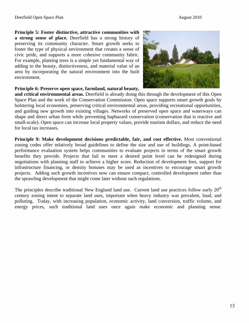
Principle 5: Foster distinctive, attractive communities with a strong sense of place. Deerfield has a strong history of preserving its community character. Smart growth seeks to foster the type of physical environment that creates a sense of civic pride, and supports a more cohesive community fabric. For example, planting trees is a simple yet fundamental way of adding to the beauty, distinctiveness, and material value of an area by incorporating the natural environment into the built environment. Principle 6: Preserve open space, farmland, natural beauty, and critical environmental areas. Deerfield is already doing this through the development of this Open Space Plan and the work of the Conservation Commission. Open space supports smart growth goals by bolstering local economies, preserving critical environmental areas, providing recreational opportunities, and guiding new growth into existing villages. Networks of preserved open space and waterways can shape and direct urban form while preventing haphazard conservation (conservation that is reactive and small-scale). Open space can increase local property values, provide tourism dollars, and reduce the need for local tax increases. Principle 9: Make development decisions predictable, fair, and cost effective. Most conventional zoning codes offer relatively broad guidelines to define the size and use of buildings. A point-based performance evaluation system helps communities to evaluate projects in terms of the smart growth benefits they provide. Projects that fail to meet a desired point level can be redesigned during negotiations with planning staff to achieve a higher score. Reduction of development fees, support for infrastructure financing, or density bonuses may be used as incentives to encourage smart growth projects. Adding such growth incentives now can ensure compact, controlled development rather than the sprawling development that might come later without such regulations. The principles describe traditional New England land use. Current land use practices follow early 20th century zoning intent to separate land uses, important when heavy industry was prevalent, loud, and polluting. Today, with increasing population, economic activity, land conversion, traffic volume, and energy prices, such traditional land uses once again make economic and planning sense.

Deerfield Open Space Plan August 2010
14
Section 4 THE ECONOMIC BENEFITS OF OPEN SPACE Common misconceptions hold that open space programs are expensive for municipalities, but dozens of studies over the past few decades have shown that communities who curb sprawl and implement smart growth principles, including land preservation, spend considerably less money than towns with sprawl. Towns with widely-distributed residential development and continued construction of new residential areas have giant costs of infrastructure construction, including water, sewer, road, and utilities. In 2005, the Trust for Public Land (TPL) released a study entitled, Managing Growth: The Impact of Conservation and Development on Property Taxes in New Hampshire. Looking at the unique relationship between property taxes and municipal revenue in New Hampshire, the study addressed the concern that land conservation increased property taxes. A description of the system of taxation in New Hampshire leads to a better understanding of the concerns over the expenses of conservations lands. Who pays for land protection? Acquiring conservation lands by direct purchase represents a known cost to the buyer, which in the case of a municipality is borne by the taxpayers. Municipalities purchasing conservation lands should clearly communicate the benefits of open space, and residents should understand the costs and benefits of the purchase. However, there are hidden costs of land acquisition in the form of lost tax revenue. Since municipalities often need to compensate for the lost tax revenue, there can be a small, short-term tax increase for residents. In New Hampshire, there are measures in place by land conservation bodies to account for this tax base loss and avoid making residents pay the difference. Open space land in Deerfield is most likely to be obtained through purchase or conservation easement acquired by the Town or through a private conservation group. Land may also be obtained through conservation subdivisions. In each situation, the cost is covered in different manners:
• Private conservation groups: Private conservation groups tend to acquire conservation easements, in which the owner continues to pay current use taxes on the land.
• Conservation subdivision: Open space land in conservation subdivisions is often owned by the developer, where it gets passed on to a Homeowner’s Association. The taxation values are low because the land has lost its development rights, and taxes are paid through homeowner association dues by the residents of the subdivision.
• Municipal lands: When a municipality purchases land, they do not pay property taxes to themselves, so the property is removed from the tax roll. However, due to the Statewide Education Property Tax and Adequacy Aid (SWEPT), the total equalized value of the town would decrease with the lands removed from the tax roll. Therefore, “property rich” towns would have to send fewer property taxes to the state for education and “property poor” towns would receive greater adequacy aid from the state. While the SWEPT funds do not account for the total value lost, the resulting tax increase is slight (in the TPL study, the highest scenario of tax increase was a mere $0.88 on a $100,000 property).
While not as likely in Deerfield, the state and federal governments have measures in place to account for municipal tax revenue lost through state and federal open space land acquisition:
Deerfield Open Space Plan August 2010
15
• Federal lands: If the federal government purchases land in New Hampshire, they do not pay taxes but rather pay two annual fees. One fee goes directly to the town’s school district and the other to the town as a Payment In Lieu of Taxes (PILT). If the fees do not equal the amount of taxes the town would receive on that land under current use, the state will pay the difference. However, these fees often exceed the current use taxation values.
• State lands: The state pays the municipality the amount of taxes they would receive under current use value of the land.
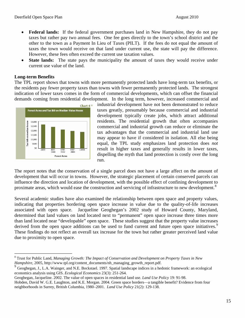
Long-term Benefits The TPL report shows that towns with more permanently protected lands have long-term tax benefits, or the residents pay fewer property taxes than towns with fewer permanently protected lands. The strongest indication of lower taxes comes in the form of commercial developments, which can offset the financial demands coming from residential development. In the long term, however, increased commercial and
industrial development have not been demonstrated to reduce taxes greatly, presumably because commercial and industrial development typically create jobs, which attract additional residents. The residential growth that often accompanies commercial and industrial growth can reduce or eliminate the tax advantages that the commercial and industrial land use may appear to have if considered in isolation. All else being equal, the TPL study emphasizes land protection does not result in higher taxes and generally results in lower taxes, dispelling the myth that land protection is costly over the long run.
The report notes that the conservation of a single parcel does not have a large affect on the amount of development that will occur in towns. However, the strategic placement of certain conserved parcels can influence the direction and location of development, with the possible effect of confining development to proximate areas, which would ease the construction and servicing of infrastructure to new development.7F
8 Several academic studies have also examined the relationship between open space and property values, indicating that properties bordering open space increase in value due to the quality-of-life increases associated with open space. Jacqueline Geoghegan’s 2002 study of Howard County, Maryland, determined that land values on land located next to “permanent” open space increase three times more than land located near “developable” open space. These studies suggest that the property value increases derived from the open space additions can be used to fund current and future open space initiatives.8F
9 These findings do not reflect an overall tax increase for the town but rather greater perceived land value due to proximity to open space.
8 Trust for Public Land, Managing Growth: The Impact of Conservation and Development on Property Taxes in New Hampshire, 2005, http://www.tpl.org/content_documents/nh_managing_growth_report.pdf. 9 Geoghegan, J., L.A. Wainger, and N.E. Bockstael. 1997. Spatial landscape indices in a hedonic framework: an ecological economics analysis using GIS. Ecological Economics 23(3): 251-264. Geoghegan, Jacqueline. 2002. The value of open spaces in residential land use. Land Use Policy 19: 91-98. Hobden, David W. G.E. Laughton, and K.E. Morgan. 2004. Green space borders—a tangible benefit? Evidence from four neighborhoods in Surrey, British Columbia, 1980–2001. Land Use Policy 21(2): 129-138.

Deerfield Open Space Plan August 2010
16
Does Open Space Pay? A study conducted during the mid 1990s by Philip A. Auger, Extension Educator, Forest Resources, University of New Hampshire Cooperative Extension, looked at the cost of community service for residential, commercial, industrial, and open space land uses within the communities of Stratham, Dover, Fremont, and Deerfield. In each community, residential land use revenues were exceeded by expenditures by an average of approximately 12%. Conversely, for open space land use, revenues exceeded expenditures. The results of this study, published in 1996, still ring true today as evidenced by a similar study for the Town of Brentwood, NH. This small town in southeastern New Hampshire, not far from Deerfield, had a population of 3,197 in 2000. Tax revenue generated from residential property in this town fell short of the cost of school and town services by 17%, while revenue from open space lands exceeded town service costs by 17%.9F
10 While each town in New Hampshire has a unique blend of land uses, revenues and expenditures, these studies point out some fiscal consistencies that are likely to apply in most circumstances. One of these is that residential land use very often costs communities more than they generate in revenues. Traditional residential housing brings with it a tremendous cost load for community services, roads, landfills and schools. Open space lands are often a net asset to New Hampshire communities, and contribute to the stability of community tax rates. If land is taken out of open space and converted to housing, it will often cost far more than it generates in taxes. This has been supported by other well-documented fiscal impact studies in New Hampshire communities, including Milford and Londonderry. Water—quantity, quality, supply, and flood control Among the many benefits of land preservation is that undeveloped land contributes to a readily accessible and sufficient supply of clean water and reduced flood events. While water is commonly construed as a health or ecological benefit, it is also a strong economic benefit as adequate water supply is essential for economic activity, and water treatment or purchase can be a costly endeavor for municipalities without access to enough clean water. Deerfield’s water supply is currently clean and healthy, providing an adequate source of water for residential, commercial, and institutional users. Should large tracts of open space be developed, more pollutants can enter the water supply. In the case of a polluted water source, the Town could potentially incur millions of dollars in clean-up costs or residents could face the need to purchase water from other sources. It is estimated that the cost of cleaning up roadway-related water pollution could exceed $200 billion.10F
11 This figure does not include the pollution of pesticides, fertilizers, and some road salting, all of which contribute to pollution but which can be mitigated through open space preservation and aquatic buffers.
10 Brentwood Open Space Task Force. Does Open Space Pay in Brentwood? Part 1: Housing Growth and Taxes. May 2002. 11
Hilary Nixon and Jean-Daniel Saphores, Impacts of Motor Vehicle Operation on Water Quality: A Preliminary Assessment, School of Civil & Environmental Engineering, University of California, Irvine (www.uctc.net), 2003.
Steven’s Field on Griffin Road

Deerfield Open Space Plan August 2010
17
Through the preservation of open space, Deerfield can protect its water supply, preventing costly clean up and maintenance. In addition, rain and snow can recharge the water table, maintaining river and stream flows, healthy wetlands, and clean lakes and ponds. When rain and snow melt refill the aquifers, rather than running off into surface waters, the potential for flooding is substantially reduced or eliminated when combined with informed development practices. A Note on Climate Instability Given recent recognition and acknowledgement of the realities of current and future climate instability, open space increases even more in value because it provides the many essential functions mentioned previously. These functions moderate extremes in climate related events, and include:
• Providing food, fiber, and fuel • Absorbing carbon dioxide • Cooling hot days/nights • Cleaning the air • Absorbing and slowing flood waters and snow melt
Funding land conservation Deerfield has already taken a vital step in ensuring that some of its open lands remain permanently in their natural states. The Town has allocated 50% of the land use change tax monies to the conservation committee for the purpose of acquiring conservation lands. However, to maximize the economic, social, and environmental benefits of open space, the Town must find additional means of land preservation. The DOSC emphasizes the importance of regulatory conservation strategies, including changes to zoning ordinances to emphasize conservation subdivisions. These regulations would have no implementation cost and, in fact, save money on infrastructure and operating costs. Using conservation subdivisions, the open space land is built into new developments rather than purchased afterwards, allowing cost savings for the Town. For funding-based land acquisition, the Town can work cooperatively with land trusts and private non-profit conservation organizations to pool financial resources and expand conservation efforts. The Bear Paw Regional Greenway Land Trust works specifically with Deerfield and surrounding communities to link Bear Brook State Park, Pawtuckaway State Park, Northwood Meadows State Park, and other conservation areas. As a community-based organization composed of many townspeople, Bear Paw can serve as an important mobilizing and organizing resource. The Rockingham Land Trust, serving all the communities of Rockingham County, can also be a good local resource, although it currently holds no conservation lands in Deerfield. The Trust for Public Land and the Nature Conservancy are both national land trust organizations active in New Hampshire, which can provide resources and assistance to preservation projects. Additional state resource organizations include the Society for the Protection of New Hampshire Forests and the Audubon Society. For more information on funding and strategies, see Section 8 on Implementation.

Deerfield Open Space Plan August 2010
18
Section 5 SOCIAL BENEFITS OF OPEN SPACE Connecting Resource Lands Regional greenways, such as those prioritized in the seven town the Bear Paw Regional Greenways Land Trust, provide recreational and open space corridors for residents of the region as well as facilitating wildlife survival. Greenways, particularly among rivers and streams, have social as well as ecological benefits, such as the potential for recreational trails, wildlife viewing, and a wide expanse of connected open space. The Deerfield Conservation Commission has already protected significant parcels of land encompassing some of the town’s most valuable natural resources, including wetlands, waterways, steep slopes, town forests, and historic sites. These areas are home to diverse populations of flora and fauna, including old-growth beech, native rhododendron, great blue herons, and a black gum swamp. Additionally, these areas have been fitted with trails, picnic tables, and other amenities to encourage public enjoyment. Bear-Paw Regional Greenways is a land trust dedicated to creating greenways to connect Pawtuckaway, Northwood Meadows, and Bear Brook State Parks, as well as other natural areas. Due to the high rate of land development, experts fear that wildlife habitats protected in the parks will suffer as outside land becomes developed. Bear-Paw has helped to protect over 2,000 acres to date and has over 3,000 more in negotiation. Most landowners have voluntarily approached the land trust to work towards preservation. In the case of lands fragmented by roads, greenways that connect undeveloped tracts of land can create an expanse of scenic landscape along the roadway. These scenic roads can be enjoyed by all Deerfield residents as they drive through the town. Within these tracts, residents can hike, bike, jog, ski, and potentially fish and hunt (with permission of property owners). Greenways would provide a wealth of recreational opportunities to Deerfield citizens literally in their own backyards. Two key strategies are fundamental to creating a regional open space network:
• Residents need to be better informed about the open space resources that already exist through the Deerfield Conservation Commission, and about the potential for new regional connections through Bear-Paw Regional Greenways;
• A coordinating and management entity is needed to forge continuing connections and enhance information exchange, harmonize local plans, build consensus on priorities, and help to fund specific projects.
If Deerfield is to protect the irreplaceable biological diversity, the Town must reduce fragmentation and restore the health and vitality of its forest communities. Open Space and Recreation Lands that offer personal or socially interactive recreation, or active or passive recreation, are essential elements of the open space system. Universal access should be provided at a variety of appropriate places where development of such access will not compromise the character of the area.
Deerfield Open Space Plan August 2010
19
The Town of Deerfield recognizes the opportunity to provide responsible recreation for all types - walkers, skiers, snowshoers, people with strollers or wheelchairs, horseback riders, mountain bikers, hunters, fishers, and ATVs. Deerfield has a network of trails ranging from rustic paths to dirt roads existing on town lands and with some access granted on private conservation easements. Further study is needed to evaluate trail use and to suggest a recreational network to serve the spectrum of trail users in this town. Not all open space land is appropriate for trail use and/or public access, but there remains potential to better connect and expand existing trails. Deerfield can also consider implementing a plan for Livable, Walkable Communities, through New Hampshire Celebrates Wellness. The necessary elements of this plan include economic health, environmental health, human health, and community health. With these elements, residents can access services, improve air and water quality, improve their fitness through recreation, and gather informally with friends and neighbors. The characteristics of Livable, Walkable Communities are symbiotic with the goals of the open space plan.
Class VI roads are a significant resource for Deerfield. These currently provide recreational opportunities for Deerfield citizens and are often functionally used as trails. The town currently has the opportunity to develop policies for open space in the future, of which Class VI roads can be an important contributor to rural quality of life when preserved for recreational use. When considering the transfer of class VI roads to recreational trails, the town must consider the road’s use in terms of access to land. RSA 231:43 stipulates that no roadway of any type that provides sole access to any land shall be reclassified as a class B trail without the written consent of the owner of that land.
In order to supplement the trails existing in Deerfield, the Town can look into the Recreational Trails Program (RTP), which is a component of the Transportation Equity Act for the 21st Century (TEA-21). This program funds motorized, non-motorized, and diversified trail projects, and it is funded through federal gas tax money paid on fuel for off-highway recreational vehicles. Projects are given up to 80% of funding, with at least 20% required from the Town or organization in the form of labor, supplies, or cash. Many projects are completed by local scout groups or volunteers. Over $900,000 in grant funding was approved for trail projects in 2009. As of September 30, 2009 the SAFETEA:LU has expired and a new Federal surface transportation bill has not yet been established. Programs under the SAFETEA:LU are currently operating under a continuing resolution for Federal Fiscal Year 2010. As a result, the state’s apportionment of will be received incrementally as notified. Final funding amounts for FY 2010 are unknown at this time.
Another strategy for local recreation is to change land use regulations to require that existing paths and trails be incorporated into subdivision design. One successful example is Deer Run Estates, where new residents benefit from access to a trail within a designated right of way that provides them direct access to state parks.
The town also maintains park facilities and fields for recreational use, many of which also highlight the natural surroundings. Veasey Park offers a sandy beach and lake frontage on Pleasant Lake, and Lindsay Woods houses a physical training challenge course as well as trails around the woodland acreage. Deerfield Community School, G.B. White Building, and Bicentennial Field all offer some combination

Deerfield Open Space Plan August 2010
20
of playgrounds, athletic fields, and open lawn space. These parks are run by volunteers appointed by the Board of Selectman The advancement of recreational opportunities in Deerfield can also expand the social network of the town. Residents can meet neighbors while hiking a trail, hold town festivals in newly-established parks, and work together to construct improvements to public open spaces. The increased social benefits of open space again reinforce the rural character of the town. Aesthetics A prime reason that people move to Deerfield is to live among the beautiful scenery of the rural, wooded town. With cleared agricultural lands, rivers and streams, and a rolling terrain, the Town of Deerfield offers many scenic viewscapes that residents associate with the character of the town. The alternative to preserving land for its aesthetic value is to live in a town characterized by billboards, parking lots, and fences rather than fields, trees, and hills. Aesthetic landscapes lend appeal to the town and provide economic benefits as well. As delineated in Section 4, several studies indicate that land values bordering open space are higher than those in developed neighborhoods, suggesting that people are willing to pay for the aesthetic value derived from open space protection. Air Quality The rural town of Deerfield does not currently suffer from excessive air pollution, in large part due to the amount of undeveloped land. The trees in forested areas absorb pollutants such as ozone and sulfur dioxide, leaving the air noticeably cleaner. A single acre of trees takes in about 2.6 tons of carbon dioxide each year, removing the some of the pollutants released by vehicles (American Forestry Association). As development progresses, construction and traffic will increase air pollution and formerly forested land may be cleared for buildings. Open space preservation is integral in maintaining air quality in Deerfield. The older, larger trees (ones with diameters greater than 30 inches) currently residing in Deerfield’s forests, such as the black gum tree, can remove up to 70 times more pollution from the air than trees with diameters less than three inches (Nowak 1994), meaning that trees cleared for development and replaced by new trees would contribute less to air quality. Additionally, trees trap the particulate pollution that causes asthma and respiratory problems (Nelson 1975). Water Supply Deerfield residents receive their drinking water from underground aquifers through private wells, both of which are subject to runoff pollution due to salted roads and parking lots, pesticides, antifreeze, and other toxins of developed lands. Forested areas can retain up to 90% more of the rainfall than pavement and roofs, filtering the chemicals from entering the water system (Anderson 2000, Trust for Public Land 2005). The town of Deerfield does not provide municipal water service nor does it have any immediate plans to provide this service. However, the Town has dam and flowage rights to

Deerfield Open Space Plan August 2010
21
Pleasant Lake, which is in the northwest quadrant of Deerfield. These rights were acquired by deed in 1974 from Thomas Hodgson and Son, Inc. The town owns several small tracts of land, including Veasey Park, around Pleasant Lake, and 30 acres on the western part of Freese’s pond, which connects with the Lamprey River headwaters. Town residents obtain most of their water supply from underground aquifers in either sand and gravel deposits or bedrock, with wells located throughout the Town. Water Quality Vegetated buffers physically protect a stream or river by maintaining trees, shrubs, bushes, tall grasses, and groundcovers that provide shade and remove debris and polluting nutrients. Buffers usually contain three zones: the innermost streamside zone of forested shade to enhance stream quality; the middle zone, 50-100 feet, often a managed forest with some clearing for trails or open areas, and the outer zone, usually around 25 feet, but often expanded to protect adjacent wetlands and any floodplain. Developed lands include structures with roofs, driveways, and parking lots that shed water and concentrate the runoff into surface waters. Trees, meadows, scrub areas, and agricultural lands allow water to recharge back into underground supplies, maintaining base flow in rivers and streams, lakes and ponds, and wetlands. Without such recharge, droughts are more likely, as well as flooding during severe rainfall or snow melt.

Deerfield Open Space Plan August 2010
22
Section 6 ECOLOGICAL BENEFITS OF PROTECTING OPEN SPACE The Importance of Biodiversity11F
12 Biodiversity, which encompasses the existence and interacting processes of plants, animals, fungi, algae, bacteria, and other microorganisms, is integral to human survival. The complex natural world provides elements that support human life, such as enriched soil to grow food, oxygen to breathe, and purified water to drink. The balance of maintaining these processes and protecting the habitats in which they occur is vital to supporting all life on Earth. However, as habitats are lost due to development of land or invasive and non-native species, this balance of biodiversity is threatened. Biodiversity is important to maintain for economic as well as ecological reasons. Plants are sources of food, medicine, fuel, fibers, timber, and more. Furthermore, plants and animals pollinate fruit and vegetables, control pests, and add nutrients to the soil as part of their natural functioning. Wildlife is an attractive draw for visitors from around the country, who come to the region to bird-watch, to hunt and fish, and to hike amidst the fall foliage. In New Hampshire, 88 percent of the population participates in wildlife-related activities and this brings millions of dollars to local communities. New Hampshire Fish and Game Department has completed a statewide wildlife action plan (WAP) for both game and important non-game species. Because of the importance of wildlife to rural economies, additional federal funding is expected to support a wide range of activities in local communities so that wildlife populations remain healthy as the state grows. Rare Species and Natural Communities HNew Hampshire’s Natural Heritage Inventory (NHI) 12F
13 has assessed the Rare Species and Exemplary Natural Communities of Deerfield based on state and federal status as well as rarity of the species in the community. Table 2 lists those species and communities of very 6 From Wildlife Habitats, Fall 1996, University of New Hampshire Cooperative Extension. 13 Natural Heritage Inventory, New Hampshire Natural Heritage Bureau. January 2010.
Table 2: NHI Inventory Species or Community Name Type of Species State Status
Locations in Town in the last 20 years
Red Oak – ironwood – PA sedge woodland
Community – Terrestrial 3
Rick Appalachian oak rocky woods
Community – Terrestrial 2
Rick Appalachian oak rocky woods system
Community – Terrestrial 2
Semi-rich Appalachian oak – sugar maple forest
Community – Terrestrial 1
Black gum - red maple basin swamp
Community-Palustrine 3
Emergent marsh – shrub swamp system
Community-Palustrine 1
Giant Rhododendron Plant 1Small Whorled Pogonia Plant Endangered 1Cerulean Warbler Bird Critical 1Common Loon Bird Threatened 1Osprey Bird Threatened 1Blanding's Turtle Reptile 3Northern Black Racer Reptile 2
Smooth Green Snake Reptile Special Concern 1
Wood Turtle Reptile Special Concern 1

Deerfield Open Space Plan August 2010
23
high importance that can still be found in Deerfield today. These inventories identify sites that contain habitat of rare, endangered and threatened natural species. The NHI was used to identify rare species and natural community areas on the Lands of Special Importance Map (Appendix N, Map 8). There is the rare black gum tree, living in several “basin swamps” in Deerfield. The black gum tree (Nyssa sylvatica) is a hardwood in the tupelo family that may grow up to 75-80 feet tall and may live over 400 years. Wildlife Crossings “The New Hampshire Fish and Game Department has worked together with 0Hpartners in the conservation community to create the state's first Wildlife Action Plan. The plan, which was mandated and funded by the federal government through the State Wildlife Grants program, provides New Hampshire decision-makers with important tools for restoring and maintaining critical habitats and populations of the state's species of conservation and management concern. It is a pro-active effort to define and implement a strategy that will help keep species off of rare species lists, in the process saving taxpayers millions of dollars.”13F
14 Map 17, Appendix A, illustrates the Wildlife Habitat for the Town of Deerfield and Map 2, Appendix A, illustrates the Wildlife Connectivity for the Town of Deerfield. The aforementioned regional greenways are also important tools to protecting wildlife habitats. Small blocks of open space expose more borders to development, thereby threatening species habitat inside. Wildlife crossings are a simple way to help connect wildlife habitat through consideration in zoning and planning. Wildlife crossings are small parcels of land, usually underneath or across roadways that connect fragmented wildlife habitats and allow wildlife to breed, find food, and migrate to find new habitats. The most important environmental features to consider in terms of wildlife habitat are unfragmented tracts of land with natural land cover and undeveloped riparian zones. Wildlife crossings can be as simple as constructed passages through or under roadways that connect two wildlife habitats. The following areas are recommendations for potential wildlife corridors for the Town of Deerfield. These areas have the highest risk for wildlife movement and cause fragmentation of large, important areas of wildlife habitat. Southwest
• South Road • Mt. Delight Road between Swamp Road and Thurston Pond
Southeast
• Rte 107 between the town line and the intersection of Rte 43
14 NH Fish and Game. Wildlife Action Plan. 2006

Deerfield Open Space Plan August 2010
24
Northwest • Griffin Road at Mud Pond or Fogg Shores Forest • Old Center Road north of Meeting House Hill • Rte 107 between Old Candia Rd and Perkins Rd
Northeast
• Nottingham Road west of Perry Road • Rte 43 between Saddleback Mountain Rd. and Harvey Rd.
Wildlife crossings are particularly effective when located along a riparian corridor, which has a rich array of species habitats. Aquatic buffers to developments can provide these crossings along such corridors. Water Quality and Quantity Sustained water quality and quantity are vitally important to support all ecological functions. Undeveloped land supports the health of water bodies and wetlands, and the network of rivers and streams provide corridors vital for wildlife movement and food and shelter. As discussed previously, the forested soil of wooded lands can filter significantly more pollutants from pesticide or roadway-related runoff than can lawns or asphalt surfaces. By protecting the water supply, open space lands not only contribute to the health and economic benefits of the town, but they protect valuable water resources and wildlife habitats as well. Reducing Climate Instability See page 17.

Deerfield Open Space Plan August 2010
25
Section 7 PRIORITIES FOR DEERFIELD There are a significant number of areas in Deerfield that are desirable locations for open space preservation. The Deerfield Open Space Committee has not specified any individual lots for protection; rather, they have focused on areas desirable as open space based on the land’s attributes. These priorities and other significant considerations for assessing open space potential are described in the following section, with areas of high value to the town described at the end. Criteria for Acquisition and Protection of Open Space The DOSC considers the following criteria priorities in terms of land protection:
1. Lands within the most current Green Infrastructure Open Space Network. 2. Protect Deerfield’s most sensitive natural areas, including prime wetlands, aquifers, vernal pools,
streams and lakes, wildlife habitats (including wildlife corridors), old forest stands, and agricultural soils to protect the environment and to balance growth and development with quality of life.
3. Connect un-fragmented areas with guidance based on local knowledge from residents, scientists, and land trusts.
4. Preserve the natural and cultural resources provided by Deerfield’s scenic views, Class VI Road system, trails, and culturally and historically significant lands.
5. Continue to work with land trusts and state and federal agencies to develop a natural greenway and trail system consisting of public and private protected lands linking Bear Book State Park, Pawtuckaway State Park and Northwood Meadows Sate Park.
6. Work with the NH Coastal Watershed Land Protection Program, through the Nature Conservancy, NH Estuaries Project, and regional planning commissions, to establish priorities for preservation.
7. Work with neighboring towns to connect the green infrastructure and to create linkages for open space on a regional basis
These priorities will be considered for individual parcels as they become available for open space protection, as the Town works to best allocate its limited financial resources. Additionally these priorities will guide the Conservation Commission’s larger efforts to match its own conservation strategies with those of state and regional conservation groups. While the DOSC will prioritize the abovementioned criteria when considering land for open space protection, the following are additional criteria to consider beyond those specified by the commission:
• Potential linkages to existing open space, to recreation facilities, and to similar areas in adjacent communities.
• Environmental sensitivity and importance of the parcel such as the presence of aquifers, rivers, wetlands, wildlife and scenic qualities. This includes wildlife corridors, unique habitat, and endangered, threatened and rare species.
• Location in areas that do not have enough public open space or are threatened by continued development. Will the acquisition of the parcel provide additional recreational opportunities in an

Deerfield Open Space Plan August 2010
26
area of the Town that is in need of such facilities? Does the purchase of the parcel encourage Town-wide distribution of open space and recreation?
• Town-wide versus special group benefit. Would the acquisition of this parcel benefit the Town as a whole or a select group of residents in need of additional opportunities? The importance of addressing each need will depend on the specific goals of the Town.
• Outdoor recreation potential. This is related to providing additional athletic fields as well as providing areas for greenways and trails that provide opportunities for hiking, walking, running, skiing, and biking.
• Cost and availability of the parcel. This should account for the amount residents are willing to pay to purchase open space (in the form of increased taxes) and the availability of funding sources that would be available if a particular property were targeted for acquisition.
• The financial impact that removing the parcel from development will have on the Town. For example, a residential parcel may cost the Town in services while a commercial property may be a positive contribution to the tax base (see previous summary detailing cost of residential service versus open space costs and benefits).
• Aesthetic benefits to the general public and the preservation of the Town character. 2004 Co-Occurrence Analysis A natural resources Co-Occurrence Analysis is an important tool in identifying and prioritizing areas for protection. The Analysis identifies high-value natural resource areas and maps them, with multiple levels of unique resource data overlayed spatially using geographical information system software (GIS) to display on one comprehensive map. The Analysis applies numerical values to selected resource factors, with higher values and darker colors indicating land that should be prioritized for protection. The Deerfield Open Space Committee, with assistance from the Southern New Hampshire Planning Commission conducted a co-occurrence analysis in 2004 and the following are the twelve resource factors considered in the 2004 Deerfield Co-Occurrence Analysis:
• Stratified drift aquifer • Potentially favorable gravel well area • Sanitary radii • Drinking water protection areas • National Wetlands Inventory (NWI) identified wetlands • Open/Agricultural/Disturbed land cover • High elevation (>800 ft.) • Steep south facing slopes • Unfragmented natural land cover • Undeveloped riparian zone • Prime agricultural soil and soils of statewide significance • Hydric soil (poor or very poor drainage)
Appendix N shows maps of Deerfield, developed during the 2004 co-occurrence analysis, featuring unfragmented lands, wildlife features, lands of special importance, and wetlands, all of which are features of the co-occurrence analysis. The following areas, roughly categorized by region, are some of the areas with the highest Co-Occurrence scores from that analysis

Deerfield Open Space Plan August 2010
27
. Southeast
• Lamprey River corridor east of Cottonwood Estates Easement • Lamprey River corridor along Rte. 107 • Riparian corridor along the brook north of Reservation Road
Southwest
• North Branch River corridor south of South Road • Area north of Bear Brook State Park by Rockingham/Merrimack County border
Central
• Area along Ridge Road in Drinking Water Protection Area • Area immediately west of Old Center Road North
Northeast
• Land west of Curry protected area • Back Creek riparian corridor • Undeveloped shore lands of Freese’s Pond (lower portion) • Lamprey River riparian corridor
Northwest
• Mud Pond and surrounding riparian corridor • Riparian corridor north of Pleasant Lake • Riparian corridor west of Griffin Road
2009 Co-occurrence Analysis Through the I-93 Community Technical Assistance Program (CTAP) under the New Hampshire Department of Transportation, the Town of Deerfield has had the opportunity to update the 2004 analysis with new information that has come out since that was done and to develop the town’s green infrastructure from this new analysis. Green infrastructure is defined as “an interconnected network of green space that conserves natural ecosystem values and functions and provides associated benefits to human populations.” 14F
15
• The purpose of the green infrastructure is to connect open space areas that meet the priorities identified in this plan and subsequent updates
• The green infrastructure provides desirable open space that Deerfield needs to maintain its rural
character as identified in the master plan.
• It helps town residents to focus on land with higher conservation values. 15 Benedict, Mark A. and Edward T. McMahon. The Conservation Fund. Green Infrastructure: Smart Conservation for the 21st Century. Sprawl Watch Clearinghouse Monograph Series. 2002.

Deerfield Open Space Plan August 2010
28
• The green infrastructure provides the opportunity for the Town to connect its own open space
corridors to surrounding towns and make better decisions when considering new open space parcels to protect.
• The green infrastructure should be a continuous network with no “islands” of infrastructure land
throughout the town.
• The infrastructure should inform the design of new developments and act as a guide for where in a new development open space areas should be.
Guidelines for defining the green infrastructure:
- Include areas of exceptionally high resource value for a particular category. - Include areas where multiple resource values occur in the same place. - Give added consideration to lands near existing conservation lands. - Give added considerations to lands that allow each resident reasonable access to open space. - Avoid areas slated for industrial use or commercial development, unless they contain
exceptionally high quality resources. - Include at least 25% of the town’s land area to ensure the sustainability of natural processes. - Do not include over 50% of the town’s land area, to allow for future development. - Try to combine high value polygons into a single polygon, by including “linking lands” that are
feasible to protect. - Include the connectivity corridors identified by NH Fish and Game, et al.
The following are the resource factors taken from the Bear Paw data considered in the 2009 Deerfield Co-Occurrence Analysis: • Stratified drift aquifer • Potentially favorable gravel well area • Sanitary radii • Drinking water protection areas • National Wetlands Inventory (NWI) identified wetlands • Open/Agricultural/Disturbed land cover • High elevation (>800 ft.) • Steep south facing slopes • Unfragmented natural land cover • Undeveloped riparian zone • Prime agricultural soil and soils of statewide significance • Hydric soil (poor or very poor drainage) The following data sources also were used: • 2006 Wildlife Action Plan – Tier 1 & Tier 2 Habitats

Deerfield Open Space Plan August 2010
29
• 2006 Wildlife Action Plan – Peatland, Grassland (25+ acres), Forest Floodplain, Cliff, Rocky Ridge or Talus Slope
• Quality of Life Areas – Scenic Views, 21 Cornerstons, Scenic Roads listed on page 94 of Town Report.
The analysis was a straight co-occurrence, where each factor was weighted the same (1 point) and final co-occurrence values were derived from overlaying each layer on top of one another to determine where the highest values occur in Deerfield. The areas listed above with the highest Co-Occurrence scores from the 2004 analysis are still the areas with the highest co-occurrence scores in 2009. See Map 9, Appendix N, for the 2004 analysis and Map 1, Appendix A for the 2009 Analysis. A comparison of the maps and data layers from 2004 to 2009 shows that very little has changed on the individual data layers and also on the co-occurrences that were developed. Along with the co-occurrence, the addition of the 2006 Wildlife Action Plan data, Wildlife Connectivity Model and the Quality of Life Areas (Appendix A, Map 19) helped the Open Space Committee to determine how best to develop the green infrastructure and the linkages that exist from the different open space habitats. The NH Wildlife Connectivity Model is a basic, GIS-based, landscape permeability model that predicts broad-scale wildlife connectivity zones across the state. This analysis can identify both key areas for land protection efforts and strategic locations for restoring connectivity in currently fragmented landscapes. Preliminary validation of the NH wildlife connectivity model utilized available data from tracking and telemetry studies. Visual assessment of these data provided a sufficient level of confidence in the model to accept the resulting cost surface for general conservation planning purposes. Further, the traffic volume data for local roads was estimated from population vs. road class parameters. It is strongly encouraged that users incorporate best available local data sources wherever possible and ground-truth the results of corridor analyses, which is essential for identifying critical connectivity zones.15F
16 As described above, the 2009-2010 Deerfield Open Space Committee developed the town’s green infrastructure, using the resource factors and co-occurrence analysis as a guide to determine the areas with the highest natural resources values in town. Map 3, Appendix A shows the network of green infrastructure identified by the Committee. The Deerfield green infrastructure is 12,661.4 acres and 38% of the town. Map 4, Appendix A shows the parcels in Deerfield which intersect with the green infrastructure. An update to the Wildlife Action Plan and related data became available on March 22, 2010, after the analysis for this report had been completed. The Deerfield Open Space Committee addressed this update at their May 31, 2010 meeting comparing the new data to the old and to the analysis that had been done for the plan. Minor changes were made to the previously defined green infrastructure after reviewing the new data and the other base layers already used in the analysis to incorporate certain areas of importance the committee felt had not been captured previously. The green infrastructure does not capture every area in town that has 1 or more natural resources of high value to the town; it is meant to capture those areas with the most high value natural resources and to create a network and linkages between them. Deerfield should plan to work with neighboring towns to 16 NH Fish and Game. Wildlife Connectivity Model Background Data.

Deerfield Open Space Plan August 2010
30
continue the green infrastructure’s network and linkages throughout the region, as conservation of high value natural resources needs to be approached from a regional perspective, since natural resources span town boundaries and are not confined within just one town. Important Agricultural soils (Map 5, Appendix A) are located in several areas of Deerfield that are not covered by the green infrastructure. This does not mean that these areas are any less important than those contained within the green infrastructure and they should still be areas that the town aims to protect and conserve. The green infrastructure is meant as a guide for the town when they are developing and implementing conservation strategies, so that their efforts can be focused in the areas that are the most crucial, in terms of the area and quantity of high value natural resources and so that a network can be developed, which is highly important to the function of many natural resources. Other areas of town that have high value natural resources that are not captured in the green infrastructure should also be considered in the development of protection and conservation strategies. It should be noted here that certain lands may become available that do not meet some of the specifications delineated above. When this occurs, the Town may wish to consider the potential purchase of these properties, or the purchase of a conservation easement, if these actions will enhance the Town’s open space acquisition program. Success of the program is determinate upon flexibility and creativity. Strategies for the protection of important agricultural soils and agricultural lands include: Existing Protections in New Hampshire for Agricultural lands In the New Hampshire State Development Plan, one of the goals is to, “Protect and preserve New Hampshire’s land and water resources including farms, forestlands, wildlife habitats, water resources, air quality, and other critical environmental areas.” Strategies to achieve this goal include,
- “Encourage the establishment of municipal agricultural commissions.”
- “Establish state and local tax credits for agricultural activities and uses.”
- “Provide assistance to municipalities to ensure that their local land use ordinances and regulations are farm friendly.”
- “Develop model ordinances for the protection of agricultural land and existing agricultural
operations; provide assistance to municipalities to tailor such ordinances to meet local needs and conditions.”
New Hampshire also supports agriculture through its Right to Farm Law (Chapter 432: Soil Conservation and Farmland Preservation), which protects farmers and ranchers from nuisance lawsuits and helps to keep farms economically viable by discouraging neighbors from filing lawsuits against agricultural operations. This statute also allows for the purchase of development rights as a means of protecting agricultural lands, stating “Development rights of agricultural lands may be acquired by any

Deerfield Open Space Plan August 2010
31
governmental body or charitable corporation or trust which has the authority to acquire interests in land. The restrictions arising from the acquisition of the development rights may be enforced by injunction or other proceeding. Representatives of the holder shall be entitled to enter such land in a reasonable manner and at reasonable times to assure compliance with the restriction.”16F
17 Other ways of protecting agricultural lands and keeping them viable include: Agricultural Conservation Easements, Transfer of Development Rights Programs, Mitigation Programs, Tax Relief Programs, Tax Incentives for Conservation Easement Donations, Agricultural Economic Development, and Farmland Assistance Programs. Agricultural Conservation Easements The most common tool for farmland protection is an agricultural conservation easement. A conservation easement is a deed restriction that landowners voluntarily place on part or all of their land. The easement limits development in order to protect the land’s natural resources. This type of easement is specifically designed for agricultural land and can be donated or sold to a public agency or qualified conservation organization through a “Purchase of Development Rights” (PDR) Program. Once the development rights are sold or donated through a conservation easement, they are in effect “retired”, usually in perpetuity. The farmer benefits from the sale of the agricultural conservation easement and a lower tax rate on their property. The cost of doing this to the farmer is that most easements are attached to the land for perpetuity, meaning they apply to all future owners of the land and the same restrictions apply to the land for them as well. The value of the land is also lowered with an easement because of the restrictions, specifically on development, that are attached to it. This tool is beneficial to the farmer who places value on keeping the land for agricultural use, possibly for passing down to future generations, or who simply would like to keep the land as it is in perpetuity because of the value they place on agricultural viability and preservation. New Hampshire Land and Community Heritage Investment Program The New Hampshire Land and Community Heritage Investment Program (LCHIP) is an independent state authority that makes matching grants to NH communities and non-profits to conserve and preserve New Hampshire’s most important natural, cultural and historic resources. Among other projects, LCHIP funds may be used by eligible applicants for the acquisition of real property in fee simple and the acquisition of easement interests in real property. Tax Relief Programs RSA 79-A is New Hampshire’s Current Use Taxation Statute, which allows for farm, forest and open space land to be assessed at its use value, rather than its fair market, or highest and best use value for the purposes of local property taxation. This statute states,
17 http://www.gencourt.state.nh.us/rsa/html/XL/432/432-mrg.htm

Deerfield Open Space Plan August 2010
32
"It is hereby declared to be in the public interest to encourage preservation of open space, thus providing a healthful and attractive outdoor environment for work and recreation of the state's citizen's, maintaining the character of the state's landscape, and conserving the land, water, forest, agricultural and wildlife resources." Deerfield participates in the State’s current use taxation program in support of local agriculture. This is an important element of a successful agriculture viability campaign and Deerfield should continue to participate in this program. When land that is in current use is converted to another use, the landowner pays a current use change penalty for doing so. Undeveloped land is not as readily available as it once was and therefore New Hampshire is seeing an increase in the current use change penalties being paid to convert current use lands to other uses. In order for this program to keep being effective municipalities must create a mechanism for mitigating the loss of current use/preservation lands to development. One way to do this is to direct all or a portion of the current use change penalty to the local conservation fund to protect additional land in town, in affect, mitigating the loss that was incurred from the current use change. The Town of Deerfield currently allocates 50% of the current use penalty tax to the Conservation Fund with a cap of $500,000. Federal Tax Incentives Another form of tax relief for farmers comes through federal tax incentives enacted in 2006 to promote donations of conservations easements by private landowners. These incentives were extended through 2009 and are expected to be extended through 2010 as well. This tax incentive has helped to conserve millions of acres of farms across the United States. The incentive, which applies to a landowner’s federal income tax, does the following:
• Raise the deduction a donor can take for donating a voluntary conservation agreement from 30% of their income in any year to 50%.
• Allow farmers and ranchers to deduct up to 100% of their income. • Increase the number of years over which a donor can take deductions from 6 to 16 years.
The amount of the donation is the difference between the land’s value with the agreement and its value without the agreement. Agricultural Economic Development An important component to increasing support for local agriculture is an economic development piece. Promoting local agriculture through a “Buy local” campaign is the best way to increase awareness of local agriculture and its benefit to the local economy and as a local food source. Municipalities can support local agricultural producers by implementing and supporting a campaign that promotes local agricultural producers among other local businesses. Farmland Assistance Programs
Deerfield Open Space Plan August 2010
33
The USDA funds several conservation programs each year to assist farmers with natural resources management and stewardship of their land. Programs include:
- Agricultural Management Assistance Program - Environmental Quality Incentives Program - Grassland Reserve Program - Wetlands Reserve Program - Wildlife Habitat Incentives Program
The USDA also funds the Farm and Ranch Lands Protection Program, which is another Purchase of Development Rights Program. Landowners must work with a sponsoring entity to apply to the program, such as the State of New Hampshire, a municipality, a land conservation organization or a tribal organization. The program then matches funds provided by the sponsoring entity.

Deerfield Open Space Plan August 2010
34
Section 8 IMPLEMENTATION STRATEGIES The Deerfield Open Space Committee recognizes that the preservation of open space is closely tied to smart growth principles and that the largest threat to open space may be Deerfield’s current growth patterns. The following are the committee’s recommendations on the most effective and cost-efficient tactics to preserve open space and rural character: Summary of Recommendations 1. Establish development and subdivision zoning regulations and ordinances for Deerfield to encourage
smart growth, preserve open space, and make the Town economically sustainable. • Amend the Town’s Open Space Development Regulations to mandate future subdivisions to
include open space provisions, integrating practices that protect sensitive environmental features of the development parcel.
• Provide incentives to developers building Open Space Developments, including density bonuses, reduction of minimum lot standards, and a streamlined application process.
• Create areas of the Town where increased density will be allowed in exchange for protecting specific rural features.
2. Implement cost-effective means to preserve land to have the greatest overall tax and revenue benefits
to Deerfield citizens. • Employ smart growth principles and regulatory measures to preserve open space. • Strengthen relationships with local, state, and federal agencies to obtain grants and technical assistance with conservation easements. • Encourage communication between landowners, town officials, and funding agencies. • Continue to fund open space projects adequately.
3. Use the priorities and criteria established in this Open Space Plan when considering potential lands for open space preservation.
The DOSC considers the following criteria priorities in terms of land protection:
1. Lands within the most current Green Infrastructure Open Space Network. 2. Protect Deerfield’s most sensitive natural areas, including prime wetlands, aquifers, vernal pools,
streams and lakes, wildlife habitats (including wildlife corridors), old forest stands, and agricultural soils to protect the environment and to balance growth and development with quality of life.
3. Connect un-fragmented areas with guidance based on local knowledge from residents, scientists, and land trusts.
4. Preserve the natural and cultural resources provided by Deerfield’s scenic views, Class VI Road system, trails, and culturally and historically significant lands.

Deerfield Open Space Plan August 2010
35
5. Continue to work with land trusts and state and federal agencies to develop a natural greenway and trail system consisting of public and private protected lands linking Bear Book State Park, Pawtuckaway State Park and Northwood Meadows Sate Park.
6. Work with the NH Coastal Watershed Land Protection Program, through the Nature Conservancy, NH Estuaries Project, and regional planning commissions, to establish priorities for preservation.
7. Work with neighboring towns to connect the green infrastructure and to create linkages for open space on a regional basis
4. Work to gain informed support from the residents of Deerfield concerning the multiple economic,
health, ecological, and recreational benefits of Open Space. • Encourage the reading of the following aspects of the Open Space Plan:
o Identify the economic benefits of open space to the town’s tax base. o Promote open space protection as a prevention tool for the health hazards that can arise
from non-point pollution sources in groundwater and air. o Promote the recreational potential of open space lands through Class VI roads, trails,
and parks. o Demonstrate the importance of open space for wildlife habitat. o Promote the use of open space for flood control purposes.
The remainder of this section delineates techniques and strategies for fulfilling these recommendations. To help meet Deerfield’s Open Space Goals, the following is a variety of tools and techniques that communities throughout New Hampshire have used for land protection. Dorothy Tripp Taylor describes many of these tools and techniques in more detail in the handbook “Open Space for New Hampshire, a Tool Book of Techniques for the New Millennium.” The handbook also refers to associated state laws and regulations, sample communities that have used these methods, and where to acquire technical assistance and additional written documents on each method. If the Town of Deerfield is interested in acquiring additional information on any of the following, this resource should be utilized. Section 8 describes some of the key ways of implementing land protection programs, but more of the techniques described in the above Tool Book can be found in Appendix G. Section 7 outlined a host of criteria to consider for the acquisition and protection of open space. Deerfield should focus upon the criteria identified in this report first when implementing their open space plan. Once the Town has identified parcels for protection, the Town should determine the most appropriate method of protecting the parcel. Options can range from growth management ordinances to outright purchase of the property, and the most successful option will depend upon the specifications of the property and the needs of the landowner. Voluntary Land Protection There are two primary types of voluntary land protection. The first is conservation easements and the second is conservation subdivision options. A voluntary conservation easement involves the donation of the develop rights over the land. The landowner makes the decision that they wish to prohibit development on their land and preserve the natural state. They donate the development rights to the town or a land trust as the easement holder; this group is then responsible for easement stewardship. The

Deerfield Open Space Plan August 2010
36
owners continue to use their land and pay property taxes on it. However, a portion of the value of the easement donated can be deducted from federal income taxes. A Conservation Subdivision is a residential or mixed-use development in which a large portion of the development site is set aside as unfragmented, permanently protected open space, with the buildings clustered off in the remaining portion of the land. A Conservation Subdivision Ordinance gives specific criteria that developers must meet in order to have a Conservation Subdivision, and these criteria will vary by town. Some of the main advantages of this arrangement include its efficiency and low cost relative to other protection methods, and its ability to maintain rural character while still allowing development. Drawbacks include resistance from residents concerned with increased density on the developed land and more complex governance of the resultant open space.
In a voluntary conservation subdivision option, developers may chose to develop land into a conservation subdivision instead of evenly dividing the property into larger lots. The Town of Deerfield can add Conservation Subdivision Ordinances into their zoning regulations so as to encourage these among developers. This would include adding exceptions to minimum lot size in low-density residential zoning districts for the purpose of conservation subdivisions. The ordinance would be most effective if it were accompanied by a streamlined site plan review process to Conservation Subdivisions and tax exemptions or discounts for open spaces contained within the development.
Open Space Development versus Conservation Subdivision Deerfield’s current zoning ordinance contains wording pertaining to Open Space Developments, in which greater density is allowed in exchange for setting aside at least 50 percent of available land as open space. The ordinance also regulates that no more than 50 percent of the common open space area may consist of wetlands or steep slopes. Deerfield’s Open Space Developments, therefore, can protect land and resources, yet through the addition of several important characteristics they can increase their conservation value. Conservation Subdivisions, like the Open Space Developments, set aside open space land and increase density of individual lots. However in Conservation Subdivisions, open space land is placed under an easement for permanent protection from development. More significantly, Conservation Subdivisions consider the natural features of the landscape and natural vegetation when laying out parcels for homes and for open space areas. Focus is placed upon connecting sensitive resources, unfragmented lands, and trails rather than setting aside the most convenient parcel for open space.

Deerfield Open Space Plan August 2010
37
Another form of voluntary conservation subdivisions exists as the “Village Plan Alternative,” as described in RSA 674:21, available in its full text in Appendix J. This stipulates that a developer must locate all development on 20% of the development property to allow for maximum open space. The open space area will be under a recorded conservation easement. The Village Plan area should have expedited review for all applications. It is subject to all ordinances and regulations with the exception of density, lot size, and frontage and setbacks. Regulatory Land Protection Another approach to land protection involves the use of zoning or municipal regulations to prohibit unnatural disturbance or development on the protected parcel. Two methods of regulatory protection are the Conservation Subdivision Requirement and Growth Management Ordinances. A Conservation Subdivision requirement has the same result as conservation subdivision option but the requirement regulates that all new development must be in conservation subdivisions. This ordinance would lower the lot size of all houses built in new subdivision developments in Deerfield. However, it would also significantly increase the amount of conservation open space, ensuring that increased development will also maintain substantial amounts of open space. Growth Management Ordinances are often used by municipalities experiencing population growth at a rapid pace whose public facilities and services cannot keep up. They function by placing short or long-term caps on new residences or population numbers. Under certain circumstances, a town may adopt regulations to control the rate of development. In New Hampshire, a town must have both a master plan and a capital improvement plan before it can adopt any ordinances controlling the timing of development. In certain rapid growth situations, slowing the rate of development can give a community time to update its master plan, develop infrastructure, and consider ways to conserve open space. Methods include limiting the number of building permits, or an interim growth moratorium allowing the planning board to halt or severely limit development for up to one year.
Conservation Easements A conservation easement permanently restricts development rights on open space or agricultural land. Any landowner can donate or sell a conservation easement to the easement holder (usually a non-profit land trust or municipality). The easement holder does not hold development rights (the rights are extinguished), but rather they are responsible for stewardship and enforcement of the conditions of the easement. An easement should be tailored to the specific parcel of land and the values of the landowner, meaning existing structures and activities may continue to take place. This could include archaeological excavations, agriculture, and public events. An easement does not signify public use; rather, the landowner can determine the best use of the land, including granting permission for community recreation and use.

Deerfield Open Space Plan August 2010
38
Property Owner Education Another approach to land protection involves providing educational information to property owners on best management practices for their land and ways they can protect the natural resources that exist on their property. This can be done a number of different ways, including distribution of educational materials to property owners, educational workshops and events, media outreach through educational newspaper articles and cable tv spots and offering a series of classes on best management practices for natural resource protection and conservation. Purchase The final method of open space protection is through the purchase of the land or acquisition of development rights to that land. Depending on the needs of the landowner and sources of available funding, land and development rights can be purchased at varying cost to the town. In the case of an outright purchase, the town buys the property at market value from the current landowner. There are no tax benefits or exceptions for either party, and the Town no longer receives taxes on the land. This is the most costly method of land protection but requires no special arrangements with the landowner. A bargain sale is an agreement of discounted sale of property to the Town. The landowner agrees to sell his/her land below market value, and the difference between fair market value and the sale price becomes a tax-deductible charitable donation. Bargain sales are also useful for the landowner in minimizing the liability of a long-term capital gains tax associated with selling a large estate. After the sale, the Town retains all rights and responsibilities over the land. Finally, the Town can purchase or acquire conservation easements over the land, which means the owner still maintains ownerships and tax responsibility but is prohibited from developing the land. The owner of the easement purchases development rights, which is usually calculated to be the fair market value of the land for development purposes minus the value of the land for open space or agricultural purposes. The Town gains the responsibility of easement stewardship, which means monitoring the land to ensure that the agreements of the easement (generally a lack of development or disturbances) are being followed. Combining Strategies While these methods are described for use independent of other strategies, they can be creatively combined to protect more land for less money. For more information on combining strategies and more implementation ideas and details, see Appendix G. Applying Open Space Priorities to Zoning Ordinances Regulatory measures are perhaps the most cost-efficient means of land preservation, and if implemented according to the open space priorities of the town, can be extremely effective in curbing sprawl and protecting land. The two primary methods of regulatory land preservation are the above-mentioned conservation subdivisions and growth management ordinances. Additionally other subdivision ordinances may be added to zoning regulations in order to reflect priorities on smaller scales.

Deerfield Open Space Plan August 2010
39
The Deerfield Zoning Ordinance contains provisions for Open Space Developments, which stipulates that open space development is required for all subdivisions over twelve acres. Mandatory subdivision regulations requiring Open Space Developments for all new subdivisions will ensure that Deerfield would retain at least 50% of its open space even at total build-out. Currently (May 2010) Deerfield has 4 Open Space Developments, Sawyer Farm on Mt Delight, Cottonwood Estates off Cotton Rd, High Meadows and Jeff White/Tukor both on South Rd.
Semi-mandated conservation subdivision options are another route that some communities take to proactively encourage open space developments without requiring them. Some rural towns require all developers to submit an alternative conservation plan along with conventional patterns of development. These conservation plans take open space, environmentally sensitive parcels, lot size, and profitability into consideration. Most regulations for alternative conservation plans require that certified landscape architects or similarly qualified experts help to craft the plan based on soil type, drainage, and
Frequently Asked Questions about Regulatory Measures Do conservation subdivisions involve a taking without compensation? No, for two reasons. The first is that no density is taken away. Developers can still build at full permitted density for the municipality’s current zoning, but houses are condensed onto smaller lots such that at least half of the land is left as open space. Second, no land is taken for public use, since the neighborhood or the developer owns and manages the open space land (except in rare cases that are negotiated with the town). What are the ownership, maintenance, and tax issues? In the case of a conservation subdivision, the land most commonly belongs either to the original landowner (who can pass the land to heirs and keep it under conservation easement) or the Homeowner’s Association (which consists of all residents in the neighborhood and minimizes facilities to keep dues low). In rare cases the municipality or a private land trust maintains the land or an easement on the land. The landowner or Homeowner’s Association is responsible for taxation, generally the same as a normal subdivision, and maintenance. How can on-site sewage work with conservation subdivisions? Contrary to popular belief, conservation subdivisions lend themselves well to sewage disposal. One option is to situate houses on the best-drained soils to ease efficiency of septic systems. Another option is to provide central water and sewage disposal, or leach fields, which can be located under playing fields or conservation meadows. Conservation subdivisions can also utilize spray irrigation in which wastewater is heavily aerated in deep lagoons and nutrients are taken up by the forests or fields in the surrounding open space. Creative design can allow residents to enjoy the benefits of environmentally sensitive sewage treatment without unpleasant olfactory or visual side effects. How do conservation subdivisions differ from clustering? Clustering uses the same principle of decreasing lot size in exchange for more open space. However, clustering requires less land be set aside for conservation and makes no specifications as to what land be conserved. Conservation subdivisions are planned to preserve the most strategic features and create networks of green space throughout the community.

Deerfield Open Space Plan August 2010
40
environmental features. These towns have found that once developers create an alterative plan, a great number carry through with the conservation design due to the many advantages it offers. While communities could achieve the greatest degree of open space protection for the lowest cost by mandating Open Space Developments, they may also choose to offer incentives to encourage developers to build according to Open Space Regulations. The following are some of the most effective incentives:
• Density bonuses: Subdivisions that use innovative protection can receive density bonuses allowing them to build more houses on the existing developable land. This bonus would come in addition to the density credit from the open space land. The density bonuses should not exceed 15% of the yield plan nor should they exceed the soil-based carrying capacity for the entire parcel.
• Reduction of minimum lot standards: Reducing requirements for elements of the subdivision allows the builder to have more flexibility in design and ultimately save money. The incentives could allow for exceptions in frontage, yard area, height, setback, and landscaping.
• Reduction in road design standards: As another incentive to save money and increase flexibility, the Town could allow for reductions in road width, parking, and signage standards. In a subdivision with more compact development, driving speeds would be reduced, allowing for safe road variations. Federal standards exist for low volume rural roads, and have been successfully used in at least one 2005 subdivision in Deerfield. Given that success, reduction in road dimensions should be considered for any future subdivision that meets the low volume criteria.
• Streamlined application process: The Town could implement a priority zoning or building permit process for conservation subdivisions to allow developers to save time (and money) in getting their developments approved.
While conservation subdivisions are the ideal way to ensure that all future development will maintain the rural character of the Town, other ordinances can be effective at smaller scales. These reflect the ideal characteristics of the conservation subdivision ordinance but can be implemented piece by piece.
• Density requirements for new developments: Ordinances for house lots in Deerfield are currently a minimum of three acres per lot. Reducing the minimum lot size alone could reduce the amount of land subdivided into residential areas, but reducing the minimum lot size while increasing the allowable density for residential districts and mandating open space areas within new developments could achieve similar effects as a conservation subdivision.
• Mandatory percentage of open space: Zoning ordinances can require that all subdivided lots maintain at least 50% of the original area as undeveloped, open space. This ordinance can also require an assessment of potential or priority conservation areas according to the priorities expressed by the DOSC.
• Maximum setbacks and street widths: By regulating that streets be made slightly narrower and that houses be built within a certain distance from the road, the Town can maximize the amount of open space contained contiguously behind each lot rather than leaving disjointed green space between the road and the building.
• Expanded buffer zones for wetlands, riparian corridors, and special wildlife habitat on all new developments: The DOSC expresses certain criteria for land protection due to their economic, health, social, and environmental benefits. By requiring developers to consider and protect particularly sensitive and valuable areas, the Town can preserve its resources at little or no cost.

Deerfield Open Space Plan August 2010
41
Potential Schedule and Costs for Implementation It is recommended that the Deerfield Open Space Committee oversee the implementation of the Open Space Plan. The following basic steps can guide the implementation process:
• Identify and evaluate key conservation resource areas of Deerfield to pursue acquisition and protection.
• Work with Town officials to organize and develop sources of funding, including the issuance of bonds
• Assist the Conservation Commission in the development of an overall management plan for conservation land and existing Town-owned property.
In addition, the Planning Board and Conservation Commission should continue to amend the Town’s zoning, subdivision and site plan regulations and adopt other mechanisms that give the Town more authority to create permanent, useable open space in and near new developments, if appropriate. Cooperation with Conservation Agencies The Southern New Hampshire Planning Commission (SNHPC) received a grant from the New Hampshire Estuaries Project 2006 Local Grants Program to create a public outreach program to develop and implement local land use regulations to protect undisturbed streamside buffers in the Towns of Deerfield and Candia. This program, which was completed in January 2007, includes updated maps delineating the undisturbed natural vegetated buffers along streams within the Lamprey River watershed. The SNHPC worked closely with planning boards to develop land use requirements to protect these areas. The Town of Deerfield can incorporate the technical assistance provided by SNHPC into its land protection program, specifically focusing upon water quality and shoreline protection areas. Outreach and Landowner Contact The Town of Deerfield is working towards open space preservation for the public good of all citizens. As the project is motivated by the expressed needs and concerns of Deerfield citizens, landowners would ideally cooperate with the Town to sell their land or property rights with fair compensation. However, as landowners are reluctant to forfeit their individual properties and any potential revenues they may hold, the Town faces the challenge of reaching out to residents to persuade them of the importance and the benefits, both social and economic, of open space. Public education campaigns are the first important step in outreach. The Natural Resources Outreach Coalition (NROC) under UNH Cooperative Extension is already focused upon presenting growth issues and concerns to the residents of Deerfield, and the DOSC has already recognized the challenge of identifying conservation lands without threatening property owners. The DOSC is committed to identifying critical protection areas based on natural resource co-occurrence value, large parcels of land, and “hot spots” in town without identifying specific landowners or parcels. With community outreach and cooperation with Bear-Paw Regional Greenway (and other land conservation organizations); some landowners and developers will be more eager to conserve their land through easements, conservation subdivision options, and sale of property. The Town must recognize that not all parcels perceived to be of highest conservation value will be available for purchase. However, landowners approached with the greatest array of benefits will be more likely to sell or donate their land. Therefore, preparing information on the income and estate tax benefits of land conservation can be one of the most influential ways to acquire open space from landowners.

Deerfield Open Space Plan August 2010
42
ACTION PLAN FOR IMPLEMENTATION
Actions/Recommendations
Time Frame
Funding Source
Primary Responsibility
Establish development and subdivision zoning regulations and ordinances for Deerfield to encourage smart growth, preserve open space, and make the Town economically sustainable.
Adopt the Open Space Plan as an official part of the Town’s Master Plan.
summer 2010 NA Planning Board (PB)
Amend the Town’s Open Space Development Regulations to tie individual projects within the overall functioning network of open space as presented in the Open Space Plan. Also add new practices and techniques to the Regulations that can help preserve the community’s rural character and protect sensitive environmental features.
• Create zoning regulations requiring Open Space Developments for new subdivisions, with an emphasis on the natural features of the landscape.
• Add to zoning ordinances incentives for developers building Open Space Developments, such as relaxed regulations for setbacks, street widths, etc.
Short-term Long term
Planning Bd budget
Open Space Committee (DOSC) Conservation Commission (CC) PB PB
Consider defining areas within the community where increased density (i.e. above and beyond that permitted by current zoning) will be allowed in exchange for protecting specific rural features such as undeveloped road frontage, steep slopes, view points, view sheds, fields and pastures, vegetated corridors, etc. This may be achieved through a Rural Features Overlay District, a Density Credit Overlay District, or the Transfer of Development Rights.
Mid-term PB CC
Develop performance regulations to zone land according to the impact of its potential or expected activities upon the surrounding areas.
Short-term PM
Implement cost-effective means to preserve land to have the greatest overall tax and revenue benefits to Deerfield citizens.
Employ smart growth principles and regulatory measures in development decisions to curb sprawl and preserve open space.
Ongoing Planning Bd budget
PB
Pursue means of land protection to best utilize available funding and tax benefits offered by state,
Ongoing Grants, Conservation
PB Board of

Deerfield Open Space Plan August 2010
43
federal, and non-profit agencies. • Educate citizens about tax benefits of
conservation easements, land donations, and bargain sales.
• Forge partnerships with local, state, and national land trusts to connect with additional funding sources.
• Identify and work to obtain grants for agricultural land protection, forestry, water resource protection, wetlands, scenic roadways, cultural and historic resources, and wildlife habitats.
• Continue to improve knowledge and practices in creation and use of conservation easements.
• Encourage communication among landowners.
Fund
Selectmen (BOS) CC
Continue to fund open space projects adequately. • Find sources for funding of future projects.
Ongoing Bond issue, Conservation Fund, Land use change tax, Budget appropriation
CC
Use the priorities and criteria established in the Open Space Plan when considering potential lands for open space preservation.
Distribute criteria determined by the Deerfield Open Space Committee as well as other relevant information to the parties making land acquisition decisions, including the Planning Board, the Conservation Commission, the Select Board, the Zoning Board, and developers.
Short-term CC
Add in ref to lands in green infras (criterion #1
Protect Deerfield’s most sensitive natural areas, including wetlands, aquifers, vernal pools, water bodies, wildlife habitats, old forest stands, and agricultural soils.
• Work with the Southern New Hampshire Planning Commission to apply for a Local Source Water Protection Grant and grant funds from the New Hampshire Estuaries Project to protect water sources.
• Work with area farmers to establish agricultural conservation easements on
Short term Short term
Grant funds
PB CC CC
Deerfield Open Space Plan August 2010
44
current agricultural land and to ease zoning ordinances that restrict agricultural operations.
• Encourage private forest owners to join the New Hampshire Tree Farm Program, which promotes sustainable forest management practices.
• Work with New Hampshire Fish and Game on the implementation of the Wildlife Action Plan.
Short term Short term
CC CC
Connect unfragmented areas with guidance from the green infrastructure developed through this open space plan, local knowledge, Bear Paw Regional Greenways, I-93 Conservation Framework, Seacoast Conservation Plan, and others.
• Maintain current tax maps including subdivided property and conservations lands, and make these available to parties making land preservation and land development decisions.
• Contact landowners in important conservation areas.
Short term DOSC
Preserve the natural and cultural resources provided by Deerfield’s scenic views, Class VI road system, trails, and culturally and historically significant lands.
• Develop regulations that will preserve the natural and cultural resources provided by Deerfield’s Class VI Roads and existing trail system.
• Inventory existing trail network and create townwide trails plan to be used for conservation and development planning.
• Consider scenic road designation of other town owned roads.
• Prepare an inventory and map of significant historic sites in Deerfield.
• Place conservation easements on all Town Forests and Conservation Areas.
Mid term Mid term Mid term Mid term Short term
Cons. Fund
PB Local volunteers CC Historical Society Cons Comm
Continue to work with Bear Paw Regional Greenway and other land trusts and state and federal agencies to develop a natural greenway and trail system consisting of public and private protected lands linking Bear Brook State Park, Pawtuckaway State Park, and Northwood Meadows State Park.
• Maintain partnership with Bear Paw in order
Ongoing DOSC CC

Deerfield Open Space Plan August 2010
45
to ensure congruency between the goals of both parties.
• Expand partnerships with Conservation Commissions in surrounding towns.
CC
Work with the NH Coastal Watershed Land Protection Program (NHCWLPP), through the Nature Conservancy, NH Estuaries Project, and regional planning commissions, to refine priorities for preservation.
• Establish and maintain relationship with the NHCWLPP to ensure congruency between the goals of both parties.
• Collaborate between the Planning Board, the Conservation Commission, the Zoning Board, and the Open Space Committee on the Shoreline Protection Buffer Study and promote and implement appropriate land use regulations.
Ongoing Short term
NH Estuaries Grant
CC DOSC CC PB Zoning Board

Deerfield Open Space Plan August 2010
46
Work with neighboring towns to connect the green infrastructure and to create linkages for open space on a regional basis
• Schedule regular meetings with neighboring towns while they develop their green infrastructure to coordinate regional connections
• Contact neighboring towns as the Open Space Plan is updated to include their input
Short Term Ongoing
DOSC CC PB
Work to gain informed support from the residents of Deerfield concerning the multiple economic, health, ecological, and recreational benefits of Open Space.
Publicize the Open Space Plan as part of the Master Plan and encourage the reading of the following aspects:
• Identify the economic benefits of open space to the town’s tax base and land values.
• Promote open space protection as a prevention tool for the health hazards that can arise from non-point pollution sources in groundwater and air.
• Promote the recreational potential of open space lands through Class VI roads, trails, and parks.
• Demonstrate the importance of open space for wildlife habitat.
• Promote the use of open space for flood control purposes.
Short term Ongoing Long term Mid term Short term Short term
DOSC DOSC CC CC CC CC

Deerfield Open Space Plan August 2010
47
APPENDIX A EXISTING PLANS AND PROGRAMS


North Rd
South Rd
Middle Rd
Raymond Rd
Griffin Rd
Cand
ia R
d
Mt Deli
ght Rd
Ridge Rd
Nottingham Rd
Mt View Rd
Mou
ntai
n R
d
Perry Rd
Stag
e R
d
Brown Rd
Ran
ge R
d
Rese
rvat
ion
Rd
Old Centre Rd
Har
vey
Rd
Currier Rd
Church St
Coffeetown Rd
Cat
e R
d
Birc
h R
d
Hay
nes
Rd
Cotton Rd
Blakes H
ill Rd
Tand
y R
d
Lang
Roa
d
Unkn
own
Parade Rd
Cole Rd
Woo
dman
Rd
Ada
ms
Hill
Rd
Swamp Rd
Perkins Rd
Meeting House Hill
Goodrich Rd
Swet
t Rd
Thur
ston Pond R
d
Old
Can
dia
Rd
Camp Rd
Maple Av
Jam
es R
d
Isla
nd R
d
Gulf Rd
Ritchie Rd
Sadd
leba
ck M
tn R
d
Bean Hill Rd
Peterson Rd
Oak
Dr
Allenstown Rd
Whittier Rd
Harmony Rd
Cilley Rd
Dow Rd
Echo Valley Farm Rd
James City Rd
Old South R
d
Millstone Ln
Old
Cen
tre
Rd
Nor
th R
d
Unknown
DeerfieldOpen Space
Plan
?À@
Natural ResourcesCo-Occurrence Analysis
·
Map 1
AÖ
Data Sources:NH GRANIT Digital Data (1:24,000)Town of DeerfieldBear-Paw Regional GreenwaySouthern New Hampshire Planning CommissionNew Hampshire Department of Transportation
The Town of Deerfield and the SNHPC make no representations or guarantees to the accuracy of the features and designations of this map. This map is for planning purposes only. It is not to be used for legal boundary determinations or for regulatory purposes.
Map produced by: GIS Service SNHPC 2009. Contact: [email protected].
Northwood
0 0.8 1.60.4Miles
Nottingham
RaymondCandiaHooksett
Alle
nsto
wn
Epso
m
?À@
?À@
AÖ
AÖ
Town BoundaryLakes and Ponds
RoadsInterstate & State RoutesMajor RoadsLocal RoadsClass VI Roads
Co-OccurrenceTotal Natural Resource Score
0 Points1 Point2 Points3 Points4 Points
5 Points6 Points7 Points8 Points
Pleasant Lake
Page 48

North Rd
South Rd
Middle Rd
Raymond Rd
Griffin Rd
Cand
ia R
d
Mt Deli
ght Rd
Ridge Rd
Nottingham Rd
Mt View Rd
Mou
ntai
n R
d
Perry Rd
Stag
e R
d
Brown Rd
Ran
ge R
d
Rese
rvat
ion
Rd
Old Centre Rd
Har
vey
Rd
Currier Rd
Church St
Coffeetown Rd
Cat
e R
d
Birc
h R
d
Hay
nes
Rd
Cotton Rd
Blakes H
ill Rd
Tand
y R
d
Lang
Roa
d
Unkn
own
Parade Rd
Cole Rd
Woo
dman
Rd
Ada
ms
Hill
Rd
Swamp Rd
Perkins Rd
Meeting House Hill
Goodrich Rd
Swet
t Rd
Thur
ston Pond R
d
Old
Can
dia
Rd
Camp Rd
Maple Av
Jam
es R
d
Isla
nd R
d
Gulf Rd
Ritchie Rd
Sadd
leba
ck M
tn R
d
Bean Hill Rd
Peterson Rd
Oak
Dr
Allenstown Rd
Whittier Rd
Harmony Rd
Cilley Rd
Dow Rd
Echo Valley Farm Rd
James City Rd
Old South R
d
Millstone Ln
Old
Cen
tre
Rd
Nor
th R
d
Unknown
DeerfieldOpen Space
Plan
?À@
Soil Condition SpecialistsCo-Occurrence Analysis
Map 1A
AÖ
Data Sources:NH GRANIT Digital Data (1:24,000)Town of DeerfieldBear-Paw Regional GreenwaySouthern New Hampshire Planning CommissionNew Hampshire Department of Transportation
The Town of Deerfield and the SNHPC make no representations or guarantees to the accuracy of the features and designations of this map. This map is for planning purposes only. It is not to be used for legal boundary determinations or for regulatory purposes.
Map produced by: GIS Service SNHPC 2009. Contact: [email protected].
Northwood
0 0.75 1.50.375Miles
Nottingham
RaymondCandiaHooksett
Alle
nsto
wn
Epso
m
?À@
?À@
AÖ
AÖ
Co-OccurrenceSoil Score
1 Point2 Points3 PointsTown BoundaryLakes and Ponds
RoadsInterstate & State RoutesMajor RoadsLocal RoadsClass VI Roads
Pleasant Lake
·Page 49

North Rd
South Rd
Middle Rd
Raymond Rd
Griffin Rd
Cand
ia R
d
Mt Deli
ght Rd
Ridge Rd
Nottingham Rd
Mt View Rd
Mou
ntai
n R
d
Perry Rd
Stag
e R
d
Brown Rd
Ran
ge R
d
Rese
rvat
ion
Rd
Old Centre Rd
Har
vey
Rd
Currier Rd
Church St
Coffeetown Rd
Cat
e R
d
Birc
h R
d
Hay
nes
Rd
Cotton Rd
Blakes H
ill Rd
Tand
y R
d
Lang
Roa
d
Unkn
own
Parade Rd
Cole Rd
Woo
dman
Rd
Ada
ms
Hill
Rd
Swamp Rd
Perkins Rd
Meeting House Hill
Goodrich Rd
Swet
t Rd
Thur
ston Pond R
d
Old
Can
dia
Rd
Camp Rd
Maple Av
Jam
es R
d
Isla
nd R
d
Gulf Rd
Ritchie Rd
Sadd
leba
ck M
tn R
d
Bean Hill Rd
Peterson Rd
Oak
Dr
Allenstown Rd
Whittier Rd
Harmony Rd
Cilley Rd
Dow Rd
Echo Valley Farm Rd
James City Rd
Old South R
d
Millstone Ln
Old
Cen
tre
Rd
Nor
th R
d
Unknown
DeerfieldOpen Space
Plan
?À@
Water Quality SpecialistsCo-Occurrence Analysis
Map 1B
AÖ
Data Sources:NH GRANIT Digital Data (1:24,000)Town of DeerfieldBear-Paw Regional GreenwaySouthern New Hampshire Planning CommissionNew Hampshire Department of Transportation
The Town of Deerfield and the SNHPC make no representations or guarantees to the accuracy of the features and designations of this map. This map is for planning purposes only. It is not to be used for legal boundary determinations or for regulatory purposes.
Map produced by: GIS Service SNHPC 2009. Contact: [email protected].
Northwood
0 0.8 1.60.4Miles
Nottingham
RaymondCandiaHooksett
Alle
nsto
wn
Epso
m
?À@
?À@
AÖ
AÖ
Co-OccurrenceWater Quality Score
1 Point2 Points3 Points4 Points5 PointsTown BoundaryLakes and Ponds
RoadsInterstate & State RoutesMajor RoadsLocal RoadsClass VI Roads
Pleasant Lake
·Page 50

North Rd
South Rd
Middle Rd
Raymond Rd
Griffin Rd
Cand
ia R
d
Mt Deli
ght Rd
Ridge Rd
Nottingham Rd
Mt View Rd
Mou
ntai
n R
d
Perry Rd
Stag
e R
d
Brown Rd
Ran
ge R
d
Rese
rvat
ion
Rd
Old Centre Rd
Har
vey
Rd
Currier Rd
Church St
Coffeetown Rd
Cat
e R
d
Birc
h R
d
Hay
nes
Rd
Cotton Rd
Blakes H
ill Rd
Tand
y R
d
Lang
Roa
d
Unkn
own
Parade Rd
Cole Rd
Woo
dman
Rd
Ada
ms
Hill
Rd
Swamp Rd
Perkins Rd
Meeting House Hill
Goodrich Rd
Swet
t Rd
Thur
ston Pond R
d
Old
Can
dia
Rd
Camp Rd
Maple Av
Jam
es R
d
Isla
nd R
d
Gulf Rd
Ritchie Rd
Sadd
leba
ck M
tn R
d
Bean Hill Rd
Peterson Rd
Oak
Dr
Allenstown Rd
Whittier Rd
Harmony Rd
Cilley Rd
Dow Rd
Echo Valley Farm Rd
James City Rd
Old South R
d
Millstone Ln
Old
Cen
tre
Rd
Nor
th R
d
Unknown
DeerfieldOpen Space
Plan
?À@
Forest Continuity
Specialists
Co-Occurrence Analysis
Map 1C
AÖ
Data Sources:NH GRANIT Digital Data (1:24,000)Town of DeerfieldBear-Paw Regional GreenwaySouthern New Hampshire Planning CommissionNew Hampshire Department of Transportation
The Town of Deerfield and the SNHPC make no representations or guarantees to the accuracy of the features and designations of this map. This map is for planning purposes only. It is not to be used for legal boundary determinations or for regulatory purposes.
Map produced by: GIS Service SNHPC 2009. Contact: [email protected].
Northwood
0 0.8 1.60.4Miles
Nottingham
RaymondCandiaHooksett
Alle
nsto
wn
Epso
m
?À@
?À@
AÖ
AÖ
Co-OccurrenceForest Continuity Score
1 Point2 Points3 PointsTown BoundaryLakes and Ponds
RoadsInterstate & State RoutesMajor RoadsLocal RoadsClass VI Roads
Pleasant Lake
·Page 51

North Rd
South Rd
Middle Rd
Griffin Rd
Raymond Rd
Cand
ia R
d
Mt Deli
ght Rd
Ridge Rd
Nottingham Rd
Mt View Rd
Mount
ain A
v
Podu
nk R
d
Old Mountain Rd
Mou
ntai
n R
d
Stag
e R
d
Perry Rd
Dowst Rd
Gulf Rd
Brown Rd
Flutter St
Sanborn Hill R
oad
Center Hill Rd
Currier Rd
Stevens Hill Rd
Bow St
Ran
ge R
d
Rese
rvat
ion
Rd
Old Centre Rd
Har
vey
Rd
Swamp Rd
Church St
Win
ding
Hill
Rd
Coffeetown Rd
Cat
e R
d
NH 107
Tarlton Rd
Lucas Pond Rd
Birc
h R
d
Hay
nes
Rd
Cotton Rd
Blakes H
ill Rd
Tand
y R
d
Kettle R
ock Rd
Upp
er D
eerf
ield
Rd
Lang
Roa
d
Unkn
own
Spruce Rd
Parade Rd
Gebig Rd
Cole Rd
Philb
rick
Rd
Fund
y R
d
Woo
dman
Rd
Green St
Coopers H
ill RdOld Turnpike Rd
Wing Rd
Ada
ms
Hill
Rd
Pauper Rd
Round Pond Trail
Har
mon
y R
d
Deerfi
eld R
d
Cass R
d
Perkins Rd
Meeting House Hill
Low
er D
eerf
ield
Rd
Goodrich Rd
Swet
t Rd
Cat
o Se
avy
Rd
Thur
ston Pond R
d
Old
Can
dia
Rd
Garland Rd
Camp Rd
Maple Av
Birchwood Dr
Mount Delight Rd
Chestnut Dr
Jam
es R
dMunroe Rd
Oakw
ood
Dr
Echo Valley Rd
New
Orchard R
d
Isla
nd R
d
Ritchie Rd
Sadd
leba
ck M
tn R
d
Bean Hill Rd
Haines R
d
Lakeview Dr
Coun
try R
d
Peterson Rd
Clea
rvie
w D
r
Oak
Dr
Allenstown Rd
Rou
nd P
ond
Rd
Sanborn Hill Rd
Whittier Rd
Waldo Rd
Cilley Rd
Dow Rd
Davl
ynn
DrRid
gew
ood
Cir
Bear
Hill
Pon
d Rd
Moores
Rd
James City Rd
Deer Ln
Shad
ow L
n
Old South R
d
Mou
ntai
n Vi
ew R
d
Companion Rd
Millstone Ln
Deerfield Rd
Nor
th R
d
Unknown
Old
Mou
ntai
n R
d
Stage Rd
Mou
ntai
n R
d
Old
Cen
tre
Rd
Swamp Rd
Podunk Rd
Mt Delight Rd
Bla
kes
Hill
Rd
Old M
ountain Rd
Chur
ch S
t
Mou
ntai
n R
d
Res
erva
tion
Rd
Dee
rfie
ld R
d
DeerfieldOpen Space
Plan
?À@
WildlifeConnectivity Model
Map 2
AÖ
Data Sources:NH GRANIT Digital Data (1:24,000)Town of DeerfieldNew Hampshire Department of Fish and GameSouthern New Hampshire Planning CommissionNew Hampshire Department of Transportation
The Town of Deerfield and the SNHPC make no representations or guarantees to the accuracy of the features and designations of this map. This map is for planning purposes only. It is not to be used for legal boundary determinations or for regulatory purposes.
Map produced by: GIS Service SNHPC 2009. Contact: [email protected].
Northwood
0 0.9 1.80.45Miles
Nottingham
RaymondCandiaHooksett
Alle
nsto
wn
Epso
m
?À@
?À@
AÖ
AÖ
Wildlife Connectivity Model Mean Cost Surface
High Cost
Low CostTown Boundary
RoadsInterstate & State RoutesMajor RoadsLocal RoadsClass VI Roads
Pleasant Lake
·Page 52

North Rd
South Rd
Middle Rd
Raymond Rd
Griffin Rd
Cand
ia R
d
Mt Deli
ght Rd
Ridge Rd
Nottingham Rd
Mt View Rd
Mou
ntai
n R
d
Perry Rd
Stag
e R
d
Brown Rd
Ran
ge R
d
Rese
rvat
ion
Rd
Old Centre Rd
Har
vey
Rd
Currier Rd
Church St
Coffeetown Rd
Cat
e R
d
Birc
h R
d
Hay
nes
Rd
Cotton Rd
Blakes H
ill Rd
Tand
y R
d
Lang
Roa
d
Unkn
own
Parade Rd
Cole Rd
Woo
dman
Rd
Ada
ms
Hill
Rd
Swamp Rd
Perkins Rd
Meeting House Hill
Goodrich Rd
Swet
t Rd
Thur
ston Pond R
d
Old
Can
dia
Rd
Camp Rd
Maple Av
Jam
es R
d
Isla
nd R
d
Gulf Rd
Ritchie Rd
Sadd
leba
ck M
tn R
d
Bean Hill Rd
Peterson Rd
Oak
Dr
Allenstown Rd
Whittier Rd
Harmony Rd
Cilley Rd
Dow Rd
Echo Valley Farm Rd
James City Rd
Old South R
d
Millstone Ln
Old
Cen
tre
Rd
Nor
th R
d
Unknown
DeerfieldOpen Space
Plan
?À@
GreenInfrastructure
Map 3
AÖ
Data Sources:NH GRANIT Digital Data (1:24,000)Town of DeerfieldSouthern New Hampshire Planning CommissionNew Hampshire Department of Transportation
The Town of Deerfield and the SNHPC make no representations or guarantees to the accuracy of the features and designations of this map. This map is for planning purposes only. It is not to be used for legal boundary determinations or for regulatory purposes.
Map produced by: GIS Service SNHPC 2009. Contact: [email protected].
Northwood
0 0.75 1.50.375Miles
Nottingham
RaymondCandiaHooksett
Alle
nsto
wn
Epso
m
?À@
?À@
AÖ
AÖ
Green Infrastructure12661.4 Acres, 38% of TownConservation LandTown BoundaryLakes and Ponds
RoadsInterstate & State RoutesMajor RoadsLocal RoadsClass VI Roads
Pleasant Lake
·Page 53

North Rd
South Rd
Middle Rd
Raymond Rd
Griffin Rd
Cand
ia R
d
Mt Deli
ght Rd
Ridge Rd
Nottingham Rd
Mt View Rd
Mou
ntai
n R
d
Perry Rd
Stag
e R
d
Brown Rd
Ran
ge R
d
Rese
rvat
ion
Rd
Old Centre Rd
Har
vey
Rd
Currier Rd
Church St
Coffeetown Rd
Cat
e R
d
Birc
h R
d
Hay
nes
Rd
Cotton Rd
Blakes H
ill Rd
Tand
y R
d
Lang
Roa
d
Unkn
own
Parade Rd
Cole Rd
Woo
dman
Rd
Ada
ms
Hill
Rd
Swamp Rd
Perkins Rd
Meeting House Hill
Goodrich Rd
Swet
t Rd
Thur
ston Pond R
d
Old
Can
dia
Rd
Camp Rd
Maple Av
Jam
es R
d
Isla
nd R
d
Gulf Rd
Ritchie Rd
Sadd
leba
ck M
tn R
d
Bean Hill Rd
Peterson Rd
Oak
Dr
Allenstown Rd
Whittier Rd
Harmony Rd
Cilley Rd
Dow Rd
Echo Valley Farm Rd
James City Rd
Old South R
d
Millstone Ln
Old
Cen
tre
Rd
Nor
th R
d
Unknown
DeerfieldOpen Space
Plan
?À@
Parcels within theGreen Infrastructure
Map 4
AÖ
Data Sources:NH GRANIT Digital Data (1:24,000)Town of DeerfieldSouthern New Hampshire Planning CommissionNew Hampshire Department of Transportation
The Town of Deerfield and the SNHPC make no representations or guarantees to the accuracy of the features and designations of this map. This map is for planning purposes only. It is not to be used for legal boundary determinations or for regulatory purposes.
Map produced by: GIS Service SNHPC 2009. Contact: [email protected].
Northwood
0 0.75 1.50.375Miles
Nottingham
RaymondCandiaHooksett
Alle
nsto
wn
Epso
m
?À@
?À@
AÖ
AÖ
Green Infrastructure12661.4 Acres, 38% of TownGreen Infrastructure ParcelsDeerfield Parcels (2007)Conservation LandTown BoundaryLakes and Ponds
RoadsInterstate & State RoutesMajor RoadsLocal RoadsClass VI Roads
Pleasant Lake
·Page 54
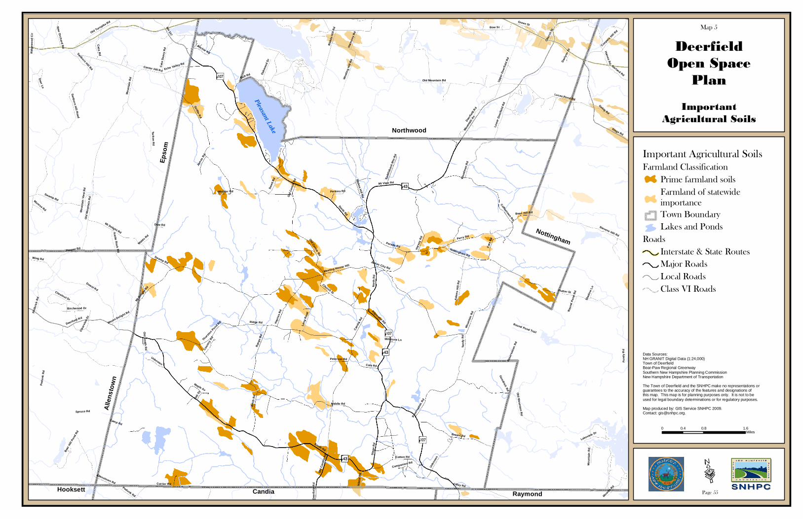
North Rd
South Rd
Middle Rd
Griffin Rd
Raymond Rd
Cand
ia R
d
Mt Deli
ght Rd
Ridge Rd
Nottingham Rd
Mt View Rd
Mount
ain A
v
Podu
nk R
d
Old Mountain Rd
Mou
ntai
n R
d
Stag
e R
d
Perry Rd
Dowst Rd
Gulf Rd
Brown Rd
Flutter St
Sanborn Hill R
oad
Center Hill Rd
Currier Rd
Stevens Hill Rd
Bow St
Ran
ge R
d
Rese
rvat
ion
Rd
Old Centre Rd
Har
vey
Rd
Swamp Rd
Church St
Win
ding
Hill
Rd
Coffeetown Rd
Cat
e R
d
NH 107
Tarlton Rd
Lucas Pond Rd
Birc
h R
d
Hay
nes
Rd
Cotton Rd
Blakes H
ill Rd
Tand
y R
d
Kettle R
ock Rd
Upp
er D
eerf
ield
Rd
Lang
Roa
d
Unkn
own
Spruce Rd
Parade Rd
Gebig Rd
Cole Rd
Philb
rick
Rd
Fund
y R
d
Woo
dman
Rd
Green St
Coopers H
ill RdOld Turnpike Rd
Wing Rd
Ada
ms
Hill
Rd
Pauper Rd
Round Pond Trail
Har
mon
y R
d
Deerfi
eld R
d
Cass R
d
Perkins Rd
Meeting House Hill
Low
er D
eerf
ield
Rd
Goodrich Rd
Swet
t Rd
Cat
o Se
avy
Rd
Thur
ston Pond R
d
Old
Can
dia
Rd
Garland Rd
Camp Rd
Maple Av
Birchwood Dr
Mount Delight Rd
Chestnut Dr
Jam
es R
dMunroe Rd
Oakw
ood
Dr
Echo Valley Rd
New
Orchard R
d
Isla
nd R
d
Ritchie Rd
Sadd
leba
ck M
tn R
d
Bean Hill Rd
Haines R
d
Lakeview Dr
Coun
try R
d
Peterson Rd
Clea
rvie
w D
r
Oak
Dr
Allenstown Rd
Rou
nd P
ond
Rd
Sanborn Hill Rd
Whittier Rd
Waldo Rd
Cilley Rd
Dow Rd
Davl
ynn
DrRid
gew
ood
Cir
Bear
Hill
Pon
d Rd
Moores
Rd
James City Rd
Deer Ln
Shad
ow L
n
Old South R
d
Mou
ntai
n Vi
ew R
d
Companion Rd
Millstone Ln
Deerfield Rd
Nor
th R
d
Unknown
Old
Mou
ntai
n R
d
Stage Rd
Mou
ntai
n R
d
Old
Cen
tre
Rd
Swamp Rd
Podunk Rd
Mt Delight Rd
Bla
kes
Hill
Rd
Old M
ountain Rd
Chur
ch S
t
Mou
ntai
n R
d
Res
erva
tion
Rd
Dee
rfie
ld R
d
DeerfieldOpen Space
Plan
?À@
ImportantAgricultural Soils
Map 5
AÖ
Data Sources:NH GRANIT Digital Data (1:24,000)Town of DeerfieldBear-Paw Regional GreenwaySouthern New Hampshire Planning CommissionNew Hampshire Department of Transportation
The Town of Deerfield and the SNHPC make no representations or guarantees to the accuracy of the features and designations of this map. This map is for planning purposes only. It is not to be used for legal boundary determinations or for regulatory purposes.
Map produced by: GIS Service SNHPC 2009. Contact: [email protected].
Northwood
0 0.8 1.60.4Miles
Nottingham
RaymondCandiaHooksett
Alle
nsto
wn
Epso
m
?À@
?À@
AÖ
AÖ
Important Agricultural SoilsFarmland Classification
Prime farmland soilsFarmland of statewideimportanceTown BoundaryLakes and Ponds
RoadsInterstate & State RoutesMajor RoadsLocal RoadsClass VI Roads
Pleasant Lake
·Page 55

North Rd
South Rd
Middle Rd
Griffin Rd
Raymond Rd
Cand
ia R
d
Mt Deli
ght Rd
Ridge Rd
Nottingham Rd
Mt View Rd
Mount
ain A
v
Podu
nk R
d
Old Mountain Rd
Mou
ntai
n R
d
Stag
e R
d
Perry Rd
Dowst Rd
Gulf Rd
Brown Rd
Flutter St
Sanborn Hill R
oad
Center Hill Rd
Currier Rd
Stevens Hill Rd
Bow St
Ran
ge R
d
Rese
rvat
ion
Rd
Old Centre Rd
Har
vey
Rd
Swamp Rd
Church St
Win
ding
Hill
Rd
Coffeetown Rd
Cat
e R
d
NH 107
Tarlton Rd
Lucas Pond Rd
Birc
h R
d
Hay
nes
Rd
Cotton Rd
Blakes H
ill Rd
Tand
y R
d
Kettle R
ock Rd
Upp
er D
eerf
ield
Rd
Lang
Roa
d
Unkn
own
Spruce Rd
Parade Rd
Gebig Rd
Cole Rd
Philb
rick
Rd
Fund
y R
d
Woo
dman
Rd
Green St
Coopers H
ill RdOld Turnpike Rd
Wing Rd
Ada
ms
Hill
Rd
Pauper Rd
Round Pond Trail
Har
mon
y R
d
Deerfi
eld R
d
Cass R
d
Perkins Rd
Meeting House Hill
Low
er D
eerf
ield
Rd
Goodrich Rd
Swet
t Rd
Cat
o Se
avy
Rd
Thur
ston Pond R
d
Old
Can
dia
Rd
Garland Rd
Camp Rd
Maple Av
Birchwood Dr
Mount Delight Rd
Chestnut Dr
Jam
es R
dMunroe Rd
Oakw
ood
Dr
Echo Valley Rd
New
Orchard R
d
Isla
nd R
d
Ritchie Rd
Sadd
leba
ck M
tn R
d
Bean Hill Rd
Haines R
d
Lakeview Dr
Coun
try R
d
Peterson Rd
Clea
rvie
w D
r
Oak
Dr
Allenstown Rd
Rou
nd P
ond
Rd
Sanborn Hill Rd
Whittier Rd
Waldo Rd
Cilley Rd
Dow Rd
Davl
ynn
DrRid
gew
ood
Cir
Bear
Hill
Pon
d Rd
Moores
Rd
James City Rd
Deer Ln
Shad
ow L
n
Old South R
d
Mou
ntai
n Vi
ew R
d
Companion Rd
Millstone Ln
Deerfield Rd
Nor
th R
d
Unknown
Old
Mou
ntai
n R
d
Stage Rd
Mou
ntai
n R
d
Old
Cen
tre
Rd
Swamp Rd
Podunk Rd
Mt Delight Rd
Bla
kes
Hill
Rd
Old M
ountain Rd
Chur
ch S
t
Mou
ntai
n R
d
Res
erva
tion
Rd
Dee
rfie
ld R
d
DeerfieldOpen Space
Plan
?À@
HydricSoils
Map 6
AÖ
Data Sources:NH GRANIT Digital Data (1:24,000)Town of DeerfieldBear-Paw Regional GreenwaySouthern New Hampshire Planning CommissionNew Hampshire Department of Transportation
The Town of Deerfield and the SNHPC make no representations or guarantees to the accuracy of the features and designations of this map. This map is for planning purposes only. It is not to be used for legal boundary determinations or for regulatory purposes.
Map produced by: GIS Service SNHPC 2009. Contact: [email protected].
Northwood
0 0.8 1.60.4Miles
Nottingham
RaymondCandiaHooksett
Alle
nsto
wn
Epso
m
?À@
?À@
AÖ
AÖ
Hydric SoilsTown BoundaryLakes and Ponds
RoadsInterstate & State RoutesMajor RoadsLocal RoadsClass VI Roads
Pleasant Lake
·Page 56

North Rd
South Rd
Middle Rd
Raymond Rd
Griffin Rd
Cand
ia R
d
Mt Deli
ght Rd
Ridge Rd
Nottingham Rd
Mt View Rd
Mou
ntai
n R
d
Perry Rd
Stag
e R
d
Brown Rd
Ran
ge R
d
Rese
rvat
ion
Rd
Old Centre Rd
Har
vey
Rd
Currier Rd
Church St
Coffeetown Rd
Cat
e R
d
Birc
h R
d
Hay
nes
Rd
Cotton Rd
Blakes H
ill Rd
Tand
y R
d
Lang
Roa
d
Unkn
own
Parade Rd
Cole Rd
Woo
dman
Rd
Ada
ms
Hill
Rd
Swamp Rd
Perkins Rd
Meeting House Hill
Goodrich Rd
Swet
t Rd
Thur
ston Pond R
d
Old
Can
dia
Rd
Camp Rd
Maple Av
Jam
es R
d
Isla
nd R
d
Gulf Rd
Ritchie Rd
Sadd
leba
ck M
tn R
d
Bean Hill Rd
Peterson Rd
Oak
Dr
Allenstown Rd
Whittier Rd
Harmony Rd
Cilley Rd
Dow Rd
Echo Valley Farm Rd
James City Rd
Old South R
d
Millstone Ln
Old
Cen
tre
Rd
Nor
th R
d
Unknown
DeerfieldOpen Space
Plan
?À@
South FacingSteep Slopes
Map 7
AÖ
Data Sources:NH GRANIT Digital Data (1:24,000)Town of DeerfieldBear-Paw Regional GreenwaySouthern New Hampshire Planning CommissionNew Hampshire Department of Transportation
The Town of Deerfield and the SNHPC make no representations or guarantees to the accuracy of the features and designations of this map. This map is for planning purposes only. It is not to be used for legal boundary determinations or for regulatory purposes.
Map produced by: GIS Service SNHPC 2009. Contact: [email protected].
Northwood
0 0.7 1.40.35Miles
Nottingham
RaymondCandiaHooksett
Alle
nsto
wn
Epso
m
?À@
?À@
AÖ
AÖ
Steep South Facing SlopesTown BoundaryLakes and Ponds
RoadsInterstate & State RoutesMajor RoadsLocal RoadsClass VI Roads
Pleasant Lake
·Page 57
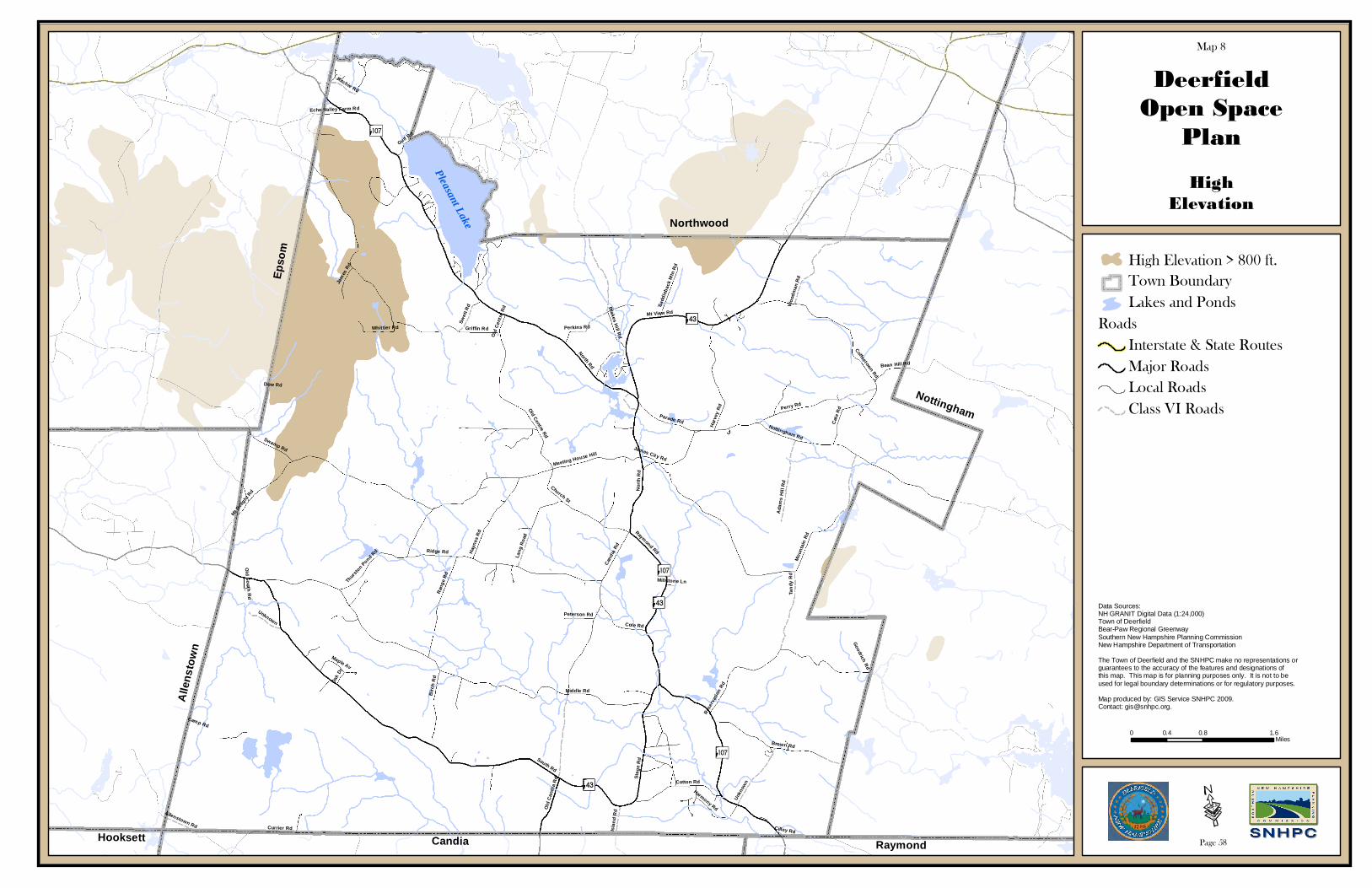
North Rd
South Rd
Middle Rd
Raymond Rd
Griffin Rd
Cand
ia R
d
Mt Deli
ght Rd
Ridge Rd
Nottingham Rd
Mt View Rd
Mou
ntai
n R
d
Perry Rd
Stag
e R
d
Brown Rd
Ran
ge R
d
Rese
rvat
ion
Rd
Old Centre Rd
Har
vey
Rd
Currier Rd
Church St
Coffeetown Rd
Cat
e R
d
Birc
h R
d
Hay
nes
Rd
Cotton Rd
Blakes H
ill Rd
Tand
y R
d
Lang
Roa
d
Unkn
own
Parade Rd
Cole Rd
Woo
dman
Rd
Ada
ms
Hill
Rd
Swamp Rd
Perkins Rd
Meeting House Hill
Goodrich Rd
Swet
t Rd
Thur
ston Pond R
d
Old
Can
dia
Rd
Camp Rd
Maple Av
Jam
es R
d
Isla
nd R
d
Gulf Rd
Ritchie Rd
Sadd
leba
ck M
tn R
d
Bean Hill Rd
Peterson Rd
Oak
Dr
Allenstown Rd
Whittier Rd
Harmony Rd
Cilley Rd
Dow Rd
Echo Valley Farm Rd
James City Rd
Old South R
d
Millstone Ln
Old
Cen
tre
Rd
Nor
th R
d
Unknown
DeerfieldOpen Space
Plan
?À@
HighElevation
Map 8
AÖ
Data Sources:NH GRANIT Digital Data (1:24,000)Town of DeerfieldBear-Paw Regional GreenwaySouthern New Hampshire Planning CommissionNew Hampshire Department of Transportation
The Town of Deerfield and the SNHPC make no representations or guarantees to the accuracy of the features and designations of this map. This map is for planning purposes only. It is not to be used for legal boundary determinations or for regulatory purposes.
Map produced by: GIS Service SNHPC 2009. Contact: [email protected].
Northwood
0 0.8 1.60.4Miles
Nottingham
RaymondCandiaHooksett
Alle
nsto
wn
Epso
m
?À@
?À@
AÖ
AÖ
High Elevation > 800 ft.Town BoundaryLakes and Ponds
RoadsInterstate & State RoutesMajor RoadsLocal RoadsClass VI Roads
Pleasant Lake
·Page 58

North Rd
South Rd
Middle Rd
Raymond Rd
Griffin Rd
Cand
ia R
d
Mt Deli
ght Rd
Ridge Rd
Nottingham Rd
Mt View Rd
Mou
ntai
n R
d
Perry Rd
Stag
e R
d
Brown Rd
Ran
ge R
d
Rese
rvat
ion
Rd
Old Centre Rd
Har
vey
Rd
Currier Rd
Church St
Coffeetown Rd
Cat
e R
d
Birc
h R
d
Hay
nes
Rd
Cotton Rd
Blakes H
ill Rd
Tand
y R
d
Lang
Roa
d
Unkn
own
Parade Rd
Cole Rd
Woo
dman
Rd
Ada
ms
Hill
Rd
Swamp Rd
Perkins Rd
Meeting House Hill
Goodrich Rd
Swet
t Rd
Thur
ston Pond R
d
Old
Can
dia
Rd
Camp Rd
Maple Av
Jam
es R
d
Isla
nd R
d
Gulf Rd
Ritchie Rd
Sadd
leba
ck M
tn R
d
Bean Hill Rd
Peterson Rd
Oak
Dr
Allenstown Rd
Whittier Rd
Harmony Rd
Cilley Rd
Dow Rd
Echo Valley Farm Rd
James City Rd
Old South R
d
Millstone Ln
Old
Cen
tre
Rd
Nor
th R
d
Unknown
DeerfieldOpen Space
Plan
?À@
AquiferTransmissivity
Map 9
AÖ
Data Sources:NH GRANIT Digital Data (1:24,000)Town of DeerfieldBear-Paw Regional GreenwaySouthern New Hampshire Planning CommissionNew Hampshire Department of Transportation
The Town of Deerfield and the SNHPC make no representations or guarantees to the accuracy of the features and designations of this map. This map is for planning purposes only. It is not to be used for legal boundary determinations or for regulatory purposes.
Map produced by: GIS Service SNHPC 2009. Contact: [email protected].
Northwood
0 0.8 1.60.4Miles
Nottingham
RaymondCandiaHooksett
Alle
nsto
wn
Epso
m
?À@
?À@
AÖ
AÖ
Stratified Drift Aquifer*Town BoundaryLakes and Ponds
RoadsInterstate & State RoutesMajor RoadsLocal RoadsClass VI Roads
Pleasant Lake
·Page 59
*Stratified Drift Aquifers with a maximumtransmissivity >= 1000 ft2 per day
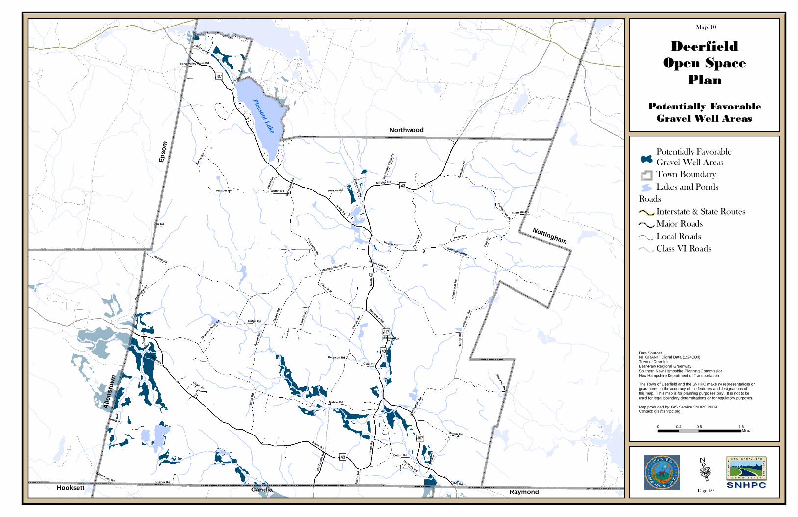
North Rd
South Rd
Middle Rd
Raymond Rd
Griffin Rd
Cand
ia R
d
Mt Deli
ght Rd
Ridge Rd
Nottingham Rd
Mt View Rd
Mou
ntai
n R
d
Perry Rd
Stag
e R
d
Brown Rd
Ran
ge R
d
Rese
rvat
ion
Rd
Old Centre Rd
Har
vey
Rd
Currier Rd
Church St
Coffeetown Rd
Cat
e R
d
Birc
h R
d
Hay
nes
Rd
Cotton Rd
Blakes H
ill Rd
Tand
y R
d
Lang
Roa
d
Unkn
own
Parade Rd
Cole Rd
Woo
dman
Rd
Ada
ms
Hill
Rd
Swamp Rd
Perkins Rd
Meeting House Hill
Goodrich Rd
Swet
t Rd
Thur
ston Pond R
d
Old
Can
dia
Rd
Camp Rd
Maple Av
Jam
es R
d
Isla
nd R
d
Gulf Rd
Ritchie Rd
Sadd
leba
ck M
tn R
d
Bean Hill Rd
Peterson Rd
Oak
Dr
Allenstown Rd
Whittier Rd
Harmony Rd
Cilley Rd
Dow Rd
Echo Valley Farm Rd
James City Rd
Old South R
d
Millstone Ln
Old
Cen
tre
Rd
Nor
th R
d
Unknown
DeerfieldOpen Space
Plan
?À@
Potentially FavorableGravel Well Areas
Map 10
AÖ
Data Sources:NH GRANIT Digital Data (1:24,000)Town of DeerfieldBear-Paw Regional GreenwaySouthern New Hampshire Planning CommissionNew Hampshire Department of Transportation
The Town of Deerfield and the SNHPC make no representations or guarantees to the accuracy of the features and designations of this map. This map is for planning purposes only. It is not to be used for legal boundary determinations or for regulatory purposes.
Map produced by: GIS Service SNHPC 2009. Contact: [email protected].
Northwood
0 0.8 1.60.4Miles
Nottingham
RaymondCandiaHooksett
Alle
nsto
wn
Epso
m
?À@
?À@
AÖ
AÖ
Potentially Favorable Gravel Well AreasTown BoundaryLakes and Ponds
RoadsInterstate & State RoutesMajor RoadsLocal RoadsClass VI Roads
Pleasant Lake
·Page 60

North Rd
South Rd
Middle Rd
Raymond Rd
Griffin Rd
Cand
ia R
d
Mt Deli
ght Rd
Ridge Rd
Nottingham Rd
Mt View Rd
Mou
ntai
n R
d
Perry Rd
Stag
e R
d
Brown Rd
Ran
ge R
d
Rese
rvat
ion
Rd
Old Centre Rd
Har
vey
Rd
Currier Rd
Church St
Coffeetown Rd
Cat
e R
d
Birc
h R
d
Hay
nes
Rd
Cotton Rd
Blakes H
ill Rd
Tand
y R
d
Lang
Roa
d
Unkn
own
Parade Rd
Cole Rd
Woo
dman
Rd
Ada
ms
Hill
Rd
Swamp Rd
Perkins Rd
Meeting House Hill
Goodrich Rd
Swet
t Rd
Thur
ston Pond R
d
Old
Can
dia
Rd
Camp Rd
Maple Av
Jam
es R
d
Isla
nd R
d
Gulf Rd
Ritchie Rd
Sadd
leba
ck M
tn R
d
Bean Hill Rd
Peterson Rd
Oak
Dr
Allenstown Rd
Whittier Rd
Harmony Rd
Cilley Rd
Dow Rd
Echo Valley Farm Rd
James City Rd
Old South R
d
Millstone Ln
Old
Cen
tre
Rd
Nor
th R
d
Unknown
DeerfieldOpen Space
Plan
?À@
Sanitary Radii
Map 11
AÖ
Data Sources:NH GRANIT Digital Data (1:24,000)Town of DeerfieldBear-Paw Regional GreenwaySouthern New Hampshire Planning CommissionNew Hampshire Department of Transportation
The Town of Deerfield and the SNHPC make no representations or guarantees to the accuracy of the features and designations of this map. This map is for planning purposes only. It is not to be used for legal boundary determinations or for regulatory purposes.
Map produced by: GIS Service SNHPC 2009. Contact: [email protected].
Northwood
0 0.7 1.40.35Miles
Nottingham
RaymondCandiaHooksett
Alle
nsto
wn
Epso
m
?À@
?À@
AÖ
AÖ
Sanitary RadiiTown BoundaryLakes and Ponds
RoadsInterstate & State RoutesMajor RoadsLocal RoadsClass VI Roads
Pleasant Lake
·Page 61

North Rd
South Rd
Middle Rd
Raymond Rd
Griffin Rd
Cand
ia R
d
Mt Deli
ght Rd
Ridge Rd
Nottingham Rd
Mt View Rd
Mou
ntai
n R
d
Perry Rd
Stag
e R
d
Brown Rd
Ran
ge R
d
Rese
rvat
ion
Rd
Old Centre Rd
Har
vey
Rd
Currier Rd
Church St
Coffeetown Rd
Cat
e R
d
Birc
h R
d
Hay
nes
Rd
Cotton Rd
Blakes H
ill Rd
Tand
y R
d
Lang
Roa
d
Unkn
own
Parade Rd
Cole Rd
Woo
dman
Rd
Ada
ms
Hill
Rd
Swamp Rd
Perkins Rd
Meeting House Hill
Goodrich Rd
Swet
t Rd
Thur
ston Pond R
d
Old
Can
dia
Rd
Camp Rd
Maple Av
Jam
es R
d
Isla
nd R
d
Gulf Rd
Ritchie Rd
Sadd
leba
ck M
tn R
d
Bean Hill Rd
Peterson Rd
Oak
Dr
Allenstown Rd
Whittier Rd
Harmony Rd
Cilley Rd
Dow Rd
Echo Valley Farm Rd
James City Rd
Old South R
d
Millstone Ln
Old
Cen
tre
Rd
Nor
th R
d
Unknown
DeerfieldOpen Space
Plan
?À@
Drinking WaterProtection Areas
Map 12
AÖ
Data Sources:NH GRANIT Digital Data (1:24,000)Town of DeerfieldBear-Paw Regional GreenwaySouthern New Hampshire Planning CommissionNew Hampshire Department of Transportation
The Town of Deerfield and the SNHPC make no representations or guarantees to the accuracy of the features and designations of this map. This map is for planning purposes only. It is not to be used for legal boundary determinations or for regulatory purposes.
Map produced by: GIS Service SNHPC 2009. Contact: [email protected].
Northwood
0 0.8 1.60.4Miles
Nottingham
RaymondCandiaHooksett
Alle
nsto
wn
Epso
m
?À@
?À@
AÖ
AÖ
Well Head Protection AreaTown BoundaryLakes and Ponds
RoadsInterstate & State RoutesMajor RoadsLocal RoadsClass VI Roads
Pleasant Lake
·Page 62

North Rd
South Rd
Middle Rd
Griffin Rd
Raymond Rd
Cand
ia R
d
Mt Deli
ght Rd
Ridge Rd
Nottingham Rd
Mt View Rd
Mount
ain A
v
Podu
nk R
d
Old Mountain Rd
Mou
ntai
n R
d
Stag
e R
d
Perry Rd
Dowst Rd
Gulf Rd
Brown Rd
Flutter St
Sanborn Hill R
oad
Center Hill Rd
Currier Rd
Stevens Hill Rd
Bow St
Ran
ge R
d
Rese
rvat
ion
Rd
Old Centre Rd
Har
vey
Rd
Swamp Rd
Church St
Win
ding
Hill
Rd
Coffeetown Rd
Cat
e R
d
NH 107
Tarlton Rd
Lucas Pond Rd
Birc
h R
d
Hay
nes
Rd
Cotton Rd
Blakes H
ill Rd
Tand
y R
d
Kettle R
ock Rd
Upp
er D
eerf
ield
Rd
Lang
Roa
d
Unkn
own
Spruce Rd
Parade Rd
Gebig Rd
Cole Rd
Philb
rick
Rd
Fund
y R
d
Woo
dman
Rd
Green St
Coopers H
ill RdOld Turnpike Rd
Wing Rd
Ada
ms
Hill
Rd
Pauper Rd
Round Pond Trail
Har
mon
y R
d
Deerfi
eld R
d
Cass R
d
Perkins Rd
Meeting House Hill
Low
er D
eerf
ield
Rd
Goodrich Rd
Swet
t Rd
Cat
o Se
avy
Rd
Thur
ston Pond R
d
Old
Can
dia
Rd
Garland Rd
Camp Rd
Maple Av
Birchwood Dr
Mount Delight Rd
Chestnut Dr
Jam
es R
dMunroe Rd
Oakw
ood
Dr
Echo Valley Rd
New
Orchard R
d
Isla
nd R
d
Ritchie Rd
Sadd
leba
ck M
tn R
d
Bean Hill Rd
Haines R
d
Lakeview Dr
Coun
try R
d
Peterson Rd
Clea
rvie
w D
r
Oak
Dr
Allenstown Rd
Rou
nd P
ond
Rd
Sanborn Hill Rd
Whittier Rd
Waldo Rd
Cilley Rd
Dow Rd
Davl
ynn
DrRid
gew
ood
Cir
Bear
Hill
Pon
d Rd
Moores
Rd
James City Rd
Deer Ln
Shad
ow L
n
Old South R
d
Mou
ntai
n Vi
ew R
d
Companion Rd
Millstone Ln
Deerfield Rd
Nor
th R
d
Unknown
Old
Mou
ntai
n R
d
Stage Rd
Mou
ntai
n R
d
Old
Cen
tre
Rd
Swamp Rd
Podunk Rd
Mt Delight Rd
Bla
kes
Hill
Rd
Old M
ountain Rd
Chur
ch S
t
Mou
ntai
n R
d
Res
erva
tion
Rd
Dee
rfie
ld R
d
DeerfieldOpen Space
Plan
?À@
National WetlandInventory
Map 13
AÖ
Data Sources:NH GRANIT Digital Data (1:24,000)Town of DeerfieldBear-Paw Regional GreenwaySouthern New Hampshire Planning CommissionNew Hampshire Department of Transportation
The Town of Deerfield and the SNHPC make no representations or guarantees to the accuracy of the features and designations of this map. This map is for planning purposes only. It is not to be used for legal boundary determinations or for regulatory purposes.
Map produced by: GIS Service SNHPC 2009. Contact: [email protected].
Northwood
0 0.8 1.60.4Miles
Nottingham
RaymondCandiaHooksett
Alle
nsto
wn
Epso
m
?À@
?À@
AÖ
AÖ
National Wetland InventoryTown BoundaryLakes and Ponds
RoadsInterstate & State RoutesMajor RoadsLocal RoadsClass VI Roads
Pleasant Lake
·Page 63

North Rd
South Rd
Middle Rd
Raymond Rd
Griffin Rd
Cand
ia R
d
Mt Deli
ght Rd
Ridge Rd
Nottingham Rd
Mt View Rd
Mou
ntai
n R
d
Perry Rd
Stag
e R
d
Brown Rd
Ran
ge R
d
Rese
rvat
ion
Rd
Old Centre Rd
Har
vey
Rd
Currier Rd
Church St
Coffeetown Rd
Cat
e R
d
Birc
h R
d
Hay
nes
Rd
Cotton Rd
Blakes H
ill Rd
Tand
y R
d
Lang
Roa
d
Unkn
own
Parade Rd
Cole Rd
Woo
dman
Rd
Ada
ms
Hill
Rd
Swamp Rd
Perkins Rd
Meeting House Hill
Goodrich Rd
Swet
t Rd
Thur
ston Pond R
d
Old
Can
dia
Rd
Camp Rd
Maple Av
Jam
es R
d
Isla
nd R
d
Gulf Rd
Ritchie Rd
Sadd
leba
ck M
tn R
d
Bean Hill Rd
Peterson Rd
Oak
Dr
Allenstown Rd
Whittier Rd
Harmony Rd
Cilley Rd
Dow Rd
Echo Valley Farm Rd
James City Rd
Old South R
d
Millstone Ln
Old
Cen
tre
Rd
Nor
th R
d
Unknown
DeerfieldOpen Space
Plan
?À@
UndevelopedRiparian Zones
Map 14
AÖ
Data Sources:NH GRANIT Digital Data (1:24,000)Town of DeerfieldBear-Paw Regional GreenwaySouthern New Hampshire Planning CommissionNew Hampshire Department of Transportation
The Town of Deerfield and the SNHPC make no representations or guarantees to the accuracy of the features and designations of this map. This map is for planning purposes only. It is not to be used for legal boundary determinations or for regulatory purposes.
Map produced by: GIS Service SNHPC 2009. Contact: [email protected].
Northwood
0 0.7 1.40.35Miles
Nottingham
RaymondCandiaHooksett
Alle
nsto
wn
Epso
m
?À@
?À@
AÖ
AÖ
Undeveloped Riparian ZonesTown BoundaryLakes and Ponds
RoadsInterstate & State RoutesMajor RoadsLocal RoadsClass VI Roads
Pleasant Lake
·Page 64

North Rd
South Rd
Middle Rd
Raymond Rd
Griffin Rd
Cand
ia R
d
Mt Deli
ght Rd
Ridge Rd
Nottingham Rd
Mt View Rd
Mou
ntai
n R
d
Perry Rd
Stag
e R
d
Brown Rd
Ran
ge R
d
Rese
rvat
ion
Rd
Old Centre Rd
Har
vey
Rd
Currier Rd
Church St
Coffeetown Rd
Cat
e R
d
Birc
h R
d
Hay
nes
Rd
Cotton Rd
Blakes H
ill Rd
Tand
y R
d
Lang
Roa
d
Unkn
own
Parade Rd
Cole Rd
Woo
dman
Rd
Ada
ms
Hill
Rd
Swamp Rd
Perkins Rd
Meeting House Hill
Goodrich Rd
Swet
t Rd
Thur
ston Pond R
d
Old
Can
dia
Rd
Camp Rd
Maple Av
Jam
es R
d
Isla
nd R
d
Gulf Rd
Ritchie Rd
Sadd
leba
ck M
tn R
d
Bean Hill Rd
Peterson Rd
Oak
Dr
Allenstown Rd
Whittier Rd
Harmony Rd
Cilley Rd
Dow Rd
Echo Valley Farm Rd
James City Rd
Old South R
d
Millstone Ln
Old
Cen
tre
Rd
Nor
th R
d
Unknown
DeerfieldOpen Space
Plan
?À@
Open/Agricultural/Disturbed Land Cover
Map 15
AÖ
Data Sources:NH GRANIT Digital Data (1:24,000)Town of DeerfieldBear-Paw Regional GreenwaySouthern New Hampshire Planning CommissionNew Hampshire Department of Transportation
The Town of Deerfield and the SNHPC make no representations or guarantees to the accuracy of the features and designations of this map. This map is for planning purposes only. It is not to be used for legal boundary determinations or for regulatory purposes.
Map produced by: GIS Service SNHPC 2009. Contact: [email protected].
Northwood
0 0.8 1.60.4Miles
Nottingham
RaymondCandiaHooksett
Alle
nsto
wn
Epso
m
?À@
?À@
AÖ
AÖ
Open/Agricultural/Disturbed Land CoverTown BoundaryLakes and Ponds
RoadsInterstate & State RoutesMajor RoadsLocal RoadsClass VI Roads
Pleasant Lake
·Page 65

North Rd
South Rd
Middle Rd
Raymond Rd
Griffin Rd
Cand
ia R
d
Mt Deli
ght Rd
Ridge Rd
Nottingham Rd
Mt View Rd
Mou
ntai
n R
d
Perry Rd
Stag
e R
d
Brown Rd
Ran
ge R
d
Rese
rvat
ion
Rd
Old Centre Rd
Har
vey
Rd
Currier Rd
Church St
Coffeetown Rd
Cat
e R
d
Birc
h R
d
Hay
nes
Rd
Cotton Rd
Blakes H
ill Rd
Tand
y R
d
Lang
Roa
d
Unkn
own
Parade Rd
Cole Rd
Woo
dman
Rd
Ada
ms
Hill
Rd
Swamp Rd
Perkins Rd
Meeting House Hill
Goodrich Rd
Swet
t Rd
Thur
ston Pond R
d
Old
Can
dia
Rd
Camp Rd
Maple Av
Jam
es R
d
Isla
nd R
d
Gulf Rd
Ritchie Rd
Sadd
leba
ck M
tn R
d
Bean Hill Rd
Peterson Rd
Oak
Dr
Allenstown Rd
Whittier Rd
Harmony Rd
Cilley Rd
Dow Rd
Echo Valley Farm Rd
James City Rd
Old South R
d
Millstone Ln
Old
Cen
tre
Rd
Nor
th R
d
Unknown
DeerfieldOpen Space
Plan
?À@
UnfragmentedBlocks
Map 16
AÖ
Data Sources:NH GRANIT Digital Data (1:24,000)Town of DeerfieldBear-Paw Regional GreenwaySouthern New Hampshire Planning CommissionNew Hampshire Department of Transportation
The Town of Deerfield and the SNHPC make no representations or guarantees to the accuracy of the features and designations of this map. This map is for planning purposes only. It is not to be used for legal boundary determinations or for regulatory purposes.
Map produced by: GIS Service SNHPC 2009. Contact: [email protected].
Northwood
0 0.7 1.40.35Miles
Nottingham
RaymondCandiaHooksett
Alle
nsto
wn
Epso
m
?À@
?À@
AÖ
AÖ
Unfragmented Blocks Greater Than 500 acresTown BoundaryLakes and Ponds
RoadsInterstate & State RoutesMajor RoadsLocal RoadsClass VI Roads
Pleasant Lake
·Page 66

North Rd
South Rd
Middle Rd
Raymond Rd
Griffin Rd
Cand
ia R
d
Mt Deli
ght Rd
Ridge Rd
Nottingham Rd
Mt View Rd
Mou
ntai
n R
d
Perry Rd
Stag
e R
d
Brown Rd
Ran
ge R
d
Rese
rvat
ion
Rd
Old Centre Rd
Har
vey
Rd
Currier Rd
Church St
Coffeetown Rd
Cat
e R
d
Birc
h R
d
Hay
nes
Rd
Cotton Rd
Blakes H
ill Rd
Tand
y R
d
Lang
Roa
d
Unkn
own
Parade Rd
Cole Rd
Woo
dman
Rd
Ada
ms
Hill
Rd
Swamp Rd
Perkins Rd
Meeting House Hill
Goodrich Rd
Swet
t Rd
Thur
ston Pond R
d
Old
Can
dia
Rd
Camp Rd
Maple Av
Jam
es R
d
Isla
nd R
d
Gulf Rd
Ritchie Rd
Sadd
leba
ck M
tn R
d
Bean Hill Rd
Peterson Rd
Oak
Dr
Allenstown Rd
Whittier Rd
Harmony Rd
Cilley Rd
Dow Rd
Echo Valley Farm Rd
James City Rd
Old South R
d
Millstone Ln
Old
Cen
tre
Rd
Nor
th R
d
Unknown
DeerfieldOpen Space
Plan
?À@
Wildlife Action Plan (2006)
Map 17
AÖ
Data Sources:NH GRANIT Digital Data (1:24,000)Town of DeerfieldSouthern New Hampshire Planning CommissionNew Hampshire Fish and Game DepartmentNew Hampshire Department of Transportation
The Town of Deerfield and the SNHPC make no representations or guarantees to the accuracy of the features and designations of this map. This map is for planning purposes only. It is not to be used for legal boundary determinations or for regulatory purposes.
Map produced by: GIS Service SNHPC 2009. Contact: [email protected].
Northwood
0 0.75 1.50.375Miles
Nottingham
RaymondCandiaHooksett
Alle
nsto
wn
Epso
m
?À@
?À@
AÖ
AÖ
Wildlife Action PlanRANK
Highest ranked habitat in NH (by condition)Highest ranked habitatin biological regionTown BoundaryLakes and Ponds
RoadsInterstate & State RoutesMajor RoadsLocal RoadsClass VI Roads
Pleasant Lake
·Page 67
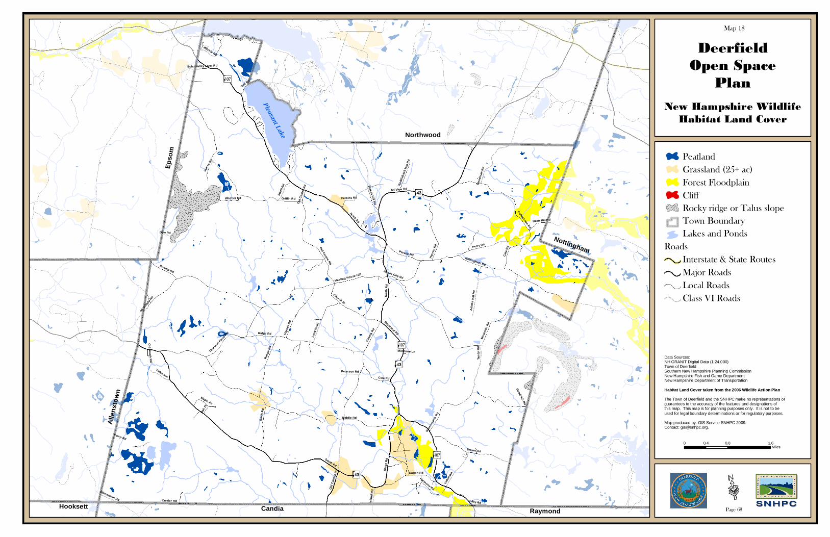
North Rd
South Rd
Middle Rd
Raymond Rd
Griffin Rd
Cand
ia R
d
Mt Deli
ght Rd
Ridge Rd
Nottingham Rd
Mt View Rd
Mou
ntai
n R
d
Perry Rd
Stag
e R
d
Brown Rd
Ran
ge R
d
Rese
rvat
ion
Rd
Old Centre Rd
Har
vey
Rd
Currier Rd
Church St
Coffeetown Rd
Cat
e R
d
Birc
h R
d
Hay
nes
Rd
Cotton Rd
Blakes H
ill Rd
Tand
y R
d
Lang
Roa
d
Unkn
own
Parade Rd
Cole Rd
Woo
dman
Rd
Ada
ms
Hill
Rd
Swamp Rd
Perkins Rd
Meeting House Hill
Goodrich Rd
Swet
t Rd
Thur
ston Pond R
d
Old
Can
dia
Rd
Camp Rd
Maple Av
Jam
es R
d
Isla
nd R
d
Gulf Rd
Ritchie Rd
Sadd
leba
ck M
tn R
d
Bean Hill Rd
Peterson Rd
Oak
Dr
Allenstown Rd
Whittier Rd
Harmony Rd
Cilley Rd
Dow Rd
Echo Valley Farm Rd
James City Rd
Old South R
d
Millstone Ln
Old
Cen
tre
Rd
Nor
th R
d
Unknown
DeerfieldOpen Space
Plan
?À@
New Hampshire WildlifeHabitat Land Cover
Map 18
AÖData Sources:NH GRANIT Digital Data (1:24,000)Town of DeerfieldSouthern New Hampshire Planning CommissionNew Hampshire Fish and Game DepartmentNew Hampshire Department of Transportation
Habitat Land Cover taken from the 2006 Wildlife Action Plan
The Town of Deerfield and the SNHPC make no representations or guarantees to the accuracy of the features and designations of this map. This map is for planning purposes only. It is not to be used for legal boundary determinations or for regulatory purposes.
Map produced by: GIS Service SNHPC 2009. Contact: [email protected].
Northwood
0 0.8 1.60.4Miles
Nottingham
RaymondCandiaHooksett
Alle
nsto
wn
Epso
m
?À@
?À@
AÖ
AÖ
PeatlandGrassland (25+ ac)Forest FloodplainCliffRocky ridge or Talus slopeTown BoundaryLakes and Ponds
RoadsInterstate & State RoutesMajor RoadsLocal RoadsClass VI Roads
Pleasant Lake
·Page 68

North Rd
South Rd
Middle Rd
Raymond Rd
Griffin Rd
Cand
ia R
d
Mt Deli
ght Rd
Ridge Rd
Nottingham Rd
Mt View Rd
Mou
ntai
n R
d
Perry Rd
Stag
e R
d
Brown Rd
Ran
ge R
d
Rese
rvat
ion
Rd
Old Centre Rd
Har
vey
Rd
Currier Rd
Church St
Coffeetown Rd
Cat
e R
d
Birc
h R
d
Hay
nes
Rd
Cotton Rd
Blakes H
ill Rd
Tand
y R
d
Lang
Roa
d
Unkn
own
Parade Rd
Cole Rd
Woo
dman
Rd
Ada
ms
Hill
Rd
Swamp Rd
Perkins Rd
Meeting House Hill
Goodrich Rd
Swet
t Rd
Thur
ston Pond R
d
Old
Can
dia
Rd
Camp Rd
Maple Av
Jam
es R
d
Isla
nd R
d
Gulf Rd
Ritchie Rd
Sadd
leba
ck M
tn R
d
Bean Hill Rd
Peterson Rd
Oak
Dr
Allenstown Rd
Whittier Rd
Harmony Rd
Cilley Rd
Dow Rd
Echo Valley Farm Rd
James City Rd
Old South R
d
Millstone Ln
Old
Cen
tre
Rd
Nor
th R
d
Unknown
DeerfieldOpen Space
Plan
?À@
Quality of Life/Scenic Views
Map 19
AÖ
Data Sources:NH GRANIT Digital Data (1:24,000)Town of DeerfieldSouthern New Hampshire Planning CommissionNew Hampshire Department of Transportation
The Town of Deerfield and the SNHPC make no representations or guarantees to the accuracy of the features and designations of this map. This map is for planning purposes only. It is not to be used for legal boundary determinations or for regulatory purposes.
Map produced by: GIS Service SNHPC 2009. Contact: [email protected].
Northwood
0 0.7 1.40.35Miles
Nottingham
RaymondCandiaHooksett
Alle
nsto
wn
Epso
m
?À@
?À@
AÖ
AÖ
Quality Of Life/Scenic Views*Town BoundaryLakes and Ponds
RoadsInterstate & State RoutesMajor RoadsLocal RoadsClass VI Roads
Pleasant Lake
·Page 69
*Quality of Life are the 21 official Cornerstones from the Deerfield Cornerstone Project. Also included in the Quality of Life areas are the 2008 Scenic Roads listedon page 94 of the Deerfield Town Report.
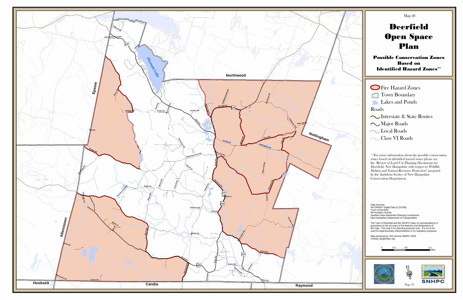
North Rd
South Rd
Middle Rd
Raymond Rd
Griffin Rd
Cand
ia R
d
Mt Deli
ght Rd
Ridge Rd
Nottingham Rd
Mt View Rd
Mou
ntai
n R
d
Perry Rd
Stag
e R
d
Brown Rd
Ran
ge R
d
Rese
rvat
ion
Rd
Old Centre Rd
Har
vey
Rd
Currier Rd
Church St
Coffeetown Rd
Cat
e R
d
Birc
h R
d
Hay
nes
Rd
Cotton Rd
Blakes H
ill Rd
Tand
y R
d
Lang
Roa
d
Unkn
own
Parade Rd
Cole Rd
Woo
dman
Rd
Ada
ms
Hill
Rd
Swamp Rd
Perkins Rd
Meeting House Hill
Goodrich Rd
Swet
t Rd
Thur
ston Pond R
d
Old
Can
dia
Rd
Camp Rd
Maple Av
Jam
es R
d
Isla
nd R
d
Gulf Rd
Ritchie Rd
Sadd
leba
ck M
tn R
d
Bean Hill Rd
Peterson Rd
Oak
Dr
Allenstown Rd
Whittier Rd
Harmony Rd
Cilley Rd
Dow Rd
Echo Valley Farm Rd
James City Rd
Old South R
d
Millstone Ln
Old
Cen
tre
Rd
Nor
th R
d
Unknown
DeerfieldOpen Space
Plan
?À@
Possible Conservation ZonesBased on
Identified Hazard Zones**
Map 20
AÖ
Data Sources:NH GRANIT Digital Data (1:24,000)Town of DeerfieldNH Audubon SocietySouthern New Hampshire Planning CommissionNew Hampshire Department of Transportation
The Town of Deerfield and the SNHPC make no representations or guarantees to the accuracy of the features and designations of this map. This map is for planning purposes only. It is not to be used for legal boundary determinations or for regulatory purposes.
Map produced by: GIS Service SNHPC 2009. Contact: [email protected].
Northwood
0 0.8 1.60.4Miles
Nottingham
RaymondCandiaHooksett
Alle
nsto
wn
Epso
m
?À@
?À@
AÖ
AÖ
Fire Hazard ZonesTown BoundaryLakes and Ponds
RoadsInterstate & State RoutesMajor RoadsLocal RoadsClass VI Roads
Pleasant Lake
·Page 70
**For more information about the possible conservationzones based on identified hazard zones please seethe "Review of Land Use Planning Documents forDeerfield, New Hampshire with respect to WildlifeHabitat and Natural Resource Protection", preparedby the Audubon Socitey of New HampshireConservation Department.

North Rd
South Rd
Middle Rd
Raymond Rd
Griffin Rd
Cand
ia R
d
Mt Deli
ght Rd
Ridge Rd
Nottingham Rd
Mt View Rd
Mou
ntai
n R
d
Perry Rd
Stag
e R
d
Brown Rd
Ran
ge R
d
Rese
rvat
ion
Rd
Old Centre Rd
Har
vey
Rd
Currier Rd
Church St
Coffeetown Rd
Cat
e R
d
Birc
h R
d
Hay
nes
Rd
Cotton Rd
Blakes H
ill Rd
Tand
y R
d
Lang
Roa
d
Unkn
own
Parade Rd
Cole Rd
Woo
dman
Rd
Ada
ms
Hill
Rd
Swamp Rd
Perkins Rd
Meeting House Hill
Goodrich Rd
Swet
t Rd
Thur
ston Pond R
d
Old
Can
dia
Rd
Camp Rd
Maple Av
Jam
es R
d
Isla
nd R
d
Gulf Rd
Ritchie Rd
Sadd
leba
ck M
tn R
d
Bean Hill Rd
Peterson Rd
Oak
Dr
Allenstown Rd
Whittier Rd
Harmony Rd
Cilley Rd
Dow Rd
Echo Valley Farm Rd
James City Rd
Old South R
d
Millstone Ln
Old
Cen
tre
Rd
Nor
th R
d
Unknown
DeerfieldOpen Space
Plan
?À@
Natural ServicesNetwork
Map 21
AÖ
Data Sources:NH GRANIT Digital Data (1:24,000)Town of DeerfieldSouthern New Hampshire Planning CommissionNew Hampshire Department of Transportation
The Town of Deerfield and the SNHPC make no representations or guarantees to the accuracy of the features and designations of this map. This map is for planning purposes only. It is not to be used for legal boundary determinations or for regulatory purposes.
Map produced by: GIS Service SNHPC 2009. Contact: [email protected].
Northwood
0 0.8 1.60.4Miles
Nottingham
RaymondCandiaHooksett
Alle
nsto
wn
Epso
m
?À@
?À@
AÖ
AÖ
Conservation LandsNatural Services NetworkTown BoundaryLakes and PondsPower Lines
RoadsInterstate & State RoutesMajor RoadsLocal RoadsClass VI Roads
Pleasant Lake
·Page 71
The Natural Services Network (NSN) identifies lands thatprovide important ecological services and that are difficultand/or expensive to replicate. The four components thatmake up the NSN data layer are:
Water Supply Lands Productive Soils Important Wildlife Habitats Flood Storage LandsThe Natural Services Network was created as part of the I-93Community Technical Assistance Program (CTAP) by New Hampshire GRANIT. 2007. New HampshireNatural Services Network. Complex Systems Research Center,Institute for the Study of Earth, Oceans, and Space, Universityof New Hampshire, Durham, NH.

North Rd
South Rd
Middle Rd
Raymond Rd
Griffin Rd
Cand
ia R
d
Mt Deli
ght Rd
Ridge Rd
Nottingham Rd
Mt View Rd
Mou
ntai
n R
d
Perry Rd
Stag
e R
d
Brown Rd
Ran
ge R
d
Rese
rvat
ion
Rd
Old Centre Rd
Har
vey
Rd
Currier Rd
Church St
Coffeetown Rd
Cat
e R
d
Birc
h R
d
Hay
nes
Rd
Cotton Rd
Blakes H
ill Rd
Tand
y R
d
Lang
Roa
d
Unkn
own
Parade Rd
Cole Rd
Woo
dman
Rd
Ada
ms
Hill
Rd
Swamp Rd
Perkins Rd
Meeting House Hill
Goodrich Rd
Swet
t Rd
Thur
ston Pond R
d
Old
Can
dia
Rd
Camp Rd
Maple Av
Jam
es R
d
Isla
nd R
d
Gulf Rd
Ritchie Rd
Sadd
leba
ck M
tn R
d
Bean Hill Rd
Peterson Rd
Oak
Dr
Allenstown Rd
Whittier Rd
Harmony Rd
Cilley Rd
Dow Rd
Echo Valley Farm Rd
James City Rd
Old South R
d
Millstone Ln
Old
Cen
tre
Rd
Nor
th R
d
Unknown
DeerfieldOpen Space
Plan
?À@
Wildlife Action Plan (2010)
Map 22
AÖ
Data Sources:NH GRANIT Digital Data (1:24,000)Town of DeerfieldSouthern New Hampshire Planning CommissionNew Hampshire Fish and Game DepartmentNew Hampshire Department of Transportation
The Town of Deerfield and the SNHPC make no representations or guarantees to the accuracy of the features and designations of this map. This map is for planning purposes only. It is not to be used for legal boundary determinations or for regulatory purposes.
Map produced by: GIS Service SNHPC 2009. Contact: [email protected].
Northwood
0 0.75 1.50.375Miles
Nottingham
RaymondCandiaHooksett
Alle
nsto
wn
Epso
m
?À@
?À@
AÖ
AÖ
Wildlife Action PlanHabitat Ranking
Highest Ranked Habitatin NH (Tier 1)Highest Ranked Habitatin Biological Region (Tier2)Supporting Landscapes (Tier 3)Town BoundaryLakes and Ponds
RoadsInterstate & State RoutesMajor RoadsLocal RoadsClass VI Roads
Pleasant Lake
·Page 72

Deerfield Open Space Plan August 2010
73
EXISTING PLANS AND MAPS RELATED TO OPEN SPACE IN DEERFIELD During the past few years, a number of plans and maps have been created to assist the Town of Deerfield with the task of open space planning. The following is a list of these plans, strategies and maps, with a brief summary of each. 1. Natural Resources Inventory Report: 1991
• Identifies important community and natural resources and examines relationship with land use. • Maps of land and resources completed by community volunteers. • Priorities for protection of natural resources included evaluating development proposals,
identifying areas for protection, revising the Master Plan, and completing “build out” projections for the town.
2. Civic Profile and Community Vision Profile: 1995-1996
• Citizen evaluation of Deerfield identifying Deerfield’s more critical needs and solutions for implementation.
• Emphasis on preserving Deerfield’s natural beauty, open space, and rural character.
3. Trails: Deerfield Conservation Commission 2000 • Guide with property maps and trail descriptions for many of Deerfield’s public and private lands
overseen by the Town of Deerfield.
4. Community Conservation Assistance Program (CCAP): Deerfield Open Space Committee Work Plan 2002; Updated 2004
• A guide for the DOSC prepared by the UNH Cooperative Extension to cover the following actions:
o Self-education and organization of DOSC o Landowner education and outreach o Prioritization of areas for conservation o Development of a funding strategy o Exploration of avenues to help shape conservation policy in Deerfield
5. Bear Paw Regional Greenways Conservation Plan (July 2008)
• This Conservation Plan identifies and describes those areas that include the region’s most important ecological, biological, and water resources. Using the results of the natural resource inventory completed for Bear-Paw in 2003 along with information from the NH Wildlife Action Plan, Bear-Paw identified where to focus its conservation efforts. With this information Bear-Paw determined that the most effective way to conserve the region’s water, wildlife habitat, forests and farmland is through the protection of its large unfragmented forests, riparian areas, and important agricultural soils and farms since they present the best opportunity to conserve the most important natural areas in the region. These areas provide “greenways” and “blue ways” between and within the natural lands in and outside the region. The plan will also allow Towns and other organizations in the region to help protect and conserve a network of land and water to sustain the region.

Deerfield Open Space Plan August 2010
74
6. 2006 New Hampshire Wildlife Action Plan (Updated in 2010) The New Hampshire Fish and Game Department has worked together with 1Hpartners in the conservation community to create the state's first Wildlife Action Plan. The plan, which was mandated and funded by the federal government through the State Wildlife Grants program, provides New Hampshire decision-makers with important tools for restoring and maintaining critical habitats and populations of the state's species of conservation and management concern. It is a pro-active effort to define and implement a strategy that will help keep species off of rare species lists, in the process saving taxpayers millions of dollars.
• A core team of biologists identified 123 species and 27 habitats in greatest need of conservation. • Following the development of species and habitat profiles, technical analyses were conducted to
assess the condition of habitats and risks to wildlife. 7. The Land Conservation Plan for New Hampshire’s Coastal Watersheds (August 2006)
The Nature Conservancy, the Society for the Protection of New Hampshire Forests, Rockingham Planning Commission, and the Strafford Planning Commission, have completed work on the Land Conservation Plan for New Hampshire’s Coastal Watersheds. The project, undertaken in a partnership among the four agencies, was funded through the New Hampshire Coastal Program, the New Hampshire Estuaries Project, and the New Hampshire Charitable Foundation. The plan will be released in September.
The plan identifies 75 Conservation Focus Areas within the coastal watersheds as the most important lands to retain for conserving living resources and water quality. The plan also sets out regional strategies including voluntary measures and regulatory tools to protect these areas in order to maintain diverse wildlife habitat, abundant wetlands, clean water, productive and contiguous forest blocks, and outstanding recreational opportunities. The analysis involved geospatial data and complex GIS modeling of the coastal watersheds to identify a network of important areas for conservation.
8. Natural Services Network The NSN was developed through the I-93 Community Technical Assistance Program (CTAP), to help communities identify the most important areas in state, region, and their town for conservation to protect essential natural services. The Natural Services Network identifies lands that provide water supply, flood storage, productive agricultural soils, and important wildlife habitat. The New Hampshire Natural Services Network is a GIS-based tool identifying lands that provide important ecological services that are difficult and expensive to replicate. Loss of these services affects human health, safety, quality of life, and economic opportunity. Created by a collaborative of planning and natural resource professionals, the Natural Services Network can be configured for use at multiple scales (municipal, regional, state) and adapted to incorporate additional data, such as resources of local importance. Annual Town Reports: 1. Summary of the Deerfield Conservation Commission Reports: 1999-2009
• 1999: In 1999, the Conservation Commission completed the Weiss property project, committed two more properties to conservation easements, and came close to completion on two additional

Deerfield Open Space Plan August 2010
75
properties. Signs were erected at the Shores Conservation Area and the Hart Town Forest to commemorate the donations. They also reviewed wetland, dredge, fill, and buffer projects and worked with community volunteers on natural resource improvement projects.
• 2000: The Commission completed the Linden conservation easement and began work on five more easements. They reviewed 16 new wetland applications and worked closely with the Veasey Park Commission, the Society for the Protection of NH Forests, the Nature Conservancy, and the Tree Stewards on community projects and events. At the Town Meeting 2000, Article 13 passed, which showed Deerfield’s support for the Land and Community Heritage Program in New Hampshire.
• 2001: The Deerfield Town Meeting approved 100 percent of its annual Land Use Change Tax to be placed in the Conservation Fund for land protection. The Meeting also approved an additional $50,000 for the same purpose. The Conservation Commission increased its involvement with the Bear-Paw Regional Greenway on the proposed Doane and Cummings conservation easements. They met with a Rockingham County Conservation District Representative and Candia Conservation Commission members to discuss the I-93 widening. Seven new wetland applications were reviewed.
• 2002: The Conservation Committee worked on three pending and two potential conservation easements as well as the acquisition of the Peg King Park. The Commission reviewed eight new wetland permits. The DCC helped to formalize the creation of the Deerfield Open Space Committee, which has worked with the Trust for Public Land, the UNH cooperative extension, and community members to learn about funding and innovation in land protection. DCC members continued to be active in the I-93 widening discussions.
• 2003: The DCC finalized three conservation easements with Bear-Paw Regional Greenways and began working on two more. The Commission continued to work with the DOSC, review wetland applications, and review complaints on wetland violations. They also worked with forestry management and encouraged developers to conserve backlands.
• 2004: The DCC finalized an additional three conservation easements with Bear-Paw Regional Greenways and began working on three more. They completed work on Peg King Park and Willoughby Easement, and they obtained a Natural Resources Outreach Coalition (NROC) grant for conservation and impact planning. The Commission worked with Bear-Paw and the DOSC to set aside lands for passive recreation use and wildlife habitat. They continued to process wetland applications and violations.
• 2005: The DCC worked with developers of the Dodge property on South Road to plan an open space development. Further Commission projects during 2005 included continued support for work done at Peg King Park brought to completion in late fall. The completion of the Doane-Schorr easement off North Road; the Rosenfield-Mallett easement, a joint venture with the Nottingham Conservation Commission, off Nottingham Rd; and the near completion of the Clifford Farms easement and the Steve Cruikshank Memorial easement protected over two hundred open space acres in the town. With the assistance of Bear Paw Regional Greenways, the commission was successful in obtaining an $87,500 grant from the federal Farm and Ranch Lands Protection Program to apply to the Clifford Farms easement. The grant funds received will be used to reduce costs to the Town.
• 2006: During 2006, members of the DCC worked closely with landowners and representatives of the Bear Paw Regional Greenways to finalize conservation easements for Clifford and Cruikshank and begin the initial groundwork for three others. The Clifford and Cruikshank easements protected over 100 open space acres in town. The Deerfield Open Space Committee

Deerfield Open Space Plan August 2010
76
(DOSC), as part of the DCC, continued its work to find ways to protect and preserve the open space and rural character of Deerfield. The Open Space Plan may become part of the Master Plan when it is next updated. For March 2007 Town Meeting DCC, has proposed the purchase of the Freese 176 acre property, an exceptional conservation-rich property located in the 2,000 acre Lamprey headwaters area. With assistance of Bear Paw this project already has received a grant of $100,000 from statewide NH Land and Community Heritage Investment Program (LCHIP), only one of 4 LCHIP grants for conservation project in 2006.
• 2007: During 2007, members of DCC worked closely with landowners and representatives of the Bear Paw Regional Greenways on a conservation easement for Freese land in the Lamprey River Headlands in northwest Deerfield off Mount Delight Road. Voters supported the project with financial contribution in 2007. The DCC is in the last stages of completing this project, which will add 175 acres to the town’s permanently protected lands. Public input regarding proposed uses and activities on the property is being evaluated and will be completed by Spring 2008.
• 2008: After the supportive Town vote for the Freese purchase in 2007, the DCC has spent over a year completing the details of the new 175 acre Town Forest off Mount Delight Road in the Lamprey River headwaters. Also in 2008, thanks to the generosity of Jeanne Menard, The DCC worked with Bear Paw to complete a conservation easement for a park on a 1.5 acre parcel on James City Road where it crosses the Lamprey River.
• 2009: The DCC worked with the Forestry Committee to develop a Town Forest management objective and to review/select a professional forester to conduct a Town Forest inventory and develop a forestry management plan. The DCC continued to work with Bear Paw Regional Greenway to develop approved public uses and activities for the Freese Town Forest. The DCC researched and investigated a potential timber trespass by an abutter to the Alvah Chase Town Forest. The Commission funded the services of a land survey professional to clarify parcel boundaries. The DCC assisted in re-forming the Open Space Committee to finalize the Draft Open Space Plan and to incorporate it into the Town Master Plan. The DCC also developed and submitted a warrant article for inclusion on the 2010 ballot to see if the town will go on record in support of establishing conservation easements to permanently protect Town-owned Town Forest and Conservation Area properties.
Existing Open Space in Deerfield Please see Appendix E, for a detailed list of the conservation lands in Deerfield. The Town of Deerfield is a rural town with a tradition of land protection. The Town consists of 33,375.5 acres, of which approximately 6,085.9 acres, or 18% of the municipality, are currently protected or conserved. Of these, 3,044 are conserved by the town with the remaining lands conserved by state or federal government. Additionally, the Town has conserved 32.8% of the 2,491.3 acres of NWI Wetlands and 24.23% of the 25,879.4 acres of forest land. There were 4,960 acres conservation lands 1998, 5,226 acres in 2004 and 6,085.9 in 2009 or 18% of the municipality. The data is provided by GRANIT. As illustrated previously, the Town of Deerfield has seen extreme changes in developed versus undeveloped land in the past decade. An estimated 293 acres were developed between 1998-2003, with 59 acres developed each year (Source: Society for the Protection of NH Forests 2005). Currently it is estimated that Deerfield has 3,529 acres of developed land or 10.6% of the town.

Deerfield Open Space Plan August 2010
77
According to the Town Assessor’s Records (2010), there are a total of 74 lots consisting of 1008.48 acres of Town-owned lands in Deerfield. In addition, there are a total of six lots consisting of 3,224 acres of State-owned lands located within the Town. Some of these lands may be considered for open space protection in the future. The majority of the Town-owned properties are located in the northeast quadrant of the city, where the Town made previous efforts to connect several conservation parcels. The town also has many other significant parcels scattered throughout Deerfield, as illustrated in Map 4. The most significant state parcels are Bear Brook State Park in the southwestern corner of the Town and Pawtuckaway State Park in the eastern section of the Town. Maintenance Responsibilities Many groups and citizens take responsibility for the public lands of the Town of Deerfield. The largest effort on a state and regional scale are those of the state parks and the Bear-Paw Regional Greenways Project. Pawtuckaway and Bear Brook State Parks both have land area within Deerfield, and these areas are managed by the New Hampshire Division of Parks and Recreation. The Bear-Paw Regional Greenways Project is a land trust dedicated to protecting the land around and between these parks into regional greenways. Additionally, the town owns many town properties, in the form of parks, easements, and town forests. In the case of conservation easements, the primary easement holder, or grantee, is responsible for monitoring its conservation easements. Volunteers and local scout groups carry out a large amount of maintenance on parks and town forests. There are two volunteer park commissions that manage Veasey Park and Bicentennial Field; these commissions are appointed by the Board of Selectmen Open Woodlands In 2009, Deerfield had 25,879.4 acres of forest land (77.6% of the town) and 18,958.5 acres of the land in forest blocks of greater than 500 acres. However, Deerfield is projected to lose nearly 800 acres of forest by 2025 (Source: Society for the Protection of NH Forests, 2005). Much of Deerfield’s forested land exists at the edge of the developments along the main roads (such as Routes 43/107, South Road, Mountain Road, North Road, and Griffin Road). The largest tracts are connected to Bear Brook and Pawtuckaway State Parks. While Deerfield does still retain a large percentage of its land cover in natural forested blocks, these are continuously threatened as they border the increasing development. Much of the land lost to development is forested land, although this appears as a relatively small percentage of total area due to the large area of forested land in the Town. A Forest Stewardship Plan While Deerfield has rich forest landcover over the majority of its land, it no longer has an active Forest Stewardship Plan. A forest stewardship plan addresses fish and wildlife habitat, water resources, recreation, forest protection, soils, timber, wetlands, aesthetic values, cultural features and endangered species at the local level. Besides giving management direction, a forest stewardship plan is necessary for certain current use assessment categories and certified Tree Farm status.

Deerfield Open Space Plan August 2010
78
Deerfield formerly had an active Forest Commission, but the past few decades have seen forest stewardship passed on to the Conservation Commission. A revival of a Forest Stewardship Plan, ideally created and carried out jointly between a Forest Commission and the Conservation Commission, would be an important step to protecting forest spaces. Lakes, Ponds, and Water Bodies in Deerfield Deerfield has a total of 569.94 acres of open water, the largest of which being Pleasant Lake, which is also used by some residents of Deerfield for water supply. Pleasant Lake, located in the northwest tip of the Town, is 450 acres. Freese’s Pond has 67 acres of surface water and is surrounded by a Town-owned park. There are also a variety of other brooks, streams, ponds, and rivers in the town. Lamprey River is a nationally-designated “Wild and Scenic River” from the Bunker Pond Dam in Epping to the Piscassic River in the towns of Durham and Newmarket, and it begins in the Town of Deerfield. Bear Brook State Park contains Bear Brook, Beaver Pond, and Spruce Pond. Other waterways include Nicholl’s Brook, Hartford Brook, Pease Brook, Thurston Pond, and Griffin Brook. Many of these pass through existing conservation areas, and the potential exists to extend the protected zones. The waterways and wetlands of Deerfield are rich in species’ habitats and offer considerable natural beauty to the Town. FEMA Flood Insurance Study A number of Conservation Commissions in other communities have begun to purchase land that is frequently flooded, that will help reduce the repetitive losses due to flooding in these areas. The Flood Insurance Study prepared for Rockingham County in 2005 indicates that floods have occurred along the Lamprey River, although portions in Deerfield are less prone to flooding than other towns. Some of the more severe flooding occurs in early spring as a result of snowmelt and heavy rains in conjunction with ice jams. Autumn is another critical season for flood damage because of heavy rainfall associated with storms of tropical origin. Minor flood incidences in Deerfield can occur at any time of the year, as even thunderstorms can result in rapid runoff and flooding in the downstream portions of small streams. The Conservation Commission may wish to consider a review of lands that have had problems with frequent flooding. Town of Deerfield Master Plan, 2009 The 2009 Deerfield Master Plan includes a chapter on Existing Land Use. This chapter indicates that of the Town’s 33,375.7 acres, 5,756 acres are classified as conservation lands. An additional 569.94 acres were in open water, 133.7 acres were in agricultural land and 724.78 acres were in municipal land. Together, 89.5% of Deerfield’s land was undeveloped leaving 10.5% of the town as developed land, mostly in residential development. The Master Plan also included a chapter on natural resources, the results of which are catalogued throughout the report. Deerfield’s current land use development trends have resulted in the following: 1) Year-round single-family residential homes and subdivisions built adjacent to existing roads; 2) Limited commercial activity along Route 107/43 in the central portion of town, with most businesses
operating out of homes throughout the town; and

Deerfield Open Space Plan August 2010
79
3) limited industrial operations, with 200 acres of land excavated and one five-acre industrial facility. The Master Plan also included information on natural resources, wetlands, water resources, soils, and recreation, the results of which are catalogued throughout the report. Changes in Land Use While Deerfield remains a rural town with limited development, the Town has experienced major shifts in land use in the past two decades. Developed land was estimated at 953 acres17F
18 in the 1970’s. Most currently developed land is estimated at 3,529 acres.18F
19 During this time period, the Town experienced its most significant losses of agricultural and forest land, losing approximately 2,000 acres of each during this same period of increased development. In response to this sharp change in land use patterns, the Town of Deerfield resolved to increase conservation efforts in its Master Plan of 1999. This includes clustering in Rural/Agricultural and Residential Districts to reduce the impact of development on agricultural lands, enforcement of the Shoreland Protection Act to protect waterways, and reducing dense growth in areas without sewer or water systems. The Town also resolved to change zoning ordinances to allow growth and mixed-usage of its villages (Deerfield Parade, Deerfield Center, Rands Corner, Leavitts Hill, and Butler’s Corner). The Town hopes to direct limited commercial development to certain sections of the villages and enforce strict standards on commercial and industrial operations, including buffers, screening, signage, traffic, and noise.
18 UNH Agricultural Exp. Station, 1978 and Lobdell Associates estimate. 19 GRANIT data

Deerfield Open Space Plan August 2010
80
APPENDIX B SOIL TYPES AND OPEN SPACE According to a study by the American Farmland Trust, 1 million acres of irreplaceable agricultural lands are lost to sprawl each year in this country. The house-building industry, however, doubts that a farmland crisis exists. With the US population expected to grow 23 percent by 2020, some land currently being farmed will likely be needed for housing - but how much? Many times, developers will purchase and build on farmland that often provides the “perfect” conditions for the development of housing: well-drained soils, low slopes, and ease of topsoil removal. Although the remaining amount of active farmland in Deerfield has decreased over time, this section contains a brief discussion of prime farmlands and farmlands of statewide importance. Prime and Unique Farmland 19F
20 Prime farmland is land best suited for producing food, feed, forage, fiber and oilseed crops, and is available for these uses. The land could be cropland, pastureland, forestland, or other land but not urban built-up land or water. It has the soil quality, growing season, and moisture supply needed to produce sustained high yields of crops economically when treated and managed. Unique farmland is land other than prime farmland that is used for the production of specific high-value food and fiber crops. It has the special combination of soil quality, location, growing season, and moisture supply needed to produce sustained high quality and/or high yields of a specific crop when treated and properly managed. Rockingham County examples of such crops are apple orchards and vegetable gardens. Deerfield has significant acreage of prime farmland soils but only limited agricultural activity. There are 2,440.6 acres of prime agricultural soils in Deerfield, or 7.3% of the municipality. Only 0.03% of these are protected. The encroachment of development on these soils or lands that are currently in agricultural use is a concern for the long-term use of land in Deerfield. As most farmlands tend to be level and well drained, they are often considered prime developable land. Farmland of Statewide Importance Farmland of statewide importance is needed for the production of food, feed, fiber, forage and oilseed crops. Criteria for defining and delineating this land were determined by state and local agencies in New Hampshire. The soils in this category are important to agriculture in New Hampshire, yet they exhibit some properties that exclude them from prime farmland, such as erodibility or droughtiness. These soils can be farmed satisfactorily with good crop yields by greater inputs of fertilizer, soil amendments and erosion control practices. Farmlands may include pastures, sheep and horse farms, and “pick your own” operations as well as dairy farms. The protection of agricultural land represents a substantial challenge--a balance must be achieved 20 Rockingham County Soils GIS coverage produced by the USDA, Natural Resources Conservation Service (NRCS).

Deerfield Open Space Plan August 2010
81
between the rights of landowners, the need for development, and the preference among many residents for a rural lifestyle. As a farmland protection policy, the Town could consider designating prime agricultural areas. Farmers within such areas might be encouraged to participate in New Hampshire’s Natural Resource Protection Service Farmland Protection Program, which allows farmers to agree to keep their land in agricultural use in exchange for a payment from the state. Conservation easements and deed restrictions for farmland protection might also be considered, along with a Transfer of Development Rights (TDR) program. Appendix M contains information on TDR Programs that may be helpful to the community. So how do soil types affect the use and designation of open space? Wetlands are a great selection for open space, since they are a prime area to preserve for the community. Floodplains are another area to preserve, since they should not be considered a prime area for development. Other areas include steep slopes, woodlands, prime farmlands, aquifers, and other lands that support wildlife and their habitat. Steep Slopes Much of Deerfield is gently rolling land forming gradual ridges and lower wetland valleys. Many areas having steep slopes, greater than 15%, are generally located in association with the hilly topography in the Town, and can be seen on the South Facing Steep Slopes Map and the National Wetlands Inventory Map (see Appendix A, Map 7 and 13). The steeper topography provides a visual background to views of the farm and village landscapes. If cleared of vegetation, the steep slopes would be prone to erosion, would cause more rapid and deeper flooding of the runoff streams and would reduce the appeal of views throughout the community. Thus, the slope of the land has important implications for future land use choices. If development of steep slope areas is carried out without designing and installing adequate waste disposal systems and implementing erosion control measures, problems will likely result. Areas with slopes in excess of 25% should be carefully monitored in order to prevent uses that would result in negative environmental impacts. Steep slopes should be protected from development and should be managed for wildlife habitat and sustainable timber production. Sand and Gravel Operations The Planning Board has identified the locations of 15 former sand/gravel operations within Deerfield (source: Master Plan, 1999). The locations of most of the active operations appear to be coincident with the most “probable” sources of sand and gravel deposits located in Deerfield, which amounts to 3,075 acres. Sand and gravel operations typically take advantage of the natural resources associated with rivers. Oftentimes the pits that were excavated for sand and gravel will be filled with water, and can be used for recreation purposes. These areas can also become a part of the open space inventory of the town if they fit with the overall intent and purpose of the open space plan.

Deerfield Open Space Plan August 2010
82
Appendix C HYDROLOGICAL FEATURES Sites that protect surface and subsurface water resources are an important aspect of any Open Space Plan. It is important to protect surface water for public access as well as ground water quality. The National Wetlands Inventory Map (Appendix A, Map 13) displays layers containing the locations of watershed boundaries, floodplains, wetlands, and aquifers, hydric soils, and water bodies. Watershed Boundaries Watersheds are natural drainage basins that allow water to flow to the lowest point within the basin. The Town of Deerfield lies within the Lamprey River, the North River, the Little Suncook River, and the Pawtuckaway Pond watersheds (Bear-Paw Regional Greenways Water Resources Map, 2003). Deerfield’s major surface water resources are the Lamprey River and Pleasant Lake. The total surface area of all hydrological features in Deerfield is 765 acres. Exclusive of the Lamprey River and its tributaries, a total of approximately two dozen lakes or ponds of various sizes ranging from less than one acre to 450 acres are located within the Town of Deerfield. The largest surface water bodies in Deerfield are Pleasant Lake (450 acres), and Freese’s Pond (67 acres). Streams and tributaries are generally at the lowest point of a watershed. A certain percentage of the precipitation that falls in the watershed will flow into the streams and then travel downstream to its major outlet, which in the case of the Lamprey River is Great Bay. Characteristics of a watershed generally include soil, vegetation and habitat, and the man-made environment of roads, utilities, and structures. Much of the information in this section related to the watershed boundaries within Deerfield can be found in the Master Plan produced by the SNHPC for the Town of Deerfield in 2009 as well as the Water Resources Map, produced by Bear Paw Regional Greenways for the Town in March 2003. Floodplains Floodplains or flood hazard areas are adjacent to rivers and tributaries, and can provide one of the best habitats for a number of species. They can also provide a continuous and unbroken habitat that allows species to travel throughout their range. Typically, floodplain areas will contain a significant amount of vegetative cover, including trees, brush, grasses and shrubs. These areas provide both food and water for the species that are found here. The floodplains described below have been identified from the Flood Hazard Boundary Map for the Town of Deerfield, May 17, 2005. Deerfield contains significant floodplains surrounding its major bodies of water. Among the largest is the floodplain surrounding the Lamprey River, which bisects the Town and widens significantly towards the southern part of Deerfield. Other significant floodplains exist around Griffin Brook, Mud Pond, Hartford Brook, Nichols Brook, Freese’s Pond, Bear Brook, Thurston Pond, Back Creek, Spruce Pond, Beaver Pond, and the North Branch River. Additional smaller floodplains surround minor wetlands and tributaries.

Deerfield Open Space Plan August 2010
83
Since these areas are frequently flooded, an attempt should be made to discourage persons from building in the floodplain. The floodplain should remain in its natural condition to accommodate runoff water during snowmelt and rainstorm periods, and to provide wildlife habitat. Any construction within these areas may result in higher water levels during flood events, as well as disrupting habitat features. Wetlands The State of New Hampshire Wetlands Board defines wetlands as: “…those areas that are inundated or saturated by surface or groundwater at a frequency and duration sufficient to support, and that under normal conditions do support, a prevalence of vegetation typically adapted for life in saturated soil condition.” This type of vegetation is termed “hydrophytic” vegetation. Due to their saturated state, wetland soils are often termed either “very poorly drained” or “poorly drained” soils. Many communities in New Hampshire base their wetland definitions on soil drainage classification alone, since in disturbed areas hydrophytic vegetation may have been removed or destroyed. Consistent with this definition, the U.S. Department of Agriculture, Natural Resource Conservation Service (NRCS) has identified two classes of wetland soils – Hydric A and Hydric B soils. Hydric A soils are those which the NRCS has determined to be very poorly drained and Hydric B soils are those which are poorly drained or somewhat poorly drained. The Hydric A soils are rated by the NRCS as having severe limitations for virtually all forms of development, including septic systems. The ability of Hydric B soils to accommodate residential development is limited. Some of these soils have seasonally high water tables, which could be potentially damaging in terms of producing wet basements or creating frost heaves in roadways. Regardless of their size and limitations, wetlands are known to be an extremely valuable resource. Wetlands act principally as flood control areas where water is stored during periods of high runoff. They slowly release excess water downstream, which subsequently prevents hazardous flooding. In addition, wetlands also may be:
• used for peak flood reductions; • settling basins for sediment generated by erosion; • pollution filters (wetland vegetation utilizes some pollutants as nutrients); • areas of water supplies, by recharging groundwater and streams; • wildlife habitats, providing food, cover, and nesting and breeding sites; • educational and recreational resources; and • groundwater recharge zones.
Wetlands are usually found in close proximity to rivers, streams, and ponds or in isolated upland depressions. Wetlands are generally ranked as having the lowest development potential of any land type. Their disturbance quite often disrupts the other valuable roles they serve. Instead, wetlands should be designated for use by compatible activities such as those that do not require the construction of buildings or structures, or those that will not necessitate alteration of the natural surface configuration by the addition of fill or by dredging. National Wetlands Inventory (NWI) wetland areas have been identified on the National Wetlands Inventory Map (Appendix A, Map 13). Ideally, wetlands and floodplains should remain in their natural state for many reasons, including water resources protection, habitat preservation and flood damage reduction.

Deerfield Open Space Plan August 2010
84
The New Hampshire Wetlands Bureau administers regulations that require permits for wetland alterations. The Federal Emergency Management Agency (FEMA) requires local regulations that respect the flooding cycles of all water bodies. It is in the Town’s interest to consider these factors when planning future development and protection of open space preservation areas. Currently the Deerfield Conservation Commission (DCC) reviews all applications regarding wetland alteration and wetland violations.
"America's wetlands provide something for everyone. Wetlands protect us all in many ways--they filter pollutants from our drinking water, protect our homes by storing floodwater, and provide homes for fish, shellfish, and wildlife. Wetlands are crucial for clean water, serving as a natural filter, absorbing water-borne pollutants and damaging contaminants before the water enters our rivers, lakes, and streams. Despite the fact that wetlands are of unique value to our society, a 1997 survey by the U.S. Fish and Wildlife Service reports that roughly 58,500 acres of wetlands are being destroyed annually. Sierra Club is fighting for the restoration and protection of wetlands all across America, for our families and for our future."
The Sierra Club
Wetlands are found in many areas throughout the Town of Deerfield. In 1996, the DCC completed a study of 46 wetlands in Deerfield, ranking them in their value to the town. However, there were no prime wetlands designated. On a town-wide basis, the Hydric B soils or poorly drained or somewhat poorly drained soils comprise approximately 1,917 acres, and Hydric A soils or the very poorly drained soils, that include muck, peat and freshwater marsh areas, are estimated to comprise approximately 2,916 acres within the Town. In contrast, there are 2,491.3 acres of wetlands in Deerfield identified in the National Wetlands Inventory (NWI) conducted by the U.S. Geological Survey. Deerfield’s wetlands are spread throughout the Town, with the largest area of wetlands in the southern portion of the Town around the Lamprey and North Branch Rivers. The other significant concentrations are in the Pleasant Lake area, the northeast quadrant (between Route 43 and Nottingham Road), and in Bear Brook State Park. The Water Resources Map shows that there are numerous wetlands scattered throughout Deerfield. None of the wetlands are tidal in nature. Regulations related to wetlands found within the Town’s zoning, site plan and subdivision ordinances should be reviewed regularly in order to assure that these areas are adequately protected from unnecessary development, except for those uses that do not contribute to the degradation of a wetland area. Aquifers An aquifer consists of underground soil or rock that groundwater is easily able to move through. Aquifers typically consist of gravel, sand, sandstone or fractured rock. Water from fractured bedrock provides 25% of New Hampshire’s drinking water and 85% of the water for private domestic wells. Most residents in the Town of Deerfield depend upon aquifers to supply them with drinking water. During years of drought, some wells dry up and homeowners are forced to drill new wells for domestic water.

Deerfield Open Space Plan August 2010
85
It is important to protect groundwater within existing or potential public drinking water supply aquifers. Aquifers, like wetlands, serve as a place of storage for water. Development of land that overlies aquifers can have negative, often irreversible impacts. Faulty septic systems or leaking underground storage tanks can contaminate groundwater. Activities such as sand and gravel excavation remove the overburden that can filter out many potential pollutants. Because of the role aquifers play in contributing abundant clean water, as well as their interconnections with wetlands and rivers, land planning in and around these sites should favor low-impact, low-intensity uses that do not have a high degree of probability for groundwater contamination. In 1990 and 1995, the U.S. Geological Survey and the Water Resources Division of the New Hampshire Department of Environmental Services jointly produced two significant ground water resource studies. These studies identified the most productive aquifers in Deerfield as the stratified-drift aquifers which consist mainly of layers of sand and gravel, parts of which are saturated and can yield water to wells and springs. The most significant of the several stratified-drift aquifers identified by these studies are as follows:
1. Deerfield fairgrounds/Lower Hartford Brook area 2. Spruce Pond area, Bear Brook State Park 3. North of Freese’s Pond 4. North of Pleasant Lake 5. Along Routes 107/43 east of Deerfield Community School
There are a total of 3,388.3 acres of land in Deerfield covering stratified drift aquifers. Overall, it can be concluded that these aquifers constitute a significant resource for Deerfield. Water quality within the Lamprey River and land use types can affect the quality of the groundwater in most of these aquifers. Although data is not currently available on the potential of these aquifers to supply various water needs, these high-yield aquifers must be considered to be potential sources capable of meeting future requirements for municipal water supplies. Serious consideration should be given to means of protecting the identified aquifers for this possible future use. Faulty septic systems above aquifers can cause widespread groundwater contamination. Excessive paving and other forms of land covering could inhibit the replenishment of ground water supplies. Automotive service stations are another possible pollution threat due to leaking underground storage tanks. Any industrial operation producing hazardous by-products has the potential to damage water quality. The location of aquifers should be a prime consideration of this open space planning effort. Deerfield has made a commitment to protecting groundwater by including potential threats to groundwater among its priorities in terms of zoning regulations and planning. However, the Town needs to consider adopting specific groundwater protection regulations and the protection of wellhead areas in its zoning ordinance. Additionally non-regulatory actions such as land purchase or easements should be considered in areas containing aquifers. These aquifer areas and their immediate contributing watersheds are important water resources worthy of protection.
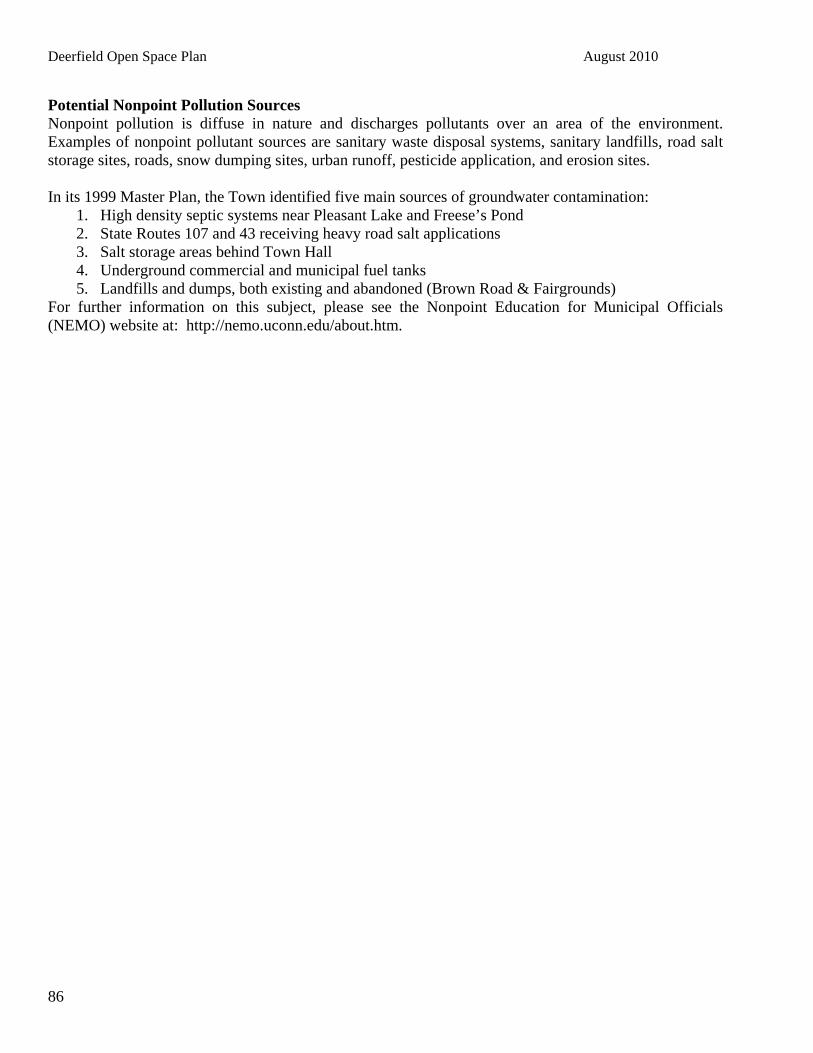
Deerfield Open Space Plan August 2010
86
Potential Nonpoint Pollution Sources Nonpoint pollution is diffuse in nature and discharges pollutants over an area of the environment. Examples of nonpoint pollutant sources are sanitary waste disposal systems, sanitary landfills, road salt storage sites, roads, snow dumping sites, urban runoff, pesticide application, and erosion sites. In its 1999 Master Plan, the Town identified five main sources of groundwater contamination:
1. High density septic systems near Pleasant Lake and Freese’s Pond 2. State Routes 107 and 43 receiving heavy road salt applications 3. Salt storage areas behind Town Hall 4. Underground commercial and municipal fuel tanks 5. Landfills and dumps, both existing and abandoned (Brown Road & Fairgrounds)
For further information on this subject, please see the Nonpoint Education for Municipal Officials (NEMO) website at: Hhttp://nemo.uconn.edu/about.htmH.

Deerfield Open Space Plan August 2010
87
APPENDIX D COMMUNITY CONSERVATION ASSISTANCE
PROGRAM WORK PLAN

Deerfield Open Space Plan August 2010
88

Deerfield Open Space Plan August 2010
89

Deerfield Open Space Plan August 2010
90

Deerfield Open Space Plan August 2010
91

Deerfield Open Space Plan August 2010
92

Deerfield Open Space Plan August 2010
93

Deerfield Open Space Plan August 2010
94
APPENDIX E DEERFIELD CONSERVATION LANDS
# Property Name Map - Lot Book/Page Type Prot Acres
Perm Prot
? Forestry
OK? OHRVOK ActiveAG
Hay
Map: DCC 2001
Map: BPRG 2003
Map: GCL 2008 Comments
1 Alvah Chase 2358-0730 Town Forest (46) NO yes | X X X
ownership established in 2009 as mostly private; small portion left
2 Arthur Chase 2201-0746 Town Forest 38 NO yes | X X X
3 Burbank 2821-0450 Easement 95 yes yes | X X
Listed as 1 lot on BPRG 2003; part of Great Brook Cons. per DCC2001
4 Burbank 2821-0458 Easement 20 yes yes | X Listed as 3 lots on GCL 2008
5 Brower 416-82 9 X
6 Butterfield - - -
Listed in 1991 Natural Resources Inventory Report
7 Cate 416-12 - - -
Mentioned by Frank Mitchell 8/2008
8 Clark lot X X
9 Clifford 4746-2111 Easement 22 - - - 10 Corey WMA X X
11 Cottonwood Estate 424-93 Easement 120 ?? yes | X - no association to enforce
12 Cumings Easement 4250-1104 Easement 17 yes yes | X
13 Cruikshank 4744-1770 Easement 27 DCC has Bear-Paw binder

Deerfield Open Space Plan August 2010
95
14 Curry 2885-0362 Easement 342 yes yes | yes X X X
Part of Great Brook Cons. per DCC2001. Listed as two lots per GCL2008.
15 Devries 415-92 2407-1493 4 X
16 Doane-Schorr Easement 4482-2837 Easement 70 yes yes | yes X X 5 acres reserved 17 Doles Marsh WMA X
18 Dowst Cate Town Forest 416-16 2451-0058 Town Forest 110 NO yes | X X letter stipulates park/TownForest
19 Flanders 415-30 ? 2561-2196 14
20 Fogg-Shores Memorial Forest 405-53 Easement 120 yes yes | yes X
21 Fowler Conservation Area #1 414-38 2843-2054 X X
GCL 2008 lists as 4 separate properties
22 Fowler Conservation Area #2 X 23 Fowler Conservation Area #3 X 24 Fowler Conservation Area #4 X
25 Freese 410-32 4957-0653 30 NO yes | X X X
26 Hart Town Forest 403-2 2968-2568 Town Forest 72 NO yes | X X X
27 Jaeger 2885-0392 Easement 110 yes yes | X X X
Part of Great Brook Cons. per DCC2001
28 Johnson, Iver 405-99 4633-2656
29 Peg King Park 414-97 3914-2601 Town Park 11 NO ?? NO NA
conveyed at Town Mtg 15 Mar 2003 Article 15 for "hiking, picnicking, and general use" by unanimous hand vote and applause; deed calls for

Deerfield Open Space Plan August 2010
96
pedestrian paths and ped bridge across Nichols Brook
30 Lamontagne WMA X X
31 Levesque Lot 2303-0683 X
32 Lewis Builders, Inc. 409-48 Easement 6 yes yes | X
Connector trail; part of Great Brook Cons. per DCC2001
33 Linden Conservation Area 414-3 3457-2485 Easement 10 yes yes | X X X
Listed as "Lindsay-Flanders-Linden Conservation Areas" on BPRG 2003; listed as two parcels in GCL
34 Lindsay-Flanders 415-30 2235-0813 68 NO NO | X X X
By deed restrictions; listed as separate lots on DCC 2001
35 Malouin 409-38 2885-0355 Easement 1 yes yes | X X X
Connector trail; part of Great Brook Cons. per DCC2001; listed on GCL2008 as "Malovin"
36 McNeil Conservation Area T.F. Town Forest 47 NO yes | X X X 37 McNeil Conservation Area 406-12 1903-385
38 Menard, Jeanne 209-57 ? 4873-2371 1 - - -
Mentioned by Frank Mitchell 8/2008
39 Menard, Frances L. 415-57 3037-1731 Easement 230 yes yes | X X SPNHF easement 40 Olsen-Villnave 404-9 Easement 300 yes yes | X X SPNHF easement 41 O'Neal Lot X

Deerfield Open Space Plan August 2010
97
42 Pendleton 2885-0372 Easement 128 yes yes | X X X
Listed as 1 lot on BPRG 2003; part of Great Brook Cons per DCC 2001
43 Pendleton Easement 57 Yes yes | X X
44 Pleasant Hill Rd -- ? - - -
Mentioned by Frank Mitchell 8/2008
45 Pleasant Lake Boat Launch X
46 Rosenfield-Mallette 4456-2380 Easement 85 yes yes ALL yes X 5 acres reserved 47 Sherburne 416-24 Easement 44 yes yes | X X TNC easement
48 Shores 3189-2050 Easement 140
49 Stillbach 424-?? 3258-2347 Easement 403 yes yes | X X SPNHF easement 50 UNH Saddleback Mountain X
51 Weiss Town Forest 416-18 3352-2796 Town Forest 93 NO yes | X X 52 Wells Town Forest 411-39 Town Forest 83 NO yes | X X X
53 Williams 405-84 3400-0039 Easement 87 yes yes NO X X 54 Woodman S.F. X X
55 Willoughby 4344-0575 Easement 28 yes yes | X 1 lot reserved 56 Yeaton Lot X 3,044 MAP SOURCES: DCC Trails Map, 2001 (DCC 2001) Bear-Paw Regional Greenways, prepared 2003 (BPRG 2003) ** Relies primarily on GRANIT data obtained in 2001 2008 GRANIT "Conservation Layer" (GCL 2008) OTHER SOURCES: 1991 Deerfield Natural Resources Inventory Report 2008 list of Town Properties

Deerfield Open Space Plan August 2010
98
APPENDIX F ABOUT TAX BENEFITS, FUNDING, EASEMENTS The numerous income and estate tax benefits have helped to convince many landowners to sell or donate their land or development rights. Both Congress and the New Hampshire state legislature make frequent changes to tax laws that affect the donation or sale of land, and therefore landowners should consult with an attorney or tax advisor before taking action on their property.
Any land donated for charitable purposes (i.e. without requirement, stipulation, or payment of goods or services) may qualify for an income tax deduction from the IRS. These charitable gifts may be made during the donor’s lifetime or at his or her death and must be made to an IRS-qualified entity, such as a government agency or a tax-exempt land trust organization. Land donated becomes removed from estate taxes, thus releasing the burden to heirs. Conservation easements also reduce the amount of estate taxes as they reduce the assessed value of the land. If the value of the donated property or property rights exceed $5,000, the landowner must obtain a “qualified appraisal” by a “qualified appraiser,” the details of which can be explained by an attorney or tax advisor.
Income Tax
Income tax deductions for gifts of appreciated property (including most gifts of land and easements) can qualify for up to 30% of one’s Adjusted Gross Income (AGI). If the value of the gift is less than 30% of one’s AGI, the value can be carried for up to five additional years, with a 30% deduction each year until the total value of the gift or six years have passed. If a landowner claim’s the property’s basis—the original purchase price or value of the property at the time of inheritance—rather than fair market value, the landowner can claim up to 50% of his or her AGI each year for up to six years (in the same manner as with the 30% deduction). For a conservation easement, the easement value is adjusted in proportion to the property’s basis. The 50% option is preferable for recently purchased or inherited property, property that has not significantly appreciated since time of acquisition, or anticipation of not living long enough to take advantage of the five-year carry forward period.
The enhanced tax deduction for conservation easements expired on December 31, 2009; it is very likely Congress will renew the incentive in 2010 and make it retroactive to January 1st. The enhanced tax deduction for donating a conservation easement allowed a donor to take a deduction of 50% of adjusted gross income, qualified farmers could deduct up to 100% of their income, and the number of years over which a donor could take deductions is 16 years.
Bargain sale of property also holds tax advantages, as the amount of discount below the full value can qualify for IRS income tax deductions. With the addition of real estate broker commissions, real estate transfer tax, and capital gains tax paid through the full value sale, the bargain sale can be nearly as financially valuable to the landowner while passing significant savings to the municipality.
Deerfield Open Space Plan August 2010
99
Other costs relevant to conservation easements can also be tax deductible. For example, cash or securities used to endow stewardship of easements are considered charitable donations. Also, legal and appraisal fees can qualify as miscellaneous deductions if they can alone or in combination with other fees make up at least 2% of one’s AGI.
Estate Tax
Estate taxes are based upon the economic value of a property, so conservation easements have reduced assessed value (due to their lack of development potential), which results in significant decreases in estate taxes. This can be an important consideration for landowners wishing to conserve their land, as heirs often sell and subdivide land to pay for estate taxes. Estate tax rates are extremely high, in some cases reaching nearly 50%, and estate tax laws are frequently under review and revision. Landowners who anticipate their estates will be subject to estate taxes should consult a professional to prepare their options.
The Taxpayers Relief Act of 1997 stipulates that up to 40% of the value of a conservation easement (up to $500,000) may be excluded from the gross estate, following certain qualifications. This thereby reduces the amount of the estate tax. The Act also allows the estate of the landowner to grant an easement after the death of the landowner. Under the federal estate and gift tax, an individual can give up to $11,000 tax-free annually to any number of individuals. With this arrangement, a landowner can reduce the value of his or her land with a conservation easement and then donate it to children in undivided interests over a period of years. Landowners should also be aware that any land donated to charity is exempt from federal estate taxes.
Current Use Land under current use pays taxes at a lower rate than land not in current use. Rates for current use are set by the NH Department of Revenue Administration Current Use Board. While conservation easements can reduce the total property value and therefore reduce property taxes, most landowners already have the land under current use and are not paying full property taxes on it. For land not already in the current use program, or less than 10 acres in size, the landowner can apply to the municipality for a Conservation Restriction assessment. This would allow an easement on this land to be assessed at values similar to current use assessments.

Deerfield Open Space Plan August 2010
100
APPENDIX G FURTHER IMPLEMENTATION STRATEGIES, PROGRAMS AND FUNDING SOURCES The Deerfield Open Space Committee highlights in Section 8 their priorities for land conservation and open space regulations. However, the most effective open space plan will take into account all available strategies and funding sources, compiling the optimal mix for a comprehensive land protection program. The following are existing implementation tools to assist in crafting land protection: Agricultural District Laws: Agricultural district laws allow farmers to form special areas where commercial agriculture is encouraged and protected. Programs are authorized by state legislatures and implemented at the local level. Common benefits of enrollment in a district include automatic eligibility for differential assessment, protection from eminent domain and municipal annexation, enhanced right-to-farm protection, exemption from special local tax assessments and eligibility for state PACE programs. Buffers: Planning Boards are advised to consider a buffering requirement on uses adjacent to a farm when reviewing plans for subdivisions. Circuit Breaker Tax Relief Credits: Circuit breaker tax programs offer tax credits to offset farmers’ property tax bills. Like differential assessment laws, circuit breaker tax relief credits reduce the amount farmers are required to pay in taxes. Cooperative Purchases With Conservation Groups (e.g., New England Forestry Foundation, The Nature Conservancy, Corporate Conservation Council, and Trust for Public Land): Various local, regional, and national land trusts and conservation groups can provide a tremendous amount of assistance to landowners wishing to keep their property unde-veloped. Once land is accepted by a trust, stewardship of the property tends to be excellent. The Trust for Public Land (TPL), a national land trust, is able to move quickly with willing landowners, and can provide the necessary legal assistance to complete the transaction. TPL is particularly helpful with larger more expensive pieces of property that are threatened for development. Current Use Program: The Current Use Program is voluntary for landowners, but it is required under state statute for municipalities. Land under the New Hampshire’s Current Use Program is based upon the value of the land as it is being used now (usually farmland, forest, and wetlands) as opposed to its potential use that would result in the property being taxed at a significantly higher rate. Density Bonuses: Developers are allowed some reduction in regulations, such as approval for a limited number of additional units (higher densities) on a site with reduced road width or set back requirements, in exchange for providing something else that the community desires, such as open space.

Deerfield Open Space Plan August 2010
101
Designating Forests: A town or the state, through the Department of Resources and Economic Development (DRED), can purchase, manage and improve forestlands. The forest designation can encourage landowners to donate their forestland because the donation can be accompanied by conditions restricting its use. The town also benefits from the forest designation. It can receive money from the state in lieu of taxes it would have gotten if the land were privately owned. Designating Scenic Roads: The Planning Board, Conservation Commission, or Historical Commission can request that a particular road be designated as “scenic.” The entire road does not have to be designated as scenic; portions of road are acceptable. Voters can decide at a town meeting whether to officially approve the road(s). Prior to acceptance of a road as “scenic” abutters must be contacted and informed of the designation. Once the road is officially designated as “scenic” any repair, maintenance, reconstruction, or paving work done to that road cannot involve the removal of trees or any portion of a stone wall except with the written permission of the town Planning Board after a public hearing is held. Impact Fees: Towns that have capital improvements programs are allowed to charge developers impact fees to help cover the costs of the development on specific municipal facilities and increased infrastructure to support new development areas. While the statute specifies that the fees cannot be used for public open space, fees can be used to direct new development to desired areas. Management Agreements: Management Agreements can be made with willing landowners through verbal or written agreements or contract agreements to help protect natural resources. On-Farm Retail Sales: Flexibility in site plan review regulations can be used to exempt farm stands from inappropriate commercial regulation, or allow a community to develop a tiered approach to the regulating of farm stands. Communities are encouraged to exempt seasonal farm stands from municipal regulations other than proof of safe site access. Year-round operations warrant review by the local authorities to address the safe operation of the site. However, the review should be modified to provide for reduced standards from those applied to commercial and industrial uses. Overlay Districts: Overlay districts can be used by communities to apply special regulations to a number of resources with definable site-specific characterization that can be delineated on a map. There are several types of overlay districts, such as drinking water, wetlands, steep slopes, mountain, agricultural, village, historic, species of concern, and scenic overlay districts. Performance and Design Standards: Performance and Design Standards can include aesthetic and natural characteristics based land use regulations, and flexible zoning. Purchase of Development Rights or Transfer of Development Rights (PDR or TDR): The purchase of development rights is essentially the purchase of a conservation easement. Instead of donating easements, farmers can sell them to the state, concurrently placing permanent agricultural preservation restrictions on their farms. Similarly, a community or local group may purchase development rights on farmland or other land. Instead of a tax

Deerfield Open Space Plan August 2010
102
deduction for the gift of an easement, the landowner receives cash for the value of the easement. Transfer of development rights operates under the same theory as a purchase program. This program transfers development from one area to another, and preserves open space in the sending area. Development rights are transferred from conservation land, such as farmland, to land slated for development. A developer purchases development rights from the owner of land in a conservation zone in order to accrue development “points”. He or she can apply points toward development of property in a zone where development is encouraged, and develop that land at a greater density than would otherwise be permitted. Purchase of Land: A voluntary method that a town can use to preserve open space. Land can be acquired through donation or purchase with or without various restrictions including deed restrictions, conservation easements, or for tax benefit to the donor. Although purchasing property is an obvious method that a town can use to preserve open space, this method can often times be cost prohibitive to a community. However, there are a variety of methods that a town can use to appropriate funds to purchase land for conservation purposes. A town can appropriate money through a Conservation Fund. These funds can be utilized after a vote of the town legislative body. The town can use Capital Reserve Funds as long as they are specified for a particular purpose such as purchasing land or an easement. Dollars have been raised through managing town property in some communities, usually through timber harvesting. Surplus Funds from previous years can be used after a town meeting vote. If a proposal passes town meeting by a two-thirds vote, the town can borrow money through a municipal bond. A property that the town acquires through a tax lien could be used for conservation purposes. If the town decides to sell the particular property, a conservation easement or deed restriction could be placed on the property. Finally, land use change tax can be used for conservation purposes when a property is withdrawn from the Current Use Program. Right-Of-First-Refusal: A right acquired or donated to the Town, where the Town would have the first option to purchase a piece of property when an owner decides to sell. The Town would not be obligated to purchase the property, but would have a limited amount of time to decide if there was interest in purchasing the land. Tax Abatement: Tax abatement is the exemption or deferment of taxes under certain conditions, either for a specified period, or until the conditions are no longer met. Taxes can be abated in New Hampshire for providing shade trees adjacent to highways and for not cutting timber. Any person can apply to the selectmen to have their taxes abated if they plant and protect shade trees along a highway adjoining their land. A person who owns and cuts woodlands as a business has to file a notice of intent to cut with the proper assessing officials in the town where such cutting is to take place. This notice includes, among other things, the persons name, residence, and an estimate of the amount and species to be cut. This procedure enables tax officials to tax an owner for the wood that is cut.

Deerfield Open Space Plan August 2010
103
Tax Deduction: The federal government provides some incentives to encourage people to donate land or conservation restriction on their land to the public either during their lifetime or in their wills. A person can deduct, on their federal income tax return, the amount of the value of the property or conservation restriction donated, subject to a ceiling on the allowance for charitable gifts in any one-year period. Urban Growth Districts: An urban growth district allows a community to define one or more areas where growth and development will be concentrated. Typically, this includes downtown areas and perhaps existing areas with higher concentrations of development. Open space can be conserved outside the urban growth by concentrating desired growth inside the urban growth district. STATE AND FEDERAL GRANT PROGRAM There are numerous State and Federal grant programs available that can be used to promote open space protection. The status of grant programs is subject to change. However, the following include some current programs that could be used by the Town to further the open space plan goal, objectives and recommendations. STATE PROGRAMS: Community Conservation Assistance Program. UNH Cooperative Extension. Assistance for project guidance and training for community projects through municipalities and non-profit conservation groups. Contact Amanda Stone at (603) 364-5324. Community Foundation Grant Program. The Greater Piscataqua Community Foundation Provides funding to non-profit and public agencies in the fields of environment, arts and humanities, education, and health and social and community services. Contact 603-430-9182. Conservation License Plate Grant Program. NH State Conservation Committee. To promote natural resource related programs throughout NH. Conservation districts, Cooperative Extension, conservation commissions, schools, groups, and other non-profits can apply for funding. Contact Joanna Pellerin, at (603) 679-2790 or www.mooseplate.com. Fisheries Habitat Conservation Program. NH Fish and Game Department. To conserve fisheries habitat through a watershed approach. Landowners wishing to protect/enhance fisheries habitat can apply for funding. Contact Scott Decker, (603) 271-2744 or [email protected]. Forest Legacy Program. Provides up to 75% of the purchase price for development rights to forestlands from willing sellers. Streamside land is among program priorities. Rights are held by the state in perpetuity, while the landowner retains all other rights, including the right to harvest timber. Contact NH DRED at (603) 271-2214. Land and Community Heritage Investment Program. This is a grant program for conserving and preserving New Hampshire’s most valuable natural, cultural, and historical resources. Grant applications for the purchase of land/buildings or restoration of structures

Deerfield Open Space Plan August 2010
104
are accepted from tax –exempt organizations, municipalities, or other political subdivisions of the State. Contact the SNHPC or visit Hwww.lchip.orgH. Land and Water Conservation Fund Program. Provides grants to state and municipal agencies for outdoor recreation and conservation projects. Contact NH DRED Division of Parks and Recreation, at (603) 271-3556 or email [email protected] Local Source Water Protection Grants (Drinking Water Source Protection). To protect public drinking water sources. Water suppliers, municipalities, conservation districts, and non-profits can apply. For more information, call DES at (603) 271-3503. New Hampshire Drinking Water Source Protection Program. This grant is available to public water suppliers for source water protection. The program, which began in 1997, has a total of $200,000 available to disburse every year to eligible municipalities. Grant amounts vary from $2,000 to $50,000. Past grants have been used to fund a watershed assessment and protection plan; perimeter fencing to protect a wellhead area; and monitoring wells for groundwater evaluation. Past recipients include: Conway, Lebanon, Manchester, Rochester, Dover, Keene and Portsmouth. For further information contact: Sarah Pillsbury at (603) 271-1168 or e-mail [email protected] H. Transportation Enhancement Program. New Hampshire Department of Transportation provides funding for scenic highway projects and mitigation of water pollution due to highway runoff. www.nh.gov/dot/org/projectdevelopment/planning/tecmaq/index.htm Watershed Assistance Restoration Grants (Section 319 Restoration Grants). Grants can be given to farmers, watershed associations, conservation districts, non-profit organizations, regional planning agencies, and municipalities to implement practices that help restore impaired waters. Call (603) 271-2358.H Wildlife habitat – Small Grants Program – NH Fish and Game Department. For restoring, sustaining, or enhancing wildlife habitat on privately owned land. Owners of private, municipal, corporate or other non-governmental lands can apply for funds to implement habitat-improving practices. For more information, contact your regional F&G office or the Wildlife Division at (603) 271-2461. Aquatic Resource Mitigation Funds. ARM funds are available to implement programs to restore, protect, provide habitat improvements to or create wetlands and other aquatic resources. These funds are available for the purpose of replacing or protecting wetlands and other aquatic resource functions and values that were impacted by development projects in the watershed. Lori Sommer NHDESWetlands Bureau PO Box 95 Concord, NH 033020095 [email protected] (603) 2714059

Deerfield Open Space Plan August 2010
105
FEDERAL SOURCES: Coastal America Corporate Wetlands Restoration Partnership. U.S. Army Corps of Engineers. Voluntary public-private partnership in which corporations join forces with federal and state agencies to restore wetlands and other aquatic habitats. www.cwrp.org Conservation Reserve Program (CRP) . USDA Farm Service Agency. For converting highly erodible land to vegetative cover. Annual rental or other incentive payments for certain activities are offered. Cropland owners and operators who have owned or leased the land for at least 1 year can apply for funds. Program Contact: Patricia Engler (202) 720-1836. Environmental Quality Incentives Program (EQUIP). United States Department of Agriculture Natural Resources Conservation Service (NRCS). Cost sharing and technical assistance for planning and installation of environmentally beneficial and cost effective conservation practices that address locally identified natural resource concerns. Agricultural or forestry producers can apply. The EQUIP program assists landowners wishing to conserve archeological and other cultural resources. This program provides technical expertise and field experience on a voluntary basis to private landowners in developing conservation systems. The program assists rural and urban communities to reduce erosion, conserve and protect water and solve other resource problems. The EQUIP is a voluntary conservation program for farmers and ranchers who face serious threats to soil, water and related natural resources. Eligibility is limited to persons engaged in livestock or agricultural production. Priority areas are identified through a locally led conservation process that requires completion of a natural resources needs assessment and develops proposals. Activities must be carried out according to site-specific conservation plans subject to NRCS technical standards. EQUIP provides technical, financial and educational assistance, primarily in designated priority areas, to install or implement structural, vegetative, and management practices. It offers 5-10 year contracts that provide incentive payments (up to 3 years) and cost sharing (up to 75%) for conservation practices. Total cost-share and incentive payments limited to $300,000 over a six year contract length. Contact: Tim Beard, EQIP Program Manager (202) 690-2621. Farmland and Ranchland Protection Program (FRPP). Administered through the US Department of Agriculture Natural Resources Conservation Service. Provides matching funds to help slow the conversion of farmland to non-agricultural uses. An entity holds the conservation easement deed, and land must contain important farmland soils, and a conservation plan. The easements are for 30 years, but priority is given to perpetual easements. The Farmland Protection Program is a voluntary program implemented by the United States Department of Agriculture (USDA) and the Natural Resources Conservation Service (NRCS), and provides funding to State or local governments with existing farmland protection programs to purchase conservation easements. To be eligible for the FPP, the land must be: part of a pending offer from a non-governmental organization, state tribe, or local farm protection program; on prime, unique, or other important farmland soil; covered by a conservation plan developed with/through the Natural Resources Conservation Service; privately owned; large enough to sustain agricultural production; accessible to markets for what the land produces and surrounded by parcels of land that can support long-term

Deerfield Open Space Plan August 2010
106
agricultural production. Visit Hwww.nh.nrcs.usda.gov H or contact the NRCS State Office in Durham NH at (603) 868-7581. Robert Glenson, National Manager (202) 720-9476. North American Wetlands Conservation Fund. This fund assists partnerships in acquisition, enhancement and/or restoration of wetlands and associated uplands for migratory birds and other wildlife. A 1:1 non-federal match is required. This program strives to conserve North American wetland ecosystems and waterfowl and the other migratory birds and fish and wildlife that depend upon such habitats. This program provides grants under the North American Wetlands Conservation Act (NAWCA). Projects are subjected to a scoring process and site visits, if needed. Projects rank higher if they contain long-term acquisition or restoration, high migratory bird values, a high match grant ratio and many diverse partners. These funds are primarily used for acquisition, restoration and enhancement of wetlands and associated uplands. Uses of grant and matching funds include (but are not restricted to) research, conservation education, and public use, (e.g., roads, viewing towers). Grant requests can range from $50,000 to $1,000,000. A 1:1 match is required. Sources of funds include Congressional appropriations that are not possible to predict, but the program has averaged about $30 million per year since the first year FY 1991. Contact: Division of Bird Habitat Conservation (703) 358-1784. Partners For Fish and Wildlife – US Fish and Wildlife Service. To restore, improve, and protect fish and wildlife habitat on private lands, private landowners, private organizations, towns and municipalities can apply for cost-sharing funds. NH Branch, Eric Derleth (603) 223-2541 x14, [email protected]. Scenic and Cultural Byways Program. Roads designated under the New Hampshire Scenic and Cultural Byways Program may be eligible for federal grant money for purchase of conservation easements for scenic values along designated byways. Such funds may be used to ensure the long-term protection of open spaces along the byways. NH Scenic Byway State Coordinator, Dean Eastman, [email protected]
Wetlands Reserve Program (WRP) – USDA Natural Resources Conservation Service. To protect/enhance wetlands through conservation easements or cost-share agreements. Technical assistance and cost-share funding (or a permanent easement) are available for landowners with eligible wetlands. The Wetland Reserve Program (WRP) is a voluntary program to restore and protect wetlands on private property. WRP offers three options: permanent easements; 30-year easements; and restoration cost-share agreements with minimum 10-year duration. Some easements may be eligible for tax credits. Land must be restorable and suitable for wildlife benefits. To offer conservation easement, landowner must have owned land for at least one year before program enrollment unless land was inherited or not obtained for purpose of enrolling it in the program. To participate in restoration cost-share agreement, landowner must show ownership evidence. Ineligible land includes wetlands converted after December 23, 1985; lands with timber stands established under CRP contract; federal lands; and lands where conditions make restoration impossible. Acting Wetland Reserve Program Manager (202) 720-1067.
Deerfield Open Space Plan August 2010
107
Wildlife Habitat Incentives Program – USDA Natural Resources Conservation Service. A voluntary cost-sharing program to improve wildlife habitat on non-federal land. NRCS will help landowners or land managers develop a wildlife habitat plan based on their management objectives. The Wildlife Habitat Incentives Program (WHIP) is a voluntary conservation program for those wanting to develop and improve wildlife habitat on private lands. The program offers three options: permanent easements; 30-year easements; and restoration cost-share agreements with minimum 10-year duration. Some easements may be eligible for tax credits. Individuals must own or have control of land under consideration. There is no minimum acreage requirement. WHIP may also be used to restore riparian habitat. Land is not eligible if it is currently enrolled in similar USDA programs, used for mitigation, owned by the federal government, or if the USDA determines that on-site or off-site conditions would reduce the benefits of habitat development. This program provides technical and financial assistance for initial establishment of wildlife habitat development practices. If landowner agrees, state and private organizations may provide expertise or additional funding to help complete a project. Cost-share assistance requires at least 10-year agreement; up to 75% of cost of installing the practices is paid. Cost-share payments may be used to establish, maintain, or replace practices. Contact: Albert Cerna (202) 720-9358. LAND TRUST ALLIANCES Land Trust Alliances are non-profit organizations that work towards land preservation through land acquisition, stewardship, and education. The following is an alphabetical list of agencies to contact regarding stewardship of your conservation properties. Not all are members of LTA. All operate within the State of New Hampshire. Web sites and email addresses are included where available. Bear-Paw Regional Greenways LTA Member Adopted S&P PO Box 19 Deerfield, NH 03037-0019 Phone: (603) 463-9400 Fax: (603) 230-2447 Area of Operation: A seven town region in southeastern New Hampshire Founded: 1995 e-mail: [email protected] H2Hwww.bear-paw.orgH Beaver Brook Association 117 Ridge Rd Hollis, NH 03049-6425 Phone: (603) 465-7787 Fax: (603) 465-9546 Area of Operation: Southern New Hampshire, neighboring Massachusetts Founded: 1964 e-mail: [email protected] www.beaverbrook.org

Deerfield Open Space Plan August 2010
108
Earth Bridge Community Land Trust 1221 Bonnyvale Road Brattleboro, VT 05301-2578 Phone: (802) 254-2490 Area of Operation: Southern Vermont, Southern New Hampshire Founded: 1976 Environmental Design Group LTA Member 212 Elm St Somerville, MA 02144-2959 Phone: (617) 623-5555 Fax: (617) 623-5111 Area of Operation: New England Founded: 1969 New England Forestry Foundation LTA Member Adopted S&P PO Box 1099 Littleton, MA 01460-1346 Phone: (978) 952-6856 Area of Operation: Forests e-mail: [email protected] Hwww.newenglandforestry.orgH New England Wild Flower Society 180 Hemenway Rd Framingham, MA 01701-2636 Phone: (508) 877-7603 Fax: (508) 877-3658 Area of Operation: New England Founded: 1900 e-mail: [email protected] www.newfs.org Nichols-Smith Land Trust PO Box 266 Hollis, NH 03049-0266 603-465-6144 Area of Operation: South-central New Hampshire and north-central Massachusetts Founded: 1997 e-mail: [email protected]

Deerfield Open Space Plan August 2010
109
Southeast Land Trust PO Box 675 Exeter, NH 03833 Phone: (603) 778-6088 Fax: (603) 778-0007 Area of Operation: Rockingham County Founded: 1980 Hwww.seltnh.org H Society for the Protection of New Hampshire Forests LTA Member Adopted S&P 54 Portsmouth St Concord, NH 03301-5486 Phone: (603) 224-9945 Fax: (603) 228-0423 Area of Operation: New Hampshire Founded: 1901 e-mail: [email protected] H4Hwww.spnhf.org H The Nature Conservancy, New Hampshire Field Office 22 Bridge Street, 4th Floor Concord, NH 03301-4987 Phone: (603) 224-5853 Fax: (603) 228-2459 [email protected] www.nature.org
LTA: Land Trust Alliance
Adopted S&P indicates adoption of LTA's H5HStandards & PracticesH, guidelines for responsible and ethical operation of a land trust.
Deerfield Open Space Plan August 2010
110
APPENDIX H GLOSSARY OF SOME COMMON OPEN SPACE TERMS Assessed Valuation: The value of property as determined for property tax purposes. The assessed valuation is not necessarily the true market value of property, and is not usually accepted by the IRS for federal tax purposes. Conservation Easement: A conservation Easement consists of a deed conveying perpetual restrictions on real property. These restrictions include limitations on the future use or development of the property. Typically, no development or mining is allowed on the easement. Rights may include access to the easement grantee for monitoring. Typically, no development or mining is allowed on the easement. Conservation Gift: A donation in an interest in land for conservation purposes, including easements, gifts, bargain sales, and other types of gifts. Conservation Restriction Assessment: Land permanently subject to a conservation easement is assessed at the low current use assessment rates. Current Use Assessment: When undeveloped land is taxed at a low rate rather than actual assessed value. A Land Use Change Tax will be assessed if the land is later developed. Fragmentation: Land that is fragmented mainly by roads or development. Greenway: A natural or man made corridor or trail through one or more natural areas that links areas to form a recreational opportunity, usually supported and maintained by a local non-profit organization. Habitat: An area that contains all the resources – food, water, cover and space – essential for the survival of a wildlife population. Land Trusts: A private or public group formed for land conservation and protection, usually municipal subdivisions or private voluntary corporations. Land Use Change Tax: A penalty tax imposed when land under the current use assessment program is developed, also known as change of use penalty tax. Monitoring: Periodic inspection of property under a conservation easement to ensure the restrictions have not been violated. Reserved Area: A portion of a tract of land not subject to the terms of the conservation easement. Tax Lien Properties: Tax lien properties have been and will be taken by the Town of Weare to help with land conservation purposes. Wildlife Corridors: These corridors have been developed to assist wildlife to roam freely within their range as well as to provide habitat and cover.

Deerfield Open Space Plan August 2010
111
APPENDIX I POPULATION GROWTH RATES IN SOUTHERN NEW HAMPSHIRE, 1980-2008 2000 Census population information compared with 1980 and 1990, Southern New Hampshire Planning Commission Municipalities Population growth rates have been substantial in southern New Hampshire from 1980 to 2000. The data below indicate an average growth rate of 13% in the Southern New Hampshire Planning Commission region.
Growth 2000-2008
Municipality 1980 1990 2000 2008*Amount Percent
Auburn 2,883 4,085 4,682 5,085 403 9% Bedford 9,481 12,563 18,274 20,807 2,533 14% Candia 2,989 3,557 3,911 4,085 174 4% Chester 2,006 2,691 3,792 4,621 829 22% Deerfield 1,979 3,124 3,678 4,366 688 19% Derry 18,875 29,603 34,021 34,071 50 0% Goffstown 11,315 14,621 16,929 17,605 676 4% Hooksett 7,303 9,002 11,721 13,483 1,762 15% Londonderry 13,598 19,781 23,236 24,567 1,331 6% Manchester 90,936 99,332 107,006 108,154 1,148 1% New Boston 1,928 3,214 4,138 5,129 991 24% Raymond 5,453 8,713 9,674 10,825 1,151 12% Weare 3,232 6,193 7,776 8,993 1,217 16% Totals 171,978 216,479 248,838 261,791 12,953 5%
*NHOEP Population Estimates
Deerfield Open Space Plan August 2010
112
APPENDIX J SELECTED NEW HAMPSHIRE STATUTES RELATED TO OPEN SPACE TITLE 5 Taxation CHAPTER 79A Current Use Taxation § 79-A:1 Declaration of Public Interest. – It is hereby declared to be in the public interest to encourage the preservation of open space, thus providing a healthful and attractive outdoor environment for work and recreation of the state's citizens, maintaining the character of the state's landscape, and conserving the land, water, forest, agricultural and wildlife resources. It is further declared to be in the public interest to prevent the loss of open space due to property taxation at values incompatible with open space usage. Open space land imposes few if any costs on local government and is therefore an economic benefit to its citizens. The means for encouraging preservation of open space authorized by this chapter is the assessment of land value for property taxation on the basis of current use. It is the intent of this chapter to encourage but not to require management practices on open space lands under current use assessment. Source. 1973, 372:1. 1991, 281:2, eff. Aug. 17, 1991. 1996, 176:2, eff. Aug. 2, 1996. TITLE 5 Taxation CHAPTER 79A Current Use Taxation § 79-A:4 Powers and Duties of Board; Rulemaking. – The board shall have the following powers and duties: I. It shall meet at least annually, after July 1, to establish a schedule of criteria and current use values to be used for the succeeding year. It shall have the power to establish minimum acreage requirements of 10 acres or less. It shall also review all past current use values and criteria for open space land established by past boards. The board shall make such changes and improvements in the administration of this chapter as experience and public reaction may recommend. II. The board shall reduce by 20 percent the current use value of land that is open 12 months a year to public recreational use, without entrance fee, and that also qualifies for current use assessment under an open space category. There shall be no prohibition of skiing, snowshoeing, fishing, hunting, hiking or nature observation on such open space land, unless these activities would be detrimental to a specific agricultural or forest crop or activity. The owner of land who opens his land to public recreational use as provided in this paragraph shall not be liable for personal injury or property damage to any person, and shall be subject to the same duty of care as provided in RSA 212:34. III. The board shall annually determine, vote upon and recommend to the chairman of the board the schedule of criteria and current use values for use in the forthcoming tax year. The board shall hold a series of at least 3 public forums throughout the state to receive general comment through verbal and written testimony on the current use law. After the public forums are concluded and the board has made its recommended changes, the chairman shall proceed to adopt any proposed rules, in accordance with paragraph IV. IV. The chairman of the board shall adopt rules, pursuant to RSA 541-A, for the schedule of criteria and current use values as recommended by the board, and for other forms and procedures as are needed to implement this chapter consistent with board recommendations
Deerfield Open Space Plan August 2010
113
and to assure a fair opportunity for owners to qualify under this chapter and to assure compliance of land uses on classified lands. Source. 1973, 372:1. 1974, 7:4. 1977, 326:3. 1982, 33:2. 1986, 62:1. 1988, 5:3. 1991, 281:7. 1993, 205:1. 1995, 137:3, eff. May 24, 1995. TITLE 5 Taxation CHAPTER 79A Current Use Taxation § 79-A:25 Disposition of Revenues. – I. Except as provided in paragraph II, all money received by the tax collector pursuant to the provisions of this chapter shall be for the use of the Town or city. II. The legislative body of the Town or city may, by majority vote, elect to place the whole or a specified percentage, amount, or any combination of percentage and amount, of the revenues of all future payments collected pursuant to this chapter in a conservation fund in accordance with RSA 36-A:5, III. The whole or specified percentage or amount, or percentage and amount, of such revenues shall be deposited in the conservation fund at the time of collection. III. If adopted by a Town or city, the provisions of RSA 79-A:25, II shall take effect in the tax year beginning on April 1 following the vote and shall remain in effect until altered or rescinded pursuant to RSA 79-A:25, IV. IV. In any Town or city that has adopted the provisions of paragraph II, the legislative body may vote to rescind its action or change the percentage or amount, or percentage and amount, of revenues to be placed in the conservation fund. Any such action to rescind or change the percentage or amount, or percentage and amount, shall not take effect before the tax year beginning April 1 following the vote. Source. 1973, 372:1. 1988, 120:2. 1991, 281:19, 20, eff. Aug. 17, 1991. TITLE 5 Taxation CHAPTER 79A Current Use Taxation § 79-A:25-a Land Use Change Tax Fund. – I. Towns and cities may, pursuant to RSA 79-A:25-b, vote to account for all revenues collected pursuant to this chapter in a land use change tax fund separate from the general fund. After a vote pursuant to RSA 79-A:25-b, no land use change tax revenue collected under this chapter shall be recognized as general fund revenue for the fiscal year in which it is received, except to the extent that such revenue is appropriated pursuant to paragraph II of this section. Any land use change tax revenue collected pursuant to this chapter which is to be placed in a conservation fund in accordance with RSA 79-A:25, II, shall first be accounted for as revenue to the land use change tax fund before being transferred to the conservation fund at the time of collection. II. After any transfer to the conservation fund required under the provisions of RSA 79-A:25, II, the surplus remaining in the land use change tax fund shall not be deemed part of the general fund nor shall any surplus be expended for any purpose or transferred to any appropriation until such time as the legislative body shall have had the opportunity at an annual meeting to appropriate a specific amount from said fund for any purpose not prohibited by the laws or by the constitution of this state. At the end of an annual meeting, any inappropriate balance of land use change tax revenue received during the prior fiscal year shall be recognized as general fund revenue for the current fiscal year. Source. 1991, 156:1. 1992, 122:1, eff. June 30, 1992.

Deerfield Open Space Plan August 2010
114
TITLE 2 Transportation CHAPTER 231A Municipal Trails § 231-A:2 Reclassification of Highways; Damages. – I. Any class V or VI highway may be reclassified as a class A or class B trail, and any class A trail may be reclassified as a class B trail, by vote of the local legislative body. II. In accordance with RSA 231:43, no highway of any class which provides the sole access to any land shall be reclassified as a class B trail without the written consent of the owner of that land. III. Whenever a reclassification is made under this section, any aggrieved landowner may appeal, or may petition for the assessment of damages, in the same manner as in the discontinuance of highways pursuant to RSA 231:48 and 231:49, and the amount of damages, if any, shall reflect the landowner use provisions set forth in RSA 231-A:1. Source. 1993, 60:2, eff. Jan. 1, 1994. TITLE 20 Transportation CHAPTER 231A Municipal Trails § 231-A:4 Public Trail Use Restrictions. – In this chapter, "public trail use restrictions" means any restrictions upon use of a trail by the general public. Such restrictions may be imposed by a landowner as a condition of grant or dedication of a trail acquired under RSA 231-A:5, or by vote of the local legislative body or its designee at or subsequent to the time the trail is established, or by the local governing body under RSA 41:11. Such restrictions may include, but are not limited to, prohibition of motor vehicles, prohibition of wheeled vehicles, prohibition of off highway recreational vehicles, or restriction to specified modes of travel such as horse, bicycle, or foot. Such restrictions, if posted using legible signs at entrances to the trail from public highways, or at any property boundaries where new or different restrictions become applicable, shall be enforceable in the same manner as traffic violations as set forth in RSA 265. Any person violating such restrictions shall be guilty of a violation. Source. 1993, 60:2, eff. Jan. 1, 1994. TITLE 20 Transportation CHAPTER 231A Municipal Trails § 231-A:5 Acquisition of New Trails. – I. Municipalities shall not use the power of eminent domain to establish trails. II. A class A or B trail may be established by the local legislative body or its designee over any land previously acquired by the municipality, including land acquired by the conservation commission pursuant to RSA 36-A:4, or Town forests established pursuant to RSA 31:110, unless the establishment of such trail would violate any right or interest reserved or retained by a prior grantor or held by a third party. III. The local legislative body or its designee may acquire, by dedication and acceptance or by gift, purchase, grant or devise: (a) Any class A or B trail, subject to such public trail use restrictions as may be imposed by deed by the owner or grantor; or (b) Any lesser interest in land for trail purposes, including but not limited to a revocable easement, revocable license, lease or easement of finite duration, or conservation restriction, subject to such public trail use restrictions and such reserved rights as may be imposed by or agreed upon with the owner or grantor. IV. A properly established conservation commission may utilize RSA 36-A:4 for the acquisition of trails.

Deerfield Open Space Plan August 2010
115
Source. 1993, 60:2, eff. Jan. 1, 1994. TITLE 20 Transportation CHAPTER 231A Municipal Trails § 231-A:8 Liability Limited. – I. All trails established under this chapter shall be deemed to constitute land open without charge for recreational or outdoor educational purposes pursuant to RSA 212:34 and RSA 508:14, I, and the liability of owners, lessees or occupants of land affected by a trail, and of the municipality establishing the trail, shall be limited as set forth in those statutes. II. The liability of any person performing volunteer management or maintenance activities for or upon any trail established under this chapter, with the prior written approval of the body or organization with supervision over trail management pursuant to RSA 231-A:7, shall be limited as set forth in RSA 508:17, and such management shall not be deemed "care of the organization's premises" under RSA 508:17, IV. Source. 1993, 60:2, eff. Jan. 1, 1994. TITLE 52 Actions, Process, and Service Of Process CHAPTER 508 Limitation of Actions § 508:14 Landowner Liability Limited. – I. An owner, occupant, or lessee of land, including the state or any political subdivision, who without charge permits any person to use land for recreational purposes or as a spectator of recreational activity, shall not be liable for personal injury or property damage in the absence of intentionally caused injury or damage. II. An owner of land who permits another person to gather the produce of the land under pick-your-own or cut-your-own arrangements, provided said person is not an employee of the landowner and notwithstanding that the person picking or cutting the produce may make remuneration for the produce to the landowner, shall not be liable for personal injury or property damage to any person in the absence of willful, wanton, or reckless conduct by such owner. Source. 1975, 231:1. 1979, 439:1. 1981, 293:2. 1985, 193:2, eff. July 30, 1985. TITLE 64 Planning And Zoning CHAPTER 674 Local Land Use Planning And Regulatory Powers Master Plan § 674:2 Master Plan Purpose and Description VIII. A conservation and preservation section which may provide for the preservation, conservation, and use of natural and man-made resources. The conservation and preservation section of the master plan should include a local water resources management and protection plan as specified in RSA 4-C:22. This plan should be reviewed and revised as necessary at intervals not to exceed 5 years. Source. 1983, 447:1. 1986, 167:2. 1988, 270:1. 1989, 339:28, eff. Jan. 1, 1990; 363:15, eff. Aug. 4, 1989. § 674:21 Innovative Land Use Controls VI. (a) In this section, ‘village plan alternative’ means an optional land use control and subdivision regulation to provide a means of promoting a more efficient and cost effective method of land development. The village plan alternative's purpose is to encourage the preservation of open space wherever possible. The village plan alternative subdivision is

Deerfield Open Space Plan August 2010
116
meant to encourage beneficial consolidation of land development to permit the efficient layout of less costly to maintain roads, utilities, and other public and private infrastructures; to improve the ability of political subdivisions to provide more rapid and efficient delivery of public safety and school transportation services as community growth occurs; and finally, to provide owners of private property with a method for realizing the inherent development value of their real property in a manner conducive to the creation of substantial benefit to the environment and to the political subdivision's property tax base. (b) An owner of record wishing to utilize the village plan alternative in the subdivision and development of a parcel of land, by locating the entire density permitted by the existing land use regulations of the political subdivision within which the property is located, on 20 percent or less of the entire parcel available for development, shall provide to the political subdivision within which the property is located, as a condition of approval, a recorded easement reserving the remaining land area of the entire, original lot, solely for agriculture, forestry, and conservation, or for public recreation. The recorded easement shall limit any new construction on the remainder lot to structures associated with farming operations, forest management operations, and conservation uses. Public recreational uses shall be subject to the written approval of those abutters whose property lies within the village plan alternative subdivision portion of the project at the time when such a public use is proposed. (c) The village plan alternative shall permit the developer or owner to have an expedited subdivision application and approval process wherever land use and subdivision regulations may apply. The submission and approval procedure for a village plan alternative subdivision shall be the same as that for a conventional subdivision. Existing zoning and subdivision regulations relating to emergency access, fire prevention, and public health and safety concerns including any setback requirement for wells, septic systems, or wetland requirement imposed by the department of environmental services shall apply to the developed portion of a village plan alternative subdivision, but lot size regulations and dimensional requirements having to do with frontage and setbacks measured from all new property lot lines, and lot size regulations, as well as density regulations, shall not apply. The total density of development within a village plan alternate subdivision shall not exceed the total potential development density permitted a conventional subdivision of the entire original lot unless provisions contained within the political subdivision's land use regulations provide a basis for increasing the permitted density of development within a village plan alternative subdivision. In no case shall a political subdivision impose lesser density requirements upon a village plan alternative subdivision than the density requirements imposed on a conventional subdivision. (d) Within a village plan alternative subdivision, the exterior wall construction of buildings shall meet or exceed the requirements for fire-rated construction described by the fire prevention and building codes being enforced by the state of New Hampshire at the date and time the property owner of record files a formal application for subdivision approval with the political subdivision having jurisdiction of the project. Exterior walls and openings of new buildings shall also conform to fire protective provisions of all other building codes in force in the political subdivision. Wherever building code or fire prevention code requirements for exterior wall construction appear to be in conflict, the more stringent building or fire prevention code requirements shall apply. (e) If the total area of a proposed village plan alternative subdivision including all roadways and improvements does not exceed 20 percent of the total land area of the undeveloped lot, and if the proposed subdivision incorporates the total sum of all proposed development as permitted by local regulation on the undeveloped lot, all existing and future dimensional

Deerfield Open Space Plan August 2010
117
requirements imposed by local regulation, including lot size, shall not apply to the development. Source. Effective July 16, 2002.

Deerfield Open Space Plan August 2010
118
APPENDIX K NEW HAMPSHIRE’S LEGAL DEFINITION OF AGRICULTURE Section 21:34-a 21:34-a Farm, Agriculture, Farming. – I. The word "farm" means any land, buildings, or structures on or in which agriculture and farming activities are carried out or conducted and shall include the residence or residences of owners, occupants, or employees located on such land. Structures shall include all farm outbuildings used in the care of livestock, and in the production and storage of fruit, vegetables, or nursery stock; in the production of maple syrup; greenhouses for the production of annual or perennial plants; and any other structures used in operations named in paragraph II of this section. II. The words "agriculture" and "farming" mean all operations of a farm, including: (a)(1) The cultivation, conservation, and tillage of the soil. (2) The use of and spreading of commercial fertilizer, lime, wood ash, sawdust, compost, animal manure, septage, and, where permitted by municipal and state rules and regulations, other lawful soil amendments. (3) The use of and application of agricultural chemicals. (4) The raising and sale of livestock, which shall include, but not be limited to, dairy cows and the production of milk, beef animals, swine, sheep, goats, as well as domesticated strains of buffalo or bison, llamas, alpacas, emus, ostriches, yaks, elk (Cervus elephus canadensis), fallow deer (Dama dama), red deer (Cervus elephus), and reindeer (Rangifer tarandus). (5) The breeding, boarding, raising, training, riding instruction, and selling of equines. (6) The commercial raising, harvesting, and sale of fresh water fish or other aquaculture products. (7) The raising, breeding, or sale of poultry or game birds. (8) The raising of bees. (9) The raising, breeding, or sale of domesticated strains of fur-bearing animals. (10) The production of greenhouse crops. (11) The production, cultivation, growing, harvesting, and sale of any agricultural, floricultural, forestry, or horticultural crops including, but not limited to, berries, herbs, honey, maple syrup, fruit, vegetables, tree fruit, flowers, seeds, grasses, nursery stock, sod,

Deerfield Open Space Plan August 2010
119
trees and tree products, Christmas trees grown as part of a commercial Christmas tree operation, trees grown for short rotation tree fiber, or any other plant that can be legally grown and harvested extensively for profit or subsistence. (b) Any practice on the farm incident to, or in conjunction with such farming operations, including, but not necessarily restricted to: (1) Preparation for market, delivery to storage or to market, or to carriers for transportation to market of any products or materials from the farm. (2) The transportation to the farm of supplies and materials. (3) The transportation of farm workers. (4) Forestry or lumbering operations. (5) The marketing or selling at wholesale or retail, on-site and off-site, where permitted by local regulations, any products from the farm. (6) Irrigation of growing crops from private water supplies or public water supplies where not prohibited by state or local rule or regulation. III. A farm roadside stand shall remain an agricultural operation and not be considered commercial, provided that at least 35 percent of the product sales in dollar volume is attributable to products produced on the farm or farms of the stand owner. IV. Practices on the farm shall include technologies recommended from time to time by the university of New Hampshire cooperative extension, the New Hampshire department of agriculture, markets, and food, and appropriate agencies of the United States Department of Agriculture.
Source. 1961, 140:1. 1977, 95:1. 1979, 60:1. 1985, 6:1, eff. May 31, 1985. 1997, 250:1, eff. Aug. 18, 1997. 1999, 191:2, eff. Sept. 4, 1999.

Deerfield Open Space Plan August 2010
120
APPENDIX L BIO-TIMBER INVENTORY The Society for the Protection of New Hampshire Forest’s Bio-Timber Inventory (BTI) is a complete land management system, designed to give foresters and land managers the tools they need to practice eco-system based forest management. The product of more than 6 years of research and development, the BTI has benefited greatly from the input and ideas of many natural resource professionals, including; foresters, ecologists, wildlife biologists, botanists, statisticians, and computer programmers. The BTI system consists of three primary components. First, the BTI Field Method has been fully coded and programmed for use with electronic data loggers (users without data loggers can fill out paper field forms and transfer the data to a PC afterwards). Second, a software program named Sylvester processes field and non-field data and exports user-chosen reports to a management plan template. Third, Sylvia (a suite of custom-built ArcView extensions) converts field and non-field data into ArcView maps, using three separate applications (BTI-Grid, BTI-Path and BTI-Map). In the field, the BTI augments established timber cruising practices with targeted ecological data collection, providing foresters with a practical way of performing comprehensive inventories. In the office, a suite of new software programs is used to process BTI field data, automatically converting it into a variety of powerful tables, graphs, queries and ArcView (GIS) maps. Property features that are not sampled in the field (such as deeds, taxes, bound status, gates, signs, trails, soils, stratified drift aquifers, etc.) are also automatically converted into tables and maps by the software. All told, the software automates the production of more than 60 reports (tables, graphs, queries and maps) from both field and non-field sources. Users then have the option of automatically exporting any or all of these reports directly into a management plan template, greatly expediting the often-tedious job of forest management plan production. The end result is a comprehensive forest management plan that integrates timber information with ecological attributes and processes (in keeping with Green Certification guidelines), for a fraction of the time that a “regular” plan would have taken to produce. Ecological elements sampled and processed by the BTI system include:
Vertical profiles of vegetation layers and their respective densities, facilitating wildlife habitat modeling
Disturbance mapping; whether biotic (animals, insects and/or diseases), abiotic (ice damage, blowdown, etc.), or human (prior forest management activities and/or other land uses)
Age class distribution (even or uneven-aged classification of stands) Aspect and slope Maps of landscape-scale features, such as stratified drift aquifers, watersheds, surface
waters, wellhead protection areas, land type associations (LTA’s), etc. Extensive New Hampshire soils information (derived from published soils manuals and
other sources), including soil attribute tables and maps. For users outside of New
Deerfield Open Space Plan August 2010
121
Hampshire, the system will support the substitution of NH soils data with soils information for other states
Per acre estimates of snags (dead standing trees) and downed logs, important habitat features for wildlife
Hydrologic features, including seeps, streams, etc. Locative maps of wildlife sign and special habitats, including tracks, scat, bear-clawed
trees, vernal pools, deer yards, etc. Probable natural forested plant communities (as interpreted from the New Hampshire
Natural Heritage classification system) Unusual, rare, threatened, endangered, and/or invasive alien plant occurrences, both
woody and non-woody (herbaceous) A master list of all woody and non-woody plant species identified during the inventory Maps of recreational and cultural features, such as trails, vistas, stonewalls, wells, cellar
holes, orchards, old roads, etc. Silvicultural information of value in forest management includes:
Stand delineation and mapping Per-acre timber volumes (board-foot, cord, ton, or cubic-foot) by user-assigned product
class (e.g., veneer, sawlog, pulpwood, etc.) - by species, by stand, and property-wide Stand and stock tables - by species, diameter and trees per acre Quantified and proportional estimates of overstory vs. understory and acceptable vs.
unacceptable growing stock trees - by species, by stand and property-wide Relative densities by species and by stand Cut and leave basal area and board foot estimates Proportional estimates of damaged trees by stand (also of use in wildlife habitat
assessments) Regeneration stocking estimates by species and by stand Silvicultural prescriptions, by sample point and by stand Operability maps showing the types and locations of areas with operating limitations
(slope, terrain, wet, etc.) User-defined value estimates of cut/leave and/or all standing timber, by species and by
stand Site index tables (derived from published soil manuals) Soil maps showing relative timber productivity (derived from published soil manuals and
other sources) Statistical confidence limits, associated to a variety of quantifiable estimates (both
commercial and non-commercial) For more information on the BTI Land Management System, please contact Andrea Alderman at SPNHF (the Society for the Protection of New Hampshire Forests): (603) 224-9945 or [email protected]
Deerfield Open Space Plan August 2010
122
APPENDIX M TRANSFER OF DEVELOPMENT RIGHTS: TDR Transfer of development rights (TDR) is a market-based technique with little governmental intervention that encourages the voluntary transfer of growth from places where a community would like to see less development (called sending areas) to places where a community would like to see more development (called receiving areas). The sending areas can be environmentally sensitive properties, open space, agricultural land, wildlife habitat, historic landmarks or any other places that are important to a community. The receiving areas should be places that the general public has agreed are appropriate for extra development because they are close to jobs, shopping, schools, transportation and other urban services.
TDR is driven by the profit motive. Sending site owners permanently deed-restrict their properties because the TDR program makes it more profitable for them to sell their unused development rights than develop their land. Developers buy the development rights and use them to increase the density of receiving site projects. They do that because these larger projects are more profitable than the smaller projects allowed when development rights are not transferred. In addition to making property owners and developers happy, TDR solves a seemingly intractable dilemma for communities: it gives them a way to achieve critical land use goals using little or no public funding.
The author provided case studies of 112 TDR programs in the 436-page book Saved By Development: Preserving Environmental Areas, Farmland and Historic Landmarks With Transfer Of Development Rights. Since that book was published in November 1997, 12 additional TDR programs have been identified. None of the 12 TDR programs are as successful as those of Montgomery County, Maryland, The New Jersey Pinelands, the Tahoe Regional Planning Agency or many of the other 107 communities discussed in Saved By Development. Neither of the first two communities listed below have had a transaction for TDR. Nevertheless, all 12 case studies reconfirm the components needed to create a successful TDR program.
Lee, New Hampshire has a TDR ordinance to preserve farmland, open space, forests, watershed and other significant natural resources as well as the Town's rural character. The sending sites and receiving sites must be contiguous. The amount of density that can be transferred from a sending site is equal to the development rights allowed to that site under baseline zoning, a one-to-one transfer ratio. The amount of development allowed on the receiving site through TDR is the total density permitted on both the sending and receiving sites under the baseline zoning. The Planning Board has the right to decide transfer applications on a case-by-case basis taking into consideration the specific natural characteristics and resource values of the two sites.
Dover, New Hampshire includes in its zoning ordinance the ability to transfer development rights within overlay districts. The purpose of TDR in Dover is to allow receiving areas to be certain business and industrial zones since the amount of land within these areas is limited. Sending areas include all wetlands and wetland buffers. At the discretion of the Planning Board, an applicant for development approval within the receiving area of the defined TDR
Deerfield Open Space Plan August 2010
123
district may apply the performance standards specified in the zoning ordinance in return for the acquisition of land or development rights from the sending area within the same TDR district.
Townsend Township, MA, population 1,200, borders New Hampshire, 40 miles northwest of Boston. Its TDR program, adopted in 1991, is designed to preserve the banks of the Squannacook River, an aquifer recharge area and open space in general. Transferable development credits are assigned to the sending sites at the rate of 1.2 credits for each build able lot, or a transfer rate of 1.2 to 1. Receiving site projects incorporating TDCs must be approved in conjunction with a subdivision plan and a rezoning to a zoning district that allows exemptions from density, minimum lot frontage and minimum lot area as long as a substantial portion of the site is preserved as open space.
Windsor, Connecticut, population 28,000, was one of the 107 communities studied in Saved By Development. The Town has experienced its first transfer, a 4.5-acre parcel of land along the Connecticut River, that the Town will use for a future riverfront walking trail and other recreation. In return for this transfer, the owners of an existing industry were allowed to exceed the density limits normally allowed on this receiving site.
Montgomery County, Maryland has the most successful TDR program in the country. In 1997, Saved By Development stated that the County had permanently preserved 29,000 acres of farmland using TDR. The County has now preserved over 38,000 acres.
TDR has been used across the country for many years, but is still not in widespread use in New Hampshire. As communities gain additional experience with this open space-zoning tool, it may become an important way to preserve open space in this state.

Deerfield Open Space Plan August 2010
124
APPENDIX N 2004 OPEN SPACE PLANNING MAPS

Deerfield Open Space Plan August 2010
125

Deerfield Open Space Plan August 2010
126

Deerfield Open Space Plan August 2010
127

Deerfield Open Space Plan August 2010
128

Deerfield Open Space Plan August 2010
129

Deerfield Open Space Plan August 2010
130

Deerfield Open Space Plan August 2010
131

Deerfield Open Space Plan August 2010
132
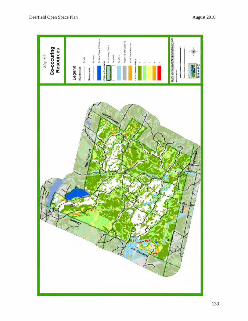
Deerfield Open Space Plan August 2010
133

Deerfield Open Space Plan August 2010
134

Deerfield Open Space Plan August 2010
135

Deerfield Open Space Plan August 2010
136
BIBLIOGRAPHY
Auger, Phil and Jeanie McIntyre. Natural Resources: An Inventory Guide for NH Communities. Prepared by the Upper Valley Land Trust and University of New Hampshire Cooperative Extension. July 1992. Brentwood Open Space Task Force. Does Open Space Pay in Brentwood? Part I: Housing Growth and Taxes. May 2002. Center for Land Conservation Assistance. Conserving Your Land. 2004. Center for Rural Pennsylvania. “Rural Is. . . A New Definition.” March/April 2003 Newsletter. Chase, Vicki, Audubon Society of New Hampshire, L. Deming, Audubon Society of New Hampshire, and F. Latawiec, N.H. Office of State Planning. Buffers for Wetlands and Surface Waters: A Guidebook for New Hampshire Municipalities. 1997. City of Concord, NH Conservation Commission and Planning Board. Open Space Master Plan Year 2010. 1993. Diehl, Janet and T.S. Barrett. The Conservation Easement Handbook. 1988. Dyke, Carter van, Carter van Dyke Associates, Inc. Delaware Township Open Space Preservation and Recreation Master Plan Components. 1998. Exeter River Local Advisory Committee. Exeter River Corridor and Watershed Management Plan. 1999. Federal Emergency Management Agency (FEMA). Flood Insurance Study, Town of Hooksett, New Hampshire. 1990. Garvin, Alexander. Parks, Recreation and Open Space: A Twenty-First Century Agenda. American Planning Association, Planning Advisory Service, Report Number 497/498. December 2000. Geoghegan, Jacqueline. 2002. “The value of open space in residential land use.” Land Use Policy 19: 91-98. Geoghegan, J, L.A. Wainger, and N.E. Bockstael. 1997. “Spatial landscape indices in a hedonic framework: an ecological economics analysis using GIS.” Ecological Economies 23 (3): 251-264. Hobden, David W., G.E. Laughton, and K.E. Morgan. 2004. “Green space borders—a tangible benefit? Evidence from four neighborhoods in Surrey, British Columbia, 1980-2001.” Land Use Policy 21 (2): 129-138. International City/County Management Association. Why Smart Growth: A Primer. Washington, D.C., 1998.

Deerfield Open Space Plan August 2010
137
Kline, Elizabeth. Protecting Open Space: A Guide to Selected Protection Techniques. 1975. Land Trust Alliance. Conservation Options: A Landowner’s Guide. 1999. Master Plan for the Town of Chester. May 1986. Master Plan for the Town of Chester, March 1997. McClure, Jan W. Land Protection for New Hampshire Communities & Organizations. 1984. McClure, Jan W. Land Protection & the Tax Advantages for New Hampshire Landowners. 1984. Michigan Land Institute. “Economic Consequences of Sprawl.” Follow the Money. January 2005. New Hampshire Coalition of Sustaining Agriculture. Preserving Rural Character Through Agriculture: A Resource Kit for Planners. 2000. New Hampshire Fish and Game Department and New Hampshire Office of State Planning, under a grant from the US EPA. Identifying and Protecting New Hampshire’s Significant Wildlife Habitat: A Guide for Towns and Conservation Groups. 2001. New Hampshire Office of State Planning. New Hampshire Outdoors 1994-1999. State Comprehensive Outdoor Recreation Plan (SCORP). January 1996. New Hampshire Office of State Planning. New Hampshire Planning and Land Use Regulations. 2002-2003 Edition. 2003. New Hampshire State Conservation Committee. Riparian Conservation: A Professional’s Practical Guide to Financial Assistance and Program Support. March 2001. New Hampshire Municipal Association. Conservation Easements and Other Land Protection Techniques. August 1994. Nixon, Hilary and Jean-Daniel Saphores. 2003. Impacts of Motor Vehicle Operation on Water Quality: A Preliminary Assessment. School of Civil and Environmental Engineering, University of California, Irvine. Accessed on www.uctc.net. North Country and Southern NH Resource Conservation and Development Councils. Planning for the Future of New Hampshire’s Forest: A Forest Resource Planning Guide. 2001. O’Neill, David J. The Smart Growth Tool Kit and PKF Consulting, Analysis of Economic Impacts of the Northern Central Rail Trail. Annapolis, Maryland, 1994. Report prepared for the Maryland Greenways Commission, Maryland Department of Natural Resources. Society for the Protection of New Hampshire Forests. New Hampshire’s Vanishing Forests: Conversion, Fragmentation and Parcelization of Forests in the Granite State. April 2001.

Deerfield Open Space Plan August 2010
138
Southern New Hampshire Planning Commission. Sprawl and Smart Growth in Southern New Hampshire Communities. June 2002. Southern New Hampshire Planning Commission. Land Use Plan 2015. January, 1999. Southern New Hampshire Planning Commission. Natural and Cultural Resources Inventory. June 1998. Southern New Hampshire Planning Commission. Sprawl and Smart Growth Choices for Southern New Hampshire Communities. June 2002. Sundquist, Dan, Society for the Protection of New Hampshire Forests and M. Stevens, New Hampshire Chapter of the Nature Conservancy. New Hampshire’s Changing Landscape. October 1999. Taylor, Dorothy Tripp. Open Space for New Hampshire: A Toolbook of Techniques for the New Millennium. 2000. The Brookings Institution Center on Urban and Metropolitan Policy. Open Space Protection: Conservation Meets Growth Management. April 2002. The Trust for Public Land. Managing Growth: The Impact of Conservation and Development on Property Taxes in New Hampshire. 2005. Accessed on http://www.tpl.org/content_documents/nh_managing_growth_report.pdf. Town of Deerfield. “A Brief History of Deerfield.” Deerfield Official Website. Accessed at Hwww.ci.deerfield-nh.us/townhistory.htmH. University of Connecticut, College of Agriculture and Natural Resources, UConn. Cooperative Extension System. Municipal Open Space: How to Identify it, How to Characterize it, How to Prioritize it, How to Acquire it, and How to Fund it. 2000. University of New Hampshire Cooperative Extension. Wildlife Habitats. Fall 1996. United States Census Bureau. Demographic figures, 1950-2005. Access on www.census.gov.