town of medway, massachusetts planning board rules and
TRANSCRIPT

Town of Medway, Massachusetts Planning Board Rules and Regulations Chapter 100 – Land Subdivision (Adopted under the Subdivision Control Law, Chapter 41, M.G.L., Section 81K – 81GG Inclusive) Rules and Regulations for the Review and Approval of Land Subdivisions
Medway Planning Board Daniel J. Hooper, Chairman Matthew J. Hayes, P.E., Vice-Chairman Alan DeToma, Clerk Karyl Spiller-Walsh Eric Alexander 155 Village Street Medway, MA 02053 508-533-3291 townofmedway.org
Adopted - April 26, 2005
TOWN OF MEDWAY, MASSACHUSETTS Planning Board Rules and Regulations
Chapter 100 – Rules and Regulations for the Review and Approval of Land Subdivisions
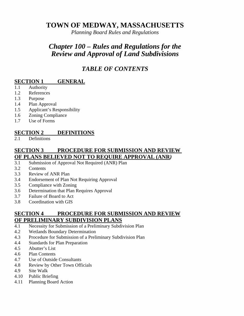
TABLE OF CONTENTS
SECTION 1 GENERAL 1.1 Authority 1.2 References 1.3 Purpose 1.4 Plan Approval 1.5 Applicant’s Responsibility 1.6 Zoning Compliance 1.7 Use of Forms SECTION 2 DEFINITIONS 2.1 Definitions SECTION 3 PROCEDURE FOR SUBMISSION AND REVIEW OF PLANS BELIEVED NOT TO REQUIRE APPROVAL (ANR) 3.1 Submission of Approval Not Required (ANR) Plan 3.2 Contents 3.3 Review of ANR Plan 3.4 Endorsement of Plan Not Requiring Approval 3.5 Compliance with Zoning 3.6 Determination that Plan Requires Approval 3.7 Failure of Board to Act 3.8 Coordination with GIS SECTION 4 PROCEDURE FOR SUBMISSION AND REVIEW OF PRELIMINARY SUBDIVISION PLANS 4.1 Necessity for Submission of a Preliminary Subdivision Plan 4.2 Wetlands Boundary Determination 4.3 Procedure for Submission of a Preliminary Subdivision Plan 4.4 Standards for Plan Preparation 4.5 Abutter’s List 4.6 Plan Contents 4.7 Use of Outside Consultants 4.8 Review by Other Town Officials 4.9 Site Walk 4.10 Public Briefing 4.11 Planning Board Action
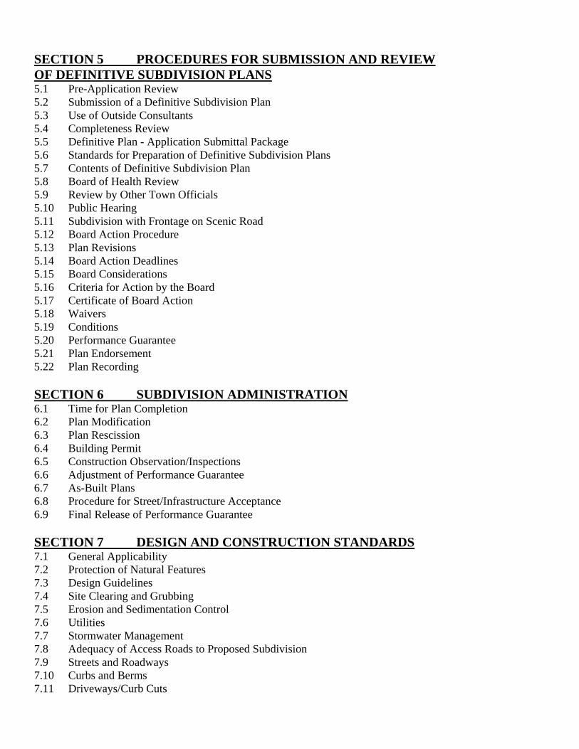
SECTION 5 PROCEDURES FOR SUBMISSION AND REVIEW OF DEFINITIVE SUBDIVISION PLANS 5.1 Pre-Application Review 5.2 Submission of a Definitive Subdivision Plan 5.3 Use of Outside Consultants 5.4 Completeness Review 5.5 Definitive Plan - Application Submittal Package 5.6 Standards for Preparation of Definitive Subdivision Plans 5.7 Contents of Definitive Subdivision Plan 5.8 Board of Health Review 5.9 Review by Other Town Officials 5.10 Public Hearing 5.11 Subdivision with Frontage on Scenic Road 5.12 Board Action Procedure 5.13 Plan Revisions 5.14 Board Action Deadlines 5.15 Board Considerations 5.16 Criteria for Action by the Board 5.17 Certificate of Board Action 5.18 Waivers 5.19 Conditions 5.20 Performance Guarantee 5.21 Plan Endorsement 5.22 Plan Recording SECTION 6 SUBDIVISION ADMINISTRATION 6.1 Time for Plan Completion 6.2 Plan Modification 6.3 Plan Rescission 6.4 Building Permit 6.5 Construction Observation/Inspections 6.6 Adjustment of Performance Guarantee 6.7 As-Built Plans 6.8 Procedure for Street/Infrastructure Acceptance 6.9 Final Release of Performance Guarantee SECTION 7 DESIGN AND CONSTRUCTION STANDARDS 7.1 General Applicability 7.2 Protection of Natural Features 7.3 Design Guidelines 7.4 Site Clearing and Grubbing 7.5 Erosion and Sedimentation Control 7.6 Utilities 7.7 Stormwater Management 7.8 Adequacy of Access Roads to Proposed Subdivision 7.9 Streets and Roadways 7.10 Curbs and Berms 7.11 Driveways/Curb Cuts

7.12 Stone Walls 7.13 Sidewalks 7.14 Embankments/Slopes/Retaining Walls 7.15 Temporary and Permanent Pavement Patching 7.16 Guardrails 7.17 Fire Prevention and Protection Measures 7.18 Loam and Seed 7.19 Trees and Slope Stabilization 7.20 Street and Traffic Control Signs and Street Names 7.21 Streetlights 7.22 Walkways and Bikeways 7.23 Open Space 7.24 Easements 7.25 Monuments and Bounds 7.26 Site Clean Up 7.27 Maintenance of Subdivision Improvements 7.28 Construction Schedule SECTION 8 ADMINISTRATION 8.1 Fees and Costs 8.2 Payment 8.3 Special Accounts 8.4 Administrative Appeal of Consultant Selection 8.5 Appeals 8.4 Validity
APPENDIX FORMS FORM A Application for Endorsement of Plan Believed Not to Require Subdivision Approval (ANR) FORM B Application for Approval of a Preliminary Subdivision Plan FORM C Application for Approval of a Definitive Subdivision Plan FORM D Designer’s Certificate FORM E Certified List of Abutters & Owners Within 300’ FORM F Development Impact Report FORM G Restrictive Covenant FORM H Bond Agreement – Deposit of Money FORM I Partial Release of Restrictive Covenant FORM J Grant of Utility and/or Drainage Easement FORM K Grant of Trail Easement FORM L Quitclaim Deed - Conveyance of Open Space and/or Drainage Parcel FORM M Quitclaim Deed - Conveyance of Road FORM N Certificate of Completion and Final Release of Subdivision Performance Guarantee
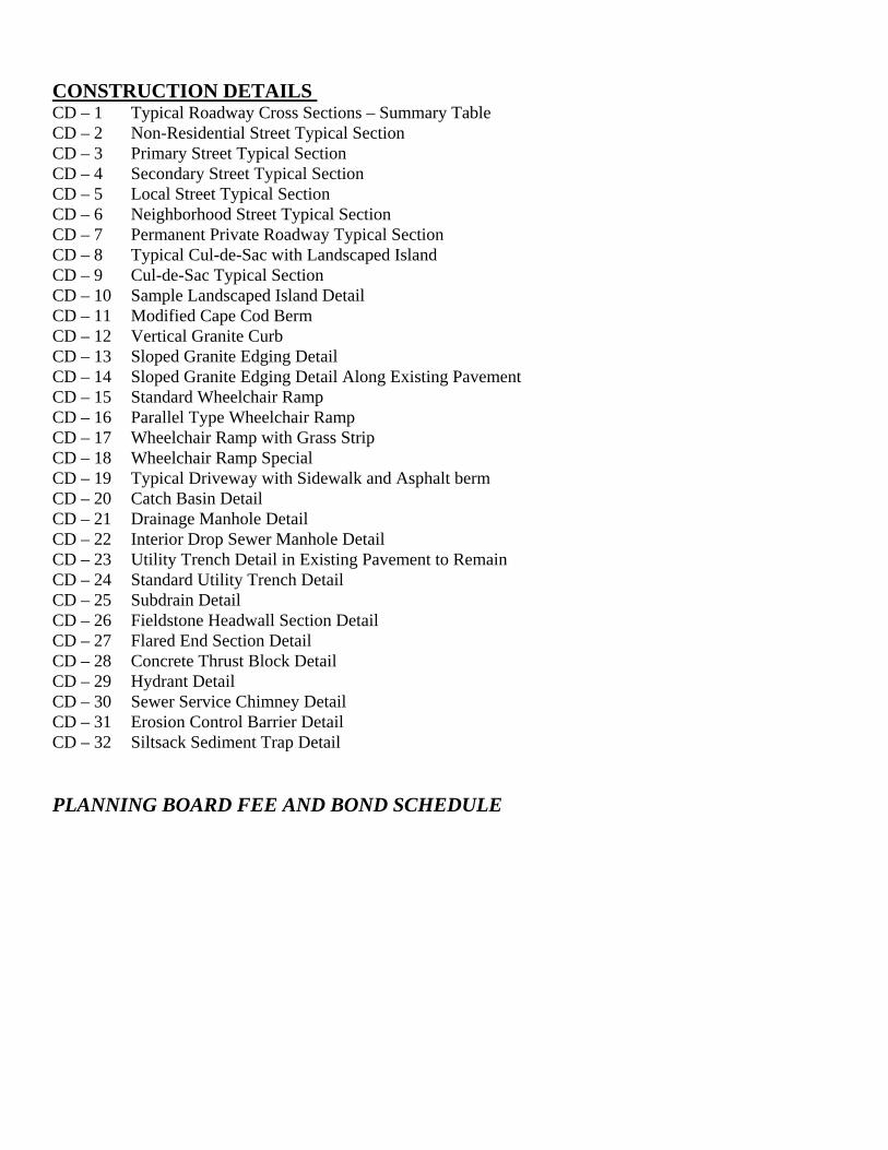
CONSTRUCTION DETAILS CD – 1 Typical Roadway Cross Sections – Summary Table CD – 2 Non-Residential Street Typical Section CD – 3 Primary Street Typical Section CD – 4 Secondary Street Typical Section CD – 5 Local Street Typical Section CD – 6 Neighborhood Street Typical Section CD – 7 Permanent Private Roadway Typical Section CD – 8 Typical Cul-de-Sac with Landscaped Island CD – 9 Cul-de-Sac Typical Section CD – 10 Sample Landscaped Island Detail CD – 11 Modified Cape Cod Berm CD – 12 Vertical Granite Curb CD – 13 Sloped Granite Edging Detail CD – 14 Sloped Granite Edging Detail Along Existing Pavement CD – 15 Standard Wheelchair Ramp CD – 16 Parallel Type Wheelchair Ramp CD – 17 Wheelchair Ramp with Grass Strip CD – 18 Wheelchair Ramp Special CD – 19 Typical Driveway with Sidewalk and Asphalt berm CD – 20 Catch Basin Detail CD – 21 Drainage Manhole Detail CD – 22 Interior Drop Sewer Manhole Detail CD – 23 Utility Trench Detail in Existing Pavement to Remain CD – 24 Standard Utility Trench Detail CD – 25 Subdrain Detail CD – 26 Fieldstone Headwall Section Detail CD – 27 Flared End Section Detail CD – 28 Concrete Thrust Block Detail CD – 29 Hydrant Detail CD – 30 Sewer Service Chimney Detail CD – 31 Erosion Control Barrier Detail CD – 32 Siltsack Sediment Trap Detail
PLANNING BOARD FEE AND BOND SCHEDULE

Town of Medway, Massachusetts Planning Board Rules and Regulations Chapter 100 – Subdivision (Adopted Under the Subdivision Control Law, Chapter 41, M.G.L., Sections 81-K to 81-GG Inclusive) Rules & Regulations for the Review and Approval of Land Subdivisions
SECTION 1.0 GENERAL 1.1 AUTHORITY - Under the authority vested in the Planning Board of the Town of Medway by Section 81-Q of Chapter 41 of Massachusetts General Laws (M.G.L.) as amended, the Subdivision Control Law, said Board hereby promulgates and adopts these Rules and Regulations governing the subdivision of land in the Town of Medway. The Board shall be responsible for administering these Rules and Regulations and from time to time, may propose amendments thereto. The Board may assign the appropriate town agencies, officials or outside consultants to serve as its Agents. 1.2 REFERENCES - The attention of all Applicants submitting a plan for approval under these Rules and Regulations is also directed to the provisions of the Wetland Protection Act (Chapter 131, Section 40, M.G.L.), Massachusetts Department of Environmental Protection (DEP) Stormwater Management Policy requirements, Stormwater Pollution Prevention Plan (SWPPP), all of the Massachusetts General Laws, MEPA requirements, NPDES permit requirements, Mass Highway standards, all requirements of the federal Americans with Disabilities Act (ADA) and Massachusetts Architectural Access Board (AAB) and applicable Medway bylaws and regulations of the Conservation Commission, Board of Health, Board of Water/Sewer Commissioners and Department of Public Services. Compliance with the requirements of the aforementioned provisions may necessitate major or minor changes/modifications in any subdivision plan submitted to the Board. For matters not covered by these Rules and Regulations, reference is made to the provisions of M.G.L., Chapter 41, Sections 81-K through 81-GG, inclusive. 1.3 PURPOSE - These Rules and Regulations are enacted for the purpose of protecting the safety, convenience, and welfare of the inhabitants of Medway by regulating the laying out and construction of ways in subdivisions, and in proper cases, providing access to the lots therein, but which have not become public ways, ensuring sanitary conditions in subdivisions, and providing parks and open areas. The powers of the Board and of the Board of Appeal under the Subdivision Control Law shall be exercised with due regard for the provision of adequate access to all lots in a subdivision by ways that will be safe and convenient for travel; for lessening congestion in such ways and in the adjacent public ways; for reducing danger to life and limb in the operation of motor vehicles; for securing safety in the case of fire, flood, panic and other emergencies; for ensuring compliance with the applicable local zoning ordinances or by-laws; for securing adequate provision for water distribution, sewerage, drainage, underground utility services, and flood control; for protecting wetlands and natural water
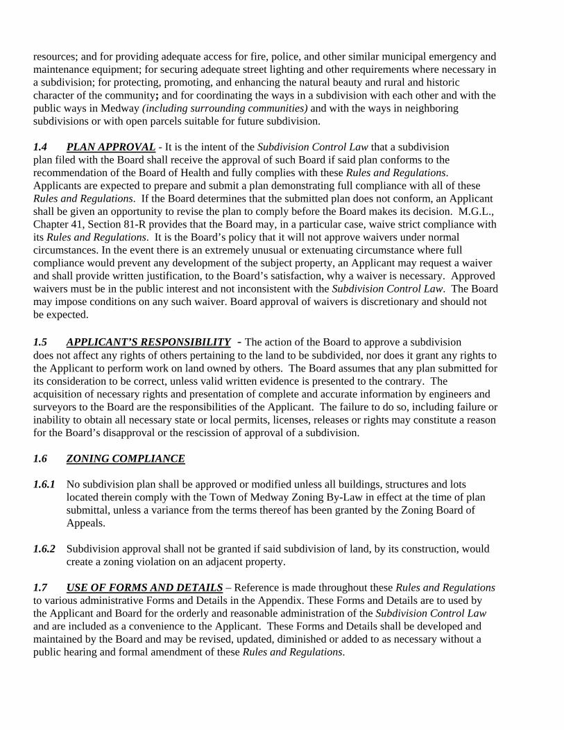
resources; and for providing adequate access for fire, police, and other similar municipal emergency and maintenance equipment; for securing adequate street lighting and other requirements where necessary in a subdivision; for protecting, promoting, and enhancing the natural beauty and rural and historic character of the community; and for coordinating the ways in a subdivision with each other and with the public ways in Medway (including surrounding communities) and with the ways in neighboring subdivisions or with open parcels suitable for future subdivision. 1.4 PLAN APPROVAL - It is the intent of the Subdivision Control Law that a subdivision plan filed with the Board shall receive the approval of such Board if said plan conforms to the recommendation of the Board of Health and fully complies with these Rules and Regulations. Applicants are expected to prepare and submit a plan demonstrating full compliance with all of these Rules and Regulations. If the Board determines that the submitted plan does not conform, an Applicant shall be given an opportunity to revise the plan to comply before the Board makes its decision. M.G.L., Chapter 41, Section 81-R provides that the Board may, in a particular case, waive strict compliance with its Rules and Regulations. It is the Board’s policy that it will not approve waivers under normal circumstances. In the event there is an extremely unusual or extenuating circumstance where full compliance would prevent any development of the subject property, an Applicant may request a waiver and shall provide written justification, to the Board’s satisfaction, why a waiver is necessary. Approved waivers must be in the public interest and not inconsistent with the Subdivision Control Law. The Board may impose conditions on any such waiver. Board approval of waivers is discretionary and should not be expected. 1.5 APPLICANT’S RESPONSIBILITY - The action of the Board to approve a subdivision does not affect any rights of others pertaining to the land to be subdivided, nor does it grant any rights to the Applicant to perform work on land owned by others. The Board assumes that any plan submitted for its consideration to be correct, unless valid written evidence is presented to the contrary. The acquisition of necessary rights and presentation of complete and accurate information by engineers and surveyors to the Board are the responsibilities of the Applicant. The failure to do so, including failure or inability to obtain all necessary state or local permits, licenses, releases or rights may constitute a reason for the Board’s disapproval or the rescission of approval of a subdivision. 1.6 ZONING COMPLIANCE 1.6.1 No subdivision plan shall be approved or modified unless all buildings, structures and lots
located therein comply with the Town of Medway Zoning By-Law in effect at the time of plan submittal, unless a variance from the terms thereof has been granted by the Zoning Board of Appeals.
1.6.2 Subdivision approval shall not be granted if said subdivision of land, by its construction, would
create a zoning violation on an adjacent property. 1.7 USE OF FORMS AND DETAILS – Reference is made throughout these Rules and Regulations to various administrative Forms and Details in the Appendix. These Forms and Details are to used by the Applicant and Board for the orderly and reasonable administration of the Subdivision Control Law and are included as a convenience to the Applicant. These Forms and Details shall be developed and maintained by the Board and may be revised, updated, diminished or added to as necessary without a public hearing and formal amendment of these Rules and Regulations.

SECTION 2.0 DEFINITIONS For the purposes of these Rules and Regulations, the following terms shall have the meaning herein under assigned to them: AASHTO: American Association of State Highway and Transportation Officials ABUTTER: Owners of land directly adjacent to property lines of the Applicant and owners of land directly opposite on any public or private street or way, as they appear on the most recent applicable tax list, notwithstanding that the land of any such owner is located in another city or town, the Planning Board of the city or town, and the Planning Board of every abutting city or town. APPLICANT: One who applies for the approval of a plan of a subdivision or plan believed not to require approval. "Applicant" refers to "an owner or his agent or representative, or his assigns". (Section 81-L of Chapter 41, M.G.L) BASE FLOOD ELEVATION: The "Base Flood Elevation" shall be the level of flooding having a one percent chance of being equaled or exceeded in any give year, as designated on Federal Insurance Administration (FIA) maps (100 yr. flood elevation), or, in the absence of such designation, to be determined by the Board based upon the best available information regarding flood hazards, including any available United States Geologic Survey, Soil Conservation Service, and Corps of Engineers studies. BEST MANAGEMENT PRACTICE (BMP): Structural device, measure, facility or activity that helps to achieve stormwater management control objectives at a designated site. BOARD: The Planning Board of the Town of Medway. BOARD AGENT: Individual(s) authorized by the Board to review plans, observe/inspect construction, and administer the Rules and Regulations. CERTIFIED BY: Certified by (or endorsed by) the Board, as applied to a plan or other instrument required or authorized by the Subdivision Control Law to be recorded, shall mean bearing a certification or endorsement signed by a majority of the members of the Board, or by its chairman or clerk or any other person authorized by it to certify or endorse its approval or other action and named in a written statement to the Register of Deeds and Recorder of the Land Court, signed by a majority of the Board. (Sec. 81-L of Chapter 41, M.G.L.) CUL-DE-SAC: A dead end street culminating in a circular turnaround. DESIGN SPEED: A selected speed used to determine the various geometric design features of the roadway. The assumed design speed should be a logical one with respect to the topography, anticipated operating speed, the adjacent land use and the functional classification of the roadway. DESIGNER: A person licensed as a Professional Civil Engineer or registered to practice civil engineering in the Commonwealth of Massachusetts.

DETENTION: Temporary storage of storm runoff in a stormwater management practice with the goals of controlling peak discharge rates and providing gravity settling of pollutants. DETENTION FACILITY: A detention basin or alternative structure designed for the purpose of temporary storage of stream flow or surface runoff and gradual release of stored water at controlled rates. DEVELOPER: A person, persons, corporation, trust, firm or partnership or other legal entity who will be responsible for the development of land and/or structure(s). DEVELOPMENT IMPACT REPORT (DIR) –The DIR is intended to serve as a guide to the applicant in formulating their development proposal, as well as a guide to the Board in evaluating the Subdivision Plan. The DIR shall identify and assess development impacts, which could possibly be avoided or mitigated if recognized early in the development process. The DIR shall clearly and methodically assess the relationship of the proposed development to the natural, physical, and social environment of the surrounding area. (See Appendix for DIR – Form F) EASEMENT: A grant by a property owner to the use of land by the public, a corporation, or persons for specific purposes such as the construction of utilities, drainage ways and roadways. ENGINEER: A person registered or legally permitted to practice professional civil engineering in the Commonwealth of Massachusetts. FRONTAGE: The boundary of a lot coinciding with a street line providing rights of access across that boundary to a potential building site, measured continuously along one street line between side lot lines, or in the case of a corner lot, from the side lot line to the midpoint of the arc that constitutes the corner rounding at the intersection of the two streets or ways. INFILTRATION: The process by percolating stormwater into the subsoil. INFILTRATION FACILITY: Any structure or device designed to infiltrate retained water to the subsurface. These facilities may be above grade or below grade. ITE: Institute of Transportation Engineers. LAND SURVEYOR: A person registered or legally permitted to practice Land Surveying in the Commonwealth of Massachusetts. LOT: An area of land in one ownership with definite boundaries that is used, or available for use, as the site of one (1) or more buildings. MUNICIPAL SERVICES: Fire and police services and public utilities furnished by the Town of Medway such as sanitary sewers, fire alarms, stormwater drains and water mains and their appurtenances, street lights which may become the property or responsibility of the Town and other such utilities as gas pipes, electrical lines, telephone lines, TV cable and other similar service installations and their appurtenances. OWNER: The person holding the ultimate fee simple title to a parcel, tract or lot of land, as shown by the record in the Land Registration Office, Registry of Deeds or Registry of Probate.
PARTIES OF INTEREST: Parties of interest shall mean the Applicant, petitioner, abutters, owners of land directly opposite on any public or private street or way, and abutters to the abutters within three hundred feet (300’) of the property line of the petitioner, as they appear on the most recent applicable tax list, notwithstanding that the land of any such owner is located in another city or town, the Planning Board of the city or town, and the Planning Board of every abutting city or town. PATH: A cleared way for pedestrians and/or bicycles that may or may not be paved or otherwise improved. PERMANENT PRIVATE WAY: A privately owned roadway, intended to remain such in perpetuity and not to be accepted as a public way by the Town of Medway. PROFILE: A vertical section of a street along its centerline, showing existing and proposed grades, storm drainage and sanitary sewer facilities. RECORDED: Recorded in the Registry of Deeds of Norfolk County or the Recorder of the Land Court. RIGHT-OF-WAY/ROADWAY LAYOUT: Public or privately owned land designated for roadway and access purposes. The roadway layout includes the paved or unpaved traveled roadway and all related infrastructure including but not limited to curbing, sidewalks, utilities and drainage structures. ROADWAY: The improved portion of a street right-of-way intended for vehicular travel. SCENIC ROAD: A road designated by the Town under the provisions of M.G.L, Chapter 40, Section 15C, the Scenic Roads Act. SIDEWALK: A paved, surfaced or leveled area within the right-of-way, generally parallel and separated from the street, designed for use by pedestrians. STORMWATER MANAGEMENT: The use of structural or non-structural practices that are designed to reduce storm water runoff pollutant loads, discharge volumes, peak flow discharge rates and detrimental changes in stream temperature that affect water quality and habitat. STREET or WAY: A strip of land dedicated to use as a public thoroughfare, including a public way laid out and accepted by a public authority or which the Town Clerk certifies is used and maintained as a public way, or a way laid out on a Definitive Subdivision Plan theretofore approved and endorsed under the Subdivision Control Law, or a way already in existence on the ground when the Subdivision Control Law became effective in Medway and having, in the opinion of the Board, adequate width, construction, and grades for the needs of the existing and future buildings and uses abutting thereon or to be served thereby. STREET, DEAD-END: Any street, or group of connected streets, which has only one means of egress and access with a through street. STREET, LOCAL: A public street, which in the opinion of the Board, is currently being used or will be used primarily to provide access to six (6) or more abutting residential dwelling units and which will not be used for through traffic. Estimated traffic volume shall be less than four-hundred (400) vehicles

per day. In residential areas, volume per day shall be computed at the rate of ten (10) trips per family dwelling per day, or as defined in the most current ITE standards. STREET, NEIGHBORHOOD: A public street which, in the opinion of the Board, is currently being used, or will be used primarily to provide access to five (5) or less abutting residential dwelling units and which will not be used for through traffic. STREET, PRIMARY: A public street which, in the opinion of the Board, is currently being used, or may potentially be used as a thoroughfare within the Town of Medway and which will otherwise carry a volume of traffic over fifteen hundred (1,500) vehicles per day or as defined in the most current ITE standards. Also, any street that connects two (2) existing primary streets. STREET, SECONDARY: A public street collecting traffic from one (1) or more local or neighborhood streets which, in the opinion of the Board, is used or will be used to carry a volume of traffic of over four hundred (400) vehicles per day, but not in excess of fifteen hundred (1,500) vehicles per day, from such local or neighborhood street(s) to a primary street or community facility; a principal entrance street to a shopping center, industrial park, planned-unit development, large subdivisions or group of subdivisions; and any principal circulation street within a subdivision.. In residential areas, volume per day shall be computed at the rate of ten (10) trips per family dwelling per day, or as defined in the most current ITE standards. STREET, THROUGH: A street which provides at least two (2) means of egress and access. At least one means of the egress and access must be from another through street. SUBDIVISION: "Subdivision" shall mean the division of a tract of land into two (2) or more lots and shall include re-subdivision, and, when appropriate to the context, shall relate to the process of subdivision of the land or territory subdivided; provided, however, that the division of a tract of land into two (2) or more lots shall not be deemed to constitute a “subdivision” within the meaning of the Subdivision Control Law if, at the time when it is made, every lot within the tract so divided has the required frontage on:
A. on a public way or a way which the Town Clerk certifies is maintained and used as a public way, or
B. on a way shown on a Definitive Subdivision Plan theretofore approved and endorsed in
accordance with the Subdivision Control Law, or C. on a way in existence when the Subdivision Control Law became effective in the Town of
Medway (1952), having, in the opinion of the Board, sufficient width, suitable grades, and adequate construction to provide for the needs of vehicular traffic in relation to the proposed use of the land abutting thereon or thereby, and for the installation of municipal services to serve such land and the buildings erected or to be erected thereon. Such frontage shall be at least the minimum length that is then required by the Medway Zoning By-Law, for erection of a building on such lot within that particular zoning district.
Conveyances or other instruments adding to, taking away from, or changing the size and shape of lots in such a manner as not to leave any lot so affected without the required frontage as set forth above in A-C, or the division of a tract of land on which two (2) more buildings were standing when the Subdivision Control Law into effect in Medway into separate lots on each of which one
(1) such building remains standing, shall not constitute a “subdivision.” (Per Section 81-L of Chapter 41, M.G.L.) SUBDIVISION CONTROL: "Subdivision Control" shall mean power of the subdivision of land granted to the Town of Medway by the Subdivision Control Law, Chapter 41, Sections 81-L through 81-GG inclusive, as hereinafter amended within these Rules and Regulations. SWALE (or DITCH): A manmade defined channel in the earth with distinct side slopes used to convey collected stormwater runoff to a formal drainage system. TERRACE: A raised flat mound of earth with sloping sides. UTILITIES, PRIVATE: Telephones, cable television, internet access, electric light and power, and gas lines whether installed on, above or beneath the surface of the ground. WETLANDS: As defined in M.G.L, Chapter 131, Section 40, its regulations (310 CMR 10.0), and the Town of Medway General Bylaws, Article XXI – General Wetlands Protection. SECTION 3.0 PROCEDURE FOR SUBMISSION AND REVIEW OF PLANS BELIEVED NOT TO REQUIRE APPROVAL (ANR) 3.1 SUBMISSION OF APPROVAL NOT REQUIRED (ANR) PLAN 3.1.1 Any person who wishes to cause a plan of land to be recorded in the Registry of Deeds or to be filed with the Land Court and who believes that the plan does not require approval under the Subdivision Control Law shall submit the following to the Board: a. seven (7) prints of the ANR Plan of Land;
b. One (1) original of a properly executed Form A – ANR Application; c. Project Explanation to describe what is to be accomplished by the ANR plan; and d. the appropriate ANR Filing Fee
The submittal shall be filed with the Board during regularly scheduled office hours at least five (5) full business days prior to the Board’s regularly scheduled meeting at which endorsement is requested. 3.1.2. Said person shall also file, by delivering in hand or by registered mail, a notice with the Town Clerk stating the date the ANR application was submitted to the Board accompanied by a copy of the plan and one (1) original Form A – ANR Application with a description of the land to which the plan relates sufficient for identification. 3.1.3 Any plan determined by the Board or its Agent to not completely satisfy this Section and Section 3.2 will be deemed not to have been submitted. Such plan will be returned to the Applicant and a notice of the Board’s determination sent to the Town Clerk. The ANR Filing Fee shall either be returned in part or retained to be applied to a resubmission at the Applicant’s option. When brought into conformity with the requirements of this Section and Section 3.2, such plan may be re-submitted and will be considered without prejudice.
3.2 CONTENTS Said plan shall be legibly drawn in accordance with the Rules and Regulations of the Registry of Deeds, Chapter 36, Section 13A as amended pertaining to plan size, material, ink, lettering and related requirements. The plan shall be drawn at a scale of forty feet (40') to the inch or such other scale as the Board may accept, and should contain the following: 3.2.1 Identification of the plan by name and address of owner(s) of record and location and address of the land in question; a locus map; the map and parcel numbers of Medway Assessors Maps on which the land is located; the scale, graphic scale, north point and date; and the name, address, signature, and stamp of the Registered Land Surveyor who has prepared the plan. 3.2.2 The Registry Block and the statement "Approval Under Subdivision Control Law Not Required", with sufficient space for the date and the signatures of all members of the Board in the upper right-hand corner of the plan. 3.2.3 All zoning classification(s) that apply including overlay districts, the location of any and all zoning district boundaries, and the applicable minimum lot area, front, side and rear yard depths as required by the Zoning By-Law. The calculation of the lot shape factor shall also be provided for each lot. 3.2.4 In the case of the creation of a new lot, the plan shall show the new lot in its entirety, the lot shape factor analysis, and remaining land area and frontage of the land in the ownership of the Applicant. The new lot lines and former lot lines shall be clearly marked and distinguished. The distance from a new lot line to any existing building/structure shall be indicated. 3.2.5 Notice of any decisions by the Zoning Board of Appeals, including but not limited to special permits, variances and exceptions, regarding the land or any buildings thereon. Also, the existence of any public or private restrictions of record shall be noted on the plan. This shall include, but not be limited to easements, rights-of-way, covenants, or any deed restrictions affecting the development of the land. 3.2.6 Names of abutters adjacent to the land and across adjoining ways as obtained from the most recent local tax list based upon inspection of the most current Assessors records. 3.2.7 Names and status of all public and private streets and ways shown on the plan. Medway Scenic Roads shall be indicated. 3.2.8 Bearings and distances of all lines of the lot or lots shown on the plan. 3.2.9 Location of all existing buildings, bounds, fences, walls, wells, septic tanks and sewage disposal systems on the subject lots and parcels and their relation/distance to the boundaries of new lot lines. 3.2.10 Locations of cart paths, easements, rights-of-way, wetlands, water courses and other significant natural features. 3.2.11 A statement indicating whether the subject property is classified as Chapter 61A or 61B land. 3.2.12 A statement in a block as follows: “Planning Board endorsement does not constitute a determination of compliance with the Medway Zoning By-Law.”

3.3 REVIEW OF ANR PLAN - The Board shall evaluate the ANR plan to determine if it shows a subdivision. The Board shall determine first, whether each and every lot shown on the plan has the minimum frontage required by the Medway Zoning By-Law on a suitable way (Section 3.3.1); and second whether vital, direct, practical, and traversable access exists from an abutting way to the buildable portion of the lot(s) (Section 3.3.2). 3.3.1 The lot(s) shown on an ANR plan must have the minimum frontage required by the Medway Zoning By-Law on one (1) of the following types of ways:
a) a public way; or b) a way certified by the Town Clerk as being used and maintained as a public way in accordance with a vote by Town Meeting; or c) a way shown on a previously approved Definitive Subdivision Plan where the way has been constructed in accordance with the conditions of the approved plan or acceptable security/performance guarantee has been provided to assure such construction, or
d) a way that was in existence on the ground and provided meaningful vehicular access prior to
1952 (when the Subdivision Control Law became effective in the Town of Medway). The Board shall also determine if the way presently has sufficient width, suitable grades, and adequate construction to provide for the practical needs of vehicular traffic in relation to the proposed uses of the land abutting thereon or served thereby and to provide for the installation of municipal services to serve such land and the buildings erected or to be erected thereon. To make such a determination, the Board shall consider the following minimum roadway standards, among others:
1. The roadway vertical alignment shall not exceed eight percent (8 %) and the horizontal and vertical alignment of the roadway shall provide a minimum two - hundred foot (200’) sight distance. 2. The traveled surface shall be at least eighteen feet (18’) wide and shall be adequate to
provide access to each lot by fire-fighting equipment, police and other emergency vehicles. Where the lot(s) shown on the ANR plan do not have the minimum frontage required by the Medway Zoning By-Law on one of the above ways, the Board shall not consider the lot as having sufficient frontage to allow a division of land without approval under the Subdivision Control Law. 3.3.2 The Board shall determine whether vital, direct, practical and traversable access to municipal services exists from the abutting way to the buildable portion of a lot. The access shall be safe and convenient for travel. Where access is illusory due to the existence of steep grades, or other physical barriers, constraints or impediments, the Board shall not consider the lot as having sufficient frontage to allow a division of land without approval under the Subdivision Control Law. 3.4 ENDORSEMENT OF PLAN NOT REQUIRING APPROVAL If the Board determines that the plan satisfies the provisions of Sections 3.1 and 3.2 and does not require subdivision approval, it shall without a public hearing and within twenty-one (21) days of submission, endorse the plan with the words, “Approval Under the Subdivision Control Law Not Required.” The Board may add to such endorsement a statement of the reason approval is not required and any other comments deemed
pertinent to the recording of this plan. The Board may find that some lots have sufficient frontage and thus do not necessitate subdivision approval while other parcel(s) do not meet the frontage requirements and may therefore be designated as “not a buildable lot” on the ANR plan. The endorsed original plan shall be returned to the Applicant. The Board shall provide written notification of its action to the Town Clerk, Board of Assessors, Inspector of Buildings and other boards or departments as may be appropriate. 3.5 COMPLIANCE WITH ZONING An endorsement by the Board of a plan not requiring subdivision approval does not address, nor in any way imply that the lots shown thereon conform to the Zoning By-Law or any other local or state regulations. Any proposed parcel that does not conform to zoning shall be designated on the plan as “not a buildable lot.” 3.6 DETERMINATION THAT PLAN REQUIRES APPROVAL If the Board determines that the properly submitted plan does require approval under the Subdivision Control Law, it shall, within twenty-one (21) days of submission of the plan, so inform the Applicant in writing and return the plan with its action of denial. The Board shall also notify the Town Clerk in writing of its action. 3.7 FAILURE OF BOARD TO ACT If the Board fails to act upon a properly submitted plan under this section and fails to notify the Town Clerk and the person submitting the plan of its action within twenty-one (21) days after its submission, it shall be deemed to have determined that approval under the Subdivision Control Law is not required, and the Board shall forthwith make such endorsement on said plan, and upon the failure of the Board to do so forthwith, the Town Clerk shall issue a certificate to the same effect. 3.8 COORDINATION WITH TOWN GEOGRAPHIC INFORMATION SYSTEM – The Applicant shall provide the Town with the approved ANR plan in CAD format using the layering and format criteria as specified by the Board of Assessors. The Town may charge a fee to the Applicant for the expense of inputting the ANR Plan into the Town’s GIS system. 4.0 PROCEDURES FOR SUBMISSION AND REVIEW OF PRELIMINARY SUBDIVISION PLANS 4.1 NECESSITY FOR SUBMISSION OF A PRELIMINARY SUBDIVISION PLAN A Preliminary Subdivision Plan shall be submitted to the Board for any proposed non-residential subdivision and may be submitted for any proposed residential subdivision, for review and discussion by the Board. The submission of a Preliminary Subdivision Plan will allow the Applicant, the Board, the Board of Health, the Conservation Commission, the Public Services Department, the Fire Department, the Police Department, other Town agencies, boards or committees and owners of property abutting the subdivision to consider and discuss issues and clarify the details of such subdivision before a Definitive Subdivision Plan is prepared. Therefore, it is strongly recommended that a Preliminary Subdivision Plan be filed in every case. 4.2 WETLANDS BOUNDARY DETERMINATION The Board strongly recommends the Applicant secure an Abbreviated Notice of Wetlands Area Delineation (ANRAD) from the Medway Conservation Commission before preparing and submitting a Preliminary Subdivision Plan. 4.3 PROCEDURE FOR SUBMISSION OF A PRELIMINARY SUBDIVISION PLAN
4.3.1 Any person who wishes to submit a Preliminary Subdivision Plan shall submit the following to the Board: a. a properly executed application Form B - Application for Approval of Preliminary Subdivision
Plan, b. sixteen (16) copies of the Preliminary Subdivision Plan
c. Form E – Certified Abutter’s List (See Section 4.5) d. Form F - Development Impact Report e. the appropriate Preliminary Subdivision Plan Filing Fee,
f. an advance of the Plan Review Fee pursuant to Section 8.1 of these Rules and Regulations The submittal shall be filed with the Board during regularly scheduled office hours or at a Planning Board meeting. 4.3.2 The Applicant shall file by delivery, in hand, or registered or certified mail, a notice with the Town Clerk stating the date the application was submitted to the Board accompanied by a copy of a properly executed application Form B, one (1) print of the Preliminary Subdivision Plan, and one (1) copy of the Development Impact Report. 4.3.3. The Applicant shall also submit one (1) copy of the application Form B and one (1) print of the Preliminary Subdivision Plan to the Board of Health for its review. 4.3.4 Any plan determined by the Board or its Agent to not completely satisfy Section 4.6 within fourteen (14) days of the Applicant’s written notice to the Town Clerk that such plan has been submitted to the Planning Board, will be deemed not to have been submitted. Such plan will be returned to the Applicant, and a notice of the Board's determination sent to the Town Clerk. The Preliminary Subdivision Plan Filing Fee shall either be returned in part or retained to be applied to a resubmission at the Applicant’s option. When brought into conformity with the requirements of Section 4.6, such plan may be re-submitted to the Board and will be considered without prejudice. 4.4. STANDARDS FOR PLAN PREPARATION - A Preliminary Subdivision Plan shall be prepared by a Professional Engineer and Professional Land Surveyor duly registered in the Commonwealth of Massachusetts and shall be legibly drawn in accordance with the Rules and Regulations of the Registry of Deeds pertaining to plan size, material, lettering and related requirements. 4.5 ABUTTER’S LIST - The Applicant shall prepare and provide, at the time of the application to the Board, a list of abutters and parties of interest as defined in these Rules and Regulations, certified by the Assessor, for properties located within three-hundred feet (300’) of the boundaries of the subject parcel, for the purpose of sending by first class mail notification of the meeting date and time when the Preliminary Subdivision Plan shall be considered by the Board. The Applicant shall be required to reimburse the Board for costs of said mailing on or prior to said meeting date. 4.6 PLAN CONTENTS To form a clear basis for discussion of the details of the subdivision prior to the preparation of a Definitive Subdivision Plan, the Preliminary Subdivision Plan shall contain the following: 4.6.1 The subdivision name, boundaries, north point, date, scale, legend and title "Preliminary Subdivision Plan".
4.6.2 The locus of the land shown on the plan at a scale of no smaller than 1” = 100’ with sufficient information to accurately locate the land, and adjacent land and all property lines and buildings within five hundred feet (500’) of the land. 4.6.3 The names and addresses of the record owner of the land and the Applicant and the name and address of the engineer and surveyor who made the plan, all of which shall appear in the lower right-hand corner. 4.6.4 The names of all abutters and parties of interest to the land, including those across adjoining ways, as determined from the Assessors most current listing, unless the Applicant shall have more recent knowledge of such abutters 4.6.5 The existing and proposed lines of streets, ways, easements and any public or common areas within the subdivision, in a general manner, drawn at a scale of forty (40) feet to the inch. 4.6.6 An Existing Conditions sheet which provides a mapped overview of significant existing features within the entire site including but not limited to stone walls, fences, monuments, buildings, free-standing structures, bridges, historic markers and locations of historically or archaeologically significant sites, single free-standing trees with a diameter of one foot (1’) or greater at twenty-four inches (24”) above grade, significant group tree masses, wooded areas, ledge/rock outcroppings, large boulders, cliffs, high points, hilltops and ridges, major long views, abutting permanent open space, clearly defined trails, swamps, wetlands, water bodies and natural waterways including streams and ponds, natural drainage courses, drainage ditches, and 100 year Flood Zones. 4.6.7 The existing and proposed system of sewage disposal, water distribution and storm drainage, and on-site as well as adjacent (within 500 feet of the subdivision) existing natural waterways in a general manner. 4.6.8 The approximate boundary lines of proposed lots, with approximate areas and dimensions, as well as calculations for upland area and lot shape factors. 4.6.9 The names, approximate locations and widths of adjacent streets, or streets approaching or within reasonable proximity of the subdivision, but in no case less than five hundred feet (500’) of the subdivision. 4.6.10 Existing and proposed topography at two foot (2’) contour intervals, unless it is determined by the Board that another interval is required to sufficiently show the grading with datum reference to U.S.C. & G.S benchmarks. 4.6.11 The anticipated name(s) of the proposed streets, (NOTE: Street names(s) shall be approved by the Street Naming Committee of the Town of Medway) and a number on each lot on each proposed street. 4.6.12 The wetland boundaries and adjacent upland resource areas including 100-foot buffer zones and 200-foot riverfront offsets, as defined by M.G.L. Chapter 131, Section 40 (the Wetlands Protection Act) as evidenced by an ANRAD determination from the Medway Conservation Commission
4.6.13 Boundary and area of adjoining land, if any, of the Applicant and the owner, not presently being subdivided and a plan, showing in a general manner, the proposed overall development of all of said land. 4.6.14 The zoning classification(s) of land shown on the plan and the location of any zoning district boundaries, as well as flood plain boundaries 4.6.15 Areas of proposed cuts and fills in excess of eight feet (8’) and disturbance to slopes of twenty-five percent (25%) or more. 4.7 USE OF OUTSIDE CONSULTANTS – Upon receipt of a Preliminary Subdivision Plan application but before acceptance of it as a complete application, the Board may submit the plan to an independent, outside consultant(s) to determine if the Applicant has satisfied all submission requirements and to prepare an itemized budget estimate for the review of the Preliminary Subdivision Plan. At its next regularly scheduled meeting, the Board will either accept the application and set a Plan Review Fee based on the outside consultant’s estimate or determine that the application is incomplete and vote to return it to the Applicant. 4.8 REVIEW BY OTHER TOWN OFFICIALS 4.8.1 Upon receipt of an application, the Board shall transmit one (1) copy of the Preliminary Subdivision Plan to the Department of Public Services, Board of Health, Conservation Commission, Fire Department, Inspector of Buildings, Police Department, Water/Sewer Board and other town boards or agencies as the Board determines may be helpful in reviewing the application. 4.8.2 The Board may convene a meeting of various Town boards/departments/committees to assist in project review and to help applicants better understand the permitting procedures of other Town agencies. 4.9 SITE WALK – At its discretion, the Planning Board may conduct a site walk to become more familiar with the land, its topography and site characteristics. 4.10 PUBLIC BRIEFING – To ensure that all abutters and parties in interest have the opportunity to discuss any potential problems that may arise through the development of the proposed subdivision, the Board shall hold a briefing on the proposed Preliminary Subdivision Plan during a regularly scheduled Board meeting. The Board shall send, by first class mail, a notice of the time and place of the briefing and of the subject matter to be discussed sufficient for identification, to all abutters and parties in interest. 4.11 PLANNING BOARD ACTION 4.11.1 The Board or its designee shall ensure the completeness of the Preliminary Subdivision Plan application. Applicants are advised that failure to submit or provide any required item shall be deemed a deficiency and the Board may act to disapprove the application based on its technical deficiencies. The Board shall determine if the plan satisfies the provisions of Section 4.6 and shall act on such Preliminary Subdivision Plan within forty-five (45) days after the date of the proper submission, with or without modification or recommended revisions. The action of the Board in respect to a Preliminary Subdivision Plan shall be by vote of a simple majority of the Board, which shall be represented by its written Certificate of Action, copies of which shall be filed with the Town Clerk and sent to the
Applicant. If the Board conditions, modifies, or disapproves the Preliminary Subdivision Plan, it shall state its reasons in its Certificate of Action. Approval of a Preliminary Subdivision Plan does not constitute approval of the subdivision but facilitates the Applicant’s preparation of the Definitive Subdivision Plan. In the event of disapproval, the Board shall state the reasons for its disapproval in accordance with M.G.L. Section 81-S of Chapter 41. 4.11.2 Approval shall be effective for seven (7) months from the date of Preliminary Subdivision Plan submittal or until a Definitive Subdivision Plan evolving from the Preliminary Subdivision Plan is filed, whichever comes first. Should no Definitive Subdivision Plan evolving from the Preliminary Subdivision Plan be filed within seven (7) months from the date of the Preliminary Subdivision Plan’s submittal, the approval of the Preliminary Subdivision Plan will expire. 5.0 PROCEDURES FOR SUBMISSION, REVIEW AND ACTION ON DEFINITIVE SUBDIVISION PLANS - No person shall make a subdivision within the meaning of the Subdivision Control Law of any land within the Town, or proceed with the improvements for the sale of lots in a subdivision, or the construction of ways, or preparation therefore, or the installation of utilities and municipal services therein, unless and until a Definitive Subdivision Plan of such subdivision has been submitted, approved, and endorsed by the Board as hereinafter provided. 5.1 PRE-APPLICATION REVIEW - An applicant may request one (1) informal meeting with the Board prior to submission of a Definitive Subdivision Plan. The purpose of such informal meeting is to provide the applicant an opportunity to present the proposed subdivision in the early stages of the design process, before a significant amount of money is spent on engineering details. 5.2 SUBMISSION OF A DEFINITIVE SUBDIVISION PLAN 5.2.1 Planning Board - Any person who submits a Definitive Subdivision Plan to the Board for approval shall file with the Board all items required in Sections 5.5 and 5.7 and the appropriate Definitive Plan Filing Fee and an advance on the Plan Review Fee pursuant to Section 8.1 for a Definitive Subdivision Plan to be "duly submitted" in accord with these Rules and Regulations and the General Laws of Massachusetts. Such submissions shall be made to the Board during regularly scheduled office hours or at a Board meeting. It is the responsibility of the applicant to assure that the application to be submitted is thorough, complete and accurate. 5.2.2 Town Clerk - The Applicant shall file by delivery in hand, or registered or certified mail, a notice with the Town Clerk stating the date of submission for such approval accompanied by a copy of the completed Application for Approval of Definitive Subdivision Plan (Form C), one (1) contact print of the Definitive Subdivision Plan, one (1) copy of the Stormwater Management Analysis, and one (1) copy of the Traffic Study. Submission of the application to the Town Clerk does not, of itself, establish the submission date. 5.2.3 Board of Health - At the same time of filing of the Definitive Subdivision Plan, the Applicant shall also file, at the Applicant’s expense, with the Board of Health, two (2) contact prints of the Definitive Subdivision Plan, together with such information regarding percolation tests and deep test holes as the Board of Health may require. Notice of such submission will be provided to the Board.
5.2.4 After an application for a Definitive Subdivision Plan is submitted, no tree removal, no utility installation, no ditching, grading or construction of roads, no grading of land or lots, no excavation except for purposes of soil testing, no dredging or filling, and no construction of buildings or structures shall be done on any part of the development site until the Definitive Subdivision Plan has been approved, endorsed, and recorded at the Registry of Deeds. 5.3 USE OF OUTSIDE CONSULTANTS – Upon receipt of a Definitive Subdivision Plan application, but before acceptance of it as a complete application, the Board may submit the plan to an independent, outside consultant(s) to determine if the Applicant has satisfied all submission requirements and to prepare an itemized budget estimate for the review of the Definitive Subdivision Plan. At its next regularly scheduled meeting, the Board will either determine that the application is incomplete and vote to return it to the Applicant because of its deficiencies, or accept the application as complete and establish the Plan Review Fee based on the outside consultant’s estimate(s). 5.4 COMPLETENESS REVIEW - Within twenty-one (21) days after submittal, the Board or its Agent will review the submittal for completeness with respect to Sections 5.5, 5.6, and 5.7. Any plan that does not satisfy the requirements of Sections 5.5, 5.6 and 5.7 will be deemed not to have been submitted. The plan will be returned to the Applicant and a notice of the Board's determination sent to the Town Clerk. The Filing Fee may either be returned in part or retained to be applied to a resubmission at the Applicant's option. When the submission completely satisfies the requirements of Sections 5.4, 5.5, and 5.6, such plan may be resubmitted and the Board will consider it without prejudice. 5.5 DEFINITIVE PLAN - APPLICATION SUBMITTAL PACKAGE - The submission shall include the following: 5.5.1 Eighteen (18) sets of drawings of the Definitive Subdivision Plan in dark line on white background prepared in accordance with Section 5.6 shall be submitted. The original Definitive Subdivision Plan drawing will only be needed if and when the final plan is endorsed. 5.5.2 A properly executed application Form C - Application for Approval of a Definitive Subdivision Plan. The application shall specify the time within which the ways and public utilities in the subdivision shall be completed. It should be noted that approval of all plans shall be upon the condition that all ways shown thereon and public utilities required by the Board shall be completed and installed within the time so specified. (See Section 6.1) The application shall include the Applicant’s authorization for the Board or its agents to enter upon the subject property. 5.5.3 Form D - Designer's Certificate as to the source or sources of information about the location of property lines, in those cases in which the land shown on a plan is abutted by land not owned by the owner of the land as shown on the Definitive Subdivision Plan. 5.5.4 Form E - Certified List of Abutters 5.5.5 A statement from the developer that he will retain the fee in the streets shown on the plan and upon construction of the streets and installation of services, will grant to the Town the fee in such streets; and will grant to it any drainage or other easements shown on the plan. In order to retain the fee in the street, the developer must clearly define lot lines when selling individual lots, to make it clear that the lot stops at the street layout. Otherwise, the owners of individual lots, will by convention, own the street to the centerline. If this occurs, the Town cannot accept the street, since any conveyance of the street from the developer to the Town would be meaningless.
5.5.6 Where the applicant believes extenuating circumstances exist that merit a waiver from these Rules and Regulations, a written request shall be provided that includes an explanation as to why the waiver is requested, how the waiver would permit a superior design, alternatives to granting the waiver, impact of waiver denial on the project, and the reasons why the Applicant believes the waiver request to be in the best interests of the Town.
5.5.7 Receipt of submission of the plan to the Board of Health
5.5.8 Receipt of submission of the plan to the Town Clerk. 5.5.9 Two (2) copies of a Stormwater Management Analysis prepared by a registered Professional Civil Engineer, in accordance with Massachusetts Stormwater Management standards. The analysis shall take into account the maximum possible build-out of the property in accordance with current zoning requirements. The analysis shall include the following, at a minimum:
a) Existing drainage characteristics (pre-development) of the tributary area of the proposed
subdivision and the effect of the proposed use and the effect of any proposed drainage facilities (post-development) on the existing drainage characteristics including drainage facilities within or outside the subdivision (within 700 feet of the subdivision)
b) Existing and proposed watershed maps showing drainage areas, watershed limits even if
beyond property lines, design discharge points, time of concentration paths, existing and proposed contours, land use, acreage, and any other pertinent data.
c) Map of proposed drainage areas tributary to each proposed catch basin or other inlet (for pipe
calculations.) d) Summary table of existing and proposed peak discharge rates at each design discharge point
for the two (2), twenty (20), and one-hundred (100) year storm event. e) Summary table of existing and proposed volumes at each design discharge point for the two
(2), twenty (20), and one hundred (100) year storm event. f) Soil types and hydrologic groups on the site from available soil maps. g) Calculations for existing and proposed conditions using the Soil Conservation Service (SCS)
TR-55 or TR-20 methods for the two (2), ten (10), and one-hundred (100) year storm events. h) Calculations for proposed piping system using the Rational Method for the twenty-five (25)
year storm event. i) Calculations for the proposed grates to ensure grate capacities will meet the twenty-five (25)
storm event. j) Culvert analysis for all proposed culverts or affected existing culverts for the fifty (50) year
storm event.

5.5.10 Long-term Operation and Maintenance Plan for the drainage and stormwater management facilities. 5.5.10.1 Soil Survey, Percolation and High Groundwater Tests - Results of such soil surveys and tests shall be provided to establish the suitability of the land for the proposed storm drainage installations and proposed street construction. Test locations will be shown on the plan. Percolation rates and the high groundwater tests must be performed at each proposed detention or infiltration system location. Additional locations may be required by the Board. 5.5.11 Form F - Development Impact Report
5.5.12 Traffic Study - For all non-residential subdivisions and for residential subdivisions of twenty (20) dwelling units or more, the Applicant shall submit a traffic study to address the impact the subdivision will have on congestion, safety and convenience of the roadway system providing access to the subdivision. Impacts on both vehicular and pedestrian travel shall be addressed. The study shall be prepared by a registered Professional Engineer qualified in the field of traffic engineering. Two (2) copies of the traffic study shall be submitted. The traffic study shall include the following:
a) Review of available prior studies for the area including studies by other consultants, Mass Highway, the regional planning agency, the town and other recent in-house efforts, as may be available.
b) Visit to the site to observe conditions and gather information that can affect site access
and traffic circulation. c) Contact the Town to identify other roadway and development projects that might affect
traffic volumes in the area and planned or recently completed area roadway improvements.
d) Based on available data and field observations, the applicant and Town staff will jointly
identify the potential study area for subsequent detailed analyses and traffic study.
e) Perform morning, evening, and/or weekend peak hour traffic counts at intersections in the vicinity of the proposed development to understand the existing characteristics of the area and develop a baseline condition for traffic in the area of the proposed development. The locations will be specifically identified after preliminary discussions with the Town.
f) Perform two 3-day traffic counts along area roadways serving the site using automatic
traffic recorders (ATRs) to identify the hourly and daily traffic volumes along the roadways.
g) Research existing vehicular crash information along study area roadways using the Mass
Highway Department’s Accident Record System for the most recent three-year period. In specific instances, the Medway Police Department may need to be contacted to identify specific issues relating to the proposed development’s traffic impact.
h) Perform Trip Generation calculations using standard industry procedures using the most
recent version of the ITE Trip Generation manual. This will be performed in order to determine the potential number of vehicular trips that could be generated by the proposed
development. If empirical data is available and is relevant, the developer may elect to use this information in addition to the ITE data.
i) Develop a trip distribution pattern to understand the distribution of the projected site
traffic onto the local roadway network. This would be based on an evaluation of population densities, U.S. Census journey-to-work data, the efficiency of the existing roadway system, and available empirical data.
j) Review the development plan for adequate access and circulation for vehicles,
emergency vehicles and pedestrians.
k) Qualitatively evaluate existing roadway conditions and site access and describe potential traffic impacts and possible mitigation measures. This will include an evaluation of the study area intersections using the means and methods contained in the most recent version of the Highway Capacity Manual.
l) Develop and propose mitigation actions aimed at addressing the locations where traffic
impacts of the proposed development reduce the level of service (LOS) of any individual intersection and/or approach to an intersection to a LOS of E or F.
m) Summarize the findings of the assessment in a traffic memorandum for submission to the
Board. 5.5.13 Sight Distance Computations for all proposed new intersections. The Applicant shall provide a letter from a traffic engineer registered in the Commonwealth of Massachusetts. This information shall also be shown on the Definitive Subdivision Plan. 5.5.14 ANRAD determination from CONCOM certifying the limit of all wetland and adjacent upland resource areas within the proposed subdivision and up to one-hundred fifty feet (150’) beyond the property line of the subdivision. 5.5.15 Proof of existing or pending ownership of all land within the subdivision. At its discretion, the Board may refer such documentation to the Board of Assessors for review and verification. 5.6 STANDARDS FOR PREPARATION OF DEFINITIVE SUBDIVISION PLAN 5.6.1 The Definitive Subdivision Plan shall be prepared by a Professional Engineer and Professional Land Surveyor duly registered in the Commonwealth of Massachusetts. The survey of existing conditions shall be performed by a Professional Land Surveyor. A signed statement to this effect by the Professional Land Surveyor shall appear on the Definitive Subdivision Plan drawing. A legible copy of the traverse notes shall be furnished to the Board upon request. 5.6.2 The Definitive Subdivision Plan shall be clearly and legibly drawn on Mylar in black India ink or compatible ink. All lettering height shall conform to Registry of Deeds standards. 5.6.3 The plan shall be at a scale of one inch (1") equals forty feet (40'), or such other scale as the Board may have accepted in advance to show details clearly and adequately. The Definitive Subdivision Plan submission shall include plans and profiles of each individual street at a scale of one-inch (1") equals forty feet (40') horizontal and one inch (1") equals four feet (4') vertical. All existing

and proposed elevations shall refer to the North American Vertical Datum of 1988 (NAVD88). Roadway slope gradient shall be shown by figures expressed in percent. 5.6.4 Sheet sizes shall be twenty-four by thirty-six inches (24" x 36") including a three quarter inch (3/4") border on top, bottom and right side and a one and one half inch (1-1/2") border on the left side. 5.7 CONTENTS OF DEFINITIVE SUBDIVISION PLAN SET - The Definitive Subdivision Plan drawings shall contain the following information: 5.7.1 A sheet showing the entire subdivision, adjacent streets, lots with lot numbers, and street names. 5.7.2 All property lines and building(s) within five hundred feet (500’) as shown on current Medway Assessors Maps shown on a locus map of a scale of two hundred feet (200’) per inch. 5.7.3 A title, appearing in the lower right-hand corner of the plan showing the name of the subdivision; the date; scale; the names and addresses of the Applicant; and the names of the engineer and surveyor duly registered in the Commonwealth of Massachusetts who prepared the plan. 5.7.4 North point, graphic scale, vertical and horizontal benchmarks and boundaries of the subdivision. 5.7.5 Location and ownership of abutting property as listed on Form E, Certified List of Abutters, unless the Applicant shall have more recent knowledge of such abutters, including all abutting land owned by the Applicant and owner not presently being subdivided, and all other land within seven hundred feet (700') of the boundaries of the land shown in the subdivision. 5.7.6 An Existing Conditions Sheet which shall include a mapped overview of significant existing features within the entire site including but not limited to stone walls, fences, monuments, buildings, free-standing structures, bridges, historic markers and locations of historically or archaeologically significant sites, single free-standing trees with a diameter of one foot (1’) or greater at twenty-four inches (24”) above grade, significant group tree masses, wooded areas, ledge/rock outcroppings, large boulders, cliffs, high points, hilltops and ridges, major long views, abutting permanent open space, clearly defined trails, swamps, wetlands, water bodies and natural waterways including streams and ponds, natural drainage courses, drainage ditches, and 100 year Flood Zones.
5.7.7 Wetland Boundaries and Resource Areas, including 100-foot buffer zones and 200 foot riverfront offsets, as defined by M.G.L, Chapter 131, Section 40 (the Wetlands Protection Act) and certified by the Medway Conservation Commission. 5.7.8 Lines of existing and proposed streets, ways, lots, lot numbers or other designation of each lot, easements and public or common areas within the subdivision. 5.7.9 Existing wells, septic systems and building(s) on the property and within one hundred feet (100') of the perimeter property line. 5.7.10 Sufficient data to determine the location, direction and length of every proposed street including street stationing, way line, lot line, easement and boundary line, and to be able to establish
these lines on the ground. These data shall include the lengths and bearings of plan and boundary lines of all subdivision lot lines including lot frontage on the streets, of the boundary lines of all streets and easements, and the lengths, radii, tangents, and central angles of all curves in lot lines and street lines. All angle points or intersections of tangents along the street lines shall be shown. Areas of lots with lot numbers and the area and frontage on public ways as set forth in Section 81-L of Chapter 41, M.G.L. of adjoining lands of the Applicant not included in the subdivision will be shown. The total length(s) of streets within the subdivision shall be provided. Stationing at cul-de-sacs shall extend through the cul-de-sac to the end of the layout. 5.7.11 Location of all permanent monuments properly identified as to whether existing or proposed. 5.7.12 Location, names, ownership status, and present widths of existing streets or private ways bounding, approaching or within seven hundred feet (700') of the subdivision, showing both roadway pavement widths and right-of ways widths. 5.7.13 The zoning district classification(s) of land shown on the plan and the location of any zoning district boundaries that falls within the locus of the plan. The existing and proposed location of the Base Flood Elevation (see definition) if encountered within seven hundred feet (700') of the subdivision shall also be shown. 5.7.14 Location of the minimum lines of building setback (front, side and rear yard depths) as required by the Zoning By-Law. The calculation of the lot shape factor shall also be provided for each lot. This shall be shown as a fine dashed line on both the lot plan and topographic plan. 5.7.15 Indication of all easements, covenants or restrictions applying to the land or abutting land and their purposes, whether or not within the subdivision, including any special permit, decision on appeal or any variances or exceptions made by the Zoning Board of Appeal applicable to the subdivision of the land or any building thereon. 5.7.16 A list of all waiver requests. This list will appear on the cover sheet of the first submittal of the proposed Definitive Subdivision Plan and shall be modified to conform to the final action taken by the Board, if any, prior to endorsement by the Board. 5.7.17 If the property that comprises the subdivision or any part or boundary thereof has been examined, approved and confirmed by the Massachusetts Land Court, such information shall be noted on the Definitive Subdivision Plan with case numbers and other pertinent references to Land Court Procedure. The same requirement shall apply to any adjoining parcels of land of the Applicant. The various additional items as required by Land Court will be shown on the Definitive Subdivision Plan drawings. 5.7.18 For all the plan sheets submitted including the cover sheet, suitable space to record the action of the Board and the signatures of the five (5) members of the Board along with space for the date of approval, date of endorsement and the notation that the plan is subject to a Covenant to be recorded with the plan. In addition, the plan will include suitable space for the Town Clerk’s certification of no appeal. 5.7.19 Proposed layout (including plans and profiles) of street construction, storm drainage and stormwater management facilities, water supply, and sewage disposal system, including grades, and the
proposed electric, telecommunications, natural gas, cable TV, and spare communications conduit. NOTE – The applicant or his representative will be responsible for field locating all utility installations during construction so they can be accurately represented on the as-built plans. 5.7.20 Existing roadway profiles of the roadway centerline drawn in fine black solid line and proposed profile of the finished center-line drawn in heavy black solid line will be provided for all proposed streets at a horizontal scale of one inch (1") equals forty feet (40') and vertical scale of one inch (1") equals four feet (4’). At least two (2) benchmarks are to be shown on each plan and profile sheet, and proposed grade elevations shall be shown at 50 foot (50') station intervals except on vertical curves where elevations shall be shown at twenty-five foot (25’) station intervals. Proposed intersections, sidewalks and probable location of driveways on lots shall be shown. Profiles shall extend across intersections to the outer layout line and to the layout line of the cul-de-sacs. The Board may require additional profile data when grading extends beyond the layout. 5.7.21 Existing and proposed topography at two-foot (2') contour intervals. Topographic data will extend at least 20 feet (20') beyond the property boundaries. The Board may require additional information on abutting land, including but not limited to five foot (5') contour intervals within seven hundred feet (700') of the subdivision, whenever it is deemed necessary, to ensure compatibility of grades and drainage. Reference benchmarks must be fully identified. 5.7.22 Location and results of ledge, soil, percolation, and water table tests and all soil logs from such testing. 5.7.23 The Stormwater Management System designed in accordance with Section 7.7 of these Rules and Regulations. The plan shall also show the following, at a minimum:
a) location and type of inlets proposed; b) location, size, length, invert elevations and slope of proposed drains and culverts; c) location, size, elevations, materials for swales, detention systems, infiltration systems or other stormwater management mitigation; d) details of inlets, manholes, pipe, headwalls, swales, detention systems, infiltration systems or other stormwater management mitigation; e) Long-term Operation and Maintenance provisions for the entire stormwater management system shall be shown on the definitive plan and shall be in accordance with the DEP Stormwater Management Policy; f) An independent drainage system to collect and discharge subsurface runoff from the
foundation perimeter drains for the houses that abut the proposed roadway. The system must be shown on the plans clearly illustrating pipe locations from each house, the trunkline located within the roadway layout, and outfall locations including the backflow preventor location and invert elevations. Details must be provided showing the size and type of pipe proposed.

5.7.24 Location and Species of Proposed Shade Trees - The Definitive Subdivision Plan shall specify which existing trees are to be retained, where new trees are to be planted, planting details, planting schedule, and the maintenance program. 5.7.25 Typical cross-section of each street, roadway and sidewalk to be constructed. 5.7.26 The following items shall be shown in tabular form on the first sheet of the Definitive Subdivision Plan:
a) The total area of land that is being subdivided. b) The total number of lots and parcels. c) The total area of lots and parcels including wetland and upland totals. d) The total area dedicated for street purposes. e) The total area not included for streets, lots or parcels that is dedicated for drainage, sewer
or utility easements. f) The total of areas reserved for open space, parks, schools and other public use. g) A summary showing the sum of the above equal to the total area being subdivided.
5.7.27 The proposed location and approval of all street signs and traffic control signs on the proposed street, as well as, with the intersecting streets will be shown. The Town Safety Officer’s correspondence will be required prior to endorsement by the Board. 5.7.28 Streetlight Locations – Proposed and existing streetlights shall be shown on the plan. Existing streetlights to be relocated at the expense of the developer shall also be shown on the plan. 5.7.29 Sidewalk locations 5.7.30 Driveway and apron locations 5.7.31 Locations of proposed open space – Proposed park or open space areas suitably located within the subdivision for playground or recreation purposes or for providing light and air in accordance with M.G.L, Chapter 41, Section 81-U. 5.7.32 Cul-de-sac Island Landscaping – A landscape design plan, prepared by an experienced landscape designer, which shall include a plan view and a list of all plant and inorganic materials. The Board may require use of a professional landscape architect registered in the Commonwealth of Massachusetts. 5.7.33 Preliminary Stormwater Pollution Prevention Plan (SWPPP) – This plan shall be prepared in accordance with the requirements outlined in the National Pollutant Discharge Elimination System (NPDES) Permit application for Construction Activities. The Preliminary SWPPP shall include the following:
a) site description b) development description c) wetland characteristics d) drainage characteristics e) rare and endangered species data f) limits of existing vegetation

g) limits of vegetation to be cleared h) erosion and sedimentation Best Management Practices and related construction details i) existing and proposed grading j) proposed drainage system k) operation and maintenance plan for maintenance during and after construction l) implementation responsibilities and schedule for each task included in the operation and
maintenance plan m) potential stock pile and borrow areas and related erosion control measures n) construction sequence o) staging sequence.
5.7.34 Handicap Accessibility – A note shall be added to the cover sheet of the Definitive Subdivision Plan indicating that all improvements shall be constructed in accordance with Mass Highway handicap requirements and the current ADA/AAB requirements in effect at the time of construction. 5.7.35 Clearing and grading limit lines shall be clearly shown on the plan. Any stockpile areas shall also be clearly marked. Limit lines for clearing and grading shall match. Areas that will or may require clearing, grading, or regular maintenance such as utility easements, shall be clearly demarked as such on the plans and differentiated from areas to be preserved in their natural state. Existing vegetation to be preserved shall be shown clearly on the plan. When selective cutting is proposed, the plan shall indicate the total wooded area and the percentage of total wooded area to be removed. The Board may require additional information on the proposed clearing methods to determine potential impacts to underlying soils and the general area. 5.7.36 Location of house footprints shown at forty feet (40’) by eighty feet (80’). 5.8 REVIEW BY BOARD OF HEALTH AS TO SUITABILITY OF THE LAND - Within forty-five (45) days of receipt of the proposed Definitive Subdivision Plan, the Board of Health shall report to the Planning Board in writing, its approval or disapproval of said plan. If the Board of Health disapproves the proposed Definitive Subdivision Plan, it shall make specific findings as to which, if any, of the lots shown on such plan cannot be used for building sites without injury to the public health, and include such specific findings and the reasons therefore in such report, and where possible, shall make recommendations for the adjustment thereof, provided, however, if a municipal sewerage system will service the proposed subdivision, then failure of the Board of Health to make such a report within forty-five (45) days after the plan is filed with their office shall be deemed approval by the Board of Health. The Board of Health shall also send a copy of such report, if any, to the person who submitted said plan. 5.9 REVIEW BY OTHER TOWN OFFICIALS 5.9.1 The Board shall distribute copies of the proposed Definitive Subdivision Plan to Town officials/boards as follows: Water/Sewer Department, Conservation Commission, Board of Selectmen, Public Services Department, Fire Department, Police Department, the Disability Commission, Design Review Committee, the Inspector of Buildings/Zoning Enforcement Officer, Police Department, Fire Department and other such departments, boards or committees as the Board determines to be appropriate. Before the Definitive Subdivision Plan is approved, the Board shall request written comments from the above officials with regard to the proposed improvements in the following respect:
a) The Conservation Commission as to the potential involvement with M.G.L. Chapter 131, Section 40, stormwater management policies, and the effects of the subdivision on streams, wildlife and similar considerations within the scope of the Conservation Commission. The Conservation Commission report will address whether the basic location of the proposed roadway layout can be built without being in violation of the Wetlands Protection Act and the Town of Medway General Wetlands Protection By-Law.
b) The Board of Selectmen and Department of Public Services as to the design of the street
system, location of easements, monuments, street lights, drainage systems, and curb cuts. c) The Fire Department as to street alignment, location of hydrants, installation of the alarm
system and emergency access. d) The Police Department as to traffic control, street safety, both vehicular and pedestrian, safe
stopping site distance, access for emergency vehicles, and street light location. e) The Inspector of Buildings/Zoning Enforcement Officer as to general conformance with the Zoning By-Law and to general suitability of lots for building purposes including the
independent roadway drainage system for perimeter drains. f) The Water/Sewer Department as to conformance with its regulations regarding the construction of water and sanitary sewer systems. g) The Disability Commission as to conformance with laws and regulations regarding handicap accessibility. h) The Design Review Committee as to conformance with the Medway Design Guidelines then
in effect. 5.9.2 The Board may convene a meeting of various Town boards/departments/committees to assist in project review and to help applicants better understand the permitting procedures of other Town agencies. 5.10 PUBLIC HEARING 5.10.1 Before taking any action to approve, modify and approve, or disapprove a properly submitted application for a Definitive Subdivision Plan, the Board shall hold a hearing at which the Applicant, the Applicant’s official representative, and the engineer and surveyor who prepared the plans shall present the proposed plan. The public shall have an opportunity to be heard, in person, or by agent or attorney, or in writing, and various Town departments/boards/ committees and outside consultants shall provide their review and comment. The Board may continue the public hearing as needed. 5.10.2 Legal Notice - Notice of the time and place of such hearing and of the subject matter, sufficient for identification, shall by published by the Board in a newspaper of general circulation in the Town of Medway once in each of two (2) successive weeks. The first publication shall not be less than fourteen (14) days before the date of the hearing. The cost of the newspaper advertisement shall be borne by the Applicant. The Board shall also file the public hearing notice with the Town Clerk for posting in a conspicuous place in Town Hall.
5.10.3 Abutter Notice - The Board shall prepare and send by certified mail, return receipt requested, a copy of the public hearing notice to the Applicant and to all owners of land, abutters, and parties of interest within three hundred feet (300’). The notice shall include a brief description of the project. The cost of the certified mailing shall be borne by the Applicant. 5.10.4 Public Hearing Continuation - In the event a public hearing is continued either six (6) times or for more than six (6) months, the Applicant shall be responsible for the costs of re-notifying abutters and re-advertising the legal notice. 5.10.5 Closing the Public Hearing – Before determining its action, the Board shall close the public hearing after all written and oral testimony is collected. 5.11 SUBDIVISIONS WITH FRONTAGE ON SCENIC ROADS – Any proposed subdivision, which includes land with any frontage on a designated Medway Scenic Road, shall also comply with the Board’s Rules and Regulations for the Review and Issuance of Scenic Road Work Permits. 5.12 BOARD ACTION PROCEDURE - The procedure that the Board will follow with regard to approval, approval with modifications/conditions/waivers, or disapproval of the proposed Definitive Subdivision Plan submitted by the Applicant will be that as set forth in Chapter 41, Section 81-U, M.G.L., as amended. 5.13 PLAN REVISIONS – During the course of review, the Applicant shall submit revised plans to the Board and the Town’s Consulting Engineer at least two weeks prior to the next scheduled public hearing. Failure to do so shall result in public hearing continuation. Any plan revision shall be accompanied by a written summary describing the proposed changes. 5.14 BOARD ACTION DEADLINES – The Board may approve, approve with modifications/ conditions/waivers; or disapprove a proposed Definitive Subdivision Plan pursuant to the deadlines as specified in M.G.L, Chapter 41, Section 81-U. 5.14.1 Where a Preliminary Subdivision Plan has been duly submitted and acted upon or where forty-five (45) days has elapsed without action since submission of the Preliminary Subdivision Plan and a Definitive Subdivision Plan is duly submitted, the Board shall file its Certificate of Action with the Town Clerk within ninety (90) days. The Board shall send notice of its action by certified mail to the Applicant. 5.14.2 Where no Preliminary Subdivision Plan was duly submitted, or where forty five (45) days has not elapsed between submission of a Preliminary Subdivision Plan and submission of a Definitive Subdivision Plan, the Board shall file its Certificate of Action on the Definitive Subdivision Plan with the Town Clerk within one hundred thirty five (135) days of receipt of the Definitive Subdivision Plan application or extension of such time. The Board shall send notice of its action by certified mail to the Applicant. 5.14.3 Deadline Extension – The Applicant may request, in writing, an extension of the deadline by which the Board must file its Certificate of Action on a Definitive Subdivision Plan with the Town Clerk. Notice of the Board’s acceptance of the Applicant’s request for a deadline extension shall be filed by the Board with the Town Clerk.

5.15 BOARD CONSIDERATIONS – When all issues raised by the Board, various Town boards and departments, abutters, and the Board’s consultants have been resolved to the satisfaction of the Board, the Board will act on the plan. In making its decision, the Board shall consider the information as presented in the application and all revisions thereto, reports of outside consultants, Town boards, commissions and departments, the testimony presented at the public hearing, and any additional information available to the Board, submitted to the Board by any person, official or agency, or acquired by the Board on its own initiative or research during the public hearing process. 5.16 CRITERIA FOR ACTION BY THE BOARD – The Board, in considering any proposed Definitive Subdivision Plan, shall be concerned with the best use of the land being subdivided and the Master Plan of the Town of Medway. Proposed subdivisions shall adhere to principles of correct land use, sound planning, and good engineering. The Board shall evaluate the proposed subdivision according to the following criteria before taking action on the Definitive Subdivision Plan. 5.16.1 Completeness and technical accuracy of all submissions. 5.16.2 Determination that the street pattern is safe and convenient and that proper provision is made for street extension. The Board may disapprove a plan where it determines that dangerous traffic or unsafe conditions may result from the inadequacy of the proposed ways within the subdivision. 5.16.3 Determination that development at this location does not entail unwarranted hazard to safety, health and convenience of future residents of the development or of others because of possible natural disasters, traffic hazard or other environmental degradation. 5.16.4 Determination, based upon the environmental impact analysis, where submitted, that the subdivision as designed will not cause substantial and irreversible damage to the environment, which damage could be avoided or ameliorated through an alternative development plan. 5.16.5 Determination that the roads and ways leading to and from the subdivision shall be adequate to provide emergency medical, fire and police protection as well as safe travel for the projected volume of traffic. The Board may disapprove a plan where it determines that dangerous traffic or unsafe conditions may result from the inadequacy of the proposed access or of any ways adjacent to or providing access to the subdivision. 5.16.6 Conformity with all applicable requirements of the Medway Zoning By-Law including but not limited to minimum area and frontage standards. 5.16.7 Consistency with the purposes of the Subdivision Control Law. 5.17 CERTIFICATE OF BOARD ACTION 5.17.1 The action of the Board in respect to a Definitive Subdivision Plan shall be by vote of a simple majority of the Board which shall be represented by its written Certificate of Action, copies of which shall be filed with the Town Clerk and sent to the Applicant. If the Board conditions, modifies, or disapproves such plan, it shall state its reasons in its Certificate of Action. 5.17.2 If, within six (6) months of the Board’s action to deny a definitive subdivision plan, the Applicant submits revised plans and all other required submittals resolving the specific reasons for the
Board’s disapproval and fully conforming to the Rules and Regulations then in effect, the Board shall rescind its disapproval and approve the revised plan. 5.18 WAIVERS - Any approved waiver(s) shall be noted in the Certificate of Action and shall be included on the cover sheet of final revised Definitive Subdivision Plan before endorsement. 5.19 CONDITIONS - The Board may, as a condition of granting approval under M.G.L, Chapter 41, Section 81-U, impose reasonable requirements, conditions, safeguards and limitations designed to promote the health, convenience, safety, and general welfare of the community and to benefit the Town. 5.19.1 The Board may determine that the Applicant shall be responsible for the construction or funding of public improvements that are directly related to the impact of the subdivision on the community and in the surrounding area. Such public improvements may include but are not limited to the construction of intersection improvements, sidewalks, drainage improvements, and replacement of street trees. Conditions may include provisions for the construction of such public improvements to be phased over time and milestone performance dates to be established. 5.19.2 As a permanent condition of approval, the Board shall indicate that the approved subdivision is limited to a specified number of lots as depicted on the Definitive Subdivision Plan. The Board shall require that no further subdivision of the land and/or the creation of additional lots within the subdivision will be allowed without a formal modification to the Definitive Subdivision Plan. Minor lot line changes shall also require approval of the Board. 5.19.3 The Board shall include all such conditions in its Certificate of Action and shall endorse such conditions on the Definitive Subdivision Plan to which they relate, or set forth a separate instrument attached thereto, to which reference is made on such plan and which shall for the purpose of the Subdivision Control Law, be deemed to be a part of the Definitive Subdivision Plan. 5.20 PERFORMANCE GUARANTEE 5.20.1 Before the Board endorses its approval of a Definitive Subdivision Plan, the Applicant shall agree to complete, without cost to the Town, all the required improvements (construction of ways, drainage facilities, and installation of municipal services) as shown on the plan and shall provide security for such completion. 5.20.2 The Board requires that such construction and installation is secured by the following method: a Restrictive Covenant, reviewed and approved by Town Counsel, which promises not to sell or build upon any lots until completion of the improvements; and by posting a Deposit of Money or a bond that has been reviewed and approved by the Board with the assistance of the Town Treasurer, which the Town can use in the event the improvements are not completed within three (3) years, or such other period of time as may be approved by the Board.
a) A Restrictive Covenant (Form F) shall be executed and duly recorded by the owner of record,
running with the land, whereby such ways and services shall be completed to serve any lot before such lot may by built upon or conveyed, other than by mortgage deed; provided, that a mortgagee who acquires title to the mortgaged premises by foreclosure or otherwise and any succeeding owner of such premises or part thereof may sell any such lot, subject to that portion of the covenant which provides that no lot shall by built upon until such ways and services have been completed to serve such lot; and provided, further, that nothing herein shall be deemed to

prohibit a conveyance by a single deed, subject to such covenant, of either the entire parcel of land shown on the subdivision plan or of all lots not previously released by the Board. A deed of any part of the subdivision in violation hereof shall be voidable by the grantee prior to the release of the covenant but not later than three (3) years from the date of such deed.
b) Deposit of Money - No lot shall be released from the Restrictive Covenant unless construction of the streets and ways and drainage system and the installation of municipal services and other improvements in accordance with the approved Definitive Subdivision Plan for said lots have been completed or a Deposit of Money has been substituted, sufficient to complete said streets and ways, drainage system, municipal services and other improvements.
1. A Deposit of Money (a deposit of certified funds or negotiable securities) shall be
placed in an account with the Town of Medway Treasurer in an amount determined by the Board to be reasonable and sufficient to cover the Town’s expected cost to complete all or any part of the improvements specified on the endorsed Definitive Subdivision Plan not covered by a Restrictive Covenant under Section 5.20.2.a) hereof. The Town’s Consulting Engineer shall prepare an estimate of the current cost to complete all work as specified in the endorsed Definitive Subdivision Plan that remains unfinished at the time the bond estimate is requested. The estimate shall be based on unit prices in the latest Weighted Average Bid Prices issued by the MassHighway Department. The estimate shall also include the cost to maintain the roadways and stormwater management system in the event that the developer fails to adequately perform such. The estimate shall reflect the cost for the Town to complete the work as a public works project, which may necessitate additional engineering, inspection, legal and administrative fees, staff time and public bidding procedures. A twenty-five percent (25 %) contingency shall be added to the total bond estimate to guard against unexpected costs and the effects of inflation. The Board shall approve the estimate and notify the Town Treasurer of said approved amount. The Applicant shall provide a signed withdrawal slip to the Town Treasurer at the time the account is established before plan endorsement.
2. The Board may require that an agreement be transacted by the developer, Town and
financial institution pertaining to the Cash Bond. At a minimum, the agreement shall: define the obligations of the developer and financial institution; specify a scheduled date by which the developer shall complete construction of the approved plan; state that the agreement does not expire until released in full by the Board; and include procedures for collection upon default.
5.20.3 The Board reserves the right to return a lot or lots, which have not been sold in good faith, to the Restrictive Covenant. This action may only be taken if the Board finds that the developer has failed to abide by any of the conditions of the subdivision approval or if the performance guarantee being held is deemed to be insufficient to secure the completion of the subdivision. Such action shall occur at a regularly scheduled meeting of the Board where the developer shall be allowed an opportunity to be heard. 5.21 PLAN ENDORSEMENT - The approved Definitive Subdivision Plan is intended to be used as a contract document for the construction and inspection of the streets and utilities within the subdivision. Final approval, if granted, shall be endorsed on the original drawings of all sheets of the final Definitive Subdivision Plan by the signatures of a majority of the Board, within ninety (90) days
after the statutory twenty (20) day appeal period has elapsed following the filing of the Board’s Certificate of Action with the Town and the Clerk has notified the Board that no appeal has been filed. If an appeal has been made, the Board’s endorsement shall be made within ninety (90) days after the entry of a final decree of the Court sustaining the approval of such plan. Failure of the Applicant to comply with this provision shall be considered a violation of the subdivision approval and reason for the Board to rescind its approval of the Definitive Subdivision Plan. Final approval will be subject to the construction specifications contained herein and to the Rules and Regulations of the Board. Plan endorsement shall not be made until the Board has verified that the following has occurred: 5.21.1 The Applicant has signed a Restrictive Covenant that has been approved by Town Counsel and provided a copy to the Board. Reference to the Restrictive Covenant shall be clearly shown on the Definitive Subdivision Plan; 5.21.2 The statutory notification of the expiration of the twenty (20) day appeal has been received from the Town Clerk’s Office; 5.21.3 The Applicant has provided the Board with a copy of any and all “Order of Conditions” as issued by the appropriate agency, and recorded by the Applicant, pursuant to the Wetlands Protection Act. Proof of recording shall be provided to the Board. Any changes to the definitive subdivision plan, required under the “Order of Conditions”, shall be presented to the Board, by the Applicant, for review and approval as a modification to the definitive subdivision plan. Except for very minor changes to the approved definitive subdivision plan, a public hearing will be held on the modified plan. The Board reserves the right to negotiate with the issuing authority any mutually acceptable modifications to the “Order of Conditions” that may be deemed appropriate by the Board and the Town’s Consulting Engineer. After the public hearing and acceptance of the modifications to the definitive subdivision plan, the Board shall take action on the modified definitive subdivision plan, reporting said action to the Town Clerk. The statutory notification of the expiration of the twenty (20) day appeal must be received from the Town Clerk’s Office for the modification; 5.21.4 Additionally, upon issuance of any “Order of Conditions” for the individual lot filings under the Wetlands Protection Act, the Applicant must submit the recorded copy of the “Order of Conditions” to the Board. Should the “Order of Conditions” require a change to the design presented on the definitive subdivision plan, the developer shall prepare a modification to the Definitive Subdivision Plan clearly identifying the changes required under the Wetlands Protection Act and submit such to the Board for action. 5.21.5 The waivers, as voted by the Board, are listed in detail on the cover page of the definitive subdivision plan. 5.21.6 The Applicant has provided the final revised Definitive Subdivision Plan that addresses all items presented as conditions in the Certificate of Action voted by the Board and all required documentation to the Board and their consultant(s) for review. 5.21.7 The Applicant has provided verification that title to the premises shown on said plan and appurtenances thereto including any off-site easements and rights-of-way is in the Applicant's name and is free of all encumbrances or that the encumbrances set forth will not preclude any required subdivision improvements.

5.21.8 The Applicant has established a bond account with the Town of Medway at an area financial institution and provided a signed withdrawal slip and passbook to be held by the Town Treasurer. 5.21.9 The Applicant has paid any balance due of Plan/Project Review Fees and has paid a Construction Observation/Inspection Fee to the Town of Medway. 5.21.10 The Applicant has provided the Board with the final approval documentation from the Water and Sewer Department. 5.21.11 The Applicant has provided the Town with the approved definitive subdivision plan in CAD format using the layering and format criteria as specified by the Board of Assessors. The Applicant has paid a fee to the Town for the expense of inputting the definitive subdivision plan into the Town’s GIS system. 5.21.12 The Applicant has provided proof that all taxes due the Town of Medway are paid in full. 5.21.13 The Applicant has provided copies of the deeds to convey each individual building lot. Such deeds shall include specific descriptive reference to any and all easements as shown on the plan and shall include a lot sketch plan. 5.21.14 The Applicant has provided a copy of the deed and any easements conveying property (roadway, open space or drainage system parcels) or property rights to the Town of Medway. 5.21.15 Failure of the Applicant to submit, for endorsement, revised final plans and other required submittals within ninety (90) days after the Certificate of Action is filed with the Town Clerk shall be basis for the Board to rescind its approval of the plan. 5.21.16 After the Definitive Subdivision Plan has been approved and endorsed the Board shall return the original to the Applicant for recording. 5.21.17 Approval and endorsement of the Definitive Subdivision Plan does not constitute the laying out or acceptance by the Town of streets shown on the plan. 5.22 PLAN RECORDING – The Applicant shall file all of the approved and endorsed Definitive Subdivision Plan drawings including, but not limited to, cover sheet, lotting sheets, grading sheets, drainage design, profiles and details, Certificate of Action and the Restrictive Covenant, at the Registry of Deeds, and shall notify the Board in writing presenting evidence of the recording of the plans and the Covenant within thirty (30) days of such recording. The Applicant shall deliver to the Board twelve (12) sets of the approved, endorsed, and recorded Definitive Subdivision Plan. SECTION 6 ADMINISTRATION OF APPROVED SUBDIVISIONS 6.1 TIME FOR PLAN COMPLETION 6.1.1 The endorsement of the approved plan by the Board shall be valid for a period of three (3) years from the date of said endorsement. All improvements shown on the endorsed plan shall be completed within the three (3) year period, unless the Board requires in its Certificate of Action that
completion occur sooner, or such time is extended as provided in Section 6.1.3. Completion shall be deemed to include submission to the Board of an as-built plan (See Section 6.7) documenting that improvements have been made in compliance with the endorsed plan. The as-built plan must be submitted a minimum of forty-five (45) days prior to the expiration of the three-year period (or as extended under Section 6.1.3) to allow sufficient time for the Board, the Town’s Consulting Engineer, and the Department of Public Services to review and approve the as-built plan. If the ways in any subdivision are not completed, the utilities are not installed, and the as-built plan is not prepared to the Board’s satisfaction within the time so required by the Board, any such bond may be enforced and any such deposit may be applied by the Board and the Town of Medway to complete the work for the benefit of the Town. 6.1.2 If an as-built plan is not received at least forty-five days prior to the expiration of the three-year period (or as extended under Section 6.1.3) the Board shall notify the applicant of the violation and request that either an as-built plan or a request for extension be submitted within fourteen (14) days. If a timely response is not received, the Board shall notify the applicant by registered mail that it shall commence action to make the proceeds of whichever performance guarantee is in effect available to the Town to be used to complete the improvements. 6.1.3 An extension of time to complete the ways and improvements within the subdivision may be granted by the Board if there are mitigating circumstances. At least ninety (90) days prior to the expiration of the three (3) year approval period, the Applicant and/or owner may request in writing to the Board an extension of time, if necessary, to complete the construction of subdivision roadways, etc. The developer shall submit a written request to the Board outlining the mitigating circumstances necessitating such extension request. An extension request shall constitute a modification of the approved Definitive Subdivision Plan and shall be processed in accordance with Section 6.2 herein. Any modification is subject to the Rules and Regulations in effect at the time the modification is sought. Prior to approving any extension of time, the Board will review and revise the amount of the bond deposit or other surety and the Applicant shall provide a new or revised security instrument prior to the Board's vote to approve the requested extension. An extension shall not exceed one (1) year. Additional extensions after the first may be applied for but not until at least nine (9) months have expired on the extension in effect. 6.1.4 Construction Phasing – Phasing the construction of an approved subdivision is not permitted. 6.2 PLAN MODIFICATION 6.2.1 The Board, on its own motion or on the petition of the Applicant or any person interested, shall have power to modify or amend its approval of a subdivision, or to require a change in a plan as a condition of its retaining the status of an approved plan. All of the provisions of the Subdivision Control Law and these Rules and Regulations relating to the submission and approval of a plan of a subdivision shall, so far as apt, be applicable to the approval of the modification or amendment of such approval and to a plan which has been changed under this section. Any modification is subject to the Rules and Regulations in effect at the time of the modification is sought. 6.2.2 No modification or amendment of the approval of a plan of a subdivision or change in such plan shall affect the lots in such subdivision which have been sold or mortgaged in good faith and for a valuable consideration subsequent to the approval of the plan, or any rights appurtenant thereto, without the consent of the owner of such lots, and of the holder of the mortgage or mortgages, if any, thereon.
6.2.3 So far as unregistered land is affected, no modification or amendment of the approval of a plan, or a change in a plan under this Section shall take effect until: a) The plan as originally approved, or a copy thereof, and a certified copy of the vote of the Board
making such modification, amendment, or change, and any additional plan referred to in such vote, have been recorded;
b) An endorsement has been made on the plan originally approved as recorded referring to such
vote and where it is recorded; and c) Such vote is indexed in the grantor index under the names of the owners of record of the land. 6.2.4 So far as registered land is affected, no modification or amendment of the approval of a plan or change in a plan under this Section shall take effect, until such modification, amendment or change has been verified by the Land Court. 6.2.5 The Board shall charge a Subdivision Plan Modification Fee, pursuant to Section 8.1 which shall be submitted with an application for modification. Said fee shall be as specified in the Board’s Fee and Bond Schedule. 6.3 PLAN RESCISSION 6.3.1 The Board, on its own motion or on the petition of the Applicant or any person interested, shall have power to rescind its approval of a subdivision. The following shall constitute sufficient reasons for the Board to rescind its approval of a Definitive Subdivision Plan in accordance with the provisions of M.G.L., Chapter 41, Section 81-W. a) Failure of the Applicant to present the revised plans and other required submittals to conform to
the conditions or modifications required in the Certificate of Approval, within ninety (90) days of said approval, for the Board’s endorsement.
b) Failure of the Applicant to record the endorsed Definitive Subdivision Plan with the Registry of
Deeds within a six (6) month period of its endorsement. c) Failure of the Applicant to perform within the three (3) year completion period (unless otherwise
specified in the Certificate of Approval and approved performance agreement) or to request an extension thereof in accordance with the provisions of Section 6.1.2 herein. This may result in the Board’s notifying the Inspector of Buildings that no additional building permits shall be issued in said development.
6.3.2 The Board shall provide written notification to the Town Clerk of any decision to rescind subdivision plan approval. 6.3.3 After plan rescission, an Applicant may apply for a new Definitive Subdivision Plan for the site. However, the application will be subject to the Zoning By-law and the Rules and Regulations then in effect at the time of application. 6.4.1 BUILDING PERMIT
6.4.1. No building permit shall be issued within a subdivision without written permission from the Board by release of covenant, bond, or securities resulting from the fulfillment of developer obligations. 6.4.2 The Inspector of Buildings shall not issue any building permit for the erection of a building until first satisfied that the lot on which the building is to be erected is not within a subdivision or that a way furnishing the access to such lot as required by the Subdivision Control Law is shown on a Definitive Subdivision Plan recorded or entitled to be recorded under M.G.L., Chapter 41, Section 81-X, as amended and that any condition endorsed thereon limiting the right to erect or maintain buildings on such lot have been satisfied or waived by the Board. 6.4.3 Not more than one (1) building designed or available for use for dwelling purposes shall be erected or placed or converted to use as such on any lot in a subdivision, or elsewhere in the Town, without the consent of the Board. Such consent may be conditional upon the providing of adequate ways furnishing access to each site for such building in the same manner as otherwise required for lots within a subdivision. (M.G.L, Chapter 41, Section 81-Q) 6.4.4 In the event that more than one building for dwelling purposes is to be erected or placed or converted to use as such on any lot, the Building Inspector must be satisfied prior to issuance of a permit that consent has been obtained from the Board in accord with Section 6.4.3 of these Rules and Regulations, and M.G.L., Chapter 41, Section 81-Y and amendments thereto. 6.5 CONSTRUCTION OBSERVATION/INSPECTION 6.5.1 Inspector - The Town’s Consulting Engineer shall act as the Board’s Inspector to ensure that the construction of roadways and all utilities depicted on the Definitive Subdivision Plan are carried out in accordance with these Rules and Regulations and Town standards. All elements of work are to be at all times subject to inspection. The Inspector and the Board may order tests and interim as-built plans to be prepared by the developer, at his expense, as may be needed to demonstrate that these Rules and Regulations and the construction standards contained herein have been met. 6.5.2 Pre-Construction Meeting – Following endorsement of the approved Definitive Subdivision Plan, the developer shall notify the Town’s Consulting Engineer, Department of Public Services, Water and Sewer Department, and the Fire and Police Departments, in writing, no later than seven (7) days prior to the start of construction, to schedule a pre-construction meeting with the developer and his contractor(s). Any problems contemplated during the construction and the inspection schedule shall be discussed as well as procedures to be followed. At the pre-construction meeting, the developer shall provide a copy of the final Stormwater Pollution Prevention Plan (SWPPP) as filed with the Massachusetts Department of Environmental Protection and a detailed construction schedule. The schedule should be for each street along with an overall project time line. The schedule should be updated regularly to show actual versus planned progress. 6.5.3 The developer shall notify the Town’s Consulting Engineer, the Department of Public Services, and the Water and Sewer Department at least forty-eight (48) hours prior to the time at which each one of the required construction observations/inspections should take place. 6.5.4 The developer shall provide safe and convenient access to all parts of work for

observation by the Town’s Consulting Engineer, Department of Public Services, Water and Sewer Department, and by the Board's members or agents. No work shall be approved that has been undertaken and covered before the required inspection/observation. To assure compliance, the following procedure must be followed:
a) The developer must notify the Town’s Consulting Engineer, Department of Public Services, Water and Sewer Department, Fire Department when underground infrastructure, such as but not limited to sewer, perimeter drain, fire alarm and drainage are installed to allow for inspection of the installation by the respective department before the excavation is backfilled.
b) The subgrade must be approved by the Town’s Consulting Engineer and the Department of
Public Services before the application of the gravel base course.
c) The gravel base course must be approved by Department of Public Services and the Town’s Consulting Engineer before the application of hot mix asphalt (street or sidewalk) pavement, subject to compaction results provided by an independent testing lab.
d) Each application of hot mix asphalt on the street and sidewalk and placement of curbing must be
approved by the Department of Public Services and the Town’s Consulting Engineer. e) The developer must keep the Department of Public Services and the Town’s Consulting
Engineer informed when materials and other items of work are ready for inspection and approval such as the installation of bounds, loam, and seeding, and general cleanup.
f) The developer shall notify the Medway Disabilities Commission and request inspection and
written certification of sidewalks and pedestrian ramp construction.
6.5.5 The Inspector shall complete construction observation/inspection reports and shall provide copies to the developer and/or contractor and the Board. 6.5.6 Failure to comply with the construction observation/inspection procedures shall result in the Board requiring any uninspected work to be exposed in order that the proper inspection may be made. This may necessitate removal of improvements, at the expense of the Applicant. The Board’s may rescind its approval of the Definitive Subdivision Plan in accordance with M.G.L., Chapter 41, Section 81-W, or withhold approval of additional partial releases of Covenant. 6.6 ADJUSTMENT OF PERFORMANCE GUARANTEE 6.6.1 At the Applicant’s written request, the penal sum of any such bond or the amount of any deposit held for the completion of improvements required under Section 5.20 as security for the performance of which was given by bond, deposit or covenant, or upon the performance of any covenant with respect to any lot may, from time to time, be reduced by the Board and the obligations of the parties thereto released by the Board in whole or in part. Prior to final release of the performance guarantee, the Board may grant up to three (3) partial releases for partial completion of improvements. The Board shall require that a minimum bond be retained until street acceptance by affirmative vote of Town Meeting (in the case of public ways) or until As-Built Plan acceptance (in the case of permanent private ways) to ensure maintenance of streets and infrastructure, and construction adequacy against hidden defects or engineering errors. The minimum bond amount shall be as specified in the Board’s Fee and Bond Schedule.
6.6.2 In order to establish the amount to adjust the performance guarantee, the Town’s Consulting Engineer shall prepare an estimate of the current cost for the Town to complete all work as specified in the endorsed Definitive Subdivision Plan that remains to be constructed at the time the estimate is submitted. The estimate shall be based on unit prices in the latest Weighted Average Bid Prices as issued by the MassHighway Department. The bond reduction estimate shall also include the cost to maintain the roadways and stormwater management system in the event that the developer fails to adequately perform such. The estimate shall reflect the cost for the Town to complete the work as a public works project, which may necessitate engineering, inspection, legal and administrative fees, additional staff time and public bidding procedures. A twenty-five percent (25 %) contingency shall be added to the total bond estimate to guard against unexpected costs and the effects of inflation. The Board shall approve a revised bond estimate and notify the Town Treasurer of said approved adjustment. 6.6.3 The Board shall not grant a partial release from such security for partial completion of improvements until the following items, at a minimum, have been installed, inspected and approved by the Board or its agent:
a) Gravel subbase b) Binder course c) Drainage system completed to the proposed outfall with frame and grates set to binder
grade, as well as detention basins, swales, infiltration systems or any other stormwater management facilities. d) As-built plan of each detention pond and forebay contoured in two foot (2’) intervals; and all critical elevations and details of the structures, pipes and headwalls within the detention pond area. e) Street name signs and “Street Not Accepted by the Town” signs in a size and form as specified by the Medway Department of Public Services, and all regulatory signs as specified in the approved plan. f) Stop line pavement markings. g) Sidewalk binder h) Provisions for fire prevention and protection, such as a cistern, dry hydrant system or municipal water service constructed, installed and functional in the area of the subdivision in which the lots are located.
6.7 AS-BUILT PLANS 6.7.1 Within ninety (90) days after completion of all work in the subdivision but prior to requesting Town acceptance of the street or roadways, the Applicant shall provide an As-Built Plan that shows actual as-built conditions and any plan modifications authorized by the Board. The existence of any Order of Conditions issued by the Medway Conservation Commission or DEP must be acknowledged on the As-Built Plan. 6.7.2 The developer shall file six (6) prints of an As-Built Plan of the completed streets and infrastructure with the Board. 6.7.3 The As-Built Plans shall be drawn with a minimum lettering height of one-eighth inch (1/8”) (Registry of Deeds Standards) and to a one-inch (1”) = forty foot (40’) scale and shall be stamped by a Professional Land Surveyor registered in the Commonwealth of Massachusetts.

6.7.4 The As-Built Plan shall show the actual As-Built locations and profiles of all street, ways and utilities, including those installed by others such as power, telephone, fire alarm and gas. The As-Built Plan shall contain the following information: a) Graphical scale; b) Boundaries of the roadway layout and all easements; c) Reference to the approved subdivision including all plan recording data; d) Locus map;
e) Curbing type/limits, sidewalks, pedestrian ramps and driveways; f) All monumentation, including dates set and vertical benchmarks;
g) All utilities (water, water services and valves, sanitary sewers, storm drains, perimeter drains, spare conduit, manholes, catch basins, electric/telephone/cable TV, gas, and fire alarm system) in the plan view. A symbol key shall be provided along with appropriate labels;
h) Water, sanitary sewer and drainage shown on the profile, noting inverts, rims, pipe type, slopes, sizes and materials for catch basins and manholes. Sump depths or sump elevations shall be included;
i) Centerline stationing with the starting and ending of the layout clearly noted with station equations at all road intersections.
j) Lots fronting on the streets shall be detailed with the lot numbers as assigned by the
definitive plan plus the house numbers as assigned to each lot by the Assessor’s office. k) “DIG SAFE” notification as a warning before future excavation of the streets. l) The signature of the Professional Land Surveyor registered in the Commonwealth of
Massachusetts preparing such As-Built Plan shall be endorsed on the plan in the following form:
“I hereby certify that this plan shows the actual as-built locations, profiles and elevations of the roadways, drainage facilities and utilities, based upon a field survey performed on (date).”
m) Actual grading on the site at a minimum of 2-foot contour intervals, including grading at
detention ponds, swales or other stormwater management facilities. Critical elevations at detention pond bottoms and berm elevations shall also be included.
n) Actual dimensions and critical elevations of all orifices, weirs, pipe inverts or other devices
associated with stormwater control at detention ponds, infiltration systems, or any other stormwater management facility intended to detain or infiltrate stormwater flows.
6.7.5 The Board shall refer the As-Built Plan to the Town’s Consulting Engineer for review, the cost of which shall be the responsibility of the Developer and shall be paid from the Applicant’s Construction Observation/Inspection Special account. The Board shall also circulate the As-Built Plan
to various Town departments and boards including but not limited to the Department of Public Services, Fire Department, and the Board of Water/Sewer Commissioners, for their review and comment. 6.7.6 The developer shall revise the As-Built Plan as needed to include all required information to the satisfaction of the Board and provide an original and six (6) copies of the revised/final As-Built Plan for the Board’s approval. 6.7.7 The Board shall acknowledge its approval of the As-Built Plan by endorsing the signatures of its members on the original and six (6) copies. The Board shall provide the endorsed original As-Built Plan and one (1) copy to the Department of Public Services and distribute copies to the Board of Assessors, Board of Water/Sewer Commissioners, the Conservation Commission, and the Town’s Consulting Engineer and retain one copy for its records. 6.7.8 The developer shall provide a copy of the final As-Built Plan in digital AUTOCAD format acceptable to the Board of Assessors. The plan shall be referenced to Massachusetts State Plane NAD83 and NAVD88 formats. 6.7.9 Failure to submit the As-Built Plan shall be considered a violation of the definitive plan approval. The Board reserves the right to use any remaining performance guarantee to complete as-built plans per M.G.L, Chapter 41, Section 81-U. 6.8 PROCEDURE FOR STREET/INFRASTRUCTURE ACCEPTANCE – At the time the street or way or portion thereof is ready for acceptance and after the Board has approved the As-Built Plan, the developer may request that the Town accept the subdivision streets. 6.8.1 Legal Description, Deeds & Easements a) The developer shall prepare and submit to the Board a legal description of each road, open
space parcel, drainage system parcel, and easement, proposed for acceptance by the Town, and a copy of said documents in electronic format as specified by the Board.
b) The developer shall execute an instrument, on a form approved by the Board and acceptable
to Town Counsel, transferring to the Town, without cost, valid unencumbered title to the street(s) and all common sewers, storm drains and water mains, and all appurtenances thereto, constructed and installed in the subdivision or portion thereof to be approved.
c) The developer shall execute an instrument, on a form approved by the Board and
acceptable to Town Counsel, conveying to the Town, without cost and free of all liens and encumbrances, valid unencumbered title to any open space parcel or drainage system parcel.
d) The developer shall execute an instrument, on a form approved by the Board and acceptable to Town Counsel, conveying to the Town without cost and free of all liens and encumbrances, perpetual right and easements to construct, inspect, repair, renew, replace, operate and forever maintain the aforesaid underground utilities, with any manholes, pipes, conduits and other appurtenances, and to do all acts incidental thereto, in the subdivision or portion thereof to be approved. If any such utilities have been constructed and installed in land not within such streets, then said transfer shall be in, through and under an easement as shown on the Definitive Subdivision Plan. Unless authorized in writing by the Board of
Water/Sewer Commissioners, private sewer lines, force mains, and pumping stations shall remain private and shall not be deeded to the Town.
e) The Board shall forward the legal documents to Town Counsel for review and approval. Town Counsel shall hold the documents in escrow until after the Town Meeting when street acceptance occurs.
6.8.2 Street/Infrastructure Acceptance Fee – Pursuant to Section 8.1 herein, the developer shall submit a non-refundable Street Acceptance Fee to the Board at the time street acceptance is requested. This fee shall cover the Town’s expense for inspections, legal review, and the recording of deeds, easements and the street acceptance plan. 6.8.3 Street Acceptance Plan – The developer shall have a Street Acceptance Plan prepared and certified by a Professional Land Surveyor registered in the Commonwealth of Massachusetts. The Street Acceptance Plan is separate from and in addition to the As-Built Plan. The original Mylar and 5 copies of the Street Acceptance Plan shall be submitted to the Board which shall have the Town’s Consulting Engineer review said plan for completeness, and recommendation to the Board. a) The Street Acceptance Plan shall be drawn at a scale of 1” = 40’ and shall be
prepared in accordance with the Norfolk County Registry of Deeds Standards in a manner suitable for recording at the Registry. The Plan shall be 24" x 36" in size.
b) The Street Acceptance Plan shall show: 1) roadway layout width;
2) distance, bearing, radius, tangent length and deflection angle to define all roadway layout and easement lines;
3) roadway baseline (including the starting and ending stations clearly noted) 4) certification that all permanent monuments have been set. 5) reference to the approved Definitive Subdivision Plan including all recording data 6) a Title Block on each sheet in the lower right corner that indicates the title
“STREET ACCEPTANCE PLAN”, roadway name, subdivision name, owner’s name, surveyor’s name, date, and scale.
7) the surveyor’s certification stating:
“The street (or way or portion thereof) as laid out and the bounds have been set as shown on the plan.”
8) two signature blocks on each sheet of the Street Acceptance plan, one for the
Planning Board and the other for the Board of Selectmen. Each signature block shall include space for board signatures, a date, and a reference, “Road Layout Acceptance Approved.”
c) The Street Acceptance Plan shall be dated, signed and the surveyor’s stamp affixed thereon.
d) Failure of the developer to submit Street Acceptance Plans shall be considered a violation of
the definitive plan approval. The Board reserves the right to use any remaining performance guarantee to complete Street Acceptance Plans per M.G.L., Chapter 41, Section 81-U.
6.8.4 Pre-Acceptance Inspection & Review by Other Town Boards a) The Town’s Consulting Engineer shall inspect the roadway and all related
infrastructure for which Town acceptance has been requested. This inspection shall determine if any additional items need to be completed by the developer such as repairs or other maintenance items. A punch-list of improvements required for street acceptance shall be prepared and provided to the developer. The Town’s Consulting Engineer shall prepare a recommendation to the Board confirming that construction of all ways and sidewalks, installation of monuments, street and traffic control signs, pavement, lighting, gutters and curbs, required grading and drainage, water mains, hydrants and appurtenances, all sewer mains and appurtenances, if, any, adequate lot drainage, planting and seeding, are all in accordance with the Definitive Subdivision Plan documents and in compliance with these Rules and Regulations.
b) The Department of Public Services (DPS) will inspect the roadway and related infrastructure
for which Town acceptance has been requested. This inspection shall determine if any additional items need to be completed by the developer such as repairs or other maintenance items. A punch-list of improvements required for street acceptance shall be prepared and provided to the developer. The DPS shall prepare a recommendation to the Board whether the work is satisfactory for Town acceptance.
c) The Chief of the Fire Department will inspect the subdivision streets for which Town acceptance has been requested. The Chief shall prepare a written report to the Board confirming that the installation of the fire alarm system and appurtenances has been satisfactorily completed. d) The Medway Disabilities Commission will inspect the subdivision for which Town acceptance has been requested to determine if the construction meets the standards of the Massachusetts Architectural Access Board. e) The Tree Warden will inspect the subdivision to confirm that installation of street trees and other plantings have been completed satisfactorily, that such plantings have been exposed to one winter season and that damaged plantings, if incurred, have been replaced to the satisfaction o f the Tree Warden.
f) The Water/Sewer Department will inspect to confirm that the installation of water and sewer
facilities is in conformance with its standards and regulations. g) The Medway Conservation Commission shall provide a Certificate of Compliance based on
the Order of Conditions issued by the Conservation Commission for the respective subdivision under M.G.L. chapter 131, Section 40 and the Medway Wetlands Protection By-Law.
h) The Medway Treasurer/Collector shall verify that all property taxes owed to the Town for
land contained within the subdivision owned by the applicant or by the original developer, or his/her successors in interest have been paid to the Town.

6.8.5 Certificate of Completion and Compliance – A Letter of Certification of Completion and Compliance signed under oath by the developer and signed and stamped by a Professional Engineer registered in the Commonwealth of Massachusetts, who shall attest and certify that all facets of the subdivision work have been completed according to endorsed Definitive Subdivision Plan and these Rules and Regulation, shall be provided to the Board. 6.8.6 Board Recommendation - No roadway will be recommended for Town acceptance until the road pavement and drainage system have had one full winter of use and all of the above actions have occurred to the satisfaction of the Board. The Board shall recommend street acceptance only where the construction and maintenance of the streets and infrastructure have complied with these Rules and Regulations and the above noted satisfactory inspections and reviews by other Town boards/departments. 6.8.7 Town Meeting Warrant - The Board shall prepare and submit the necessary text to the Board of Selectmen to include the proposed street acceptance on the warrant for the Annual or next Special Town Meeting 6.8.8 Board of Selectmen Establish Roadway Layout – Upon the recommendation of the Board but prior to Town Meeting, the Board of Selectmen shall vote to establish the final roadway layout. 6.8.9 Approval of Street Acceptance Plans - Before Town Meeting acceptance, the Planning Board and the Board of Selectmen shall endorse the Street Acceptance Plan. 6.8.10 Town Meeting Acceptance – Upon recommendation of the Board and the Board of Selectmen, Town Meeting will accept the roadway layout by majority vote. 6.8.11 Recording – After the street has been accepted by Town Meeting, Town Counsel shall record the necessary deeds, easements and other conveyances as may be in the Town’s best interests. All originals of the recorded documents shall be retained by the Town Clerk. 6.9 FINAL RELEASE OF PERFORMANCE GUARANTEE 6.9.1 The Board shall not release security until: a) As-Built Plan has been submitted, determined to be complete, and approved by the Board. b) Street Acceptance Plan is endorsed by the Planning Board and Board of Selectmen. c) Streets are accepted by Town Meeting 6.9.2 The Board shall issue a Certificate of Completion and Final Release of Subdivision Performance Guarantee and shall so notify the Town Treasurer that the security may be released. SECTION 7 DESIGN AND CONSTRUCTION STANDARDS 7.1 GENERAL APPLICABILITY

7.1.1 No street or way shall be recommended for acceptance by the Town unless the same has been previously constructed and completed in accordance with the Standard Cross Section (See Appendix and the Design and Construction Standards of these Rules and Regulations, unless such have been waived by the Board. 7.1.2 To ensure high quality and uniformity of construction, and unless otherwise specified, all work and materials used in the work to be done shall conform to the Commonwealth of Massachusetts Highway Department Standard Specifications for Highways and Bridges, the latest edition, as amended, hereinafter referred to as the Standard Specifications and A Policy on Geometric Design of Highways and Streets published by AASHTO. Appropriate illustrations are found in the most recent edition of the MassHighway Department Construction Standards. 7.1.3 Where there is a conflict between the Design and Construction Standards of these Rules and Regulations and the Standard Specifications, the provisions of the stricter of the two shall apply. 7.1.4 The content of work required is as shown upon the approved/endorsed plans and described in the Certificate of Action, and shall be in compliance with the Standard Cross Section. 7.1.5 Failure of an Applicant to comply with these Design and Construction Standards without the benefit of a waiver granted by the Board shall be considered reason for rescission of the Definitive Subdivision Plan or for the Board to obtain performance guarantee funds. 7.1.6 If any items required of the approved Definitive Subdivision Plan are not completed in accordance with these Rules and Regulations, except as waived, the developer shall immediately make the necessary corrections to ensure compliance. Until corrections are made, the Board may withhold additional lot releases, return lots to the covenant, rescind subdivision approval, elect to obtain the performance guarantee funds so the Town can complete the work, or decline to release performance guarantee funds that cover the required work. The course of action shall be the decision of the Board and shall be in the public interest, taking into consideration the project’s construction history, the seriousness of the item, and public safety. 7.1.7 As each construction operation is completed, it shall be approved by the proper Town authority prior to starting work on the succeeding operation. 7.1.8 Provision for Extension – Reasonable provision shall be made for extension of pavements and utilities to adjoining properties. The subdivider shall not deny others connection to the utilities, provided that they pay all costs of such connection. If determined by the Board, the developer may be required to provide for access to abutting developable property in order to provide for future extension of the street onto the abutting property. If the Board determines that there is no possibility for the dead end street to be extended, this requirement is not applicable. If there is any possibility of connection to an adjacent subdivision, the roadway shall be designed as a Minor roadway as defined herein. 7.2. PROTECTION OF NATURAL FEATURES - During construction within the right of way and on the lots being created, the applicant’s contractors shall show all due regard for all natural features such as large shade trees, wooded areas, water courses, scenic vistas, historic resources, rock formations and similar community assets which, if preserved, will help retain the character of the land, add value to the subdivision and benefit the community. The Board strongly encourages Applicants, developers and subdividers to investigate and make use of conservation and land preservation grants and easements.
Cuts and fill for roadway construction shall be done in a manner that preserves natural vegetation whenever possible. Stockpiles of fill shall be located in areas that do not bury existing trees above the natural grade. Machine operators shall exercise due caution during construction and avoid unnecessary damage to root systems or scraping bark from trees to be preserved. 7.3 DESIGN GUIDELINES 7.3.1 Mitigation - The roadway, drainage design and building construction in all subdivisions shall be designed to reduce to the greatest extent possible, the following: a) The volume of cut and fill; b) The area over which existing vegetation will be disturbed, especially on land within two
hundred feet (200’) of a wetlands resource area, river, pond or stream or having a slope of more than fifteen percent (15%), or overlying easily eroded soils.
c) The number of mature trees to be removed; d) The extent of waterways altered or relocated; e) The visual prominence of man-made elements even if necessary for safety or orientation; f) The removal of existing stone walls; f) Erosion or siltation; g) Alteration of natural valley flood storage areas; h) Disturbance of important wildlife habitats, outstanding ecological or botanical features,
scenic views or historic resources;
i) Detrimental impacts to water quality. j) Building site frontages or driveway egresses onto secondary streets.
k) Water runoff l) Maintenance frequency and costs 7.3.2. Enhancement - The roadway, drainage design and building construction in all subdivisions shall be designed to increase to the extent reasonably possible, the following: a) Vehicular use of collector streets to avoid traffic on streets providing house frontages; b) Visual prominence of natural landscape features; c) Legal and physical protection of views from public ways;

d) Design street layouts to facilitate southern orientation of houses; e) Use of curvilinear street patterns; f) Pedestrian and bicycle access and safety; g) Natural green belt and trees on lots. h) Stormwater infiltration and groundwater recharge 7.4 SITE CLEARING AND GRUBBING 7.4.1 The applicant shall make all possible efforts to retain all shade trees located within the proposed roadway layout. 7.4.2 This work shall consist of cutting, clearing, grubbing, removal and satisfactory disposal of brush, shrubs and trees and their stumps, and the removal and disposal of walls (except those stone walls serving as property lines), fences, boulders, miscellaneous above ground structures and obstructions, and all refuse and debris, from the area of the traveled way, shoulders, sidewalks and utility trenches as shown on the plan and as directed by the authorized representative of the Board. Clearing and grubbing must be performed in a manner to ensure that such items are removed and not buried in the roadway layout or on the subdivision lots. On-site burning of any debris resulting from such clearing is not permitted. 7.4.3 The stumps of brush, shrubs and trees, together with their major root systems, shall be grubbed and removed from all excavation areas and under all embankments. All clearing and grubbing debris shall be expeditiously removed from the site and appropriately disposed of within nine (9) months of removal, in a manner satisfactory to an authorized Agent of the Board. On-site storage of cleared and grubbed debris is not permitted. 7.4.4 All damage done to remaining trees by the contractor’s operations, and all branches of trees extending within roadway areas, shall be trimmed and painted where cut as directed by the authorized representative of the Board to provide a seven foot (7’) minimum vertical clearance. 7.4.4 Dutch Elm diseased wood shall be disposed of in accordance with the provisions of M. G. L., Chapter 87, Section 5 and Chapter 132, Sections 8 & 11 as amended, and in accordance with any additional local regulations. 7.4.5 All topsoil and organic materials shall be removed for the full length and width (unless the approved plan shows otherwise) of the roadway to its full depth as directed by an authorized representative of the Board. No removal of topsoil from the site shall be allowed until a four-inch (4”) thickness of compacted topsoil shall be provided throughout the disrupted area of all lots and on the planting strips along the roadways. 7.4.6 Where excavation and site work occur within an existing public way (to connect a new roadway to an existing public way) and such work involves the cutting or removal of Public Shade Trees, the Tree Warden must be notified, pursuant to M.G.L, Chapter 87, the Public Shade Tree Act. 7.5 EROSION AND SEDIMENTATION CONTROL
7.5.1 General Requirements - In a subdivision with excessive slope or a subdivision, which abuts or includes a stream(s), wetland(s) or pond(s) or where major earth work is anticipated, an erosion and sedimentation analysis and management plan shall be presumed necessary. The developer shall provide the Board with a copy of the Stormwater Pollution Prevention Plan (SWPPP) when required as part of the National Pollutant Discharge Elimination System (NPDES) stormwater construction permit process. 7.5.2 Procedure - The Board may determine specific requirements to address specific problems and needs of a particular subdivision during the review of the Preliminary Subdivision Plan. The Board may also determine these requirements during the Definitive Subdivision Plan phase. Erosion and sedimentation control measures shall be adequate to retain all erosion within the subdivision and away from nearby water systems and catch basins both during and after construction. Control measures can include erection of walls, drains, dams and structures, planting vegetation, trees, shrubs, furnishings, necessary easements, and may specify a method of performing various kinds of work, and the sequence and timing thereof. A timetable outlining anticipated construction activity and associated erosion and sedimentation control measures shall be submitted to the Board. All work shall be subject to periodic inspection by the Board or Board's agents. 7.6 UTILITIES 7.6.1 Excavation - Excavation for structures, including foundation for drains and water pipes, retaining walls and other structures shall be made to the depth as indicated on the Definitive Plan or established by the Board's Agent as field conditions warrant. Any unsuitable material, as determined by an agent of the Board, encountered within the limits of the roadway shall be excavated to its full depth and shall be replaced with a clean granular gravel conforming to the gradation of the roadway subbase. 7.6.2 Installation - All drain, sewer, gas and water pipes, underground utilities, and other structures shall be installed upon the completion of the roadway subgrade and before the placing of the sub-base, gravel base course, sidewalks or pavement. Utilities shall not be located underneath landscaped islands in cul-de-sacs. a) Extension of Utilities - Where adjacent property is not subdivided or where abutting
developed lots are not served, or where all the property of the Applicant is not being subdivided at the same time, provision shall be made for the extension of the utility system by continuing the mains the full length of streets and to the exterior limits of the subdivision, and service connections to the property lines of above-mentioned abutting developed lots at such grade and size which will, in the opinion of the Board, permit their proper extension at a later date.
b) Water Facilities Installation - Water mains, with hydrants, valves and other fittings, shall be constructed and installed within the subdivision as necessary to provide to all lots therein adequate water supply for domestic and fire protection use. Water facilities must conform to the Medway Water Rules and Regulations, which are under the jurisdiction of the Water and Sewer Department. Proper connections shall be made with existing public water systems. Water lines shall be at least 8-inch diameter cement-lined ductile iron, Class 52 or greater, or as currently required by the Town of Medway Water and Sewer Department and shall be furnished with adequate valves and appurtenances to the specifications of the Town of Medway Water and Sewer Department. Water pipes shall be extended and connected to form a loop type system. Easements across lots shall be used to eliminate dead ends.
c) Water Supply - Potable water of quality and quantity acceptable to the Board of Health for domestic use, and for fire protection shall be provided in each subdivision. The Board will not approve a subdivision plan where no municipal water supply is available within a reasonable distance of the subdivision, as determined by the Board, unless adequate groundwater supply is available at the sites in the opinion of the Board acting with the advice of the Board of Health.
d) Sewer - Sewer manholes, sewer service laterals and other sanitary sewer components shall be constructed and installed within the subdivision as necessary to provide to all lots therein adequate municipal sewer service. Sewer facilities must conform to the Medway Sewer Department Rules and Regulations, which are under the jurisdiction of the Water and Sewer Department. Proper extensions to existing public sewer systems shall be provided and made. e) Septic Facilities – Every lot in the proposed subdivision so located that it cannot be served by a connection to the municipal sewer system shall be provided with septic tank and drain-field satisfactory to the Board of Health and the Commonwealth of Massachusetts Sanitary Code minimum standards as determined by the Board of Health. A note shall be added to all plans as follows: “No dwelling will be constructed on any lot without first securing from the Board of Health the Disposal Works Construction Permit required by Title 5 of the State Environmental Code.” Approval of a Definitive Subdivision Plan by the Board does not absolve the applicant of any other requirements of the Board of Health. f) Gas - Gas mains shall be installed if gas connection is available unless said installation is specifically waived by the Board. Gas systems shall meet the specifications of the Gas Company.
g) Other Utilities - Within all lots, underground telephone, electric and cable television lines shall be installed underground within rigid conduits approved by the respective utility companies for each specific purpose. The Applicant shall provide design plans from said utilities to the Board and their agent. Utilities located under the sidewalks are strongly discouraged.
h) Spare Underground Conduit – A spare communication conduit shall be installed in the same trench with electric, telephone, and cable conduit for future use by the Town of Medway. Conduit shall be three inch (3”) Schedule 40 PVC. The installation shall be clearly shown on all plans and shall conform to the relevant provisions of Section 801 of the Specifications. Conduit shall have a minimum of four inches (4”) of topsoil and sod cover in unpaved areas.
7.7 STORMWATER MANAGEMENT 7.7.1 General Requirements - Approval of subdivision plans may be withheld until the Board is provided with complete documentation that the proposed subdivision will not result in any increase in the rate or volume of stormwater runoff from natural or existing conditions, or that adequate provisions will be taken to maintain the volume and rate of runoff at its natural or existing level. The objective of this regulation is to maintain the integrity of existing natural drainage patterns, in order to provide adequate stormwater drainage, prevent flooding, and avoid alteration of existing stream channels. 7.7.2 Procedure - The design of the storm drainage system will conform to the following procedure and requirements. This procedure may be modified by the Board to better suit the problems and specific needs of a particular site.

a) All proposed subdivisions, regardless of number of lots and regardless of the jurisdictional status of the Medway Conservation Commission, must meet the standards of the Massachusetts Department of Environmental Protection (DEP) Stormwater Management Policy and any applicable By-Laws of the Town of Medway.
b) All proposed subdivisions shall follow the latest design guidelines of the DEP Stormwater
Management Policy. c) The design shall take into account the maximum possible build-out of the property in
accordance with current zoning requirements. d) No proposed subdivision shall result in any increase in the peak rates or volumes of
stormwater runoff over natural and existing conditions for the two (2), ten (10), twenty-five (25) and one-hundred (100) storm events. Any site that was wooded within five (5) years of plan filing must be considered as undisturbed woods for all pre-construction runoff conditions, regardless of clearing or cutting activities that may have occurred on the site during the pre-application period.
e) A watershed analysis, which includes all upgradient areas, shall be provided along with
supporting data to establish the present (pre-development) rate and volume of runoff, as well as the rate and volume of runoff that would occur from the fully developed proposed subdivision (post-development). The runoff rates and volume shall be developed using the Soil Conservation Service (SCS) TR-55 and/or TR-20 methods. The calculations shall be on the basis of runoff produced from a two (2), ten (10), twenty-five (25) and one-hundred (100) year, twenty-four (24) hour duration storm event (Norfolk County) with a Type III distribution. Times of Concentration shall be calculated using the SCS method, with a standard time of five (5) minutes for impervious surfaces. In calculating proposed runoff and drainage requirements, the developer shall consider the development of each lot, removal of trees/vegetation and the impact of septic systems on the amount of land clearing. In a residential subdivision, the analysis shall assume a minimum forty-foot (40’) by eighty foot (80’) building footprint and a paved driveway for each lot. Cast iron manhole covers and catch basin grates shall be as manufactured by or equivalent, as determined by the Board or Board's Agent, to E.L. LeBaron Foundry Model No.'s LK-110 for manholes, L.F. 248-2 for catch basins.
f) The design for the capacity of all storm system pipes and inlet grates shall be based on a
Rational Method analysis for a twenty-five (25) year storm intensity. Times of concentration on impervious surfaces shall be a standard five (5) minutes. All pipes shall provide for the design flow of water to be at speeds between two (2) and twelve (12) feet per second at design flow (not full pipe) conditions. The minimum grade shall be not less than 0.5 percent for all pipes. All pipes will have a minimum diameter of twelve (12) inches. Catch basins shall have a minimum four (4) foot sump below the invert. All drop manholes or inlets with a drop of six (6) feet or more shall be provided with a splash pad. Catch basins or inlets shall be spaced along both sides of a street at three hundred foot (300’) maximum intervals and located at all low points and corner roundings at street junctions.
g) Runoff rates and volumes from all subdivisions must be detained on-site for the two (2), ten
(10), twenty-five (25) and one-hundred (100) year storm events. Provisions shall be made so
that runoff beyond the twenty-five (25) year design storm of the pipe and grate systems reaches the appropriate detention facilities on-site and does not impact adjacent properties
h) All proposed culverts or affected existing culverts shall be designed for the fifty (50) year
storm event. Culvert calculations must include appropriate headwater and tailwater analyses. i) The stormwater management system design shall follow the latest design guidelines of the
DEP Stormwater Management Policy, and may make use of inlets, catch basins, manholes, subsurface piping, culverts, surface channels, natural waterways, and detention basins, swales (open or stone filled), infiltration systems, or other Best Management Practices (BMPs). The Board will not approve any design or component which, in its opinion, does not conform to standard engineering practice, and will not function without frequent maintenance, is a possible threat to public safety, or is unsuited to the character of the subdivision.
j) Streets shall be graded to provide for expeditious runoff of water. Detention basins, swales,
infiltration systems or other BMPs designed to remove pollutants shall be used in accordance with the DEP Stormwater Management Policy. No basement subdrains, industrial or domestic waste shall be discharged or be allowed to enter storm drains.
k) Permanent maintenance easements and provisions for vehicular access shall be provided
along the entire length of swales, ditches, storm drain lines and detention basins. l) In order to maintain the rate and volume of stormwater runoff at pre-development levels, the developer may elect to do so through any method, which can be
demonstrated to control the required amount of runoff to the satisfaction of the Board. All stormwater detention basins/facilities shall be reviewed by the Board and its Agent to confirm compliance with these Rules and Regulations and to determine if the design is in the best interest of the Town. In each instance, the method or methods elected shall be suitable to the site and subject to the approval of the Board. The Board can, on a case-by-case basis, require modifications and more restrictive design constraints when, in its opinion, the imposed changes would be in the best interest of the Town. The definitive plan drawings shall provide sufficient construction details for the stormwater detention system(s) to ensure proper construction.
m) Side slopes for stormwater detention basins/facilities shall be no steeper than three (3)
horizontal to one (1) vertical. Slopes greater than 4:1 that are to be vegetated shall be protected by an approved erosion control matting. Seed mixture and fertilization shall be submitted to the Board for approval. Slopes that are to be stabilized by rip rap stone shall be provided with a geotextile filter fabric under the stone.
n) Stormwater detention basins greater than four feet (4’) in depth shall be provided with a ten
foot (10’) side access ramp (8% maximum slope) and a ten (10) foot side safety bench. This safety bench need not extend around the entire structure but should provide sufficient access for maintenance of the inlet and outfall structures, including the forebay.
o) Stormwater detention basin dikes shall be constructed with an impervious core. Outlet
control structures shall be designed with “anti-seep” collars. The top of the dike shall be at least one (1) foot above the anticipated 100-year flood storage elevation. The dike width at

the top shall be a minimum of ten feet (10’). All dikes shall be provided with an erosion proof emergency overflow weir.
p) Detention and retention basins and underground infiltration systems and any related drainage
structures shall be located on separate parcels and shall not be included on individual house/building lots. The limits of detention and retention basins and related structures shall not be closer than thirty feet (30’) from its lot/parcel line and any right-of way. The limits of a detention pond are characterized by a distinct break in the proposed grading. For a pond cut into the existing grade, the limit is defined as top of the proposed slope where it meets the existing grade. For a pond built above the existing grade using berms, the limit is defined as the bottom of the berm slope on the exterior side of the pond where it meets the existing grade.
q) Detention and retention basins shall be designed to be integrated into the site’s topography
and natural features such that the contours are softened and a naturalized appearance is achieved.
r) Substantial landscaping and planting shall be provided around detention and
retention basins and shall be included in the overall design of the drainage system, to the satisfaction of the Board. For screening purposes and to minimize visual impact, such landscaping shall include two staggered rows of suitable native trees and shrubs. Use of native species is required. Landscaping shall be designed as not to obstruct maintenance access.
s) The stormwater management system shall be designed so that maintenance shall not be
required more than two times per year. t) Headwalls that are visible from a way shall be fabricated with a natural stone appearance to
the satisfaction of the Board.
7.7.3 Lot Drainage - Existing lot grading shall be retained wherever possible to maintain predevelopment drainage patterns to the greatest extent possible. Where lot grading must be altered, the proposed grading shall not convey additional overland flows across lot lines or cause ponding on an adjacent lot or property. Stormwater collected in a physical structure such as a pipe or swale shall not be discharged overland across lot lines. Drainage easements shall be provided to convey stormwater below the surface via a pipe or culvert to the nearest drainage system. 7.7.4 Construction. Drainage facilities shall be provided as indicated on the plan and in conformity with the requirements of Sections 200, 220, and 230 of the Standard Specifications.
a) Manholes shall be constructed to the required depth at each junction point and as shown on the plan. Pipe culvert and pipe drains shall be in conformity with the requirements of Section 230 of the Standard Specifications for installation of pipes.
b) All drain pipes except sub-drains shall be Class IV reinforced concrete pipe (latest requirements of ASTM-C76 or AASHTO-M170) and shall be installed as shown on the plans. No pipes shall be backfilled until the installation has been inspected by the Board's Agent. All drainage trenches shall be provided with crushed stone pipe bedding and filled with clean gravel borrows in accordance with Section 150 of the Standard Specifications.

c) Where sub-drains are required, they shall be constructed in conformance with Section 260 of the Standard Specifications. Such sub-drains may be required by the Board or the Board's Agent following clearing and grubbing operations. No drainage pipes from roof drains, basement drains, driveway drains or other on-lot sources shall be connected to the street drainage system.
d) An independent drainage system shall be provided to collect and discharge subsurface runoff
from the foundation perimeter drains for the houses along the proposed roadway. The system shall be constructed of four inch (4”) perforated HDPE pipe wrapped in filter fabric and installed to withstand an H-20 vehicle loading. The depth of installation should be determined to meet this loading requirement assuming the trunkline must flow by gravity and will pass under proposed driveways.
The trunkline must be located within the roadway layout and discharge to an approved outfall location such as a detention pond or predetermined drainage outfall area with the appropriate easements to allow for maintenance access. A backflow preventor or check valve shall be installed at all outfalls within the designated discharge areas within the drainage easement. The outfall shall not be located such that it will discharge to an area that is not designated for drainage purposes and it must be protected so as not to be damaged or clogged by debris.
Connections to this system shall be accomplished using a compatible “T” connector provided by the manufacturer. The installation will be subject to inspection by the Building inspector, DPS or the Planning Board’s representative. All homes within a subdivision may not have to be connected to this system provided the flow can be discharged on the lot so as not to affect abutting properties, sidewalks and the roadway right of way. However, the trunkline will have to be installed as part of the roadway construction for future connections as needed. The maintenance of this independent drainage system shall be the responsibility of a subdivision homeowners association established by the developer. All installations associated with this system shall be shown on the as-built plans prepared for the subdivision. No roof drains, basement drains, driveway drains or other on lot sources shall be connected to the independent drainage system or the roadway drainage system.
7.7.5 Impervious Dams - An impervious dam or bulkhead cutoff of clay or other impervious material shall be constructed in the trench as directed, by either the Board, or by the Board’s Agent as a result of on-site inspection, to interrupt the unnatural flow of groundwater after construction is completed. The dam shall be effectively keyed into the trench bottom and sidewalls. Provide at least one clay or other impervious material dam in the pipe bedding between each manhole where directed or every 300 feet, whichever is less. 7.8 ADEQUACY OF ACCESS ROADS TO PROPOSED SUBDIVISION 7.8.1 The roads and ways to and from the proposed subdivision shall be adequate to provide emergency medical, fire and police protection as well as safe travel and adequate circulation for the projected volume of traffic. The Board may disapprove a plan where it determines that dangerous traffic or unsafe conditions may result from the inadequacy of the proposed access or of the proposed ways within the subdivision or of any ways adjacent to or providing access to the subdivision. The Board may require appropriate and reasonable improvements in adjacent streets and ways to minimize congestion, to ensure safe and adequate access to the proposed subdivision, and to ensure safe and adequate
vehicular and pedestrian travel in a coordinated system of streets and ways in Medway. Improvements that the Board may require in adjacent and nearby streets and ways shall include, but not be limited to: grade adjustments and realignments of horizontal and vertical curves; corrections of drainage deficiencies; improvements of bridges and culverts; widenings and additions of travel lanes; installation of traffic control signage and traffic signals; and construction of sidewalks and bikeways. 7.8.2 Access to any residential subdivision shall be provided within Town limits. Any additional access to a subdivision through another Town requires certification from that Town that the road is in accordance with the plans and subdivision regulations of that Town, that adequate bond is posted, and the access is adequate for expected traffic. 7.9 STREETS AND ROADWAYS - Streets shall be designed so that they will provide safe vehicular traffic and adequate circulation of vehicular and pedestrian traffic within the proposed subdivision and in conjunction with adjacent streets and ways. Due consideration shall also be given to designing streets to be aesthetically pleasing and to blend with the surrounding landscape, natural features, and the character and topography of the area in order to obtain the maximum livability and amenity of the subdivision. Street patterns derived solely for the purpose of providing maximum lot development will be strongly discouraged. The Board will give due regard to the prospective character of different subdivisions – small and large, open space and reduced density, residential or business, nature of terrain and the prospective amount of travel upon the various streets and sidewalks therein. 7.9.1 Location
a) All streets in the subdivision shall be designed so that, in the opinion of the Board, they will provide safe vehicular and pedestrian travel and an attractive street layout in order to obtain the maximum safety and amenity for future residents of the subdivision, as well as, the general public. b) The proposed streets shall conform in location, to any existing plans of the Board, and where required by the Board, to the existing street system. c) Provision satisfactory to the Board shall be made for the proper projection of streets, or for access to adjoining property, whether or not subdivided, consistent with good planning and in the public interest. d) Reserve strips prohibiting access to streets or adjoining property within the Town of Medway shall not be permitted, except where such strips shall be in the public interest as determined by the Board. d) Use of Local Street construction standards is required for subdivisions of six (6) and
more lots/dwelling units. f) Neighborhood Street construction standards are to be used for subdivisions of up to five (5) lots/dwelling units. e) The Board may authorize permanent private ways for subdivisions of up to three (3) lots/dwelling units.
7.9.2 Alignment

a) The minimum centerline offset between intersecting streets shall be one hundred and fifty feet (150'). The minimum centerline distance for roadway jogs caused by reverse curves will be one hundred fifty feet (150'). b) The minimum horizontal centerline radii of streets shall be as follows: Primary Street Four Hundred Feet (400') Secondary Street Two Hundred Feet (200') Local Street One Hundred Fifty Feet (150')
Neighborhood Street One Hundred Fifty Feet (150’) Permanent Private Way One Hundred Fifty Feet (150’)
c) Streets shall be laid out so as to intersect as nearly as possible at right angles. No street centerline shall intersect any other street centerline at less than sixty (60) degrees. d) Property lines at a street intersection shall be rounded or cut back to provide a property line radius of twenty-eight feet (28’), or for a curb radius of not less than forty feet (40’), whichever is more stringent or as required to provide a distance between street pavement and property line as follows:
e) The Board prefers curvilinear alignments as opposed to long straight tangents. No tangent
length shall exceed three hundred feet (300’) unless authorized by the Board due to individual site factors such as topography, soil conditions, wetland locations, etc.
7.9.3 Intersection Sight Distance – Sight distances for turning movements to and from the subdivision and within the subdivision shall meet current minimum AASHTO standards and shall be clearly shown on the plans. 7.9.4 Width (Right-of-Way)
a) The minimum width of any permanent private way, neighborhood, minor or secondary street right-of-way, including dead-end streets, will be fifty feet (50'), except for streets in non-residential zoned areas where the minimum right-of-way will be sixty feet (60').
b) All primary streets, and such secondary streets which, in the judgment of the Board may in the future be changed in character to become primary streets, shall have a minimum right-of-way of sixty feet (60').
c) Cul-de-sacs shall have an outside roadway diameter of at least one hundred feet (100’) and a
property line diameter of at least one hundred and twenty feet (120’). 7.9.5 Grade
a) The minimum centerline grade for any street shall not be less than two percent (2%). b) The maximum centerline grade for streets shall be as follows:
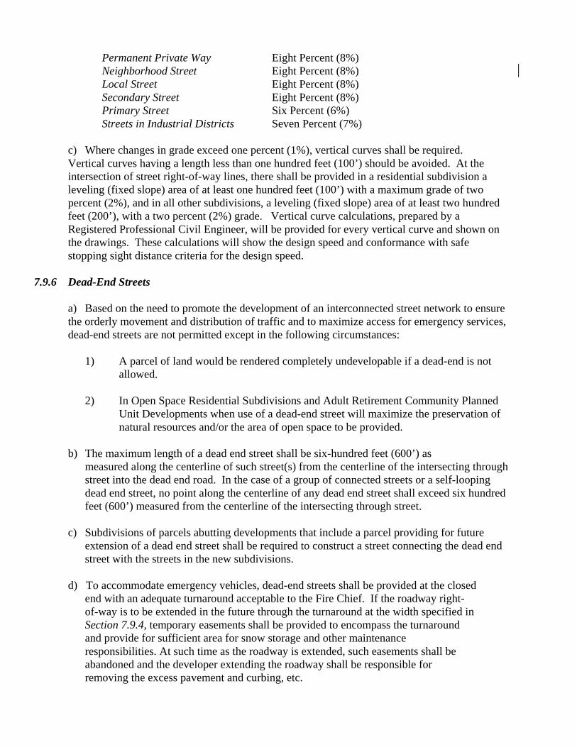
Permanent Private Way Eight Percent (8%) Neighborhood Street Eight Percent (8%) Local Street Eight Percent (8%) Secondary Street Eight Percent (8%) Primary Street Six Percent (6%) Streets in Industrial Districts Seven Percent (7%)
c) Where changes in grade exceed one percent (1%), vertical curves shall be required. Vertical curves having a length less than one hundred feet (100’) should be avoided. At the intersection of street right-of-way lines, there shall be provided in a residential subdivision a leveling (fixed slope) area of at least one hundred feet (100’) with a maximum grade of two percent (2%), and in all other subdivisions, a leveling (fixed slope) area of at least two hundred feet (200’), with a two percent (2%) grade. Vertical curve calculations, prepared by a Registered Professional Civil Engineer, will be provided for every vertical curve and shown on the drawings. These calculations will show the design speed and conformance with safe stopping sight distance criteria for the design speed.
7.9.6 Dead-End Streets a) Based on the need to promote the development of an interconnected street network to ensure
the orderly movement and distribution of traffic and to maximize access for emergency services, dead-end streets are not permitted except in the following circumstances:
1) A parcel of land would be rendered completely undevelopable if a dead-end is not
allowed. 2) In Open Space Residential Subdivisions and Adult Retirement Community Planned
Unit Developments when use of a dead-end street will maximize the preservation of natural resources and/or the area of open space to be provided.
b) The maximum length of a dead end street shall be six-hundred feet (600’) as
measured along the centerline of such street(s) from the centerline of the intersecting through street into the dead end road. In the case of a group of connected streets or a self-looping dead end street, no point along the centerline of any dead end street shall exceed six hundred feet (600’) measured from the centerline of the intersecting through street.
c) Subdivisions of parcels abutting developments that include a parcel providing for future
extension of a dead end street shall be required to construct a street connecting the dead end street with the streets in the new subdivisions.
d) To accommodate emergency vehicles, dead-end streets shall be provided at the closed
end with an adequate turnaround acceptable to the Fire Chief. If the roadway right- of-way is to be extended in the future through the turnaround at the width specified in Section 7.9.4, temporary easements shall be provided to encompass the turnaround and provide for sufficient area for snow storage and other maintenance responsibilities. At such time as the roadway is extended, such easements shall be abandoned and the developer extending the roadway shall be responsible for removing the excess pavement and curbing, etc.

e) Turnarounds shall be designed in one of the two following ways: 1) A cul-de-sac turnaround with a perimeter diameter of one hundred feet (100’) shall
include a twenty-four foot (24’) diameter center landscaped island. (For use on permanent private ways, neighborhood and local streets.)
2) A hammerhead or T-shaped turnaround. (For use on permanent private ways only.) 7.9.7 Roadway Construction - The roadway shall be graded and prepared for pavement as follows:
a) Clearing and grubbing shall be performed in accordance with Section 7.4. b) Earth excavation shall be the removal of all materials encountered within the area of the traveled way, berms, shoulders, and sidewalks down to the true surface of the subgrade or to suitable material in areas where unsuitable material exists, as determined by the Board’s Agent, in preparation for foundation of roadway, sidewalks, driveways and berms. Excavation material obtained from the excavation may be used in fills if approved by the Board. c) When, in the opinion of the Board or Board's Agents, suitable material is not available within the limits of the proposed roadway location to form a suitable subgrade or sub-base, the developer shall provide suitable additional material, conforming to AASHTO A-1 or A-3, along with laboratory test results from other sources in accordance with this Section and to be approved by the Board's Agent.
d) The subgrade surface, sixteen inches (16") below the finished surface grade in residential streets, and eighteen inches (18") below the finished surface grade in all streets in non-residential subdivisions shall be prepared true to the lines, grades and cross sections given and compacted to not less than ninety-five percent (95%) of the maximum dry density of the material as determined by the AASHTO Standard Method of Test T99. Road sections constructed on ledge rock shall have a minimum of twenty-four inches (24”) of roadway structure consisting of gravel borrow subbase, dense graded crushed stone base and hot mix asphalt (HMA). The subgrade shall be crowned to assure proper drainage of the sub-base. All soft or spongy material below the subgrade surface shall be removed to a depth determined by the Board or its Agent. The space thus made shall be filled with gravel borrow, containing no stones over six inches (6") in their largest dimension. The subgrade shall be compacted in conformance with the same standards that apply for the sub-base. e) The additional materials for subgrade, gravel fill and gravel subbase shall be spread in layers not exceeding eight inches (8”). The subbase layer shall be spread in conformity with the requirements of the Standard Specifications, Section M-103.0 Gravel Borrow Type b, three inches (3”) largest dimension.
Each layer shall be thoroughly watered, rolled and compacted to not less than 95 percent (95%) of the maximum dry density of the material as determined by the AASHTO Standard Method of Test T99. Any depressions that appear during and after the rolling shall be filled with additional gravel and re-rolled until the surface is true. Suitable subgrade fabric may be required by the Board or its Agent prior to gravel placement.

f) Final grading, rolling and finishing including the shaping, trimming, rolling and finishing of the surface of the sub-base prior to application of pavement for surfacing of the roadway base courses, walks and berms shall be in accordance with this Section and as directed by the Board and/or its agent. Compaction testing and soil gradations shall be performed by an independent lab as required by the Board and/or its agent with test results provided prior to paving.
g) Roadway shall be constructed for the full length of all streets within the subdivision and shall
have the curb radii as required in Section 7.9.2 (d). The centerline of all roadways shall coincide with the centerline of the street right-of-way unless the Board approves a deviation. The minimum widths of the roadway pavement shall be as follows:
Non-Residential Street Thirty-Six Feet (36’) Primary Street Thirty-Two Feet (32') Secondary Street Twenty-Nine Feet (29') Local Street Twenty-Six Feet (26') Neighborhood Street Twenty Feet (20’) Permanent Private Way Eighteen Feet (18’)
h) Pavement for roadways in subdivisions shall be Hot Mix Asphalt Pavement. The material and construction methods for laying pavement shall conform in every way to the applicable sections of Section 400 and Section M of the Standard Specifications except that no such construction shall be undertaken before April 15th of any year, nor after November 15th of any year. Pavement on minor and secondary residential subdivision streets shall be laid to a compacted depth of four inches (4") and laid in two (2) courses. The intermediate (binder) course shall consist of Dense Binder and be compacted to two and one-half inches (2-1/2”); the surface shall consist of Top Course and shall be compacted to one and one half inches (1-1/2”). i) Pavement on primary and non-residential subdivision streets shall be laid to a compacted depth of six inches (6”) and placed in three (3) courses. The HMA base layer shall consist of a Base Course mixture and shall be compacted to two and one-half inches (2-1/2”), intermediate (binder) course shall consist of Dense Binder material and be compacted to one and three-quarter inches (1-3/4”), the surface shall consist of Modified Top Course material and shall be compacted to one and three quarter inches (1-3/4”).
j) The Board or its Agent may require the installation of a Petromat type fabric or any approved equal over any areas in the base pavement that, in their opinion, require reinforcement prior to the placement of an additional course of pavement.
k) If, in the opinion of the Board’s Consulting Engineer, subdrains are required, they shall be
installed, as specified by the Board’s consulting engineer. 7.10 CURBS AND BERMS
7.10.1 Vertical granite curbing shall be installed at intersection roundings and cul-de-sac entrances. 7.10.2 Curbing shall be provided the full length of all streets along each side of the roadway. The following curb types are required for the various street categories: Permanent Private Way Hot Mix Asphalt Cape Cod Berm

Neighborhood Street Sloped Granite Edging (Type S-A) Local Street Sloped Granite Edging (Type S-B) Secondary Street Vertical Granite Curb (Type VA3) Primary Street Vertical Granite Curb (Type VA3)
See Appendix for detail. 7.11 DRIVEWAYS/CURB CUTS 7.11.1 Driveways shall be at least ten feet (10') wide and shall not exceed twenty-five feet (25’) wide and shall have a three-foot (3’) radius edge treatment consistent with the specific type of road construction. Construction/layout shall comply with Town of Medway Street Standards as maintained by the Medway DPS. 7.11.2 The construction of driveway openings shall not be within sixty-five feet (65') of the intersection of the centerline of intersecting streets or within fourteen feet (14’) feet of a catch basin, unless otherwise restricted by Town bylaws, regulations or restrictions. 7.11.3 Driveways shall slope down from the edge of the street right-of-way toward the back of the sidewalk at a grade no less that one percent (1%) but not more than eight percent (8%). It is the intention to not depress the sidewalk elevation at driveways or the grass area within the layout for driveways on the street side without a sidewalk. Sidewalk grades shall be continuous across driveway openings. Transition in grades shall conform to the latest ADA and AAB requirements in effect at the time of street acceptance by the Town. 7.11.4 The junction of sidewalks, driveways and roadways shall be constructed in such a manner as to prevent puddling. 7.11.5 All driveways within the bounds of the street right of way shall be paved using material types and thicknesses consistent with the sidewalk. 7.11.6 Existing residential dwelling units that abut a proposed way shall be provided with a driveway to the proposed way wherever possible. 7.11.7 See Town of Medway Street Standards as maintained by the Department of Public Services for additional driveway construction requirements. 7.12 STONE WALLS - Where a subdivision is accessed from a Medway Scenic Road, the subdivision entrance shall be designed to reflect stone wall, post/rail fence or other distinctive features already present along the scenic roadway. See Appendix for illustrated examples. 7.13 SIDEWALKS 7.13.1 Sidewalks shall be constructed within the subdivision, and shall have pedestrian access ramps that conform to the latest regulations of the Americans with Disabilities Act, and requirements of the Massachusetts Architectural Access Board.

7.13.2 The sidewalks shall extend the full length of the street and around the entire perimeter of the cul-de-sac, with pedestrian ramps at both sides of the cul-de-sac entry, and shall be as follows: Permanent Private Way No sidewalks required
Neighborhood Street Six feet (6’) on one side – Hot Mix Asphalt with a minimum four-foot (4’) grass strip.
Local Street Six feet (6’) on one side – Hot Mix Asphalt with a
minimum six and one-half foot (6.5’) grass strip.
Secondary Street Six feet (6’) on two sides – Cement concrete with no grass strip
Primary Street Eight feet (8’) on both sides – Cement concrete with no grass strip
Non-Residential Street Six feet (6’) on both sides – Cement concrete with no grass strip
NOTE – The above specified sidewalk widths do not include the width of the edge/curb treatment.
Where sidewalks are only required on one (1) side of the street, they should be located to enable connections with sidewalks on adjoining streets. 7.13.3 Sidewalks shall also be provided along the entire frontage of the subdivision parcel along existing Town ways, including the frontage of any lots held in common ownership with the subdivision parcel within five (5) years prior to the submission of the Preliminary or (if no Preliminary) Definitive Subdivision Plan. In those instances where sidewalk construction is not feasible or practical, the Applicant shall make a payment in lieu of sidewalk construction to the Town of Medway, in an amount determined by the Town’s Consulting Engineer. Such funds shall be deposited to a revolving fund to be used to finance construction of sidewalks and/or other public improvements. 7.13.4 Hot Mix Asphalt (HMA) sidewalks shall be laid to a compacted depth of three inches (3”) and placed in two courses. The intermediate (binder) course shall consist of Dense Binder and be compacted to one and three-quarter inches (1-3/4”). The surface shall consist of Top Course and shall be compacted to one and one quarter inches (1-1/4”). The twelve inch (12”) granular subbase layer shall be spread in conformity with requirements of the Standard Specifications, Section – 103.0 Gravel Borrow Type C, two (2) inches largest dimension and compacted to not less than 95 percent of the maximum dry density of the material as determined by AASHTO Standard Method of Test T99. 7.13.5 Cement concrete sidewalks shall be formed, placed and finished in accordance with the Standard Specifications, Section 701. The sidewalk shall be constructed of air entrained, 4000 PSI, ¾”, 610 cement concrete formed to provide a sidewalk mat that is 4” deep. At driveways, the sidewalk shall be 6 inches in depth. The 8” subbase gravel layer material shall be spread in conformance with the Standard Specifications for gravel borrow type C - two (2) inches largest dimension and compacted to 95% of the maximum dry density of the material as determined by AASHTO Standards.
7.14 EMBANKMENTS/SLOPES/RETAINING WALLS
7.14.1 Outside the right-of-way, embankments shall be evenly graded and pitched at a slope of not greater than three feet (3’) feet horizontal to one foot (1’) vertical. Where cuts are made in ledge, other slopes may be determined with the approval of the Board. Where terrain necessitates greater slopes, retaining walls, terracing, fencing, or rip-rap may be used either alone or in combination to provide safety and freedom from maintenance, but must be done in accordance with plans filed with and approved by the Board. Alternative geotextile materials for slope stabilization may be approved upon review by the Board or its consultants. Manufacturer’s information on the special geotextile materials proposed must be submitted with the definitive subdivision plan. The plan must include a site-specific detail showing the installation method of the geotextile materials. Gabion structures are expressly prohibited. Whenever embankments are built in such a way as to require approval by the Board, the developer must furnish to the Town duly recorded access easements free of encumbrances for maintenance of the slopes, terraces or retaining walls. 7.14.2 All slopes shall be grassed in accordance with the Standard Specifications for the area between the roadway and sidewalk or roadway and boundary of the right-of-way. The Board suggests the use of hardy, drought tolerant grass mixtures. The Developer shall submit the seed mix and fertilization mix for approval prior to the seeding of these areas. Special mixtures will be needed for detention basins, swales or other stormwater management facility embankments. 7.14.3 Whenever retaining walls are used, the developer will be required to provide design plans prepared and stamped by a Registered Professional Structural Engineer and said walls will, if appropriate, require a Building permit. 7.14.4 All walls shall be constructed of stone and mortar or shall have a natural stone appearance, the design of which shall be reviewed and recommended by the Design Review Committee for the Board’s approval. When fencing is required on top of a retaining wall, its design shall be reviewed and recommended by the Design Review Committee and the Police Department’s Safety Officer. Chain link fencing is not permitted. 7.15 TEMPORARY AND PERMANENT PAVEMENT PATCHING - When making temporary or permanent patches to the pavement and for backfill excavations and trenches within the limits of existing pavement, work shall comply with the Town of Medway Street Standards as required by the Medway Department of Public Services. 7.16 GUARDRAILS – Guardrails of a design approved by the Board shall be required along roadways as per AASHTO’s Guide for Selecting, Locating and Designing Traffic Barriers and where, in the opinion of the Board, they are needed for public safety. Guardrails shall consist of steel posts with corrosion resistant weathering steel rails. The Board shall pay special attention to the type of guardrail on designated Medway Scenic Roads to ensure that guardrails will not detract from their desirable rural qualities. 7.17 FIRE PREVENTION AND PROTECTION MEASURES 7.17.1 A fire alarm system shall be installed in accordance with the specifications of and located as directed by the Medway Fire Department or a sum of money paid to the Town equal to the cost of installing a fire alarm system within the subdivision, for use by the Fire Department for capital purchases.

7.17.2 Fire hydrants shall not be nearer than twenty-five feet (25') from the intersection of two (2) streets, measured from the intersection of the tangents of the intersecting street curb lines. These items shall be placed in back of sidewalks (7'6" behind back of curb/berm) wherever possible and easements provided where necessary. 7.18 LOAM AND SEED – For excavated roadway side slopes, grassy strips, median strips (if any) and housing unit lot lawn areas, six inches (6”) minimum of compacted loam shall be provided and all areas must have complete grass or ground cover coverage. Plantings of any grass or ground covers must be maintained in a healthy state, as determined by the Board’s Agent, prior to roadway acceptance. 7.19 TREES AND SLOPE STABILIZATION 7.19.1 In an effort to preserve Medway’s rural New England character, the Board strongly encourages builders and developers to protect and retain as much existing, healthy woodland growth as is reasonably possible on all lots and roadway layouts within a proposed subdivision. Indiscriminate clear cutting is not allowed. In areas with woodland growth, substantial “selective-cut zones” adjacent to each lot’s side and rear property lines shall be designated on the subdivision plan and provisions for such shall also be included in the subdivision’s homeowners protective covenant. 7.19.2 To enhance the aesthetic quality of the streetscape, deciduous street trees of nursery stock conforming to the standards of the American Association of Nurserymen, shall be planted on each side of each street in a subdivision, except in those locations where the Board has approved certain trees to be retained which are healthy and are of adequate size and species. Street trees shall be located on private property at least six feet (6’) from the roadway layout. At least three (3) trees are to be located on each lot at approximately forth foot (40’) intervals and shall be planted no more than twenty (20) feet from the right-of-way line. Trees shall be at least twelve feet (12') in height and two and one-half inches (2 1/2") in caliper measured four feet (4') above the approved grade. Each of the trees shall be planted in at least one cubic yard of topsoil unless otherwise required by the Town. Trees shall be properly planted, wrapped and guyed to ensure their survival. 7.19.3 All deciduous “street trees” shall be clear of any branches from the approved grade level to a point seven feet (7') above finished grade. Trees shall not be planted where their current or mature growth will interfere with utility lines or entrances. 7.19.4 Trees approved for planting are: Shademaster, Honey and Skyline Locust; Sugar Maple; White, Scarlet, Pin and Northern Red Oak; Bradford and Aristocrat Pears; London Planetree or other species if approved in advance by the Tree Warden. At least three (3) species shall be planted in every subdivision and they shall be staggered so that no one species shall be planted next to a like species. 7.19.5 Outside of the paved way but within the right of way plus the twenty foot (20)’ strip parallel thereto, any existing tree with over a six inch (6”) caliper at four feet (4’) high shall be retained and shall be marked in the field to avoid accidental damage during construction. Grade within the drip line of such trees shall not be changed more than six inches (6”) and not less than twenty-five percent (25%) of that area shall be retained within four inches (4”) of present grade. Tree wells or retaining walls shall be used where necessary to accomplish this, and shall be of fieldstone with a thickness at any point of not less than one-third (1/3) the depth below retained grade, unless an alternative is detailed in the plan submittals and approved by the Board.
7.19.6 All cut bankings or slopes that tend to wash or erode must be provided with suitable erosion control methods planted with a low-growing evergreen shrub for full sun, or vinca, pachysandra, Baltic ivy, and densiforma yews for part to mostly shade, and seeded with a deep rooted perennial grass to prevent erosion. Wood chip mulch without plantings shall not be permitted. 7.19.7 The developer shall be responsible for all trees so planted as to their erectness and good health after planting for at least two years or until the release of all guarantees, approval of as-built plans for private ways or the acceptance of the street by Town Meeting as a public way, whichever is longer. 7.19.8 Street shade trees shall not be nearer than twenty-five feet (25’) from the intersection of two (2) streets, measured from the intersection of the tangents of the intersecting street curb lines. 7.19.9 Landscaping of cul-de sac islands – Cul-de-sac turnarounds shall feature a twenty-four foot (24’) diameter landscaped center island encircled by edge treatment consistent with the road type per Section 7.10.2. The topography of the center island shall be convex in shape to prevent pooling of water. The island shall be surrounded by a ten-foot (10’) paved apron. The island shall be planted with nursery grown stock installed in accordance with detail sheets in the Appendix. Substantial, low-maintenance and four-season landscaping shall be installed. The landscape design shall incorporate a mixture of deciduous and evergreen trees and shrubs, rocks, perennials, fully developed grass as in a mature pasture, non-invasive ground cover, and mulch. Native species shall be included. Existing vegetation may be retained and incorporated as part of the design to achieve a natural appearance. The design shall incorporate provisions for infiltration of collected stormwater. See Appendix for details on planting specifications, required spacing, and suggested plant species. Provisions for the on-going maintenance and upkeep of the landscaped island shall be included in the subdivision’s homeowners’ protective covenants.
7.20 STREET AND TRAFFIC CONTROL SIGNS AND NAMES 7.20.1 Prior to filing a definitive subdivision plan application the Applicant shall secure approval of street names by the Street Naming Committee to prevent duplication, to provide names in keeping with the character of the Town, and to maximize easy identification for public safety and emergency vehicles. Application for street name approval shall be made through the Town Clerk’s office. Use of proper names such as Mary Jones Way shall not be accepted. However, historical names may be approved. 7.20.2 Location - The subdivider shall furnish and install double-faced extruded-aluminum street signs, mounted on two-inch (2”) diameter posts equal to those in use by the Medway Department of Public Services and conforming to its specifications. Two street signs, one for each street, shall be erected at each intersection after the installation of the base coat of the roadway and prior to the issuance of lot releases and the first building permit. Traffic control signs within the subdivision, as well as those proposed for pre-existing adjacent public ways, shall be installed after obtaining approval from the Town Safety Officer. 7.20.3 Installation – Street signposts shall be ten feet (10’) in length, three feet (3’) of which shall be buried in the ground. An anchor rod shall be installed with the underground portion to prevent turning or removal.

7.20.4 From the time of rough grading until such time as each street is accepted by the Town as a public way, the sign posts at the intersection of such street with any other street shall have affixed thereto an additional sign designating such street as an Unaccepted Street. 7.21 STREETLIGHTS 7.21.1 It shall be the responsibility of the developer to install street lighting within the subdivision at the entrance to the subdivision, at all intersections within the subdivision, sharp turns, or other areas where the Traffic Safety Officer deems they are needed for public safety. The quantity, type and location of lights shall be shown on the definitive plan. The developer is responsible for installing the pole, wiring and arranging installation of the light fixture. 7.21.2 High efficiency streetlights shall conform to the type and style in general use in the Town of Medway. The quantity, type and location of lights shall be in accordance with the policy established by the Board of Selectmen in their capacity as Road Commissioners and the applicable utility company, unless otherwise specified, and shall be shown on the definitive subdivision plan. 7.21.3 Street lights shall not be nearer than twenty-five feet (25’) from the intersection of two (2) streets, measured from the intersection of the tangents of the intersecting street curb lines; and shall be placed in back of sidewalks (7' 6" behind back of curb/berm) wherever possible. Easements shall be provided if required. 7.21.4 The developer is responsible for paying for the cost of electricity until such time as the road is accepted by Town Meeting, 7.21.5 Specifications: The lighting fixture lumen rating shall be four thousand (4,000). The nominal structure mounting height above street grade shall be twenty-five feet (25’). 7.21.6 Street lights shall be installed prior to the issuance of the certificate of occupancy for the first dwelling in the subdivision. 7.21.7 Applicants are strongly encouraged to include a requirement for individual lot post lights in the subdivision’s homeowner’s covenant 7.22 WALKWAYS and BIKEWAYS - It is the policy of the Board to maximize opportunities for pedestrian and bicycle access. Pedestrian walkways or trails and/or bikeways are required to ensure connections between adjacent subdivisions and between the subdivision and nearby schools, playgrounds, parks, shopping areas, public transportation, open spaces and/or other public facilities or community services or for such other reasons as the Board may determine. At the discretion of the Board, such walkways, trails and/or bikeways shall be located within the public right-of-way, on open space areas controlled or to be conveyed to the Town, on easements across lots within the subdivision, or other appropriate locations. The Board may require review by the Design Review Committee (DRC). 7.23 OPEN SPACE 7.23.1 For subdivisions with six (6) or more lots, the applicant will set aside open space for
playground and recreation purposes or an area for maintaining natural buffers. Unless otherwise specifically approved by the Board, the total amount of area to be reserved for open space purposes will not be less than five percent (5%) of the gross area of the subdivision or ten percent (10%) of the minimum lot area times the number of lots in the subdivision, whichever is greater. The Board may require that the open space area be located within the central subdivision, or areas reserved will be located and laid out so as to be used in conjunction with similar areas of adjoining subdivisions or of probable future subdivisions. 7.23.2 Any land so reserved will be designated as a separate parcel and be graded to dispose properly of surface water and be left in condition for the purpose intended, as required by the Board. Pedestrian walkways, bikeways, or bridle paths of up to twenty feet (20’) in width may be requested where deemed desirable to provide circulation access. Each area reserved for such purpose will be of suitable area, dimensions, topography and natural character for the purposes of a park and/or playground. The area or areas will be so located as to serve adequately all parts of the subdivision as approved by the Board. 7.23.3 Town or Homeowner’s Association. As agreed upon by the Applicant and the Board, dedicated open space will be permanently preserved as such, and conveyed to one of the following:
a) the Town for park or open space; b) a non-profit organization, the principal purpose of which is the conservation of open space; or c) a corporation or trust owned or to be owned by the owners of all building lots within the
development. If such corporation or trust is utilized, ownership thereof shall pass with conveyances of the lots or residential units.
7.23.4 In any case, where such land is not conveyed to the Town, a restriction enforceable by the Town pursuant to (M.G.L., Ch. 40A, Section 9) will be recorded providing that such land will be kept in an open, natural state and will not be developed for residential homes or roadways. If necessary, such restrictions will further provide for maintenance of the common land in a manner which will ensure its suitability for its function, appearance, cleanliness, and proper maintenance of drainage, utilities, and the like.
7.23.5 If the dedicated open space is not to be conveyed to the town, then the Applicant will include, as part of the covenant, a provision that the dedicated open space will be deeded as approved by the Board. In addition, the covenant will hall not be released until proof of ownership of the open space has been provided to the Board. 7.23.6 If the dedicated open space is not to be conveyed to the town, the Applicant must provide a written program describing how the open space will be maintained in perpetuity to standards satisfactory to the Board. The Applicant will also provide an agreement empowering the Town to perform maintenance of the open space in the event of failure to comply with the program. This agreement will provide that, if the Town is required to perform any maintenance work, the owner(s) of the open space will pay the cost thereof and the cost will constitute a lien upon the property until said cost has been paid. 7.23.7 If the dedicated open space is to be owned by the owners of all building lots within the development, the agreement will provide that if the Town is required to perform any maintenance work,

the owner(s) of the open space will pay the cost thereof and any unpaid costs will constitute liens upon the homeowners property until said costs have been paid. 7.23.8 Subject to the above, the dedicated open space may be kept in an open and natural state or may be used for recreational uses including, but not limited to golf courses, riding trails, athletic fields or gardens. 7.24 EASEMENTS 7.24.1 Where utilities cross or are centered on rear or side lot lines, utility and drainage easements shall be provided and shall, whenever possible, be centered on side or rear lot lines. Easements shall be of a width of at least twenty feet (20'). Greater widths may be required by the Board where site conditions warrant additional area for access. 7.24.2 Where a subdivision is traversed by a water course, drainage way, channel or stream, the Board will require a stormwater easement or drainage right-of-way of adequate width to accommodate the physical limits of the channel plus a 10-foot wide access way along each side. The limit of the channel will be defined by an observable break in grade and/or the median high water limit. Construction within the easement should be avoided, however if construction is necessary, the ten foot (10’) wide access way should have a traversable cross slope not to exceed 4:1. When the channel is within the jurisdiction of the Conservation Commission, the Order of Conditions issued by the Conservation Commission shall dictate the appropriate measures to be taken. 7.24.3 Access easements to park and conservation land outside the subdivision shall be provided and shall be at least twenty feet (20’) wide. 7.24.4 Easements shall be shown on the definitive plan, as-built plan and street acceptance plan. 7.25 MONUMENTS/BOUNDS 7.25.1 Monuments shall be installed along the roadway layout at all points of curvature and angle points. Monumentation shall be provided at easements at each angle point along the easement where the lot line intersects the street right-of-way, and at other points where, in the opinion of the Board, monuments are necessary. 7.25.2 Monuments shall be a standard permanent granite or reinforced concrete marker of not less than three feet (3’) in length and not less than five inches (5”) in width and breadth and shall have a three-eighth inch (3/8”) drill hole in the center of the top surface, or in a driveway location only, a one inch (1”) diameter standard steel rod three feet (3’) in length with one-eighth inch (1/8”) drill hole. In addition to the standard permanent roadway monuments, each point where the lot lines intersects the street right-of-way shall have a one inch (1”) diameter steel rod three feet (3’) in length installed with the top flush with the final graded surface. 7.25.3 Each lot line established within the subdivision shall be completely defined in accordance with the corresponding plans recorded or to be recorded at the Registry of Deeds, by placing of permanent monuments at each point of change of direction of that line.

7.25.4 Permanent open space shall be marked by the installation of iron pins with survey caps at each point of change of direction of the property line and at intervals of not more than 100 feet (100’) apart.
7.25.5 Bounds shall be set to the finished grade and installed only after all construction which would destroy or disturb them has been completed. 7.25.6 The placement and accurate location of easements and all monuments shall be certified by a registered land surveyor and properly located on the as-built and street acceptance plans. 7.26 SITE CLEAN-UP - During construction, the developer shall keep the site free of rubbish that may be carried by wind or rain off the site to abutting properties or onto public ways. Upon completion of all work on the ground, the developer shall remove from the streets and adjoining property, all temporary structures, all surplus material, debris, tree stumps, loose rocks, silt fences and synthetic erosion control measures, and such rubbish which may have accumulated during construction, and shall leave the work site in a neat and orderly fashion. 7.27 MAINTENANCE OF SUBDIVISION IMPROVEMENTS 7.27.1 For the purpose of protecting the safety, convenience and welfare of the Town's inhabitants; for the provision of adequate access to all of the lots in a subdivision by ways that will be safe and convenient for travel; for reducing the danger to life and limb in the operation of motor vehicles; and for securing safety in the case of fire, flood, panic and other emergencies; the Applicant or his successor shall maintain, in a manner satisfactory to the Board, the subdivision roads for vehicular traffic and provide for the proper maintenance and repair of improvements including drainage structures, trees, sidewalks, and underground utility boxes. Maintenance shall commence during the construction and continue until approval of the as-built plan for private roads or street acceptance by Town Meeting for proposed public ways. Such maintenance shall include snow removal and street sweeping and upkeep of stormwater detention systems beginning from the time of occupancy of an individual owner or tenant other than the developer. 7.27.2 Snow and Ice Control – Plowing, sanding, and/or salting shall be performed in accordance with the Town of Medway Department of Public Services (DPS) requirements. Such activities shall coincide with the Town’s activities to ensure seamless travel ways throughout the community. It shall be the developer’s responsibility, prior to November 1st of each year, to prepare and coordinate a snow/ice control plan with the DPS. The developer shall provide the DPS with the primary contact information for the person(s) responsible for snow and ice control operations, in the event that a proper and timely response has not occurred. Such person(s) shall be available 24 hours a day, 7 days per week. a) The developer shall be responsible for applying sand/salt to all subdivision streets on which a
dwelling(s) is/are occupied so as to provide safe access to an existing public way. Sand/salt shall be applied in a manner consistent with the then current requirements of the Medway DPS.
b) The developer shall be responsible for plowing occupied streets to provide safe access to an existing public way whenever the Medway DPS plows accepted streets, usually at snowfalls of two inches (2”) or more.
7.27.3 Street Sweeping – At a minimum, the developer shall cause all streets on which a dwelling(s) is/are occupied to be swept monthly. The developer shall maintain an accurate record of all street sweeping activity in his/her development and shall provide copies of same to the Board. A final sweeping shall be performed at least two weeks but not more than four (4) weeks prior to consideration of any subdivision street for acceptance by Town Meeting. 7.27.4 Maintenance of Drainage and Stormwater Management Facilities – After construction and prior to street acceptance, all drainage and stormwater management facilities shall be maintained by the Applicant in accordance with all applicable construction erosion and sediment controls as specified in these Rules and Regulations and in accordance with the long term Operation and Maintenance plan included on the Definitive Subdivision Plan. The following are the minimum standards for the operation and maintenance of stormwater management systems.
a) Open and closed stormwater management systems shall be inspected annually and cleared of debris, sediment and vegetation where such materials are found to affect the functioning and/or design capacity of the facility. Any long term maintenance plan that calls for attention/action more than twice a year is not permitted.
b) Biofilters shall be inspected monthly and mowed or replanted as necessary. Clippings are
to be removed and disposed of properly. c) Where lack of maintenance is causing or contributing to a water quality/control problem as
determined by the Board or its agents, the Board shall direct the developer to take immediate action to correct the problem. d) The applicant is referred to DEP’s specifications for detailed maintenance standards.
7.27.5 To ensure public safety in the developer fails to perform as required, the Town may perform such duties and deduct its expense for snowplowing, sanding and road maintenance, and stormwater management infrastructure maintenance from the subdivision bond. 7.27.6 If any damage to public or private ways occurs during construction, the developer shall be responsible for the repair or cost to repair the damage 7.28 CONSTRUCTION SCHEDULE - The construction of all subdivision improvements shall only occur during seasonal and weather conditions that allow for high quality infrastructure construction, utilizing accepted industry standards. SECTION 8 ADMINISTRATION 8.1 FEES AND COSTS - The Board shall adopt a Fee and Bond Schedule which shall specify the amount of filing, all other applicable fees, and minimum bond amounts for all development projects including but not limited to:
a. Subdivision Approval Not Required (ANR) Plans b. Preliminary Subdivision Plans c. Definitive Subdivision Plans
8.1.1 Application/Filing Fee – An Application/Filing Fee shall be assessed to offset the town’s internal expense of processing and reviewing preliminary and definitive subdivision plan applications and project administration during construction. The Application/Filing Fee shall be provided at the time of the submittal of an application. Any application filed without this fee shall be deemed incomplete and no review work shall commence until the Application/Filing Fee has been paid in full. The Board may waive or reduce any Application/Filing Fee, if, in the opinion of the Board, unusual circumstances exist regarding the subject property or Applicant. Once the review process has been commenced, the Board shall not refund an Application/Filing Fee. 8.1.2 Other Fees, Costs and Expenses - All expenses for advertising, publication of legal notices, postage and mailings, professional plan reviews, construction inspections, recording and filing of documents, and all other expenses in connection with a subdivision including without limitation sampling and/or testing required by the Board or its agents shall be borne solely by the Applicant. The Board reserves the right to fund and use fees, which it has established pursuant to Massachusetts General Laws Chapter 44, Section 53G. 8.1.3 Project/Plan Review Fee - When the Board reviews either a preliminary or definitive plan, the Board, at its sole discretion, may determine that the assistance of outside consultants is warranted due to the size, scale, or complexity of a proposed project or because of the project’s impact on the Town. The Board may engage the services of outside consultants which may include but is not be limited to engineers, planners, lawyers, urban designers, landscape architects or other appropriate professionals. The assistance of these consultants shall include but not be limited to analyzing an application and ensuring compliance with all relevant laws, Town Bylaws and these Rules and Regulations. If the Board determines that such services are required, the Applicant shall pay a Project/Plan Review Fee prior to the review by the outside consultants. This Fee shall be the reasonable costs incurred by the Board for the employment of the outside consultants engaged by the Board to assist in the review of a proposed project. The Project/Plan Review Fee shall not be a fixed amount but will vary with the costs incurred by the Board. The Applicant shall provide an advance on this Fee, in an amount as specified in the Board’s Fee and Bond Schedule, to the Board at the time a preliminary or definitive plan is filed. Should the services of outside consultants be required after the initial Project/Plan Review Fee has been expended, then the Applicant shall be required to pay an additional fee for subsequent review of resubmitted and/or revised documents. Failure of the Applicant to pay subsequent Project/Plan Review Fees shall be grounds for the Board to halt the plan review process. If not remedied, the Board may deny the subdivision plan. 8.1.4 Construction Observation/Inspection Fee - After a subdivision has been approved by the Board, the Board may determine that the assistance of outside consultants to monitor construction is warranted due to the size, scale or complexity of the approved plan or because of its impact on the Town. The Board may engage the services of outside consultants, which may include but are not be limited to engineers and other appropriate professionals. The assistance of
these consultants shall include but not be limited to monitoring or inspecting a project site during construction or implementation for compliance with the Board’s decision, the approved subdivision plan, and these Rules and Regulations. If the Board determines that such services are required, the Applicant shall pay a Construction Observation Inspection Fee prior to the Board’s endorsement of the plan. Failure of the Applicant to pay the Fee shall be grounds to withhold plan endorsement. The Construction Observation Inspection Fee shall be the reasonable costs incurred by the Board for the employment of the outside consultants engaged by the Board to assist in the inspection of the approved plan. This fee shall not be a fixed amount but will vary with the costs incurred by the Board. Should the services of outside consultants be required after the initial Construction Observation Inspection Fee has been expended, the Applicant shall be required to pay an additional fee for subsequent inspection services. Failure of an Applicant to pay subsequent Construction Observation Inspection Fees shall be grounds for the Board to halt construction inspection services. If not remedied, the Board may vote to not reduce or release the subdivision’s security or to rescind the releases of lots that are not yet conveyed. 8.1.5 Plan Modification Fee – If an applicant seeks to modify an endorsed Definitive Subdivision Plan, a Plan Modification Fee shall be assessed to offset the Town’s internal expense of processing such application. The Plan Modification Fee shall be submitted at the time an application for a plan modification is submitted to the Planning Board. Any application filed without this fee shall be deemed incomplete and no review work shall commence until the Plan Modification Fee has been paid in full. The Board may waive or reduce any Plan Modification Fee, if, in the opinion of the Board, unusual circumstances exist regarding the subject property or Applicant. Once the review process has been commenced, the Board shall not refund a Plan Modification Fee. 8.1.6 Street Acceptance Fee – A nonrefundable Street Acceptance Fee shall be paid to the Board for each such street or roadway at such time as the developer requests street acceptance by Town Meeting. Said fee shall be used to defray the Town’s internal expenses for inspections, GIS mapping, legal, recording and administrative costs related to the Town’s acceptance and receipt of such street or roadways and any underlying or related sewer, water, or drainage improvements and related appurtenances, and any easements or other interests. The amount of said fee shall be as specified in the Board’s Fee and Bond Schedule 8.2. PAYMENT - Funds paid by the Applicant shall be by certified check, made payable to the Town of Medway and provided to the Board. 8.3 SPECIAL ACCOUNTS 8.3.1 Establishment - When Project/Plan Review or Construction Observation/Inspection funds are received by the Board pursuant to this Section they shall be deposited with the Town Treasurer who shall establish a special account for this purpose. Expenditures from this special account may be made at the direction of the Board without further appropriation. Expenditures from the special account shall be made only for services rendered in connection with a specific project or projects for which a fee has been or will be collected from the Applicant. Accrued interest may also be spent for this purpose. Failure of an Applicant to pay a Project/Plan Review Fee shall be grounds for denial of the approval sought.

8.3.2 Replenishment – When the balance in an Applicant’s special account falls below twenty- five percent (25%) of the original Project/Plan Review or Construction Observation Inspection Fee, the Board shall bill the Applicant for supplemental funds to ensure the continued availability of funds so the Town may compensate the outside consultants and either the review process or inspections are not halted. 8.3.3. Remedy – Failure of an Applicant to pay the Plan/Project Review Fee or the Construction Observation Inspection Fee or to replenish its account when invoiced, shall be grounds for plan disapproval, refusal to release development security, or rescission of the releases of the lots not yet conveyed. 8.3.4. Refund - At the completion of the Board’s review of a project, or upon street acceptance, any excess amount in the Applicant’s account, including interest, attributable to a specific project shall be repaid to the Applicant or the Applicant’s successor in interest. A final report of said account shall be made available to the Applicant or the Applicant’s successor in interest. For the purpose of this regulation, any person or entity claiming to be an Applicant’s successor in interest shall provide the Board with documentation establishing such succession in interest. 8.4 ADMINISTRATIVE APPEAL OF CONSULTANT SELECTION- Any Applicant may make an administrative appeal from the selection of the outside consultant to the Board of Selectmen. Such appeal must be made in writing and may be taken only within twenty (20) days after the Board has mailed or hand-delivered notice to the Applicant of the selection. The grounds for such an appeal shall be limited to claims that the consultant selected has a conflict of interest or does not possess the minimum, required qualifications. The minimum qualifications shall either consist of an educational degree in, or related to, the field at issue or three or more years of practice in the field at issue or a related field. The required time limit for action upon an application by the Board shall be extended by the duration of the administrative appeal. In the event that no decision is made by the Board of Selectmen within one month following the filing of the appeal, the selection made by the Board shall stand. 8.5 APPEALS - Appeals may be taken from the determination of the Board to the Superior Court or to the Land Court in accordance with M.G.L., Chapter 41, Section 81BB. 8.6 VALIDITY - The provisions of these Rules and Regulations are hereby declared to be separable. If, in any respect, any provision of these Rules and Regulations in whole or in part, or the application of such provision to any person or circumstance shall prove to be invalid for any reason, such invalidity shall only affect the part of such provision which shall be held invalid and shall not be construed to affect the validity of any of the remaining provisions. In all other respects these Rules and Regulations shall stand. It is hereby declared that the intent of these Rules and Regulations is that the remaining Sections would have been adopted had such invalid provisions not been included therein.
********************************************************** Adopted: April 26, 2005 Attest: __________________________________________ ___________________________ Susan E. Affleck-Childs Date Planning Board Assistant
A true copy attest: ___________________________________________ ___________________________ Maryjane White Date Town Clerk MEDWAY PLANNING BOARD SUBDIVISION RULES AND REGULATIONS Adopted – April 26, 2005
APPENDIX – FORMS

FORM A Application for Endorsement of Plan Believed Not to Require Subdivision Approval (ANR) FORM B Application for Approval of a Preliminary Subdivision Plan FORM C Application for Approval of a Definitive Subdivision Plan FORM D Designer’s Certificate FORM E Certified List of Abutters & Owners Within 300’ FORM F Development Impact Report FORM G Restrictive Covenant FORM H Bond Agreement – Deposit of Money FORM I Partial Release of Restrictive Covenant FORM J Grant of Utility and/or Drainage Easement FORM K Grant of Trail Easement FORM L Quitclaim Deed - Conveyance of Open Space and/or Drainage Parcel FORM M Quitclaim Deed - Conveyance of Road FORM N Certificate of Completion and Final Release of Subdivision Performance Guarantee
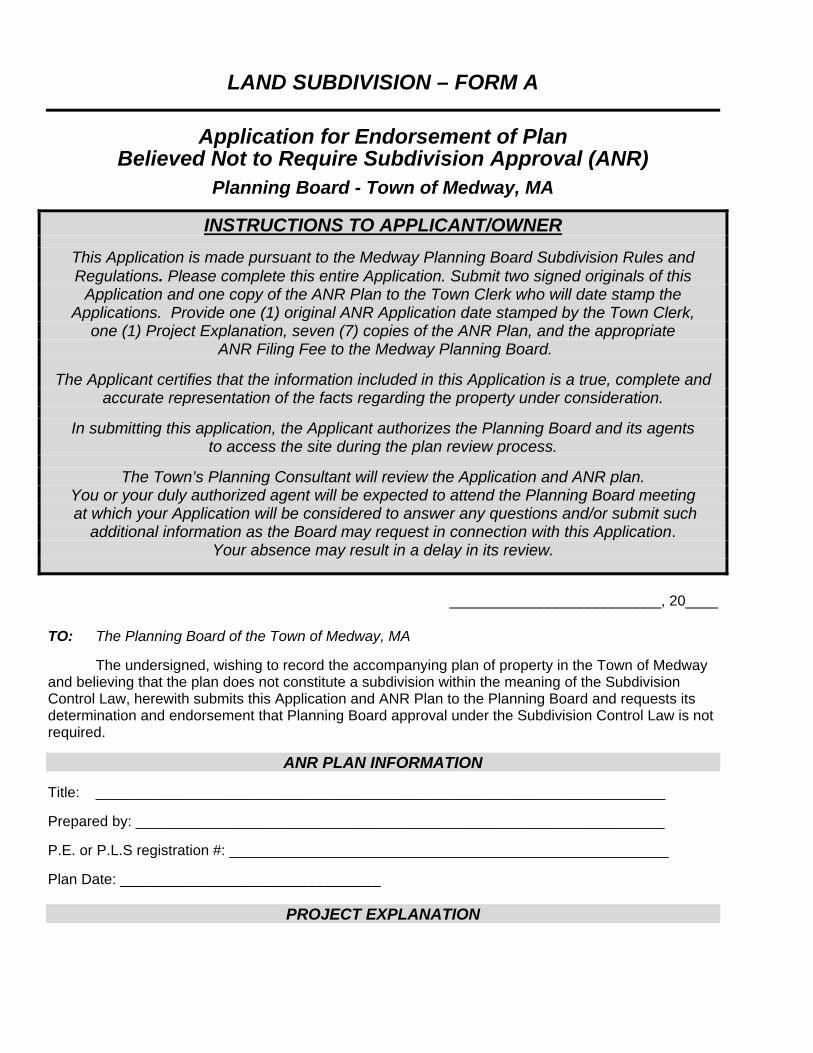
LAND SUBDIVISION – FORM A
Application for Endorsement of Plan Believed Not to Require Subdivision Approval (ANR)
Planning Board - Town of Medway, MA
INSTRUCTIONS TO APPLICANT/OWNER
This Application is made pursuant to the Medway Planning Board Subdivision Rules and Regulations. Please complete this entire Application. Submit two signed originals of this
Application and one copy of the ANR Plan to the Town Clerk who will date stamp the Applications. Provide one (1) original ANR Application date stamped by the Town Clerk,
one (1) Project Explanation, seven (7) copies of the ANR Plan, and the appropriate ANR Filing Fee to the Medway Planning Board.
The Applicant certifies that the information included in this Application is a true, complete and
accurate representation of the facts regarding the property under consideration.
In submitting this application, the Applicant authorizes the Planning Board and its agents to access the site during the plan review process.
The Town’s Planning Consultant will review the Application and ANR plan.
You or your duly authorized agent will be expected to attend the Planning Board meeting at which your Application will be considered to answer any questions and/or submit such
additional information as the Board may request in connection with this Application. Your absence may result in a delay in its review.
__________________________, 20____
TO: The Planning Board of the Town of Medway, MA
The undersigned, wishing to record the accompanying plan of property in the Town of Medway and believing that the plan does not constitute a subdivision within the meaning of the Subdivision Control Law, herewith submits this Application and ANR Plan to the Planning Board and requests its determination and endorsement that Planning Board approval under the Subdivision Control Law is not required.
ANR PLAN INFORMATION Title: ______________________________________________________________________ Prepared by: _________________________________________________________________ P.E. or P.L.S registration #: ______________________________________________________ Plan Date: ________________________________
PROJECT EXPLANATION
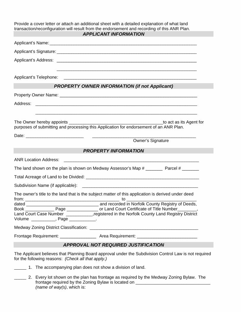
Provide a cover letter or attach an additional sheet with a detailed explanation of what land transaction/reconfiguration will result from the endorsement and recording of this ANR Plan.
APPLICANT INFORMATION Applicant’s Name: _____________________________________________________________ Applicant’s Signature: __________________________________________________________ Applicant’s Address: __________________________________________________________
__________________________________________________________
Applicant’s Telephone: _______________________________________________________
PROPERTY OWNER INFORMATION (if not Applicant) Property Owner Name: _________________________________________________________ Address: ___________________________________________________________________
___________________________________________________________________ The Owner hereby appoints _______________________________________to act as its Agent for purposes of submitting and processing this Application for endorsement of an ANR Plan. Date: ________________________ ___________________________________________
Owner’s Signature
PROPERTY INFORMATION ANR Location Address: ________________________________________________________ The land shown on the plan is shown on Medway Assessor’s Map # _______ Parcel # _______ Total Acreage of Land to be Divided: _______________________________________________ Subdivision Name (if applicable): ________________________________________________ The owner’s title to the land that is the subject matter of this application is derived under deed from: _______________________________________ to _____________________________ dated ______________________________ and recorded in Norfolk County Registry of Deeds, Book ____________ Page _____________ or Land Court Certificate of Title Number________, Land Court Case Number ___________,registered in the Norfolk County Land Registry District Volume __________, Page ___________. Medway Zoning District Classification: _____________________________________________ Frontage Requirement: _______________ Area Requirement: _________________________
APPROVAL NOT REQUIRED JUSTIFICATION The Applicant believes that Planning Board approval under the Subdivision Control Law is not required for the following reasons: (Check all that apply.) _____ 1. The accompanying plan does not show a division of land. _____ 2. Every lot shown on the plan has frontage as required by the Medway Zoning Bylaw. The
frontage required by the Zoning Bylaw is located on _______________________________ (name of way(s), which is:
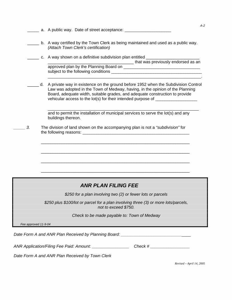
A-2
_____ a. A public way. Date of street acceptance: ____________________ _____ b. A way certified by the Town Clerk as being maintained and used as a public way. (Attach Town Clerk’s certification) _____ c. A way shown on a definitive subdivision plan entitled _______________________
_____________________________________ that was previously endorsed as an approved plan by the Planning Board on _________________________________ subject to the following conditions _______________________________________ __________________________________________________________________.
_____ d. A private way in existence on the ground before 1952 when the Subdivision Control Law was adopted in the Town of Medway, having, in the opinion of the Planning Board, adequate width, suitable grades, and adequate construction to provide vehicular access to the lot(s) for their intended purpose of __________________
_________________________________________________________________
and to permit the installation of municipal services to serve the lot(s) and any buildings thereon.
_____ 3. The division of land shown on the accompanying plan is not a “subdivision” for
the following reasons: ______________________________________________ ________________________________________________________________ ________________________________________________________________ ________________________________________________________________ ________________________________________________________________
ANR PLAN FILING FEE
$250 for a plan involving two (2) or fewer lots or parcels
$250 plus $100/lot or parcel for a plan involving three (3) or more lots/parcels, not to exceed $750.
Check to be made payable to: Town of Medway
Fee approved 11-9-04
Date Form A and ANR Plan Received by Planning Board: ______________________________
ANR Application/Filing Fee Paid: Amount: ________________ Check # _________________ Date Form A and ANR Plan Received by Town Clerk
Revised – April 14, 2005

A-3
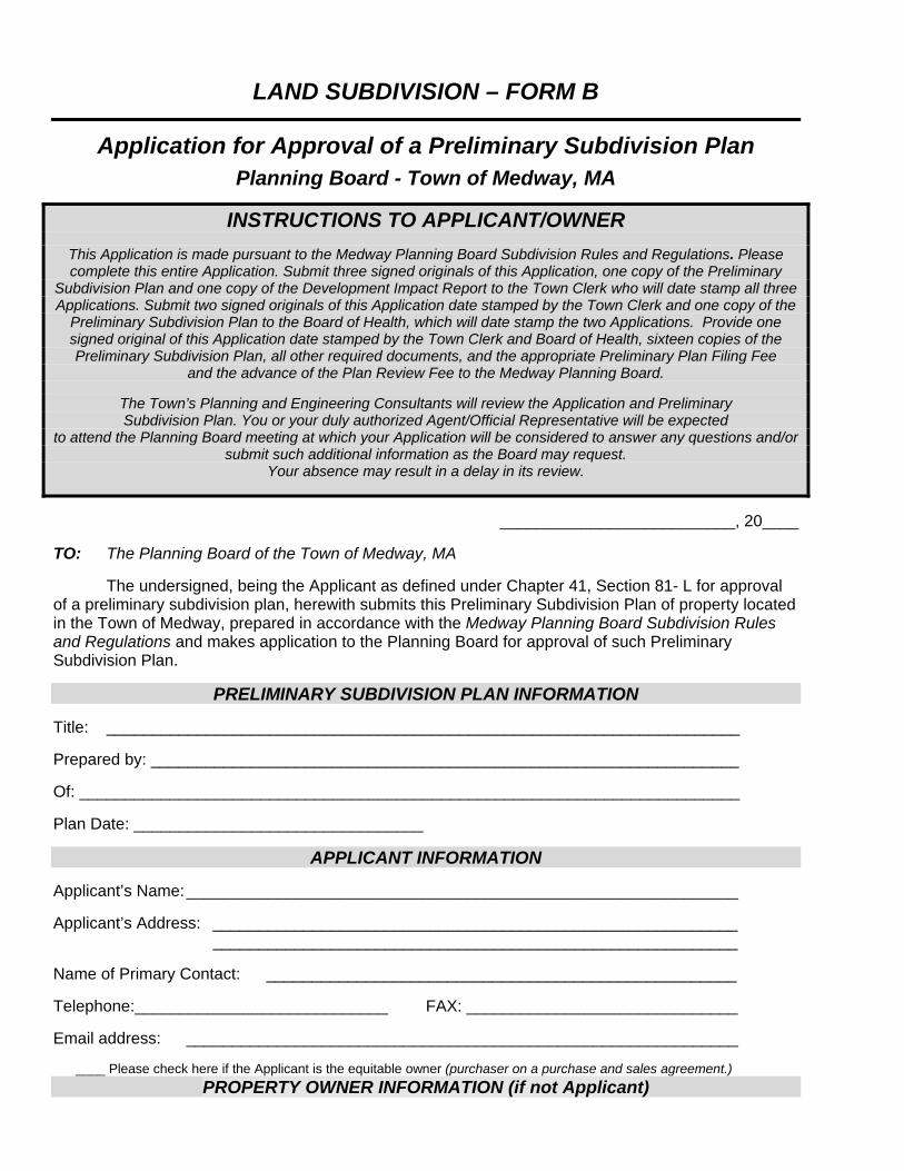
LAND SUBDIVISION – FORM B
Application for Approval of a Preliminary Subdivision Plan
Planning Board - Town of Medway, MA
INSTRUCTIONS TO APPLICANT/OWNER
This Application is made pursuant to the Medway Planning Board Subdivision Rules and Regulations. Please complete this entire Application. Submit three signed originals of this Application, one copy of the Preliminary
Subdivision Plan and one copy of the Development Impact Report to the Town Clerk who will date stamp all three Applications. Submit two signed originals of this Application date stamped by the Town Clerk and one copy of the
Preliminary Subdivision Plan to the Board of Health, which will date stamp the two Applications. Provide one signed original of this Application date stamped by the Town Clerk and Board of Health, sixteen copies of the Preliminary Subdivision Plan, all other required documents, and the appropriate Preliminary Plan Filing Fee
and the advance of the Plan Review Fee to the Medway Planning Board.
The Town’s Planning and Engineering Consultants will review the Application and Preliminary Subdivision Plan. You or your duly authorized Agent/Official Representative will be expected
to attend the Planning Board meeting at which your Application will be considered to answer any questions and/or submit such additional information as the Board may request.
Your absence may result in a delay in its review.
__________________________, 20____
TO: The Planning Board of the Town of Medway, MA
The undersigned, being the Applicant as defined under Chapter 41, Section 81- L for approval of a preliminary subdivision plan, herewith submits this Preliminary Subdivision Plan of property located in the Town of Medway, prepared in accordance with the Medway Planning Board Subdivision Rules and Regulations and makes application to the Planning Board for approval of such Preliminary Subdivision Plan.
PRELIMINARY SUBDIVISION PLAN INFORMATION Title: ______________________________________________________________________ Prepared by: _________________________________________________________________ Of: _________________________________________________________________________ Plan Date: ________________________________
APPLICANT INFORMATION Applicant’s Name: _____________________________________________________________ Applicant’s Address: __________________________________________________________
__________________________________________________________ Name of Primary Contact: ____________________________________________________ Telephone:____________________________ FAX: ______________________________ Email address: _____________________________________________________________ ____ Please check here if the Applicant is the equitable owner (purchaser on a purchase and sales agreement.)
PROPERTY OWNER INFORMATION (if not Applicant)

Property Owner Name: _________________________________________________________ Address: ___________________________________________________________________
___________________________________________________________________ Primary Contact: _____________________________________________________________ Telephone: _________________________ FAX: _________________________________
CONSULTANT INFORMATION Engineer: _____________________________________________________________________ Address: _____________________________________________________________________ _____________________________________________________________________ Primary Contact: _______________________________________________________________ Telephone: _________________ Fax: _______________ Email: ______________________ _ Surveyor: _____________________________________________________________________ Address: _____________________________________________________________________ _____________________________________________________________________ Primary Contact: _______________________________________________________________ Telephone: _________________ Fax: _______________ Email: ______________________
PROPERTY INFORMATION Location Address: _____________________________________________________________ The land shown on the plan is shown on Medway Assessor’s Map #_______ Parcel # _______ Total Acreage of Land to be Divided: ______________________________________________ General Description of Property: __________________________________________________ ____________________________________________________________________________ ____________________________________________________________________________ Medway Zoning District Classification: _____________________________________________ Frontage Requirement: _________________ Area Requirement: ____________________ Scenic Road Does any portion of this property have frontage on a Medway Scenic Road? ____ Yes ____ No If yes, please name street: ___________________________________ Wetlands Is any portion of the property within a Wetland Resource Area? ____ Yes ____ No Groundwater Protection
Is any portion of the property within a Groundwater Protection District? ___Yes ____ No
Flood Plain Is any portion of the property within a Flood Plain? ____ Yes ____ No
B-2 The owner’s title to the land that is the subject matter of this application is derived under deed from: _______________________________________ to ____________________________

dated ______________________________ and recorded in Norfolk County Registry of Deeds, Book ____________ Page _____________ or Land Court Certificate of Title Number________, Land Court Case Number ___________, registered in the Norfolk County Land Registry District Volume__________, Page ___________.
PROJECT INFORMATION Subdivision Name: __________________________________________________________ This is a: ______ Residential Subdivision _____ Non-Residential Subdivision The plan shows the division of land into ______ building lots numbered _______________ and ______ parcels not intended for building thereon. The plan shows the following existing ways that are being proposed as lot frontage: ________________________________ as frontage for lot(s) ___________________________ ________________________________ as frontage for lot(s) ___________________________ ________________________________ as frontage for lot(s) ___________________________ The plan shows the following proposed new ways that are being proposed as lot frontage: ________________________________ as frontage for lot(s) ___________________________ ________________________________ as frontage for lot(s) ___________________________ ________________________________ as frontage for lot(s) ___________________________ Total Length of Proposed New Roadway(s) _________________________________________ Are the new roads proposed to be public or private ways? _____ Public _____ Private Proposed Utilities: _______ water ______ well ______ sewer ______ septic
SIGNATURES I hereby certify, under the pains and penalties of perjury, that the information contained in this application is true, accurate and complete to the best of my knowledge and belief. (If applicable, I hereby authorize ______________________________________ to serve as my Agent/Official Representative to represent my interests before the Medway Planning Board with respect to this Preliminary Subdivision Plan application.) In submitting this application, I authorize the Planning Board, its staff and agents, to access the site during the plan review process. _____________________________________________ _____________________ Signature of Property Owner Date ________________________________________________ _______________________ Signature of Applicant (if other than Property Owner) Date _____________________________________________ _______________________ Signature of Agent/Official Representative Date
B-3
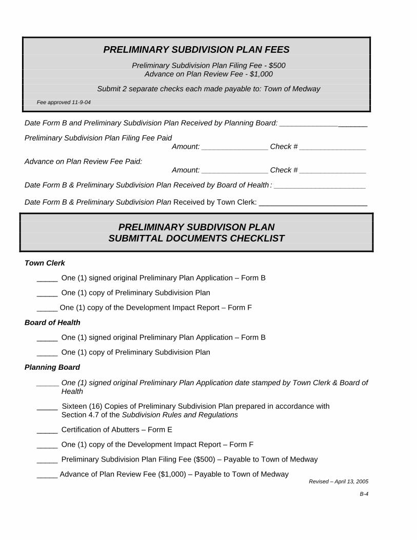
PRELIMINARY SUBDIVISION PLAN FEES
Preliminary Subdivision Plan Filing Fee - $500 Advance on Plan Review Fee - $1,000
Submit 2 separate checks each made payable to: Town of Medway
Fee approved 11-9-04
Date Form B and Preliminary Subdivision Plan Received by Planning Board: _____________________ Preliminary Subdivision Plan Filing Fee Paid Amount: ________________ Check # ________________ Advance on Plan Review Fee Paid: Amount: ________________ Check # ________________ Date Form B & Preliminary Subdivision Plan Received by Board of Health : ______________________ Date Form B & Preliminary Subdivision Plan Received by Town Clerk: __________________________
PRELIMINARY SUBDIVISON PLAN SUBMITTAL DOCUMENTS CHECKLIST
Town Clerk _____ One (1) signed original Preliminary Plan Application – Form B _____ One (1) copy of Preliminary Subdivision Plan _____ One (1) copy of the Development Impact Report – Form F Board of Health _____ One (1) signed original Preliminary Plan Application – Form B _____ One (1) copy of Preliminary Subdivision Plan Planning Board
_____ One (1) signed original Preliminary Plan Application date stamped by Town Clerk & Board of Health
_____ Sixteen (16) Copies of Preliminary Subdivision Plan prepared in accordance with
Section 4.7 of the Subdivision Rules and Regulations _____ Certification of Abutters – Form E _____ One (1) copy of the Development Impact Report – Form F _____ Preliminary Subdivision Plan Filing Fee ($500) – Payable to Town of Medway _____ Advance of Plan Review Fee ($1,000) – Payable to Town of Medway
Revised – April 13, 2005
B-4
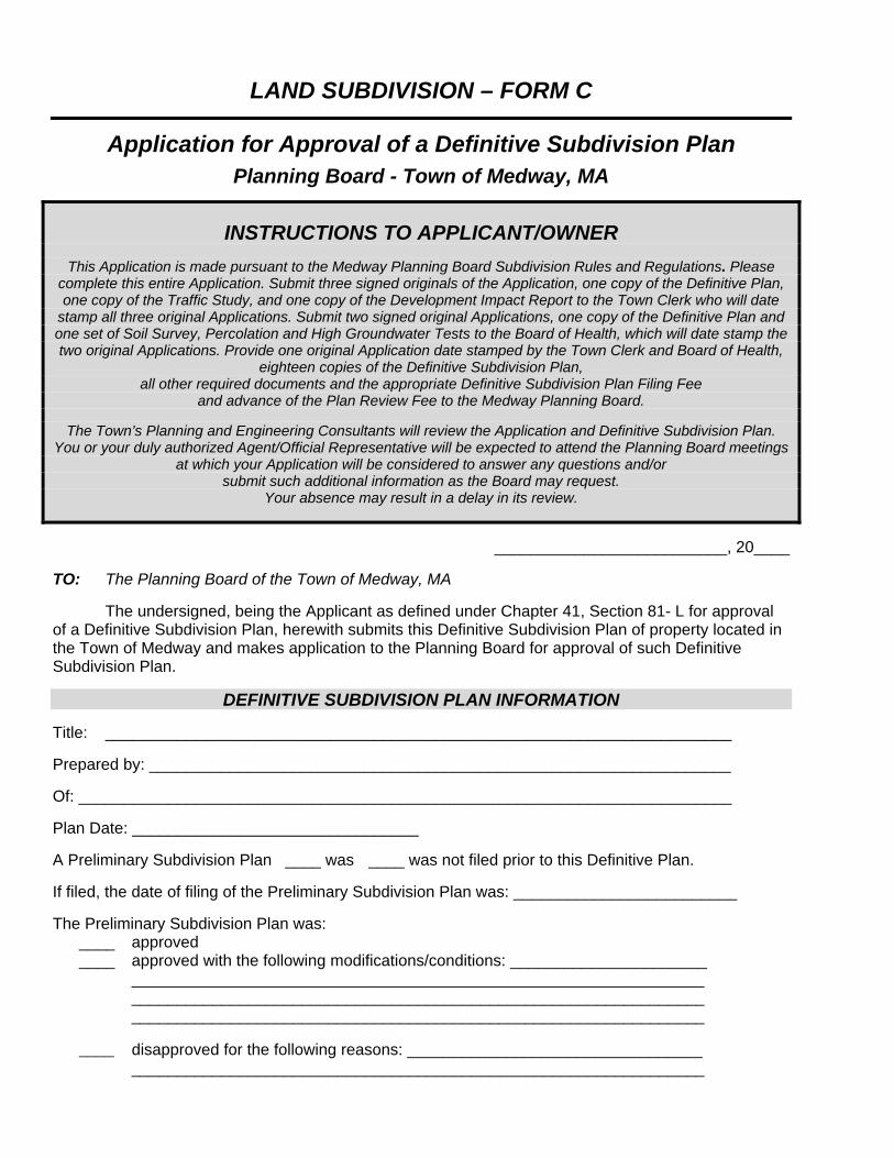
LAND SUBDIVISION – FORM C
Application for Approval of a Definitive Subdivision Plan
Planning Board - Town of Medway, MA
INSTRUCTIONS TO APPLICANT/OWNER
This Application is made pursuant to the Medway Planning Board Subdivision Rules and Regulations. Please complete this entire Application. Submit three signed originals of the Application, one copy of the Definitive Plan, one copy of the Traffic Study, and one copy of the Development Impact Report to the Town Clerk who will date
stamp all three original Applications. Submit two signed original Applications, one copy of the Definitive Plan and one set of Soil Survey, Percolation and High Groundwater Tests to the Board of Health, which will date stamp the two original Applications. Provide one original Application date stamped by the Town Clerk and Board of Health,
eighteen copies of the Definitive Subdivision Plan, all other required documents and the appropriate Definitive Subdivision Plan Filing Fee
and advance of the Plan Review Fee to the Medway Planning Board.
The Town’s Planning and Engineering Consultants will review the Application and Definitive Subdivision Plan. You or your duly authorized Agent/Official Representative will be expected to attend the Planning Board meetings
at which your Application will be considered to answer any questions and/or submit such additional information as the Board may request.
Your absence may result in a delay in its review.
__________________________, 20____
TO: The Planning Board of the Town of Medway, MA
The undersigned, being the Applicant as defined under Chapter 41, Section 81- L for approval of a Definitive Subdivision Plan, herewith submits this Definitive Subdivision Plan of property located in the Town of Medway and makes application to the Planning Board for approval of such Definitive Subdivision Plan.
DEFINITIVE SUBDIVISION PLAN INFORMATION Title: ______________________________________________________________________ Prepared by: _________________________________________________________________ Of: _________________________________________________________________________ Plan Date: ________________________________ A Preliminary Subdivision Plan ____ was ____ was not filed prior to this Definitive Plan. If filed, the date of filing of the Preliminary Subdivision Plan was: _________________________ The Preliminary Subdivision Plan was: ____ approved ____ approved with the following modifications/conditions: ______________________ ________________________________________________________________ ________________________________________________________________ ________________________________________________________________
____ disapproved for the following reasons: _________________________________ ________________________________________________________________
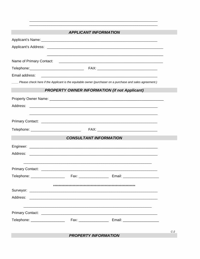
________________________________________________________________ ________________________________________________________________
APPLICANT INFORMATION Applicant’s Name: __________________________________________________________ Applicant’s Address: __________________________________________________________
__________________________________________________________
Name of Primary Contact: ____________________________________________________ Telephone:___________________________ FAX: ______________________________ Email address: __________________________________________________________ ____ Please check here if the Applicant is the equitable owner (purchaser on a purchase and sales agreement.)
PROPERTY OWNER INFORMATION (if not Applicant) Property Owner Name: _________________________________________________________ Address: ________________________________________________________________
________________________________________________________________ Primary Contact: __________________________________________________________ Telephone: _________________________ FAX: ______________________________
CONSULTANT INFORMATION
Engineer: ________________________________________________________________ Address: ________________________________________________________________ ________________________________________________________________ Primary Contact: __________________________________________________________ Telephone: _________________ Fax: _______________ Email: __________________
*********************************************************** Surveyor: ________________________________________________________________ Address: ________________________________________________________________ ________________________________________________________________ Primary Contact: __________________________________________________________ Telephone: _________________ Fax: _______________ Email: __________________
C-2 PROPERTY INFORMATION
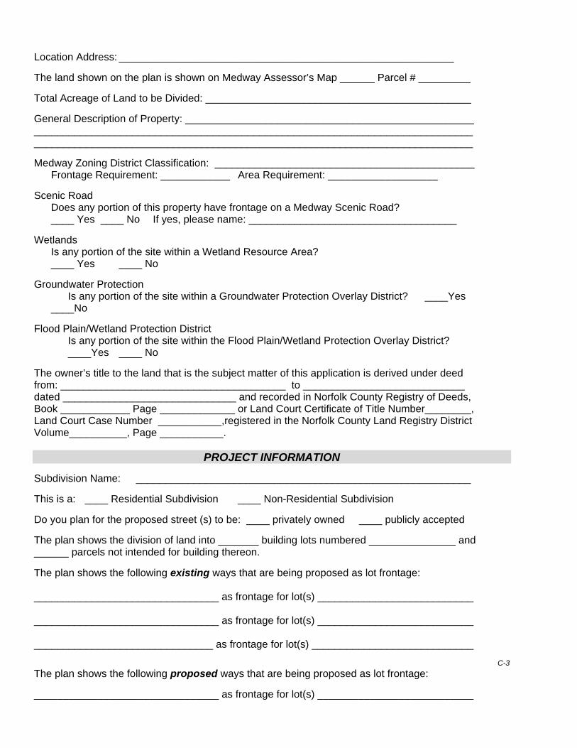
Location Address: __________________________________________________________ The land shown on the plan is shown on Medway Assessor’s Map ______ Parcel # _________ Total Acreage of Land to be Divided: ______________________________________________ General Description of Property: __________________________________________________ ____________________________________________________________________________ ____________________________________________________________________________ Medway Zoning District Classification: _____________________________________________ Frontage Requirement: ____________ Area Requirement: ___________________ Scenic Road Does any portion of this property have frontage on a Medway Scenic Road? ____ Yes ____ No If yes, please name: ____________________________________ Wetlands Is any portion of the site within a Wetland Resource Area? ____ Yes ____ No Groundwater Protection
Is any portion of the site within a Groundwater Protection Overlay District? ____Yes ____No Flood Plain/Wetland Protection District Is any portion of the site within the Flood Plain/Wetland Protection Overlay District? ____Yes ____ No The owner’s title to the land that is the subject matter of this application is derived under deed from: _______________________________________ to ____________________________ dated ______________________________ and recorded in Norfolk County Registry of Deeds, Book ____________ Page _____________ or Land Court Certificate of Title Number________, Land Court Case Number ___________,registered in the Norfolk County Land Registry District Volume__________, Page ___________.
PROJECT INFORMATION Subdivision Name: __________________________________________________________ This is a: ____ Residential Subdivision ____ Non-Residential Subdivision Do you plan for the proposed street (s) to be: ____ privately owned ____ publicly accepted The plan shows the division of land into _______ building lots numbered _______________ and ______ parcels not intended for building thereon. The plan shows the following existing ways that are being proposed as lot frontage: ________________________________ as frontage for lot(s) ___________________________ ________________________________ as frontage for lot(s) ___________________________ _______________________________ as frontage for lot(s) ____________________________
C-3
The plan shows the following proposed ways that are being proposed as lot frontage: ________________________________ as frontage for lot(s) ___________________________
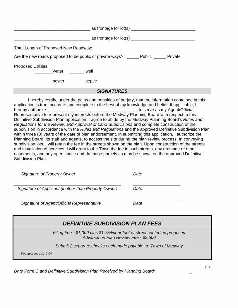
________________________________ as frontage for lot(s) ___________________________ ________________________________ as frontage for lot(s) ___________________________ Total Length of Proposed New Roadway: ___________________________________________ Are the new roads proposed to be public or private ways? _____ Public _____ Private Proposed Utilities: _______ water ______ well _______ sewer ______ septic
SIGNATURES
I hereby certify, under the pains and penalties of perjury, that the information contained in this application is true, accurate and complete to the best of my knowledge and belief. If applicable, I hereby authorize ______________________________________ to serve as my Agent/Official Representative to represent my interests before the Medway Planning Board with respect to this Definitive Subdivision Plan application. I agree to abide by the Medway Planning Board’s Rules and Regulations for the Review and Approval of Land Subdivisions and complete construction of the subdivision in accordance with the Rules and Regulations and the approved Definitive Subdivision Plan within three (3) years of the date of plan endorsement. In submitting this application, I authorize the Planning Board, its staff and agents, to access the site during the plan review process. In conveying subdivision lots, I will retain the fee in the streets shown on the plan. Upon construction of the streets and installation of services, I will grant to the Town the fee in such streets, any drainage or other easements, and any open space and drainage parcels as may be shown on the approved Definitive Subdivision Plan. _____________________________________________ ____________________ Signature of Property Owner Date _____________________________________________ ____________________ Signature of Applicant (if other than Property Owner) Date _____________________________________________ ____________________ Signature of Agent/Official Representative Date
DEFINITIVE SUBDIVISION PLAN FEES
Filing Fee - $1,000 plus $1.75/linear foot of street centerline proposed Advance on Plan Review Fee - $2,500
Submit 2 separate checks each made payable to: Town of Medway
Fee approved 11-9-04
C-4
Date Form C and Definitive Subdivision Plan Received by Planning Board: _______________
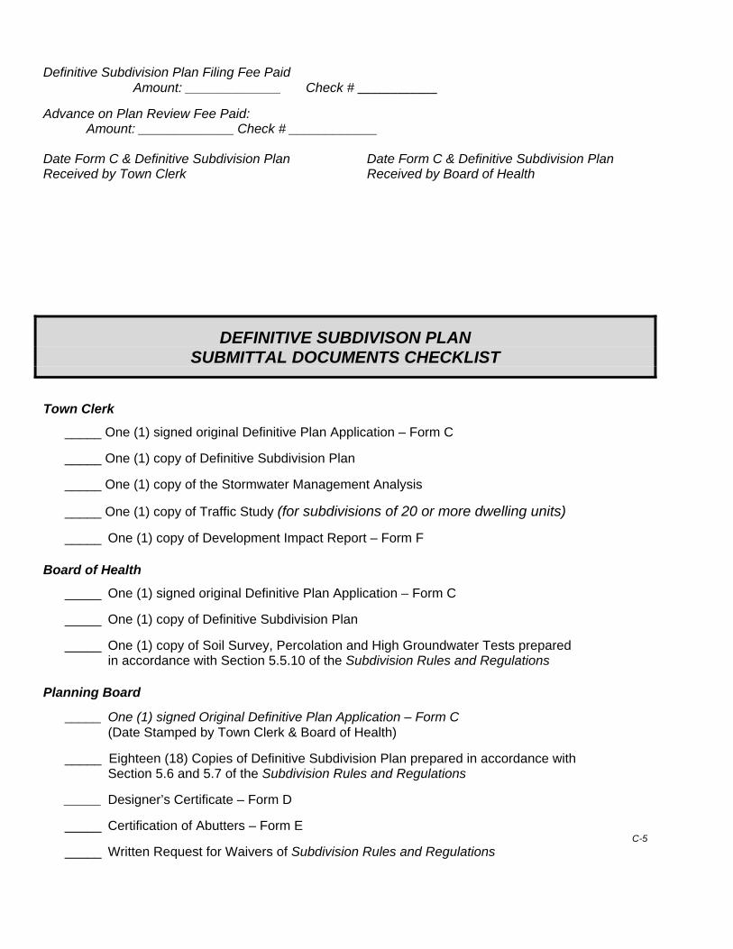
Definitive Subdivision Plan Filing Fee Paid Amount: _____________ Check # ____________
Advance on Plan Review Fee Paid: Amount: _____________ Check # ____________ Date Form C & Definitive Subdivision Plan Date Form C & Definitive Subdivision Plan Received by Town Clerk Received by Board of Health
DEFINITIVE SUBDIVISON PLAN SUBMITTAL DOCUMENTS CHECKLIST
Town Clerk
_____ One (1) signed original Definitive Plan Application – Form C _____ One (1) copy of Definitive Subdivision Plan _____ One (1) copy of the Stormwater Management Analysis _____ One (1) copy of Traffic Study (for subdivisions of 20 or more dwelling units) _____ One (1) copy of Development Impact Report – Form F Board of Health
_____ One (1) signed original Definitive Plan Application – Form C
_____ One (1) copy of Definitive Subdivision Plan
_____ One (1) copy of Soil Survey, Percolation and High Groundwater Tests prepared in accordance with Section 5.5.10 of the Subdivision Rules and Regulations
Planning Board
_____ One (1) signed Original Definitive Plan Application – Form C (Date Stamped by Town Clerk & Board of Health)
_____ Eighteen (18) Copies of Definitive Subdivision Plan prepared in accordance with
Section 5.6 and 5.7 of the Subdivision Rules and Regulations _____ Designer’s Certificate – Form D _____ Certification of Abutters – Form E
C-5 _____ Written Request for Waivers of Subdivision Rules and Regulations
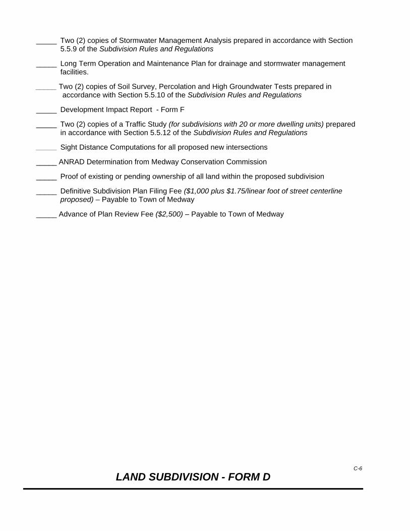
_____ Two (2) copies of Stormwater Management Analysis prepared in accordance with Section 5.5.9 of the Subdivision Rules and Regulations
_____ Long Term Operation and Maintenance Plan for drainage and stormwater management
facilities.
_____ Two (2) copies of Soil Survey, Percolation and High Groundwater Tests prepared in accordance with Section 5.5.10 of the Subdivision Rules and Regulations
_____ Development Impact Report - Form F
_____ Two (2) copies of a Traffic Study (for subdivisions with 20 or more dwelling units) prepared in accordance with Section 5.5.12 of the Subdivision Rules and Regulations
_______ Sight Distance Computations for all proposed new intersections _____ ANRAD Determination from Medway Conservation Commission _____ Proof of existing or pending ownership of all land within the proposed subdivision
_____ Definitive Subdivision Plan Filing Fee ($1,000 plus $1.75/linear foot of street centerline proposed) – Payable to Town of Medway
_____ Advance of Plan Review Fee ($2,500) – Payable to Town of Medway
C-6
LAND SUBDIVISION - FORM D

Designer’s Certificate
Planning Board – Town of Medway, MA
________________________, 20______
TO: The Planning Board of the Town of Medway, Massachusetts
In preparing the plan entitled _____________________________________________________ and dated _____________________________________, I hereby declare that the above named plan and accompanying data is true and correct to the accuracy required by the current Medway Planning Board Subdivision Rules and Regulations and required by the rules of the Massachusetts Registries of Deeds. My source of information about the location of boundaries shown on said plan was one or more of the following: 1. Deed from ___________________________________________________________________ to ___________________________________________________ dated _________________ and recorded in the Norfolk County Registry of Deeds, Book _________, Page_____________. 2. Other deeds and plans, as follows: ___________________________________________________ ____________________________________________________________________________________________________________________________________________________________________ 3. Oral information furnished by: ________________________________________________________ ____________________________________________________________________________________________________________________________________________________________________ 4. Actual measurements on the ground from a starting point established by: ____________________ ____________________________________________________________________________________________________________________________________________________________________ (Seal of Surveyor) Signed ________________________________________________ (Registered Land Surveyor) __________________________________________________ __________________________________________________ __________________________________________________
Registration No. __________________________________ Signed ________________________________________________ (Seal of Engineer) (Registered Professional Engineer) ___________________________________________________ ___________________________________________________
___________________________________________________
Registration No. _______________________________
Revised – March 25, 2005

LAND SUBDIVISION - FORM E
Certified List of Abutters & Owners within 300’
PLANNING BOARD – Town of Medway, MA
__________________________, 20_______ TO: The Planning Board of the Town of Medway, Massachusetts
The undersigned, being an applicant for approval of a preliminary/definitive (please circle the stage of plan you are submitting) plan of a proposed subdivision entitled: ____________________________________________________________________________ and dated _________________________, hereby submits the following abutter information: _____ 1. The attached sketch of the land (Assessor’s Map) in and around the proposed
subdivision listing the names of all adjoining/abutting owners and all other owners of land within three hundred feet (300’) of the land shown on the plan, in their relative positions, including and across adjoining ways.
_____ 2. The attached names and addresses of all parties adjoining/abutting and owning land
within three hundred feet (300’) of the proposed subdivision. (See reverse side of this Form for instructions on preparing a Certified Abutters List.) The name and address information has been certified as accurate and dated by the Town of Medway Assessor’s Office and by the Assessor of any adjacent town(s) in which land within three hundred feet (300’) of the boundaries of the proposed subdivision is located.
In submitting this information I hereby certify that to the best of my ability and
knowledge, the list of names and addresses is complete and includes all adjoining/ abutting owners of property and all owners within three hundred feet (300’) of the boundaries of the proposed subdivision. ______________________________________ ________________________________ Applicant’s Name (PRINT) Applicant’s Signature
_________________________________________ ________________________________ Preparer’s Name (if different than applicant) Preparer’s Signature *********************************************************************************************** Date Form E Received by the Planning Board:_________________________
Information provided: _____ Sketch of land with names of all adjoining/abutting owners and all other owners within 300’ _____ List of names and addresses of adjoining/abutting owners and all other owners of land within
300’ certified as correct by the Medway Assessor’s office. _____List of names and addresses of adjoining/abutting owners of land and all other owners within
300’ in any adjacent community certified as correct by the respective municipal Assessor’s office.
Revised – March 29, 2005
INSTRUCTIONS For Preparing a Certified Abutters List
for the Medway Planning Board
An applicant for preliminary or definitive subdivision plan approval shall submit a
Certified Abutters List to the Planning Board with the application. A Certified Abutters List identifies the subject parcel(s) and specifies the Assessor’s Map and Parcel Numbers, property owner names, location addresses, and property owner mailing addresses, as they appear on the most recent applicable tax list, of the following:
A. Direct abutters to the subject parcel(s) including:
1. Owners of land directly adjacent/contiguous to the property lines of the subject parcel (boundary lines of the proposed development); and
2. Owners of land directly opposite the subject parcel on any public or private street
or way.
B. Abutters to abutters (and beyond) within three hundred feet (300’) beyond the property line of the subject parcel (boundary lines of the proposed development).
The Planning Board uses the Certified Abutters List to prepare the mailing to the abutters of
the notice of the public briefing or hearing at which the Planning Board will discuss the subdivision application and plan.
The applicant prepares an Abutters List using information available at the Medway Assessor’s Office and provides it to the Assessor’s Office for certification. It is the Applicant’s responsibility to compile a complete list that includes all properties within the required areas noted above.
Certification by the Medway Assessor’s Office pertains only to the accuracy of
the information on the list you compile and submit to them for review. The Assessor’s Office will correct and update map/parcel numbers, property owner names and addresses prior to their certification. The Assessor’s certification does NOT verify that your list is complete or that all properties within the required area are included. The Assessor’s Office does not measure the map to check that you have listed all required parcels. THAT IS YOUR JOB!
NOTE – If any of the properties within three-hundred feet (300’) of the parcel are located in an adjacent community, a separate Abutters List for the affected properties in that community, certified by the Board of Assessors of that Town, shall also be submitted to the Planning Board.

E-2
LAND SUBDIVISION - FORM F
Development Impact Report (DIR)
PLANNING BOARD – Town of Medway, MA
OVERVIEW The DIR is intended to serve as a guide to the applicant in formulating their development proposal, as
well as a guide to the Planning Board in evaluating the proposed Subdivision Plan in the context of existing conditions and the Town’s planning efforts. The DIR should be prepared as early in the design
process as possible, even if certain aspects are unknown at that time.
The DIR seeks to raise the broad range of issues generally association with a subdivision development plan in a form and in language that is understandable to the layperson. The DIR shall identify and assess development impacts that could possibly be avoided or mitigated if recognized early in the
development process. Other portions of the DIR request information that will help the Town plan ahead to provide adequate services in the future.
The DIR shall be filed with an application for approval of a Preliminary and a Definitive Subdivision Plan. It shall clearly and methodically assess the relationship of the proposed development to the
natural, physical, and social environment of the surrounding area. In preparing the DIR, a systematic interdisciplinary approach shall be utilized to include professionals in the natural and social
sciences and environmental design arts.
Date ______________________________
1. Name of Proposed Subdivision: _____________________________________________ 2. Location: ________________________________________________________________ 3. Name of Applicant (s): _____________________________________________________ 4. Brief Description of the Proposed Project: ______________________________________ 5. Name of Individual Preparing this DIR _________________________________________ Address: _____________________________ Phone: ____________________________ Professional Credentials: _____________________________________________________
SITE DESCRIPTION
6. Total Site Acreage: _____________
Approximate Acreage
At Present
After Completion
Meadow/brushland (non-agricultural) Forested Agricultural (includes orchards, croplands, pasture) Wetlands Water Surface Area Flood Plain Unvegetated (rock, earth or fill) Roads, buildings and other impervious surfaces Other (indicate type) TOTAL
7. Present permitted and actual land use by percentage of the site.
Uses
Percentage
Industrial Commercial Residential Forest Agricultural Other (specify)
8. List the zoning districts in which the site is located and indicate the percentage of the
site in each district. NOTE – Be sure to include overlay zoning districts.
Zoning District
Percentage
9. Predominant soil type(s) on the site: ___________________________________
Soil Drainage
(Use the U.S. Soil Conservation Service’s definition)
Soil Type
% of Site
Well drained Moderately well drained Poorly drained
F-2
10. Are there any bedrock outcroppings on the site? _____ Yes _____ No If yes, specify: _____________________________________________________ 11. Approximate percentage of proposed site with slopes between:
Slope
% of Site
0 – 10% 10 – 15% Greater than 15%
12. In which of the Groundwater Protection Districts is the site located?
Zone(s) ______ Proximity to a public well: ________ feet
13. Does the project site contain any species of plant or animal life that is identified as rare or endangered? (Consult the Massachusetts Heritage Program and the Medway Conservation Commission for information.) _____ Yes _____ No If yes, specify: _____________________________________________________ 14. Are there any unusual site features such as trees larger than 30 inches, bogs, kettle ponds, eskers, drumlins, quarries, distinctive rock formations or granite bridges?
_____ Yes _____ No If yes, specify: _____________________________________________________________ 15. Are there any established foot paths running through the site or railroad right of ways?
_____ Yes _____ No If yes, please specify: ________________________________________________________ 16. Is the site presently used by the community as an open space or recreation area? _____ Yes _____ No If yes, please specify: ________________________________________________________ 17. Does the site include scenic views or will the proposed development cause any scenic vistas to be obstructed from view? _____ Yes _____ No If yes, please specify: ________________________________________________________
F-3
18. Are there wetlands, lakes, pond, streams or rivers within or contiguous to the site? _____ Yes _____ No If yes, please specify: _______________________________________________________ _________________________________________________________________________ 19. Is there any farmland or forest land on the site protected under Chapter 61A or 61B of the Massachusetts General Laws? _____ Yes _____ No If yes, please specify: ________________________________________________________ 20. Has the site ever been used for the disposal of hazardous waste? Has a 21E study been conducted for the site? _____ Yes _____ No If yes, please specify: ________________________________________________________ __________________________________________________________________________ 21. Will the proposed activity require use and/or storage of hazardous materials, or generation of hazardous waste? _____ Yes _____ No If yes, please specify: _________________________________________________________ ___________________________________________________________________________ 22. Does the project location contain any buildings or sites of historic or archaeological significance? (Consult with the Medway Historical Commission)
_____ Yes _____ No If yes, please describe: ________________________________________________________ ___________________________________________________________________________ 23. Is the project contiguous to or does it contain a building located in a National Register historic district? _____ Yes _____ No If yes, please describe: ______________________________________________________ _________________________________________________________________________
CIRCULATION 24. What is the expected average weekday traffic and peak hour volumes to be generated by the proposed subdivision?
Average weekday traffic Average peak hour volumes – morning Average peak hour volumes - evening
F-4
25. Existing street(s) providing access to the proposed subdivision: Please specify: ______________________________________________________________ 26. Existing intersection(s) within 1000 feet of any access to the proposed development. Please specify intersection names: ______________________________________________ 27. Location of existing sidewalks within 1000 feet of the proposed site: _________________ ___________________________________________________________________________ 28. Location of proposed sidewalks and their connection to existing sidewalks: 29. Are there parcels of undeveloped land adjacent to the proposed site:
_____ Yes _____ No
Will access to these undeveloped parcels be provided from the proposed subdivision? _____ Yes _____ No If yes, please describe: ________________________________________________ _____________________________________________________________________ If no, please explain why: ________________________________________________
_____________________________________________________________________
UTILITIES AND MUNICIPAL SERVICES 30. What is the total number of dwelling units proposed? _____________________________ 31. What is the total number of bedrooms in the proposed subdivision? __________________ 32. Stormwater Management
A. Describe the nature, location and surface water body receiving current surface water of the site: _________________________________________________________ __________________________________________________________________ _______________________________________________________________
F-5

B. Describe the how the proposed stormwater management system will operate and how the existing stormwater patterns will be altered: _______________________ _________________________________________________________________
_________________________________________________________________ _________________________________________________________________ C. Will a NPDS Permit be required? _____ Yes _____ No
33. Please estimate the response time of the Fire Department to this site:
(Please consult with the Fire Department): __________________________________ 34. Schools A. Projected number of new school age children: ____________________ B. Distance to nearest elementary school: __________________________ MEASURES TO MITIGATE IMPACTS - Please attach a brief description of the measures that haven been taken during subdivision design and will be taken during subdivision construction for each of the following: 35. Maximize stormwater infiltration and groundwater recharge 36. Prevent surface and groundwater contamination 37. Reduce detrimental impacts to water quality 38. Maintain slope stability and prevent erosion 39. Conserve energy 40. Preserve wetlands 41. Preserve wildlife habitats, outstanding ecological or botanical features 42. Protect scenic views 43. Retain natural landscape features 44. Design street layouts to facilitate southern orientation of houses 45. Use curvilinear street patterns 46. Promote pedestrian and bicycle access and safety
F-6
47. Reduce the number of mature trees to be removed 48. Provide green belt/buffer areas 49. Preserve historically important structures and features on the site 50. Retain natural valley flood storage areas 51. Minimize the extent of waterways altered or relocated 52. Reduce the volume of cut and fill 53. Minimize the visual prominence of man-made elements even if necessary for safety or orientation 54. Minimize municipal maintenance frequency and costs 55. Reduce building site frontages or driveway egresses onto primary or secondary
streets
In describing each of the above, please use layman’s terms where possible while still being accurate and comprehensive. Where appropriate, please use graphic illustrations. Identify
data sources, reference materials and methodology used to determine all conclusions.
Created – April 13, 2005
F-7

MEDWAY PLANNING BOARD SUBDIVISION RULES AND REGULATIONS Adopted – April 26, 2005
APPENDIX – CONSTRUCTION DETAILS
CD – 1 Typical Roadway Cross Sections – Summary Table CD – 2 Non-Residential Street Typical Section CD – 3 Primary Street Typical Section CD – 4 Secondary Street Typical Section CD – 5 Local Street Typical Section CD – 6 Neighborhood Street Typical Section CD – 7 Permanent Private Roadway Typical Section CD – 8 Typical Cul-de-Sac with Landscaped Island CD – 9 Cul-de-Sac Typical Section CD – 10 Sample Landscaped Island Detail CD – 11 Modified Cape Cod Berm CD – 12 Vertical Granite Curb CD – 13 Sloped Granite Edging Detail CD – 14 Sloped Granite Edging Detail Along Existing Pavement CD – 15 Standard Wheelchair Ramp CD – 16 Parallel Type Wheelchair Ramp CD – 17 Wheelchair Ramp with Grass Strip CD – 18 Wheelchair Ramp Special CD – 19 Typical Driveway with Sidewalk and Asphalt berm CD – 20 Catch Basin Detail CD – 21 Drainage Manhole Detail CD – 22 Interior Drop Sewer Manhole Detail CD – 23 Utility Trench Detail in Existing Pavement to Remain CD – 24 Standard Utility Trench Detail CD – 25 Subdrain Detail CD – 26 Fieldstone Headwall Section Detail CD – 27 Flared End Section Detail CD – 28 Concrete Thrust Block Detail CD – 29 Hydrant Detail CD – 30 Sewer Service Chimney Detail CD – 31 Erosion Control Barrier Detail CD – 32 Siltsack Sediment Trap Detail
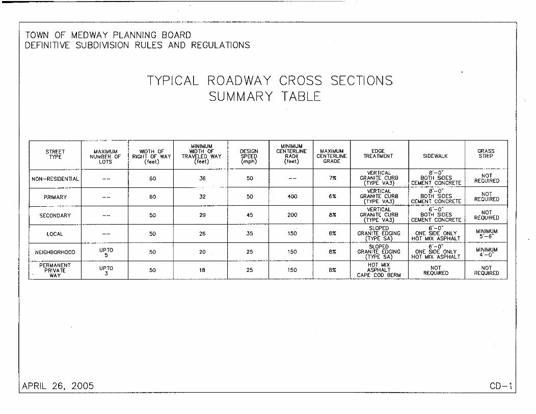

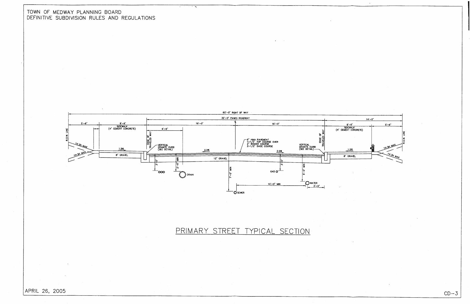
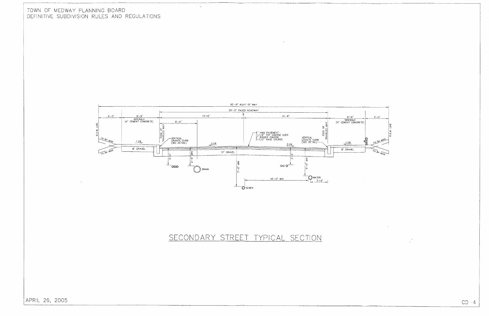
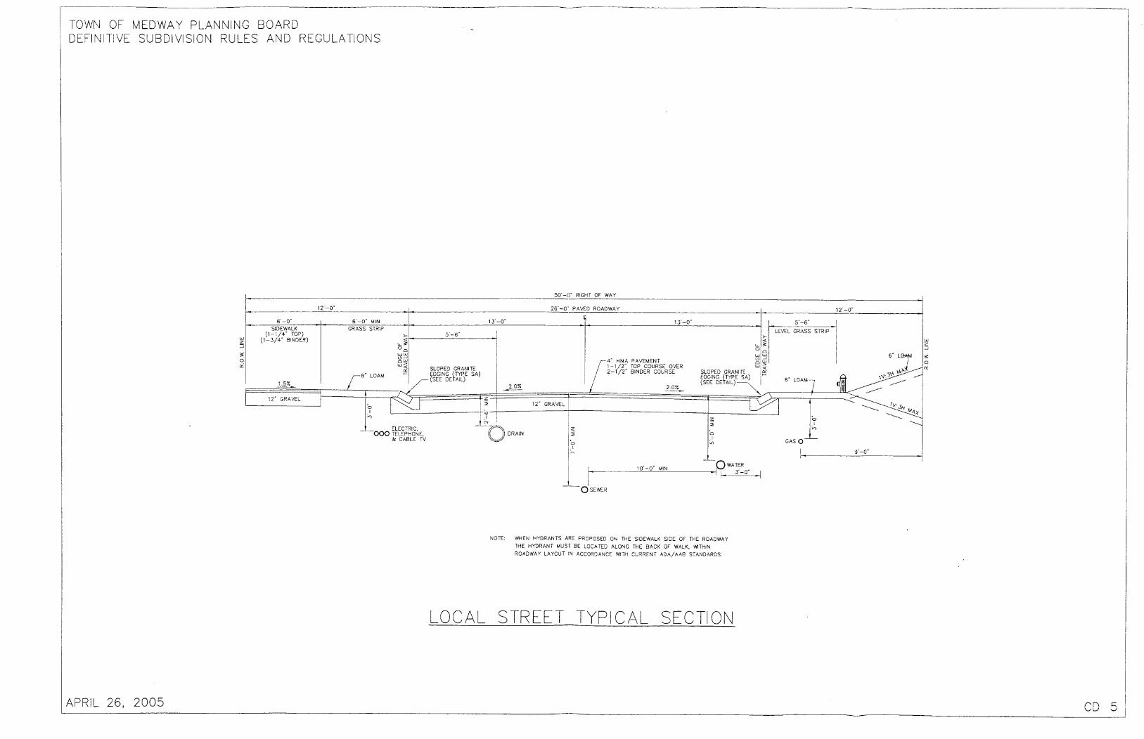

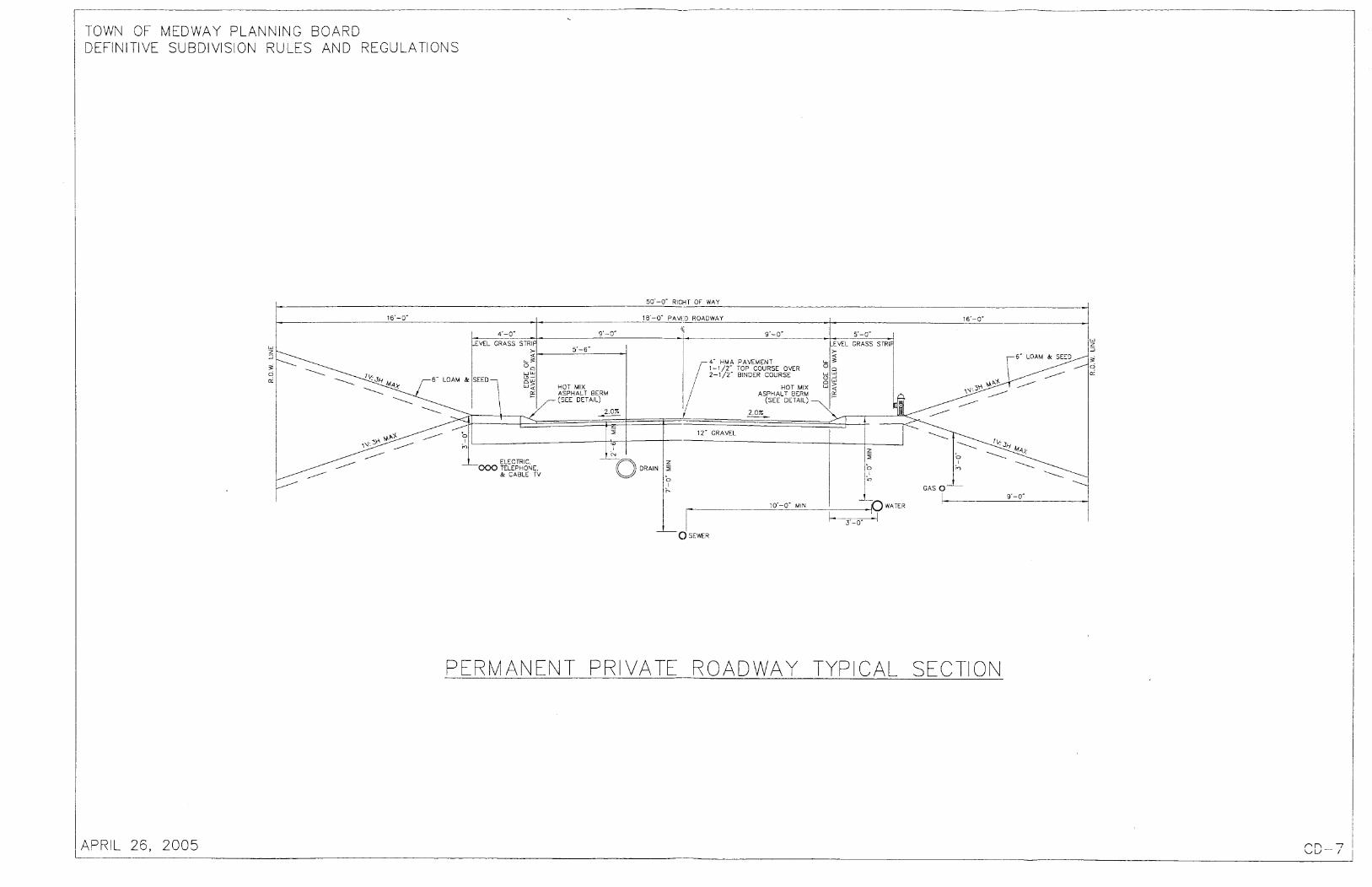

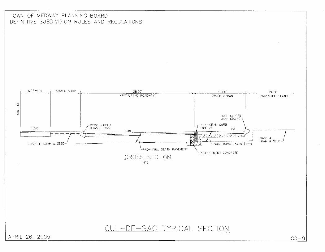
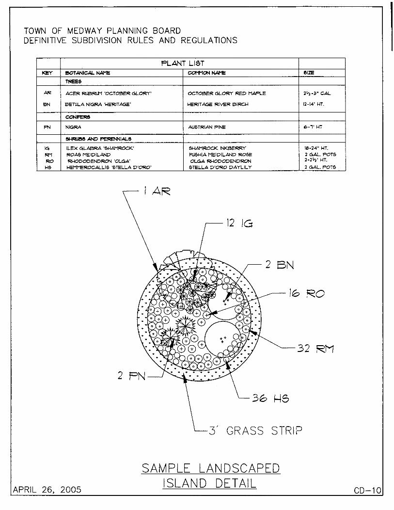
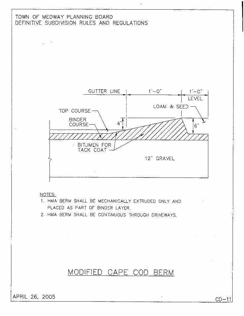
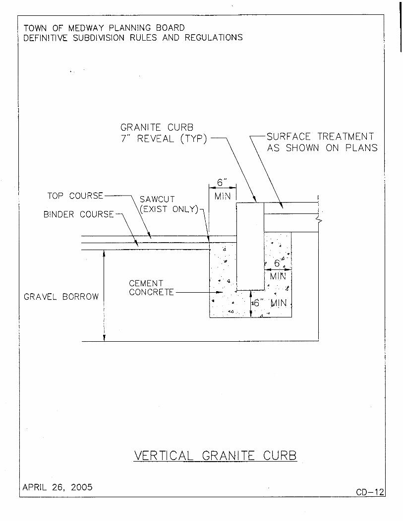


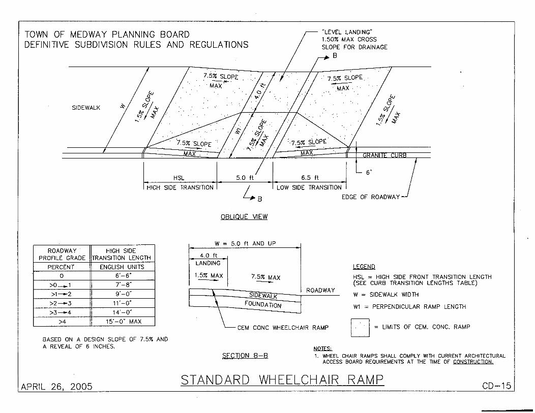
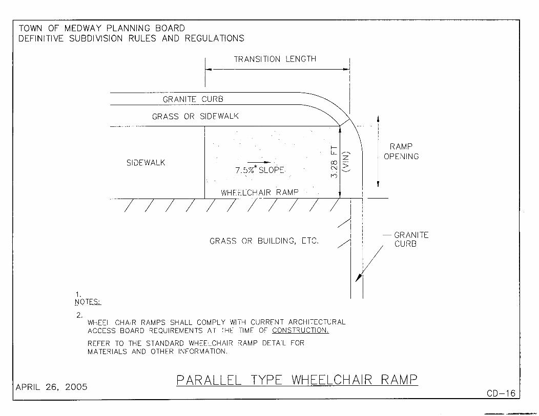
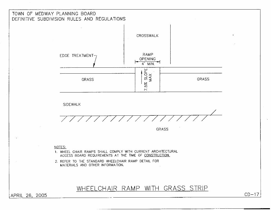
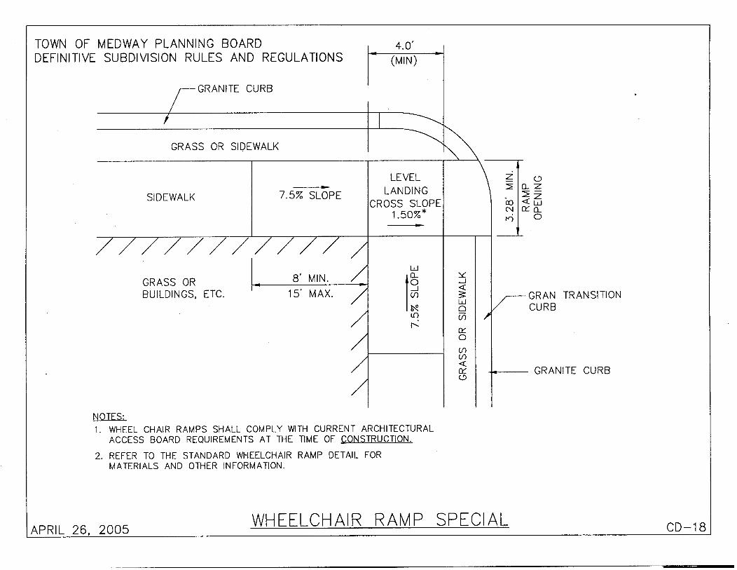

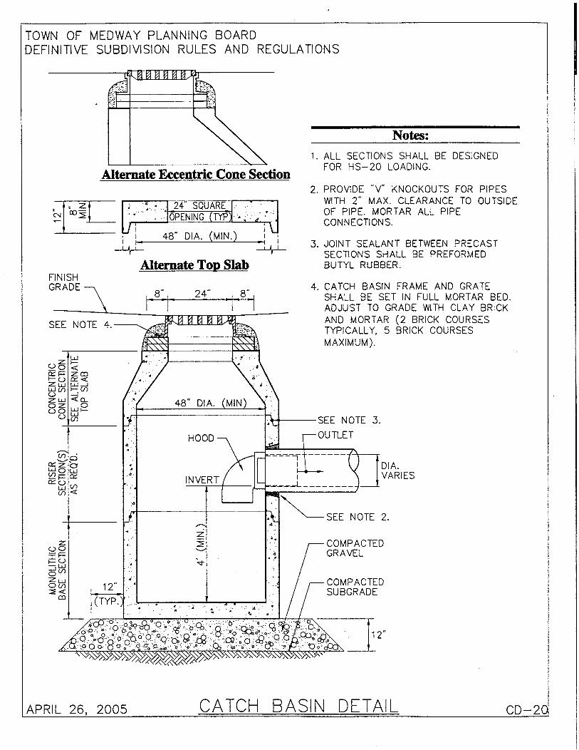

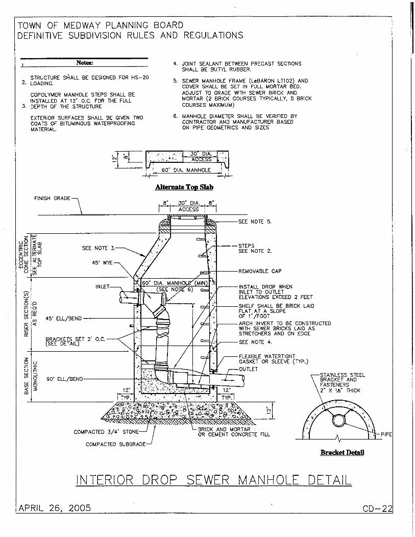

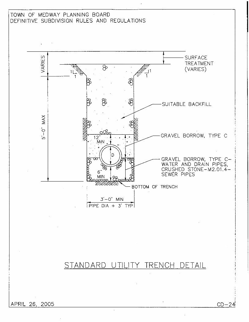
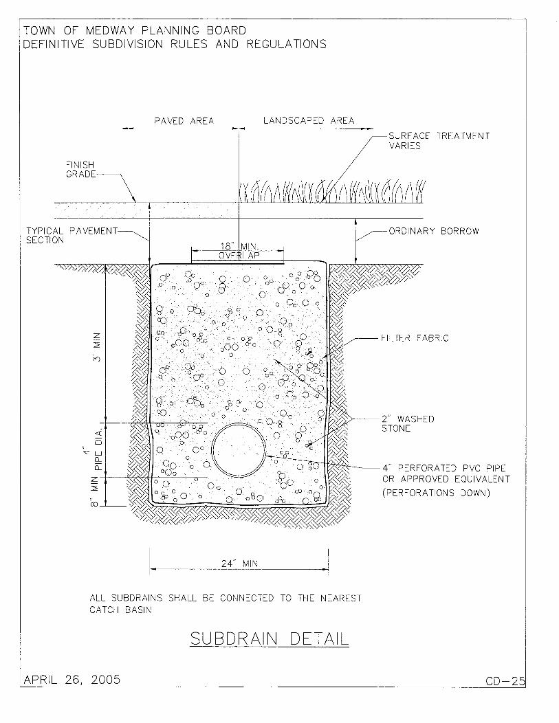
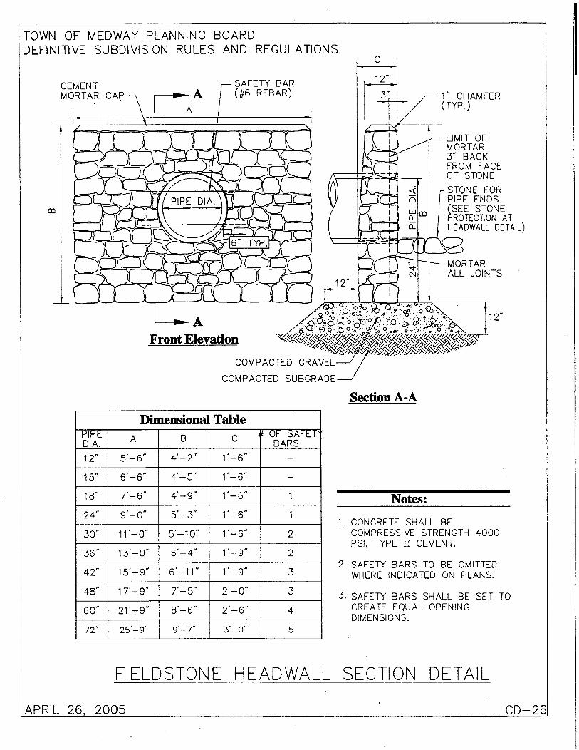


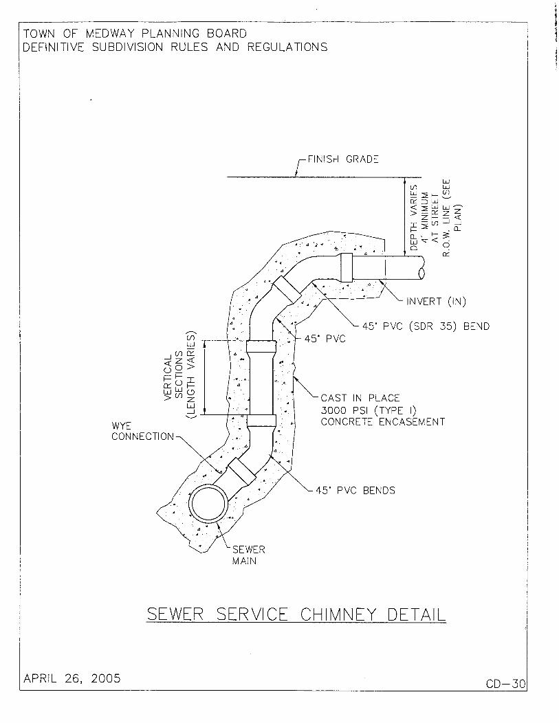
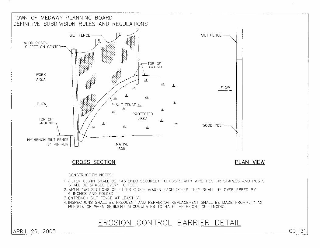

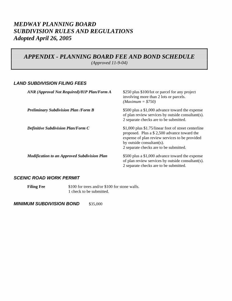
MEDWAY PLANNING BOARD SUBDIVISION RULES AND REGULATIONS Adopted April 26, 2005
APPENDIX - PLANNING BOARD FEE AND BOND SCHEDULE (Approved 11-9-04)
LAND SUBDIVISION FILING FEES ANR (Approval Not Required)/81P Plan/Form A $250 plus $100/lot or parcel for any project
involving more than 2 lots or parcels. (Maximum = $750)
Preliminary Subdivision Plan /Form B $500 plus a $1,000 advance toward the expense
of plan review services by outside consultant(s). 2 separate checks are to be submitted.
Definitive Subdivision Plan/Form C $1,000 plus $1.75/linear foot of street centerline
proposed. Plus a $ 2,500 advance toward the expense of plan review services to be provided by outside consultant(s). 2 separate checks are to be submitted.
Modification to an Approved Subdivision Plan $500 plus a $1,000 advance toward the expense
of plan review services by outside consultant(s). 2 separate checks are to be submitted.
SCENIC ROAD WORK PERMIT Filing Fee $100 for trees and/or $100 for stone walls.
1 check to be submitted.
MINIMUM SUBDIVISION BOND $35,000