tour of mont blanc - s3-eu-west-1.amazonaws.com · the col the vallon de la lée blanche, guarded...
TRANSCRIPT

TOUR OF MONT BLANCby
Kev Reynolds
JUNIPER HOUSE, MURLEY MOSS, OXENHOLME ROAD, KENDAL, CUMBRIA LA9 7RL
www.cicerone.co.uk
779 TMB Layout Aug 2017 Rpt.indd 3 23/08/2017 14:11

© Kev Reynolds 2015Fourth edition 2015 ISBN: 978 1 85284 779 1Reprinted 2016 (with updates), 2017 (with updates)Third edition 2011 Second edition 2007 First edition 2002
A catalogue record for this book is available from the British Library.All photographs are by the author unless otherwise stated.Printed in China on behalf of Latitude Press Ltd.
The routes of the GR®, PR® and GRP® paths in this guide have been reproduced with the permission of the
Fédération Française de la Randonnée Pédestre holder of the exclusive rights of the routes. The names GR®, PR® and GRP® are registered trademarks. © FFRP 2015 for all GR®, PR® and GRP® paths appearing in this work.
Front cover: Mont Blanc from the Grand Balcon Sud between La Flégère and Le Brévent
Updates to this GuideWhile every effort is made by our authors to ensure the accuracy of guidebooks as they go to print, changes can occur during the lifetime of an edition. Any updates that we know of for this guide will be on the Cicerone website (www.cicerone.co.uk/779/updates), so please check before planning your trip. We also advise that you check information about such things as transport, accommodation and shops locally. Even rights of way can be altered over time. We are always grateful for information about any discrepancies between a guidebook and the facts on the ground, sent by email to [email protected] or by post to Cicerone, Juniper House, Murley Moss, Oxenholme Road, Kendal LA9 7RL, United Kingdom.
Register your book: To sign up to receive free updates, special offers and GPX files where available, register your book at www.cicerone.co.uk.
DedicationThis book is dedicated to the memory of Andrew Harper
(1930–2001), author of the first English-language guide to the Tour of Mont Blanc.
779 TMB Layout Aug 2017 Rpt.indd 4 23/08/2017 14:11
58
The Tour of MonT Blanc
STAGE 3Les Chapieux – Col de la Seigne – Rifugio Elisabetta
Walk out of Les Chapieux heading northeast along the road, shortly joining company with the river and enter-ing a defile which is, in effect, the demarcation between the lower and upper valleys. Less than 1km from Les Chapieux take a signed footpath on the right which entices you off the road, exchanging what would other-wise be a slog on tarmac, for a more pleasant walk. The path climbs some way above the road before sloping down to cross the river on a fine bridge, then contin-ues heading upstream through the Vallée des Glaciers, at the head of which the pinnacle of the Aiguille des Glaciers is the most prominent feature. Soon the Col de la Seigne appears to the right of the aiguille. Drawing level with the few farm buildings of La Ville des Glaciers (1789m, 1½hrs), the footpath comes onto a track feed-ing from the road. It is here that the Col des Fours
Start point Les Chapieux (1554m)Distance 15kmHeight gain 1004mHeight loss 258mTime 4½–5hrsHigh point Col de la Seigne (2516m)Accommodation Les Mottets (2hrs) – privately-owned refuge
Rifugio Elisabetta – CAI refuge
On this stage the TMB crosses out of France and enters Italy at the Col de la Seigne, one of the easiest crossings of the circuit, but one which also happens to be among the most scenic. Given reasonable visibility, the view of Mont Blanc and the Aiguille Noire from Col de la Seigne is stunning, and is seen at its best early in the morning.
This relatively short stage will enable you to relax a little after what will have been two fairly demanding days, and there’s a good chance you’ll arrive at Rifugio Elisabetta with plenty of time in hand.
779 TMB Layout Aug 2017 Rpt.indd 58 23/08/2017 14:11

59
staGe 3: les Chapieux – rifuGio elisabetta
variante joins the main route. There’s a toilet block just across the bridge here, and an opportunity to top up water bottles. Apart from the refuge 30mins ahead, there will be no further guaranteed supply until you reach Rifugio Elisabetta.
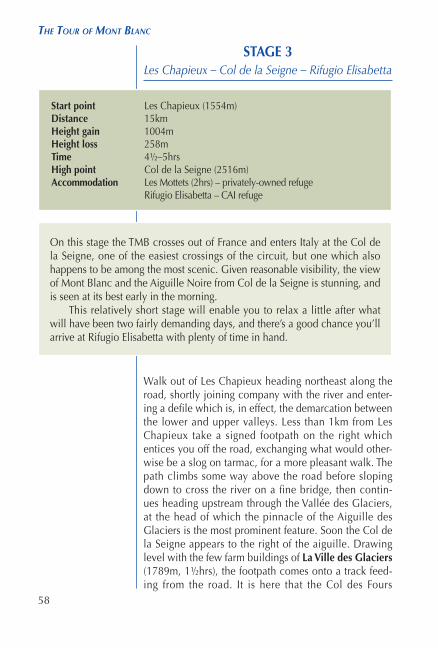
The small hamlet of Les Chapieux nestles on a bend in the Vallée des Glaciers
1½hrs 1¾–2hrs 3¼–3½hrs 4½–5hrs0m
500m
1000m
1500m
2000m
2500m
3000m
kilometres
Vill
e de
s G
laci
ers
Col
de
la S
eign
e
Les
Cha
pieu
x15
54m R
ef d
es M
otte
ts
Rif
Elis
abet
ta21
95m
779 TMB Layout Aug 2017 Rpt.indd 59 23/08/2017 14:11

60
The Tour of MonT Blanc
Vallé
e de
s Gla
cier
s
Gl desGlaciers
VILLE DESGLACIERS1789m
Les Chapieuxto
Rifugio Elisabetta
Col de la Seigne2516m
LES CHAPIEUX1554m
REF DESMOTTETS1870m
Gl de laLée Blanche
RIF ELISABETTA2195m
Aig. des Glaciers3816m
Tré-la-Tête3930m
Mont Tondu3196m
Tête de Bellaval2892m
Pte. des Ouillons3110m
FRANCE
ITALY
0 1 2 3
Kilometres
N
779 TMB Layout Aug 2017 Rpt.indd 60 23/08/2017 14:11

61
staGe 3: les Chapieux – rifuGio elisabetta
The valley’s upper basin now spreads out to reveal the rocky eminence of Mont Tondu, above to the left; a pas-toral area that encroaches as far as the outliers of the Mont Blanc massif. Follow the track ahead to the ruins of a one-time hotel and continue to the former dairy farm that has been converted to the
REFUGE DES MOTTETS (1870m, 2hrs) accommodation, refreshments; 90 dortoir places; open mid-June to mid-Sept (Tel 04 79 07 01 70; www.lesmottets.com).
This is an atmospheric place for a night’s lodging, with a dining room decorated with an assortment of old cheese-making implements, and the former cowshed turned into a dormitory. As it is the only place for refresh-ments between Les Chapieux and Rifugio Elisabetta, it’s worth stopping to tank up before heading for the pass.
From here the route to the col is neither long nor par-ticularly arduous, although it has a few short, steep sec-tions. Initially a broad, well-graded path, it later breaks into a skein of often muddy trails. Ascending high pas-tures, it dips into a stream-cut ravine and eases up the final broad slope that leads to the Col de la Seigne (11) (2516m, 3¼–3½hrs) and the revelation of a new world.
Arrival at the col is an eye-opener. Standing on the borders of France and Italy views in all directions are magnificent. Directly ahead the hillside falls away into a long, deep trench that forms a moat to the southern bastions of the Mont Blanc range. Immediately below the col the Vallon de la Lée Blanche, guarded by the Pyramides Calcaires, spills into the Vel Veni, which in itself leads to the (Italian) Val Ferret, at whose head the Grand Col Ferret will be crossed in another three days’ time. Beyond that rise Mont Vélan and the Grand Combin. Along the right-hand wall of this ‘moat’ a rum-pled green hillside carries the route of the TMB, while the left-hand wall boasts a succession of astonishingly rugged peaks and spiky ridges interrupted by cascades of ice and grey moraines. Dominant in all this is the grace-ful iced dome of Mont Blanc itself, with the spectacular
779 TMB Layout Aug 2017 Rpt.indd 61 23/08/2017 14:11

97
staGe 8: ChaMpex – Col de la forClaz
on the left. The trail is often greasy in places, with some steeply descending sections. On occasion a brief view is gained through the trees to Martigny on a bend in the Rhône valley, and of the road which snakes its way up through the Martigny Combe to Forclaz.
At last the path emerges from woodland with the Col de la Forclaz (19) just ahead.
COL DE LA FORCLAZ (1526m, 4½–5hrs) refreshments, shop, bus to Martigny and Trient, accommodation in Hotel du Col de la Forclaz, 40 dortoir places, 35 beds, camping, open mid-Dec to Nov (Tel 027 722 26 88; [email protected]; www.coldelaforclaz.ch).
Note Dortoir accommodation is also available in Trient (+ 30mins) and Le Peuty – also camping (+ 45mins) in the Vallée du Trient below to the west. See Stage 9 below for details.
The Bovine alp, with the Grand Combin in the distance floating among the clouds
779 TMB Layout Aug 2017 Rpt.indd 97 23/08/2017 14:11

103
alternative staGe 8: ChaMpex – Col de la forClaz
• Hotel du Col de la Forclaz (in 45mins) – beds and dortoirs
• Refuge Les Grands – no meals provision (1½hrs) • Le Peuty for gîte and camping (30mins) and Trient
(45mins) for dortoirs.Much, of course, will depend on your state of fit-
ness after the demands of the route so far. But you’ll also need to consider tomorrow’s route too, for there’s more than one way to reach the Col de Balme on Stage 9. All of the above overnight options are on one route or another to the col, except the Forclaz hotel. Walkers choosing to spend the night there will either return to this junction at Chalet du Glacier or descend to the road near Trient and walk back upvalley. Details will be found under Stage 9.
Route to Col de la ForclazDo not cross the torrent, but keep ahead along the easy, near-level path which accompanies the Bisse du Trient (22) for about 45mins all the way to the
HOTEL DU COL DE LA FORCLAZ (1526m, 6½hrs) refreshments, shop, bus to Martigny and Trient, accommodation; 40 dortoir places, 35 beds, camping, open mid-Dec to Nov (Tel 027 722 26 88; [email protected]; www.coldelaforclaz.ch).
Route to Refuge Les GrandsBear left at the signpost below the Chalet du Glacier, cross the footbridge and turn left on a good path which rises along the wooded hillside. When the path forks take the upper option (the alternative leads to the Alpage des Petoudes). Shortly after this junction the gra-dient steepens, and the path climbs in zigzags up the west side of the narrow valley falling from the Glacier des Grands. At the top of the zigzags the way slants to the right and crosses a shelf (safeguarded with fixed cable) against an impressive rock slab, and just above this comes to the
779 TMB Layout Aug 2017 Rpt.indd 103 23/08/2017 14:11

176
The Tour of MonT Blanc
Lacs
Jove
t
Tête
de
Bel
lava
l28
92m
Mon
t Ton
du31
96m
VIL
LE D
ESG
LAC
IER
S17
89m
RIF
ELI
SAB
ETTA
2195
m
Col
de
la S
eign
e25
16m
Col
de
la C
roix
du B
onho
mm
e24
83m
REF
DU
BO
NH
OM
ME
2443
m
Col
des
Fou
rs26
65m
Col
du
Bon
hom
me
2329
m
Tête
Nor
dde
s Fo
urs
2756
m
Les T
ufs
Cha
lets
de
la R
aja
Vallée des G
laciers
Rifu
gio
Elis
abet
tato
Ref
uge
du B
onho
mm
eLE
S C
HA
PIEU
X15
54m
REF
DES
MO
TTET
S18
70m
Pic
des
Oui
llons
3110
m
FRA
NC
EIT
ALY
01
23
Kilo
met
res
N
779 TMB Layout Aug 2017 Rpt.indd 176 23/08/2017 14:11

178
The Tour of MonT Blanc
dormitories, and the dining room in the main building being decorated with an assortment of old cheese-mak-ing and farming implements. Some evenings the guar-dienne entertains with music on her accordion.
A short distance beyond the refuge cross a stream on a footbridge, and a few paces after this join a track. When it curves to cross a bridge below the farming hamlet of La Ville des Glaciers (1789m; water supply and toilet block), take a footpath heading downvalley, still on the left bank of the Torrent des Glaciers. However, should it be your plan to take the Col des Fours variante, cross the bridge, go up the slope to the buildings and follow directions as below.
Main Route via Les ChapieuxFollow the left bank footpath heading downstream. Shortly before reaching Les Chapieux, it crosses the river then climbs above the road for a while before sloping down onto the road leading into the hamlet of
Once a dairy farm, Refuge des Mottets
now provides accommodation for TMB walkers below
Col de la Seigne
779 TMB Layout Aug 2017 Rpt.indd 178 23/08/2017 14:11

213
STAGE 10Trient – Alp Bovine – Champex
The day begins by walking up the hillside to the Col de la Forclaz, and to achieve this you make your way above the church in Trient to the main road, where you bear right. A short distance along this, turn off by a stone cross on a broad grass track rising above the road. Entering woodland, this track brings you onto the Forclaz road. Bear right for a few paces, then cross a footbridge to a continuing trail which climbs steeply, eventually bringing you onto a lovely level footpath beside a bisse (irrigation channel). Turn left, shortly to arrive at the
COL DE LA FORCLAZ (19) (1526m, 45mins) refreshments, shop, bus to Martigny, accommodation in Hotel du Col de la Forclaz; 40 dortoir places, 35 beds, camping, open mid-Dec to Nov (Tel 027 722 26 88; [email protected]; www.coldelaforclaz.ch).
Start point Trient (1279m)Distance 17kmHeight gain 929mHeight loss 742mTime 5½hrs High point Collet Portalo (2040m)Accommodation Col de la Forclaz (45mins) – hotel/dortoir, camping
Bovine (2½hrs) – emergency dortoir only Champex d’en Haut (4½hrs) – gîte, hotel Champex – hotels, pensions, gîte, camping
Alternative route Les Grands – Fenêtre d’Arpette – Champex (see Alternative Stage 10)
Of the two routes to Champex, this is the easier – but it does have its challenging sections, and some surprising views of the Rhône Valley, Bernese Alps and Grand Combin. For the Fenêtre d’Arpette variante, see below.
779 TMB Layout Aug 2017 Rpt.indd 213 23/08/2017 14:11
222
The Tour of MonT Blanc
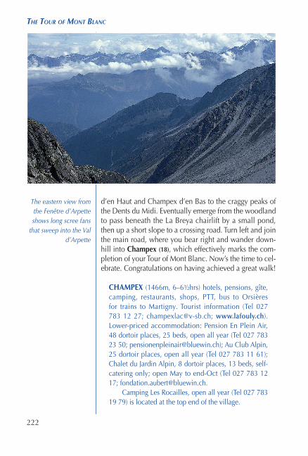
d’en Haut and Champex d’en Bas to the craggy peaks of the Dents du Midi. Eventually emerge from the woodland to pass beneath the La Breya chairlift by a small pond, then up a short slope to a crossing road. Turn left and join the main road, where you bear right and wander down-hill into Champex (18), which effectively marks the com-pletion of your Tour of Mont Blanc. Now’s the time to cel-ebrate. Congratulations on having achieved a great walk!
CHAMPEX (1466m, 6–6½hrs) hotels, pensions, gîte, camping, restaurants, shops, PTT, bus to Orsières for trains to Martigny. Tourist information (Tel 027 783 12 27; [email protected]; www.lafouly.ch). Lower-priced accommodation: Pension En Plein Air, 48 dortoir places, 25 beds, open all year (Tel 027 783 23 50; [email protected]); Au Club Alpin, 25 dortoir places, open all year (Tel 027 783 11 61); Chalet du Jardin Alpin, 8 dortoir places, 13 beds, self-catering only; open May to end-Oct (Tel 027 783 12 17; [email protected].
Camping Les Rocailles, open all year (Tel 027 783 19 79) is located at the top end of the village.
The eastern view from the Fenêtre d’Arpette shows long scree fans
that sweep into the Val d’Arpette
779 TMB Layout Aug 2017 Rpt.indd 222 23/08/2017 14:11
224
The Tour of MonT Blanc
Le Peclet, Le Champel, 74170 Saint Gervais (Tel 06 84 18 45 55, [email protected], www.lepeclet.fr) 6b: June–Sept
Refuge de Miage, 74170 Saint Gervais (Tel 04 50 93 22 91) – 37d, 2b: June–mid-Sept
Auberge du Truc, Chemin du Truc, 74170 Saint Gervais (Tel 04 50 93 12 48, [email protected]) – 28d: mid-June–mid-Sept
LES CONTAMINES-MONTJOIE
Office de Tourism, 18 Route de Notre Dame de la Gorge, BP7, 74170 Les Contamines-Montjoie (Tel 04 50 47 01 58, [email protected]; www.lescontamines.com)
Refuge du CAF, 22 Route du Plan du Moulin, 74170 Les Contamines (Tel 04 50 47 00 88) – 28d: mid-June–mid-Sept
Chalet Bonaventure, 135 Chemin du Nivorin d’en Bas, 74170 Les Contamines (Tel 04 50 47 23 53, [email protected]) – 8d: mid-June–mid-Sept
Hotel Christiania, 593 Route de ND de la Gorge, 74170 Les Contamines (Tel 04 50 47 02 72, [email protected]; www.lechristiania-hotel.com) – b
Chalet-Hotel La Chemenaz, Les Hameaux du Lay, 74170 Les Contamines-Montjoie (Tel 04 50 47 02 44 www.chemenaz.com) – 112b
Gîte du Pontet, 2485 Route de N.D. de la Gorge, 74170 Les Contamines (Tel 04 50 47 04 04, [email protected]) – 32d: June–Sept
Refuge Nant Borrant, Chemin du Col du Bonhomme, 74170 Les Contamines (Tel 04 50 47 03 57, [email protected]) – 35d: mid-June–Sept
Refuge de la Balme, Route Col du Bonhomme, 74170 Les Contamines (Tel 04 50 47 03 54) – 36d, 14b: mid-June–mid-Sept
Refuge de la Croix du Bonhomme, 73270 Beaufort/Doron (Tel 04 79 07 05 28, [email protected]) – 113d: mid-June–mid-Sept
LES CHAPIEUX
Auberge de la Nova, Les Chapieux, 73700 Bourg St Maurice (Tel 04 79 89 07 15, [email protected], www.refugelanova.com) – 35d, 35b: May–Oct
Chambre de Soleil, Les Chapieux, 73700 Bourg St Maurice (Tel 04 79 31 22, [email protected], www.leschambresdusoleil-montblanc.com – 14b
Refuge des Mottets, Vallée des Glaciers, 73700 Bourg St Maurice (Tel 04 79 07 01 70, [email protected], www.lesmottets.com) – 90d: mid-June–mid-Sept
779 TMB Layout Aug 2017 Rpt.indd 224 23/08/2017 14:11