tot iwrm approach to climate change impacts and adaptation ... · pdf file3.4.1 presentation...
TRANSCRIPT

1
CB-HYDRONET
CONGO BASIN NETWORK FOR
RESEARCH AND CAPACITY BUILDING IN WATER RESOURCES
REGIONAL TRAINING OF TRAINERS IN IWRM APPROACH TO C LIMATE CHANGE IMPACTS AND ADAPTATION MEASURES
FINAL REPORT
KINSHASA 12-16 MAY 2014

2
TABLE OF CONTENT
EXECUTIVE SUMMARY ..................................................................................................................... 4
1. INTRODUCTION ........................................................................................................................... 5
2. METHODOLOGICAL APPROACH ............................................................................................... 7
3. RESULTS ....................................................................................................................................... 9
3.1 Introduction to catchment based Integrated Water Resources Management ............................... 9
3.1.1 IWRM concepts and principles ......................................................................................... 9
3.1.2 Tools for water evaluation and planning in IWRM .......................................................... 12
3.1.3 Global Water Partnership (GWP) Toolbox for IWRM..................................................... 17
3.1.4 Stakeholder participation in IWRM ................................................................................ 18
3.2 Understanding drivers and impacts of climate change ............................................................. 19
3.2.1 Physical science basis of climate change ......................................................................... 19
3.2.2 Drivers of climate change ............................................................................................... 20
3.2.3 Observed and projected trends of climate change and impacts on water cycle ................. 23
3.2.4 Groundwater management in IWRM ............................................................................. 24
3.3 Adapting to climate change through a catchment based approach ........................................... 28
3.3.1 Group assignments ......................................................................................................... 28
3.3.2 Concepts definition: vulnerability, adaptation, mitigation, resilience ............................... 29
3.3.3 Developing climate change adaptation strategies ............................................................. 30
3.3.4 Linkages between adaptation to climate change, disaster risk reduction and disaster prevention ...................................................................................................................................... 31
3.3.5 Groundwater vulnerability to climate change and possible adaptation measures .............. 31
3.3.6 Atlas on renewable energy and National Adaptation Plan ............................................... 32
3.3.7 IWRM implementation: a case of UNEP project for the Lukaya catchment + .................. 33
Planning for field visit and introduction to the stakeholder analysis exercise .................................. 33
3.4 Field visit to Lukaya catchment, a UNEP project on IWRM implementation .......................... 34
3.4.1 Presentation of the IWRM project in the Lukaya catchment ............................................ 34
3.4.2 Field Site Discussion: REGIDESO Water Treatment Plant ............................................. 36
3.4.3 Field visit to the Quarry (SBA) ....................................................................................... 37
3.5 Adapting to climate change through a catchment based approach ........................................... 37
3.5.1 Adaptation measures within a framework of PANA-ASA ............................................... 37
3.5.2 Presentation of case studies ............................................................................................ 39
3.5.3 AMCOW/GWP water security framework document and capacity development programme .................................................................................................................................... 39
3.5.4 Groupwork presentations, general discussion and the way forward ................................. 40
4. WORKSHOP EVALUATION ....................................................................................................... 41
4.1 General evaluation..................................................................................................................... 41
4.2 Outcome evaluation ................................................................................................................... 46
5. CONCLUSION AND RECOMMENDATIONS ............................................................................ 48
ACKNOWLEDGMENT ....................................................................................................................... 56

3
LIST OF ABBREVIATIONS AUBR/L : Association des Usagers de Bassin Versant de la rivière Lukaya CAR : Central African Republic CAPNET: Capacity Building Network in Integrated Water Resource Management
CBD: Convention of Biological Diversity CB-HYDRONET: Congo Basin Network for Research and Capacity Development in Water
Resources CBLT: Commission du Bassin du Lac Tchad CICOS : Commission Internationale du Bassin Congo-Oubangui-Sangha CREN-K: Centre Régional d’Etudes Nucléaires de Kinshasa DRC: Democratic Republic of Congo DRE: Direction des Ressources en Eau DSS: Decision Support System ECCAS: Economic Commission of Central African States ESSTE: Ecole Supérieure des Sciences et Technologies de l’Eau GWP: Global Water Partnership/ Partenariat Mondial de l’Eau IWRM: Integrated Water Resources Management MECNT: Ministère de l’Environnement Conservation de la Nature et Tourisme METTELSAT: Agence Nationale de Météorologie et Télédétection par Satellite ODMP: Okavango Delta Management Plan REGIDESO: Régie d’Adduction d’Eau Potable SADC: Southern African Developpement Community UNDP : United Nations Development Programme UNEP: United Nations Environmental Programme UNIKIN: Université de Kinshasa UNISA: University of South Africa UPN: Université Pédagogique Nationale WEAP: Water Evaluation And Planning WATERNET: Water Capacity Building Network

4
EXECUTIVE SUMMARY
A regional training of trainers in IWRM approach to climate change impacts and adaptation measures was held in Kinshasa from 12-16 May 2014, with the aim to develop capacity of stakeholders towards a better appreciation of climate change impacts in water resources and the ability to use IWRM approach as a tool for climate change adaptation.
The training was implemented by CB-HYDRONET with financial and logistic supports from CAP-NET, WATERNET, GWP Central Africa and Southern Africa, United Nations Development Program (UNDP) in the Democratic Republic of Congo (DRC), University of Kinshasa and the Ministry of Environment in the DRC. Overall, 40 participants took part in the training. The participants came from 33 institutions of water sectors in 13 countries that are part of the Southern Africa Development Community (SADC) and the Economic Community for Central Africa States (ECCAS) Region, representing a broad range of stakeholder groups that included research and education, private sector, civil society organisations, policy and decision makers from government, river basin organisations, amongst others.
The methodological approach to the workshop was centered on plenary presentations, group work sessions, field visits and facilitation meetings. The five day workshop had a 100% participation rating with respect to the number of participants invited. Participants present had quite a good balance in terms of regional and gender representation. With respect to content, the workshop was a good mix of theory and practice as CB-HYDRONET mobilised a mix of academic and field experts from the Central, Eastern and Southern Africa Regions, as well as from the United Nations system and NGOs.
Based on the final evaluation, it was acknowledged by the participants that the workshop achieved its main objectives of providing participants with skills for capacity building on IWRM as a tool for climate change adaptation. The final workshop evaluation by participants also indicated that the workshop achieved its objective of improving their understanding of not only the concepts and principles of IWRM and climate change, but also the linkages between them. Moreover, the workshop was honored to receive as guest the Secretary General of CICOS who explained to participants the origins, activities and future development of CICOS. He especially expressed CICOS wish to continue collaborating with CB-HYDRONET in strengthening capacity within the Congo River Basin.
It is expected that the participants will make special effort to mainstream IWRM and climate change in the academic training curricula at their respective institutions. The participants agreed to keep CB-HYDRONET secretariat informed on how they capitalise knowledge and tools acquired in their respective professional activities, academic and training programs.

5
1. INTRODUCTION
The impacts of climate change on water resources in Africa cannot be stressed enough. Predicted changes include seasonal distributions of climate variables such as temperature, evapo-transpiration, rainfall, wind speed and solar radiation; increase in frequency of extreme events such as flood and drought; variation of flow regimes including surface runoff, infiltration, soil moisture, recharge and base flows. The envisaged changes will have considerable impacts on water availability and the ecosystem services, thus affecting socio-economic development and livelihoods of the poor.
A recent report by the United Nations Environment Program (UNEP, 2013) on “Climate-change impacts, adaptation challenges and costs for Africa” gives a summary of the expected impacts as follow:
• Extreme weather events including droughts, floods and heat waves are likely to become both more frequent and more severe.
• With 4°C warming by 2100, sea-level rise along most African coasts could approach or exceed one meter. This will threaten communities and economic activity along some of Africa’s coastlines.
• Agricultural and fishery productivity will be diminished by changing climatic conditions. • Ecosystem ranges will potentially shift rapidly as warming increases, with a risk of loss of
biodiversity as species may be unable to migrate to keep pace. Accelerated woody plant encroachment could limit grazing options for both wildlife and animal stock.
• Crop production is expected to be reduced across much of the continent as optimal growing temperatures are exceeded and growing seasons shortened.
• Human health will be undermined by the risks associated with extreme weather events and an increased incidence of transmittable diseases and under-nutrition.
• At warming exceeding 3°C globally, virtually all of the present maize, millet, and sorghum cropping areas across Africa could become unviable. However, even a warming approaching 2°C will lead to a substantial increase in the proportion of under-nourished people in sub-Saharan Africa.
• Human health will be affected, as rates of undernourishment, child stunting, vector-borne diseases (e.g. malaria), and water-borne diseases (e.g. cholera) are altered by climatic changes. Extreme weather events such as flooding and drought can also cause morbidity and mortality.
• The tourism sector could be affected through factors such as extreme summertime temperatures, loss of biodiversity and natural attractions, and damage to infrastructure as a result of extreme weather events.
• Disruptions to energy supply could occur as changes in river runoff and increased temperatures affect hydroelectric dams and the cooling systems of thermoelectric power plants.

6
• In many cases, urban areas are particularly exposed to a number of risks associated with
climate change, including sea-level rise, storm surges and extreme heat events. Informal settlements are highly vulnerable to flooding and the poor urban populations have been found to be the most vulnerable to elevated food prices following disruptions to agricultural production.
• Those African populations that are already most vulnerable to climatic variability, such as the poor inhabitants of informal settlements, will become even more vulnerable.
While the impacts of climate change on water resources in Africa have been largely investigated, actions to build capacity of stakeholders towards improved appreciation of the impacts and adaptation measures to reduce their repercussion on livelihoods remain largely behind. This is certainly the case in the Congo Basin riparian countries where capacity building delivery to support current political, social and economic reforms on strategies for climate change impacts and adaptation is in disarray. It is therefore necessary to assist in developing capacities aimed at ensuring increased knowledge of stakeholders towards climate change impacts and their capabilities to address challenges of climate change on water resources within the framework of river basin planning and management.
In this context, a regional training of trainers on Integrated Water Resources Management (IWRM) Approach to Climate Change Impacts and Adaptation Measures was held in Kinshasa from 12 to 16 May 2014. The training was held in line with the work plan of the Congo Basin Network for Research and Capacity Development in Water Resources (CB HYDRONET) and the Water Capacity Building Network (WATERNET) respectively partners of the Capacity Building Network in Integrated Water Resource Management (CAPNET) in Central and Southern Africa. The initiative also aims to support the implementation of climate change commitments in the 2008 African Union Heads of State Sharm el Sheikh Declaration on water and sanitation that have been organized into a Water, Climate and Development Programme (WACDEP) by the African Ministers Council on Water (AMCOW). The WACDEP is implemented by the Global Water Partnership (GWP) network and its partners, and this training is also aligned to the WACDEP 2014 Regional work plans for GWP Southern Africa (GWP SA) and GWP Central Africa (GWP CAf).
The overall objective of the training of trainers’ workshop was to develop capacity of stakeholders towards a better appreciation of climate change impacts in water resources and the ability to use IWRM approach as a tool for climate change adaptation.

7
2. METHODOLOGICAL APPROACH
The training was implemented by CB-HYDRONET with financial and logistic supports from Cap-Net, WATERNET, GWP Central Africa and Southern Africa, United Nations Development Program (UNDP) in the Democratic Republic of Congo (DRC), University of Kinshasa and the Ministry of Environment in the DRC. Overall, 40 participants took part in the training. The participants came from 13 countries that are part of the Southern Africa Development Community (SADC) and the Economic Community for Central Africa States (ECCAS) Region, representing a broad range of stakeholder groups that included research and education, private sector, civil society organisations, policy and decision makers from government, river basin organisations, amongst others. Table 1 shows cartography of the institutions represented in the workshop. Appendix 1 presents particulars of the participants. The selection of the participants was made through an open online call and based on analysis of the information provided by the applicants. The elements of the application comprised of a Curriculum Vitae and a Motivation letter. The overall planning and coordination of the training was jointly assured by the regional secretariat of CB-HYDRONET, WATERNET and GWP Central Africa.
The training was prepared based on foundation materials developed by CAP-NET, following a series of case studies on climate change and adaptation. Other materials developed by African Union (AU) and African Ministers Council on Water (AMCOW) with GWP on the Strategic Framework for Water Security and Climate Resilient Development were used.
The approach to training delivery was mainly based on interactive lectures and participatory discussions led by resource persons with practical experience in IWRM and climate change. Facilitators included resource persons from universities, research institutions, United Nations Agencies and other international organisations. To make the training more practice oriented, case studies, practical examples from participating countries, group exercises, field visit to areas affected by climate change and experience sharing sessions were facilitated. Both English and French languages were used with simultaneous interpretation services available. Appendix 2 presents the programme and content of the training. Overall, the content for the five day training included the following modules:
• Introduction to catchment based Integrated Water Resources Management, Day 1;
• Understanding drivers and impacts of climate change, Day 2;
• Adapting to climate change through a catchment based approach, Day 3; • Field Visit to Lukaya catchment, a project of the United Nations Environmental
Programme (UNEP) on IWRM implementation, Day 4;
• Adapting to climate change through a catchment based approach (Cont’d), Day 5.
To facilitate the above mentioned course modules, CB-HYDRONET mobilised trainers from a mix of academic and field experts from the Central, Eastern and Southern Africa Regions, as well as from the UN system and NGOs (Table 2).

8
Table 1 Category of institutions and countries represented in the training
Table 2 List of facilitators
No Institution Category Countries Participants
1 Okavango Research Institute Research Botswana 1
2 University of Burundi Academics and Reseach Burundi 1
3 ACEEN/Lake Chad NGO Cameroon 1
4 GWP-CAF Inter Governmental Institution Cameroon 1
5 University of Bangui Academics and Reseach CAR 1
6 AUBR/L Water User Association/UNEP DRC 2
7 CB-HYDRONET Capacity Building DRC 5
8 CICOS River Basin Organistion DRC 1
9 CNEAE Government DRC 2
10 ESSTE Academics and Reseach DRC 1
11 GEEC Inter Ministry DRC 1
12 METTELSAT National Hydrological Service DRC 1
13 Ministry of Environment Government DRC 1
14 Ministry of Planning Government DRC 1
15 REGIDESO Water supply DRC 3
16 State Presidency State Presidency DRC 1
17 UNDP United Nations DRC 1
18 UNEP United Nations DRC 1
19 University of Bukavu Academics and Reseach DRC 1
20 University of Kinshasa Academics and Reseach DRC 2
21 University of Lubumbashi Academics and Reseach DRC 1
22 University of Mbuji May Academics and Reseach DRC 1
23 Agricultural Trade Private sector Rwanda 1
24 ECCAS Inter Governmental Institution Gabon 1
25 CIAT Inter Governmental Institution Sao Tome 1
26 University of South Africa Academics and Reseach South Africa 1
27 Ministry of Agriculture Government Swaziland 1
28 University of Dar es Salaam Academics and Reseach Tanzania 1
29 University of Zambia Academics and Reseach Zambia 1
30 Ministry of Mines, Energy and Water Government Zambia 1
31 Waternet Inter Governmental Institution Zimbawe 1
32 Fund Raising and Knowledge Mgt NGO Zimbawe 1
33 University of Zimbabwe Academics and Reseach Zimbawe 1
Facilitator Institution Country
Dr. Lapologang Magole WATERNET/ Okavango Research Institute Botswana
Mr. Hycinth Banseka GWP-CAF Cameroon
Mr. Patrick Mulengera University of Bukavu DRC
Mr. Idesbald Chinamula UNDP DRC
Mrs. Celine Jacmain UNEP DRC
Prof. Jean Ndembo PANA-ASA/ University of Kinshasa DRC
Prof. Raphael Tshimana CB-HYDRONET/University of Kinshasa DRC
Mr. Jean Pierre Kimfuta AUBR/L DRC
Dr. Francois Ilunga University of South Africa South Africa
Prof. Daniel Nkhuwa University of Zambia Zambia
Dr. Hodson Makurira University of Zimbabwe Zimbabwe
3. RESULTS
This section summarises the outcomediscussions, case studies presented and field visit.
3.1 Introduction to catchment based Integrated Water Resources Management
3.1.1 IWRM concepts and principles
Summary
The session on IWRM concepts and principles was facilitated by CAF) and brought to light basic key concepts of IWRM with regards to the distribution of water at the global scale, the limited amount of water for the growing socioneed to promote sustainable management of the limited resources through application of IWRM principles.
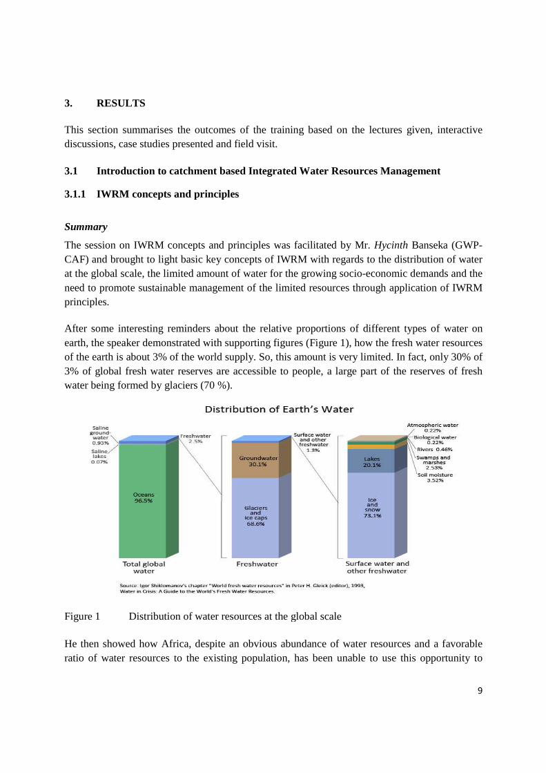
After some interesting reminders about the relative proportions of different types of water on earth, the speaker demonstrated with supporting figuresof the earth is about 3% of the world supply. So, this amount is very limited. In fact, only 30% of 3% of global fresh water reserves are accessible to people, a large part of the reserves of fresh water being formed by glaciers (70 %).
Figure 1 Distribution of water resources at the global scale
He then showed how Africa, despite an obvious abundance of water resources and a ratio of water resources to the existing population
es the outcomes of the training based on the lectures given, interactive discussions, case studies presented and field visit.
Introduction to catchment based Integrated Water Resources Management
IWRM concepts and principles
epts and principles was facilitated by Mr. HycinthCAF) and brought to light basic key concepts of IWRM with regards to the distribution of water at the global scale, the limited amount of water for the growing socio-economic eed to promote sustainable management of the limited resources through application of IWRM
After some interesting reminders about the relative proportions of different types of water on earth, the speaker demonstrated with supporting figures (Figure 1), how the fresh water resources of the earth is about 3% of the world supply. So, this amount is very limited. In fact, only 30% of 3% of global fresh water reserves are accessible to people, a large part of the reserves of fresh
ed by glaciers (70 %).
Distribution of water resources at the global scale
He then showed how Africa, despite an obvious abundance of water resources and a the existing population, has been unable to use t
9
s of the training based on the lectures given, interactive
Introduction to catchment based Integrated Water Resources Management
Hycinth Banseka (GWP-CAF) and brought to light basic key concepts of IWRM with regards to the distribution of water
economic demands and the eed to promote sustainable management of the limited resources through application of IWRM
After some interesting reminders about the relative proportions of different types of water on , how the fresh water resources
of the earth is about 3% of the world supply. So, this amount is very limited. In fact, only 30% of 3% of global fresh water reserves are accessible to people, a large part of the reserves of fresh
He then showed how Africa, despite an obvious abundance of water resources and a favorable has been unable to use this opportunity to

10
achieve sustainable socio-economic development. The main issues of concern for managing these resources were identified as follow:
• Population growth: demands for more water and producing more waste water and pollution
• Urbanization: migration from rural to urban areas which increases the current level of difficulty in water delivery and waste water treatment
• Economic growth: mainly in developing countries with large populations contributes to increased demand for economic activities
• Globalization of trade: production is relocated to “labor-cheap” areas that takes place without consideration for water resources
• Climate variability: more intense floods and droughts increase vulnerability of people • Climate change: increase uncertainty about water cycle regimes
After a general picture of water distribution and the issues facing its availability, the facilitator went on to trace the roots of IWRM as from the International Conference held in Mar del Plata in 1977 through the Dublin International Conference in 1992, and how IWRM concepts and principles evolved and were established with time.
He also explained the key functions of water management, which justify the need of IWRM and include: water allocation, pollution control, monitoring, financial management, flood and drought management, information management, basin planning and stakeholder participation. At the basin scale the questions of concern with regards to the above mentioned functions include:
• Management of transboundary water resources, • Scale issues within a basin (with disparate communities and institutions), • Managing a basin that has no monitoring network, • Managing a basin where water supply and demand fluctuate both intra-seasonally and
inter-annually, • Managing a basin where authorities have a little access to financial and technological
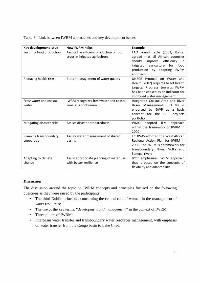
capabilities. Table 3 gives a summary of examples where IWRM has been used to address some key development issues.
11
Table 3 Link between IWRM approaches and key development issues
Key development issue How IWRM helps Example
Securing food production Assists the efficient production of food
crops in irrigated agriculture
FAO round table (2003, Rome)
agreed that all African countries
should improve efficiency in
irrigated agriculture for food
production by adopting IWRM
approach
Reducing health risks Better management of water quality UNECE Protocol on Water and
Health (2007) requires to set health
targets. Progress towards IWRM
has been chosen as an indicator for
improved water management
Freshwater and coastal
water
IWRM recognizes freshwater and coastal
zone as a continuum
Integrated Coastal Area and River
Basin Management (ICARM) is
endorsed by GWP as a basic
concept for the GEF projects
portfolio
Mitigating disaster risks Assists disaster preparedness
WMO adopted IFM approach
within the framework of IWRM in
2000
Planning transboundary
cooperation
Assists water management of shared
basins
ECOWAS adopted the West African
Regional Action Plan for IWRM in
2000. The IWRM is a framework for
transboundary Niger, Volta and
Senegal rivers
Adapting to climate
change
Assist appropriate planning of water use
with better resilience
IPCC emphasizes IWRM approach
that is based on the concepts of
flexibility and adaptability
Discussion
The discussion around the topic on IWRM concepts and principles focused on the following questions as they were raised by the participants:
• The third Dublin principles concerning the central role of women in the management of water resources;
• The use of the key terms: “development and management” in the context of IWRM; • Three pillars of IWRM; • Interbasin water transfer and transboundary water resources management, with emphasis
on water transfer from the Congo basin to Lake Chad.

12
To all these questions, the facilitator gave clarifications, but stressed that the issue of transfer of water from one transboundary river basin to another is highly sensitive, and needs to be approached with tact.
3.1.2 Tools for water evaluation and planning in IWRM
Summary
The session on Tools for water evaluation and planning in IWRM (facilitated by Dr. Raphael Tshimanga and Mr. Mulengera, from CB-HYDRONET/University of Kinshasa and the University of Bukavu, respectively) underlined the need for water resources evaluation and planning, data requirements, steps for water resources evaluation and planning and some tools used for water resources evaluation and planning. As shown in Figure 4, the need for water resources evaluation and planning is based on three key concepts which take into account (1) the limited available fresh water, (2) the growing socio-economic needs and competing uses, and (3) the uncertainties arising from predicted and unpredicted impacts on water resources. Data requirements comprise of biophysical data, hydrometeorological data, socio-economic data, water-use data as well as related water quality data. Table 4 shows details of data requirement for water resources evaluation and planning. Two main observations with regard to quality assurance include the need for standard procedures (Data collection, data storage and format, data sharing) and the need to highlight uncertainties.
Figure 3 One participant to the right side asking questions to the facilitator (left side) to explain the “3” pillars of IWRM.

13
Figure 4 Need for water resources evaluation and planning
Table 4 Data requirement for water evaluation and planning process.
Data type Variables Description
Climate Precipitation, air temperature, air
humidity, solar radiation, sunshine,
wind speed
Quantification of water input in the
catchment, Estimation of proportion of
water evaporated
Physiographic data Elevation, vegetation types, soil
types, geology, drainage patterns
Define river networks and catchment
boundaries,
Identify potential sources of water
pollution, Assessment of runoff and
groundwater recharge.
Surface water data
Water quality, stage-discharge,
Water in lakes, wetlands, and
man-made reservoirs
Estimation of available water resources
(including usable water due to quality
requirements)
Socio-economic data Agricultural, Irrigated and non
irrigated crops, Urban land,
Industrial sites, Mining
Assess infiltration and impact on runoff,
Major areas of water use, Consumptive
vs Non- consumptive, Demand vs
Perceived Need, Identify potential
sources of water pollution
Demography Basic demographic data,
Projections of growth
Assess infiltration and impact on runoff,
Major areas of water use

14
Some of the tools used for water evaluation and planning were also highlighted with an emphasis on the application of a WEAP (Water Evaluation And Planning) model, basically used for decision making of IWRM in many countries around the world. Many of the existing tools are easy to use, available free of charge and are applied at the catchment scale (Figure 5).
Figure 5 Some of the tools used for water resources evaluation and planning around the world
Participants were then introduction to the WEAP model for the Congo basin, which was developed through a World Bank project aimed at enhancing the resilience of African infrastructures to climate change impacts and involved collaborative efforts from CB-HYDRONET, Stockholm Environmental Institute – US Centre and the Institute for Water Research of South Africa (Figure 6). The model can be used for evaluating current and future options of integrated water resources management in the Congo basin, including scenarios for the current issue of interbasin water transfer between the Congo and Lake Chad basins. It should be noted that there are several models currently used as decision support tools, but the choice of a tool will depend on the planning objectives and available data. There is also need to consider uncertainties in the all processes.

15
Figure 6 A decision support tool of IWRM in the Congo basin
Discussion
The session on tools for water resources evaluation and planning brought discussion around the following questions: (1) What would you propose as solutions where there exist no hydrological gauging stations? And how do we deal with the lack of historical data? (2) there are a lot of information for the Congo basin as the presentation mentioned throughout but, still data are not being shared, and this hinders development of tools and identification of appropriate adaptation measures (3) will it not be possible to involve population in the decision-making process? (4) Will the suggested model be efficient enough for both water quality and quantity issues?
The presenters explained that the lack of measuring stations and data is common in most African countries which could adopt the alternative to generate data by making use of techniques such as linking remotely sensed data to ground data, etc. Data exchange is never a reality; there is a need to explore possibilities to apply decision support tools to combine the quantitative and qualitative aspects. Decision makers should create adequate structures or a framework of managing the information and promote awareness to inform people. Furthermore, it is important to integrate

16
local population in the decision-making given that freshwater resources are limited and their need of water resources for various uses especially agriculture.
Figure 7 Discussion session on tools for water evaluation and planning
Recommandations
As recommendations, participants expressed the hope that:
1. Countries in Central Africa can appropriate tools already available for regional water policy;
2. Each country has got an obligation to adequately master and monitor its hydro-meteorological networks;
3. In CICOS region, absence of measuring network for water and climate variables means current data is very unreliable. Moreover, there exists no data sharing protocols between members states and institutions. It is thus important that a data sharing protocol be established between countries of the Congo River Basin to improve water resources management within the basin.
Participants (upper photos from the left to the right side) asking questions to the presenters (lower photos from the left to the right side) about:
� Techniques to generate data;
� Data sharing system;
� How to overcome missing
data?
� Etc.

17
3.1.3 Global Water Partnership (GWP) Toolbox for IWRM
Summary
The GWP IWRM tool box (facilitated by Mr. Hycinth Banseka) is an online forum for water experts and broader water community that serves as knowledge sharing platform on practical implementation of IWRM and is based on the IWRM pillars and components. The operational dynamics of the ToolBox are a mix of tools or theory, case studies or practice and synthesis or critical challenges. Ultimately, this platform supplies interesting materials as for academics, policy makers and professionals in the field of water resources. The tools are organized into three catagories, based on the IWRM pillars:
• A Tools: Enabling Environment • B Tools: Institutional Roles
• C Tools: Management Instruments.
Case studies can be submitted with regard to each component and participants were introduced to the procedure and format for preparing and submitting case studies to the platform. The presenter justified the usefulness of the ToolBox as a platform which addresses the concern that people use IWRM as a slogan because it has become a very “marketable approach”, while they keep on working with a sector approach.
Discussion In the discussion that followed the presentation, participants raised questions about: (1) the benefits of the GWP ToolBox to academicians who publish articles on it (2) How does the national IWRM plan link to transboundary one? (3) which one of those tools is far much better for producing results? (4) to which extend of comparison academics can still use this toolkit to publish papers in scientific journals to advance their careers? (5) how to use the toolbox in the process of elaboration of terms of reference ? (6) how to calculate virtual water in the imported food? (7) Up to this stage, the main contributors are English speaking people. The challenge of the language barrier is a real problem to French speaking people. (8) Are the GWP set of norms scientifically based or not? The presenter explained that the national and transboundary IWRM plans are linked and should be complementary. In fact, the transboundary IWRM should normally build on existing national IWRM plans. He further clarified that the GWP Toolbox is not designed for publishable materials; however, material that had been published can be converted into GWP Toolbox format.
Recommendation A recommendation was made to GWP Central and West Africa to accelerate the translation into French of Toolbox website to ensure French speaking people also benefited from it.

18
Finally, the presenter requested that participants search for a paper related to virtual water to better understand the concept.
3.1.4 Stakeholder participation in IWRM
Summary The session on stakeholder participation in IWRM (facilitated by Dr. Lapologang Magole) stated concepts of development and the basic principles of IWRM and subsequently presented an approach for IWRM planning across a marshy area (wetland) located at the northern part of Botswana, which is a portion of an extended watershed shared between Angola, Botswana and Namibia within the Okavango Delta basin. The presentation was based on lessons learnt from the process of stakeholder mobilisation for participation in the elaboration of the Okavango Delta Management Plan (ODMP). The session introduced the concept of stakeholder analysis for an effective participation strategy, which consist of categorising stakeholders according to their interests and influence in the use and management of water resources, while advocating a broad consultation of stakeholders, including those of indigenous knowledge. As illustrated in Figure 8 and based on the case of the Okavango Delta, stakeholders are organised into primary (people living in delta), secondary (upstream actors) and tertiary (others) categories based on their livelihoods. This analysis can be illustrated as a two-dimensional diagram with "influence" as a criterion in the X axis and "interest" as a criterion in the Y axis. The quadrants of the diagram bring out four stakeholder groupings namely: vulnerable, key, most critical and no priority stakeholders. In principle, stakeholder participation does not just happen, it has to be planned and managed, and needs resources.
Figure 8 stakeholder analysisprocess

19
Discussion
The questions asked during the discussion included: (1) The difference between the lessons learned and best practices? (2) How to identify real stakeholder within a certain area? The presenter underlined the importance of capitalising indigenous knowledge, and being specific during stakeholder identification process. The session introduced an exercise on stakeholder analysis, for which participants were grouped based on the river basins represented at the workshop, notably: Congo basin, Lake Chad, Nile basin, Orange and Zambezi basins. The criteria used for the exercise included: no priority, vulnerable, most critical and key stakeholders, and the process involved determining where various stakeholders were to be located in the map.
The results of the exercise shows that: (1) Positioning stakeholders within a quadrant helps to map how power and interest dynamics interplay; (2) Depending on the context of the study, stakeholders will move from one quadrant to another; it is therefore important to know how and why a certain criterion is used; (3) Legislation does not always give one power, but various such as economic strength, etc; (4) NGOs, academic and media can play a lobbying role, going beyond their mandate, resulting in them being placed in quadrants where they would not ordinarily fall into, and (5) Desist from grouping stakeholders (e.g. water users and government).
3.2 Understanding drivers and impacts of climate change
3.2.1 Physical science basis of climate change Summary The session (facilitated by Dr .Francois Ilunga) focused on developing an understanding of some of the basic aspects of climate change and how it is detected before considering the impacts of such change. The global climate system is composed of the atmosphere, the hydrosphere (liquid water), the cryosphere (ice and snow), the lithosphere (soil and rock) and the biosphere (plants and animals, including humans). The climate of a particular place is dependent on the complex nonlinear interactions between these components under the effects of solar radiation, the rotation of the earth and its orbital motion around the sun.
Water vapour (H2O), carbon dioxide (CO2), methane (CH4), nitrous oxide (N2O) and chlorofluorocarbons (CFCs) are the major greenhouse gases available in the atmosphere; there are a few other gases, which appear in trace amounts only. The earth’s surface emits radiation. This emitted radiation is absorbed by greenhouse gas molecules and re-emitted in all directions, causing a warming of the earth’s surface. Any change in the greenhouse gas content of the atmosphere triggers change in the global climate by modifying climate variables such as temperature. Both natural and human-made factors can be responsible for the changes in the greenhouse gas content of the atmosphere. The natural greenhouse effect may be caused by changes in CO2 and CH4 concentration in the atmosphere that have been associated with

20
transitions between glacial and interglacial episodes, vegetation, weathering of rocks etc.
Ultimately, the session introduced an average entropy index aimed to evaluate stationarity or non stationarity. The presenter demonstrated that climate change is a multidisciplinary issue and everyone should be concerned on the matter as many states have agreed that it is actually a reality. Despite challenges that include the lack of data, the speaker underlined the point on how to transfer or transform the available data into useful information that can enlighten decision making process.
Discussion The discussion focused around the procedure to calculating and making use of the entropy index to appreciate the change in climatic data as well as the alternative to reconstruction of the ozone layer through mitigation effects of climate change.
3.2.2 Drivers of climate change
Summary The session on drivers of climate change (facilitated by Dr. Francois Ilunga and Mr. Idesbald
Chinamula, respectively) stressed that that there are natural and human induced drivers – e.g.
volcanic eruptions and aircraft emissions. Carbon dioxide is responsible for over 60 per cent of
the "enhanced greenhouse effect." Humans are burning coal, oil, and natural gas at a rate that is
much, much faster than the speed at which these fossil fuels were created. This is releasing the
carbon stored in the fuels into the atmosphere and upsetting the carbon cycle, the millennia-old,
precisely balanced system by which carbon is exchanged between the air, the oceans, and land
vegetation. Currently, atmospheric levels of carbon dioxide are rising by over 10 per cent every
20 years. Figure 9 (left) shows the trend in global contribution of green house gases and Figure 9
(right) shows the contribution per sector. According to IPCC projections if no ambitious policies
are implemented (business-as-usual), global emissions will continue to grow by 25-90% by 2030
relative to 2000 (the projects of different scenarios vary depending on the underlying
assumptions, such macroeconomic trends, the rate of technology innovation and deployment,
etc.). in this context, UNDP efforts focus on reducing the emissions to -80% in the nord and -
20% in the south as illustrated in Figure 10.

21
Figure 9 A global trend in greenhouse gases
Figure 10 UNDP target for GHG reduction
To achieve the target, UNDP supports initiatives in the following sectors:
Energy production: - Increase yield for hydropower supply - Promote cogeneration - Change sources of energy (hydraulics, solar, wind, geothermal, biofuel)

22
- Nuclear energy - CO2 sequestration
Transport - Urban planning - Soft transport - Hybrid, electric and bio-fuel for vehicles
Construction - Passive solar architecture - Cooling or heating based on solar energy
Industry - Electric equipment with high performance - Recycling of materials - Circular economy
Agriculture - Land management to increase carbon sequestration - Land restoration - Improving agricultural techniques
Forest - Halting deforestation - Encouraging reforestation - Sustainable management of forest - Valuing energy from forest product
Waste - Recycling
Discussion
Questions and comments include: - Does the UNDP assist with funds for local capacity building trainings and research for
the region – there is indeed interest of funding research that is relevant for our context and there are also ongoing campaigns to capacitate communities
- The Kyoto protol is coming to an end and considering the challenges that were not addressed during its term, will the new negotiations work to ensure that countries comply to fighting global warming – “If heavens would be separated we would survive comfortably”; but we can’t and the ironic part is that we are the most vulnerable due to lack of infrastructure and this means we are supposed to fight the hardest. We have already lost 13 years, and we have not succeeded in changing energy use. This meeting serves to encourage participants to be involved more into these issues

23
- Are there initiatives being promoted that include vulnerable groups and what approaches are being used – There are various documents available to show the various initiatives and also the approaches
Recommendation
On climate change, there are not reference scenarios for Africa; most of the research done is theoretic. There is need for research that is specific for our context, so that we can develop models that can potentially improve our understanding on Climate Change in our region, enabling us to come up mitigation and adaptive strategies that can also work for our region.
3.2.3 Observed and projected trends of climate change and impacts on water cycle
Summary The session was facilitated by Dr. Makurira Hodson and began with the introduction of chronological issues on climate change which dated as early 1827 when Frenchman, Jean Baptiste Fourier considered the “Greenhouse effects”. And, the United Nations setup the IPCC in 1988 which two years later produced its first report on levels of man-made greenhouse gases which were increasing in the atmosphere and predicted that these will cause global warming. Then, it came up from this discussion that there is need to focus also Climate Variability (cyclic changes to the shorter periods describing a climate). The reason being while our focus is centred more Climate Change (which is generally defined by a period of 30 years), shocks of climate variability affect our communities more. The question of lengthy, quality data in most African countries has been seen as impediment when analyzing climate change issues. However, even with our limited data we can put reference on consistent global trends. There is a tendency of concentrating on projections mainly informed by Global Climate Models (GCMs) forgetting the Indigenous Knowledge Systems (IKS). The observation was that there is a need for more efforts towards local modeling to inform projections. Again, the challenge is availability of sufficient pool of researchers in the region.
One concern came from the flow as: How can use other parameters different from precipitation and temperature to assess the climate variability? This is in the sense that in Kinshasa there is a gauging station installed in 1903 - There is need for the use of data from more than one hydro-meteorological station to draw a good conclusion and need to incorporate even land use patterns for detailed analysis to guide the assessment. It has been observed a diminishing of the number of hydro-meteorological stations in Africa. This is becoming big challenges in addition to what that already exist.

24
Recommendation The overall recommendation was in general in Africa, there are not many researches done in the area of climate change. However, the lack of data should encourage Africa to generate data to conduct some researches to understand the local conditions rather than relying on the other developed country to provide us information. Therefore, there is a need for more localised and regional researchers to complement global efforts. The overall recommendation was that there was a need for more localized and regional researchers to complement global efforts.
3.2.4 Groundwater management in IWRM
Summary The session on groundwater management in IWRM (facilitated by Prof. Nkuwa Daniel) initially planned for the first day was reported to the second day due to a delay in the arrival of the facilitator. The main concepts illustrated in this session comprise of:
• General understanding of groundwater o How groundwater forms o Global water budget o Current status of groundwater o Challenges ahead of us
• Surface water – groundwater relationships • Groundwater management in IWRM
Overall, the session highlighted different perspectives of water on the ground and how it forms, while pointing to issues such as growth in populations and economies + increased effects of climate variability.
• Water demand will increase, while resource-availability will remain constant or even
dwindle ⇒ Demand will outstrip Supply.
• Water shortages – in terms of quality and quantity – may also heighten / incite water-use conflicts.
• Millions of m3 pumped every year: Monitored? Who-by? How?
• 1000’s of sources of pollution: Location, nature & quantity of pollutants? aquifer vulnerability?
• 100’s of thousands of wells/boreholes: Registered? Controlled? Maintained? Info. about location, abstraction levels, water levels, water quality, formation, etc -
• Many governing departments/institutions: Joint management? Coordination / cooperation?
Arising from the foregoing, our continent requires: • Water planners with adequate/appropriate skills for improved management of existing
water resources.
• Adopting strategies that include integrated utilisation of surface water and groundwater.

25
The session also brought key elements of differentiation between surface water and groundwater as illustrated in Table 5 and Figure 11.
Table 5 Difference between Surface water and Groundwater
Figure 11 Difference between Surface water and Groundwater
Management of water resources in basins takes into account both surface- & ground-water in order to optimize the resources’:
• Productivity, equity, & environmental sustainability;
Feature Groundwater Resources Surface water Resources
Hydrological CharacteristicsStorage Very large Small to moderate
Resource Areas Relatively unrestricted Restricted to water bodies
Flow velocities Very low Moderate to highResidence time Generally decades/ centuries Mainly weeks/ monthsDrought propensity Generally low Generally highEvaporation losses Low & localised High for reservoirs
Resource evaluation High cost & significant uncertainty Lower cost & often less uncertainty
Abstraction impacts Delayed & dispersed immediate
Natural quality Generally (but not always) high Variable
Pollution vulnerability Variable natural protection Largely unprotected
....River Basin
boundaries not
coincident with
Groundwater Basin’s
Substantial differences
between River Basins and
Groundwater Basins....

26
• Efficient and effective conjunctive (simultaneous) utilization.
Conjunctive use is often incidental (water users shift intuitively between surface water and groundwater sources to cope with shortages) and should be supported by scientific studies to provide important data to understand:
� Geology of aquifer systems;
� How & where surface water replenishes groundwater, or vice-versa;
� Groundwater flow directions and gradients.
It occurs when system administrators control groundwater and surface water use simultaneously and includes components of Water Management thru Monitoring. Figure 12 illustrates the concept of conjunctive use.
Figure 12 Conjunctive uses of water resources
Ultimately, the session presented an approach to groundwater management in IWRM as illustrated in the
Figure below:

27
Figure 13 IWRM approach to Groundwater management
Discussion
The discussion focused around the following questions: (1) What is the prescribed distance between a pit latrine and a water source with regard to groundwater? (2) In the sense that 80 ha of lands have gone down at the Ikoma village found in the eastern part of DRC, what should local people expect as explanation of the phenomena in relation to groundwater? (3) Since the groundwater exploration requires a lot of resources, considering that the lack of equipments being common in Africa; what will be the basic parameters to guide the groundwater monitoring at least? (4) What is the difference between safe yield and sustainable yield? In provision to the concerns, the speaker stated that there is no prescribed distance; this should be based on the geology, the structure of the area around and needful information that can lead to make appropriate choice. He further addressed the assistance by arguing that we cannot manage what we do not know. The regards should focus on the dominant human activities in the particular area, and then seek to know what should be derived from as direct impacts to groundwater resources.
Recommendation
In this regard there is a need for water planners, adopting strategies that include integrated utilization of surface and groundwater as well as the importance of groundwater monitoring. The groundwater resource
can be used for adaptation to climate change in area of water resources management. Water resources management must assume connectivity between surface- and ground-water and managed as one resource, unless proven otherwise, thus;

28
• Water resources management practices and Water Right Systems must cease to treat surface water and groundwater as two unconnected resources.
• Local/regional networks must be set-up to monitor surface- & ground-water levels, water quality, etc. to establish interaction between them
• Capacity must be built both among water resource authorities and water users as a key driver to implementing sustainable management measures.
3.3 Adapting to climate change through a catchment based approach
The sessions on adapting to climate change through a catchment based approach were given on the third day and started with presentations of the group assignments on assessing the level of understanding of people from different river basins about climate change based on the daily activities and indigenous knowledge.
3.3.1 Group assignments
Five aspects were expected to be cover by participants, namely: Indigenous views or knowledge on the climate change especially farmers, scientific views on the climate changes, Convergence between the indigenous and scientific approaches, and Challenges related to climate change at local and regional levels.
1. Indigenous views or knowledge on the climate change especially farmers: • Dry and hot summer instead wet cold summer
• They no longer grow the crops they used to grow in the tie
• Seasonal fruits no longer grow due the effect of climate change, crops failures
• Relocation due to rainfall
• Temperature fluctuation
• Rainfall changes
• Water levels that has reduced 2. Scientific views on the climate changes
• Obvious changes in temperatures
• Variability of rainfall
• Reduced water levels
• Ecosystem disturbed and some species disappearing
• Change of agricultural practices
• Yield is dropping drastically
• Seasonal variation 3. Convergence between the indigenous and scientific approaches
• Water scarcity,
• High diseases during floods

29
• Migration 4. Challenges related to climate change at local and regional levels
• Data availability and exchange
• Capacity
• Coping/adaptation
• Information unavailability
• Potential to increase of up/down stream conflicts
• No tools,
• Government are not giving enough funds on the disaster management and planning. It comes as the disaster has already come.
5. Opportunity arising from climate change • Business
• Research expansion
• Support of Funds and availability
• Cooperation, joint initiatives
• Training
3.3.2 Concepts definition: vulnerability, adaptation, mitigation, resilience Summary The session (facilitated by Mr. Hycinth Banseka) established undersading and definition of key concepts frequently used in climate change. Focusing on mitigation and adaptation, it was highlighted that mitigations address the causes of climate change while Adaptations addresses the impacts of climate change (CC) or relate to human responses to climate change impacts. It was also conveyed that the two terms can be differed using as basis spatial scale, time scale and sectors of interventions. On the Spatial scale, Mitigation is a global issue, while Adaptation is local, specific to your own environment. Considering the Time scale, Mitigation has a long time effect while Adaptation has a short term effect. In terms of Sectors, Mitigation is a priority in the energy, transportation, industry and waste management. Adaptation is a priority in the water and health sectors and in coastal or low-lying areas. However, both Mitigations and Adaption are relevant to the agriculture and forestry sectors. In addition, NAPs/PNA (National Adaptation Plans/ Plan National d’Adaptation) is based on the study of the vulnerability. Vulnerability equals to potential impact minus the adaptive capacity. If you have strong adaptive capacity (economic, finances, etc) then your vulnerability is reduced.
In terms of impacts there are two elements that concern: (1) Exposure which is linked to geographical location (main land and coastal location), and (2) Sensitivity linked to rainfall seasons, for instance (e.g. one or two rain seasons).

30
Discussion Two questions were asked from the flow: (1) should we grant the credit of the PNA data on vulnerability? (2) Considering the capacity to adapt, what will be the consequences of poor people against rich people when comes to adaptation? The speaker underlined that it is always important to be proactive, making decisions which include projections than to base on the current facts. On top of that added one participant, there are no problem at the national level, but the gaps are found at the local scale when comes to planning, e.g. Brazil or Cuba. To use the results of a model, you need to understand the hypothesis used for its deduction. Lastly, the concept of poverty is destructive and it is actually in the mind.
3.3.3 Developing climate change adaptation strategies
Summary The session (facilitated by Dr. Makurira Hodson and Dr. Lapologang Magole) turned around key questions, notably: (1)Why to develop adaption strategies? Because there are so many evidences of climate change are backed up with no-solid-facts, there is a wide stakeholders, need to have a baseline to follow, climate change is new for many countries. Some multidisciplinary approaches need to be considered for basin case study relating to socio-economic, water quality analysis, water resources assessment, environment water assessment, scenario development i.e. modelling approaches.
(2)What to do with the collected data based on the above areas? For owning and management in order to set: (a) IWRM governance requirements that will include the integration of knowledge, sector, regulatory instruments; the appropriate institutional capacity; the supportive regulatory environment (equity, conflict resolution, stakeholder participation, co-management). (b) Regulatory environment analysis that comprise policy (legal, law gaps, law impacts, law clashes) and institutional analysis. (c) Problem analysis. (d) Problem evaluation and prioritization. (e) SWOT analysis.
Discussion The discussion related to this session highlighted (1) the need to share case studies of the management based on the results as own practical cases may be better in somehow assisting participants. (2) Suggestion on relocating people from flood prone Areas (3) Climate change adaptation procedures? Then some provisions were aligned as: Problem is not climate change but management related problems. More awareness among people to avoid flood victims because people move and return home afterwards and the government deals with it! All big companies have license to use groundwater except small users like Households. Only challenge is no account for GW use. No operating systems in place and / or none for operational adaptation. Water management policy is
31
a problem, and planning to be observed; all stakeholders are supposed to be there for operating, different users are supposed to contribute priority based on country.
3.3.4 Linkages between adaptation to climate change, disaster risk reduction and disaster prevention
Summary During the session (facilitated by Dr Makurira Hodson), concepts of disaster risk reduction were introduced as being a package of policy, strategies directed for managing climate risks while Disaster prevention refers the tremendous measures to stop disaster. Then Adaptation as a response to disturbance or stress implying risk prevention, risk and international strategy for risk reduction (ISDR) or in other view it can be defined as “series of responses to drivers of vulnerability, building response capacity, managing climate risk, confronting climate change issues”. So, there is a need to look at both processes as interlinked: disaster risk reduction & adaptation. The session was concluding by illustrating that disaster risk reduction, social protection and climate change adaptation are interlinked. Discussion Comments and questions came from the assistance just after the presentation: (1) costs of adaptation means bringing strategies that people buy technology for adapting with low adaptation costs; transfer of technology in case of rainfall variability (e.g. Rwanda small reservoirs are built, balancing more local contribution can be cost for fighting disaster). Sometimes yes, when we let people be part, like 10% of the cost to establish a reservoir for example. (2) To provide examples of a country with floods within our climatic region with successful implemented system? Netherlands example was given to show that invention of any new technology requires a close follow up.
3.3.5 Groundwater vulnerability to climate change and possible adaptation measures
Summary The session was facilitated by Prof. Nkuwa Daniel. Climate change can be perceived as any change over time and variability. So, complex interactions exist between atmosphere, geosphere and hydrosphere due to the Suns energy. The Groundwater resources can be an alternative to water security for 21st century; alternative for farmers when water lacks i.e. in case of rainfall reduction since climate change causes water shortages for up to billion people. The impacts on rainfall amount are indirectly flux and storage of water in surface & subsurface reservoirs (lakes, soil moisture etc.) and also groundwater storage and discharges. Still it is so complex to provide explanation on the relationship between climate change and groundwater. The management adaptation responses for groundwater depend on climate variability/change: groundwater recharge and storage, quality, demands and discharge into its basin. Therefore, local and regional

32
climate change impacts, impact of climate change on water resources have taken place. All these require fund investments, more research… Discussion Comments and questions were captured from participants as relating to: (1) Does the rainfall distribution be affected by CC? And how? (2) what are the artificial methods of groundwater recharge? (3) Are they possibilities to retrieve or to depollute groundwater when polluted? (4) Vulnerability of groundwater to recharge and which alternative with demands using remote sensing tools for detecting recharge? (5) What about Sewer system? i.e. big issue due to Lagos capital was transferred to Abuja (6) why in Namibia, treated wastewater are still used to recharge aquifers? It should be noted that depollution of groundwater is very expensive and relies on understanding of aquifers systems, best storage and recharging. In addition to that in RSA, the country has got some guidance for artificial groundwater recharge. The criteria are: geology, transmissivity, land use, rainfall occurrence, legal framework, etc. One, participant shared an example of the use of dry pit latrines (ECOSAN) as alternative to groundwater contamination from sewer. That was a best option because rainwater harvest isn’t a good one; role in water management system including surface and groundwater… Recommandation Need to master our groundwater resources in a long term in order to focus management strategies to adapt to climate change impacts.
3.3.6 Atlas on renewable energy and National Adaptation Plan
Summary The session was facilitated by Mr. Idesbald Chinamula. DRC has various but poorly recorded and quantified resources. The full energy generation potential of the Inga hydropower dam and of DRC is about 400,000 MW and 100.000 MW respectively. An Atlas on renewable energy is being put in place to provide improving access to modern energy services at national and local level: potential sights, renewable energy, in terms of site promising energy, and put in lights all the information for the investors). The presenter also quoted the “Renewable Energy for All Initiative” . from where it originated. He further stressed on the need for preparing a National Adaptation Plans (NAPs), which are the second generation of National Adaptation Programs of Action (NAPAs), as they strive to integrate climate change adaptation into policies, programs, etc., in order to provide a critical mass of information for the formulation of development projects (climate change, agro -ecology, flood management etc.).

33
3.3.7 IWRM implementation: a case of UNEP project for the Lukaya catchment + Planning for field visit and introduction to the stakeholder analysis exercise
Two presentations were successively made by Mrs. Celine Jacmain and Dr. Lapologang Magole. The UNEP project on IWRM implementation in the Lukaya catchment was presented by Mrs Celine and Dr. Magole gave the introduction of the field visit exercise on stakeholder analysis.
The discussion provided below concerned also the topic 3.5 and provisions were provided immediately.
Summary Implementation of IWRM is based on catchment areas, functional unit; the Lukaya basin is located in the southern outskirts of Kinshasa. Its major problems are uncontrolled urbanization, deforestation, flooding, land ownership conflicts, lack of drainage systems and basic infrastructure, etc. The main reasons for choosing the Lukaya catchment as a pilot case by UNEP were:
• Catchment area clearly mapped and understood;
• Ease of access from Kinshasa; • Strategic importance of catchment due to mining activities and potable water supply
uptake;
• Relatively well preserved environment with a potentially devastating environmental footprint (sedimentation, deforestation, erosion, pollution, etc);
• IWRM approach and idea already established through existence of “River Contract” or “Contrat de Riviere”.
Discussion The following questions were brought into the discussion: (1) Lack of data for implementing adequate hydrological modelling and need for alternative approaches. (2) Provision of hydroelectric in rural areas. (3) Management regime given the role of parties as well as rights and obligations. (4) Organisation of the catchment committees and their links to the local socio-political structures. Initiatives to raise awareness educate users and implement income generating activities. (5) Monitoring network is always an issue and actors in the water sector should develop strategies to deal with it and this context, NGOs can play a good role. In Cameroon, a consultative meeting of stakeholders has attracted the interest of the involvement of political support for collection of meteorological data.
Field visit exercise on stakeholder analysis Dr Magole came after the discussion to provide explanation on how the exercise needs to be directed and presented by Friday morning.

34
3.4 Field visit to Lukaya catchment, a UNEP project on IWRM implementation The field visit to Lukaya catchment sought the following objectives:
• To have first-hand experiences of IWRM activities implemented in the Lukaya catchment; • To meet stakeholders implementing activities in the Lukaya basin and;
• To appreciate the evidence of climate change impacts in the Lukaya basin. The main aspects of the field visit included a presentation of the IWRM project in the Lukaya catchment, visit to the REGIDESO water treatment plan and visit to the inundated area of a quarry site in the catchment.
3.4.1 Presentation of the IWRM project in the Lukaya catchment The following photograph shows features of the Lukaya catchment on a map being explained to the participants.
Figure 14 Map of the Lukaya Catchment presented during the field visit The session was facilitated by Mr. Jean Pierre Kimfuta from the Association d’ Utilisateurs du Bassin de Lukaya (AUBRL) and introduced the participants to the IWRM project which started in January 2013 after consultative and participatory processes between users, local authorities and IWRM project team. The Lukaya catchment covers an area estimated at 350 km2, and with

35
a perimeter of about 133 km. the major challenge faced has been the issue of land ownership and authority of traditional leaders. Main activities in the basin include its protection and preservation, wealth creation, sanitation and renewable energy. Stakeholders in the catchment have been grouped to take into consideration interests of various sub-areas of the catchment and include upstream and downstream sub committees, technical support committee, and user associations. Benefit sharing of the income generated by the activities in the basin includes 25% to the local authorities, 25% to the IWRM implementation team and 50% for the users.
Discussion (1) The criteria used to categorise users into up-stream and downstream committees rather than economic activities of the basin- Why people in the middle of the basin were not considered to form a separate committee? (Users prefer to be distinguished based on their location. However, the committee headed by the President and his two vice presidents oversees activities of the whole basin). (2) Power relationships in the committee and their duties-What is the role of the local authority in return for the 25% benefit share? (The Chief has an obligation to ensure order and secure investments. Approach based on common understanding, i.e. 25% of benefits go to authorities, 25% go to IWRM implementation team for their efforts, 50% retained by users. (3) Analysis of socio-economic component should be added-Are there measurements in place to measure quality in the activities of the basin? (It is possible to measure quality in terms of the cost. Measuring the impact of project over a two year project is difficult. Change is noticed overtime) (4) Gender participation in basin activities (The reigning Chief is a woman. The Chief has a committee of 5 men who reports to her. The Chief reported high consultation since conceptualisation of the project. The cultural beliefs in the area where a woman is free to inherit Chieftainship supports gender equality). (5) Need to analyze whether alternative livelihood makes a positive difference e.g. Deforestation against farming. To come up with a sustainable deforestation plan. (an understanding of why deforestation has happened is key. Interventions must address the root causes of deforestation and provide an economic value higher than what people were getting from cutting firewood). (6) The basin intervention is replicable. The current intervention was borrowed from another conservation area and it can also be replicated to other IWRM partners, etc. (7) What about the sustainability of the project? (While most of the species in the basin were supplied at the beginning of the project, for sustainability the local communities would have to buy own seeds and trees once they have enough services).

36
3.4.2 Field Site Discussion: REGIDESO Water Treatment Plant Summary The following photograph was taken at the REGIDESO water treatment plant in the Lukaya catchment.
Figure 15 Visit to the REGIDESO water treatment plant in the Lukaya
During this session, participants were introduced to the process of water treatment in the Lukaya catchment and the main problems facing safe water delivery in the catchment. The water treatment plant contains four pumps of 55 cubic metres/hours each. Two pumps run at a time while the other two are for back up and the total production capacity is 110 m3/hour. The main processes of water treatment include:
• Screening- removal of debris
• Sedimentation- or removal of suspended dissolved sediments that is facilitated by processes of coagulation and flocculation using an Aluminium phosphate based chemical;
• Filtration – using sand filters and charcoal filters;
• Purification using a chlorine based chemical (sodium hypoclorite) is used to disinfect the water. Hypochlorite dosage is such that residual chlorine is pumped into distribution network to ensure disinfection right to tap at home.
Discussion The discussion turned around the impacts of implementation of IWRM project which has led to a reduction in quantity of chemicals used in the water treatment process, and the issue of residual chlorine used in the treatment of potable water.

37
Participants suggested to the REGISO team to monitor evolution of financial costs of potable water treatment as a means to better monitor benefits and impacts of activities of the IWRM project.
3.4.3 Field visit to the Quarry (SBA)
A key issue at the SBA quarry was the flooding of the site resulting from extreme flood event which could bring in the issue of climate change impacts on the catchment. The quarry is estimated to be of over 100 m length, 70 m wide and 45 m deep, and is crossed by the Lukaya River. The quarry got over flooded on the 12th of December 2012, which led to cease the activities of the quarry until to date. Based on accounts from locals, such an extreme event has never been observed for the past 50 years. Immediate measures were taken to pump out water from the quarry, which has not dried up until to date, though almost at end. It could be seen that the presence of the quarry prevented a huge disaster in the catchment that could be flooded entirely with much loss of lives and investments. The participants suggested that the company exploiting the quarry could be a good partner in supporting the strengthening of hydrological and meteorological services to generate data and provide useful information related to early warning that can help them avoid or mitigate such damaging impacts of climate related events.
3.5 Adapting to climate change through a catchment based approach
3.5.1 Adaptation measures within a framework of PANA-ASA The session was facilitated by Prof. Jean Ndembo and introduced the participants to adaptation measures for agricultural sector as applied in the framework of PANA-ASA.
Discussion This presentation raised the following questions and comments: (1) The new seeds that were introduced in the context of the project, where are they coming from? In general, Communities end up losing drought resistant seeds due to the introduction of new seeds. Did you try to conserve indigenous seeds? 1a. As a response, the presenter highlighted that improved seeds were provided by one of the project’s partners, namely the International Institute for Tropical Agriculture (IITA).1b.The presenter also mentioned that some indigenous seeds performed better than the breeds or improved seeds. (2) One participant wished to find out which source of the hydro-meteorological data was used for the study, while stations have been set up recently. 2a. The presenter revealed that the source was the Institut de Recherche Agronomique (IRA), which exists since 1960s. 2b.Of course, the monitoring capacity has depreciated, as illustrated by only seven (7) operational stations of the 54 stations that were used in the 1960s. 2c. In most cases, data is found on paper. Efforts are thus being made to convert this data into soft copies.

38
(3) Are there enough seeds produced for replication elsewhere in the country ? 3a.The presenter highlighted that these are still pilot studies. Therefore seed banks are still with pilot studies’ committees. 3b.At present, 25 tons of seeds have been produced. (4) The study is being carried out for a spatious country. Did the project factor in spatial variability (particularly for the seeds in the inventory, compared to local seeds and soils analyses) in pilot sites before any final results can be communicated? 4a. The presenter acknowledged that the country presents a high variability of conditions. However, pilot studies are still being carried out within 40 Km range of the INERA (Institut National d’Etudes et Recherche Agronomiques) 4b. Later, the project intends to disseminate monitoring stations to communities.
(5)It is good idea to value water resources. However, did the project undertake any socio-economic impact assessment upfront? The presenter acknowledged that such an assessment could be considered as a weakness for the project. However, the project has to last four (4) years and an impact assessment is planned after the third year.
(6) Improved seeds and breeds are considered as resilient in the project. However, was there any consideration to control the introduction of GMOs (Genetically modified organisms)? Yes, specific control measures were put in place.
(7) As a request for advice regarding farmers who are not willing to change their old-fashioned technologies or local seeds, what strategies should be put in place in order to get them involved? 7a.This is a serious challenge. To address it, one needs to discuss with the beneficiaries of the project, to make them participate in the process. This will particularly prevent them from waiting too much from funding partners. 7b.One practical approach in the case of improved seeds would require to ask them bring their local seeds and you plant them in the same conditions with the improved seeds. Then you compare the results, which should convince them of the need to change. 7c.Finally train the beneficiaries.
(8) configuration of agro-ecological zones seems interesting, how was that made considering the Equator? Data collection was limited to a few stations that are still operational within airports.
(9) How much did the project cost? 9a.The cost of the project was USD three (3) million dollars. The number of beneficiaries is three thousand and 100 households. 9b.A considerable cost is involved in research and field activities.

39
3.5.2 Presentation of case studies The following presentations were individual case study. In total three case studies were brought up from which participants raised questions as well as some comments.
• Case Study 1 –Implication to policy and decision making process - by Aboukar
• Case Study 2 – Recorded changes over hydrological extremes of Oubangui at Bangui – by Cyriaque
• Case Study 3 – Small reservoirs as adaptation measures to climate change in the Limpopo basin– presented by Patrick
• Case Study 4 – Catchment management and family planning, by Esperance Kabalisa.
3.5.3 AMCOW/GWP water security framework document and capacity development programme
Summary The session (facilitated by Mr. Hycinth Banseka) highlighted that WACDEP is an AMCOW’s project, which implementation is undertaken by the GWP in order to assist countries attain water security. So, what’s the difference between IWRM and water security? He quoted that IWRM is a process that can lead to water security.
Discussion
(1)An emphasis was made by one participant at this stage with practical example through planning initiatives and processes – accessing national levels, which is good. Then, bad experience with Okavango, sectors disintegrated after planning, transboundary levels, similarly governments were not interested to pick up the coordination, probably finances are the key to the problem. A quick reaction was made as the wish of GWP is to try to accompany countries, and it also sets evaluation and monitoring teams (economist, water, climate change experts) to support implementation of what is “wished” to be achieved. It thus goes beyond the technical skills, it also has to deal with personal ways of tracking the process. (2)Another commented that water management is a new sector for planning and development in the DRC. He further highlighted that water resources management is still carried out on a sectoral approach. Further support is therefore required to accompany the country in the process towards the adoption of an IWRM approach. (3) On top of that, another commented that AMCOW generally sends forms to be filled by countries. however; these are generally not easy to understand. Comment was well taken, so an

40
effort will be made to communicate with the partners at AMCOW. One of the solutions could thus be to add some explanatory notes to the forms and documents. (4) What were the achievements and regrets regarding the WACDEP? 4a Concerning achievements 4b. some documents have been published by the GWP,4c.stakeholders meetings allow knowledge exchange,4d.networks are being developed and strengthened. In terms of regrets ; 4e it is sometimes difficult to have political arenas plan beyond election or political cycles (it is a wish that any plan could go beyond 5 years). 4f.There are still challenges related to knowledge sharing.
(5)A concern is raised regarding geographical choices, particularly how particular zones were selected. In the same perspective, the choice of geographical zones could change if groundwater aquifers were considered in the selection. It appears that the focus is on surface water, why not liaise with some other bodies, such as the African groundwater commission? 5a.Sometimes it is difficult to establish links with some of the big organizations, but it is still possible to start linking up. Prior to that, a check will be made within the reference group to see who the expert is.
3.5.4 Groupwork presentations, general discussion and the way forward
The groupwork presentations were led by Dr. Magole. The discussions focused on outcomes of the fieldwork, particularly the visit to the Lukaya river basin, and the related water users association (AUBR/L). It was noted that:
• AUBR/L represented a good framework for dialogue • There was a need to further strengthen transparency within the project in order to
assure the project’s sustainability
• There is still a need to help the community at the ground level understand the IWRM approach, particularly concerning: Implications and (inter) linkages with other issues, and Subdivision of the catchment;
• For sustainability, the interest and influence of donors and development partners need to be reduced or scaled down over time, as the community should take over.
A QUESTION: Why was the incentive given to the chief? Are there any other places where it is done so? A participant answered that at least the incentive approach is something working for them so that the chief helps the project get implemented easily. Community leaders also need to be further capacitated in the context of the project.

41
4. WORKSHOP EVALUATION
The evaluation of the workshop was carried out at the end of the last day session by the participants. The participants were requested to take a moment to freely provide insightful feedback to CB-HYDRONET as concerning the overall workshop activities. An evaluation form of 3 pages was designed for the purpose. It consisted of two sections, Section I: General Evaluation and Section II: Outcome Evaluation. The Section I referred to the workshop venue, content, hand-outs, workshop management, conducted activities, quality of facilitators as well as the level of participants’ appreciation. The Section II comprised of a guidance of self-rating knowledge, confidence and skills of the participants before and after attending the workshop and also the participant’s expectations for future activities.
In order to raise the confidence of participants to fill in right information, the responses were kept anonymous. The participants were reminded of the need for honesty in evaluating as this will help CB-HYDRONET to achieve high performance in its growth process. The general evaluation will provide CB-HYDRONET ways of adjusting future trainings to best respond to participants’ expectations. The results were processed and analysed under MS Excel and subjected to descriptive analyses to capture the relevance of the feedback efficiently. The output of the evaluation is given for each section.
4.1 General evaluation
4.1.1 The workshop venue
The workshop venue refers to the place the workshop was held and it includes also hotel services for participants that were accommodated to the hotel. As shown in Figure 16, most of participants (95.5%) agreed that the venue was comfortable enough and well located and 4.5 % of participants remained neutral and disagreed. Concerning the adequacy of food and refreshments provided during the workshop events, the analysis shows clearly that a wide range of attendants really appreciated services provided in this regards. Individual comments from two participants were formulated with respects to room services which were not quite good.

42
Figure 16 Evaluation of the Workshop Venue
4.1.2 Course content
The evaluation of the course content was based on the relevance to the Aspects which were covered and on how easy these aspects were understood by participants. From the results obtained after processing, it has been noted that the course content was relevant and easy to understand. This is shown in Figure 17. However, few people pointed out that some modules were too academic; while others were more theoretical than being practical.
Figure 17 Evaluation of the course content
95.5 95.3
0
10
20
30
40
50
60
70
80
90
100
Comfortable well located
Pe
rce
nt
Venue
80
90
4.5
15.510
0
10
20
30
40
50
60
70
80
90
100
Relevant Easy to
understand
More
academic and
theoretical
not relevant Difficult to
understand
Pe
rce
nt
Course content

43
4.1.3 The workshop handouts
The handouts here refer to the training materials that were delivered to participants in different sessions. These materials provided useful additional information as they were clear and well organised as shown in Figure 18. Beyond these aspects, participants requested for future trainings to focus on country-based practical aspects while delivering lectures.
Figure 18 Evaluation of the workshop handouts
4.1.4 The workshop management
The general view on the workshop management was that the time management during sessions
was well controlled since a time keeper had been appointed at the starting of the workshop. The
breaks were given on time and for a sufficient time so as participants could interact each other.
Although the workshop organisation was successfully done, the workshop program was
overcrowded as noted by some participants and this could not allow foreign participants to visit
Kinshasa.
8581
913
6
0
10
20
30
40
50
60
70
80
90
100
Provided
useful
additional
Information
Well clear and
well organised
Not
informative
Not Clear Neutral
Pe
rce
nt
Workshop handouts

44
4.1.5 The workshop activities
Participants agreed that the conducted activities during the workshop were useful learning
experiences. These activities included the oriented discussions, the field trip and the group work
that did not benefit enough time.
4.1.6 The facilitation team
The evaluation on the facilitation team targeted three aspects such as state of knowledge, level of
preparation and the ability to respond to participant’s questions. The overall view from
participants on these aspects was that the facilitators were knowledgeable, well-prepared and
responsive to participants’ questions. However, other participants noted that the facilitator was
overloaded given he also made several expert presentations. They thus suggested to organisers
to consider this aspect in future training activities.
4.1.7 Appreciation of participants
The level of participants’ appreciation was evaluated based on what they did prefer best and least
about the referred workshop. Various reactions are given below:
What was best preferred
• The stakeholder Analysis;
• The UNDP climate change and impacts; • The multidisciplinary team of facilitators;
• The field trip; • The relevance of the training material to IWRM and CC related issues;
• The interactive approach of facilitators; • knowledge Sharing on case studies; • Groundwater resources;
• Quality of facilitator; • Organisation team.
What was less preferred
• Lengthy questions;
• Lengthy presentations; • Excess number of topics developed per day;
• No supporting documents were given in advance; • The program was too packed;

45
• Sometimes, mismatch in the intepretation system;
• Language barrier did not allow some participants to communicate and network amongst themselves.
4.1.8 The improvement of the workshop
The recommendations are formulated by the participants to improve this training course:
• Avoiding more theoretical presentations on Climate change;
• Including the practical downscaling aspects of climate change;
• Including the IWRM approach related to groundwater resources; • Allocating much time to practical issues;
• Identify ongoing projects within catchment for field visit;
• Providing the handout or technical backstopping documents in advance;
• Making use of decision support tools as a practical example during session; • Involve more decision makers to attend the training; • Reducing the number of topics given per day;
• A well balanced team of facilitators from different areas of expertise; • Conception, elaboration, implementation, monitoring and evaluation of projects related to
water sector, sanitation, and also to emphasis the sustainable development and adaptation measures of CC impacts;
• Consider the aspects of IWRM monitoring tools and procedures for adapting to CC related impacts and experiences, i.e. droughts, floods, etc.
• Consider inter-basin water transfer, especially at transboundary level, and its related short, mid and long term consequences in future workshops;
4.1.9 Reasons for recommending the training to a colleague
The participants accepted they will recommend this training course to their colleagues for the
following reasons:
• The workshop is very informative and can help to provide sound basis for developing climate change adaptation measures;
• The workshop covers the aspect of the river basin management;
• The workshop emphasised on IWRM innovations;
• The workshop offers a platform to discuss new thinking, practices, policies and also provides a great opportunity for networking at PAN-AFRICAN level.

46
4.2 Outcome evaluation
4.2.1 Individual improvement from the workshop
This section shows how effective the workshop was in improving the participant’s knowledge
and ability with regards to some aspects of the workshop. The levels of improvement which
have been evaluated before and after the workshop are: Poor, Fair, Good and Excellent. The
table 1 highlights the overall improvement of participants although only few of them did not
express their view point.
Tableau 6 Improvement of Participants knowledge and ability before and after the workshop
As it can be visualised from the above table, before the workshop some participants were poor
with regards to the aforementioned elements while no body was found to be excellent in this
matter. Thus, due to the quality of the training materials as well as the multidisciplinary of
facilitator’s team and the interactive teaching approach, the general trend in the understanding of
topics and the ability of participants to transfer the gained knowledge improved up to the
Excellency level. As a direct consequence from the insightful inputs of the workshop,
participants have agreed and strongly agreed that their skills and their ways of perceiving things
have improved. Therefore, this acquired capacity will assist them in setting up strategies that fit
into the environment while being also marketable.
4.2.2 Future involvement of participants in IWRM related topics
The participants pointed out additional aspects that they would like to learn with regards to
IWRM climate change based course. These are:
• Internal conflict prevention extended to transboundary by seeking to estimate the
ecosystem services of wetlands, adapting to CC through ecosystem based adaptation;
Items Poor Fair Good Excellent Poor Fair Good Excellent
Link between IWRM approach to CC and creating wealth 18.2 63.6 13.6 9.1 54.5 36.4
Catchment based IWRM approach to CC 27.3 40.9 27.3 22.7 40.9 36.4
Confidence to transfer aquired knowledge 31.8 27.3 31.8 18.2 45.5 31.8
Skills and strategies to transfer aquired knowledge 3.18 36.4 18.2 13.6 54.5 27.3
% Before the workshop % After the worskhop

47
• IWRM approach and food security in Africa;
• Climate Change resilience and economical rehabilitation;
• IWRM and data collection techniques, tools for evaluation and planning.
As presented above, this workshop evaluation contained items related to some aspects of the
training workshop. It processed and analysed inputs from participants with regards to the
workshop venue, workshop content, handouts, activities, time management, facilitation team and
the confidence and the ability to transfer the gained knowledge.
The overall output from this evaluation will assist the CB-HYDRONET and the workshop
organization team to best respond to participants’ expectations when organising future trainings.
48
5. CONCLUSION AND RECOMMENDATIONS
5.1 Conclusion
Based on the final evaluation, it was acknowledged by the participants that the workshop
achieved its main objectives of providing participants with tools for capacity building on IWRM
as a tool for climate change adaptation. The five day workshop had a 100% participation rating
with respect to the number of participants invited. Participants present had quite a good balance
in terms of regional and gender representation. Moreover, the workshop was honored to receive
as guest the Secretary General of CICOS who explained to participants the origins, activities and
future development of CICOS. He especially expressed CICOS wish to continue collaborating
with CB-HYDRONET in strengthening capacity within the Congo River Basin.
The methodological approach to the workshop was centered on plenary presentations, group
work sessions, field visits and facilitation meetings.
With respect to content, the workshop was a good mix of theory and practice as CB-
HYDRONET mobilized a mix of academic and field experts from the Central, Eastern and
Southern Africa Regions, as well as from the UN system and NGOs. The field visit that
addressed stakeholder participation, flooding, and use of water for drinking and industry, helped
strengthen participants understanding of the concepts explained by experts.
The final workshop evaluation by participants indicated workshop achieved its objective of
improving their understanding of not only the concepts and principles of IWRM and climate
change, but also the linkages between them. Further, they indicated the workshop logistics were
well managed especially as accommodation was comfortable.
The workshop ended with an expert meeting on the CB-HYDRONET that addressed the issue of
positioning CB-HYDRONET as a regional strategic partner for capacity development. The
experts agreed that key stakeholders like GWP Regional Water Partnership Secretariats (Central
and Southern Africa), CICOS, IRD, ECCAS, SADC, etc should be members of the Steering
Committee of CB-HYRONET, as this can hopefully help sustain technical and financial
cooperation with these institutions. It was also highlighted that current Africa Union (AU)

49
Agenda for 2063 is anchored on agriculture through the “comprehensive agriculture program of
the AU”, thus CB-HYDRONET growth strategy should consider alignment with this vision.
5.2 Recommendations
The participants and organizers formulated the following key recommendations:
• CB-HYDRONET team should provide handouts on key topics to be addressed during workshops in advance, as this will ameliorate understanding of some key topics;
• CB-HYDRONET to engage with CICOS Secretary General and position CB-HYDRONET as capacity development tool for CICOS;
• CB-HYDRONET to engage with ECCAS expert present at meeting to develop a strategy to position CB-HYDRONET as capacity development tool for CICOS;
• CB-HYDRONET to develop a plan to address request for separate capacity building workshop on “water resources assessment and monitoring”;
• CB-HYDRONET should promote and support the establishment of a data sharing protocol between countries of the Congo River Basin;
• Participants to keep CB-HYDRONET secretariat informed on how they capitalize knowledge and tools acquired in their academic and training programs;
• Participants will make special effort to mainstream IWRM and climate change in the academic training curricular at their respective institutions.
• Institutions in Africa should promote research that will help establish a reference scenario for climate change in different regions and why not countries (possibilities exist to collaborate with UNDP);
• In its operations, CB-HYDRONET will start working with individuals as “Champions” in
their respective countries (five potential “champions” were identified);
• GWP ToolBox team should look into the language barrier existing for “francophone”
users of the ToolBox;
• Groundwater or “Underground” water constitutes a major part (>60%) of our freshwater
resources, and thus should be monitored and assessed for productive use in Africa;
• African Union (AMCOW) water resources management monitoring tools sent to
countries should be accompanied by explanatory notes on how to fill them, to support
objective reporting on issues addressed.

50
Appendix 1: Liste des participants
LISTE DES PARTICIPANTS / LIST OF PARTICIPANTS
NO Noms/Names Sexe/Gender Pays/Country Institution Position E-mail 01 Antoine LUMU
M DRC UNILU Chef de travaux [email protected]
02 Aboukar MAHAMAT
M CAMEROUN ACEEN Coordonnateur [email protected]
03 Monde PATRINAMABUKA
F NAMIBIA UKZN Student [email protected]
04 Georges MUYAYABANTU
M DRC UOM Professeur [email protected]
05 Eness MUTSVANGWA F ZIMBABWE WATERNET Program Interim Coordonator
06 Esperance KABALISA
M RWANDA ETG Country Manager [email protected]
07 Arly BATUMBO M DRC METTELSAT Directeur [email protected] 08 Lapologang MAGOLE F BOTSWANA UB-ORI Research Scholar [email protected] 09 Charles TANANIA
KABOBO M GABON CEEAC Expert Gestion Base des
données Eau [email protected]
10 Francois ILUNGA M SOUTH AFRICA
UNISA Associate Professor [email protected]
11 Dlamini MALANGENI M SWIZILAND MINISTRY OF AGRICULTURE
Water Conservationist [email protected]
12 Hadson MAKURIRA M ZIMBABWE UNIVERSITY OF ZIMBABWE
Lecturer [email protected]
13 JP.KIMFUTA LUKANU M DRC AUBR/L Membre Coordination des Usagers
14 Georges GULEMVUGA
M DRC CICOS Director of Water Resource [email protected]
15 Steve LEMBA DIETO
M DRC CB-HYDRONET Assistant de Recherche [email protected]
16 Jules BEYA
M DRC CB-HYDRONET Assistant de Recherche [email protected]
17 Lee.W HANTEMBE M ZAMBIA GRZ, DWA District Water Officer [email protected]

51
(DWO) 18 Olivia MUZA
F ZIMBABWE PROGRESSIO-UK
Development worker
Fund raising and Knowledge Mngt
19 Cyriaque NGUIMALET M RCA UNIVERSITE de BANGUI
Chercheur [email protected]
20 Serge NZIAVAKE
M DRC ESSTE Assistant [email protected]
21 Michel KALUMVUEZIKO M DRC CNAEA Secrétaire Exécutif Provincial
22 Charles BAKUNDUKIZE
M BURUNDI UNIVERSITE du BURUNDI
Senior Lecturer [email protected]
23 Deogratias MULUNGU M TANZANIA UNIV. OF DAR ES SALAAM
Senior Lecturer [email protected]
24 Patrick B. MULENGERA M DRC UNIV. CATH. BUKAVU
Lecturer [email protected]
25 Juvenal BIRIKIMO
M DRC REGIDESO Chef de Division Gestion Eaux Souterraines
26 Roger KABONGO
M DRC MECNT/DRE Chef du Bureau [email protected]
27 VALDEMIRA TAVARES F SAO TOME et PRINCIP
CIAT/MAPDR Directeur Générale [email protected]
28 Yvonne IBEBEKE F DRC REGIDESO/GW-DRC
Chef de Division Qualité de l'EAU
29 Idesbald CHINAMULA
M RDC PNUD Conseiller [email protected]
30
Roddy NGOMA M RDC CB-HYDRONET Ass. de Recherche [email protected]
31 MULOHWE NTUMBA M RDC PRESIDENCE Conseiller [email protected]
32 Gode BOLA BOSONGO M RDC CB-HYDRONET Assistant Administratif [email protected] 33 KAHAMA NAMEGABE
M RDC Ministre de Plan Directeur namegabekayahoo.fr
34 Daniel C.W. NKHUWA
M ZAMBIA University of
Zambia Associate Professor [email protected] ,
[email protected] 35 Raphael TSHIMANGA M RDC CB-HYDRONET Coordonnateur [email protected]

52
36 Pierre KABUYA M RDC CB-HYDRONET Assistant Technique [email protected] 37
Charles Wasikama M RDC PNUD Superviseur en charge de
l’environnement et agriculture
38 Celine Jackmain F RDC PNUE Coordonatrice du projet GIRE/LUKAYA
39 Christine Amba F RDC MECNT Protocole 00243 999992600 40 Jean Ndembo M RDC UNIKIN Professeur [email protected] 41 Claude Kachaka M RDC UNIKIN Professeur [email protected] 42 Martin Bitijula M RDC UNIKIN Professeur [email protected] 43 Papy Mbo M RDC CB-HYDRONET Technicien 00243 810514416 44 Emmanuel Kingambo M RDC Pro-Conférence Traducteur [email protected] 45 Fidele Lupweka M RDC DRE Professionnel [email protected]

53
Appendix 2: Training programme
Director of the ceremony: Hodson Makurira
Day 2: Tuesday 13/5/2014
8 hr 30 – 9 hr 00 Recap of Day 1 9 hr 00 – 9 hr 30 Group work presentations on
stakeholder exercise Lapologang Magole
Session 2: Understanding Drivers and Impacts of Climate Change 9 hr 30 – 10 hr 30 Physical Science basis of Climate
Change + Discussion Francois Ilunga
10 hr 30 – 10 hr 50 Break 10 hr 50 – 12 hr 30 Drivers and Impacts of Climate
Change Francois Ilunga and Idesbald Chinamula
12 hr 30 – 13 hr 30 Lunch 13 hr 30 – 14 hr 30 Methods and Tools for assessing
Climate change Impacts and uncertainties in water resources
Raphael Tshimanga
14 hr 30 – 15 hr 30 Observed and Projected trends of Climate Change and Impacts on water cycle (with applications to the African Continent)
Hodson Makurira
15 hr 30 – 15 hr 50 Break 15 hr 50 – 17 hr 30 Group work + Discussion Hodson Makurira/
Raphael Tshimanga
Director of the ceremony:
8 hr 30 – 9 hr 00 Group work cont’d 9 hr 00 – 9 hr 45 Recap of Day 2
9 hr 45 – 10 hr 00 Group work report Session 3 : Adapting to climate change through a catchment based approach
10 hr 00 – 10 hr 45 Concepts definition: Vulnerability, Adaptation, Mitigation, Resiliance,
Hycinth Banseka

54
Day 3: Wednesday 14/5/2014
etc… 10 hr 45 – 11 hr 00 Break 11 hr 00 – 11 hr 45 Developing Climate Change
Adaptation Strategies Hodson Makurira/Lapologang Magole
11 hr 45 – 12 hr 30 Linkages between adaptation to climate change and Disaster risk reduction and Disaster Prevention
Hodson Makurira
12 hr 30 – 13 hr 30 Lunch 13 hr 30 – 14 hr 15 Groundwater vulnerability to climate
change and possible adaptation
measures
Daniel Nkhuwa
14 hr 15 – 15 hr 00 Guidance available under United Nations
Framework Convention on Climate
Change, UNECE and UNDP
Hodson Makurira/ Charles Wasikama
15 hr 00 – 15 hr 45 Atlas sur les Energies Renouvelables et Plan National d’Adaptation
Idesbald Chinamula
15 hr 45 – 16 hr 00 Break 16 hr 00 – 16 hr 30 Discussion Idesbald Chinamula/
Hodson Makurira
16 hr 30 – 17 hr 30 UNEP project on IWRM implementation in Lukaya catchment + Planning for field visit + introduction to the stakeholder analysis exercise
Celine Jacmain and Lapologang Magole
17 hr 30 End of Day 3
Day 4 : Thursday 15/5/2014
Field Visit to the UNEP project on IWRM implementation in the LUKAYA catchment
Director of the ceremony: 8 hr 30 – 9 hr 00 Recap of day 4

55
Day 5: Friday 16/5/2014
Session 4 : Adapting to climate change through a catchment based approach (Cont) 9 hr 00 – 10 hr 00 Presentation of case studies Hycinth Banseka
10 hr 00 – 10 hr 45 -Water Security and Climate Change
Resilience
-AU/ AMCOW Strategic Framework for
Water Security and Climate Resilient
Development applied through the
implementation of the WACDEP
Hycinth Banseka
10 hr 45 – 11 hr 00 Break
11 hr 00 – 12 hr 00 Adaptation measures within a
framework of PANA-ASA
Jean Ndembo
12 hr 00 – 12 hr 30 Group Work + Discussion Hycinth Banseka 12 hr 30 – 13 hr 30 Lunch 13 hr 30 – 15 hr 00 Group work presentations + General
discussion and the way forwards Lapologang Magole
15 hr 00 – 15 h 30 Workshop evaluation Steve Lemba/Gode Bola
15 hr 30 – 16 hr 00 Coffee break and Closing Ceremony
End of Training

ACKNOWLEDGMENT CB-HYDRONET wishes to thank t
of the regional training of trainers in IWRM approach to climate change impacts and adaptation
measures. In alphabetic order we refer
and SAF), the Ministry of Environment in DRC, UNDP in DRC, University of Kinshasa, and
WATERNET.
HYDRONET wishes to thank the following partners for their supports
of the regional training of trainers in IWRM approach to climate change impacts and adaptation
habetic order we refer to: Cap-Net UNDP, Global Water Partnership (CAF
and SAF), the Ministry of Environment in DRC, UNDP in DRC, University of Kinshasa, and
56
s to the implementation
of the regional training of trainers in IWRM approach to climate change impacts and adaptation
Net UNDP, Global Water Partnership (CAF
and SAF), the Ministry of Environment in DRC, UNDP in DRC, University of Kinshasa, and