tom erik maast and lars-christian røsberg · tom erik maast and lars-christian røsberg...
TRANSCRIPT
THE AINSA BASIN: - A FIELD TRIP
Tom Erik Maast and Lars-Christian Røsberg Universitetet i Oslo, Institutt for geofag.
Desember 2006
INTRODUCTION 7.-14. October 2006 the University of Oslo
arranged a field course to the Pyreneans.
The purpose of the field course was to
study tectonic processes, basin infill
dynamics and structural framework of the
Ainsa Basin, with particular emphasis on
the Ainsa Basin as an analogue to potential
oil prospects in similar basins.
The work done in the Ainsa Basin covers
the San Vincent and Escanilla formations.
The Rhoda delta in the adjacent Tremp-
Graus Basin is also discussed and
considered to be an analogue to the
Sorbrarbre Delta in the Ainsa Basin.
Sedimentological environments and
processes will be emphasized.
These formations will be discussed, but in
order to get an overview of the tectonic
setting at the time of deposition, the
evolution of the Ainsa Basin from
Palaeocene to Oligocene, will be described
briefly.
ABSTRACT The Ainsa Basin is a piggy-back basin part of the south Pyrenean Gavarine thrust sheet, and was separated from the adjacent Jaca and Tremp-Graus Basins during Eocene. The separation of the three basins was due to the development of the Mediano and Boltaña Anticlines in response to thrusting. During this deformation sediments from the Pyreneans were transported to and deposited in the Ainsa Basin and its predescendant basin. The Ainsa Basin is therefore filled in by a shallowing upwards sequence:
• The San Vincente formation deposited in submarine channels of the continental slope.
• The Sorbrarbre Delta. Prograding on the continental shelf. • The Escanilla Formation. A fluvial depositional system.
THE AINSA BASIN
2
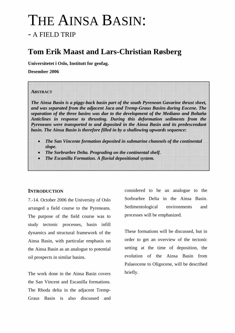
REGIONAL GEOLOGY - EVOLUTION
OF THE AINSA BASIN
The Ainsa Basin represents a piggy-back
basin and is part of the south Pyrenean
Gavarine thrust sheet (Kjemperud, 2004).
It is bounded by the Mediano Anticline to
the east and the Boltaña Anticline to the
west. The Mediano Anticline separates the
Ainsa Basin from the Tremp-Graus Basin
in the east, and the Boltaña Anticline
separates the Ainsa Basin from the Jaca
Basin to the west (figure 2).
PALAEOCENE TO EARLY EOCENE
In Palaeocene to early Eocene, before the
thrusting had generated the Boltaña and
Mediano Anticline, the three basins were
connected. The Ainsa Basin then
functioned as a transfer basin. At this time
coastal and delta depositional systems were
prograding in the Tremp-Graus basin
towards the WNW. These depositional
systems with high sedimentation rates
sourced turbidites which largely bypassed
the Ainsa Basin and were deposited as
large turbidite fans in the western Jaca
Figur 1. Map overview. 1. Locality: San Vincent, Ainsa 1 turbudites 3. Locality: Escanilla Formation 2. Locality: Sorbrarbe Delta 4. Locality: Rhoda Delta

THE AINSA BASIN
3
Basin. The Ainsa Basin was at this time a
delta slope depositional environment with
turbidite channels (San Vincent formation)
(Zühlke, 2005).
MIDDLE TO LATE EOCENE
During the middle to late Eocene the
Mediano and Boltaña Anticlines began to
develop and separated the Jaca, Ainsa and
Tremp-Graus basins. The anticlines
blocked the ESE-WNW sediment
transport.
LATE EOCENE TO OLIGOCENE
In late Eocene to Oligocene deposition of
the Sorbrarbre formation and the Escanilla
Figure 2. Regional overview. Figure from Kjemperud, 2004.
Figure 3. Profile of the Ainsa Basin. Figure from Kjemperud, 2004.

THE AINSA BASIN
4
Formation dominated. The Sorbrarbre
Formation is a delta to alluvial depositional
system, sourced from the S to SE (Zühlke,
2005) and as mentioned is compared
closely to the Rhoda Formation. The
fluvial Escanilla Formation is separated
from the Sorbrarbre Formation by an
erosional unconformity (Zühlke, 2005).
SAN VINCENTE FORMATION – THE
AINSA TURBIDITES
Figure 4. Sketch. Ainsa Quarry. Log 1. Ainsa Quarry
THE AINSA BASIN
5
The turbidite channels of the San Vincent
Formation were sourced from prograding
deltas in the Tremp-Graus Basin in
Palaeocene to early Eocene at the time
when the Ainsa Basin functioned as a
transfer basin.
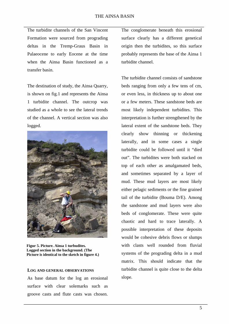
The destination of study, the Ainsa Quarry,
is shown on fig.1 and represents the Ainsa
1 turbidite channel. The outcrop was
studied as a whole to see the lateral trends
of the channel. A vertical section was also
logged.
LOG AND GENERAL OBSERVATIONS
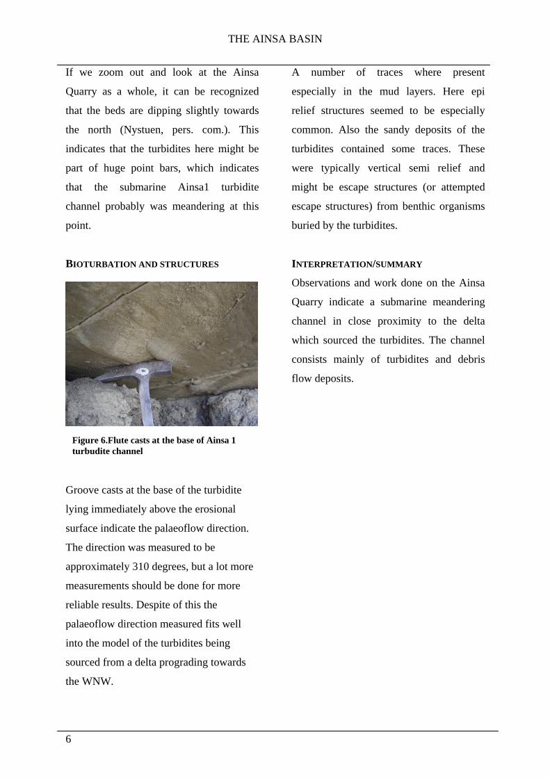
As base datum for the log an erosional
surface with clear solemarks such as
groove casts and flute casts was chosen.
The conglomerate beneath this erosional
surface clearly has a different genetical
origin then the turbidites, so this surface
probably represents the base of the Ainsa 1
turbidite channel.
The turbidite channel consists of sandstone
beds ranging from only a few tens of cm,
or even less, in thickness up to about one
or a few meters. These sandstone beds are
most likely independent turbidites. This
interpretation is further strengthened by the
lateral extent of the sandstone beds. They
clearly show thinning or thickening
laterally, and in some cases a single
turbidite could be followed until it “died
out”. The turbidites were both stacked on
top of each other as amalgamated beds,
and sometimes separated by a layer of
mud. These mud layers are most likely
either pelagic sediments or the fine grained
tail of the turbidite (Bouma D/E). Among
the sandstone and mud layers were also
beds of conglomerate. These were quite
chaotic and hard to trace laterally. A
possible interpretation of these deposits
would be cohesive debris flows or slumps
with clasts well rounded from fluvial
systems of the prograding delta in a mud
matrix. This should indicate that the
turbidite channel is quite close to the delta
slope.
Figur 5. Picture. Ainsa 1 turbudites. Logged section in the background. (The Picture is identical to the sketch in figure 4.)
THE AINSA BASIN
6
If we zoom out and look at the Ainsa
Quarry as a whole, it can be recognized
that the beds are dipping slightly towards
the north (Nystuen, pers. com.). This
indicates that the turbidites here might be
part of huge point bars, which indicates
that the submarine Ainsa1 turbidite
channel probably was meandering at this
point.
BIOTURBATION AND STRUCTURES
Groove casts at the base of the turbidite
lying immediately above the erosional
surface indicate the palaeoflow direction.
The direction was measured to be
approximately 310 degrees, but a lot more
measurements should be done for more
reliable results. Despite of this the
palaeoflow direction measured fits well
into the model of the turbidites being
sourced from a delta prograding towards
the WNW.
A number of traces where present
especially in the mud layers. Here epi
relief structures seemed to be especially
common. Also the sandy deposits of the
turbidites contained some traces. These
were typically vertical semi relief and
might be escape structures (or attempted
escape structures) from benthic organisms
buried by the turbidites.
INTERPRETATION/SUMMARY
Observations and work done on the Ainsa
Quarry indicate a submarine meandering
channel in close proximity to the delta
which sourced the turbidites. The channel
consists mainly of turbidites and debris
flow deposits.
Figure 6.Flute casts at the base of Ainsa 1 turbudite channel

THE AINSA BASIN
7
THE RHODA FORMATION –THE
PROGRADING RHODA DELTA
We have considered the Sorbrarbre
Formation of the Ainsa Basin to be
genetically similar to the Rhoda Delta.
Both the Sorbrarbre and the Rhoda
localities are seen on the map (figure 1).
LOGG AND GENERAL OBSERVATIONS
The Rhoda Delta in the Tremp-Graus
Basin represents a shallow marine
environment with the prograding Rhoda
Delta sourced from the Sis Palaeovalley.
The lower parts of the log show mudstone
very rich in fossils indicating a low energy
environment favouring an abundant and
diverse fauna. Above this a sandstone bed
a few meters thick, showing crossbedding
appears. This might be interpreted as a
tidal channel with tidal bundles and
muddrapes. Approaching the top of the log
sandstone beds dominate. The sandstones
at the top of the log represent the delta
front. The Rhoda Formation therefore is
coarsening and shallowing upwards due to
the prograding Rhoda Delta. In terms of
Figure 7. Overview of Rhoda Delta and Sis Palaeo valley.
Log
2.
Rho
da
THE AINSA BASIN
8
delta terminology, the lower, muddy parts
of the log represent the prodelta/shelf,
while the upper sandier parts of the log
represents the delta front. No delta plain
deposits were observed at the logging
locality, but fossils indicating very shallow
water is abundant at the top.
INTERPRETATION/SUMMARY
The presence of tidal channels and mud
drapes tells us that the Rhoda Delta was
influenced at least by tidal processes and
might be a tide-dominated delta. The
presence of the prodelta mud, rich in
organisms, the tidal influence and the total
thickness of the formation leads to the
conclusion that this was probably a shelf
delta (shallow water delta).
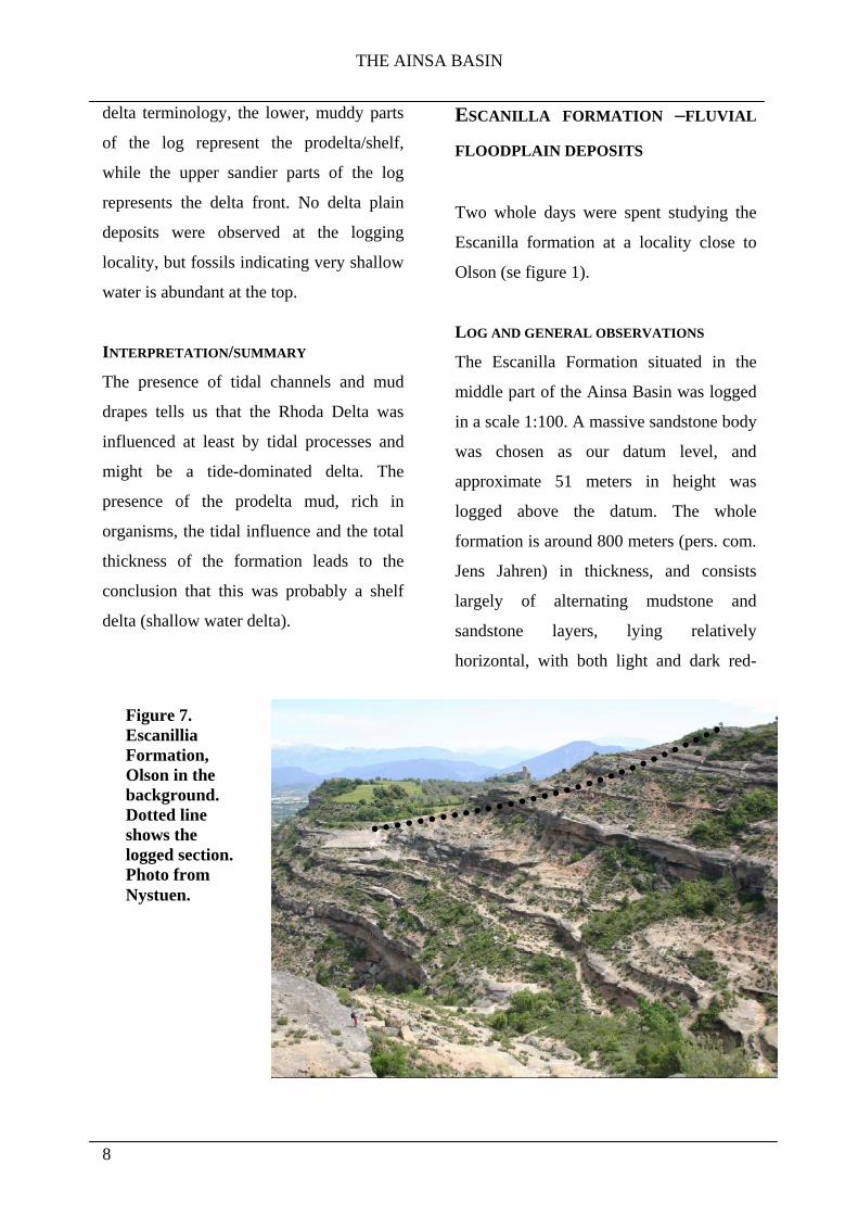
ESCANILLA FORMATION –FLUVIAL
FLOODPLAIN DEPOSITS
Two whole days were spent studying the
Escanilla formation at a locality close to
Olson (se figure 1).
LOG AND GENERAL OBSERVATIONS
The Escanilla Formation situated in the
middle part of the Ainsa Basin was logged
in a scale 1:100. A massive sandstone body
was chosen as our datum level, and
approximate 51 meters in height was
logged above the datum. The whole
formation is around 800 meters (pers. com.
Jens Jahren) in thickness, and consists
largely of alternating mudstone and
sandstone layers, lying relatively
horizontal, with both light and dark red-
Figure 7. Escanillia Formation, Olson in the background. Dotted line shows the logged section. Photo from Nystuen.

THE AINSA BASIN
9
brownish colour, indicating a subaerial
environment (oxidation). Some small parts
of the log that are marked as mudstone was
covered by recent deposited mudstone
erosive, and some small uncertainties
should be taken into consideration.
From the log we can distinguish three main
depositional units:
Unit 1: Mudstone often several meters up
to ten or even more.
Unit 2: Fine sand to silty deposits. These
deposits were thin, typically around one
meter.
Unit 3: Medium to coarse sand and gravel
deposits. These units were the ones that
where studied in most detail. They ranged
in thickness from approximately 2-4
meters in the logging area.
DISCUSSION OF THE DEPOSITIONAL UNITS
LOGGED IN THE ESCANILLA FORMATION
Unit 1: This unit was not emphasized due
to our strict schedule and because it is
more easily eroded and weathered and
hence not as well preserved. The reddish
colour is due to oxidation and traces of
roots might have been observed, in other
words this is likely a palaeosol. It should
be pointed out that the sand-shale ratio is
Log
3.
Esc
anill
a
THE AINSA BASIN
10
quite low (<1) in the logged section. The
connectivity of the sandstone bodies may
therefore be poor and the reservoir
qualities of the logged section is not great.
Unit 2: This unit was often partially
covered by erosive material from unit 1
and not easy to study. More work on these
units could tell about lateral continuity,
grading etc. Some of the units showed a
tendency towards reverse grading.
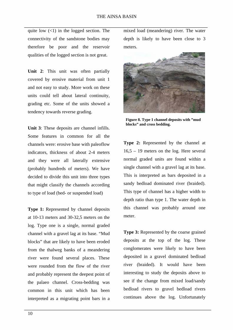
Unit 3: These deposits are channel infills.
Some features in common for all the
channels were: erosive base with paleoflow
indicators, thickness of about 2-4 meters
and they were all laterally extensive
(probably hundreds of meters). We have
decided to divide this unit into three types
that might classify the channels according
to type of load (bed- or suspended load)
Type 1: Represented by channel deposits
at 10-13 meters and 30-32,5 meters on the
log. Type one is a single, normal graded
channel with a gravel lag at its base. “Mud
blocks” that are likely to have been eroded
from the thalweg banks of a meandering
river were found several places. These
were rounded from the flow of the river
and probably represent the deepest point of
the palaeo channel. Cross-bedding was
common in this unit which has been
interpreted as a migrating point bars in a
mixed load (meandering) river. The water
depth is likely to have been close to 3
meters.
Type 2: Represented by the channel at
16,5 – 19 meters on the log. Here several
normal graded units are found within a
single channel with a gravel lag at its base.
This is interpreted as bars deposited in a
sandy bedload dominated river (braided).
This type of channel has a higher width to
depth ratio than type 1. The water depth in
this channel was probably around one
meter.
Type 3: Represented by the coarse grained
deposits at the top of the log. These
conglomerates were likely to have been
deposited in a gravel dominated bedload
river (braided). It would have been
interesting to study the deposits above to
see if the change from mixed load/sandy
bedload rivers to gravel bedload rivers
continues above the log. Unfortunately
Figure 8. Type 1 channel deposits with ”mud blocks” and cross bedding.

THE AINSA BASIN
11
further studies where impossible because
of the topography and schedule, but this
change should reflect maybe tectonic uplift
or maybe even a change in base level.
Poblet et al. (1998) suggested that the
Mediano Anticline was still active during
the deposition of the Escanilla Formation.
This could also be taken into consideration.
INTERPRETATION/SUMMARY
A section consisting of floodplain deposits
(unit 1), crevasse splay deposits (unit 2)
and fluvial channel deposits (unit 3) have
been studied. The lower most 43 meters of
the log is probably dominated by mixed
load to sandy bedload rivers (meandering
and braided in terms of channel
morphology). Above the erosional
unconformity at 44 meters it seems to be
an abrupt increase in grain size to a fluvial
system dominated by gravel dominated
bedload rivers.
SUMMARY From the fieldtrip we have gained
knowledge about the formation and infill
mechanisms of thrust generated basins.
Perhaps the most rewarding events have
been studying the sedimentological
successions of the Ainsa Basin and
interpreting our observations. Through the
localities we have been working on we
have seen how the Ainsa Basin has been
filled in by a shallowing upwards sequence
of sediments, ranging from:
The turbidite channels of the San
Vincente Formation. Representing
the shelf slope to deep marine
environment.
The Sorbrarbre Delta or its
analogue which we studied in more
detail, the Rhoda Delta. A
prograding shelf delta.
The fluvial Escanilla Formation
which in a way represents the final
infill of the Ainsa Basin.
During the deposition of these formations
thrusting has been active and separated the
Jaca, Ainsa and Tremp-Graus basins which
were initially one basin. We have seen
evidence of this synsedimentary
deformation as the Mediano and Boltaña
Anticlines.
THE AINSA BASIN
12
REFERENCES
Zühlke, R.(2005): Virtual Fieldtrip
Southern Pyrenees Foreland Basin,
available at: http://www.uni-
heidelberg.de/institute/fak12/geol/sediment
/zuehlke/virttrip/pyr/stop14/ (Accessed:
12.11.06)
Kjemperud, A., Schomacker, E.,
Brendsdal, A., Fält, L., Jahren, J.,
Nystuen, J.P. and Puigdefàbregas, C.
(2004): The Fluvial Analogue Escanilla
Formation, Ainsa Basin, Spanish Pyrenees:
Revisited*, available at:
http://www.searchanddiscovery.net/docum
ents/2004/kjemperud/index.htm (Accessed:
12.11.06)
Poblet, J., Muñoz, J. A., Travé, A., and
Serra-Kiel, J., 1998, Quantifying the
kinematics of detachment folds using
three-dimensional geometry: Application
to the Mediano Anticline (Pyrenees,
Spain): GSA Bulletin v. 110, no. 1, p. 111-
125.