to ask for your cooperation with this year’s falls survey
TRANSCRIPT

September 1, 2021
Dear License Holder,
Since the fall of 2000, the states of New Hampshire and Maine have conducted an
Inshore Bottom Trawl Survey in order to collect abundance and biological information on
groundfish, lobsters, and other marine organisms from the shore out to the 12-nautical mile limit.
We would like to ask for your cooperation with this year’s falls survey.
On September 27th and 28th, the vessel is scheduled to survey off the coast of New
Hampshire. Accompanying this letter are maps of the tow locations for the fall survey along
with the Loran C coordinates (using the W and X chains) of the stations. An interactive chart
will be available and can be found at the following website. Using a cell phone and clicking on
the location button shows where you are in relation to the scheduled tows.
https://www.maine.gov/dmr/science-research/projects/trawlsurvey/fl21/index.html
In order to avoid any gear conflicts, we are asking for your cooperation by temporarily
moving any fixed gear (lobster traps, gill nets, etc.) from an area roughly 1/8 mile on either side
of the 1-nautical mile tow area before the above dates. It is extremely important to the integrity
of this long term survey that we not have to move the trawl sites to avoid fixed gear.
In case adverse weather conditions cause delays or a postponement of the scheduled
survey dates, there are several ways for you to get updates on the survey schedule. Each
morning an announcement will be made by the vessel survey crew on VHF radio describing
which locations will be sampled that day. Finally, any schedule updates will be posted daily at
the following web site: https://www.maine.gov/dmr/science-
research/projects/trawlsurvey/index.html. You may also contact Conor O’Donnell at the Region
3 office in Durham, [email protected] or 603-868-1095.
The survey vessel is the F/V Robert Michael out of Portland, ME, under Captain Rob
Tetrault II. The vessel will be monitoring channels 16 and 13 and be ready to move to a local
working channel if you need to contact them the day of the survey. You can also contact the
vessel via cell phone at 207-557-5276 (Chief Scientist Rebecca Peters).

Finally, I want to thank you all for the outstanding cooperation we have received over the
past 21 years from the NH lobster fishing industry in moving gear out of the tow areas. The
Department sees the inshore trawl survey as an opportunity to provide credible data to state
managers, the New England Fisheries Management Council, the Atlantic States Marine Fisheries
Commission, and National Oceanic and Atmospheric Administration (NOAA) for areas where
there is currently minimal information on a variety of marine species that fisheries are reliant on.
Enclosed is a brief report that summarizes highlights and results from past surveys. We also
have a more detailed report comparing the results of the survey through the fall of 2020. If you
would like a copy of this report or have any questions about the survey in general, please contact
Conor O’Donnell at our Durham Regional Office.
Thank you again for your cooperation.
Sincerely,
Cheri Patterson
Chief Marine Fisheries
Attachment
Cc: Cheri Patterson Joshua Carloni Rebecca Heuss Conor O’Donnell
Michael Dionne Kara Villone Kevin Sullivan Renée Zobel
Robert Atwood Wendy Main District 6 Officers


Table 1. Mean weight and number per tow of marine species captured in the ME/NH Inshore Trawl Survey in Region 1 (NH and southern ME), fall 2020.
Region 1 (NH to Cape Elizabeth)- Fall 2020
Stratum 1 Stratum 2 Stratum 3 Stratum 4 Region 1 all
strata
5-20 fathoms 21-35 fathoms 36-55 fathoms 56-80+ fathoms
Species kg/tow #/tow kg/tow #/tow kg/tow #/tow kg/tow #/tow kg/tow #/tow
Acadian Redfish 0.00 0.00 0.69 45.81 2.72 77.29 6.41 149.33 3.01 78.88
Alewife 0.28 7.89 2.02 15.54 8.95 59.08 11.03 59.00 6.56 40.42
Alligatorfish 0.00 0.00 0.00 0.00 0.00 0.20 0.00 0.00 0.00 0.06
American lobster 43.64 220.58 55.41 249.55 17.45 53.18 0.87 1.67 24.07 105.94
American Plaice 0.00 0.00 0.66 12.87 2.33 27.80 1.62 15.83 1.30 15.15
American Shad 0.01 0.26 0.00 0.00 0.20 1.57 0.08 0.83 0.09 0.77
Atlantic Cod 0.00 0.00 0.11 0.39 0.00 0.00 1.47 0.17 0.51 0.12
Atlantic Hagfish 0.00 0.00 0.00 0.00 0.05 0.24 0.00 0.00 0.01 0.07
Atlantic Halibut 0.00 0.00 0.00 0.00 0.20 0.24 0.00 0.00 0.06 0.07
Atlantic Herring 0.00 0.00 8.53 76.04 2.10 14.60 0.12 0.67 2.04 16.95
Atlantic Mackerel 0.03 0.26 0.08 0.61 0.12 0.60 0.00 0.00 0.05 0.33
Atlantic Menhaden 0.00 0.00 0.16 0.39 0.00 0.00 0.00 0.00 0.03 0.07
Atlantic Moonfish 0.00 3.70 0.00 0.00 0.00 0.00 0.00 0.00 0.00 0.82
Atlantic Silverside 0.00 0.29 0.00 0.00 0.00 0.00 0.00 0.00 0.00 0.07
Barndoor Skate 0.00 0.00 0.00 0.00 0.00 0.00 2.12 0.17 0.71 0.06
Blue mussel 0.00 0.00 0.02 0.39 0.00 0.00 0.00 0.00 0.00 0.07
Blueback Herring 0.02 0.63 0.00 0.00 4.27 28.14 0.60 3.67 1.39 9.18
Butterfish 0.43 102.79 0.11 9.06 3.89 45.25 0.03 0.33 1.20 37.03
Crangon shrimp 0.00 5.32 0.00 0.39 0.00 0.00 0.00 0.00 0.00 1.25
Cunner 0.00 0.00 0.11 2.00 0.00 0.00 0.00 0.00 0.02 0.33
Dichelo shrimp 0.00 0.00 0.54 297.25 0.26 93.18 0.31 108.50 0.27 111.59
Fourbeard Rockling 0.00 0.00 0.01 0.39 0.00 0.00 0.02 0.50 0.01 0.23
Fourspot Flounder 0.00 0.00 0.00 0.00 0.06 0.34 0.08 0.33 0.04 0.21
Haddock 0.00 0.00 0.00 0.61 0.00 0.00 30.50 29.00 10.17 9.77
Jonah crab 0.06 0.84 0.78 3.92 0.07 0.40 0.12 1.00 0.20 1.28
Little Skate 0.40 0.82 0.00 0.00 0.00 0.00 0.41 0.17 0.23 0.24
Longfin squid 0.00 1.97 0.07 12.73 0.22 42.97 0.01 3.00 0.08 15.49
Longhorn Sculpin 0.00 0.00 0.53 4.21 0.04 0.40 0.02 0.17 0.11 0.87
Lumpfish 0.00 0.00 0.00 0.00 0.51 1.49 2.27 3.33 0.90 1.53
Monkfish 0.00 0.00 0.63 4.35 0.00 0.34 5.58 2.67 1.97 1.71
Montagui shrimp 0.00 0.00 0.00 0.00 0.00 0.20 0.00 0.17 0.00 0.11
Moon jelly 0.00 0.00 0.00 0.00 0.00 0.00 0.29 0.33 0.10 0.11
Northern shrimp 0.00 0.00 0.00 0.00 0.02 4.80 0.02 2.17 0.01 2.06
Ocean Pout 0.00 0.00 0.00 0.00 0.05 0.64 0.00 0.00 0.02 0.18
Pollock 0.00 0.00 0.00 0.00 0.10 0.60 0.00 0.00 0.03 0.17
Porbeagle 0.00 0.00 0.00 0.00 0.00 0.00 13.00 0.17 4.33 0.06
Rainbow Smelt 0.00 0.26 0.00 0.00 0.00 0.00 0.00 0.00 0.00 0.06
Red Hake 0.00 0.00 6.21 138.50 19.04 100.47 61.87 335.17 26.95 162.72
Rock crab 0.08 4.08 0.00 0.00 0.00 0.00 0.00 0.00 0.02 0.91
Sand dollar 0.04 4.79 0.00 0.00 0.00 0.00 0.00 0.00 0.01 1.06
Sculptured shrimp 0.00 0.00 0.00 0.00 0.00 0.40 0.00 0.00 0.00 0.11
Sea anemone 0.00 0.00 0.00 0.00 0.08 0.60 0.49 2.17 0.18 0.89
Sea scallop 0.00 0.00 0.00 0.00 0.00 0.00 0.06 1.83 0.02 0.61
Sea urchin 0.00 1.58 0.00 0.00 0.00 0.00 0.00 0.00 0.00 0.35
Shortfin squid 0.00 0.00 0.55 5.35 2.13 14.23 16.98 77.00 6.35 30.51
Shorthorn Sculpin 0.02 0.26 0.00 0.00 0.00 0.00 0.00 0.00 0.00 0.06
Silver Hake 0.00 0.00 45.33 770.02 89.88 1,615.78 154.82 3,112.67 84.13 1,614.72
Spiny Dogfish 0.00 0.00 0.00 0.00 0.00 0.00 17.76 11.33 5.92 3.78
Spotted Hake 0.00 0.00 0.05 0.39 0.00 0.00 0.00 0.00 0.01 0.07
Striped Bass 2.24 3.63 0.00 0.00 0.00 0.00 0.00 0.00 0.50 0.81
Striped Searobin 0.00 0.26 0.00 0.00 0.00 0.00 0.00 0.00 0.00 0.06
Thorny Skate 0.00 0.00 0.00 0.00 0.44 0.24 4.86 1.17 1.74 0.45

Table 1. (cont.)
Region 1 (NH to Cape Elizabeth)- Fall 2020
Stratum 1 Stratum 2 Stratum 3 Stratum 4 Region 1 all
strata
5-20 fathoms 21-35 fathoms 36-55 fathoms 56-80+ fathoms
Species kg/tow #/tow kg/tow #/tow kg/tow #/tow kg/tow #/tow kg/tow #/tow
Toad crab 0.00 0.00 0.00 0.39 0.00 0.00 0.00 0.00 0.00 0.07
Waved astarte 0.00 0.00 0.00 0.00 0.00 0.00 0.00 0.17 0.00 0.06
White Hake 0.02 1.10 3.59 28.06 3.66 14.98 5.49 5.83 3.45 11.03
Windowpane 0.27 1.95 0.00 0.00 0.00 0.00 0.00 0.00 0.06 0.43
Winter Flounder 2.18 14.03 0.51 3.81 0.36 0.87 0.00 0.00 0.67 3.99
Witch Flounder 0.00 0.00 0.73 3.57 1.30 6.80 5.18 29.50 2.21 12.32
Wrymouth 0.00 0.00 0.00 0.00 0.03 0.34 0.00 0.00 0.01 0.10
Yellowtail Flounder 0.02 0.29 0.78 4.92 0.64 3.20 0.00 0.00 0.31 1.77
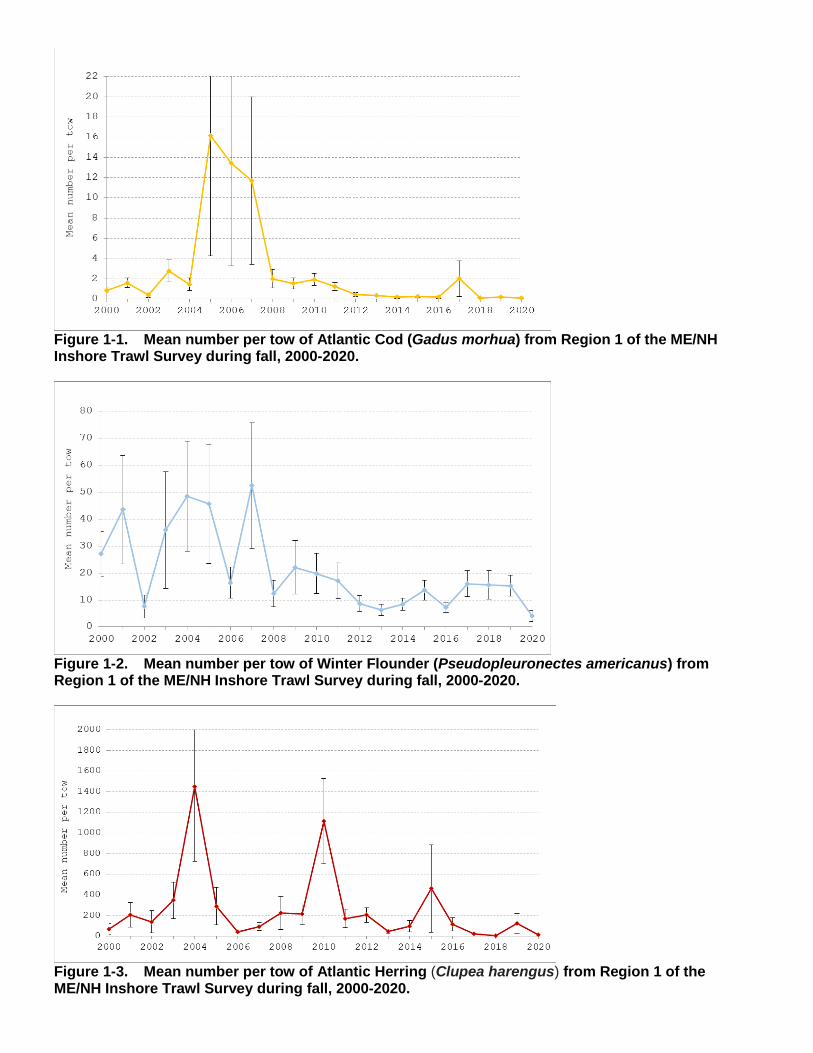
Figure 1-1. Mean number per tow of Atlantic Cod (Gadus morhua) from Region 1 of the ME/NH Inshore Trawl Survey during fall, 2000-2020.
Figure 1-2. Mean number per tow of Winter Flounder (Pseudopleuronectes americanus) from Region 1 of the ME/NH Inshore Trawl Survey during fall, 2000-2020.
Figure 1-3. Mean number per tow of Atlantic Herring (Clupea harengus) from Region 1 of the ME/NH Inshore Trawl Survey during fall, 2000-2020.
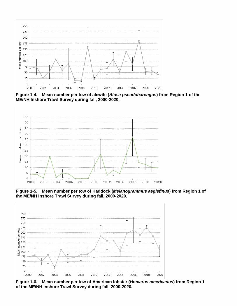
Figure 1-4. Mean number per tow of alewife (Alosa pseudoharengus) from Region 1 of the ME/NH Inshore Trawl Survey during fall, 2000-2020.
Figure 1-5. Mean number per tow of Haddock (Melanogrammus aeglefinus) from Region 1 of the ME/NH Inshore Trawl Survey during fall, 2000-2020.
Figure 1-6. Mean number per tow of American lobster (Homarus americanus) from Region 1 of the ME/NH Inshore Trawl Survey during fall, 2000-2020.