title: county, northwest oregon
TRANSCRIPT

AN ABSTRACT OF THE THESIS OF
David Ezra Nelson for the degree of Master of Science
Geology presented on March 19, 1985
in
Title: Geology of the Fishhawk Falls Jewell Area, Clatsop
County, Northwest Oregon // /Abstract approved:
Dr. Alan R. Niem, Thesis advisor
The study area is located on the NW flank of the
northern Oregon Coast Range. Seven Tertiary formations
compose the bedrock units: the Tillamook Volcanics, the
Cowlitz, Keasey and Pittsburg Bluff formations, Oswald West
mudstone (iniormal), Astoria Formation (Silver Point
member), and Grande Ronde (Depoe Bay) Basalt of the Columbia
River Group.
Major element geochemistry, petrology, and radiometric
ages of volcanic rocks near Green Mountain suggest that this
is an upthrown tectonic block of middle to upper Eocene
Tillamook Volcanics. This outlier is composed of subaerial
basaltic andesite flows and epiclastic debris flows which
are intruded by complexes of basaltic andesite dikes. The
volcanics typically contain 58-627 Si02 and reflect a rugged
stratovolcano or mid-ocean island that rose above sea level.
Radiometric dates from the uppermost part of the upper
Tillamook Volcanics in and near this study area are from
37.1 0.4 m.y. (late middle Eocene) to 42.4 + 0.5 m.y.
(early late Eocene). Preliminary paleornagnetic
investigation of three. sites in the Tillamook Volcanics and
overlying Cougar Mountain intrusions indicates that
Redacted for privacy

48.4 26° of clockwise rotation has occurred since the late
middle Eocene.
The middle to upper Eocene (Narizian) Cowlitz Formation
overlies the Tillamook Volcanics w th angular unconformity
in the study area. The Cowlitz is an onlapping marine
sequence of basaltic and arkosic sandstone and deep-marine
turbidite sandstone overlain by a regressive seq.ence of
arkosic sandstone. Four lithofacies are considered informal
members of the 465-rn--thick Cowlitz Formation. These are: a
basal fluvial-littoral basaltic andesite conglomerate (Tc1),
a lower shallow-marine sandstone composed of intrabasinal
basaltic sandstone and extrabasinal micaceous arkosic
sandstone and mudstone (Tc2), a thin turbidite sandstone and
siltstone unit (Tc3), and an upper shallow-marine arkosic
sandstone (Tc4). The lower sandstones are volcanic arenites
derived locally from the Tillamook Volcanics. They are
interbedded with micaceous plagi clase-bearing arkosic
sandstone redistributed from the Cowlitz delta of
southwestern Washington via longshore drift. The friable
arkosic upper sandstone member may be correlative to the
"Clark and Wilson" reservoir sandstone in the Mist gas
field.
The Cowlitz Formation is overlain by the 1,640-2,050-rn-
thick upper Narizian to Refugian Keasey Formation. Three
mappable lithofacies of the Keasey are defined as informal
members based on lithology and biostratigraphy. The
tuffaceous Jewell rnudstone forms the lower member of the
Keasey Formation. It contains foram and coccolith
assemblages that correlate to the Valvulineria tumeyensis
Zone of California of Donnelly (1976). The middle member is
the Vesper Church member which is late Refugian in age.
This well-bedded to laminated graded sandstone and mudstone
unit was deposited in ested slope channels by turbidites as
micaceous arkosic Cowlitz sands and muds were redistributed
offshore. The thick-bedded, structureless tuffaceous upper
mudstone member is upper Refugian and contains Foraminifera
equivalent to the Uvigerina vicksburgensis Zone of
California. Foraminifera paleoecology suggests that the
three members were deposited in upper bathyal depths.
The upper Eocene to Oligocene (upper Refugian to
Zemorrian) 200-500-rn-thick Pittsburg Bluff Formation
disconformably overlies the Keasey Formation. The
thick-bedded tuffaceous to arkosic Pittsburg Bluff
sandstones were deposited in a shallow-marine inner to
middle shelf environment. Local uplift and/or eustatic sea
level fall (corresponding to the end of cycle TE3 of Vail
and Hardenbol, 1979) combined to cause a late Eocene marine
regression and disconformity at the base of the Pittsburg
Bluff Formation.
The rnollusc-rich bioturbated Pittsburg Bluff sandstone
and the overlying tuffaceous Oswald West deep-marine
mudstone are, in part, coeval facies that represent inner to
middle shelf sands and an adjacent deep-water outer
shelf-upper slope depositional environment, respectively.
An Oligocene marine transgression corresponding to Vail and
Hardenbol's cycle T01 eventually caused onlap of Oswald West
slope muds over inner shelf Pittsburg Bluff sands. The
Oswald West is Oligocene (Zemorrian) in age in the thesisarea but is as young as lower Miocene (Saucesian) in westernClatsop County. The deep-marine lower Miocene to middleMiocene Silver Point mudstone and the turbidite sandstonesof the Astoria Formation overlie the Oswald West mudstoneswith minor unconformity.
The sedimentary strata of the thesis area were intrudedby several dikes and sills of middle Miocene tholeiiticbasalt. Principal among the intrusions are three extensivedikes (Beneke, Fishhawk Falls, and Northrup Creek) composedof low-MgO-high-Ti02 and low-MgO-low-Ti02 basalt. These
subparallel NE-trending dikes are 10 to 20 km long and aregeochemically and magnetically correlative tolow-MgO--high-Ti02 and low-MgO-low-Ti02 subaerial flows ofthe Grande Ronde Basalt that are exposed 6.5 km NE of thethesis area near Nicolai Mountain and Porter Ridge. Thiscorrelation supports the hypothesis of Beeson and others(1979) that these intrusions were formed by ttinvasivehl flowsof Columbia River Basalt. The dikes and flows represent theR2 and N2 magnetozones. Paleomagnetic results and detailedmapping along the three major dikes indicate that the dikesare cut into many small blocks by NE-trending dextral andNW-trending sinistral faults. Oblique slip along thesefaults may have rotated these small blocks clockwise fromthe expected middle Miocerie declination. One such
fault-bounded block in Beneke quarry has been rotated 110clockwise relative to other blocks in the quarry.
The area has apparently undergone four periods of
structural deformation. Late Eocene deformation produced
normal faults and a highly faulted anticline in the Cowlitz,
Keasey and Pittsburg Bluff formations. Uplift of the Oregon
Coast Range commenced during the Oligocene. NW-SE extension
in the middle Miocene permitted intrusion of the NE-trending
dikes, perhaps along pre-existing faults or joints.
Post-middle Miocene N-S compression produced a conjugate
shear couplet of dextral NW-trending and sinistral
NE-trending oblique-slip faults and associated E-W thrust
faults. These may compose a 20-km-wide zone of distributed
shear between the Oregon Coast Range tectonic block and the
smaller tectonic blocks of SW Washington (Wells, 1981).
These post-middle Miocene faults may be related to wrench
tectonics and NW-trending dextral slip faults observed on
the Columbia Plateau. They may have formed sympathetically
to regional right-lateral wrenching of the North American
plate by oblique subduction of the Juan de Fuca plate and/or
extensional opening of the Basin and Range province (Magill
and others, 1982).
The north-central and eastern parts of the study area
hold the greatest potential for natural gas accumulation in
the permeable upper Cowlitz sandstones (Tc4) that may be
correlative to the "Clark and Wilson" sand. Mapping of the
limited outcrops of this potential reservoir suggests that
the unit may pinch out to the west. It is overlain by
Keasey mudstones that could form cap rock. A highly faulted
NW-trending antiform in the subsurface, postulated from
surface mapping, represents the best structural trap in the
area if the reservoir sands are not breached by faulting.

GEOLOGY OF THE FISHHAWK FALLS JEWELL AREA,
CLATSOP COUNTY, NORTHWEST OREGON
by
David Ezra Nelson
A THESIS
submitted to
Oregon State University
in partial fulfillment ofthe requirements for the
degree ofMaster of Science
Thesis presented on March 19, 1985
Commencement June 1985

APPROVED:
Associate Professor of Geology in charge of major
Chairman, Department of($eology
Dean of Gradiat School
Date thesis is presented March 19, 1985
Typed by David E. Nelson and Carolyn F. Knapp-Nelson
Printed in Prestige Pica typestyle
Redacted for privacy
Redacted for privacy
Redacted for privacy
1
ACKNOWLEDGEMENTS
To the many people who have aided and supported me inthis study, my sincere thanks.
This work was funded jointly by Diamond-ShamrockCorporation and Houston Oil & Minerals (now Tenneco OilExploration and Production Company). Special thanks for themonetary support are due to Chuck Wheeler, Western DistrictGeologist, and geologist Alan Seeling, of Diamond-ShamrockCorporation.
The project was suggested by Dr. Alan R. Niem, my majorprofessor, who generated the interest and support ofDiamond-Shamrock and Houston Oil & Minerals. I extend mygratitude to Alan and Wendy Niem, both of whom helped me toimprove the manuscript significantly over the first draft.Special thanks to Wendy for retyping some of their suggestedrevisions; your effort made my revisions a lot easier.
The paleomagnetic study would not have been possiblewithout the guiding interest of Dr. Shaul Levi, my committeemember. Shaul provided knowledge, equipment and the use ofthe magnetics laboratory in the College of Oceanography atOregon State University.
Dr. J. G. Johnson instilled in me the importance ofgood writing, though the length of this report far exceedshis preferences. Thank you, Jess, for your excellentteaching; and sorry about the length.
Several individuals deserve credit for their help byproviding special diagnoses free of charge. Drs. EllenMoore, Kristin McDougall, David Bukry, and Jack Baldaufkindly provided paleontological identifications of molluscs,Foraminifera, coccoliths and diatoms. Dr. Peter Hooperprovided geochemical analyses at an incredibly low rate sothat I could run many more samples on a limited budget.
My colleagues in grad school were great friends andwere very helpful in providing lively discussion of thegeologic field problems we were trying to solve. My specialthanks to Carolyn Peterson, Jim Olbinski, Jeff Goalen, DanMumford and Phil Rarey. Also, Tom Murphy took me on thefirst field trip through my thesis area as well as his own.Tom, I can't decide whether to say thanks or not! Threepeople were tremendously helpful in the paleomagnetics lab:Karin Schultz [Hayman], Dennis Schultz and Bob Karlin.Thanks for all the help in the lab, and in the field too,Dennis! Thank you to Kris McElwee and Robert A. Duncan fortheir important help in establishing the age of the Eocenevolcanics. Mrs. Therese Belden typed my bibliography thefirst time through and her efforts are much appreciated.

11
Thanks to David Blanchard for his fine artwork in the finalcolor copies of the geologic plates.
Most importantly, thank you Carolyn, my beloved friendand wife, for maintaining peace and even humor over all thedelays. Had it not been for you, I would have possiblynever ended this project. You are the apple of my eye and,along with our beautiful daughter Robyn, are my inspiration.And I love you both.
Peter and Carol Ames are two special friends whodeserve my sincerest thanks for friendship, recreation,travel and dancing; all were important and much-neededbreaks from the constant effort I put into this study.
Finally, my thanks and love go out to my parents, Ezraand Aleda, for their continual support and love. Thank you.I am proud to be your son.

TABLE OF CONTENTS
111
P ag
INTRODUCTION...... S. 1
Purpose of Investigation... . . . . . .. . . . . ........... 1Location and Accessibility. .. . . . . . . . . . . . . . .... . . .2
Geographic Features ............ . ................ 2Methods of Investigation .......... . .... . . . .5
Field Procedures ............. * .............. 5Laboratory Procedures ............ ......... .8
Previous Work ............ . . . . ........ . . ......... .11
REGIONAL STRATIGRAPHY . . . . . . ..................... ......... 15
Biostratigraphic and ChronostratigraphicNomenclature. . . . . . . . . . . ............................. 24
DESCRIPTIVE GEOLOGY OF THE THESIS AREA. .................. .27
T illamook Volcanics ................................. 27Nomenclature ................... . .............. 27Distribution.................... . . . . . . . . . . . . . . . .29L ithology................ .30
Vol c an i c b r e cc i a s .......................... 30Basaltic andesite flows ................... .32Petrography of flows ...................... 33Lithology and Petrography of intrusiverocks ..................................... 34
Geochemistry of the Tillamook Volcanics... ...... 38Contact Relations ...................... . ........ 43Age and Correlation............................ .44Paleomagnetism of the Tillamook Volcanics ...... 48
Cowlitz Formation.................................... 53Nomenclature .................................... 53Distribution .................................. ..55Lithologies, Structures and Provenance..........56
Conglomerate Member ........................ 56Lower Sandstone Member ..................... 60Lithology of the Lower Sandstone Member....62Turbidite Member .......... . . . .............. 70Upper Sandstone Member.. .......... 75
Contact Relations ..................... . ......... 77Age and Co r r e 1 at ion . . . . . . ...................... 7 9
Radiometric dating and biostratigraphicproblems ................................... 83
Depositional Environments ..................... .84Depositional environment of theconglomerate member .............. 84Depositional environment of the lowersandstone member ........................... 87

iv
PageDepositional environment of theturbidite member. ....................... . . .89Depositional environment of the uppersandstone member ........ . . . . . . ............ .91
Keasey Formation. ........... . . . . ....... . .......... . . .94Nomenclature1...... . . . . . . . . . . . . . . . . . . . . . . . . . . . . .94Dis t r i but ion . . . . . . . . . . . . . . . . . . . . . . . . . . . . . . . . . . . . 99
Lithologies, Structures, and Provenance........101Jewell member.. ........ . . . . ...101Vesper Church member...... . ...... . ... .. . .103Upper mudstone member .................... .113
Contact Relations ........... . . . .............. 114Age and Co r r e 1 at ion ....... . ................... 1 16Depositional Environment ................. .. .. .119
Pittsburg Bluff Formation ...... ... ................. 123Nomen c 1 at u r e ......... . . . ...... . . . . . . . . . . . . . . . 1 2 3
Distribution .......... * * . . . . . . . . . ............ 124Lithologies, Structures, and Provenance ....... 125Contact Relations . . . .......... . . . . . . . ........ 131Ag e and Co r r e 1 at ion. . . ....... . . . . . . . . ........ 1 34Depositional Environment ...... . ........... 139
Oswald West Muds tone .............. . ...... . . . . . . . . . . .145Nomenclature and Distribution. .. . . . . . . . . . . . . . . .145
Lithologies and Structures ...... ..... .148Contact Relations . . . . . . . . . . .......... 149Age and Correlation. . . . . . ...... 152Depositional Environment ................. ... . .153
Silver Point Member of the Astoria Formation........ 156Nomenclature and Distribution..... . .. ........ .156Lithology and Structures .................... 157Contact Relations .............................. 158Age and Correlation. . . * ....... . * . . 160Depositional Environment ....................... 161
Miocene Basalt Intrusives ........................... 164Introduction .............................. . . . . .164Middle Miocene Coastal Basalts. .............. . .166Columbia River Basalt Group Nomenclature ....... 169
Grande Ronde Basalt ................ 172Middle Miocene Basalt Intrusives ............... 174
Description ............... . . . . . .. ... .. ....174Petrography ........... . . . . ............... 179Geochemistry ............. . . . .182Correlation of basalt intrusives tosubaerial flows ....................... .190Hypotheses of Origin ........ . ........... . .199
Hypothesis 1: Basalts at the coasterupted locally ........... . ........ . .199

V
PageHypothesis 2: Basalts at the coasteruptedontheplateau ........ 204
Tectonic Significance of the Orientationof the Major Middle Miocene Basalt Dikes ..... ...209
Regional Considerations........ ....... . ... .209
Paleomagnetism of Middle Miocene Basalt Dikes.......217Introduction...... * . . .................. . . . . . . .217
Field sampling procedures. . . . ... . .. ...... 218Paleomagnetic Directions and Results ....... 221
Laboratory Preparation... * * . . .... . ...... .221Dem ag n e t i z at ion . . . .................. . . . . . 2 21
Summary of site statistics ........ 222Structure Corrections. ........... 224
Paleomagnetic Results from the Dikes ...... .....230Northrup Creek dike....... . .............. 230Beneke dike... .......... . . ...... . . . ..... 233Fishhawk Falls dike.. . . .... .......... 234Nicolai Mountain Porter Ridge area ...... 235Paleomagnetic data from geochemical
subtypes . . . . . . . . .................... 237Tectonic Rotation of Fault-bounded Blocks ..... .239
Problem of secular variation........ ...... 239Interpretation...... . . . . . . . . . . . . . . . . . . . . . .239Small-block tectonic rotation.... ......... 242
STRUCTURAL GEOLOGY. . . . . .................... . . . . .......... 245
Regional Structure .......... . . ............ . . . . .245Tectonic Rotation and Tectonic Boundaries......248
Tcc1 Sriifiir ..................................... 253Summary of Structural Events ..........Deformation of Upper Eocene Rocks .............. 257
Nehalem Valley Fault and related folds....257Little Fishhawk Creek Fault ............... 262Folds. ........ . . . . . . . . . , . . . . . . . ....... 263
Deformation of Dikes... . . ...... ......... . ... .. . 265
GEOLOGIC HISTORY.. . . . . . . . . ...... . . . ...................... 275
MINERAL RESOURCES ........................................ 292
Crushed Rock Resources ....... 292Petroleum Potential ................... . . ...... 293Coal Resources ............................. . ...... . 302
REFERENCES CITED ....... . . . . . . . . ...... -. .............. . . . . .305
APPENDICES 323
I MicrofossilRecovery Method ............. .....323

vi
PageII Checklist of Fossils from the Cowlitz
Formation..... ........ ........ ..326
III Checklist of Fossils from the KeaseyFormation.. ....... . .. .. . 11. . ... .....327
IV Checklist of Fossils from the PittsburgB luff Formation.., ,...... . . . . . . . . .......... .330
V Checklist of Fossils from the Oswald Westmudstone and Astoria Formation...............332
VI Major Element Geochemistry of SelectedIgneous Rock Samples...... . . . . . .. . . . . . . . . . . . .333
VII Polarity and Locations of Miocene BasaltSamples...... . . . . . . . . . . . . . . . . . . . . . . . . . . . . . . . .335
VIII Heavy Minerals of Selected Sandstones fromthe Fishhawk Falls Jewell Area.............337
IX Locations and descriptions of Eocene andMiocene paleomagnetic sample localities......339
X List of Localities Discussed in Text andin Fossil Checklists...... . . . .. . . . . . . . . . . .. . .347
XI Proton-precession Magnetometer Responses:Traverses 1 1.1. ......... ...... ,.. .. ... ..350
XII Reference section in West Buster CreekQuarry... ........ ... . ............. ...... .. . .357
XIII Clatsop County Exploration Well Locationsto 1982 .............. .. . ... ........... . ...... 358
XIV Results of Reservoir and Source RockAnalysis of Selected Samples from theFishhawkFalls-JewellArea.................359
XV Flowchart of Paleomagnetic Procedures ...... . .360
vii
LIST OF FIGURES
Figure Page1. Index map showing location of the thesis
area.................. ......... ......... . . .
2. Lineaments in northwest Oregon traced fromLandsat I imagery. . . . . . . . . . . . . . . . . . . . . . ....... 4
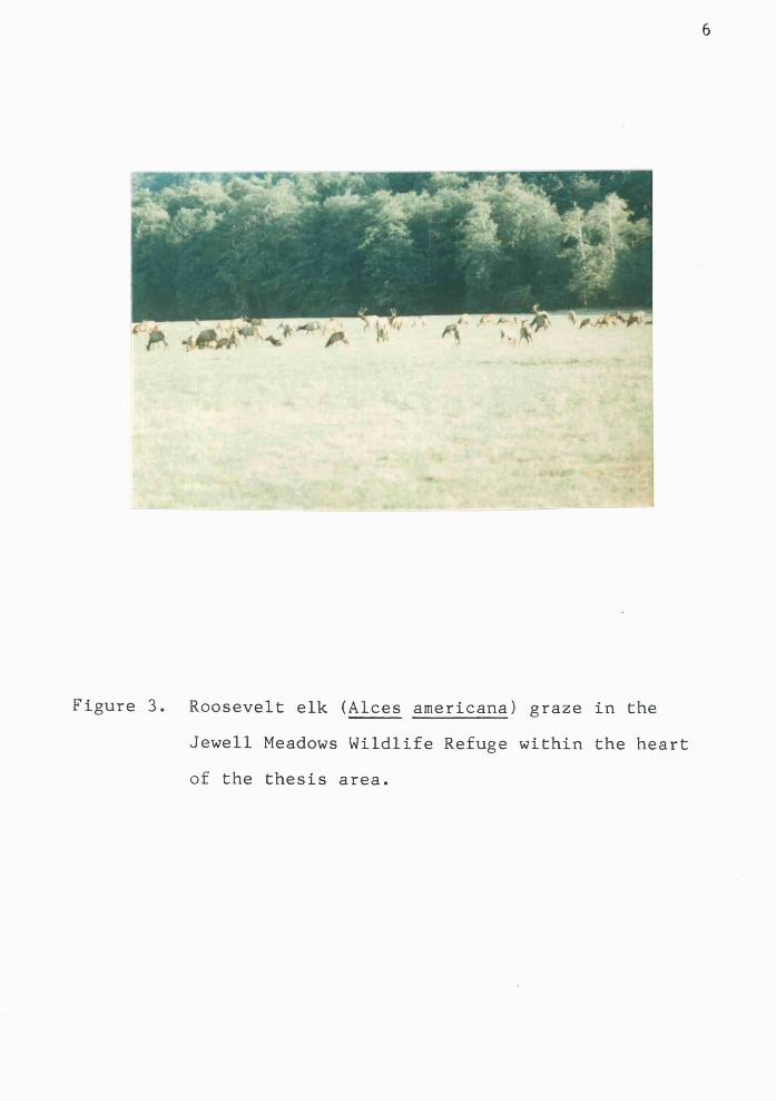
3. Roosevelt elk (Alces americana) grazingin the Jewell Meadows Wildlife Refuge..........6
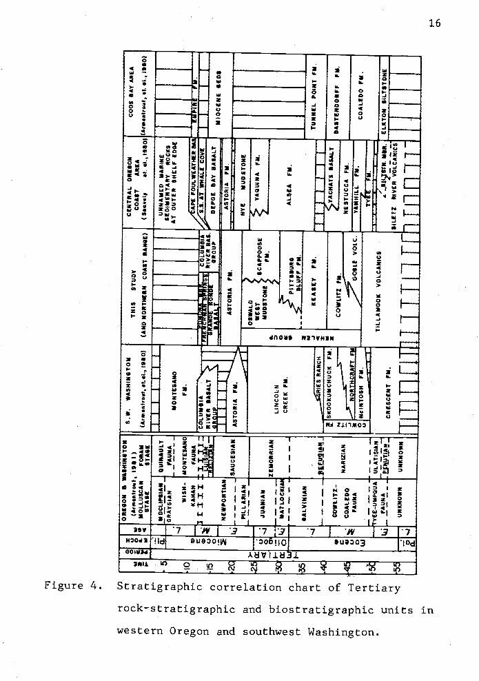
4. Stratigraphic correlation chart of Tertiaryunits in western Oregon and Washington........16
5. Stratigraphic correlation chart of Tertiarybiostratigraphic units in western Oregon andsouthwest Washington.......... . ..... ..... .. . . .25
6. Volcanic breccia of the upper TillamookVolcanic ........... . . . . . . . . ...... ........... . .31
7. Photograph and line drawing of the westBus t e r C reek qua r ry . . . . . . . . . . . . . . . . . . . . . . . . . . . 3 5
8. Silica variation diagram of major oxidesfor upper Tillamook and Goble Volcanics ...... 39
9. Alkali vs. silica diagram depicting thedifference of tholejitic and alkalic rocks....41
10. MgO_FeO*_Al2O, geochemical discriminantdiagram for Tfllam000k Volcanics .......... . . . .42
11. Upper Tillamook Volcanics paleomagneticdirections.. ...... 1 ................... . . . . . . .51
12. Epiclastic volcanic conglomerates and debrisflow breccias of the basal conglomeratemember of the Cowlitz Formation. .............. 58
13. Correlation of informal members of theCowlitz Formation... . ................ . ........ 61
14. Cowlitz sandstone classification diagram......63
15. Photomicrograph of volcanic-arenite fromthe lower sandstone member of the CowlitzFormation...... . . . . . . . . . . . . . . . . . . ........... .65
16. Photomicrograph of lithic arkose (volcanic-plagioclase arkose) from the lower sand-stone member of the Cowlitz Formation. ...... ..66

viii
Figure Page
17. Scanning electron photomicrograph ofdetrital feldspar grain from arkose inlower sandstone member of the CowlitzFormation ......... . . . . . . . . . . . . ......... . . . . . . .67
18. Photograph of the turbidite member of theCowlitz Formation .............. . . . . . . . . . . . . . . . 71
19. Triangular QFL provenance classificationdiagram for Cowlitz sandstones ..... .74
20. Conceptual diagram of major storm and stormsurge currents on a sediment-laden shelf......92
21. Correlation of the informal members of theKeasey Formation.... ... . ... . ........ . . . ...... .98
22. Typical exposure of the Jewell member ofthe Keasey Formation..... ...... . ... . .. . ...... 102
23. Sequence of alternating thin siltstone andfine-grained micaceous arkosic sandstonebeds of the Vesper Church member of theKeasey Formation .......... . . ...... . . . ....... .106
24. Light gray sandstone beds in the VesperChurch member of the Keasey Formation........107
25. Helminthoida trace fossils in theinterbedded siltstone from the VesperChurch member of the Keasey Formation ........ 109
26. Classification of sandstones of the VesperChurch member of the Keasey Formation........ 110
27. Typical exposure of the upper mudstonemember of the Keasey Formation .............. .112
28. Typical exposure of thick bedded,structureless sandstone of the PittsburgB luff Formation............... . ......... . . . . .127
29. Classification of Pittsburg Bluff sandstones.129
30. Distribution of middle Miocene Beneke,Fishhawk Falls and Northrup Creek basaltdikes,..... . . . . . . . . ....... . .................. 165
31. Partial list of units of Columbia RiverBasalt Group and correlation to Oregoncoastal basalt units ............ ........ . .167

Figure
ix
Page
32. Partial list of Columbia River Basalt Groupflows and correlation to magnetostratigraphiczones ......... . . .. .... . . ...... . .. . . ...... .. ..171
33. Photomicrograph of high-MgO type GrandeRonde Basalt dike showing subophiticintergrowth of plagioclase inicrolites andaugite crystals. . . . . . . . . . . . . . . . . . . . ...... .181
34. Silica variation diagram of Grande RondeBasalt intrusives in the thesis area.........186
35. MgO vs. Ti02 bivariate graph of Miocenebasalt intrusives in the thesis area ....... 187
36. Alkali vs. silica diagram depicting thedifference between tholeiitic and alkalicrocks.. ................ 0* ...... . . . . . . . . . .189
37. Distribution of plateau-derived basaltflows and middle Miocene coastal basalt inwestern Oregon and southwestern Washington...207
38. Schematic diagram showing the relation ofvertical and horizontal components ofstresstomagmaintrusion..... ...... . ........ 210
39. Site location map of Eocene and middleMiocene paleomagnetic sample localitiesof Tillamook and Grande Ronde basalts........219
40. Paleomagnetic directions of three middleMiocene dike trends in eastern ClatsopCounty ................. . ..................... 231
41. Paleomagnetic directions for sites inGrande Ronde Basalt dikes and flows havinglow-MgO-high-Ti02 chemistry ................. .236
42. Paleomagnetic directions of geochemicalsubtypes of Grande Ronde Basalt in easternClatsop County ..................... . . ........ 238
43. Observed deflections of paleomagnetic fielddirections along three prominent northeast-trending dikes in eastern Clatsop County.....241
44. Paleomagnetic directions for three sites ofthe middle Miocene Grande Ronde Basalt dikeintheBenekequarry...... ................... 243
Figure Page
45. Photograph of the gouge and shear zone inthe middle Miocene Grande Ronde (Tiht)basalt dike in Beneke quarry ....... . ...... . . .267
46. S-pole stereogram of fault and fractureplanes in the Beneke quarry ........ 269
47. Strain ellipse depicting relation ofconjugate strike-slip faults to largerscale wrench motion. . . . . . . . . . . ....... . . ...... 273
48. Coastal onlap cycles. .... ... . . . .... .. . . . . . . .280

xiLIST OF TABLES
Table
1. Average chemical compositions of GrandeRonde-DepoeBayBasalts ........ 184
2. Average composition of Grande Ronde Basaltgeochemical subtypes in the study area ....... .185
3. Tabulation of Paleomagnetic Data from GrandeRonde Basalt: 5 flows & 11 Dikes.... ..... .. . .225
4. TabulationbyDikeTrend ....... .228
5. Tabulation by Grande Ronde Basalt228Ce o c hem i cal Sub type . . ....... . . . . . . . . . . . . . . . . .
LIST OF PLATES
(in pocket)
Plates
xii
1. Geologic Map of the Fishhawk Falls Jewell Area
2. Generalized Geologic Cross-Sections
3. Measured Section of the Cowlitz Fornation Alongthe Nehalem River, Clatsop County, NorthwestOregon
4. Detailed Geologic Map of the Beneke Quarry,NE1/4, NE1/4, sec. 14, T6N, R7W, Clatsop County,Oregon
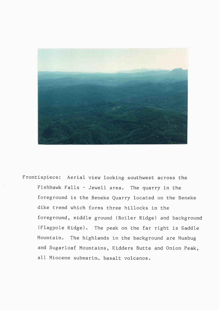
Frontispiece: Aerial view looking southwest across the
Fishhawk Falls Jewell area. The quarry in the
foreground is the Beneke Quarry located on the Beneke
dike trend which forms three hillocks in the
foreground, middle ground (Boiler Ridge) and background
(Flagpole Ridge). The peak on the far right is Saddle
Mountain. The highlands in the background are Humbug
and Sugarloaf Mountains, Kidders Butte and Onion Peak,
all Miocene submarin,. basalt volcanos.

GEOLOGY OF THE FISHHAWK FALLS JEWELL AREA,
CLATSOP COUNTY, NORTHWEST OREGON
INTRODUCTION
Purpose of Investigation
The purposes of this thesis study are:
1. to produce a geologic map of the Fishhawk Falls Jewell
area (scale 1:31,680) and to determine the structural and
stratigraphic relations of the Tertiary sedimentary and
volcanic rock units;
2. to describe the facies and interpret the depositional
environments, paleocurrent dispersal patterns, geometries
and provenances of the gas-producing middle to upper Eocene
Cowlitz Formation, the overlying upper Eocene to lower
Miocene Keasey, Pittsburg Bluff and Oswald West formations;
3. to determine the origin of middle Miocene basalt dikes
that occur in the thesis area;
4. to measure the paleomagnetic directions and evaluate the
possibility of tectonic rotation and origin of the upper
Eocene Tillamook Volcanics in this area. The significance
of this rotation relative to other Coast Range paleoinagnetic
studies is considered;
5. to estimate the petroleum source rock and reservoir
potential of sedimentary rocks in the thesis area using
surface mapping, subsurface correlations, and laboratory
analyses of total organic carbon, porosity and permeability.

2
Location and Accessibility
The thesis area is located in Clatsop County
approximately 72 km west of Portland and 40 km southeast of
Astoria, Oregon (Fig. 1). The 168 square kilometer area is
included on parts of four 15-minute U. S. Geological Survey
maps (Birkenfeld, Cathiamet, Saddle Mountain, and Svensen
Quadrangles). It lies between latitudes 450 53 and
46° 00' N. and longitudes 123° 29' and 123° 40' W.
Access is provided by U. S. Highway 26, which crosses
the southwest part; State Highway 202, which crosses the
middle part; and the Fishhawk Falls Highway in the southeast
part of the area (Fig. 1). In addition, numerous gravel
logging roads, maintained by Crown Zellerbach and the Oregon
Department of Forestry, provide access to the interior of
the study area. The best outcrops are exposed on these
logging roads and in the Nehalem River.
Geographic Features
Prominent topographic features include Flagpole and
Boiler Ridges. These ridges transect the thesis area from
southwest to northeast, and appear as a lineament on aerial
photographs (scale 1:62,500) and Landsat I satellite imagery
(Fig. 2).
The maximum relief of the area is approximately
530 meters. The southward-flowing Nehalem River forms a
base level of 120 meters in the southwest part of the area.

3
Columbia RiverASTORIA
U.S 30
State CLATSKANIE
High woy
202 Mistgas f/el
z A4uJ MISTo0 SEASIDE
J ELL2U.S.26 0
.0 PITTSBURG
4State P/shhawk falls VERNONIA
-... Hiqhwo ELSIEHwy. State
10 Hwy.
CLATSOP COUNTY 47
1y/TILLAMOOK COUNTY 1
/0 5 0 mi/es /0NEHALE i L
BAY /0 5 0 km. /0 Thesis Area
Area of
True North
Figure 1. Index map showing location of the thesis area.

AWASHINGTON Mt.St
He'ens
urnbioRyer°
220
Voncouer /,,,i,' I$inM
I "1 /
20 40m1.I( \ H.,::.
t- II\ \0 30 60km.Scale 1:1,000.000 / OREGON
/ I
Figure 2. Lineaments in northwest Oregon traced from
Landsat I imagery (1:1,000,000). The northeast
trending lirieaments nearest the thesis area
reflect the Beneke, Fishhawk Falls and Northrup
dikes (middle Miocene basalt)..

5
The highest elevation is a 650 meter-high ridge, in the
northwest part which forms a topographic divide between the
northwest-flowing Kiaskanirie River and the Nehalem River
drainage basin (Plate I). Walker Creek, Fishhawk Creek,
Little Fishhawk Creek, Buster Creek, Hamilton Creek, and
Humbug Creek are tributaries of the upper Nehalem River.
The communities of Jewell, Vinemaple and Elsie occur in
the thesis area. Other cultural and natural features
include the Lee Wooden County Park; the scenic, cascading
Fishhawk Falls; and the Jewell Meadows Wildlife Refuge. The
refuge incorporates 1,200 acres of public and private
contractual land and it contains large herds of
Roosevelt elk (Fig. 3) and other wildlife which are best
seen during early mornings and late afternoons.
Methods of Investigation
Field Procedures. Field work was completed during the
spring and summer of 1981. Daily field work consisted of
geologic mapping and sampling of sedimentary and igneous
rock units. Field geology was recorded on topographic base
maps having a scale of 1:31,680 (2 inches 1 mile).
Low-altitude (scale 1:12,000) and high-altitude (1:62,300)
aerial photographs and an altimeter were used as aids to
field mapping.
p"
Figure 3. Roosevelt elk (Alces americana) graze in the
Jewell Meadows Wildlife Refuge within the heart
of the thesis area.
7
An outcrop map was prepared and updated each day during
the mapping. A geologic map was constructed showing the
distribution of 16 different lithologies without assignment
to formations. The geologic map of the thesis area (Plate
I) is the synthesis of several preliminary maps.
Measurement of representative stratigraphic sections
were made using a chain and Brunton compass, or Jacobs staff
and Abney level. Clastic rock units were described using
standard grain size charts, the Geological Society of
America "Rock Color Chart", and the stratification and
cross-stratification terminology of McKee and Weir (1953).
Other sedimentary structures were described following the
Bouma classification (1962). Basaltic rocks were described
by color, by phenocryst content, and size (e.g., phyric or
microphyric), and by the intrusive contact. Geochemistry
and magnetic polarity of basaltic rocks were later
determined in the laboratory for further classification.
Sedimentary rock samples were collected for heavy
mineral analysis, petrography, source rock maturation,
porosity and permeability, molluscan fossils, (foraminifers,
diatoms, and coccoliths) and trace fossils. Samples of
middle Miocene Grande Ronde Basalt and upper Eocene
Tillamook Volcanics were collected for major oxide
chemistry, petrography and determination of paleomagnetic
polarity.
Paleomagnetic core samples were collected using a water
cooled diamond drill at 22 selected outcrops (see further
discussion of sampling method in Appendix XVI). Nineteen
sites in middle Miocene basalt dikes and sills and three
roadcut and quarry sites in upper Eocene Tillamook Volcanics
were sampled. Of these, five sample sites of middle Miocene
intrusive basalt and two sites of the upper Eocene Tillamook
Volcanics occur in the thesis area. The other sites occur
in the Buster Creek Nehalem Valley thesis area (Olbinski,
1984) and the Elk Mountain - Porter Ridge thesis area
(Goalen, in prep.). Orientations of core samples were
measured using a Brunton compass and a sun compass, when
possible. Dr. Shaul Levi, 0. S. U. School of Oceanography,
directed the drilling operations. Drs. Alan Niem and
Robert Bentley assisted in the drilling operations.
A proton precession magnetometer was used on traverses
to locate the middle Miocene basalt dikes not exposed on the
forested surface. Basalt bodies in the subsurface can be
interpreted where strong magnetic gradients are observed
(See Appendix XI). Surface float of basalt is also common,
suggesting the presence of an igneous body. These magnetic
anomalies are valuable in locating dikes where no float is
present.
Laboratory Procedures. Laboratory work included:
1. disaggregation of samples for microfossil recovery
(Appendix I);
2. heavy mineral analysis and provenance study by
separation using a funnel separatory method and

tetrabromoethane, and point count of thin sections and grain
mounts (Appendix VIII);
3. modal analysis and petrography of basalt and sandstone
thin sections;
4. porosity, permeability and source rock maturation
(performed by Amoco Production Company) (Appendix XIV);
5. major oxide chemistry of selected basalt samples
(Appendix VIII);
6. determination of magnetic polarity and remanent
magnetism using fluxgate and spinner magnetometers
(Appendix VII and XV).
Mudstone samples were disaggregated using the method
described in Appendix I. Samples of Foraminifera from these
disaggregated samples were sent to Dr. Kristin McDougall of
the U. S. Geological Survey, Menlo Park, California, for
identification, age determination and paleoecological
information. Coccoliths recovered from disaggregated
samples were identified by Dr. David Burky ot the U. S.
Geological Survey, La Jolla, California. Diatom samples
were identified by Mr. Jack Baldauf, U. S.
Geological Survey, Menlo Park, California. Molluscan
fossils were identified by Dr. Ellen Moore of the U. S.
Geological Survey, Menlo Park, California. Representative
trace fossil specimens were identified by
Dr. C. Kent Chamberlain of Valero Producing Company, Denver,
Colorado.

10
Sandstone samples were impregnated with an epoxy resin
and thin sections were cut from the resulting billets.
Modal analyses of these samples were made by point count and
the rocks classified following Williams, Turner, and Gilbert
(1954) and Folk (1980). Tectonic associations were
interpreted following Folk (1980) and Dickinson (1982).
Chemical analyses of 11 major oxides were performed
by Dr. Peter Hooper and technicians at the
Washington State University X-ray Fluorescence Facility
using the international basalt standard. In order to
compare the Miocene basalt chemical analyses with other
Columbia River basalts, the results of analyses of the
Miocene basalt samples were recalculated to the
Columbia River Basalt Standard using a correction factor
derived by Goalen (in prep.).
Chemical classification of igneous rocks follow the
methods of MacDonald and Katsura (1964), Snavely and others
(1973), and Pearce and others (1977). Modal analyses of 11
samples were completed using the petrographic microscope.
Compositions and igneous rock textures were classified
following Williams and others (1954) and Nockolds, Knox and
Chinner (1978).
Determination of normal or reverse magnetic polarity of
oriented samples of middle Miocene basalt was determined
using a fluxgate magnetometer. The procedures of Doell and
Cox (1964) were followed.

11
Paleomagnetic directions of core samples from 22
selected sites were determined by the writer in the
tnagnetics laboratory in the 0. S. U. School of Oceanography,
under the direction of Dr. Shaul Levi. Natural remanent
magnetization (NRM) was measured using a Schonstedt DSM-1
spinner magnetometer. Demagnetization levels were
determined for selected pilot samples by stepwise
alternating field demagnetization (AFD). Following these
initial steps, the remainder of the samples were "cleaned"
using the preselected AFD levels determined during the pilot
runs in order to obtain directional stability of the
paleomagnetic directions. Paleomagnetic directions were
determined with the spinner magnetometer that was linked to
a computer. Statistical analyses of the data were also
performed by the computer (Appendix XV).
Porosity, permeability and source rock maturation of
selected rocks were analyzed by Amoco Production Company's
Petroservices Group in Tulsa, Oklahoma through the courtesy
of Terry Mitchell, of Amoco, Denver, Colorado.
Previous Work
Dana (1849) was the first geologist to examine the
geology of northwest Oregon. He accompanied the
Wilkes Exploring Expedition of 1838-1842. Condon (1880, in
Washburne, 1914) named the Astoria "shale" near
Astoria, Oregon. He dated the Astoria "shale" as Oligocene
and Miocene based on molluscan fossils. Diller (1896)

12
described "Eocene basic volcanic rocks along the
Nehalelm River, in southern Clatsop County", 6.5 km south of
the thesis area. Washburne (1914), in an oil and gas
reconnaissance investigation of northwest Oregon, traversed
the thesis area and recognized exposures of Astoria "shale"
at several localities along Little Fishhawk Creek. He
mentions no fossils that confirm this stratigraphic
assignment, however. Washburne (1914) also noted that a
locality near the mouth of Buster Creek in the thesis area
(Plate I) was where Diller (1896) collected Eocene or
Oligocene molluscan fossils. Washburne described the
structure of the Jewell area as a series of gentle
northeast-trending anticlines and syclines with flank dips
of 2° to 15°. Washburne found residues of "dead" oil and
investigated a number of reported gas seeps in Tertiary
sedimentary rocks of northwest Oregon.
Warren and others (1945) mapped undifferentiated
Tertiary sedimentary rocks and basaltic rocks in the thesis
area at a scale of 1:143,000 as part of a reconnaissance
investigation of the oil and gas potential in northwest
Oregon. Wells and Peck (1961) compiled a geologic map of
Oregon west of the 121st. meridian (1:500,000 scale). They
mapped the two Miocene basalt dikes, Eocene volcanics and
Cowlitz Formation, but did not differentiate the younger
Eocene and Oligocene strata.
Beaulieu (1973) published a regional study and geologic
map of the potential geologic hazards of eastern Tillamook

13
and Clatsop counties. Part of his study included the thesis
area. He suggested that mass movement and flash foods may
be significant environmental hazards. Earthquakes may be
important hazards insofar as they may trigger down slope
movement of unstable ground. The accompanying geologic map
of eastern Clatsop County in Beaulieu's report showed
upthrown late Eocene volcanics, along an E-W trending fault,
against undifferentiated Oligocene Eocene mudstories.
Since 1973, Dr. Alan R. Niem and more than 15
Oregon State University graduate students under his guidance
have undertaken projects of detailed geologic mapping and
sedimentological and stratigraphic studies in Clatsop and
Tillamook counties, northwest Oregon. Several shallow
marine, deltaic and turbidite lithofacies have been defined
and assigned informal member status in the Astoria
Formation. Penoyer (1977) completed a study of Saddle and
Humbug Mountains on the western border of the thesis area.
Other M. S. theses, in progress or completed, surround the
Fjshhawk Falls Jewell theses area (Jeff Goalen,
Carolyn Peterson, Jim Olbinski, Dan Mumford, Phillip Rarey
and Eugene Safley). In addition, graduate students working
under the direction of Dr. Robert 0. Van Atta and Tom Benson
of Portland State University are studying the stratigraphy,
sedimentology and structure of the Eocene and Oligocene
units in nearby Columbia County.
A U. S. C. S. open file regional geologic compilation
map of the western half of the Vancouver map sheet
14
(scale 1:125,000) by Wells and others (1983) includes the
thesis area.
Renewed interest in Clatsop and Columbia Counties has
recently occurred because of the discovery of commercial
quantities of natural gas on a northwest trending anticline
near the town of Mist, Oregon, 20 km east of the thesis area
(Newton, 1978; Olmstead,, 1982; Fig. 1).
REGIONAL STRATIGRAPHY
The Fishhawk Falls Jewell area is located near the
axis of the northward-plunging Oregon Coast Range
"anticlinorium" described by Niem and Van Atta (1973).
Numerous high-angle normal and reverse faults which trend
northeast and northwest are superimposed upon this regional
structure (Snavely and Wagner, 1964; Baldwin, 1981). Low
amplitude, broad, gentle, northwest- to southeast-trending
folds with flank dips typically 100 to 20° also occur in the
area (Newton and Van Atta, 1976). The thesis area is
located on the western flank of the northern Oregon
Coast Range gravity high (Bromery and Snavely, 1964). This
gravity high reflects the northern continuation of the
Tillamook Volcanics basement rocks within the core of the
anticline.
Ten volcanic and sedimentary formations form the
bedrock units of the northern Oregon Coast Range. From the
oldest to youngest these are: Tillamook Volcanics,
Goble Volcanics, Cowlitz Formation, Keasey Formation,
Pittsburg Bluff Formation, Scappoose Formation, Oswald West
mudstone, Astoria Formation, and the Columbia River Basalt
Group and its coastal equivalents (e.g., Depoe Bay and
Cape Foulweather basalts).
The Siletz River and Tillamook Volcanics (2,700 to
4,200 m thick) form the basement rocks of the Oregon
CD
U) ft CD
'1 0 '
-1
CD 0 p3
(I) 0 ft
CD
U) ft
p3
U)
p.3.
ft 0
'1 0 C)
U) ft 1
p3 ft
P1
p3
I-"
C)
'33
I-I.
0 0) ft
'33
ft
GO 1
'3)
t.J.
C)
I.J. ft U
) 1.
00 CD
.1.
Cl)
ft
P1
'33
ft
00 P1
'3)
C)
C) 0 '1 1 CD
'3)
ft 0 C)
'3) 1 ft 0 '-3
CD
P1 ft I-'.
13)
'1
O 00
-Z L
,,
OR
EG
ON
S W
AS
HIN
GT
ON
(Arm
.nIr
out
95 I)
MO
LLU
SC
AN
FO
RA
MS
TA
GE
ST
AU
S.W
.W
AS
HIN
GT
ON
(Ari,
Iroi
$, it
. ii,
950)
TH
ISS
TU
DY
(AN
D N
OR
TH
ER
N C
OA
ST
RA
NG
E)
CE
NT
RA
L O
RE
GO
NC
OA
ST
AR
EA
(S*.
vsIy
ii. ii
., 19
50)
CO
OS
SA
Y A
RE
A
(Ar.
.ntr
oiit
it. ii
.95
0)
5M
OC
UP
SIA
WG
RA
YS
IAN
FA
UN
A
Ill_III_
IU
NN
AM
ED
MA
RIN
ES
ED
IME
NT
AR
YR
OC
KS
AT
OU
TE
R S
HE
LFEDGE
:M
ON
TE
SA
NO
10
0) C-
WIS
H-
KA
HA
Ni r t 11
MO
NT
ES
AN
O
FA
UN
AI
T
FM
.
CO
LUM
BIA
____
____
____
____
AP
E F
OU
LWE
AT
HE
R
/S.S
.AT
WH
ALE
CO
VE
-Ti;
: : :
((
15
RIV
ER
BA
SA
L_
____
____
____
TJ.
IND
ER
ON
DE
DE
PO
E B
AY
BA
SA
LT-
MIO
CE
NE
BE
DS
____
____
=rS
AIT
--r
AS
TO
RIA
PM
.A
ST
OR
IAF
M.
NE
WP
OR
TIA
Ni
_____________
-----
2(
_S
AU
CE
SIA
NA
ST
OR
IA F
M.
WY
FN
UO
ST
ON
E- i. 0
OS
WA
LDW
ES
TS
CA
PP
OO
SE
MU
D$T
ON
EF
M
PIT
T$B
U*G
-
PIt.LA
RIA
N
JUA
MIA
M
MA
TLO
CK
IAI
---
____
____
____
____
____
____
____
____
____
____
____
_
ZE
MO
RR
IAN
- - -
LIN
CO
LNC
RE
EK
FM
.
YA
QU
INA
FM
.
ALS
EA
FM
.
o. Li
--
-B
LUF
F F
M.
35
SA
LVIN
IAN
- - - -
LfUI.Ii.1
__RIES RANCH
a ..a
ICE
A$E
TP
M.
- - - - - -
TU
NN
EL
PO
INT
FM
.1 _ I_
I_I
ojuITosH
0
ISK
OO
KU
MC
HU
CK
FM
[AF
TCOWLITZ FM
AT
S B
AS
ALT
NE
ST
UC
CA
FM
.D
AS
TE
ND
OIF
F F
M.
C_____
o 0 U
COWLITZ..
CO
ALE
DO
FA
UN
A
NA
RIZ
IAN
M a
YANHILL
FM
.C
OA
LED
O F
M.
FM
.
NM
BR
.S
ILE
TR
IVE
R V
OLC
AN
ICS
-Y
EE
-UM
PQ
UA
FA
UN
AU
LAT
ISIA
N .fl
CR
ES
CE
NT
FM
.
TIL
LAM
OO
K V
OLC
AN
ICS
ELK
TO
N $
ILT
$TO
ME
UN
KN
OW
NU
NK
NO
WN
1.1111
-.
____rnnFnhIJTT11y[llnrnF

17
Coast Range and crop out within the core of the range (Fig.
4). These lower to middle Eocene formations consist
of tholeiitic and alkalic basalts having similar
geochemistry to mid-oceanic basalts (Snavely and others,
1980). Kuim and Fowler (1976) postulated that these
formations may represent a detached part of the Farallon
oceanic plate (e.g., a volcanic archipelago or the Coast
Range seamount province of Dickinson (1976) obducted onto
the North American continental plate). Duncan (1982)
suggests that these volcanic rocks formed over a hot spot.
Recent workers (Kuim and Fowler, 1976; Snavely and others,
1980) suggest the episodic underthrusting of the converging
Farallon plate beneath the North American plate in western
Oregon and Washington caused repeated uplift and high-angle
faulting of the Coast Range during the Tertiary. Much of
the upper part of the Tillamook Volcanics consists of
basaltic andesite and volcanic debris flows (Olbinski, 1983;
Jackson, 1983) developed on underlying basaltic submarine
breccias, pillow lavas and dikes 45 m.y. ago (Magill and
others, 1981; Wells and others, 1983).
Regional uplift formed an angular unconformity between
the lower to middle Eocerie Tillamook Volcanics and the
overlying middle to upper Eocene Cowlitz Formation. A basal
basaltic conglomerate characterizes the lower Cowlitz
Formation (Olbinski, 1983; Jackson, 1983). Middle Eocene
underthrusting may also have initiated rotation of the Coas.t

Range following a westward shift of the subduction zone
(Dickinson, 1976; Magill and Cox, 1981).
The upper Eocene Goble Volcanics consist of
60 to 1,500 m of alkalic and tholeiitic subaerial basalt
flows, pillow lavas, flow breccias and minor interbedded
basaltic conglomerates, mudstones and sandstones. The unit
was named by Wilkinson and others (1946) for exposures near
Goble, Oregon, on the Columbia River in Columbia County.
Whole rock radiometric dates reported for the Goble
Volcanics range from 45 + 1.4 to 32.2 ± 0.3 m.y. (Beck and
Burr, 1979); thus, spanning late middle Eocene to the end of
Eocene time.
The Goble Volcanics Lntertongue with the upper part of
the 300-rn--thick middle to upper Eocene Cowlitz Formation
near the type section along the Cowlitz River in southwest
Washington (Henriksen, 1956). There, the Cowlitz Formation
consists of micaceous and arkosic marine sandstone,
siltstone and claystone. Thick sub-bituminous coal beds
also occur in non-marine parts of the type Cowlitz Formation
(Yett, 1979; Armentrout and others, 1980).
The 400-rn-thick Cowlitz Formation in northwest Oregon
is described as a littoral to sublittoral marine deposit by
Niem and Van Atta (1973) and Newton and Van Atta (1976). A
recent study of the Cowljtz Formation in the northern Oregon
Coast Range suggests that the unit was deposited in a
forearc basin associated with orogenic arc volcanic rocks of
the Goble Volcanics (Timmons, 1981). Small scale channels,
19
high-angle planar cross-bedding and trace fossils indicate
that the depositional environment of the Cowlitz Formation
was a high energy, wave-dominated, shallow marine
environment (Olbinski, 1983; Timmons, 1981). However,
McKeel (1979) interpreted age-diagnostic benthic
foraminiferal assemblages from the Texaco Clark and
Wilson #6-1 well in Columbia County (21 km east of the
thesis area) as a regressive sequence from open marine
bathyal to neritic conditions for the upper Cowlitz
Formation of northwest Oregon. Bruer (1980) suggested that
the Cowlitz sandstone in the subsurface in the Mist field
may have formed in a deep marine gorge similar to the
present Strait of Juan de Fuca, between the Olympic
Mountains and south Vancouver Island.
The 600-rn--thick upper Eocene Keasey Formation
unconformably overlies the Cowlitz Formation in northwest
Oregon and contains three members. These are: a basal thin
pebbly volcanic sandstone and conglomerate; a thick middle
member of structureless, fossiliferous, tuffaceous mudstone;
and an upper thin sequence of interbedded siltstone and
fine-grained sandstone (Niem and Van Atta, 1973). Benthic
Foraminifera in the type section of the Keasey Formation
indicate deposition in water depths of 200 to 300 m
(McDougall, 1980). Rare free-swimming Tertiary crinoids
also occur in the upper Keasey Formation in bluff-forming
outcrops along the Nehalem River near Mist, Oregon (Vokes
and Moore, 1953). The Keasey Formation is correlative to
20
the Bastendorff and Tunnel Point Formations of the central
Oregon Coast area and may be, inpart, correlative to the
lower Lincoln Creek Formation in southwest Washington (Fig.
4).
The 26O-m-thick upper Eocene to Oligocene
Pittsburg Bluff Formation disconformably overlies the Keasey
Formation. Warren and Norbisrath (1946) and Van Atta (1971)
divided the Pittsburg Bluff Formation into two units. The
lower unit consists of massive to thin-bedded, bioturbated,
arkosic, tuffaceous sandstone and siltstone. The upper unit
is composed of basaltic conglomerate, cross-bedded sandstone
and thin coal lenses (Niem and Van Atta, 1973). Shallow
marine, estuarine and deltaic sedimentary depositional
environments are represented by the Pittsburg Bluff
Formation (Van Atta, 1971). The Pittsburg Bluff is
correlative to the upper part of the Lincoln Creek Formation
in southwest Washington and to parts of the Alsea Formation
of the central Oregon Coast (Moore, 1976; Fig. 4).
A disconformity separates the overlying Scappoose
Formation from the Pittsburg Bluff Formation. The Scappoose
Formation consists of 450 m of carbonaceous micaceous arkose
and tuffaceous mudstone with basalt and polymict
conglomerate (Miem and Van Atta, 1973). A deltaic
depositional environment is interpreted for the unit by
Van Atta (1971). Warren and Norbisrath (1946) defined the
upper Oligocene to lower Miocene Scappoose Forniation in the
northeast Oregon Coast Range and correlated the unit to the
21
Sooke Formation of Vancouver Island on paleontological
basis. The Scappoose Formation is also correlated to the
Lincoln Creek Formation of southwest Washington and to parts
of the Alsea Formation, Yaquina Formation and Nye Mudstone
of the central Oregon Coast Range (Fig. 4). Cressy (1974)
suggested that the sandstone-rich Scappoose Formation is
equivalent to Oswald West mudstones of the northwest Oregon
Coast Range.
Kelty (1981) and Van Atta and Kelty (1982) show that
coarse-grained fluvial basaltic conglomerate and arkoses of
the Scappoose Formation fill channels eroded into the
underlying Pittsburg Bluff Formation. In places, the
Scappoose rests directly on strata of the Keasey Formation.
Basalt clasts in the conglomerate in the Scappoose channels
have a Columbia River Basalt Group (Grande Ronde) chemistry
(Kelty, 1981). This implies that the upper part of the
Scappoose Formation as mapped by Warren and others (1945)
and Wells and Peck (1961) is interbedded with, and younger
than, the middle Miocene Grande Ronde Basalt of the
Columbia River Basalt Group. In light of this information,
revision of the stratigraphic nomenclature may be required
to define the age of the Scappoose Formation.
The 550-rn--thick Oswald West mudstone crops out only in
the northwest part of the Oregon Coast Range. This unit was
informally named for sea cliff exposures at Oswald West
State Park (Cressy, 1974) where distinctive trace fossils
and foramiriiferal assemblages indicating a bathyal
22
depositional environment occur. The thick, tuffaceous,
bioturbated tnudstone unit was divided into three parts by
Neel (1976) and Penoyer (1977). Warren and others (1945)
originally measured a section at the type section of the
Oswald West mudstone and referred the rocks to the Blakeley
Stage. Using fossil evidence, Penoyer (1977) suggested that
the lower part of the Oswald West mudstone is correlative to
the Keasey Formation; that the middle part is equivalent in
age to the shallow marine and deltaic Pittsburg Bluff
Formation; and that the upper part of the Oswald West is
equivalent in age to the deltaic Scappoose Formation of the
northwest Oregon Coast Range. Penoyer (1977) mapped the
deep-marine Oswald West mudstone adjacent to the western
boundary of the Fishhawk Falls Jewell thesis area. This
unit apparently grades laterally into the shallow marine
Pittsburg Bluff Formation. Sandstones that crop out in the
map area (Plate I) have yielded a probable upper Oligocene
molluscan fossil assemblage that is equivalent to the upper
part of the Lincoln Creek Formation (E. J. Moore, pers.
comm., 1982).
The lower to middle Miocene Astoria Formation crops out
in three marine embayments (the Newport, Tillamook, and
Astoria areas) in the western part of the Oregon Coast Range
(Cooper, 1981). Several informal mappable members,
reflecting a variety of lithologic and depositional facies,
have been defined. These units include: the Angora Peak
sandstone, a deltaic facies (Cressy, 1974); the Big Creek

23
sandstone, a shallow marine unit (Coryell, 1978; Cooper,
1980); the Silver Point member, a deep-water mudstone with
rhythmically bedded turbidite sandstone in its lower part
(Smith, 1975); and the Pipeline member, a submarine
sandstone channel or canyon head deposit (Nelson, 1978).
Only the Silver Point member occurs in the study area
(Plate I).
Two middle Miocene coastal basalt units have been
differentiated in the western Oregon Coast Range (Snavely
and others, 1973). These are the aphanitic Depoe Bay and
sparsely porphyritic Cape Foulweather Basalts. These
basalts form headlands and prominent topographic highs
composed largely of submarine breccia and pillow lavas and
related intrusives. Snavely and others (1973) interpreted
these coastal basalts to be correlative on petrological,
chemical and age bases to the Yakima and late-Yakima types
of the Columbia River Group of Waters (1961). In a revision
of the stratigraphic nomenclature of the Columbia River
Basalt by Swanson and others (1979), the Grande Ronde Basalt
and the Frenchman Springs Member of the Wanapum Basalt of
the Columbia River Basalt Group are the petrologic
correlatives of the coastal Depoe Bay and Cape Foulweather
Basalts, respectively, of Snavely and others (1973) (Fig.
4). Beeson and others (1979) suggested that the Depoe Bay
and Cape Foulweather Basalts may be the submarine extension
of invasive flows of the Grande Ronde and Frenchman Springs

24
Basalts, respectively, which flowed down an ancestral
Columbia River valley to the sea.
Biostratigraphic and Chronostratigraphic Nomenclature
The biostratigraphic framework used in this thesis
follows that of Armentrout (1981) and Bukry (1981) (Fig. 5).
Calcareous nannofossil, benthic and planktonic foraminiferal
and molluscan biochronologies are tied in part to the
worldwide geologic time scale. The coccolith zones and
subzones of Bukry (1981) and Martini (1971) are tied by
Armentrout to the revised chronostratigraphic chart for
Oregon and Washington.
Some Paleogene units have been shifted on the geologic
time scale in the revision of Tertiary chronostratigraphic
units by Armentrout (1981). The Eocenefaligocene boundary
(Refugian/Zernorrian) for Oregon rocks is near 32 m.y.B.P.
This is younger than the accepted European boundary for the
Eocene/Oligocene which is placed at 37 m.y.B.P. (Hardenbol
and Berggren, 1978) (Fig. 5). The "Narizian'/"Refugian"
boundary in Oregon is placed at 39 m.y.B.P. on the new

25
CALCAREOUSWANNOPLANITON1
EUROPEAN FORAMINFERAL MOLLUSCAN
W STAGE ZONE SUSZONE STAGE STAGE
NESSINIAN QUINAULT FAUNA /OR AYS IA N
NNIJ /4_ TORrONIAN MONTESANO /
FAUNA10 /NNIO- /WISHKAHANNNS
I.)Iii NM
SERRAVALI.IAN_/1/AT0S -
NW?u
_"LUISIAN"'RELIZANNN$
NW 5 NEWPORTIANLANSHIAN
NN4
,. BUROIGALIAN"SAUCESIAN - - - - - - -.20
PILLAR IANAQUITANIAN NNI CNIo/b
25 -NPZ5u CPIPb
CHATTIAN JUANIANNPZ4"ZEMORRIAN'
NP23 CPIS/I?30
RUPELIAN NPZ1 CPI$c MATLOCKIAN-
NPZ CPISo/b
NPZO
35 W CPISb "REFUGIAN" GAL.VINIAN- PRIABONIAN
'a 4 NPIS.1-4
0.
40 NPIB
NPJ?- 'a SARTONIAN-
NPIG "NARIZIAN" COWLiTZ-.COALEDO
FAUNALUTETIAN NP)5
'ULATISIANNPI4_________
50 TYEE-UMPQUA- YPRESIAN
"PENUTIAN"FAUNANPI2
- U NPII
Figure 5. Stratigraphic correlation chart of some Tertiary
biostratigraphic units in western Oregon and
southwest Washington (after Armentrout, 1981, and
Bukry, 1981).

26
scale. The Narizian Pacific Coast provincial Foraminiferal
Stage has been shifted on the geologic time scale to the
middle Eocene. The Refugian Foraminiferal Stage was
formerly referred to as early Oligocene (Snavely and others,
1969), but is now considered entirely upper Eocene. The
Zemorrian Stage, which was formerly late Oligocene, is now
considered entirely Oligocene.
DESCRIPTIVE GEOLOGY OF THE THESIS AREA
Tillamook Volcanics
Nomenclature
27
The name, Tillamook Volcanics, was first proposed by
Warren and others (1945) and Warren and Norbisrath (1946)
for the Eocene basalts that form the Tillamook highlands of
the Oregon Coast Range. They also mapped an outlier of
Eocene volcanic rocks on Green Mountain north of the
Tillamook highlands as Tillamook Volcanics. Part of this
outlier is within the study area (Plate I). Culver (1919)
and earlier workers also recognized these volcanic rocks as
Eocene and noted differences from the suprajacent Columbia
River Basalt of Miocene age.
Later, Wells and Peck (1961) labeled this outlier of
Eocene volcanic rock on Green Mountain as Goble Volcanics,
differentiating this outlier as a younger unit than the main
mass of Tillamook Volcanics to the south.
Van Atta (1971) and Newton and Van Atta (1976) mapped a
part of the Tillamook Volcanics as Goble Volcanics in nearby
Columbia County, Oregon. Van Atta referred to volcanic
flows and intrusive rocks associated with Cowlitz strata as
the Goble Volcanics member of the Cowlitz Formation. He
apparently followed the reasoning of Henriksen (1956) in
assigning a lower stratigraphic rank to these rocks because
they are not as thick as the type Tillamook Volcanics and
are enclosed within a predominantly marine sedimentary rock
section Newton and Van Atta (1976, p. 11) believed that the
Gable Volcanics of Green Mountain, located southeast of the
study area, are overlain and interbedded with the lower
Cowlitz sedimentary rocks.
In this study, the Eocene volcanic rocks and associated
sedimentary rocks in the southeast part of the map area
(Plate I) are referred to the Tillamook Volcanics. This is
based on: 1. historical usage, 2. similar lithology of the
rocks found in this study area to those originally described
in the upper part of the Tillamook Volcanics, 3. K/Ar
radiometric dates of basalt flows similar to those obtained
from the upper part of the Tillamook Volcanics (Magill and
others, 1981; Olbinski, 1983; t4umford and Safley, pers.
comm., 1983), and 4. similar major element chemistry of both
volcanic piles (Jackson, 1983).
In addition, detailed mapping to the south of our study
area indicates that Tillamook Volcanics exposed on Green
Mountain and in the study area are part of an uplifted block
separated on the south from the main mass of Tillamook
Volcanics by a graben composed of the Cowlitz Formation.
The mapping also shows that the type Tillamook Volcanics can
be mapped almost continuously from the Tillamook highlands
to the Green Mountain and Jewell areas.

Distribution
The Tillamook Volcanics (Ttv) crop out in a 2.5 square
mile area in sec. 25 and 26, T5N, R7W, and are repeated by a
small thrust fault in sec. 23 (Sl/2) and 24 (SW1/4) of the
same township (Plate I). The rocks are best exposed in the
east and west Buster Creek quarries (sec. 25), on the banks
of Buster Creek, along the Fishhawk Falls Highway, and in
the Nehalem River where the river lows southward through a
gorge formed by the weathering-resistant Tillamook volcanic
rocks.
The Tillamook Volcanics mapped in this area are part of
the larger topographic high composed of Tillamook Volcanics
that form an outlier near Green Mountain between Jewell and
Elsie.
Tillarnook volcanic rocks tend to be resistant to
weathering and erosion relative to the fine-grained clastic
sedimentary rocks of adjacent formations. As a result, the
volcanics form topographic ridges deeply dissected by narrow
stream valleys. Broader alluvium-filled valleys and
meandering creeks tend to form on the less resistant younger
sedimentary rocks and in structural lows and down-faulted
blocks.
30
Lithology
In the thesis area, the Tillamook Volcanics consist
predominantly of epiclastic volcanic breccias and minor
subaerial flows with a few minor volcanic sandstone
interbeds. Some vesicular and scoriaceous basaltic rocks
also occur. Basalt and andesite dikes and sills intrude
the epiclastic volcanic breccia in the east and west Buster
Creek quarries (localities 265 and 268). These relations
are well exposed where the resistant intrusive is excavated
for crushed road aggregate. The Tillamook Volcanics are
unconformably overlain by the middle to upper Eocene Cowlitz
Formation.
Volcanic breccias. The volcanic breccias are best
exposed in the Nehalem River (SE corner, sec. 23, T5N, R7W)
and in the Buster Creek quarries (sec. 25, T5N, R7W). These
rocks consist of poorly sorted, angular, boulder- and
cobble-sized volcanic clasts supported in a volcaniclastic
sandstone matrix (Fig. 6). The breccias are unstratified
and poorly indurated, and the clasts have variable degrees
of angularity, roundness and lithology, all suggesting that
these are debris flow deposits. The clasts consist of
porphyritic plagioclase-augite andesite, palagonitized
scoria, volcanic sandstone and vesicular and porphyritic
basaltic andesite. The matrix is composed of lapilli,
coarse ash and volcaniclastic sandstone.

31
"-'.
;:.'- - -
-:
':*. W-' 'p .
i- ::t 'I r
-
,-7df, :i-
-.
Figure 6. Volcanic breccia of the upper Tillamook Volcanics
(Ttv). Locality 268 near Buster Creek. (Hammer
is 29 cm long.)
32
The breccias are a light olive gray (5 Y 6/1) to
greenish gray (5 GY 6/1). Red paleosols are developed at
the tops of some debris flows suggesting subaerial exposure.
A moderate blue green (5 BG 416) mineral in the matrix of
some rocks is probably celadonite, possibly a
low-temperature hydrothermal alteration product resulting
from a younger Tillarnook Volcanics intrusive, or from
present day weathering. In the Buster Creek quarry
exposures (localities 265, 268), calcite veins and veinlets
fill fractures in the volcanic breccia and occur as cement
in the matrix.
Basaltic andesite flows. Vesicular subaerial lava
flows are lithologically distinct from the epiclastic
volcanic breccias. There are two types of basaltic andesite
flows in the thesis area, porphyritic and aphyric. The
porphyritic flows contain lathlike plagioclase phenocrysts
and are light olive gray (5 Y 5/2). Vesicles are lined with
shiny brownish-black altered glass (chlorophaeite); some
are filled with zeolites or chalcedonic silica.
Although the lithostratigraphic sequence within the
Tillamook Volcanics in the Buster Creek vicinity is not well
exposed, Olbinski (1983) noted that in the adjacent Green
Mountain area subaerial flows are most abundant underlying
the volcaniclastic breccias and dikes. The Tillamook
Volcanics in this study area are dominantly dikes and
epiclastic debris flows and appear to correlate well with

33
the upper unit of the Tillamook Volcanics of Olbinski (Ttv2;
1983).
Petrography of flows. A thin section (sample 265B) of
an aphyric vesicular basalt flow consists of an intergrowth
of plagioclase (50-55°h), augite (257), leucoxene and
magnetite (57), and chlorophaeite (1O-157). The latter is
an orange-brown isotropic alteration product in the matrix
and in vesicles.
Plagioclase microlites form euhedral and subhedral
lathlike crystals with albite and periclirie twins.
Oscillatory zoned plagioclase was not observed. The
microlites have an Anorthite content of 5O-567
(labradorite), based on the measurement of extinction angles
of a-normal sections. Augite occurs as smaller subhedral
grains interstitial to plagioclase.
Chlorophaeite occurs in the groundinass as botyroidal
spherulites in some vesicles, and the spherulites are
commonly birefringent. Chlorophaeite also occurs in the
groundmass as an alteration product of volcanic glass.
Ilmenite appears to be entirely altered to leucoxene.
Volcanic textures of the aphyric vesicular flows are a
hyalocrystalline and microcrystalline groundmass set in a
hypidiomorphic-granular framework of feldspar and pyroxene.
The abundant feldspar microlites in the groundmass display a
pilotaxitic to intersertal texture. Chlorophaeite and brown
basaltic glass fill the interstices between the feldspar
microlites and augite.
34
The porphyritic vesicular basalt flow (sample 211-3)
consists of phenocrysts of plagioclase and augite set in a
groundmass of plagioclase microlites, augite, volcanic
glass, chlorophaeite and celadonite. The composition of
plagioclase phenocrysts averages An75 (bytownite). The
composition of plagioclase in the groundmass was not
petrographically determined.
Petrographic textures of the porphyritic flow include a
microcrystalline groundmass displaying a pilotaxitic
alignment of plagioclase microlites. Plagioclase and augite
phenocrysts are hypidiomorphic-porphyritic. The groundmass
is sub-ophitic, suggesting that the plagioclase crystallized
prior to augite.
Lithology and Petrography of intrusive rocks. The
intrusive rocks in the Buster Creek area (localities Cvi,
265, 269) are largely an anastomosing system of finger-like
dikes and apophyses that intrude epiclastic volcanic breccia
(Fig. 7). The intrusives are massive, black, aphyric
basaltic rocks. The irregular basalt mass has an apparent
horizontal thickness of 50 m but coalesces and thickens
toward the base of the exposure. Columnar jointing is well
developed in some of the intrusive bodies.
There are petrographic and geochemical differences
between the intrusives in the two Buster Creek quarries.
The intrusive complex in the west Buster Creek quarry
(paleomagnetic sample site GV1, sec. 25, T5N, R7W) is
andesitic in composition (62.37 Si02) and contains an

35
Y;I/I
"1'"/'
SASE OF QUAftRY F4CE --<'
Figure 7. Photograph and line drawing of the west Buster
Creek quarry. The inclined columnar jointed
andesitic Tillamook Volcanics intrusion into
volcanic breccia is truncated by angular
unconformity of overlying Cowlitz basalt
conglomerate. (Face of quarry is 35 m high.)

intergrowth of Carlsbad and Albite twinned plagioclase,
augite, magnetite and chlorophaeite. The average
An-content is An32, which is andesine. Sparry calcite and
chlorophaeite occur as irregular vesicle and veinlet
fillings. The groundmass is fine-grained phaneritic and
composed of sub-ophitic augite and plagioclase microlites
that surround a hypidiomorphic-porphyritic framework of
plagioclase. These petrographic observations suggest that
this rock is an andesite.
Below the quarries and within the bed of Buster Creek,
a massive aphyric intrusive basaltic rock is exposed
(locality 269) that is macroscopically similar to the
intrusive system in the west quarry above. As the hand
specimens are similar, it is probable that these igneous
rocks are part of the same dike system. However, the
petrographic textures are quite different.
The intrusive rock collected from the creek bed
consists of fresh plagioclase, clinopyroxene (augite?),
magnetite, and glass. The composition of plagioclase
phenocrysts ranges from An7 to An12, which seems to silicic
for the overall mineralogy of the rock. This determination
is questionable because perfect orientations of laths having
uniform illumination were few. All of the minerals in the
groundmass are cryptocrystalline. Lathlike plagioclase
crystals in the groundmass are acicular. The matrix also
contains pyroxene, glass and crystallites of an opaque
mineral, probably magnetite.

37
The intrusive rock exposed in the creek bed is probably
related to the dikes exposed in the quarry above the creek.
The petrographic differences are probably textural
differences that were imparted to the rock during cooling.
The intrusive exposed in the creek bed may have cooled more
rapidly than the intrusives in the quarry as indicated by
the fine acicular microlites in the groundmass of the
intrusive.
In the east Buster Creek quarry, another dike is
exposed that is 25-30 m thick. The intrusive rock is
massive, black and rarely phyric. The dike intrudes
epiclastic volcanic breccias and has irregularly shaped
contacts. The jointing pattern is also irregular, unlike
the well-developed columnar joint sets of the adjacent dike
complex in the west quarry.
The rock is composed of 56.97 Si02, making it a
basaltic andesite. From a petrographic analysis, the rock
is determined to consist of 7Q-8O7 euhedral to subhedral
plagioclase microlites in the groundmass, with augite,
magnetite and chlorophaeite comprising the remainder.
Plagioclase compositions from two phenocrysts average sodic
oligoclase (An12). Augite occurs as sub-ophitic grains
interstitial to plagioclase in the groundmass. One augite
phenocryst was also observed in thin section. The
groundmass is hypocrystalline and microcrystalline.
Porphyritic plagioclase crystals are hypidiomorphic and
pilotaxitic.

Geochemistry of the Tillamook Volcanics
Geochemical analyses for 11 major oxides from four
samples of the Tillamook Volcanics were performed (see
Appendix VI). Sample Cvi, from the west Buster Creek
quarry, and sample GV2, from the Fishhawk Falls Highway, are
intrusive rocks. Sample GV3, from Lukarilla Road in
sec. 4, T4N, R7W, and sample 265, from the east Buster Creek
quarry, are flows. One bleached volcanic clast was
collected and analyzed from the Cowlitz conglomerate in the
west Buster Creek quarry.
The compositional range of all samples is from 56.9 to
62.67 Si02, 15.57 to 16.657 A1203, 7.34 to 9.6i7 total iron,
and 4.38 to 7.927 total alkalis. These rocks thus range
from basaltic andesite to andesite. The one sample from the
Cowlitz conglomerate (sample 268) that directly overlies the
Tillamook Volcanics has an anomalous chemistry that suggests
that the sample has been highly altered. The anomalous
chemistry consists of 7O.57 Si02, very low total iron, MgO,
CaO and t4nO (see Appendix VI).
As a group, these rocks can be classified as
subalkaline tholeiitic rocks as suggested by the silica
versus alkali diagrams (Figs. 8 and 9). A silica variation
diagram (Fig. 8) indicates that the broad range of silica
content is concomitant with a broad range of other major
oxides. The four samples appear scattered on the silica

39
Upp. Tiliamook Voicanics of Gr..n Mtn. auth., (this study & Otbinskg, 1983)o Upp, TIflamook Voicanics (Jackson. 1933)
A Oobi. Voicanies, S.W. Washington (ø,..rr, 1978)
l3cP12 tetal F.O A A
AA MgO
7
08A AA
A AA Aa 510 0 0 A 4
:00c8 AA
A7
A A ..A 0 8, 1S.AII I _1 I I_____f ..I._II,III.,tt,
.K2 0 A A
AI03
.2
o
AA 00po014S
IS
4 *Q.øw.
A
4
A A
U I
NaO2 P02 5
32
IIIIIA A m
1000 A A10
9 0o0A AA
A CaO A Ti0 9.8
cP6U A
7
6As
.5 05
S.
AA 0
2.1
I I I I JipiIs,_III,.,.
I
50 52 54 56 58 60 82 64 68 50 52 54 56 58 60 62 64 66$103 Sb2
Figure 8. Silica variation diagram of major oxides for
upper Tillamook and Coble Volcanics; data from
Burr (1978), Jackson (1983), Olbinski (1983) and
this study.

40
versus alkali diagram (Fig. 9) of MacDonald and Katsura
(1964), reflecting the broad range of both silica alkalis.
Comparison of these geochemical data with other
geochemical work on the Tillamook Volcanics (Fig. 8) shows
similar chemical variability of the middle to upper Eocene
volcanics (Burr, 1978; Timmons, 1981; Cameron, 1980;
Jackson, 1983). Because the section of Tillamook Volcanics
that is exposed in the study area is near the uppermost part
of the Eocene volcanic pile, it is best to compare these
data to other uppermost Tillamook rocks.
The upper part of the Tillamook Volcanics consists of
several different rock types suggesting several intrusive
and eruptive events during the late Eocene. The Tillamook
Volcanics exposed on Green Mountain (Olbinski, 1983) are
also basaltic andesite in composition and have a similar
range of major element chemistry as those collected in this
study area. Jackson (1983) collected and analyzed basaltic
andesites from the uppermost part of the Tillamook volcanic
pile. He also observed a range of silica, iron and alkali
content similar to those reported for this thesis area. He
also noted two distinct groupings in his geochemical data,
and some samples that did not fit either group. Thus,
Jackson (1983) suggested that there may be other
unrecognized geochemical groups indicative of separate
volcanic events within the upper part of the Tillamook
Volcanics.
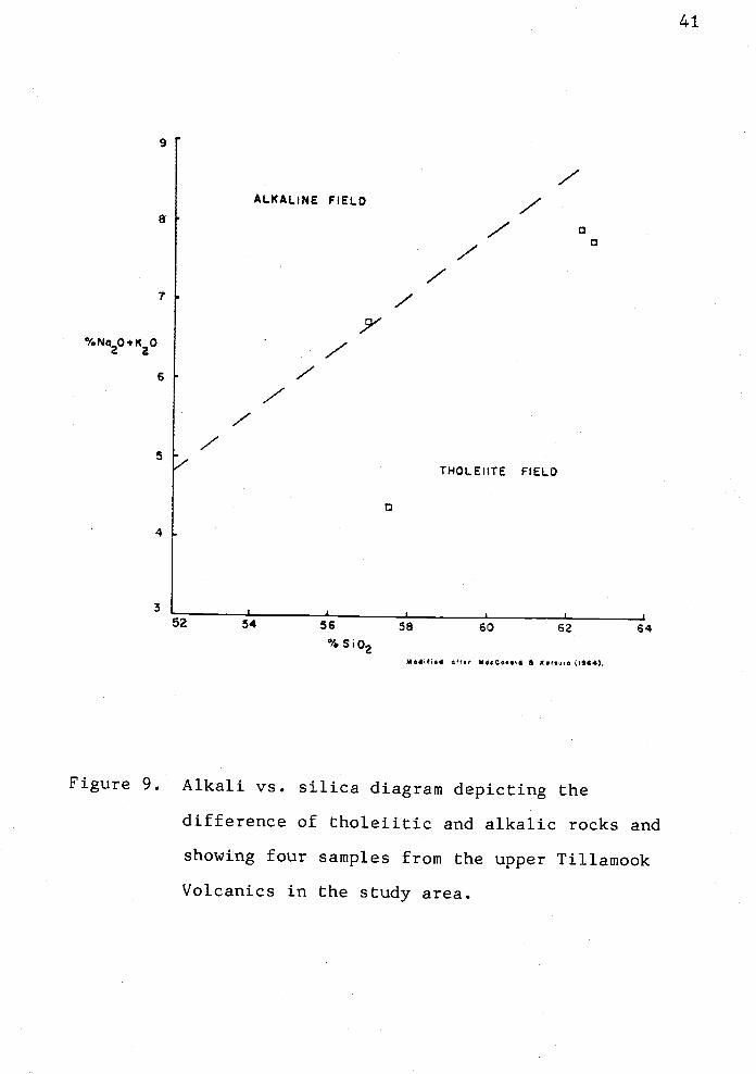
9
8
7
% Na20. K20
6
5
4
3
41
54 56 58 60 62 64% SO2
M4iI,d aft., MdeQo..I ,44).
Figure 9. Alkali vs. silica diagram depicting the
difference of tholeiitic and alkalic rocks and
showing four samples from the upper Tillamook
Volcanics in the study area.

MqO
42
Figure 10. MgO_FeO*_A1203geochemical discriminant diagram
for Tillamook Volcanics (after Pearce and
others, 1977).
43
Pearce and others (1977) attempted to relate the major
oxide chemistry of subalkaline "basaltic andesites" to plate
tectonic setting using a geochemical discriminant diagram of
MgO-FeO--Al203 (Fig. 10). The four rocks analyzed from the
Tillamook Volcanics in the thesis area fall within the
"spreading center island" field. That is, the Tillamook
Volcanic flows and intrusives most similar fit a
differentiated mid-ocean ridge island, like Iceland. In a
study of the Goble Volcanics, Beck and Burr (1979) found
Chat the Goble rocks fall within the "orogenic" field on the
MgO-FeO-Al203 discriminant diagram. This finding is
significantly different from the results for four samples of
Tillamook Volcanic rocks from the present study. These
geochemical data thus suggest that the Tillamook Volcanics
near Green Mountain are geochemically different from the
Goble Volcanics exposed near the Columbia River.
Contact Relations
The base of the Tillamook Volcanics is not exposed in
the thesis area. Regionally, the several thousand meter
thick Tillamook Volcanics overlie the middle Eocene Yamhill
rnudstone (Wells and others, 1983; Armentrout and others,
1983) and are interbedded with marine sedimentary rocks of
the Cowlitz Formation (Wilkinson and others, 1946; Warren
and Norbisrath, 1946; Van Atta, 1971). The contact with
the overlying Cowlitz Formation is an angular unconformity
44
in the thesis area (Plates I and III). The unconformity
truncates epiclastic volcanic breccias and intrusive rocks
(Fig. 7). The Tillamook rocks dip approximately 200
southeast whereas the overlying Cowlitz strata dip 20°
northward.
and Correlation
On the basis of similar K-Ar ages, major and trace
element geochemistry, petrology, lithology, stratigraphic
position and geographic proximity, the late Eocene volcanics
in the uplifted outlier in the Jewell Green
Mountain Elsie area are assigned to the upper Tillamook
Volcanics. This is in agreement with the original mapping
of the Tillamook highlands by Warren and others (1945), with
the recent compilation geologic map of the western half of
the Vancouver Sheet by Wells and others (1983) (Fig. 9), and
with Olbinski's (1983) mapping of the Green Mountain area
adjacent to this study.
Radiornetric dating using whole rock K-Ar analysis of
the Tillamook intrusive rock in an abandoned quarry on the
Fishhawk Falls Highway (sec. 23, T5N, R7W) yields an age of
42.4 ± 0.5 m.y. A flow in the Tillamook Volcanics on the
south flank of Green Mountain (sec. 34, T5N, R6W) yields a
whole rock K-Ar date of 37.1 + 0.4 m.y. (Kris McElwee, pers.
comm., 1984). This is the youngest reliable date obtained
from the upper Tillamook Volcanics so far.

45
A volcanic rock near the Fishhawk Falls Highway and the
Nehalern River (south of the thesis area, sec. 3, T4N, R7W)
yields an age of 41.6 0.4 m.y. (Alan Niem, and Kris
McElwee, pers. comm., 1984). The U. S. Geological Survey
dated this same sample as 40.1 1.2 m.y. (Leda Beth Parker
and Parke D. Snavely, written comm. to Alan Niem, 1983).
Other ages of the upper Tillamook Volcanics outlier itt
the Jewell Green Mountain Elsie area are 37.1 ± 0.4 m.y.
in the Rock Creek area on the south flank of Green Mountain
(NE1/4, SE1/4, sec. 15, T4N, R5W; McElwee, pers. comm.,
1984) and 43.5 -i- 0.5 m.y. for a flow in the Columbia Quarry
(NW1/4, SE1/4, sec. 22, T4N, R5W) near the top Cowlitz
contact in Columbia County and 37.2 0.4 m.y. for basaltic
lavas in the Rocky Point Quarry (SWl/4, SW1/4, sec. 15, T4N,
R5W; Kris McElwee, pers. comm., 1984).
Hence, the K-Ar whole rock dates of the Tillamook
Volcanics range from 37.1 0.4 to 43.5 ± 0.5 rn.y., a span
of 6.4 m.y. This places the uppermost part of the Tillamook
Volcanics in the middle to late Eocene on Armentrout's
(1981) time scale for the Pacific N.W. (Fig. 5).
The main Tillamook Volcanic pile, three to five km
south of the study area, has yielded radiometric dates
ranging from 40 to 45 m.y. near the upper part of the unit
along the Nehalem River (Mumford and McElwee, pars. comm.,
1983). Hence, there is an overlap of several million years
between the K-Ar dates of the type Tillamook Volcanics to
the south and in this study.
46
These observations suggest that the two areas are
composed of the same volcanic unit. In the past, the late
Eocene volcanic outlier of the Jewell Green
Mountain Elsie area has been mapped as the Goble
Volcanics, a younger unit that the Tillamook Volcanics
(Wells and others, 1961; Newton and Van Atta, 1976). Beck
and Burr (1979) reported that radiometric dating of the
Goble Volcanics in southwest Washington yielded the
following ages: 32.2 0.3 m.y. and 35.9 0.4 m.y. in the
Toutle River area; and, 45.0 ± 1.4 m.y. and 41.4 1.3 m.y.
along Coweman Road (south of the Toutle River area). Kris
McElwee (pers. comm., 1983) also reports unpublished whole
rock K-Ar dates of 42.8 -- 1.2 m.y. for the type area of the
Goble Volcanics along the Columbia River south of Longview,
Washington and 41.5 0.5 m.y. for the Goble Volcanics in
the Willipa Hills, which was mapped by Wells (1981).
The dates of Goble rocks span late middle Eocene to
latest Eocene ("Narizian" to "Refugian" Stages) on
Armentrout's (1981) time scale (Fig. 5). Hence, the age
range of the Goble Volcanics of S.W. Washington overlaps the
age range of the upper Tillamook Volcanics of N.W. Oregon
and are age correlative rocks. Most of the Goble Volcanics
of S.W. Washington are more than 41 m.y. old and would be
correlative to the lower Tillamook Volcanics along the
Nehalem River which are dated 42.5 0.4 m.y. at two
localities: SW1/4, SE1/4, sec. 35, T4N, RSW;
SE1/4, sec. 23, T5N, R7W.
and, SW1/4,

47
The upper Tillamook Volcanics can be correlated to
several other upper Eocene volcanic sequences that occur in
western Oregon and Washington (COSUNA chart, Armentrout and
others, 1983). These include: the Yachats Basalt (Snavely
and MacLeod, 1974); and the Cascade Head volcanics (Barnes,
1981) along the central Oregon coast; the upper Eocene Unit
B basalt in the Grays River area of SW. Washington (Wolfe
and McKee, 1972); the Hatchet Mountain Volcanics in the
Toledo - Castle Rock, Washington area (Roberts, 1958); and,
the Tukwila Volcanics near Renton and Seattle, Washington
(Vine, 1962).
In summary, the upper Eocene volcanic outlier between
Jewell and Elsie is correlated to the upper part of the type
Tillamook Volcanics four to five km to the south on the
basis of similar lithology, stratigraphic position and
geochemistry. Both the type Tillamook \Tolcanics and the
middle to late Eocene volcanics of this study area underlie
the same facies of middle to late Eocene Cowlitz Formation
(Safley, in prep; Mumford, in prep.). Both volcanic units
are dominantly composed of subaerial basaltic to basaltic
andesite flows, and minor dikes and volcanic breccias.
Basaltic andesites, mudflows and intrusives appear to be
more developed than other lithologies within this thesis
area because only the uppermost part of the Tillamook
Volcanics that immediately underlies the Cowlitz Tillamook
unconformity is exposed here.

Major element geochemistry of the two volcanic units
also overlap on silica variation diagrams. The trace
element chemistry of late Eocene rocks in the Green Mountain
outlier and in the main Tillamook Volcanics mass to the
south are similar (Jackson, 1983).
Geologic mapping along Highway 26 in southeast Clatsop
County (Mumford, Safley, M.S. theses in prep.) has shown
that this basalt outlier of Tillamook Volcanics actually
consists of several horst-like blocks between a conjugate
NE- and NW-trending fault system. The Cowlitz Formation is
exposed, in the adjacent graben between the outlier and main
Tillamook mass. Scattered fault exposures occur within one
km of the Green Mountain outlier. This field evidence also
suggests that the middle to late Eocene volcanics of the
study area are indeed an uplifted part of the Tillamook
Volcanic basement.
Paleomagnetism of the Tillamook Volcanics
Samples for paleomagnetic analysis were collected from
three sites in and near the thesis area. The three sites
are located and referred to as: 1. the west Buster Creek
quarry (site GV1); 2. near the Nehalem River on the
Fishhawk Falls Highway (site GV2); and 3. in the Cougar
Mountain sills on Lukarilla Road southeast of the study area
(site GV3). (See the Site Location Map in Appendix IX.)
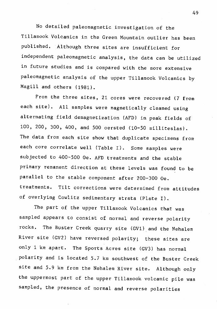
49
No detailed paleomagrietic investigation of the
Tillamook Volcanics in the Green Mountain outlier has been
published. Although three sites are insufficient for
independent paleomagnetic analysis, the data can be utilized
in future studies and is compared with the more extensive
paleomagnetic analysis of the upper Tillamook Volcanics by
Magill and others (1981).
From the three sites, 21 cores were recovered (7 from
each site). All samples were magnetically cleaned using
alternating field demagnetization (AFD) in peak fields of
100, 200, 300, 400, and 500 oersted (10-50 milliteslas).
The data from each site show that duplicate specimens from
each core correlate well (Table I). Some samples were
subjected to 400-500 Oe. AFD treatments and the stable
primary remanent direction at these levels was found to be
parallel to the stable component after 200-300 Oe.
treatments. Tilt corrections were determined from attitudes
of overlying Cowlitz sedimentary strata (Plate I).
The part of the upper Tillamook Volcanics that was
sampled appears to consist of normal and reverse polarity
rocks. The Buster Creek quarry site (GV1) and the Nehalem
River site (GV2) have reversed polarity; these sites are
only 1 km apart. The Sports Acres site (GV3) has normal
polarity and is located 5.7 km southwest of the Buster Creek
site and 5.9 km from the Nehalem River site. Although only
the uppermost part of the upper Tillamook volcanic pile was
sampled, the presence of normal and reverse polarities
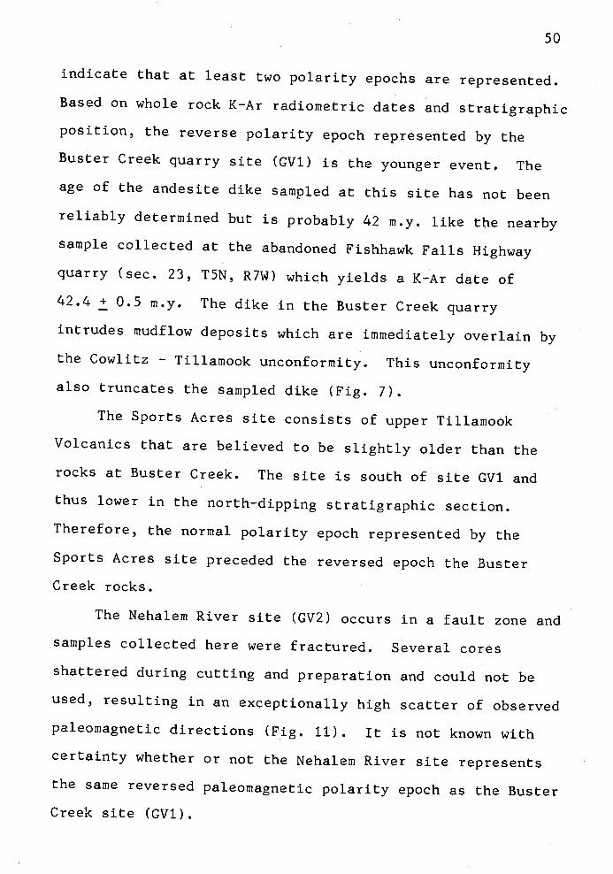
50
indicate that at least two polarity epochs are represented.
Based on whole rock K-Ar radiometric dates and stratigraphic
position, the reverse polarity epoch represented by the
Buster Creek quarry site (GV1) is the younger event. The
age of the aridesite dike sampled at this site has not been
reliably determined but is probably 42 m.y. like the nearby
sample collected at the abandoned Fishhawk Falls Highway
quarry (sec. 23, T5N, R7W) which yields a K-Ar date of
42.4 0.5 m.y. The dike in the Buster Creek quarry
intrudes mudf low deposits which are immediately overlain by
the Cowlitz Tillamook unconformity. This unconformity
also truncates the sampled dike (Fig. 7).
The Sports Acres site consists of upper Tillamook
Volcanics that are believed to be slightly older than the
rocks at Buster Creek. The site is south of site GV1 and
thus lower in the north-dipping stratigraphic section.
Therefore, the normal polarity epoch represented by the
Sports Acres site preceded the reversed epoch the Buster
Creek rocks.
The Nehalem River site (GV2) occurs in a fault zone and
samples collected here were fractured. Several cores
shattered during cutting and preparation and could not be
used, resulting in an exceptionally high scatter of observed
paleomagnetic directions (Fig. 11). It is not known with
certainty whether or not the Nehalem River site represents
the same reversed paleomagnetic polarity epoch as the Buster
Creek site (GV1).

360
LOWER HEMiSPHERE PLOT( Eap.ct.d
STRUCTURE CORRECTED
Eoc.,,.DiritIon
SITE STRUCTURE CORREN
I
a -9 5L EDIRECTION (0, I) AFO LEVEL
GVI 32 -49° 970400 Ga.
0 0 0GV2 28 7 -50.3 33.1 400 OGV3 580 61.8° 9.5 100 0..
MEAN OF SITES 38.5° 57.7° 18.6°
Figure 11. Upper Tillamook Volcanic paleomagnetic
directions for three sites in the study area.
These are structure corrected data and are
51
90°
restored to horizontal using an attitude of
N85°E, 19°N, which closely fits the present-day
orientation of the upper Tillamook Volcanics.
The mean of sites is 38.5°, 57.7° (D,I), with an
a-95 of 16.6°, indicating clockwise rotation of
48.4 + 25.9° from the expected Eocene direction
(designated by triangle; Irving, 1979). GV1
and GV2 (both reverse polarity) are projected
through the origin to the lower hemisphere; GV3
has normal polarity.

52
The paleomagnetic directions of the three sites (17
core specimens used) is consistent with the hypothesis of
clockwise tectonic rotation of this area. The observed
clockwise rotation is 48.4°±25.9°, where the uncertainty in
rotation corresponds to a 957 confidence level (alpha-95).
The upper Tillamook Volcanics in northern Tillamook County
also show clockwise rotation of 46°±13°, a value which
overlaps these three sites in the Green Mountain outlier,
and suggests that the rocks are paleomagnetically related
(Fig. 11). The rotation expressed by these rocks is unlike
that of the Goble Volcanics of S.W. Washington which have
undergone considerably less clockwise rotation of 23°19°
(Wells, 1982; Beck and Burr, 1979).
The observed inclination of the upper Tillamook
Volcanics in the Green Mountain outlier, after tectonic tilt
correction, is 5750 This is not significantly different
than the expected value of the middle Tertiary pole of the
North American craton (3500 declination, 65.4° inclination;
Irving, 1979), nor is it different from that observed from
the upper Tillamook mass to the south (64°; Magill and
others, 1981).
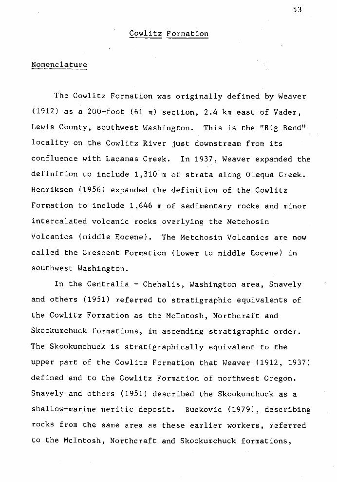
Cowlitz Formation
Nomenclature
53
The Cowlitz Formation was originally defined by Weaver
(1912) as a 200-foot (61 m) section, 2.4 km east of Vader,
Lewis County, southwest Washington. This is the "Big Bend"
locality on the Cowlitz River just downstream from its
confluence with Lacamas Creek. In 1937, Weaver expanded the
definition to include 1,310 in of strata along Olequa Creek.
Henriksen (1956) expanded the definition of the Cowlitz
Formation to include 1,646 in of sedimentary rocks and minor
intercalated volcanic rocks overlying the Metchosin
Volcanjcs (middle Eocene). The Metchosin Volcanics are now
called the Crescent Formation (lower to middle Eocene) in
southwest Washington.
In the Centralia Chehalis, Washington area, Snavely
and others (1951) referred to stratigraphic equivalents of
the Cowlitz Formation as the McIntosh, Northcraft and
Skookumchuck formations, in ascending stratigraphic order.
The Skookumchuck is stratigraphically equivalent to the
upper part of the Cowlitz Formation that Weaver (1912, 1937)
defined and to the Cowlitz Formation of northwest Oregon.
Snavely and others (1951) described the Skookuinchuck as a
shallow-marine neritic deposit. Buckovic (1979), describing
rocks from the same area as these earlier workers, referred
to the McIntosh, Northcraft and Skookumchuck formations,

54
collectively, as the "Cowlitz Formation". He correlated
this formation to the Puget Group of west-central
Washington. The Puget Group contains several formations of
the middle to upper Eocene Puget deltaic system. Armentrout
(1973) and Yett (1979) wrote definitive papers on the
molluscan faunas and microfossils of the type Cowlitz
Formation in southwest Washington.
The Cowlitz Formation in northwest Oregon was first
mapped by Warren and others (1945). The sedimentary rocks
are composed of basal conglomerate, siltstone, mudstone,
sandstone and intercalated volcanic materials that
unconformably overlie the Tillamook Volcanics. Faunas are
correlative to the type Cowlitz Formation of Washington.
Warren and Norbisrath (1946) divided the Cowlitz Formation
of northwest Oregon into four informal members: a basal
conglomerate of variable thickness, a lower shale member, a
sandstone member 200 to 300 feet (61 to 91 m) thick, and an
upper shale member. These workers estimated the overall
thickness of the Cowlitz Formation to be 290 in.
Van Atta (1971), Timmons (1981), Newton and Van Atta
(1976), Olbinski (1983) and Jackson (1983) have further
described the sandstone petrography, stratigraphy, facies
and depositional environments of the Cowlitz Formation of
northwest Oregon. Olbinski (1983) recognized and mapped
five informal members in the Cowlitz Formation in southeast
Clatsop County; these correlate well with the four members
recognized in the present study.

55
Distribution
Warren and Norbisrath (1946) described the Cowlitz
strata as occurring in creeks northwest of Green Mountain,
in Rock Creek near Keasey, at Rocky Point southwest of
Vernonia, and along the Wolf Creek Highway (Sunset Highway,
U.S. Highway 26). None of these areas are included in the
thesis area, but Warren and others (1945) do show one fossil
locality which they considered Cowlitz in the thesis area.
This is located near the bridge over the Nehalem River at
the common corner of sec. 21, 22, 27, and 28, T5N, R7W
(locality FM-20 of Warren and others, 1945). I have
included this locality in the lower sandstone member of the
Cowlitz Formation (Tc23; Plate 1).
Within the thesis area, the Cowlitz Formation crops out
in the southeast part over approximately 10 square km and a
465-rn--thick section (Plate 3) is exposed discontinuously
along the Fishhawk Falls Highway three km south of Jewell.
Outcrops occur in roadcuts, in ditches and in some places in
the Nehalem River bed at summertime low water levels.
Strata strike generally east-west and average 15° northward
dip (Plate 1).
Four informal members are recognized. The basal
conglomerate member (Tc1) is discontinuously exposed along
the Fishhawk Falls Highway in roadcuts and ditches (Plate
3), but good exposures occur in two quarries on the Buster
Creek road (NW1/4, sec. 25, T5N, R7W). An angular
unconformity between the underlying Tillamook Volcanics and

56
overlying Cowlitz Formation is well-exposed in both quarries
(Fig. 7).
The conglomerate members and lower sandstone (Tc1 and
Tc2,3) of the Cowlitz Formation are relatively resistant to
erosion and form low dissected hills and slopes adjacent to
the high elongate ridges cored by volcanic rocks. Where the
southward-flowing Nehalem River, in the southeastern part of
the map area, cuts through the Cowlitz units, it lacks the
broad floodplain that tends to be well-developed where the
bedrock is composed of the less-resistant mudstone of the
Keasey Formation.
The lower sandstone member (Tc23) is best exposed
along the Nehalem River and in highway cuts between sec. 23
and 24, T5N, R7W (see measured section, Plate 3), in old
logging roadcuts, in forest service roadcuts, above the
Nehalem River bridge (SE1/4, sec. 22, T5N, R7W), in the
Nehalem River in sec. 28, T5N, R7W, and along Buster Creek
road (sec. 26, T5N, R7W).
The overlying turbidite member (Tc3) is well exposed in
roadcuts along the Fishhawk Falls Highway, three km south of
Jewell (locality 236, sec. 14, T5N, R7W). The overlying
arkosic sandstone member (Tc4) overlies the turbidite member
at this same locality.
Lithologies, Structures and Provenance
Conglomerate Member. The basal volcanic conglomerate
(Tc1) consists of rounded to angular boulders and cobbles of
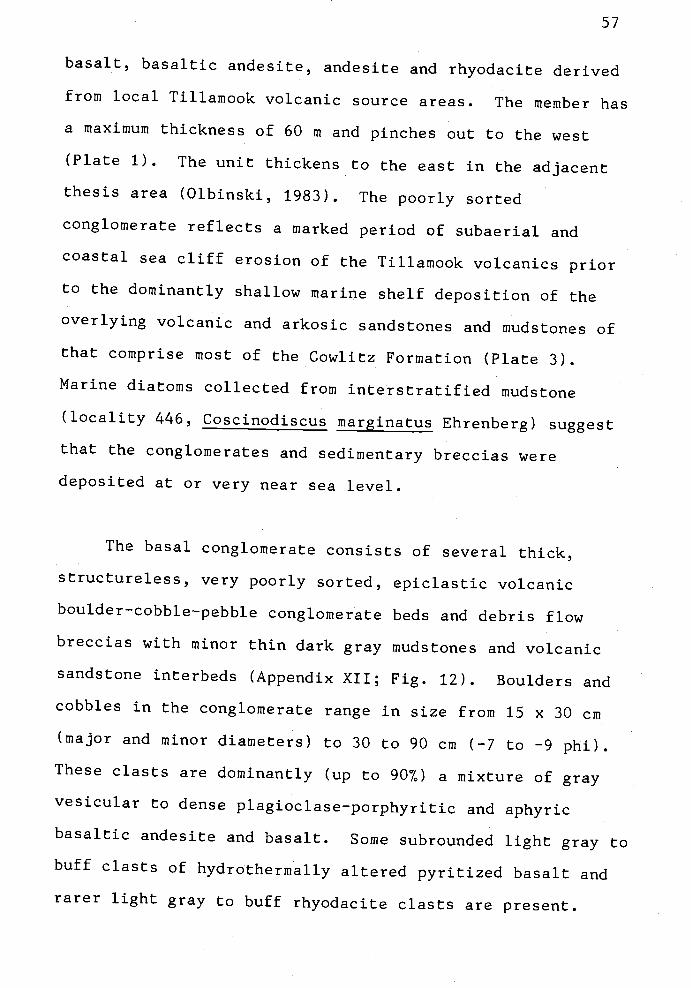
57
basalt, basaltic andesite, andesite and rhyodacite derived
from local Tillamook volcanic source areas. The member has
a maximum thickness of 60 m and pinches out to the west
(Plate 1). The unit thickens to the east in the adjacent
thesis area (Olbinski, 1983). The poorly sorted
conglomerate reflects a marked period of subaerial and
coastal sea cliff erosion of the Tillamook volcanics prior
to the dominantly shallow marine shelf deposition of the
overlying volcanic and arkosic sandstones and mudstones of
that comprise most of the Cowlitz Formation (Plate 3).
Marine diatoms collected from interstratified mudstone
(locality 446, Coscinodiscus marginatus Ehrenberg) suggest
that the conglomerates and sedimentary breccias were
deposited at or very near sea level.
The basal conglomerate consists of several thick,
structureless, very poorly sorted, epiclastic volcanic
boulder-cobble-pebble conglomerate beds and debris flow
breccias with minor thin dark gray mudstones and volcanic
sandstone interbeds (Appendix XII; Fig. 12). Boulders and
cobbles in the conglomerate range in size from 15 x 30 cm
(major and minor diameters) to 30 to 90 cm (-7 to -9 phi).
These clasts are dominantly (up to 907) a mixture of gray
vesicular to dense plagioclase-porphyritic and aphyric
basaltic andesite and basalt. Some subrounded light gray to
buff clasts of hydrothermally altered pyritized basalt and
rarer light gray to buff rhyodacite clasts arepresent.

Figure 12. Epiclastic volcanic conglomerates and debris
flow breccias of the basal conglomerate member
(Tc1) of the Cowlitz Formation. The
conglomerate beds are unstratified and contain
smaller subrounded clasts (as at geologist's
feet). Debris flow breccias consist of larger
angular clasts, are more poorly sorted and are
in matrix support (e.g., below hammer, circled).
Locality 268, west Buster Creek quarry.

59
Smaller, less-resistant, amygdaloidal and scoriaceous
basaltic andesite clasts are less abundant (up to 107. in
some beds) and contain hollow cavities partly filled with
quartz crystals (geodes). Clasts in the conglomerate beds
are in framework support and are subrounded.
In the debris flow deposits, the breccias are in matrix
support and are angular to subangular and generally contains
much larger clasts. The matrix consists of coarse grained
basaltic volcaniclastic sandstone which is grayish yellow
green (5 GY 712). Most conglomerates and debris flow
breccias are poorly sorted and unstratified and range from
one to three meters in thickness (Fig. 12; Appendix XII).
One leucocratic, aphanitic clast (20 x 25 cm) of
particular interest was analyzed geochemically (Appendix VI)
and petrographically. This rock (sample 268G), from the
west Buster Creek quarry, contains 70.57. Si02, is depleted
in iron and magnesium and is enriched in alumina (167. by
weight). It is a peraluminous rhyodacite and is interpreted
as a rhyolitic differentiate. Wells and others (1983) show
the occurrence of several siliceous masses within the upper
Tillamook Volcanics which could have served as a source for
this clast.
Petrographic textures of this sample (265G) are a
hypidiomorphic-porphyritic feldspar-phyric framework set in
a microcrystalline siliceous groundmass. The feldspar
microlites have a trachytic alignment. Potassium feldspar
(4.36 wt.7. K20) comprises 85-907. of the groundmass.
Leucoxene was also observed in the groundmass. Overall, the
rock is composed of 9O7 feldspar that appears fresh and
unaltered.
Some conglomerate and breccia beds above the Buster
Creek quarries contain abundant highly vesicular clasts (up
to 5O7) which may be derived from Tillainook volcanic flow
tops and/or local cinder cones. Olbinski (1983) reported
finding similar rock types in the adjacent thesis area.
A few poorly preserved diatom fragments (sample 446)
were found in the thin, one to two meters thick, dark gray
mudstone interstratified with the conglomerate above the
west Buster Creek quarry. These diatoms are
Coscinodiscus inarginatus Ehrenberg 1843. This fossil is not
useful for stratigraphic correlation but it is restricted to
the marine environment (Jack Baldauf, written comm., 1982).
Lower Sandstone Member. The basal conglomerate (Tc1)
grades upward into a 300-rn-thick unit consisting of
interbedded volcanic and arkosic micaceous sandstones. I
have included within this unit a poorly exposed, and unknown
thickness of, mudstone(?) which correlates to a mudstone
unit mapped by Olbinski (unit Tc3, 1983). The poorly
exposed mudstone unit may be included in the covered part of
the measured section between 800 and 1,100 foot markers
(Plate 3). Collectively, then, these two lithofacies are
named the lower sandstone member (Tc23) (Fig. 13).
The lower sandstone member apparently undergoes a
facies change toward the southwest part of Columbia County

z0I-
0U-
NI-
-J
0()
61
S.E. CL.ATSOP S.W.COLUM8IA N. W. OREGONJewelt Area Co.
Warren et a).,(This Study) Van Atta,
1945, 19461971Keasey Fm. Keasey Fm. Keasey Fm.
Upper tipperSandstone Mudstone shale
membermember (Ic5)member thickness not15-80m.
..
mentionedTurbid it e
Sandstone Sandstonemember (Tc4)member member30m.
60-91 m.(.owevsandstonemember 'N. Lower(Tc2,3)
'coican Cs shale300m.(Includes a ember member
poorlySiltstone / variableexposedmembey" thicknessmudstone,9 1 m.
ConglomerateConglomerate
member (Tc1) CongIoe member0-60 m.
GobIe ..-'.
O-60m.w.wTillamook
- - - - -Tillamook
Volcanics Volcanics ,..-,_ Volcanics
Figure 13. Correlation of the informal members of the
Cowlitz Formation as used in this thesis to
those of previous workers.
62
and correlates to the siltstone member of Van Atta (1971)
(Fig. 13).
Fossils are scarce in the lower sandstone member. One
Dentalium sp. was recovered from the middle part of the
measured section (locality 435) and the trace fossil
Planolites, a sub-vertical burrow, was found at the same
locality.
Lithology of the Lower Sandstone. The lower 135 m (450
ft.) of the lower sandstone member (Tc2 3) consists of
well-indurated, coarse grained, thick bedded, volcanic
sandstone and subordinate micaceous lithic arkosic
sandstone. In the upper part of the measured section along
Fishhawk Falls Highway, thinner micaceous arkosic fine
grained sandstone and mudstone are interbedded with the
subordinate coarse grained volcanic-arkosic sandstone (Plate
3).
The sandstones classify as volcanic-arenites and
volcanic-plagioclase arkoses (Fig. 14). They are composed
almost exclusively of basaltic andesite and andesite
fragments with pilotaxitic flow texture of plagioclase
microlItes in an opaque glassy groundniass. They are
compositionally and texturally similar to the underlying
Tillamook Volcanics from which they were probably derived.
Other grains include plagioclase (labradorite?), augite (?)
and magnetite in a pore-filling sparry calcite matrix.
In outcrop, the volcanic sandstones are thin bedded to
thick bedded and medium to coarse grained. The
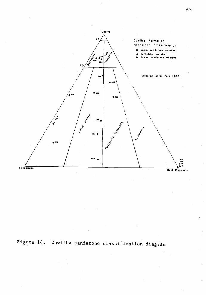
Qi.er$e
I1w Je"e!
£100
75/"
/1la
0
//303./IiSwII
/"I
£
Feld.pore
63
Cowtitz FormationSandstone ClIssification
upper sandstone memberlurbidils memberlower sondit051 member
Idioqom after Folk, 1980)
C
C
-d
Figure 14. Cowlitz sandstone classification diagram
\ I,,\ 17\ 1e\ no
Rock Froqments
64
well-indurated volcanic sandstones are tightly cemented by
calcite, clay(?) and iron oxides. Commonly, concentrations
of comminuted carbonaceous debris occur on bedding planes.
Fresh exposures are greenish olive gray (5 Y 3/2) but
weather to light olive gray (5 Y 5/2) and moderate brown
(5 YR 4/4). The detrital grains are angular to subrounded
and moderately to poorly sorted (Fig. 15). The sandstones
are texturally and compositionally immature (Folk, 1980),
suggesting rapid deposition and burial after derivation from
a high rugged relief area.
Arkoses and lithic arkoses are micaceous, containing
both biotite and muscovite in a 4:1 ratio. The mica and
carbonized wood fragments define bedding planes in some
parallel laminated sandstones. Mica shows crenulation due
to compaction during burial.
In thin section, biotite shows various stages of
chemical weathering. Loss of iron is evident from the
formation of "green biotite" and limonite. Muscovite,
however, is relatively unaltered.
Arkosic sandstones are loosely consolidated and poorly
cemented. Minor iron oxide and diagenetic clay rims around
detrital grains act as a weak cementing agent. Such cements
commonly form at shallow burial depths and low geothermal
gradients in fore-arc regions (Galloway, 1974). Two
blue-dyed epoxy-impregnated thin sections have 7 to 127.
(point counted) intergranular porosity (Fig. 16). Evidence

65
Figure 15. Photoinicrograph of volcanic-arenite from the
lower sandstone member (Tc2 3) of the Cowlitz
Formation. The framework clasts of the
sandstone are very coarse sand to granules, are
poorly sorted and subrounded. Note the
pilotaxitic flow texture of the andesitic to
basaltic andesite rock fragments that are
predominant in this slide. Locality 215, 28x,
plane light.

Figure 16. Photomicrograph of lithic arkose
(volcanic-plagioclase arkose) from the lower
sandstone member (Tc2 3) of the Cowlitz
Formation. Blue dyed epoxy medium demonstrates
intergranular porosity (1O7). Note plagioclase
(F), quartz (Q), volcanic rock fragments (V),
epidote (E) and mica (M) grains with abundant
clay rim cements (opaque material around
framework grains). Locality 203, 80x, plane
light.

c3 7
Figure 17. Scanning electron photomicrograph of detrital
feldspar grain from arkose in lower sandstone
member (Tc2 3) of the Cowlitz Formation. Note
corrosion along cleavage planes of the feldspar
suggestive of diagenesis and secondary porosity
development. Bar scale is 10 microns,
magnification 1800x.

for secondary porosity development is minor and consists of
some solution of feldspars along cleavage planes (Fig. 17).
Lithic arkoses and arkoses are moderately to well
sorted and contain subangular to rounded framework grains.
Compositional maturity is quite varied, ranging from
submature to mature depending on the admixture of volcanic
rock fragments. These sandstones are generally texturally
mature which reflects prolonged winnowing of detrital clays
and sorting by waves and currents (Folk, 1980).
In thin section, the arkoses consist of monocrystalline
quartz (5-257.), polycrystalline quartz (4-157.), plagioclase
(5-357.), potash feldspar (<57.), mica (3-357.), volcanic rock
fragments (1-57.) (probably basaltic andesite and andesite)
and minor plutonic rock fragments (<57). Minor amounts
(<1-27.) of glauconite, chlorite and zircon were also
observed. Carbonate (probably calcite) is a common
pore-filling cement.
A mixed local intermediate volcanic and distant
metamorphic-siliceous plutonic provenance is suggested from
petrographic and heavy mineral studies. The abundance of
intermediate volcanic rock fragments and subangular
plagioclase in the volcanic arenites indicate a basaltic to
intermediate volcanic source terrain. These sandstones,
like the basal basaltic conglomerate member (Tc1), probably
were derived from nearby Tillamook Volcanics highland areas.
However, the abundance of potash feldspar with plagioclase,
muscovite and biotite in the arkoses suggest that more
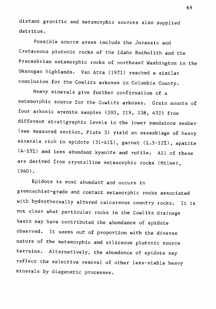
distant granitic and metamorphic sources also supplied
detritus.
Possible source areas include the Jurassic and
Cretaceous plutonic rocks of the Idaho Batholith and the
Precambrian metamorphic rocks of northeast Washington in the
Okanogan highlands. Van Atta (1971) reached a similar
conclusion for the Cowlitz arkoses in Columbia County.
Heavy minerals give further confirmation of a
metamorphic source for the Cowlitz arkoses. Grain mounts of
four arkosic arenite samples (203, 219, 238, 432) from
different stratigraphic levels in the lower sandstone member
(see measured section, Plate 3) yield an assemblage of heavy
minerals rich in epidote (31-417), garnet (1.5-127), apatite
(4-157) and less abundant kyanite and rutile. All of these
are derived from crystalline metamorphic rocks (Mimer,
1940).
Epidote is most abundant and occurs in
greenschist-grade and contact metamorphic rocks associated
with hydrothermally altered calcareous country rocks. It is
not clear what particular rocks in the Cowlitz drainage
basin may have contributed the abundance of epidote
observed. It seems out of proportion with the diverse
nature of the metamorphic and siliceous plutonic source
terrains. Alternatively, the abundance of epidote may
reflect the selective removal of other less-stable heavy
minerals by diagenetic processes.
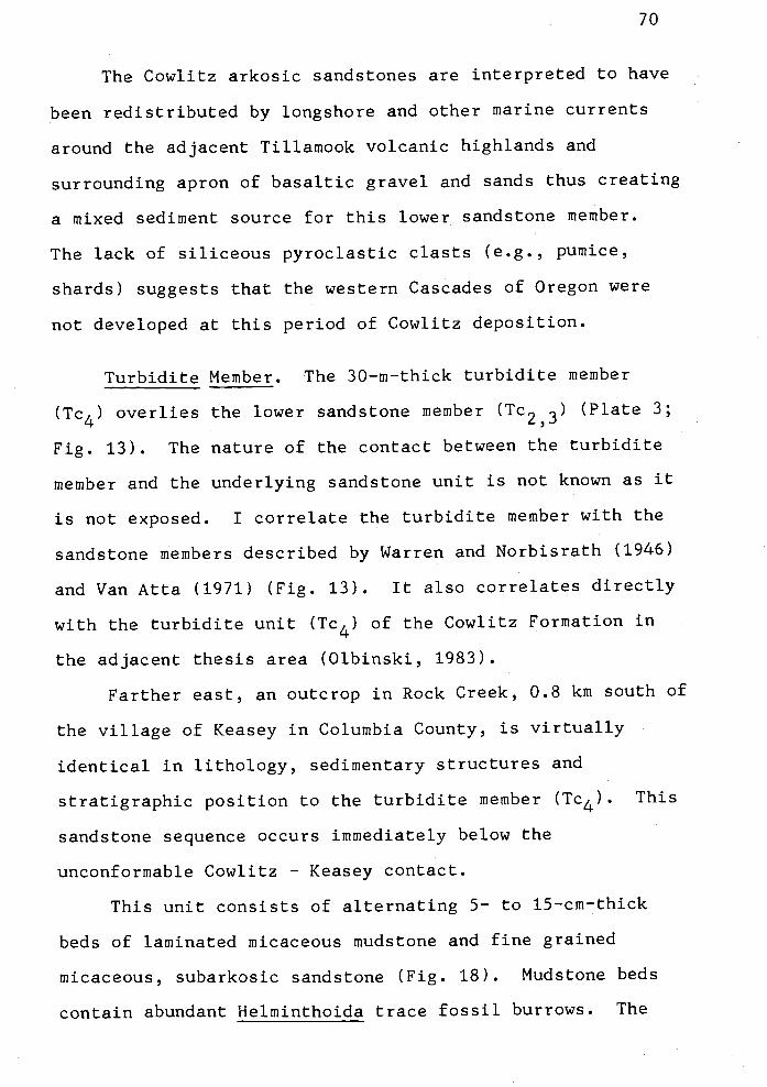
70
The Cowlitz arkosic sandstones are interpreted to have
been redistributed by longshore and other marine currents
around the adjacent Tillamook volcanic highlands and
surrounding apron of basaltic gravel and sands thus creating
a mixed sediment source for this lower sandstone member.
The lack of siliceous pyroclastic clasts (e.g., pumice,
shards) suggests that the western Cascades of Oregon were
not developed at this period of Cowlitz deposition.
Turbidite Member. The 30-rn-thick turbidite member
(Tc4) overlies the lower sandstone member (Tc23) (Plate 3;
Fig. 13). The nature of the contact between the turbidite
member and the underlying sandstone unit is not known as it
is not exposed. I correlate the turbidite member with the
sandstone members described by Warren and Norbisrath (1946)
and Van Atta (1971) (Fig. 13). It also correlates directly
with the turbidite unit (Tc4) of the Cowlitz Formation in
the adjacent thesis area (Olbinski, 1983).
Farther east, an outcrop in Rock Creek, 0.8 km south of
the village of Keasey in Columbia County, is virtually
identical in lithology, sedimentary structures and
stratigraphic position to the turbidite member (Tc4). This
sandstone sequence occurs immediately below the
unconformable Cowlitz Keasey contact.
This unit consists of alternating 5- to 15-cm-thick
beds of laminated micaceous mudstone and fine grained
micaceous, subarkosic sandstone (Fig. 18). Mudstone beds
contain abundant Helminthoida trace fossil burrows. The
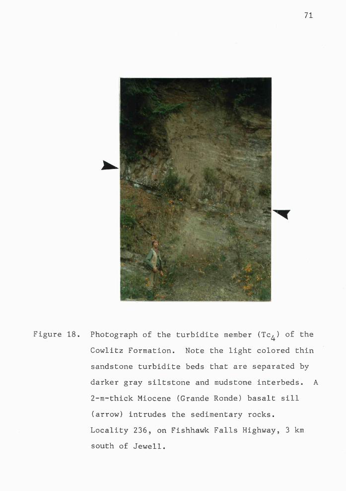
'I'
Figure 18. Photograph of the turbidite member (Tc4) of the
Cowlitz Formation. Note the light colored thin
sandstone turbidite beds that are separated by
darker gray siltstone and mudstone interbeds. A
2-rn-thick Miocene (Grande Ronde) basalt sill
(arrow) intrudes the sedimentary rocks.
Locality 236, on Fishhawk Falls Highway, 3 km
south of Jewell.

72
beds are dusky brown (5 YR 2/2) in color. Sandstone
interbeds have sharp basal contacts with the underlying
mudstone, gradational upper contacts and contain Bouma Tabc
and Tde sequences. Bouma Tde layers are very thin, commonly
less than 1 mm thick. Individual sandstone beds display
graded bedding, parallel laminations and
micro-cross-laminations. A single unidirectional
paleocurrent measurement of cross-laminations in a sandstone
bed is oriented N 50 W (locality 236).
Elongate calcareous concretionary ledges occur
discontinuously in certain sandstone beds. Thin sections of
the concretionary layers reveal that sparry pore-filling
calcite cement is displacively precipitated causing detrital
framework constituents to be wedged apart. Some volcanic
rock fragments are entirely replaced by the sparry calcite.
The subarkosic sandstones plot in a cluster on Folk's
(1980) sandstone classification chart (Fig 14). Quartz
comprises 30 to 4O7 of the clastic constituents, whereas
feldspar makes up 6 to 117g. Monocrystalline and
polycrystalline quartz are present, but monocrystalline
types predominate. Plagioclase is much more abundant than
potassium feldspar. Coarse biotite and flakes of muscovite,
in a 3:1 ratio, form 5 to 107 of the framework constituents.
The sandstones are typically very fine grained, well sorted,
subrounded, texturally and compositionally mature.
Grain size, graded bedding, Bouma Tabc and Tde
sequences and Helminthoida burrows suggest that turbidity
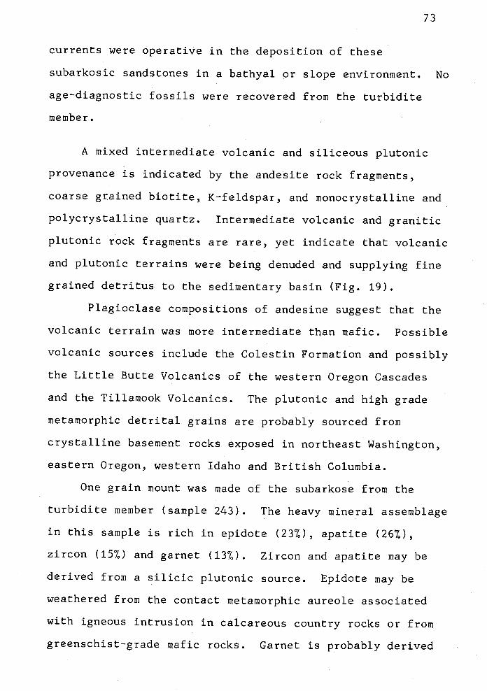
73
currents were operative in the deposition of these
subarkosic sandstones in a bathyal or slope environment. No
age-diagnostic fossils were recovered from the turbidite
member.
A mixed intermediate volcanic and siliceous plutonic
provenance is indicated by the andesite rock fragments,
coarse grained biotite, K-feldspar, and monocrystalline and
polycrystalline quartz. Intermediate volcanic and granitic
plutonic rock fragments are rare, yet indicate that volcanic
and plutonic terrains were being denuded and supplying fine
grained detritus to the sedimentary basin (Fig. 19).
Plagioclase compositions of andesine suggest that the
volcanic terrain was more intermediate than mafic. Possible
volcanic sources include the Colestin Formation and possibly
the Little Butte Volcanics of the western Oregon Cascades
and the Tillamook Volcanics. The plutonic and high grade
metamorphic detrital grains are probably sourced from
crystalline basement rocks exposed in northeast Washington,
eastern Oregon, western Idaho and British Columbia.
One grain mount was made of the subarkose from the
turbidite member (sample 243). The heavy mineral assemblage
in this sample is rich in epidote (237), apatite (26°h),
zircon (157.) and garnet (137.). Zircon and apatite may be
derived from a silicic plutonic source. Epidote may be
weathered from the contact metamorphic aureole associated
with igneous intrusion in calcareous country rocks or from
greenschist-grade mafic rocks. Garnet is probably derived

CONTINENTAL StOCKPRO VENANCES
2ia 0
I
0
/ast
,/200 /
/
A/ 2310'I
/I
/I
/
/ 233t*I. /
I
/// S.II
SEC YCLEO OSOGEN
PRO VENANCES
JOI 0
74
U UPPER SANG MENDER2.00 TURSSOITE MENDER
\ 0 LOWER 5$ ENIER
MAGMA TIC ARC
PRO VENA NCESSQ A
F'Figure 19. Triangular QFL provenance classification diagram
(after Dickinson and Suczek, 1978) indicates
mixed source areas for Cowlitz sandstones. The
original provenance fields of the mean framework
modes of selected sandstone suites were
determined by Dickinson and Suczek (1978).
These data suggest that Cowlitz turbidite
sandstones (Tc4) were derived from denuded
continental block materials. The scatter of
arkosic sandstone samples from the lower
sandstone member (Tc23) suggests a mixed
influence of all three provertances.

75
from crystalline metamorphic rocks, or less commonly, from
silicic plutonic rocks (Mimer, 1940).
pper Sandstone Member. The zircon-rich upper
sandstone member (Tc5) is correlated to parts of the
sandstone members of Warren and Norbisrath (1946) and Van
Atta (1971) (Fig. 13). This member lacks preserved fossils
and is exposed in weathered outcrops in the thesis area
making exact correlations difficult. The unit is best
exposed in the measured section along the Fishhawk Falls
Highway three km south of Jewell where it is at least 15 m
thick and the top contact is covered (Plate 3). A
40-rn-thick section of sandstones that are petrographically
and stratigraphically similar to the upper sandstone member
(Tc5) occurs in the southeast part of the Nehalem
Valley Buster Creek area (Olbinski, 1983). Overlying the
zircon-rich sandstones are 80 m of epidote-rich sandstones
(Olbinski, 1983, p.65). The upper sandstone member is
tentatively correlated to the 230-rn-thick "Clark and Wilson"
sand that is present in the subsurface in the Mist, Oregon
area (Mr. Larry O'Connor, pers. comm., 1982). The upper
sandstone member (Tc5) appears to thin or is truncated to
the west by the overlying Jewell member of the Keasey
Formation (Plate 1).
In outcrop, the upper sandstone member is massive,
poorly consolidated and weathered. Fresh exposures display
low-angle cross-stratification and parallel stratification.

76
Petrographically, the rock classifies as a lithic arkose
(Folk, 1980) (sample 233, Fig. 14). It is medium grained,
moderately sorted and is composed dominantly of subangular
to subrounded monocrystalline and polycrystalline quartz and
albite-twinned plagioclase. The abundance of
monocrystalline quartz exceeds that of polycrystalline
quartz by 2:1 and plagioclase is more abundant than K-spar
by a 9:1 ratio. The matrix consists of chioritic clay and
abundant yellowish-red limonite cement. The sandstone is
friable and poorly cemented by limonite. Much of the
limonite is probably due to surface weathering and oxidation
of biotite and volcanic rock fragments which has
significantly reduced primary porosity. The rock is
texturally immature and compositionally submature; however,
the textural immaturity (e.g., clay matrix) may be due to
the degree of weathering and diagenesis.
A mixture of sources is indicated by thin section and
grain mount studies. Mudstone fragments comprise 47 of the
framework fragments, suggesting penecontemporaneous erosion
of earlier-deposited Cowlitz mudstone. Metamorphic and
intermediate volcanic rock fragments also comprise a minor
proportion (47) of the rock.
The heavy mineral assemblage (sample 233) is rich in
euhedral zircon (347), apatite (187), tourmaline (67) and
garnet (207). Zircon, apatite and tourmaline are indicative
of a silicic plutonic provenance (Mimer, 1940). Garnet may

77
be derived from either a crystalline metamorphic area or,
less commonly, from silicic plutonic rocks and contact
metasomatic aureoles.
The upper sandstone member (Tc5) contains a zircon-rich
heavy mineral assemblage which correlates with the
zircon-rich arkosic sands (Tc5) of Olbinski (1983) (e.g.,
the Waage Road section 11 km to the east) and with the
zircon-rich arkosic sands in the Quintana "Watzek" #30-i
well 6.5 km to the north. The plagioclase, K-spar,
monocrystalline and polycrystallirie quartz, muscovite and
biotite all suggest a distant eastern plutonic source of
granitic and high grade metamorphic (e.g., gneiss) rocks for
the upper sandstone member of the Cowlitz Formation.
Contact Relations
The basal conglomerate (Tc1) of the Cowlitz Formation
overlies the Tillamook Volcanics with angular discordance.
This relationship is well exposed in two basalt quarries on
the Buster Creek road (N1/2, sec. 25, T5N, R7W; Fig. 12).
The angular unconformity truncates basaltic andesite feeder
dike systems that intrude Tillamook volcanic breccias. The
erosional surface is uneven (Fig. 12). The beds of volcanic
breccia dip 30° to 40° southeast. The overlying Cowlitz
conglomeratic sandstone dips 20° to 30° northward. It is
possible that the intrusion of the dike system may have
tilted the Tillamook breccias slightly, and therefore
attitudes taken from the quarry do not represent regional
dip of the Tillamook section.
The angular unconformity is also inferred at a locality
along the Fishhawk Falls Highway (SE1/4, SW1/4, sec. 23,
T5N, R7W, north of road). It is interpreted that this area
is far enough removed from the Buster Creek intrusive center
that these Tillamook beds are riot deformed by igneous
intrusion. Here, two subaerial flows of the Tillamook
Volcanics are separated by a sandstone interbed. The beds
strike N 800 W and dip 350 s The overlying Cowlitz strata
dip northward in the area (Plate 1), and are poorly exposed
on the hill above this locality.
Conformity is assumed between each member of the
Cowlitz Formation previously described. The strike and dips
between units are very similar (e.g., Plates I and III).
The locations and positions of these contacts are inferred
due to cover in many places and are drawn on the map with
some geologic license (Plate 1). Local disconformity
between units of the Cowlitz Formation is possible.
The contact between the Cowlitz Formation arid the
overlying Keasey Formation is not exposed anywhere in the
thesis area due to the thick vegetative and soil cover.
There is indirect evidence of disconformity and seismic
evidence of angular unconformity. The upper sandstone
member (Tc5) of the Cowlitz Formation appears to thin to the
west in east-to-west transects from the Clatsop Columbia
county line to the Jewell area. The thickness changes from

79
an estimated 200 meters near the county line to 15 meters on
the Fishhawk Falls Highway three km south of Jewell (Plate
3). If this is due to erosion of the upper sandstone unit
prior to deposition of the Keasey Formation, then a hiatus
of deposition occurred between Cowlitz and Keasey time and a
disconformity separates to the two formations. Olbinski
(1983) also interpreted an unconformity between the two
units in the Buster Creek Green Mountain area to the east
of this study.
Seismic reflection surveys have been made through the
thesis area and in the Mist gas field to the east. I have
learned that the seismic records also indicate an angular
unconformity between the Cowlitz and Keasey Formations
(Larry O'Connor, Mike Navaho, Tenneco; John Girgis,
Diamond Shamrock, pers. Comm., 1981).
and Correlation
Exposures at the "Big Bend" of the Cowlitz River,
Weaver's (1912) type locality of the Cowlitz Formation in
southwest Washington, were correlated to the Tejon formation
of California by Arnold (1906). Molluscan fossils of the
Cowhitz Formation were studied by Weaver (1912), Van Winkle
(1918), Armentrout (1973) and Nesbitt (in Armentrout and
others, 1980). Foraminiferal studies were made by Hanna and
Hanna (1924), Beck (1943), Rau (1958), Yett (1979) and
McDougall and Jefferis (in Armentrout and others, 1980).
All faunas indicate a late Eocene age (upper Narizian Stage)
for the type Cowlitz Formation.
Henriksen (1956, p.58) reported that the Olequa Creek
Member of the type Cowlitz Formation should be assigned to
Laiming's (1943) upper Eocene A-i (Plectofrondicularia
jenkinsi Zone). He considered the Olequa Creek Member to be
stratigraphically equivalent to the Skookumchuck Formation
of central western Washington. Henriksen correlated the
underlying Stiliwater Creek Member of the type Cowlitz
Formation to Laiming's A-2 foraminiferal Zone, which is
middle Eocene. He considered the McIntosh Formation of
Washington a stratigraphic equivalent of the Stiliwater
Creek Member. Some subsequent workers have maintained this
correlation (Rau, 1958; Yett, 1979) (Fig. 4). Wells (1981)
restricted the definition of the Cowlitz Formation in the
Willapa Hills to the Olequa Creek Member and remapped the
Stiliwater Creek Member as part of the McIntosh Formation.
In Oregon, Warren and Norbisrath (1946, p.225)
considered the Cowlitz Formation to be close in age (late
Narizian) to the beds of the type section on the Cowlitz
River. The major difference noted in the microfaunas from
the two areas was the presence of Plectofrondicularia
packardi Cushman and Schenck in the Oregon Cowlitz
Formation. This foraminifera species does not occur in the
Washington section, suggesting to Weaver that a difference
of facies or age may exist.

[3$
Additional refinement of the Cowlitz stratigraphy in
Oregon and Washington by regional mapping and whole rock
K-Ar dating of volcanic rocks suggests that the Cowlitz is
late middle to late Eocene in age. Mapping by Wells (1981)
in the Willapa Hills shows that the type Cowlitz Formation
(Olequa Creek and Stillwater Creek Members) underlies the
Goble Volcanics which have been recently radiometric dated
by the K-Ar method at 41.5 ± 0.5 m.y. (McElwee, pers. comm.
from A. R. Niem, 1984) and 32-39 m.y. (Wells, 1981). The
range of Goble deposition in southwest Washington overlaps
the age of the Tillamook Volcanics in this thesis study area
and in northern Tillamook County.
Megafossils and foraminferal assemblages from the
Cowlitz Formation in nearby Columbia County, Oregon, yield a
late Narizian age (Norbisrath and others, 1944; Newton and
Van Atta, 1976; Jackson, 1983). No age-diagnostic fossils
were found in the Cowlitz Formation in the thesis area
during this study. However, Warren and others (1945)
reported a Cowlitz-age molluscan and foraminifera locality
(FM-20 in the lower sandstone member (Tc2), see Plate 1)
near the Nehalem River and Fishhawk Falls Highway in the
SW1/4, sec. 22, T5N, R7W. Molluscs in this collection
include:
Nucula n. sp.Nuculana cf. N. vaderensis (Dickerson)Pholadya n. sp.Hemipleurotoma pulchra (Dickerson)Cyclammina natlandi BeckC. pacifica Beck

Epistornina eocenica Cushman & HannaMarginulina saundersi (Hanna & Hanna)
Correlation of the Cowlitz Formation in the thesis area
to the Cowlitz mapped in northwest Oregon by Warren and
others (1945) is made by continuous mapping into the
adjacent areas, by similarity of lithologic units (or
members) within the Cowlitz, and by their stratigraphic
position above the older Tillamook Volcanics and below the
younger lower Refugian Keasey Formation.
The Cowlitz Formation in Oregon is lithologically
different from the Cowlitz in Washington. The former
contains a basal volcanic conglomerate and no obvious coal
beds, suggesting different depositional facies for each
unit. Deacon (1953) also noted these differences and
suggested that the Cowlitz Formation in Columbia County be
named a separate formation (e.g., Rocky Point formation).
But I suggest retaining the name Cowlitz Formation for
Narizian sandstones and mudstones overlying the Tillamook
Volcanics in Oregon because the usage is deeply ingrained in
the literature since the original descriptions by Warren and
Norbisrath (1946).
Regionally, the Cowlitz Formation is correlated to
other Narizian formations of western Oregon. These include:
the Nestucca Formation of the central Oregon Coast Range
(Snavely and others, 1980); the Spencer Formation and the
upper part of the Yamhill Formation of the northeast Coast
Range (Schlicker and Deacon, 1963; Al Azzaby, 1980); and,
the Coaledo and Bastendorff Formations of the southern Coast
Range (Baldwin, 1981; Armentrout and others, 1980).
The revision of chronostratigraphic units in Oregon and
Washington by Armentrout
middle Eocene and lowest
affects other formations
As this is a very recent
see if it is accepted or
workers studying the Pal
(1981) places the Narizian in the
upper Eocene (Figs. 4 and 5). This
assigned to the Narizian as well.
revision, some time is needed to
requires further modification by
eogene of Oregon and Washington.
Radiometric dating and biostratigraphic problems.
There is a 7 rn.y. discrepancy between the 31.7 0.5 m.y.
K-Ar date of the youngest upper Tillainook intrusions in the
study area and the absolute age correlated to the Narizian
foram stage on Armentrout's time scale. The top of the
Narizian Stage is approximately 39 m.y.b.p. according to
this time scale (Fig 20).
The young radiometric date of 31.7 0.5 m.y.b.p. is
probably not be correct. Potential 40Ar loss, potassium
enrichment, or presence of nonradiogenic argon in
crystalline phases could yield a date that is too young.
Lost radiogenic 40Ar could be diffused from the mineral
lattice by chemical weathering and alteration from fluid in
the amorphous volcanic glass (devitrification) and formation
of secondary minerals may result in K enrichment.
Radiometric dating of other nearby Tillamook basaltic
andesites (by K. McElwee) from the top of the Tillamook
volcanic pile has yielded older dates of 42 to 37 m.y.
(t4cElwee, pers. comm., 1984). (See Age and Correlation of
the Tillamook Volcanics, p. 44.)
Depositional Environments
A transgressive open marine depositional environment is
interpreted for much of the Cowlitz Formation in the thesis
area. Sediments deposited in the marine environments vary
from alluvial basaltic gravels and debris flow sediments
(Tc1) to marginal shallow marine sands and muds (Tc23) to
deeper marine shelf and slope turbidites (Tc4) near the top
of the section, and possibly followed by short-lived
regressive (or progradational) shelf sand (Tc5). Scarce
marine fossils occur in the formation (Dentalium sp. and
the trace fossil Planolites).
The depositional environments are interpreted from
sedimentary structures, lithologies and facies
relationships. Textural maturity of a sediment is also an
indicator of the energy of the final depositional
environment (Folk, 1980). Sediment maturity is influenced
by the tectonic setting of the depositional basin. Folk's
(1980) guidelines for interpreting the depositional
environment and relief from textural maturity parameters are
used in the interpretation of the Cowlitz depositional
environment.
Depositional environment of the congjomerate member
Abundant subrounded clasts, poor sorting, lack of

85
stratification and the lenticular nature (0-60 m) of the
basal conglomerate suggest that the depositional environment
was a humid coastal alluvial fan or river mouth. The thin
basal conglomerate contains one-meter--diameter angular
clasts of basaltic andesite derived from the subaerial
Tillamook volcanics and intrusives which directly underlie
the conglomerate (e.g., see Fig. 7). The size, compositions
and angularity of the clasts indicate that the clasts were
not transported far and were derived from a rugged, high
relief source terrain. The subrounded clasts of mixed
compositions in framework support suggest fluvial transport,
perhaps by a braided stream. The subangular clasts in some
breccia beds are in matrix support and were probably
deposited by debris flows which are common in alluvial fan
sequences (Rust, 1979). Interbedded graded basaltic
sandstone beds may reflect overbank deposits or sand bars
between stream gravels and debris flows.
The thinness of the basal conglomerate (0-60 m)
suggests that the alluvial fan was small, perhaps at the
mouth of short high-gradient streams which drained a
dissected volcanic highland. Marine diatoms in the
interbedded mudstones in the basal Cowlitz (Tc1) at the
Buster Creek quarry suggest that the alluvial fan or braided
river mouth deposit prograded into the adjacent shallow
marine environment.
A surf zone probably existed nearby. This is supported
by the occurrence of nearby shoreface deposits of rounded

conglomerate and well sorted basaltic sandstone and the
proximity of the overlying shallow marine facies represented
by the lower sandstone member in this study area (see Plates
I and III). Van Atta (1971), Rarey and Mumford (pers.
comm., 1983) report broken oysters, barnacles and mytilus
mussel shells in the basal conglomerate (Tc1) to the south
and east of the study area. These disarticulated intertidal
fossils indicate that the basal conglomerate and sandstone
were deposited along a high energy nearshore marine terrace
adjacent to volcanic seacliffs much like the basaltic
headlands and beach gravels along the Oregon coast today.
The topography of this marine shoreline may have been very
steep, deepening quickly from the strandline to inner shelf
depths in a very short distance. A similar origin is
envisioned by Timmons (1981) and Olbinski (1983) for the
origin of the basal Cowlitz conglomerate in adjacent areas
I envision small coastal alluvial fans and braided
stream mouth deposits which accumulated near sea level. The
fans and braided streams would have cut into the nearby
steep and dissected topography of the Green
Mountain Tillamook Volcanic highlands (probably islands).
As a result of degradation of the highland and a marine
transgression which followed, a gradual facies change
occurred from subaerial coastal fan-river mouth gravel
deposits to a high energy shallow-marine shelf sand
environment forming the overlying lower sandstone member
(Tc2) and bordering the Green Mountain volcanic island high.
Depositional environment of the lower sandstone member
The lower sandstone member consists of texturally
mature lithic arenites and micaceous arkoses. As in the
basal conglomerate, the abundance of granule to coarse
grained basaltic andesite rock fragments in the volcanic
sandstone in the lower part of the lower sandstone member
implies a local subaerial source.
Short steep-gradient streams as well as volcanic sea
cliffs supplied coarse grained epiclastic volcanic detritus
directly to the marine shoreline. Strong wave, tidal and
longshore currents abraded and redistributed this coarse
grained detritus in the littoral zone. The fine grain size,
a high degree of roundness, the moderate sorting and lack of
matrix in thin sections (e.g., see Fig. 15) of the the
lithic arenites support the hypothesis that strong currents
and wave action were capable of winnowing silt and clay
material and of breaking down the larger clasts into fine
sand size detritus.
A neritic sublittoral depositional environment is
inferred for the fine grain basaltic sandstone and micaceous
arkose and mudstone in the upper part of the lower sandstone
member (Plate 3). Norbisrath and others (1945) collected
shallow marine molluscs in this unit at locality FM-20 in
the study area. The fine grained tnicaceous arkosic
sandstones interbedded with the coarse grained arenites in
the upper part of the lower sandstone member are texturally
submature to mature.
The two sediment compositions reflect two different
sources. The mineralogy and texture of the clean arkosic
sandstones suggest longer transport and final deposition in
a lower energy environment than the underlying coarser
grained basaltic sandstone and conglomerate. Because of its
hydrodynamic behavior in fluid, mica will not settle in a
high energy wave environment but will settle out on a lower
energy shelf. The provenance of these K-spar, mica and
epidote rich sandstones is a very distant plutonic and
metamorphic source (e.g., the Idaho Batholith).
The fine grained arkosic sandstones, which are
interbedded with mudstone, were probably transported into
the sublittoral inner shelf depositional environment around
the subdued Tillamook volcanic islands from a river mouth to
the east by longshore drift or sediment plumes off the river
mouth. Kuim and others (1975) reported that fine grained
sands are carried onto the present inner continental shelf
by the Columbia River plume and by high amplitude storm
waves. These modern inner shelf sands are fine grained,
sorted and laminated with carbonaceous debris like the
arkosic sandstones of the lower sandstone member (Tc2 3).
The Cowlitz arkosic sands were probably deposited by
the Cowlitz delta to the north of the thesis area in
southwest Washington where there are coal beds in the type
section (Henriksen, 1956). Green Mountain (southeast of the
thesis area) and the Tillamook highlands (southwest of the

thesis area) may have formed subdued topographic highs
bordering the Cowlitz sea and contributed volcanic detritus
to the lower sandstone member (Tc23). Strandline and
nearshore volcanic gravels and coarse grained sandstone
grade to deeper marine mudstone to the southeast and
southwest of the thesis area (Mumford, Safley, and Rarey,
pers. comm., 1983).
Depositional environment of the turbidite member (4).
A turbidity current origin is interpreted for the sandstones
of this member based upon the graded bedding, Bouma
sequences Tac and Tde sharp bottom and gradational upper
contacts, and even-bedded alternating mudstones and
sandstones. These features are attributed to low density
distal turbidites by Middleton and Hampton (1973) and by
Walker and Mutti (1973). The Helminthoida-burrowed
mudstones between turbidites indicate slow hemipelagic
sedimentation rates between the turbidites (Howard, 1978).
Helminthoida is most common in offshore to bathyal
environments (Chamberlain, 1978).
The 30-ni-thick unit is thin relative to typical
turbidite fan sequences and lacks associated upper and
middle fan facies (Mutti and Ricci Lucci, 1978). The thin
turbidjte unit is sandwiched between the arkosic shallow
water shelf units, Tc2 and Tc5 (Plate 3).
Two models are possible for the deposition of this
lithofacies. The turbidites may signify increasing water
depth followed by a regressive event within the Cowlitz
section. This water depth change might have been caused by
either a transgressive sea or gradual basin subsidence due
to tectonism (or a combination of the two). The result of
the change in depth may have been that shelf and nearshore
arkosic sand (Tc2) was redistributed down-slope by
low-density turbidity currents moving across the continental
shelf.
Dott and Bird (1979) described a similar thin
channelized sequence of thin-bedded turbidites (Elkton
Formation) which were funneled down ttsea gullies" from the
upper Eocene Coaledo delta front sands in the Coos Basin,
southern Oregon Coast Range. Similar small-scale
channelized turbidites were noted in the lateral equivalent
of this turbidite member (Tc4) in the Cowlitz Formation in
Rock Creek (13 km to the east near Keasey) on a field
reconnaissance. Perhaps the turbidite member formed in sea
gullies cut into the slope off the main Cowlitz delta to the
northeast (i.e., the type Cowlitz in southwest Washington).
The second model requires no significant change in
water depth due to eustacy or basin subsidence. C. H.
Nelson (1982) discussed thin storm-generated graded sand
layers between mud layers on the Yukon delta Bering shelf.
He demonstrated that rhythmically bedded graded sand
sequences on epicontinental shelves can be the result of
storm-surge processes that affect the sediment-laden shelf.
Seaward sand transport has been observed by the ebb flow of
wind driven storm currents. Nelson (1982) showed that
91
graded sand sequences formed by these storm-surge currents
can mimic the classical Bouma Ta_e structures commonly
associated with deeper marine turbidite deposits on
continental slopes.
The primary sedimentary structures in the turbidite
member are compatible with the sequences that Nelson (1982)
described as storm-generated graded sand layers. The
Cowlitz basin in northwest Oregon may have been a
sediment-laden system off the main Cowlitz delta centered in
the type area.
Walker (1979) and Dott and Bourgeois (1981, 1982) also
picture thin-bedded "turbidites' and muds forming below
storm wave base seaward from and associated with storm
deposited hummocky cross-bedded shelf sandstones. Olbinski
(1983) and Jackson (1983) report storm induced hummocky
bedding in the thick- and thin-bedded shelf arkosic
sandstones in the Cowlitz Formation in adjacent areas,
suggesting that the turbidites may be associated with the
density entrained storm surge currents that created the
hummocky bedding (Fig. 20).
Depositional environment of the upper sandstone member
(Tc5). The sandstones of the upper member (Tc5) of the
Cowlitz Formation are micaceous and zircon-rich. These
friable rocks are generally poorly exposed and lack abundant
primary sedimentary structures and fossils that may be
definitive of a specific depositional environment. However,
the unit is thick bedded and, in places, displays parallel
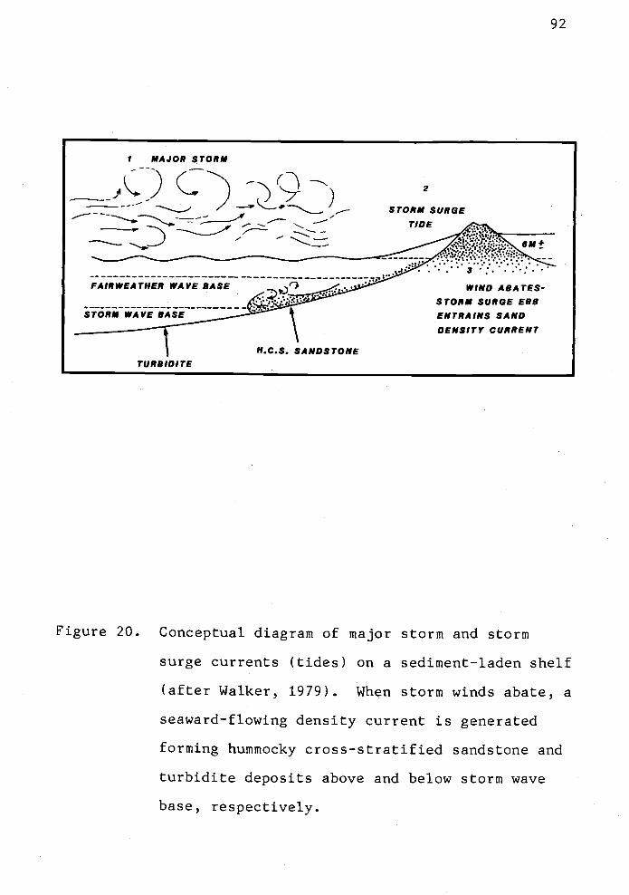
I MAJOR STORM
- -
D
FAIR WEATHER WAVE BASE
STORM WAVE BASE __
TURBIDITE
Figure 20.
H.C.S. SANDSTONE
2
STORM SURGETiDE
7WIND ABATES-
STORM SURGE EBBENTRA INS SAND
DENSITY CURRENT
92
Conceptual diagram of major storm and storm
surge currents (tides) on a sediment-laden shelf
(after Walker, 1979). When storm winds abate, a
seaward-flowing density current is generated
forming hummocky cross-stratified sandstone and
turbidite deposits above and below storm wave
base, respectively.

93
stratification and low-angle cross-stratification suggesting
a tractive currentshallow marine origin. The present inner
shelf sands of the Oregon continental shelf are also
parallel laminated (Kuim and others, 1975).
Although coarser grained, the sand is compositionally
related to the fossiliferous micaceous arkoses in the lower
sandstone member (Tc23). Therefore, deposition probably
took place in a similar inner shelf, shallow marine
environment with longshore currents. Olbinski (1983) noted
gastropod and disarticulated pelecypod molds, mudstone
rip-up clasts, hummocky bedding, ripple
micro-cross-laminations and troug1i cross-bedding in
correlative upper arkosic sandstones (Tc5). These primary
sedimentary depositiorial structures indicate high energy
storm dominated shelf conditions. Perhaps the upper
sandstone member of the Cowlitz Formation reflects a
shallowing-up sequence, or a more shoreward depositional
facies, that prograded in time over the underlying
storm-generated turbidites (Tc4).

Keasey Formation
Nomenclature
94
The "Keasey shale" was originally defined by Schenck
(1927b). The type section was described as dark gray
fossiliferous and well-stratified sandy shales 1.1 km north
of the hamlet of Keasey, Oregon. The type section is
exposed along Rock Creek, which is a tributary to the
Nehalem River east of the thesis area. Weaver (1937)
calculated the thickness of the Keasey Formation as 366 m in
the Rock Creek area.
Warren and Norbisrath (1946) redefined the Keasey
Formation to include three members and extended the section
beyond Schenck's original description. The lower member,
which includes the type section of Schenck (1927), consists
of a dark gray shale with variable thickness. In some
localities away from the type section, these workers
encountered difficulty distinguishing this unit from
lithologically similar underlying Cowlitz mudstones. Warren
and Norbisrath (1946, p. 225) discussed the problems of
discerning this lower shale member where it is either poorly
exposed, missing, or replaced by a rock of slightly
different lithology.
The middle member is a light gray, unstratified,
tuffaceous siltstone with resistant calcareous concretionary
beds. This fossiliferous member is approximately 518 m
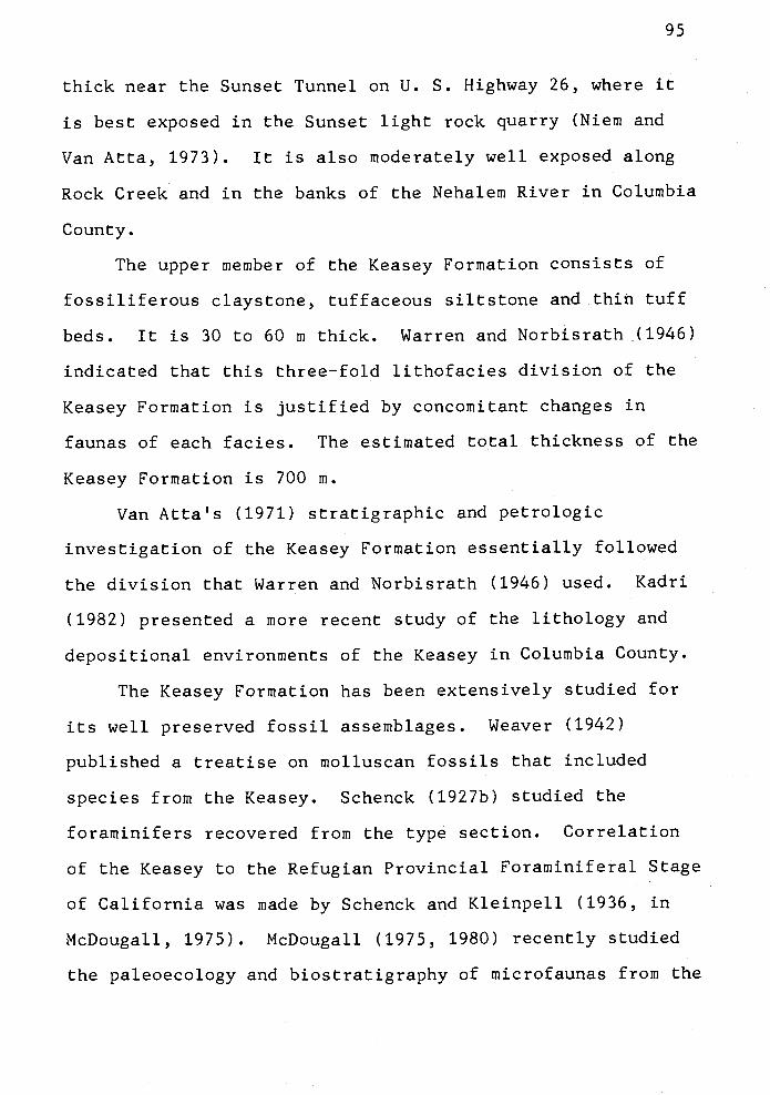
95
thick near the Sunset Tunnel on U. S. Highway 26, where it
is best exposed in the Sunset light rock quarry (Niem and
Van Atta, 1973). It is also moderately well exposed along
Rock Creek and in the banks of the Nehalem River in Columbia
County.
The upper member of the Keasey Formation consists of
fossiliferous claystone, tuffaceous siltstone and thin tuff
beds. It is 30 to 60 ni thick. Warren and Norbisrath (1946)
indicated that this three-fold lithofacies division of the
Keasey Formation is justified by concomitant changes in
faunas of each facies. The estimated total thickness of the
Keasey Formation is 700 m.
Van Atta's (1971) stratigraphic and petrologic
investigation of the Keasey Formation essentially followed
the division that Warren and Norbisrath (1946) used. Kadri
(1982) presented a more recent study of the lithology and
depositional environments of the Keasey in Columbia County.
The Keasey Formation has been extensively studied for
its well preserved fossil assemblages. Weaver (1942)
published a treatise on molluscan fossils that included
species froni the Keasey. Schenck (1927b) studied the
foraminifers recovered from the type section. Correlation
of the Keasey to the Refugian Provincial Foraminiferal Stage
of California was made by Schenck and Kleinpell (1936, in
McDougall, 1975). McDougall (1975, 1980) recently studied
the paleoecology and biostratigraphy of microfaunas from the

1a
type section of the Keasey Formation and studied other
surface sections and well samples.
McDougall has considered the relation of the Keasey
Formation to other biostratigraphically correlative
formations in California, Oregon and Washington (McDougall,
1980). She concluded that part of the benthic Foraminifera
in the Keasey are facies controlled and that much of the
Keasey was deposited in outer shelf and upper slope
environments.
Usage of the term Keasey Formation as a faunal stage
has caused confusion of the definition. The name has been
applied in the Pacific N.W. both in lithostratigraphic and
time-stratigraphic senses (McDougall, 1975). Within the
outcrop area of the Keasey Formation (Columbia and Clatsop
counties), the lithologic description of the members is
variable due to facies changes. The lack of continuous
exposure makes intraformational stratigraphic correlation
difficult in detailed study. Warren and Norbisrath (1946)
indicated that without fossils the Keasey Formation west of
the Nehalem River basin could not be distinguished from the
claystones of the Cowlitz Formation.
Deacon (1953, p. 18) proposed the "Nehalem formation"
for exposures within the type section of the Keasey in Rock
Creek. The formation was proposed for heterogeneous strata
between the lithologically distinct Cowlitz Formation (which
Deacon called "Rocky Point formation") and the overlying
Keasey Formation. Deacon's Keasey Formation included only
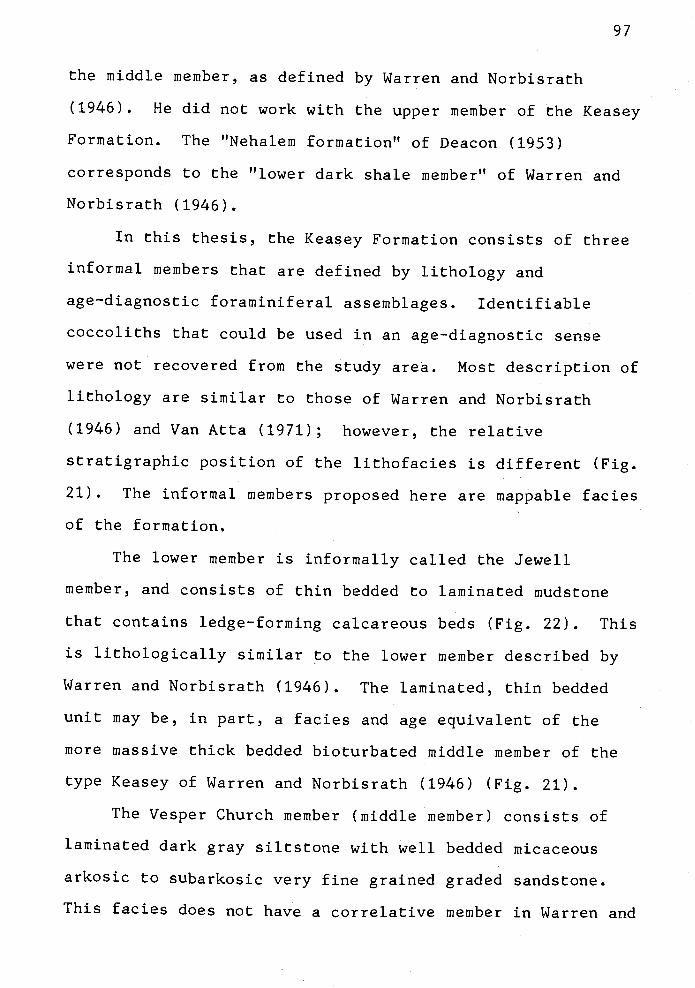
97
the middle member, as defined by Warren and Norbisrath
(1946). He did not work with the upper member of the Keasey
Formation. The "Nehalem formation" of Deacon (1953)
corresponds to the "lower dark shale member" of Warren and
Norbisrath (1946).
In this thesis, the Keasey Formation consists of three
informal members that are defined by lithology and
age-diagnostic foraminiferal assemblages. Identifiable
coccoliths that could be used in an age-diagnostic sense
were not recovered from the study area. Most description of
lithology are similar to those of Warren and Norbisrath
(1946) and Van Atta (1971); however, the relative
stratigraphic position of the lithofacies is different (Fig.
21). The informal members proposed here are mappable facies
of the formation.
The lower member is informally called the Jewell
member, and consists of thin bedded to laminated mudstorie
that contains ledge-forming calcareous beds (Fig. 22). This
is lithologically similar to the lower member described by
Warren and Norbisrath (1946). The laminated, thin bedded
unit may be, in part, a facies and age equivalent of the
more massive thick bedded bioturbated middle member of the
type Keasey of Warren and Norbisrath (1946) (Fig. 21).
The Vesper Church member (middle member) consists of
laminated dark gray siltstone with well bedded micaceous
arkosic to subarkosic very fine grained graded sandstone.
This facies does not have a correlative member in Warren and

z0I-
0U-
>-wCl)
w
w E
JeweH area Foram stage Keasey area
(Warren & Norbisrath,(This study)
thickness thickness 1946)
Upper mudstone Upper member:member: uncertain 30-60 m. claystone & faintly
mudstone & claystone upper Refugianstratified sandy shale,
with glauconite, tuff tuff bedsbeds & concretions
Vesper member: Middle member:laminated siltstone & 1000
518 m. massive tuffaceous shaleinterlaminated sand- 1200 in.
Re fugian with fossiliferousstone, discontinuous cemented beds
thin beds. ______________________Lower shale member:Jewell member: (type section)
thin-bedded to lamin- 335-400 m. 120 m. Well stratified clayston.ated mudstone with lower Refugian & siltstone w/glauconite
layersresistant calcareous ____________________lenses, rare arkosic basal
OWtZ Formationss. dikes & bedsn__ Narizian_n_nJ-
Cowlitz Formation
Figure 21. Correlation of the informal members of the
Keasey Formation used in this thesis to those
used by Warren and Norbisrath (1946) in the NE
Oregon Coast Range.

Norbisrath's division of the Keasey Formation but is
believed to be a lateral facies of the middle member (Fig.
21). It appears from their descriptions and sketch map that
they considered this facies to be the Lower part of the
Pittsburg Bluff Formation (Warren and Norbisrath, 1946, p.
230). For both lithologic and chronostratigraphic reasons
stated in the following section, it is unlikely that this
unit should be included in the Pittsburg Bluff Formation.
It best fits as a facies of the Keasey Formation. Olbinski
(1983) thought that the Vesper Church member is so different
from the type Keasey and Pittsburg Bluff Formations
described by Warren and Norbisrath (1946) that he proposed
it as a new informal formation.
The upper member consists of massive dark gray mudstone
arid claystone. It has foram abundant assemblages and
glauconite and contains distinctive thin white tuff beds.
This member is correlative to the upper member of Warren and
Norbisrath (1946) (Fig. 21).
Distribution
The Keasey Formation crops out over 60 km2 in a broad
band trending northeast-southwest through the middle part of
the thesis area. The formation ranges in thickness from
1,450 to 2,100 m, based on surface mapping and the Quintana
well. The outcrop pattern follows that of the underlying
Cowlitz Formation. Numerous strike-slip, oblique-slip and
vertical normal faults have offset the members of the Keasey

100
Formation (Jewell, Vesper Church and upper mudstone
members). The outcrop belt wraps around the N.W. side of
the northward-plunging axis of the Coast Range anticlinorium
and gravity high. To the east in Columbia and Washington
counties, the strike of the Keasey Formation changes to
northwest-southeast and north-south, where the unit crops
out on the east flank of the regional structure.
The mudstones of the Keasey Formation weather quickly
and form low, stream-dissected hills. Areas underlain by
the Keasey mudstone are prone to landslides and mudf lows (as
on Plate I). U. S. Highway 26 is constantly repaired in
order to keep up with the rate of erosion. Furthermore, the
removal of the toes of landslides and mudf lows near highways
and residences can destablize the hilislope, prompting
further sliding.
The upper Nehalem River has formed broad floodplains in
areas underlain by Keasey mudstone on Plate I). The
river meanders through this broad valley. At springtime
high water levels, the cutbanks are rapidly eroded by
floods. Roadways constructed near these undercut banks
often require repair. The Red Bluff Road (south-center part
of map area, NW1/4, sec. 24, T5N, R7W) formerly connected
the communities of Jewell and Elsie, but the Nehalem River
undercut the road years ago, and it has never been
reconstructed.
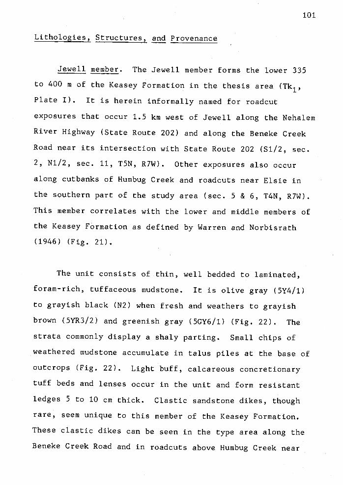
101
Lithologies, Structures, and Provenance
Jewell member. The Jewell member forms the lower 335
to 400 m of the Keasey Formation in the thesis area (Tk1,
Plate I). It is herein informally named for roadcut
exposures that occur 1.5 km west of Jewell along the Nehalem
River Highway (State Route 202) and along the Beneke Creek
Road near its intersection with State Route 202 (S1/2, sec.
2, N1/2, sec. 11, T5N, R7W). Other exposures also occur
along cutbanks of Humbug Creek and roadcuts near Elsie in
the southern part of the study area (sec. 5 & 6, T4N, R7W).
This member correlates with the lower and middle members of
the Keasey Formation as defined by Warren and Norbisrath
(1946) (Fig. 21).
The unit consists of thin, well bedded to laminated,
foram-rich, tuffaceous mudstone. It is olive gray (5Y4/1)
to grayish black (N2) when fresh and weathers to grayish
brown (5YR3/2) and greenish gray (5GY6/1) (Fig. 22). The
strata commonly display a shaly parting. Small chips of
weathered mudstone accumulate in talus piles at the base of
outcrops (Fig. 22). Light buff, calcareous concretionary
tuff beds and lenses occur in the unit and form resistant
ledges 5 to 10 cm thick. Clastic sandstone dikes, though
rare, seem unique to this member of the Keasey Formation.
These clastic dikes can be seen in the type area along the
Beneke Creek Road and in roadcuts above Humbug Creek near

102
Figure 22. Typical exposure of the Jewell member (Tk1) of
the Keasey Formation. Locality 89 on East
Humbug Road, SE1/4, sec. 13, T5N, R8W. The
purple foxglove (Digitalus purpurea) in lower
left approximately 1 meter tall; the hammer is
28 cm.

103
Elsie (NW1/4, sec. 5, T4N, R7W). Clastic dikes have not
been observed in the Cowlitz Formation nor in other members
of the Keasey Formation, but occur elsewhere in northwest
Oregon in the upper Eocene to lower Miocene Oswald
West mudstone (Cressy, 1974; Penoyer, 1977). The sandstone
in the dikes is arkosic and micaceous and is similar in
appearance and composition to the thick bedded upper
sandstone member of the Cowlitz Formation.
The Jewell member contains abundant foraminifers that
indicate a late Eocene or early Refugian age that is
equivalent to the California Valvulineria tumeyensis Zone of
Donnelly (1976). Representative forams collected from the
member are:
Bathysiphon eocenica Cushman and HannaCibicides elmaensis RauCyclammina pacifica BeckDentalina dusenburyi BeckGyroidina orbicularisHoeglundina eocenica (Cushman and Hanna)alvulineria tumeyensis Cushman and Simonson
McDougall (1982, written communication).
Vesper Church member. The Vesper Church member (Tk2)
is the middle member of the Keasey Formation in the thesis
area. In the Nehalem Valley Buster Creek area to the
east, the same unit has been mapped as the Vesper Church
formation (Olbinski, 1983). The unit lenses or pinches out
into the tuffaceous Keasey mudstone (Tk1) in the
southwestern part of the thesis area. The estimated
thickness is 1,000 to 1,200 m from outcrop and well

104
information (e.g., Quintana "Watzek" #30-1). This informal
member was named by Olbinski (1983) for roadcut and
landslide scarp exposures near the Vesper Church,
approximately 0.25 km north of the Nehalem River Highway in
sec. 25, T6N, R6W. This locality is close to the
Clatsop--Columbia county line.
Warren and Norbisrath (1946), Van Atta (1971), and most
recently Kadri (1982) described this member as a lower unit
of the Pittsburg Bluff Formation rather than as a member of
the Keasey. However, the Vesper Church is distinctly
dissimilar to the type Pittsburg Bluff Formation. It is
composed of rhythmically bedded micaceous arkosic turbidites
and inudstones, and the unit is both underlain and overlain
by typical Keasey strata (i.e., the Jewell member and upper
Keasey mudstone) (Plate I). It is not associated with the
Pittsburg Bluff Formation because it contains late Narizian
to early Refugian forams and equivalent coccolith
assemblages. The younger type Pittsburg Bluff contains late
Refugian to early Zemorrian forains and equivalent age
coccoliths.
The Vesper Church is missing in the type section of the
Keasey Formation on Rock Creek, however. Probably the
facies represented by this member had local distribution and
was not deposited in the area of the type section (Fig. 21).
Although Olbinski (1983) called the Vesper Church a separate
formation, it is considered by the author to be part of the
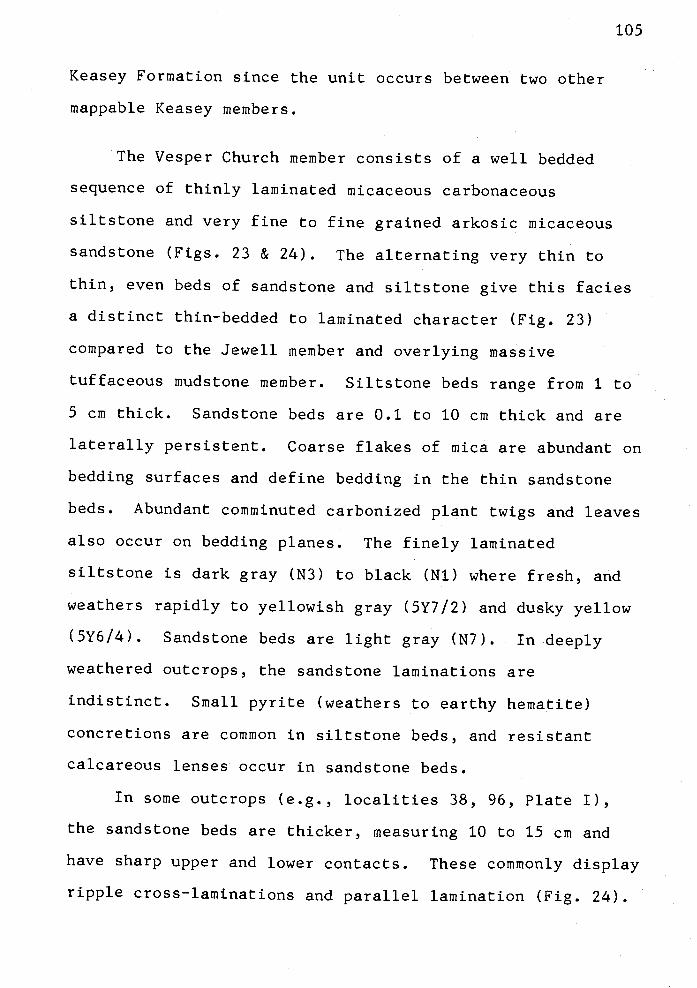
Keasey Formation since the unit occurs between two other
mappable Keasey members.
The Vesper Church member consists of a well bedded
sequence of thinly laminated micaceous carbonaceous
siltstone and very fine to fine grained arkosic micaceous
sandstone (Figs. 23 & 24). The alternating very thin to
thin, even beds of sandstone and siltstone give this facies
a distinct thin-bedded to laminated character (Fig. 23)
compared to the Jewell member and overlying massive
tuffaceous mudstone member. Siltstone beds range from 1 to
5 cm thick. Sandstone beds are 0.1 to 10 cm thick and are
laterally persistent. Coarse flakes of mica are abundant on
bedding surfaces and define bedding in the thin sandstone
beds. Abundant comininuted carbonized plant twigs and leaves
also occur on bedding planes. The finely laminated
siltstone is dark gray (N3) to black (Ni) where fresh, and
weathers rapidly to yellowish gray (5Y712) and dusky yellow
(5Y6/4). Sandstone beds are light gray (N7). In deeply
weathered outcrops, the sandstone laminations are
indistinct. Small pyrite (weathers to earthy hematite)
concretions are common in siltstone beds, and resistant
calcareous lenses occur in sandstone beds.
In some outcrops (e.g., localities 38, 96, Plate I),
the sandstone beds are thicker, measuring 10 to 15 cm and
have sharp upper and lower contacts. These commonly display
ripple cross-laminations and parallel lamination (Fig. 24).
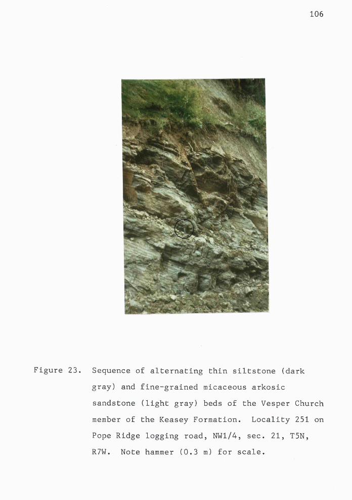
106
Figure 23. Sequence of alternating thin siltstone (dark
gray) and fine-grained micaceous arkosic
sandstone (light gray) beds of the Vesper Church
member of the Keasey Formation. Locality 251 on
Pope Ridge logging road, NW1/4, sec. 21, T5N,
R7W. Note hammer (0.3 m) for scale.

- .7 ..- -
-
':'..
107
Figure 24. Light gray sandstone beds in the Vesper Church
member of the Keasey Formation have ripple
laminations and planar beds (Tc_d) These
normally-graded 10- to 15-cm-thick beds are
separated by very thin darker gray mudstone
(Te) Locality 38 on logging road near Flagpole
Ridge. (Hammer is 28 cm long.)

Bouma sequences Tabe and Tbcd occur in some of these
normally-graded turbidite sandstones. Thirty to 60 foot
wide nested channels also occur in the unit along logging
roads in sec 26, T5N, R8W (see Plate I). Channels are
exposed along the Nehalem River Highway in the adjacent
thesis area (Olbinski, 1983). The channels truncate the
thin bedded strata and are filled with thin bedded sandstone
and siltstone of similar lithology.
Benthic foraminifers, mollusks, and trace fossils have
been recovered from the Vesper Church member. The foram
Lenticulina inornata (d'Orbigny) indicates water depths not
less than 50 m, the upper limit of this species (McDougall,
1982, pers. comm.). This species could be transported to
greater depth. Foraminiferal assemblages from the Vesper
Church member in the adjacent thesis area suggest deposition
in water depths ranging from 1,000 to 1,500 m (Olbinski,
1983). Mollusks include the pelecypod Propeamusium sp. and
an unidentified nuculanid which are not age-diagnostic
(Ellen Moore, written comm., 1982). The nuculanid burrowers
are commonly in growth position in siltstone beds, and the
burrows are filled with arkosic sandstone. Trace fossil
ichnogenera Helminthoida and Planolites are typically found
in the siltstone above graded sandstone beds in this member
(Fig. 25).
Petrographically, the thin bedded sandstones are
feldspathic litharenites (Folk, 1980) or feldspathic wackes

109
Figure 25. Helminthoida trace fossils in the interbedded
siltstone from the Vesper Church member of the
Keasey Formation (locality 188).

C)
'1
()
(D
(D 'l 0 CD
CD
(I)
CD 0 1 rt 0
'll C '1
CD 0'
C-)
fr-a
Cl)
Cl)
C)
Cr 0 0 H) (
I)
Cl)
Cr 0 CD
U) 0 H)
Cr
CD
CD
Ct)
CD
'1
F
Kea
sey
For
mat
3on
San
dsto
neC
toss
ifjco
tion
quar
tzqu
artz
cher
tQ
cher
tau
ortz
,te
Lur,sTuoIr
pRito
nic
rock
frag
men
tsro
ck fr
agm
ents
(otte
rF
oth,
980)
(afte
rW
iltia
ms
& o
ther
s, t9
54)
0
111
(Williams and others, 1954) (Fig. 26). Two thin sections of
very fine to fine grained sandstone were examined (samples
188, 304). The sandstone consists of quartz (35 to 507),
albite twinned plagioclase (5 to 87), orthoclase (1 to 37),
muscovite and biotite (3 to 207), and rock fragments (11 to
167). Accessory framework clasts include chlorite,
glauconite, opaque iron oxides and carbonaceous plant
fragments. The matrix composes 3 to 207 of the rock (by
volume). The framework grains are moderately sorted and
subrounded to subangular. Textural maturity is low
(submature) indicating low to moderate energy in the
depositional environment. Compositional maturity is
submature to mature due to the varying abundance of rock
fragments. Rock fragments include metamorphic, volcanic,
sedimentary, and rare plutonic and chert clasts.
Grain mounts of heavy minerals from three samples (38,
243, 304) were examined to determine provenance. The heavy
mineral assemblage (listed in Appendix VIII) is rich in
apatite (13 to 347) and biotite (9 to 447); garnet, epidote
and tourmaline are also present but are less abundant. The
heavy minerals and framework mineralogy and rock fragments
indicate a mixed provenance. The K-feldspar, coarse biotite
flakes, apatite, garnet, epidote and quartz indicate that
distant siliceous plutonic and metamorphic sources
contributed detritus to the sandstones, probably via an
ancestral Columbia River drainage system. The andesitic to
basaltic lava fragments could have been derived from the

112
Figure 27. Typical exposure of the upper mudstone member
(Tk3) of the Keasey Formation. White tuff bed
is approximately 5 cm thick. Sample localities
155, 488 and 505 are near this location (SE1/4,
SW1/4, sec. 6, T5N, R7W) in Little Fishhawk
Creek (Plate I).
113
Tillamook Volcanics or a western Cascade Volcanic series in
central Oregon. The rock fragments indicate a diversity of
source areas.
Most of the clastic grains in the graded sandstones
were probably reworked and redistributed from shallow inner
shelf environments to deep-water environments of deposition.
Some of the sand may have been recycled from the underlying
Cowljtz sandstone which has a similar arkosic and lithic
composition.
Upper Mudstone Member. The upper member of the Keasey
Formation (Tk3, Plate I) correlates to the upper member of
the type Keasey as used by Warren and Norbisrath (1946) and
Van Atta (1971) (Fig. 21). The thickness is variable. An
accurate measurement cannot be made because the location of
the gradational contact with the underlying Vesper Church
member is uncertain. Based on surface mapping, the upper
mudstone member varies in thickness across the map area from
305 m in the northeastern part to 450 m in the southwestern
part of the area (Plate I). The best exposures are freshly
excavated logging roadcuts near Boiler Ridge, especially on
Lewis & Clark Main Line, Fishhawk X-Over and Samuelson Main
Line in secs. 7, 8, & 18, T5N, R7W.
The strata are dark gray (N3) to black (Ni) tuffaceous
mudstone and claystone that most commonly weather to a
yellowish gray (5Y7/2). Scattered glauconite pellets are
found in the freshest exposures. The mudstone and claystone

are structureless; therefore,
bedding is difficult. Thin (5
the unit are commonly the only
planes where strike and dips c
(Fig. 27).
Foraminiferal assemblages
114
measuring attitudes of
to 15 cm) white tuff beds in
stratigraphic reference
an be measured accurately
recovered from this facies
indicate that the unit was deposited at upper bathyal water
depths of 200 to 500 m (McDougall, written comm., 1982).
The diatom, Braarudosphaera, was also recovered from this
member (Baldauf, written comm., 1982).
Nodular calcite concretions weather out of this unit.
These are 5 to 15 cm in diameter and contain megafossil
fragments about which calcite has precipitated. A crab
carapace (Zanthropsis? cf. Z. vulgaris Rathbun) was
discovered within one of these nodules (Moore, written
comm., 1982). The best locality to collect these
fossil-bearing concretions is in Little Fishhawk Creek
(secs. 6 & 7, T5N, R7W).
Contact Relations
The contact between the Keasey Formation and the
underlying Cowlitz Formation has been described in the
literature as both conformable and unconformable. Van Atta
(1971) explains that strikes of bedding differ by as much as
900 between the Cowlitz and Keasey formations in Columbia
County, suggesting a disconformable relationship. Seismic
evidence (see Cowlitz Formation Contact Relations section)

115
indicates angular discordance between Cowlitz and Keasey
formations.
Attitudes of bedding within the thesis area (e.g.,
Plate I) are not as discordant as Van Atta (1971) found.
The contact between the underlying upper sandstone member of
the Cowlitz Formation (Tc5) and the overlying Jewell member
(Tk1) is not exposed. However, the contact is placed
between the outcrops of upper Cowlitz sandstone member and
Jewell member mudstorie and then is drawn on the geologic map
(Plate I) by projection, using average strike and dip of the
mudstone strata. I suspect that there is a small angular
discordance between the Keasey and Cowlitz formations as
other regional mapping also indicated this in Columbia
County (Van Atta, 1971; Newton and Van Atta, 1976; Kadri and
others, unpublished map, 1980). The locality where the
Cowlitz Keasey contact comes nearest to exposure is in the
Nehalem River, south of Jewell (N1/2, sec. 13, T5N, R7W).
The contact is concealed by alluvium, thick cover and minor
faulting.
Contacts between the three informal members of the
Keasey Formation (the Jewell, Vesper Church, and upper
mudstone members) are shown as concordant on the map (Plate
I) and cross-sections (Plate 2), though in actuality these
facies probably interfinger. Therefore, the contacts
between lithofacies are schematic. The similarity of
strikes and dips between the three members suggests
conformable contacts.

116
The contact with the overlying Pittsburg Bluff
Formation is disconformable. This disconformity is
suggested by a substantial change in lithologic character
(e.g., from mudstone to fine grained sandstone) and in water
depth indicated by the fossils. The Pittsburg Bluff
Formation was deposited in 20 to 200 meters of water whereas
the underlying upper member of the Keasey Formation was
deposited in depths as much as 500 m. The best locality to
observe the Keasey Pittsburg Bluff contact is in Little
Fishhawk Creek and logging roadcuts in W1/2 sec 6, T5N, R7W.
Warren and Norbisrath (1946) reported a regional
unconformity between the Pittsburg Bluff and Keasey. This
is also suggested in the regional map pattern. The
Pittsburg Bluff overlies the upper mudstone member of the
Keasey in the study area but it overlies the Vesper Church
member to the east toward the Clatsop Columbia county line
(Olbinski, 1983; Kadri and others, unpublished map, 1980).
In the northeast part of Columbia County, the Pittsburg
Bluff overlies the thick, massive, tuffacebus mudstone
member of the Keasey (as exposed in the type section on Rock
Creek) (Wells and others, 1983; Van Atta and others,
unpublished map, 1980).
and Correlation
Schenck (1927) considered the type Keasey shale to be
lower Oligocene. Later, Schenck and Kleinpell (1936)
suggested that the formation is late Eocene. Weaver and

117
others (1944) correlated the Keasey Formation to the lower
Refugian Foraminiferal Stage and considered the Keasey to be
late Eocene to Oligocene.
McDougall (1975) studied the collections of
foraminifers from the type section. The basal tuffaceous
pebbly sandstone and the first 30 meters of the section are
assigned a late Narizian (late Eocene) age. The "basal"
Refugian is represented by the next 60 m of strata in the
type section (Fig. 21). This part of the section is called
basal Refugian because Narizian species are not present and
key species belonging to the lower Refugian Uvigerina
cocoaensjs Zone are absent as well (McDougall, 1975, p.
347-350). The remainder of the type section is poorly
exposed but is considered lower Refugian by McDougall
(1975).
In the thesis area, forams collected from the Jewell
member are equivalent to the lower Refugian Valvulineria
tumeyensis Zone of Donnelly (1976) (McDougall, written comm,
1982). Assuming that the California zonal schemes are
workable in northwestern Oregon, the V. tumeyensis Zone is
lower Refugian and correlates to the time-transgressive
modified Sigmomorphina schencki Zone of McDougall (1980).
The thick section of massive tuffaceous shale of the type
Keasey which Warren and Norbisrath (1946) assigned to the
middle member of the Keasey Formation yields lower Refugian
foraminifers (McDougall, 1975). Therefore, the
biostratigraphic correlation of the Jewell member to the

118
lower shale and middle member of Warren and Norbisrath
(1946) seems valid (Fig. 21) (sample locality 302, sec. 11,
T5N, R7W).
The best estimate of age will probably come from the
combined use of age-diagnostic Foraminifera and calcareous
nannofossils. A foram assemblage from the type Jewell
member on State Highway 202 indicates a late Narizian age
(Rau, pers. comm. to A. R. Niem, 1980) for the Jewell
member. Similarly, foram assemblages identified by a
consulting paleontologist on the Quintana "Watzek" #30-1
well indicate a Narizian age for the Jewell member (Cressy,
1981, and Bruer, 1983, pers. comm. to A. R. Niem). A
coccolith assemblage identified by Laurel Bybell of the
U.S.G.S. (written comm., 1982) in the Cowlitz below the
Jewell member would be in the coccolith zones NP17 to NP21
(see Fig. 5, p. 24), which equates to the Refugian Stage.
Hence, the age of the unit may straddle the upper Narizian
lower Refugian boundary (latest Eocene on Armentrout's
geologic time scale for the Pacific NW (1981) (Fig. 5).
The Vesper Church member and upper mudstone member are
assigned to the upper Refugian on the basis of Foraminifera
(McDougall, written comm., 1982). The one foram species
collected from the Vesper Church member in the thesis area
is not age-diagnostic.
The diverse assemblage of foraminifers from the upper
mudstone member of the Keasey are equivalent to the upper
Refugian Uvigerina vicksburgensis Zone of California

119
(Donnelly, 1976; McDougall, written comm., 1982). The U.
vicksburgensis Zone is correlative to the modified
Cassidulina galvinensis Zone (McDougall, 1980, p. 28). In
terms of the new time scale proposed by Armentrout (1981),
the Keasey Formation represents the upper Eocene Stage
(Figs. 4 & 5).
The upper Eocene Keasey Formation is correlative to the
Bastendorff and Tunnel Point formations of the Coos Bay,
Oregon area. In Washington, the correlative formations are
the Lincoln Creek Formation and the Gries Ranch beds.
Depositional Environment
The depositional environment interpreted for the Keasey
Formation is a deepening-then--shallowing, bathyal
open-marine sequence. Paleobathymetry, as indicated by
benthic foraminifers, is the principle tool for this
interpretation.
The foraminiferal assemblage collected from the Jewell
member suggest deposition in water depths of 200 to 500 in
and is equivalent to the upper bathyal biofacies of
McDougall (1980) (McDougall, written comm., 1982). This
corresponds to the upper slope region of the continental
margin.
The trace fossil Helminthoida, although not restricted
to a specific depositional marine environment (Chamberlain,
written comm., 1982) is most common in offshore to bathyal
environments.
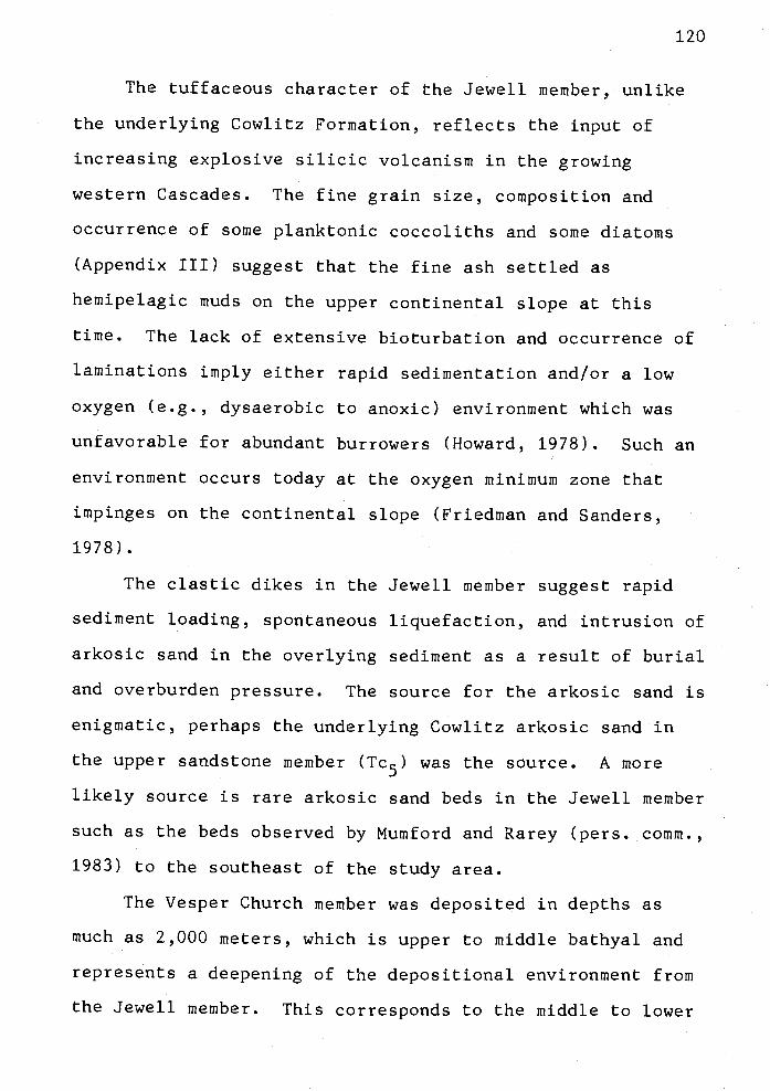
120
The tuffaceous character of the Jewell member, unlike
the underlying Cowlitz Formation, reflects the input of
increasing explosive silicic volcanism in the growing
western Cascades. The fine grain size, composition and
occurrence of some planktonic coccoliths and some diatoms
(Appendix III) suggest that the fine ash settled as
hemipelagic muds on the upper continental slope at this
time. The lack of extensive bioturbation and occurrence of
laminations imply either rapid sedimentation and/or a low
oxygen (e.g., dysaerobic to anoxic) environment which was
unfavorable for abundant burrowers (Howard, 1978). Such an
environment occurs today at the oxygen minimum zone that
impinges on the continental slope (Friedman and Sanders,
1978).
The clastic dikes in the Jewell member suggest rapid
sediment loading, spontaneous liquefaction, and intrusion of
arkosic sand in the overlying sediment as a result of burial
and overburden pressure. The source for the arkosic sand is
enigmatic, perhaps the underlying Cowlitz arkosic sand in
the upper sandstone member (Tc5) was the source. A more
likely source is rare arkosic sand beds in the Jewell member
such as the beds observed by Mumford and Rarey (pers. comm.,
1983) to the southeast of the study area.
The Vesper Church member was deposited in depths as
much as 2,000 meters, which is upper to middle bathyal and
represents a deepening of the depositional environment from
the Jewell member. This corresponds to the middle to lower
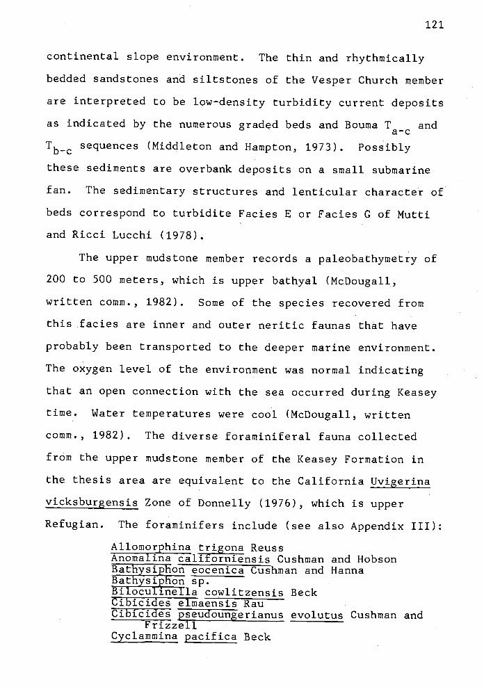
121
continental slope environment. The thin and rhythmically
bedded sandstones and siltstones of the Vesper Church member
are interpreted to be low-density turbidity current deposits
as indicated by the numerous graded beds and Bouma Ta_c and
Tb_c sequences (Middleton and Hampton, 1973). Possibly
these sediments are overbank deposits on a small submarine
fan. The sedimentary structures and lenticular character of
beds correspond to turbidite Facies E or Facies C of Mutti
and Ricci Lucchi (1978).
The upper mudstone member records a paleobathymetry of
200 to 500 meters, which is upper bathyal (McDougall,
written comm., 1982). Some of the species recovered from
this facies are inner and outer neritic faunas that have
probably been transported to the deeper marine environment.
The oxygen level of the environment was normal indicating
that an open connection with the sea occurred during Keasey
time. Water temperatures were cool (McDougall, written
comm., 1982). The diverse foraminiferal fauna collected
from the upper mudstone member of the Keasey Formation in
the thesis area are equivalent to the California Uvigerina
vicksburgensis Zone of Donnelly (1976), which is upper
Refugian. The foraminifers include (see also Appendix III):
Allomorphina trigona ReussAnomalina californiensis Cushman and HobsonBathysiphon eocenica Cushman and HannaBathysiphon sp.Biloculinella cowlitzensis BeckCibicides elmaensis RauCibicides pseudoungerianus evolutus Cushman and
FrizzellCyclammina pacifica Beck
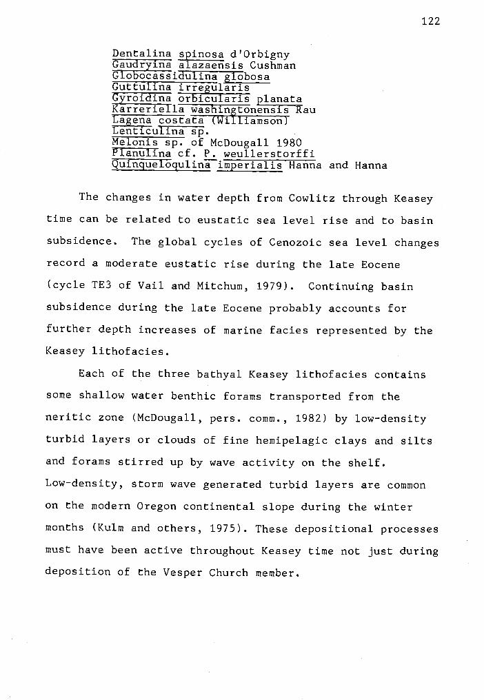
122
Dentalina spinosa d'OrbignyGaudryina alazaensis CushmanGfobocassiii1ina globosaGuttulina irregularisGyroidina orbicularis planataKarreriella washingtonensis RauLagena costata (Williamson)Lenticufina sp.Melonis sp. of McDougall 1980Planuljna cf. P. weullerstorffiQuinguelogulina imperialis Hanna and Hanna
The changes in water depth from Cowlitz through Keasey
time can be related to eustatic sea level rise and to basin
subsidence. The global cycles of Cenozoic sea level changes
record a moderate eustatic rise during the late Eocene
(cycle TE3 of Vail and Mitchum, 1979). Continuing basin
subsidence during the late Eocene probably accounts for
further depth increases of marine facies represented by the
Keasey lithofacies.
Each of the three bathyal Keasey lithofacies contains
some shallow water benthic forams transported from the
neritic zone (McDougall, pers. comm., 1982) by low-density
turbid layers or clouds of fine hemipelagic clays and silts
and forams stirred up by wave activity on the shelf.
Low-density, storm wave generated turbid layers are common
on the modern Oregon continental slope during the winter
months (Kuim and others, 1975). These depositional processes
must have been active throughout Keasey time not just during
deposition of the Vesper Church member.
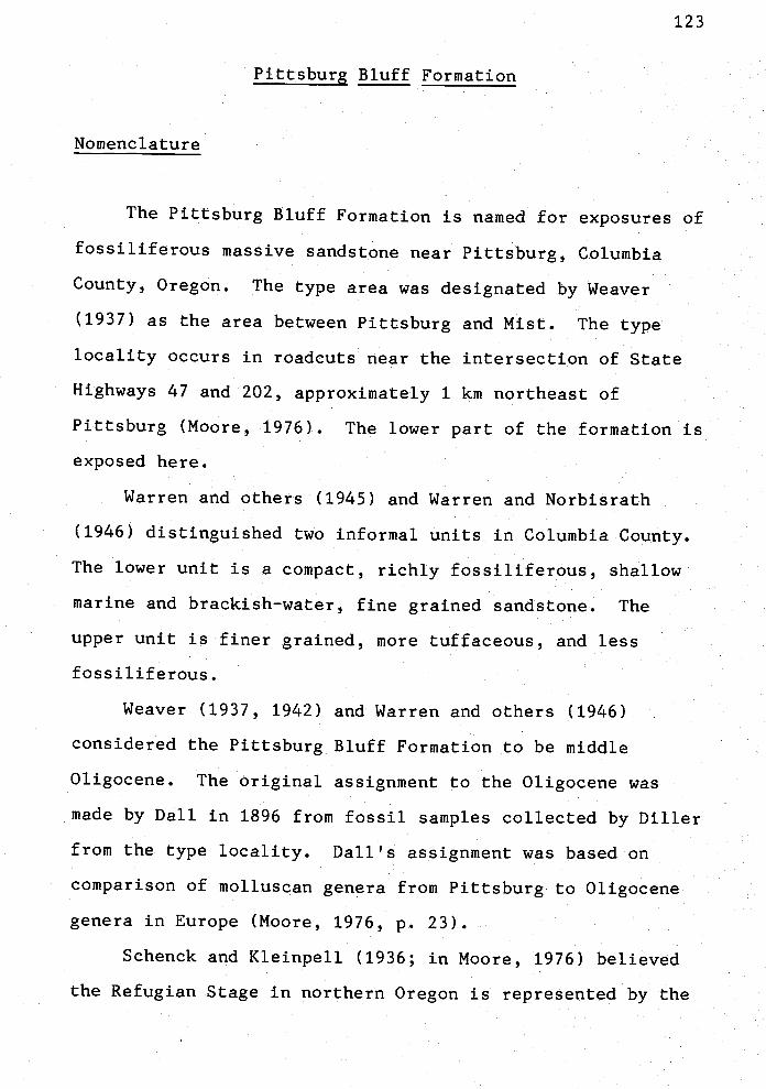
Pittsburg Bluff Formation
Nomenclature
123
The Pittsburg Bluff Formation is named for exposures of
fossiliferous massive sandstone near Pittsburg, Columbia
County, Oregon The type area was designated by Weaver
(1937) as the area between Pittsburg and Mist. The type
locality occurs in roadcuts near the intersection of State
Highways 47 and 202, approximately 1 km northeast of
Pittsburg (Moore, 1976) The lower part of the formation is
exposed here
Warren and others (1945) and Warren and Norbisrath
(1946) distinguished two informal units in Columbia County
The lower unit is a compact, richly fossiliferous, shallow
marine and brackish-water, fine grained sandstone. The
upper unit is finer grained, more tuffaceous, and less
fossiliferous
Weaver (1937, 1942) and Warren and others (1946)
considered the Pittsburg Bluff Formation to be middle
Oligocene The original assignment to the Oligocene was
made by Dali in 1896 from fossil samples collected by Dilier
from the type locality Dali's assignment was based on
comparison of inolluscan genera from Pittsburg to Oligocene
genera in Europe (Moore, 1976, p. 23).
Schenck and Kleinpeli (1936, in Moore, 1976) believed
the Refugian Stage in northern Oregon is represented by the

124
Keasey and Pittsburg Bluff formations. The type locality of
the Pittsburg Bluff contains the Molopophorus gabbi Zone
(Durham, in Weaver and others, 1944) and the Acila shumardi
Zone. Schenck and Kleinpell included the Acila shumardi
Zone in the Refugian. They consider the Refugian Stage to
represent the upper Eocene and lower Oligocene European
stages (Priabonian and Rupelian, respectively) (Fig. 5).
Distribution
The Pittsburg Bluff Formation (Tpb) crops out with a
pattern similar to the Keasey Formation in the Nehalem and
Astoria basins. The resistant strata wrap around the
northward-plunging anticlinal axis of the Oregon Coast
Range. In Columbia County, on the east flank of the Coast
Range uplift, the outcrop pattern of the Pittsburg Bluff
trends north-south to northwest-southeast. Local folds and
faults cause variable strikes and reversals of dip (Newton
and Van Atta, 1976; Kadri and others, unpub. map, 1980).
In the northern part of the thesis area, 26 to 39 km
west of the type area (and on the west flank of the Coast
Range uplift), the Pittsburg Bluff Formation (Tpb) crops out
in a narrow northeast-southwest-trending band and dips
northwest (Plate I). The homoclinal northwestward dipping
unit typically forms ridges or bluffs that stand a few
hundred feet above the lower hummocky hills and valleys of
the underlying less-resistant Keasey mudstones. Dips of

125
strata are gentle, ranging from 100 to 27° to the northwest.
Local reversals and steepening of dip are probably due to
faulting (Plates I and II).
The best localities to observe the Pittsburg Bluff
Formation in the thesis area are: in logging roadcuts in
the upper reaches of the Little Fishhawk Creek valley (N1/2,
sec. 1, T5N, R8W and NW1/4, sec. 6, T5N, R7W); near the
Nehalem River Highway (State Route 202, NW1/4, NW1/4, sec.
30, T6N, R8W); and in logging roadcuts in the Bull Heifer
Creek drainage area (sec. 22, T6N, R7W). Several
well-preserved molluscan fossils were recovered from silty
fine grained bioturbated sandstone in NE1/4, NW1/4, sec. 22,
T6N, R7W.
The Pittsburg Bluff Formation crops out only in the
hills having an elevation greater than 230 m. The formation
does not crop out in the lower valleys. This suggests that
it was once more extensive, probably covering the entire
upper Nehalem River valley area. Downcutting and erosion by
the Nehalem River and its tributaries has removed much of
the formation in the area of the Coast Range anticlinal
axis.
Litholoies, Structures, and Provenance
The Pittsburg Bluff Formation consists of tuffaceous,
micaceous, arkosic, fine to medium grained silty sandstone
which grades into siltstone. Glauconitic sandstone and

126
mudstone are locally abundant and in some exposures
comprises more than 507 of the framework constituents
(locality 335, SE1/4, SW1/4, sec. 22, T6N, R7W and locality
138 NE1/4, SE1/4, sec. 1, T5N, R8W). Sandstones form
resistant structureless bioturbated beds 1 to 3 m thick.
Thin tuffaceous mudstone, 0.3 to 1 m thick, is interbedded
with the thick bedded sandstones (Fig. 28). Rare grit bids
and molluscan fossils occur at the base of some thick
sandstone beds. The molluscan fossils, including
articulated bivalves, are commonly well-preserved and in
growth position, or concentrated on bedding planes as fossil
hash. In weathered outcrops, molds are common where the
shell has been leached by meteoric waters. Spheroidal
calcareous concretions are rare but commonly are
concentrated along beds with fossil hash. In addition to
rich molluscari, foraminiferal and coccolith faunas,
scattered pieces of carbonized wood are preserved. A small
crab (Branchioplat? sp. cf. B. washingtoniana Rathbun) was
discovered in the sandstone (locality 407, SE1/4, SW1/4,
sec. 21, T6N, R7W). A checklist of fossils collected from
the Pittsburg Bluff Formation in the thesis area occurs in
Appendix IV and fossil localities are shown on the geologic
map (Plate I) and listed in Appendix X.
Fresh exposures of the Pittsburg Bluff Formation are
rare. The tuffaceous strata are yellowish gray (5Y7/2) to
light gray (N7). A spheroidal fracture pattern is common in
weathered exposures.
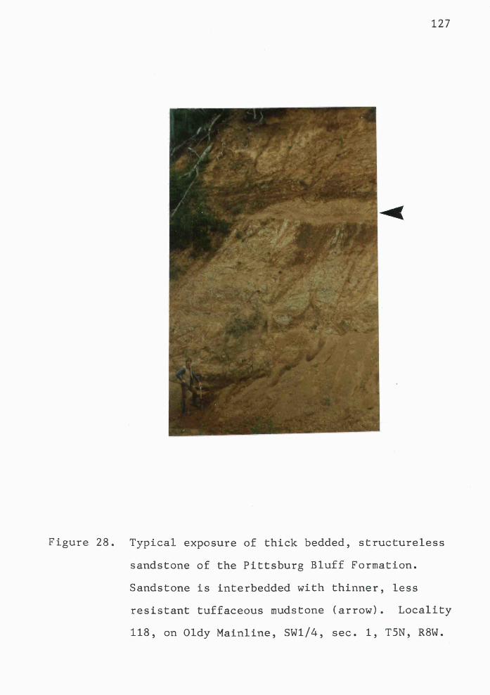
127
Figure 28. Typical exposure of thick bedded, structureless
sandstone of the Pittsburg Bluff Formation.
Sandstone is interbedded with thinner, less
resistant tuffaceous mudstone (arrow). Locality
118, on Oldy Mainline, SW1/4, sec. 1, T5N, R8W.

128
Three thin sections of sandstones from the Pittsburg
Bluff Formation were examined. One of these (sample 138) is
a greensand consisting of glauconite pellets or grains
(487), quartz (127), reworked sedimentary rock fragments
(97), feldspar (17), muscovite (17), and abundant clay
matrix (2O7). The glauconite grains are well rounded. The
very abundant silt-sized angular grains of quartz, feldspar
and mica in the clay matrix precludes the chance that
currents may have winnowed the bioturbated sediments or that
the matrix is diagenetic in origin. Most detrital matrix
probably formed by bioturbation and mixing by infauna (e.g.,
mollusks, crabs, worms, etc.) of better sorted clay, silt
and sand layers.
Pittsburg Bluff sandstones typically have greater than
1O7 matrix and thus are classified as wackes. The framework
constituents of two such wackes (from localities 315, 347)
include dominantly subangular monocrystalline and
polycrystalline quartz (33-497), biotite (1O-157) and
muscovite (3-57), subrounded volcanic lava fragments
(4-157), plagioclase (5-1O7), inicrocline and orthoclase
(27), glauconite (27) and opaques (137). The matrix
consists of finely disseminated limonite and fine silt.
These sandstones are subarkoses to feldspathic litharenites
in Folk's (1980) classification (Fig. 29) or subfeldspathic
lithic and feldspathic wackes in Williams and others (1954)
classification (Fig. 29).
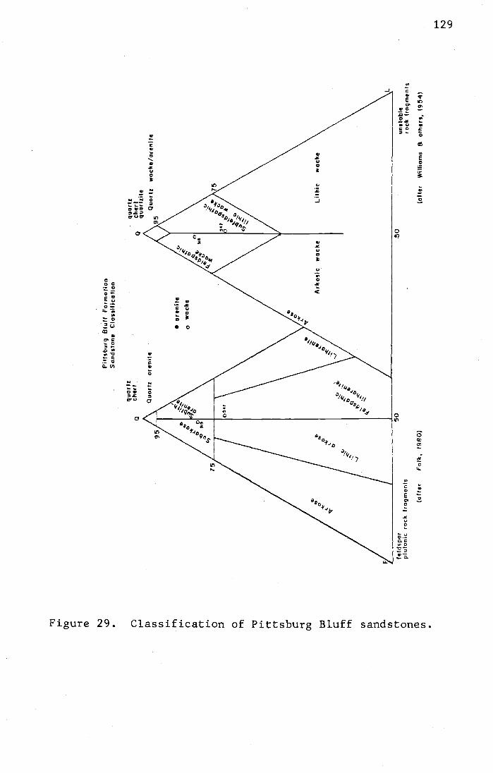
.Ii
'-I CD N) a U
)U
) l-' () 0 0 Cr
Cr
U)
U)
p)
U) 0 CD U)
Ptfs
burq
Blu
ff F
orm
otio
nS
and;
tone
Cla
ssifi
catio
n
quor
lzqu
art!
cher
lnu
ar t
,iI.
feld
spar
50-5
0un
stab
lepl
uton
ic r
ock
frag
men
ts-
rock
frag
men
ts
(afte
rF
olk,
198
0)to
tter
Will
iam
s &
olh
ers
1954
)
N)


132
In addition, a regional unconformity is suggested by
mapping. The Pittsburg Bluff Formation in the study area
overlies the upper Keasey mudstone (Tk3) (Plate I), but
between Jewell and Birkenfeld, 10 km to the east, the
Pittsburg Bluff directly overlies the Vesper Church
turbidite unit of the Keasey Formation (Tk2) (geologic map
of Olbinskj, 1983). This thinning, or loss of section, of
the upper Keasey mudstone (Tk3) to the east can be seen on
the geologic map (Plate I). The unit goes from 450 to 305 m
in a northeast direction along strike across the study area.
Generally, the Pittsburg Bluff sandstones are
bluff-farmers and a topographic change occurs between the
sandstones and slope-forming Keasey mudstones. The sharp
contact between the two units is exposed in one roadcut
(NE1/4, sec. 11, T5N, R8W) on East Humbug Road. A zone of
spring-seeps marks the contact between the underlying
impermeable Keasey mudstone and the overlying permeable
Pittsburg Bluff sandstone forming a perched water table.
The seepage zone is marked by lush vegetation in the roadcut
and is most obvious during the late summer.
Warren and Noi-bisrath (1946) also noted the
disconformable relationship between the Pittsburg Bluff
Formation and the underlying Keasey Formation in Columbia
County.
The nature of the contact with the overlying, and
partly coeval, Oswald West mudstone is uncertain because the
contact is covered. However, from regional mapping, this

133
contact is probably conformable as the Oswald West mudstone
appears to interfinger with Pittsburg Bluff sandstone.
Rarey (in prep.) has found that the Pittsburg Bluff
Formation gradually becomes less arkosic, thins, becomes
finer grained and more glauconitic, and passes laterally
into laminated silty mudstone and sandy siltstone southwest
of U. S. Highway 26. Peterson (1984) has mapped and
documented a similar facies change in the Pittsburg Bluff
Formation to deeper water more silty mudstone of the Oswald
West formation immediately northwest of this study area.
The Oswald West mudstone also overlies the Pittsburg Bluff
sandstone in this thesis area and is exposed in the Beneke
quarry (Plate I, sec. 14, T6N, R7W).
In Columbia County, the sandstone-rich Oligocene to
lower Miocene Scappoose Formation disconformably overlies
the Pittsburg Bluff Formation with slight angular
discordance (Warren and Norbisrath, 1946). This contact is
locally marked by a cobble conglomerate (Moore, 1976).
Mapping in the study area suggests that the lower to
middle Miocene Silver Point member of the Astoria Formation
unconformably overlies the Pittsburg Bluff Formation (Plate
I). The Pittsburg Bluff Silver Point contact is generally
poorly exposed but one can follow the section as it changes
from structureless silty fine grained sandstone with
spheroidal fracture to well-indurated thin bedded and
laminated micaceous arkosic fine grained sandstone and dark
rnudstone with abundant carbonaceous material on bedding

134
planes. This stratigraphic sequence can be followed in
unnamed logging roadcuts in NW1/4 sec. 25, T6N, R8W.
The thickness of the Pittsburg Bluff Formation within
the thesis area is estimated to be 200 to 500 m. This is
based on projected contacts of the Pittsburg Bluff Formation
(Tpb) with the underlying upper mudstone member of the
Keasey Formation (Tk3) and the overlying Silver Point member
of the Astoria Formation (Tsp); both contacts are poorly
exposed. Some of the sandstone thickness was removed by
erosion prior to deposition of the Silver Point member of
the Astoria Formation which prevents better estimation of
the original thickness. Warren and Norbisrath (1946)
estimated the overall thickness of the unit in Columbia
County to be 252 m. Moore (1976) measured 200 m in the type
area.
and Correlation
The original assignment of the Pittsburg Bluff
Formation to the Oligocene by Dali on the basis of molluscan
fauna appears to be valid still. Schenck (1927a) designated
a middle Oligocene age. Weaver (1937) and Warren and
Norbisrath (1946) agreed with the middle Oligocene age.
Moore (1976) concurred with this assignment in the type area
near Pittsburg, Oregon.
Armentrout's (1981) revision of the Tertiary time scale
for the Pacific NW may cause reassignment of the age of

135
these strata. The type section of the Pittsburg Bluff
Formation contains the Acila shumardi Zone and Molopophorus
gabbi Zone which occur within the Refugian Foraminiferal
Stage (Schenck and Kleinpell, 1936). In the revised
Tertiary time scale, the Refugian Stage is considered
entirely within the late Eocene (Armentrout, 1981).
Moore (1976, p. 23-26) explained that the boundaries of
the type section of the Refugian Stage in California were
originally defined using both molluscan and foratniniferal
faunas. However, more recently the stage has been
characterized strictly by foraminiferal content. This
renders the Refugian Stage useless to molluscan
biochronology because of the significant difference in
provincialism of forams and mollusks over large distances
(Moore, 1976). Also, some workers (Addicott, 1972, in
Moore, 1976) have suggested that the Refugian Stage and the
overlying Zemorrian Stage (Fig. 5) are, in part,
contemporary because of the co-occurrence of index fossils
of each stage in certain stratigraphic sections. In the
type area of the Pittsburg Bluff, near Vernonia, Oregon,
coccoliths recovered from the Pittsburg Bluff Formation
indicate a late Eocene to earliest Oligocene age (Moore,
1976).
Many of the molluscan assemblages found in this study
are typical of Pittsburg Bluff faunas (Moore, 1976; written
comm., 1982) and belong in the Galvinian Molluscan Stage and
Refugian Foraminiferal Stage which are late Eocene according
136
to the revised time scale (Armentrout, 1981). From
lithologic similarity, stratigraphic position and faunal
assemblages, there seems no doubt that these sandstones are
part of the Pittsburg Bluff Formation.
However, using the new Tertiary time scale, the age
range of the upper part of the formation in the study area
is not certain (either .Galvinian Refugian or Zemorrian or
both) because the molluscan and coccolith age-diagnostic
fossils collected from the same locality disagree. For
example, a gastropod and coccoliths were collected from
locality 424. The gastropod Turricula? sp. cf. 1'.
washirigtonensis (Weaver) is characteristic of the Turritella
porterensis Zone of Hickman (1974). This molluscan zone is
considered to be equivalent to the late Refugian
Foraminiferal Stage (Moore, written comm., 1982) and occurs
in the upper part of the Lincoln Creek Formation in
southwest Washington. In contrast, an assemblage of five
coccolith species (listed in Appendix IV) were recovered
from locality 424 that indicate a probable late Oligocene
age (David Bukry, written comm., 1982). One of the species,
Dictyococcites bisectus (Hay et al.), is characteristic of
calcareous nannoplankton subzone 19b (Bukry, 1981) and zone
NP25/NN1 (Martini, 1971) (Fig. 5). These nannoplankton
zones are equivalent to the late Zemorrian or late Oligocene
on the revised Tertiary time scale (Armentrout, 1981).
It may be that the Galvinian Refugian mollusks at
this locality (424) reflect provincialism and a shallow

137
marine environment that persisted locally for a longer time
whereas the planktonic coccoliths, which are less controlled
by facies and thus more reliable for time-stratigraphic
study, reflect the younger age of this unit. (This is
similar to the provincialism between foranis and mollusks
noted by Moore in 1976.)
As the coccoliths indicate only a probable age, it
appears that the best estimate of the age of the Pittsburg
Bluff Formation in the thesis area is latest Eocene to
Oligocerie, spanning the upper Refugian and part of the
Zemorrian stages.
The Pittsburg Bluff Formation is correlative to the
upper part of the Lincoln Creek Formation in southwest
Washington, to the Tunnel Point Formation in the Coos Bay
area, to the Eugene Formation of the Willamette Valley, and
to the Alsea and Yaquina formations near Newport, Oregon
(Schenck, 1927a; Weaver and others, 1944; Moore, 1976;
Snavely and others, 1969; MacLeod and Snavely, 1973; Niem
and Van Atta, 1973).
The lower part of the Oswald West mudstone is also
correlative to the Pittsburg Bluff Formation. The type
Oswald West mudstone is early Oligocene to early Miocene
(Cressy, 1974). However, the base of this unit is unexposed
and the earliest age of the Oswald West has never been
defined in the type area (Cressy, 1974, p. 29-30). Workers
who have mapped adjacent areas of western Clatsop County

138
(Penoyer, 1977; Smith, 1975; Tolson, 1976; M. Nelson, 1978;
Coryell, 1978; Peterson, 1984; Rarey, in prep.) have
included thick mudstones that yield Zemorrian, Refugian, and
in some cases Narizian, fossils in the Oswald West
formation. These Refugian mudstones are, therefore, age
correlatives of the Pittsburg Bluff Formation.
Because the thesis area lies between areas having two
different stratigraphic nomenclatures, an attempt is made
here to merge the nomenclature. It is well-accepted that
Tertiary shallow-marine facies grade into deeper marine
facies from east to west in northwest Oregon (Niem and Van
Atta, 1973; Cressy, 1973; Penoyer, 1977; Peterson, 1984).
This thesis area lies about mid-way between the well-studied
shallow-marine formations of Columbia County (e.g.,
Pittsburg Bluff, Scappoose formations), and the deep-marine
units (e.g., Oswald West, Astoria Silver Point mudstones)
exposed along the Oregon Coast. The shallow-marine (inner
shelf and deltaic) sandstones apparently grade subtly into
finer grained sedimentary rocks progressing from east to
west (Peterson, 1984). The interfingering relationship is
very difficult to map precisely, and the contacts are
uncertain due to discontinuous exposure, dense forest and
thick soil horizons. Low faunal density also complicates
the issue.
Nevertheless, the thick bluff-forming arkosic and
tuffaceous bioturbated sandstone of the Pittsburg Bluff
139
Formation appears to grade laterally into correlative sandy
siltstone, tuffaceous mudstone arid thinner glauconitic
sandstone in the vicinity of Saddle Mountain near the
western boundary of the study area (shown schematically on
Plate I). This change is also noted south of U. S. Highway
26 (Rarey, in prep.) and in the Kiaskanine River area
(Peterson, 1984).
The informal name Oswald West mudstone is applied to
sequences in which the lithology is predominantly mudstone
(>70%) and thick bluff-forming arkosic, tuffaceous sandstone
is lacking. The lithofacies dominated by thick
structureless Refugian Zemorrian age sandstone (>70%) is
described as the Pittsburg Bluff Formation. Thus, it is
herein assumed that the Oswald West mudstone extends down in
the upper Refugian, and that in its lower part, the Oswald
West is coeval to the Pittsburg Bluff Formation.
Depositional Environment
The depositional environment of the Pittsburg Bluff
Formation is interpreted to be shallow-marine inner to outer
shelf. Paleoecology of molluscan faunas collected in the
study area indicate water depths of 20 to 200 m (Moore,
written comm., 1982). Fossiliferous rocks are concentrated
in the eastern part of the thesis area (e.g., sec. 22, T6N,
R7W, Plate I). The molluscan fossil assemblage from the Elk
Mountain Porter Ridge area, north and east of the present

140
study area, indicates a slightly narrower range of water
depths (20 to 50 m, written comm. to Jeff Goalen from Dr.
Ellen Moore, 1982).
Genera from the molluscan fossil collection which have
extant species offer some information about the
paleoecology. The subgenus Pitar (Pitar) is restricted to
sand flats, sand bars or protected bays (Moore, 1976, p.,
18). Dentalium (Fissidentalium) sp. lives under a thin
sediment layer in water depths of 20 m or more. Dr. Moore
(1976, p. 17) characterized the Pittsburg Bluff faunas as
filter-feeders, detritus-feeders and carnivores that lived
on the sea floor or in the substrate. Primary sedimentary
structures are not observed in outcrop, and the lack of
structures is probably due to thorough bioturbation by
infauna.
The Tertiary marine setting is comparable to the modern
Oregon continental margin. The modern facies are analogous
to the ancient depositional environments and serve as a
depositional model. Detailed sedimentological studies
reveal three distinct sedimentary facies on the modern
Oregon shelf (Kulm and others, 1975). These facies are
composed primarily of three sedimentary components;
detrital, biogenic, and authigenic (glauconite).
The sand facies is distributed on the inner shelf at
depths of 90 to 100 m where sediment supply from river
systems is large (Kulm and others, 1975). This facies tends
to be laminated and composed of fine sand.

141
The mud facies is irregularly distributed and tends to
concentrate near rivers having high sediment discharge.
Silt and clay size sediment that compose this facies are
deposited during summer seasons. The sediment discharge of
the Columbia River, for example, is greatest during the
summer. Ocean swells and storm waves are reduced in
intensity, periodicity and wavelength during the summer
season and, therefore, disturb the shelf sediment less (Kuim
and others, 1975). Thus, silt and clay size sediment tends
to settle from suspension on the middle to outer shelf
during the summer but is carried over the shelf edge and
onto the continental slope during the winter.
The mixed sand and mud facies occurs seaward of the
inner shelf sand facies. The former is a facies produced
from sediment homogenization by burrowing benthic organisms.
Intensity of bioturbatiori and density of benthic organisms
increases as water depth increases. Glauconite occurs on
the outer shelf seaward of the mixed sand and mud facies and
on topographic highs as relict sand formed during
Pleistocene sea level lows (Kuim and others, 1975).
Three turbid water layers occur within the water column
formed in response to density contrast between clear water
and mixed sediment/water (or cloudy) layers. These turbid
layers are capable of transport of suspended sediment over
the continental shelf edge. During winter when storm energy
and wave amplitudes are greatest, the turbidity of the three
water layers increases. This signifies seaward transport of

142
sediment from the nearshore marine to the slope environment
of deposition.
If the present-day sedimentological relations can be
used to model the late Eocene and Oligocene seas, then a
depositional model for the Pittsburg Bluff Formation can be
developed. Molluscan paleoecology indicates a sandy and
shallow substrate. Depths of 20 to 200 meters correspond to
the inner shelf. Subgenera such as Pitar (Pitar), Crenella,
and Nemocardium (Keenaea) (?) lorenzanum live on sand
substrates but not in high energy environments (Moore, 1976,
p. 18). Delectopecten prefers silty substrates and its thin
shell wall indicates adaptation to quiet water environments.
The latter genus was collected from fine grained sandstone
in the Pittsburg Bluff Formation in the western part of the
thesis area (locality 145) suggesting a deepening of the
shelf in that direction.
The Pittsburg Bluff depositional model is one of a very
gently sloping inner to outer shelf protected from high
energy wave conditions. Paleodepths within the thesis area
are a maximum of 200 m during Pittsburg Bluff time. In the
type area in Columbia County, water depths of 10 to 20 m and
an intertidal beach environment are indicated by the
paleoecology of mollusks (Moore, 1976). Supratidal marsh
environments are indicated by coal seams that occur in the
Pittsburg Bluff section in Columbia County. An average
slope of 1 meter per 100 meters (or approximately 1/2°) can

143
be calculated for this shelf on a northwest-southeast
transect from the type area to the present study area.
In the Oligocene sea, glauconite may have formed in
shallow water and on isolated or protected topographic
highs, resulting in the observed patchy distribution. It
typically forms as fecal pellets of mud-ingesting infaunas
in a low energy slightly reducing environment with slow
sedimentation rates (McRae, 1972).
Pelletal glauconitic sandstone within the thick
arkosic tuffaceous Pittsburg Bluff sandstone does not seem
to fit the modern Oregon shelf analogy in that it occurs as
relict sands on the modern low energy outer shelf and slope
mud environments (Kuim and others, 1975). More likely,
glauconite beds in the Pittsburg Bluff may have resulted
from redistribution of glauconite by bottom currents or
storm wave-induced currents into higher energy environments.
Similar transported glauconitic greensands occur in some
quartz sandstones in the Cambrian of Wisconsin (Daiziel and
Dott, 1970). Concentrations of glauconite are common at
nonconformities or marked periods of nondeposition.
The lower Oswald West mudstone in the southwest part of
the thesis area is probably coeval to part of the Pittsburg
Bluff Formation (Plate I). These mudstones were deposited
on the outer shelf to upper slope seaward of the Pittsburg
Bluff Formation during the late Eocene and Oligocene. In
the depositional model, these mud-size suspended sediments
derived from the nearshore and surf zones were transported

144
offshore as turbid layer currents to the shelf edge and
deposited from suspension on the outer shelf and upper
slope. Maximum transport of silt and clay occurred during
storm seasons, as in the modern analogue. This sediment
by-pass contributed to a slow depositional rate of outer
shelf silt and increased the sedimentation rate on the
adjacent continental slope (Kuim and others, 1975).

145
Oswald West Mudstone
Nomenclature and Distribution
The informal name Oswald West mudstone (Tow) was first
applied by Niem and Van Atta (1973) and Cressy (1974) to 549
in of Zemorrian age bioturbated silty mudstone and tuffaceous
siltstone exposed in the sea cliffs along Short Sand Beach
in Oswald West State Park on the northwest Oregon coast.
Warren and others (1945) measured a section and collected
fossils at this locality. They referred to the section as
Beds of Blakeley age because faunas collected there could be
correlated to the Echiriophoria rex Zone and E. apta Zone
that occur in the type section of the Blakeley Formation of
western Washington (Weaver, 1937; Weaver and others, 1944).
Warren and others (1945) believed that the sedimentary
structures in the Short Sand Beach section "indicated unique
conditions for Blakeley sedimentation", meaning that the
facies observed does not occur elsewhere in the parts of
northwest Oregon that they mapped. In a later paper, Warren
and Norbisrath (1946) also applied the name Scappoose
Formation for the first time to Beds of Blakeley age that
occur in Columbia County. These beds are predominantly
friable thick arkosic sandstone and are quite different from
the deep marine niudstone strata at Oswald West State Park.

146
The Oswald West mudstone is an informal formation name
applied to a deep-marine mudstone facies that is Oligocene
to early Miocene in age. It lies stratigraphically between
the upper Eocene to Oligocene Pittsburg Bluff Formation and
lower to middle Miocerie Astoria Formation. Due to cover and
a thick basalt sill, the base of this formation was not
defined at the type section (Cressy, 1974, p. 23, 29).
Murphy (1981, p. 38) showed that the base of the Oswald West
mudstone could be defined in the Nicolai Mountain Westport
area (16 km north of this study area) by its disconformable
contact with the underlying sandstone-rich Pittsburg Bluff
Formation.
The Oligocene Oswald West mudstones are, however,
lithologically similar to the thick structureless tuffaceous
mudstone that forms much of the type upper Eocene Keasey
Formation. Distinguishing the two formations in Clatsop
County on the basis of lithology is possible where the
Pittsburg Bluff sandstone lies between them. But, where the
sandstone-rich Pittsburg Bluff Formation grades to mudstone,
the distinction between similar mudstones of upper Eacene
(Keasey) and of Oligocene (Zemorrian) age is not possible
without good paleontological data.
As a result, other workers who have mapped areas west
of this study area (Penoyer, 1977; Tolson, 1976; M. Nelson,
1978; Coryell, 1978; Peterson, 1984) extended the definition
of the Oswald West mudstone to rocks containing Refugian,

147
and even Narizian forams. Extending the range of the Oswald
West mudstone causes some confusion about its stratigraphic
relationship to the Pittsburg Bluff, Keasey and Cowlitz
formations.
I suggest that the Oswald West mudstone (Tow) be
considered a long-ranging deep-marine (slope and outer
shelf) facies which is the stratigraphic equivalent to the
combined Scappoose, Pittsburg Bluff and Keasey Formations.
These units along with the Cowlitz Formation have been
collectively referred to as the Nehalem Group (Van Atta,
1971, p. 17). The Oswald West mudstone may interfinger with
each of the three younger formations of the Nehalem Group in
response to rising and falling of the Paleogene sea.
Peterson (Plate IV, 1984) concurs with this suggestion and
shows the lateral relationship of the Keasey and Pittsburg
Bluff formations with the "upper" and "lower" parts of the
Oswald West mudstone.
The Oswald West mudstone crops out in three
outlier-like patches within the thesis area and represents a
lateral facies of the Pittsburg Bluff tuffaceous arkosic
sandstone. The first is on the western boundary near Saddle
Mountain (W1/2 sec. 11, NW1/4 sec. 14, NE1/4 sec. 15, T5N,
R8W); the second is on the northern border above a Grande
Ronde basalt sill (NW1/4, NW1/4 sec. 16 and NEI/4, NE1/4
sec. 17, T6N, R7W); and the third is in the northeast
corner of the thesis area around the Beneke dike quarry

148
(NW1/4 sec. 14, T6N, R8W) (Plate I). On the geologic map of
Oregon west of the 121st meridian (Wells and Peck, 1961),
undifferentiated Eocene-Oligocene marine rocks form an
arcuate pattern around the northward-plunging "Coast Range
Anticlinorium". The Oswald West mudstone is part of that
undifferentiated sequence. The Oswald West formation dips
from 70 to 31° to the southeast (Plate I) which opposes
regional northwestward dip and probably reflects drag by
many small cross-cutting faults and perhaps slumps.
Lithologies and Structures
The dominant lithologies are thick bedded tuffaceous
mudstone and sandy siltstone, and minor silty sandstone. In
outcrop, the tuffaceous mudstone and siltstone are
structureless and bioturbated but in rare cases are faintly
laminated. The laminations are formed by carbonized wood
chips. Fresh exposures were not observed but weathered
Oswald West mudstone is yellowish gray (5Y7/2). The small,
hook-shaped trace fossil Sciarituba (Chamberlain, written
comm., 1982) is ubiquitous in the structureless Oswald West
mudstones. The strata are rnicromicaceous. In one locality,
the rock is displays uncommon platy jointing (locality 382,
NE1/4, NE1/4 sec. 17, T6N, R7W). Probably the platy
jointing is caused by baking due to an adjacent intrusion of
Miocene basalt.
149
Fossils recovered from the Oswald West mudstone include
forams, articulated pelecypods, scaphopods and trace
fossils. Mollusks recovered from the unit include:
Dentalium (Fissidentalium?) sp. cf. D. (F.?)laneensis Hickman
Pitar CPicar)? sp. cf. P. (p.) dalli WeaverDelectopecten sp.cardiidsnuculani ids
The large non-diagnostic foram Cyclammina pacifica is also
abundant in the tuffaceous mudstone. A complete list of the
fossil collection is presented in Appendix V. No
age-diagnostic fossils were collected from this formation in
the study area.
Contact Relations
The lower part of the Oswald West mudstone in the study
area is a deep-water and finer grained facies of the
sandstone-rich Pittsburg Bluff Formation. Mapping suggests
that the unit probably interfingers with the Pittsburg Bluff
in the southwest part and overlies the Pittsburg Bluff in
the northern part of the study area (Plate I).
The contact is conformable or paraconformable (Dunbar
and Rogers, 1957) with the underlying Pittsburg Bluff
Formation. As used in this sense, the base of the Oswald
West mudstone is defined by a lithologic change rather than
a change in faunal character. Where the sedimentary facies
150
is dominated by thick bedded bioturbated tuffaceous mudstone
the term Oswald West is applied. Where the facies is
dominated by thick arkosic tuffaceous fine grained sandstone
the name Pittsburg Bluff Formation is used. Thus, the
Oswald West mudstone was in part deposited on the Pittsburg
Bluff shelf sandstone in the northern part of the study
area.
Peterson (1984) and Rarey (in prep.) also mapped the
gradual change of the Pittsburg Bluff sandstone into a
dominantly (Oswald West) mudstone facies immediately to the
southwest and west of this study. These workers, along with
Murphy (1981) and Penoyer (1977), found that a younger
Zemorrian Saucesian (Oligocene to early Miocene) Oswald
West mudstone overlies the Pittsburg Bluff Formation.
Rarey (in prep.) has noted that a minor section of the
Pittsburg Bluff sandstone facies can be mapped near U. S.
Highway 26 (4.8 km southwest of the study area) and that
this sandstone facies undergoes an interfingering facies
change to very well laminated mudstones and thick
glauconitic sandstone beds of the Oswald West mudstone. He
suggests that these thick glauconitic sandstones and
laminated mudstones mark the base of the Oswald West
mudstone with the underlying structureless upper mudstone
member of the Keasey Formation (Tk3) when the intervening
thick arkosic sandstone facies of the Pittsburg Bluff
Formation is missing western Clatsop County.
151
The Silver Point member and Angora Peak member of the
Astoria Formation unconforrnably overlie the Oswald West
mudstone. The contact is not exposed in the thesis area.
The unconformable relationship between the Oswald West and
the Silver Point member of the Astoria Formation has been
observed in other areas of western Clatsop County (Peterson,
1984; Neel, 1976; Penoyer, 1977; Tolson, 1976; M. Nelson,
1978).
Near the type section of the Oswald West mudstone, an
angular unconformity between the Oswald West mudstone and
the Angora Peak member of the Astoria Formation is suggested
by the following: a sharp lithologic change from deep-marine
mudstone to shallow-marine pebbly arkosic sandstone and
volcanic pebble conglomerate; Blakeley age (Oligocene)
mollusks in the underlying Oswald West mudstone and Temblor
age (middle Miocene) mollusks in the overlying Astoria,
implying that the intervening Vaqueros Stage (lower Miocene)
is absent; abrupt change in foram and trace fossil
paleoecology that is attendant to the lithologic change from
Oswald West mudstone to Astoria Formation (Angora Peak
member) sandstone (Cressy, 1974; Cooper, 1981).
Fossils recovered from the type Oswald West mudstone
indicate normal marine sedimentation at upper bathyal water
depths. The overlying Angora Peak sandstones are very
shallow-marine, deltaic and fluvial deposits which succeeded
a rapid shallowing of the depositional environment (Cressy,
152
1974; Cooper, 1981). Murphy (1981) placed the contact
between the Oswald West inudstone and clean arkosic Big Creek
member sandstones on a persistent glauconite bed in the
Nicolai Mountain Westport area.
and Correlation
The age of the Oswald West mudstone is early Oligocene
to early Miocene and is defined on the basis of molluscan
and foraminiferal assemblages. The original assignment by
Warren arid others (1945) to the molluscan Blakeley Stage
implies an early Oligocene age for the type section based on
the correlation of the Echinophoria rex Zone to the early
Zemorrian Foraminiferal Stage (Moore, 1984). Warren and
others (1945) also correlated the Beds of Blakeley Age at
the type Oswald West section to the E. apta Zone, which is
equivalent to the late Zemorrian and early Saucesian
Foraminiferal Stages that are currently assigned to the late
Oligocene and early Miocene, respectively (Moore, 1984).
Zemorrian (Oligocene) and Saucesian (lower Miocene)
foraminifers have also been collected from the type section
(Cressy, 1974; Niem and Van Atta, 1973). Other workers
(Penoyer, 1977; Neel, 1976; M. Nelson, 1978; Tolson, 1976;
Peterson, 1984) have extended the range of the Oswald West
mudstone down to the Refugian, and possibly the Narizian,
Foraminiferal Stage (upper Eocene). No age diagnostic

153
faunas were collected from the Oswald West mudstone in the
study area.
The Oswald West tnudstone is correlative to the arkosic
tuffaceous fine grained sandstone of the Pittsburg Bluff
Formation and to the Scappoose Formation of the northeastern
£ lank of the Oregon Coast Range, to the Alsea Formation,
Yaquina Formation and Nye Mudstone of the central coast
area, and to the Lincoln Creek Formation of southwest
Washington (Fig. 4).
Depositional Environment
The Oswald West mudstone was deposited on the outer
shelf or upper slope of the continental margin. The
depositional environment was largely seaward of the shelf
environment represented by the Pittsburg Bluff Formation.
The very fine grain size, lack of primary sedimentary
structures and bioturbation are characters of the mud facies
on the middle to outer modern Oregon continental shelf and
upper slope (Kuim and others, 1975). The modern mud facies
is thickest in areas adjacent to coastal rivers that have
high seasonal discharge, such as the Columbia River. An
irregular distribution on the outer shelf and upper slope is
also a character of the mud facies. As the Oswald West is
predominantly mudstone with patchy distribution and is
linked to deposition of Pittsburg Bluff shelf sandstone, the

154
Oswald West is modeled after the modern Oregon outer shelf
mud facies (Kulm and others, 1975) and upper slope
depositional environments.
Cressy (1974) proposed a depositional model for the
Oswald West mudstone in which the bathyal mudstones and
siltstones were deposited in pro-delta or delta-slope
environments coupled to the coeval Scappoose Formation delta
on the northeastern flank of the Oregon Coast Range. Minor
sedimentary structures and features (e.g., rare graded
turbidites, contorted bedding, mudflow deposits, clastic
dikes) are similar to those in pro-delta slope sediments and
are indicative of rapid sedimentation and loading in a
deep-water pro-delta to delta-slope environments.
In the study area, however, a different depositional
model is envisioned for these older Oswald West mudstones.
Because the upper Eocene Oligocene Oswald West mudstone is
in part correlative to the Pittsburg Bluff in the southern
part of the study area and overlies the Pittsburg Bluff in
the northern part of the study area, an alternative
transgressive shelf slope (non-deltaic) model is
suggested. This field relationship implies that onlap of
upper slope outer shelf Oswald West mud facies onto
Pittsburg Bluff shelf sand occurred during the Oligocene.
This transgression can be tentatively correlated to cycle
TO1 (Vail and Mitchum, 1979; Vail and Hardenbol, 1979).

155
Large volumes of tuffaceous silt and clay that were
erupted from the active Western Cascades volcanic arc were
dispersed over a wide area of the adjacent middle to outer
shelf and slope by mid-layer turbidity currents. In
addition, bottom-layer turbidity currents generated by long
wavelength winter storm waves also transported very fine
"Pittsburg Bluff" sand from inner middle shelf and
nearshore environments into this deeper-marine environment.
The fine sand, silt and clay layers were homogenized by
burrowing infauna and filter feeders to form the thick
structureless silty mudstone and sandy siltstone that now
comprises the Oswald West mudstone.
A slow sedimentation rate is implied by the extensive
bioturbation (Howard, 1978). The Helminthoida burrows,
which are common in the unit, are associated with the
Zoophycos trace fossil assemblage which indicates deposition
at bathyal depths (e.g., upper slope depths) (Chamberlain,
in Cressy, 1973). The abundant large forams, Cyclammina
pacifica are the pelagic component in the hemipelagic
sediment. This, along with other forams and other
planktonic microorganisms may have absorbed suspended clays
by filter-feeding and aided flocculation. The unbroken
valves of nuculaniids and Pitar imply low energy normal
marine conditions below wave base for the Oswald West
mudstone.

156
Silver Point Member of the Astoria Formation
Nomenclature and Distribution
The informal name Silver Point mudstone member was
proposed by Smith (1975) for well-bedded and laminated
mudstones of the lower to middle Miocene Astoria Formation.
The type section for the member occurs along the sea cliffs
at Silver Point, approximately 5 km south of Cannon Beach,
Oregon and 38 km from this study area. The thickness of the
Silver Point member in the type area is approximately 200 m
(Smith, 1975).
The Silver Point member (Tsp) crops out only in the
northwest part of the study area (Plate I). The unit dips
from 9° to 14° northward except where drag along faults has
increased dips to as much as 22°. This laminated rnudstone
unit is the only member of the Astoria Formation that occurs
in the thesis area. The best exposures occur along logging
roadcuts on the \est Tidewater Road (W1/2 sec. 18, T6N, R7W)
and Tidewater Summit Road (NE1I4, SE1/4 sec. 19, SE1/4,
SE1/4 sec. 18, and SW1/4, SW1/4 sec. 17, T6N, R7W). Because
it weathers easily, the unit forms low stream-dissected
ridges.
The Silver Point member is uncoriformably underlain by
the fossiliferous shallow-marine sandstones of the Pittsburg
Bluff Formation. The lithofacies is mapped and tentatively
157
assigned to the upper Silver Point member on the basis of
lithologic similarity to the upper Silver Point member
described by Smith (1975), by stratigraphic position, and by
continuous mapping of the unit from the study area to the
type section through the thesis areas of Peterson (1984),
Penoyer (1977), Neel (1976), Smith (1975) and Tolson (1976).
Lithology and Structures
Smith (1975) subdivided the type Silver Point into two
units. The lower unit is a facies dominated by rhythmically
bedded to thick arkosic turbidite sandstones and laminated
micaceous mudstone in nearly equal percentages. The upper
part of the member is thin bedded and finer grained and
consists largely of interlaminated micaceous siltstone, very
fine grained sandstone, and claystone.
In the thesis area, the Silver Point member consists of
365 m of laminated to thin-bedded micaceous very fine
grained arkosic sandstone, siltstone and mudstone. Coarse
flakes of mica are typically coarser grained than other
clastic constituents of the rock. The coarseness and
abundance of mica is used along with laminations to
distinguish the Silver Point member from older mudstones of
the Keasey and Oswald West formations in the study area.
Laminations are 1 to 2 cm thick and are formed by
concentrations of carbonized wood fragments, plant debris

158
and mica parallel to bedding surfaces. The strata are
easily cleaved along these surfaces. Rare fossil leaf
imprints of deciduous plants also occur. One pelecypod,
Delectopecten sp., was recovered from this unit (locality
360, NW1/4, SE,i/4 sec. 20, T6N, R7W).
Where fresh, the siltstorie and very fine grained
sandstone laminations are dark yellowish brown (1OYR4/2) to
dusky yellowish brown (1OYR2/2). The interbedded claystone
beds are black (Ni) to grayish black (N2). The mudstone and
very fine grained sandstone are most commonly weathered to
yellowish gray (5Y7/2) and dusky yellow (5Y6/4). Weathering
obscures the distinction between mudstone, very fine grained
sandstone and siltstone laminae.
Contact Relations
The lower contact of the Silver Point mudstone with the
underlying Pittsburg Bluff Formation, and locally with the
Oswald West mudstone, is thought to be unconformable based
on regional relations. The Silver Point interfingers with
the underlying Angora Peak sandstone member of the Astoria
Formation near the type section along the northwest Oregon
Coast (Smith, 1975; Cooper, 1981). This exposed contact is
conformable and gradational. Elsewhere in the Astoria
basin, however, mapping shows that the Angora Peak sandstone
member is not present beneath the Silver Point and has been

159
removed by erosion. The latter rests unconformably on the
lower to middle Miocene Big Creek sandstone member of the
Astoria Formation (Coryell, 1978; Murphy, 1981), or rests
unconformably on the upper Eocene Oligocene Oswald West
mudstone (Peterson, 1984), or on the upper
Eocene Oligocene Pittsburg Bluff Formation (this study;
Goalen, in prep.). The unconformable contact is not exposed
in the study area; however, the Silver Point member and the
underlying Pittsburg Bluff Formation are in close
association within a few hundred meters along unnamed
logging roads in the SE1/4 sec. 25, T6N, R8W and on the
Tidewater Summit Road in the SW1/4, sec. 21, T6N, R7W.
The upper contact of the Silver Point member is not
exposed in the study area. Other workers have indicated
that the Silver Point interfingers with the Pipeline
sandstone member of the Astoria Formation (Murphy, 1981; M.
Nelson, 1978; Coryell, 1978) or is unconformably overlain by
extrusive breccias and pillow lavas of Depoe Bay (Grande
Ronde) and Cape Foulweather Basalt (Frenchman Springs)
(Smith, 1975; Neel, 1976; Penoyer, 1977; Tolson, 1976;
Murphy, 1981). Numerous middle Miocene Grande Ronde basalt
dikes and sills intrude the Silver Point member in the study
area (Plate [).
160
and Correlation
The regional stratigraphic position of the Silver Point
member of the Astoria Formation indicates that its age is
early to middle Miocene. The underlying Oswald West
mudstone is late Eocene to early Miocene in age (Cressy,
1974; Neel, 1976; Peterson, 1984). Basalt of middle Miocene
age intrudes and nonconformably overlies the Silver Point
member. Depoe Bay (Grande Ronde) Basalt that intrudes
Silver Point mudstone at Ecola State Park and at Neahkahnie
Mountain was radiometrically dated (K-Ar method) as 14 2.7
m.y. (Snavely and others, 1973; Niem and Cressy, 1973).
Forams and mollusks in the interbeds in basaltic breccias
indicate a Saucesian (middle Miocene) age (Neel, 1976;
Murphy, 1981).
Unfortunately, no age-diagnostic molluscan or
microfossils were recovered from this unit in the study
area. Foraminifers and mollusks collected by other workers
(Neel, 1976; M. Nelson, 1978; Coryell, 1978; Tolson, 1976;
Cooper, 1981) from the Silver Point member are diagnostic of
age, however. The molluscan faunal assemblages are
correlative to the Temblor Formation of California (early to
middle Miocene) (Cooper, 1981). Foraminiferal assemblages
from the Silver Point are indicative of the Saucesian Stage
(early to middle Miocene) (Cooper, 1981; Neel, 1976; Niem
and Van Atta, 1973).
161
Since no age-diagnostic fossils were collected from
Silver Point strata in this thesis area, it is possible that
this laminated unit is a facies of the upper Eocene
(Refugian Zemorrian) Pittsburg Bluff Formation. Olbinski
(1983) chose to include some of these laminated mudstones in
the upper Pittsburg Bluff Formation in the adjacent thesis
area to the east.
Depositional Environment
The lower to middle Miocene Silver Point mudstones in
Clatsop County were deposited as hernipelagic muds and
storm-deposited silt and very fine sand in an open-marine
environment on the outer continental shelf and upper slope.
Foram paleoecology from fossils collected in the unit by
other workers suggests water depths of sublittoral to upper
bathyal zones (60 to 300 m) (Neel, 1976, p. 77).
Thin-shelled mollusks in western Clatsop County also
indicate low-energy sublittoral to bathyal depths (>250 m)
(Neel, 1976; M. Nelson, 1978). Delectopecten, an extant
genus, is a thin-shelled pelecypod that is generally
restricted to mud substrates in water depths of 18 to 180 m
(Moore, 1963, p. 17, 19, 67). This fossil suggests a
slightly shallower water depth (e.g., neritic) for the
Silver Point strata in the study area compared to elsewhere
in western Clatsop County.

162
Turbidity currents derived from the Angora Peak delta
periodically transported and deposited micaceous, fine
grained, graded arkosic sand to the lower part of the Silver
Point member (Neel, 1976; Penoyer, 1977; Cooper, 1981;
Peterson, 1984). The lack of bioturbation and thin
laminations in the Silver Point strata in this study area
suggest rapid sedimentation rates (Howard, 1978) and/or
anoxic conditions in an oceanographic oxygen minimum layer
such that highly diverse and abundant benthic organisms and
infauna could not exist. High sedimenttion rates of mud
and very fine sand may be associated with turbid water
discharge during floods from the delta of a major river
system like the modern Columbia River. Alternatively, the
very fine sand and silt layers between the hemipelagic muds
may be the result of resuspension of inner shelf sediments
and seaward transport during storm wave conditions. Such a
mechanism has been described by Dott and Bourgeois (1984)
for the interlaminated siltstone, very fine grained
sandstone and mudstone of the middle to upper Eocene Coaledo
Formation of southwest Oregon.
The unconformity at the base of the Silver Point and
the lack of intervening shallow marine sandstone such as the
Big Creek or Angora Peak members of the Astoria Formation
suggest that this may be a submarine unconformity formed by
nondeposition and/or slight submarine erosion of Oswald West

163
and Pittsburg Bluff strata before deposition of the Silver
Point strata.

Miocene Basalt Intrusives
Introduction
164
Middle Miocene tholeiitic basalts in northwest Oregon
have been mapped as local intrusions associated with thick
piles of basalt breccias, pillow lavas and minor subaerial
flows of Depoe Bay and Cape Foulweather basalts (Snavely and
others, 1973; Cressy, 1974; Smith, 1975; Neel, 1976;
Penoyer, 1977; Coryell, 1978; Murphy, 1981). These middle
Miocene basalts of western Oregon have chemical, magnetic,
age, and physical characteristics similar to units of the
Columbia River Basalt Group which erupted in eastern Oregon
and Washington and western Idaho between 17 and 12 m.y.B.P.
(Snavely and others, 1973; Swanson and others, 1979; Watkins
and Baski, 1974; McKee and others, 1977).
In eastern Clatsop County (east of Saddle Mountain), a
multitude of middle Miocene basalt dikes and sills intrude
upper Eocene to middle Miocene marine strata (Penoyer, 1977;
Olbinski, 1983; Peterson, 1984; Goalen, in prep., this
study). Three spectacular, long dikes follow a sub-parallel
northeast-southwest trend (Fig. 30; Plate 1). These dikes
can be easily observed on aerial photographs and satellite
imagery as elongate ridges cutting across much of the
eastern part of the county. The longest of these is 22 km
and is called the Beneke dike trend. Two other dikes lie

-.TfflIrn..i . C..
o 20 4Omi
o 30 60km.Scale 1:1,000,000
c/i
Area ot'
/above mop
Figure 30. Distribution of middle Miocene Beneke, Fishhawk
Falls and Northrup Creek basalt dikes trending
N30°E across eastern Clatsop County.

166
approximately 2 km northwest and 4.8 km southeast of the
Beneke dike trend and are herein referred to as the Fishhawk
Falls and Northrup Creek dikes, respectively. The Beneke
dike is called a "trend" because at least two periods of
basalt intrusion occurred along its length. The Beneke and
Fishhawk Falls dikes occur in the study area (Plate 1).
This chapter describes the field relations, lithology,
geochemistry and paleotnagnetic character of the middle
Miocene tholeiitic dikes and sills in the study area (Plate
1) and the three dike trends and related flows outside the
study area in eastern Clatsop County, Oregon (Fig. 30). In
the field, the Beneke, Fishhawk Falls and Northrup Creek
basalt dikes appear to be identical; however, close
inspection of the lithology, geochemistry and magnetic
polarity shows that each basalt dike has slightly different
characteristics. This chapter also explores two speculative
hypotheses concerning the origin of the dikes and documents
some of the evidence pertaining to dike and sill emplacement
in the study area.
Middle Miocene Coastal Basalts
U. S. Geological Survey geologists have mapped and
formally defined three units of middle Miocene coastal
basalt in western Oregon and Washington (Figs. 4 and 31)
(Snavely and others, 1963, 1964, 1973, 1980). From oldest

167
Columbia River Plat.ou Coastal Ore. & Wash Columbia River Plateau
WATERS (1961) SNAVELY ond OTHERS SWANSON and OTHERS ((979)((973)
ii H H HilPomona SADDLE
0-Pomona fbi.1 Pock Sock LookoutBasalt Member MOUNTAINS Q
BASALT o 0
late - Yakimo
If1
IIIIItype Priest Rapids
-J MemberWANAPUM
Roza Member4U) -4 Frenchman BASALT
oCope Foulweother Basalt
Springs Mem.
La1111111111 Member _________ 0-
Vokimo- Depoe Bay Basalt GRANDE RONDE 44type BASALT
-j
H0____ C.)
1Schmincke ((967)
Figure 31. Partial list of units of Columbia River Basalt
Group and correlation to Oregon coastal basalt
units.
to youngest, these are: Depoe Bay Basalt, Cape Foulweather
Basalt, and the Basalt of Pack Sack Lookout. Snavely and
others (1973) reported that each of the three Miocene basalt
sequences is lithologically, petrographically, geochemically
and isotopically distinct from the others. These
distinctions can be used in mapping these basaltic units.
The paleomagnetic stratigraphy of these coastal basalts had
been not defined when these workers published their
findings.
Snavely and others (1973) believed that these three
coastal basalt units were "locally-derived" from magma
sources beneath the Coast Range and in some way were related
to equivalent units of the middle Miocene Columbia River
Basalt Group of eastern Oregon and Washington. Separate
magma sources were suggested for each of the three coastal
basalt units.
Snavely and others (1973) correlated the Depoe Bay
Basalt to the "plateau-derived" Yakima Basalt (Waters,
1961), the Cape Foulweather Basalt to the laCe-Yakima
Basalt, and the Basalt of Pack Sack Lookout to the Pomona
flow of the Saddle Mountains member (late-Yakima type of
Waters, 1961) (Fig. 31). Each of these correlations was
made on the basis of similarities of petrography, major and
minor element geochemistry, K-Ar radiometric age, and
stratigraphic position. Snavely and others (1973)
interpreted that the coastal tholeiitic basalts were erupted
from local vents along a 260-km-long north-south fracture

169
system extending from Waldport, Oregon, to Grays Harbor,
Washington.
Recognition that these three "locally-derived" basalts
are virtually identical in characteristics to three
age-equivalent units of the Columbia River Basalt Group
resulted in their suggestion that the basaltic magmas of
both "local source" and "plateau source" were
consanguineous.
Snavely and others (1973) offered three models to
explain the occurrence of virtually identical sequences of
intrusive and extrusive tholejitic middle Miocene basalts
which were erupted from vents 500 km apart. They admitted
that the models fall short of explaining some significant
problems such as the occurrence of the intervening middle
Miocene caic-alkaline maginas itt the Cascade volcanic arc.
Beeson and others (1979) also noted the geochemical and
magnetic similarities between these coastal basalts and some
units of the Columbia River Basalt Group and suggested a
one-vent "plateau-derived" hypothesis for the origin of both
coastal and plateau basalts. These models are discussed in
the following sections.
Columbia River Basalt Group Nomenclature
Waters (1961) was the first to synthesize a detailed
stratigraphy for basaltic lavas of the Columbia plateau.
His designations were flexible so that later revisions could

170
be made. Swanson and others (1979) recently formalized the
stratigraphic nomenclature after an exhaustive study of the
geochemistry and magnetostratigraphy of the lavas. A part
of the stratigraphy recognized on the plateau has been
correlated to northwestern Oregon (including Clatsop County)
(Fig. 32). Several basalt lavas of the Grande Ronde,
Wanapum arid Saddle Mountains basalts flowed down the
ancestral Columbia River and reached the ocean in the
vicinity of Nicolai Mountain and Porter Ridge in northeast
Clatsop County (Murphy, 1981; Murphy and Niem, 1982; Goalen,
in prep.; Swanson and others, 1979; Beeson and Moran, 1979;
Snavely and Wagner, 1963).
The Columbia River Basalt Group consists of five
formations which can be subdivided on the basis of
petrography, geochemistry and magnetic polarity. Field
characteristics such as jointing patterns, mineralogy, color
and weathering may also be used. The formations are: the
Irnnaha Basalt, Grande Ronde Basalt, Picture Gorge Basalt
(which is equivalent to, but does not intertongue with,
Grande Ronde), Wanapum Basalt, and Saddle Mountains Basalt
(Swanson and others, 1979).
The Pomona Member of the Saddle Mountains Basalt occurs
in western Oregon and Washington and is correlated to the
Basalt of Pack Sack Lookout (Snavely and others, 1973) (Fig.
31). The Frenchman Springs Member of the Wanapum Basalt
occurs in western Oregon and is correlated to the Cape

171
COLUMBIA PLATEAU a AGE POLARITY OREGON COASTAL BASALTCOLUMBIA RIVER GORGE (Ma) ZONE
_11! I
Saddle
Mountains LPOMONA POMONA =DBasalt
0
C
30 !L N
4
WanapumPRIEST RAPIDS
MEMBER
_____*3
14-ROZA MEMBER IFRENCHMAN SPAS. FRENCHMAN SPRINGS MEMBERBasaltECKLER MFN. MBR.
I I I I I I IN2HMI,2 3LMLT2 FISHNAWE DIKE
O
Grands Ronde BasaltIS LMLT1
LMHT?LMHTZ BENEKE DIKELMHT1 NORTHRUP DIKE
-1111_J IS- NOT EXPOSED
II
I
I
INII
1
COASTALI
I
I
AREA
o iiU I
1
I
I
I
I
Imnaha Basalt NOT EXPOSED IN WESTERN OREGONN0
Figure 32. Partial list of Columbia River Basalt Group
flows (Swanson and others, 1979) and correlation
to magnetostratigraphic zones (after Goalen, in
prep.; this study).

172
Foulweather Basalt by Snavely and others (1973). In this
discussion, the Grande Ronde Basalt is the most important
formation of the group as it correlates the Depoe Bay Basalt
(Fig. 31). Basalts in the thesis area have Grande Ronde
chemistry and petrography, and have magnetic polarity zones
that are correlative to the Grande Ronde sequence (Fig. 32).
Grande Ronde Basalt. The Grande Ronde Basalt consists
of reverse- and normal-polarity lavas and, therefore, can be
subdivided into four magnetostratigraphic polarity zones:
Ri, Ni, R2 and N2, listed by decreasing age (Fig. 32)
(Swanson and others, 1979). The Ri zone includes the same
reversed polarity epoch as the uppermost flows of the Imnaha
Basalt (Choinere and Swanson, 1979; Swanson and others,
1979; Camp and Hooper, 1981). Within the Grande Ronde
Basalt in the Columbia River gorge, only the Ni, R2 and N2
magnetostratigraphic zones are known (Beeson and Moran,
1979). The Ni zone is represented by one flow in the
Clackamas River area (Anderson, 1978). Most Grande Ronde
basalts in western Oregon are lavas representing the R2 and
N2 magnetozones. The coastal Depoe Bay Basalt of Snavely
and others (1973) contains flows and breccias correlated to
the R2 and N2 magnetozones (Choinere and Swanson, 1979).
Another useful subdivision of Grande Ronde Basalt is
geochemical variation in MgO content (Wright and others,
1973; Nathan and Fruchter, 1974; Beeson and Moran, 1979).
Within the basalts of the N2 zone, the amount of MgO varies.

173
Some flows have <47 (wt.70) MgO (low-MgO basalts) and some
have >47 MgO (high-MgO basalts) (Figs. 32 and 35). The
difference is displayed on silica variation diagrams (Fig.
34 and 35). As many as 12 low-MgO-type N2 flows are known
in western Oregon and two flows of the high-MgO-type N2
flows have been recognized (Beeson and Moran, 1979). All R2
Grande Ronde Basalts, and some N2 flows as well, belong to
the low-MgO-type. All high-MgO-type basalts have normal
(N2) polarity.
Yet another chemical subdivision proves useful for the
low-MgO section in northwestern Oregon. Murphy (1981),
Murphy and Niem (1982) and Goalen (in prep.) distinguish a
variation in Ti02 content within low-MgO--type Grande Ronde
Basalt and in the equivalent coastal intrusive rocks (Fig.
34). The low-Ti02 subtype contains <27 (wt.7.) T102 and the
high-Ti02 subtype contains >27 Ti02 (Table 2; Fig. 34).
A composite stratigraphic section of eight Grande Ronde
flows in the Nicolai Mountain Plympton Creek areas (9 km
north of the thesis area) contains the geochemical variation
in MgO and Ti02 content (Goalen, in prep.). Here, three
subaerial flows with low-MgO and high-Ti02 chemistry
(designated Tiht on Plate 1 and LMHT on Fig. 32) are
overlain by two low-MgO flows with low-Ti02 (Tilm on Plate 1
and LMLT on Fig. 32) chemistry. The youngest Grande Ronde
basalts in the Fishhawk Falls Jewell area (this study) are
the high-MgO-types.

174
The stratigraphic order of the MgO and Ti02 chemical
variants in the Grande Ronde Basalt is very important to
correlations that I make to the middle Miocene intrusive
basalts in the thesis area. The low-MgO Grande Ronde Basalt
flows in the Nicolai Mountain and Plynipton Creek
stratigraphic sections can be correlated on the basis of
geochemistry and paleomagnetic polarity to the three
laterally extensive dikes (the Beneke, Northrup Creek and
Fishhawk Falls) that occur in eastern Clatsop County (Figs.
30 and 32).
Middle Miocene Basalt Intrusives
Description. Lithologic descriptions of the basalt
that forms the Beneke, Fishhawk Falls and Northrup Creek
dikes vary slightly. All three dikes are low-MgO-type
Grande Ronde basalt. The Beneke dike trend is composed of
greenish-black to black, microphyric basalt. The abundant
plagioclase microphenocrysts range from 1 to 2 mm in length
and are set in a finely crystalline to aphanitic groundmass.
The basalt has reversed magnetic polarity north of Boiler
Ridge (Plate 1). The part of the Beneke dike trend south of
Boiler Ridge has different lithology, geochemistry and
normal magnetic polarity (Plate 1). This southern part of
the Beneke trend is lithologically, geochemically and
paleomagnetically similar to the Fishhawk Falls dike. Both
are composed of aphyric grayish-black basalt. The lack of
175
plagioclase microphenocrysts distinguishes the Fishhawk
Falls dike and the southern part of the Beneke dike from the
other basalt dikes in the study area.
The Northrup Creek dike is composed of microphyric
basalt with a medium gray (N3) aphanitic groundmass. The
plagioclase microphenocrysts are less than 1 mm, generally
smaller and less abundant than those of the north part of
the Beneke dike trend. The Northrup Creek dike has reverse
magnetic polarity.
The three dikes are subparallel, trending N30-45°E
(Plate 1 and Fig. 30). Dips vary from nearly vertical in
most places (as at the Beneke quarry, NE1/4, NE1/4 sec. 14,
T6N, R7W) to 450 from horizontal (as at Fishhawk Falls
NW1/4, SW1/4 sec. 32, T6N, R7W). The direction of dip along
the length of the dike is generally southeast but rarely is
northwest (as at Denver Point, NW1/4 sec. 4, T5N, R7W and in
a borrow pit near U. S. Highway 26, SE1/4, NW1/4 sec. 25,
T5N, R8W). Though exposure is not continuous, the dikes are
interpreted to be continuous in the subsurface except where
offset by faulting (Plate 1). Eleven proton-precession
magnetometer traverses prove the presence of the dikes in
the subsurface along trend (see Appendix XI and Plate 1 for
locations).
The Beneke dike trend is over 22 km long (Fig. 30),
extending from Flagpole Ridge at an elevation of 474 m
(Plate 1) to 439 m south of Nicolai Mountain quarry (Goalen,
in prep.). The southern end of the dike (paleomag site
176
JGO7-sec. 34, T5N, R8W) is sill-like. The dike intrudes the
upper Eocene Jewell, Vesper Church, and upper mudstone
members of the Keasey Formation, the upper Eocene Pittsburg
Bluff Formation and the Oligocene lower Miocene Oswald
West mudstone. The dike holds up discontinuous
440-490-rn-high ridges that trend northeast-southwest,
including Flagpole Ridge and Boiler Ridge (Plate 1). The
dike is best exposed in Beneke quarry (Plate 4), at Denver
Point on State Highway 202 and in a large quarry on the
north end of Boiler Ridge (SE1/4, SW1/4 sec. 8, T5N, R8W).
The Fishhawk Falls dike crops out at several locations
in quarries and in streams along its 10 km length. The best
exposures are at Fishhawk Falls (a 45-rn waterfall) and a
quarry on the Fishhawk X-Over (SW1/4, NW1/4 sec. 5, T5N,
R7W). The dike intrudes the upper mudstone member of the
Keasey Formation and the Pittsburg Bluff Formation.
The Northrup Creek dike extends for approximately 8.5
km from east of Walker Creek in section 1, T5N, R7W to sec.
34, T7N, R6W. The dike forms a 427-rn-high
northeast-trending ridge and intrudes the Vesper Church
member of the upper Eocene Keasey Formation and the
Pittsburg Bluff Formation. Because of their length and
continuity, these dikes have important implications for the
tectonic development of northwest Oregon.
The three dikes display a tabular geometry in all
cases. They all appear to be finely crystalline basalt from
the wall rock to center of each dike. The thickness of the
177
dikes does not appear to vary in any one exposure; however,
discontinuous exposures of the dikes along trend have
variable thickness. From these discontinuous exposures it
appears that the Beneke dike varies in thickness from 8 m to
76 m, the Fishhawk Falls dike varies from 32 to 88 m; the
Northrup Creek dike has a similar range of thickness to the
other two.
Subhorizontal cooling fractures have developed
perpendicular to the bounding tabular surfaces with the
adjacent upper Eocene Oligocene sedimentary rocks.
Columnar jointing is the most common fracture pattern
although blocky jointing also occurs. War-bonnet jointing
rarely is developed (locality 186, SE1/4, NE1/4 sec. 8 T5N,
R7W). Colonnade and entablature couplets are not observed.
The master fractures of many columnar joints extend into the
baked country rock, indicating that the country rock was
affected by some degree of thermal contact metamorphism. A
blister surface, resembling mudcracks, is developed on some
basalts at the contact with contiguous sedimentary rocks.
The contact between the dike and the sedimentary
country rocks is sharp, vertical and discordant. The dips
of the country rocks are gentle and little distorted,
suggesting brittle deformation and fracturing (e.g., Beneke
quarry). However, in some places, the contact is very
irregular and the sedimentary beds are highly distorted and
folded to a near vertical position (Olbinski, 1983, p. 122),
178
indicating some soft sediment plastic deformation also
occurred.
Post-middle Miocene faulting and offset of the three
dikes is evident in numerous quarries (Plate 4) and in
offset outcrop trends (Plate 1). Faults, fractures, shears
with oblique to subhorizontal slickensides, and 1 to 2 m
wide fault gouge cut across the master subhorizontal
columnar joints and for this reason are not related to
contraction of the magma during cooling. The dikes are
offset from a few centimeters to >300 m by these faults
(Plates 1 and 4). In some cases, the faults repeat
subparallel outcrops of the dikes (e.g., Boiler Ridge, N1/2,
Sec. 19, T5N, R7W, Plate I). In the Beneke quarry (NE1/4,
NE1/4, sec. 14, T6N, R7W), numerous oblique faults parallel
to the margin of the Beneke dike display spectacular
slickensides (Plate 4). The rake of these slickensides is
45°N in the fault plane that strikes N35°E and dips 50°SE.
The fault is subparallel to the trend of the dike and
offsets the dike by 33 m. Slip appears to have occurred in
an oblique left-lateral sense.
Exposures of dikes in other quarries also have the
pattern of northeast-trending faults with slickensides
suggesting that latest movement in post-middle Miocene time
occurred in a left-lateral sense. Second order
northwest-trending faults have apparent right-lateral
separation. The orientation of conjugate faults and
fractures in quarry exposures of the dikes suggests a
179
component of north-south compression. This conjugate
fracture set may indicate post-Miocene crustal shortening.
The northeast-trending fractures along which the
Beneke, Fishhawk Falls and Northrup Creek dikes intruded
imply a period of extension in which the principle tensile
stress (sigma 1) was oriented NW-SE. These basalt-filled
fractures may not be faults because the contacts of the
sedimentary units are not obviously offset (Plate 1;
Olbinski, 1983; Goalen, in prep.), although admittedly the
sedimentary contacts are hard to observe in the field and
are projected on the map (Plate 1) from scattered field
outcrop relationships. The basalt-filled fractures may be
older joints in bedrock that the dikes followed. Similar
dikes with the same trend (N45°E) intersect Saddle Mountain,
Humbug Mountain and Angora Peak where a very strong pattern
of N45°E-trending joints are evident in these thick middle
Miocene basaltic breccia piles (Penoyer, 1977; A. R. Niem,
pers. comm., 1984).
Petrography. Five thin sections were examined to
determine the petrographic characteristics of the middle
Miocene basalt intrusives in the thesis area (samples 13,
96,, 145B, 309, 408). Although the mineralogy is the same
the crystallinity of the intrusive basalts can be quite
different depending on what part of the intrusion is sampled
and on the thickness of the intrusion. Thus the
crystallinity of basalt intrusions is not as reliable for

correlation purposes as are geochemical and paleomagnetic
properties.
The middle Miocene intrusives are typically hypohyaline
and microcrystalline. Except in the plagioclase-phyric
basalts, the groundmass is aphanitic. The small euhedral
plagioclase phenocrysts are 1 to 2 mm in length. Some
smaller plagioclase and augite crystals are locally arranged
in a glonieroporphyritic texture. The texture of the
groundmass is generally intersertal, grading to
intergranular (Willams and others, 1954) in the thicker,
slower-cooled parts of intrusions. Rarely, the textures are
equigranular and subophitic. Glass in the groundmass ranges
from 5 to 5O7, or higher in rapidly chilled margins of the
intrusions.
The minerals that form the middle Miocene basalts are
45-5O7 plagioclase, 2O-357 augite, 8-1O7 opaques (probably
magnetite and ilmenite), and less than 57 apatite. Olivine
has been reported by some workers (Snavely and others,
1973), but olivine was not observed in these samples.
Plagioclase occurs as subbedral to euhedral crystals that
have Carlsbad and albite twinning (Fig. 33). None of the
plagioclase crystals is oscillatory zoned. Tiny crystals of
subhedral augite between plagioclase microlites are the only
pyroxene noted. Other workers have reported pigeonite in
the groundmass and bronzite-hypersthene (Reidell, in press;
Snavely and others, 1973). Basaltic glass is composed of
dark tachylyte and, in some cases, has altered to

181
Figure 33. Photomicrograph of high-MgO type Grande Ronde
3asaLt dike showing subophitic intergrowth of
plagioclase inicrolites and augite crystals.
Plagioclase crystals dispLay Carlsbad (rhombic
section) and albite twins. Dark tachylyte
basaltic glass also occurs in the grouncimass.
Locality 96, 80x, crossed nicols.

182
chlorophaeite. Small amounts of glass are altered to
smectitic clays displaying a greenish brown color that masks
the birefringence of these alteration mineral(s).
Birefringent fibers of clays also occur in irregular shaped
masses interstitial to pyroxene and plagioclase. A few
augite grains are replaced by greenish smectitic
pseudomorphs. Ilmenite is rarely altered to leucoxene.
Geochemistry. Twenty basalt samples were analyzed for
11 major oxides by Dr. Peter Hooper, Washington State
University XRF Analytical Facility. A table of the results
is presented in Appendix VI. The values reported here were
standardized against the international standard rather than
the Columbia River basalt standard (BCR-1 or equivalent)
(Snavely and others, 1973, p. 393). Use of the
international standard causes minor problems for direct
comparison with other published major element analyses of
Columbia River Basalts run in the BCR-1 standard.
Therefore, a correction factor was determined for each major
oxide except ferrous and ferric iron (Jeff Goalen, pers.
comm., 1982). Table 1 contains average compositions of
selected basalt samples from the thesis area corrected with
the Columbia River Basalt standard and with the
international standard.1 The correction factor is also
1Basalt values appearing in the text and on the graphs arethose from the international standard.
L

183
listed in Table 1. Analytical error includes instrumental
arid sampling errors (Hooper and others, 1981) and is shown
graphically in Figs. 34 and 35).
All middle Miocene basalt intrusives in the thesis area
have Grande Ronde Basalt major oxide chemistry (Table 1).
Comparison of average Depoe Bay, Grande Ronde and middle
Miocene intrusive basalts from the thesis area shows the
close correlation of the three data sets (Table 1). Within
the study area, significant variations of MgO and Ti02 are
noted in some of the intrusive Grande Ronde basalts. For
example, silica variation diagrams (Fig. 34) and binary
plots of MgO versus Ti02 (Fig. 35) reveal the distinct
clustering of the major oxide data. The high-MgO Grande
Ronde Basalt averages greater than 47 (by wt.) MgO (Table 2)
which is similar to the findings of other workers for
high-MgO-type Grande Ronde Basalt (Wright and others, 1973;
Nathan and Fruchter, 1974; Beeson and Moran, 1979; Murphy,
1981). The high-MgO-type basalt also consistently has lower
Si02 and higher CaO contents than the low-MgO-type (Table
2; Fig. 34). Thus, the high-MgO-type is more mafic in
character.
The low-MgO basalt intrusives are further subdivided
into two subunits based on Ti02 content. A Ti02 content of
<27 (by wt.) separates low-Ti02-subtype from
high-Ti02-subtype basalt with >27g. A binary plot of Ti02
versus MgO (Fig. 35) shows the three distinct field into
which the Graride Ronde Basalt is subdivided. The
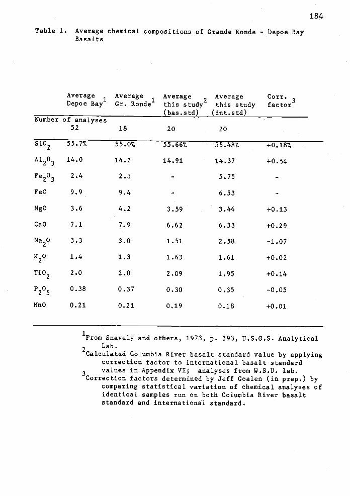
184
Table 1. Average chemical compositions of Grande Ronde - Depoe BayBasalts
Average1
Average1
Average2
Average Corr.Depoe Bay Gr. Ronde this study this study factor
(bas.std) (int.std)Number of analyses
52 18 20 20
Si02 55.77. 55.07. 55.667. 55.487. +0.187.
Al203 14.0 14.2 14.91 14.37 +0.54
Fe203 2.4 2.3 - 5.75 -
FeO 9.9 9.4 - 6.53 -
MgO 3.6 4.2 3.59 3.46 +0.13
CaO 7.1 7.9 6.62 6.33 +0.29
Na20 3.3 3.0 1.51 2.58 -1.07
K20 1.4 1.3 1.63 1.61 +0.02
Ti02 2.0 2.0 2.09 1.95 +0.14
P205 0.38 0.37 0.30 0.35 -0.05
!4n0 0.21 0.21 0.19 0.18 +0.01
1From Snavely and others, 1973, P. 393, U.S.G.S. Analytical
2Lab.
Calculated Columbia River basalt standard value by applyingcorrection factor to international basalt standardvalues in Appendix VI; analyses from 1.S.U. lab.
Correction factors determined by Jeff Goalen (in prep.) bycomparing statistical variation of chemical analyses ofidentical samples run on both Columbia River basaltstandard and international standard.

185
Table 2. Average composition of Grande Ronde Basalt geochemicalsubtypes in the study area
Column[Turn]
1 2
[Tihtj3 4
[Tihrn]
5 6
Number of analyses 9 9 7 7 4 4
Si02 56.247, 56.067. 55.757, 55.577, 54.177. 53.99%
Al203 14.96 14.42 14.90 14.21 14.95 14.41
Fe203 - 5.74 - 5.75 - 5.78
FeO - 6.45 - 6.59 - 6.62
NgO 3.37 3.24 3.35 3.22 4.52 4.39
CaO
Na20
K20
Ti02
P205
MnO
Column:
7.00 6.71
2.34 3.41
1.63 1.61
2.08 1.94
0.30 0.35
0.19 0.18
5.15
1.37
1.94
2.41
0.32
0.18
4.86 8.37 8.08
2.44 2.16 3.23
1.91 1.11 1.09
2.27 2.03 1.89
0.37 0.27 0.32
0.17 0.22 0.21
1 - Average for low-MgO-low-Ti02 basalt [Tilml (basalt std.).22 - Average for low-MgO-low-TiO basalt [Turn) (international1std.)
3 - Average for low-Ng0-high-Ti2 basalt [Tihtl (basalt std.)24 - Average for low-MgO-high-Ti02 basalt [Tiht] (internaqonal std.)
5 - Average for high-NgO-type basalt [Tihm] (basalt std.)26 - Average for high-MgO-type basalt [Tthinl (international std.)
1Calculated Columbia River basalt standard values byapplying correction factor to analyses frominternational standard values reported in Appendix VI.Correction factor determined by Jeff Goalen, Oregon
2State University (in prep.).
Values from Appendix VI.

17
6
'5
'4
'3
'5
'4
'3
12
II
B
6
4
I I
High MqOLowMqO-(owTiO2Low NqO.high Tb2Error De,s
.4it.d tt, SII.Ip I I (111$).
A1203
Fe 0
Si 02
*4
Mg 0
*. S
74'.
Na2 0
/;I;N)+K
2
CYP025
Si
Ii 02
I.
Figure 34. Silica variation diagran of Grande Ronde Basalt
intrusives in the thesis area. Solid lines show
the fields for Depoe Bay basalt and Yakinia-type
basalt defined by Snavely and others (1973, p.
417) which are equivalent to Grande Ronde Basalt
in the study area.
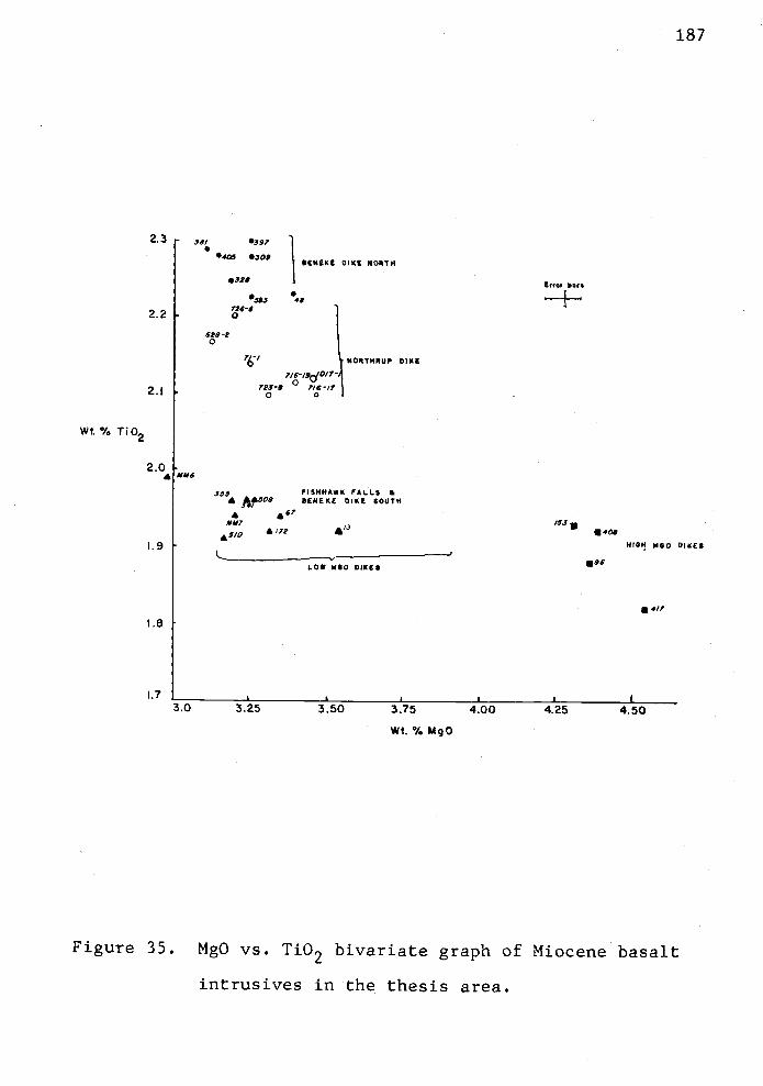
2.3 ,,, 397
0405 0309SENEKE DIKE NORTH
2.2[ 0
5S383 40
726-9
608-80
NORTHRUP DIKE
2.j 0 07239 7/6/7
Wt.% Ti02
2.0£ 0M6
355 PISHHAWK *LLS ft* *.508 DENEKE DIKE SOUTH
*MM,
*5/0 *17?
.9
1.08 $50 DIKES
I.e
1.7 II
3.0 3.25 3.50 3.75 4.00
Wt. % Mg0
187
Err,, Dora
Ii
' U408HIGH MGO DIKES
.96
4/7
4.50
Figure 35. MgO vs. Ti02 bivariate graph of Miocene basalt
intrusives in the thesis area.

high-Ti02-subtype occurs only in the low-MgO Grande Ronde
Basalt, and averages 2.37 (by wt.) Ti02 (Table 2).
Low-Ti02 low-MgO Grande Ronde Basalt averages 1.95% Ti02
(Fig. 35). High-MgO-type basalt does not show as great a
variation in titanium as the low-MgO basalts. Note that the
reverse polarity Beneke dike north of Boiler Ridge and the
reverse polarity Northrup Creek dike are the
low-MgO-high-Ti02-subtype and closely cluster on Fig. 35.
The Beneke dike south of Boiler Ridge and the Fishhawk Falls
dike are the low-MgO-low-Ti02--subtype and also cluster
together on Fig. 35.
On the geologic map (Plate 1), each geochemical type is
considered a different stratigraphic unit. For example,
high-MgO intrusives are labeled Tihm, the
low-MgO-low-TiO2-subtype is labeled Turn, the
low-MgO--high-Ti02-subtype is labeled Tiht, and intrusives
that were not sampled for geochemical analysis are grouped
into one undifferentiated unit (Tib).
All the Grande Ronde intrusives fall into the tholeiite
field of MacDonald and Katsura (1964) (Fig. 36). Other
workers have noted that Miocene basalts on the plateau and
coast are choleiitic in composition (Waters, 1961, 1962;
Snavely and others, 1963, 1964, 1973; Hill, 1975). Trace
element concentrations of middle Miocene coastal tholeiites
and plateau tholeiites are in good agreement (Hill, 1975;
Snavely and others, 1973; Murphy, 1981). Abundances of rare
earth elements (La through Lu), normalized by average
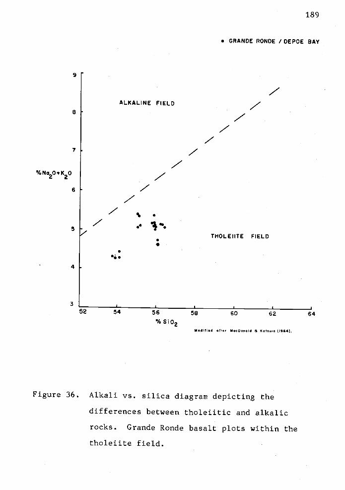
9
8
7
%No2OsK2O
6
5
4
3
:9
. GRANDE RONDE / DEPOE BAY
52 54 56 58 60 62 64% S102
Modified after MacDonald & Katsora (1964).
Figure 36. Alkali vs. silica diagram depicting the
differences between tholeiitic and alkalic
rocks. Grande Ronde basalt plots within the
tholeiite field.
190
chondrite abundance, are identical for coastal Depoe Bay
Basalt and plateau-derived Grande Ronde Basalt (Hill, 1975,
p. 40-41) suggesting that they are identical units.
Correlation of basalt intrusives to subaerial flows.
The basalt sills and dikes in the study area can be
correlated to subaerial Columbia River Basalt units in the
nearby Nicolai Mountain Porter Ridge area on the basis of
geochemistry, lithology, and paleomagnetism. Major element
geochemistry is the most important correlation tool.
High-MgO and low-MgO Crande Ronde basalt intrusives occur in
the map area (Plate 1 and Fig. 32). High-MgO basalt is the
youngest Grande Ronde basalt unit in the Nicolai
Mountain Porter Ridge area and forms four small normal
polarity dikes in the western part of the thesis area: in
the W1/2, sec. 19, T6N, R7W, in the S1/2, sec. 25 and N1/2,
sec. 36, T6N, R8W, in the NW1/4, sec. 24, T5N, R8W, and in
the SW1/4, sec. 35, T5N, R8W (Tihm on Plate 1).
The Beneke, Fishhawk Falls and Northrup Creek dike
trends, and numerous other smaller intrusives have low-MgO
chemistry and are both normal and reverse polarized. Of
these low-MgO basalts, both the low-Ti02-subtype and
high-Ti02-subtype (Tilm and Tiht, respectively) occur.
Chemical differences among these dikes can be clearly
seen on MgO vs. TiO2 binary plots (Fig. 35). The Beneke
dike has different chemistry in the northern part than in
the southern part. The northern part of the dike (i.e.,

191
north of Boiler Ridge to the Beneke quarry) is higher in
Ti02 by 0.2 to 0.37 (a high-Ti02 basalt) than the southern
part of the dike (Boiler Ridge to Flagpole Ridge). The
southern part of the dike is composed of low-MgO--low-Ti02
basalt. In addition, the northern part of the dike has
reverse magnetic polarity whereas the southern part of the
dike has normal polarity. These differences clearly show
that two different dikes intruded along the Beneke dike
trend. Pfaff (1981) also showed that the trace element
distribution differs between the southern and northern parts
of the dike and also suggested that the Beneke dike trend is
occupied by two different intrusions.
The chemistry of the southern part of the Berieke dike
is indistinguishable from the chemistry of the Fishhawk
Falls dike, which is normal polarity low-MgO-low-Ti02 basalt
(Fig. 35). Samples collected along the trend of the
Northrup Creek dike appear to have slightly lower Ti02
content than the northern Beneke dike (Fig. 35), but still
classify as low-MgO--high-Ti02 reverse polarity Grande Ronde
basalt. The Northrup Creek dike averages 2.17 Ti02 and 3.37
MgO (Olbinski, 1983). Pfaff (1981, p. 45-46) analyzed trace
elements but not major oxides of a sample from the Northrup
Creek dike. She also noted that the basalt has low-MgO
Grande Roride basalt character and reverse polarity. The
trace element differences (Sc, Cr, Ba, La, Sm, and Eu)
reported by Pfaff (1981), along with the slight Ti02
differences (Fig. 35), further support the lithologic

192
indication that the reverse polarity Northrup Creek dike is
different from the Beneke dike.
As these intrusives are so similar geochemically,
petrographically and magnetically to the Grande Ronde
Basalt, correlation to the Columbia River Basalt Group is
made. Measured stratigraphic sections of the subaerial
basalt sequence on Nicolai Mountain and Plympton Creek areas
have been described by Murphy (1981) and Goalen (in prep.).
The three major dikes can be correlated to the composite
stratigraphic section in these two areas. These dikes can
be traced to within a few hundred meters of the correlative
flows. The relative age of each intrusive can also be
obtained by comparison to the composite section derived by
Murphy (1981) and Goalen (in prep.).
The Northrup Creek dike does not crop out in the thesis
area but is mentioned because it is related to the
emplacement of the other two major dikes. The dike crops
out in the adjacent thesis areas (Olbinski, 1983; Goalen, in
prep.). The Northrup Creek dike has low-MgO-high--Ti02
Grande Ronde chemistry, reversed magnetic polarity and
microphyric lithology. Microphenocrysts of plagioclase are
1 to 2 mm. It is correlated to subaerial Grande Ronde flow
LMHT2 (Goalen, pers. comm., 1982; Plate III of Goalen, in
prep.) which, from the bottom, is the second flow of six
flows in the Plympton Creek section located on Porter Ridge
(sE1/4, SW1/4, sec. 2, T7N, R6W). Intrusion of the Northrup
193
Creek dike occurred during the R2 magnetostratigraphic
epoch.
The Berieke dike crops out in the thesis area and
extends 9.6 km northeast to correlative submarine pillow
lavas on Nicolai Mountain. Major and trace element
geochemistry, lithology and paleomagnetic signature of the
Beneke dike are different on the northern and southern
parts. The northern part has low-MgO--high-Ti02 chemistry,
reversed polarity (R2) and microphyric character. This part
of the dike correlates to the reversed polarity pillow lavas
on Nicolai Mountain which have identical polarity,
geochemistry and petrography. Paleomagnetic data from these
two flows suggest that the structure corrected paleomggnetic
directions of the lower flow more closely inathch the average
directions obtained from the Beneke dike. Murphy (1981)
found that the northern terminus of the Beneke dike and the
R2 pillow lava on Nicolai Mountain both have the same major
and trace element composition. Thus, the Beneke dike
probably correlates directly to the lower pillow flow in the
Nicolai Mountain quarry.
The southern part of Beneke dike has low-MgO-low-Ti02
chemistry, normal magnetic polarity and aphyric character.
Geochemically and paleomagnetically, the southern part of
the Beneke trend is similar to the Fishhawk Falls dike, and
these are therefore correlative to the same basaltic
intrusive episode. Both dikes have low-MgO-low--Ti02
chemistry and normal polarity. These dikes correlate to

194
the LMLT2 subaerial Grande Ronde flow on Porter Ridge
(Goalen, pers. comm., 1982) based on similarity of aphyric
lithology, geochemistry and normal polarity. Intrusion
occurred during the N2 magnetostratigraphic epoch. This is
the youngest of the three major dike systems in eastern
Clatsop County. However, other less extensive dikes (e.g.,
high-MgO dikes) follow this episode.
Recent exploration wells in the area have penetrated
several intervals of middle Miocene basalt. Hand-picked
chips of the well cuttings from the Quintana "Watzek" #30-1
well adjacent to the Northrup Creek dike have been analyzed
for major oxide chemistry (Olbinski, 1983). Again,
petrologic correlation of the subsurface middle Miocene
basalts to those exposed at the surface can be made by
geochemical similarity. Olbiriski (1983) reported four
intervals of basalt in the Quintana well north of Je.well.
These include: a 9-meter-thick low-MgO--low--Ti02 Grande Ronde
sill at 859 m (2820'); a low-MgO-low-Ti02 Grande Ronde
intrusive at 1079 in (3540'); and, a high-MgO Grande Ronde
intrusive at 1600 m (5250'). The "younger" high-MgO Graride
Ronde basalt occurs at greater depth in the well and the
"older" Grande Ronde basalt units (i.e.,
low-MgO-low-Ti02-subtypes) occur at the shallowest depths
(Olbinski, 1983). This is the reverse stratigraphic order
of the subaerial Graride Ronde flows on Nicolai Mountain and
Porter Ridge (Murphy, 1981; Goalen, in prep.). Subsurface

195
middle Miocene basalt samples from other wells in Clatsop
County do not follow this pattern, however.
Seismic reflection evidence (Mike Navaho and Larry
O'Connor, pers. comm., 1982) indicates a large sill at
shallow depth beneath the thesis area (see cross-section
A-A', Plate 2). This is expressed on seismic records as a
high amplitude reflector and contrasts markedly with
surrounding lower amplitude reflectors from less dense
sedimentary rocks. On a regional basis, this subhorizontal
sill generally cuts across reflectors from sedimentary rocks
(creating a false unconformity) and dips gently to the east
on the record section. It was penetrated by the Quintana
"Watzek" #30-1 well. This intrusion is interpreted to rise
toward the surface near Saddle Mountain, 3 km west of the
thesis area. Because of near-vertical dips, the Fishhawk
Falls, Beneke and Northrup Creek dikes are not seen
seismically but may potentially cause problems of
diffraction and "noise" on seismic records.
Gravity and magnetic modeling of the area underlain by
the Fishhawk Falls and Berieke dikes by Pfaff in 1981 has
produced interesting speculations on the depth of the dikes.
The geophysical models suggest that the dikes are shallow
and rootless. The Fishhawk Falls dike is modeled as having
a terminus at 107 m in the subsurface (Pfaff, 1981). The
Beneke dike may terminate at 45 m. Furthermore, Pfaff's
geophysical models suggest that the dikes do not extend to
the Eocene volcanic basement which along with their shallow

196
depths support an invasive origin (Pfaff, 1981). The
intrusions would end within the section of upper Eocene to
middle Miocene marine sedimentary rocks overlying the middle
to upper Eocene volcanic basement.
The interpretation that the intrusions terminate at
such shallow depths is not necessarily valid. Exploration
wells drilled in Clatsop County since 1981 show that low-MgO
Grande Ronde basalt sills, that are correlative to the
Beneke, Fishhawk Falls and Northrup Creek dikes, are present
at much greater depths. For example, a low-MgO-low--Ti02
sill at 1079 m in the Quintana well has the same chemistry
as, and most likely fed, the Fishhawk Falls dike. Similarly
a low-MgO-high-Ti02 sill at 859 m in the Quintana well
probably fed the Northrup Creek dike (Olbinski, 1983).
Hence, these dikes and their related sills are much deeper
than the geophysical modelling predicted.
Other deeply buried middle Miocene sills have been
found elsewhere in western Oregon. Basalts of Depoe Bay
(Grande Ronde) chemistry were penetrated at depths of 1,100
m in the Standard Union Nautilus #1 (P-0103) offshore test
well (Snavely and others, 1980, p. 5). The expression of
middle Miocene basalt sills over distances of several
kilometers is seen in multichannel seismic reflection
records of offshore central and northwestern Oregon (A. R.
Niem, pers. comm., 1982; Snavely and others, 1980).
The preferred interpretation is that two or three large
sill-like bodies occur within the upper Eocene sedimentary
197
section in the subsurface (Plate 2). These sills could have
fed the Beneke and Fishhawk Falls dikes. The presence of
the sill-like intrusives is suggested by seismic evidence.
How the sills were emplaced is still open to question and
debate. Either the locally-derived hypothesis of Snavely
and others (1973) or the plateau-derived invasive hypothesis
of Beeson and others (1979) could account for these
subsurface "feeder sills".
Large tholeiitic basalt sills could be emplaced by
direct rise from the mantle, or partially melted subducted
Juan de Fuca plate, as envisaged by the locally-derived
hypothesis. Alternatively, the sills may have been derived
from subaerial Grande Ronde basalt that sank into the soft
Miocene Oligocene sediments upon reaching the marine
shoreline. These flows injected downward into the more
compacted sedimentary rocks by hydrofracturing and spread
laterally (southwestward) to form "invasive sills" upon
reaching a dense impenetrable subsurface layer. The sills,
under hydrostatic pressure, encountered pre-existing joints
or faults and injected upward, forming the Fishhawk Falls,
Beneke, Northrup Creek and other dikes in the area. The
point of invasion is unknown but apparently lay between the
outcrops of subaerial flows at Nicolai Mountain and Porter
Ridge and the intrusive correlatives.
The Fishhawk Falls, Beneke and Northrup Creek dikes are
indeed intrusive bodies and not exhumed intracanyon flows as

suggested by Pfaff (1981). The apparent gently sinuous
outcrop pattern of the three dikes was used by Pfaff (1981)
to support her suggestion that these basalt "dikes" were
narrow intracanyon flows that form an inverse topography
after erosion of the softer sedimentary canyon walls. She
pictured that the low-MgO basalts flowed over a coastal
lowland and filled a trellis drainage system on that
lowland. However, field relationships between the basalt
dikes and adjacent sedimentary rocks suggest otherwise. The
dikes are tabular though offset by faults. The orientation
of columnar jointing is everywhere subhorizontal rather than
vertical. Vertical jointing in subaerial flows is common
because the cooling surfaces are the top and bottom of the
flow. However, some intracanyon flows may develop
horizontal columnar joints near canyon walls. If the dikes
are interpreted as intracanyon flows, the canyon would have
to be narrow (100 m or less) and carved deep into soft
sedimentary strata. In such a setting, the basalt could
have formed horizontal cooling joints against the canyon
walls. It is unlikely that there was such a narrow canyon
because the soft sediments could not have maintained a
vertical angle of repose. Colonnade, entablature, vesicular
flow tops or flow breccia, common in subaerial flows, are
not observed in the dikes but baked contacts typical of
intrusives are common in these dikes. The adjacent strata
are commonly bowed upward as though dragged by an
upward-moving intrusion. The sinuous pattern of the Beneke,
199
Fishhawk Falls and Northrup Creek dikes is partly caused by
later offset by strike-slip faults.
Hypotheses of Origin
Hypothesis 1: Basalts at the Coast Erupted Locally.
Suavely and others (1973) are the chief supporters of the
hypothesis that the middle Miocene coastal basalts were
erupted locally. The three coastal basalt petrologic types,
Depoe Bay Basalt, Cape Foulweather Basalt and the Basalt of
Pack Sack Lookout form three consanguineous petrologic
groups with their Columbia River Basalt Group counterparts,
the Grande Ronde, Frenchman Springs, and Pomona basalts,
respectively.
Chemical and isotopic data show that all three groups
originated from different parental magmas (Hill, 1975, p.
49). A very large magma source must have been
simultaneously tapped three times in order to produce the
estimated 325,000 km3 of coastal tholeiitic basalt (Snavely
and others, 1973). The problem is that the vent areas for
the coastal basalts and plateau basalts are more than 500 km
apart. Because identical basalt was erupted simultaneously
from such widely separated vent areas, the magma reservoir
from which the magmas were generated must have been
widespread, homogeneous with respect to elemental and
isotopic composition, and very deep (Suavely and others,
1973).

200
According to Snavely and others (1973), the source may
have been a widespread zone of partially melted mantle below
eastern Oregon Washington and western
Oregon southwestern Washington. The basaltic lavas
erupted on the plateau and at the coast show no geochemical
or isotopic contamination and little variation between
respective geochemical (or petrologic) types (Hill, 1975).
Isotopic variability would indicate mixing of separate
magmas, country rock contamination or source inhomogeneity.
The tholeiitic magmas must have risen rapidly along
deep-seated tensional fractures in both the plateau and the
coast (Snavely and others, 1973).
They suggest that two plate tectonic models can be
supported by the geological data. In the first model,
partial melting of the eastward-dipping Juan de Fuca plate
generates large batches of tholeiitic melt as it is
subducted. The source of the melt is refractory eclogite of
the deeply subducted oceanic lithospheric slab. The model
relies on the hypotheses of Atwater (1970) and Hayes and
Pitman (1970) for estimated rates of underthrusting.
Assuming that these rates were on the order of 4 to 5 cm/yr
commencing in the late Eocene (approximately 40 rn.y.B.P.),
the Juan de Fuca slab by the middle Miocene would have been
underthrust beneath the North American continental margin to
a position beneath the feeder dike swarms of the Columbia
River basalts on the plateau. They hypothesized that some
of the tholeiitic magma beneath the plateau rose rapidly

201
along the subducted slab of the Juan de Fuca plate until it
encountered a deep-seated fracture zone along the coast.
The magma followed this fracture zone and erupted on the
surface forming the "local" coastal basalt units.
Model two of Snavely and others (1973) suggests that a
very broad zone of partially melted mantle existed at the
base of the westward-drifting North American plate from the
Columbia Plateau to western Oregon and Washington. They
hypothesized that partial melting is related to high
pressure shear between decoupled brittle lithosphere and the
underlying plastic asthenosphere. The magma thus generated
rose three times through deep-seated fractures in both the
Columbia Plateau and the Oregon - Washington coast to form
the Grande Ronde Depoe Bay basalts, Frenchman
Springs Cape Foulweather basalts, and Pomona Pack Sack
Lookout basalts.
Regardless of which model is chosen, basaltic magma was
diverted in two directions during ascent. Deep-seated
tension fractures on the plateau were associated with either
back arc spreading or north-south horizontal compression
(Hooper and Camp, 1981) or basin and range extension which
tapped the partially melted magma in the upper
asthenosphere. Tholeiitic magma rapidly ascended dilated
fractures and erupted on the Columbia Plateau.
Simultaneously, tholeiitic magmas rapidly migrated up a
major north-south-trending extensional fracture zone along
the continental margin from Waldport, Oregon to Grays

202
Harbor, Washington (Snavely and others, 1973). This
fracture zone controlled emplacement of tholeiitic basalt in
coastal areas of Oregon and Washington. An offset fracture
system with a northeast trend may have controlled the
emplacement of dikes, piles of pillow basalts and breccias
in eastern Clatsop County, Oregon (Snavely and others
(1973). According to hypothesis one, then, the Beneke,
Fishhawk Falls and Northrup Creek dikes are directly related
to magma from deep-seated sources beneath the Oregon and
Washington coast and Coast Range.
Hill (1975, p. 52-53) proposed a model for the
derivation of middle Miocene coastal basalts of western
Oregon and southwestern Washington that is similar to Model
2 of Snavely and others (1973). This model for magma
generation follows the hypotheses of Green and Ringwood
(1967) for continentally derived tholeiite. Basalts of the
three chemical (or petrologic) types (e.g., Depoe Bay-Grande
Ronde, Cape Foulweather-Frenchman Springs and Pack Sack
Lookout-Pomona) could be derived by different degrees of
partial melting, fractionation of inhomogeneous mantle rock,
and wall rock reactions. Tholeiitic magmas derived from
mantle depths rise and fractionate and possibly react
chemically with wall rocks in the uppermost part of the
mantle or lower crust. The magmas are produced by partial
melting in a thin tabular chamber deep in the mantle.

203
From trace element geochemistry of the coastal basalt
units, Hill (1975, P. 47-49) suggested that the Depoe Bay
(Grande Ronde) magma was not the source of either the Cape
Foulweather or Pack Sack Lookout basalts. That is, these
younger basalts were not produced by fractional
crystallization of a melt with Grande Ronde composition. A
wholly different period of partial melting occurred to
produce each of the three geochemical types (Hill, 1975).
Hill (1975) also suggested that the coastal basalt
units probably formed from basaltic magma that rose along
the subduction zone of the oceanic plate beneath the
continental margin as proposed in Kodel 1 of Snavely and
others (1973).
Snavely and others (1973) recognized that the models
for local eruption of the coastal basalts do not adequately
explain how calc-alkaline volcanic rocks of the Cascade arc
could be erupted simultaneously with the eruption of
identical tholeiitic basalts to either side of the arc. The
caic-alkaline Cascade volcanics were derived from the
fractionated liquids of partial melts, not from primary
magmas as the coastal and Columbia River tholeiitic lavas
were. Strontium ratios (87Sr/86Sr) for calc-alkaline and
tholeiitic basalt lavas are significantly different,
indicating different sources (Hedge and others, 1970 in
Snavely and others, 1973). The position and assumed source
of generation of Miocene caic-alkaline magmas (e.g.,

204
Rhododendron and Sardine formations of Hammond, 1979) is
located between the two vent areas of the middle Miocene
tholeiitic basalts.
Lack of explanation of how the basaltic magmas that
were erupted at the coast reached the surface from the
melting Juan de Fuca plate beneath the Columbia Plateau
without contamination during passage through the zone of
caic-alkaline magma generation beneath the Cascade arc
weakens Snavely and others' and Hill's hypotheses. For
example, the second model of Snavely and others (1973),
which proposes a very extensive zone of partial melt,
requires a homogeneous composition of the zone to account
for the identical chemistry of each pair of tholeiitic
basalt. Hill (1975, p. 51, 52) expressed the opinion that a
500-km-wide zone of homogeneous basaltic magma is not likely
considering the intervening caic-alkaline Cascades. Thus,
the three models for the origin of the middle Miocene
coastal basalts and Columbia River basalts are left with a
problem to be solved.
Hypothesis 2: Basalts at the Coast Erupted on the
Plateau. Beeson and others (1979) offered art alternative to
the two-vent hypotheses of Snavely and others (1973) for the
origin of middle Miocene tholeiitic basalts in western
Oregon and southwest Washington that solves the problem of
the caic-alkaline Cascade volcanic arc. They hypothesized
that Columbia River Basalts, derived from fissures in the

205
eastern part of the plateau, are the source of Miocene
basalts along the coast of western Oregon and western
Washington. That is, the coastal basalts are erosional
remnants of westward extensions of the flood basalt lavas.
They envisioned that the plateau basalts flowed down the
ancestral Columbia river gorge to the Willamette Valley,
across the subdued Oregon-Washington Coast Ranges through
topographic lows, to marine embayments at Astoria, Newport
and Tillamook, Oregon and in the Grays Harbor area of
southwest Washington.
The submarine basalt flows and breccias may have formed
in association with dikes and sills by invading
semiconsolidated marine sediment in ways similar to small
scale invasive Columbia River basalt flows in diatomaceous
sediments reported on the plateau (Schmincke, 1964; Camp,,
1981). An observation that supports this radical hypothesis
is that all of the middle Miocene coastal basalt units have
subaerial Columbia River Basalt correlatives in the
Clackamas drainage of the Willamette Valley (Beeson and
Moran, 1979; Swanson and others, 1979; Murphy, 1981) that
are nearly identical in geochemistry and magnetic polarity.
If the coastal submarine basalts are indeed the distal ends
of flows that originated on the plateau, then one would
expect to find correlative units along the route which they
travelled (i.e., in the westward-flowing paleodrainages).
Perhaps the most significant of the observations in
support of this hypothesis are the similarities in

206
petrography, geochemistry and radiometric ages. The mapped
distributions of subaerial Columbia River Basalt from the
plateau and the correlative coastal basalts in western
Oregon and southwestern Washington closely coincide,
practically without overlap (Fig. 37). According to the
hypothesis proposed by Beeson and others (1979), this is no
accident.
The hypothesis that the coastal basalts were erupted on
the plateau is not to be taken without issue, however. A
rheological mechanism or quantitative theoretical model to
explain how basalt lava can intrude indurated rocks (in this
case as old as upper Eocene) and buried as deep as 1.6 km
(Olbinski, 1983) has not been made. The idea of "invasive
sills' is acceptable for setniconsolidated, thin,
shallow-buried sediments such as diatomaceous lake beds in
eastern Washington and shallow marine or deltaic lower to
middle Miocene sands and silts in northwest Oregon (Niem,
1976). However, extending this suggestion to include
50-rn-thick and up to 20-km-long dikes such as the Beneke,
Fishhawk Falls and Northrup Creek dikes in eastern Clatsop
County and sills such as those penetrated by the
Standard-Union Nautilus #1 (P-0103) offshore test well to
depths of 1,161 and 1,177 m (Snavely and others, 1980, p. 5)
in consolidated Oligocene sediments is difficult to
reconcile.
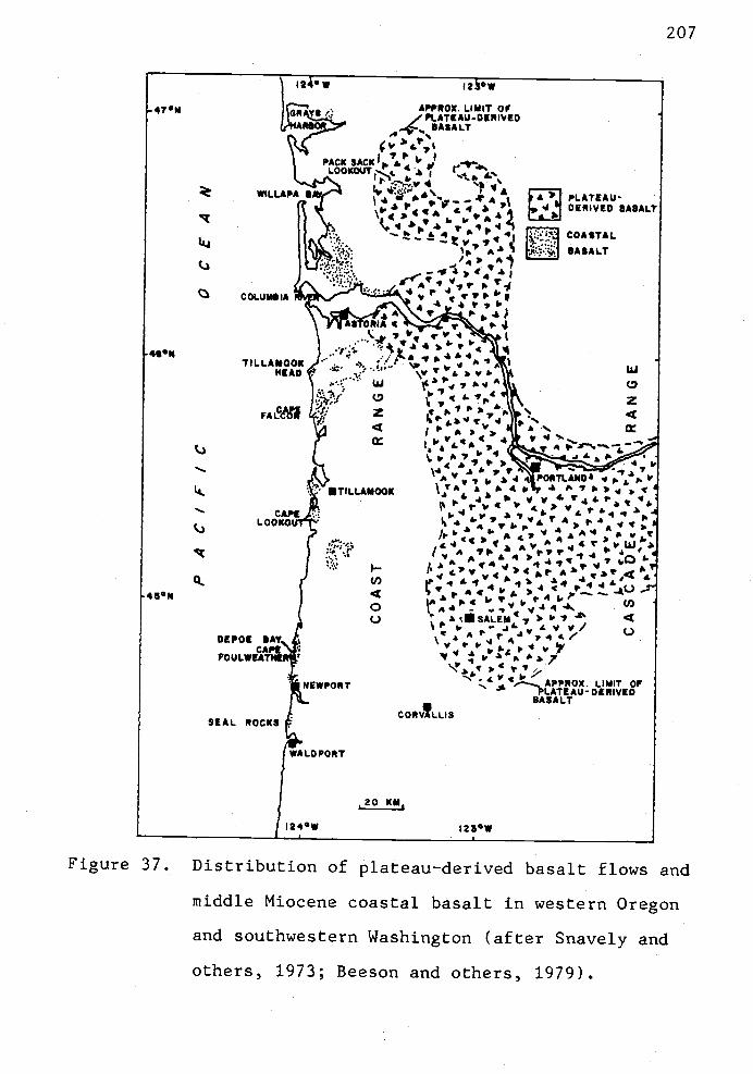
SI.
LU
C-)
C-)
45N
Ia°w
APPDX. LIMIT OF/ P%.ATEAU-DE*IV!D
BASALT?HA)4.p,I
IIPACK SACK p &
LOOKOUT
& C7VIPLATEAU.WILLAPA BDERIVED BASALTt41,SP1 AP4q COASTAL- ' BASALT
/
1,vp'1
'COLUMBIA 4 1IA 47 4)
A$TORIA 7 A
4p1 ':?tA...4A1A%
LUTILLAMOOK
HEADa..
I, z. 4SPç4
.f.. 4_..-
.'''.V '
POATLAND1.lA
1\ TILLAMOOK . p v v £ V44P '1,
CAPELOOKO
I (4A 4 p v
'., AAI fr444)(,, 41
A, 14.ZLO
(I)l b'4
o A( V .44'.,A4C)
. LVVIDEPOE BAY '. , . p 4CAPS . : p1'.lFOUL.WEATHE
' LIMIT OFNEWPORTPLATEAU-DERIVED
BASALTCOR VLLI S
SEAL ROCKS
WA LO PORT
,20 KM1
1245W 25°W
207
Figure 37. Distribution of plateau-derived basalt flows and
middle Miocene coastal basalt in western Oregon
and southwestern Washington (after Snavely and
others, 1973; Beeson and others, 1979).

Rheological parameters and models for this sort of
mechanism have not been developed. There are no known
similar occurrences on this scale cited in the geological
literature. The hypothesis suggests that Columbia River
Basalt lavas flowed into marine embayments along the coast
to form hundreds of meters of palagonitic breccia (Murphy
and Niem, 1982) and temporarily ponded lava either within
the breccia piles or behind these palagonitic breccia lava
deltas (Murphy, 1981). The dense liquid basalt and breccia
overloaded and sank into the underlying less dense,
setniconsolidated early Miocene marine sediments. The fluid
basalt vertically and/or laterally injected or "invaded" the
underlying consolidated sedimentary rocks causing
readjustment of these rocks to the newly imposed vertical or
lateral stress. Tensional fractures developed where the
vertical stress exceeded horizontal stress (perhaps along
old fault zones or joints) and the open fractures were
injected with liquid basalt lava from above or laterally.
Significant hydrostatic head must be required to push the
basaltic lava to a depth of 1,600 m (5,250') (Olbinski,
1983).
One might expect a near random orientation of
lava-filled fractures (i.e., irregular trends of dikes and
sills) since this locally imposed stress is unevenly
distributed. Such is the case for many coastal intrusives
in the younger Miocene and Oligocene strata (Cressy, 1974;
Smith, 1975; Neel, 1976; Tolson, 1976; Coryell, 1978; M.

209
Nelson, 1978; Penoyer, 1978). However, the laterally
extensive Beneke, Fishhawk Falls and Northrup Creek dikes in
eastern Clatsop County follow a consistent northeast trend
(N30-37°E) in older Oligocene to upper Eocene strata (Fig.
30). These three dikes may be related to regional stresses
or intrusion following pre-existing fault zones and joints
rather than injection stress created by ponded lavas of
palagonitic breccias.
Tectonic Significance of the Orientation of the Major Middle
Miocene Basalt Dikes
Regional Considerations: a discussion. The intrusion
and orientation of the dikes can be related to a particular
alignment of tectonic stresses in the lithosphere.
Emplacement of magma bodies of any shape and orientation is
dependent on the dilation of tensile fractures (Willams and
McBirney, 1979, p. 307).
Three gross stress regimes can be defined on the basis
of principle stress orientations and their relative
magnitudes (Willams and McBirney, 1979) (Fig. 38). If the
vertical component of compressive stress exceeds the
horizontal component of compressive stress magma will
be intruded as dikes and may be associated with normal
faulting. If the horizontal component exceeds the
vertical component of compressive stress (f), magma will be

frCase I Case 2
210
Case 3
Figure 38. Schematic diagram showing the relation of
vertical and horizontal components of
stress to magma intrusion (after Williams and
McBirney, 1979).

211
injected as sills and may be accompanied by reverse
faulting. Extrusion is not likely to occur in this latter
case. If the vertical and horizontal components of
compressive stressv andh) are approximately equal,
magma will rise by stoping toward the surface to form a plug
or bulbous intrusion. Randomly oriented dikes and
cylindrical intrusions result if the lithosphere has a
relatively homogeneous fabric. Pre-existing structural
anisotropy (e.g., joints or faults) within the lithosphere
will control the ascent and emplacement of magma.
The spatial orientations of the dikes may allow
definition of which of the three gross stress regimes may
have existed during the middle Miocene intrusive event. As
we are dealing primarily with dikes, the stress regime in
which sills are formed can be eliminated (Case 2).
Therefore, two possibilities remain: either the horizontal
and vertical components of compressive stress were
approximately equal and magma rose along some pre-existing
structural anisotropy (i.e., faults or joints) (Case 3, Fig.
38) or the vertical compressive stress (j) exceeded the
magnitude of horizontal compression (0h) (Case 1, Fig. 38).
Consider the geologic and tectonic setting of western
Oregon during the middle Miocene. The area was located in
an elongate north-south forearc basin developed within the
arc-trench gap of the Cascadian arc orogen (Dickinson and
Seely, 1977; Dickinson, 1976; Niem and Niem, 1984). The
region had been undergoing periods of compressive and

212
extensional tectonism since the middle Eocene (Snavely and
others, 1980). Regional compressive stresses acting on the
brittle lithosphere resulted from oblique subduction of the
Juan de Fuca Farallon plates beneath the North American
plate (Snavely and others, 1980; Wells, 1981). Stresses
were focused upon, and possibly modified, pre-existing
anisotropic fabric of the lithosphere.
According to Williams and McBirney (1979), volcanism is
scarce in areas undergoing regional compression. Under such
conditions, injection of sills is the most likely magmatic
activity. Magma can ascend to the surface only if there is
relaxation of horizontal compression, allowing the vertical
stresses to become dominant. Relaxation of horizontal
compression might occur, for example, at the cessation of a
deformational episode and/or a slowing on the rate of
convergence of two lithospheric plates. Elastic strain may
be reduced, perhaps allowing dilatational cracks (joints) to
develop in an anisotropic lithosphere. Secondly, regional
upwarping of the crust related to isostatic rebound may
allow emplacement of dikes to occur if the relative
magnitude of the vertical compressive stress exceeds that of
the horizontal compressive stress.
Regionally, the middle Miocene extrusive vent breccias
and intrusive coastal basalts of western Oregon have a
preferred orientation which is roughly north-south (Snavely
and others, 1973). These intrusive and extrusive basalts
occur in a relatively narrow belt (35 km wide) from Seal
Rocks, near Waldport, Oregon to Grays Harbor, southwestern
Washington. The belt is 260 km long (Fig. 37). The outcrop
belt parallels the arc-trench axis, perhaps not
coincidentally. There may be an association between the
outcrop belt and the geometry of the plate tectonic
elements.
Snavely and others (1980) suggested that this
north-south belt of middle Miocerie intrusives and extrusives
may have been formed during a period of east-west extension
and isostatic rebound due to a slower convergence rate
between the Juan de Fuca and North American plates. The
linear trend of Beneke, Fishhawk Falls and Northrup Creek
dikes in eastern Clatsop County (Fig. 30) varies 450 from
the regional north-south trend of outcrop and may reflect a
local northwest-southeast extension regime (sigma3).
This northwest-southeast extensional regime during
emplacement of the Beneke, Fishhawk Falls and Northrup Creek
dikes may reflect the beginning of isostatic uplift of the
northern Oregon Coast Range gravity high during a slowing of
the plate convergence. This gravity high of Tillamook
volcanics basement rocks is oriented N20°E through eastern
Clatsop County (Bromery and Snavely, 1964). The dikes
nearly parallel this high on the west. They may have
followed northeast-trending normal faults (i.e., extension,
Case 1, Fig. 38) associated with the fault block uplift of
this high (Kadri, 1982). However, the contacts of the host
sedimentary units adjacent to the dikes, although hard to

214
map continuously, do not show displacement due to normal
faulting.
It appears from surface arching of sedimentary strata,
from well data (Olbinski, 1983), and from seismic
information (Navolio and O'Connor, pers. comm., 1982) that
the Beneke, Fishhawk Falls and Northrup Creek dikes were fed
from thick sills below (cross-sections, Plate 2) or were fed
laterally by invasive Grande Ronde flows in the Porter
Ridge Nicolai Mountain Big Creek area (9 km to the
north). These sills may have encountered pre-existing
northeast-trending faults or joints and under magmatic
pressure injected magma up or laterally along these
fractures.
It is more likely that these fractures were joints
related to middle Miocene isostatic uplift. Several Grande
Ronde dikes in the thick piles of Grande Ronde breccia at
Saddle Mountain (Penoyer, 1977) and at Angora Peak and
Humbug Mountain (A. R. Niem, pers. comm., 1984) also trend
N40°E. The regional joint system in these thick breccia
piles is well developed in the N40°E and N20°W to N40°W
direction (Penoyer, 1977; Niem, pers. comm., 1984) and
apparently also controlled the orientation of the "ring
dike" and other dikes in the Kiaskanine River area
(Peterson, 1984).
It is interesting to note that where coastal basalt
dikes and sills intrude semi-consolidated strata younger
than early Miocene in western Clatsop County, the dikes

215
generally do not have a persistent trend but are randomly
oriented (see maps of Cressy, 1974; Smith, 1976; Neel, 1976;
Tolson, 1976). It is only in eastern Clatsop County where
dikes intruded older, more consolidated, less plastic
Oligocene and upper Eocene strata (Cowlitz, Keasey and
Pittsburg Bluff formations) that the dikes reflect the
tectonic fabric. Further complicating the picture, the
northeast trend of the Beneke, Fishhawk Falls and Northrup
Creek dikes has been rotated as much as 3970 clockwise by a
conjugate system of strike-slip faults (see next section on
paleomagnetism) which may have affected the overall trend of
the dikes. That is, if the dikes were rotated an average of
25° clockwise, their original trend would have been N1O-20°E
or more north-south than their present orientation. Thus,
these three major dikes would have more nearly parallelled
the regional structural trend of the middle Miocene coastal
basalts noted by Snavely and others (1973). As mentioned
above, this north-south trend would mimic the trend of the
forearc basin and would reflect east-west extension due to
relaxation of plate convergence.
By far, the greatest volume of middle Miocene basalt
coastal basalt erupted and intruded in western Oregon and
Washington is that of Grande Ronde (Depoe Bay) type (Snavely
and others,1973). This basalt erupted during a 2 m.y.
period (Swanson and others, 1979). It is possible that this
basaltic magma could not be emplaced or erupted until stress
conditions in western Oregon were amenable. The magma may
216
have remained "in storage" in the asthenosphere or deep
crustal levels until such time as the predominantly
horizontal compressive stress conditions relaxed. This
implies that the timing of basalt emplacement is tied to
larger scale plate tectonic events. As mentioned, dikes can
not be emplaced and extrusions can not occur unless the
vertical compressive stress (ç) exceeds horizontal
compression (0h). One mechanism whereby the horizontal
compression can be reduced is to have cessation of the rate
of collision between the North American and Juan de
Fuca Farallon plates. Two events may have occurred. One,
the relaxation of stress opened dilatational cracks in the
lithosphere through which the magma rose. Or two, a large
segment of the lithosphere (e.g., northern Oregon Coast
Range) was isostatically uplifted, allowing dike emplacement
and concurrent submarine volcanism (Case 1, Fig. 38).

217
Paleomagnetism of Middle Miocene Basalt Dikes
Introduction
A paleomagnetic study was initiated itt order to
determine paleomagnetic field directions of major middle
Miocene basalt dikes (e.g., Beneke, Fishhawk Falls, and
Northrup Creek) in the thesis area and neighboring thesis
areas (Coalen, in prep.; Olbinski, 1983). The determination
of field directions was, in part, intended to help test the
invasive hypothesis (Beeson and others, 1979) that these
three dikes, and other middle Miocene basalt intrusions in
northwestern Oregon, were related to the subaerial Columbia
River basalt flows near Westport, Porter Ridge and Nicolai
Mountain. It was assumed that if the flows and intrusives
show similar paleomagnetic directions, this would be further
evidence in support of the invasive hypothesis.
A second aspect of the paleomagnetic investigation was
to determine how much, if any, tectonic rotation of
microblocks has occurred since the middle Miocene in
northwest Oregon by sampling along the dike trends between
strike-slip faults. The amount of tectonic rotation
measured in this area would be compared with the amount of
rotation measured by other workers (Magill and Cox, 1981;
Magill and others, 1982) in the Columbia River Basalt. The
intention, also, was to determine a mechanism to explain
this rotation.

218
Field sampling procedures. Eighteen paleomagnetic
sites were drilled, including 8 sites along the Beneke dike
(22 km long), Fishhawk Falls dike (8 km long), and Northrup
Creek dike (10 km long). Five sites were drilled in the
Grande Ronde subaerial and pillow lavas (which are
correlative to the dikes based on geochemistry) on Nicolai
Mountain and Porter Ridge. Two sites were drilled in
high-MgO Grande Ronde Basalt dikes. Three closely spaced
sites were established between exposed strike-slip faults in
part of the Beneke quarry to test the effect of strike-slip
motion on small block rotation (Plate 4).
The sampling occurred during two periods, once in the
Spring of 1981 with follow-up sampling in November 1981.
Seven sites were established in the Spring of 1981 and
consisted of: two sites each along the Beneke and Northrup
Creek dike trends; and one site on the Fishhawk Fails dike;
one site was located in a low-MgO--high-Ti02 Grande Ronde
pillow basalt flow on Nicolai Mountain; and a seventh site
located on Little Fishhawk Creek in a low-MgO-low Ti02 type
basalt dike. Some of these sites failed to provide
meaningful results because too few cores were selected,
resulting in poor statistics. The sample locations are
described in Appendix IX and a map is presented in Fig. 39.
In November 1981, four of the seven previous sites
(MM2, MM3, MM4, MM5) were reoccupied and additional cores
were collected with the intent of reducing statistical error
of paleomagnetic directions. Eleven additional sites were

219
SITE LOCATION MAP- r Nil. £. c.____.._jS SN 4 -..
Figure 39. Site location map of Eocene and middle Miocene
paleomagnetic sample localities of Tillamook and
Grande Ronde basalts.

220
also established. These new sites included: a second
overlying low-MgO-high--Ti02 Grande Ronde pillow basalt flow
on Nicolai Mountain; three new sites in three subaerial
low-MgO-high-Ti02 Grande Ronde flows near Plympton Creek
southwest of Westport, Oregon; three new sites in Beneke
quarry (Plate 4); a site at Denver Point along the Beneke
dike trend; one site near the southern terminus of the
Beneke trend; and two sites in two of the high-MgO Grande
Ronde Basalt dikes.
A minimum of 8 cores were collected at each site and
were drilled 1 to 5 m apart across the face of the outcrops.
A portable, hand-held core drill with diamond bits was used
to obtain the cores. The cores were oriented with an
orienting tool (borrowed from R. W. Simpson) and Brunton
compass. When possible, with a sun compass and backsighting
techniques were used to correct small local deflections of
magnetic compass readings. One site (MM13) was excluded
from the data set because of widely disparate magnetic
directions that are likely the result of poor sampling
procedures (i.e., sampling after dusk with flashlight!).
Throughout the investigation, Dr. Shaul Levi of the
College of Oceanography provided guidance and equipment to
conduct this experiment. Dr. Robert Bentley of Central
Washington University also assisted in field sampling during
the second phase of work in November 1981. A flow chart of
the procedures developed by Dr. Levi and used in the
221
magnetics laboratory in the College of Oceanography is
presented in Appendix XV.
Paleomagnetic Directions and Results
Laboratory Preparation. Each basalt core was cut into
2 to 2.5 cm long specimens prior to analysis of natural
remanent directions and magnetic cleaning treatments. One
specimen per core was selected for measurement of
paleomagnetic directions on a Schonstedt spinner
magnetometer. Generally, the innermost specimen was used as
this is the least weathered sample. In cases where it
appeared that a selected specimen did not have stable
magnetic directions through a series of alternating field
demagnetization treatments, another specimen from the core
was measured. In the statistical analysis, only one
specimen per core was considered so that each core within a
site carried equal weight.
Demagnetization. Natural remanent magnetization (NRM)
of each specimen was measured first, followed by stepwise
magnetic cleaning in an Schonstedt alternating field
demagnetizer. Thermal treatments were not used in the
study. Peak fields in the cleaning process ranged from 300
to 1000 Oersteds. Stable levels were selected by visual
examination of the data for consistent paleomagnetic
directions through successive alternating field
222
demagnetization (AFD) treatments. These levels varied from
sample to sample and the selected levels are listed in Table
3.
Summary of site statistics. Sites MM9, MM1O and MM11
in the Plyinpton Creek section (Fig. 39) presented special
problems which were not resolvable in this study (see Table
3). These sites sampled subaerial Columbia River Basalt
flows which have low-MgO chemistry. These flows were
critical to that aspect of the study which attempted to show
similarity of paleomagnetic field directions of subaerial
flows on Nicolai Mountain and Porter Ridge to the
geochemically correlative Beneke, Fishhawk Falls and
Northrup Creek dikes. Unique magnetic directions were not
observed for these three sites. For example, both normal
and reversed directions were obtained from apparently stable
core samples within a site.
Of these three problem sites, MM9 has the tightest
clustering of paleomagnetic field directions but has a poor
a95 (13°). The directions indicate that site MM9 has normal
polarity. This site has geochemistry similar to that of the
Fishhawk Falls dike (site MM6), and the latter also has
normal polarity. But the shallow inclination of site MM9
(1=25°) is anomalous to all other sites in the study in
which the inclination is 43° to 77°.

223
Site MM1O, in a Grande Ronde subaerial flow along
Plympton Creek (Fig. 39), showed high scatter. Field
directions of only three specimens plot near one another.
Site MM11, the oldest Grande Ronde flow in the Plympton
Creek section (Fig. 39), also produces anomalous results.
There appear to be two mean directions, one having reversed
polarity and a second having normal polarity (Table 3). The
reason for this bimodal distribution is uncertain. However,
the flow is located near the stratigraphic position of the
R2 and N2 paleomagnetic polarity transition which may have
had some effect on magnetic directions.
The precision parameter, K of the Fisher distribution
(Fisher, 1953), is inversely relative to the angular
dispersion about the mean (a95). K is large for low angular
dispersion about the mean, but K is small where the circle
of confidence is large. This parameter varies from 30.6 to
582.2 for all sites (excluding MM9, 10, 11) (Table 3). A
fold test was not attempted for these data because the sites
do not occur on opposite limbs of well-defined folds.
Excluding the problem sites, MM9, MM1O and MM11, the
average a95 of 14 individual sites (MM1, 2, 3, 4, 5, 5A, 5B,
5C, 6, 7, 8, 12, 14, 15) is 7.6°. Fourteen sites located in
the basalt dikes (including low-MgO and high-MgO Grande
Ronde types) have an average a95 of 7.25°.
Only two of five sites in Grande Ronde basalt flows
gave meaningful results (sites MM3 and MM8). These two
flows are located in the Nicolai Mountain quarry (NW1/4,
224
sec. 21, T7N, R6W) and are the "lower" (site MM3) and
"upper" (site MM8) pillow basalt flows. The structure
corrected directions and associated a95's (see Table 3) of
these two flows are: D = 207°, I = -62° (11° a95) for the
lower flow; and D = 195°, I = -45.5° (8.5° a95) for the
upper flow. A summary of paleomagnetic directions and
statistics for each major dike trend is presented in Table
4.
When compiled by chemical subtype, the a95 for reverse
polarity low-MgO-high--Ti02 basalts is 4.8° and declination
and inclination of 220° and -63°, respectively. The
low-MgO-low--Ti02 subtype basalt dikes sampled in this study
are normal polarity having a declination and inclination of
70° and +65°, and have an a95 of 4.4°. High-MgO basalts are
also normal polarity (D = 6°, I +46°) and have an a95 of
5.1° (see Table 5).
Structure Corrections. Two field directions are listed
in Table 3, 4 and 5. The "core rotated" columns correspond
to field directions in which the strike and dip of the core
axis has been removed. The "structure corrected" columns
correspond to directions that are corrected for tectonic
tilt of the rocks sampled. The structure correction of
270°, 6°N was used in most of the sites. This is a
reasonable tilt correction because the geochemically similar
Grande Ronde, the Frenchman Springs and Pomona flows on
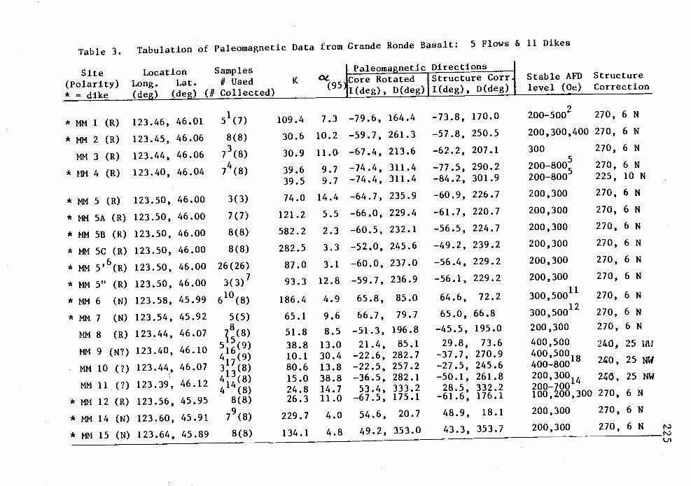
Table 3. Tabulation of Paleomagnetic Data from Grande Ronde Basalt: 5 Flows & 11 Dikes
Site Location Samples 1 Paleomagnetic Directions
(Polarity) Long. Lat. 1/ Used K °95JCore Rotated Structure Corr Stable AFD Structure
* = dike (deg)(deg) (// Collected) ' 1I(deg), D(deg) I(deg), D(deg) level (Oe) Correction
* MM 1 (R) 123.46, 46.0151(7)
* MM 2 (R) 123.45, 46.06 8(8)
MM 3 (R) 123.44, 46.06 7(8)
* MM 4 (R) 123.40, 46.04 7(8)
* MM 5 (R) 123.50, 46.00
* MM 5A (R) 123.50, 46.00
* MM 5B (R) 123.50, 46.00
* MM 5C (R) 123.50, 46.00
* MM 5'6(R) 123.50, 46.00
* MM 5" (R) 123.50, 46.00
* MM 6 (N) 123.58, 45.99
* MM 7 (N) 123.54, 45.92
MM 8 (R) 123.44, 46.07
MM 9 (N?) 123.40, 46.10
MM 10 (?) 123.44, 46.07
MM 11 (?) 123.39, 46.12
* MM 12 (R) 123.56, 45.95
* MM 14 (N) 123.60, 45.91
* MM 15 (N) 123.64, 45.89
3(3)
7(7)
8(8)
8(8)
26(26)3(3)7
610(8)
5(5)
T8(8)
13 (8)
4 13(8)
4 14(8)
8(8)
7(8)
8(8)
109.4 7.3 -79.6, 164.4 -73.8, 170.0
30.6 10.2 -59.7, 261.3 -57.8, 250.5
30.9 11.G -67.4, 213.6 -62.2, 207.1
39.6 9.7 -74.4, 311.4 -77.5, 290.2
395 97 -74.4, 311.4 -84.2, 301.9
74.0 14.4 -64.7, 235.9 -60.9, 226.7
121.2 5.5 -66.0, 229.4 -61.7, 220.7
582.2 2.3 -60.5, 232.1 -56.5, 224.7
282.5 3.3 -52.0, 245.6 -49.2, 239.2
87.0 3.1 -60.0, 237.0 -56.4, 229.2
93.3 12.8 -59.7, 236.9 -56.1, 229.2
186.4 4.9 65.8, 85.0 64.6, 72.2
65.1 9.6 66.7, 79.7 65.0, 66.8
51.8 8.5 -51.3, 196.8 -45.5, 195.0
38.8 13.0 21.4, 85.1 29.8, 73.6
10.1 30,4 -22.6, 282.7 -37.7, 270.9
80.6 13.8 -22.5, 257.2 -27.5, 245.6
15.0 38.8 -36.5, 282.1 -50.1, 261.8
24.8 14.7 53.4, 333.2 28.5, 332.226.3 11.0 -67.5, 175.1 -61.6, 176.1
229.7 4.0 54.6, 20.7 48.9, 18.1
134.1 4.8 49.2, 353.0 43.3, 353.7
200_5002 270, 6 N
200,300,400 270, 6 N
300 270, 6 N
200-800 270, 6 N
200-800 225, 10 N
200,300 270, 6 N
200,300 270, 6 N
200,300 270, 6 N
200,300 270, 6 N
200,300 270, 6 N
200,300 270, 6 N
300,50011 270, 6 N
300,50012 270, 6 N
200,300 270, 6 N
400,500 240, 25 i
400,500400_80018 240, 25 14W
2003004 268, 25 NW200-700100,200,300 270, 6 N
200,300 270, 6 N
200,300 270, 6 N r'.
I'.)

Footnotes:
Samples form cores 2 & 5 are excluded because stabel directions were not obtained (Core 2) and declin-
ation measured in Core 5 is far from the site mean declination.
2AF levels vary: Core 1 - 400,500 Ce; Core 3 300,400 Oe; Core 4 - 200,300; Core 6 - 300; Core 7 - 200,300
Specimens from Core 4 are excluded because of poor agreement of magnetic directions between two speci-
mens of the same core and magnetic instability of the same samples.
Specimens from Core 3 are excluded because of poor agreement of paleomagnetic directions and magnetic
instability.
AF levels vary: Cores 1, 2 & 4 - 200,300 Ce; Core 5 - 200,250; Core 6 - 500,600; Core 7 - 600,700 Ce;
Core 8 400,500 Oe.
6MM 5' represents the mean directions of 26 samples collected in Beneke Quarry. All samples are given
equal weight and only one specimen per core is considered.
Only the means of sites MM5A, 5B, & SC are considered in MM 5". This gives the mean of means of 3
sites in Beneke Quarry.
Core 2 excluded because the mean inclLnation of the core is far from the mean inclination of the site.
Core 3 excluded because the declination of the specimen of the core is far from the mean declination
of the site.
10Cot1 excluded because the paleomagnetic directions are reversed and far from the mean for the site.
Core 3 was never measured.
AF levels vary: Cores 2, 4, 5, 7 & 8 - 300 Oe; Core 6 - 500 Oe.12
AF levels vary: Cores 1, 2, 3 & 4 - 300 Ce; Core 5 - 500 Ce.

Footnotes (con't.)
13Site MM 11 is divided into 2 groups of reversed polarity & normal polarity. This line of data is for
the reversed polarity group using specimens from Cores 1,2,3 & 8, all at the 200,300 Oe AF level.
14This line of data is for the normal polarity group of site MM 11 using specimens from Cores 4, 5, 6 &
7; AF levels vary: Core 4 - 400,500 Oe; Core 5 - 600,700; Core 6 - 500,600; Core 7 - 200,300 Oe.
15Site MM 9 is divided into two groups of normal and reversed polarity. This line of data is for the
normal polarity group, using specimens from Cores 5, 6, 7, 8 & 9.
16This line of data is f or the reversed polarity group using specimens from Cores 1, 2, 3 & 4.
17Only Cores 3, 5 & 6 are used because specimens from these cores clustered together with similar inclin-
ation (up in Quadrant III). Other cores are disregarded because of poor agreement between specimens
of the same core, strong overprint due possibly to secondary magnetization which could not be removed
with A? demagnetization, and/or disparate paleomagnetic directions of these other cores.
Stable A? levels vary: Core 3 400,500 Oe; Cores 5 & 6 - 700,800 Oe.

Table 4: Tabulation by Dike Trend
Trend/Chemistry Polarity Sites Used K ((95\ L Paleomagnetic Directions j StructureNo. of snips ' ' Core Rotated Structure Corr. Correction
1(deg), D(deg) I(deg), D(deg)
Northrup! MM1, 11114 23.9 9.1 -84.0, 286.8 -82.7, 233.4 270, 6 NLow MgO high Ti02 R
Beneke /
Low MgO high Tb2 R
N = 12
11112, SA, 511, 22.8 4.95C, MM12N = 39
-63.7, 233.4 -59.8, 225.0 270, 6 N
Fl shhawk/
Low MgO, low Ti02 N 11116, MM7 110.5 4.4 66.2, 82.6 64.8, 69.8 270, 6 NN = 11
Table 5: Tabulation by Crande Ronde Basalt Ceochemical Sub-type
Chemistry Sites Used K Paleomagnetic Directions StructureNo. of smps / [Core Rotated Structure Corr.1 Correction
Iceg), D(deg) l(deg), D(deg)l
Low MgO, high Tb2 MIII, 4, 8, 16.0 4.8 -67.4, 228.8 -63.2, 219.7 270, 6 NSA, SB, SC,& MM 12N58
Low MgO low Ti02 11116, MM? 110.5 4.4 66.2, 82.6 64.8, 69.8 270, 6 N
High ligO 111114, 111115 52.2 5.1 52.3, 7.3 45.5, 5.8 270, 6 N00

229
Nicolai Mountain have a hornoclinal north dip of
approximately 6° and east-west strike (Murphy, 1981).
Deformation of these middle Miocene flows is probably
due to regional north plunge of the nose of the Oregon Coast
Range anticlinorium, the axis of which passes near the area.
The middle Miocene basalt intrusives and surrounding
sedimentary strata have been similarly deformed since the
middle Miocerte as these rocks also occur near the axis of
the Oregon Coast Range anticlinorium. This deformation
probably occurred after primary magnetic remanence of the
Grande Ronde basalts was acquired.
Local dips of upper Eocene and Oligocene sedimentary
rocks surrounding the middle Miocene intrusives are steeper
than the tectonic tilt correction reported in the tables.
Even if the local steeper tilt corrections are taken into
account, they are mild in any case (<10° dip and <20-30°
variation in strike direction) and did not result in widely
different "structure corrected" fi?ld directions when
applied in several cases. The subaerial flows in the
Plyinpton Creek section (sites MM9, MM1O and MM11) have a
locally steeper dip (25°NW) and strike than the regional
tilt (Goalen, in prep.).
The locally high dips and variability of dip direction
of the sedimentary strata may reflect small block tilting
that pre-dates middle Miocene and the dike intrusion events
because the sills and dikes cut across folds without
mappable folding of the intrusives themselves (cross-section
230
H-H', Plate 2). Wells (1981) and Wells and others (1982)
also found better paleomagnetic correspondence between
middle Miocene intrusions and their subaerial equivalents in
southwestern Washington when the locally higher sedimentary
dips were ignored, suggesting that these dips were in large
part due to pre-rniddle Miocene structure.
Paleomagnetic Results from the Dikes
Northrup Creek dike. Two sites (MM1 and MM4) are
located 3.6 km apart on the Northrup Creek dike. Both of
these sites have reversed polarity and very steep
inclinations. When the assumed middle Miocene tectonic tilt
of the Oregon Coast Range is removed, the two sites average
I = -83°, D = 233° (Table 4 and Fig. 40). The steep
inclination is anomalous compared to the Miocene expected
direction for latitude 46°N and is probably due to secular
variation of the geomagnetic field during cooling or to some
inherent variable magnetic properties of the dike.
The steep inclination is also distinct from that of the
Beneke dike which has an average inclination of -59.8°. The
Beneke dike has similar geochemistry to the Northrup Creek
dike (i.e., low-MgO-high-Ti02 Crande Ronde subtype) and it
was noted earlier that the Northrup Creek dike has slightly
lower Ti02 content than the Beneke dike (Fig. 35), and
therefore is a separate basalt unit. Both dikes have
reverse polarity but show different inclinations and

33O
STRUCTURE CORRECTED
300/ UPPER HEMJSPHERE PLOT
270NORTHRUP
FISHHA WK®
QENEKE a EXPECTEDMIOCENE
9O
DiRECTION
° MM8
210
180
150
231
Figure 40. Paleomagnetic directions of three middle Miocene
dike trends in eastern Clatsop County. The
direction of Fishhawk Falls dike, which has
normal polarity, is projected through the origin
into the upper hemisphere (represented by filled
circle). Site MM3 from Nicolai Mtn. appears to
correlate to the Beneke dike based on overlap of
a95ts. The larger circles represent cone of 957
confidence (a95).

232
declinations of paleomagnetic directions (Fig. 40). This
difference of paleomagnetic directions also suggests that
the Northrup Creek and Beneke dikes are separate intrusive
bodies formed at different times within a changing
geomagnetic field.
Alternatively, the anomalously steep inclinations of
the Northrup Creek dike may be due to the effect of local
tilting of small tectonic blocks. Near the Northrup quarry
site (MMI), a large left-lateral oblique-slip fault is
mapped which offsets the Northrup Creek dike by 100 m south
of site MM1 (Olbinski, Plate I, 1983). Unrecognized tilting
about axes other than the strike of the strata due to this
faulting may explain why the declination is so different
between this site and the second site on the Northrup Creek
dike (MM4). Tilting about a non-vertical axis could also
cause the anomalous steep inclination.
Other explanations are also possible. Stauss (1982)
measured anomalous paleomagnetic directions in Eocene dikes
in central Washington and suggested that anomalous
directions may result from several factors, including:
secondary uncleaned chemical remanent magnetism (CRM); or
inadequate sampling of the dipole field from rocks that
acquire remanent magnetization during major excursions or
polarity reversals; or to deflection of thermal remanent
magnetization (TRM) directions during crystallization due to
stress anisotropy on the intrusive. Determining which of
these factors may have caused the anomalous steep
233
inclinations of the Northrup Creek dike at site MM1 is
beyond the intent of this study.
Beneke dike. Seven sites (MM2, MM5, MM5A, MM5B, MM5C,
MM12, MM13) are located along the length of the Beneke dike
trend (Fig. 39, Tables 3 and 4). Site MM2 is near the
northern end of the trend, 1.8 km south of Nicolai Mountain
(Fig. 39). Sites MM5, 5A, 5B and 5C are located in the
Beneke quarry (NE1/4, NE1/4, sec. 14, T6N, R7W; Plate 4).
Site MM5 was originally sampled in the Spring of 1981 but
the locations of the four cores collected here were
destroyed by the quarrying operation. When the site was
reoccupied in the November 1981, three new sites (MM5A, 5B,
5C) were established in order to determine if rotation had
occurred between small fault-bounded blocks mapped within
the quarry. Although the original boreholes of site MM5
were destroyed, site MM5A is located within the same area
and fault block in the quarry and thus replaces the original
site MM5. The a95 statistic for site MM5A (5.5°) is much
improved over that of MM5 (14.4°), yet the field directions
are very similar (Table 3). The primary reason that the a95
statistic is improved is that more samples are used in site
MM5A.
The three Sites in the quarry are located on different
structural blocks bounded by oblique-slip faults. Site MM5A
is in the northern part of the quarry, site MM5B near the
middle part of the quarry, and site MM5C is located near the

234
southern end of the quarry exposure (see Plate 4). These
sites are the focus of discussion in a later section on
small-block tectonic rotation.
Site MM12 is located at Denver Point (Plate 1; NW1/4
sec. 4, TSN, R7W). It is 7.7 km southwest of the Beneke
quarry along the trend of the dike.
All five sites along the northern part of the Beneke
trend (sites MM2, MM5A, MM5B, MM5C and MM12) have reversed
polarity and similar geochemistry corresponding to the
low-MgO--high-Ti02 Grande Ronde type. Mean structure
corrected paleomagnetic field directions are: D = 225°,
I = -60° with an a95 4.9° (Table 4, Fig. 40). The range
of declination and inclination values from individual sites
in the Beneke dike are: D = 250.5° to 176.1° and I = -49.2°
to -61.6° (Table 3).
One site (site MM13) was located on the southern part
of the Beneke dike which has low-MgO-low-Ti02 chemistry that
is indistinguishable from the chemistry of the Fishhawk
Falls dike. This southern part of the Beneke dike trend has
normal polarity as measured with a fluxgate magnetometer.
Site MM13 failed to provide meaningful data due to widely
disparate directions after magnetic cleaning of the samples.
This problem is probably related to poor sampling
techniques.
Fishhawk Falls dike. One site located on the Fishhawk
Falls dike has normal polarity and paleomagnetic directions
235
of: D = 70°, I = 65° (structure corrected) (Figs. 39 and
40; Table 4). Two sites (MM6 and MM7) are located in two
geographically separate dikes having the low-MgO-low--Ti02
chemistry and normal polarity characteristic of the Fishhawk
Falls dike (Plate 1; Appendix IX). Site MM6 is located at
Fishhawk Falls (the waterfall) in the center of the Fishhawk
dike itself. Site MM7 is located at Little Fishhawk Falls,
southeast of the other Fishhawk Falls (NW1/4, SE1/4, sec. 8,
T5N, R7W) (Plate 1). This isolated 0.5-km-long dike, though
similar geochemically and paleomagnetically to the dike at
site MM6, is not on the same linear trend of the main
Fishhawk Falls dike.
Nicolai Mountain Porter Ridge area. Two reverse
polarized pillow basalts of low-MgO--high-Ti02 chemistry were
sampled on Nicolai Mountain (sites MM3 and MM8). These
flows represent Grande Ronde basalt units from the Columbia
River plateau which entered the middle Miocene ocean
(Murphy, 1981). The lower flow has a structure corrected
inclination of -62° and declination of 207° (Table 3). The
upper flow has an inclination of -46° and a declination of
195°. Murphy (1981) incorrectly identified the upper pillow
flow as normally polarized based on fluxgate magnetometer
measurements. The lower flow (site MM3) appears to
correlate well to the northern part of the Beneke dike as
these units have similar low-MgO-high-Ti02 chemistry,
reverse polarity and similar average paleomagnetic
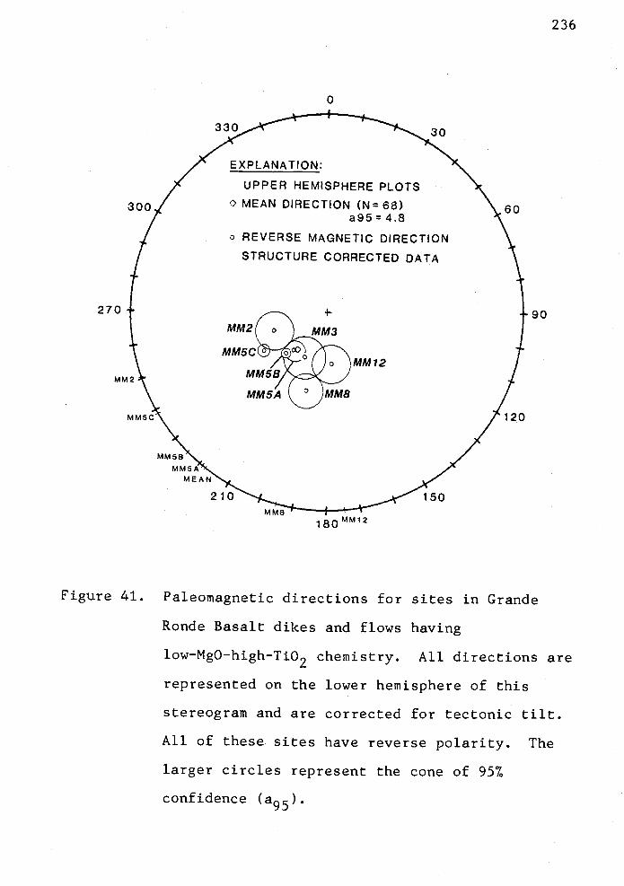
330 30
EXPLANATION:
UPPER HEMISPHERE PLOTS0 MEAN DIRECTION (N=68)30(o REVERSE MAGNETIC DIRECTION
a95 48
STRUCTURE CORRECTED DATA
270
MM5C° O
MM12MM5BMM2
MM5A JMM8MM5C
MM5BMM5AMEAN
150210MM8
180
120
236
Figure 41. Paleomagnetic directions for sites in Grande
Ronde Basalt dikes and flows having
low-MgO-high-Ti02 chemistry. All directions are
represented on the lower hemisphere of this
stereogram and are corrected for tectonic tilt.
All of these sites have reverse polarity. The
larger circles represent the cone of 957.
confidence (a95).

237
directions (Tables 3 and 4; Fig. 40). The inclinations and
declinations of sites MM3 and MM8 are close to the expected
middle Miocene pole position (Figs. 40 and 41).
Paleomagnetic data from geochemical subtypes.
Considered as a group by geochemical subtype (Table 5), the
low-MgO-high-Ti02 Grande Ronde basalt dikes and flows that
were sampled in this study (sites MM1, MM2, MM3, 5A, 5B, 5C,
MM12) have reversed polarity. However, this may not be
entirely representative of Columbia River and coastal
basalts because there may be other low-'-MgO-high-Ti02 Grande
Ronde flows in western Oregon that have not been sampled
here. Goalen (in prep.) believes that a normally polarized
low-MgO-high-Ti02 flow may exist on Porter Ridge. Six sites
(MM4, MM8, MM5A, 5B, 5C, and MM12) were used in the
tabulation and mean directions are I -63°, D = 220°, with
an 957 confidence circle of 4.8° (Fig. 42).
Low-MgO-low-Ti02 basalt dikes and flows in the study
area and elsewhere may have either normal or reversed
polarity based on fluxgate magnetometer measurements
(Murphy, 1981; Peterson, 1984; Goalen, in prep.). In this
study however, only normal polarity low-MgO--low-Ti02 basalt
was sampled (sites MM6 and MM7). Mean directions are: I =
65°, 0 = 70°, with an a95 of 4.4° (Table 5; Fig. 42).
Two small high-MgO basalt dikes were sampled (site MM14
in NE1/4, NW1/4, sec. 24, T5N, R8W and site MM15 in SW1/4,
SW1/4, sec. 35, T5N, R8W). The structure corrected

330
/ STRUCTURE CORRECTED£ DATA (2700 B N)
3001 UPPER HEMISPHERES
30
238
+
LOW Ti02LOW MgO
®HIGH Ti02
270LOW MgO
O EXPECTEDHIGH( MIOCENEMgO DIRECTIONS
240
210
180
150
120
Figure 42. Paleomagnetic directions of geochemical subtypes
of Grande Ronde Basalt in eastern Clatsop
County. All directions are represented in the
upper hemisphere of this stereogram and are
corrected for tectonic tilt. Filled circles
represent normal polarity directions that are
projected through the origin to the upper
hemisphere. Small open circles represent
reverse polarity directions. Large circles
represent the 957 cone of confidence (a95).
239
inclination varied from 43.2° to 48.9° and the declination
varied from 353.7° to 18.1° for these two dikes (Table 3).
Mean field directions of these two sites are: I = 46°, D =
6°, with an a95 of 5.1° (Table 5). High MgO Grande Ronde
basalts clearly have normal polarity.
Tectonic Rotation of Fault-bounded Blocks
Problem of secular variation. The effect of secular
variation of the earth's paleomagnetic fields on the results
in this study is not known. There may
not have been an adequate span of geologic time between
these representative samples to average out the secular
variation of the geomagnetic field. If the dikes cooled
over a period of 10 to 1,000 years, this period may have
allowed considerable variation of the geomagnetic field, but
secular variation would probably not be averaged out.
If the dikes cooled over a longer period of time, say
10,000 years, and if the samples collected in this study
represent an average of this time span, then secular
variation might be averaged out. Assuming that secular
variation is averaged out, then pole positions calculated
from these paleomagnetic directions would representative
mean poles.
Interpretation. High MgO basalt dikes show the least
clockwise tectonic rotation (R=5.8°) from the expected
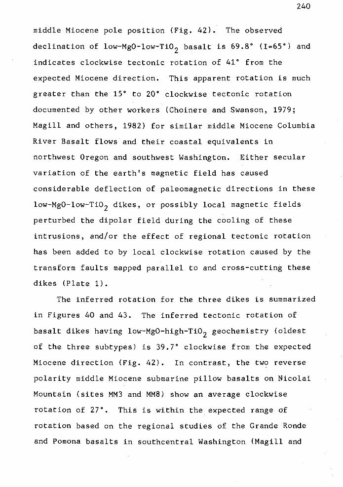
240
middle Miocene pole position (Fig. 42). The observed
declination of low-MgO-low-Ti02 basalt is 69.8° (1=65°) and
indicates clockwise tectonic rotation of 41° from the
expected Miocene direction. This apparent rotation is much
greater than the 15° to 20° clockwise tectonic rotation
documented by other workers (Choinere and Swanson, 1979;
Magill and others, 1982) for similar middle Miocene Columbia
River Basalt flows and their coastal equivalents in
northwest Oregon and southwest Washington. Either secular
variation of the earth's magnetic field has caused
considerable deflection of paleomagnetic directions in these
low-MgO-low-Ti02 dikes, or possibly local magnetic fields
perturbed the dipolar field during the cooling of these
intrusions, and/or the effect of regional tectonic rotation
has been added to by local clockwise rotation caused by the
transform faults mapped parallel to and cross-cutting these
dikes (Plate 1).
The inferred rotation for the three dikes is summarized
in Figures 40 and 43. The inferred tectonic rotation of
basalt dikes having low-MgO-high-Ti02 geochemistry (oldest
of the three subtypes) is 39.7° clockwise from the expected
Miocene direction (Fig. 42). In contrast, the two reverse
polarity middle Miocene submarine pillow basalts on Nicolai
Mountain (sites MM3 and MM8) show an average clockwise
rotation of 27°. This is within the expected range of
rotation based on the regional studies of the Grande Ronde
and Pomona basalts in southcentral Washington (Magill and
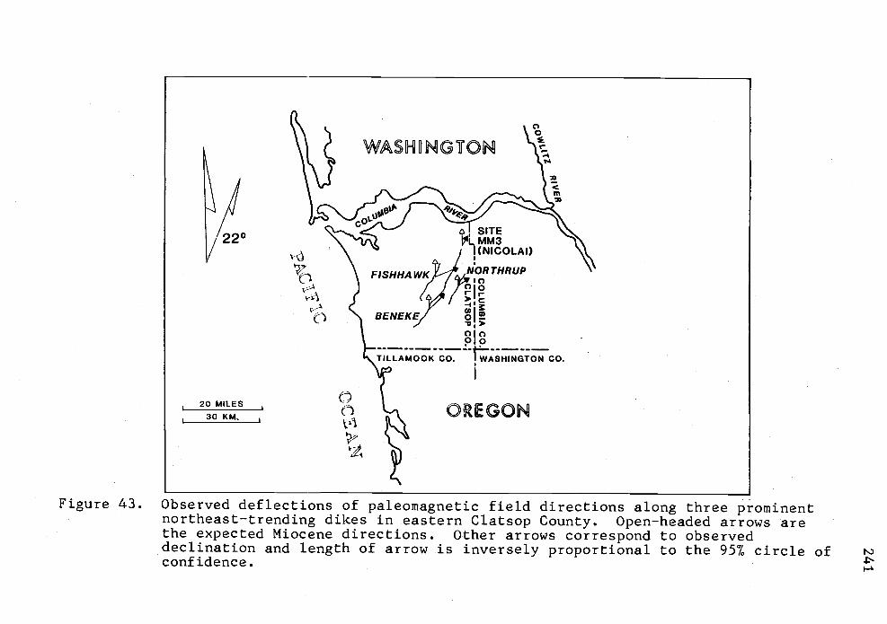
\F,sHHAwKJ-7/0'?Th1Rhu1'
J / )foI (&f >15C V
BENEKE/ oI.uI>
I 00
OREGON
4
Figure 43. Observed deflections of paleomagnetic field directions along three prominentnortheast-trending dikes in eastern Clatsop County. Open-headed arrows arethe expected Miocene directions. Other arrows correspond to observeddeclination and length of arrow is inversely proportional to the 957 circle ofconfidence.

242
others, 1982; Wells and others, 1984). The much greater
rotation of the three dikes is anomalous.
Small-block tectonic rotation. As mentioned
previously, three separate sites (site MM5A, 5B, and 5C) are
located in Beneke quarry. Very detailed geologic mapping
(1" = 100') of faults and shear zones in the quarry (Plate
4) shows that many northwest- and northeast-trending
oblique-slip faults repeat and offset small blocks (e.g., 10
in x 100 in) that contain or bound the northeast-trending
Beneke dike. This density of faults is found in nearly
every major quarry along the Beneke, Northrup Creek and
Fishhawk Falls dikes, suggesting that distributed shear is
predominant in the area. The northeast-trending shear zones
which are subparallel to the dikes are the most prominent.
The samples from the sites in the northern and middle parts
of the Beneke quarry (sites 5A and 5B) are paleomagnetically
similar (i.e., site 5A: I = -62°, D = 221° and site 5B:
I -57°, D = 225; Table 3; Figs. 41 and 44). The a95 of
the two sites overlap. However, site MM5C (115 in south of
sites MM5A and MM5B) has a mean direction deflected 11°
clockwise of the mean for the three sites (Fig. 44). There
is no overlap of the a95 statistic between sites MM5C and
sites MM5A and 5B, suggesting that there is a geological
reason for the lack of overlap.
The detailed mapping shows that the part of the basalt
dike sampled at site MM5C is a repeated section that has
243
0
330 '-.... 30
EXPLANATION:A MEAN OF 3 SITES WITH EACH
7 SPECIMAN GIVEN EQUAL WEIGHT. (N26)
300/ o SITE MEAN, UPPER HEMISPHERE 60I STRUCTURE CORRECTION 270°,6° N.
270-1. +90
(N26) MEAN OF
oD (N3)MEANS
7-
/MMSC ,/120
MEAN 229'MM5 227MM5B 225'%,MMSA 221
210 150
180Figure 44. Paleomagnetic directions for three sites of the
middle Miocene Grande Ronde Basalt dike in the
Beneke quarry (NE1/4, NE1/4, sec. 14, T6N, R7W).
All directions are represented in the upper
hemisphere of the stereogram and are reversed
polarity. Large open circles represent the 957
cone of confidence. Site MM5C occurs within the
southern block in the quarry and is rotated 110
clockwise from two other sites that are within a
different structural block. There is no overlap
of the a95.

244
been translated northeastward along a northeast-trending
left-lateral oblique-slip fault. The paleomagnetic data
indicates that this small fault bounded block (only 15-20 m
long) contains a part of the dike that may have rotated
during movement on the fault relative to the blocks
containing sites MM5A and MM5B. The possibility exists for
many other clockwise rotations of this nature along all the
major northeast- and northwest-trending faults that
pervasively cut the Beneke, Northrup Creek and Fishhawk
Falls dikes throughout their lengths.
The existence of many small tectonic blocks bounded by
sinistral northeast- and dextral northwest-trending faults
may explain the anomalously large apparent rotations
indicated by these data relative to the measured rotation of
equivalent basalts in southwestern Washington (Wells and
others, 1983b). Due to the limited exposure in the area, it
is difficult to map the boundaries of the many possible
small tectonic blocks.

245
STRUCTURAL GEOLOGY
Structure
The Oregon Coast Range is composed of uplifted basement
blocks of lower Tertiary ocean floor basaltic crust
surrounded by younger Paleogene and Neogene sedimentary
rocks (Niem and Niem, 1984). The core of the central and
northern Oregon Coast Range is composed of 15,000- to
20,000-foot-thick lower to middle Eocene Siletz River
Volcanics and Tillamook Volcanics (Snavely and others, 1968;
MacLeod and Snavely, 1973; Wells and others, 1983). The
northern part of the Coast Range forms a gently
northward-plunging anticlinorium or geanticline. The term
"anticlinorium' is a misleading description of the regional
Coast Range structure because it is difficult to trace out
anticlinal and synclinal structures on the surface (Niem and
Van Atta, 1973). Local reversals of dip and discordant
strikes can be as effectively explained by faults as by
folds (this study; Olbinski, 1983; Kadri, 1982; Peterson,
1984). Therefore, the terms geanticline or basement upwarp
are preferable because these terms describe a regional
uplift of the crust and associated sedimentary basins
without implying the presence of fold structures. Warren
and Norbisrath (1946) also described the Coast Range
structure as a geanticline.

246
The axis of the northward-plunging regional structure
is located just northeast of the thesis area in the
southeastern part of the Astoria basin and nearly coincides
with the eastern boundary of Clatsop County, 9 km east of
the study area. On the east and west flanks of this
structure are the Nehalem and Astoria basins, respectively.
The structure continues northward as indicated by the
north-northeast-trending Bouguer gravity anomaly that
reflects the Tillamook Volcanics in the subsurface (Bromery
and Snavely, 1964; Berg and Thiruvathukal, 1967; Kadri,
1982).
A northward plunge of 100 to 15° is indicated by the
northward dip of the middle Miocene Columbia River basalt
flows that form Nicolai Mountain (9 km north of the thesis
area) (Murphy, 1981). This plunge is in general accord with
the regional dip of Eocene and Oligocene strata in the
thesis area which dip northwest at 100 to 15°. Assuming
that the dikes were originally vertical, the generally steep
southeastward dip of the three major Grande Ronde dikes in
eastern Clatsop County implies that north and/or
northwestward tilting of the entire thesis area has occurred
since emplacement. Local variations in dip of the dikes
can be accounted for by smaller fault block adjustments due
to post-middle Miocene north-south compression (e.g., Plate
1 and 4; Olbinski, 1983; Goalen, in prep.).

247
Offshore seismic reflection profiles provide the
best evidence of regional structures and continental
accretion (Snavely and others, 1980). Several periods of
uplift, compression and extension have affected the Oregon
Coast Range and nearby continental shelf and slope since the
Eocene. Discontinuous periods of underthrusting during the
middle Eocene, middle late Eocene, late middle Miocene,
Pleistocene and Holocene have deformed Cenozoic rocks of
this continental margin (Snavely and others, 1980).
Low-angle, eastward-dipping imbricate thrust faults and
folds on the Oregon continental shelf and slope are
associated with the subduction episodes as the Juan de Fuca
and Farallon oceanic plates slipped beneath the North
American continental plate during oblique plate convergence
(Kulm and Fowler, 1974; Snavely and others, 1980; Wells,
1981; Magill and others, 1980, 1982; Niem and Niem, 1984).
Compressional periods were interrupted by periods of
strike-slip faulting and extension during the late Eocene
and late middle Miocene (Snavely and others, 1980; Wells,
1981). Periods of extension produced normal faulting and
igneous intrusion in the Coast Range and coincided with
calc-alkaline arc volcanism in the western Cascade Range.
The late Eocene to early Oligocene (e.g., 29-34
m.y.B.P.) was also a period of extension and igneous
intrusion as several sills of gabbroic and syenitic
composition were intruded into middle to upper Eocene marine

248
strata in the central Oregon Coast Range. Upper Eocene to
Oligocene marine strata (Refugian age) have a significantly
more tuffaceous character than the Eocene marine strata
(Narizian age). The volcanic materials were probably
derived from an early, more active and developing western
Cascade volcanic arc of andesitic to silicic composition
(Niem and Niem, 1984). Uplift of the Oregon Coast Range
commenced during early Oligocene time (Snavely and Wagner,
1963; Snavely and others, 1980). The rapid shallowing of
the depositional basin from bathyal to shelf environments
between late Keasey time and Pittsburg Bluff time supports
this interpretation.
Tectonic Rotation and Tectonic Boundaries
Paleomagnetic studies of Tertiary basalts and
sedimentary roáks of the Oregon and Washington Coast Ranges
and western Cascade Range indicate that up to 750 of
clockwise tectonic rotation of western Oregon and Washington
has occurred (Magill and others, 1981, 1982; Magill and Ccx,
1980, 1981;. Beck and Plumley, 1980; Globerman and Beck,
1979; Bates and others, 1979, 1981; Beck, 1976). Workers
who have focused on the lower to middle Eocene oceanic
basaltic crust and middle to upper Eocene strata of the
Oregon Coast Range suggest that a part of the Farallon
oceanic plate fragmented during late middle Eocene time as
249
it collided with the North American continent (Simpson and
Cox, 1977; Magill and Cox, 1980, 1981; Magill and others,
1981). Accretion of the fragment, or microplate, may have
occurred as the buoyant oceanic crust was obliquely
subducted beneath the North American continent.
To explain the apparent rotation of the Oregon Coast
Range suggested by paleomagnetic studies, several workers
(Simpson, 1977; Simpson and Cox, 1977; Magill and others,
1982) proposed a two-phase tectonic rotation model. They
hypothesized that during an early phase which preceded the
Oligocene the oceanic crust rotated up to 48° clockwise
about a vertical pivot in the Kiamath Mountains of southern
Oregon. Northeastward movement of the Farallon oceanic
plate against the North American plate caused clockwise
rotation of the Farallon plate fragment. The subduction
zone was then jammed by anomalously thick buoyant oceanic
crust carrying seamounts and oceanic islands into the
oceanic trench. This caused the subduction zone, which
probably lay beneath the Willamette Valley, to be abandoned,
and a new trench and subduction zone formed to the west in
the vicinity of the present Oregon outer continental shelf
and slope. An isolated segment of the plate, trapped
between the older and now inactive trench and the new
subduction zone, contains the Siletz River, lower Tillamook
and Roseburg volcanics.

250
Following the westward jump of the subduction zone, a
second phase of clockwise rotation of up to 27° occurred in
association with post-early Miocene back-arc extension of
the Basin and Range province (Magill and Cox, 1981).
Dextral slip faulting also occurred along
northwest-southeast trends.
The Coast Range rotated as a semi-rigid block. There
are no through-going faults that break the Coast Range into
several smaller tectonic blocks. Paleocurrent orientations
in the Tyee and Flournoy formations are consistent
throughout the Oregon Coast Range (Snavely and others, 1963,
1964), further supporting the interpretation that the Coast
Range is a single tectonic block, or microplate.
Magill and others (1981) and Beck and Plumley (1980)
interpret that clockwise rotation recorded in the Eocene,
Oligocene and Miocene volcanic and intrusive rocks suggests
progressive rotation with time. The older Eocene formations
(i.e., Siletz River Volcanics, Tyee-Flournoy formations, and
Tillamook Volcanics) have been rotated more than the younger
formations (i.e., Yachats and Goble Volcanics, and Oligocene
and middle Miocene intrusions). The lower to middle Eocene
Siletz River Volcanics (50 to 55 m.y.) are rotated as much
as 75±15° (Magill and others, 1981). The middle to upper
Eocene upper Tillamook Volcanics (minimum age of 46 m.y.)
are rotated 4613° (Magill and others, 1981; this study).
The upper Eocene Goble Volcanics (32 to 45 m.y.), in the

251
Kelso and Longview, Washington area, have been rotated
clockwise through as much as 2513° (Beck and Burr, 1979).
Other Eocene basement volcanic rocks north of the Columbia
River (i.e., Crescent and Goble Volcanics) are also rotated,
but to lesser degrees than volcanic rocks of similar age in
the Oregon Coast Range (Wells, 1981; Wells and Coe, 1979;
Globermari and Beck, 1979).
Thus, Magill and others (1981) interpreted that a major
tectonic boundary exists between the Oregon and Washington
Coast Ranges near or along the Columbia River. These
workers suggested that the Oregon Coast Range contrasts to
the Washington Coast Range and Western Cascade Range. The
latter areas were broken up into several smaller tectonic
domains, or tectonic blocks, whereas much of the Oregon
Coast Range remained a coherent block during late Eocene to
post-middle Miocene deformation and rotation.
The thesis area is situated in the zone that is herein
proposed as the northern boundary between these two
different tectonic regimes. A preliminary investigation of
the paleomagnetism of the uppermost Tillamook Volcanics in
the Green Mountain outlier (see Paleomagnetism of the
Tillainook Volcanics, p. 48-52) indicates that these upper
Eocene volcariics and the overlying Cougar Mountain
intrusives (Rarey, in prep.) have been rotated clockwise
48+26°. This amount of rotation is nearly identical with
the 46° of clockwise rotation measured in the lower part of

252
the Tillatnook Volcanics in Tillamook County by Magill and
others (1981). Much of this rotation must have taken place
since the upper Eocene (i.e., since 40 m.y.B.P., the K-Ar
age of the volcanics at Green Mountain and near Buster
Creek) and perhaps since the Cowlitz Formation was
deposited. Thus, the tectonic boundary lies between the
Green Mountain Buster quarry area (the northernmost
exposure of the Tillatnook Volcanics) and the Columbia River.
The age equivalent Goble Volcanics and older Crescent
Volcanics north of the Columbia River have been rotated less
than 25° (Wells, 1981). The tectonic boundary is covered by
younger Tertiary marine sedimentary rocks.
I propose that this boundary manifests itself as
distributed shear along a number of sinistral
northeast-trending- and dextral northwest-trending
oblique-slip faults. Much of the motion along these faults
took place since the middle Miocene because these faults
offset the major middle Miocene Beneke, Northrup Creek and
Fishhawk Falls dikes (Plates 1 and 4; Olbinski, 1983;
Goalen, in prep.). Movement on the oblique-slip faults may
have caused as much as 69° of clockwise rotation of some
small blocks of the dikes. In the Beneke quarry, up to 110
of clockwise rotation can be demonstrated between
strike-slip faults which bound very small blocks (see
preceding section on paleomagnetism of Miocene basalts).
253
At present, the dikes follow the western boundary of
the northern Oregon Coast Range gravity high. The
pre-rotation position of these dikes would be closer to
north-south.
To explain the anomalous patterns of rotation of the
Goble and Crescent volcanics in southwestern Washington,
Wells (1981) suggested that a post-late Eocene north-south
shear couple, driven by oblique subduction of the Juan de
Fuca plate beneath the North American plate, could cause
clockwise rotation between small tectonic blocks bounded by
sinistral northwest-trending and dextral northeast-trending
faults. This mechanism apparently operated in northwestern
Oregon in the sag between the Willapa Hills to the north,
which rotated 25° to 300, and the main Coast Range block to
the south, which rotated 46200 (Magill and others, 1981;
this study). This intervening area took up the differential
shear between the two microplates or crustal blocks.
Local Structure
Overall, the sedimentary rocks in the thesis area
strike northeast and dip gently 10° to 15° north and
northwest (Plate 1). This outcrop pattern is part of the
western limb of the northward-plunging Coast Range
anticlinorium of Niem and Van Atta (1973). The Eocene
volcanic rocks, middle and upper Eocene to Miocene

zhi +
sedimentary rocks, and middle Miocene intrusive basalts in
the study area are cut by numerous northwest- and
northeast-trending faults (Plates 1, 2 and 4). Therefore,
the area is broken into many small fault blocks. Drag and
tilting associated with the faults has created many
anomal.ous dips and strikes in the sedimentary strata.
Slumps and basalt intrusions also cause local variations in
the attitudes of the regional northwest dip and
northeast-southwest strike of strata.
There are probably more faults than shown on the
geologic map (Plate 1) but are not recognized at the surface
due to poor bedrock exposure and thick iorest and soil
cover. Many faults are inferred from offset outcrop
patterns, abrupt lithologic changes in sedimentary rocks in
short distances along strike, discordant attitudes of
bedding, and offset of presumably linear middle Miocene
intrusions. However, many faults and gouge zones are
recognized and interpreted from offsets of dikes and sills
(e.g., Beneke dike) in basalt quarries where the dip and
strike of fault planes and the orientations of slickensides
can be measured. (These positively recognized faults and
straie are designated with solid lines and dip directions on
Plates 1, 2 and 4).
The three major middle Miocene basalt dikes in the area
(e.g., Beneke, Northrup Creek and Fishhawk Falls dikes) are
believed to have been intruded along an oider zone of

255
weakness (e.g., joint or fault set) that trends
northeast-southwest. It appears from field relations that
these dikes initially were straight and offsets along the
trend of the dikes are due to post-middle Miocene fault
movement. Unfortunately, the dikes are not continuously
exposed, although they do hold up linear northeast-trending
ridges (see fronticepiece, for example) that appear
regionally as straight lineations on ERTS imagery and
orthophotographs of the area. However, I recognize that
dikes may deviate somewhat from an overall linear trend and
that dikes may fill pre-existing fractures in an en-echelon
style, or may abruptly change direction and orientation when
following a conjugate joint (or fault) set (as in the Eocene
Clarno intrusives of eastern Oregon (Taylor, 1981)).
Nevertheless, the map pattern of the dikes in the thesis
area does not indicate rapid changes of direction. The
tacit assumption is that the dikes intruded a
northeast-trending linear fracture system. If the
assumption is correct, then offset of this linear system,
using the vertical dikes as piercing points, is a measure of
the amount of horizontal separation along faults.
Summary of Structural Events
At least four periods of deformation are interpreted
from the structural relations in the thesis area. The
256
earliest recorded period of deformation in the thesis area
occurred during the late Eocene and produced faulting and
folding of the Cowlitz, Keasey, and Tillamook formations in
the southeastern part of the study area (Plate 1). These
faults do not clearly offset younger strata (e.g., Pittsburg
Bluff, Silver Point or alluvium). This late Eocene block
faulting may have created the northern Coast Range gravity
high of Tillamook Volcanics and the Astoria and Nehalem
basins. The structural high, in turn, may have influenced
the distribution of Cowlitz arkosic sandstone which is
thickest in the Nehalem basin and thins against and over
this high.
Broad uplift and gentle folding of the Oregon Coast
Range in the latest Eocene and middle Oligocene through the
early Miocene restricted the marine environment to the
western flank of the range (Snavely and others, 1980). The
lack of Zemorrian or Oligocene marine strata between the
late Refugian Pittsburg Bluff and Saucesian Silver Point
member of the Astoria Formation in the study area may
reflect this regional uplift, or a later early Miocene
unconformity (Peterson, 1984).
A period of northwest-southeast extension during the
middle Miocene is interpreted from intrusion of the middle
Miocene Beneke and Fishhawk Falls basalt dikes along the
northeast linear trend. The dikes intruded a fracture zone

257
that may be older than middle Miocene and that was
reactivated in middle Miocene time.
The youngest period of deformation is post-middle
Miocene north-south compression. The north-south
compressive stress formed a system of conjugate oblique-slip
faults that offset older Tertiary rocks and are subparallel
to the trend of middle Miocene Grande Ronde dikes.
North-south compression also may have created the small
east-west striking, northward-dipping thrusts in the
Tillamook Volcanics and Vesper Church units, and a faulted
fold in the Keasey and Pittsburg Bluff formations in the
central part of the study area.
The structural pattern and history are probably more
complex than described above. The structural history of the
area is difficult to determine because critical outcrops are
not continuous. Therefore, individual beds, stratigraphic
horizons, and faults cannot be followed laterally and mapped
in greater detail. High quality reflection seismic
acquisition and interpretation, and additional drilling may
improve the subsurface structural picture.
Deformation of Upper Eocene Rocks
Nehalem Valley Fault and related folds. Evidence for
north-south compression is present in the southeastern part
of the thesis area where a minor thrust and folds are

258
present (sections 20, 21, 26, 27, 28, T5N, R7W). The
Nehalem River channel makes an abrupt right-angle bend from
south to west as it flows through an uplifted,
northward-dipping block of Tillamook Volcanics (Ttv) and
continues its course on bedrock composed of less-resistant
Cowlitz strata (Tc2) in sec. 23, T5N, R7W. This right-angle
turn and the alignment of the river's course with regional
photolineaments (Figure 2, p. 4) suggest that the river may
be structurally controlled. Other workers have also
interpreted structural control of the river in this area
(Newton and Van Atta, 1976; Beaulieu, 1973; Olbinski, 1983).
The best evidence for an east-west fault here is that
the Tillarnook Volcanics (Ttv) form a resistant east-west
linear ridge for several kilometers and the volcanics are in
contact with down-faulted and repeated Cowlitz units (Tc1
and Tc2) (see Plate 1; Plate 2, cross sections E-E', F-F').
A magnetic profile obtained by proton-precession
magnetometer traverses (M.T. 4, Appendix XI and Plate 1)
shows an abrupt termination of the magnetic anomaly
associated with the Tillamook volcanics basement that is in
contact with the Cowlitz strata and suggests that a fault
may be present here.
South of the fault zone, attitudes of bedding in the
Cowlitz formation differ by as much as 80° from those in the
Tillamook Volcanics north of the zone. The Cowlitz
formation trends into the Tillaniook Volcanics north of the

259
Buster Creek quarries along the Buster Creek Road (N1/2 sec.
25, T5N, R7W).
There is some field evidence for the fault besides
photolineation and repetition of the sedimentary and
volcanic units. Several outcrops in the vicinity of the
right-angle bend in the Nehalern River display evidence that
the fault is a thrust. For example, within the basaltic
andesite dikes and epiclastic breccias of the Tillamook
Volcanics (Ttv) there is a small thrust near the level of
the highway that can be traced several meters (SE1/4, sec.
23, T5N, R7W). Highly sheared fragments of Tillamook basalt
caught in the 30-cm-thick gouge zone are slickensided and
polished by movement on this smaller thrust fault. This
thrust was, perhaps, a subsidiary splay of a larger
east-west thrust fault that forms the photolineation (Plate
1). Slickensides in the fault plane indicate an average
strike and dip of the plane of N30°E, 26°NW based on a
stereonet plot. The orientation of the slickensides in this
plane suggests that movement was predominantly horizontal.
Other Cowlitz outcrops in the east-west stretch of the
Nehalem River also suggest horizontal shearing and thrust
faulting with east-west strike. On the north bank of the
river in the SE1/4, SE1/4, sec. 21, T5N, R7W, sandstone beds
of the Cowlitz Formation (Tc2) are sheared by several small,
splaying thrusts that are subparallel to the northward dip
of the Cowlitz bedding. Slickensides are developed on the

260
bedding surfaces and average 26° plunge to the north.
Smooth versus rough step-like surfaces of the slikensides
suggest that the upper plate moved toward the south relative
to the lower plate. These thrust planes strike N89°E and
dip 26°N. An outcrop of similar fine-grained Cowlitz
sandstone occurs on a hillside above this locality (above
Red Bluff Road in SW1/4, sec. 22, T5N, R7W). Here, the
pattern of shearing and bedding plane disruption suggests
that shearing occurred nearly parallel to the east-west
strike and gentle northward dip of the bedding.
From these shear patterns, orientations of
slickensides, and the repetition of Tillarnook Volcanics
overlying the younger Cowlitz Formation (Tc2; Plate 2, cross
sections E-E', F-F'), I interpret that a larger low-angle
thrust fault occurs nearby. The magnitude of shearing
suggests that the sole of the thrust is not observed;
rather, the deformed Cowlitz Formation and sheared Tillamook
Volcanics are part of an upper plate of a larger thrust
occurring at shallow depth (Plate 1). The structural
interpretation is that this thrust developed on the north
limb of an asymmetric anticline (Plate 2, cross section
E-E'). As the fold verged to the south, the north limb
failed and part of the axis of the fold was overridded by
the upper plate. The anticlinal axis and an associated
syncline (located in the S1/2, sec. 30, T5N, R7W) are shown
on Plate I. The orientations of these folds and the fault

261
suggest north-south compression. The main thrust plane is
not exposed in the Nehalem River Valley as it is covered by
stream alluvium. However, the smaller thrust faults
described above mimic the east-west trend. The name herein
given to the structure is the Nehalem Valley Fault.
Following the strike of the Nehalem Valley Fault to the
east, structural shortening appears to be absorbed on
several splays of the fault in Cowlitz strata in the Buster
Creek area (Olbinski, 1983). One splay trends across the
north flank of Green Mountain where it is mapped as a thrust
fault, but here the fault yields to the north (Olbinski,
1983) and may actually be separate fault within the larger
fault zone. Olbinski believed that the straight lineation
of the Nehalem River Fault is not typical of an eroded
thrust fault and so mapped the continuation of this fault as
a right-lateral fault, yet had ito field evidence of dextral
motion.
The age of the thrusting is difficult to determine from
surface exposures alone. It definitely post-dates the
Cowlitz Formation because it cuts Tillamook Volcanics and
Cowlitz strata but it may precede deposition of the Keasey
Formation because there is no positive evidence that it cuts
the Keasey Formation on the surface. However, the
photolineation (shown on Plate 1) suggests that a
continuation of this fault may offset the Keasey Formation
and the middle Miocene Beneke dike. Thus, it is likely that

262
this thrusting is related to, or was reactivated by, the
north-south compression that also created the system of
northwest-southeast trending oblique-slip faults (described
in detail in the following text). The amount of post-middle
Miocene stratigraphic throw, based on offset of volcanic and
sedimentary units appears to be small on these thrusts,
perhaps 30 meters or less. This study and Olbinski's study
(1983) are the first to present evidence of thrusting in the
northern Oregon Coast Range in the region of a major
tectonic boundary between two microplates that comprise the
Oregon and Washington Coast Ranges.
Little Fishhawk Creek Fault. A major west- to
northwest-trending oblique-slip fault offsets the members of
the Keasey Formation and Pittsburg Bluff Formation in the
central part of the map area (Plate 1). This fault is
herein called the Little Fishhawk Creek Fault because it is
subparallel to the winding course of Little Fishhawk Creek.
Calculations based on cross sections through the fault
indicate approximately 650 m of dip-slip separation and 2400
m of sinistral strike-slip separation (cross sections D-D',
H-H' and G-G'). The north side of the east-west-trending
fault where it offsets the Jewell and Vesper Church members
(Tk1 and Tk2) is upthrown. This part of the fault was
active prior to Pittsburg Bluff time and may be related to a
relatively brief period of regional extension during the

263
late Eocene (Refugian). The fault is interpreted to have
been reactivated since Pittsburg Bluff time (i.e., late
Refugian) as the lower contact of the formation (Tpb) and
the middle Miocene Beneke and Fishhawk Falls basalt dikes
are offset approximately 200 m in a right-lateral sense on
the northwest-trending part of the fault. This
right-lateral offset on a northwest-trending fault is
probably related to north-south compression and post-middle
Hiocene deformation.
Alternatively, the east-west-trending part and the
northwest-trending part of the Little Fishhawk Creek Fault
may be two different faults; one with post-middle Miocene
strike-slip motion (northwest-trending), and the other with
pre-Pittsburg Bluff (Eocene) normal-slip motion
(E-W-trending).
Folds. A broad, gentle, northwest-trending anticline
(now faulted) occurs in the center of the map area and is
recognized by the arcuate outcrop pattern of the Keasey and
Pittsburg Bluff units (Plate 1; cross section D-D', Plate
2). This fold probably formed in response to
northeast-southwest compression in the middle Oligocene to
early Miocene. Unfortunately, the random attitudes of these
units do not confirm an anticlinal structure. The
randomness of the attitudes is probably due to complex
post-middle Miocene strike-slip faulting which locally
tilted and broke the limbs of the fold in several

264
directions. Peterson (1984) recognized the continuation of
the arcuate outcrop pattern in her thesis area along the
northwest strike of the fold axis.
The age of folding is thought to be pre-middle Miocene
because the middle Miocene sills that cut across the
anticline do not appear folded (Mike Navaho, pers. comm.,
1982; cross section D-D', Plate 2) whereas the late
Refugian-early Zemorrian Pittsburg Bluff (late Eocerie to
early Oligocene) and older units are folded. Peterson
(1984) and Cooper (1981) noted an unconformity between the
marine units of the lower Miocene Astoria Formation (e.g.,
Big Creek and Silver Point members) and the underlying
Oligocene Oswald West and upper Eocene Keasey and Pittsburg
Bluff formations. Perhaps this early Miocene unconformity
formed during the time of folding and northeast-southwest
compression. A regional nonconformity occurs between the
Columbia River Basalt and the Keasey, Pittsburg Bluff,
Oswald West and Astoria formations (Penoyer, 1977; Cooper,
1981; Murphy, 1981).
Alternatively, the arcuate outcrop pattern could be the
result of post-middle Miocene vertical uplift between
several northwest-trending extensional faults in the
Tjllamook Volcanic basement and the fold reflects the drape
of sedimentary units over the rigid basement fault blocks.
Kadri (1982) used such a mechanism to explain a similar
pattern of conjugate northwest- and northeast-trending

265
faults, an anomalous distortion of bedding attitudes, and
the general lack of traceable fold axes in a study area near
the Columbia-Clatsop county line, 9 km to the east.
A third possibility is that the arcuate outcrop pattern
of the Keasey and Pittsburg Bluff units is due to varying
magnitudes of oblique-slip on northwest-trending
right-lateral faults. Offset on a series of subparallel
faults could produce this apparent structure. However, I do
not favor this third hypothesis because the middle Miocene
Beneke, Fishhawk Falls and Northrup Creek dikes do not
reflect a similar arcuate outcrop geometry although the
dikes are offset by these faults.
Deformation of Dikes
Since the late middle Miocene, the area has undergone
north-south compression. This compression is related to
that occurring across the Columbia Plateau since the late
middle Miocene. Quarry exposures of the middle Miocene
basalt dikes in the thesis area provide clues to the complex
and intense nature of the deformation (Plates 1 and 4). The
Beneke quarry (NE1/4, NE1/4, sec. 14, T6N, R7W), for
example, was mapped in detail (1:600) to gain an
understanding of the post-middle Miocene structural style
-(Plate 4). Excavation of more than 0.5 km of outcrop in the
active quarry provided unparalleled fresh exposures for

266
observation of offset relations of the contacts between the
Beneke dike and Oswald West sedimentary rocks as well as
exposing many fault gouge zones and slikensides (Plate 4).
Proton-precession magnetometer traverses (M.T. 1, 2, 3)
were made normal to the dike in order to learn the magnetic
profile of the dike. The traverses were useful to show the
existence and continuation of unexposed parts of the dike to
the south of the quarry (MT. 3). These traverses, and
others, are presented in Appendix XI.
The margins of the dike in the Beneke quarry are part
of a major northeast-trending shear zone. The shear zone on
the northwest side of the 30-ni-wide dike produced the widest
gouge zone (up to 3.5 in wide) with 2 in diameter phacoidal
blocks of basalt caught in the zone (Fig. 45 and Plate 1).
Thinner zones (<1 m wide) of gouge and shear occur along the
southeast contact of the dike with Oswald West mudstone.
The zone trends N37-40°E, which is slightly oblique to the
N35°E trend of the dikes. The fault plane dips 50°SE.
Large subhorizontal slickensides occur on the footwall of
the fault plane and plunge 20° to 35°N on the plane. Slip
therefore appears to have been in an oblique sense along the
major shear. "Steps" developed on the slickensides and the
sense of offset of the west wall of the Beneke dike and
Oswald West mudstone indicate left-lateral separation (Plate
4).

f.
S
'-
!
'
-v
-
267
Figure 45. Photograph of the gouge and shear zone in the
middle Miocene Grand Ronde (Tiht) basalt dike in
Beneke quarry (NE1/4, NE1/4, sec. 14, T6N, R7W).
Note hammer for scale, 15 cm long.

I:
At the south end of the quarry, the 25-30-rn-wide dike
and shear zone are abruptly terminated by another
oblique-slip fault which trends N50-60°E and dips 66°SE.
The exposed fault plane has subhorizontal slickensides with
0.25 to 0.5 m of gouge (Plate 4). Right-lateral separation
of more than 200 m has displaced the dike to the southwest.
No outcrops of the basalt were found in the forest hillsides
south of the fault at the south end of the Beneke quarry,
but magnetometer traverses and float of basalt indicate the
presence of the dike in the subsurface and support the
indicated separation.
Since the contacts of the Beneke dike are nearly
vertical they can be used as piercing points, and along with
the subhorizontal slickensides, suggest predominantly
strike-slip motion with subordinate dip-slip component on
these northeast-trending faults.
Orientations of faults and fractures mapped in Beneke
quarry are used to determine the principle stress
orientations that caused this deformation. The sterogram in
Fig. 46 shows the contoured distribution of s-poles for
these fault and fracture planes and the orthogonal stress
axes. The maximum compressive stress (sigma 1) is oriented
23°N, N20°W and the least compressive stress (sigma 3) is
oriented 23°SW, S70°W.
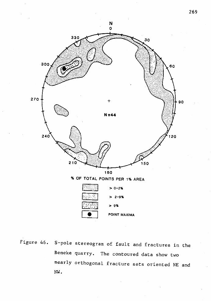
270
N0
180
% OF TOTAL POiNTS PER 1% AREA
>0-2%
> 2-9%
> 9%
LI POINT MAXIMA
90
269
Figure 46. S-pole stereogram of fault and fractures in the
Beneke quarry. The contoured data show two
nearly orthogonal fracture sets oriented NE and
NW.

270
Numerous second order faults trending northwest and
northeast offset the N37-40°E trending shear zone in
right-lateral and left-lateral senses, respectively.
Horizontal separation on the second order faults ranges from
several cm to 10 m. These second order faults intersect at
nearly 90°. Other subordinate fractures and small faults
form acute angles with these second order faults. These
fractures and small faults trend east-west (generally
right-lateral offset) and northeast-southwest, intersecting
the major N37-40°E trending shear at an acute angle
(generally with left-lateral offset). The pattern of
northwest-trending dextral slip and northeast-trending
sinistral slip on these faults suggests a conjugate shear
system developed in response to north-south compression that
has occurred since the intrusion of Grande Ronde dikes 14-16
m.y.B.P.
Similar northwest and northeast orientations of
strike-slip faults with gouge zones were observed in several
other quarries on the Beneke dike trend. Probably the
Fishhawk Falls dike has a similar style of deformation but
the basalt-sedimentary rock contacts are not as well exposed
as are the basalt-sedimentary rock contacts of the Beneke
dike. Olbinski (1983) and Goalen (in prep.) mapped similar
right-lateral northwest-trending and left-lateral
northeast-trending faults cutting the subparallel Northrup
271
Creek dike and northern continuation of the Beneke dike,
respectively.
The pattern of northwest-trending right-lateral and
northeast-trending left-lateral faults is extended to the
rest of the map area where offsets are also indicated by the
sedimentary units and where strikes and dips of proximal
outcrops are discordant. Because of the overall poor
exposures and weathered nature of the sedimentary units,
mapping of the faults is also aided by field checking
lineations observed on high-altitude U-2 aerial photography
and ERTS satellite imagery.
Apparently, the post-middle Miocene style of
deformation is very widespread in northwest Oregon. A
similar structural style is observed in areas to the east
(Olbinski, 1983), north (Goalen, in prep.), west (Peterson,
1984; Coryell, 1978), and south (Murnford, Rarey, and Safley,
all in prep.). The pattern may almost extend to the
Columbia River 25 km north of the study area, which has been
postulated as a major tectonic boundary between two rotating
plate fragments that were accreted to the North American
plate; (Beck and Plumley, 1980; Magill and others, 1981,
1982). Wells (1981) has also mapped a similar conjugate
system of post-middle Miocene faults in the Willapa Hills on
the north side of the Columbia River in southwest
Washington.

272
The observed conjugate fault pattern is remarkably
similar to the pattern of conjugate strike-slip faults that
form in wrench fault zones and can be depicted in a strain
ellipse (Wilcox and others, 1973). Clay models that were
used to simulate deformation of rocks in a wrench system
show that a consistent development of faults and en echelon
folds. Conjugate strike slip faults with left-lateral and
right-lateral separation are an integral part of the wrench
system and form at acute angles to the strike of the wrench
zone (Fig. 47). If this basic wrench model is applied to
the structure of the thesis area then we may expect to find
that the northwest-trending dextral-slip faults and
northeast-trending sinistral-slip faults are developed in
response to a larger zone of strike-slip motion or wrench
system that has affected the study area.
I interpret that the pattern suggests a distributed
shear zone (or shear couple) of northeast- and
northwest-trending strike-slip faults with subordinate dip
slip in the 25 km x 35 km area between the Tillamook
highlands (e.g., the Green Mountain outlier) and Nicolai
Mountain just south of the Columbia River. Murphy (1981)
showed that Nicolai Mountain is a nearly unfaulted,
north-dipping homoclinal sequence of Columbia River basalt
and is apparently unaffected by shear strain. The
interpretation implies that the tectonic boundary between
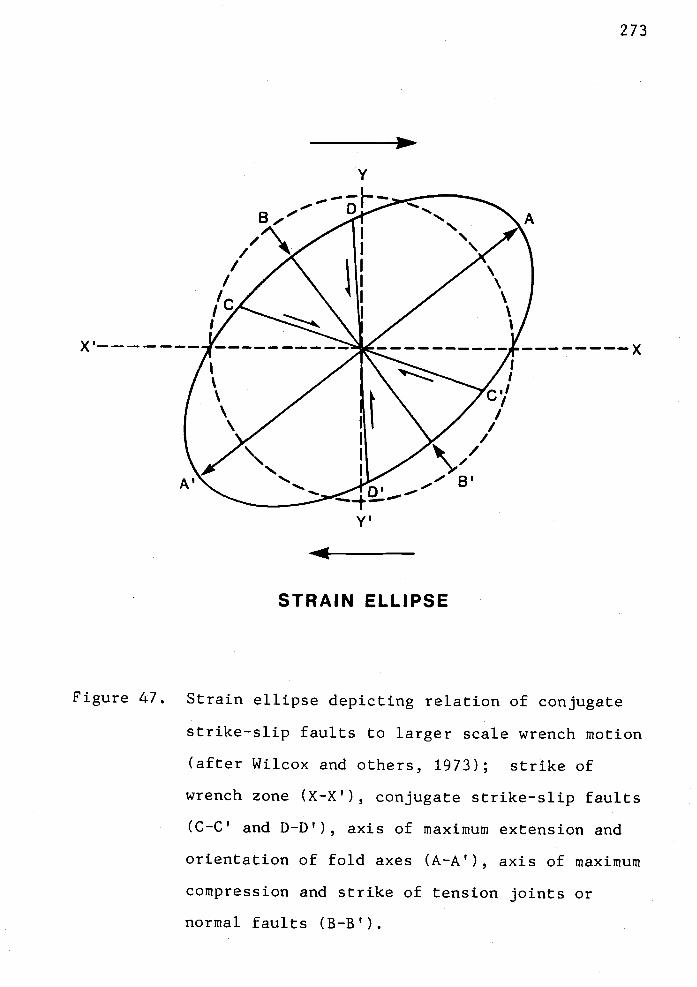
-
A'
Y
- .-. F-
B,.'
Il/c
1D'B'
t---
STRAIN ELLiPSE
A
273
Figure 47. Strain ellipse depicting relation of conjugate
x
strike-slip faults to larger scale wrench motion
(after Wilcox and others, 1973); strike of
wrench zone (X-X'), conjugate strike-slip faults
(C-C' and D-D'), axis of maximum extension and
orientation of fold axes (A-A'), axis of maximum
compression and strike of tension joints or
normal faults (B-B').

274
the Oregon Coast Range and the Washington Coast Range is a
diffuse zone of shear spread across the 25 km x 35 km area.
This interpretation is important to current petroleum
exploration in Clatsop County and in the Mist gas field,
which is within this wide distributed shear zone. In
addition to the folding (or arching) of subsurface Tertiary
strata on the Mist anticline (Newton, 1976, 1979), numerous
post-middle Miocene oblique-slip faults may offset gas-prone
structural highs targeted along northwest trends parallel to
the Mist structure. Potential Cowlitz sandstone reservoirs
may have been disrupted by the faulting and broken in
several reservoirs at different elevations. Many may have
leaked gas due to faults and fractures through the
reservoir.
This fault zone may represent a shear zone between two
rotating microplates (i.e., the ball bearing hypothesis of
Beck, 1976). This tectonic pattern may be much more
widespread, affecting much of western Oregon and
southwestern Washington. For example, Wells (1981, 1982)
mapped and described a conjugate system of
northwest-trending right-lateral and northeast-trending
left-lateral faults in the Willapa Hills of southwest
Washington. They suggest this conjugate fault system also
occurs in the Tillamook highlands (Wells and others, 1983),
in the Newport, Oregon area (Snavely and others, 1976a,
1976b, 1976c), and in the western Cascades (Hammond and

275
others, 1980, 1982). Wells (1981, 1982) and Wells and Coe
(1979) suggested that these conjugate strike-slip faults
were formed as Reidel shears in response to north-south
compression created by oblique subduction of the Juan de
Fuca plate beneath the North American plate. This regional
stress also may explain the origin of, or reactivation of,
the small east-west thrust faults such as the Nehalem Valley
Fault in the thesis area.
Kadri (1982) suggested that the lack of compression
features (e.g., folds) and near horizontal bedding in the
sedimentary units in the area near the Columbia-Clatsop
county line and the Mist gas field imply mainly vertical
block faulting of the basement volcanics as a cause of the
intense conjugate system of normal(?) or high-angle faults.
However, the abundance of subhorizontal slickensides on many
of these faults and offset of dikes as piercing points
suggest that north-south compression, not vertical block
faulting, is responsible for this deformation. Kadri
(1982), in all due respect, had only sedimentary rock
exposures and lacked basalt dikes and basalt quarries with
well-preserved slickensides and gouge zones to observe the
relationships mapped here.
275
GEOLOGIC HISTORY
The Oregon Coast Range represents a slab of accreted
Tertiary oceanic crust, a Paleogene accretionary prism, and
a Paleogene-Neogene forearc basin located seaward of an
active Western Cascade volcanic arc (Niem and Niem, 1984;
Magill and others, 1981; Niem, 1976; Hammond, 1979). The
core of the northern Oregon Coast Range is composed of
middle to upper Eocene Tillamook Volcanics and underlying
lower to middle Eocene Siletz River Volcanics (Wells and
others, 1983). The Siletz River Volcanics are similar in
chemical composition to oceanic ridge basalts and are
interpreted to have formed at a spreading center (Snavely
and others, 1980). Subsequent volcanism constructed guyots,
seamounts, and some subaerial oceanic islands that may have
included the lower Tillamook Volcanics on top of the oceanic
tholeiitic basalt basement.
In the southern Oregon Coast Range during the early to
middle Eocene, oceanic basalts were thrusted and rotated
clockwise beneath the North American continental margin
(i.e., Klamath Mountains) as the Farallon oceanic plate
collided with North America (Snavely and others, 1980; Niem
and Niem, 1984; Simpson and Cox, 1977; Pertuu and Benson,
1980). The zone of underthrusting (now buried beneath
younger volcanics) probably continued northward and may have
initially coincided with the present-day axis of the Cascade

276
Range. The subduction zone is hypothesized by Magill and
others (1981) to have jumped westward by late middle Eocene
to its present position eastward of the Oregon continental
shelf. This westward jump may have occurred as the buoyant,
seamount-studded oceanic crust clogged the subduction zone.
Paleomagnetic studies of lower to middle Eocene sedimentary
and volcanic rocks indicate that the westward jump of the
zone was accompanied by the initiation of clockwise tectonic
rotation (adding up to a maximum of 750 to the present) and
accretion of the Coast Range microplate during the the late
middle Eocene (Magill and Cox, 1981; Magill and others,
1981).
Following accretion, more than 7,000 m of elastic
marine sedimentary rocks of the Tyee, Flournoy, and lower
Yamhill formations accumulated as submarine fans, deltaic
complexes, and deep bathyal muds, respectively, in a late
middle Eocene forearc basin that formed east of the active
subduction zone (Chan and Dott, 1983; Snavely and others,
1980). These formations are now exposed in the central part
of the Oregon Coast Range and overlie the Siletz River and
Roseburg volcanic basement. The sediments were derived from
Mesozoic metamorphic, volcanic, and plutonic rocks of the
Kiamath Mountains exposed to the south and southeast
(Snavely and Wagner, 1963; Snavely and others, 1964) and
from the Idaho batholith to the east of the Oregon Coast
Range (Heller and Ryberg, 1983).
277
In the middle to late Eocene (45 to 39 m.y.B.P.) a
thick sequence of submarine to subaerial mafic volcanics
(several thousand feet thick) built up as a differentiated
oceanic island complex of shield volcanoes upon the
Tyee-Yamhill mudstones and Siletz River volcanics in the
northern Oregon Coast Range (Cameron, 1980; Jackson, 1983;
Rarey, in prep.). This sequence is known as the Tillamook
Volcanics (Wells and others, 1983). In the study area, they
consist of subaerial flows, intrusives, and epiclastic
debris flows and breccias of basaltic andesite and andesite,
all representing the upper part of this differentiated
oceanic island. Duncan (1982) suggested that the Tillamook
Volcanics may have formed as an oceanic island over a hot
spot or mantle plume beneath the Farallon plate (now
represented by the Siletz River Volcanics). During or soon
after the late Eocene accretion of the Farallon plate to the
North American continent, tectonic rotation of these
volcanics commenced and accumulated up to 45° clockwise
rotation to the present as suggested by paleomagnetic
studies of the Tillamook Volcanics (Magill and others, 1982;
this study).
Following a period of erosion, the ancient Cowlitz
basin developed on top of the Tillarnook Vol.canics in
northwest Oregon during the late middle to late Eocene
(Narizian Foraminiferal Stage). A delta, analogous to the
present-day Columbia River delta, was formed by rivers
entering the southwest Washington part of this basin

278
(Snavely and Wagner, 1963). Coal and lignite deposits in
upper middle to upper Eocene strata in southwest Washington
(Yett, 1979; Henriksen, 1956) indicate that warm subtropical
climatic conditions favored development of thick swamp
vegetation. Rivers flowed across the Pacific Northwest and
formed a broad coastal plain that included a large part of
the eastern Puget Sound and the Willamette Valley (Dott,
1966; Snavely and Wagner, 1963). Several rivers meandered
across this coastal plain and entered the Cowlitz basin near
the southern Puget Sound (Buckovic, 1979) and near Longview,
Washington (Henriksen, 1956). The upper middle to upper
Eocene coal-bearing deposits indicate that this area also
received large volumes of arkosic deltaic sediment at that
time, perhaps derived from the Mesozoic granitic batholiths
of the northern Rocky Mountains (Snavely and others, 1951;
Henriksen, 1956; Livingston, 1966; Buckovic, 1979).
In northwest Oregon, west of Longview, Washington, the
depositional environment was shallow marine and marginal
marine. There is no evidence of coal and lignite that would
suggest a swamp environment like that which occurred in
southwest Washington. Highland areas were located to the
south where the accreted Tillamook Volcanics were exposed as
an irregular coastline of rugged seacliffs and stacks.
Local fluvial basaltic sands and gravels and debris flows
derived from the rugged Tillamook highlands were deposited
unconformably over the eroded Tillamook Volcanics as
near-shore and inner shelf sand, and as stream terrace and

279
marine gravels to form the basal Cowlitz conglomerate (Tc1).
Littoral drift parallel to this late Eocene shoreline
redistributed the fine arkosic sands from the Cowlitz delta
near Longview, Washington and perhaps to the southeast along
the shallow inner shelf. These transported arkosic sands
were deposited immediately offshore from the basal basaltic
gravels. In Columbia and eastern Clatsop counties, these
arkosic sandstones are interbedded with locally derived,
shallow-marine, well-sorted volcanic sandstones. These
interbedded arkoses and volcanic arenites compose the lower
sandstone member of the Cowlitz Formation (Tc2) in the
thesis area and reflect a gradual transgression over the
basal conglomerate.
As the Nehalem-Astoria basin subsided further,
turbidite arkosic sands and muds from the Cowlitz delta were
deposited in this area of southeastern Clatsop County,
forming a turbidite unit (Tc3). The Tillamook high was
eventually submerged beneath the Cowlitz sea and no longer
served as a source for basaltic sand. A minor regression
allowed longshore currents to transport shallow-marine
cross-bedded arkosic sands into the basin to form the upper
Cowlitz sandstone (Tc5) which is probably related to the
Clark and Wilson sand that produces gas at the nearby Mist
field. This regression recognized in the Cowlitz Formation
may record the global regression or eustatic sea level fall
noted by Vail and Harderibol (1979) between their cycles
TE2.2 and TE3 (Fig. 48).
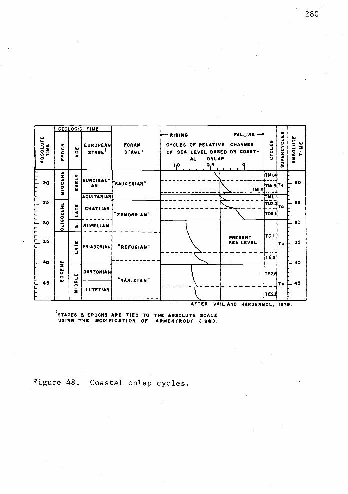
TIME-RISING FALLING
I EUROPEAN FORAM CYCLES OF RELATIVE CHANGESU)w UI
Q0
UIC' STAGE1 STAGE1 OF SEA LEVEL BASED ON COAST-
.3 0
AL ONLAP U4 - - 10 05 0
I . . I LI I it4
U______________
20 8UROIGAL"SAUCESIAN" -rMI3T,
..__J!4L2- AQUITANIAN
_25"-...----
T02.Td
_25wCHATTIAN - _.
"ZEMORRIAN" 02.l
30 -J ui RUPELIAN
\ PRESENT ToUI \ SEA LEVEL Ic -
PRIABONIAN "REFUGIAN".3
TE3- 40 UI
. _40-BARTONIAN TE2.
NARIZIAN"Tb .45
LUTETIAN rTEZ.I
AFTER VML AND HARDENBOL, 1979.
1STAGES & EPOCHS ARE TIED TO THE ABSOLUTE SCALEUSING TIlE MODIFICATION OF ARMENTROUT (19*1).
Figure 48. Coastal onlap cycles.

281
Near the close of Cowlitz time (late Eocene), a
1500-m--thick pile of tholeiitic and calc'-alkaline Goble
Volcanics was erupted from local vents near Kelso
Longview, Washington and the Goble and Rainer area, Oregon
(Wilkinson and others, 1946). Subaerial basaltic lavas and
breccias are interbedded with strata of the upper Cowlitz
Formation in southwest Washington and northwest Oregon (Niem
and Van Atta, 1973; Henriksen, 1956). Local volcanic sands
derived from weathering of the lavas were also deposited in
the shallow Cowlitz basin. Beck and Burr (1979) indicate
that the type Goble Volcanics may be the initial stage of
volcanic arc activity on the western edge of the Western
Cascade volcanic arc (Jakes and White, 1972). The Goble
Volcanics of southwest Washington (e.g., Willapa Hills area;
Wells, 1981) may be the same age as the upper Tillamook
Volcanics in the thesis area. Thus, it is possible that the
sandstone members of the Cowlitz Formation in the thesis
area that overlie the Gable-correlative Tillamook Volcanics
are younger than the type Cowlitz and were derived, in part,
by redistribution of the older type Cowlitz deltaic
sediments from southwestern Washington.
A renewed period of underthrusting in the middle late
Eocene (Refugian Foraminiferal Stage) is indicated by
offshore seismic reflection data and geologic mapping in the
central Oregon Coast Range (Snavely and others, 1980).
Less-deformed tuffaceous mudstone of the Refugian Alsea
Formation unconformably overlie more-deformed Narizian
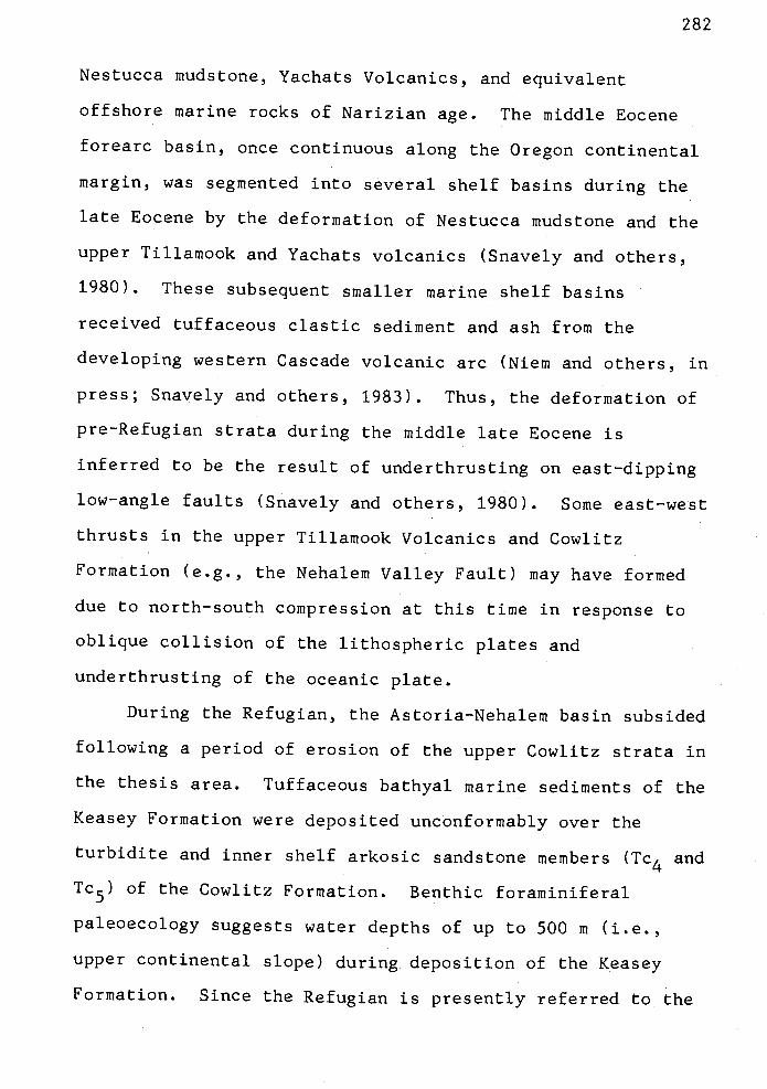
282
Nestucca mudstone, Yachats Volcanics, and equivalent
offshore marine rocks of Narizian age. The middle Eocene
forearc basin, once continuous along the Oregon continental
margin, was segmented into several shelf basins during the
late Eocene by the deformation of Nestucca mudstone and the
upper Tillamook and Yachats volcanics (Snavely and others,
1980). These subsequent smaller marine shelf basins
received tuffaceous elastic sediment and ash from the
developing western Cascade volcanic arc (Niem and others, in
press; Snavely and others, 1983). Thus, the deformation of
pre-Refugian strata during the middle late Eocene is
inferred to be the result of underthrusting on east-dipping
low-angle faults (Snavely and others, 1980). Some east-west
thrusts in the upper Tillamook Volcanics and Cowlitz
Formation (e.g., the Nehalem Valley Fault) may have formed
due to north-south compression at this time in response to
oblique collision of the lithospheric plates and
underthrusting of the oceanic plate.
During the Refugian, the Astoria-Nehalem basin subsided
following a period of erosion of the upper Cowlitz strata in
the thesis area. Tuffaceous bathyal marine sediments of the
Keasey Formation were deposited unconformably over the
turbidite and inner shelf arkosic sandstone members (Tc4 and
Tc5) of the Cowlitz Formation. Benthic foraminiferal
paleoecology suggests water depths of up to 500 m (i.e.,
upper continental slope) during deposition of the Keasey
Formation. Since the Refugian is presently referred to the

283
upper Eocene (Arinentrout, 1981), the marine transgression
recorded in the Refugian strata may be related in part to
global eustatic sea level rise during the late Eocene. This
eustatic rise may be correlated to cycle TE3 of Vail and
Hardenbol (1979) (Fig. 48).
In the thesis area, the Refugian is represented by the
Keasey Formation and by the lower part of the Pittsburg
Bluff Formation. The Keasey Formation is more tuffaceous in
character than the underlying Cowlitz Formation and it
records an influx of volcanic material into the forearc
basin. The volcanic detritus was probably produced by
explosive silicic volcanic activity in the ancestral Western
Cascade arc (e.g., the Little Butte Volcanics and
Ohanapecosh Formation) (Hammond, 1979; Niem and Niem, 1984;
Wells and others, 1964) and by the pyroclastic volcanism
that produced the John Day Formation of north central Oregon
(Oles and Enlows, 1971; Niem and Niem, 1984).
A deep-marine basin persisted throughout Keasey time in
the study area but there were rapid facies changes as a
result of changing source areas, basin subsidence, or
eustatic changes. The following three facies (or members)
of the Keasey Formation represent an onlap sequence of
deep-marine upper slope mudstone over shelf sandstone (Tc5)
of the underlying Cowlitz Formation. Deposition of
well-bedded hemipelagic mudstone of the Jewell member (Tk1)
occurred at 200 to 500 in water depths on the upper

284
continental slope (foram data from Kristin McDougall,
written comm., 1982). Arkosic clastic dikes formed by rapid
loading and spontaneous liquefaction of rare arkosic sands
in the Jewell member (Tk1) of the Keasey Formation.
Continuing basin subsidence to depths up to 2,000 m
occurred during slow deposition of the overlying Vesper
Church member (Tk2) on the lower and middle continental
slope. The lack of bioturbation and infauna (e.g., lack of
molluscs) suggests that basin depths caused anoxic
conditions at the sediment-water interface. This anoxic
environment, or oxygen minimum zone, occured only during
deposition of the Vesper Church member and did not occur
during deposition of any other Tertiary sedimentary unit
within the Nehalem and Astoria basins. Thin carbonaceous
and micaceous arkosic sandstone laininae and thin, graded,
arkosic sandstone beds that are distinctive to the Vesper
Church member (Tk2) were possibly derived from erosion of
older, inner shelf Cowlitz arkosic sandstone. Nested
channels of sandstone and interbedded mudstone in the Vesper
Church (Tk2) member were deposited on small "sea gullies"
cut into the lower continental slope or were small distal
fans.
Deposition of the overlying tuffaceous upper mudstone
member of the Keasey Formation (Tk3) in water depths of 200
to 500 in implies a shallowing of the basin as toward the end
of Keasey time. Ash beds and thick-bedded tuffaceous
mudstone in the upper mudstone member (Tk3) imply a more
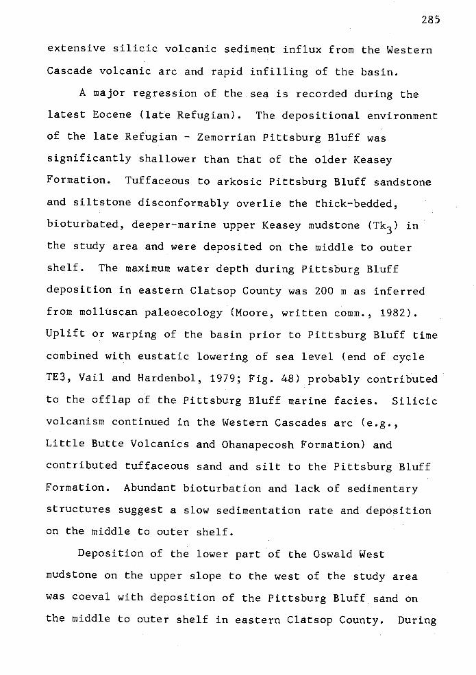
285
extensive silicic volcanic sediment influx from the Western
Cascade volcanic arc and rapid infillirig of the basin.
A major regression of the sea is recorded during the
latest Eocene (late Refugian). The depositional environment
of the late Refugian Zemorrian Pittsburg Bluff was
significantly shallower than that of the older Keasey
Formation. Tuffaceous to arkosic Pittsburg Bluff sandstone
and siltstone disconformably overlie the thick-bedded,
bioturbated, deeper-marine upper Keasey mudstone (Tk3) in
the study area and were deposited on the middle to outer
shelf. The maximum water depth during Pittsburg Bluff
deposition in eastern Clatsop County was 200 in as inferred
from molluscari paleoecology (Moore, written comm., 1982).
Uplift or warping of the basin prior to Pittsburg Bluff time
combined with eustatic lowering of sea level (end of cycle
TE3, Vail and Hardenbol, 1979; Fig. 48) probably contributed
to the offlap of the Pittsburg Bluff marine facies. Silicic
volcanism continued in the Western Cascades arc (e.g.,
Little Butte Volcanics arid Ohanapecosh Formation) and
contributed tuffaceous sand and silt to the Pittsburg Bluff
Formation. Abundant bioturbation and lack of sedimentary
structures suggest a slow sedimentation rate and deposition
on the middle to outer shelf.
Deposition of the lower part of the Oswald West
mudstone on the upper slope to the west of the study area
was coeval with deposition of the Pittsburg Bluff sand on
the middle to outer shelf in eastern Clatsop County. During

the Oligocene (Refugian to Zeinorrian), this deep-marine
facies onlapped part of the Pittsburg Bluff shelf sandstone,
reflecting renewed subsidence. The west-to-east eustatic
marine transgression can be correlated to global cycle TOl
of Vail and Hardenbol (1979) (Fig. 48). To the east of the
study area, the upper Oligocene to middle Miocene Scappoose
Formation was deposited as a prograding, high-energy, delta
system which included inner shelf, marginal marine and
fluvial facies (Niem and Van Atta, 1973; Van Atta, 1971).
A major unconformity formed near the end of Oligocene
time. A significant fall in sea level is recognized
worldwide in the middle Oligocene. Vail and Hardenbol
(1979) chose this fall as the boundary between their
supercycles Tc and Td (Fig. 48). This low stand of the sea
in the middle Oligocene (approximately 29 m.y. ago) is the
lowest sea level for all the Phanerozoic (Vail and Mitchum,
1979). In northwest Oregon, however, the major unconformity
occurs between Oswald West mudstone and the lower to middle
Miocene Astoria Formation which is nearer to the early
Miocene than the middle Oligocene. However, disagreement
between the stages of the European and North American
Paleogene System may in part contribute to the disparity of
age of the unconformity.
Broad epeirogenic uplift of the eastern part of the
Coast Range began during the middle Oligocene (Snavely and
others, 1980). Consequently, most upper Oligocene to lower
Miocene marine strata were deposited only on the western

flank of the Oregon Coast Range. This restricted deposition
is represented by the upper part of the Oswald West mudstone
and by the Yaquina delta and Nye Mudstone in the central
Coast Range (Snavely and others, 1964; Goodwin, 1973).
Although the Oswald West occurs only in small patches in the
thesis area, the formation crops out over much of the
western part of Clatsop County (Peterson, 1984). This
deep-marine, upper slope, Oligocene to lower Miocene
mudstone may have been more continuous throughout the
northern part of the Coast Range but was subsequently
removed during development of the early Miocene erosional
unconformity and prior to deposition of the lower Miocene
Astoria Formation. Deltaic and fluvial facies of the lower
to middle Miocene Scappoose Formation were deposited
unconformably on the Oswald West mudstone on the east flank
of the Coast Range uplift (Kelty, 1981).
Deposition of the Astoria Formation occurred during
late early Miocene (Saucesian or Pillarian; Fig. 5). The
Angora Peak member of the basal Astoria Formation and
Scappoose Formation formed a westward prograding
fluvial-deltaic system (Cooper, 1981; Cressy, 1974).
Lateral and overlying marine fades of the Astoria Formation
include the shallow--marine Big Creek sandstone member to the
north and the transgressive deep-marine heinipelagic mudstone
and turbidite facies of the Silver Point member to the south
(Cooper, 1981; Neel, 1976). The submarine channel or canyon
head facies associated with the turbidites is informally

,z.z.Jr.1.]
referred to as the Pipeline member of the Astoria Formation
(Coryell, 1978; M. Nelson, 1978). The deep-marine Silver
Point member is the only facies of the Astoria Formation in
the thesis area. It was deposited disconformably on the the
shelf sandstones of the Pittsburg Bluff Formation.
Apparently, the shallow-marine Big Creek and Angora Peak
facies were never deposited in this area or were eroded away
prior to deposition of the Silver Point facies (Peterson,
1984).
Snavely and others (1973, 1980) suggested that during
the middle Miocene a period of regional extension and mafic
igneous activity occurred in the western Oregon Coast Range.
Local tholeiitic basalts, generated by partial melting of
mantle rocks, were intruded into Paleogene and Neogene
marine strata in the western Oregon Coast Range. Along the
Astoria marine embayment, thick extrusive breccias and
pillow lavas of the middle Miocene tholeiitic Depoe Bay
basalt constructed submarine volcanic edifices (Penoyer,
1977; Cressy, 1974). Onion Peak, Sugarloaf Mountain,
Kidders Butte, Humbug Mountain, Saddle Mountain, Elk
Mountain, and Wickiup Mountain are erosional remnants of
these piles of basaltic pillow lavas and breccias. Some of
these peaks are northeast-trending (N45-50°E; e.g., Humbug,
Saddle Mountain and Elk Mountain) and contain
northeast-trending dikes. That is, they are nearly parallel
to the three long dike systems (Beneke, Fishhawk Falls, and
Northrup Creek) discussed in this study area. These
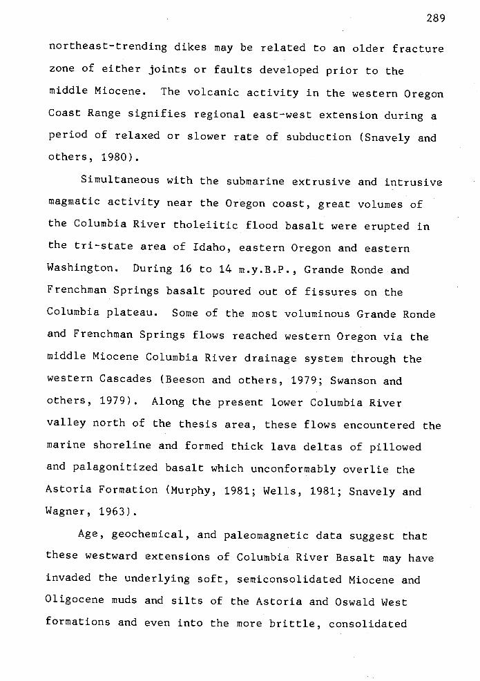
northeast-trending dikes may be related to an older fracture
zone of either joints or faults developed prior to the
middle Miocene. The volcanic activity in the western Oregon
Coast Range signifies regional east-west extension during a
period of relaxed or slower rate of subduction (Snavely and
others, 1980).
Simultaneous with the submarine extrusive and intrusive
magmatic activity near the Oregon coast, great volumes of
the Columbia River tholeiitic flood basalt were erupted in
the tn-state area of Idaho, eastern Oregon and eastern
Washington. During 16 to 14 m.y.B.P., Grande Ronde and
Frenchman Springs basalt poured out of fissures on the
Columbia plateau. Some of the most voluminous Grande Ronde
and Frenchman Springs flows reached western Oregon via the
middle Miocene Columbia River drainage system through the
western Cascades (Beeson and others, 1979; Swanson and
others, 1979). Along the present lower Columbia River
valley north of the thesis area, these flows encountered the
marine shoreline and formed thick lava deltas of pillowed
and palagonitized basalt which unconformably overlie the
Astoria Formation (Murphy, 1981; Wells, 1981; Snavely and
Wagner, 1963).
Age, geochemical, and paleomagnetic data suggest that
these westward extensions of Columbia River Basalt may have
invaded the underlying soft, semiconsolidated Miocene and
Oligocene muds and silts of the Astoria and Oswald West
formations and even into the more brittle, consolidated
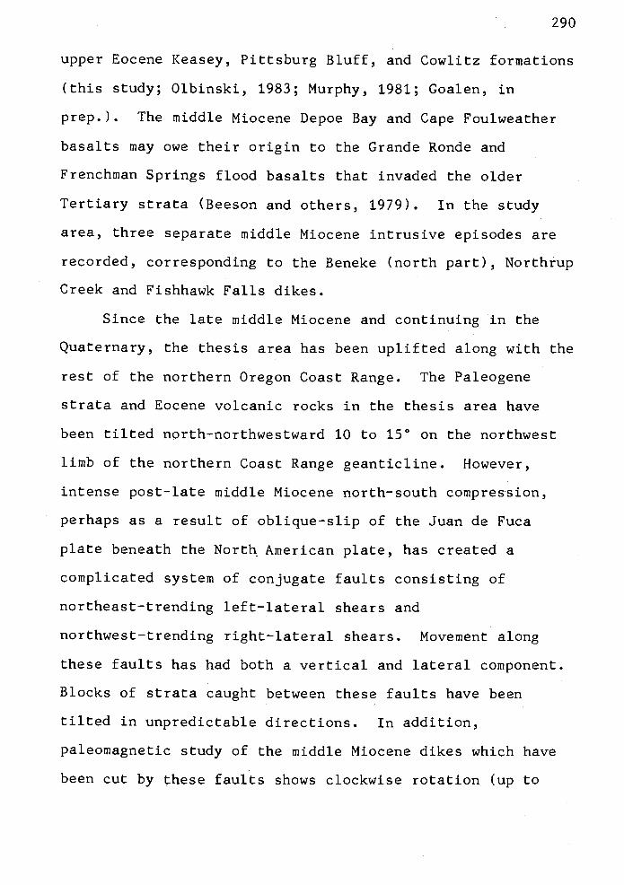
290
upper Eocene Keasey, Pittsburg Bluff, and Cowlitz formations
(this study; Olbinski, 1983; Murphy, 1981; Goalen, in
prep.). The middle Miocene Depoe Bay and Cape Foulweather
basalts may owe their origin to the Grande Ronde and
Frenchman Springs flood basalts that invaded the older
Tertiary strata (Beeson and others, 1979). In the study
area, three separate middle Miocene intrusive episodes are
recorded, corresponding to the Beneke (north part), Northrup
Creek and Fishhawk Falls dikes.
Since the late middle Miocene and continuing in the
Quaternary, the thesis area has been uplifted along with the
rest of the northern Oregon Coast Range. The Paleogene
strata and Eocene volcanic rocks in the thesis area have
been tilted north-northwestward 10 to 15° on the northwest
limb of the northern Coast Range geanticline. However,
intense post-late middle Miocene north-south compression,
perhaps as a result of oblique-slip of the Juan de Fuca
plate beneath the North American plate, has created a
complicated system of conjugate faults consisting of
northeast-trending left-lateral shears and
northwest-trending right-lateral shears. Movement along
these faults has had both a vertical and lateral component.
Blocks of strata caught between these faults have been
tilted in unpredictable directions. In addition,
paleomagnetic study of the middle Miocene dikes which have
been cut by these faults shows clockwise rotation (up to
291
11°) of these small blocks caught between the conjugate
shears as first suggested by Wells (1981). Small east-west
thrust faults in the study area also may have resulted from
this compression.
A similar pattern of fault orientations and folding is
observed throughout the Pacific Northwest (Bentley, 1982;
Ross and Reidell, 1982; Wells and others, 1983), suggesting
regional north-south compression in the Pacific Northwest.
The structures observed in the thesis area may be
sympathetically related to regional right-lateral wrenching
of the western margin of the North American continental
plate by the oblique subduction of the Juan de Fuca plate
(Bentley, 1982; Magill and others, 1982).
In the Quaternary, the study area was uplifted and
eroded by subsequent streams, including the Nehalem River
which follows old fault zones in some stretches.

292
MINERAL RESOURCES
Crushed Rock Resources
Basaltic rock is quarried for local use as a road base
for logging roads and as large rip-rap material. Several
quarries are operated intermittently by Crown Zellerbach
Corporation and the Oregon State Department of Highways to
produce stockpiles of crushed aggregate. Quarries located
in the thesis area are marked on the geologic map (Plate 1).
Rock from flows and dikes of the middle to upper Eocene
Tillamook Volcanics and from the middle Miocene Columbia
River basalts is suitable for use as aggregate. Due to
transportation costs, crushed rock and rip-rap must come
from areas close to the intended market. Suitable basaltic
rock is well distributed throughout the study area and can
be readily excavated for use in the construction of logging
roads. The extensive Fishhawk Falls, Beneke and Northrup
Creek dikes of eastern Clatsop County and a multitude of
smaller intrusives in the study area provide more than
adequate roadbed and rip-rap reserves.
Potential quarry locations exist along the trends of
the three major dikes (Plate 1; Olbinski, 1983; Goalen, in
prep.) and on some of the larger middle Miocene Grande Ronde
basalt intrusives (e.g., sec. 23, T5N, R8W; sec. 16 & 17,
T6N, R7W). The massive columnar jointed dikes are best

293
suited for rip-rap. When used for crushed aggregate, this
massive basalt is quarried by blasting and then crushed in
trailer-mounted portable ball mills or jaw crushers and
reduced to specified size. In the southeast part of the
study area, two quarries on the Buster Creek Road are
sources of fine aggregate (sec. 25, T5N, R7W). Here,
andesite sills and dikes of the upper Eocene Tillamook
Volcanics are best suited for crushed rock. Other
lithologies from the Tillamook Volcanics, such as volcanic
mudflow breccias and weathered basaltic andesite flows, are
not well suited because they rapidly break down to form
slippery, expandable, montmorillonite clays.
Petroleum Potential
The 1979 discovery of commercial quantities of natural
gas in the Cowlitz Formation near Mist, Oregon, has
increased exploration and leasing activity in Clatsop and
Columbia counties (Newton, 1979; Olmstead, 1980, 1981).
Most of the interest is centered on the gas-producing middle
to upper Eocene Cowlitz Formation. Interest in the Angora
Peak and Big Creek sandstone members of the Astoria
Formation as potential hydrocarbon reservoirs is not as
great because of concern that the Astoria Formation may not
have been buried deeply and long enough to be mature and
capable of thermal gas generation.

294
At Mist, the arkosic Clark and Wilson sandstone of the
upper Cowlitz Formation produces natural gas from a
complexly faulted northwest-trending anticline (Bruer, 1980;
Kadri, 1982; Newton, 1979). The Clark and Wilson sandstone
(or C & W) is the informal name used by geologists for the
producing horizon; it comes from the "Clark and Wilson"
#6-i well drilled by Texaco in 1946. This well penetrated
approximately 1850 feet of the Keasey Formation and 1,180
feet of Cowlitz mudstone and siltstone before reaching the
porous C & W sandstone (Newton and Van Atta, 1976; Newton,
1979).
Two potential reservoirs in the Cowlitz Formation were
noted by the early drilling activity and by recent surface
mapping (this study; Olbinski, 1983). The C & W reservoir
in the Cowlitz Formation, below the mudstone and siltstone
interval penetrated by the Texaco Clark and Wilson #6-1
well, consists of porous and permeable micaceous arkosic
sandstone and is approximately 600 feet thick. Porosities
range from 26 to 30% (Newton and Van Atta, 1976; Newton,
1979). This unit would correlate to the arkosic upper
sandstone member (Tc5) in the thesis area and adjacent study
area (Olbinski, 1983) and is a prime target for further
exploration drilling in Columbia and eastern Clatsop
counties.

295
A second potential reservoir sandstone in the Cowlitz
underlies the C & W sandstone and its equivalents to the
west. A thick volcanic interval was penetrated by the Clark
and Wilson #6-1 well between 4,700 and 7,270 feet and
separates the two potential reservoirs. The volcanics are
probably part of the Goble Volcanics that are interbedded
with the Cowlitz Formation (Livingston, 1966; Henriksen,
1956). Porous arkosic sandstones, between 7,89 feet and
8,210 feet in the well, underlie this thick volcanic
interval and have been informally named: the lower Cowlitz
sandstone member (Van Atta, 1971), Yamhill sandstone, or
Claskanine sandstone (Bruer, pers. comm. to Alan Niem, 1982;
Arnientrout and others, 1983).
Formation tests of the Texaco "Clark and Wilson" #6-1
well flowed salt water at rates of 65 to 70 barrels per day
from an interval between 7,800 and 8,000 feet, indicating
good porosity and permeability A slight trace of gas was
reported, enough to ignite at the surface, but no oil shows
were observed during the tests. Electric logs of the well
have well developed SP and resistivity response through the
two sandstones, also suggesting that they may have reservoir
quality permeability. In the study area, these lower
arkosic sandstones may equate with the outcropping arkosic
lower sandstone member of the Cowlitz Formation (Tc2) along
the Nehalem River.
The Mist gas field presently encompasses parts of
Townships 6 and 7 North and Ranges 4 and 5 West, in Columbia

296
County. The central part of the field is located 16 km east
of the eastern border of the thesis area. As of 1982, 39
wells had been drilled in the field (Olmstead, 1982). Nine
of these wells resulted in commercial production of natural
gas. Thirty wells have been dry holes. Two wells were
drilled in the field in 1982: the Reichold Energy Corp.
"Columbia County" #4-redrill and the "Columbia County"
#13-1-redrill. Gas production in 1981 was from five wells
which penetrated two separate gas pools; four wells were
shut in. Production during the first part of 1981 was over
20 million cubic feet per day (MMcfg/d), but dropped to
slightly less than 10 MMcfg/d at year's end (Olmstead,
1982). During the month of July, 1982, gas production
remained at slightly less than 10 MMcfg/d. In 1983, a new
pooi located 2 km southwest of the main field was discovered
in the Cowlitz Formation and began production at 3 MMcfg/d
rate. The principal operator in the Mist gas field is
Reichold Energy Corporation in partnership with Oregon
Natural Gas Development Company. Several other major oil
companies have been active in leasing in Clatsop and
Columbia counties.
The composition of the gas produced from the Mist gas
field is mostly methane, ranging to pentane; nitrogen is
present in minor abundances (Bruer, 1980). One author has
suggested that the gas is of thermogenic origin (Bruer,
1980).
-J

297
In Clatsop County, six exploration wells have been
drilled during the period from 1979 to 1982. The locations
of these wells are listed in Appendix XIII. All of these
wells have been dry holes; however, gas shows have been
reported. The nearest well to the thesis area is the
Quintana "Watzek" #30-1 drilled to 7,068 feet in sec. 30,
T6N, R6W.
The geologic requirements for natural gas accumulation
are present in the thesis area (i.e., organic-rich source
beds, porous and permeable reservoir rocks, structural
and/or stratigraphic trap mechanisms and time). Potential
problems for commercial discovery of new reserves are that
the Mist anticline, and presumably adjacent structures as
well are highly faulted, causing gas pools to be relatively
small. Some of the faults may have been ineffective seals,
which allowed gas to escape.
The mudstones of the Cowlitz and Keasey formations and
the Oswald West mudstone are potential source beds for
natural gas. The total organic carbon content (TOC) of one
Cowlitz (from subunit Tc2) and six Keasey mudstones (from
subunits Tk1 and Tk2) from the thesis area is less than 17
(Appendix XIV). The results of laboratory determinations
(provided by Amoco Production Co.) for source rock
maturation are presented in Appendix XIV. The Cowlitz and
Keasey mudstone samples are a fair source rock but are
thermally immature (pregeneration; 0.547 R0), suggesting
that these rocks have not been buried deep enough to have

generated hydrocarbon. The sedimentary rocks on the surface
are weathered and may not be representative of the TOC
content of unaltered rock in the subsurface. Mudstones
probably have a significantly higher TOC content than
surficial rocks. The kerogen source for both Cowlitz and
Keasey niudstone is woody material which is most likely to
generate gas.
The Silver Point mudstones of the Astoria Formation are
also a potential source of natural gas in the subsurface in
that they have abundant comminuted woody material on bedding
planes. No analyses of the Silver Point were made, however.
Thick micaceous, arkosic to lithic sandstones of the
lower and upper Cowlitz Formation (Tc2 and Tc5), that are
potential reservoirs, probably occur in the subsurface in
the eastern part of the thesis area. Two hundred fifty to
300-foot exposures of the lower Cowlitz sandstone (Tc2) in
the southeastern part of the thesis area (T5N, R7W) consist
of mostly volcanic arenite and plagioclase-arkose (Plates 1
and 3). Porosities and permeabilities range from a low of
13.17 and 2.8 millidarcies in the more tightly
calcite-cemented and diagenetically altered volcanic
sandstones to a high of 32.77 and 4.4 millidarcies in the
more friable epidote-bearing rnicaceous arkosic sandstone
(Appendix XIV). Of the two sandstone compositional types,
these lower Cowlitz arkosic sandstones have greater
potential as a reservoir. These sandstones appear to pinch
out several miles to the southwest according to recent
299
mapping by Daniel Mumford (in prep.) and Philip Rarey (in
prep.).
Geologic mapping by Olbinski (1983) and by this author
suggests that the upper sandstone member of the Cowlitz
Formation (Tc5), which includes the gas-producing Clark and
Wilson sandstone, thins to the west-southwest from the
Clatsop County line through the study area 1.5 miles west of
the Nehalem River. Olbinski (1983) estimates that the upper
sandstone member (Tc5) of the Cowlitz Formation is
approximately 275 feet thick in the Waage Road measured
section (2.4 km east of the study area). The equivalent
interval, correlative to the Clark and Wilson sandstone, is
a minimum of 100 feet thick along the Nehalem River measured
section (Plate 3, this study) and apparently pinches out
entirely 1.2 km west of the Nehalem River (Plate 1).
The reasons for the pinchout of the C & W sandstone are
not clear. Possible causes include: depositional pinchout
or change of facies from shallow-marine arkose to deep-water
mudstone (Tc4); submarine erosion of the upper arkosic
sandstone (Tc5) prior to deposition of the unconformably
overlying Jewell member of the Keasey Formation; or, a
general thinning of the arkosic sandstones over the northern
Coast Range structural high of Tillamook Volcanics which may
have controlled sedimentation patterns in the area during
middle to late Eocene time.
The Clark and Wilson sandstone at the Mist gas field
contains a heavy mineral assemblage rich in epidote and is

300
correlative to a thick epidote-rich arkosic sandstone near
the Clatsop-Columbia county line and near Green Mountain
(Olbinski, 1983). Olbinski (1983) calls this sandstone unit
TC5a) and thinks that it may thin out before reaching the
Nehalem River. However, an arkosic sandstone with a
zircon-rich heavy mineral assemblage (called Tc5b by
Olbinski) reaches this study area along the Nehalem River
(Plate 3) and was penetrated in the Quintana "Watzek" #30-1
well. Although this zircon-rich sandstone is in a
stratigraphic position in the well similar to the
epidote-rich Clark and Wilson arkosic sandstone at Mist, it
may be a different unit because of the compositional
difference of heavy minerals. In the Watzek well, the
sandstone is tightly cemented by calcite (possibly due to
metasomatic alteration by art adjacent basalt sill) and thus
has limited reservoir potential (Olbinski, 1983).
There are potential fault traps in the subsurface in
the north-central and northeastern parts of the thesis area
where porous and permeable Cowlitz sandstone (such as the
lower and upper sandstone members) may be in fault contact
with Keasey or Cowlitz mudstone units (Plate 2). In the
southeast and southwest parts of the map area, these
sandstone units are exposed on the surface and are breached
by erosion, but they dip to the north and northwest beneath
thick impermeable Keasey mudstone a cap rock and are
offset by faults. The local thick sills (Plate 3) and the
Beneke and Fishhawk Falls dikes (Plates 1 and 2) may serve

301
as impermeable barriers between gas reservoirs. These
middle Miocene volcanics are probably too thin to have
significantly altered the regional heat flow to create large
volumes of thermogenic gas from carbonaceous beds.
In the northwestern part of the thesis area, the most
promising location for further hydrocarbon exploration (in
terms of a structural trap) is 4 miles (6.5 km) northwest of
Jewell, in the southwest part of T6N, R7W, secs. 27, 28, 29,
32, 33, and 34. The units at the surface are the upper
Keasey and the lower Pittsburg Bluff formations (Plate 1).
Cowlitz units which are possible reservoirs (e.g., lower and
upper sandstone members, Tc2 and Tc5, respectively) may be
present at approximately 5,900 feet (1,800 m) to 6,500 feet
(1,980 m) below the impermeable Keasey mudstones (Jewell
(Tk1) and Vesper Church (Tk2) members; cross sections A-A',
C-C', D-D'). Field mapping of the Keasey and Pittsburg
Bluff formations suggests a possible structural high or
faulted fold with a gentle northwest plunge through the
central part of the thesis area. Several conjugate
oblique-slip faults having northwest and northeast trends
are traced through this fold and have tilted the limbs in
various directions (Plate 1). The fold may have been
created by basement uplift or block faulting such as
hypothesized by Kadri (1982) in Columbia County rather than
by northeast-southwest compression.
By projecting the strike of the Clark and Wilson
sandstone at the surface, it is predicted that the unit will

302
be present in the subsurface in the northeastern part of the
thesis area, but may pinch out on the structural high in the
central part of the study area. Regional outcrop patterns
of the Tertiary formations wrap around the northward
plunging axis of the Coast Range "anticlinorium" (Niem and
Van Atta, 1973). Thus, potential reservoir sandstones
correlative to the Clark and Wilson sandstone, with a cap of
Keasey mudstone (Jewell and Vesper Church members), may
occur in the subsurface in this area.
Coal Resources
The potential for economic recovery of coal resources
in the thesis area is nonexistent. There is one reported
"discovery" of coal in the area. Near the turn of this
century, a prospector named Mr. Moore located a claim near a
creek in sec. 27, T5N, R7W. The creek is now called Moores
Creek and is the underlain by the lower sandstone and
conglomerate members of the Cowlitz Formation (Tc1 and Tc2).
Local residents told the author about the reported coal and
the vicinity of its occurrence. Samples of the
sub-bituminous coal were obtained from Mr. Nick Nogle of
Jewell. Mr. Nogle explained that he found the coal in
Moores Creek near his water well and in the vicinity of the
original claim. The author made several traverses through
the area of the reported occurrence but found no outcrop nor
trace of coal in the stream bed gravels. The low-lying area

303
has been logged in recent years and if the coal is still
present, it is probably covered by slash and colluvium.

304
BLANK PAGE

305
REFERENCES CITED
Addicott, W. 0., 1973, Oligocene molluscan biostratigraphy andpaleontology of the lower part of the type Temblor Formation,California: U. S. Geological Survey Prof. Paper 791, 48 p., 9plates.
Al-Azzaby, F. A., 1980, Stratigraphy and sedimentation of the SpencerFormation in Yamhill and Washington counties, Oregon: unpub. M.S.thesis, Portland State University, Portland, Oregon, 104 p.
Anderson, J. L., 1978, The stratigraphy and structure of the ColumbiaRiver Basalt in the Clackamas River drainage: unpub. M.S. thesis,Portland State University, Portland, Oregon, 136 p.
Armentrout, J. H., 1973, Holluscan paleontology and biostratigraphy ofthe Lincoln Creek Formation (late Eocene-Oligocene), southwesternWashington: University of Washington (Seattle), Ph.D.dissertation, 479 p.
1981, Correlation and ages of Cenozoic chronostratigraphicunits in Oregon and Washington: Geol. Soc. Amer. Special Paper184, P. 137-148.
McDougall, Kristin, Jefferis, P. T., and Nesbitt,Elizabeth, 1980, Geologic field trip guide for the Cenozoicstratigraphy and late Eocene paleoecology of the southwesternWashington, in Oles, K. F., Johnson, J. G., Niem, A. R., and Niem,W. A., eds., Geologic field trips in western Oregon andsouthwestern Washington: Oregon Dept. of Geology and MineralIndustries Bull. 101, p. 79-119.
Hull, D. A., Beaulieu, J. D., and Rau, W. W., 1983,Correlation of Cenozoic stratigraphic units of western Oregon andWashington: Oregon Dept. Geology and Mineral Industries Oil andGas Investigation No. 7, 90 p.
Arnold, Ralph, 1906, The Tertiary and Quaternary pectens of California:U.S. Geological Survey Prof. Paper 47, 264 p.
Atwater, Tanya, 1970, Implications of plate tectonics for the Cenozoictectonic evolution of western North America: Geol. Soc. Amer.Bull., v. 81, p. 3513-3536.
Baldauf, Jack, written communication, May 1, 1982.
Baldwin, E. N.,, 1981, Geology of Oregon: Kendall/Hunt Publishing Co.,Dubuque, Iowa, 170 p.
Barnes, N. A. W., 1981, The geology of Cascade Head, an Eocene volcaniccenter: unpub. M.S. thesis, University of Oregon, Eugene, 94 p.,map.

306
Bates, R. G., Beck, N. E., Jr., and Burmester, R. F., 1981, Tectonicrotations in the Cascade Range of southwestern Washington:Geology, v. 9, p. 184-189.
Bates, R. G., Beck, M. E., Jr., and Simpson, R. W., 1979, Preliminarypaleomagnetic results from the southern Cascade Range ofsouthwestern Washington, (abstr.): EOS (Trans., Amer. Geophys.Union), v. 60, no. 46, p. 816-817.
Beaulieu, J. D., 1973, Environmental geology of inland Tillamook andClatsop Counties, Oregon: Oregon Dept. Geology and MineralIndustries Bull. 79, 65 p., 43 figs., 4 tables, 14 maps.
Beck, N. E., Jr., 1976, Discordant paleomagnetic pole positions asevidence of regional shear in the western Cordillera of NorthAmerica: Amer. Jour. Sci., v. 276, p. 694-712.
1980, Paleomagnetic record of plate-margin tectonicprocesses along the western edge of North America: Jour. Geophys.Res., v. 85, p. 7115-7131.
and Burr, C. D., 1979, Paleomagnetism and tectonicsignificance of the Goble Volcanic Series, southwestern Washington:Geology, v. 7, p 175-179.
Engebretson, D. C., and Globerman, B. R., 1979, Cenozoicmicroplate rotations in Washington State: A progress report:Geol. Soc. Amer., Abstr. with Programs, v. 11, no. 7, p. 386.
and Plumley, P. W., 1980, Paleomagnetism of intrusiverocks in the Coast Range of Oregon: microplate rotations in middleTertiary time: Geology, v. 8, p. 573-577.
Beck, R. S., 1943, Eocene Foraminifera from the Cowlitz River, LewisCounty, Washington: Jour. Paleo., v. 17, p. 584-614.
Beeson, M. H., and M. R. Moran, 1979, Columbia River Basalt Groupstratigraphy in western Oregon: Oregon Geology, v. 41, no. 1,p. 11-14.
Perttu, R. and Perttu, J., 1979, The origin of the Niocenebasalts of coastal Oregon and Washington: An alternativehypothesis: Oregon Geology, v. 41, no. 10, p. 159-166.
Bentley, R. D., 1982, Late Tertiary thin skin deformation of theColumbia River Basalt in the western Columbia plateau, Washingtonand Oregon: EOS (Trans., Amer. Geophys. Union), v. 63, p. 173.
Berg, J. W., and Thiruvathukal, J. V., 1967, Complete Bouguer gravityanomaly map of Oregon: Oregon Dept. Geology and Mineral IndustriesMap GMS 4-b.
307
Berggren, W. A., Kent, D. V., and Flynn, J. J., 1983, Paleogenegeochronology and chronostratigraphy, in Snelling, N. J., ed.,Geochronology and the geological record: Geol. Soc. London,Special Paper.
Blatt, Harvey, Middleton, Gerard, and Murray, Raymond, 1980, Origin ofsedimentary rocks, second edition: Englewood Cliffs, New Jersey,Prentice-Hall, Inc., 782 p.
Bouma, A. H., 1962, Sedimentology of some flysch deposits: Elsevier,Amsterdam, 168 p.
Bromery, R. W., and Snavely, P. D., Jr., 1964, Geologic interpretationof reconnaissance gravity and aeromagnetic surveys in northwesternOregon: U.S. Geological Survey Bulletin 1181-N, 13 p.
Bruer, W. C., 1980, Mist gas field, Columbia County, Oregon: Technicalprogram reprints, Pacific section, Amer. Assoc. PetroleumGeologists - Soc. Explor. Geophys., 55th Ann. Mtg., Bakersfield,Calif., 10 p.
Buckovic, t. A., 1979, The Eocene deltaic system of west-centralWashington, unArmentrout, J. H., Cole, N. R., and TerBest, Harry,Jr., eds.: Cenozoic Paleogeography of the Western United States,Pacific Coast Paleogeography Symposium 3: Pac. Sec. Soc. Econ.Paleon. Miii., p. 147-163.
Bukry, David, 1981, Pacific Coast coccolith stratigraphy between PointConception and Cabo Corrientes, Deep Sea Drilling Project, Leg 63,in Yeats, R. S., Haq, B. U., and others, eds.: Initial Reports,Deep Sea Drilling Project, Leg 63, U.S. Government PrintingOffice, Washington, D.C., p. 445-472.
written communication, April 20, 1982.
Burr, C. D., 1978, Paleomagnetism and tectonic significance of the GobleVolcanics of southern Washington: unpub. M.S. thesis, WesternWashington University, Bellingham, 66 p.
Cameron, K. A., 1980, Geology of the south-central margin of theTillamook highlands; southwest quarter on the Enright quadrangle,Tillamook County, Oregon: unpub. N.S. thesis, Portland StateUniversity, Portland, Oregon, 87 p.
Camp, V. E., 1981, Upper Miocene basalt distribution, reflecting sourcelocations, tectonism, and drainage history in the Clearwaterembayment, Idaho, Part II, in Camp, V. E. and Hooper, P. R.,Geologic studies of the Columbia Plateau: Ceol. Soc. Amer. Bull.,v. 92, p. 669-678.

308
and Hooper, P. R., 1981, Geologic studies of the ColumbiaPlateau, Part I, Late Cenozoic evolution of the southeast part ofthe Columbia River Basalt province: Geol. Soc. Amer. Bull., v. 92,p. 659-668.
Chamberlain, C. K., 1978, Recognition of trace fossils in cores: in,Basan, P. B., ed., Trace Fossil Concepts: Soc. Econ. Paleon. Mm.Short Course No. 5, p. 119-166.
Chamberlain, C. Kent, written communication, February 25, 1982.
Chan, M. A., and Dott, R. H., Jr., 1983, Shelf and deep-seasedimentation in Eocene forearc basin, western Oregon--fan ornon-fan?: Amer. Assoc. Petroleum Geologists Bull., v. 67, no. 11,p. 2100-2116.
Choiniere, S. R., and Swanson, D. A., 1979, Magnetostratigraphy andcorrelation of Miocene basalts of the northern Oregon Coast andColumbia Plateau, southeast Washington: Amer. Jour. Sd., v. 279,p. 755-777.
Clifton, H. E., Hunter, R. E., and Phillips, R. L., 1971, Depositionalstructures and processes in the non-barred high-energy nearshore:Jour. Sed. Pet., v. 41, no. 3, p. 651-670.
Code of Stratigraphic Nomenclature, 1961, American Commission onStratigraphic Nomenclature: Amer. Assoc. Petroleum GeologistsBull., v. 45, no. 5, p. 645-660.
Cooper, N. D., 1981, Sedimentation, stratigraphy and fades variationwithin the early to middle Niocene Astoria Formation in Oregon:unpub. Ph.D. dissertation, Oregon State University, Corvallis, 443p.
Coryell, G. F., 1978, Stratigraphy, sedimentation, and petrology of theTertiary rocks in the Bear Creek-Wickiup Mountain-Big Creek area,Clatsop County, Oregon: unpub. N.S. thesis, Oregon StateUniversity, Corvallis, 178 p.
Cressy, F. B., Jr., 1974, Stratigraphy and sedimentation of theNeahkahnie Mountain-Angora Peak area, Tillamook, and Clatsopcounties, Oregon: unpub. 14.5. thesis, Oregon State University,Corvallis, 148 p.
Crouch, J. K., and Bukry, David, 1979, Comparison of Miocene provincialforaminiferal stages to coccolith zones in the Californiacontinental borderland: Geology, v. 7, no. 4, p. 211-215.
Culver, H. E., 1919, The coal fields of southwestern Washington:Washington [state] Geol. Survey Bull. 19, 155 p.
Dairymple, C. B., 1979, Critical table for conversion of K-Ar ages fromold constants to new constants: Geology, v. 7, no. 11, p. 558-560.

309
Dalziel, I. W. D., and Dott, R. H., Jr., 1970, Geology of the Baraboodistrict, Wisconsin: Wisconsin Geol. and Nat. Hist. SurveyInformation Circular 14, p. 39-64.
Dana, J. D., 1849, Wilkes exploring expedition, 1838-1842: v. 10,(Geol.), p. 653.
Deacon, R. J., 1953, A revision of upper Eocene and lower Oligocenestratigraphic units in the upper Nehalem River basin, northwestOregon: unpub. M.S. thesis, Oregon State University, Corvallis,84 p.
Deer, W. A., Howie, R. A., and Zussman, J., 1966, An introduction to therock-forming minerals: Longman Press, London, 528 p.
Demarest, H. H., 1983, Error analysis for the determination of tectonicrotation from paleomagnetic data: Jour. Geophys. Res., v. 88, p.4321-4328.
Dickinson, W. R., 1976, Sedimentary basins developed during evolution ofMesozoic-Cenozoic arc-trench system in western North America:Canadian Jour. Earth Sci., v. 13, p. 1268-1287.
1982, Compositions of sandstonessubduction complexes and fore-arc basins:Geologists Bull., v. 66, p. 121-137.
in circum-PacificAmer. Assoc. Petroleum
and Seely, D. R., 1979, Structure and stratigraphy offorearc regions: Amer. Assoc. Petroleum Geologists Bull., v. 63,no. 1, p. 2-31.
and Suczek, C. A., 1978, Plate tectonics and sandstonecompositions: Amer. Assoc. Petroleum Geologists Bull., v. 63, p.2164-2182.
Diller, J. S., 1896, Geological reconnaissance in northwestern Oregon:U.S. Geological Survey 17th Ann. Rpt., p. 1-80.
Doell, R. R., and Cox, Allen, 1964, Determination of the magneticpolarity of rock samples in the field: U.S. Geological SurveyProf. Paper 450-D, p. 105-108.
Donnelly, A. T., 1976, The Refugian Stage of the California Tertiary:Foraminifera zonation, geologic history, and correlations with thePacific Northwest: Ph.D. dissertation, University of California,Berkeley, 150 p.
Dott, R. H., and Bird, K. J., 1979, Sand transport through channelsacross an Eocene shelf and slope in southwestern Oregon, in Doyle,L. J., and Pilkey, 0. H., Jr., eds., Geology of continental slopes:Soc. Econ. Paleon. Mm. Special Publication No. 27, p. 327-342.
310
Dott, R. H., and Bourgeois, Joanne, 1982, Hummocky stratification:significance of its variable bedding sequences: Geol. Soc. Amer.Bull., v. 93, p. 663-680.
Dunbar, C. 0., and Rodgers, John, 1957, Principles of stratigraphy:Wiley, New York, 356 p.
Duncan, R. A., 1982, A captured island chain in the Coast Range ofOregon and Washington: Jour. Geophy. Res., v. 87, no. B13, p.10,827-10,837.
Duncan, R. A., Associate Professor of Marine Geology, Oregon StateUniversity, Corvallis.
Fisher, P.. A., 1953, Dispersion on a sphere: Proc. Roy. Soc. London, v.A217;, p. 295-305.
Folk, P.. L., 1980, Petrology of Sedimentary Rocks: Hemphill PublishingCompany, Austin, Texas, 182 p.
Friedman, C. M., and Sanders, J. E., 1978, Principles of sedimentology:John Wiley & Sons, New York, 792 p.
Galloway, 1974, Deposition and diagenetic alteration of sandstones inLE. Pacific arc-related basins: Implications for graywackegenesis: Geol. Soc. Amer. Bull., v. 85, no. 3, pp. 379-390.
Gary, Margaret, McAfee, Robert, Jr., and Wolf, C. L., eds., 1972,Glossary of geology: American Geological Institute, 857 p.
Globerman, M. R., and Beck, N. E., 1979, Cenozoic tectonic rotations inthe western Cordillera: new evidence from the Washington CoastRange: EOS (Trans., Amer. Geophys. Union), v. 60, no. 46, p. 817.
Goalen, Jeff, Geology of the Elk Mountain-Porter Ridge Area, ClatsopCounty, northwest Oregon: M.S. thesis (in prep>, Oregon StateUniversity, Corvallis.
Goodwin, C. J., 1973, Stratigraphy and sedimentation of the YaquinaFormation, Lincoln County, Oregon: unpub. M.S. thesis, OregonState University, Corvallis, 121 p.
Green, D. H. and Ringwood, A. E., 1967, The genesis of basalt magmas:Contributions to Mineralogy and Petrology, v. 15, p. 103-190.
Hammond, P. E., 1979, A tectonic model for evolution of the CascadeRange, in, Artnentrout, J. N., Cole, N. P.., and TerBest, Harry, Jr.,eds., Cenozoic paleogeography of the western United States:Pacific Section, Soc. Econ. Paleon. Mm., Pacific CoastPaleogeography Symposium 3, p. 219-237.

311
Anderson, J. L., and Manning, K. J., 1980, Guide togeology of the upper Clackamas and North Santiam Rivers area,northern Oregon Cascade Range, in, Oles, K. F., Johnson, J. G.,Nieni, A. R., and Niem, W. A., eds., Geologic field trips in westernOregon and southwestern Washington: Oregon Dept. Geology andMineral Industries Bull. 101, p. 133-167.
Ceyer, K. N., and Anderson, J. L., 1982, Preliminarygeologic map and cross sections of the upper Clackamas and NorthSantiam Rivers area, northern Oregon Cascade Range: Portland StateUniversity Department of Earth Sciences, Portland, Oregon, scale1:62,500.
Hanna, C. D., and 1-lanna, N. A., 1924, Foraminifera from the Eocene ofthe Cowlitz River, Lewis County, Washington: University ofWashington Publications in Geology (Seattle) v. 1, p. 57-64.
Hardenbol, J. and Berggren, W. A., 1978, A new Paleogene numerical timescale, in Cohee, C. V., and others, eds., Contributions to thegeological time scale: Amer. Assoc. Petroleum Geologists Studiesin Geology, no. 6, p. 213-234.
Hayes, D. E., and Pitman, W. C.., III, 1970, Magnetic lineations of theNorth Pacific: Geol. Soc. Amer. Memoir 126, p. 291-314.
Heller, P. L., and Ryberg, P. T., 1983, Sedimentary record of subductionto forearc transition in the rotated Eocene basin of westernOregon: Geology, v. 11, no. 7, p. 380-383.
I-{enriksen, D. A., 1956, Eocene stratigraphy of the lower CowlitzRiver-eastern Willapa Hills area, southwestern Washington: Wash.Div. Mines and Geology Bull. 43, 122 p., 2 plates, including map.
Hickman, C. S. J., 1974, Characteristics of bathyal mollusk faunas inthe Pacific Coast Tertiary: Western Society of MalacologistsAnnual Report, v. 7, p. 41-50.
Hill, D. W.., 1975, Chemical composition studies of Oregon and Washingtoncoastal basalts: unpub. M.S. thesis, Oregon State University,Corvallis, 99 p.
Hooper, P. R., and Camp, V. E., 1981, Deformation of the southeast partof the Columbia Plateau: Geology, v. 9, no. 7, p. 323-328.
Reidel, S. P., Brown, J. C., Holden, C. S., Kieck, W. D.,Sundstrom, C. E., and Taylor, T. L., 1976, Major element analysesof Columbia River Basalt (Part I): Basalt research group,Washington State University, Pullman, unpub. report, 59 p.
Howard, J. D., 1978, Sedimentology and trace fossils: in, Basan, P. B.,ed., Trace Fossil Concepts: Soc. Econ. Paleon. Mm. Short CourseNo. 5, p. 11-22.
312
Irving, E., 1979, Paleopoles and paleolatitudes of North America andspeculations about displaced terrains: Can. Jour. Earth Sci., v.16, P. 669-694.
Jackson, N. K., 1983, Stratigraphic relationships of the TillamookVolcanics and Cowlitz Formation in the Upper Nehalem River-WolfCreek area, northwestern Oregon: unpub. M.S. thesis, PortlandState University, Portland, Oregon, 118 p.
Jakes, P., and White, A. J. R., 1972, Major and trace element abundancesin volcanic rocks of orogenic arcs: Geol. Soc. Amer. Bull., v. 83,p. 29-40.
Kadri, N. N.,, 1982, Structure and influence of the Tillamook uplift onstratigraphy of the Mist area, Oregon: unpub. M.S. thesis,Portland State University, Portland, Oregon, 105 p.
Kelty, K. B., Ordway, Elizabeth, Timmons, Dale, andVan Atta, R. 0., 1980, Preliminary geologic map of Townships 4, 5,6, and 7 N., Ranges 4 and 5 W., northwest Oregon (scale 1:31,680),inKelty, K. B., 1981, Stratigraphy, lithofacies, and environmentof deposition of the Scappoose Formation in central ColumbiaCounty, Oregon: unpub. M.S. thesis, Portland State University,Portland, Oregon, 81 p.
Kelty, K. B., 1981, Stratigraphy, lithofacies and environment ofdeposition of the Scappoose Formation in central Columbia County,Oregon: unpub. M.S. thesis, Portland State University, Portland,Oregon, 81 p.
Kuim, L. D., and Fowler, G. A., 1974, Oregon continental marginstructure and stratigraphy: a test of the imbricate thrust model,inBurk, C. A., and Drake, C. L., eds.: The geology of continentalmargins.: Springer-Verlag, New York, p. 261-283.
1976, Cenozoic sedimentary framework of theGorda-Juan de Fuca plate and adjacent continental margin:Econ. Paleon. Mm., Sp. Pub. 19, p. 212-229.
Soc.
Kuim, L. D., Roush, R. C., Harlett, J. C., Neudeck, R. H., Chambers, D.N., and Runge, B. J., 1975, Oregon continental shelf sedimentation:interrelationships of facies distribution and sedimentaryprocesses: Jour. Geology, v. 83, no. 2, p. 145-175.
and Scheidegger, K. F., 1979, Quaternary sedimentation onthe tectonically active Oregon continental slope, in Doyle, L. J.,and Pilkey, 0. H., Jr., eds., Geology of continental slopes: Soc.Econ. Paleon. Mm. Special Publication No. 27, p. 247-264.
Laiming, Boris, 1943, Eocene foraminiferal correlations in California,in Geologic formations and economic development of the oil and gasfields of California: California Division of Mines Bull. 118, p.193-198.
313
Livingston, V. E., Jr., 1966, Geology and mineral resources of theKelso-Cathiamet area, Cowlitz and Wahkiakum Counties, Washington:Washington Division of Hines and Geology Bull. 54, 110 p.
MacDonald, G. A., and Katsura, T., 1964, Chemical classification ofHawaiian lavas: Jour. Petrology, v. 5, p. 82-113.
MacLeod, N. S., and Snavely, P. D., Jr., 1973, Volcanics and intrusiverocks of the central part of the Oregon Coast Range, in, Beaulieu,J. D., ed., Geologic field trips in northern Oregon and Washington:Oregon Dept Geology and Mineral Industries Bull. 77, p. 47-74.
Magill, J. R., and Cox, A. V., 1980, Tectonic rotation of the OregonWestern Cascades: Oregon Dept. Geology and Mineral IndustriesSpecial Paper 10, 67 p.
1981, Post-Oligocene tectonic rotation of the Oregonwestern Cascade Range and the Kiamath Mountains: Geology, v. 9, p.127-131.
Magill, James, Cox, Allan, and Duncan, Robert, 1981, Tillamook VolcanicSeries: further evidence for tectonic rotation of the Oregon CoastRange: Jour. Geophys. Res., v. 86, no. B4, p. 2953-2970.
Magill, J. R., Wells, R. B., Simpson, R. W., and Cox, A. V., 1982,Post-12 m.y. rotation of southwest Washington: Jour. Geophys.Res., v. 87, no. 5, p. 2761-3776.
Martini, E., 1971, Standard Tertiary and Quaternary calcareousnannoplankton zonation: Proc. 2nd Planktonic Conf., p. 739-785.
McDougall, Kristin, 1975, The microfauna of the type section of theKeasey Formation of northwestern Oregon, in, Weaver, D. W.,Hornaday, C. R. and Tipton, Ann, ads., Future energy horizons ofthe Pacific Coast: Amer. Assoc. Petroleum Geologists-Soc. Econ.Paleon. Nin.-Soc. Econ. Geophys. Pacific Sections Ann. Mtg., LongBeach, Calif., p. 343-359.
1980, PaleoecologicaJ. evaluation of the late Bocenebiostratigraphic zonations of the Pacific coast of North America:Soc. Econ. Paleon. Miner. Paleontological Monograph No. 2, 46 p.,29 plates.
1981, Systematic paleontology and distribution of the lateEocene benthic foraminifers from northwestern Oregon andsouthwestern Washington: U.S. Geological Survey Open File Report81-109, 501 p.
written communication, April 27, 1982, August 31, 1982.
McElwee, Kristin, Oregon State University graduate student.
314
McElwee, K. R., and Duncan, R. A., 1983, Punctuated volcanism inOregon's Coast Range: Amer. Geophys. Union, Pacific NorthwestRegional Meeting, Program with Abstracts.
McKee, E. D., and Weir, G. W., 1953, Terminology for stratification andcross-stratification in sedimentary rocks: Geol. Soc. Amer. Bull.,v. 64, p. 381-390.
McKee, E. H., Swanson, D. A., and Wright, T. L., 1977, Duration andvolume of Columbia River Basalt volcanism, Washington, Oregon andIdaho: Geol. Soc. Amer. Abstr. with Programs, v. 9, p. 463-464.
McKeel, D. R., 1979, Biostratigraphy of the Texaco Clark and Wilson No.6-1 well, Columbia County, Oregon: Oregon Geology, v. 41, no. 12,p. 192.
McRae, S. C., 1972, Glauconite: Earth-Science Reviews, v. 8, p.397-440.
Middleton, C. V., and Hampton, N. A., 1973, Mechanics of flow anddeposition, in, Middleton, G. V., and Bouma, A. H., eds.,Turbidites and deep-water sedimentation: Pacific Section, Soc.Econ. Paleon. Mm., p. 1-38.
Mimer, H. B., 1940, Sedimentary petrography, 3rd ed.: NordemanPublishing Co., New York, 666 p.
Moore, E. J., 1963, Miocene marine mollusks from the Astoria Formationin Oregon: U.S. Geological Survey Prof. Paper 419, 109 p., 33plates., 3 tables.
Moore, E. J., 1976, Oligocene marine mollusks from the Pittsburg BluffFormation in Oregon: U.S. Geological Survey Prof. Paper 922, 66p., 17 plates.
written communication, February 16, 1982.
written communication, to Jeff Goalen, Oregon StateUniversity, Corvallis, Oregon, June 5, 1982.
1984, Middle Tertiary molluscan zones of the PacificNorthwest: Jour. Paleon., v. 58, no.3, p. 718-737.
and Vokes, H. E., 1953, Lower Tertiary crinoids fromnorthwestern Oregon: U.S. Geological Survey Prof. Paper 233-E, p.113-148.
Mumford, Daniel, Oregon State University graduate student.
Murphy, T. H., 1981, Geology of the Nicolal Mountain-Gnat Creek area,Clatsop County, northwest Oregon: unpub. M.S. thesis, Oregon StateUniversity, Corvallis, 355 p.
315
and Niem, A. R., 1982, Tectonic and paleoenvironmental
significance and magnetic-geochemical stratigraphy of the ColumbiaRiver Basalt at the middle Miocene shoreline, northwestern OregonCoast Range: EOS (Trans., Amer. Geophys. Union), v. 63, no. 8, p.173.
Mutti, E., and Ricci Lucchi, F., 1978, Turbidites of the northernApennines: introduction to facies analysis: translated from Letorbiditi del' Appennino settentrionale: introduzione all' analisidi facies, Membrie della Societa Geologica Italiana (1972) byNilsen, T. H.: reprinted from International Geology Review, v. 20,p. 125-199.
Nathan, S., and Fruchter, J. S., 1974, Geochemical and paleomagneticstratigraphy of the Picture Gorge and Yakima basalts (ColumbiaRiver group) in central Oregon: Geol. Soc. Amer. Bull., v., 85, p.63-76.
Navolio, Mike, Senior Exploration Geophysicist, Tenneco Oil Explorationand Production Company, Bakersfield, California.
Neel, R. H., 1976, Geology of the Tillamook Head-Necanicum Junctionarea, Clatsop County, northwest Oregon: unpub. M.S. thesis, OregonState University, Corvallis, 204 p.
Nelson, C. H., 1982, Modern shallow-water graded sand layers from stormsurges, Bering shelf: a mimic of Bouma sequences and turbiditesystems: Jour. Sed. Pet., v. 52, p. 537-545.
Nelson, C. H., Normark, W. R., Bouma, A. H., and Carison, P. R., 1978,Thin-bedded turbidites in modern submarine canyons and fans, inStanley, D. J., and Kelling, C., eds., Sedimentation in submarinecanyons, fans and trenches: Dowden, Hutchinson, and Ross,Stroundsburg, Pennsylvania.
Nelson, M. P., 1978, Tertiary stratigraphy and sedimentation in theLewis and Clark-Young's River area, Clatsop County, northwesternOregon: unpub. M.S. thesis, Oregon State University, 242 p.
Nesbitt, E. A., 1981, Architecture of Cenozoic deltaic molluscancommunities: Geol. Soc. Amer. Abstr. with Programs, v. 13, no. 7,p. 519.
Newton, V. C., Jr., 1976, Geology, prospective fold structures, andreservoir characteristics in the upper Nehalem River basin, Oregon,Part I, in Newton, V. C., and Van Atta, R. 0., Prospects fornatural gas production and underground storage of pipe-line gas inthe upper Nehalem River basin, Columbia-Clatsop Counties, Oregon:Oregon Dept. Geology and Mineral Industries Oil and GasInvestigations 5, 56 p., map.
1979, Subsurface correlations in the Mist area, ColumbiaCounty, Oregon: Oregon Geology, v. 41, no. 12, p. 193-196.

316
Newton, V. C., and Van Atta, R. 0., 1976, Prospects for natural gasproduction and underground storage of pipe-line gas in the upperNehalem River basin, Columbia-Clatsop Counties, Oregon: OregonDept. Geology and Mineral Industries Oil and Gas Investigations 5,56 p., map.
Niem, A. R., 1976, Tertiary volcaniclastic deltas in an arc-trench gap,Oregon Coast Range: Geol. Soc. Amer., Abstr. with Programs, v. 8,no. 3, p. 400.
and Cressy, F. B., Jr., 1973, K-Ar dates for sills fromthe Neahkanje Mountain and Tillamook Head areas of the northwesternOregon coast: Isochron/West, v. 7, no. 3, p. 13-15.
and Niem, W. A., 1984, Cenozoic geology and geologichistory of western Oregon: Ocean margin Drilling Program, RegionalAtlas Series, Atlas I: Western North American continental marginand adjacent ocean floor off Oregon and Washington, sheets 17 and18: Marine Science International, Woods Hole, Massachusetts.
and Van Atta, R. 0., 1973, Cenozoic stratigraphy ofnorthwestern Oregon and adjacent southwestern Washington, inBeaulieu, J. D., ed., Geologic field trips in northern Oregon andsouthern Washington: Oregon Dept. Geology and Mineral IndustriesBull. 74, p. 75-89.
Nockolds, S. R., Knox, R. W. O'B., and Chinner, G. A., 1978, Petrologyfor students: Cambridge University Press, Cambridge, reprinted1979, 435 p.
North American Commission on Stratigraphic Nomenclature, 1983, NorthAmerican stratigraphic code: Amer. Assoc. Petroleum GeologistsBull., v. 67, no. 5, p. 841-875.
O'Connor, Larry, Geologist, Tenneco Oil Exploration and ProductionCompany, Bakersfield, California.
Olbinski, J. S., 1983, Geology of the Buster Creek-Nehalem Valley area,Clatsop County, northwest Oregon: M.S. Thesis, Oregon StateUniversity, Corvallis, 204 p.
Oles, K. F., and Enlows, H. E., 1971, Bedrock geology on the Mitchellquadrangle, Wheeler County, Oregon: Oregon Dept. Geology andMineral Industries Bull. 72, 62 p.
Olmstead, D. L., 1980, Oil and gas exploration and development inOregon, 1979: Oregon Geology, v. 42, no. 3, p. 47-52.
Olmstead, D. L., 1981, Oil and gas exploration and development inOregon, 1980: Oregon Geology, v. 43, no. 3, p. 27-32.
Olmstead, D. L., 1982, Oil and gas exploration and development inOregon, 1981: Oregon Geology, v. 44, no. 3, p. 27-31.

317
Pearce, T. H., Gorman, B. E., and Birkett, T. C., 1977, The relationshipbetween major element chemistry and tectonic environment of basicand intermediate volcanic rocks: Earth and Planetary ScienceLetters, v. 36, P. 121-132.
Peck, D. L.,, 1964, Geologic reconnaissance of the Antelope-Ashwood area,north-central Oregon, with emphasis on the John Day Formation oflate Oligocene and early Miocene age: U.S. Geological SurveyBulletin 1161-D, p. D1-D26.
Griggs, A. B., Schlicker, H. G., Wells, F. C., and Dole,H. M., 1964, Geology of the central and northern parts of theWestern Cascade Range in Oregon: U.S. Geological Survey Prof.Paper 449, 56 p.
Penoyer, P. E., 1977, Geology of the Saddle and Humbug Mountain area,Clatsop County, Northwestern Oregon: unpub. M.S. thesis, OregonState University, Corvallis, 232 p.
Pertuu, R. K., and Benson, G. T., 1980, Deposition and deformation ofthe Eocene Umpqua Group, Sutherlin area, southwestern Oregon:Oregon Geology, v. 42, no. 8, p. 135-140.
Peterson, C. P., 1984, Geology of the Green Mountain-Young's River area,Clatsop County, northwest Oregon: unpub. MS. thesis, Oregon StateUniversity, Corvallis, 215 p.
Pfaff, V. J., 1981, Geophysical and geochemical analyses of selectedMiocene coastal basalt features, Clatsop County, Oregon: unpub.M.S. thesis, Portland State University, Portland, Oregon, 150 p.
Rarey, Phillip, Oregon State University graduate student.
Rau, W. W., 1958, Stratigraphy and foraminiferal zonation in someTertiary rocks of southwestern Washington: U.S. Geological SurveyOil and Gas Investigation, Chart 0. C. 57, 2 sheets.
Reidel, S. P., Long, P. E., and Mase, Jack, 1982, New evidence forgreater than 3.2 km of Columbia River Basalt beneath the centralColumbia Plateau: EOS (Trans., Amer. Geophys. Union), v. 63, no.8, p. 173.
Roberts, A. E., 1958, Geology and coal resources of the Toledo-CastleRock District, Cowlitz and Lewis Counties, Washington: U.S.Geological Survey Bull. 1062, 71 p.
Robinson, P. T., 1975, Reconnaissance geologic map of the John DayFormation in the southwestern part of the Blue Mountains andadjacent areas, north-central Oregon: U.S. Geological Survey Map1-872.

318
Ross, N. E., and Reidel, S. P., 1982, Folding and faulting of basalts ofthe Columbia River Group along a portion of the Blue Mountainuplift, Oregon and Washington: EOS (Trans., Amer. Geophys. Union),v. 63, p.173.
Rust, B. R., 1979, Fades Models 2. Coarse alluvial deposits, in,Walker, R. C., ed., Facies models: Geoscience Canada ReprintSeries 1, p. 9-21.
Safley, Eugene, Oregon State University graduate student.
Schenck, H. G., 1927a, Marine Oligocene of Oregon: Univ. Calif. Publ.in GeoL. Sci.., V. 16, no. 12, p. 449-460.
1927b, Stratigraphic and faunal relations of the KeaseyFormation of the Oligocene of Oregon: Geol. Soc. Amer. Bull., v.44, no. 1, p. 217.
Schenck, H. G., and Kleinpell, R. N., 1936, Refugian Stage of PacificCoast Tertiary: Amer. Assoc. Petroleum Geologists Bull., v. 20,no. 2, p. 215-225.
Schlicker, H. C., and Deacon, R. J., 1963, Engineering geology of theTualatin Valley region, Oregon: Oregon Dept. Geology and MineralIndustries Bull. 60, 103 p.
Schmincke, H. U., 1964, Petrology, paleocurrents, and stratigraphy ofthe Ellensburg Formation and interbedded Yakima basalt flows,southcentral Washington: Johns Hopkins University, Baltimore,Maryland, Ph.D. dissertation, 426 p.
1967, Stratigraphy and petrography of four upper YakimaBasalt flows in south-central Washington: Geol. Soc. Amer. Bull.,v. 78, p. 1385-1422.
Seeling, Alan, Geologist, Diamond Shamrock Corporation, Denver,Colorado.
Simpson, R. W., 1977, Paleomagnetic evidence for tectonic rotation ofthe Oregon Coast Range: Ph.D. thesis, Stanford University,Stanford, California, 156 p.
Simpson, R. W., and Cox, A. V., 1977, Paleomagnetic evidence fortectonic rotation of the Oregon Coast Range: Geology, v. 5, p.585-589.
Smith, T. N., 1975, Stratigraphy and sedimentation of the Onion Peakarea, Clatsop County, Oregon: unpub. M.S. thesis, Oregon StateUniversity, Corvallis, 190 p.
Snavely, P. D., Jr., and MacLeod, N. S.., 1974, Yachats basalt - an upperEocene differentiated volcanic sequence in the Oregon Coast Range:Jour. Res. U.S. Geological Survey, V. 2, no. 4, p. 395-403.

319
Snavely, P. D., Jr., MacLeod, N. S., and Rau, W. W., 1969, Geology ofthe Newport area, Oregon: The Ore Biu, v. 31, nos. 2 and 3, p.25-71.
MacLeod, N. S., and Wagner, H. C., 1968, Tholeiitic andalkalic basalts of the Eocene Siletz River Volcanics, Oregon CoastRange: Amer. Jour. Sci., v. 266, P. 454-481.
MacLeod, N. S., and Wagner, H. C., 1973, Miocenetholelitic basalts of coastal Oregon and Washington and theirrelations to coeval basalts of the Columbia Plateau: Geol. Soc.Amer. Bull., v. 84, p. 387-421.
MacLeod, N. S., Wagner, H. C., and Lander, D. L., 1980,Geology of the west-central part of the Oregon Coast Range, in,Oles, K. F., Johnson, J. C., Niem, A. R., and Nieni, W. A., eds.,Geologic field trips in western Oregon and southwestern Washington:Oregon Dept. of Geology and Mineral Industries Bull. 101, p. 39-76.
Rau, W. W., Hoover, L., Jr., Roberts, A. E., 1951,McIntosh Formation, Centralia-Chehalis Coal district, Washington:Amer. Assoc. Petroleum Geologists Bull., v. 35, p. 1052-1061.
and Wagner, H. C., 1963, Tertiary geologic history ofwestern Oregon and Washington: Washington (State) Division ofMines and Geology, Report of Investigations No. 22, 25 p.
Oregon:and Wagner, H. C., 1964, Geologic sketch of northwesternU.S. Geological Survey Bull. 1181-N, p. 1-17.
Wagner, H. C., and Lander, D. L., 1980, Interpretation ofthe Cenozoic geologic history, central Oregon continental margin:cross-section summary: Geol. Soc. Amer. Bull., part I, v. 91, p.143-146.
Wagner, H. C., and MacLeod, N. S., 1964, Rhythmicallybedded eugeosynclinal deposits of the Tyee Formation, Oregon CoastRange, in, Symposium on cyclic sedimentation: Kansas GeologicalSurvey Bulletin 169, p. 461-480.
Squires, R. L., 1981, A transitional alluvial to marine sequence: TheEocene Liajas Formation, Southern California: Jour. Sed. Pet., v.51, no. 3, p. 923-938.
Stauss, L. D., 1982, Anomalous paleomagnetic directions in Eocene dikesof central Washington: unpub. M.S. thesis, Western WashingtonUniversity, Bellingham, Washington, 101 p.
Swanson, D. L., Wright, T. L., Hooper, P. R., and Bentley, R. D., 1979,Revisions in stratigraphic nomenclature of the Columbia RiverBasalt Group: U.S. Geological Survey Bull. 1457-C, 59 p.

320
Taubeneck, W. H., 1970, Dikes of the Columbia River Basalt innortheastern Oregon, western Idaho, southeastern Washington, inGilmour, E. H., and Stradling, Dale, eds., Proceedings of thesecond Columbia River Basalt Symposium: Cheney, Eastern WashingtonState College Press, p. 73-96.
Taylor, E. M., 1981, A mafic dike system in the vicinity of Mitchell,Oregon, and its bearing on the timing of Clarno-John Day volcanismand early Oligocene deformation in central Oregon: Oregon Geology,v. 43, no. 8, p. 107-112.
Thiruvathukal, J. V., Berg, J. W., Jr., and Heinrichs, D. F., 1970,Regional gravity of Oregon: Geol. Soc. Amer. Bull. v. 81, no. 3,p. 725-738.
Timmons, D. M., 1981, Stratigraphy, lithofacies and depositionalenvironment of the Cowlitz Formation, T. 4 and 5 N., R. 5 W.,northwest Oregon: unpub. M.S. thesis, Portland State University,Portland, Oregon, 89 p.
Tolson, P. N., 1976, Geology of the Seaside-Young's River Falls area,Clatsop County, Oregon: unpub M.S. thesis, Oregon State University,Corvallis, 191 p.
Vail, P. R., and Hardenbol, Jan, 1979, Sea-level changes during theTertiary: Oceanus, v. 22, no. 3, p. 71-79.
and Mitchum, R. N., Jr., 1979, Global cycles of relativechanges of sea level from seismic stratigraphy: in Watkins, J. S.,Nontadert, L., and Dickerson, P. W., eds., Geological andgeophysical investigations of continental margins: Amer. Assoc.Petroleum Geologists Memoir 29, p. 469-472.
Van Atta, R. 0., 1971, Sedimentary petrology of some Tertiaryformations, upper Nehalem River basin, Oregon: Ph.D. dissertation,Oregon State University, Corvallis, 245 p.
Van Atta, R. 0., and Kelty, K. 3., 1984, Stratigraphic relationships ofthe Scappoose Formation and the Grande Ronde Basalt, NW Oregon:Oregon Academy of Science Proceedings, v. 20, p. 56.
Van Winkle, K. E., 1918, Paleontology of the Chehalis Valley,Washington: University of Washington Publications in Geology,Seattle, v. 1, no. 2. p. 69-97.
Vine, J. D., 1962, Stratigraphy of Eocene rocks in a part of KingCounty, Washington: Washington (State) Division of Mines andGeology Report of Investigations No. 21, 20 p.
Walker, R. G., 1980, Fades models 8. Turbidites and associated coarseclastic deposits, in, Walker, R. G., ed., Facies Models:Geoscience Canada Reprint Series 1. p. 91-103.

321
Walker, R. G., and Mutti, Einiliano, 1973, Turbidite facies and faciesassociations, in, Middleton, G. V., and Bouma, A. H., eds.,Turbidites and deep-water sedimentation: Pacific Section, Soc.Econ. Paleon. Mm., p. 119-158.
Warren, W. C., Norbisrath, Hans, and Grivetti, R. N., 1945, Geology ofnorthwestern Oregon west of the Willamette River and north oflatitude 45° 15': U.S. Geological Survey Oil and GasInvestigations, Preliminary Map 42.
and Norbisrath, Hans, 1946, Stratigraphy of upper NehalemRiver basin, northwestern Oregon: Amer. Assoc. PetroleumGeologists Bull., v. 30, no. 2, p. 213-237.
Washburne, C. W, 1914, Reconnaissance of the geology and oil prospectsof northwestern Oregon: U.S. Geological Survey Bull. 590, 111 p.
Waters, A. C., 1961, Stratigraphic and lithologic variations in theColumbia River Basalt: Amer. Jour. Sci., v. 259, P. 583-611.
Waters, A. C., 1962, Basalt magma types and their tectonicassociations -- Pacific Northwest of the United States: in, Crustof the Pacific Basin: Amer. Geophys. Union Monograph 6, p.158-170.
Watkins, N. D., and Baski, A. K., 1974, Magnetostratigraphy andoroclinal folding of the Columbia River, Steens and Owhyee basaltsin Oregon, Washington and Idaho: Amer. Jour. Sd., V. 274, p.148-189.
Weaver, C. E., 1912, A preliminary report on the Tertiary paleontologyof western Washington: Washington (State) Geological SurveyBulletin 15, 80 p.
1937, Tertiary stratigraphy of western Washington andnorthwestern Oregon: University of Washington Publications inGeology, Seattle, v. 4, 266 p.
1942, Paleontology of the marine Tertiary formations ofOregon and Washington: University of Washington Publications inGeology, Seattle, v. 5, 790 p.
and others, 1944, Correlation of the marine Cenozoicformations of western North America: Geol. Soc. Amer. Bull., v.55, p. 569-598.
Wells, F. C., and Peck, D. L., 1961, Geologic map of Oregon west of the121st Meridian: U.S. Geological Survey Misc. Geol. mv. Map 1-325,scale 1:500,000.
Wells, R. E., 1981, Geologic map of the eastern Willapa Hills, Cowlitz,Lewis, Pacific, and Wahkiakum Counties, Washington: U.S.Geological Survey Open File Report 81-674, 1 map.

322
Wells, R. B., 1982, Paleomagnetism and geology of Eocene volcanic rocks,southwest Washington: constraints on mechanisms of rotation andtheir regional tectonic significance: Ph.D. dissertation, Univ.California Santa Cruz, 165 p.
Wells, R. E., and Coe, R. S., 1979, Paleomagnetism and tectonicsignificance of the Eocene Crescent Formation, southwesternWashington: Geol. Soc. Amer., Abstr. with Programs, v. 11, no. 7,p. 537-538.
Wells, R. E., Niem, A. R., MacLeod, N. S., Snavely, P. D., and Niem, W.A., 1983, Preliminary geologic map of the west half of theVancouver (Wa.-Ore.) 1° x 2° quadrangle, Oregon: U.S. GeologicalSurvey Open-File Report 83-591, map scale 1:250,000.
Wells, R. B., Simpson, R. W., Kelley, M. H., Beeson, H. N., and Bentley,R. D., 1983b, Columbia River Basalt stratigraphy and rotation insouthwest Washington: EOS, (Trans., Amer. Geophys. Union), v. 64,no 45. p. 687.
Wilcox, R. E., Harding, T. P., and Seely, D. R., 1973, Basic wrenchtectonics: Amer. Assoc. Petroleum Geologists Bull., v. 57, no. 1,p. 74-96.
Wilkinson, W. B., Lowry, W. B., and Baldwin, E. H., 1946, Geology of theSt. Helens Quadrangle, Oregon: Oregon Dept. Geology and MineralIndustries Bull. 31, 39 p.
Williams, Howell, and NcBirney, A. R., 1979, Volcanology: Freeman,Cooper, and Co., San Francisco, 397 p.
Williams, Howell, Turner, and Guilbert, 1954, Petrography: W. H.Freeman and Co., San Francisco, 406 p.
Wolfe, E. W., and McKee, E. H., 1972, Sedimentary and igneous rocks ofthe Grays River Quadrangle, Washington: U.S. Geological SurveyBull. 1335, 70 p.
Wright, T. L., Grolier, M. J., and Swanson, B. A., 1973, Chemicalvariation related to the stratigraphy of the Columbia River basalt:Geol. Soc. Amer. Bull., v. 84, p. 371-381.
Yett, J. R., 1979, Eocene Foraminifera from the Olequa Creek Member ofthe Cowlitz Formation, southwestern Washington: unpub. M.S.thesis, University of Washington, Seattle, 110 p.
APPENDICES
323
APPENDIX I
Microfossil Recove.y Method
I. Drying (4-8 samples can be run at a time)
A. Select approximately 100 g. of the freshest
sample
B. Place sample in 1000 ml beaker
C. Place beaker in oven set at 90°c and dry overnight.
II. Kerosene soak
A. Remove hot beakers from the oven and place
under the fume hood.
B. Cover rock with kerosene (filtered if previously
used in the process) and let soak for a minimum
of 5 hours.
1. The rock will not disaggregate during this
process.
2. The beakers do not have to be covered, but
covering will reduce evaporation of kerosene.
III. Disaggregation
A. Pour of f the kerosene into a separate 1000 ml
recovery beaker.
1. Do all of the samples of the run.
2. During this process, the kerosene can be
filtered through a coffee filter into a
sealable metal or plastic (not glass) con-
tainer.
B. Fill the beakers ½ full with hot tap water.

324
C. Place the beakers on a large hot plate (temper-
0ature set at 300-400 F) under the fume hood.
D. Add ½ tablespoon of sodium carbonate (Na2CO3)
which goes by the commercial name of Calgon,
or similar water softener.
1. The Na2CO3 flocculates the clay particles.
E. Heat for a period up to 3 hours. Some samples
may be completely disaggregated within a few
minutes; other samples will not dissolve at
all and are probably cemented.
1. Let the samples cook until the rock has
completely disaggregated, but not more than
3 hours.
2. Do not dissolve samples with HC1 if the
intention is to recover calcareous forams!
IV. Wet Sieving
A. Stack the l, 2 and 40 (or 3.75fä) wet sieves
on the sieve funnel in the sink.
1. Be sure to place the sieves in proper order.
B. Remove a sample from the hot plate and add a
small amount of detergent to help cut the kerosene.
C. Stir the sample throughly to suspend all the
particles and pour the slurry into the stack
of sieves.
1. Wash each fraction thoroughly being careful
not to overfill the smallest sieve.
325
2. \ sairiple that is well-disggregated will
tend to clog the 4' sieve. Be patient.
if the other 2 sieves are removed from the
stack and the 4 sieve sits undisturbed for
a few minutes, the very fine sand will settle
and only silt and clay will be left in
suspension. The suspended sediment can be
poured off carefully over the edge of the
sieve.
D. Once each sieve separate has been thoroughly
washed, label 3 paper towels with the sample
number and sieve size.
1. Tamp the sieve upside-down on the towel.
2. Fold the towel over and place in drying oven.
E. Wash the sieves thoroughly before sieving the
next sample.
F. Follow the above procedure f or each sample of
the run.
V. Drying, storing, and examination
0A. Dry samples overnight at 90 C.
B. Transfer to plastic bags (or small vials) with
sample number and sieve separate clearly labeled.
It is a good idea to include a paper label in
the bag in case the ink rubs off.
C. Examine each separate for foraminifers. Crush
the ig separate for nannofossil smear mounts.
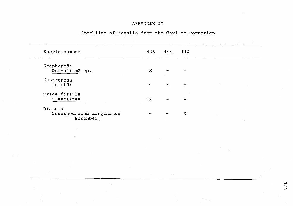
APPENDIX II
Checklist of Fossils from the Cowlitz Formation
Sample number 435 444 446
ScaphopodaDentalium? sp. X
Gas tropodaturrid: - X
Trace fossilsPlanolites X
DiatomsCoscinodiscus marginatus - X
Ehrenberg
a.'

APPENDIX III
Checklist of Fossils from the Keasey Formation
Sample number H H f-I H H t.) ) I'.) M W L Li.) 4 I .(.. UiH w C - - Q Co Co Co Ui U, Ui LC) -D O 0 0 Co H Co CO CO 0H aD C CO H Co '.0 0 t'J 4 H -I .O H NJ'.0 U H I '.0
CrustaceaZanthopsis? cf. Z. vulgaris Rathbun ---------------------- X
GastropoclaBruclarkia? sp."chinophoria"? sp.
Pelecypoda (Bivalvia)Acila (Truncacila) sp. cf. A. (T.)nehalemensis (G. D. Hanna)nuculanid (unidentified)Propeamusium sp.
-----X ------------------X-------------X------------
Foraminif eraAllomorphina trigona Reuss ---------------------- X -Anomalina californiensis Cushman --------------------- X -and HobsonBathysiphon eocenica Cushman & Hanria----------- X --------- X -Bathysiphon sp. --------------------- XBiloculinella cowlitzensis Beck --------------------- XCassidulina galvinensis Cushman ------------------ X - -and FrizzellCibicideselmaensisRau ----------- X --------- XCibicides pseudoungerianus evolutus ---------------------- X -Cushman and FrizzellCyclammina pacifica Beck - - X - X - - X - - - X - X ------ X -
U)Ni-4
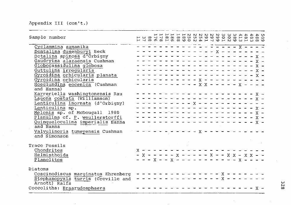
Appendix III (co&t.)
-HH HLJ4UiSample number i- - oD -J .-J 03 CO CO CO Ui Ui Ui ¼0 '.0 '.0 0 C) 03 H 03 CD 03 0
H -J CD C 03 H C 03 '.0 C) I'i H - ¼C) H ti '.0 Ui H U) 03 '.Q
Cyclammina samanika ------------------ X - -DentalinadusenburyiBeck -------------- X --------Detalinapinosad'OrbignyGaudryina alazaensis Cushman --------------------- X -Globocassidulina globosa --------------------- X -Guttulina irregularis --------------------- X -çyroidinaorbicularisplanata --------------------- X--
Gyroidina orbicularis ----------- X -----------Hoeglundina eocenica (Cushman ----------- X X ----- X - -arid Hanna)Karreriella washingtonensis Rau --------------------- X -Lagena costata (Williamson) --------------------- X -Lenticulina inornata (d'Orbigny) ---------- X ------------Lenticulina sp. --------------------- X -Melonis sp. of McDougall 1980 --------------------- XPlanulinacf.P.weullerstorffiQuinqueloculinaimperialisHannaand HannaValvulineria tumeyensis Cushman ----------- X -----------and Simonson
Trace FossilsChondritesHelminthoidaPlariolites
DiatomsCoscinodiscus marginatus EhrenbergStephanopyxis turns (Greville andArnott) Ralfs
Coccoliths: Braarudosphaera
x----------------------.-x ----- x ----- x--xx-xx-------x--x ----------- x----
x-------x-------
UiNiX- 00

Appendix III (con't.)
Sample number
Age
LR=lower RefugianR=RefugianUR=upper Refugian
Paleobachymetry
UB=upper bathyal(200-600 in)
B=bathyal(600-2000 m)
LMBlower middle bathyal(2000-4000 in)
LB=lower bathyal(4000-6000 in)
MemberJ=Jewell memberV=Vesper Church memberM=upper mudstone member
l- Ni Ni Ni Ni Ni Ni Ui U) Ui.l - Ui
Ui 00 J J 0000 00 00 Ui Ui Ui 0 000 - 0000 00 04 00O0Ni--H-1 ONi'O U)-U)00 O
URLR--LR---T--R-
LMB-U-UB ------- UB-LB
VVVMMVMVVVJJJJJJMJVVMM
U)Ni

APPENDIX IV
Checklist of Fossils from the Pittsburg Bluff Formation
- F ( W (J C ( (J ( W L) (JSample number -i -i t' . -J -i UI 4 1'.) 0) '-0 0 (71 -J '-0 --J -
CrustaceaBranchioplat? sp. B. washingtoniana -------------------- X -Ra thbun
GastropodaCryptonatica?sp. X ---------------ExiliabentsonaeHickman ---------------------- XPriscofusus chahalisensis (Weaver) ------------- X ---------Turricula? sp. cf. T. washingonensis--------------------- X -(Weaver)
Pelecypoda (Bivalvia)Acila (Truncacila) sp. cf. A. (T.)nehalemensis (G. D. Hanna)Crenélla'? sp. cf. C. porterensisWeaverDelectopecten sp.Litorhadia washingtonensis (Weaver)Nemocardium (Keenaea)? sp. cf. N.(K.) lorerizanum (Arnold)nuculanid (unidentified)Pitar (Pitar)? sp. cf. P. (P.)dalli (Weaver)Pitar? sp.
X--------X---------
-----X ------------------X-------
X-----------x--XX -----
X -----
0
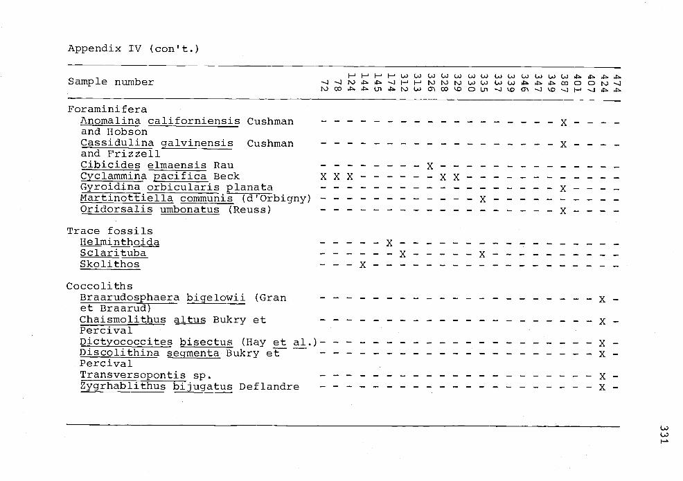
Appendix IV (con't.)
Sample number
Foraminif eraAnomalina californiensis Cushmanand HobsonCassidulina galvinensis Cushmanand FrizzellCibicides elmaensis Rauçyçlammina pacifica BeckGyroidina orbicularis planataMartinottiella communis (d'Orbigny)Oridorsalis umbonatus (Reuss)
Trace fossilsHe iminthoidaSciaritubaSk 01 tho s
H H H H (J C) (p.) W W W W CJ L) t) L) LJ W .'-i - H H L) L) Q cD t'J -1
co . u-i .. i c' co o o u-i - -o -.1 '.o -i H -i .t
x--------------xxx ------ xx ------------x----------
x------
x-----------------x----- x ----------
C oc co 11th s
Braarudosphaera bigelowli (Gran --------------------- X -et Braarud)Chaismo1ithu altus Bukry et --------------------- X -PercivalDictyococcites bisectus (Hay et al.) --------------------- X -DiscolithinasegmentaBukryet --------------------- X-PercivalTransversopontis sp. --------------------- X -Zygrhablithus bijugatus Deflandre --------------------- X
()

APPENDIX V
Checklist of Fossils from the Oswald West mudstone and Astoria Formation
Oswald West Astoria
Sample number Q0
S caphopodaDentalium (Fissidentaliurn?) X - -sp. cf. D. (F.?) laneensis Hickman
Pelecypodacardiid (unidentified) - X - -nuculanid (unidentified) X -Pitar (Pitar)? sp. cf. P. (P.) - X -dalli (Weaver)Delectopecten sp. - - X
Foraminif eraCyclammina pacifica Beck X - -
Trace fossilSciarituba - X -
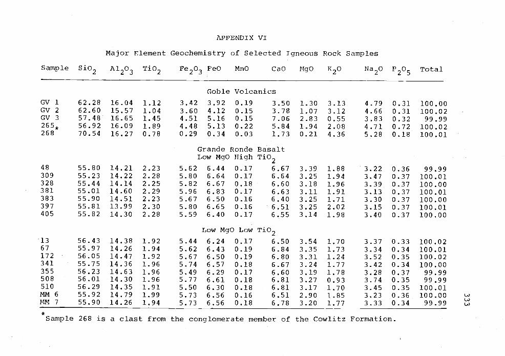
APPENDIX VI
Major Element Geochemistry of Selected Igneous Rock Samples
Sample Si02 A1203 Tb2 Fe203 FeO MnO CaO MgO K20 Na20 P205 Total
Goble Volcanics
GV 1 62.28 16.04 1.12 3.42 3.92 0.19 3.50 1.30 3.13 4.79 0.31 100.00GV 2 62.60 15.57 1.04 3.60 4.12 0.15 3.78 1.07 3.12 4.66 0.31 100.02GV 3 57.48 16.65 1.45 4.51 5.16 0.15 7.06 2.83 0.55 3.83 0.32 99.99265k 56.92 16.09 1.89 4.48 5.13 0.22 5.84 1.94 2.08 4.71 0.72 100.02268 70.54 16.27 0.78 0.29 0.34 0.03 1.73 0.21 4.36 5.28 0.18 100.01
Grande Ronde BasaltLow MgO High Tb2
48 55.80 14.21 2.23 5.62 6.44 0.17 6.67 3.39 1.88 3.22 0.36 99.99309 55.23 14.22 2.28 5.80 6.64 0.17 6.64 3.25 1.94 3.47 0.37 100.01328 55.44 14.14 2.25 5.82 6.67 0.18 6.60 3.18 1.96 3.39 0.37 100.00381 55.01 14.60 2.29 5.96 6.83 0.17 6.63 3.11 1.91 3.13 0.37 100.01383 55.90 14.51 2.23 5.67 6.50 0.16 6.40 3.25 1.71 3.30 0.37 100.00397 55.81 13.99 2.30 5.80 6.65 0.16 6.51 3.25 2.02 3.15 0.37 100.01405 55.82 14.30 2.28 5.59 6.40 0.17 6.55 3.14 1.98 3.40 0.37 100.00
Low MgO Low Ti02
13 56.43 14.38 1.92 5.44 6.24 0.17 6.50 3.54 1.70 3.37 0.33 100.0267 55.97 14.26 1.94 5.62 6.43 0.19 6.84 3.35 1.73 3.34 0.34 100.01172 56.05 14.47 1.92 5.67 6.50 0.19 6.80 3.31 1.24 3.52 0.35 100.02341 55.75 14.36 1.96 5.74 6.57 0.18 6.67 3.24 1.77 3.42 0.34 100.00355 56.23 14.63 1.96 5.49 6.29 0.17 6.60 3.19 1.78 3.28 0.37 99.99508 56.01 14.30 1.96 5.77 6.61 0.18 6.81 3.27 0.93 3.74 0.35 99.99510 56.29 14.35 1.91 5.50 6.30 0.18 6.81 3.17 1.70 3.45 0.35 100.01MM 6 55.92 14.79 1.99 5.73 6.56 0.16 6.51 2.90 1.85 3.23 0.36 100.00MM 7 55.90 14.26 1.94 5.73 6.56 0.18 6.78 3.20 1.77 3.33 0.34 99.99
*Sample 268 is a clast from the conglomerate member of the Cowlitz Formation.
(-p)

Appendix VI (con't.)
Sample Si02 A1203 Ti02 Fe203 FeO MnO CaO MgO K20 Na20 P205 Total
96153408417
54.11 14.41 1.8853.96 14.40 1.9354.11 14.27 1.9253.78 14.55 1.82
High MgO
5c68 6.50 0.205.89 6.74 0.205.84 6.69 0.225.72 6.55 0.20
8.10 4.37 1.108.02 4.27 1.117.96 4.39 1.128.22 4.52 1.02
3.33 0.32 100.003.15 0.33 100.003.14 0.34 100.003.30 0.30 99.98
All analyses are standardized using the international standard (Hooper and others, 1976).
C.)

335
APPENDIX VII
Polarity and Locations of Miocene Basalt Samples
Sample Polarity Intensity Location (sec., Twp., Rg.)*
13 N NW¼,SW¼, 34, 5N, 8W16 N S NW¼,NW¼, 3, 4N, 8W4l N S NE¼,NE¼, 25, 5N, 8W48 N - NE¼,NE¼, 22, 5N, 8W61 N S SE¼,Sw¼, 15, 5N, 8W62 R S NW¼,SE¼, 15, 5N, 8W67 N M SE¼,NW¼, 25, 5N, 8W7O N s sw¼, 11, 5N, 8W96 N NE¼,NW¼, 24, 5N, 8W100 N S SW¼,NW¼, 24, SN, 8W1063 N M SW¼,SE¼, 18, SN, 7W110 R M Nw¼,Nw¼, 17, 5N, 7W137 N S SW¼,NE¼, 1, 5N, 8W140A N N NE¼,NW¼, 1, 5N, 8W
152k N S NE¼,NW¼, 36, 6N, 8W153 N S NW¼,SW¼, 25, 6N, 8W155 N S SE¼,SW¼, 6, SN, 7W162k N S sw¼,sw¼, 25, 6N, 8W172 N NE¼,SE¼, 6, 5N, 7W.175 N w SW¼,NW¼, 5, SN, 7W181 N VW SW¼,NW¼, 4, 5N, 7W186 N w SW¼,NE¼, 8, 5N, SW320k R N NE¼,SW¼, 33, 6N, 7W328 R SE¼,NE¼, 22, 6N, 7W338k N N NE¼,NW¼, 22, 6N, 7W341 N NE¼,SW¼, 15, 6N, 7W342k N SE¼,NW¼, 15 6N, 7W355 N SE¼,SW¼, 21, 6N, 7W358 N w NW¼,NW¼, 21, 6N, 7W361 N M SE¼,SE¼, 17, 6N, 7W371 N W SW¼,SE¼, 19, 6N, 7W376 N N NE¼,SE¼, 18, 6N, 7W378 N S NW¼, 17, 6N, 7W38O N S NE¼,NW¼, 17, 6N, 7W381k R M NE¼,NE¼, 17, 6N, 7W383 R NWP,NWP, 17, 6N, 7W384 R 5 SW¼,NE¼, 17, 6N, 7W385 N w Sw¼,Nw¼, 16, 6N, 7W396k R 5 NE¼,NW¼, 18, 6N, 7W
N N C 18, 6N, 7W405 R N NW¼,NW¼, 4, SN, 7W

336
Appendix VII (con't.)
Sample Polarity Intensity Location
*4O8 N417 N486k P.
5O8 N5lO NMM6 N
* NM1v15=309 R513 NFishhawk Falls N
NW¼,SE¼, 19, 6N, 7WS sW¼,SW¼, 35, 5N, 8WVW NW¼,NW¼, 17, SN, 7WS SE¼,SE¼, 14, 5N, 7W- NE¼,SW¼, 18, 6N, 7W- NW¼,SW¼, 32, 6N, 7W- SE¼,SE¼, 8, 5N, 7W- NE¼,NE¼, 14, 6N, 7WS SE¼,SE¼, 18, 6N, 7WM NW¼,SW¼, 32, 6N, 7W
*Major oxide geochemistry determined; see Appendix VI.
F luxgate magnetometerIntensity levels:
S strong pegs scale left or rightM moderate -2O -4QSLW weak - <20.IiVW very weak - barely perceptible 2OfL
C

337
APPENDIX VIII
Heavy Minerals of Selected Sandstones
from the Fishhawk Falls Jewell Area
Mineral Cowlitz Formationspecies(% oftotal) 200 203 219 233 238 260 432
Ainph ibo 1 e s
Green hornblende 0.2 2 8 - 2 0.7 7Brown hornblende - - 0.5 - 2 0.3 1Basaltic hornblende 3 - - 1 - -Actinolite - 0.5 3 - 1 0.2 3Tremolite 0.5 2 - 1 - -
PyroxeneAugite 0.2 1 - - - - -
MicaBiotite 5 0.5 12 2 9 5 9Muscovite - - - - - 3 0.6Chlorite - 1 - - 0.3 1 0.3
Epidote GroupPistacite 9 36 38 3 28 5 20Clinozoisite 3 4 3 - 2 1 1
Tourma lineGreen 0.2 - 1 3 3 9 4Brown 1 2 - -
GarnetColorless 6 1 3 9 8 l0 2Pink 1 - - 1 1 1
Kyanite 0.3 - - 0.2 - 0.3 0.3Sillimanite 0.5 1 0.2 1 0.2 0.6 0.3Stauroljte 3 4 1 0.2 0.2 0.3 3Monazite 1 4 - - - 0.3Rutile 1 20 2 5 1 5 0.3Zircon 9 5 6 18 8 15 8Sphene - - - - - - -Apatite 15 4 12 10 12 2 3Magnetite 29 1 4 7 9 2 3Hematite 11 - 1 - 7 23 30Leucoxene - 4 3 0.4 7 16 4Pyrite 1 - 1 1 - -Limonite 3 2 - 39 -
Total Points 622 206 664 820 624 674 350
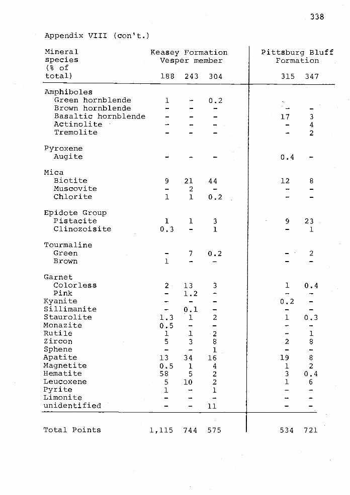
Appendix VIII (con't.)
Mineral Keasey Formationspecies Vesper member(% oftotal) 188 243 304
Amph ibo 1 e s
Green hornblendeBrown hornblendeBasaltic hornblendeActinoliteTremolite
PyroxeneAug ± te
MicaBiotiteMuscoviteChlorite
Epidote GroupPistaciteClinozoisite
TourmalineGreenBrown
GarnetColorlessPink
KyaniteSillimaniteStauroliteMonaziteRutileZirconSpheneApatiteMagnetiteHematiteLeucoxenePyriteLimoni teunidentified
Total Points
1 - 0.2
9 21 44- 2 -1 1 0.2
1 1 3
0.3 - 1
- 7 0.21 - -
2 13 3
- 1.2 -
- 0.1 -1.3 1 2
0.5 - -1 1 2
5 3 8- - 1
13 34 160.5 1 4
58 5 2
5 10 2
1 - 1
- - 11
1,115 744 575
338
Pittsburg BluffFormation
315 347
17 3
- 4
- 2
0.4 -
12 8
9 23- 1
- 2
1 0.4
0.2 -
1 0.3
- 1
2 8
19 8
1 2
3 0.41 6
534 721
339
APPENDIX IX
Locations and descriptions of
Eocene and Niocene paleomagnetic sample localities
Eocene
GV1
SE¼, NW¼, sec. 25, T. 5 N., R. 7 W., Birkenfeld
Quad. The site is located on Buster Creek Road at the
westernmost of two rock quarries. Cores were drilled
at exposed face approximately 150 meters off the main
road. Access to the core sites is by an old road at
the south end of the lower parking lot. Core samples
span a distance of approximately 50 m. Attitude:
N 85° E, 21° N from bedding stratification of Cowlitz
conglomerate member exposed near the top of the quarry.
GV2
SE¼, SE¼, sec. 23, T. 5 N., R. 7 W., Saddle Mtn.
Quad. The site Is exposed on the west side of Fishhawk
Falls Hwy approximately 4.4 km south of Jewell. A
possible thrust fault and/or normal fault are associated
with this site. Cores A, B and C were drilled in a
partially-filled amygdaloidal vesicular basalt. Core D
was drilled into volcaniclastics and not used; cores
B, F and G were drilled in massive aphyric basalt.
Cores C and D appear to cluster on stereonet as do
cores B and F. There was insufficient data to separate
them into two sites. The samples span a distance of
approximately 40 m. Attitude: N 85 B, 19° N from sand-
stone beds.

340
GV3 "Sports Acres" site.
NW¼, SE¼, sec. 4, T. 4 N., R. 7 W., Saddle Mountain
Quad. The site is located on Lukarilla Road, northwest
of Sports Acres development. Cores A, B and C are from a
series of vesicular basalt flows with small plagioclase
phenocrysts. The lowest flow is the only one sampled.
Core D was taken from a vesicular porphyritic basalt
which is in fault contact with sediments that underlie
the basalt flow of cores A, B and C. Cores E, F and
G are from a blocky weathering vesicular basalt with
war-bonnet jointing. The samples span approximately
100 m. Attitude: N 28° W, 28° NE from sedimentary
interbeds overlying the flow associated with cores A,
B and C.
Miocene
MM1 "Northrup Dike South"
NW¼, NW¼, sec. 16, T. 6 N., R. 6 W., Cathiamet
Quad. The quarry is located on Northrup Creek Road.
Proceed left at intersection with Cow Creek Road and
bear right at junction with Northrup Pit Road. Take
next spur road to the right (approximately 50 m north
of Northrup Pit junction). All cores are from a
dike of massive, nonvesicular and aphyric basalt (unit
LNHT1 of Goalen, 1983). Trend of dike is N 40 E, 80 NW.

341
MM2 " Beneke Dike North" (1 JG 09 or 81-9)
NW¼, NE¼, sec. 29, T. 7 N., R. 6 W., Cathiamet
Quad. Dike is exposed at the intersection of Beneke/
Kerry Road and Big Creek Road. It is approximately
16.5 m thick, and is the Low MgO-high Ti02 chemical
type Grande Ronde Basalt. Baked columnar-jointed
and bioturbated yellow-gray mudstone of Oligocene?
age occur on either side of the dike. Basalt is
blocky with poorly formed columnar joints. The site
was redrilled in 1981 to reduce error. Attitude:
N 65 E., 28 NW? from the outcrop; the regional dip is
E-W, 6° N.
MM3 "Nicolai Quarry" (1 13G 10 or 81-10)
SW¼, NW¼, sec. 21, T. 7 N., R 6 W., Cathiamet
Quad. The site is located along Kerry Road, approximately
0.2 km east of Nicolai Mainline. Outcrop is in a large
quarry of closely packed pillows of Grande Ronde Basalt
(type LMHT2). The site was reoccupied in 1981 to
reduce statistical error. Attitude: E-W, 6°N from
regional dip of Nicolai Mountain.
MM4 "Northrup Dike North" (1 JG 08 or 81-8)
NE¼, NW¼, sec. 3, T. 6 N., R. 6 W., Cathiamet
Quad. Northern extension of the Northrup dike. The
exposure is on Greasy Spoon Road. The dike crops out
on both sides of the road. Estimated thickness of the
dike is 3 meters; trending N 22 E, 73 NW. The basalt
is type LMHT1 of Goalen (1983) and cuts interbedded.
sandstone and siltstone of the Pittsburg Bluff Formation.
342
0 0Attitude: N 45 E, 10 NW from sedimentary rock outcrop
east of the dike.
MM5 "Beneke Dike Quarry" (1 JG 03, 04, 05, or 81-1 to -5)
NE¼, NE¼, sec. 14, T. 6 N., R. 7 W., Svensen Quad.
Drill sites are located in a large quarry at a road
terminus on the Walker Road system. The site was re-
occupied in 1981 and three new sites (81-3, 81-4 and 81-5)
were established. Between the times the quarry was
sampled, excavation of the basalt occurred so that the
original site (MM5) was completely removed. The three
new sites are in the north part of the quarry (81-3),
the middle part (81-4) and the south part (81-5). See
Plate IV for a detailed map of the quarry. The dike
trend is N 35° E, 65° SE but has an irregular margin.
Both the dike and adjacent Oswald West mudstones are
deformed. The bioturbated siltstone cut by the dike is
0thought to be Oligocene in age. Attitude: N 10 E,
15° NW from adjacent strata but this may not be the
regional dip due to local faults.
MM6 "Fishhawk Falls Dike
NW¼, SW¼, sec. 32, T. 6 N., R 7 W., Saddle Mtn
Quad. Quarry exposed on the north side of StatHighway
202, dike can be traced to the southwest under the road
and into Fishhawk Creek where it forms the resistant
layer comprising Fishhawk Falls. Cores A - E were
drilled in the quarry, cores F - H were drilled in the
creek. This site was also drilled by R. W. Simpson.
343
Local contacts with the sedimentary rocks are uncertain.
Chemically, the rock is a low MgO-low Ti02 type Grande
Ronde Basalt. The dike trends N 300 E, 45° SE.
MM7 "Little Fishhawk" Dike
NW¼, SE¼, sec. 8, T. 5 N.rn, R. 7 W., Saddle Mtn.
Quad. The dike crops out in Little Fishhawk Creek and
trends N 20-25° E. All drill sites were in or near the
creek bed. The sedimentary strata is laminated micaceous
siltstone of the Vesper member of the Keasey Formation.
The basalt has low MgO-low Ti02 chemistry (Grande
Ronde Basalt).
MM8 "Nicolai Mountain Quarry - upper flow" (1 JG 11)
SW¼, NW¼, sec. 21, T. 7 N., R. 6 W., Cathiamet
Quad. Two closely packed pillow sequences are exposed
in this large quarry on the south-facing slope of
Nicolai Mountain. The lower pillow sequence directly
overlies Big Creek sandstone of the Astoria Formation.
This pillow flow is site MN3 and later reoccupied as
site 81-10. The upper flow is Grande Ronde Basalt
(type LMHT3? of Goalen, 1983) and is site MM8 (also
labeled 1 JG 11 or 81-11). The structure correction
used is the regional dip of the Nicolai Mountain
0cuesta, E-W, 6 N.
MM9 "Plympton Creek section" (1 JG 12, or 81-12)
SE¼, SW¼, sec. 2, T. 7 N., R. 6 W., Cathlamet
Quad. A subaerial Grande Ronde Basalt flow sampled
here overlies three other basalt flows. The flow
344
of site MM9 has low MgO-low T±02 chemistry and is
referred to as the LMLT2 unit (Goalen, 1983). The
structure correction (N 60° E, 250 NW) is obtained from
an imaginary plane normal to entablature joint sets,
from platy jointing of overlying flow lobe and an
overlying mudstone.
NM1O "Plympton Creek section" (1 JG 01, 81-1)
SE¼, SW¼, sec. 2, T. 7 N.,, R 6 W., Cathiamet
Quad. The site is located near Plympton Creek approx-
imately 2.4 km southwest of the town of Westport, Oregon.
This abundantly phyric basalt flow has low MgO-high
Ti02 chemistry of Grande Ronde Basalt (type LMLT2 of
Goalen, 1983) and is the second lowest flow in the
middle Niocene basalt section of Plympton Creek.
IM11 "Plympton Creek section" (1 JG 02, 81-2)
SE¼, SW¼, sec. 2, T. 7 N., R. 6 W., Cathiamet
Quad. The site is located near Plympton Creek approx-
imately 2.4 km southwest of Westport, Oregon. This
fine-grained aphanitic basalt flow is the lowermost
flow in the Plympton Creek section and is type LMHT1
of Goalen (1983). Though the groundmass is fine-grained,
this basalt has occasional large phenocrysts of plagio-
clase ( 4 x 2 mm). Attitude ofAlithic sandstone bed
between successive basalt flows is N 600 E, 250 NW.
In addition, aligned flow vesicles are oriented parallel
to flow direction and base of flow.
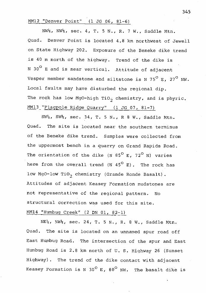
345
MM12 "Denver Point" (1 JG 06, 81-6)
NW¼, NW¼, sec. 4, T. 5 N., R. 7 W., Saddle Mtn.
Quad. Denver Point is located 4.8 km northwest of Jewell
on State Highway 202. Exposure of the Beneke dike trend
is 40 m north of the highway. Trend of the dike is
N 300 E and is near vertical. Attitude of adjacent
Vesper member sandstone and siltstone is N 750 E, 270 NW.
Local faults may have disturbed the regional dip.
The rock has low MgO-high Tb2 chemistry, and is phyric.
MM13"Flagppje Ridge Quarry" (1 JGO7, 81-7)
SW¼, SW¼, sec. 34, T. 5 N., R 8 W., Saddle Mtn.
Quad. The site is located near the southern terminus
of the Beneke dike trend. Samples were collected from
the uppermost bench in a quarry on Grand Rapids Road.
The orientation of the dike (N 85° E, 72° N) varies
here from the overall trend (N 45° B). The rock has
low MgO-low Ti02 chemistry (Grande Ronde Basalt).
Attitudes of adjacent Keasey Formation mudstones are
not representative of the regional pattern. No
structural correction was used for this site.
MM14 "Humbug Creek" (2 DN 0], 82-1)
NE¼, NW¼, sec. 24, T. 5 N., R. 8 W., Saddle Mtn.
Quad. The site is located on an unnamed spur road off
East Humbug Road. The intersection of the spur and East
Humbug Road is 2.8 km north of U. S. Highway 26 (Sunset
Highway). The trend of the dike contact with adjacent
Keasey Formation is N 30° E, 80° NW. The basalt dike is

346
approximately 5 m thick. The rock is correlated to
the high MgO type Grande Ronde Basalt on the basis of
major oxide geochemistry.
MM15 "Big Creek near Flagpole Ridge" (2 DN 02, 82-2)
SW¼, SW¼, sec. 35, T. 5 N., R. 8 W., Saddle Mtn.
Quad. The site is located southeast of Flagpole Ridge
near Big Creek, and can be reach via the Grand Rapids
Road. The latter intersects U. S. Highway 26 (Sunset
Highway) near the crest of a steep grade in section 21,
T. 5 N., R. 8 W. The basalt dike is correlative to
the high MgO type Grande Ronde Basalt. The dike is
approximately 5 m thick and trends N450
E. Contacts
and attitudes of adjacent Keasey Formation mudstones
are uncertain.

347
APPENDIX X
List of Localities Discussed in
Text and in Fossil Checklists
Goble Volcanics
GV1 SE¼, NW¼, 25, T5N, R7WGV2 SE¼, SE¼, 23, T5N, R7WGV3 NW¼, SE¼, 4, T4N, R7W211 NW¼, SE¼, 23, T5N, R7W265 SE¼, NW¼, 25, T5N, R7W265B SE¼, NW¼, 25, T5N, R7W269 SE¼, NW¼, 25, T5N, R7W
Cowlitz Formation
203 SE¼, sE¼, 22, T5N, R7W219 SE¼, NE¼, 23, T5N, R7W233 SE¼, SE¼, 14, T5N, R7W236 SE¼, SE¼, 14, T5N, R7W238 NE¼, NE¼, 23, T5N, R7W432 SW¼, Sw¼, 13, T5N, R7W435 SW¼, NE¼, 24, T5N, R7W444 NE¼, NE¼, 27, T5N, R7W446 SE¼, NW¼, 25, T5N, R7W
Keasey Formation
11 NW¼, NE¼, 2, T4N, R8W37 NE¼, SW¼, 26, T5N, R8W38 NE¼, SwP, 26, T5N, R8W88 NE, NW¼, 13, T5N, R8W89 Nw¼, SE¼, 13, T5N, R8W96 NE¼, NW¼, 24, T5N, R8W
155 sE½, SW¼, 6, T5N, R7W176 SW¼, SW¼, 32, T6N, R7W178 NE¼, NW¼, 8, T5N, R8W181 SW¼, NW¼, 4, T5N, R7W186 sw¼, NE¼, 8, T5N, R7W188 sw¼, NE¼, 8, T5N, R7W189 NW¼, NW¼, 19, T5N, R7W243 NW¼, SW¼, 26, T5N, R8W250 sE¼, SE¼, 17, T5N, R7W251 SW¼, SW¼, 16, T5N, R7W252 Nw¼, Nw¼, 21, T5N, R7W254 sw¼, NW¼, 5, T4N, R7W291 NE¼, NE¼, 13, T5N, R7W

348
Appendix X (con't.)
Keasey Formation (con't.)
297 NW¼, SE¼, 29, T5N, R7W299 NE¼, NE¼, 11, T5N, R7W301 NW¼, NE¼, 11, T5N, R7W302 NE¼, NW¼, 11, T5N, R7W304 SE¼, SE¼, 26, T6N, R7W389 SE¼, Sw¼, 30, T6N, R7W413 NW¼, Sw¼, 25, T5N, R8W481 Nw¼, NE¼, 25, T5N, R8W483 SE¼, 5E¼, 17, T5N, R7W488 NW¼, NE¼, 7, T5N, R7W505 SW¼, SW¼, 13, T5N, R7W509 NW¼, SW¼, 6, T5N, R7W
Pittsburg Bluff Formation
72 NW¼, NE¼, 11, T5N, R8W78 NE¼, NE¼, 11, T5N, R8W
118 SE¼, Sw¼, 1, T5N, R8W124 SE¼, SE¼, 1, T5N, R8W138 NE¼, SE¼, 1, T5N, R8W144 NW¼, SE¼, 36, T6N, R8W145 NW¼, SE¼, 36, T6N, R8W174 SE¼, NE¼, 6, T5N, R7W312 SE¼, NW¼, 14, T6N, R7W313 SE¼, SW¼, 11, T6N, R7W315 NE¼, NW¼, 14, T6N, R7W326 Sw¼, NW¼, 23, T6N, R7W328 SE¼, NE¼, 22, T6N, R7W329 SW¼, NE¼, 22, T6N, R7W330 sw¼, NW¼, 27, T6N, R7W335 SW¼, NE¼, 22, T6N, R7W337 NE¼, NW¼, 22, T6N, R7W339 SE¼, SW¼, 15, T6N, R7W346 NE¼, SW¼, 22, T6N, R7W347 NW¼, Sw¼, 22, T6N, R7W349 NW¼, SE¼, 21, T6N, R7W387 NW¼, NW¼, 30, T6N, R7W401 NW¼, Sw¼, 28, T6N, R7W407 SE¼, SW¼, 21, T6N, R7W424 sw¼, NW¼, 1, T5N, R8W474 NE¼, NW¼, 22, T6N, P3W

349
Appendix X (con't.)
Oswald West mudstone
68 SE¼, SW¼, 11, T5N, R8W309 NE¼, NE¼, 14, T6N, R7W314 NE¼, NW¼, 14, T6N, R7W382 NE¼, NE¼, 17, T6N, R7W
Astoria Formation (Silver Point Mbr.)
360 NW¼, wE¼, 20, T6N, R7W

350
Appendix XI
Proton-precession Magnetometer Responses:Traverses 1 - 11

(I)
agnetorneter Traverse 1NE¼, NE¼, sec. 14, T. 6 N., R. 7 W.
56,000 Beneke Quarry
WI
55,0O0
Oi
S 40° W
54,000 0 50 100
feet
56,000
55,000
4,000
S 40° w
/Dike contacts
56 ,00
55,0001IrIc
54, 000J
56, 000,
(ii
5,0O0
'Dike contacts 0
Magnetometer Traverse 2NE¼, NE¼, sec. 14, T. 6 N., R. 7 W. 54,000Beneke Quarry
Ln
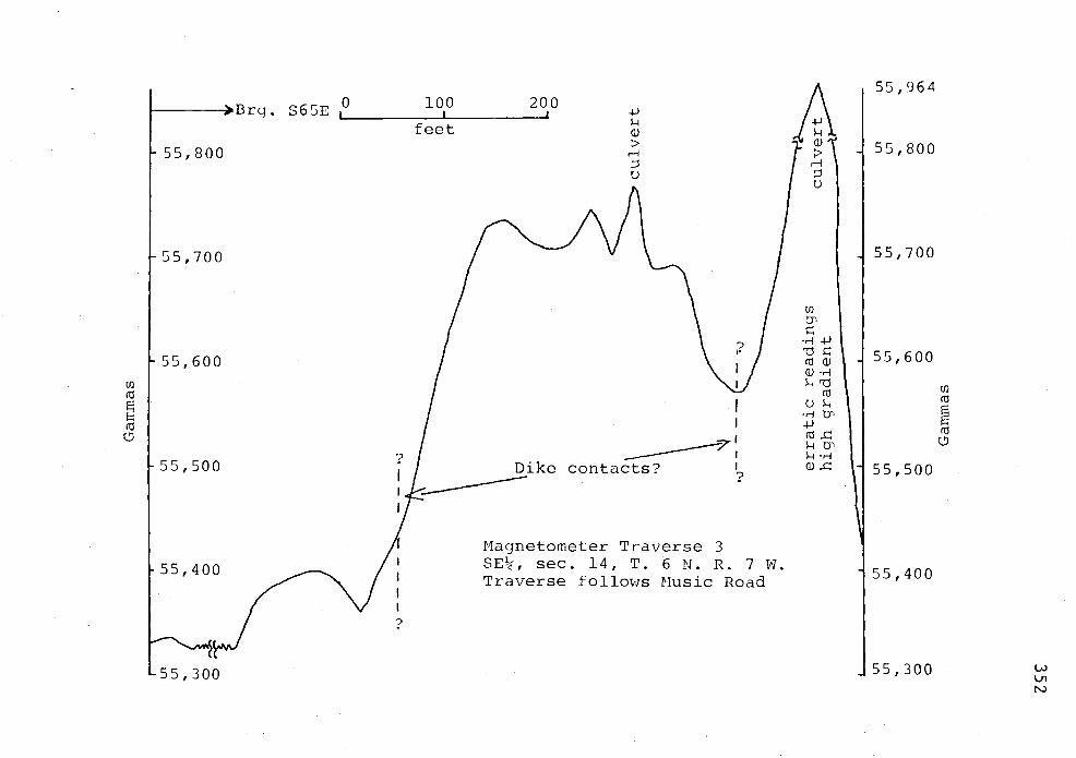
I I
1551964>Brg. S65E 0 100 200
feet wI'10)l'
r-1 I
55,800 t' -1 55,800
0 i1I
j55,70055,700
H4J
'U 55,60055,600Q) r-
U)
'U U)
'U'U
'U
0 'U, 'U
55,500 Dike contacts? 55,500
Magnetometer Traverse 3I SE, sec. 14, T. 6 N. R. 7 W.55,400 55,400I Traverse follows Music Road
?
J55,300 U)0155,300N)
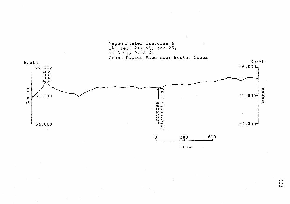
South
r 56'oL94 U)
r- -4
.c_ o
!
/5,0O0
54,000
Magnetometer Traverse 4S½, sec. 24, N½, sec 25,T. 5 N., R. 8 W.Grand Rapids Road near Buster Creek
Cd
0
did)U)
0 300 600
feet
North56, 000.,
U)
55,000(d
0
54,000
Ui
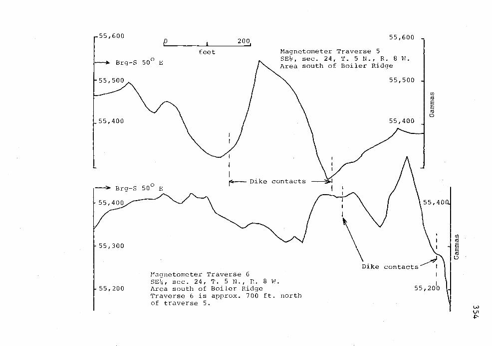
00p 20
feet
Brg-S 50° E
55,400
55,300
aanetorneter Traverse 6
55,600
Magnetometer Traverse 5SE, sec. 24, T. 5 N., R. 8 W.Area south of Boiler Ridge
Dike contacts
SE¼, sec. 24, T. 5 N., P.. 8 .
55,200 Area south of Boiler RidgeTraverse 6 is approx. 700 ft. northof traverse 5.
55,500
55,400
(I)
8ni
e)
Tç\\Jfl
Dike contacts
55, 20J
(-i)
LIP

Magnetometer Traverse 9NW¼, SE¼, sec. 34, T. 5 N., R. 8 WTraverse is 250 feet NE of Traverse 8.
56,00056,000
U)
(U
(U0
55,000 Dike 55,000
56,000
>Brg-S 70° E Magnetometer Traverse 8SW¼, sec. 34, T. 5 N., R. 8 W.South of Flagpole Ridge
55,000 Interpretation: No dike in subsurface.0 200
feet
56,000 Magnetometer Traverse 7 56,000NE, Sw¼, sec. 34, T. 5 N., R. 8 W.
Brg-S 85° W South of Flagpole Ridge
E (U
(U U0 ____ - __
55,000 55,000
Interpretation: No dike in subsurface.
56,000
U)
(U
(U0
55,000
U)
(U
'U
0
U)
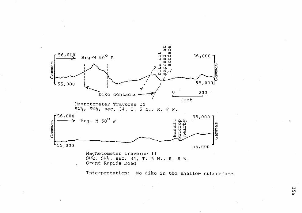
-p nI
o'tj4-4 56,00056,00,Brg-N 6
55,000 5,000
Dike contacts 0 200?
feetMagnetometer Traverse 10SW¼, SW¼, sec. 34, T. 5 N.., R. 8 W.
56,000 56,000
H OQ
Magnetometer Traverse 11SW¼, SW¼, sec. 34, T. 5 N., R. 8 W.Grand Rapids Road
Interpretation: No dike in the shallow subsurface
()
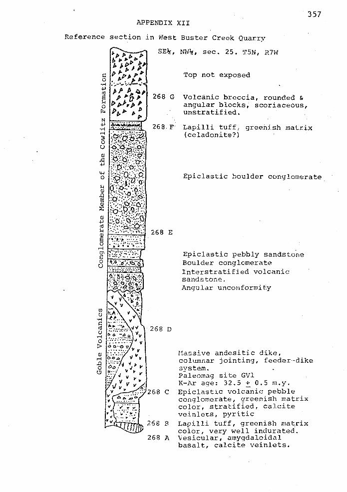
357APPENDIX XII
Reference section in Tes Buster Creek Quarry
0
CU
E
0c4
N
r-
UU)
0
U)
U)
U)4J
U)
0
0U
U)
0
(U
0
0
U)
0
SE, NW¼, sec. 25. T5N, R7W
Top not exposed
268 G Voj.cärijc breccia, rounded &angular blocks, scoriaceous,unstratified.
268r Lapilli tuff; greeiish matrix(celadonite?)
268 E
268 C
268 B
268 A
Epiclastic boulder conglomerate
Epiclastic pebbly sandstoneBoulder conglomerateInterstratified volcanicsandstone.Angular unconformity
I1asive andesitic dike,columnar jointing, feeder-dikesystem.Paleornag site GV].K-Ar age: 32.5 ± 0.5 m.y.Epiclastic volcanic pebbleconglomerate, greenish matrixcolor, stratified, calciteveinlets, pyriticLapilli tuff, greenish matrixcolor, very well indurated.Vesicular, arnygdaloidalbasalt, calcite veinlets.

358
APPENDIX XIII
Clatsop County Exploration Well Locations to 1982
Well name/ sec., Tp., Rg.Operator
DSC 11-14 B. C. NW¼, 14, 7N, 7WDiamond ShamrockCorporation
DSC 11-28 C. Z. NW¼, 28, 5N, 9WDiamond ShamrockCorporation
DSC 31-17 C. Z. NE¼I 17, 6N, SWDiamond ShamrockCorporation
ONG Johnson 33-33 SE¼, 33, 8N, 9WOregon Natural GasDevelopment Company
ONG Patton 32-9 NE¼, 9, 7N, 8WOregon Natural GasDevelopment Company
Quintana "Watzek" NE¼, 30, 6N, 6W30-l/QuintanaPetroleum
Texaco Clark &Wilson #6-1Texaco
Socal HoeglundUnit No. 1Standard Oil Co.of California
O.G. Brown #1Lower ColumbiaOil and Gas
NE¼, 19, 6N, 4W(Columbia County)
SE¼, 11, 7N, low
NW¼, 25, 8N, lOW
Depth and status
TD=7,864 ft.Abandoned, dry hole
TD=5,700 ft.Abandoned, dry hole
TD=6,095 ft.Abandoned, dry hole
TD=10,006 ft.
Permitted to 11,000ft.; drilling
TD=7,068 ft.Abandoned, dry hole
TD=8,460 ft.Abandoned, gas shows
TD=7,l0l ft., floures-
ence on core
TD=4,808 ft.Gas shows and traceof oil?.

359
Appendix XIV
Results of Reservoir and Source Rock Analysis
of Selected Samples from the
Fishhawk Falls - Jewell Area
Smp No. Location %TOC1 Kerogen type Generation Stage of(sc,T.,R.) Oil/Gas Rating Diagenesis
Cowlitz Formation
258 NE, 27, 0.5 Gas Fair Pregeneration5N, 7W
Keasey Formation
188 NE, 8, 0.8 Gas Fair Pregeneration5N, 7W
244 SW, 26, 0,6 Gas Poor-Pair Pregeneration5N, 8W,
246 NE, 16, 0.9 Gas Fair Pregeneration5N, 7W
256A NE, 16, 0.2 Gas Nonsource Pregeneration5N, 7W
502 NW, 12, 0.7 Gas Fair Pregeneration5N, 7W
Smp No. Location % Porosity2 Permeability2Lithology(md)
Cowlitz Formation
215 NW, 24, 13.1 2.8 Voic. arenite5N, 7W
219 NW, 24, 22.9 2.2 Plag. arkose5N, 7W
238 NW, 24, 32.7 4.4 Lith. arkose5N, 7W (epidote-rich)
Keasey Formation
256C NE, 16, 17.0 3.5 Subarkose5N, 7W
Smp No. Location Vitrinite Reflectance (%RO)
492 N½, 27, 0.54 (Cowlitz Formation?)SN, 7W
1TOC = Total organic carbon
2Nuclear Magnetic Resonance (NMR) method used in analyses.
I