northwest quadrant jefferson county report
TRANSCRIPT
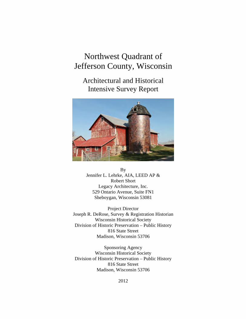
Northwest Quadrant of Jefferson County, Wisconsin
Architectural and Historical Intensive Survey Report
By Jennifer L. Lehrke, AIA, LEED AP &
Robert Short Legacy Architecture, Inc.
529 Ontario Avenue, Suite FN1 Sheboygan, Wisconsin 53081
Project Director
Joseph R. DeRose, Survey & Registration Historian Wisconsin Historical Society
Division of Historic Preservation – Public History 816 State Street
Madison, Wisconsin 53706
Sponsoring Agency Wisconsin Historical Society
Division of Historic Preservation – Public History 816 State Street
Madison, Wisconsin 53706
2012

1
Acknowledgments This program receives Federal financial assistance for identification and protection of historic properties. Under Title VI of the Civil Rights Act of 1964, Section 504 of the Rehabilitation Act of 1973, and the Age Discrimination Act of 1975, as amended, the U.S. Department of the Interior prohibits discrimination on the basis of race, color, national origin, or disability or age in its federally assisted programs. If you believe you have been discriminated against in any program, activity, or facility as described above, or if you desire further information, please write to: Office of the Equal Opportunity, National Park Service, 1849 C Street NW, Washington, DC 20240. The activity that is the subject of this Intensive Survey Report has been financed entirely with Federal Funds from the National Park Service, U.S. Department of the Interior, and administered by the Wisconsin Historical Society. However, the contents and opinions do not necessarily reflect the views or policies of the Department of the Interior or the Wisconsin Historical Society. Nor does the mention of trade names or commercial products constitute endorsement or recommendation by the Department of the Interior or the Wisconsin Historical Society. The authors would like to thank the following persons or organizations for their assistance in completing this project: Wisconsin Historical Society
Jim Draeger, Deputy State Historic Preservation Officer Joseph R. DeRose, Survey & Registration Historian Jefferson County Historic Sites Preservation Commission
John Molinaro, Chair Larry Cole, Vice-Chair Kathleen Lasley, Secretary Cindy Arbiture Robert Burmingham James Levy Jesse Powers Area Research Center University of Wisconsin-Whitewater
Deronica Goldsmith Karen Weston
Lake Mills-Aztalan Historical Society
Cheryl Peterson, President Town of Aztalan Assessor - Bowmar Appraisal Inc.
Karen Bodouski Town of Lake Mills
Robin Untz, Town Clerk Town of Lake Mills Assessor - Jacobson Appraisals
Ron Jacobson Town of Milford Assessor - National Appraisal Corp.
Debbie Hennessy All photographs contained in this report were taken by Legacy Architecture, Inc.

2
Abstract This report documents an architectural and historical intensive survey of resources located within the boundaries of the Towns of Aztalan, Lake Mills, Milford, and Waterloo, comprising the northwest quadrant of Jefferson County, Wisconsin, as of 2012. A reconnaissance survey of this area was conducted by the principal and assistant investigators as the first part of the survey. After which, a research effort was conducted to ascertain the architectural and historical significance of the resources identified during the reconnaissance survey. The resulting products of the project were produced according to standards set by the Wisconsin Historical Society’s Division of Historic Preservation and include the following: Intensive Survey Report The intensive survey report includes a summary of the research and a brief history of the community. It provides a historical context for the evaluation of historic resources and serves as a means for identifying significant properties, farmsteads, and districts eligible for listing in the National Register of Historic Places. It also contains recommendations for future survey and research needs, priorities for National Register listing, and strategies for historic preservation. Survey and District Maps Survey maps indicate all previously and newly surveyed properties as well as properties already listed in the National Register of Historic Places. Farmstead and district maps identify boundaries and all resources in the potential farmsteads and districts. These maps are included in the Survey Results Chapter in this intensive survey report. Electronic Documents The Wisconsin Historical Society’s website contains an electronic database, called the Architecture and Historic Inventory (AHI), for all inventoried properties. Also, an electronic copy of this report is saved on compact disc and held at the Wisconsin Historical Society and the Jefferson County Courthouse.

3
Table of Contents Contents Page Acknowledgements ..................................................................................................1 Abstract ....................................................................................................................2 Table of Contents .....................................................................................................3 Chapter 1 Introduction ..............................................................................................................5 Chapter 2 Survey Methodology ..............................................................................................11 Chapter 3 Historical Overview ...............................................................................................15 Chapter 4 Historic Indians ......................................................................................................23 Chapter 5 Government............................................................................................................25 Chapter 6 Settlement ..............................................................................................................31 Chapter 7 Agriculture .............................................................................................................33 Chapter 8 Industry ..................................................................................................................39 Chapter 9 Transportation ........................................................................................................47 Chapter 10 Architecture ............................................................................................................51 Chapter 11 Education ...............................................................................................................75 Chapter 12 Religion ..................................................................................................................89 Chapter 13 Commerce ..............................................................................................................93 Chapter 14 Planning & Landscape Architecture ......................................................................95 Chapter 15 Recreation & Entertainment ..................................................................................99 Chapter 16 Notable People .....................................................................................................103 Chapter 17 Bibliography ........................................................................................................117 Chapter 18 Survey Results .....................................................................................................121 Chapter 19 Recommendations ................................................................................................149 Chapter 20 Notes ....................................................................................................................153 Chapter 21 Appendix ..............................................................................................................163 How to Gain Commission Credibility Building Support for Local Historic Preservation Creating a Preservation Ethic in Your Community Planning a Local Historic Preservation Program Guidelines for Planning Historic Preservation Tax Credit Projects Historic Preservation Tax Incentive for Income-Producing Historic Buildings Wisconsin Historic Homeowners Tax Credit Program

4
This page intentionally left blank.

5
Introduction The Jefferson County Historic Sites Preservation Commission received a Historic Preservation grant-in-aid from the National Park Service, U.S. Department of the Interior to hire Legacy Architecture, Inc., an architectural and historic preservation consulting firm based in Sheboygan, Wisconsin, to conduct an intensive survey of architecturally and historically significant resources within the boundaries of the Towns of Aztalan, Lake Mills, Milford, and Waterloo, comprising the northwest quadrant of Jefferson County, Wisconsin. The major objective of the project was to identify structures, farmsteads, and districts of architectural or historical significance that are potentially eligible for listing in the National Register of Historic Places. The survey was executed during the period from March 2012 to July 2012 by Principal Investigators Jennifer L. Lehrke and Robert Short with assistance by Thomas Barg and JoAnn Veldman, all of Legacy Architecture, Inc. It consisted of several major work elements: completing a reconnaissance survey, conducting research, evaluating resources, and preparing an intensive survey report. The boundaries of the survey were delineated as shown on the Survey Boundaries Map. The survey identified approximately173 resources of architectural and historical interest as well as 1 potential historic district and 6 potential farmsteads. Although the resources include a small quantity of public buildings such as schoolhouses, commercial buildings, a town hall, bank, and mill; the majority of the surveyed resources are farm houses and agricultural buildings. The purpose of this survey report was not to write a definitive history of the four townships comprising the northwestern quadrant of Jefferson County, but rather to provide an overview of the history of the townships and their buildings in relation to a series of themes or study units, and to provide basic information on the resources that were identified during the reconnaissance survey, which can be used in future planning decisions and increasing public awareness of the history and architecture of the community. This architectural and historical intensive report and the associated work elements mentioned above are kept at the Historic Preservation Division of the Wisconsin Historical Society in Madison; and a copy of the report is kept at the Jefferson County Courthouse and Jefferson Public Library.
1

6
Northwest Quadrant of Jefferson County Survey Boundaries Map

7

8
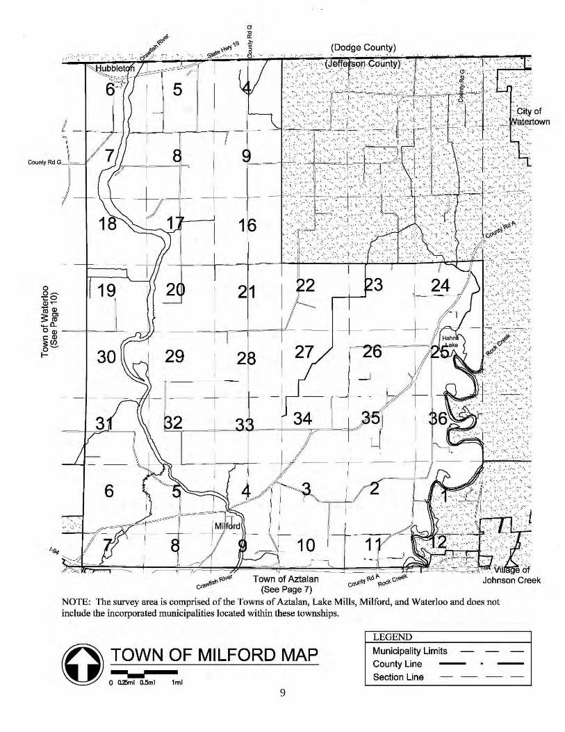
9

10

11
Survey Methodology Introduction The Architectural and Historical Intensive Survey was conducted in the Towns of Aztalan, Lake Mills, Milford, and Waterloo, comprising the northwest quadrant of Jefferson County, Wisconsin, over a period of several months, beginning in March of 2012 and concluding in July of 2012. The architectural firm of Legacy Architecture, Inc. of Sheboygan, Wisconsin, executed the survey. The principal investigators, Jennifer L. Lehrke and Robert Short, conducted the reconnaissance survey fieldwork and performed historical research. Jennifer L. Lehrke edited the majority of the intensive survey report and generally oversaw the survey. Robert Short authored the report, Thomas Barg prepared the survey maps, and JoAnn Veldman provided clerical support. The Northwest Quadrant of Jefferson County Architectural and Historical Survey consisted of four major work tasks: (1) reconnaissance survey, (2) architectural and historical research, (3) evaluation of significant resources for inclusion in the intensive survey report, and (4) preparation and presentation of the intensive survey report. Reconnaissance Survey In March 2012, a windshield survey of the Towns of Aztalan, Lake Mills, Milford, and Waterloo was conducted that resulted in the identification of approximately 173 resources of architectural and historical interest. During this time, an entry was made for each site, including the location, name, style, and other key pieces of information in a spreadsheet, and a digital photograph was taken. The portions of the Towns of Aztalan, Lake Mills, Milford, and Waterloo within the delineated boundary area as described in Chapter 1 were surveyed street-by-street and structure-by-structure for resources of architectural and historical significance. Approximately 26 previously surveyed resources were updated. Information contained in the AHI, particularly the address, was confirmed and corrected if needed, and field observations were recorded if any alterations, additions, or demolition work had been done to the structure since last surveyed. A new digital photograph of each property was taken to be added to the AHI. There were 13 resources that were previously surveyed that now lack integrity and are no longer survey worthy, and 5 resources that are believed to have been demolished mostly along the Highway 26 corridor. Therefore, those entries were updated accordingly. As is customary; the 8 resources already listed in the National Register of Historic Places were excluded from the survey.
2

12
In addition to updating the 26 previously surveyed resources, almost 147 new resources of interest were observed and documented. Information such as address, name, and architectural style were noted, and field observations were recorded which were later entered into the AHI. A digital photograph of each property was also taken for inclusion in the AHI. In areas where a potential historic district or farmstead was identified, all buildings within the potential district or farmstead boundaries were observed and documented. In addition, all of the existing and newly surveyed properties were identified by AHI number on maps which are included in the Survey Results Chapter. Architectural and Historical Research Architectural and historical research of the Towns of Aztalan, Lake Mills, Milford, and Waterloo was conducted by the principal and assistant investigator throughout the course of the project in an effort to provide a historical context to evaluate resources. Of great importance were items located at the Area Research Center at the University of Wisconsin-Whitewater, including, but not limited to, their extensive collection of research on local history. Secondary information was also found at the Wisconsin Historical Society, the Jefferson County Courthouse, the Town of Aztalan Assessor, Town of Lake Mills Assessor, the Town of Milford Assessor, and the L. D. Fargo Public Library. Summaries of the history of the Towns of Aztalan, Lake Mills, Milford, and Waterloo are included in this report and arranged in themes according to guidelines set forth by the Historic Preservation Division of the Wisconsin Historical Society. Areas of research include historic Indians, government, settlement, agriculture, industry, transportation, architecture, education, religion, commerce, planning and landscape architecture, recreation and entertainment, and notable people. Structures deemed eligible for listing in the National Register were evaluated based on their association with these themes. Evaluation of Significant Resources After the reconnaissance survey and research were completed, the data was analyzed to determine which individual properties and districts were potentially eligible for listing in the National Register of Historic Places. The evaluation of individual historic resources, districts, and farmsteads were also reviewed with the Historic Preservation Division of the Wisconsin Historical Society prior to inclusion in this report. The evaluation was performed according to the National Register’s Criteria for Evaluation and Criteria Considerations which are used to assist local, state, and federal agencies in evaluating nominations to the National Register of Historic Places. The Criteria for Evaluation and Criteria Considerations are described in several National Register publications as follows:
The quality of significance in American history, architecture, archeology, and culture is present in districts, sites, buildings, structures, and objects that possess integrity of location, design, setting, materials, workmanship, feeling, and association, and:

13
A. that are associated with events that have made a significant contribution to the broad patterns of our history; or
B. that are associated with the lives of persons significant in our past; or C. that embody the distinctive characteristics of a type, period, or method of construction, or that
represent the work of a master, or that possess high artistic values, or that represent a significant and distinguishable entity whose components may lack individual distinction; or
D. that have yielded, or may be likely to yield, information important in prehistory or history. Ordinarily, cemeteries, birthplaces, or graves of historical figures, properties owned by religious institutions, or used for religious purposes, properties primarily commemorative in nature, and properties that have achieved significance within the past 50 years shall not be considered eligible for the National Register. However, such properties will qualify if they are integral parts of districts that do meet the criteria or if they fall within the following categories: A. a religious property deriving primary significance from architectural or artistic distinction or
historical importance; or B. a building or structure removed from its original location, but which is significant primarily
for architectural value, or which is the surviving structure most importantly associated with a historic period or event; or
C. a birthplace or grave of a historical figure of outstanding importance if there is no other appropriate site or building directly associated with his or her productive life; or
D. a cemetery which derives its primary significance from graves of persons of transcendent importance, from age, from distinctive design features, or from association with historic events; or
E. a reconstructed building when accurately executed in a suitable environment and presented in a dignified manner as part of a restoration master plan, and when no other building or structure with the same association has survived; or
F. a property primarily commemorative in intent if design, age, tradition, or symbolic value has invested it with its own historical significance; or
G. a property achieving significant within the past 50 years is it is of exceptional importance. As noted above, a historic district is placed in the National Register of Historic Places in a manner similar to individual propertied; using essentially the same criteria. A historic district is comprised of resource; that is, building, structures, sites, or objects located in a geographically definable area. The historic district is united by historical factors and a sense of cohesive architectural integrity. District resources are individually classified as contributing or non-contributing. A. A contributing building, site, structure, or object adds to the historic architectural qualities,
historic associations, or archeological values for which a property is significant because (a.) it was presented during the period of significance and possesses historic integrity reflecting its character at that time or is capable of yielding important information about the period, or (b.) it independently or individually meet the National Register criteria.
B. A non-contributing building, site, structure, or object does not add to the historic architectural qualities, historic associations, or archeological values for which a property or district is significant because (a.) it was not present during the period of significance [less than 50 years old or moved to the site], (b.) due to alterations, disturbances, addition, or other changes, it no longer possesses historic integrity reflecting its character at that time or is incapable of yielding important information about the period, or (c.) it does not independently meet the National Register criteria.
Preparation and Presentation of the Intensive Survey Report This survey report describes the project and survey methodology, gives an overview of the history of Towns of Aztalan, Lake Mills, Milford, and Waterloo that comprise the northwest

14
quadrant of Jefferson County, Wisconsin, summarizes the thematic research and survey results, and gives recommendations for the Jefferson County Historic Sites Preservation Commission. This report does not include a definitive history of the Towns of Aztalan, Lake Mills, Milford, and Waterloo. Rather, it provides a broad historical overview of many themes in one publication. It is intended to be a work in progress which can lead to future research and can be updated over time as new information is collected. Copies of the final survey report were issued to the Historic Preservation Division of the Wisconsin Historical Society and the Jefferson County Historic Sites Preservation Commission. Legacy Architecture, the Jefferson County Historic Sites Preservation Commission, and the Historic Preservation Division of the Wisconsin Historical Society conducted two public information meetings regarding the survey. The first meeting was held on March 22, 2012, to introduce the survey team and the project process to the community. A second meeting, held on July 26, 2012, presented the results of the project including the survey report, potential farmsteads and districts, and information on the National Register to Jefferson County and to the Historic Sites Preservation Commission.

15
Historical Overview Jefferson County The rural northwest quadrant of Jefferson County, consisting of the Towns of Aztalan, Lake Mills, Milford, and Waterloo, has historically been similar, and at times unique, to the rest of the county. The area is largely rural but is dotted with several small cities and unincorporated communities, including the City of Lake Mills, City of Waterloo, Village of Johnson Creek, and the unincorporated communities of Aztalan, Hubbleton, Kroghville, London, and Milford. The proximity of the nearest larger city to the area, the City of Watertown to the northeast, and the crossing of Interstate Highway 94 between Milwaukee and Madison have had a lesser effect on the area’s strong rural, agricultural history that has continued through the nineteenth and twentieth centuries to present day. Typical to Jefferson County’s 576 square miles of land, the Towns of Aztalan, Lake Mills, Milford, and Waterloo generally feature flat land and gently rolling hills. Rock Lake at the southern end of the survey area and the Crawfish and Rock Rivers, running north-south and largely parallel to one another through the Towns of Aztalan and Milford, dominate the landscape. Low points in the land tend to be near these bodies of water, while high points surrounded by marshland in the Town of Waterloo were historically referred to as the “Islands.” This landscape was formed by glacial activity during the Ice Age. Its plains, forests, moraines, and marshes were viewed as ideal for development by the earliest white settlers and were soon drained and tilled for agriculture.1 Prior to permanent white settlement, the northwest quadrant of Jefferson County was the domain of the Potawatomi with the occasional temporary habitation of French fur traders. Jefferson County was included in territory ceded to the United States by the Potawatomi under the Treaty of 1833. By the end of that year, most of the land in southeastern Wisconsin was surveyed by the federal government. A land office was established in Green Bay in 1835 from which to sell the land, and private land claims began to be made. The first settlers of Jefferson County were attracted to waterfalls and possible transportation routes along the Rock River.2 Many of the earliest land claims in Jefferson County were made by Yankee settlers. Jefferson County was set off from Milwaukee County in 1835. The county’s population doubled from just under 500 to 914 between 1838 and 1840.3 The earliest settlers of Jefferson County cleared the land to establish subsistence agriculture. By 1845, many saw mills across the county were converted to handle grain. Until that time, farmers had to transport their grain the considerable distance to Beloit for grinding.4 Most of the county’s earliest settlers were Yankees looking for lucrative opportunities in the new territory.
3
16
They primarily established community-building businesses such as saw mills, grist mills, hotels, and general stores to form settlements; many were simply land speculators, purchasing land to sell to other settlers. In rural areas, many established wheat farms, the cash crop of the day. By the mid-nineteenth century, Wisconsin became a leading wheat-producing state. The wheat craze eventually faded, and was supplanted by a brief period of the successful cultivation of hops, and ultimately dairy farming.5 Across Jefferson County, many small settlements were established during the late 1830s and 1840s. Several of these experienced sustained growth, incorporated, and grew to become small and medium-sized municipalities; these include the City of Watertown, the largest in the county, as well as the Cities of Fort Atkinson, Lake Mils, and Jefferson and the Villages of Johnson Creek, Palmyra, and Sullivan. Many settlements founded during that same time period failed to grow and remain unincorporated communities that dot the rural landscape. In the survey area, these include Aztalan in the Town of Aztalan, Hubbleton and Milford in the Town of Milford, and Kroghville and London in the Town of Lake Mills.6 The population of Jefferson County grew rapidly between 1840 and 1850, increasing from less than 1,000 residents to over 15,000. The vast majority of residents lived in family groups on farms at this time. By 1860, the county’s population doubled to over 30,000 residents. The 1870 Census found a small decrease in the county’s population, followed by thirty years of a stabilized population starting in 1880. By this time, the county’s farmland was largely developed and its larger communities slowed in their industrial growth.7 Each federal census since the early twentieth century has shown a slight increase in the county’s population. During the mid-twentieth century, the school districts within each of Jefferson County’s towns were consolidated and eventually absorbed by those of their surrounding incorporated municipalities.8 Today, almost all educational, religious, commercial, and healthcare services are only available within the County’s incorporated municipalities. As of 2010, Jefferson County has a population of 83,693.9 Town of Aztalan The area comprising the present-day Town of Aztalan was first closely inspected by white visitors during a federal survey in late 1835. At this time, ruins of a culturally advanced Indian settlement were discovered on the west bank of the Crawfish River. The ruins, including wooden stockades and mounded earth structures, was named Aztalan by Nathaniel F. Hyer after a report by Baron Alexander von Humboldt, a well-known early-nineteenth century German anthropologist who studied American Indian antiquities, which told of the Aztec people coming to Mexico from a land by flowing waters far to the north, called Aztalan. The name became used for the white settlement that would begin near the ruins the following year.10 In October of 1836, an expedition set out from Milwaukee with the purpose of establishing a settlement at Aztalan. Two members of the party, Timothy Johnson and Thomas Brayton, went ahead of the rest of the group and reached the settlement site. Johnson and Brayton returned to Milwaukee when the rest of the party did not arrive within a few days. The two men returned to

17
the site soon after to establish the settlement of Aztalan, accompanied by Thomas Brayton’s brother, William Brayton; Stephen Fletcher; Rev. Jared F. Ostrander; and several others. Brayton’s brothers, Jeremiah and Alfred A., soon arrived as well. Thomas Brayton constructed a non-extant, 16- by 20-foot log house that was used publicly to accommodate passing travelers and land seekers. His family joined him at the settlement of Aztalan the following summer, the third family to settle in Jefferson County. Soon, more families followed. The first post office in Jefferson County was established in Aztalan in 1837. Territorial roads from Milwaukee to Mineral Point and from Janesville to Fond du Lac intersected at the settlement.11 The Town of Aztalan was formed at the second session of the first Legislature of the Wisconsin Territory at Burlington, Iowa (then part of the Wisconsin Territory), at which a representative of the residents of Jefferson County petitioned for a large portion of the county to be organized into a township with the name Aztalan. The Town of Aztalan was organized in February of 1839, and originally included all of the present-day Towns of Aztalan, Lake Mills, and Waterloo and the portions of present-day Town of Milford west of the Crawfish River.12 At the Territorial Legislative session in Belmont, Wisconsin in 1839, Madison was selected over the settlement of Aztalan by a single vote for the location of the capital.13 The settlement grew quickly. A hotel was opened in 1840, and a general store the following year. Aztalan was the leading commercial and industrial center in Jefferson County by 1842. That same year, the settlement of Aztalan was platted by Thomas Brayton, Edward Abbe, and Rev. Jared F. Ostrander from a 30-acre survey prepared by John Darrow Waterbury and incorporated as the Village of Aztalan. The Village of Aztalan was the first incorporated municipality in Jefferson County.14 By 1853, the Town of Aztalan had a population of 250; and the settlement of Aztalan’s commercial and industrial facilities included three general stores, two hotels, a steam sawmill, wagon works, fanning mill shop, sodium bicarbonate factory, shoemaking shop, tree nursery, brickyard, and a stone quarry. However, with the 1859 construction of the railroad 5 miles away from Aztalan and decreasing traffic on the territorial roads, the settlement’s growth and prominence in the county fell behind other communities.15 In 1881, another railroad was constructed through the Town of Aztalan, again bypassing the Village of Aztalan by two miles. The following year, a third railroad bypassed the Village once again. Without direct access to the railroad, businesses closed; and the Village of Aztalan became a northing more than a rural crossroads by the turn of the twentieth century. The Aztalan post office was closed in 1904.16 As the Village of Aztalan was fading, the Village of Johnson Creek was incorporated on the east border of the Town of Aztalan in 1903.17 Services at the Aztalan Baptist Church were eventually discontinued, with the exception of a brief revival during the early twentieth century. By 1912, the only businesses remaining in the former Village were a creamery and general store.18 The creamery closed in 1926; and the store was destroyed by fire three years later.19

18
In 1942, the newly formed Lake Mills-Aztalan Historical Society breathed life into the former Village of Aztalan by restoring the Baptist Church and opening a local history museum within it. Since that time, several other historic buildings have been reconstructed on or relocated to the museum grounds, which became a Registered Wisconsin Landmark in 1969.20 The Town of Aztalan had a population of 861 in 1950, 562 of which resided on farms.21 Since that time, growth has been slow, yet steady, and has largely continued the rural style of development characteristic of the township. Some suburban development has occurred, but is limited to the portions of the township outside of the City of Lake Mills and Village of Johnson Creek. The former Village of Aztalan remains a small cluster of buildings, almost exclusively used as residences, and matches the rural and suburban residential character of the rest of the township. As of 2010, the Town of Aztalan has a population of 1,456.22 Town of Lake Mills Morgan Bartlett owned the original land claims in what became the City of Lake Mills in the mid-1830s, then part of the Town of Lake Mills. He sold his land in Lake Mills to Joseph Keyes in 1836.23 The town soon began being settled, first by Royal Tyler of Northfield, Vermont, and Elihu Lester Atwood of Massachusetts. The rest of the Atwood family arrived at Lake Mills in 1837.24 In 1837, Captain Joseph Keyes was the first settler in what became the City of Lake Mills. Two years later, he constructed the first sawmill in the western portion of the county. In 1842, he opened the first grist mill in the county; no longer requiring settlers to travel to Milwaukee to purchase flour. That same year, a 25-acre area was platted as the village of Lake Mills. A post office was established at the settlement of Lake Mills in 1844. During the 1840s, several businesses began operating in the settlement, including several stores, liveries, and inns.25 In February of 1845, the area around Lake Mills successfully petitioned the Wisconsin Territorial Legislature for the founding of the present-day Town of Lake Mills, separating it from the Town of Aztalan. The Village of Lake Mills was incorporated from the Town of Lake Mills in 1856. 26 A dam on the Koshkonong Creek and sawmill were constructed near the Jefferson-Dane County line in 1845; they were purchased by Casper Krogh in 1848. The settlement of Kroghville soon grew around the mill. By 1850, a general store had opened at the settlement. In 1852, Krogh platted the village of Kroghville from a survey by John Darrow Waterbury. However, the village was never incorporated. He constructed a grist mill there in 1853 and founded a brickyard in 1858; however, it was only in operation for a single year. A post office was established at the settlement of Kroghville in 1862. A woolen mill was established at Kroghville by Casper Krogh in 1868. By the late 1870s, Krogh established a factory at the settlement of Kroghville to manufacture a cultivator that he had patented. One of Krogh’s sons also established a factory there for the production of artificial limbs. A cheese factory was also located at the settlement.27 By the 1880s, Rock Lake and the Town of Lake Mills became a popular summer resort destination.28

19
In 1881, the Northwestern Railroad constructed its new line through the Town of Lake Mills providing a boom to City of Lake Mill’s businesses and industries with the connections east and west to Milwaukee and Madison.29 However, after the railroad bypassed the settlement of Kroghville, most of the residents of Kroghville relocated nearby to where a stop on the railroad had been located, establishing the settlement of London. Many of the buildings were also moved from Kroghville to London at this time. With little left of the former settlement, the Kroghville post office was closed in 1887.30 As the settlement of Kroghville decline, the settlement of London prospered. A post office was opened in 1882; and a Moravian Church was established there in 1894. The settlement of London soon became an important center for tobacco packing and shipping. During the 1890s, London became a popular area for summer vacations seeking leisurely country living and fun at a race track located at the settlement. However, London was never incorporated and began to decline in importance after the turn of the twentieth century.31 The Village of Lake Mills incorporated as a city in 1905.32 The Town of Lake Mills had a population of 1,161 in 1950, 763 of which resided on farms.33 During the mid-twentieth century, growth predominately occurred nearest the City of Lake Mills. In line with this trend, the railroad discontinued stops at the London train depot, and the post office there closed as well in 1960. Population growth and suburban development has occurred on a larger scale in the Town of Lake Mills than the other townships in the northwest quadrant of Jefferson County, but is largely limited to the portions of the township around Rock Land and the City of Lake Mills. As of 2010, the town had a population of 2,072, the largest township in the survey area.34 Town of Milford The land west of the Crawfish River currently within the Town of Waterloo was a part of the original Town of Aztalan and the remainder of the town was part of the original Town of Watertown, both formed in 1839.35 However, even after the area began being settled by whites, local Indians remained against the agreements made in the Treaty of 1833. The present-day Town of Milford was a favored spot for hunting game, harvesting wild rice, and catching fish and clams in the Crawfish and Rock Rivers; at that time, the Crawfish River was known as the “West Branch of the Rock River.” An Indian burial ground was also maintained into this time near the Crawfish River in the northern portion of the township.36 Soon after, a settlement by the name of Milford began where County Highway A crosses the Crawfish River. The first white settlers in the Town of Milford were Benjamin Nute and William Lamphear, who together bought land along the Crawfish River from Nelson Hawkes and Byron Kilbourne. There, in 1840, they built a non-extant dam north of the river’s rapids and a non-extant sawmill on the river’s south side. The settlement’s location was chosen as it was at a shallow, fordable spot along the river. This may be an explanation for the town’s name, meaning “mill ford.” A grist mill was opened at the settlement of Milford by Norman Pratt in 1845. During the 1840s, the settlement of Milford grew on both sides of the Crawfish River

20
around the grist mill. Benjamin Nute constructed a small hotel during the mid-1840s. A bridge crossing the river at the settlement was constructed in 1846.37 A small group of French immigrants settled in the eastern portion of the Town of Milton during the early-to-mid-nineteenth century. They established a settlement known as Grelton on the west shore of Hahn’s Lake at what is now the intersection of County Highways A and N. The spot was chosen for its extensive maple tree stand, and the production of maple syrup soon became the settlement’s principal industry. Soon, a halfway house was established at Grelton. However after a few years, many of Grelton’s residents moved to new settlements along Lake Winnebago.38 The area had been known by the name Milford for some time before 1848, when the Town of Milford was set off from the Towns of Aztalan and Watertown and established. The town recorded a population of 728 two years later.39 The first store was opened at the settlement of Milford by Robert Howell in 1848. A post office was established there in 1849. Several other stores and businesses, including a blacksmith, shoemaker, and lawyer, were established during the 1850s. School districts began being established in the Town of Milford during the mid-nineteenth century. The first schoolhouse at the settlement of Milford had constructed by the 1850s. Sometime during the mid- to late-nineteenth century, a cheese factory was founded. Congregational, Lutheran, and Methodist congregations were formed in Milford by 1860. The settlement of Milford, along both sides of the river, was platted as a village by Nathaniel S. Greene in 1854. This plat was not recorded until 1865, when Greene platted an additional five blocks along both sides of the river. However, the village was never incorporated.40 A third settlement in the present-day Town of Milford was also settled prior to 1840. Named Hubbleton after nearby land-owner Levi Hubbell, it was also known as Hubbleville in its earliest days. The settlement of Hubbleton was surveyed by K. P. Clark of Watertown in 1852 with its main street along the plank road connecting Watertown with the settlement of Portland in the Town of Waterloo. During the mid-nineteenth century, a steam sawmill was constructed at the settlement. A post office operated at the settlement of Hubbleton for a short period of time in the early 1850s, and was reestablished in 1854.41 When the railroad was constructed through the north portions of the Towns of Milford and Waterloo in 1859, a station was constructed at Hubbleton. During the decades that followed, small steamboats were utilized to ship flour and grain between the mill at the settlement of Milford and the Hubbleton train station. Passengers were also carried by boat between the two communities.42 A lime kiln was founded at the settlement of Milford in 1870; and the cheese factory was reestablished in 1871. In 1873, Francis Allen platted an addition to the unincorporated village consisting of two blocks, containing 12 lots, along the north side of County Highway A on the east bank of the river. A saloon was founded in 1875. By the end of the 1870s, the settlement had a population of 138 and a second general store had opened along with a harness maker, wagon works, farm implement dealer, barber shop, and doctor’s office. Later, butter tub and broom factories were established. The family of Nathaniel S. Greene eventually opened a private bank.43
21
The late 1870s and early 1880s saw major setbacks to the growth and development of the settlement of Milford. A proposed railroad between the Cities of Watertown and Lake Mills failed to materialize in 1879. After ongoing litigation against Nathaniel S. Greene over the effects of his grist mill’s dam, Greene abandoned the milling business after the mill was destroyed by fire in 1883. The dam was removed soon after, removing with it the opportunity for a new mill. Without this major industry and a railroad connection, the community ceased to grow further. Without a large employment base or strong factors for growth, several shop keepers, businessmen, and residents relocated to the nearby City of Lake Mills. However, a second cheese factory was founded at the settlement by 1885; and a third in 1888. However, few businesses remained at the settlement of Milford. The Milford post office closed in 1904, and the three churches dissolved or relocated by the mid-twentieth century.44 The Town of Milford had a population of 999 in 1950, 676 of which resided on farms.45 Since that time, population growth has been minimal compared to the other townships in the northwest quadrant of Jefferson County. As of 2010, the town has a population of 1,101.46 Town of Waterloo The land that currently makes up the Town of Waterloo was a part of the original Town of Aztalan formed in 1839. In February of 1845, it was set off as part of the Town of Lake Mills. In May 1847, the present-day Town of Waterloo was established.47 The first white settler in the township was Joseph Edwards, arriving in 1838 to the area then known as “Maunesha,” the Indian name for Waterloo Creek. In 1842, Bradford Hills settled at what became the settlement of Waterloo along the creek in the northwest corner of the township. Business and industry soon developed, beginning with Hill’s establishment of a public house in 1843. Also that year, a blacksmith shop was established; and brothers Abraham and Ira Brooks constructed a dam on the creek and built a sawmill. A general store was in operation soon thereafter. By 1844, the settlement also was home to a carpenter and mason, surveyor, two physicians, and a lawyer. A post office was established at the settlement of Waterloo in 1847. A flour mill was also constructed that year at the upper mill pond; a second at the lower pond began five years later. However, the settlement and town grew slowly. By 1848, the Town of Waterloo only had a population of 40.48 During the late 1840s and early 1850s, concentrated immigration of Germans and Bohemians occurred in the eastern portion of the Township known as the “Islands,” for their multiple highlands surrounded by marsh. During the mid-nineteenth century, a community hall, general store, and cheese factory were all operating in the Islands area of the Township. However, as road access improved to the settlement of Waterloo, community and business activities began to slowly fade from the “Islands.” Even the Town’s St. Wenceslaus Catholic Church dissolved in 1891, less than thirty years after its organization in 1863.49 Nearby the settlement of Waterloo was located another settlement along the Waterloo Creek on the Jefferson-Dodge County line by the name of Portland. During the 1850s, the Milwaukee-Watertown Plank Road was constructed through Portland, and it was fast becoming the business

22
center of the Town of Waterloo. However, in 1859, the first railroad was constructed through Jefferson County and a route was chosen through the settlement of Waterloo. As a result, one-square mile of the Town of Waterloo containing the settlement was incorporated as the Village of Waterloo in 1859. In 1861, this charter was adjusted to enlarge the village to encompass the northwestern-most four square miles of the township, including the portion of the former settlement of Portland within Jefferson County, and has expanded into Dodge County as well.50 Despite its small size, the Village of Waterloo became a leading grain market in the area by the late 1870s.51 The forerunner to the largest nursery in the State of Wisconsin, McKay Nursery Company, began in the Town of Waterloo in 1912. Eventually the company would cultivate over one section of land in the township.52 The Town of Waterloo had a population of 710 in 1950, 654 of which resided on farms, the highest percentage of farm population of the townships in the northwest quadrant of Jefferson County.53 In 1963, the Village of Waterloo incorporated as a city.54 Since that time, growth has been minimal; and what little development has occurred has predominately continued the rural style of development characteristic of the township. As of 2010, the town had a population of 908, the smallest township in the survey area.55

23
Historic Indians Paleo-Indian and Archaic Cultures There is archeological evidence of settlement in Jefferson County by several Native American groups. The earliest known group, Paleo-Indians and those of the Archaic cultures are known to be hunters and gatherers who made stone tools prior to 1000 B.C. A group of five ceremonial sites known as the Bean Lake Islands Archaeological District, located in the Town of Lake Mills, are listed in the National Register of Historic Places for the sites’ potential to provide further information about Indian culture from the periods between the years 1749 and 1000 B.C. Woodland Cultures The Early, Middle, and Late Woodland cultures were mound builders and left distinctive landscape features across the State of Wisconsin, including Jefferson County. Members of the Early Woodland culture constructed conical burial mounds between the years of 1000 and 1 B.C. Mounds constructed during the Middle Woodland period, from approximately 1 to 500 A.D., were situated in large groupings. From approximately 500 to 1000 A.D., members of the Late Woodland culture constructed effigy mounds in shapes of stylized animal, symbol, religious, or human figures.56 A ceremonial burial ground known as the Tilfer Site, located in the Town of Milford, is listed in the National Register of Historic Places for the site’s potential to provide further information about Indian culture from the period between the years 120 and 650 A.D. Mississippian Cultures Members of the Mississippian Culture, from approximately 1000 to 1500 A.D., constructed a large platform mound at a settlement along the west bank of the Crawfish River.57 When the site was discovered by white explorers in the 1830s, it was named Aztalan after a report by Baron Alexander von Humboldt, a well-known early-nineteenth century German anthropologist who studied American Indian antiquities, which told of the Aztec people coming to Mexico from a land by flowing waters far to the north by that name.58 The Aztalan Village Site, located at N6200 County Highway Q, was listed in the National Register of Historic Places in 1975. The site’s nomination contains extensive history on the mound, its site, and other remaining artifacts and is an invaluable resource in describing the site’s history. Consequently, no attempt will be made in this chapter to cover ground that has been so expertly covered by others.
4

24
Potawatomi While Wisconsin was inhabited by several groups of Native Americans during the past several hundred years, including the Dakota (Sioux), Ho-Chunk (Winnebago), Menominee, and Ojibwa (Chippewa); the Potawatomi were one of the more significant in Jefferson County prior to white settlement. The Potawatomi first came to Wisconsin to escape the Iroquois Wars fought to control the fur trade in the eastern United States during the mid-seventeenth century. After initially settling in the Green Bay and Door County areas, they soon began working with French traders and overcame smaller tribes, becoming a powerful force in the fur trade in southeastern Wisconsin, southern Michigan, and northern Illinois. It is estimated that there were around 100 Potawatomi villages in the region with populations of 10,000 residents by 1820. However, pressures from whites to settle rose at that time. Treaties with the federal government in 1829 and 1833 ceded Potawatomi lands. Many sought refuge in central and northern Wisconsin to resist removal.59 No historic resources were found to be associated with the Potawatomi. Winnebago The Ho-Chunk (Winnebago) was another significant tribe in Jefferson County prior to white settlement. Treaties with the federal government in 1829 and 1833 ceded Winnebago lands. However, the Town of Milford was a favorite spot of local Indians for hunting game, harvesting wild rice, and catching fish and clams prior to the white settlement of Jefferson County. Land near the Crawfish River continued to be a seasonal campsite well into the years of white settlement. The Indians constructed a non-extant, V-shaped fish trap dam of rock on the Crawfish River approximately a half mile north of the settlement of Milford.60 Some Winnebago remained in Jefferson County until as late as 1850, not wanting to leave the land of their fathers. Several attempts were made by the federal government to remove the Winnebago from the area; however, these attempts were unsuccessful. Plans were eventually made to provide the tribe with a reservation near Blue Earth, Minnesota.61 No historic resources were found to be associated with the Winnebago. List of Surveyed Historic Resources Mentioned in the Text Town Address Historic Name Date Class Aztalan N6200 County Highway Q Aztalan Village Site Listed Lake Mills Bean Lake Islands Archaeological District Listed Milford Tilfer Site Listed

25
Government Introduction Throughout its early history, the area that is now the State of Wisconsin was under the jurisdiction of the Northwest Territory from 1788 to 1800, the Indiana Territory from 1800 to 1809, the Illinois Territory from 1809 to 1818, and the Michigan Territory from 1818 to 1836. During that time, the area was ceded to the United States by a treaty in 1833 from the Potawatomi and other local American Indian tribes. The survey area was set off from the territory’s original Brown County as part of the newly formed Milwaukee County in 1834. The Wisconsin Territory was organized and opened for settlement in 1836. Jefferson County was set off from Milwaukee County in 1836, with a county government finally established three years later. Provisions were made at that time for the establishment of three towns. The Town of Aztalan was officially established in 1842. In 1845, the Town of Lake Mills was formed out of portions of the Town of Aztalan. The Towns of Milford and Waterloo were separated from the earlier townships and established in 1848.62 Federal Government United States Postal Service The first post office established in Jefferson County was at the settlement of Aztalan in the Town of Aztalan in April of 1837. Nathaniel F. Hyer served as its first postmaster. Originally known as Jefferson, its name was changed to Aztalan during the summer of 1839. After other post offices were established, the Aztalan office served as a distribution point for the rest of the county. It continued in operation until the establishment of free rural delivery in 1904.63 The Lake Mills post office was established in 1844 with Joseph Keyes as post master receiving mail from the Aztalan office.64 The Waterloo post office was established in 1847. Charles D. Topping served as its first postmaster. Mail was received weekly from the office at Aztalan.65 A post office was established at the settlement of Milford in the Town of Milford in 1849. Nathaniel S. Green served as postmaster out of a non-extant building on the north side of County Highway A near the river’s west bank. The Milford post office closed upon the establishment of free rural delivery in 1904.66
5

26
A post office was established at the settlement of Hubbleton in 1850 with Lemuel P. Griggs as its first postmaster. The office was discontinued in 1852, but was reestablished two years later with J. R. Crowley as postmaster. The Hubbleton post office continued operation until 1955.67 In 1862, a post office was established at the settlement of Kroghville in the Town of Lake Mills. Alexander McCracken served as the first postmaster from his general store. With the abandonment of the settlement of Kroghville for the settlement of London and its new railroad stop, the Kroghville post office was closed in 1887.68 In 1877, a post office was established in the southwest corner of the Town of Aztalan. Known as the Harvey Post Office, it was initially operated out of the house of Josiah Smith. Harvey B. Smith, son of Josiah, served as the first post master until 1898.69 Little else is known about it at this time. By 1879, a post office was also located in the area known as Tousley in the Town of Lake Mills Section 8.70 A post office was established at the settlement of London in 1882.71 A post office was established in the area of the Town of Milton known as Navan in 1887. It was operated by postmaster Andrew Hughes from his home. John Hughes succeeded his father as postmaster and maintained the office until it closed in 1904.72 Little is known about these post offices at this time, and no historic resources were found to be associated with them. State Government At the Territorial Legislative session in Belmont, Wisconsin in 1839, a location for the state capital was selected; Madison was chosen over the settlement of Aztalan in the Town of Aztalan by a single vote.73 Wisconsin State Legislature Mark R. Clapp, from Boston, settled in the Town of Milford in 1840. He served in the in the Wisconsin Territorial Legislature in 1845 and 1846.74 Sometime during the mid-nineteenth century, he constructed a house in the Town of Milford.75 The Mark R. Clapp House, located at N6810 County Highway Q, was included in the survey but is not individually eligible for listing in the National Register of Historic Places. Elihu Lester Atwood was an early settler in the original Town of Aztalan, staking a claim near what later became known as Hooper’s Mill by 1837.76 He operated an ashery and sodium bicarbonate (baking soda) factory located on west bank the Crawfish River just south of County Highway B in the Town of Aztalan during the mid-nineteenth century. Elihu Lester Atwood served as a delegate to the first Constitutional Congress in Madison, preparing for Wisconsin’s

27
statehood, from August through December of 1846 and the second Constitutional Congress in Madison, for the same purpose, from December 1847 to February of 1848.77 No historic resources were found to be associated with Elihu Lester Atwood. Benjamin Nute, from Strafford County, New Hampshire, settled in the Town of Milford in 1837 and, along with William Lamphear, became the first white settlers in the Town of Milford. The two men partnered to construct a non-extant dam and sawmill on the Crawfish River at the settlement of Milford in the Town of Milford in 1840. Their partnership continued through the 1840s. Nute also constructed a non-extant hotel on the southwest corner at the settlement of Milford during the 1840s which he operated until 1858. Benjamin Nute represented Jefferson County in the Wisconsin Territorial Legislature, before being elected to the State legislature in 1848 representing the Towns of Watertown, Milford, Aztalan, and Waterloo.78 No historic resources were found to be associated with Benjamin Nute. Nathaniel S. Greene, an early settler of the Town of Milford, purchased a non-extant grist mill from Norman Pratt at the settlement of Milford in 1846. Greene made great improvements to the mill and its dam. Greene also served as the first postmaster of the post office at the settlement of Milford starting in 1849. He platted the settlement of Milford, along both sides of the Crawford River at the intersection of County Highways A and Q in 1854. This plat was not recorded until 1865, when Greene platted an addition of five blocks along both sides of the river. However, the village was never incorporated. Nathaniel S. Greene was elected to the Wisconsin State Legislature in 1864. Later in 1883, Greene’s mill was destroyed by fire, and he resettled in the City of Fort Atkinson.79 No historic resources were found to be associated with Nathaniel S. Greene. Walter Greene, son of Nathaniel S. Greene, served in the in the Wisconsin State Legislature in 1862 and 1863. He later served in the Wisconsin State Senate in 1873 and 1874.80 No historic resources were found to be associated with Walter Greene. Gardner Spoor, of Monroe County, New York, moved to Wisconsin in 1846. First settling in Dane County, he soon relocated to the Town of Aztalan. He served as the Town of Aztalan Treasurer in 1853, and later Town Supervisor. He married Emily Hyer, of St. Lawrence County, New York, in 1862. Gardner Spoor was elected to the Wisconsin State Legislature in 1864. After serving in the legislature, he continued in his office as Town Supervisor, serving as Chairman of Supervisors in 1876. He also served as a Justice of the Peace for several years.81 No historic resources were found to be associated with Gardner Spoor. Charles Frederick Greenwood was born in the Town of Aztalan in 1852. He was raised and worked on his family’s farm in Aztalan. He later attended the Liberal Institute in Jefferson. Upon graduation, he established a general store in Johnson Creek. After five years in the mercantile trade, he assisted his parents with the operation of their farm in the Town of Aztalan. In 1873, he married Ida M. Reynolds of the Town of Aztalan.82 A home was constructed for the couple in 1874.83 The Charles F. and Ida M. Greenwood House, located at W6076 County Highway B in the Town of Aztalan, was included in the survey but is not eligible for listing in the National Register of Historic Places. From 1875 to 1880, Charles Frederick Greenwood served as Clerk for the Town of Aztalan. He served as Chairman of the Town Board in 1881.84

28
Greenwood and his younger brother, Arthur W. Greenwood, established the Greenwood Brothers Bank in the Village of Lake Mills in 1883, which incorporated as the Greenwood State Bank ten years later.85 Greenwood served as the Chairman of the Town of Lake Mills from 1884 to 1886. From 1887 to 1889, he served as the Chairman of the Jefferson County Board of Supervisors. In 1904, Charles Frederick Greenwood was elected to the Wisconsin State Legislature. He served in this role for two years.86 Charles Phillips was born in Westmoreland, New York, in 1824. He migrated to Jefferson County with his family during the mid-nineteenth century, purchasing and settling on the farm of Joseph Keyes in the Town of Lake Mills. During the late 1860s, Charles and his brother, William Phillips, imported several cows from the Isle of Jersey in Scotland and by 1871 constructed a creamery producing 76 pounds of butter per day. In 1875, Charles married Mary E. Butterfield in New York; however, the couple returned to live on the family farm in the Town of Lake Mills which they continued to operate with William. Charles went on to serve as a member of the Jefferson County board of supervisors for several years, the school board for twelve, and mayor of the City of Lake Mills for one term. Charles Phillips was later elected to the Wisconsin State Legislature and, after serving on that body for two years, was elected to the State Senate. However, he died in office shortly thereafter in 1879.87 No historic resources were found to be associated with the Charles Phillips. County Government Civil Court Thomas Brayton, from New York, was heavily involved with the establishment of the settlement of Aztalan in 1836. There, he constructed a non-extant, 16- by 20-foot log house that was used publicly to accommodate passing travelers and land seekers. His wife and children joined him at the settlement of Aztalan the following summer, making his the third family to settle in Jefferson County. In 1842, Brayton, with Edward Abbe and Rev. Jared F. Ostrander, platted the Village of Aztalan, which soon thereafter became the first incorporated municipality in Jefferson County. Thomas Brayton served as the first judge over the Jefferson County Civil Court, from 1843 to 1846, in the Village of Aztalan. He died in 1853.88 No historic resources were found to be associated with Thomas Brayton. Local Government Town of Aztalan The Town of Aztalan, one of the three original townships in Jefferson County, was officially established in 1842.89 A stone town hall and garage was constructed around 1937 for the Town of Aztalan on County
Aztalan Town Hall & Highway Shop, c. 1938 W6260 County Highway B, Town of Aztalan

29
Highway B, just west of the former village of Aztalan. The Aztalan Town Hall & Highway Shop, located at W6260 County Highway B, was included in the survey and is individually eligible for listing in the National Register of Historic Places. Town of Lake Mills In February of 1845, the area around Lake Mills successfully petitioned the Wisconsin Territorial Legislature for the founding of the present-day Town of Lake Mills, separating it from the Town of Aztalan. The first town officials were elected that spring, including Joseph Keyes, Miles Millard, and John Twining as town supervisors, Walter Sloan as town clerk, and Edward Abby as treasurer. The present-day Town of Waterloo separated from the Town of Lake Mills in 1847.90 The Lake Mills Town Hall is located at 1111 South Main Street, in the City of Lake Mills, outside of the boundaries of the survey area. Town of Milford The land west of the Crawfish River currently within the Town of Waterloo was a part of the original Town of Aztalan and the remainder of the town was part of the original Town of Watertown, both formed in 1839.91 A saloon building owned by Carl Gritzner on the east bank of the Crawfish River at the settlement of Milford served as a public gathering place for town board meetings and political caucuses, among other events during the late nineteenth century.92 Little else is known about the building at this time, including its exact location and current condition. In 1968, the former Methodist church at the settlement of Milford was converted into the Milford Town Hall.93 Milford Methodist Church, located at W6335 County Highway A in the Town of Milford, was not included in the survey as its additions and alterations have diminished its original architectural integrity. For more information on the Methodist Church, refer to Chapter 12 Religion. Town of Waterloo The area around Lake Mills successfully petitioned the Wisconsin Territorial Legislature for its separation from the original Town of Aztalan and was founded as the Town of Lake Mills in 1845. From the Town of Lake Mills, the present-day Town of Waterloo separated and was established in 1847.94 In recent years, the Town of Waterloo constructed a new Town Hall on State Highway 89. The Waterloo Town Hall, located at W8193 State Highway 89 in the Town of Waterloo, was not included in the survey as it is not of age to be considered an historic resource.

30
List of Surveyed Historic Resources Mentioned in the Text Town Address Historic Name Date Class Aztalan W6260 County Highway B Aztalan Town Hall & Highway Shop c. 1937 Eligible Aztalan W6076 County Highway B Charles Frederick & Ida M. Greenwood House 1874 Eligible Milford N6810 County Highway Q Mark R. Clapp House < 1887 Surveyed

31
Settlement Central European French A small group of French immigrants settled in the eastern portion of the Town of Milton during the early-to-mid-nineteenth century. They established a settlement known as Grelton on the west shore of Hahn’s Lake at what is now the intersection of County Highways A and N. The spot was chosen for its extensive maple tree stand, and the production of maple syrup soon became the settlement’s principal industry. Being Catholic, the French settlers at Grelton were active with the St. Bernard Catholic Church in the nearby City of Watertown. However, after a few years, most of the French settlers sold their land to incoming German immigrants; many moved to new settlements along Lake Winnebago.95 No historic resources were found to be associated with French settlement at Grelton. Yankee Private land claims began being made in Jefferson County with the establishment of a federal land office in Green Bay. Most settlers arriving in the county prior to 1845 were Yankees from New England looking for lucrative opportunities in the new territory. They primarily established community-building businesses such as saw mills, grist mills, hotels, and general stores to form settlements; many were simply land speculators, purchasing land to sell to other settlers. In rural areas, many established wheat farms, the cash crop of the day, as it was easy to grow with little capital. By the mid-nineteenth century, Wisconsin became a leading wheat-producing state. However, due to pests and the depletion of soil nutrients, wheat increasingly became less profitable after the Civil War. By the 1870s, Yankee farmers began moving to new farms and virgin soils to grow wheat farther north and west in Wisconsin, Minnesota, and the Dakotas.96 German During the mid-1840s, Germans began immigrating to southeastern Wisconsin, including Jefferson County. One of the first areas of concentrated German settlement in the county was the “East Island” area of the Town of Waterloo during the late 1840s and early 1850s.97 During the mid-nineteenth century, the German language was taught at both schools of the Town of Aztalan, as there were twice as many German speakers than there were residents of other nationalities in the township.98
6

32
The 1850 census indicates that 31 percent of the county’s population was foreign-born, the majority in Germany. By 1860, 38 percent of the county’s population was foreign-born. This number may even be skewed lower by the fact that many of the earliest German immigrants who arrived in the late 1840s had American-born children by this time. By 1870, 71 percent of the entire population of Jefferson County reported one or both parents born in a foreign country, 69 percent of which were German. This statistic is verified by the predominance of German names throughout the county. In the 1880 census, the percentage of Germans among those indicating they were born in a foreign country was 80 percent and remained as high through 1910.99 Many German immigrants were artisans or farmers and brought with them the knowledge of crop rotation, diversified farming, and soil enrichment at transition period for agriculture in Wisconsin after the wheat-craze of the mid-nineteenth century. This began an era of diversified farming in the area. From 1864 to 1870, the cultivation of hops grew popular partly as it was a necessary ingredient for brewing beer, a beverage that was increasing in popularity due to the increase in Germans immigration to the United States during the mid-nineteenth century. The hops craze ended quickly as fields in Wisconsin were soon devastated by the hops louse.100 Immigrants from Germany introduced a half-timber style of construction, during their settlement in the United States. Known as “Fachwerkbau,” reminiscent of medieval building traditions practiced in their homeland, the style continued to be practiced in rural Germany well into the nineteenth century and thus was utilized by many German settlers in the central United States, including southeastern Wisconsin, when they settled here.101 An extant example of Fachwerkbau is located in the southwest corner of the Town of Waterloo. This house, located at N7477 County Highway O, was included in the survey but is not eligible for listing in the National Register of Historic Places. Eastern European Czech During the late 1840s and early 1850s, the Town of Waterloo was settled by immigrants from Bohemia, now part of the Czech Republic. These immigrants primarily came from several small, proximate villages, namely Rudelsdorf, Michelsdorf, Ratzdorf, and Knappendorf, and settled near each other on the high grounds in the Blue Joint Marsh. The Czech residents of the Town of Waterloo established St. Wenceslaus Catholic Church, named for the patron saint of Bohemia, in 1836.102 St. Wenceslaus Catholic Church, located at W7911 Blue Joint Road, is listed in the National Register of Historic Places. For more information on St. Wenceslaus Catholic Church, refer to Chapter 12 Religion. List of Surveyed Historic Resources Mentioned in the Text Town Address Historic Name Date Class Waterloo N7477 County Highway O House Surveyed

33
Agriculture Introduction Similar to the rest of Wisconsin, farming was historically the primary occupation of rural residents of Jefferson County. There have been three distinct eras in the history of agriculture in the state. First was the shift from subsistence farming to the commercial cultivation of wheat occurring during the mid-nineteenth century followed by the shift to raising livestock. Then saw the dominance and growth of dairy farming.103 By the early-twentieth century, the number of farms and farm population of Jefferson County began to decrease; however, still above the state average, Jefferson County ranked nineteenth in the state for percentage of land area in farmland in 1954. This decline has been attributed to the increase in military service during and the attraction of urban industrial employment that followed World War II as well as the mechanization of farm operations and other technological advances that result in fewer farm workers being needed. Simultaneously, the average farm size has generally increased since the turn of the twentieth century.104
Jefferson County Farms105
Year Total Farms (Number)
Total Farm Acreage (Acreage)
Average Size of Farm (Acreage)
Land Area in Farms (Percent)
1860 2,835 282,877 99.8 79.9 1870 3,272 317,249 97.0 89.6 1880 3,483 334,192 95.9 94.4 1890 3,360 328,969 97.9 92.9 1900 3,453 337,431 97.7 95.3 1910 3,356 335,156 99.9 94.7 1920 3,263 331,204 101.5 93.6 1925 3,325 325,992 98.0 92.1 1930 3,209 323,653 100.9 91.4 1935 3,170 332,575 104.9 93.9 1940 3,102 329,663 106.3 93.1 1945 3,008 332,491 110.5 93.9 1950 2,934 323,698 110.3 91.4 1954 2,782 319,062 114.7 90.1
State Rank in 1954
20 33 59 19
However, during the past several decades, the rural farmstead has changed dramatically. Most are no longer in operation as commercial farms; those that remain in operation have faced considerable loss of historic integrity due to inappropriate additions and remodeling. Many historic agricultural buildings have been replaced with modern pole buildings. Many modern
7

34
dairy facilities are not even barns, rather large open, post and roof structures with removable coverings for seasonal weather. Today, most historic farmsteads are used solely as residential properties. Some property owners use the agricultural buildings for hobby farming, raising animals for personal use, or horse barns; many are not in use at all. Many are in poor condition due to neglected maintenance. Farmhouses have similarly been subjected to additions and remodeling that have largely eliminated architectural integrity. New windows, doors, porches, siding, and additions of inappropriate scale are common, even on farmhouses that are well maintained. However, this survey has uncovered several farmsteads and farmhouses that maintain their architectural integrity. Wheat Cultivation As new settlers arrived in Jefferson County during the late 1830s, they viewed its prairies, oak savannahs, and fertile marshes as ideal farmland where one could make money growing wheat, the leading cash crop of the mid-nineteenth century as it was easy to grow with little capital. Many of Wisconsin’s early wheat farms were established by Yankee settlers. By the mid-nineteenth century, Wisconsin became a leading wheat-producing state; and in 1865, Jefferson County contained just over 28,000 acres of land engaged in wheat production. That year, Jefferson County farmers produced over 268,000 bushels of wheat valued at almost $300,000. However, due to pests and the depletion of soil nutrients, wheat increasingly became less profitable after the Civil War. The decline in wheat cultivation began in the southeastern portion of the state, and moved westward. By the 1870s, many Yankee farmers moved to new farms and virgin soils to grow wheat farther north and west in Wisconsin, Iowa, Minnesota, and the Dakotas. Those that remained were joined by an influx of German immigrant farmers, who brought with them to southeastern Wisconsin the knowledge of crop rotation, diversified farming, and soil enrichment.106 The existence and success of several grist mills in the Town of Milford during the mid-nineteenth century, including the Pratt and Hooper Mills, attests to the importance and scale of the area’s wheat production. After the deepening of the Crawfish River caused by improvements to the dam at the settlement of Milford, Nathaniel S. Greene began employing small steamboats to transport finished products from his mill to the train station in Hubbleton and return with additional grain to be milled, attesting to the capacity and scale of the area mill’s production being larger than the local production of wheat.107 For more information on the individual mills, refer to Chapter 8 Industry. Feed Crop and Grain Cultivation Corn & Oats Corn and oats were the principle feed crops in territorial Wisconsin. During the wheat-era of the mid-nineteenth century, other crops such as corn and oats were also grown, but at much lower values. At the height of wheat production with Jefferson County farmers producing 268,000 bushels of wheat valued at $300,000, for example, a much smaller acreage of land cultivated for

35
corn and oats produced over 450,000 bushels of those products; however, this produce was valued at $40,000 less than the wheat cultivated that year. But due to pests and the depletion of soil nutrients, wheat increasingly became less profitable in southeastern Wisconsin after the Civil War. Wisconsin farmers increasingly planted corn, oats, and hay in tandem with the rise of animal husbandry in the state. By the 1890s, 90 percent of the state’s cropland was dedicated to feed crops and livestock.108 During the mid-twentieth century, Jefferson County grew to rank sixth out of all counties in Wisconsin in wild hay production and eighth in corn production. The Towns of Ixonia and Milford had the highest percentage of cropland in the county devoted to the cultivation of oats, at just over 36 percent; 30 percent for the county as a whole.109 Hops From 1864 to 1870, the cultivation of hops grew popular. At this time, a hop louse infestation was ruining hop fields in the eastern United States, making prices skyrocket. Hops was also successful economically in Wisconsin, being a necessary ingredient for brewing beer, a beverage that was increasing in popularity due to the large number of Germans immigrating to the United States during the mid-nineteenth century. However, the hops craze ended quickly as the hops louse soon made its way to Wisconsin, just as eastern farmers rid themselves of the pest.110 Specialty Agriculture Production Aztalan Nursery By the early 1850s, a 150,000-tree nursery operated in the Village of Aztalan by Isaac Atwood. He is credited with bringing the first grapevines into the Town of Aztalan and planting the first trees at the village of Aztalan public square.111 No historic resources were found to be associated with the Aztalan Nursery. McKay Nursery Company In 1912, brothers P. J. and J. M. McKay established a nursery stock business, shipping plants and shrubs across the state. After P. J.’s death, J. M. retired and their brother, William G. McKay established the McKay Nursery Company with business partner L. J. Tucker. The company grew to become the largest nursery in Wisconsin, cultivating over a section of land. The company remains headquartered in Waterloo.112 Livestock and Poultry Production Livestock Production Jeremiah Brayton, settling in Aztalan in 1838, is credited with bringing the first cows to the Town of Aztalan, having purchased them in Janesville.113

36
After the wheat and hops crazes of the mid-nineteenth century, famers went through a phase of diversifying their production. The number of farmers engaging in the raising of stock animals, notably sheep, began to increase at this time.114 Poultry Production During the mid-twentieth century, Jefferson County grew to rank fifth out of all counties in Wisconsin in both chicken and egg production.115 No historic resources were found to be associated with commercial poultry farming. Early Dairy Production Most farms maintained a few dairy cows during the mid-nineteenth century to provide milk that could be made into cheese and butter for their own personal consumption. However, these cows were generally poorly kept and often only gave milk in warm weather. But by the 1870s, farmers sought the next stable cash crop after the demise of the wheat and hops crazes of the mid-nineteenth century. Dairy farming proved to be it, as progressive farmers realized that the sale of milk to cheese and butter factories could provide a steady income and would not require the making of these products on the farm themselves. Wisconsin was also well suited for the growing of feed crops that could sustain dairy cows for longer periods of time.116 In 1872, six men from Jefferson County and one from Fond du Lac County formed the Wisconsin Dairyman’s Association to promote the advancement of milk, cheese, and butter in the state as well as raise the quality of Wisconsin dairy products to increase out of state sales. The University of Wisconsin’s College of Agriculture was instrumental at this time in technological innovations and promoting dairying in the state. Farmers, especially those in Jefferson County, embraced dairying and converted many existing barns into dairy barns. New dairy barns were constructed on almost every farmstead, along with structures related to dairy farming such as silos and corn cribs. This transition to dairy farming greatly affected the physical appearance of rural Jefferson County.117 By the early twentieth century, Jefferson County was a focal point in the expanding dairy farming industry. Almost all farms in the county were dairy farms, selling their milk to creameries and cheese factories throughout the county which became increasingly industrialized. In 1900, there were 3,400 farms in the county, a number that was stable through the 1930s. However, with growing opportunities in nearby cities after World War II, the number of farms slowly began to decrease along with the rate of continuing family farms. By 1964, there were 2,200 farms in the county; with only 1,235 of those being dairy farms.118 Industrialized Dairy Production By 1975, the typical family farm operated with a herd of less than 50 dairy cows. However, due to low milk prices and increasing competition from other states, especially California, small farmers discontinued dairy farming by the hundreds beginning around that time. By 2002, less

37
than 200 dairy farms existed in Jefferson County. By 2007, the number of dairy farms was as low as 158, meaning over three fourths of the county’s dairy farms in 1964 ceased operations. Today, family farms still exist; however, they are operated as corporations involving several family members. These remaining farms have become highly industrialized with most farmers milking hundreds of cows and purchasing their feed from farmers who specialize in the growing of feed crops. Others of these “mega-farms” cultivate thousands of acres of feed crops to feed up to 1,000 or more cows which they milk in shifts 24-hours per day.119

38
This page intentionally left blank.

39
Industry The small unincorporated communities of the northwest quadrant of Jefferson County, specifically Aztalan, Hubbleton, Kroghville, London, and Milford, were each budding centers of industry during the nineteenth and early twentieth centuries. Companies in these communities provided employment to area residents and manufactured goods that were sold throughout the county, state, and region. These companies notably included brickyards, quarries, cheese factories, creameries, and several different types of mills. However, the county’s incorporated municipalities surpassed the rural areas and many industries outside of them slowly faded. However, some have remained active to this day. Quarrying and Masonry Products While it is know that a stone quarry and lime kiln were operation in the Towns of Aztalan and Milford, respectively, during the nineteenth century, little is known about either operation at this time and no historic resources associated with their operation remain today. Aztalan Brickyard By the early 1850s, a brickyard was established in the Village of Aztalan by Elihu Lester Atwood. The cream bricks it produced were used in constructing many of the settlement’s original buildings, all now non-extant except for the Old Baptist Church. The Old Baptist Church, located at N6364 County Highway Q, is listed in the National Register of Historic Places. No other historic resources were found to be associated with the operation of the Aztalan brickyard. Kroghville Brickyard A brickyard was established by Casper Krogh at the settlement of Kroghville in the Town of Lake Mills in 1858. Clay from the nearby Koshkonong Creek was used to produce red bricks. However, the brickyard only operated for a single year. With bricks from his brickyard, Krogh constructed a house at the settlement in 1859.120 The Casper & Catharine Krogh House, located at W9640 Bridge Street in the Town of Lake Mills, was included in the survey and is individually eligible for listing in the National Register of Historic Places. No other historic resources were found to be associated with the operation of the Kroghville brickyard.
8

40
Logging and Lumber Milling Like the rest of pioneer communities in the state during the early nineteenth century, most settlements began with the construction of a sawmill. Sawmills are known to have been constructed during the early years of the settlements of Aztalan, Hubbleton, Kroghville, and Milford; however little is known about most of them at this time. No historic resources were found to be associated with the operation of any of those sawmills. Lamphear and Nute Sawmill Benjamin Nute and William Lamphear bought land along the Crawfish River from Nelson Hawkes and Byron Kilbourne and built a non-extant dam north of the river’s rapids. There, on the river’s south side, they erected a non-extant sawmill in 1840. The settlement of Milford soon grew around the mill, which with its location at a shallow, fordable spot along the river may have provided inspiration for the naming of the area “mill ford.” The sawmill continued operation until 1865.121 No historic resources were found to be associated with Lamphear, Nute, or their sawmill. Krogh Sawmill A non-extant dam and sawmill was constructed along the Koshkonong Creek in the Town of Lake Mills in 1845 and purchased by Casper Krogh in 1848.122 For more information on Casper Krogh, refer to Chapter 16 Notable People. No historic resources were found to be associated with the operation of this sawmill. Milling Grist and feed mills were commonly constructed in growing pioneer settlements throughout Wisconsin during the nineteenth century. Jefferson County was no different. It is known that grist and feed mills were in operation during the early years of the settlements of Hubbleton, Kroghville, and Milford; however little is known about most of them at this time. No historic resources were found to be associated with the operation of most of those mills. Hooper Mill Richard and Thomas Hooper, brothers from Cornwall, England, immigrated to the United States with their father and settled on a farm in the Town of Palmyra in 1846. There, Richard apprenticed under a shoemaker, and Thomas was trained as a stoneworker. Thomas began working at a quarry owned John M. Brown, who had plans to construct a house and grist mill on the Rock Creek in the Town of Milford. Thomas cut stones that were used to construct the mill and house, moved to the Town of Milford soon after to aid in construction, and completed the buildings with carpenter Alexander R. Earle in 1849.123 The Hooper brothers and Brown went to California to work as gold miners in 1850. Brown died shortly after returning to Wisconsin in 1853. The following year, Richard and Thomas returned

41
to the Wisconsin and purchased the grist mill from Brown’s estate. After two years of operating the mill together, Richard purchased Thomas’s interests in the business and continued its operation.124 The Hooper Mill, located at N6920 Hoopers Mill Lane in the Town of Milford, was included in the survey and is individually eligible for listing in the National Register of Historic Places. By the 1860s, Richard constructed a sawmill and cider mill on the grist mill property. These were destroyed in 1914 when heavy rains washed out their foundations.125 The mill was enlarged to three stories after the nearby mill of Nathaniel S. Greene was destroyed by fire in 1883. Power was provided by 16-foot diameter, hand-made water wheels, which were used until they broke due to heavy ice loads in 1884. A Leffel wheel was installed at that time. Hooper also replaced the mill’s original burr stones, approximately 4-feet in diameter and imported from France, with rollers and a modern bolting system which produced a finer grade of flour. At its height of production, the mill produced 70 barrels of flour daily.126 A small settlement, which took the name of Hoopers Mill, eventually grew up around the mill. Richard retired in 1910, at which time he sold the mill to his son, Eugene Hooper. In 1939, Eugene R. Hooper, the son of Eugene, took over the mill’s operation. Alvin Vehlow and Raymond Kowksi purchased the mill in 1948.127 Krogh Mill In 1853, Casper Krogh constructed a non-extant grist mill near his dam and sawmill on the Koshkonong Creek at the settlement of Kroghville in the Town of Lake Mills.128 For more information on Casper Krogh, refer to Chapter 16 Notable People. Pratt Mill Norman Pratt, of Whitewater, purchased land along the north side of the Crawfish River at the settlement of Milford in the Town of Milford from Benjamin Nute in 1845. The sale included the north half of the non-extant mill dam, constructed by Nute and William Lamphear five years prior. On this land, Pratt constructed a grist mill capable of producing 400 barrels of flour per day. The flour produced in the mill was hauled by wagon to Milwaukee.129 After one year, Pratt sold the mill to Nathaniel S. Greene, who eventually enlarged the mill until it had seven millstones.130 Greene improved the dam, resulting in the deepening of the river as far north as the settlement of Hubbleton. Soon, he began employing small steamboats to transport finished products from his mill to the train station in Hubbleton and return with additional grain to be milled. This attests to
Hooper Mill, 1847 N6920 Hoopers Mill Lane, Town of Milford

42
the capacity and scale of his mill’s production being larger than what the local production of wheat could maintain. Greene eventually owned his own steamboat to serve his mill.131 During the early 1880s, local farmers brought litigation against Nathaniel S. Greene over the mill’s dam. Greene’s case was upheld in multiple hearings; however, Greene abandoned the milling business after his grist mill was destroyed by fire in 1883. At that time, he loaded his belongings on his steamboat and sailed down to Fort Atkinson to resettle. The dam was removed soon after.132 No historic resources were found to be associated with the Pratt Mill. Brewing Ladish Stoppenbach Malt Company
James Lytle and Joseph Stoppenbach founded the Lytle Stoppenbach Malting Company around the turn of the twentieth century. After several years’ involvement in the company, Herman W. Ladish purchased controlling interest and renamed the company the Ladish Stoppenbach Malt Company. The company’s facilities south of Johnson Creek in the Town of Aztalan grew to be the world’s largest malting facility. After Herman’s retirement, the company was operated by his son until its closing.133 The Ladish Stoppenbach Malt Co. Silos, located at N5355 Junction Road in the Town of Aztalan, were included in the survey and are individually eligible for listing in the National Register of Historic Places. Eventually, the former Ladish Stoppenbach facilities were utilized by the Cargill Company. After years of non-use, the large facility was purchased by Renew Energy to utilize as an ethanol factory in 2006. Renew Energy was the recipient of a $1.5 million Freight Rail Infrastructure Improvement Loan which helped finance the facility’s renovation. It became the largest ethanol plant in the state.134 However, the Renew Energy plant was financially unsuccessful and soon closed. In 2010, the 344-acre property was purchased for $72 million by Valero Renewable Fuels, LLC to continue the production of ethanol.135
Ladish Stoppenbach Malt Company Silos N5355 Junction Road, Town of Aztalan

43
Dairy Products As Jefferson County became a major center for the dairy farming industry, manufacturers of dairy products operated in most communities in the county during the late-nineteenth and into the early-twentieth centuries. It is known that several cheese factories and creameries were in operation the Towns of Lake Mills, Milford, and Waterloo; however little is known about several of them at this time. No historic resources were found to be associated with the operation of many of these cheese factories and creameries. Faville Cheese Factory By 1866, the Faville family was operating a cheese factory near their farmsteads in the southeastern portion of the Town of Waterloo known as Faville’s Grove. Clara Faville, daughter of Stephen W. Faville, took first prize at the Centennial Exposition of 1876 in Philadelphia for the butter she manufactured there.136 Buildings comprising the Alpheus D. Faville Farmstead, located at N7557, N7563, and N7597 County Highway G in the Town of Waterloo, and the Elijah Faville Farmstead, at N7563 County Highway G in the Town of Waterloo, were included in the survey are eligible for listing in the National Register of Historic Places as contributing resources to the Faville Grove Historic District. Lake Mills Cheese Factory By 1887, a cheese factory was constructed and in operation at the southwest corner of the intersection of County Highways S and B in the Town of Lake Mills.137 The cheese factory located at N6685 County Highway S in the Town of Lake Mills was included in the survey and is individually eligible for listing in the National Register of Historic Places. Today the building serves as a single-family residence. Milford Cheese Factory A cheese factory had been established on the east side of the Crawfish River at the settlement of Milford in the Town of Milford during the mid- to late-nineteenth century. In great disrepair, it was purchased by Edwin P. Ingalls in 1871. Ingalls reconstructed the factory and was soon processing over 10,000 pounds of milk per day. In 1879, Ingalls won a premium cheese award at the New York Diary Fair. By 1880, the factory was producing Edam cheese and butter. Several other local residents held offices in the company’s management. The factory continued operation after Ingalls’ death in 1890. The H. Grell Company purchased the cheese factory in 1894.138 Little else is known about it at this time. No historic resources were found to be associated with the Milford Cheese Factory.
Cheese Factory, c. 1887 N6685 County Highway S, Town of Lake Mills

44
Phillips Creamery Charles H. and William Phillips, brothers, established a creamery in the Town of Lake Mills by 1871 on the former farm of Joseph Keyes, which they purchased with their father, Jonathan, and brother, Frank, after migrating to Jefferson County from Massachusetts during the mid-nineteenth century. Their milk was produced by cows which they imported from the Isle of Jersey in Scotland during the late 1860s. The creamery was capable of producing 76 pounds of butter per day and sent most of its products to be sold in Chicago.139 No historic resources were found to be associated with the Phillips creamery. Pickett Cheese Cooperative The first cheese cooperative in the State of Wisconsin was established by Anne Pickett in the Town of Lake Mills after the Pickett family migrated to the area in 1840 from Litchfield, Ohio. The family operated a small dairy farm near the north shore of Rock Lake with 10 cows which they brought from Ohio. Anne recognized that this was not a large enough herd to produce the amount of milk necessary to manufacture a large enough quantity of butter and cheese to sell. She formed the first cheese cooperative in Wisconsin by renting 20 of her neighbors’ cows. The rented cattle grazed together and were driven to the Pickett farm to be milked by each individual owner. Returns were given to cooperative’s members in a percentage of the cheese manufactured. Cheese beyond that needed for each family’s consumption was traded in Milwaukee for food and other supplies. The group produced its first cheese in the Pickett family’s non-extant log house in the summer of 1841. In 1842, five more cows were added by new settlers. The cooperative dissolved when the Pickett family relocated to Winnebago County in 1845; however, the cooperative movement begun by Anne Pickett soon spread through the Jefferson County and the state.140 No historic resources were found to be associated with the Anne Pickett’s cheese cooperative. Riverside Cheese Factory The Riverside Cheese Factory was established by 1885 on the site of the former hotel on the southwest corner of County Highways A and Q, on the west side of the Crawfish River, at the settlement of Milford in the Town of Milford. By 1894, the factory had switched to producing butter. By 1899, the company was owned by the Milford Creamery Association, with Herbert W. Gallup as president and Herman Teich as operating manager. Dodge Creameries of Lake Mills purchased the factory in 1901 and later sold it to John Malings of Oakland in 1905. Malings had served as the factory’s operating manager for three years at that time. When he relocated to New Lisbon in 1909, Gallup repurchased what the factory, which had become known as Milford Creamery. Sold again in 1910, the factory soon closed. Fred Robisch reopened the factory as a creamery in 1912 and continued its operation until 1933, at which time he sold the factory to John Feutz of Switzerland. Feutz returned the facility’s primary purpose to making cheese and continued running it as the Milford Dairy until 1945. Clarence Kowski owned the factory from that time until 1973, when he sold it to Frank Fanello. The factory closed in 1980 when its primary wholesaler, the Milwaukee Cheese Company, ceased operations.141 The Riverside Cheese Factory, located at W6435 County Highway A, was not

45
included in the survey as its additions and alterations have too greatly diminished its original architectural integrity. Textile Industry Kroghville Woolen Mill Sometime after Casper Krogh constructed a non-extant dam on the Koshkonong Creek in the Town of Lake Mills in 1845, he established a non-extant woolen mill there as well.142 For more information on Casper Krogh, refer to Chapter 16 notable People. List of Surveyed Historic Resources Mentioned in the Text Town Address Historic Name Date Class Aztalan N6364 County Highway Q Old Baptist Church 1852 Listed Aztalan N5355 Junction Road Ladish Stoppenbach Co. Malting Silos Eligible Lake Mills W9640 Bridge Street Casper & Catharine Krogh House 1859 Eligible Lake Mills N6685 County Highway S Cheese Factory < 1887 Eligible Milford N6920 Hoopers Mill Lane Hooper Mill 1847 Eligible Waterloo N7557 County Highway G Alpheus D. Faville Farmstead House < 1887 Surveyed Waterloo N7563 County Highway G Alpheus D. Faville Farmstead Silo SurveyedWaterloo N7563 County Highway G Alpheus D. Faville Farmstead Corn Crib SurveyedWaterloo N7563 County Highway G Alpheus D. Faville Farmstead House SurveyedWaterloo N7563 County Highway G Alpheus D. Faville Farmstead Barn SurveyedWaterloo N7563 County Highway G Alpheus D. Faville Farmstead Shed SurveyedWaterloo N7563 County Highway G Alpheus D. Faville Farmstead Wind Mill SurveyedWaterloo N7563 County Highway G Alpheus D. Faville Farmstead Small Animal Barn SurveyedWaterloo N7597 County Highway G Alpheus D. Faville Farmstead House < 1899 SurveyedWaterloo N7606 County Highway G Elijah Faville Farmstead House Surveyed

46
This page intentionally left blank.

47
Transportation Inland Waterways Crawfish River Navigation Benjamin Nute and William Lamphear constructed a dam north of the rapids on the Crawfish River in the Town of Milford, along with a non-extant sawmill on the river’s south side, in 1840. The settlement of Milford soon grew around the mill. In 1845, Norman Pratt purchased land on the opposite bank of the river and rights to the north half of the dam from Nute. There Pratt constructed a non-extant grist mill, which he sold to Nathaniel S. Green the following year. Greene improved the dam, resulting in the deepening of the river as far north as the settlement of Hubbleton. Starting in 1860, Greene’s mill began employing small steamboats to transport their finished products to the train station in Hubbleton and return with additional grain to be milled.143 John Bissett is believed to have operated the first of these steamboats, a 40-foot ship. Bissett hauled passengers, wheat, and flour between Milford and Hubbleton.144 Eventually, Greene purchased his own steamboat, a 75-foot ship constructed by local shipwright N. A. Tummy. Greene’s steamboat was reported to have had capacity for 500 barrels of flour per trip. Greene also purchased a second boat from Tummy around that time, which he is believed to have used for exclusively as a water taxi to Hubbleton for private excursions.145 No historic resources were found to be associated with steamboat navigation on the Crawfish River. Early Road Networks Territorial Roads The Milwaukee to Mineral Point Territorial Road crossed through Jefferson County during the early- to mid-nineteenth century. The historic roadway is now roughly the right-of-way for present-day County Highway B in the Towns of Aztalan and Lake Mills. The former village of Aztalan was platted at the intersection of the Milwaukee to Mineral Point Territorial Road and the Janesville to Fond du Lac Stage Coach Road in 1836. The Janesville to Fond du Lac Territorial Road is now roughly the right-of-way for present-day County Highway Q in the Towns of Aztalan and Milford.146 No historic resources were found to be associated with these early territorial roads.
9

48
Rail Lines Chicago & North Western Railroad In 1856, the City of Watertown raised $200,000 in bonds for the construction of the Chicago, Fond du Lac & St. Paul Railroad, to run north and south from the city, and $200,000 in bonds for the construction of the east-west Watertown & Madison Railroad. By the end of that summer, the portion of the north-south railroad from Chicago to Janesville was complete and work progressed on the section from Fond du Lac to Watertown. To finance the connection of these two segments through Jefferson County, additional bonds were made: $150,000 from the City of Watertown, $100,000 from the City of Fort Atkinson, $75,000 from the City of Jefferson, $50,000 from the City of Juneau in Dodge County, and $25,000 from the Village of Johnson Creek. Work on the line was stopped during the railroad crash of 1857; however work resumed in 1859. The line through Jefferson County was completed that year, passing through the Towns of Milford and Aztalan. Around that time the railroad company was reorganized as the Chicago & North Western Railroad.147 No historic resources were found to be associated with the Chicago & Northwestern Railroad. During the early-1880s, the Chicago & North Western Railroad constructed an east-west railroad between Milwaukee and Madison that crossed Jefferson County through the Towns of Aztalan and Lake Mills. Stations were located at the Village of Johnson Creek, City of Lake Mills, and the settlement of London in the Town of Lake Mills. During the mid-twentieth century, the railroad discontinued stops at the settlement of London. The London train depot was demolished in 1970. In 1986, the railroad’s right-of-way was converted into a recreational trail.148 For more information on the Glacial Drumlin State Trail, refer to Chapter 15 Recreation & Entertainment. Chicago, Milwaukee & St. Paul Railroad The Milwaukee & Watertown Railroad Company was constructed between its namesake cities between 1854 and 1855. At its completion at the City of Watertown, the Madison and Watertown Railroad Company constructed an extension of the railroad to Madison, crossing Jefferson County through the Towns of Milford and Waterloo in 1856. Stations on the railway included one at the settlement of Hubbleton in the Town of Milford and the Village of Waterloo. After a number of reorganizations, the east-west rail line was reorganized as the Chicago, Milwaukee & St. Paul Railway in 1863.149 No historic resources were found to be associated with the Chicago, Milwaukee & St. Paul Railroad. Later Road Networks Interstate Highway System Interstate Highway 94 is a federal highway constructed during mid-twentieth century, crossing Jefferson County through the Town of Lake Mills and along the boundary between the Towns of Aztalan and Milford. It is the northernmost east–west interstate highway in the United States and connects the country’s Great Lakes and Intermountain regions, beginning in at the U.S.-

49
Canada border in Port Huron, Michigan, and ending at the junction with Interstate Highway 90 in Billings, Montana. No historic resources were found to be associated with Interstate Highway 94.150 Bridges Crawfish River Bridge at Milford As the settlement of Milford grew, the first bridge to cross the Crawfish River there was financed by the Town of Aztalan, of which the Town of Milford was a part of at that time, and was known as Nute’s Bridge. The bridge was replaced in 1906, and was reinstalled in the City of Watertown to provide access to Tivoli Island.151 A concrete bridge for County Highway A has since replaced the 1906 bridge. The Crawfish River Bridge at Milford was not included in the survey.

50
This page intentionally left blank.

51
Architecture Introduction Architecture in Wisconsin has mirrored the trends and fashions that were evident in the rest of the United States. Jefferson County’s historic architecture stock is no different; however, the type of construction seen in rural areas is typically quite different from that in urban areas, generally with less detailed examples of high-styles. This chapter includes a brief description of the architectural styles, vernacular building forms, and agricultural building types evident in the northwest quadrant of Jefferson County followed by examples of buildings of that particular style. A discussion of the prevalent building materials in northwest Jefferson County is also included with several examples of buildings constructed of those materials. Architectural Styles Greek Revival The Greek Revival style is derived from historic Greek temples. It was one of the first recognized styles seen in Wisconsin, dating from 1840 to 1870, the period of time Jefferson County experienced its fastest growth. Because these buildings date so early in Wisconsin’s history, they were often wood framed as it was the only readily available material of the time. Its main elements include a formal and symmetrical arrangement of columns, which may be of the Doric, Ionic, or Corinthian order, that support a triangular shaped, low sloped pediment roof. The arrangement of the fenestration is also regular and symmetrical. In some instances, Greek Revival style buildings have tall first floor windows topped by a pediment-shaped window head while the second floor windows are hidden into an enlarged frieze. The front entry door may be topped with a transom and flanked by sidelights. In simpler designs, the columns are translated into fluted pilaster corner boards and the gabled roofline has returned eaves.152
10
Jesse Myers & Olive Crump House, c. 1895 N7430 North Shore Road, Town of Waterloo

52
Examples of Greek Revival style buildings in the northwest quadrant of Jefferson County include: Town Address Historic Name Date Class Aztalan N5595 County Highway N Union School < 1887 Surveyed Lake Mills W9640 Bridge Street Casper & Catharine Krogh House 1859 Eligible Waterloo N8139 County Highway G Joseph Hannah House < 1887 Surveyed Waterloo N7469 Faville Road Rosenberg House < 1887 Surveyed Waterloo N7430 North Shore Road Jesse Myers & Olive Crump House c. 1895 Eligible
Italianate The Italianate style was popular in Wisconsin from approximately 1850 to 1880, the period of time during which Jefferson County experienced its fastest growth. These buildings are square or rectangular in plan, and at two stories in height, are often cubic in mass. Its main elements include a low sloped hipped roof with wide soffits that is seemingly supported by a series of decorative oversized wooden brackets. The roof may be topped with a cupola. The fenestration arrangement is regular and balanced with tall thin windows that are topped with decorative window heads or hood moldings. The windows may also be arched. Italianate buildings are often adorned with a decorative full porch or a smaller central porch that is supported by thin wooden columns and decorative brackets.153 Examples of Italianate style buildings in the northwest quadrant of Jefferson County include: Town Address Historic Name Date Class Aztalan N5726 Harvey Road Alexander R. & Louisa Earle House c. 1857 Eligible Milford N7280 Manske Road Drake House < 1887 Surveyed
Romanesque Revival Romanesque Revival architecture was popular in Wisconsin from 1855 to 1885. These buildings tend to be monochromatic and constructed of brick or stone. They are very heavy and massive in their appearance. Openings are exaggerated and often have thick, elaborate round arched tops. Buildings of this style may have towers and buttresses. In the later years of this period, polychromatic finishes appeared in a more Victorian Romanesque style that used different colored and textured stone or brick to highlight decorative elements of the building.154
Alexander R. & Louisa Earle House, c. 1857 N5726 Harvey Road, Town of Aztalan
Milford State Graded School, c. 1870 W6480 County Highway A, Town of Milford

53
An example of Romanesque Revival style buildings in the northwest quadrant of Jefferson County includes: Town Address Historic Name Date Class Milford W6480 County Highway A Milford State Graded School 1870 Eligible
Queen Anne The Queen Anne style was popular in Wisconsin from 1880 to 1910. This style is highlighted by its asymmetrical plan and massing and lavish surface decoration. Architectural elements that lend to the varied massing include towers, turrets, tall chimneys, large wrap-around porches, bays, and other projecting elements. Steeply sloped roofs with multiple gables and hips are evident in this style. Wall surfaces tend to be adorned with wood clapboards, scalloped fish scale shingles, stone, brick, as well as other ornamental details. The fenestration on these types of buildings is often irregular and may include a border of colored glazing in the upper sash of a double hung window.155
Examples of Queen Anne style buildings in the northwest quadrant of Jefferson County include: Town Address Historic Name Date Class Aztalan N5921 Jefferson Road John Kohl House c. 1894 Eligible Aztalan N6314 Ziebell Road August Zupke House 1900 Surveyed Lake Mills 6703 County Highway B House < 1899 Surveyed Lake Mills W9595 E. Kroghville Road Fred Hein Farmstead House < 1887 Surveyed Milford W6772 County Highway A John G. Wollin House c. 1884 Surveyed Milford N9045 County Highway Q Fred & Minnie Albrecht House c. 1891 Surveyed
American Craftsman The American Craftsman style, descending from the English Arts and Crafts movement in the nineteenth century, was popular in Wisconsin from 1900 to 1920. Typically in Wisconsin, American Craftsman style houses are two and one-half stories in height and constructed of brick, stucco, or stone with contrasting wood bands. The style is distinguishable by its characteristic quality construction and simple exterior and interior detailing such as broad gable or hipped roofs, one or two large front dormers, decorative brackets or rafters, prominent chimneys,
Fred & Minnie Albrecht House, c. 1891 N9045 County Highway Q, Town of Milford
Hubbleton School, 1926 W7259 State Highway 89, Town of Milford

54
and simple sashes. Glazed sun porches or open wood pergolas are common in addition to the style’s hallmark open porch and heavy piers.156 An example of American Craftsman style buildings in the northwest quadrant of Jefferson County includes: Town Address Historic Name Date Class Milford W7259 State Highway 19 Hubbleton School 1926 Eligible
American Foursquare The American Foursquare style, popularized by mail-order catalogues and speculative builders, was popular in Wisconsin from 1900 to 1930. Part of a larger movement toward more simplified and rectilinear residential architecture, the style is primarily distinguished by its boxy massing, broad proportions, and lack of overt stylistic references. A typical residence is two stories in height, with a hipped roof, widely overhanging eaves, and a central dormer. The simple exterior is a reflection of the straightforward interior plan of the Foursquare, typically featuring four large rooms on each floor and a corner entry hall and stairwell.157 A one-story porch spanning the front façade, another essential component of the American Foursquare plan, often features Tuscan columns and a filled-in or ballustraded railing. Exterior surface materials commonly include brick, stone, stucco, concrete block, clapboards, and shingles. Often the exterior is articulated by floor with alternating materials. Occasionally, the style’s simplicity is embellished by details of the Period Revival, American Craftsman, or Prairie styles.158 Examples of American Foursquare style buildings in the northwest quadrant of Jefferson County include: Town Address Historic Name Date Class Lake Mills N5002 County Highway A Gustave Schultz House 1920 Surveyed Milford N7565 County Highway N Arthur Lenz House 1923 Surveyed Waterloo W7602 Island Church Road Mary Allen House c. 1910 Surveyed Waterloo W7873 Short Lane Ewald Fischer House 1925 Surveyed
Bungalow From 1910 to 1940, the Bungalow style was popular in Wisconsin. Houses are classified in this style because of their plan, not because of their aesthetics. These buildings can appear in several variants. It can be one story or two stories. The roofs can be gabled or hipped and may have decorative, exposed rafter ends. If the house is one story, the roof is generally low sloped. If the
Gustave Schultz House, 1920 N5002 County Highway A, Town of Lake Mills

55
house is two stories, the roof often starts above the first floor and is more steeply pitched to allow for the second floor. Features of Bungalow Style buildings include dominant fireplaces and chimney, exposed and exaggerated structural elements, and porches supported by massive piers. The exterior design is adaptable to many different stylistic interpretations and can be seen with Colonial, American Craftsman, Tudor, Japanese, and Spanish influences. Buildings of this style are clad in natural materials such as wood clapboards, shingles, brick, stone, stucco, or a combination thereof in order to achieve the desired stylistic interpretation.159 An example of Bungalow style buildings in the northwest quadrant of Jefferson County includes the following: Town Address Historic Name Date Class Milford N7396 County Highway Q Herbert Watson Gallup House 1922 Surveyed
Period Revival Period Revival Styles were popular in Wisconsin from 1900 to 1940. As their name suggests, period revival styles are reminiscent of earlier styles. Colonial Revival The Colonial Revival style became especially popular due to the restoration of Williamsburg, Virginia in the early twentieth century. The style is characterized by gable roofs, dormers, simple columns and pilasters, denticulated cornices, and shutters. Residential structures are typically two stories in height and faced with wood clapboards. Most commonly rectangular in plan, later residential examples may assume an L-shaped form to accommodate a breezeway and garage. Due to the style’s simplicity and regularity, it lent itself well to standardization. Builders used a colonial sensibility for many houses in the early decades of the twentieth century.160
Examples of Colonial Revival style buildings in the northwest quadrant of Jefferson County include: Town Address Historic Name Date Class Lake Mills W7958 County Highway B John & Adeline Scholl House 1946 Surveyed Lake Mills W9520 County Highway B William Kuhlow House 1949 Surveyed
Herbert Watson Gallup House, 1922 N7396 County Highway Q, Town of Milford
John & Adeline Scholl House, 1946 W7958 County Highway B, Town of Lake Mills

56
Dutch Colonial Revival The Dutch Colonial Revival style is less formal than the Colonial, Georgian, or Regency period revival styles. Examples of the style are most easily identified by a gambrel roof, occasionally ending with deep, flared eaves. Clapboards, shingles, brick, and stone are materials commonly used in combination on the exteriors. The symmetry of the style is often offset by a small wing on either of the gable ends. The style was especially popular for small-scale residences in early twentieth century suburbs. 161 Examples of Dutch Colonial Revival style buildings in the northwest quadrant of Jefferson County include: Town Address Historic Name Date Class Lake Mills W7994 County Highway B Charles S. & Minerva Greenwood House 1900 Eligible Lake Mills W8576 County Highway B Herman W. Prochnow House 1918 Eligible Milford W6951 County Highway A T. R. Tasher Farmstead House 1914 Surveyed Waterloo N7585 Airport Road Ewald Korth House c. 1916 Surveyed
Ranch The Ranch style, which originated in California during the 1930s, reflects design for a more informal lifestyle. It became popular throughout the United States after World War II for single family suburban residences. It was used extensively in large and affordable suburban tract developments of the mid- to late twentieth century; however, such an application cannot be found in the northwest quadrant of Jefferson County. 162 As with other contemporary styles, Ranch can be eclectic and may incorporate elements of other historic styles. Some Ranch style homes echo the low profile of the Bungalow style; the wide, overhanging hip roofs of the Prairie style; and the minimalism and wrapped corner windows of the International Style. Ranch homes are typically single story or bi-level, often rambling with hipped or gabled roofs. They are generally rectangular, L-, or U-shaped in plan with horizontal, asymmetrical façades. Attached garages, sliding glass doors, and large picture windows are common features.163 An example of Ranch style buildings in the northwest quadrant of Jefferson County includes: Town Address Historic Name Date Class Aztalan N4938 Martin Road Fred M. & Wanda Kramer House 1968 Surveyed
Charles S. & Minerva Greenwood House, 1900 W7994 County Highway B, Town of Lake Mills
Fred M. & Wanda Kramer House, 1968 N4938 Martin Road, Town of Aztalan

57
Geodesic Dome The Geodesic Dome is a contemporary folk architectural style that reflects the need for basic, economic shelter without concern for fashionable stylistic design or detailing. Domes were widely popularized by the advocacy of Buckminster Fuller and his design for the United States Pavilion at the Montreal World’s Fair of 1967. The form consists of a rigid geometric, metal or plastic frame and is generally covered by either a flexible skin or rigid panels. The form was used for commercial and less commonly residential uses in Wisconsin during the mid- to late-twentieth century.164 Examples of Geodesic Domes in the northwest quadrant of Jefferson County include: Town Address Historic Name Date Class Waterloo W8333 Doepke Road Bruce A. Hoffland House 1966 Surveyed Waterloo W8144 Island Road Klecker House 1966 Surveyed
Contemporary The term Contemporary is used to describe mid- and late-twentieth century buildings that cannot be ascribed to styles detailed previously in this chapter. Architectural historians and architects have identified names for many contemporary theories of architecture; however, buildings of these genres are now first reaching sufficient age to be evaluated for significance per National Register criterion.165 The house at N5393 Felsen Ridge Court was included in the survey, despite its recent construction, as it is a significant example of contemporary interpretation of the International Style. Examples of Contemporary style buildings in the northwest quadrant of Jefferson County include: Town Address Historic Name Date Class Aztalan N5393 Felsen Ridge Court William F. Hue & Laura F. Challoner House 1992 Surveyed Lake Mills W8147 Elm Point Road John & Myrtle Spangenburg Cottage 1954 Surveyed
Klecker House, 1966 W8144 Island Road, Town of Waterloo
William F. Hue & Laura F. Challoner House, 1992 N5393 Felsen Ridge Court, Town of Aztalan

58
Vernacular Forms Vernacular architecture is a term for buildings easily described as a “backdrop” to others that can be attributed to the previously described styles. These common buildings, whose distinguishing characteristic is their simplicity, are generally classified by their exterior massing, roof shape, and number of stories.166 Front Gable The front gable was a common form for houses, commercial buildings, halls, churches, schools, and other types of buildings in both rural and urban Wisconsin communities from 1840 well into the twentieth century. Characterized by a rectangular plan and gabled roof, the form is named so as its major façade is placed on the gable end of the building. Front gable buildings are most commonly one-and-a-half stories in Wisconsin; however, one, two, and two-and-a-half story versions are found.
Dormers can be found on the half-story versions on one or both sides of the gabled roof.167 Proportions of earlier examples of the form are narrower in width than the later, generally broader examples regardless of the number of stories. Correspondingly, roofs of earlier examples tend to be steeper and later versions more gently sloped. While typically symmetrical, a central or offset entry door may be sheltered by a small porch, uncovered stoop, or full porch with shed or hipped roof. The front gable form typically has a clapboard-clad or, occasionally, brick exterior. Simply detailed sills and lintels, turned porch posts, decorative shingles, and oversized parlor windows are commonly the only decorative embellishment associated with the form, a lack of which disassociates the form from recognized styles of the same period the front gable form predominates. This front gable form should not be confused with mundane versions of other major styles.168 Examples of front gable buildings in the northwest quadrant of Jefferson County include: Town Address Historic Name Date Class Aztalan N6273 County Highway Q Aztalan School 1918 Eligible Aztalan N5984 Jefferson Road John Kohl House 1880 Surveyed Lake Mills N5706 County Highway S Brick Street School 1876 Eligible Lake Mills N6993 Lake View Road House Surveyed Milford W6466 County Highway A House Surveyed Milford N7201 County Highway N Rock River Valley School 1881 Eligible Milford N6810 County Highway Q Mark R. Clapp House < 1887 Surveyed Milford N7510 French Road Alder Grove School 1916 Eligible Waterloo N7609 Airport Road Stony Brook School < 1887 Eligible Waterloo N7557 County Highway G Alpheus D. Faville Farmstead House < 1887 Surveyed
Aztalan School, 1918 N6273 County Road Q, Town of Aztalan

59
Side Gable The side gable form, while also used for commercial and public buildings, is predominately one of the earliest and most universal of all residential forms; it has been built around the world for centuries and during all periods of white settlement in Wisconsin with a variety of materials by various ethnic groups, especially between 1840 and 1940. The form is characterized by a rectangular plan and generally low-sloped gabled roof with its major façade on one of the long sides and its roof gables on the short ends. The side gable form is often adapted to half-story heights with or without dormers, from one to three stories; the one-and-a-half story version being most common in Wisconsin.169 While most commonly covered in clapboards, side gable buildings can also be commonly found constructed of fieldstone, cut stone, or brick. Many early examples are log or timber-framed structures. As with other vernacular forms, earlier examples also tend to be narrower, often only one room wide. Added wings are very common on the side gable form, often as a one-story with a shed roof along the rear wall or as perpendicular extensions that form a T- or L-shaped plan to the rear. Porches are very common, partially or entirely spanning the front façade, and may have the building’s only decorative embellishment such as small brackets or turned posts. The porch roof is generally not an extension of the main roof but is a separate shed, flat, or hipped roof.170 Examples of side gable buildings in the northwest quadrant of Jefferson County include: Town Address Historic Name Date Class Lake Mills N6226 County Highway S House 1848 Surveyed Lake Mills N6685 County Highway S Cheese Factory c. 1887 Eligible Milford W5884 Church Road Wegner Farm House < 1887 Surveyed Milford N8039 Trieloff Drive Ferdinand Krueger House Surveyed Milford W6607 Wollin Road John Mansfield House 1934 Surveyed Waterloo N7477 County Highway O House Surveyed
Gabled Ell The gabled ell form is one of the most ubiquitous vernacular building types built in Wisconsin from 1860 to 1910 and nearly always a residential form. The name is attributed to all buildings that are cruciform, “L,” or “T” shaped in plan. Gabled ells generally appear as two gabled wings perpendicular to each other, with the exception of the cruciform version which appears as a central front gable wing flanked by perpendicular wings on each side. Although it is uncertain with what frequency construction of the two wings of the gabled ell form was done as a whole unit, it is certain that the form commonly evolved from front or side gable buildings. Examples of the gabled ell form exhibit a variety of combinations of stories amongst its multiple wings, although a one-and-a-half story main block with a one-story side wing is most common.
Cheese Factory, c. 1887 N6685 County Highway S, Town of Lake Mills

60
Constrained by generally narrow urban lot sizes, gabled ells appear more commonly in rural or small communities. Exterior surfaces are most often covered with clapboards; however, brick and stone are also common. A porch with either a shed or hipped roof is most always located at the ell created by the junction of the two wings and has often been enclosed. The main entry door located on the porch and is commonly located on either or both walls. The only decorative elements of the gabled ell are generally brackets, turned posts, and a balustrade on the porch, making it the most visually interesting element of the otherwise simple form. Early examples may exhibit modest references to the Greek Revival or Italianate styles.171 Examples of gabled ells in the northwest quadrant of Jefferson County include: Town Address Historic Name Date Class Aztalan W6076 County Highway B Charles Frederick & Ida M. Greenwood House 1874 Surveyed Aztalan W7210 County Highway V Neuendorf House c. 1860 Surveyed Aztalan W6526 Oestrich Lane William Kuehn House 1880 Surveyed Aztalan W5743 Olszewski Lane Louis Seigmann House c. 1884 Surveyed Lake Mills N5576 County Highway O House < 1899 Surveyed Milford N7954 County Highway N House 1901 Surveyed Milford W5661 Finder Road Julius Zeibell House < 1887 Surveyed Waterloo N7421 State Highway 89 House < 1887 Surveyed Waterloo W8894 Stoney Brook Road Charles Schultz House c. 1871 Surveyed Waterloo N7684 Toppe Road William Toppe House c. 1889 Surveyed
Two-Story Cube The two-story cube, a vernacular residential form commonly built in Wisconsin between 1850 and 1880, is characterized by its boxy massing, square proportions, and hipped roof with minimal overhang. Two-story cubes generally have simple exteriors of brick, clapboard, and less frequently, stucco; however, materials are rarely juxtaposed as in the later and similar American Foursquare style. Windows are generally located symmetrically across the façade and articulated with simple frames, lintels, and sills. In most examples, a hip-roofed front porch spans the front façade or at least covers the centrally placed or offset entry door. Generally, absence of decorative embellishment distinguishes the two-story cube form from other defined styles; the only
William Kuehn House, 1880 W6526 Oestreich Lane, Town of Aztalan
J. H. Smith House, 1850 W7205 Hope Lake Road, Town of Aztalan

61
decorative elements of the two-story cube may include porch brackets and turned posts on earlier examples and Tuscan columns and a balustrade on later examples.172 Examples of Two-Story Cube buildings in the northwest quadrant of Jefferson County include: Town Address Historic Name Date Class Aztalan W7205 Hope Lake Road J. H. Smith House 1850 Surveyed Aztalan N5696 Ziebell Road Ignatz Pitterle House c. 1892 Surveyed
One-Story Cube The one-story cube was commonly built in Wisconsin from 1870 to 1930, most often as a residential form. It is characterized by its boxy and diminutive proportions. While many examples actually have a square plan, those with rectangular plans convey the same sense of cubic dimensions with the distance from the ground to the roof top approximating the width of their front façade. One-story cubes typically feature a low-sloped hipped roof; yet sometimes roofs may be steeply pitched and almost pyramidal.173 The form almost always features a full front porch, often recessed beneath the front roof and frequently enclosed to add more interior space. Porches may be adorned with brackets and turned posts in early examples. Most often clad in clapboards, brick and stucco examples are rare. Small dormers with either shed or hipped roofs often light and ventilate attic spaces. Plain windows may be found regularly or irregularly spaced; more elaborate windows or bay windows do appear on some examples. The front door is nearly always centrally placed. Decoration is even less common than on other vernacular forms. Minimalism and functionality make the one-story cube form one of the most utilitarian, reflecting its low cost and frequent occurrence as workers’ housing.174 Examples of One-Story Cube buildings in the northwest quadrant of Jefferson County include: Town Address Historic Name Date Class Lake Mills W8135 Elm Point Road Joyce S. McGovern Cottage 1955 Surveyed
Cross Gable Unlike other vernacular forms, the cross gable did not appear until late in the nineteenth century, commonly built in Wisconsin from 1890 to 1930. Examples of the form are usually two stories in height, roughly square in plan, and feature a cross gable or cross gambrel roof; the term cross referring to two intersecting, identical roofs whose ridges form a cruciform. Lesser examples may achieve the crossed gabled roofs with a greatly oversized roof or wall dormers. Early examples tend to feature delicate reminders of the Queen Anne style, while later examples may exhibit broad proportions, squatty form, and other elements of the American Foursquare and Bungalow styles.175
Joyce S. McGovern Cottage, 1955 W8135 Elm Point Road, Town of Lake Mills

62
However, because of their simplicity and general lack of adornments, cross gabled buildings are not strongly associated with any style. Roof lines broken by small gables and full front porches with low, often gabled, roofs are typical. On the most common clapboard-clad examples, porches often feature wood balustrades; however, masonry examples with either masonry or wooden porches are also common. Windows are often paired or tripled and randomly spaced on all but the front façade, which may be organized symmetrically despite a typically offset front door. Varying window sizes and shapes often reflect the interior location of baths, kitchens, and staircases.176 Examples of cross gabled buildings in the northwest quadrant of Jefferson County include: Town Address Historic Name Date Class Aztalan N6017 Jefferson Road Charles Talbot House 1900 Surveyed Milford W5821 Church Road C. H. Wollin Farmstead House c. 1881 Surveyed Milford N7628 County Highway A John Daughs House < 1887 Surveyed Milford N7870 County Highway N Waskoske House < 1887 Surveyed
Twentieth Century Commercial Twentieth Century Commercial is a generalist style for twentieth century commercial buildings that do not quite fit into the high style categories described above. They are simpler, undecorated buildings with very little architectural ornamentation. The only ornamentation that may appear in the building may come in the form of decorative brickwork at the parapet.177 Examples of 20th Century Commercial buildings in the northwest quadrant of Jefferson County include: Town Address Historic Name Date Class Aztalan W6260 County Highway B Aztalan Town Hall & Highway Shop c. 1937 Eligible Lake Mills N5526 County Highway O Automobile Showroom Surveyed Lake Mills N5697 State Highway 89 Everett & Marion Borck Garage 1950 Surveyed Milford W6394 County Highway A Charles Gallitz Garage 1938 Surveyed Milford W7055 Main Street Hubbleton State Bank 1919 Surveyed
N7628 County Highway A, Town of Milford
Aztalan Town Hall & Highway Shop, c. 1938 W6260 County Highway B, Town of Aztalan

63
Agricultural Buildings Barns Yankee and European immigrant settlers of Wisconsin brought with them several traditional agricultural practices, including traditions of constructing barns. To correspond with the diversity of crops grown in Wisconsin and the range of backgrounds of farming settlers, a vast array of agricultural buildings was constructed in the state. The following are different types of barns, typically the largest building on a farmstead.178 Animal Barn/Stable Barns used for horses, hogs, sheep, or a small herd of cattle are usually rectangular in plan with a gable or shed roof. These barns are generally one story, but may feature a loft. Animal barns are likely to have more windows than other barn types, often placed in a regular pattern. Doors, including vehicular entrances, may be located on any side of the barn. Animal barns often feature an attached pen or are located adjacent to a fenced yard. Generally of wood frame construction, animal barns in Wisconsin are typically sided with board or board and batten siding. Some examples are of stone or stovewood-clad.179 Examples of animal barns in the northwest quadrant of Jefferson County include: Town Address Historic Name Date Class Lake Mills W8739 Airport Road Fred Kassube Farmstead Animal Barn > 1940 Surveyed Milford W5821 Church Road C. H. Wollin Farmstead Horse Barn < 1940 Surveyed Milford N7060 County Highway N Stark Animal Barn < 1887 Surveyed Waterloo N7606 County Highway G Elijah Faville Farmstead Horse Barn > 1940 Surveyed Waterloo N7927 Newville Road Ferdinand Gruehow Farmstead Animal Barn < 1940 Surveyed Waterloo N7927 Newville Road Ferdinand Gruehow Farmstead Animal Barn > 1940 Surveyed
Bank Barn Bank barns are large or medium-sized, rectangular two-level barns in which the upper level is used for hay, feed, implement, or vehicle storage and the lower is used for animals, often dairy cows. The bank barn’s identifying feature is that its lower level is constructed into the rise of a hillside, with a large door on the upper level opening directly onto the rise. Bank barns generally feature a masonry lower level with the upper level frame constructed with board, board and batten, or log siding. In Wisconsin, some
Stark Animal Barn N7060 County Highway N, Town of Milford
Ferdinand Gruehow Farmstead Barn N7927 Newville Road, Town of Waterloo

64
examples may be found constructed entirely of stone or brick. Bank barns may feature a symmetrical or asymmetrical gabled, gambrel, or arched roof. Ventilation cupolas and dormers are common. Windows or vents, commonly louvered, are typically found on the second level. One or more entrances and small windows are generally found in the end walls of the lower level. The long wall opposite the hillside may feature a slight extension of the upper floor over the lower cantilevered or supported by posts, providing a sheltered area for animals and usually containing one or more doors for animal entry. Older, gable roofed examples may have originally been threshing barns that have been raised to accommodate a milking parlor below with hay loft above.180 Examples of bank barns in the northwest quadrant of Jefferson County include: Town Address Historic Name Date Class Aztalan W5743 Olszewski Lane Louis Seigmann Barn c. 1884 Surveyed Lake Mills W8739 Airport Road Fred Kassube Farmstead Barn c. 1881 Surveyed Lake Mills W8739 Airport Road Fred Kassube Farmstead Barn < 1940 Surveyed Lake Mills W9595 E. Kroghville Road Fred Hein Farmstead Barn < 1887 Surveyed Milford W5884 Church Road Wegner Farmstead Barn < 1887 Surveyed Waterloo N7927 Newville Road Ferdinand Gruehow Farmstead Barn < 1887 Surveyed
Basement Barn Basement barns are one of the most common types of barn in Wisconsin. They are medium to large in size with a raised masonry foundation, at least to the height of doorways, which forms a lower story. Basement barns generally have an upper level of frame construction with board or board and batten siding. In Wisconsin, some examples may be found constructed entirely of stone. Similar to bank barns, the lower floor was intended for animal shelter and machinery and implement storage, while the upper level was utilized for hay and grain storage. Many basement barns feature an earth or frame ramp leading to a large door on the second story.181 Basement barns may feature a symmetrical or asymmetrical gabled, gambrel, or arched roof. Often these barns feature an exaggerated peak at either end of the roof’s ridge, referred to as a hanging gable, to shelter a mechanical hayfork and protect the loft from weather. It is not uncommon for this sheltered peak to fully enclose the hayfork; this feature is referred to as a hay hood. Ventilation cupolas and dormers are common. Basement barns commonly feature multiple entrances on the lower level on both the long and short ends. Older, gable roofed examples may have originally been threshing barns that have been raised to accommodate a milking parlor below with hay loft above.182
C. H. Wollin Farmstead Barn, c. 1881 W5821 Church Road, Town of Milford

65
Examples of basement barns in the northwest quadrant of Jefferson County include: Town Address Historic Name Date Class Milford W5821 Church Road C. H. Wollin Farmstead Barn c. 1881 Surveyed Milford W5884 Church Road Wegner Farmstead Barn < 1940 Surveyed Milford W6951 County Highway A T. R. Tasher Farmstead Barn c. 1914 Surveyed Waterloo N7563 County Highway G Alpheus D. Faville Farmstead Barn < 1940 Surveyed
Centric Barn Either built into the slope of a hill or on level ground, two-story centric barns were most often used in Wisconsin for dairy purposes with the milking parlor on the lower level and hay or other storage above. The rarest barn type in Wisconsin, centric barns were constructed because they enclosed more space with the use of fewer building materials than conventional rectangular barns. Foundations are generally masonry with the upper level of frame construction. Centric barns feature conical, hipped, or gambrel-like roofs. Ventilation cupolas and dormers are common. Rare examples have a silo at the barn’s center that extends past the roof; this has often been removed.183 An example of centric barns in the northwest quadrant of Jefferson County includes: Town Address Historic Name Date Class Aztalan N5796 County Highway Q Bernard & Christine Motl Octagon Barn c. 2001 Surveyed
Hay Barn The term hay barn is intended to describe many medium-sized barns that do not fit into the category of basement or bank barns. These barns may be of a variety of shapes and uses but commonly feature vehicular entrances and an upper loft. Hay barns do not feature a masonry foundation. They may be found with either a gable or gambrel roof. A portion of a hay barn might be a corn crib, identifiable due to partially slatted exterior walls.184 Examples of hay barns in the northwest quadrant of Jefferson County include: Town Address Historic Name Date Class Milford W5884 Church Road Wegner Farmstead Barn < 1940 Surveyed Waterloo N7563 County Highway G Alpheus D. Faville Farmstead Barn < 1940 Surveyed
Bernard & Christine Motl Octagon Barn, c. 2001 N5796 County Highway Q, Town of Aztalan
Wegner Farmstead Barn W5884 Church Road, Town of Milford

66
House-Barn As its name implies, a house-barn is a building that houses both functions of a residential house and agricultural barn, developed in Western Europe, Scandinavia, and the British Isles. Two dominant styles of house-barns exist. The first is a building where the barn portion shares a wall with the house portion; occasionally the house portion will extend into part of the barn portion’s second story loft. A second style is organized with the ground floor housing the barn portion, and the second floor the house portion. House-barns were rarely constructed in the United States; settlers and immigrants almost always constructing separate buildings to house the barn and house functions. In the United States, house-barns are most prevalent in areas settled by German immigrants.185 Examples of house-barns in the northwest quadrant of Jefferson County include: Town Address Historic Name Date Class Aztalan N5207 State Highway 89 Smith House-Barn < 1887 Surveyed
Pole Barn Pole barns, a newer barn type that generally dates from after World War II, are large, rectangular, and commonly one-story structures used for many purposes. They may be constructed of wood or, more recently, steel poles and are commonly covered with aluminum siding. Pole barns generally feature gently sloped gable roofs. Entrances and windows may be located on any side.186 Examples of pole barns in the northwest quadrant of Jefferson County include: Town Address Historic Name Date Class Lake Mills W8739 Airport Road Fred Kassube Farmstead Pole Barn > 1940 Surveyed Lake Mills W8739 Airport Road Fred Kassube Farmstead Pole Barn > 1940 Surveyed Milford W6951 County Highway A T. R. Tasher Farmstead Pole Barn > 1940 Surveyed Milford W6951 County Highway A T. R. Tasher Farmstead Pole Barn > 1940 Surveyed Waterloo N7927 Newville Road Ferdinand Gruehow Farmstead Pole Barn > 1940 Surveyed Waterloo W7927 Newville Road Ferdinand Gruehow Farmstead Pole Barn > 1940 Surveyed
Smith House-Barn N5207 State Highway 89, Town of Aztalan
Ferdinand Gruehow Farmstead Pole Barn N7927 Newville Road, Town of Waterloo

67
Small Animal/Poultry Barn Barns built to house chickens, hogs, sheep, and other small animals are typically rectangular and covered by a shed or gable roof. Although some examples can be large, the typical small animal barn on a small to medium-size farm is a diminutive structure. Chicken houses traditionally feature two shed roofs sloping in opposite directions, one higher than the other, allowing windows or vents on the exposed wall of the higher shed roof. Monitor roofs, with a raised clerestory or center section spanning the long length of the building to allow for light and ventilation, are also common in place of the two shed roofs. Windows, sometimes fairly large in size, typically face south. Brooder houses, shelters for young animals, might not have these features and are the smallest of poultry barns.187 Examples of small animal and poultry barns in the northwest quadrant of Jefferson County include: Town Address Historic Name Date Class Lake Mills W9595 E. Kroghville Road Fred Hein Farmstead Small Animal Barn > 1940 Surveyed Lake Mills W9595 E. Kroghville Road Fred Hein Farmstead Small Animal Barn > 1940 Surveyed Waterloo N7927 Newville Road Ferdinand Gruehow Farmstead Small Animal Barn < 1940 Surveyed
Blacksmith Shop Blacksmith shops were fairly common on older farms and were typically constructed of stone with either a chimney or vent. Often they are located slightly apart from the rest of the farmstead’s structures.188 An example of blacksmith shops in the northwest quadrant of Jefferson County includes: Town Address Historic Name Date Class Waterloo N7927 Newville Road Ferdinand Gruehow Farmstead Blacksmith Shop < 1887 Surveyed
Corn Crib Corn cribs are generally rectangular buildings with horizontal, wood slat walls for ventilation. Walls were frequently sloped with a narrower base. Roofs are commonly gable or shed, but gambrel examples can be found. They were often constructed on blocks or pilings to prevent the nesting of rodents underneath. Corn cribs vary in size, with the earliest examples being rather small. More modern corn cribs can be constructed of metal.189
Ferdinand Gruehow Farmstead Small Animal Barn N7927 Newville Road, Town of Waterloo
Ferdinand Gruehow Farmstead Blacksmith Shop N7927 Newville Road, Town of Waterloo
Fred Hein Farmstead Corn Crib W5995 E. Kroghville Road, Town of Lake Mills

68
Examples of corn cribs in the northwest quadrant of Jefferson County include: Town Address Historic Name Date Class Lake Mills W8739 Airport Road Fred Kassube Farmstead Corn Crib > 1940 Surveyed Lake Mills W8739 Airport Road Fred Kassube Farmstead Corn Crib > 1940 Surveyed Lake Mills W9595 E. Kroghville Road Fred Hein Farmstead Corn Crib < 1940 Waterloo N7563 County Highway G Alpheus D. Faville Farmstead Corn Crib > 1940 Surveyed Waterloo N7927 Newville Road Ferdinand Gruehow Farmstead Corn Crib > 1940 Surveyed Waterloo N7927 Newville Road Ferdinand Gruehow Farmstead Corn Crib < 1940 Surveyed
Garage Garages, possibly the most common outbuilding in rural or urban settings, were constructed on farmsteads and residential properties for the storage of automobiles. Garages are most often one story in height and rectangular in plan. They commonly feature a gable or hipped roof, one or more vehicle entrance on the front façade, and windows or doors on any side. Examples of garages in the northwest quadrant of Jefferson County include: Town Address Historic Name Date Class Aztalan W5743 Olszewski Lane Louis Seigmann Garage Surveyed Lake Mills W8739 Airport Road Fred Kassube Farmstead Garage > 1940 SurveyedLake Mills W8739 Airport Road Fred Kassube Farmstead Garage > 1940 SurveyedLake Mills W9595 Kroghville Road Fred Hein Farmstead Garage > 1940 SurveyedMilford W5821 Church Road C. H. Wollin Farmstead Garage < 1940 SurveyedMilford W6951 County Highway A T. R. Tasher Farmstead Garage < 1940 SurveyedWaterloo N7606 County Highway G Elijah Faville Farmstead Garage < 1940 SurveyedWaterloo N7927 Newville Road Ferdinand Gruehow Farmstead Garage > 1940 Surveyed
Granary Granaries were commonly built on farms during Wisconsin’s earliest years of settlement when wheat dominated the state’s agricultural production; they were rarely built after the wheat era. Commonly constructed of wood frame, masonry, half-timber, and log granaries can be found. Granaries are generally small structures, square or rectangular in plan, with a gable or shed roof; some were constructed on blocks or pilings. A single doorway can be located on any side. Many were built with sloped walls.190 Examples of granaries in the northwest quadrant of Jefferson County include: Town Address Historic Name Date Class Lake Mills W9595 E. Kroghville Road Fred Hein Farmstead Granary < 1887 Surveyed Waterloo N7927 Newville Road Ferdinand Gruehow Farmstead Granary < 1940 Surveyed
Louis Seigmann Garage W5734 Olszewski Lane, Town of Aztalan
Fred Hein Farmstead Granary W9595 E. Kroghville Road, Town of Lake Mills

69
Machine Shed Long, low sheds in which to store machinery were constructed on most farms. Built of frame construction, with a shed or gable roof, they typically are rectangular in plan and feature sliding or hinged doors on one of the long sides.191 Examples of machine sheds in the northwest quadrant of Jefferson County include: Town Address Historic Name Date Class Milford W5821 Church Road C. H. Wollin Farmstead Machine Shed < 1940 Surveyed Milford W5884 Church Road Wegner Farmstead Machine Shed < 1940 Surveyed
Milk House Milk houses are multi-purpose dairy buildings used to wash cans and equipment and store milk temporarily. Small buildings constructed of frame, brick, concrete block, or stone, they are generally attached or located close to a farm’s dairy barn.192 Examples of milk houses in the northwest quadrant of Jefferson County include: Town Address Historic Name Date Class Lake Mills W8739 Airport Road Fred Kassube Farmstead Milk House > 1940 Surveyed Lake Mills W8739 Airport Road Fred Kassube Farmstead Milk House > 1940 Surveyed Milford W6951 County Highway A T. R. Tasher Farmstead Milk House < 1940 Surveyed Waterloo N7563 County Highway G Alpheus D. Faville Farmstead Milk House < 1940 Surveyed Waterloo N7927 Newville Road Ferdinand Gruehow Farmstead Milk House > 1940 Surveyed
Privy Small latrine buildings, commonly referred to as outhouses, were generally constructed of wood and located near the house; however stone and brick examples can be found. They typically feature a gable roof, small windows or vents high in the gable wall, and a clean-out trap door on the rear wall.193 Examples of privies in the northwest quadrant of Jefferson County include: Town Address Historic Name Date Class Milford W5884 Church Road Wegner Farmstead Outhouse < 1887 Surveyed Waterloo N7927 Newville Road Ferdinand Gruehow Farmstead Outhouse > 1940 Surveyed
Wegner Farmstead Outhouse W5884 Church Road, Town of Milford
Wegner Farmstead Machine Shed W5884 Church Road, Town of Milford
Ferdinand Gruehow Farmstead Milk House W9595 E. Kroghville Road, Town of Waterloo

70
Pump House Small buildings were often constructed to enclose a farm’s water supply. Sometimes pump houses were heated with a wood burning stove to prevent the system from freezing during the winter.194 Examples of privies in the northwest quadrant of Jefferson County include: Town Address Historic Name Date Class Lake Mills W9595 E. Kroghville Road Fred Hein Farmstead Pump House > 1940 Surveyed
Milford W5884 Church Road Wegner Farmstead Pump House < 1887 Surveyed
Shed Sheds are small utilitarian buildings used for storage, especially for the storage of wood or coal historically. Any small agricultural outbuilding not identifiable as a small animal barn, milk house, or smokehouse is classified as a shed.195 Examples of sheds in the northwest quadrant of Jefferson County include: Town Address Historic Name Date Class Lake Mills W8739 Airport Road Fred Kassube Farmstead Shed > 1940 Surveyed Milford W5821 Church Road C. H. Wollin Farmstead Shed c. 1881 Surveyed Waterloo N7927 Newville Road Ferdinand Gruehow Farmstead Shed > 1940 Surveyed Waterloo N7927 Newville Road Ferdinand Gruehow Farmstead Shed > 1940 Surveyed Waterloo N7927 Newville Road Ferdinand Gruehow Farmstead Shed > 1940 Surveyed
Silo Silos are tall, narrow structures used for the storage of grain or silage. The development of the silo was closely tied to the dramatic increase in the cultivation of feed crops during the late-nineteenth century; by providing inexpensive storage for feed, a dairy farmer could increase milk production by milking his herd through the winter. By the early-twentieth century, University of Wisconsin officials considered silos indispensable to successful farming.196 From its beginning with pit silos during the 1870s, silo technology went through a thirty-year period of experimentation. Above ground, square silos were deemed more effective by the 1880s; followed by the centric silo by the early-1890s as it required less material for construction and eliminated corners in which silage often spoiled. By the turn of the twentieth century, silos were commonly constructed of stone, glazed brick, or wood. Masonry silos often featured a wood liner. Poured concrete silos became popular after 1905, soon superseded by steel-rod-
Wegner Farmstead Pump House W5884 Church Road, Town of Milford
C. H. Wollin Farmstead Shed W5821 Church Road, Town of Milford
Alpheus D. Faville Farmstead Silo County Highway G, Town of Waterloo

71
reinforced concrete block structures. Later, steel or pre-formed fiberglass silos were introduced. Silos are commonly attached to barns.197 Examples of silos in the northwest quadrant of Jefferson County include: Town Address Historic Name Date Class Lake Mills W8739 Airport Road Fred Kassube Farmstead Silo < 1940 Surveyed Milford W6951 County Highway A T. R. Tasher Farmstead Silo < 1940 Surveyed Milford W6951 County Highway A T. R. Tasher Farmstead Silo > 1940 Surveyed Milford W6951 County Highway A T. R. Tasher Farmstead Silo > 1940 Surveyed Waterloo N7563 County Highway G Alpheus D. Faville Farmstead Silo < 1887 Surveyed Waterloo N7927 Newville Road Ferdinand Gruehow Farmstead Silo < 1940 Surveyed
Smokehouse Smokehouses were commonly constructed on farmsteads in which to smoke or cook meat and fish. Generally small buildings of masonry or log construction, smokehouses frequently feature a gable roof and windows. They are most easily identified by the presence of a chimney or vents in the gable walls.198 Examples of smokehouses in the northwest quadrant of Jefferson County include: Town Address Historic Name Date Class Milford W5821 Church Road C. H. Wollin Farmstead Smokehouse c. 1881 Surveyed Milford W5884 Church Road Wegner Farmstead Smokehouse < 1887 Surveyed Milford W6951 County Highway A T. R. Tasher Farmstead Smokehouse > 1940 Surveyed Waterloo N7927 Newville Road Ferdinand Gruehow Farmstead Smokehouse > 1940 Surveyed
Construction Materials and Methods Wood Because of its abundance in the area, wood has historically been the primary material for construction in Wisconsin. Wood has been used for residential construction in the form of framing studs and rafters and exterior sidings in the form of clapboards, shingles, or shakes. Many of Jefferson County’s older historic buildings were originally sided with wood clapboard.
Wegner Farmstead Smokehouse W5884 Church Road, Town of Milford
Herman W. Prochnow House, c. 1918 W8576 County Highway B, Town of Lake Mills

72
Examples of historic wood framed and sided buildings in the northwest quadrant of Jefferson County include: Town Address Historic Name Date Class Aztalan N6314 Ziebell Road August Zupke House 1900 SurveyedLake Mills W7994 County Highway B Charles S. & Minerva Greenwood House SurveyedLake Mills W8576 County Highway B Herman W. Prochnow House c. 1918 EligibleLake Mills N5576 County Highway O House <1899 SurveyedMilford W6466 County Highway A House SurveyedAztalan N6314 Ziebell Road August Zupke House 1900 Surveyed
Half-Timber Immigrants from England, France, and Germany introduced to the American colonies a half-timber construction that reminiscent of medieval building traditions practiced in their homelands. While not brought westward as extensively as other traditions, the practice continued in rural Germany well into the nineteenth century and thus was utilized by many German settlers in the central United States, including Wisconsin, especially the southeast portion of the state. Wisconsin examples are almost exclusively of German cultural origin. The German term for half-timber construction is “Fachwerkbau.” 199 Houses, barns, churches, and commercial structures were all commonly built with heavy timber that were mortised, tenoned, and pegged together. End panels are generally braced diagonally. Panels between the timbers were typically filled with bricks laid in mud mortar, rubble masonry coated with plaster, or wood staves covered with straw, mud, and plaster. Occasionally, clapboards were applied over the half-timber work at either the time of construction of or later.200 An example of historic half-timber buildings in the northwest quadrant of Jefferson County exhibiting includes: Town Address Historic Name Date Class Waterloo N7477 County Highway O House Surveyed
Stone Stone was a popular construction material historically due to its fire resistive properties and aesthetic qualities. It was used in churches, schools, and houses. Several masonry construction techniques and stone types were used throughout the northwest quadrant of Jefferson County. During the period of county’s development, limestone was considered one of the best materials for foundations and was also used extensively for window sills and other decorative trim on masonry buildings. Limestone was quarried locally in the southeastern Wisconsin.
House N7477 County Highway O, Town of Waterloo

73
Stone applications in Northwest Jefferson County employ a variety of different masonry patterns, including uncoursed fieldstone, uncoursed ledge rock, uncoursed roughly square, coursed ashlar, random coursed ashlar, and one-height patterns. Due to the general simplicity and economy of rural buildings, there are a few examples of more refined, smooth cut stone facades, the overwhelming majority of stone buildings in Northwest Jefferson County have rusticated stone facades, with rectangular or natural building stones having a rough or rock face. During the mid-nineteenth century, a stone quarry was in operation near the Village of Aztalan. Stone from this quarry was used in constructing some of the area’s earliest buildings, many of which are no longer extant.201 Examples of historic stone buildings in the northwest quadrant of Jefferson County include: Town Address Historic Name Date Class Aztalan W6260 County Highway B Aztalan Town Hall & Highway Shop c. 1937 Eligible Aztalan W5743 Olszewski Lane Louis Seigmann House c. 1884 Surveyed Lake Mills W9640 Bridge Street Casper & Catharine Krogh House 1859 Eligible Lake Mills N6685 County Highway S Cheese Factory c. 1887 Eligible Lake Mills W8147 Elm Point Road John & Myrtle Spangenburg Cottage 1954 Surveyed Waterloo W7602 Island Church Road Mary Allen House c. 1910 Surveyed Waterloo N7430 North Shore Road Jesse Myers & Olive Crump House c. 1895 Eligible Waterloo N7684 Toppe Road William Toppe House c. 1889 Surveyed
Concrete Concrete was an experimental building material during the early twentieth century. While commonly used as a structural material as the twentieth century progressed, historically, poured or pre-cast concrete was rarely used as an exterior finish material in Wisconsin. However, concrete blocks were widely used as an economical construction material, largely for utilitarian structures. Examples of historic concrete buildings in the northwest quadrant of Jefferson County include: Town Address Historic Name Date Class Aztalan N5355 Junction Road Ladish Stoppenbach Malt Co. Silos < 1941 Eligible Milford N7510 French Road Alder Grove School 1916 Eligible
Cheese Factory, c. 1887 N6685 County Highway S, Town of Lake Mills
Alder Grove School, 1916 N7510 French Road, Town of Milford

74
Brick Historically, brick was a very popular building material in Wisconsin. Due to fear of fire, it became widely used in commercial buildings as a replacement for earlier wood framed buildings. Its use was also prevalent on churches, schools, and as a veneer on wood-framed houses. Typical buildings in the northwest quadrant of Jefferson County feature the common bond bonding technique and cream, red, or brown colors. During the mid-nineteenth century, a brickyard was in operation near the Village of Aztalan. The cream bricks it produced were used in constructing some of the area earliest buildings, many of which are no longer extant.202 A brickyard which produced red brick was also located at the settlement of Kroghville in the Town of Lake Mills during the mid-nineteenth century.203 Examples of historic brick buildings in the northwest quadrant of Jefferson County include: Town Address Historic Name Date Class Aztalan N6273 County Highway Q Aztalan School 1918 EligibleAztalan N5726 Harvey Road Alexander R. & Louisa Earle House c. 1857 EligibleAztalan N5921 Jefferson Road John Kohl House c. 1894 SurveyedAztalan N5207 State Highway 89 Smith House-Barn <1887 Eligible Lake Mills W9640 Bridge Street Casper & Catharine Krogh House 1859 EligibleLake Mills N5706 County Highway S Brick Street School 1876 Eligible Milford W6480 County Highway A Milford State Graded School 1870 Eligible
Clay Tile Traditionally, glazed or painted clay tile was utilized as a decorative finish material on buildings of the Queen Anne, Richardsonian Romanesque, and late Gothic Revival style buildings of the late nineteenth century and Mediterranean and Spanish influenced buildings of the twentieth century.204 However, no buildings were included in the survey featuring this use of clay tiles. A rarer application of clay tiles can be found the northwestern quadrant of Jefferson County in experimental agricultural uses, namely silos, developed by clay tile manufacturers in cooperation with farm building specialists at the Iowa State University during the early twentieth century.205 An example of historic structures in the northwest quadrant of Jefferson County exhibiting clay tile includes the following: Town Address Historic Name Date Class Waterloo N7927 Newville Road Ferdinand Gruehow Farmstead Silo < 1940 Surveyed
Ferdinand Gruehow Farmstead Silo W9595 E. Kroghville Road, Town of Waterloo
Casper & Catharine Krogh House, 1859 W9640 Bridge Street, Town of Lake Mills

75
Education Introduction Since the founding of the Wisconsin Territory Constitution in 1836, the Wisconsin has mandated the organization and regulation of public schools. At that time, the United States Congress made a donation of land, the sixteenth section in every township, to the Wisconsin Territory for educational purposes. The first changes to the Wisconsin Territorial code, in 1837, dictated that townships populated by twenty electors would elect a school board of three commissioners with three-year terms to lay districts, lease the school lands in the sixteenth sections to provide funds with which to pay teachers, and to hold public school classes for residents’ children. Each district was then directed to elect a board of three directors with one-year terms to construct a school house, hire teachers for a minimum of three months per year, and levy taxes to support the public schools. Two years later, the code was revised to make families, instead of electors, the minimum basis for school organization; thereafter, every town with a minimum of ten families was required to organize a school district and provide public educational services. The school law of 1839 also required that each township elect five persons annually to act as school inspectors to visit all schools in the district at least quarterly. However, with minimum qualifications or required backgrounds in teaching for these school officials, the system proved inefficient. A law passed in 1848 replaced the multiple school inspector roles with a single township school superintendent. The superintendent was given larger powers of administration and supervision. This town office was substituted by a county superintendent office by state legislation in 1861.206 During the early twentieth century, some township school districts were consolidated with one another and others with the districts of nearby incorporated municipalities. With this change in administration, the township schools were eventually closed by the mid-twentieth century. Since that time, all students from the towns attend schools in nearby incorporated municipalities. This also affected these rural communities significantly as, most social and cultural activities in rural areas were historically provided largely through educational and religious organizations.207 There are presently no schools in operation in the Towns of Aztalan, Lake Mills, Milford, or Waterloo. As the rural schools were closed, their small and, most often, one-room schoolhouses were largely demolished, moved, or remodeled into single-family residences.
11

76
Primary Education – Town of Aztalan Town of Aztalan School District No. 1 – Aztalan School The first school in the Town of Aztalan began in 1838, taught by Rev. Jared F. Ostrander. It is believed to be the first school in Jefferson County. Funds raised during the 1840s to establish a never-realized labor school at the Aztalan settlement were utilized to construct the first schoolhouse in the township. The non-extant, wood-frame building served the town for both educational and religious purposes until 1850, when a 29-foot by 36-foot brick schoolhouse was constructed at the cost of $300 to serve the Town of Aztalan School District No. 1. This brick school was destroyed by fire in 1918. Classes resumed shortly thereafter in the Old Baptist Church, just across the street from the schoolhouse.208 A new brick schoolhouse was completed at the site of the former school in the fall of 1918.209 The Aztalan School, located at N6273 County Highway Q in the Town of Aztalan, was included in the survey and is individually eligible for listing in the National Register of Historic Places. By the mid-twentieth century school consolidation, Aztalan School was one of five remaining schools serving the Town of Aztalan210. To this day, the Town of Aztalan is served by schools located in City of Lake Mills, City of Jefferson, and the Village of Johnson Creek.211 Town of Aztalan School District No. 2 – Union School After consolidating with the Lake Mills School District No. 8 and Town of Oakland School District No. 12 to form the Joint District No. 11 in 1861, the Town of Aztalan School District No. 2 was reorganized by the 1880s. A new brick schoolhouse was constructed on County Highway N at Ziebell Road in 1890. Union School, located at N5595 County Highway N in the Town of Aztalan, was included in the survey but is not eligible for listing in the National Register of Historic Places. Classes were held at the school through the mid-twentieth century, after which the township’s school districts were consolidated.212 Union School is now used as a private residence.
Aztalan School, 1918 N6273 County Road Q, Town of Aztalan
Union School, 1890 N6273 County Road Q, Town of Aztalan

77
Town of Aztalan School District No. 3 – Hyer School In 1870, a schoolhouse was constructed to serve the Town of Aztalan School District No. 3. It was rebuilt in 1881 after being destroyed during an electrical storm. The new building was named Hyer School, after the school board clerk serving at that time.213 Hyer School, located at W6743 Mansfield Road in the Town of Aztalan, was not included in the survey as its additions and alterations have too greatly diminished its original architectural integrity. By the mid-twentieth century school consolidation, Hyer School was one of five remaining schools serving the Town of Aztalan214. Today the Town of Aztalan is served by schools located in City of Lake Mills, City of Jefferson, and the Village of Johnson Creek.215 Hyer School is now used as a private residence. Town of Aztalan School District No. 4 – Harvey School In 1849, a school to serve the Town of Aztalan School District No. 4 was first held at the house of Josiah Smith. Soon after, a non-extant log cabin was rented to house the school. In 1857, the district constructed a brick schoolhouse on County Highway G with a $200 donation from Smith. It became known as Harvey School.216 Harvey School, located at N5206 County Highway G in the Town of Aztalan, was not included in the survey as its additions and alterations have too greatly diminished its original architectural integrity. In 1861, the original Town of Aztalan School Districts No. 2, 4, and 5 were consolidated with the Lake Mills School District No. 8 and Town of Oakland School District No. 12 to form the Joint District No. 11. Joint District No. 11 continued utilizing Harvey School into the twentieth century.217 By the mid-twentieth century school consolidation, Harvey School was one of five remaining schools serving the Town of Aztalan218. Today the Town of Aztalan is served by schools located in the City of Lake Mills, City of Jefferson, and the Village of Johnson Creek.219 Harvey School is now used as a private residence. Town of Aztalan School District No. 5 – East Aztalan School After consolidating with the Lake Mills School District No. 8 and Town of Oakland School District No. 12 to form the Joint District No. 11 in 1861, the Town of Aztalan School District No. 5 was later reorganized, and a new brick schoolhouse was constructed around 1870. Located on State Highway 26 between Beidermann and Jefferson Roads220, the school known as East Aztalan School closed during the 1940s and was then used as a storage building.221 The East Aztalan School was recently demolished for reconstruction of State Highway 26. Town of Aztalan School District No. 6 – Tyler School Land on County Highway B was purchased from Gardner Spoor in 1848 on which to construct a school for the Town of Aztalan School District No. 6. A non-extant brick schoolhouse was

78
constructed there of locally made bricks. The school became known as Tyler School. This first schoolhouse was later replaced by a frame building.222 In 1871, a portion of the Town of Aztalan School District No. 6 was added to the jurisdiction of the Town of Milford School District No.5, and these students began attending Rock River Valley School.223 The frame building that housed Tyler School was destroyed by fire in 1906. Another brick schoolhouse was built as its replacement that same year. Tyler School was again destroyed by fire in 1945. Never replaced, classes resumed nearby in the Aztalan Town Hall.224 By the mid-twentieth century school consolidation, Tyler School was one of five remaining schools serving the Town of Aztalan225. Today the Town of Aztalan is served by schools located in City of Lake Mills, City of Jefferson, and the Village of Johnson Creek.226 Town of Aztalan School District No. 7 – Pleasant View School A school to serve the Town of Aztalan School District No. 7 was constructed on Popp Road by the early twentieth century and was known as the Pleasant View School. The Pleasant View School, located at 5344 Popp Road in the Town of Aztalan, was not included in the survey as its additions and alterations have too greatly diminished its original architectural integrity. Classes were held at the school through the mid-twentieth century, after which the township’s school districts were consolidated.227 Pleasant View School is now used as a private residence. Town of Aztalan School District No. 9 – Jefferson Junction School A school to serve the Town of Aztalan School District No. 9 was constructed on Junction Road by the early twentieth century, and was known as the Jefferson Junction School. 228 The Jefferson Junction School, located at W5302 Junction Road in the Town of Aztalan, was not included in the survey as its additions and alterations have too greatly diminished its original architectural integrity. By the mid-twentieth century school consolidation, Jefferson Junction School was one of five remaining schools serving the Town of Aztalan229. Today the Town of Aztalan is served by schools located in City of Lake Mills, City of Jefferson, and the Village of Johnson Creek.230 The Jefferson Junction School is now used as a private residence. Primary Education – Town of Lake Mills Joint School District No. 2 – Plainview School The Plain View School District was established by 1848, serving as a consolidation of school districts in the Towns of Lake Mills and Waterloo. Initially classes were held in a log cabin; however, $250 was raised around 1850 for the construction of a new schoolhouse. Plans were then made to purchase a site from Josiah Patterson, who was also contracted to construct the new

79
building. It was later decided, though, to purchase a frame house, owned at that time by Paul Hitchcock, for $100 to use as a schoolhouse. In 1865, the building was sold back to Hitchcock. At that time, a non-extant schoolhouse was constructed near the intersection of Cemetery and Rock Lake Roads in the Town of Lake Mills.231 By the mid-twentieth century school consolidation, Plainview School was one of four remaining schools serving the Town of Lake Mills.232 Today the Town of Lake Mills is served by schools located in the City of Lake Mills and the Village of Cambridge, in neighboring Dane County.233 Plainview School has since been demolished. Joint School District No. 5 – London School The Joint School District No. 5 was formed by the consolidation of several school districts in the Town of Lake Mills. A schoolhouse, known as London School, was constructed on County Highway O near the settlement of London in the Town of Lake Mills. The exact location of the schoolhouse is unknown at this time.234 Little else is known about the school district at this time. No historic resources were found to be associated with Joint School District No. 5. Joint School District No. 6 – Britzke School Joint School District No. 6 was formed by the consolidation of several school districts in western Jefferson County. A schoolhouse, known as Britzke School, was constructed near the intersection of County Highway O and London Road. The exact location of the schoolhouse is unknown at this time. By the mid-twentieth century, the schoolhouse served as a private residence.235 Little else is known about the Joint School District No. 6 at this time. No historic resources were found to be associated with Joint School District No. 6. Joint School District No. 13 – Town Line School A non-extant small, frame schoolhouse was constructed on Hope Lake Road during the mid-nineteenth century to serve a school district formed as early as 1845 in the southern portion of the Town of Lake Mills. In order to improve the school district’s services, the residents sought to enlarge the district. The Joint School District No. 13 was formed in 1868, and the schoolhouse was moved approximately one mile east of its original location on Hope Lake Road.236 Due to growing enrollment, the frame schoolhouse was demolished, and a brick schoolhouse was constructed in its place at the cost of $800 in 1881. By this time, the school became known as Town Line School. Town Line School, located at W8340 Hope Lake Road in the Town of Lake Mills, was not included in the survey as its additions and alterations have too greatly diminished its original architectural integrity. Water was not supplied at the school until a well was dug and sink installed in 1927. Electric lights were installed in the schoolhouse the following year. A semi-circular driveway, sidewalk, and landscaping were installed on the school grounds in 1932, financed by the Joint School District No. 13 Mother’s Club.237
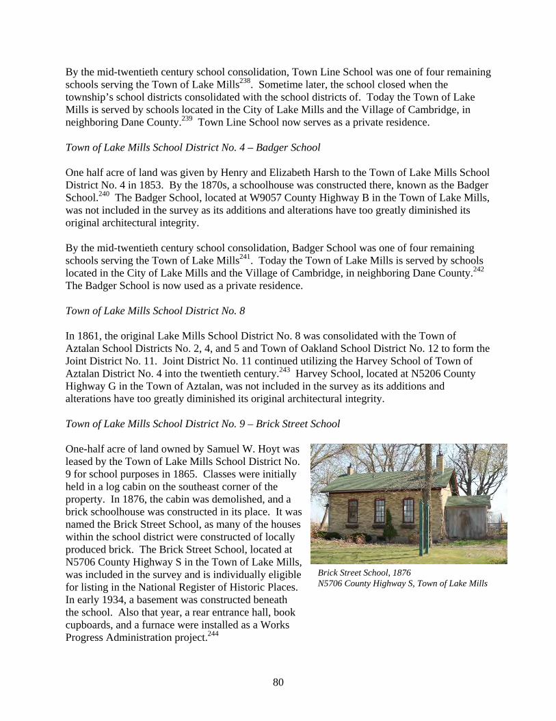
80
By the mid-twentieth century school consolidation, Town Line School was one of four remaining schools serving the Town of Lake Mills238. Sometime later, the school closed when the township’s school districts consolidated with the school districts of. Today the Town of Lake Mills is served by schools located in the City of Lake Mills and the Village of Cambridge, in neighboring Dane County.239 Town Line School now serves as a private residence. Town of Lake Mills School District No. 4 – Badger School One half acre of land was given by Henry and Elizabeth Harsh to the Town of Lake Mills School District No. 4 in 1853. By the 1870s, a schoolhouse was constructed there, known as the Badger School.240 The Badger School, located at W9057 County Highway B in the Town of Lake Mills, was not included in the survey as its additions and alterations have too greatly diminished its original architectural integrity. By the mid-twentieth century school consolidation, Badger School was one of four remaining schools serving the Town of Lake Mills241. Today the Town of Lake Mills is served by schools located in the City of Lake Mills and the Village of Cambridge, in neighboring Dane County.242 The Badger School is now used as a private residence. Town of Lake Mills School District No. 8 In 1861, the original Lake Mills School District No. 8 was consolidated with the Town of Aztalan School Districts No. 2, 4, and 5 and Town of Oakland School District No. 12 to form the Joint District No. 11. Joint District No. 11 continued utilizing the Harvey School of Town of Aztalan District No. 4 into the twentieth century.243 Harvey School, located at N5206 County Highway G in the Town of Aztalan, was not included in the survey as its additions and alterations have too greatly diminished its original architectural integrity. Town of Lake Mills School District No. 9 – Brick Street School One-half acre of land owned by Samuel W. Hoyt was leased by the Town of Lake Mills School District No. 9 for school purposes in 1865. Classes were initially held in a log cabin on the southeast corner of the property. In 1876, the cabin was demolished, and a brick schoolhouse was constructed in its place. It was named the Brick Street School, as many of the houses within the school district were constructed of locally produced brick. The Brick Street School, located at N5706 County Highway S in the Town of Lake Mills, was included in the survey and is individually eligible for listing in the National Register of Historic Places. In early 1934, a basement was constructed beneath the school. Also that year, a rear entrance hall, book cupboards, and a furnace were installed as a Works Progress Administration project.244
Brick Street School, 1876 N5706 County Highway S, Town of Lake Mills

81
By the mid-twentieth century school consolidation, Brick Street School was one of four remaining schools serving the Town of Lake Mills245. Today the Town of Lake Mills is served by schools located in the City of Lake Mills and the Village of Cambridge, in neighboring Dane County.246 Primary Education – Town of Milford Joint School District No. 10 – Faville Grove School The Joint School District No. 10 was formed by the consolidation of several school districts in the townships of Aztalan, Lake Mills, and Milford in 1844. The following year, discussions began about where to locate and build a schoolhouse. Land at the intersection of County Highway G and Manske Road owned by Alpheus D. Faville was selected; however, it was not until 1850 that a non-extant frame schoolhouse was constructed there at the cost of $250. It became known as Faville Grove School.247 In 1860, a new brick schoolhouse was constructed at the cost of $500 and became known as Faville Grove School. Faville Grove School, located at W7486 Manske Road in the Town of Waterloo, was not included in the survey as its additions and alterations have too greatly diminished its original architectural integrity. The old frame building was sold to Alpheus Faville in 1872. A furnace was installed in 1875, and electricity around the turn of the twentieth century.248 By the mid-twentieth century school consolidation, Faville Grove School was one of four remaining schools serving the Town of Milford249. Today the Town of Milford is served by schools located in the City of Lake Mills and the City of Waterloo.250 Joint School District No. 13 – Hubbleton School In 1859, several original Town of Milford and Town of Waterloo school districts were consolidated with a Town of Shields, Dodge County, School District. That fall, a non-extant frame schoolhouse to serve the joint district was constructed a half acre of land on State Highway 19 donated by George Bleeker. In 1875, the Town of Portland, Dodge County, School District No. 10 was added to Joint School District No. 13.251 After the original frame schoolhouse was destroyed by fire in early 1879, classes continued nearby in a hall owned by C. G. Grigg and, for the rest of the school year, in the house of George Bleeker. A non-extant brick schoolhouse was completed by the end of that year. It became known as Hubbleton School.252 Due to an increasing enrollment, a new brick schoolhouse was constructed in its place by a man named Hunzicker in 1926. Hubbleton School, located
Hubbleton School, 1926 W7259 State Highway 89, Town of Milford

82
at W7259 State Highway 19 in the Town of Milford, was included in the survey and is individually eligible for listing in the National Register of Historic Places. At that time of its construction, it was the most modern schoolhouse in Jefferson County, with electricity, stoker furnace, and running water. Water was initially piped in from a nearby cheese factory. The schoolhouse contained a large assembly room, two cloak rooms, two toilet rooms, a library, and teacher’s office.253 By the mid-twentieth century school consolidation, Hubbleton School was one of five remaining schools serving the Town of Milford254. Today the Town of Milford is served by schools located in City of Lake Mills, the City of Watertown, and the Village of Johnson Creek.255 Town of Milford School District No. 1- Milford State Graded School Land at the western edge of the settlement of Milford on which to construct a schoolhouse was donated to the Town of Milford School District No. 1 by Benjamin Nute in 1844. A schoolhouse was constructed there by the mid-1850s, and became known as Milford School.256 The schoolhouse was later converted into a private residence, the exact location and condition of which are unknown at this time.257 Little else is known about Milford School at this time. In 1870, the district constructed a Romanesque Revival style brick schoolhouse designed by architect Louis Charboneau at the cost of $3,150. The school opened that year as the Milford State Graded School.258 The Milford State Graded School, located at W6480 County Highway A in the Town of Milford, was included in the survey and is individually eligible for listing in the National Register of Historic Places. A large addition was constructed on the west side of the schoolhouse during the mid-twentieth century
before the school district was consolidated into the Lake Mills Area School District in 1959. Milford State Graded School continued to operate within that organization until it was closed in 1968.259 Town of Milford School District No. 2 – Alder Grove School The Town of Milford School District No. 2 constructed its first schoolhouse on land on French Road donated by Otto Dettmann. It was demolished in 1916, and a new schoolhouse was constructed of concrete block. It became known as the Alder Grove School. Alder Grove School, located at N7510 French Road in the Town of Milford, was included in the survey and is individually eligible for listing in the National Register of Historic Places. In 1936, a basement was constructed beneath the school, and a
Alder Grove School, 1916 N7510 French Road, Town of Milford
Milford State Graded School, c. 1870 W6480 County Highway A, Town of Milford

83
furnace installed. Alder Grove School was closed briefly during the mid-twentieth century, during which time its students attend the Milford Graded School in the nearby settlement of Milford. After a few years the school reopened, only to be permanently closed in 1956. The schoolhouse was converted into a private residence at that time.260 Town of Milford School District No. 3 – Hickory Grove School The first school in the Town of Milford School District No. 3 was founded in the mid-1850s. Classes were initially held in a non-extant frame schoolhouse on land on the east side of Highway Q just north of Schmidt Road. The frame building was sold and removed from the school grounds in 1857, after a non-extant brick schoolhouse was constructed that summer by Peter Harsh at the cost of $400.261 By the mid-twentieth century school consolidation, Hickory Grove School was one of five remaining schools serving the Town of Milford262. Today the Town of Milford is served by schools located in the City of Lake Mills, the City of Watertown, and the Village of Johnson Creek.263 Hickory Grove School has since been demolished. Town of Milford School District No. 5 – Rock River Valley School The first school in the Town of Milford School District No. 5 was founded in the mid-nineteenth century. Classes were initially held in a non-extant brick schoolhouse at the intersection of County Highway N and Finder Road. It became known as Rock River Valley School. In 1871, a portion of the Town of Aztalan School District No. 6 was added to the jurisdiction of the Town of Milford School District No.5, and these students began attending Rock River Valley School.264 Due to increased enrollment, a new, larger brick building was constructed in the original school’s place in 1881. Rock River Valley School, located at N7201 County Highway N in the Town of Milford, was included in the survey. At that time, the old school was sold for $5 and removed from the property.265 As the residents of the school district were predominately German, classes were initially taught in that language. It wasn’t until 1907, that classes were held solely in English. However, feeling that the language should not be completely forgotten, the German language continued to be taught as an additional subject from that time forward.266 By the mid-twentieth century school consolidation, Rock River Valley School was one of five remaining schools serving the Town of Milford267. Today the Town of Milford is served by
Rock River Valley School, 1881 N7201 County Highway N, Town of Milford

84
schools located in the City of Lake Mills, the City of Watertown, and the Village of Johnson Creek.268 In 2003, the Rock River Valley School building was donated to the Johnson Creek Historical Society by John Higgins. At that time, the Historical Society made plans to move the schoolhouse to the Village of Johnson Creek and utilize it to house the historical society.269 These plans have not yet been carried out. Town of Milford School District No. 6 – North Milford School The first school in the Town of Milford School District No. 5 was founded during the 1850s. Classes were initially held in a non-extant log cabin just west of the intersection of Reamer and Hubbleton Roads. In 1870, additional land, just east of the first schoolhouse, was purchased by the school district from William Smith for $23.50. That fall, a non-extant brick schoolhouse was constructed by James Enright at the cost of $700. The former log building was sold to Enright and was removed from the property.270 By the mid-twentieth century school consolidation, North Milford School was one of five remaining schools serving the Town of Milford271. Today the Town of Milford is served by schools located in the City of Lake Mills, the City of Watertown, and the Village of Johnson Creek.272 North Milford School has since been demolished. Town of Milford School District No. 7 – Grellton School The Town of Milford School District No. 7 constructed a frame schoolhouse, known as the Grellton School, near the intersection of County Highway A and French Road during the mid-nineteenth century.273 The exact location and current condition of Grellton School is unknown at this time. The school was closed in 1962, and was later converted into a private residence.274 No historic resources were found to be associated with Grellton School. Town of Milford School District No. 8 – Heitz School The first school in the Town of Milford School District No. 8 was founded in 1853. Classes were initially held in a non-extant log cabin on land near the intersection of County Highway Q and Navan Road donated to the district by Daniel Fetterly. A non-extant schoolhouse was constructed in its place in 1870.275 By the mid-twentieth century school consolidation, Heitz School was one of five remaining schools serving the Town of Milford276. Today the Town of Milford is served by schools located in City of Lake Mills, the City of Watertown, and the Village of Johnson Creek.277 Heitz School has since been demolished.

85
Primary Education – Town of Waterloo Joint School District No. 3 – Stony Brook School The Joint School District No. 3 was formed by the consolidation of several school districts in the Town of Milford. A brick schoolhouse, known as Stony Brook School, was constructed on Airport Road by the late-nineteenth century.278 Stony Brook School, located at N7609 Airport Road in the Town of Waterloo, was included in the survey and is individually eligible for listing in the National Register of Historic Places. By the mid-twentieth century school consolidation, Stony Brook School was one of four remaining schools serving the Town of Milford279. Today the Town of Milford is served by schools located in the City of Lake Mills and the City of Waterloo.280 Joint School District No. 12 – Kypke Grove School In 1915, the Joint School District No. 12 purchased land on Highway G near Island Church Road from a Mrs. Allen on which it constructed a non-extant 33-foot by 36-foot brick schoolhouse that same year. It became known as Kypke Grove School. By the mid-twentieth century school consolidation, Kypke Grove School was one of four remaining schools serving the Town of Milford.281 Today the Town of Milford is served by schools located in City of Lake Mills and the City of Waterloo.282 The schoolhouse was purchased by the Waterloo Post of the Veterans of Foreign Wars in 1955 and served as their post for two years. It was later converted into a private residence. The Kypke Grove School was destroyed by fire in 1996.283 St. Wenceslaus Catholic School The parish of St. Wenceslaus Catholic Church, constructed in 1864, established a parochial grade school sometime during the late-nineteenth or early-twentieth century. St. Wenceslaus Catholic Church, located at W7911 Blue Joint Road, is listed in the National Register of Historic Places. A school building was constructed next to the church; however, it was demolished by the mid-twentieth century.284 Town of Waterloo School District No. 2 – White School By 1847, the Town of Waterloo School District No. 2 constructed a non-extant log schoolhouse, known as White School, on the east side of County Highway O north of Newville Road.285 Initially it was also referred to as the “Crosby School.” It closed by the mid-twentieth century.286 No historic resources were found to be associated with White School.
Rock River Valley School, 1881 N7201 County Highway N, Town of Milford

86
Town of Waterloo School District No. 3 – Abendroth School The Town of Waterloo School District No. 3 constructed a non-extant schoolhouse, known as Abendroth School, on Abendroth Road sometime before the early twentieth century.287 The school closed by the mid-twentieth century. During its operation, it was also commonly referred to as Sheridan School.288 No historic resources were found to be associated with Abendroth School. Town of Waterloo School District No. 4 – Island School A movement to found a school in the “Hog Island” area of the Town of Waterloo, began during the 1840s with a non-extant log building serving as a schoolhouse. Known as Island School, it also served as a religious, social, and political gathering place. After several decades, the schoolhouse fell into disrepair. Several attempts were made to repair the building. Yet in 1855, the schoolhouse was destroyed by a fire rumored to have been started by several of the older boys who attended the school. However, no individual or group of people were ever blamed or held responsible for the fire.289 A new brick schoolhouse was constructed in 1855.290 Island School, located at N8995 Island Church Road in the Town of Waterloo, was not included in the survey as its additions and alterations have too greatly diminished its original architectural integrity. By the mid-twentieth century school consolidation, Island School was one of four remaining schools serving the Town of Milford.291 Today the Town of Milford is served by schools located in the City of Lake Mills and the City of Waterloo.292 Island School has since been converted into a private residence. Town of Waterloo School District No. 5 – Jordan School Residents of the area known as “Dutch Island” founded a school in 1850. Initially, classes were held in a small building owned by Jake Herring but were soon moved to a log barn owned by John Wilson; at which time the barn continued use housing Wilson’s herd of sheep during the night. Eventually organized as the Town of Waterloo School District No. 5, a schoolhouse, known as Jordan School, was constructed on Jordan Road.293 The schoolhouse is no longer extant. Vocational Education Aztalan Labor School During the 1840s, there was a movement to establish a “Labor School” at the settlement of Aztalan. A section of land on the hill at the west end of the settlement was reserved for this purpose, still known locally as “College Hill.” Some funds were raised; however, the project was never realized. The money gathered was transferred to the public school treasury and used

87
to construct the town’s first primary school building, now non-extant.294 No historic resources were found to be associated with the Aztalan Labor School. Museums Lake Mills-Aztalan Historical Society The Lake Mills-Aztalan Historical Society was founded in 1941. That same year, the society acquired the Old Baptist Church in the former Village of Aztalan which had fallen into disrepair and was victim to vandalism. After a major restoration, the church opened the following year housing the society’s museum. The Old Baptist Church, located at N6364 County Highway Q, is listed in the National Register of Historic Places. The society’s collection included Indian artifacts and pioneer relics.295 Since that time, several other historic buildings have been reconstructed on or relocated to the museum grounds. These include the Abner Pettey Cabin, Vincent Faltersack House, and Andrew Knudson House, all located at N6284 County Highway Q, and all listed in the National Register of Historic Places. In 1969, the Registered Landmark Commission approved the museum grounds as the “Pioneer Aztalan” Registered Wisconsin Landmark No. 68. The museum continues operation to this day.296 List of Surveyed Historic Resources Mentioned in the Text Town Address Historic Name Date Class Aztalan N5595 County Highway N Union School 1890 Surveyed Aztalan N6273 County Highway Q Aztalan School 1918 Eligible Aztalan N6284 County Highway Q Abner Pettey Cabin 1843 Listed Aztalan N6284 County Highway Q Vincent Faltersack House 1867 Listed Aztalan N6284 County Highway Q Andrew Knudson House 1849 Listed Aztalan N6364 County Highway Q Old Baptist Church 1852 Listed Lake Mills N5706 County Highway S Brick Street School 1876 Eligible Milford W6480 County Highway A Milford State Graded School 1870 Eligible Milford N7201 County Highway N Rock River Valley School 1881 Eligible Milford N7510 French Road Alder Grove School 1916 Eligible Milford W7259 State Highway 19 Hubbleton School 1926 Eligible Waterloo N7609 Airport Road Stony Brook School < 1887 Eligible Waterloo W7911 Blue Joint Road St. Wenceslaus Catholic Church 1863 Listed

88
This page intentionally left blank.

89
Religion Introduction In rural communities, social and cultural activities have historically been provided largely through educational and religious organizations. Several of the churches in the northwest quadrant of Jefferson County have remained in operation. However, the overwhelming majority of the church buildings have undergone inappropriate renovations and additions so that few have any significant historic features and integrity left intact. Baptist Aztalan Baptist Society In 1839, a Baptist Society was established at the settlement of Aztalan in the Town of Aztalan under the guidance of Rev. Edward Matthews, the sixth Baptist congregation in the Wisconsin Territory. Initial services were held in private residences, and then the non-extant first schoolhouse in Aztalan. In 1852, a church was constructed of bricks produced at the Aztalan brickyard.297 The Old Baptist Church, located at N6364 County Highway Q, is listed in the National Register of Historic Places. Catholic St. Wenceslaus Catholic Church During the 1850s, a priest from Jefferson routinely visited the Town of Waterloo to serve the needs of Catholic settlers in the area. In 1863, Anton and Therezia Christl donated an acre of land at the intersection of Blue Joint and Island Church Roads in the Town of Waterloo for use as a church site and cemetery. St. Wenceslaus Catholic Church, named for the patron saint of Bohemia (as the congregation was largely from that region of the present day Czech Republic), was constructed there that year. St. Wenceslaus Catholic Church, located at W7911 Blue Joint Road, is listed in the National Register of Historic Places. The congregation established the cemetery adjacent to the church in 1865. For more information on the St. Wenceslaus Cemetery, refer to Chapter 14 Planning & Landscape Architecture. The church never received status of a parish, operating as a mission until it was closed in 1891.298
12

90
Congregational Milford Congregational Church A Congregational congregation was formed at the settlement of Milford in the Town of Milford around 1860. Initially, services were held with the Methodist congregation in Milford at the non-extant Milford School on County Highway A. The Methodists constructed themselves a church in 1897, to which the Congregationalists responded by constructed their own church the following year. Located on County Highway Q, on the west side of the Crawfish River, this building later became known as “Union Hall.” Sometime later, it was moved to a site on County Highway A at the west bank of the river to replace a store that had been destroyed by fire.299 No historic resources were found to be associated with the Milford Congregational Church. Evangelical Church and Church of the United Brethren of Christ Salem Evangelical United Brethren Church Rev. John G. Miller of the Illinois Evangelical Association settled in the Town of Milford and began preaching in private residences in 1857. In 1860, a congregation was formed under the name Salem Evangelical United Brethren Church, and a small, non-extant frame church was constructed. A new and larger, brick church was constructed on the east side of Church Drive south of Finder Road in the Town of Milford in 1871. A cemetery was later established next to the church. For more information on Salem Cemetery, refer to Chapter 14 Planning & Landscape Architecture. In 1967, Salem Evangelical United Brethren Church merged with an Evangelical congregation in the City of Lake Mills; that union was later merged with the Methodist churches at the settlement of Milford and the City of Lake Mills to form the Lake Mills United Methodist Church.300 Salem Evangelical United Brethren Church has since been demolished. Aside from the cemetery, no historic resources were found to be associated with Salem Evangelical United Brethren Church. Lutheran Milford Evangelical Lutheran Church An Evangelical Lutheran congregation was formed at the settlement of Milford in the Town of Milford in 1857. The congregation constructed a frame church in 1860 at the corner of County Highways A and Q, on the east side of the Crawfish River. In 1951, the Milford Evangelical Lutheran Church was moved to Mulberry Street in the City of Lake Mills.301 No historic resources were found to be associated with the Milford Evangelical Lutheran Church. St. John Evangelical Lutheran Church St. John Lutheran Church was organized in 1867, and a non-extant church was constructed that year. In 1893, a new frame church was constructed to replace the original at the intersection of

91
Newville Road and Parsonage Lane in the Town of Lake Mills for the St. John Evangelical Lutheran Church.302 St. John Evangelical Lutheran Church, located at W8496 Parsonage Lane in the Town of Lake Mills, was not included in the survey as its additions and alterations have too greatly diminished its original architectural integrity. Sometime later a parsonage was constructed adjacent to the church.303 The St. John Parsonage, located at W8486 Parsonage Lane in the Town of Lake Mills, was not included in the surveys as its additions and alterations have too greatly diminished its original architectural integrity. At some point in time, the congregation established a cemetery nearby on Cemetery Road.304 For more information on the St. John Cemetery, refer to Chapter 14 Planning & Landscape Architecture. Methodist Milford Methodist Church A Methodist congregation was formed at the settlement of Milford in the Town of Milford around 1860. Initially, services were held with the Congregational congregation in Milford at the non-extant Milford School on County Highway A. In 1897, the Methodist congregation constructed a church, doing much of the construction work themselves. In 1967, the Milford Methodist Church merged with the Methodist congregation in the City of Lake Mills; that union was later merged with the Evangelical church in City of Lake Mills to form the Lake Mills United Methodist Church. In 1968, the church was sold to the Town of Milford and converted into the Milford Town Hall.305 Milford Methodist Church, located at W6335 County Highway A in the Town of Milford, was not included in the survey as its additions and alterations have too greatly diminished its original architectural integrity. Waterloo Methodists A Methodist congregation formed in the northern portion Town of Waterloo around 1859. A frame church was constructed just south State Highway 19 near Youker Road. The congregation dissolved around the turn of the twentieth century. During the late 1920s, the church building was sold and relocated.306 No historic resources were found to be associated with Methodists in Waterloo. Moravian Church The Moravian Church is a Protestant denomination organized in Bohemia and Moravia during the reform movement of the fifteenth century. Members of the church settled in the Wisconsin Territory during the late 1840s, primarily in Brown, Door, Jefferson, and Wood Counties. By 1890, there were 1,477 Moravians in the state, increasing greatly into the early twentieth century. German Moravians organized near Watertown during the mid-nineteenth century. By the mid-

92
twentieth century, Jefferson County was home to the largest concentration of Moravians in Wisconsin.307 London Moravian Church The London Moravian Church was constructed on County Highway O at the settlement of London in the town of Lake Mills. London Moravian Church, located at N5610 County Highway O in the Town of Lake Mills, was not included in the survey as its additions and alterations have too greatly diminished its original architectural integrity.308 The congregation was involved with establishing a cemetery nearby at the settlement of Kroghville.309 For more information on Kroghville Cemetery, refer to Chapter 14 Planning & Landscape Architecture. Mamre Moravian Church The Mamre Moravian Church was constructed on County Highway Q in the town of Milford. Mamre Moravian Church, located at N9015 County Highway Q in the Town of Milford, was not included in the survey as its additions and alterations have too greatly diminished its original architectural integrity.310 The congregation established a cemetery next to the church.311 For more information on Mamre Moravian Cemetery, refer to Chapter 14 Planning & Landscape Architecture. List of Surveyed Historic Resources Mentioned in the Text Town Address Historic Name Date Class Aztalan N6364 County Highway Q Old Baptist Church 1852 Listed Waterloo W7911 Blue Joint Road St. Wenceslaus Catholic Church 1863 Listed

93
Commerce Introduction The small unincorporated communities of the northwest quadrant of Jefferson County, specifically Aztalan, Hubbleton, Kroghville, London, and Milford, were important locations for goods and services that served their rural townships during the nineteenth and early twentieth centuries. Small businesses in these communities provided necessary goods and services to farmers, even after many of them began acquiring automobiles. However, largely after World War II, farmers and rural residents were willing and able to drive longer distances to supermarkets, discount stores, and shopping malls in nearby incorporated municipalities because of the increased quality of automobiles and rural roads. To this day, the only businesses that continue to operate in the rural communities are predominately small taverns. Goods and Services Retail Businesses Sometime during the early- to mid-twentieth century, an automobile showroom was constructed on County Highway O at the settlement of London in the Town of Lake Mills. The building located at N5526 County Highway O in the Town of Lake Mills was included in the survey but is not eligible for listing in the National Register of Historic Places. Little else is known about the automobile showroom at this time. C. F. Wendt operated a blacksmith shop and wagon works on County Highway A on the east side of the Crawfish River at the settlement of Milford in the Town of Milford during the 1880s. The shop was sold to Herbert Heller and W. Ziebell in 1900, who partnered to operate a feed mill and blacksmith shop there. The building was destroyed by fire a few years later; however, Heller constructed another building on the site where he continued to operate a blacksmith shop and garage until about 1922. The business was sold to Charles Gallitz in 1929, who continued
13
Automobile Showroom N5526 County Highway O, Town of Lake Mills
Charles Gallitz Garage, c. 1938 N5526 County Highway O, Town of Lake Mills

94
running the business primarily as an auto service garage after 1932. The garage was sold to Chalmer Chadwick in 1950, who added the sale of used cars to the business’s auto repair services.312 A concrete block building was constructed on the site around 1938. The Charles Gallitz Garage, located at W6394 County Highway A, was included in the survey but is not eligible for listing in the National Register of Historic Places. A business by the name of Milford Motors was later located at this building. In 1950, Everett & Marion Borck constructed an automobile service station on State Highway 89 in the Town of Lake Mills.313 The Everett & Marion Brock Garage, located at N5697 State Highway 89 in the Town of Lake Mills, was included in the survey but is not eligible for listing in the National Register of Historic Places. Banks In 1919, the Hubbleton State Bank constructed a building at the settlement of Hubbleton in the Town of Milford.314 The Hubbleton State Bank, located at W7055 Main Street in the Town of Milford, was included in the survey but is not eligible for listing in the National Register of Historic Places. List of Surveyed Historic Resources Mentioned in the Text Town Address Historic Name Date Class Lake Mills N5226 County Highway O Automobile Showroom Surveyed Lake Mills N5697 State Highway 89 Everett & Marion Brock Garage 1950 Surveyed Milford W6394 County Highway A Charles Gallitz Garage c. 1938 Surveyed Milford W7055 Main Street Hubbleton State Bank 1919 Surveyed
Hubbleton State Bank, 1919 W7055 Main Street, Town of Milford
Everett & Marion Borck Garage, 1950 N5697 State Highway 89, Town of Lake Mills

95
Planning & Landscape Architecture Urban Parks and Planning Aztalan Public Squares The 1842 plat of the Village of Aztalan included two public squares, one in each of the northern and southern halves of the village. The Aztalan North Public Square was never developed. The Aztalan South Public Square was located south of the intersection of County Highways A and Q and was the location of the first, non-extant schoolhouse in the village. The schoolhouse was replaced twice by the Town of Aztalan School District No. 1 in 1850 and 1918.315 For more information on the Aztalan School, refer to Chapter 11 Education. Cemeteries The northwest quadrant of Jefferson County is dotted with numerous small rural cemeteries. However, none of them were included in the survey as they did not contain historic resources eligible for listing in the National Register of Historic Places. A listing of cemeteries in the survey area is as follows: Aztalan Cemetery A cemetery was established north of the settlement of Aztalan at the intersection of County Highway Q and Cemetery Road and became known as Aztalan Cemetery. Aztalan Cemetery is located at N6603 County Highway Q in the Town of Aztalan.316 Church Hill Cemetery Church Hill Cemetery, also known as the German Methodist Cemetery, is located on the west side of County Highway A just north of the intersection with Meyer Lane in the Town of Milford.317 Island Cemetery Island Cemetery, also known as Setz Cemetery, is located at the northeast corner of the intersection of Island Road and Klug Lane in the Town of Waterloo318
14

96
Kroghville Cemetery A cemetery, affiliated with the London Moravian Church, was established at the settlement of Kroghville in the Town of Lake Mills.319 For more information on the London Moravian Church, refer to Chapter 12 Religion. The cemetery has also been known as the Lutheran Moravian Cemetery. Kroghville Cemetery is located in the southeast bend of Kroghville Road just north of its intersection with County Highway O in the Town of Lake Mills. Mamre Moravian Cemetery Mamre Moravian Church established a cemetery next to its church on County Highway Q in the town of Milford.320 For more information on Mamre Moravian Church, refer to Chapter 12 Religion. Mamre Moravian Cemetery is located at N9015 County Highway Q in the Town of Milford. Salem Cemetery Salem Evangelical Church established a cemetery next to its non-extant church on Church Drive in the town of Milford.321 For more information on Salem Evangelical Church, refer to Chapter 12 Religion. Salem Cemetery is located on the east side of Church Drive south of Finder Road in the Town of Milford. South Road Cemetery A cemetery was established next to the non-extant White School on County Highway O in the Town of Waterloo and was known as the South Road Cemetery.322 For more information on White School, refer to Chapter 11 Education. South Road Cemetery is located on the east side of County Highway O north of Newville Road in the Town of Waterloo. St. John Evangelical Lutheran Cemetery St. John Evangelical Lutheran Church in the Town of Lake Mills established a cemetery on Cemetery Road, which was also known as Newville Cemetery.323 For more information on the St. John Evangelical Lutheran Church, refer to Chapter 12 Religion. St. John Evangelical Lutheran Cemetery is located on the north side of Cemetery Road between Newville and Rock Lake Roads in the Town of Lake Mills. St. Mary Magdalene Cemetery St. Mary Magdalene Catholic Church of Johnson Creek established a cemetery on Jefferson Road in the Town of Aztalan.324 St. Mary Magdalene Cemetery is located on the west side of Jefferson Road approximately one half mile south Aztalan Street.

97
St. Wenceslaus Cemetery St. Wenceslaus Catholic Church in the Town of Waterloo established a cemetery adjacent to its church on Island Church Road around 1865.325 For more information on St. Wenceslaus Catholic Church, refer to Chapter 12 Religion. St. Wenceslaus Cemetery is located at W7911 Blue Joint Road. Conservation Bean Lake State Natural Area The Bean Lake State Natural Area is a 33-acre property owned by the Wisconsin Department of Natural Resources that was designated as a state natural area in 1973. Bean Lake supports algal blooms and yellow pond-lily and is surrounded by a narrow zone of swamp loosestrife with cattails, sedges, and soft stem bulrush. Tamarack, dogwood, bog birch, poison sumac, and willows surround the lake and encompass the entire area east to the west shore of Rock Lake. Two small upland islands along the northeast edge of the lake are forested with deciduous hardwoods. Bird species that nest in the area include green-backed herons, wood duck, mallard, blue-winged teal, sandhill crane, great horned owl, and long-eared owl. Bean Lake is owned by the DNR and was designated a State Natural Area in 1973.326 Within the natural area is a group of five historic Indian ceremonial sites known as the Bean Lake Islands Archaeological District which are listed in the National Register of Historic Places for the sites’ potential to provide further information about Indian culture from the periods between the years 1749 and 1000 B.C. Faville Prairie State Natural Area Stoughton W. Faville, son of Alpheus D. Faville, was a botanist and lover of prairie wildflowers, inspired by the natural flora around the family farmstead on which he grew up. Around the turn of the twentieth century, he discovered a hybrid lady slipper, a natural cross between a small white and a large yellow flower. The flower was later named after him, the “Cypripedium X favillianum Curtis” or the Faville’s Lady’s Slipper. To preserve local wildflowers, Stoughton set aside a 50-acre tract of land along the Crawfish River in the Town of Waterloo to the University of Wisconsin.327 It became a state natural area in 1952. The Faville Prairie State Natural Area is one of the largest low prairie remnants in the state. Originally, the Crawfish Prairie, of which it was historically a part, once covered nearly 2,500 acres. The Natural Area features a small ridge at the center of its site with lower areas of sedge meadow and shrub carr communities around it. While historic land use changes to the site have altered its hydrology, making the prairie drier and increasing in exotic and woody species, the prairie still retains a high level of floral diversity. Grasses in the preserve include big blue-stem, Indian grass, blue-joint grass, and a diverse stock of sedges. Forbs found in the preserve include yellow-star grass, shooting-star, gentians, prairie blazing-star, prairie-dock, compass-plant, mountain mint, northern bedstraw, prairie phlox, sunflowers, and asters. Rare upland sandpipers have nested in the natural area in the past.328 No historic resources were found to be associated with the Faville Prairie State Natural Area.

98
Lake Mills Wildlife Area The Lake Mills Wildlife Area is a State sanctioned wildlife preserve covering approximately 3,300 acres in the Town of Lake Mills, divided into two units. The original, eastern unit is located immediate south of Rock Lake is primarily comprised of wetlands including three lakes, extensive shrub and tamarack bog, and uplands with oak savannah and other hardwoods. The Bean Lake State Natural Area is located completely within the eastern unit of the Lake Mills Wildlife Area. The western unit, also known as the London or Zeloski Marsh, is farther west and is the result of a large wetland restoration effort of almost 2,000 acres. This unit is comprised of large impoundments to manage water levels and for migrating and nesting waterfowl, shorebirds, and other wetland flora and fauna. The area is crossed with several access lanes for management and recreational purposes. The Glacial Drumlin State Trail crosses both units of the wildlife area. Habitat types within the area include open water marsh, wet prairie, lowland hardwoods, and some oak savanna uplands. No historic resources were found to be associated with the Lake Mills Wildlife Area.329 Snapper Prairie State Natural Area The Snapper Prairie State Natural Area, located in the Town of Milford between County Highway G and the Crawfish River, is a natural area owned by the Madison Audubon Society that was designated a State Natural Area in 1981. The site is a 30-acre remnant of what was once a large 2,500-acre low prairie in the floodplain of the Crawfish River. The site may flood in spring and early summer due to poorly drained clay soils and is dominated by big blue-stem, little blue-stem, and prairie drop-seed, and other forbs including prairie blazing-star, coneflowers, compass-plant, sky-blue aster and prairie-dock. Other plants found at the site include Riddell's goldenrod, nodding ladies-tresses orchid, valerian, and narrow-leaved loosestrife. Prairie milkweed and prairie Indian plantain are two rare plants found at the site. There are good populations of savanna sparrows and eastern meadowlarks in the area; rare bobolink and upland sandpipers have nested at the site in the past.330 No historic resources were found to be associated with the Snapper Prairie State Natural Area. List of Surveyed Historic Resources Mentioned in the Text Town Address Historic Name Date Class Lake Mills Bean Lake Islands Archaeological District Listed

99
Recreation & Entertainment Tourism Industry Elm Point By the early 1950s, a cluster of vacation homes had been developed on land owned by Bertha Strasburg and platted as Elm Point.331 The Joyce S. McGovern Cottage, located at W8135 Elm Point Road, and the John & Myrtle Spangenburg Cottage, at W8147 Elm Point Road, were both included in the survey but are not eligible for listing in the National Register of Historic Places.
State and Local Recreation Areas Aztalan State Park Land on which ancient Indian ruins constructed by members of the Mississippian Culture, from approximately 1000 to 1500 A.D., along the west bank of the Crawfish River was established as Aztalan State Park in 1952.332 When it was discovered by white explorers in the 1830s, the site was named Aztalan after a report by Baron Alexander von Humboldt, a well-known early-nineteenth century German anthropologist who studied American Indian antiquities, which told of the Aztec people coming to Mexico from a land by flowing waters far to the north by that name.333 The Aztalan Village Site, located at N6200 County Highway Q, was listed in the National Register of Historic Places in 1975. The site’s nomination contains extensive history on the mound, its site, and other remaining artifacts and is an invaluable resource in describing the site’s history. Consequently, no attempt will be made in this chapter to cover ground that has been so expertly covered by others.
15
John & Myrtle Spangenburg Cottage, 1954 W8147 Elm Point Road, Town of Lake Mills
Joyce S. McGovern Cottage, 1955 W8135 Elm Point Road, Town of Lake Mills

100
Bicentennial Park Bicentennial Park is a park operated by Jefferson County and is located on State Highway 26 south of the Village of Johnson Creek in the Town of Aztalan. The 109-acre park serves as a dog park, expanded from an original 23-acre portion of the park. First established in 2003, the park’s construction was financed by $10,000 raised by county citizens. 43-acres of agricultural land within the park are leased for farming. Woodlands and wetlands each cover approximately 20 acres of the park. The park is fully fenced with a double-entry gate and features walking trails, portable restrooms, picnic areas, and a parking lot.334 No historic resources were found to be associated with Bicentennial Park. Glacial Drumlin State Trail The Glacial Drumlin State Trail is a 52-mile recreation trail developed on a former railroad right-of-way that runs between the City of Waukesha in Waukesha County and the Village of Cottage Grove in Dane County. In Jefferson County, the trail passes through the Towns of Aztalan and Lake Mills. The trail is open year-round to bicyclists, skaters, hikers, joggers, snowmobilers, and skiers.335 No historic resources were found associated with the Glacial Drumlin State Trail. Korth Park Korth Park, located near County Highway S between Korth Lane and Elm Point Road in the Town of Lake Mills, is park operated by Jefferson County and is situated on the west shore of Rock Lake. As the land remained the last large undeveloped tract on the lake, the park was established in 2000 to protect the lake’s water quality and fish habitats. The Seaver-Fargo House, previously listed in the National Register of Historic Places, was located on the land that became Korth Park. The house was demolished in 2004. Two park shelters were constructed in the park in recent years. Both Korth Park Shelters were not included in the survey as they are not of age to be considered historic resources. Korth Park is connected by trails to the Glacial Drumlin State Trail. The park also features packed gravel trails, restrooms, two parking lots, and shoreline and prairie restorations.336 Rock Lake Park Rock Lake Park is a park operated by Jefferson County which is divided into two sections known as the upper and lower parks. Upper Rock Lake Park, located on Rock Lake Road south of Interstate Highway 94 in the Town of Lake Mills, is situated at the top of a hill overlooking Rock Lake. A park shelter was constructed in the park during the late twentieth century. The Upper Rock Lake Park Shelter was not included in the survey as it is not of age to be considered an historic resource. The park features a playground, picnic areas, hiking trails, restrooms, and parking lot.337 Lower Rock Lake Park, located at County Highway B and Park Lake Road in the Town of Lake Mills, is situated on the north shore of Rock Lake. A park shelter was constructed in the park during the late twentieth century. The Lower Rock Lake Park Shelter was not included in the

101
survey as it is not of age to be considered an historic resource. The park features a boat ramp, rock-based beach, restrooms, playground, and a large parking lot.338 Rock River Park Rock River Park is a park operated by Jefferson County and is located along the Rock River on County Highway B west of the Village of Johnson Creek in the Town of Aztalan. A park shelter was constructed in the park during the late twentieth century. The Rock River Park Shelter was not included in the survey as it is not of age to be considered an historic resource. The park features a boat ramp, restrooms, parking lot, and an artesian spring.339 List of Surveyed Historic Resources Mentioned in the Text Town Address Historic Name Date Class Aztalan N6200 County Highway Q Aztalan Village Site Listed Lake Mills W8135 Elm Point Road Joyce S. McGovern Cottage 1955 SurveyedLake Mills W8147 Elm Point Road John & Myrtle Spangenburg Cottage 1954 Surveyed

102
This page intentionally left blank.

103
Notable People Introduction The list of “notable people” includes people who have helped to shape the Towns of Aztalan, Lake Mills, Milford, and Waterloo. These people range from farmers, entrepreneurs, industrialists, politicians, craftsmen, and professionals. Most of these people can be connected with an historic event or building. Any historic resources associated with these persons are listed after their short biographies. More research may unearth additional resources. Fred Albrecht Fred Albrecht was born in Pommern, Germany, in 1858 to John and Sophia Albrecht. He migrated with his parents to the Town of Milford in 1867, where John began farming what grew to be a 200-acre farm. Fred later took over operation of the farm, and acquired an additional 80 acres of farmland. Fred Albrecht married Minnie Bredow in 1891, around which time he constructed a new house on the farmstead. The Fred & Minnie Albrecht House, located at N9045 County Highway Q in the Town of Milford, was included in the survey but is not eligible for listing in the National Register of Historic Places. Albrecht was a stockholder in the First National Bank of Watertown and active with the Jefferson County Fair Association. He served six years as the road supervisor and was secretary for the Mamre Moravian Church.340 Elihu Lester Atwood Elihu Lester Atwood was an early settler in the original Town of Aztalan, staking a claim near what later became known as Hooper’s Mill by 1837, at which time his family arrived to join him.341 He operated an ashery and sodium bicarbonate (baking soda) factory located on west bank the Crawfish River just south of County Highway B in the Town of Aztalan during the mid-nineteenth century.342 Elihu Lester Atwood served as a delegate to the first Constitutional Congress in Madison, preparing for the Wisconsin’s statehood, from August through December of 1846 and the second Constitutional Congress in Madison, for the same purpose, from December 1847 to February of 1848.343 No historic resources were found to be associated with Elihu Lester Atwood. Thomas Brayton Thomas Brayton migrated from New York in September of 1836 by land to Michigan City, Indiana, from where he boarded the schooner “Martin Van Buren” for Milwaukee. Due to
16

104
extreme weather, the ship docked in Chicago, where it was subsequently rammed and sunk. Brayton continued to Milwaukee on foot. From there, he took part in the initial expedition set out from October of 1836 with the purpose of establishing a settlement at Aztalan along the Crawfish River, then referred to as the West Branch of the Rock River.344 He and Timothy Johnson went ahead of the rest of the group and reached the settlement site. They returned to Milwaukee when the rest of the party did not arrive within a few days. Brayton and Johnson returned to the site soon after to establish the settlement of Aztalan, accompanied by Brayton’s uncle, William Brayton; Stephen Fletcher; Rev. Jared F. Ostrander; and several others. He was soon followed in settling at Aztalan by his brothers, Jeremiah and Alfred A. Brayton. Thomas Brayton constructed a non-extant, 16- by 20-foot log house that was used publicly to accommodate passing travelers and land seekers. His wife and children joined him at the settlement of Aztalan the following summer, making his the third family to settle in Jefferson County.345 In 1842, Thomas Brayton, with Edward Abbe and Rev. Jared F. Ostrander, platted the Village of Aztalan from a 30-acre survey of the settlement of Aztalan prepared by John Darrow Waterbury. The Village of Aztalan was the first incorporated municipality in Jefferson County.346 Thomas Brayton served as the first judge over the Jefferson County Civil Court, from 1843 to 1846, in the Village of Aztalan.347 He died in 1853.348 No historic resources were found to be associated with Thomas Brayton. Jeremiah Brayton Jeremiah Brayton was an early resident of the settlement of Aztalan, coming to the area by 1838 with his brothers, Thomas and Alfred A. Brayton, and uncle, William Brayton. He received a land grant in the Town of Aztalan from the United States government in recognition of his service in the War of 1812. He is credited with bringing the first cows to the Town of Aztalan, having purchased them in Janesville. Jeremiah Brayton was one of the organizers of the Aztalan Baptist Society, and served as a deacon for the church until his death in 1869.349 No historic resources were found to be associated with Jeremiah Brayton. Mark R. Clapp Mark R. Clapp, from Boston, settled in the Town of Milford in 1840. He served in the in the Wisconsin Territorial Legislature in 1845 and 1846.350 Sometime during the mid-nineteenth century, he constructed a house in the Town of Milford.351 The Mark R. Clapp House, located at N6810 County Highway Q, was included in the survey but is not eligible for listing in the National Register of Historic Places. Jesse Myers Crump Jesse Myers Crump was born in the Town of Waterloo in 1872. After attending Lawrence University in Appleton, for one year, and Grant University in Athens, Tennessee, he operated his family’s 400-acre dairy farm in the Town of Waterloo, with a herd of pure-bred Holstein cattle. He constructed a new house himself on the farm around 1895, when he married Olive Mosher of
105
the Town of Milford. The Jesse Myers & Olive Crump House, located at N7430 North Shore Road in the Town of Milford, was include in the survey and is individually eligible for listing in the National Register of Historic Places. Jesse Crump served for several years as road commissioner and school treasurer.352 Alexander R. Earle Alexander R. Earle migrated from New York and settled in the Town of Aztalan during the early-nineteenth century. In 1841, he married Louisa Waterbury. He was involved with the construction of the Hooper Mill in the Town of Milford in 1849. The Hooper Mill, located at N6920 Hoopers Mill Lane in the Town of Milford, was included in the survey and is individually eligible for listing in the National Register of Historic Places. While he worked as a carpenter, joiner, and millwright, he was a shrewd investor and became one of the town’s wealthiest men. He constructed a house on Harvey Road around 1857. The Alexander R. & Louisa Earle House, located at N5726 Harvey Road in the Town of Aztalan, was included in the survey and is individually eligible for listing in the National Register of Historic Places.353 Alpheus D. Faville Alpheus D. Faville, of New York, settled in the Town of Waterloo with his brothers, Stephen W. and Elijah. Alpheus operated a farm, across the street from that of Elijah, in the southwest portion of the township that became known as Faville Grove. The Alpheus D. Faville Farmstead is known to have originally been comprised of a farmhouse, large barn, and silo. The barn is no longer extant. The Alpheus D. Faville Farmstead House, located at N7557 County Highway G in the Town of Waterloo, and the Alpheus D. Faville Farmstead Silo, at N7563 County Highway G in the Town of Waterloo, were included in the survey and are all eligible for listing in the National Register of Historic Places as contributing resources to the proposed Faville Grove Historic District. Eventually Stephen Faville relocated to the City of Lake Mills, while Alpheus and Elijah remained at Faville Grove.354 Soon after settling, Alpheus Faville became heavily involved with civic affairs, especially the forming of the Faville Grove School in 1850, for which he sold a portion of his farmstead to be the schoolhouse’s site. For more information on the Faville Grove School, refer to Chapter 11 Education. Alpheus Faville also served as the school district’s director in 1867.355 Alpheus and Elijah Faville are credited with introducing the first registered Holstein-Friesian dairy cattle to the area; and by 1866, the Faville family was operating a cheese factory at Faville’s Grove.356 In 1872, Alpheus and Stephen Faville were involved with the organization of the Wisconsin Dairyman’s Association in Watertown. The organization was aimed at improving dairying methods and furthering the interests of dairy farmers in the state.357 During the late-nineteenth century, Alpheus D. Faville constructed two new houses near the family’s farmstead. The Alpheus D. Faville Farmstead Houses, located at N7557 and N7563 County Highway G in the Town of Waterloo, were included in the survey and are both eligible

106
for listing in the National Register of Historic Places as contributing resources to the proposed Faville Grove Historic District. Throughout the late-nineteenth and earl-twentieth century, additional agricultural buildings and structures were constructed at the Alpheus D. Faville Farmstead, including two barns, a large milk house, a corn crib, and a wind mill. The Alpheus D. Faville Farmstead Barns, Shed, Corn Crib, and Wind Mill, all located at N7563 County Highway G, were included in the survey and are all eligible for listing in the National Register of Historic Places as contributing resources to the Faville Grove Historic District. Elijah Faville Elijah Faville settled in the Town of Waterloo with his brothers, Stephen W. and Alpheus D. Faville, in 1843. Elijah operated a farm across the street from that of Alpheus in the southwest portion of the township that became known as Faville Grove. The farm’s original agricultural outbuildings are no longer extent. The Elijah Faville Farmstead House, located at N7606 County Highway G in the Town of Waterloo, was included in the survey and is eligible for listing in the National Register of Historic Places as a contributing resource to the proposed Faville Grove Historic District. Eventually Stephen Faville relocated to the City of Lake Mills, while Alpheus and Elijah remained at the farmstead.358 In the twentieth century, additional outbuildings were constructed on the Elijah Faville farmstead. The Elijah Faville Farmstead Garage and Horse Barn, located at N7606 County Highway G in the Town of Waterloo, were included in the survey as non-contributing resources to the proposed Faville Grove Historic District. Stephen W. Faville Stephen W. Faville, of New York, settled in the Town of Waterloo with his brothers, Alpheus D. and Elijah Faville, in 1843. Eventually Stephen Faville relocated to the City of Lake Mills, while Alpheus and Elijah remained operating their farms in the southwest portion of the township that became known as Faville Grove.359 Soon after settling, Stephen Faville became heavily involved with civic affairs, especially the forming of the Faville Grove School in 1850. For more information on the Faville Grove School, refer to Chapter 11 Education. Stephen Faville also served as the school district’s treasurer for several terms.360 In 1872, Stephen and Alpheus Faville were involved with the organization of the Wisconsin Dairyman’s Association in Watertown. The organization was aimed at improving dairying methods and furthering the interests of dairy farmers in the state.361 No historic resources were found to be associated with Stephen W. Faville.

107
Clara Faville Clara Faville, daughter of Stephen W. Faville, took first prize at the Centennial Exposition of 1876 in Philadelphia for the butter she manufactured at the family’s cheese factory in Faville Grove.362 Clara Faville married Eugene G. Updike, and together operated a farm nearby raising pure-bred Guernseys.363 Stoughton W. Faville Stoughton W. Faville, son of Alpheus D. Faville, was a botanist and lover of prairie wildflowers, inspired by the natural flora around the family farmstead on which he grew up. Around the turn of the twentieth century, he discovered a hybrid lady slipper, a natural cross between a small white and a large yellow flower. The flower was later named after him, the “Cypripedium X Favillianum Curtis” or the Faville’s Lady’s Slipper. To preserve local wildflowers, Stoughton set aside a 50-acre tract of land to the University of Wisconsin. Today it is known as the Faville Prairie State Natural Area.364 Herbert Watson Gallup Herbert Watson Gallup was born in the Town of Milford and raised on the farm of his parents, Clarence E. and Jessie L. Gallup.365 Herbert Gallup became president of the Milford Creamery Association, which owned and operated the Riverside Cheese Factory at the settlement of Milford by 1899. The Riverside Cheese Factory, located at W6435 County Highway A in the Town of Milford, was not included in the survey as its additions and alterations have too greatly diminished its original architectural integrity. The company sold the factory in 1901, which Gallup purchased personally in 1909. The factory became known as the Milford Creamery at that time. However, Gallup sold the creamery in 1910, after which it soon closed.366 In 1922, Gallup constructed a house in the Town of Milford.367 The Herbert Watson Gallup House, located at N7396 County Road Q, was included in the survey, but is not eligible for listing in the National Register of Historic Places. Nathaniel S. Greene Nathaniel S. Greene, an early settler of the Town of Milford, purchased a grist mill from Norman Pratt in 1846. Greene improved the dam, resulting in the deepening of the river as far north as the settlement of Hubbleton. Soon, the he began employing small steamboats to transport the mill’s finished products to the train station in Hubbleton and return with additional grain to be milled. Eventually, Greene purchased his own steamboat, a 75-foot ship constructed by local shipwright N. A. Tummy. Greene’s steamboat was reported to have had capacity for 500 barrels of flour per trip. Greene also purchased a second boat from Tummy around that time, which he is believed to have used for exclusively as a water taxi to Hubbleton for private excursions. No historic resources were found to be associated with the mill.

108
Nathaniel S. Greene served as the first postmaster of the post office at the settlement of Milford starting in 1849 out of a non-extant building on the north side of County Highway A near the Crawfish River’s west bank.368 Greene platted the settlement of Milford, along both sides of the Crawford River at the intersection of County Highways A and Q in the Town of Milford, as a village in 1854. This plat was not recorded until 1865, when Greene platted an addition of five blocks along both sides of the river. However, the village was never incorporated.369 Nathaniel S. Greene served in the in the Wisconsin State Legislature in 1864.370 During the early 1880s, local farmers brought litigation against Nathaniel S. Greene over the mill’s dam. Greene’s case was upheld in multiple hearings; however, Greene abandoned the milling business after his grist mill was destroyed by fire in 1883. At that time, he loaded his belongings on his steamboat and sailed down to Fort Atkinson to resettle. The dam was removed soon after.371 Walter Greene Walter Greene, son of mill owner Nathaniel S. Greene, served in the in the Wisconsin State Legislature in 1862 and 1863. He later served in the Wisconsin State Senate in 1873 and 1874.372 No historic resources were found to be associated with Walter Greene. Charles Frederick Greenwood Charles Frederick Greenwood, the oldest son of Charles S. and Caroline Greenwood, was born in the Town of Aztalan in 1852. He was raised and worked on his family’s farm in Aztalan. He later attended the Liberal Institute in Jefferson. Upon graduation, he established a general store in Johnson Creek. After five years in the mercantile trade, he assisted his parents with the operation of their farm in the Town of Aztalan. In 1873, he married Ida M. Reynolds, of the Town of Aztalan.373 A home was constructed for the couple in 1874.374 The Charles F. and Ida M. Greenwood House, located at W6076 County Highway B in the Town of Aztalan, was included in the survey but is not eligible for listing in the National Register of Historic Places. From 1875 to 1880, Charles Frederick Greenwood served as Clerk for the Town of Aztalan. He served as Chairman of the Town Board in 1881.375 Charles Frederick Greenwood and his younger brother, Arthur W. Greenwood, established the Greenwood Brothers Bank in the Village of Lake Mills in 1883. The bank operated as a private bank until being incorporated as the Greenwood State Bank in 1893; Charles F. as president and Arthur as cashier.376 Charles Frederick Greenwood served as the Chairman of the Town of Lake Mills from 1884 to 1886. From 1887 to 1889, he served as the Chairman of the Jefferson County Board of Supervisors.377

109
In 1892, he constructed a commercial cold-storage warehouse in the area. The following year, he founded a creamery in the Town of Milford. Constructed at a cost of $4,000, the factory had an initial capacity of twelve thousand pounds of milk per day. No historic resources were found to be associated with the creamery of Charles F. Greenwood.378 In 1904, Charles Frederick Greenwood was elected to the Wisconsin State Legislature. He served in this role for two years.379 Greenwood owned and cultivated the Rush Court Farm. He also owned and rented ten summer cottages in the area. He was a member of the Lake Mills Masonic Lodge and the Odd Fellows’ Society.380 Arthur W. Greenwood Arthur W. Greenwood, the son of Charles S. and Caroline Greenwood, was born in the Town of Milford in 1862. He was raised and worked on his family’s farm in the Town of Aztalan. Greenwood later attended a business college in Detroit, Michigan. Upon graduation, he was employed as a bookkeeper for six months by a Detroit firm before relocating to Chicago. There he held similar employment for another six months, before spending a year and a half in England. Upon his return, he and his older brother, Charles Frederick Greenwood, established the Greenwood Brothers Bank in the Village of Lake Mills in 1883. Arthur W. Greenwood married Mary C. Stone, of Oshkosh, in 1887. The bank operated as a private bank until being incorporated as the Greenwood State Bank in 1893; Charles as president and Arthur as cashier. Arthur W. Greenwood also served as Treasurer of Lake Mills and was involved with the Odd Fellows’ Society.381 In 1902, Arthur W. Greenwood had a home constructed for himself on Lakeshore Drive in the City of Lake Mills.382 Charles S. Greenwood Charles S. Greenwood was born in the Town of Lake Mills in 1875, the son of Charles F. and Ida M. Greenwood. He graduated from Lake Mills High School in 1892, after which he attended the University of Wisconsin to study law. After his graduation in 1899, he established a law office in the City of Lake Mills. In 1901, Charles S. Greenwood married Minerva Prescott. At that time, the couple built a house on north shore of Rock Lake in the Town of Lake Mills. The Charles S. and Minerva Greenwood House, located at W7994 County Highway B in the Town of Lake Mills, was included in the survey and is individually eligible for listing in the National Register of Historic Places. He later became a director of his family’s Greenwood State Bank. Charles S. Greenwood was a member of the Lake Mills Methodist Church, Lake Mills Masonic Lodge, Waterloo Chapter R. A. M., Watertown commandery, and the Consistory and Mystic Shrine of Milwaukee. Beginning in 1907, he served as a member of the Jefferson County board of supervisors and was also a member of the school board.383 Richard Hooper Richard Hooper was born in Cornwall, England, in 1828. After the death of his mother, Richard immigrated to the United States with his father, John Hooper, and brother, Thomas Hooper.

110
They settled on a farm in the Town of Palmyra in 1846. There, Richard served as an apprentice to a local shoemaker.384 In 1850, Richard and Thomas Hooper went to Sacramento, California, to work as gold miners, along John M. Brown who Thomas worked for at his stone quarry in Palmyra. The Hooper brothers lent money to Brown in 1853 so he could return to Wisconsin, where he died shortly after his return. In 1854, Richard and Thomas returned to the Town of Palmyra, via Panama, New York City, and Milwaukee. At that time, the brothers purchased a grist mill in the Town of Milford from Brown’s estate. The Hooper Mill, located at N6920 Hoopers Mill Lane in the Town of Milford, was included in the survey and is individually eligible for listing in the National Register of Historic Places. After two years of operating the mill together, Richard purchased Thomas’s interests in the business and continued its operation.385 Richard Hooper he married Abigail E. Lent of Cayuga County, New York, in the Town of Milford in 1854. A small settlement, which took the name of Hoopers Mill, eventually grew up around the mill. Richard retired in 1910, at which time he sold the mill to his son, Eugene Hooper. Richard Hooper died in 1912.386 Thomas Hooper Thomas Hooper was born in Cornwall, England. After the death of his mother, Thomas immigrated to the United States with his father, John Hooper, and brother, Richard Hooper. They settled on a farm in the Town of Palmyra in 1846. Thomas was trained as a stoneworker and began working at a quarry owned by John M. Brown, who had plans to construct a house and grist mill on Rock Creek in the Town of Milford. Thomas cut stones that were used to construct the mill and house, moved to the Town of Milford soon after to aid in construction, and completed the buildings with carpenter Alexander R. Earle in 1849.387 In 1850, Thomas and Richard Hooper went to Sacramento, California, to work as gold miners, along with Brown. The Hooper brothers lent money to Brown in 1853 so he could return to Wisconsin, where he died shortly after his return. In 1854, Thomas and Richard returned to the Town of Palmyra, via Panama, New York City, and Milwaukee. At that time, the brothers purchased the grist mill in the Town of Milford from Brown’s estate. The Hooper Mill, located at N6920 Hoopers Mill Lane in the Town of Milford, was included in the survey and is individually eligible for listing in the National Register of Historic Places. After two years of operating the mill together, Thomas sold his interest to Richard, who continued its operation.388 Nathaniel F. Hyer Nathaniel F. Hyer was one of the first white explorers to closely investigate the area that became the Town of Aztalan, with William Brayton, during a federal survey in late 1835. Hyer named the ruins at Aztalan at that time after a report by Baron Alexander von Humboldt, a well-known early-nineteenth century German anthropologist who studied American Indian antiquities, which told of the Aztec people coming to Mexico from a land by flowing waters far to the north, called Aztalan.389

111
Hyer also served as the first postmaster upon the opening of the post office at the settlement of Aztalan in the Town of Aztalan in April of 1837, the first post office established in Jefferson County.390 No historic resources were found to be associated with Nathaniel F. Hyer. Edwin P. Ingalls Edwin P. Ingalls, of Jefferson County, New York, settled in the Town of Aztalan and began farming there in 1849. He moved to another farm in the Town of Milford sometime later. In 1870, he moved to the settlement of Milford in the Town of Milford. The following year, he purchased a former cheese factory on the east side of the Crawfish River at the settlement of Milford which was in great disrepair.391 He reconstructed the factory and was soon processing over 10,000 pounds of milk per day. In 1879, Ingalls won a premium cheese award at the New York Diary Fair. The factory continued operation after Ingalls’ death in 1890.392 No historic resources were found to be associated with the Edwin P. Ingalls. Casper Krogh Casper Krogh, who referred to himself as Baron Casper von Krogh, was born in Norway in 1812. There he married Catharine Johnson in 1838. The couple immigrated to the United States in 1843, settling in Racine where he worked as a gunsmith. In 1848, Krogh purchased a three-year old sawmill on the Koshkonong Creek and settled at the Jefferson-Dane County line on 170 acres of land in the Town of Lake Mills and 160 acres in Dane County. The settlement of Kroghville soon grew around the mill. In 1852, Krogh platted the village of Kroghville from a survey by John Darrow Waterbury. However, the village was never incorporated. Krogh constructed a grist mill at the settlement in 1853. He was elected Justice of the Peace in 1855. In 1858 he operated a brickyard at the settlement of Kroghville; however, it was only in operation for a single year. In 1859, Krogh constructed a large house at the settlement utilizing the brick produced at his brickyard. The Casper and Catharine Krogh House, located at W9640 Bridge Street in the Town of Lake Mills, was included in the survey and is individually eligible for listing in the National Register of Historic Places. Krogh established a woolen mill at Kroghville in 1868.393 By the late 1870s, Krogh established a factory at the settlement of Kroghville to manufacture a cultivator that he had patented.394 In addition to the cultivator, Krogh received patents for several other of his inventions as well.395 Herman W. Ladish Herman W. Ladish was born in 1880. He purchased interest in the Lytle Stoppenbach Malting Company during the early 1900s. Several years later, he purchased controlling interest and renamed the company the Ladish Stoppenbach Malt Company. The company’s facilities south of Johnson Creek in the Town of Aztalan grew and came to be considered the world’s largest malting facility. The Ladish Stoppenbach Co. Malt Silos, located at N5355 Junction Road in the Town of Aztalan, were included in the survey and are individually eligible for listing in the National Register of Historic Places. Little else is known about Herman W. Ladish at this time.396

112
James Lytle James Lytle founded the Lytle Stoppenbach Malting Company with Joseph Stoppenbach around the turn of the twentieth century. In 1902, Lytle became a member of the Milwaukee Grain & Stock Exchange. After several years, controlling interest in the company was purchased by Herman W. Ladish, and the name of the company was changed to the Ladish Stoppenbach Malt Company. The company’s facilities south of Johnson Creek in the Town of Aztalan grew and came to be considered the world’s largest malting facility.397 The Ladish Stoppenbach Malt Co. Silos, located at N5355 Junction Road in the Town of Aztalan, were included in the survey and are individually eligible for listing in the National Register of Historic Places. P. J. & L. M. McKay Brothers P. J. and J. M. McKay established a nursery business in the Town of Waterloo in 1912. After P. J.’s death and L. M.’s retirement, their brother, William G. McKay, partnered with L. J. Tucker to reorganize the business as the McKay Nursery Company, which grew to become the largest nursery in Wisconsin, cultivating over a section of land.398 No historic resources were found to be associated with P. J. and J. M. McKay. William G. McKay William G. McKay partnered with L. J. Tucker to establish the McKay Nursery Company in the Town of Waterloo as an outgrowth of his brothers’ P. J. and J. M. McKay’s nursery business, established in 1912, after their death and retirement, respectively. The McKay Nursery Company grew to become the largest nursery in Wisconsin, cultivating over a section of land and remains headquartered in Waterloo to this day.399 No historic resources were found to be associated with William G. McKay. Benjamin Nute Benjamin Nute, from Strafford County, New Hampshire, settled in the Town of Milford in 1837400 and, along with William Lamphear, became the first white settler in the Town of Milford. The two men partnered to purchase land along the Crawfish River from Nelson Hawkes and Byron Kilbourne. In 1840, they constructed a dam north of the rapids on the Crawfish River and a non-extant sawmill on the river’s south side. The settlement of Milford soon grew around the mill, which with its location at a shallow, fordable spot along the river may have provided inspiration for the naming of the area “mill ford.” Their partnership continued through the 1840s, the pair being involved with several other real estate transactions in Section 4 of the township.401 Benjamin Nute constructed a non-extant, 15-room hotel on the southwest corner of County Highways A and Q, on the west side of the Crawfish River, at the settlement of Milford in the Town of Milford during the 1840s. Nute operated the hotel until 1858 when he sold it to Harmon Mills.402

113
Land at the western edge of the settlement of Milford was donated to the school district by Nute in 1844 on which to construct a schoolhouse. A non-extant schoolhouse was constructed there by the mid-1850s.403 Benjamin Nute represented Jefferson County served in the Wisconsin Territorial Legislature, before being elected to the State legislature in 1848 representing the Towns of Watertown, Milford, Aztalan, and Waterloo.404 No historic resources were found to be associated with Benjamin Nute. Rev. Jared F. Ostrander Rev. Jared F. Ostrander, an independent theologian, established the settlement of Aztalan with Thomas and William Brayton, Stephen Fletcher, and several others. He is believed to have presided over the first Christian church service in Jefferson, held at the settlement of Aztalan.405 Rev. Jared F. Ostrander taught the first school classes in the Town of Aztalan in 1838. This is believed to be the first school in Jefferson County. He was heavily involved with the organization and fundraising to establish a labor school at the Aztalan settlement during the 1840s; however, the school was never realized.406 In 1842, Rev. Ostrander, with Edward Abbe and Thomas Brayton, platted the Village of Aztalan from a 30-acre survey of the settlement of Aztalan prepared by John Darrow Waterbury. The Village of Aztalan was the first incorporated municipality in Jefferson County.407 Rev. Ostrander later served as the first superintendent of schools for the Town of Waterloo around 1847.408 No historic resources were found to be associated with Rev. Jared F. Ostrander. Charles Phillips Charles Phillips was born in Westmoreland, New York, in 1824. At the age of 16, he began working on his father’s farm. He migrated to Jefferson County with his father, Jonathan Phillips, and brothers, Frank and William Phillips, during the mid-nineteenth century. They purchased and settled on the farm of Joseph Keyes in the Town of Lake Mills. After the deaths of Frank in 1863 and Jonathan in 1865, the remaining two brothers continued operation of the farm. During the late 1860s, Charles and William Phillips imported several cows from the Isle of Jersey in Scotland and by 1871 constructed a creamery producing 76 pounds of butter per day. The Phillips creamery sent most of its products to be sold in Chicago. In 1875, Charles married Mary E. Butterfield in New York; however, the couple returned to live on the family farm in the Town of Lake Mills which they continued to operate with William. Charles went on to serve as a member of the Jefferson County board of supervisors for several years, the school board for twelve, and mayor of the City of Lake Mills for one term. Charles Phillips was later elected to the Wisconsin State Legislature and, after serving on that body for two years, was elected to the State Senate. However, he died in office shortly thereafter in 1879.409 No historic resources were found to be associated with the Charles Phillips.

114
Anne Pickett Anne Pickett migrated to Wisconsin with her husband, Armine, and their children in 1840 from Litchfield, Ohio. The family settled near the north shore of Rock Lake in the Town of Lake Mills to operate a dairy farm with 10 cows which they brought with them from Ohio. Anne recognized that this was not a large enough herd to produce the amount of milk necessary to manufacture a large enough quantity of butter and cheese to sell. She formed the first cheese cooperative in Wisconsin by renting 20 of her neighbors’ cows. The rented cattle grazed together and were driven to the Pickett farm to be milked by each individual owner. Returns were given to cooperative’s members in a percentage of the cheese manufactured. Cheese beyond that needed for each family’s consumption was traded in Milwaukee for food and other supplies. The group produced its first cheese in the Pickett family’s non-extant log house in the summer of 1841. In 1842, five more cows were added by new settlers. The cooperative dissolved when the Pickett family relocated to Winnebago County in 1845; however, the cooperative movement begun by Anne Pickett soon spread through the Jefferson County and the state.410 No historic resources were found to be associated with Anne Pickett. Gardner Spoor Gardner Spoor, of Monroe County, New York, moved to Wisconsin in 1846 and settled on 51-acres of land in Dane County. Soon thereafter, he relocated to the Town of Aztalan and purchased 80-acres of undeveloped land on which he constructed a frame house, the exact location and current condition of which are unknown at this time. He served as the Town of Aztalan Treasurer in 1853, and later Town Supervisor. He married Emily Hyer, of St. Lawrence County, New York, in 1862. Gardner Spoor was elected to the Wisconsin State Legislature in 1864. After serving in the legislature, he continued in his office as Town Supervisor, serving as Chairman of Supervisors in 1876. He also served as a Justice of the Peace for several years.411 Joseph Stoppenbach Joseph Stoppenbach, of the City of Jefferson, founded the Lytle Stoppenbach Malting Company with James Lytle around the turn of the twentieth century. Stoppenbach was married to Adele Heilemann; she passed away in 1905. Soon thereafter, controlling interest in the company was purchased by Herman W. Ladish and the name of the company changed to the Ladish Stoppenbach Malt Company. The company’s facilities south of Johnson Creek in the Town of Aztalan grew and came to be considered the world’s largest malting facility. The Ladish Stoppenbach Malt Co. Silos, located at N5355 Junction Road in the Town of Aztalan, were included in the survey and are individually eligible for listing in the National Register of Historic Places. Joseph Stoppenbach also operated the Stoppenbach Sausage Company in the City of Jefferson with his brother, Emil Stoppenbach, and was a member of the Jefferson Masonic Lodge. He died in 1944.412 L. J. Tucker L. J. Tucker partnered with William G. McKay to establish the McKay Nursery Company in the Town of Waterloo as an outgrowth of William’s brothers’ P. J. and J. M. McKay’s nursery

115
business, established in 1912, after their death and retirement, respectively. The McKay Nursery Company grew to become the largest nursery in Wisconsin, cultivating over a section of land and remains headquartered in Waterloo to this day.413 No historic resources were found to be associated with L. J. Tucker. List of Surveyed Historic Resources Mentioned in the Text Town Address Historic Name Date Class Aztalan W6076 County Highway B Charles Frederick & Ida M. Greenwood House 1874 Eligible Aztalan N5726 Harvey Road Alexander R. & Louisa Earle c. 1857 Eligible Lake Mills W9640 Bridge Street Casper & Catharine Krogh House 1859 Eligible Lake Mills W7994 County Highway B Charles S. & Minerva Greenwood House 1900 Eligible Milford N6810 County Highway Q Mark R. Clapp House < 1887 Surveyed Milford N7396 County Highway Q Herbert Watson Gallup House 1922 Surveyed Milford N9045 County Highway Q Fred and Minnie Albrecht House c. 1891 Surveyed Milford N6920 Hoopers Mill Lane Hooper Mill 1847 Eligible Milford N7430 North Shore Road Jesse Myers & Olive Crump House c. 1895 Eligible Waterloo N7557 County Highway G Alpheus D. Faville Farmstead House < 1887 Surveyed Waterloo N7563 County Highway G Alpheus D. Faville Farmstead Silo Surveyed Waterloo N7563 County Highway G Alpheus D. Faville Farmstead Corn Crib Surveyed Waterloo N7563 County Highway G Alpheus D. Faville Farmstead House Surveyed Waterloo N7563 County Highway G Alpheus D. Faville Farmstead Barn Surveyed Waterloo N7563 County Highway G Alpheus D. Faville Farmstead Milking House Surveyed Waterloo N7563 County Highway G Alpheus D. Faville Farmstead Wind Mill Surveyed Waterloo N7563 County Highway G Alpheus D. Faville Farmstead Small Animal Barn Surveyed Waterloo N7597 County Highway G Alpheus D. Faville Farmstead House < 1899 Surveyed Waterloo N7606 County Highway G Elijah Faville Farmstead House Surveyed Waterloo N7606 County Highway G Elijah Faville Farmstead Garage Surveyed Waterloo N7606 County Highway G Elijah Faville Farmstead Horse Barn Surveyed

116
This page intentionally left blank.

117
Bibliography “Benefits of Local Historic Preservation Ordinances.” Preservation Information. Madison,
Wisconsin: Wisconsin Historical Society. Blumenson, John J. G. Identifying American Architecture: A Pictorial Guide to Styles and
Terms, 1600-1945. Second Ed. New York: W. W. Norton & Company, 1981. Bollman, Joe. Jefferson County – Overview of Agriculture. Jefferson, Wisconsin: UW-
Extension, Jefferson County, 2009. <http://jefferson.uwex.edu/files/2010/05/OverviewofJeffersonCountyAgriculture.pdf> Accessed on July 6, 2012.
Buenker, John D. The History of Wisconsin, Volume IV: The Progressive Era, 1893-1914. Madison: State Historical Society of Wisconsin, 1998.
“Building Support for Local Historic Preservation.” Preservation Information. Madison, Wisconsin: Wisconsin Historical Society.
Burlingham, Margaret. Jefferson County Dog Park Expansion Plan. Jefferson, Wisconsin: Jefferson County Parks Committee, 2007.
Census School District Reference Maps. United States Census Bureau. <http://www.census.gov/>
“Certified Local Government Historic Preservation Program in Wisconsin.” Preservation Information. Madison, Wisconsin: Wisconsin Historical Society.
“Creating a Preservation Ethic in Your Community.” Preservation Information. Madison, Wisconsin: Wisconsin Historical Society.
Current, Richard N. The History of Wisconsin, Volume II: The Civil War Era, 1848-1873. Madison: State Historical Society of Wisconsin, 1976.
Currey, Josiah Seymour. History of Milwaukee, City and County Volume 3. Chicago: The S. J. Clarke Publishing Company 1922.
“Economic Benefits of Historic Preservation in Wisconsin.” Preservation Information. Madison: Wisconsin Historical Society.
Foley, Mary Mix. The American House. New York: Harper & Row, 1980. Ford, Raymond. “Saint Wenceslaus Cemetery, Waterloo, Jefferson County, Wisconsin.”
Internment.net website. <http://www.interment.net/data/us/wi/jefferson/wenceslaus/index.htm> Accessed July 3, 2012.
Glacial Drumlin State Trail brochure. Madison, Wisconsin: Wisconsin Department of Natural Resources, 2004.
Glad, Paul W. The History of Wisconsin, Volume V: War, a New Era, and Depression, 1914-1940. Madison: State Historical Society of Wisconsin, 1976.
“Guidelines for Planning Historic Preservation Tax Credit Projects.” Wisconsin Preservation Information. Madison: State Historical Society of Wisconsin, 1997.
17

118
“Historic Preservation Ordinances and Commissions in Wisconsin.” Preservation Information. Madison, Wisconsin: Wisconsin Historical Society.
“Historic Preservation Tax Incentives for Income-Producing Historic Buildings.” Wisconsin Preservation Information. Madison: State Historical Society of Wisconsin, 1998.
The History of Jefferson County Wisconsin. Chicago: Western Historical Company, 1879. “Housebarn.” Wikipedia website. <http://en.wikipedia.org/wiki/Housebarn> Accessed July 10,
2012. “How to Gain Commission Credibility.” Preservation Information. Madison, Wisconsin:
Wisconsin Historical Society. Incentives for Historic Preservation.” Preservation Information. Madison: Wisconsin
Historical Society. “Interstate 94.” Wikipedia website. <http://en.wikipedia.org/wiki/Interstate_94> Accessed July
12, 2012. Jefferson County Agriculture. Madison, Wisconsin: Crop and Livestock Reporting Service,
1954. “Land Records.” Jefferson County website. <http://www.co.jefferson.wi.us> Liebenow, Dr. Roland. “Milford, Our ‘Sister City.’” Lake Mills Leader website.
<http://lakemillsleaderonline.com> Accessed June 21, 2012. McAlester, Virginia and Lee McAlester. A Field Guide to American Houses. New York:
Alfred A. Knopf, 1984. “Moravians in Wisconsin.” Dictionary of Wisconsin History. Wisconsin Historical Society
website. <http://www.wisconsinhistory.org/ahi/> Accessed June 21, 2012. Nesbit, Robert C. The History of Wisconsin, Volume III: Urbanization and Industrialization,
1873-1893. Madison: State Historical Society of Wisconsin, 1985. Nesbit, Robert C. Wisconsin, A History, Second Ed. Madison: The University of Wisconsin
Press, 1989. One Room Schools of Jefferson County. Johnson Creek: Johnson Creek Historical Society, 2006. Ott, John Henry. Jefferson County Wisconsin and its People. Chicago: The S. J. Clarke
Publishing Company, 1917. Perrin, Richard W.E. The Architecture of Wisconsin. Madison: The State Historical Society of
Wisconsin, 1967. “Planning a Local Historic Preservation Program.” Preservation Information. Madison,
Wisconsin: Wisconsin Historical Society. Plat Maps and Atlases. Various years. On file at the Wisconsin Historical Society Area
Research Center at the University of Wisconsin-Whitewater in Whitewater, Wisconsin. Portrait and Biographical Record of Walworth and Jefferson Counties, Wisconsin. Chicago:
Lake City Publishing Co., 1894. Ranch Style Architecture of the Twentieth Century. Antique Home website.
<http://www.antiquehome.org> Rifkind, Carole. A Field Guide to American Architecture. New York: New American Library,
1980. Schultz, Helen A. The Pioneer Aztalan Story. Aztalan, Wisconsin: Lake Mills-Aztalan
Historical Society, 1969. Page 2. Sharp, Steve. “New ethanol producer settles in at Ladish site.” Daily Times, September 10,
2010.

119
Sharp, Steve. “Work begins on largest ethanol plant in Wisconsin.” Daily Times, October 4, 2006.
“Slayton Farms – Round Barn.” National Park Service website. <http://www.nps.gov> Accessed July 9, 2012.
Smith, Alice E. The History of Wisconsin, Volume I: From Exploration to Statehood. Madison: State Historical Society of Wisconsin, 1973.
Swart, Hannah. Koshkonong Country – A History of Jefferson County Wisconsin. Fort Atkinson, Wisconsin: W. D. Hoard & Sons Co., 1975.
Thompson, William F. The History of Wisconsin, Volume VI: Continuity and Change. Madison: State Historical Society of Wisconsin, 1988.
Uncapher, Wendy. Aztalan Township Cemeteries. Janesville, Wisconsin: Origins, 2001. United States Census Bureau website. <www.census.gov> Accessed July 9, 2012. Whiffen, Marcus. American Architecture Since 1780: A Guide to the Styles. Cambridge: The
M.I.T. Press, 1992. Wisconsin Architecture & History Inventory. Wisconsin Historical Society website.
<http://www.wisconsinhistory.org/ahi/> Accessed March 15, 2012. The Wisconsin Cartographers’ Guide. Wisconsin’s Past and Present - A Historical Atlas.
Madison: The University of Wisconsin Press, 1998. Wisconsin Department of Natural Resources website. <http://dnr.wi.gov> Accessed July 10,
2012. “Wisconsin Historic Preservation Tax Credits.” Wisconsin Preservation Information. Madison:
State Historical Society of Wisconsin, 1992. “Wisconsin Patents.” Wisconsin State Journal, October 27, 1863. Wisconsin Rural Resources Jefferson County. Madison, Wisconsin: Wisconsin State Department
of Agriculture, 1958. Wyatt, Barbara, ed. Cultural Resource Management in Wisconsin: Volume 2, A Manual For
Historic Properties. Madison, Wisconsin: Historic Preservation Division State Historical Society of Wisconsin, 1986.

120
This page intentionally left blank.

121
Survey Results Introduction The survey conducted on the historical aspects of the northwest quadrant of Jefferson County shows a number of valuable historic properties within the survey boundary. Several of the properties surveyed were identified as potentially eligible for the National Register of Historic Places or were included in the proposed district and farmsteads. The examples found in the survey area suggest a community rich with history and some respect for the history of the resources that are available to them. The principal investigators surveyed 173 resources of architectural or historical interest. Of these, 18 are individually eligible for the National Register of Historic Places for architectural and/or historical significance. (See Chapter 2, Survey Methodology, for in-depth list of National Register criteria) There were also 1 potential historic district and 6 potential historic farmsteads identified. The proposed district is also primarily agricultural. This chapter contains the following results of the survey: a list of individual properties already listed in the National Register of Historic Places, a list of properties individually eligible for listing in the National Register of Historic Places, information on the proposed district and 6 proposed farmsteads eligible for listing in the National Register of Historic Places, a listing of all properties surveyed in the northwest quadrant of Jefferson County, and maps of the portions of the survey area where historic resources were identified. District and farmstead summaries include a list of all resources included within the boundaries and if the resources are contributing or not contributing to the district or farmstead. Survey maps are keyed by Township (A = Aztalan, LM = Lake Mills, M = Milford, and WL = Waterloo) and Section Number. The scale of the maps is such to depict one section north to south and one and one-half sections east to west per page. In addition to the contents of this chapter, several other types of information were gathered and organized through the course of the survey. From this information, the following documents were created: updated entries to the Wisconsin Historical Society’s online Architecture and History Inventory (AHI), an excel spreadsheet database of buildings surveyed with current owner names and addresses, photos of every surveyed building, and this report. This architectural and historical intensive survey report and the associated work elements mentioned above are kept at the Historic Preservation Division of the Wisconsin Historical Society in
18

122
Madison. A copy of the report is kept at the Jefferson County Courthouse and the Jefferson Public Library. The lists that are given of the potentially eligible properties are not permanent. Properties might change, fall into disrepair, become gutted by fire, come under renovation, demolition, or rehabilitation. Properties may fall from the list as others become potential for the list. Further research on buildings may uncover additional properties that went uncovered during the course of this survey and should be added to the potentially eligible lists. Resources Currently Listed in the National Register of Historic Places Town Address Historic Name Date Style Aztalan N6200 County Highway Q Aztalan Village Site Aztalan N6284 County Highway Q Abner Pettey Cabin 1843 Side Gabled Aztalan N6284 County Highway Q Vincent Faltersack House 1867 Side Gabled Aztalan N6284 County Highway Q Andrew Knudson House 1849 Side Gabled Aztalan N6364 County Highway Q Old Baptist Church 1852 Greek Revival Lake Mills Bean Lake Islands Archaeological District Milford Tilfer Site Waterloo W7911 Blue Joint Road St. Wenceslaus Catholic Church 1863 Listed
Resources Individually Eligible for Listing in the National Register of Historic Places Town Address Historic Name Date Style Aztalan W6260 County Highway B Aztalan Town Hall & Highway Shop c. 1937 20th C. Commercial Aztalan N6273 County Highway Q Aztalan School 1918 Front Gabled Aztalan N5726 Harvey Road Alexander R. & Louisa Earle House c. 1857 Italianate Aztalan N5355 Junction Road Ladish Stoppenbach Malt Co. Silos < 1941 Astylistic Utilitarian Aztalan N5207 State Highway 89 Smith House-Barn < 1887 Other Vernacular Lake Mills W9640 Bridge Street Casper & Catharine Krogh House 1859 Greek Revival Lake Mills W7994 County Highway B Charles S. & Minerva Greenwood House 1900 Dutch Colonial Rev. Lake Mills W8576 County Highway B Herman W. Prochnow House c. 1918 Dutch Colonial Rev. Lake Mills N5706 County Highway S Brick Street School 1876 Front Gabled Lake Mills N6685 County Highway S Cheese Factory c. 1887 Side Gabled Milford W6480 County Highway A Milford State Graded School 1870 Romanesque Rev. Milford W6772 County Highway A John G. Wollin House c. 1884 Queen Anne Milford N7201 County Highway N Rock River Valley School 1881 Front Gabled Milford N7510 French Road Alder Grove School 1916 Front Gabled Milford N6920 Hoopers Mill Lane Hooper Mill 1847 Astylistic Utilitarian Milford W7259 State Highway 19 Hubbleton School 1926 American Craftsman Waterloo N7609 Airport Road Stony Brook School < 1887 Front Gabled Waterloo N7430 North Shore Road Jesse Myers & Olive Crump House c. 1895 Greek Revival

123
Proposed Faville Grove Historic District Narrative Description The proposed Faville Grove Historic District is a well-defined cluster of 9 buildings and 3 structures situated in the southeast corner of the Town of Waterloo and has boundaries roughly delineated along County Highway G for one-quarter mile north of Manske Road. The area of farmsteads began during the mid-nineteenth century and was developed largely over the next century. By consulting aerial photographs of the county taken around 1940, it is known that two large barns and two small sheds have been demolished and three outbuildings constructed on the district’s farmsteads since that time. Representative of the prevailing architectural styles of their time and use, Gabled Ell and Astylistic Utilitarian buildings are prominent within the district. Statement of Significance The proposed Faville Grove Historic District was identified for its concentration of residential and agricultural buildings and structures constructed primarily during the mid- and late-nineteenth and early-twentieth centuries, having local significance under National Register Criterion C for Architecture. Utilizing the Wisconsin Historical Society’s Cultural Resource Management in Wisconsin, additional research centered on evaluating the resources within the district utilizing the Architecture study unit of the aforementioned text. The district is comprised of 10 contributing and 2 non-contributing resources. Boundary Description The proposed district consists of portions of the lots associated with N7557, N7563, N7597, and N7606 County Highway G associated with the contributing and non-contributing resources within the district. The boundaries of the proposed Faville Grove Historic District are clearly delineated on the accompanying district map and enclose an area of 13.04 acres. Boundary Justification The boundaries of the proposed Faville Grove Historic District enclose all the areas historically associated with the district’s 10 contributing and 2 non-contributing resources. While adjacent areas are agricultural in nature, they were never developed and contain extraneous acreage. The result is a tight district with few non-contributing resources. Resource Inventory The following inventory lists every resource in the proposed district and includes the address of the property; the historic name; the date or circa date of construction; the style; and the resource’s contributing (C) or non-contributing (NC) class. Address Historic Name Date Style Class N7557 County Highway G Alpheus D. Faville Farmstead House < 1887 Front Gabled C N7563 County Highway G Alpheus D. Faville Farmstead Silo < 1887 C N7563 County Highway G Alpheus D. Faville Farmstead Corn Crib > 1940 C

124
N7563 County Highway G Alpheus D. Faville Farmstead House < 1887 Gabled Ell C N7563 County Highway G Alpheus D. Faville Farmstead Barn < 1940 Astylistic Utilitarian C N7563 County Highway G Alpheus D. Faville Farmstead Wind Mill < 1940 C N7563 County Highway G Alpheus D. Faville Farmstead Milk House < 1940 Astylistic Utilitarian C N7563 County Highway G Alpheus D. Faville Farmstead Barn < 1940 Astylistic Utilitarian C N7597 County Highway G Alpheus D. Faville Farmstead House < 1899 Gabled Ell C N7606 County Highway G Elijah Faville Farmstead House < 1887 Gabled Ell C N7606 County Highway G Elijah Faville Farmstead Garage > 1940 Astylistic Utilitarian NC N7606 County Highway G Elijah Faville Farmstead Horse Barn > 1940 Astylistic Utilitarian NC

125
Proposed Faville Grove Historic District Map

126
Proposed Ferdinand Gruehow Farmstead Narrative Description The proposed Ferdinand Gruehow Farmstead is a well-defined cluster of 21 buildings and 4 structures situated in the southwest corner of the Town of Waterloo and has boundaries roughly delineated along Newville Road north of Stoney Brook Road. The farmstead began during the mid-nineteenth century and was developed largely over the next century. By consulting aerial photographs of the county taken around 1940, it is known that no buildings have been demolished and that approximately half have been constructed since that time. Representative of the prevailing architectural styles of their time and use, Gabled Ell and Astylistic Utilitarian buildings are prominent within the farmstead. Statement of Significance The proposed Ferdinand Gruehow Farmstead was identified for its concentration of residential and agricultural buildings and structures constructed primarily during the mid- and late-nineteenth and early twentieth centuries, having local significance under National Register Criterion C for Architecture. Utilizing the Wisconsin Historical Society’s Cultural Resource Management in Wisconsin, additional research centered on evaluating the resources within the farmstead utilizing the Architecture study unit of the aforementioned text. The farmstead is comprised of 17 contributing and 8 non-contributing resources. Boundary Description The proposed farmstead consists of portions of the property associated with N7927 Newville Road around the contributing and non-contributing resources within the farmstead. The boundaries of the proposed Ferdinand Gruehow Farmstead are clearly delineated on the accompanying farmstead map and enclose an area of 7.50 acres. Boundary Justification The boundaries of the proposed Ferdinand Gruehow Farmstead enclose the area historically associated with the farmstead’s 17 contributing and 8 non-contributing resources. While adjacent areas are agricultural in nature, they were never developed and are extraneous acreage. The result is a tight farmstead with as few non-contributing resources as possible. Resource Inventory The following inventory lists every resource in the proposed farmstead and includes the address of the property; the historic name; the date or circa date of construction; the style; and the resource’s contributing (C) or non-contributing (NC) class. Address Historic Name Date Style Class N7927 Newville Road Ferdinand Gruehow Farmstead House < 1887 Gabled Ell C N7927 Newville Road Ferdinand Gruehow Farmstead Garage > 1940 Astylistic Utilitarian C N7927 Newville Road Ferdinand Gruehow Farmstead Dog House > 1940 C

127
N7927 Newville Road Ferdinand Gruehow Farmstead Smokehouse > 1940 Astylistic Utilitarian NC N7927 Newville Road Ferdinand Gruehow Farmstead Outhouse > 1940 Astylistic Utilitarian C N7927 Newville Road Ferdinand Gruehow Farmstead Shed > 1940 Astylistic Utilitarian C N7927 Newville Road Ferdinand Gruehow Farmstead Shed > 1940 Astylistic Utilitarian C N7927 Newville Road Ferdinand Gruehow Farmstead Barn < 1887 Astylistic Utilitarian C N7927 Newville Road Ferdinand Gruehow Farmstead Silo < 1940 C N7927 Newville Road Ferdinand Gruehow Farmstead Milk House > 1940 Astylistic Utilitarian C N7927 Newville Road Ferdinand Gruehow Farmstead Animal Barn < 1940 Astylistic Utilitarian C N7927 Newville Road Ferdinand Gruehow Farmstead Animal Barn > 1940 Astylistic Utilitarian C N7927 Newville Road Ferdinand Gruehow Farmstead Shed > 1940 Astylistic Utilitarian NC N7927 Newville Road Ferdinand Gruehow Farmstead Granary < 1940 Astylistic Utilitarian C N7927 Newville Road Ferdinand Gruehow Farmstead Corn Crib < 1940 C N7927 Newville Road Ferdinand Gruehow Farmstead Blacksmith Shop < 1887 Astylistic Utilitarian C N7927 Newville Road Ferdinand Gruehow Farmstead Shed > 1940 Astylistic Utilitarian C N7927 Newville Road Ferdinand Gruehow Farmstead Small Animal Barn < 1940 Astylistic Utilitarian C N7927 Newville Road Ferdinand Gruehow Farmstead Corn Crib > 1940 NC N7927 Newville Road Ferdinand Gruehow Farmstead Shed > 1940 Astylistic Utilitarian C N7927 Newville Road Ferdinand Gruehow Farmstead Pole Barn > 1940 Astylistic Utilitarian NC N7927 Newville Road Ferdinand Gruehow Farmstead Shed > 1940 Astylistic Utilitarian NC N7927 Newville Road Ferdinand Gruehow Farmstead Shed > 1940 Astylistic Utilitarian NC N7927 Newville Road Ferdinand Gruehow Farmstead Shed > 1940 Astylistic Utilitarian NC N7927 Newville Road Ferdinand Gruehow Farmstead Pole Barn > 1940 Astylistic Utilitarian NC
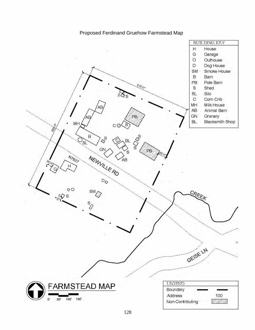
128
Proposed Ferdinand Gruehow Farmstead Map

129
Proposed Fred Hein Farmstead Narrative Description The proposed Fred Hein Farmstead is a well-defined cluster of 7 buildings and 3 structures situated in the far west central portion of the Town of Lake Mills and has boundaries roughly delineated along Kroghville Road just east of County Highway O. The farmstead began during the late-nineteenth century and was developed largely over the next half century. By consulting aerial photographs of the county taken around 1940, it is known that 6 outbuildings have been demolished, four of which occurred very recently, and 5 buildings have been added since that time. Representative of the prevailing architectural styles of their time and use, Queen Anne and Astylistic Utilitarian buildings are prominent within the farmstead. Statement of Significance The proposed Fred Hein Farmstead was identified for its concentration of residential and agricultural buildings and structures constructed primarily during the late-nineteenth and early twentieth centuries, having local significance under National Register Criterion C for Architecture. Utilizing the Wisconsin Historical Society’s Cultural Resource Management in Wisconsin, additional research centered on evaluating the resources within the farmstead utilizing the Architecture study unit of the aforementioned text. The farmstead is comprised of 8 contributing and 2 non-contributing resources. Boundary Description The proposed farmstead consists of portions of the property associated W9595 E. Kroghville Road around the contributing and non-contributing resources within the farmstead. The boundaries of the proposed Fred Hein Farmstead are clearly delineated on the accompanying farmstead map and enclose an area of 1.95 acres. Boundary Justification The boundaries of the proposed Fred Hein Farmstead enclose the area historically associated with the farmstead’s 8 contributing and 2 non-contributing resources. While adjacent areas are agricultural in nature, they were never developed and contain extraneous acreage. The result is a tight farmstead with as few non-contributing resources as possible. Resource Inventory The following inventory lists every resource in the proposed farmstead and includes the address of the property; the historic name; the date or circa date of construction; the style; and the resource’s contributing (C) or non-contributing (NC) class. Address Historic Name Date Style Class W9595 E. Kroghville Road Fred Hein Farmstead House < 1887 Queen Anne C W9595 E. Kroghville Road Fred Hein Farmstead Garage > 1940 Astylistic Utilitarian C W9595 E. Kroghville Road Fred Hein Farmstead Machine Shed < 1940 Astylistic Utilitarian NC

130
W9595 E. Kroghville Road Fred Hein Farmstead Barn < 1887 Astylistic Utilitarian C W9595 E. Kroghville Road Fred Hein Farmstead Pump House > 1940 NC W9595 E. Kroghville Road Fred Hein Farmstead Wind Mill > 1940 C W9595 E. Kroghville Road Fred Hein Farmstead Granary < 1887 Astylistic Utilitarian C W9595 E. Kroghville Road Fred Hein Farmstead Corn Crib < 1940 C W9595 E. Kroghville Road Fred Hein Farmstead Small Animal Barn > 1940 Astylistic Utilitarian C W9595 E. Kroghville Road Fred Hein Farmstead Small Animal Barn > 1940 Astylistic Utilitarian C

131
Proposed Fred Hein Farmstead Map

132
Proposed Fred Kassube Farmstead Narrative Description The proposed Fred Kassube Farmstead is a well-defined cluster of 11 buildings and 3 structures situated in the far north central portion of the Town of Lake Mills and has boundaries roughly delineated along Airport Road one-quarter mile east of Kuhl Road. The farmstead began around 1881 and was developed largely over the next half century. By consulting aerial photographs of the county taken around 1940, it is known that one barn and two smaller outbuildings have been demolished and the majority of the extant outbuildings constructed since that time. Representative of the prevailing architectural styles of their time and use, Gabled Ell and Astylistic Utilitarian buildings are prominent within the farmstead. Statement of Significance The proposed Fred Kassube Farmstead was identified for its concentration of residential and agricultural buildings and structures constructed primarily during the late-nineteenth and early twentieth century, having local significance under National Register Criterion C for Architecture. Utilizing the Wisconsin Historical Society’s Cultural Resource Management in Wisconsin, additional research centered on evaluating the resources within the farmstead utilizing the Architecture study unit of the aforementioned text. The farmstead is comprised of 8 contributing and 6 non-contributing resources. Boundary Description The proposed farmstead consists of portions of the property associated with W8739 Airport Road around the contributing and non-contributing resources within the farmstead. The boundaries of the proposed Fred Kassube Farmstead are clearly delineated on the accompanying farmstead map and enclose an area of 2.21 acres. Boundary Justification The boundaries of the proposed Fred Kassube Farmstead enclose the area historically associated with the farmstead’s 8 contributing and 6 non-contributing resources. While adjacent areas are agricultural in nature, they were never developed and contain extraneous acreage. The result is a tight farmstead with as few non-contributing resources as possible. Resource Inventory The following inventory lists every resource in the proposed farmstead and includes the address of the property; the historic name; the date or circa date of construction; the style; and the resource’s contributing (C) or non-contributing (NC) class. Address Historic Name Date Style Class W8739 Airport Road Fred Kassube Farmstead House c. 1881 Gabled Ell C W8739 Airport Road Fred Kassube Farmstead Garage > 1940 Astylistic Utilitarian C W8739 Airport Road Fred Kassube Farmstead Barn c. 1881 Astylistic Utilitarian C
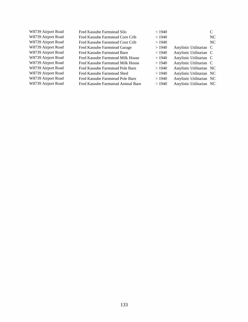
133
W8739 Airport Road Fred Kassube Farmstead Silo < 1940 C W8739 Airport Road Fred Kassube Farmstead Corn Crib > 1940 NC W8739 Airport Road Fred Kassube Farmstead Corn Crib > 1940 NC W8739 Airport Road Fred Kassube Farmstead Garage > 1940 Astylistic Utilitarian C W8739 Airport Road Fred Kassube Farmstead Barn < 1940 Astylistic Utilitarian C W8739 Airport Road Fred Kassube Farmstead Milk House > 1940 Astylistic Utilitarian C W8739 Airport Road Fred Kassube Farmstead Milk House > 1940 Astylistic Utilitarian C W8739 Airport Road Fred Kassube Farmstead Pole Barn > 1940 Astylistic Utilitarian NC W8739 Airport Road Fred Kassube Farmstead Shed > 1940 Astylistic Utilitarian NC W8739 Airport Road Fred Kassube Farmstead Pole Barn > 1940 Astylistic Utilitarian NC W8739 Airport Road Fred Kassube Farmstead Animal Barn > 1940 Astylistic Utilitarian NC

134
Proposed Fred Kassube Farmstead Map

135
Proposed T. R. Tasher Farmstead Narrative Description The proposed T. R. Tasher Farmstead is a well-defined cluster of 7 buildings and 3 structures situated in the southwest corner of the Town of Milford and has boundaries roughly delineated along County Highway A at the Rock Creek one-quarter mile east of Hoopers Mill Lane. The farmstead began around 1914 and was developed largely over the next several decades. By consulting aerial photographs of the county taken around 1940, it is known that one small shed has been demolished and six outbuildings constructed since that time. Representative of the prevailing architectural styles of their time and use, Dutch Colonial and Astylistic Utilitarian buildings are prominent within the farmstead. Statement of Significance The proposed T. R. Tasher Farmstead was identified for its concentration of residential and agricultural buildings and structures constructed primarily during early-twentieth century, having local significance under National Register Criterion C for Architecture. Utilizing the Wisconsin Historical Society’s Cultural Resource Management in Wisconsin, additional research centered on evaluating the resources within the farmstead utilizing the Architecture study unit of the aforementioned text. The farmstead is comprised of 6 contributing and 4 non-contributing resources. Boundary Description The proposed farmstead consists of portions of the property associated with W6951 County Highway A around the contributing and non-contributing resources within the farmstead. The boundaries of the proposed T. R. Tasher Farmstead are clearly delineated on the accompanying farmstead map and enclose an area of 4.41 acres. Boundary Justification The boundaries of the proposed T. R. Tasher Farmstead enclose the area historically associated with the farmstead’s 6 contributing and 4 non-contributing resources. While adjacent areas are agricultural in nature, they were never developed and contain extraneous acreage. The result is a tight farmstead with as few non-contributing resources as possible. Resource Inventory The following inventory lists every resource in the proposed farmstead and includes the address of the property; the historic name; the date or circa date of construction; the style; and the resource’s contributing (C) or non-contributing (NC) class. Address Historic Name Date Style Class W6951 County Highway A T. R. Tasher Farmstead House 1914 Dutch Colonial Rev. C W6951 County Highway A T. R. Tasher Farmstead Garage < 1940 Astylistic Utilitarian C W6951 County Highway A T. R. Tasher Farmstead Smokehouse > 1940 Astylistic Utilitarian C

136
W6951 County Highway A T. R. Tasher Farmstead Pole Barn > 1940 Astylistic Utilitarian NC W6951 County Highway A T. R. Tasher Farmstead Milk House < 1940 Astylistic Utilitarian C W6951 County Highway A T. R. Tasher Farmstead Silo < 1940 NC W6951 County Highway A T. R. Tasher Farmstead Silo > 1940 NC W6951 County Highway A T. R. Tasher Farmstead Silo > 1940 C W6951 County Highway A T. R. Tasher Farmstead Barn c. 1914 Astylistic Utilitarian C W6951 County Highway A T. R. Tasher Farmstead Pole Barn > 1940 Astylistic Utilitarian NC

137
Proposed T. R. Tasher Farmstead Map

138
Proposed Wegner Farmstead Narrative Description The proposed Wegner Farmstead is a well-defined cluster of 7 buildings and 1 structure situated in the southeast corner of the Town of Milford and has boundaries roughly delineated along the bend in Church Road between Finder Road and Nielson Lane. The farmstead began during the mid-to-late nineteenth century and was developed over the next half century. By consulting aerial photographs of the county taken around 1940, it is known that all of the extant buildings were constructed by that time, and that no outbuildings have been demolished since that time. Representative of the prevailing architectural styles of their time and use, Side Gabled and Astylistic Utilitarian buildings are prominent within the farmstead. Statement of Significance The proposed Wegner Farmstead was identified for its concentration of residential and agricultural buildings and structure constructed primarily during the mid- to-late-nineteenth and early-twentieth centuries, having local significance under National Register Criterion C for Architecture. Utilizing the Wisconsin Historical Society’s Cultural Resource Management in Wisconsin, additional research centered on evaluating the resources within the farmstead utilizing the Architecture study unit of the aforementioned text. The farmstead is comprised of 8 contributing and no non-contributing resources. Boundary Description The proposed farmstead consists of portions of the property associated with W5884 Church Road around the contributing resources within the farmstead. The boundaries of the proposed Wegner Farmstead are clearly delineated on the accompanying farmstead map and enclose an area of 1.98 acres. Boundary Justification The boundaries of the proposed Wegner Farmstead enclose all the areas historically associated with the farmstead’s 8 contributing resources. While adjacent areas are agricultural in nature, they were never developed within the farmstead’s period of significance, do not maintain the historic integrity of the resources contained within the farmstead, or are not associated with the Wegner family. The result is a tight farmstead with as few non-contributing resources as possible. Resource Inventory The following inventory lists every resource in the proposed farmstead and includes the address of the property; the historic name; the date or circa date of construction; the style; and the resource’s contributing (C) class. Address Historic Name Date Style Class W5884 Church Road Wegner Farmstead House < 1887 Side Gabled C

139
W5884 Church Road Wegner Farmstead Smokehouse < 1887 Astylistic Utilitarian C W5884 Church Road Wegner Farmstead Outhouse < 1887 Astylistic Utilitarian C W5884 Church Road Wegner Farmstead Barn < 1940 Astylistic Utilitarian C W5884 Church Road Wegner Farmstead Barn < 1887 Astylistic Utilitarian C W5884 Church Road Wegner Farmstead Barn < 1940 Astylistic Utilitarian C W5884 Church Road Wegner Farmstead Pump House < 1887 C W5884 Church Road Wegner Farmstead Machine Shed < 1940 Astylistic Utilitarian C

140
Proposed Wegner Farmstead Map

141
Proposed C. H. Wollin Farmstead Narrative Description The proposed C. H. Wollin Farmstead is a well-defined cluster of 7 buildings situated in the southeast corner of the Town of Milford and has boundaries roughly delineated along Church Road at Finder Road. The farmstead began around 1881 and was developed over the next half century. By consulting aerial photographs of the county taken around 1940, it is known that all of the extant buildings were constructed by that time, and that no outbuildings have been demolished since that time. Representative of the prevailing architectural styles of their time and use, Cross Gabled and Astylistic Utilitarian buildings are prominent within the farmstead. Statement of Significance The proposed C. H. Wollin Farmstead was identified for its concentration of residential and agricultural buildings constructed primarily during late-nineteenth and early-twentieth centuries, having local significance under National Register Criterion C for Architecture. Utilizing the Wisconsin Historical Society’s Cultural Resource Management in Wisconsin, additional research centered on evaluating the resources within the farmstead utilizing the Architecture study unit of the aforementioned text. The farmstead is comprised of 6 contributing and 1 non-contributing resources. Boundary Description The proposed farmstead consists of portions of the property associated with W5821 Church Road around the contributing and non-contributing resources within the farmstead. The boundaries of the proposed C. H. Wollin Farmstead are clearly delineated on the accompanying farmstead map and enclose an area of 4.33 acres. Boundary Justification The boundaries of the proposed C. H. Wollin Farmstead enclose the area historically associated with the farmstead’s 6 contributing and 1 non-contributing resources. While adjacent areas are agricultural in nature, they were never developed and contain extraneous acreage. The result is a tight farmstead with as few non-contributing resources as possible. Resource Inventory The following inventory lists every building in the proposed farmstead and includes the address of the property; the historic name; the date or circa date of construction; the style; and the resource’s contributing (C) or non-contributing (NC) class. Address Historic Name Date Style Class W5821 Church Road C. H. Wollin Farmstead House c. 1881 Cross Gabled C W5821 Church Road C. H. Wollin Farmstead Horse Barn < 1940 Astylistic Utilitarian NC W5821 Church Road C. H. Wollin Farmstead Smokehouse c. 1881 Astylistic Utilitarian C W5821 Church Road C. H. Wollin Farmstead Garage < 1940 Astylistic Utilitarian C

142
W5821 Church Road C. H. Wollin Farmstead Machine Shed < 1940 Astylistic Utilitarian C W5821 Church Road C. H. Wollin Farmstead Barn c. 1881 Astylistic Utilitarian C W5821 Church Road C. H. Wollin Farmstead Shed c. 1881 Astylistic Utilitarian C

143
Proposed C. H. Wollin Farmstead Map

144
Resources Included in this Survey Town Address Historic Name Date Style Aztalan W5150 County Highway B William Kelling House 1880 Gabled Ell Aztalan W5517 County Highway B Christian & Louise Mantz House c. 1876 Gabled Ell Aztalan W6076 County Highway B Charles F. & Ida M. Greenwood House 1874 Gabled Ell Aztalan W6260 County Highway B Aztalan Town Hall & Highway Shop c. 1937 20th C. Commercial Aztalan N5183 County Highway N F. A. Kluck House 1900 Gabled Ell Aztalan N5595 County Highway N Union School 1890 Greek Revival Aztalan N5796 County Highway Q Bernard & Christine Motl Octagon Barn c. 2001 Astylistic Utilitarian Aztalan N6273 County Highway Q Aztalan School 1918 Front Gabled Aztalan W7210 County Highway V Neuendorf House c. 1860 Gabled Ell Aztalan N5393 Felsen Ridge Court William F. Hue & Laura F. Challoner House 1992 Contemporary Aztalan N5726 Harvey Road Alexander R. & Louisa Earle House c. 1857 Italianate Aztalan N5923 Harvey Road George Ryder House 1880 Gabled Ell Aztalan W7205 Hope Lake Road J. H. Smith House 1850 Two -Story Cube Aztalan N5593 Indian Head Drive C. Lang House c. 1875 Gabled Ell Aztalan N5921 Jefferson Road John Kohl House c. 1894 Queen Anne Aztalan N5984 Jefferson Road John Kohl House 1880 Front Gabled Aztalan N6017 Jefferson Road Charles Talbot House 1900 Cross Gabled Aztalan N6065 Jefferson Road Charles Talbot House 1900 Gabled Ell Aztalan N5355 Junction Road Ladish Stoppenbach Co. Malt Silos < 1941 Aztalan N4938 Martin Road Fred M. & Wanda Kramer House 1968 Ranch Aztalan W6526 Oestreich Lane William Kuehn House 1880 Gabled Ell Aztalan W5743 Olszewski Lane Louis Seigmann Barn c. 1884 Astylistic Utilitarian Aztalan W5743 Olszewski Lane Louis Seigmann Garage Astylistic Utilitarian Aztalan W5743 Olszewski Lane Louis Seigmann House c. 1884 Gabled Ell Aztalan N5207 State Highway 89 Smith House-Barn < 1887 Other Vernacular Aztalan N5696 Ziebell Road Ignatz Pitterle House c. 1892 Two -Story Cube Aztalan N6314 Ziebell Road August Zupke House 1900 Queen Anne Lake Mills W8739 Airport Road Fred Kassube Farmstead House c. 1881 Gabled Ell Lake Mills W8739 Airport Road Fred Kassube Farmstead Garage > 1940 Astylistic Utilitarian Lake Mills W8739 Airport Road Fred Kassube Farmstead Barn c. 1881 Astylistic Utilitarian Lake Mills W8739 Airport Road Fred Kassube Farmstead Silo < 1940 Lake Mills W8739 Airport Road Fred Kassube Farmstead Corn Crib > 1940 Lake Mills W8739 Airport Road Fred Kassube Farmstead Corn Crib > 1940 Lake Mills W8739 Airport Road Fred Kassube Farmstead Garage > 1940 Astylistic Utilitarian Lake Mills W8739 Airport Road Fred Kassube Farmstead Barn < 1940 Astylistic Utilitarian Lake Mills W8739 Airport Road Fred Kassube Farmstead Milk House > 1940 Astylistic Utilitarian Lake Mills W8739 Airport Road Fred Kassube Farmstead Milk House > 1940 Astylistic Utilitarian Lake Mills W8739 Airport Road Fred Kassube Farmstead Pole Barn > 1940 Astylistic Utilitarian Lake Mills W8739 Airport Road Fred Kassube Farmstead Shed > 1940 Astylistic Utilitarian Lake Mills W8739 Airport Road Fred Kassube Farmstead Pole Barn > 1940 Astylistic Utilitarian Lake Mills W8739 Airport Road Fred Kassube Farmstead Animal Barn > 1940 Astylistic Utilitarian Lake Mills W9640 Bridge Street Casper & Catharine Krogh House 1859 Greek Revival Lake Mills N5002 County Highway A Gustave Schultz House 1920 American Foursquare Lake Mills 6703 County Highway B House < 1899 Queen Anne Lake Mills W7958 County Highway B John & Adeline Scholl House 1946 Colonial Revival Lake Mills W7994 County Highway B Charles S. & Minerva Greenwood House 1900 Dutch Colonial Rev. Lake Mills W8576 County Highway B Herman W. Prochnow House c. 1918 Dutch Colonial Rev.

145
Lake Mills W9520 County Highway B William Kuhlow House 1949 Colonial Revival Lake Mills N5568 County Highway O House < 1899 Gabled Ell Lake Mills N5576 County Highway O House < 1899 Gabled Ell Lake Mills N5706 County Highway S Brick Street School 1876 Front Gabled Lake Mills N6175 County Highway S Fred Strasburg House c. 1877 Other Vernacular Lake Mills N6226 County Highway S House 1848 Side Gabled Lake Mills N6685 County Highway S Cheese Factory c. 1887 Side Gabled Lake Mills W8135 Elm Point Road Joyce S. McGovern Cottage 1955 One-Story Cube Lake Mills W8147 Elm Point Road John & Myrtle Spangenburg Cottage 1954 Contemporary Lake Mills W9595 E. Kroghville Road Fred Hein Farmstead House < 1887 Queen Anne Lake Mills W9595 E. Kroghville Road Fred Hein Farmstead Garage > 1940 Astylistic Utilitarian Lake Mills W9595 E. Kroghville Road Fred Hein Farmstead Machine Shed < 1940 Astylistic Utilitarian Lake Mills W9595 E. Kroghville Road Fred Hein Farmstead Barn < 1887 Astylistic Utilitarian Lake Mills W9595 E. Kroghville Road Fred Hein Farmstead Pump House > 1940 Lake Mills W9595 E. Kroghville Road Fred Hein Farmstead Wind Mill > 1940 Lake Mills W9595 E. Kroghville Road Fred Hein Farmstead Granary < 1887 Astylistic Utilitarian Lake Mills W9595 E. Kroghville Road Fred Hein Farmstead Corn Crib < 1940 Lake Mills W9595 E. Kroghville Road Fred Hein Farmstead Small Animal Barn > 1940 Astylistic Utilitarian Lake Mills W9595 E. Kroghville Road Fred Hein Farmstead Small Animal Barn > 1940 Astylistic Utilitarian Lake Mills N6993 Lake View Road House Front Gabled Lake Mills N5526 State Highway 134 Automobile Showroom 20th C. Commercial Lake Mills N5697 State Highway 89 Everett & Marion Borck Garage 1950 20th C. Commercial Milford W5588 Albers Lane Fred Brandel House c. 1875 Gabled Ell Milford W5412 Church Road Henry J. & Emma Stark House c. 1870 Gabled Ell Milford W5821 Church Road C. H. Wollin Farmstead House c. 1881 Cross Gabled Milford W5821 Church Road C. H. Wollin Farmstead Horse Barn < 1940 Astylistic Utilitarian Milford W5821 Church Road C. H. Wollin Farmstead Smokehouse c. 1881 Astylistic Utilitarian Milford W5821 Church Road C. H. Wollin Farmstead Garage < 1940 Astylistic Utilitarian Milford W5821 Church Road C. H. Wollin Farmstead Machine Shed < 1940 Astylistic Utilitarian Milford W5821 Church Road C. H. Wollin Farmstead Barn c. 1881 Astylistic Utilitarian Milford W5821 Church Road C. H. Wollin Farmstead Shed c. 1881 Astylistic Utilitarian Milford W5884 Church Road Wegner Farmstead House < 1887 Side Gabled Milford W5884 Church Road Wegner Farmstead Smokehouse < 1887 Astylistic Utilitarian Milford W5884 Church Road Wegner Farmstead Outhouse < 1887 Astylistic Utilitarian Milford W5884 Church Road Wegner Farmstead Barn < 1940 Astylistic Utilitarian Milford W5884 Church Road Wegner Farmstead Barn < 1887 Astylistic Utilitarian Milford W5884 Church Road Wegner Farmstead Barn < 1940 Astylistic Utilitarian Milford W5884 Church Road Wegner Farmstead Pump House < 1887 Milford W5884 Church Road Wegner Farmstead Machine Shed < 1940 Astylistic Utilitarian Milford N7628 County Highway A John Daughs House < 1887 Cross Gabled Milford W6330 County Highway A Schneider House Gabled Ell Milford W6394 County Highway A Charles Gallitz Garage c. 1938 20th C. Commercial Milford W6466 County Highway A House Front Gabled Milford W6480 County Highway A Milford State Graded School 1870 Romanesque Rev. Milford W6772 County Highway A John G. Wollin House c. 1884 Queen Anne Milford W6951 County Highway A T. R. Tasher Farmstead House 1914 Dutch Colonial Rev. Milford W6951 County Highway A T. R. Tasher Farmstead Garage < 1940 Astylistic Utilitarian Milford W6951 County Highway A T. R. Tasher Farmstead Smokehouse > 1940 Astylistic Utilitarian Milford W6951 County Highway A T. R. Tasher Farmstead Pole Barn > 1940 Astylistic Utilitarian Milford W6951 County Highway A T. R. Tasher Farmstead Milk House < 1940 Astylistic Utilitarian

146
Milford W6951 County Highway A T. R. Tasher Farmstead Silo < 1940 Milford W6951 County Highway A T. R. Tasher Farmstead Silo > 1940 Milford W6951 County Highway A T. R. Tasher Farmstead Silo > 1940 Milford W6951 County Highway A T. R. Tasher Farmstead Barn c. 1914 Astylistic Utilitarian Milford W6951 County Highway A T. R. Tasher Farmstead Pole Barn > 1940 Astylistic Utilitarian Milford N7060 County Highway N Stark Animal Barn < 1887 Astylistic Utilitarian Milford N7201 County Highway N Rock River Valley School 1881 Front Gabled Milford N7565 County Highway N Arthur Lenz House 1923 American Foursquare Milford N7870 County Highway N Waskoske House < 1887 Cross Gabled Milford N7954 County Highway N House 1901 Gabled Ell Milford N6810 County Highway Q Mark R. Clapp House < 1887 Front Gabled Milford N7396 County Highway Q Herbert Watson Gallup House 1922 Bungalow Milford N9045 County Highway Q Fred & Minnie Albrecht House c. 1891 Queen Anne Milford W5592 Finder Road Ferdinand Wendt House c. 1879 Gabled Ell Milford W5661 Finder Road Julius Zeibell House < 1887 Gabled Ell Milford N7510 French Road Alder Grove School 1916 Front Gabled Milford N6920 Hoopers Mill Lane Hooper Mill 1847 Astylistic Utilitarian Milford W6885 Hoopers Mill Lane House < 1887 Gabled Ell Milford W6649 E. Hubbleton Road Fred Schultz House c. 1887 Gabled Ell Milford W7055 Main Street Hubbleton State Bank 1919 20th C. Commercial Milford N7280 Manske Road Drake House < 1887 Italianate Milford W7259 State Highway 19 Hubbleton School 1926 American Craftsman Milford N8039 Trieloff Drive Ferdinand Krueger House Side Gabled Milford N8472 West Road William Funk House c. 1866 Gabled Ell Milford W6607 Wollin Road John Mansfield House 1934 Side Gabled Waterloo N7585 Airport Road Ewald Korth House c. 1916 Dutch Colonial Rev. Waterloo N7609 Airport Road Stony Brook School < 1887 Front Gabled Waterloo N7557 County Highway G Alpheus D. Faville Farmstead House < 1887 Front Gabled Waterloo N7563 County Highway G Alpheus D. Faville Farmstead Silo < 1887 Waterloo N7563 County Highway G Alpheus D. Faville Farmstead Corn Crib > 1940 Waterloo N7563 County Highway G Alpheus D. Faville Farmstead House < 1887 Gabled Ell Waterloo N7563 County Highway G Alpheus D. Faville Farmstead Barn < 1940 Astylistic Utilitarian Waterloo N7563 County Highway G Alpheus D. Faville Farmstead Wind Mill < 1940 Waterloo N7563 County Highway G Alpheus D. Faville Farmstead Milk House < 1940 Astylistic Utilitarian Waterloo N7563 County Highway G Alpheus D. Faville Farmstead Barn < 1940 Astylistic Utilitarian Waterloo N7597 County Highway G Alpheus D. Faville Farmstead House < 1899 Gabled Ell Waterloo N7606 County Highway G Elijah Faville Farmstead House < 1887 Gabled Ell Waterloo N7606 County Highway G Elijah Faville Farmstead Garage > 1940 Astylistic Utilitarian Waterloo N7606 County Highway G Elijah Faville Farmstead Horse Barn > 1940 Astylistic Utilitarian Waterloo N8139 County Highway G Joseph Hannah House < 1887 Greek Revival Waterloo N7477 County Highway O House Side Gabled Waterloo W8333 Doepke Road Bruce A. Hoffland House 1966 Geodesic Dome Waterloo N7469 Faville Road Rosenberg House < 1887 Greek Revival Waterloo W7602 Island Church Road Mary Allen House c. 1910 American Foursquare Waterloo W8144 Island Road Klecker House < 1966 Geodesic Dome Waterloo W8657 Michel Lane Tobias Kurtz House c. 1875 Other Vernacular Waterloo N7927 Newville Road Ferdinand Gruehow Farmstead House < 1887 Gabled Ell Waterloo N7927 Newville Road Ferdinand Gruehow Farmstead Garage > 1940 Astylistic Utilitarian Waterloo N7927 Newville Road Ferdinand Gruehow Farmstead Dog House > 1940 Waterloo N7927 Newville Road Ferdinand Gruehow Farmstead Smokehouse > 1940 Astylistic Utilitarian
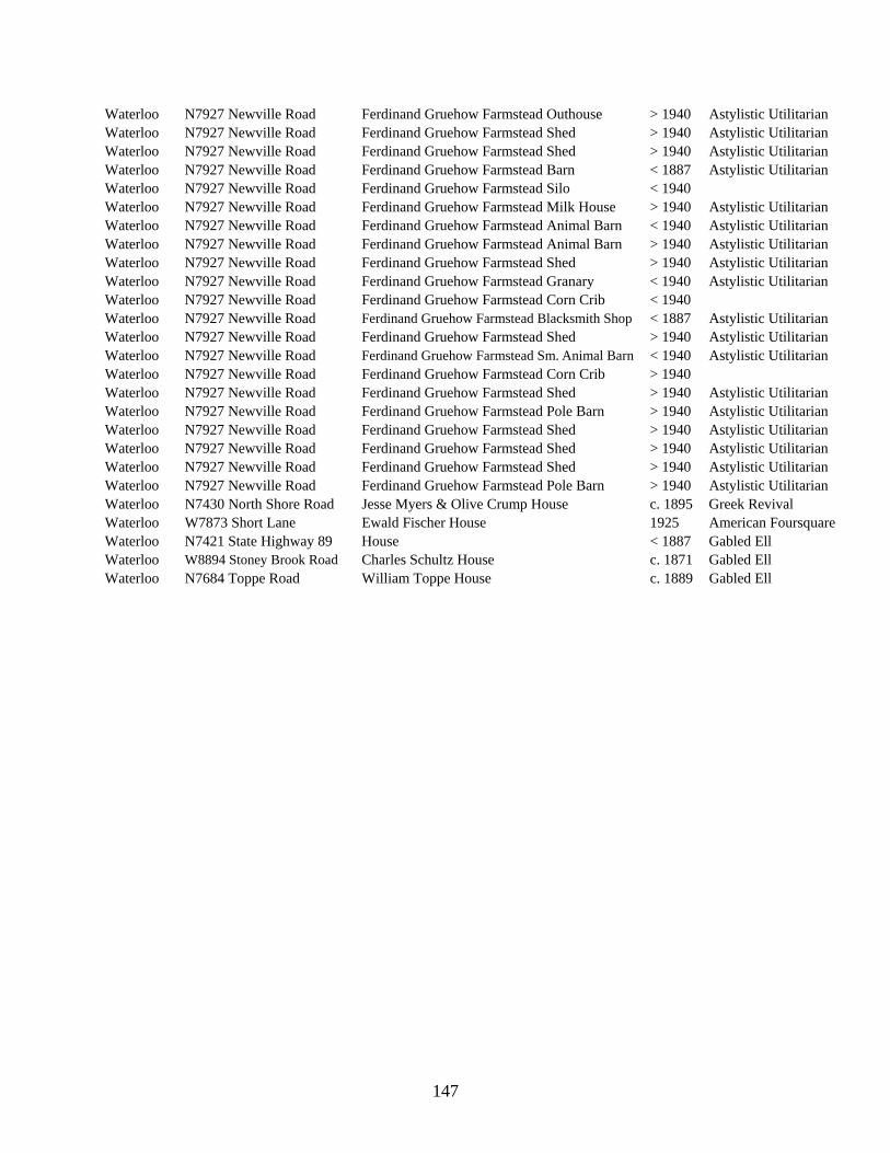
147
Waterloo N7927 Newville Road Ferdinand Gruehow Farmstead Outhouse > 1940 Astylistic Utilitarian Waterloo N7927 Newville Road Ferdinand Gruehow Farmstead Shed > 1940 Astylistic Utilitarian Waterloo N7927 Newville Road Ferdinand Gruehow Farmstead Shed > 1940 Astylistic Utilitarian Waterloo N7927 Newville Road Ferdinand Gruehow Farmstead Barn < 1887 Astylistic Utilitarian Waterloo N7927 Newville Road Ferdinand Gruehow Farmstead Silo < 1940 Waterloo N7927 Newville Road Ferdinand Gruehow Farmstead Milk House > 1940 Astylistic Utilitarian Waterloo N7927 Newville Road Ferdinand Gruehow Farmstead Animal Barn < 1940 Astylistic Utilitarian Waterloo N7927 Newville Road Ferdinand Gruehow Farmstead Animal Barn > 1940 Astylistic Utilitarian Waterloo N7927 Newville Road Ferdinand Gruehow Farmstead Shed > 1940 Astylistic Utilitarian Waterloo N7927 Newville Road Ferdinand Gruehow Farmstead Granary < 1940 Astylistic Utilitarian Waterloo N7927 Newville Road Ferdinand Gruehow Farmstead Corn Crib < 1940 Waterloo N7927 Newville Road Ferdinand Gruehow Farmstead Blacksmith Shop < 1887 Astylistic Utilitarian Waterloo N7927 Newville Road Ferdinand Gruehow Farmstead Shed > 1940 Astylistic Utilitarian Waterloo N7927 Newville Road Ferdinand Gruehow Farmstead Sm. Animal Barn < 1940 Astylistic Utilitarian Waterloo N7927 Newville Road Ferdinand Gruehow Farmstead Corn Crib > 1940 Waterloo N7927 Newville Road Ferdinand Gruehow Farmstead Shed > 1940 Astylistic Utilitarian Waterloo N7927 Newville Road Ferdinand Gruehow Farmstead Pole Barn > 1940 Astylistic Utilitarian Waterloo N7927 Newville Road Ferdinand Gruehow Farmstead Shed > 1940 Astylistic Utilitarian Waterloo N7927 Newville Road Ferdinand Gruehow Farmstead Shed > 1940 Astylistic Utilitarian Waterloo N7927 Newville Road Ferdinand Gruehow Farmstead Shed > 1940 Astylistic Utilitarian Waterloo N7927 Newville Road Ferdinand Gruehow Farmstead Pole Barn > 1940 Astylistic Utilitarian Waterloo N7430 North Shore Road Jesse Myers & Olive Crump House c. 1895 Greek Revival Waterloo W7873 Short Lane Ewald Fischer House 1925 American Foursquare Waterloo N7421 State Highway 89 House < 1887 Gabled Ell Waterloo W8894 Stoney Brook Road Charles Schultz House c. 1871 Gabled Ell Waterloo N7684 Toppe Road William Toppe House c. 1889 Gabled Ell

148
This page intentionally left blank.

36
1
1
3635
2
0221545
0221543
0221544
ROCK
RIVER
VILLAGE OF JOHNSON CREEK
C
O
U
N
T
Y
H
I
G
H
W
A
Y
N
F
I
N
D
E
R
R
D
ERB WRENSCH LN
DRAWN BY
CHECKED BY
DATE
PROJECT NUMBER
SHEET TITLE
SHEET NUMBER
RE
VIS
IO
NS
NO
.D
AT
E
PH
AS
E 2
S
UR
VE
Y M
AP
S F
OR
:
NO
RT
HW
ES
T Q
UA
DR
AN
T O
F
JE
FF
ER
SO
N C
OU
NT
Y, W
IS
CO
NS
IN
AR
CH
IT
EC
TU
RA
L &
H
IS
TO
RIC
AL
IN
TE
NS
IV
E S
UR
VE
Y
52
9 O
nta
rio
A
ve
nu
e
Sh
eb
oyg
an
, W
isco
nsin
5
30
81
(9
20
) 7
83
-6
30
3
ww
w.le
ga
cy-a
rch
ite
ctu
re
.co
m
A1-2
PARTIAL SURVEY MAP
LEGENDMunicipal Limits
AHI Number 1000000
Section LineSection Numbers
1 2
3 4

10
34
9
11
23
10
0221546
0221547
CHURCH RD
CHURCH RDFINDER RD
BU
DIG
L
N
C
O
U
N
T
Y
H
I
G
H
W
A
Y
A
SO
UT
H L
N
CH
UR
CH
R
D
SALEM
CEMETERY
0221548
0221549
0221551,
0221553
0221554
0221550,
0221552
0221558
0221559
0221560,
0221561,
0221562
0221556
0221555
0221557
DRAWN BY
CHECKED BY
DATE
PROJECT NUMBER
SHEET TITLE
SHEET NUMBER
RE
VIS
IO
NS
NO
.D
AT
E
PH
AS
E 2
S
UR
VE
Y M
AP
S F
OR
:
NO
RT
HW
ES
T Q
UA
DR
AN
T O
F
JE
FF
ER
SO
N C
OU
NT
Y, W
IS
CO
NS
IN
AR
CH
IT
EC
TU
RA
L &
H
IS
TO
RIC
AL
IN
TE
NS
IV
E S
UR
VE
Y
52
9 O
nta
rio
A
ve
nu
e
Sh
eb
oyg
an
, W
isco
nsin
5
30
81
(9
20
) 7
83
-6
30
3
ww
w.le
ga
cy-a
rch
ite
ctu
re
.co
m
A2-3
PARTIAL SURVEY MAP
LEGENDMunicipal Limits
AHI Number 1000000
Section LineSection Numbers
1 2
3 4

3
3433
4
4
3332
5
349
45
8
0119891
0119888
0119890
0119889
0119887
0006621
0119892
0006622
0221564
0221563
C
R
A
W
F
I
S
H
C
O
U
N
T
Y
H
I
G
H
W
A
Y
A
ZIE
BE
LL R
D
CO
UN
TY
H
IG
HW
AY
Q
N WOLLIN RD
KA
ST
EN
R
D
KASTEN RD
CO
UN
TY
H
IG
HW
AY
Q
MA
NS
KE
R
D
CO
UN
TY
H
IG
HW
AY
Q
C
H
U
R
C
H
R
D
C
R
A
W
F
I
S
H
R
I
V
E
R
R
I
V
E
R
DRAWN BY
CHECKED BY
DATE
PROJECT NUMBER
SHEET TITLE
SHEET NUMBER
RE
VIS
IO
NS
NO
.D
AT
E
PH
AS
E 2
S
UR
VE
Y M
AP
S F
OR
:
NO
RT
HW
ES
T Q
UA
DR
AN
T O
F
JE
FF
ER
SO
N C
OU
NT
Y, W
IS
CO
NS
IN
AR
CH
IT
EC
TU
RA
L &
H
IS
TO
RIC
AL
IN
TE
NS
IV
E S
UR
VE
Y
52
9 O
nta
rio
A
ve
nu
e
Sh
eb
oyg
an
, W
isco
nsin
5
30
81
(9
20
) 7
83
-6
30
3
ww
w.le
ga
cy-a
rch
ite
ctu
re
.co
m
A4-5
PARTIAL SURVEY MAP
LEGENDMunicipal Limits
AHI Number 1000000
Section LineSection Numbers
1 2
3 4

6
3136
1
5
3231
6
7
61
12
8
56
7
0006623
0221565
R
O
C
K
M
I
L
F
O
R
D
MA
NS
KE
R
D
M
I
L
L
R
D
C
O
U
N
T
Y
H
IG
H
W
A
Y
A
WEBER RD
FA
VILLE
R
D
C
R
A
W
F
I
S
H
R
I
V
E
R
0221566
0221655
0221567
0221568
0221569
0221570
0221571,
0221572,
0221654
0221879
C
R
E
E
K
CITY OF
LAKE MILLS
DRAWN BY
CHECKED BY
DATE
PROJECT NUMBER
SHEET TITLE
SHEET NUMBER
RE
VIS
IO
NS
NO
.D
AT
E
PH
AS
E 2
S
UR
VE
Y M
AP
S F
OR
:
NO
RT
HW
ES
T Q
UA
DR
AN
T O
F
JE
FF
ER
SO
N C
OU
NT
Y, W
IS
CO
NS
IN
AR
CH
IT
EC
TU
RA
L &
H
IS
TO
RIC
AL
IN
TE
NS
IV
E S
UR
VE
Y
52
9 O
nta
rio
A
ve
nu
e
Sh
eb
oyg
an
, W
isco
nsin
5
30
81
(9
20
) 7
83
-6
30
3
ww
w.le
ga
cy-a
rch
ite
ctu
re
.co
m
A5-6
PARTIAL SURVEY MAP
LEGENDMunicipal Limits
AHI Number 1000000
Section LineSection Numbers
1 2
3 4

18
712
13
7
61
12
17
87
18
8
56
7
0094901
0094902
HOOPERS
MILLPOND 16
M
I
L
L
R
D
WEBER RD
C
O
U
N
T
Y
H
I
G
H
W
A
Y
A
C
E
M
E
T
E
R
Y
R
D
MA
NS
KE
R
D
C
O
U
N
T
Y
H
I
G
H
W
A
Y
V
I-94
AZTALAN
CEMETERY
0221879
CO
UN
TY
H
IG
HW
AY
Q
GO
MO
LL R
D
CO
UN
TY
H
IG
HW
AY
Q
CITY OF
LAKE MILLS
DRAWN BY
CHECKED BY
DATE
PROJECT NUMBER
SHEET TITLE
SHEET NUMBER
RE
VIS
IO
NS
NO
.D
AT
E
PH
AS
E 2
S
UR
VE
Y M
AP
S F
OR
:
NO
RT
HW
ES
T Q
UA
DR
AN
T O
F
JE
FF
ER
SO
N C
OU
NT
Y, W
IS
CO
NS
IN
AR
CH
IT
EC
TU
RA
L &
H
IS
TO
RIC
AL
IN
TE
NS
IV
E S
UR
VE
Y
52
9 O
nta
rio
A
ve
nu
e
Sh
eb
oyg
an
, W
isco
nsin
5
30
81
(9
20
) 7
83
-6
30
3
ww
w.le
ga
cy-a
rch
ite
ctu
re
.co
m
A7-8
PARTIAL SURVEY MAP
LEGENDMunicipal Limits
AHI Number 1000000
Section LineSection Numbers
1 2
3 4

10
34
9
9
45
8
109
16
98
17
0221574
C
R
A
W
F
I
S
H
R
I
V
E
R
MA
NS
KE
R
D
C
E
M
E
T
E
R
Y
R
D
MA
NS
KE
R
D
KLEIN LN
I-94
ZIE
BE
LL
AZTALAN
CEMETERY
C
O
U
N
T
Y
H
I
G
H
W
A
Y
Q
ZIE
BE
LL R
D
GO
MO
LL R
D
CO
UN
TY
H
IG
HW
AY
Q
R
D
DRAWN BY
CHECKED BY
DATE
PROJECT NUMBER
SHEET TITLE
SHEET NUMBER
RE
VIS
IO
NS
NO
.D
AT
E
PH
AS
E 2
S
UR
VE
Y M
AP
S F
OR
:
NO
RT
HW
ES
T Q
UA
DR
AN
T O
F
JE
FF
ER
SO
N C
OU
NT
Y, W
IS
CO
NS
IN
AR
CH
IT
EC
TU
RA
L &
H
IS
TO
RIC
AL
IN
TE
NS
IV
E S
UR
VE
Y
52
9 O
nta
rio
A
ve
nu
e
Sh
eb
oyg
an
, W
isco
nsin
5
30
81
(9
20
) 7
83
-6
30
3
ww
w.le
ga
cy-a
rch
ite
ctu
re
.co
m
A8-9
PARTIAL SURVEY MAP
LEGENDMunicipal Limits
AHI Number 1000000
Section LineSection Numbers
1 2
3 4

10
3
11
23
10
14
1110
1515
10
0221575
I-94
CHURCH RD
BU
DIG
L
N
SO
UT
H L
N
REINDERS RD
ON A HILL LN
OLSZEWSKI LN
ALB
ER
S L
N
C
O
U
N
T
Y
H
I
G
H
W
A
Y
N
CH
UR
CH
R
D
VESPER LN
DRAWN BY
CHECKED BY
DATE
PROJECT NUMBER
SHEET TITLE
SHEET NUMBER
RE
VIS
IO
NS
NO
.D
AT
E
PH
AS
E 2
S
UR
VE
Y M
AP
S F
OR
:
NO
RT
HW
ES
T Q
UA
DR
AN
T O
F
JE
FF
ER
SO
N C
OU
NT
Y, W
IS
CO
NS
IN
AR
CH
IT
EC
TU
RA
L &
H
IS
TO
RIC
AL
IN
TE
NS
IV
E S
UR
VE
Y
52
9 O
nta
rio
A
ve
nu
e
Sh
eb
oyg
an
, W
isco
nsin
5
30
81
(9
20
) 7
83
-6
30
3
ww
w.le
ga
cy-a
rch
ite
ctu
re
.co
m
A10-11
PARTIAL SURVEY MAP
LEGENDMunicipal Limits
AHI Number 1000000
Section LineSection Numbers
1 2
3 4

13
1211
14
12
13
24
1314
23
13
24
0221486
0006625
R
O
C
K
R
I
V
E
R
JO
HN
SO
N
C
H
IC
A
G
O
&
N
O
R
T
H
W
E
S
T
E
R
N
R
A
IL
R
O
A
D
ST
ON
EF
IE
LD
D
R
BOUTELLE LN WEST ST
GO
SD
EC
K LN
J
E
F
F
E
R
S
O
N
R
D
CO
UN
TY
H
IG
HW
AY
N
ROCK
RIVER
PARK
ST. MARY
MAGDALENE
CATHOLIC
CEMETERY
C
R
E
E
K
VILLAGE OF
JOHNSON
CREEK
DRAWN BY
CHECKED BY
DATE
PROJECT NUMBER
SHEET TITLE
SHEET NUMBER
RE
VIS
IO
NS
NO
.D
AT
E
PH
AS
E 2
S
UR
VE
Y M
AP
S F
OR
:
NO
RT
HW
ES
T Q
UA
DR
AN
T O
F
JE
FF
ER
SO
N C
OU
NT
Y, W
IS
CO
NS
IN
AR
CH
IT
EC
TU
RA
L &
H
IS
TO
RIC
AL
IN
TE
NS
IV
E S
UR
VE
Y
52
9 O
nta
rio
A
ve
nu
e
Sh
eb
oyg
an
, W
isco
nsin
5
30
81
(9
20
) 7
83
-6
30
3
ww
w.le
ga
cy-a
rch
ite
ctu
re
.co
m
A13-14
PARTIAL SURVEY MAP
LEGENDMunicipal Limits
AHI Number 1000000
Section LineSection Numbers
1 2
3 4

14
1110
1515
109
16
22
1516
21
23
1415
22
0088750
0221486
REINDERS RD
SIE
GM
AN
N R
D
PIR
KE
L LN
COUNTY HIGHWAY B
CO
UN
TY
H
IG
HW
AY
N
C
O
U
N
T
Y
H
IG
H
W
A
Y
N
DRAWN BY
CHECKED BY
DATE
PROJECT NUMBER
SHEET TITLE
SHEET NUMBER
RE
VIS
IO
NS
NO
.D
AT
E
PH
AS
E 2
S
UR
VE
Y M
AP
S F
OR
:
NO
RT
HW
ES
T Q
UA
DR
AN
T O
F
JE
FF
ER
SO
N C
OU
NT
Y, W
IS
CO
NS
IN
AR
CH
IT
EC
TU
RA
L &
H
IS
TO
RIC
AL
IN
TE
NS
IV
E S
UR
VE
Y
52
9 O
nta
rio
A
ve
nu
e
Sh
eb
oyg
an
, W
isco
nsin
5
30
81
(9
20
) 7
83
-6
30
3
ww
w.le
ga
cy-a
rch
ite
ctu
re
.co
m
A14-15
PARTIAL SURVEY MAP
LEGENDMunicipal Limits
AHI Number 1000000
Section LineSection Numbers
1 2
3 4

16
98
17
21
1617
20
16
21
0006631
0221483
0221484
C
R
A
W
F
IS
H
R
IV
E
R
C
O
U
N
T
Y
H
IG
H
W
A
Y
B
ZIE
BE
LL R
D
GO
MO
LL R
D
AZTALAN
STATE PARK
CO
UN
TY
H
IG
HW
AY
Q
0006628
0006627
0006629
0006626
DRAWN BY
CHECKED BY
DATE
PROJECT NUMBER
SHEET TITLE
SHEET NUMBER
RE
VIS
IO
NS
NO
.D
AT
E
PH
AS
E 2
S
UR
VE
Y M
AP
S F
OR
:
NO
RT
HW
ES
T Q
UA
DR
AN
T O
F
JE
FF
ER
SO
N C
OU
NT
Y, W
IS
CO
NS
IN
AR
CH
IT
EC
TU
RA
L &
H
IS
TO
RIC
AL
IN
TE
NS
IV
E S
UR
VE
Y
52
9 O
nta
rio
A
ve
nu
e
Sh
eb
oyg
an
, W
isco
nsin
5
30
81
(9
20
) 7
83
-6
30
3
ww
w.le
ga
cy-a
rch
ite
ctu
re
.co
m
A16-17
PARTIAL SURVEY MAP
LEGENDMunicipal Limits
AHI Number 1000000
Section LineSection Numbers
1 2
3 4

18
712
13
19
1813
24
20
1718
19
17
87
18
0094901
0094902
CITY OF LAKE MILLS
C
O
U
N
T
Y
H
IG
H
W
A
Y
B
WO
LL
IN
R
D
C
O
U
N
T
Y
H
I
G
H
W
A
Y
V
GO
MO
LL R
D
DRAWN BY
CHECKED BY
DATE
PROJECT NUMBER
SHEET TITLE
SHEET NUMBER
RE
VIS
IO
NS
NO
.D
AT
E
PH
AS
E 2
S
UR
VE
Y M
AP
S F
OR
:
NO
RT
HW
ES
T Q
UA
DR
AN
T O
F
JE
FF
ER
SO
N C
OU
NT
Y, W
IS
CO
NS
IN
AR
CH
IT
EC
TU
RA
L &
H
IS
TO
RIC
AL
IN
TE
NS
IV
E S
UR
VE
Y
52
9 O
nta
rio
A
ve
nu
e
Sh
eb
oyg
an
, W
isco
nsin
5
30
81
(9
20
) 7
83
-6
30
3
ww
w.le
ga
cy-a
rch
ite
ctu
re
.co
m
A17-18
PARTIAL SURVEY MAP
LEGENDMunicipal Limits
AHI Number 1000000
Section LineSection Numbers
1 2
3 4

19
1813
24
30
1924
25
20
1718
19
29
2019
30
0006632
0221489
0221488
G
LA
C
IA
L D
R
U
M
LIN
B
IK
E
T
R
A
IL
MANSFIELD RD
HA
RV
EY
R
D
CO
UN
TY
H
IG
HW
AY
Q
MANSFIELD RD
CITY OF
LAKE MILLS
DRAWN BY
CHECKED BY
DATE
PROJECT NUMBER
SHEET TITLE
SHEET NUMBER
RE
VIS
IO
NS
NO
.D
AT
E
PH
AS
E 2
S
UR
VE
Y M
AP
S F
OR
:
NO
RT
HW
ES
T Q
UA
DR
AN
T O
F
JE
FF
ER
SO
N C
OU
NT
Y, W
IS
CO
NS
IN
AR
CH
IT
EC
TU
RA
L &
H
IS
TO
RIC
AL
IN
TE
NS
IV
E S
UR
VE
Y
52
9 O
nta
rio
A
ve
nu
e
Sh
eb
oyg
an
, W
isco
nsin
5
30
81
(9
20
) 7
83
-6
30
3
ww
w.le
ga
cy-a
rch
ite
ctu
re
.co
m
A19-20
PARTIAL SURVEY MAP
LEGENDMunicipal Limits
AHI Number 1000000
Section LineSection Numbers
1 2
3 4

21
1617
20
22
1516
21
27
2221
28
28
2120
29
0221488
0221492
CO
UN
TY
H
IG
HW
AY
Q
OESTREICH LN
GEHLER RD
PO
PP
R
D
Z
I
E
B
E
L
L
R
D
C
R
A
W
F
I
S
H
R
I
V
E
R
0006630
DRAWN BY
CHECKED BY
DATE
PROJECT NUMBER
SHEET TITLE
SHEET NUMBER
RE
VIS
IO
NS
NO
.D
AT
E
PH
AS
E 2
S
UR
VE
Y M
AP
S F
OR
:
NO
RT
HW
ES
T Q
UA
DR
AN
T O
F
JE
FF
ER
SO
N C
OU
NT
Y, W
IS
CO
NS
IN
AR
CH
IT
EC
TU
RA
L &
H
IS
TO
RIC
AL
IN
TE
NS
IV
E S
UR
VE
Y
52
9 O
nta
rio
A
ve
nu
e
Sh
eb
oyg
an
, W
isco
nsin
5
30
81
(9
20
) 7
83
-6
30
3
ww
w.le
ga
cy-a
rch
ite
ctu
re
.co
m
A20-21
PARTIAL SURVEY MAP
LEGENDMunicipal Limits
AHI Number 1000000
Section LineSection Numbers
1 2
3 4

22
15
23
1415
22
26
2322
2727
22
0006637
R
O
C
K
R
I
V
E
R
GEHLER RD
Z
I
E
B
E
L
L
R
D
Z
I
E
B
E
L
L
R
D
GEHLER RD
ZIM
ME
RM
AN
L
N
ZA
BE
L L
N
WOLTERMATE LN
FR
AN
KE
GO
RD
Y LN
GR
OS
S L
N
L
N
CO
UN
TY
H
IG
HW
AY
N
C
O
U
N
T
Y
H
IG
H
W
A
Y
N
DRAWN BY
CHECKED BY
DATE
PROJECT NUMBER
SHEET TITLE
SHEET NUMBER
RE
VIS
IO
NS
NO
.D
AT
E
PH
AS
E 2
S
UR
VE
Y M
AP
S F
OR
:
NO
RT
HW
ES
T Q
UA
DR
AN
T O
F
JE
FF
ER
SO
N C
OU
NT
Y, W
IS
CO
NS
IN
AR
CH
IT
EC
TU
RA
L &
H
IS
TO
RIC
AL
IN
TE
NS
IV
E S
UR
VE
Y
52
9 O
nta
rio
A
ve
nu
e
Sh
eb
oyg
an
, W
isco
nsin
5
30
81
(9
20
) 7
83
-6
30
3
ww
w.le
ga
cy-a
rch
ite
ctu
re
.co
m
A22-23
PARTIAL SURVEY MAP
LEGENDMunicipal Limits
AHI Number 1000000
Section LineSection Numbers
1 2
3 4

2423
24
24
25
25
2423
26
0006633
0006634
0221486
0221494
R
O
C
K
R
I
V
E
R
S
T
A
T
E
H
I
G
H
W
A
Y
2
6
C
H
IC
A
G
O
&
N
O
R
T
H
W
E
S
T
E
R
N
R
A
IL
R
O
A
D
J
E
F
F
E
R
S
O
N
R
D
URBAN DR
M
A
R
O
B
E
H
L
L
N
H
U
M
S
C
H
I
L
D
L
N
I
N
D
I
A
N
E
A
R
L
L
N
FR
AN
KE
L
N
C
H
IC
A
G
O
&
N
O
R
T
H
W
E
S
T
E
R
N
R
A
IL
R
O
A
D
BICENTENNIAL
PARK
H
E
A
D
D
R
FRANKIE LN
DRAWN BY
CHECKED BY
DATE
PROJECT NUMBER
SHEET TITLE
SHEET NUMBER
RE
VIS
IO
NS
NO
.D
AT
E
PH
AS
E 2
S
UR
VE
Y M
AP
S F
OR
:
NO
RT
HW
ES
T Q
UA
DR
AN
T O
F
JE
FF
ER
SO
N C
OU
NT
Y, W
IS
CO
NS
IN
AR
CH
IT
EC
TU
RA
L &
H
IS
TO
RIC
AL
IN
TE
NS
IV
E S
UR
VE
Y
52
9 O
nta
rio
A
ve
nu
e
Sh
eb
oyg
an
, W
isco
nsin
5
30
81
(9
20
) 7
83
-6
30
3
ww
w.le
ga
cy-a
rch
ite
ctu
re
.co
m
A23-24
PARTIAL SURVEY MAP
LEGENDMunicipal Limits
AHI Number 1000000
Section LineSection Numbers
1 2
3 4

24
25
25
2423
26
36
2526
35
25
36
0006636
0118288
0221493
R
O
C
K
I
N
D
I
A
N
R
IV
E
R
H
ILL D
R
JAHN RD
F
E
L
S
O
N
R
ID
G
E
C
T
S
TA
TE
L
N
C
H
I
C
A
G
O
&
N
O
R
T
H
W
E
S
T
E
R
N
R
A
I
L
R
O
A
D
H
IG
H
W
A
Y
26
RIV
ER
B
IE
D
E
R
M
A
N
D
R
FRANKIE LN
GLACIAL DRUMLIN BIKE TRAIL
DRAWN BY
CHECKED BY
DATE
PROJECT NUMBER
SHEET TITLE
SHEET NUMBER
RE
VIS
IO
NS
NO
.D
AT
E
PH
AS
E 2
S
UR
VE
Y M
AP
S F
OR
:
NO
RT
HW
ES
T Q
UA
DR
AN
T O
F
JE
FF
ER
SO
N C
OU
NT
Y, W
IS
CO
NS
IN
AR
CH
IT
EC
TU
RA
L &
H
IS
TO
RIC
AL
IN
TE
NS
IV
E S
UR
VE
Y
52
9 O
nta
rio
A
ve
nu
e
Sh
eb
oyg
an
, W
isco
nsin
5
30
81
(9
20
) 7
83
-6
30
3
ww
w.le
ga
cy-a
rch
ite
ctu
re
.co
m
A25-26
PARTIAL SURVEY MAP
LEGENDMunicipal Limits
AHI Number 1000000
Section LineSection Numbers
1 2
3 4

26
2322
27
34
27
35
2627
34
0006638
0118288
0221493
R
O
C
K
Z
I
E
B
E
L
L
R
D
GEHLER RD
Z
I
E
B
E
L
L
R
D
RIESS RD
G
L
A
C
I
A
L
D
R
U
M
L
I
N
B
I
K
E
T
R
A
I
L
GO
RD
Y LN
GR
OS
S L
N
R
IV
E
R
H
ILL D
R
F
E
L
S
O
N
R
ID
G
E
C
T
S
TA
TE
L
N
CO
UN
TY
H
IG
HW
AY
N
RIESS RD
H
IG
H
W
A
Y
26
RIV
ER
DRAWN BY
CHECKED BY
DATE
PROJECT NUMBER
SHEET TITLE
SHEET NUMBER
RE
VIS
IO
NS
NO
.D
AT
E
PH
AS
E 2
S
UR
VE
Y M
AP
S F
OR
:
NO
RT
HW
ES
T Q
UA
DR
AN
T O
F
JE
FF
ER
SO
N C
OU
NT
Y, W
IS
CO
NS
IN
AR
CH
IT
EC
TU
RA
L &
H
IS
TO
RIC
AL
IN
TE
NS
IV
E S
UR
VE
Y
52
9 O
nta
rio
A
ve
nu
e
Sh
eb
oyg
an
, W
isco
nsin
5
30
81
(9
20
) 7
83
-6
30
3
ww
w.le
ga
cy-a
rch
ite
ctu
re
.co
m
A26-27
PARTIAL SURVEY MAP
LEGENDMunicipal Limits
AHI Number 1000000
Section LineSection Numbers
1 2
3 4

31
3025
36
3136
32
2930
31
3231
0006639
0221490
HO
PE
LAK
E R
D
S
T
A
T
E
H
I
G
H
W
A
Y
8
9
HA
RV
EY
R
D
PRUST LN
CO
UN
TY
H
IG
HW
AY
G
DRAWN BY
CHECKED BY
DATE
PROJECT NUMBER
SHEET TITLE
SHEET NUMBER
RE
VIS
IO
NS
NO
.D
AT
E
PH
AS
E 2
S
UR
VE
Y M
AP
S F
OR
:
NO
RT
HW
ES
T Q
UA
DR
AN
T O
F
JE
FF
ER
SO
N C
OU
NT
Y, W
IS
CO
NS
IN
AR
CH
IT
EC
TU
RA
L &
H
IS
TO
RIC
AL
IN
TE
NS
IV
E S
UR
VE
Y
52
9 O
nta
rio
A
ve
nu
e
Sh
eb
oyg
an
, W
isco
nsin
5
30
81
(9
20
) 7
83
-6
30
3
ww
w.le
ga
cy-a
rch
ite
ctu
re
.co
m
A31-32
PARTIAL SURVEY MAP
LEGENDMunicipal Limits
AHI Number 1000000
Section LineSection Numbers
1 2
3 4

34
2728
33
3433
0006640
0221491
PO
PP
R
D
MARTIN RD
RIESS RD
POPP RD
MA
RT
IN
R
D
ST
AT
E
HIG
HW
AY
26
C
R
A
W
R
I
V
E
R
F
IS
H
DRAWN BY
CHECKED BY
DATE
PROJECT NUMBER
SHEET TITLE
SHEET NUMBER
RE
VIS
IO
NS
NO
.D
AT
E
PH
AS
E 2
S
UR
VE
Y M
AP
S F
OR
:
NO
RT
HW
ES
T Q
UA
DR
AN
T O
F
JE
FF
ER
SO
N C
OU
NT
Y, W
IS
CO
NS
IN
AR
CH
IT
EC
TU
RA
L &
H
IS
TO
RIC
AL
IN
TE
NS
IV
E S
UR
VE
Y
52
9 O
nta
rio
A
ve
nu
e
Sh
eb
oyg
an
, W
isco
nsin
5
30
81
(9
20
) 7
83
-6
30
3
ww
w.le
ga
cy-a
rch
ite
ctu
re
.co
m
A33-34
PARTIAL SURVEY MAP
LEGENDMunicipal Limits
AHI Number 1000000
Section LineSection Numbers
1 2
3 4

35
2627
34
26
35
3635
3534
0006640
RIESS RD
HY
ER
D
R
S
TA
TE
C
H
I
C
A
G
O
&
N
O
R
T
H
W
E
S
T
E
R
N
R
A
I
L
R
O
A
D
ST
AT
E
HIG
HW
AY
2
6
R
O
C
K
R
I
V
E
R
CITY OF
JEFFERSON
DRAWN BY
CHECKED BY
DATE
PROJECT NUMBER
SHEET TITLE
SHEET NUMBER
RE
VIS
IO
NS
NO
.D
AT
E
PH
AS
E 2
S
UR
VE
Y M
AP
S F
OR
:
NO
RT
HW
ES
T Q
UA
DR
AN
T O
F
JE
FF
ER
SO
N C
OU
NT
Y, W
IS
CO
NS
IN
AR
CH
IT
EC
TU
RA
L &
H
IS
TO
RIC
AL
IN
TE
NS
IV
E S
UR
VE
Y
52
9 O
nta
rio
A
ve
nu
e
Sh
eb
oyg
an
, W
isco
nsin
5
30
81
(9
20
) 7
83
-6
30
3
ww
w.le
ga
cy-a
rch
ite
ctu
re
.co
m
A34-35
PARTIAL SURVEY MAP
LEGENDMunicipal Limits
AHI Number 1000000
Section LineSection Numbers
1 2
3 4

2
3534
3
3
3433
4
10
34
9
11
23
10
0006611
0221496
0221510
PARSONAGE LN
I
-
9
4
CEMETERY RD ROCK
R
O
C
K
L
A
K
E
N
S
H
O
R
E
R
D
NE
WV
ILLE
R
D
KUHL RD
LA
KE V
I
E
W
R
D
C
O
U
N
T
Y
H
I
G
H
W
A
Y
B
RD
R
D
LA
KE
I
-
9
4
NE
WV
ILLE
R
D
UPPER ROCK
LAKE PARK
LOWER ROCK
LAKE PARK
ST. JOHN
EVANGELICAL
CEMETERY
0221880
ROCK LAKE
N
E
W
V
I
L
L
E
R
D
DRAWN BY
CHECKED BY
DATE
PROJECT NUMBER
SHEET TITLE
SHEET NUMBER
RE
VIS
IO
NS
NO
.D
AT
E
PH
AS
E 2
S
UR
VE
Y M
AP
S F
OR
:
NO
RT
HW
ES
T Q
UA
DR
AN
T O
F
JE
FF
ER
SO
N C
OU
NT
Y, W
IS
CO
NS
IN
AR
CH
IT
EC
TU
RA
L &
H
IS
TO
RIC
AL
IN
TE
NS
IV
E S
UR
VE
Y
52
9 O
nta
rio
A
ve
nu
e
Sh
eb
oyg
an
, W
isco
nsin
5
30
81
(9
20
) 7
83
-6
30
3
ww
w.le
ga
cy-a
rch
ite
ctu
re
.co
m
LM2-3
PARTIAL SURVEY MAP
LEGENDMunicipal Limits
AHI Number 1000000
Section LineSection Numbers
1 2
3 4

3
3433
4
4
3332
5
10
34
9
9
45
8
0006611
PARSONAGE LN
AIRPORT RD
NE
WV
ILLE
R
D
KUHL RD
K
R
O
G
H
V
I
L
L
E
R
D
KR
OG
HV
ILLE
R
D
I
-
9
4
0221498
0221505,
0221506
0221651
0221652
0221500
0221499,
0221501
0221502
0221503
0221504
0221507,
0221650
0221653
N
E
W
V
I
L
L
E
R
D
DRAWN BY
CHECKED BY
DATE
PROJECT NUMBER
SHEET TITLE
SHEET NUMBER
RE
VIS
IO
NS
NO
.D
AT
E
PH
AS
E 2
S
UR
VE
Y M
AP
S F
OR
:
NO
RT
HW
ES
T Q
UA
DR
AN
T O
F
JE
FF
ER
SO
N C
OU
NT
Y, W
IS
CO
NS
IN
AR
CH
IT
EC
TU
RA
L &
H
IS
TO
RIC
AL
IN
TE
NS
IV
E S
UR
VE
Y
52
9 O
nta
rio
A
ve
nu
e
Sh
eb
oyg
an
, W
isco
nsin
5
30
81
(9
20
) 7
83
-6
30
3
ww
w.le
ga
cy-a
rch
ite
ctu
re
.co
m
LM4-5
PARTIAL SURVEY MAP
LEGENDMunicipal Limits
AHI Number 1000000
Section LineSection Numbers
1 2
3 4

17
87
18
8
56
7
6
7
7
18
0006610
0221518
CO
UN
TY
H
IG
HW
AY
O
COUNTY HIGHWAY B
SCHOLLMAYER LN
ST
O
NE
Y C
RE
EK
R
D
KR
OG
HV
ILLE
R
D
K
R
O
G
H
V
I
L
L
E
R
D
(D
AN
E C
OU
NT
Y)
(JE
FF
ER
SO
N C
OU
NT
Y)
DRAWN BY
CHECKED BY
DATE
PROJECT NUMBER
SHEET TITLE
SHEET NUMBER
RE
VIS
IO
NS
NO
.D
AT
E
PH
AS
E 2
S
UR
VE
Y M
AP
S F
OR
:
NO
RT
HW
ES
T Q
UA
DR
AN
T O
F
JE
FF
ER
SO
N C
OU
NT
Y, W
IS
CO
NS
IN
AR
CH
IT
EC
TU
RA
L &
H
IS
TO
RIC
AL
IN
TE
NS
IV
E S
UR
VE
Y
52
9 O
nta
rio
A
ve
nu
e
Sh
eb
oyg
an
, W
isco
nsin
5
30
81
(9
20
) 7
83
-6
30
3
ww
w.le
ga
cy-a
rch
ite
ctu
re
.co
m
LM7-8
PARTIAL SURVEY MAP
LEGENDMunicipal Limits
AHI Number 1000000
Section LineSection Numbers
1 2
3 4

10
34
9
9
45
8
15
109
16
16
98
17
0221508
0221509
C
O
U
N
T
Y
H
I
G
H
W
A
Y
B
NE
WV
ILLE
R
D
KUHL RD
KR
OG
HV
ILLE
R
D
CO
UN
TY
H
IG
HW
AY
S
NE
WV
ILLE
R
D
K
R
O
G
H
V
I
L
L
E
R
D
DRAWN BY
CHECKED BY
DATE
PROJECT NUMBER
SHEET TITLE
SHEET NUMBER
RE
VIS
IO
NS
NO
.D
AT
E
PH
AS
E 2
S
UR
VE
Y M
AP
S F
OR
:
NO
RT
HW
ES
T Q
UA
DR
AN
T O
F
JE
FF
ER
SO
N C
OU
NT
Y, W
IS
CO
NS
IN
AR
CH
IT
EC
TU
RA
L &
H
IS
TO
RIC
AL
IN
TE
NS
IV
E S
UR
VE
Y
52
9 O
nta
rio
A
ve
nu
e
Sh
eb
oyg
an
, W
isco
nsin
5
30
81
(9
20
) 7
83
-6
30
3
ww
w.le
ga
cy-a
rch
ite
ctu
re
.co
m
LM8-9
PARTIAL SURVEY MAP
LEGENDMunicipal Limits
AHI Number 1000000
Section LineSection Numbers
1 2
3 4

12
12
11
13
1211
1418
712
13
7
61
12
0122100
0006612
ROCK LAKE
CITY OF LAKE MILLS
C
O
U
N
T
Y
H
I
G
H
W
A
Y
B
(
M
A
D
I
S
O
N
S
T
)
C
O
U
N
T
Y
H
I
G
H
W
A
Y
V
I
-
9
4
I-94
ROCK LAKE
DRAWN BY
CHECKED BY
DATE
PROJECT NUMBER
SHEET TITLE
SHEET NUMBER
RE
VIS
IO
NS
NO
.D
AT
E
PH
AS
E 2
S
UR
VE
Y M
AP
S F
OR
:
NO
RT
HW
ES
T Q
UA
DR
AN
T O
F
JE
FF
ER
SO
N C
OU
NT
Y, W
IS
CO
NS
IN
AR
CH
IT
EC
TU
RA
L &
H
IS
TO
RIC
AL
IN
TE
NS
IV
E S
UR
VE
Y
52
9 O
nta
rio
A
ve
nu
e
Sh
eb
oyg
an
, W
isco
nsin
5
30
81
(9
20
) 7
83
-6
30
3
ww
w.le
ga
cy-a
rch
ite
ctu
re
.co
m
LM11-12
PARTIAL SURVEY MAP
LEGENDMunicipal Limits
AHI Number 1000000
Section LineSection Numbers
1 2
3 4

22
1516
21
23
1415
22
0006614
0221511
0221512
0221529
W
O
O
D
H
I
L
L
S
R
D
CO
UN
TY
H
IG
HW
AY
S
C
E
D
A
R
L
N
K
O
R
T
H
L
N
ELM POINT RD
G
L
A
C
IA
L
D
R
U
M
L
IN
B
IK
E
T
R
A
IL
H
E
L
E
N
A
S
T
K
O
R
T
H
H
I
I
G
H
L
A
N
D
S
R
D
S
A
N
D
Y
B
E
A
C
H
R
D
ROCK LAKE
SHORE
KORTH
PARK
CITY OF
LAKE MILLS
DRAWN BY
CHECKED BY
DATE
PROJECT NUMBER
SHEET TITLE
SHEET NUMBER
RE
VIS
IO
NS
NO
.D
AT
E
PH
AS
E 2
S
UR
VE
Y M
AP
S F
OR
:
NO
RT
HW
ES
T Q
UA
DR
AN
T O
F
JE
FF
ER
SO
N C
OU
NT
Y, W
IS
CO
NS
IN
AR
CH
IT
EC
TU
RA
L &
H
IS
TO
RIC
AL
IN
TE
NS
IV
E S
UR
VE
Y
52
9 O
nta
rio
A
ve
nu
e
Sh
eb
oyg
an
, W
isco
nsin
5
30
81
(9
20
) 7
83
-6
30
3
ww
w.le
ga
cy-a
rch
ite
ctu
re
.co
m
LM14-15
PARTIAL SURVEY MAP
LEGENDMunicipal Limits
AHI Number 1000000
Section LineSection Numbers
1 2
3 4

20
17
18
19
29
2019
30
18
19
19
30
0006615
BRIDGE ST
CO
UN
TY
H
IG
HW
AY
O
KROGHVILLE RD
KR
OG
HV
IL
LE
R
D
C
O
U
N
T
Y
H
I
G
H
W
A
Y
O
G
L
A
C
I
A
L
D
R
U
M
L
I
N
B
I
K
E
T
R
A
I
L
KO
SH
KO
NO
NG
KROGHVILLE
CEMETERY
LAKE MILLS WILDLIFE AREA
LAKE MILLS WILDLIFE AREA
0221519
0221520
0221521,
0221522
0221523
0221524,
0221525
0221526
0221527
0221528
C
R
E
E
K
(D
AN
E C
OU
NT
Y)
(JE
FF
ER
SO
N C
OU
NT
Y)
DRAWN BY
CHECKED BY
DATE
PROJECT NUMBER
SHEET TITLE
SHEET NUMBER
RE
VIS
IO
NS
NO
.D
AT
E
PH
AS
E 2
S
UR
VE
Y M
AP
S F
OR
:
NO
RT
HW
ES
T Q
UA
DR
AN
T O
F
JE
FF
ER
SO
N C
OU
NT
Y, W
IS
CO
NS
IN
AR
CH
IT
EC
TU
RA
L &
H
IS
TO
RIC
AL
IN
TE
NS
IV
E S
UR
VE
Y
52
9 O
nta
rio
A
ve
nu
e
Sh
eb
oyg
an
, W
isco
nsin
5
30
81
(9
20
) 7
83
-6
30
3
ww
w.le
ga
cy-a
rch
ite
ctu
re
.co
m
LM19-20
PARTIAL SURVEY MAP
LEGENDMunicipal Limits
AHI Number 1000000
Section LineSection Numbers
1 2
3 4
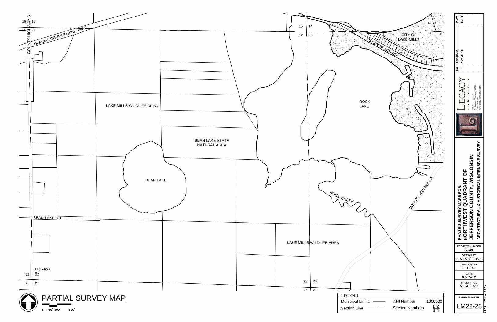
22
1516
21
23
1415
22
26
2322
27
27
2221
28
0024453
0221512
BEAN LAKE
ROCK
LAKE
CO
UN
TY
H
IG
HW
AY
S
G
L
A
C
IA
L
D
R
U
M
L
IN
B
IK
E
T
R
A
IL
BEAN LAKE RD
C
O
U
N
T
Y
H
I
G
H
W
A
Y
A
S
A
N
D
Y
B
E
A
C
H
R
D
BEAN LAKE STATE
NATURAL AREA
LAKE MILLS WILDLIFE AREA
LAKE MILLS WILDLIFE AREA
R
O
C
K
CITY OF
LAKE MILLS
C
R
E
E
K
DRAWN BY
CHECKED BY
DATE
PROJECT NUMBER
SHEET TITLE
SHEET NUMBER
RE
VIS
IO
NS
NO
.D
AT
E
PH
AS
E 2
S
UR
VE
Y M
AP
S F
OR
:
NO
RT
HW
ES
T Q
UA
DR
AN
T O
F
JE
FF
ER
SO
N C
OU
NT
Y, W
IS
CO
NS
IN
AR
CH
IT
EC
TU
RA
L &
H
IS
TO
RIC
AL
IN
TE
NS
IV
E S
UR
VE
Y
52
9 O
nta
rio
A
ve
nu
e
Sh
eb
oyg
an
, W
isco
nsin
5
30
81
(9
20
) 7
83
-6
30
3
ww
w.le
ga
cy-a
rch
ite
ctu
re
.co
m
LM22-23
PARTIAL SURVEY MAP
LEGENDMunicipal Limits
AHI Number 1000000
Section LineSection Numbers
1 2
3 4

25
2423
26
36
2526
35
0221513
MUD LAKE
V
A
T
I
O
N
R
D
MANSFIELD RD
S
T
A
T
E
H
I
G
H
W
A
Y
8
9
MUD LAKE RD
MUD LAKE RD
C
O
N
S
E
R
LAKE MILLS WILDLIFE AREA
R
O
C
K
C
R
E
E
K
DRAWN BY
CHECKED BY
DATE
PROJECT NUMBER
SHEET TITLE
SHEET NUMBER
RE
VIS
IO
NS
NO
.D
AT
E
PH
AS
E 2
S
UR
VE
Y M
AP
S F
OR
:
NO
RT
HW
ES
T Q
UA
DR
AN
T O
F
JE
FF
ER
SO
N C
OU
NT
Y, W
IS
CO
NS
IN
AR
CH
IT
EC
TU
RA
L &
H
IS
TO
RIC
AL
IN
TE
NS
IV
E S
UR
VE
Y
52
9 O
nta
rio
A
ve
nu
e
Sh
eb
oyg
an
, W
isco
nsin
5
30
81
(9
20
) 7
83
-6
30
3
ww
w.le
ga
cy-a
rch
ite
ctu
re
.co
m
LM25-26
PARTIAL SURVEY MAP
LEGENDMunicipal Limits
AHI Number 1000000
Section LineSection Numbers
1 2
3 4

33
2829
32
3433
3433
3332
0006617
0221514
CO
UN
TY
H
IG
HW
AY
A
L
O
N
D
O
N
R
D
HOPE LAKE RD
HOPE LAKE
DRAWN BY
CHECKED BY
DATE
PROJECT NUMBER
SHEET TITLE
SHEET NUMBER
RE
VIS
IO
NS
NO
.D
AT
E
PH
AS
E 2
S
UR
VE
Y M
AP
S F
OR
:
NO
RT
HW
ES
T Q
UA
DR
AN
T O
F
JE
FF
ER
SO
N C
OU
NT
Y, W
IS
CO
NS
IN
AR
CH
IT
EC
TU
RA
L &
H
IS
TO
RIC
AL
IN
TE
NS
IV
E S
UR
VE
Y
52
9 O
nta
rio
A
ve
nu
e
Sh
eb
oyg
an
, W
isco
nsin
5
30
81
(9
20
) 7
83
-6
30
3
ww
w.le
ga
cy-a
rch
ite
ctu
re
.co
m
LM32-33
PARTIAL SURVEY MAP
LEGENDMunicipal Limits
AHI Number 1000000
Section LineSection Numbers
1 2
3 4

35
2627
34
35343433
0006618
HOPE LAKE RD
CR
OS
SM
AN
R
D
NELSON LN
LAKE MILLS WILDLIFE AREA
R
O
C
K
C
R
E
E
K
DRAWN BY
CHECKED BY
DATE
PROJECT NUMBER
SHEET TITLE
SHEET NUMBER
RE
VIS
IO
NS
NO
.D
AT
E
PH
AS
E 2
S
UR
VE
Y M
AP
S F
OR
:
NO
RT
HW
ES
T Q
UA
DR
AN
T O
F
JE
FF
ER
SO
N C
OU
NT
Y, W
IS
CO
NS
IN
AR
CH
IT
EC
TU
RA
L &
H
IS
TO
RIC
AL
IN
TE
NS
IV
E S
UR
VE
Y
52
9 O
nta
rio
A
ve
nu
e
Sh
eb
oyg
an
, W
isco
nsin
5
30
81
(9
20
) 7
83
-6
30
3
ww
w.le
ga
cy-a
rch
ite
ctu
re
.co
m
LM34-35
PARTIAL SURVEY MAP
LEGENDMunicipal Limits
AHI Number 1000000
Section LineSection Numbers
1 2
3 4

7
61
12
61
8
56
7
0221530
0221531
0221532
S
T
A
T
E
H
I
G
H
W
A
Y
8
9
CO
UN
TY
H
IG
HW
AY
G
E H
UB
BLE
TO
N R
D
LAN
G L
N
REAMER RD
HOLZUETER LN
M
A
IN
S
T
P
E
A
R
L S
T
E HUBBLETON RD
RIV
ER
R
D
C
H
IC
A
G
O
, M
IL
W
A
U
K
E
E
&
S
T
. P
A
U
L
R
A
IL
R
O
A
D
C
R
A
W
F
I
S
H
R
I
V
E
R
DRAWN BY
CHECKED BY
DATE
PROJECT NUMBER
SHEET TITLE
SHEET NUMBER
RE
VIS
IO
NS
NO
.D
AT
E
PH
AS
E 2
S
UR
VE
Y M
AP
S F
OR
:
NO
RT
HW
ES
T Q
UA
DR
AN
T O
F
JE
FF
ER
SO
N C
OU
NT
Y, W
IS
CO
NS
IN
AR
CH
IT
EC
TU
RA
L &
H
IS
TO
RIC
AL
IN
TE
NS
IV
E S
UR
VE
Y
52
9 O
nta
rio
A
ve
nu
e
Sh
eb
oyg
an
, W
isco
nsin
5
30
81
(9
20
) 7
83
-6
30
3
ww
w.le
ga
cy-a
rch
ite
ctu
re
.co
m
M5-6
PARTIAL SURVEY MAP
LEGENDMunicipal Limits
AHI Number 1000000
Section LineSection Numbers
1 2
3 4

4
9
9
45
8
9
16
16
98
17
0221532
0221533
COUNTY HIG
HWAY T
CO
UN
TY
H
IG
HW
AY
Q
S
P
O
E
H
R
L
N
RIV
ER
R
D
OLSON RD
RUBIDELL RD
E HUBBLETON RD
MAMRE
MORAVIAN
CEMETERY
DRAWN BY
CHECKED BY
DATE
PROJECT NUMBER
SHEET TITLE
SHEET NUMBER
RE
VIS
IO
NS
NO
.D
AT
E
PH
AS
E 2
S
UR
VE
Y M
AP
S F
OR
:
NO
RT
HW
ES
T Q
UA
DR
AN
T O
F
JE
FF
ER
SO
N C
OU
NT
Y, W
IS
CO
NS
IN
AR
CH
IT
EC
TU
RA
L &
H
IS
TO
RIC
AL
IN
TE
NS
IV
E S
UR
VE
Y
52
9 O
nta
rio
A
ve
nu
e
Sh
eb
oyg
an
, W
isco
nsin
5
30
81
(9
20
) 7
83
-6
30
3
ww
w.le
ga
cy-a
rch
ite
ctu
re
.co
m
M8-9
PARTIAL SURVEY MAP
LEGENDMunicipal Limits
AHI Number 1000000
Section LineSection Numbers
1 2
3 4

22
1516
21
23
1415
22
26
2322
27
27
2221
28
0221538
ST
AT
E H
IG
HW
AY
W
KR
AK
OW
L
N
S
T
O
V
E
H
A
S
E
L
N
STATE HIGHWAY W
DRAWN BY
CHECKED BY
DATE
PROJECT NUMBER
SHEET TITLE
SHEET NUMBER
RE
VIS
IO
NS
NO
.D
AT
E
PH
AS
E 2
S
UR
VE
Y M
AP
S F
OR
:
NO
RT
HW
ES
T Q
UA
DR
AN
T O
F
JE
FF
ER
SO
N C
OU
NT
Y, W
IS
CO
NS
IN
AR
CH
IT
EC
TU
RA
L &
H
IS
TO
RIC
AL
IN
TE
NS
IV
E S
UR
VE
Y
52
9 O
nta
rio
A
ve
nu
e
Sh
eb
oyg
an
, W
isco
nsin
5
30
81
(9
20
) 7
83
-6
30
3
ww
w.le
ga
cy-a
rch
ite
ctu
re
.co
m
M22-23
PARTIAL SURVEY MAP
LEGENDMunicipal Limits
AHI Number 1000000
Section LineSection Numbers
1 2
3 4

24
25
25
2423
26
36
2526
35
25
36
0221536
0221542
HAHNS LAKE
Z
O
E
R
N
L
N
FRENCH RD
ROCK
RIVER
CHURCH HILL
C
O
U
N
T
Y
H
I
G
H
W
A
Y
A
ME
YE
R LN
CO
UN
TY
H
IG
HW
AY
N
DRAWN BY
CHECKED BY
DATE
PROJECT NUMBER
SHEET TITLE
SHEET NUMBER
RE
VIS
IO
NS
NO
.D
AT
E
PH
AS
E 2
S
UR
VE
Y M
AP
S F
OR
:
NO
RT
HW
ES
T Q
UA
DR
AN
T O
F
JE
FF
ER
SO
N C
OU
NT
Y, W
IS
CO
NS
IN
AR
CH
IT
EC
TU
RA
L &
H
IS
TO
RIC
AL
IN
TE
NS
IV
E S
UR
VE
Y
52
9 O
nta
rio
A
ve
nu
e
Sh
eb
oyg
an
, W
isco
nsin
5
30
81
(9
20
) 7
83
-6
30
3
ww
w.le
ga
cy-a
rch
ite
ctu
re
.co
m
M25-26
PARTIAL SURVEY MAP
LEGENDMunicipal Limits
AHI Number 1000000
Section LineSection Numbers
1 2
3 4

27
2221
28
28
2120
29
33
2829
32
34
2728
33
0221539
STATE HIGHWAY W
CO
UN
TY
H
IG
HW
AY
Q
SCHMIDT RD
TR
IE
LO
FF
D
R
DRAWN BY
CHECKED BY
DATE
PROJECT NUMBER
SHEET TITLE
SHEET NUMBER
RE
VIS
IO
NS
NO
.D
AT
E
PH
AS
E 2
S
UR
VE
Y M
AP
S F
OR
:
NO
RT
HW
ES
T Q
UA
DR
AN
T O
F
JE
FF
ER
SO
N C
OU
NT
Y, W
IS
CO
NS
IN
AR
CH
IT
EC
TU
RA
L &
H
IS
TO
RIC
AL
IN
TE
NS
IV
E S
UR
VE
Y
52
9 O
nta
rio
A
ve
nu
e
Sh
eb
oyg
an
, W
isco
nsin
5
30
81
(9
20
) 7
83
-6
30
3
ww
w.le
ga
cy-a
rch
ite
ctu
re
.co
m
M28-29
PARTIAL SURVEY MAP
LEGENDMunicipal Limits
AHI Number 1000000
Section LineSection Numbers
1 2
3 4

31
3025
36
6
3136
1
32
2930
31
5
3231
6
0221541
0221576
C
R
A
W
F
I
S
H
R
I
V
E
R
MANSKE RD
FA
VILLE
R
D
PERSCHKE LN
VA
ND
RE
R
D
VANDRE RD
N W
OL
LIN
R
D
M
A
N
S
K
E
R
D
DRAWN BY
CHECKED BY
DATE
PROJECT NUMBER
SHEET TITLE
SHEET NUMBER
RE
VIS
IO
NS
NO
.D
AT
E
PH
AS
E 2
S
UR
VE
Y M
AP
S F
OR
:
NO
RT
HW
ES
T Q
UA
DR
AN
T O
F
JE
FF
ER
SO
N C
OU
NT
Y, W
IS
CO
NS
IN
AR
CH
IT
EC
TU
RA
L &
H
IS
TO
RIC
AL
IN
TE
NS
IV
E S
UR
VE
Y
52
9 O
nta
rio
A
ve
nu
e
Sh
eb
oyg
an
, W
isco
nsin
5
30
81
(9
20
) 7
83
-6
30
3
ww
w.le
ga
cy-a
rch
ite
ctu
re
.co
m
M31-32
PARTIAL SURVEY MAP
LEGENDMunicipal Limits
AHI Number 1000000
Section LineSection Numbers
1 2
3 4

33
2829
32
34
2728
33
3
3433
4
4
3332
5
0221540
CO
UN
TY
H
IG
HW
AY
Q
N WOLLIN RD
VANDRE RD
N W
OL
LIN
R
D
CO
UN
TY
H
IG
HW
AY
Q
VANDRE RD
DRAWN BY
CHECKED BY
DATE
PROJECT NUMBER
SHEET TITLE
SHEET NUMBER
RE
VIS
IO
NS
NO
.D
AT
E
PH
AS
E 2
S
UR
VE
Y M
AP
S F
OR
:
NO
RT
HW
ES
T Q
UA
DR
AN
T O
F
JE
FF
ER
SO
N C
OU
NT
Y, W
IS
CO
NS
IN
AR
CH
IT
EC
TU
RA
L &
H
IS
TO
RIC
AL
IN
TE
NS
IV
E S
UR
VE
Y
52
9 O
nta
rio
A
ve
nu
e
Sh
eb
oyg
an
, W
isco
nsin
5
30
81
(9
20
) 7
83
-6
30
3
ww
w.le
ga
cy-a
rch
ite
ctu
re
.co
m
M32-33
PARTIAL SURVEY MAP
LEGENDMunicipal Limits
AHI Number 1000000
Section LineSection Numbers
1 2
3 4

34
27
35
2627
34
2
3534
3
3
34
0221534
0221535
C
O
U
N
T
Y
H
I
G
H
W
A
Y
A
VANDRE RD
CO
UN
TY
H
IG
HW
AY
N
C
O
U
N
T
Y
H
I
G
H
W
A
Y
A
ZA
BE
L L
N
BADE LN
ME
YE
R L
N
DRAWN BY
CHECKED BY
DATE
PROJECT NUMBER
SHEET TITLE
SHEET NUMBER
RE
VIS
IO
NS
NO
.D
AT
E
PH
AS
E 2
S
UR
VE
Y M
AP
S F
OR
:
NO
RT
HW
ES
T Q
UA
DR
AN
T O
F
JE
FF
ER
SO
N C
OU
NT
Y, W
IS
CO
NS
IN
AR
CH
IT
EC
TU
RA
L &
H
IS
TO
RIC
AL
IN
TE
NS
IV
E S
UR
VE
Y
52
9 O
nta
rio
A
ve
nu
e
Sh
eb
oyg
an
, W
isco
nsin
5
30
81
(9
20
) 7
83
-6
30
3
ww
w.le
ga
cy-a
rch
ite
ctu
re
.co
m
M34-35
PARTIAL SURVEY MAP
LEGENDMunicipal Limits
AHI Number 1000000
Section LineSection Numbers
1 2
3 4

36
2526
35
25
36
36
1
1
3635
2
0221535
0221537
CITY OF WATERTOWN
C
O
U
N
T
Y
H
I
G
H
W
A
Y
A
ZA
BE
L L
N
BADE LN
ME
YE
R L
N
BIE
TY
R
D
R
O
C
K
R
I
V
E
R
CO
UN
TY
H
IG
HW
AY
N
CHURCH HILL
CEMETERY
C
O
U
N
T
Y
H
I
G
H
W
A
Y
A
DRAWN BY
CHECKED BY
DATE
PROJECT NUMBER
SHEET TITLE
SHEET NUMBER
RE
VIS
IO
NS
NO
.D
AT
E
PH
AS
E 2
S
UR
VE
Y M
AP
S F
OR
:
NO
RT
HW
ES
T Q
UA
DR
AN
T O
F
JE
FF
ER
SO
N C
OU
NT
Y, W
IS
CO
NS
IN
AR
CH
IT
EC
TU
RA
L &
H
IS
TO
RIC
AL
IN
TE
NS
IV
E S
UR
VE
Y
52
9 O
nta
rio
A
ve
nu
e
Sh
eb
oyg
an
, W
isco
nsin
5
30
81
(9
20
) 7
83
-6
30
3
ww
w.le
ga
cy-a
rch
ite
ctu
re
.co
m
M35-36
PARTIAL SURVEY MAP
LEGENDMunicipal Limits
AHI Number 1000000
Section LineSection Numbers
1 2
3 4

10
34
9
11
23
10
34
23
0221587
DOEPKE RD
R
IN
G
L
N
YOUNKER LN
P
E
S
C
H
E
L
R
D
SCHUMACHER RD
PE
SC
HE
L R
D
C
H
IC
A
G
O
, M
IL
W
A
U
K
E
E
&
S
T
. P
A
U
L
R
A
IL
R
O
A
D
(DODGE COUNTY)
(JEFFERSON COUNTY)
DRAWN BY
CHECKED BY
DATE
PROJECT NUMBER
SHEET TITLE
SHEET NUMBER
RE
VIS
IO
NS
NO
.D
AT
E
PH
AS
E 2
S
UR
VE
Y M
AP
S F
OR
:
NO
RT
HW
ES
T Q
UA
DR
AN
T O
F
JE
FF
ER
SO
N C
OU
NT
Y, W
IS
CO
NS
IN
AR
CH
IT
EC
TU
RA
L &
H
IS
TO
RIC
AL
IN
TE
NS
IV
E S
UR
VE
Y
52
9 O
nta
rio
A
ve
nu
e
Sh
eb
oyg
an
, W
isco
nsin
5
30
81
(9
20
) 7
83
-6
30
3
ww
w.le
ga
cy-a
rch
ite
ctu
re
.co
m
WL2-3
PARTIAL SURVEY MAP
LEGENDMunicipal Limits
AHI Number 1000000
Section LineSection Numbers
1 2
3 4

10
3
9
11
23
10
1110
15
10
0006666
0221586
YOUNKER LN
IS
LA
ND
C
HU
RC
H R
D
ISLAND RD
KLECKER LN
D
E
E
R
V
I
E
W
L
N
PE
SC
HE
L R
D
IS
LA
ND
C
HU
RC
H R
D
IS
LA
N
D
R
D
ISLAND
CEMETERY
K
L
U
G
L
N
DRAWN BY
CHECKED BY
DATE
PROJECT NUMBER
SHEET TITLE
SHEET NUMBER
RE
VIS
IO
NS
NO
.D
AT
E
PH
AS
E 2
S
UR
VE
Y M
AP
S F
OR
:
NO
RT
HW
ES
T Q
UA
DR
AN
T O
F
JE
FF
ER
SO
N C
OU
NT
Y, W
IS
CO
NS
IN
AR
CH
IT
EC
TU
RA
L &
H
IS
TO
RIC
AL
IN
TE
NS
IV
E S
UR
VE
Y
52
9 O
nta
rio
A
ve
nu
e
Sh
eb
oyg
an
, W
isco
nsin
5
30
81
(9
20
) 7
83
-6
30
3
ww
w.le
ga
cy-a
rch
ite
ctu
re
.co
m
WL10-11
PARTIAL SURVEY MAP
LEGENDMunicipal Limits
AHI Number 1000000
Section LineSection Numbers
1 2
3 4

13
1211
14
18
712
13
24
1314
23
19
1813
24
0221616
0221615
ISLAND CHURCH RD
S
H
O
R
T
L
N
KOWSKI LN
IS
LA
ND
C
HU
RC
H R
D
C
O
U
N
T
Y
H
I
G
H
W
A
Y
G
W
E
L
L
S
L
N
ZIC
KE
RT
L
N
PE
TE
R L
N
IS
LA
ND
C
HU
RC
H R
D
SNAPPER
PRAIRIE
STATE
NATURAL
AREA
ST. WENCESLAUS
DRAWN BY
CHECKED BY
DATE
PROJECT NUMBER
SHEET TITLE
SHEET NUMBER
RE
VIS
IO
NS
NO
.D
AT
E
PH
AS
E 2
S
UR
VE
Y M
AP
S F
OR
:
NO
RT
HW
ES
T Q
UA
DR
AN
T O
F
JE
FF
ER
SO
N C
OU
NT
Y, W
IS
CO
NS
IN
AR
CH
IT
EC
TU
RA
L &
H
IS
TO
RIC
AL
IN
TE
NS
IV
E S
UR
VE
Y
52
9 O
nta
rio
A
ve
nu
e
Sh
eb
oyg
an
, W
isco
nsin
5
30
81
(9
20
) 7
83
-6
30
3
ww
w.le
ga
cy-a
rch
ite
ctu
re
.co
m
WL13-14
PARTIAL SURVEY MAP
LEGENDMunicipal Limits
AHI Number 1000000
Section LineSection Numbers
1 2
3 4

15
109
1616
98
17
21
1617
20
22
1516
21
0221614
CITY OF WATERLOO
ED
GE
WO
OD
R
D
TOWN HALL RD
MICHEL LN
BLUE JOINT RD
J
O
R
D
A
N
R
D
KENNY LN
SK
AL
IT
ZK
Y L
N
S
T
O
N
E
Y
B
R
O
O
K
C
R
E
E
K
DRAWN BY
CHECKED BY
DATE
PROJECT NUMBER
SHEET TITLE
SHEET NUMBER
RE
VIS
IO
NS
NO
.D
AT
E
PH
AS
E 2
S
UR
VE
Y M
AP
S F
OR
:
NO
RT
HW
ES
T Q
UA
DR
AN
T O
F
JE
FF
ER
SO
N C
OU
NT
Y, W
IS
CO
NS
IN
AR
CH
IT
EC
TU
RA
L &
H
IS
TO
RIC
AL
IN
TE
NS
IV
E S
UR
VE
Y
52
9 O
nta
rio
A
ve
nu
e
Sh
eb
oyg
an
, W
isco
nsin
5
30
81
(9
20
) 7
83
-6
30
3
ww
w.le
ga
cy-a
rch
ite
ctu
re
.co
m
WL16-17
PARTIAL SURVEY MAP
LEGENDMunicipal Limits
AHI Number 1000000
Section LineSection Numbers
1 2
3 4

24
1314
23
19
1813
24
30
1924
25
25
2423
26
0006667
ISLAND CHURCH RD
S
P
R
I
N
G
E
R
R
D
CO
UN
TY
H
IG
HW
AY
G
PRAIRIE LN
TESMER RD
PE
TE
R L
N
DRAWN BY
CHECKED BY
DATE
PROJECT NUMBER
SHEET TITLE
SHEET NUMBER
RE
VIS
IO
NS
NO
.D
AT
E
PH
AS
E 2
S
UR
VE
Y M
AP
S F
OR
:
NO
RT
HW
ES
T Q
UA
DR
AN
T O
F
JE
FF
ER
SO
N C
OU
NT
Y, W
IS
CO
NS
IN
AR
CH
IT
EC
TU
RA
L &
H
IS
TO
RIC
AL
IN
TE
NS
IV
E S
UR
VE
Y
52
9 O
nta
rio
A
ve
nu
e
Sh
eb
oyg
an
, W
isco
nsin
5
30
81
(9
20
) 7
83
-6
30
3
ww
w.le
ga
cy-a
rch
ite
ctu
re
.co
m
WL23-24
PARTIAL SURVEY MAP
LEGENDMunicipal Limits
AHI Number 1000000
Section LineSection Numbers
1 2
3 4

33
2829
3234
2728
33
0006669
0221613
STONEY BROOK RD
AB
EN
DR
OT
H R
D
T
O
P
P
E
R
D
N
E
W
V
I
L
L
E
R
D
G
E
I
S
E
L
N
S
T
O
N
E
Y
0221601
0221598
0221599,
0221597,
0221600
0221602,
0221603,
0221604
0221605
0221608,
0221609
0221589
0221588
0221590,
0221595
0221593
0221591
0221592
0221611
0221607
0221610,
0221596
0221612
0221606
0221594
B
R
O
O
KC
RE
EK
DRAWN BY
CHECKED BY
DATE
PROJECT NUMBER
SHEET TITLE
SHEET NUMBER
RE
VIS
IO
NS
NO
.D
AT
E
PH
AS
E 2
S
UR
VE
Y M
AP
S F
OR
:
NO
RT
HW
ES
T Q
UA
DR
AN
T O
F
JE
FF
ER
SO
N C
OU
NT
Y, W
IS
CO
NS
IN
AR
CH
IT
EC
TU
RA
L &
H
IS
TO
RIC
AL
IN
TE
NS
IV
E S
UR
VE
Y
52
9 O
nta
rio
A
ve
nu
e
Sh
eb
oyg
an
, W
isco
nsin
5
30
81
(9
20
) 7
83
-6
30
3
ww
w.le
ga
cy-a
rch
ite
ctu
re
.co
m
WL28-29
PARTIAL SURVEY MAP
LEGENDMunicipal Limits
AHI Number 1000000
Section LineSection Numbers
1 2
3 4

32
2930
31
5
3231
6
30
31
31
6
0006668
0221617
E MEDINA RD
A
I
R
P
O
R
T
R
D
J
U
N
G
L
E
L
N
W
O
O
D
L
N
I-94
C
O
U
N
T
Y
H
I
G
H
W
A
Y
O
COUNTY HIGHWAY O(D
AN
E C
OU
NT
Y)
(JE
FF
ER
SO
N C
OU
NT
Y)
DRAWN BY
CHECKED BY
DATE
PROJECT NUMBER
SHEET TITLE
SHEET NUMBER
RE
VIS
IO
NS
NO
.D
AT
E
PH
AS
E 2
S
UR
VE
Y M
AP
S F
OR
:
NO
RT
HW
ES
T Q
UA
DR
AN
T O
F
JE
FF
ER
SO
N C
OU
NT
Y, W
IS
CO
NS
IN
AR
CH
IT
EC
TU
RA
L &
H
IS
TO
RIC
AL
IN
TE
NS
IV
E S
UR
VE
Y
52
9 O
nta
rio
A
ve
nu
e
Sh
eb
oyg
an
, W
isco
nsin
5
30
81
(9
20
) 7
83
-6
30
3
ww
w.le
ga
cy-a
rch
ite
ctu
re
.co
m
WL31-32
PARTIAL SURVEY MAP
LEGENDMunicipal Limits
AHI Number 1000000
Section LineSection Numbers
1 2
3 4

36
2526
35
25
36
6
3136
1
1
3635
2
0006670
0221881
0221576
0221577
0221585
0221619
MANSKE RD
FA
VILLE
R
D
PERSCHKE LN
WOODLAND RD
CO
UN
TY
H
IG
HW
AY
G
MANSKE RD
CO
UN
TY
H
IG
HW
AY
G
S
T
A
T
E
H
I
G
H
W
A
Y
8
9
N S
HO
RE
R
D
0221657
0221656
0221578
0221579
0221580
0221581
0221582
0221583
0221584
DRAWN BY
CHECKED BY
DATE
PROJECT NUMBER
SHEET TITLE
SHEET NUMBER
RE
VIS
IO
NS
NO
.D
AT
E
PH
AS
E 2
S
UR
VE
Y M
AP
S F
OR
:
NO
RT
HW
ES
T Q
UA
DR
AN
T O
F
JE
FF
ER
SO
N C
OU
NT
Y, W
IS
CO
NS
IN
AR
CH
IT
EC
TU
RA
L &
H
IS
TO
RIC
AL
IN
TE
NS
IV
E S
UR
VE
Y
52
9 O
nta
rio
A
ve
nu
e
Sh
eb
oyg
an
, W
isco
nsin
5
30
81
(9
20
) 7
83
-6
30
3
ww
w.le
ga
cy-a
rch
ite
ctu
re
.co
m
WL35-36
PARTIAL SURVEY MAP
LEGENDMunicipal Limits
AHI Number 1000000
Section LineSection Numbers
1 2
3 4

149
Recommendations Introduction The survey should serve to enhance the overall historic preservation ethic in Jefferson County. It gives a brief history of the northwest quadrant of the County, identifies historic resources, and can serve as a basis for decision-making activities regarding those resources. This report can be used to create interest and awareness and promote historic resources and preservation issues in Jefferson County. This chapter outlines the many benefits of and economic incentives for historic preservation and provides preliminary recommendations for future preservation actions in the county. Community Strategies for Historic Preservation An historic preservation program can be one of the most effective forms of economic development that a municipality can support. Preservation stimulates both public and private investment in the community and supports major components of the local economy: tourism, construction, and real estate. Historic buildings attract customers and are often sought after, desirable pieces of real estate. There are many benefits of historic preservation: Enjoyment of the community’s heritage Improved property values Increased property tax receipts Investment in older & historic properties Increased tourism Greater flexibility in meeting Americans with Disabilities Act (ADA) in historic buildings More flexibility in meeting state building codes Greater community pride and an increased sense of belonging Increased attractiveness to new businesses Decreased crime and vandalism in historic areas Increased conservation of materials and natural resources Improved overall quality of life In order to achieve these benefits, many incentives for historic preservation have been developed. There are several different types of tax incentives. Property owners who undertake a certified historic restoration or rehabilitation of their property are eligible for income tax credits.
19

150
Certain historic buildings are also exempt from property taxes, and tax deductions can be utilized for historic façade easements. Additionally, there are several building code incentives. Buildings listed in the National Register of Historic Places or buildings that are eligible for listing qualify for the International Existing Building Code’s Historic Buildings Chapter which is slightly more lenient than the standard building code. There is also a greater flexibility in meeting the building requirements of the Americans with Disabilities Act (ADA). Further information regarding these incentives has been included in the Chapter 21 Appendix. Recommendation for the Registration & Protection of Resources Historic Preservation Ordinance Before any of the above mentioned benefits of preservation can continue in Jefferson County, it is imperative that a formal county-wide historic preservation program be established. In 1994, an act of the Wisconsin Statutes was passed that required municipalities which have buildings listed in the National Register of Historic Places to “enact an ordinance to regulate any place, structure or object with a special character, historic, archaeological or aesthetic interest, or other significant value, for the purpose of preserving the place, structure or object and its significant characteristics.” Ordinances serve to protect extant historic resources and officially establish a Historic Preservation Commission. Such an ordinance has already been enacted by Jefferson County. This was a great step forward in protecting the county’s historic structures. Historic Preservation Commission A group of individuals has been appointed for the commission. In the future, consideration should be given during appointments to ensure commission members possess knowledge, experience, and interest in the areas of history, historic preservation, historic architecture, real estate, and law. This commission should be commended on their ongoing efforts. They hold regular public meetings in order to tackle the tasks that lie ahead. It is their duty to establish planning policies, educate the community, and carry out the program. These tasks are imperative given the high profile threats and losses that the community has recently faced, such as the demolition the National Register-listed Seaver-Fargo House in Korth Park and several buildings along the State Highway 26 corridor. If or when the budget permits, some consideration may be given to hiring a staff preservation consultant to keep the commission organized, set policies, and carry out the day-to-day operations of the program. Certified Local Government This survey was funded by a grant through the Wisconsin Historical Society. In the future, that same grant money that could be used for preparation of an official county-wide preservation plan, public education, or National Register Nominations. The Commission should continue their efforts as a Certified Local Government so that it may receive future grant monies. Several documents that discuss this matter are published by the Wisconsin Historical Society have been included in the Chapter 21 Appendix.

151
Local Landmarking of Historic Resources It is hoped that this report will enliven the efforts of the Jefferson County Historic Sites Preservation Commission to continue to identify and landmark historic resources in the county. National Register Nominations This report has outlined many individual historic properties, one historic district, and several farmsteads that are potentially eligible for listing in the National Register of Historic Places. An effort should be made to follow through with National Register nominations for these properties, farmsteads, and district. The Historic Sites Preservation Commission should continue to apply for grants through the Wisconsin Historical Society to fund such nominations. The information contained in this survey report will act as a springboard for further research for these nominations. Threats to Resources Changes in modern conveniences and increasing public expectations have brought a great deal of pressure on older homes, especially those on historic farms. This has resulted in the demolition or relocation of a number of buildings, as well as, unsympathetic additions and the replacement of original windows and siding with more modern materials which obscure unique historic details on hundreds of buildings. These trends are expected to continue into the future. The Historic Sites Preservation Commission should keep abreast of upcoming projects at historic properties. Public Education In order to gain public support for preservation activities, it is important that the public be educated about the issues. It is also important to remind the community of the buildings that have already been lost as a means to protect historic buildings in the future. This can be accomplished in a variety of ways. Media, such as local television, radio, newspapers, and brochures, can spread the word to many. Displays in public buildings, such as the local libraries or historical societies, can also bring awareness to the community. Tourism publications can educate visitors about Jefferson County’s history. Self-guided or guided tours and tours of historic homes are often popular and can showcase the county’s historic buildings to those within the community and interested visitors. Lectures and workshops on preservation issues can also be useful. Historically appropriate maintenance, window replacement, residing, painting, and porch replacement should be promoted at these types of events. A set of design guidelines for historic preservation can be developed and distributed to local architects, building owners, contractors, and others in the community. The City of Milwaukee’s series of guides: As Good as New: A Guide for Rehabilitating the Exterior of Your Old Milwaukee Home; Good for Business: A Guide to Rehabilitating the Exteriors of Older Commercial Buildings; and Living with History: A Guide to the Preservation Standards for

152
Historically Designated Homes in Milwaukee are excellent resources for any community and any preservation project. Future Survey & Research Needs This is not a complete history of the northwest quadrant of Jefferson County. It is hoped that this survey will be periodically updated and expanded upon. This report is subject to change. Additional research and clarifications should be incorporated and added to this report in the future. This is a living document and the beginning of an ongoing historic preservation effort that will continue for years to come in this community.

153
Notes 1 Ott, John Henry. Jefferson County Wisconsin and its People. Chicago: The S. J. Clarke Publishing Company,
1917. Pages 1-5. 2 Ott, John Henry. Page 86. And Jefferson County Agriculture. Madison, Wisconsin: Crop and Livestock
Reporting Service, 1954. Page 2. 3 Swart, Hannah. Koshkonong Country – A History of Jefferson County Wisconsin. Fort Atkinson, Wisconsin: W.
D. Hoard & Sons Co., 1975. Pages 16 and 21-22. 4 Jefferson County Agriculture. Page 3. 5 Swart, Hannah. Pages 45-52. 6 Ott, John Henry. Pages 299-301. 7 Ibid. 8 One Room Schools of Jefferson County. Johnson Creek: Johnson Creek Historical Society, 2006. Page 4. 9 United States Census Bureau website. <www.census.gov> Accessed July 9, 2012. 10 Schultz, Helen A. The Pioneer Aztalan Story. Aztalan, Wisconsin: Lake Mills-Aztalan Historical Society, 1969.
Page 2. 11 Ibid. 12 Schultz, Helen A. Pages 3-4. 13 Schultz, Helen A. Page 4. 14 Ibid. 15 Schultz, Helen A. Pages 5-6. 16 Swart, Hannah. Page 167. 17 Swart, Hannah. Page 21. 18 Schultz, Helen A. Page 6. 19 Swart, Hannah. Page 167. 20 Schultz, Helen A. Page 6-7. 21 Jefferson County Agriculture. Page 13. 22 United States Census Bureau website. 23 Liebenow, Dr. Roland. “Milford, Our ‘Sister City.’” Lake Mills Leader website.
<http://lakemillsleaderonline.com> Accessed June 21, 2012. 24 Swart, Hannah. Page 172. 25 Swart, Hannah. Pages 172-178. 26 Swart, Hannah. Page 21. 27 Swart, Hannah. Pages 183-184. And The History of Jefferson County Wisconsin. Chicago: Western Historical
Company, 1879. Page703. 28 Swart, Hannah. Page 178. 29 Ibid. 30 Swart, Hannah. Page 184. 31 Swart, Hannah. Page 184-185. 32 Swart, Hannah. Page 21. 33 Jefferson County Agriculture. Page 13. 34 United States Census Bureau website. 35 Swart, Hannah. Pages 188 and 198. 36 Liebenow, Dr. Roland. 37 Ibid. 38 Swart, Hannah. Page 204.
20

154
39 Swart, Hannah. Page 198. 40 Liebenow, Dr. Roland. 41 Swart, Hannah. Page 198. 42 Liebenow, Dr. Roland. 43 Ibid. 44 Ibid. 45 Jefferson County Agriculture. Page 13. 46 United States Census Bureau website. 47 Swart, Hannah. Pages 21 and 188. 48 Swart, Hannah. Page 189. 49 Ibid. 50 Swart, Hannah. Pages 189-190. 51 Swart, Hannah. Page 190. 52 Ibid. 53 Jefferson County Agriculture. Page 13. 54 Swart, Hannah. Pages 21. 55 United States Census Bureau website. 56 The Wisconsin Cartographers’ Guide. Wisconsin’s Past and Present - A Historical Atlas. Madison: The
University of Wisconsin Press, 1998. Page 2. 57 The Wisconsin Cartographers’ Guide. Pages 2-3. 58 Schultz, Helen A. Page 2. 59 The Wisconsin Cartographers’ Guide. Pages 4 and 12-13. 60 Liebenow, Dr. Roland. 61 The Wisconsin Cartographers’ Guide. Pages 4 and 12-13. 62 Swart, Hannah. Pages 15-16. 63 Swart, Hannah. Page 163. 64 Swart, Hannah. Page 176. 65 Swart, Hannah. Page 189. 66 Liebenow, Dr. Roland. 67 Swart, Hannah. Page 198. 68 Swart, Hannah. Page 183. 69 Swart, Hannah. Page 164. 70 Plat Maps and Atlases. Various years. On file at the Wisconsin Historical Society Area Research Center at the
University of Wisconsin-Whitewater in Whitewater, Wisconsin. 71 Swart, Hannah. Page 184. 72 Swart, Hannah. Pages 201-202. 73 Schultz, Helen A. Page 3. 74 Swart, Hannah. Page 199. 75 Plat Maps and Atlases. 76 Swart, Hannah. Page 172. 77 Schultz, Helen A. Page 2. 78 Liebenow, Dr. Roland. And Hannah Swart. Page 199. 79 Ibid. 80 Swart, Hannah. Page 199. 81 The History of Jefferson County Wisconsin. Page 725. 82 Portrait and Biographical Record of Walworth and Jefferson Counties, Wisconsin. Chicago: Lake City
Publishing Co., 1894. Page 388. 83 Wisconsin Architecture & History Inventory. Wisconsin Historical Society website.
<http://www.wisconsinhistory.org/ahi/> Accessed March 15, 2012. 84 Ott, John Henry. Page 316. 85 Portrait and Biographical Record of Walworth and Jefferson Counties, Wisconsin. Page 388. 86 Ott, John Henry. Page 316. 87 Ott, John Henry. Page 268. And Hannah Swart. Page 180. 88 Uncapher, Wendy. Aztalan Township Cemeteries. Janesville, Wisconsin: Origins, 2001. Page 4. And Helen A.
Schultz. Pages 2-5.

155
89 Swart, Hannah. Pages 15-16. 90 Swart, Hannah. Pages 176-177. 91 Swart, Hannah. Pages 188 and 198. 92 Liebenow, Dr. Roland. 93 Ibid. 94 Swart, Hannah. Pages 176-177. 95 Swart, Hannah. Page 204. 96 Swart, Hannah. Pages 45-49. 97 Swart, Hannah. Page 188. 98 Swart, Hannah. Page 166. 99 Ott, John Henry. Pages 299-301. 100 Swart, Hannah. Pages 45-49. 101 Wyatt, Barbara, ed. Cultural Resource Management in Wisconsin: Volume 2, A Manual For Historic Properties.
Madison, Wisconsin: Historic Preservation Division State Historical Society of Wisconsin, 1986. Page Architecture 4-3.
102 Swart, Hannah. Page 188-189. 103 Jefferson County Agriculture. Page 1. 104 Wisconsin Rural Resources Jefferson County. Madison, Wisconsin: Wisconsin State Department of Agriculture,
1958. Page 10. 104 Liebenow, Dr. Roland. 105 Wisconsin Rural Resources Jefferson County. Page 17. 105 Liebenow, Dr. Roland. 106 Swart, Hannah. Pages 45-49. And Barbara Wyatt. Page Agriculture 1-1. 107 Liebenow, Dr. Roland. 108 Swart, Hannah. Pages 45-49. And Barbara Wyatt, ed. Page Agriculture 5-1. 108 Liebenow, Dr. Roland. 109 Jefferson County Agriculture. Page 23. 110 Swart, Hannah. Pages 45-49. 111 Schultz, Helen A. 5-6. And Hannah Swart. Page 172. 112 Swart, Hannah. Page 190. 113 Swart, Hannah. Page 166. 114 Swart, Hannah. Pages 51-52. 115 Jefferson County Agriculture. Page 23. 116 Swart, Hannah. Pages 51-53. 117 Ibid. 118 Ibid. 119 Bollman, Joe. Jefferson County – Overview of Agriculture. Jefferson, Wisconsin: UW-Extension, Jefferson
County, 2009. <http://jefferson.uwex.edu/files/2010/05/OverviewofJeffersonCountyAgriculture.pdf> Accessed on July 6, 2012.
120 The History of Jefferson County Wisconsin. Page703. 121 Liebenow, Dr. Roland. 122 The History of Jefferson County Wisconsin. Page703. 123 Ott, John Henry. Pages 316-319. And Hannah Swart. Page 202. 124 Swart, Hannah. Page 202. 125 Ibid. 126 Ibid. 127 Ott, John Henry. Pages 316-319. And Hannah Swart. Page 202. 128 The History of Jefferson County Wisconsin. Page703. 129 Liebenow, Dr. Roland. 130 Swart, Hannah. Page 199. 131 Ibid. 132 Ibid. 133 Currey, Josiah Seymour. History of Milwaukee, City and County Volume 3. Chicago: The S. J. Clarke
Publishing Company 1922. 134 Sharp, Steve. “Work begins on largest ethanol plant in Wisconsin.” Daily Times, October 4, 2006.

156
135 Sharp, Steve. “New ethanol producer settles in at Ladish site.” Daily Times, September 10, 2010. 136 Swart, Hannah. Page 180 and 194. 137 Plat Maps and Atlases. 138 Liebenow, Dr. Roland. 139 Swart, Hannah. Page 180. 140 Ibid. 141 Liebenow, Dr. Roland. 142 Swart, Hannah. Page 183. 143 Liebenow, Dr. Roland. 144 Ibid. 145 Ibid. 146 Schultz, Helen A. Page 3. 147 Swart, Hannah. Pages 22-23. 148 Swart, Hannah. Page 184. And Glacial Drumlin State Trail brochure. Madison, Wisconsin: Wisconsin
Department of Natural Resources, 2004. 149 Ott, John Henry. Pages 182-184. 150 “Interstate 94.” Wikipedia website. <http://en.wikipedia.org/wiki/Interstate_94> Accessed July 12, 2012. 151 Liebenow, Dr. Roland. 152 Blumenson, John J. G. Identifying American Architecture: A Pictorial Guide to Styles and Terms, 1600-1945.
Second Ed. New York: W. W. Norton & Company, 1981, page 27. 153 Blumenson, John J. G. Page 37. 154 Blumenson, John J. G. Page 43. 155 Blumenson, John J. G.. Page 63. 156 Wyatt, Barbara. Page Architecture 2-24. 157 Wyatt, Barbara. Page Architecture 2-25. 158 Wyatt, Barbara. Page Architecture 2-25. 159 Blumenson, John J. G.. Page 71. 160 Wyatt, Barbara. Page Architecture 2-29. 161 Wyatt, Barbara. Page Architecture 2-29. 162 Ranch Style Architecture of the Twentieth Century. Antique Home website. <http://www.antiquehome.org> 163 Ibid. 164 McCalester, Virginia and Lee McCalester. A Field Guide to American Houses. New York: Alfred A. Knopf,
Inc., 1989. Page 497. 165 Wyatt, Barbara. Page Architecture 2-37. 166 Wyatt, Barbara. Page Architecture 3-1. 167 Wyatt, Barbara. Page Architecture 3-2. 168 Wyatt, Barbara. Page Architecture 3-2. 169 Wyatt, Barbara. Page Architecture 3-3. 170 Wyatt, Barbara. Page Architecture 3-3. 171 Wyatt, Barbara. Page Architecture 3-5. 172 Wyatt, Barbara. Page Architecture 3-7. 173 Wyatt, Barbara. Page Architecture 3-8. 174 Wyatt, Barbara. Page Architecture 3-8. 175 Wyatt, Barbara. Page Architecture 3-9. 176 Wyatt, Barbara. Page Architecture 3-9. 177 Wyatt, Barbara. Page Architecture 3-10. 178 Wyatt, Barbara. Page Architecture 5-1. 179 Wyatt, Barbara. Page Architecture 5-2. 180 Wyatt, Barbara. Page Architecture 5-2. 181 Wyatt, Barbara. Page Architecture 5-2. 182 Wyatt, Barbara. Page Architecture 5-2. 183 Wyatt, Barbara. Pages Architecture 5-2 and 5-3. 184 Wyatt, Barbara. Page Architecture 5-3. 185 “Housebarn.” Wikipedia website. <http://en.wikipedia.org/wiki/Housebarn> Accessed July 10, 2012. 186 Wyatt, Barbara. Page Architecture 5-3.

157
187 Wyatt, Barbara. Page Architecture 5-3. 188 Wyatt, Barbara. Page Architecture 5-5. 189 Wyatt, Barbara. Page Architecture 5-5. 190 Wyatt, Barbara. Page Architecture 5-5. 191 Wyatt, Barbara. Page Architecture 5-5. 192 Wyatt, Barbara. Page Architecture 5-5. 193 Wyatt, Barbara. Page Architecture 5-6. 194 Wyatt, Barbara. Page Architecture 5-6. 195 Wyatt, Barbara. Page Architecture 5-6. 196 Wyatt, Barbara. Page Agriculture 5-9. 197 Wyatt, Barbara. Page Agriculture 5-9. 198 Wyatt, Barbara. Page Architecture 5-6. 199 Wyatt, Barbara. Page Architecture 4-3. 200 Wyatt, Barbara. Page Architecture 4-3. 201 Schultz, Helen A. Pages 5-6. 202 Ibid. 203 Swart, Hannah. Page 183. 204 “Slayton Farms – Round Barn.” National Park Service website. <http://www.nps.gov> Accessed July 9, 2012. 205 Wyatt, Barbara. Page Architecture 4-13. 206 One Room Schools of Jefferson County. Pages 1-2. 207 Ibid. 208 One Room Schools of Jefferson County. Page 6. 209 One Room Schools of Jefferson County. Page 6. 210 One Room Schools of Jefferson County. Page 4. 211 Census School District Reference Maps. United States Census Bureau. <http://www.census.gov/> 212 One Room Schools of Jefferson County. Pages 9 and 17. 213 One Room Schools of Jefferson County. Page 11. 214 One Room Schools of Jefferson County. Page 4. 215 Census School District Reference Maps. 216 One Room Schools of Jefferson County. Page 9. 217 One Room Schools of Jefferson County. Page 9. 218 One Room Schools of Jefferson County. Page 4. 219 Census School District Reference Maps. 220 One Room Schools of Jefferson County. Page 9. And Wisconsin Architecture & History Inventory. 221 One Room Schools of Jefferson County. Page 8. 222 One Room Schools of Jefferson County. Page 15. 223 One Room Schools of Jefferson County. Page 138. 224 One Room Schools of Jefferson County. Page 15. 225 One Room Schools of Jefferson County. Page 4. 226 Census School District Reference Maps. 227 One Room Schools of Jefferson County. Page 14. 228 One Room Schools of Jefferson County. Page 13. 229 One Room Schools of Jefferson County. Page 4. 230 Census School District Reference Maps. 231 One Room Schools of Jefferson County. Page 120-121. 232 One Room Schools of Jefferson County. Page 114. 233 Census School District Reference Maps. 234 One Room Schools of Jefferson County. Page 118. 235 Ibid. 236 One Room Schools of Jefferson County. Page 122-123. 237 One Room Schools of Jefferson County. Page 123. 238 One Room Schools of Jefferson County. Page 114. 239 Census School District Reference Maps. 240 One Room Schools of Jefferson County. Page 115. 241 One Room Schools of Jefferson County. Page 114.

158
242 Census School District Reference Maps. 243 One Room Schools of Jefferson County. Page 9. 244 One Room Schools of Jefferson County. Page 117. 245 One Room Schools of Jefferson County. Page 114. 246 Census School District Reference Maps. 247 One Room Schools of Jefferson County. Page 185. 248 Ibid. 249 One Room Schools of Jefferson County. Page 180. 250 Census School District Reference Maps. 251 One Room Schools of Jefferson County. Page 131. 252 Ibid. 253 One Room Schools of Jefferson County. Page 131-132. 254 One Room Schools of Jefferson County. Page 114. 255 Census School District Reference Maps. 256 Liebenow, Dr. Roland. 257 One Room Schools of Jefferson County. Page 133. 258 Ibid. 259 Liebenow, Dr. Roland. And Hannah Swart. Page 200. 260 One Room Schools of Jefferson County. Page 126. 261 One Room Schools of Jefferson County. Pages129-130. 262 One Room Schools of Jefferson County. Page 114. 263 Census School District Reference Maps. 264 One Room Schools of Jefferson County. Page 138. 265 Ibid. 266 Ibid. 267 One Room Schools of Jefferson County. Page 114. 268 Census School District Reference Maps. 269 One Room Schools of Jefferson County. Page 138. 270 One Room Schools of Jefferson County. Page 134-135. 271 One Room Schools of Jefferson County. Page 114. 272 Census School District Reference Maps. 273 One Room Schools of Jefferson County. Page 127. 274 One Room Schools of Jefferson County. Page 126. 275 One Room Schools of Jefferson County. Page 128. 276 One Room Schools of Jefferson County. Page 114. 277 Census School District Reference Maps. 278 Wisconsin Architecture & History Inventory. 279 One Room Schools of Jefferson County. Page 180. 280 Census School District Reference Maps. 281 One Room Schools of Jefferson County. Page 180 and 189. 282 Census School District Reference Maps. 283 One Room Schools of Jefferson County. Page 189. 284 One Room Schools of Jefferson County. Page 186. 285 One Room Schools of Jefferson County. Page 127. 286 One Room Schools of Jefferson County. Page 183. 287 One Room Schools of Jefferson County. Page 127. 288 One Room Schools of Jefferson County. Page 183. 289 One Room Schools of Jefferson County. Page 186-187. 290 One Room Schools of Jefferson County. Page 187. 291 One Room Schools of Jefferson County. Pages 180 and 186. 292 Census School District Reference Maps. 293 One Room Schools of Jefferson County. Page 127. 294 One Room Schools of Jefferson County. Page 6. 295 Schultz, Helen A. 6-7. 296 Ibid.

159
297 Swart, Hannah. Page 166. 298 Ford, Raymond. “Saint Wenceslaus Cemetery, Waterloo, Jefferson County, Wisconsin.” Internment.net
website. <http://www.interment.net/data/us/wi/jefferson/wenceslaus/index.htm> Accessed July 3, 2012. 299 Liebenow, Dr. Roland. 300 Swart, Hannah. Page 200. 301 Liebenow, Dr. Roland. 302 Swart, Hannah. Page 193. 303 Ibid. 304 Swart, Hannah. Page 193. 305 Liebenow, Dr. Roland. And Swart, Hannah. Page 200. 306 Swart, Hannah. Page 192. 307 “Moravians in Wisconsin.” Dictionary of Wisconsin History. Wisconsin Historical Society website.
<http://www.wisconsinhistory.org/ahi/> Accessed June 21, 2012. 308 “Cemeteries, Jefferson County, Wisconsin.” Ancestry.com website. <http://www.rootsweb.ancestry.com>
Accessed July 3, 2012. 309 Ibid. 310 Ibid. 311 Ibid. 312 Liebenow, Dr. Roland. 313 Plat Maps and Atlases. 314 Ibid. 315 Schultz, Helen A. “The Pioneer Aztalan Story.” Aztalan, Wisconsin: Lake Mills-Aztalan Historical Society,
1969. Page 4. 316 “Land Records.” Jefferson County website. <http://www.co.jefferson.wi.us> 317 Ibid. 318 “Cemeteries, Jefferson County, Wisconsin.” 319 “Land Records.” 320 “Cemeteries, Jefferson County, Wisconsin.” 321 Ibid. 322 Ibid. 323 “Land Records.” 324 “Cemeteries, Jefferson County, Wisconsin.” 325 Ford, Raymond. 326 Wisconsin Department of Natural Resources website. <http://dnr.wi.gov> Accessed July 10, 2012. 327 Swart, Hannah. Page 194. 328 Wisconsin Department of Natural Resources website. 329 Ibid. 330 Ibid. 331 Plat Maps and Atlases. 332 The Wisconsin Cartographers’ Guide. Pages 2-3. 333 Schultz, Helen A. Page 2. 334 Burlingham, Margaret. Jefferson County Dog Park Expansion Plan. Jefferson, Wisconsin: Jefferson County
Parks Committee, 2007. 335 Glacial Drumlin State Trail brochure. 336 The Parks of Jefferson County. Jefferson County Wisconsin website. <http://www.jeffersoncountywi.gov>
Accessed July 11, 2012. And Wisconsin Architecture & History Inventory. 337 The Parks of Jefferson County. 338 Ibid. 339 Ibid. 340 Ott, John Henry. Page 347. 341 Swart, Hannah. Page 172. 342 Schultz, Helen A. Page 2. 343 Ibid. 344 Uncapher, Wendy. Page 4. 345 Schultz, Helen A. Page 2.

160
346 Schultz, Helen A. Page 4. 347 Schultz, Helen A. Page 5. 348 Uncapher, Wendy. Page 4. 349 Swart, Hannah. Pages 166. 350 Swart, Hannah. Page 199. 351 Plat Maps and Atlases. 352 Ott, John Henry. Pages 329-330. 353 Ott, John Henry. Pages 316-319. And Hannah Swart. Page 183. 354 Swart, Hannah. Page 194. 355 Ibid. 356 Ibid. 357 Ibid. 358 Swart, Hannah. Page 180. 359 Swart, Hannah. Page 194. 360 Ibid. 361 Ibid. 362 Swart, Hannah. Page 180. 363 Ibid. 364 Swart, Hannah. Page 194. 365 Ott, John Henry. Page 193. 366 Liebenow, Dr. Roland. 367 Plat Maps and Atlases. 368 Liebenow, Dr. Roland. 369 Ibid. 370 Swart, Hannah. Page 199. 371 Liebenow, Dr. Roland. 372 Swart, Hannah. Page 199. 373 Portrait and Biographical Record of Walworth and Jefferson Counties, Wisconsin. Page 388. 374 Wisconsin Architecture & History Inventory. 375 Ott, John Henry. Page 316. 376 Portrait and Biographical Record of Walworth and Jefferson Counties, Wisconsin. Page 388. 377 Ott, John Henry. Page 316. 378 Ott, John Henry. Page 388. 379 Ott, John Henry. Page 316. 380 Ott, John Henry. Page 315. 381 Portrait and Biographical Record of Walworth and Jefferson Counties, Wisconsin. Page 383. 382 Wisconsin Architecture & History Inventory. 383 Ott, John Henry. Page 298. 384 Ott, John Henry. Pages 316-319. And Hannah Swart. Page 202. 385 Swart, Hannah. Page 202. 386 Ott, John Henry. Pages 316-319. 387 Ott, John Henry. Pages 316-319. And Hannah Swart. Page 202. 388 Swart, Hannah. Page 202. 389 Schultz, Helen A. Page 2. 390 Schultz, Helen A. Page 5. 391 Swart, Hannah. Page 200. 392 Liebenow, Dr. Roland. 393 The History of Jefferson County Wisconsin. Page703. 394 Swart, Hannah. Page 183-184. 395 “Wisconsin Patents.” Wisconsin State Journal, October 27, 1863. 396 Currey, Josiah Seymour. 397 Ibid. 398 Swart, Hannah. Pages 190. 399 Ibid. 400 Swart, Hannah. Page 199.

161
401 Liebenow, Dr. Roland. 402 Ibid. 403 Ibid. 404 Liebenow, Dr. Roland. And Hannah Swart. Page 199. 405 Schultz, Helen A. Pages 2 and 6. 406 One Room Schools of Jefferson County. 6. 407 Schultz, Helen A. Page 4. 408 Swart, Hannah. Page 192. 409 Ott, John Henry. Page 268. And Hannah Swart. Page 180. 410 Swart, Hannah. Page 180. 411 The History of Jefferson County Wisconsin. Page 725. 412 Currey, Josiah Seymour. 413 Swart, Hannah. Pages 190.

162
This page intentionally left blank

163
Appendix
21

164
This page intentionally left blank.


GUIDELINES FOR PLANNING HISTORIC PRESERVATION TAX CREDIT PROJECTS
WISCONSIN SUPPLEMENT TO THE SECRETARY OF THE INTERIOR'S STANDARDS FOR REHABILITATION
WISCONSIN PRESERVATION INFORMATION
INTRODUCTION
State and federal tax programs require that all tax-credit-related work must meet the Secretary of the Interior's Standards for Rehabilitation (or, simply, the Standards). The information contained in this pamphlet is designed to provide you with guidance about how the Standards are interpreted for various types of preservation work; however, because there are a wide variety of historic properties, it is impossible to provide a complete set of guidelines to address every situation. This pamphlet is directed to the most common preservation problems. To resolve issues not discussed here, you should refer directly to the Standards or to the brochures listed on page 10.
It is important that applicants understand some underlying principles about how the Standards are applied to the tax certification program:
1. Many historic buildings have been altered unsympathetically in the past. Under these circumstances, there is no requirement that you remove these alterations. The tax credit program allows you to leave the alterations in place and to "work around them." For example, if your intention is to rehabilitate the interior, you are not required to restore the exterior as part of the project. On the other hand, if you do elect to remove any alterations, the Standards require that the work be designed to restore the building's original features to the extent practical.
2. The public should not be given a false impression of what is, and is not, historic. For that reason, if new features are to be added to a historic building or property, they should not be made to look historic; however, they should be sympathetic in design and materials to the historic property. (See page 7: “Construction of New Additions”)
3. The long and short-term structural effect of any proposed work must be taken into consideration. Some types of work performed commonly on older buildings, such as sandblasting, lead to accelerated deterioration and should not be performed.
NOTE
This publication is not intended to be a substitute for the Secretary of the Interior's "Standards for Rehabilitation" and the suggestions below carry no legal authority. In planning work, you should refer first to the “Standards” and their guidelines. Copies of the “Standards” are available on request from the Division of Historic Preservation (a copy should be included in the packet in which you received this pamphlet.) The "Standards" are also available on the web at http://www.nps.gov/history/hps/tps/tax/rhb/stand.htm

2
SITE WORK
GENERAL DISCUSSION: Most types of site work are allowable, as long as:
- the work does not destroy significant archeological remains or landscape features;
- does not encroach on any historic buildings; and - does not introduce incompatible new features to the
site.
NOTEThe term "archeological remains" is used in this publication to denote any prehistoric or historic archeological deposits or features that may exist. These include not only burial sites and effigy mounds, but also a wide variety of prehistoric habitation sites, deposits of historic and prehistoric artifacts, cemeteries, rock art, and cave sites. Technically speaking, any federally funded or subsidized undertaking that involves ground disturbance should be analyzed for its effect on significant archeological remains, including, when necessary, archeological excavation and analysis. Under most circumstances, the tax credit program does not require you to conduct an archeological investigation unless your site contains archeological remains. However, if during the course of a project, archeological remains are discovered, you are required to cease work immediately and to contact the Office of the State Archeologist at 608/264-6496.
REGRADING, LANDSCAPING, AND CONSTRUCTION OF SIDEWALKS AND PARKING
AREAS
Regrading should be limited to areas away from, or at the rear of, the historic building. You should avoid changes in the ground level near the historic building. New plantings and sidewalks are usually not a problem as long as the character of the site is not changed. Parking areas should, to the extent possible, be located at the rear of a site and in most cases should not abut the historic building.
If the site contains significant archeological remains or landscape features, any regrading, landscaping, or construction on-site should be designed to leave these features intact.
DEMOLITION OF EXISTING BUILDINGS INCLUDING THOSE ON ADJACENT LOTS
Buildings on, or adjacent to, the site of a historic building may be demolished if they do not contribute to the significance of the historic building or its context. On the other hand, just because a building or addition is not original to a property does not always mean that it can be demolished; it may be historically significant nonetheless.
Evidence of whether a building is considered to be significant is often found in the National Register or State Register nomination for the property or district. You should contact Joe DeRose, staff historian, at 608/264-6512 for a determination of significance on any building proposed for demolition.
NEW CONSTRUCTION ON-SITE OR ON ADJACENT PARCELS OF LAND
All new construction must be described in the application. Even when new construction is to be carried out by someone other than the applicant, it will be considered part of the project if there will be a physical connection between the new structure and the historic building or if the new construction is to take place on property that has been divided from the historic property.
SITE EXCAVATION
Generally, no additional documentation is required for excavation work unless that work is to be performed at a known archeological site, in which case an archeological investigation will be required to determine that no significant remains will be disturbed as a result of the project. If the work is to take place in an area suspected to contain significant archeological remains, you may be required to conduct archeological testing before excavation can begin. If, during the course of the work you discover archeological remains, you will be required to cease work immediately and to contact the Office of the State Archeologist at 608/264-6496.
NOTE
If human remains are discovered, state law requires that you cease work immediately and contact the Division's Burial Sites office at 608/264-6507 or toll-free in Wisconsin at 800/342-7834.
BUILDING EXTERIOR
GENERAL DISCUSSION: The extent to which you can change a building's exterior appearance depends on the visibility of the area in which the changes are to take place. Generally, the less visible the side of a building is, the more changes that can be made. For purposes of the discussion below, a primary facade is one that is highly visible and, in most cases, has significant architectural detailing. A secondary facade is one that is generally visible from public rights-of-way, but may not contain any distinguishing architectural features. A rear facade is one that is generally not seen by the public and contains no architectural decoration. As a rule, primary facades should be left as intact as possible, while rear facades can be altered more substantially.

3
EXTERIOR BUILDING CLEANING
If you plan to remove paint or dirt from the outside of your building, the methods to be used should be specified in the application. Below are some things to be aware of are discussed.
In most cases, removal or dirt or paint is unnecessary in order to preserve a building. Dirt and paint are rarely harmful to building materials and, in fact, may serve as a protective layer that shields the surfaces of the buildings from the elements. Also, because every method of exterior cleaning carries with it some risk of damage to the building materials, you should consider carefully whether to clean the building at all. If you do elect to remove dirt or paint, you should proceed very cautiously.
The Standards specifically prohibit sandblasting in any form (except to clean cast iron, as discussed below). Sandblasting is sometimes referred to by other names, such as abrasive blasting or "featherblasting." When the sand is mixed with water, it is usually called waterblasting. If any of these methods are used, your project will be denied certification because of the damage that these methods cause. Equally damaging is high-pressure water blasting, even when no sand or other aggregate is added to the water. High water pressures can be damaging to most building materials. Older, softer material may be damaged at lower pressures. If you intend to use water to clean your building, you must specify that the pressure will be tested (see below).
If you intend to chemically clean your building, please be aware that no chemical or chemical manufacturer is "pre-approved" for use in this program. Building materials vary widely in composition and chemicals that may be applied safely to one building can result in severe damage to another. In addition, some chemical companies specify that the chemicals be washed from the building at high water pressures that, in itself, can damage the building. For these reasons, it is required that a cleaning test patch, typically four foot square, be performed on an inconspicuous part of the building prior to cleaning the entire building. This test patch should be inspected for possible damage to the building materials, including mortar joints, and should be used as a standard by which the rest of the cleaning is evaluated.
In cleaning metal elements, you should determine whether the metals are ferric or non-ferric. Ferric metals contain iron and are prone to rusting. Non-ferric metals, such as brass, bronze, copper, and aluminum, are non-rusting. (The simplest way to determine whether a metal is ferric is to use a magnet. Ferric metals will attract a magnet; non-ferric metals will not.)
If exterior metal elements are ferric (iron-based) it should be determined whether those elements are cast iron or coated metal. Generally, cast iron is used in storefront
columns and trim; otherwise, any metal trim is likely to be terne or zinc coated steel. Cast iron may be sandblasted to remove dirt or paint but coated steel should be hand-scraped to remove only the loose paint before repainting. Sandblasting coated steel will remove the protective coating and will ultimately lead to severe rusting.
In general, because most non-ferric metals do not corrode, they do not require cleaning and, in fact, can be damaged through the cleaning process. We recommend strongly that non-ferric metals not be cleaned.
Regardless of the methods used to clean your building's exterior, they must be specified in the application along with your intention to apply and inspect a test patch. If you plan to clean all or part of your building, you must submit with the application clear, close-up photographs of the parts of the building to be cleaned before the cleaning takes place. When the test patch is applied, you should photograph it for submission with the Request for Certification of Completed Work.
Detailed information is available in "Preservation Briefs 1: The Cleaning and Waterproof Coating of Masonry Buildings" and "Preservation Briefs 2: Dangers of Abrasive Cleaning to Historic Buildings." To request a free copy, see page 10.
REPOINTING
Repointing (also referred to as "tuckpointing") refers to the replacement of deteriorated mortar in brick and stone buildings. If done improperly, it can cause structural as well as visual damage.
The method used to remove loose mortar is an important consideration. Hand chiseling of deteriorated joints is the method least likely to cause damage to the brickwork; however, it is sometimes difficult to find contractors willing to hand-chisel the joints. Cutting the mortar out with saws and removing it with power chisels can sometimes be performed without damaging the bricks, but when these methods are employed carelessly, they can cause permanent structural damage to the masonry. It is important in the case of saw-cutting that the bricks not be sawed into and in power-chiseling that the corners not be chipped away. Regardless of the method used to remove loose mortar, we recommend that a test patch be specified, as discussed below.
In addition to the method used to remove the mortar, it is equally important that the composition of the new mortar match that of the building. Too often, especially in brick walls, mortar joints are repointed with Portland cement compounds that are harder than the bricks themselves. Then, when the building experiences thermal contraction and expansion, the faces of the bricks crack and fall off. New mortar should contain sufficient quantities of hydrated lime to make it softer than the bricks. A reasonably soft mortar should contain at least as much hydrated lime as

4
Portland cement, and preferably two or three times as much. (A useful rule of thumb is that mortar used in pre-1875 buildings should contain 3 times as much lime as Portland cement; buildings built between 1875 and 1900 should contain a 2 to 1 ratio of lime to Portland cement, and post-1900 buildings should contain equal parts of lime and Portland cement.)
Because of the potential damage that can result from any type of tuckpointing, it is strongly recommended that onlythose joints that are deteriorated be repointed. If done properly, the repointed joints will match those of the rest of the building. This is the most economical procedure, as well as the best historic preservation practice.
It is extremely important that the appearance of the new joints match those of the rest of the building, especially when only the deteriorated joints are to be repointed. Mismatched mortar joints can result in the building taking on a "patchwork quilt" appearance. The primary concerns here are the color of the replacement mortar and the tooling. With respect to color, if the mortar mix contains Portland cement, we recommend that white Portland cement be used. This will better reproduce the color of the older high lime content mortars. Along with the use of aggregate (sand) in the mix that matches the original and appropriate coloring agents (if necessary), a good overall match can be achieved. Standard, gray Portland cement generally results in joints too dark to match the original color. In addition, if the tooling of the new mortar joints does not match the original, the new joints may appear to be wider than the rest.
Ultimately, you will be responsible for the work of the contractor. If the completion photos that you submit show mortar joints that do not match the width, color, or appearance of the original joints, you may be denied final certification of your project. Therefore, we require that you specify in your contract with the mason that a test patch (a sample area of repointed joints, typically a four-foot square area,) be carried out. After the test patch is applied, it must be inspected to make sure that the appearance of the new joints matches that of the rest of the building and that the masonry units have not been damaged. The repointing contract should specify that all of the repointed joints will match the appearance of the approved test patch.
Your description of the work in the application should indicate the mortar formula to be used, the method of removing loose mortar, and that a test patch will be performed. In addition, you should photograph the approved test panel before and after repointing and submit
the photographs along with the Request for Certification of Completed Work.
Detailed information is available in "Preservation Briefs 2: Repointing Mortar Joints in Historic Brick Buildings." To request a free copy, see page 10.
WINDOW REPLACEMENTIn many tax applications, the applicants propose to replace original windows with energy-efficient, "maintenance free" units. In most cases, these units do not duplicate the historical appearances of the windows they are designed to replace. The use of inappropriate new windows will result in denial of your project for the tax incentives. Inappropriate window replacement is one of the major reasons for project denial in the tax credit program. If you plan to replace windows as part of your project, please consider the comments below.
In preparing your application, you should demonstrate that the existing windows have deteriorated beyond repair. If you claim that the existing windows cannot be saved, you should back that statement up with clear detail photographs of a number of the windows and a "window inventory" to indicate the conditions of all of the windows in the building.
If windows are to be replaced, the replacement windows must duplicate in every respect the appearances of the original windows, including the appearances of the muntins (dividing bars), the proportions of the original windows, the thickness of the sash elements, and the window finishes. The material of the old windows should be duplicated as well, if at all possible. To change materials, you must be able to demonstrate that using the historic material would be technically or financially infeasible. If the wood windows are a significant element of an important historic interior, using another material may not be acceptable. To demonstrate that the new windows match the old, you must submit comparative window section drawings, showing the head, sill, jamb, and muntin sections of the old and the new windows.
If you are replacing wooden windows with new aluminum units, the new windows must have a painted or baked-on finish, rather than an anodized finish. Anodized finishes, particularly bronze-colored finishes, have a distinctly metallic appearance that is inappropriate when aluminum windows are being substituted for wooden windows.

5
Another requirement when aluminum windows are used as substitutes for wooden windows is that the glass be set backfrom the faces of the frames by approximately the same distance as in wooden windows which, typically, would have a "putty line." To illustrate this concept, the glazing in wooden windows is held in place with either putty or wooden stops which sets the glass approximately 1/2" back from the face of the window frame. On the other hand, the glazing in many aluminum windows is held in place by a metal flange. The result is that the glass is set back from the frame by only about 1/8" which causes the window sashes to look "flat" and out-of-character with most buildings.
In addition, the use of tinted and reflective glass, including most "Low-E" glass, (which under many lighting conditions appears as reflective glass) is not allowed. Historic windows should be glazed with clear glass. If low-E glass is used a one foot square sample should be submitted to demonstrate it is not overly tinted or reflective.
For purposes of maintenance and energy efficiency you may wish to install interior or exterior storm windows instead of replacing the original windows. Exterior storm windows can be aluminum combination windows as long as the window tracks are mounted so as not to protrude from the
face of window openings and the proportions of the storm windows match those of the original windows. If you plan to install storm windows, you should include with your application large-scale head, jamb, and sill details of the storm window assembly. You should also describe the type of finish to be used. As in the case of aluminum primary windows, the finishes should be painted or baked-on, rather than anodized.
If you plan to use panning (metal covering) over the outside window framing, it must conform in shape to the existing window moldings, it must be applied tightly to the moldings, and it should not have an anodized finish.
Muntin duplication is a major problem in replacement windows. In nearly all cases, artificial muntins are unacceptable, including those that are applied on the exterior, those applied on the interior (sometimes called "snap-in" muntins), and those sandwiched between the layers of double glazing. Replacement windows must incorporate true muntins -- that is, muntins that actually divide the panes of glass. Furthermore, the appearances of the new muntins must duplicate substantially those of the original windows.

6
Detailed information is available in "Preservation Briefs 9: The Repair of Historic Wooden Windows" and "Preservation Briefs 13: The Repair and Thermal Upgrading of Historic Steel Windows." To request a free copy, see page 10.
CLOSING-UP WINDOW OPENINGS OR ADDING NEW WINDOWS
Original window patterns should not be changed on primary facades. On secondary facades, changes should be in keeping with the overall window patterns of those sides of the building. On rear facades with limited visibility, significant changes can usually be made; however, they must be in character with the rest of the building. On masonry buildings, when original windows are closed-in, the infill material should match those of the wall and should be inset from the face of the wall at least two inches. Non-original windows can usually be closed flush to the wall surfaces with matching materials. For new windows, the application should contain drawings similar to those specified in the window replacement section.
STOREFRONT ALTERATION AND RESTORATION
Rehabilitation of storefronts, either original storefronts or those that have been altered in the past, should be based on the historic appearances of the buildings. Treatments such as installation of wood or metal awnings, installation of solid panels in the transoms (which, typically, were glazed), and removal or alteration of original entrances should be avoided. In addition, projects that result in removing doorways, such that there are no apparent entrances into the storefront will likely be denied. Even if existing or original
doors are not necessary to the operation of the building, they should be left in-place and, if necessary, made inoperative. If storefront windows are to be replaced, the new windows should duplicate the materials and proportions of the originals, including any muntins (divisions between panes of glass) that may have existed.
Detailed information is available in "Preservation Briefs 11: Rehabilitating Historic Storefronts." To request a free copy, see page 10.
ROOF REPLACEMENT
Generally, flat roofs that are not visible from the street require only a brief description of the proposed roof treatment. For pitched roofs, the application must state the type of replacement material to be used. As a general rule, if a roof was originally wood shingled, the replacement shingles may either be replacement wood shingles or standard 3-tab shingles in a shade of gray that resembles weathered wood. You should avoid using artificially rustic-looking wood, asphalt, or fiberglass shingles that purport to look like wood shakes.
Slate or tile roofs should be repaired, if possible, rather than replaced. If replacement is necessary, these roofs should be replaced in-kind; however, in the case of slate, we will usually accept replacement with slate-gray, standard 3-tab shingles if it can be shown that the slates have deteriorated beyond repair. Generally, it is not appropriate to use substitute materials, such as concrete shingles, to replace slates or tiles; however, there are situations where these materials may be allowed. If you propose to use substitute materials, you should discuss your plans with us in advance to avoid denial of your project.
Detailed information is available in "Preservation Briefs 4: Roofing for Historic Buildings." To request a free copy, see page 10.
REPLACEMENT OR REPAIR OF ORIGINAL FEATURES
Repair, rather than replacement, of any feature -- such as wood trim, siding, entry steps, a dormer or a porch -- is always strongly encouraged. If replacement is necessary, documentation of the deteriorated condition of the feature should be submitted. Only those portions of any feature that are deteriorated should be replaced.
For example, if only the lower clapboards of a building’s siding have decayed, then only those boards and no other historical material should be replaced. Replacement boards should match the existing in size, design and material. Artificial siding in aluminum or vinyl is almost never seen as an appropriate replacement for wood. The use of

7
substitute materials, in some cases, may be acceptable if the new material would resolve difficult structural, economic or maintenance issues, and duplicate the original material’s appearance.
Detailed information is available in "Preservation Briefs 16: The use of Substitute Materials on Historic Building Exteriors" To request a free copy, see page 10.
REMOVAL OF LATER BUILDING ADDITIONS OR FEATURES
Later additions or features may be removed if they do not contribute to the significance of the building and if the area from which they are removed is to be restored or rehabilitated sympathetically.
Even if an addition is not original to a building, it may still be historically significant. Evidence of whether an addition is considered to be significant is often found in the National Register or State Register nomination for the property. Likewise, if the property is located within a district, you should check the district nomination to see if the feature or addition was added during the period of significance of the district. If so, you should not remove it. For example, removing a porch constructed in 1910 from an 1875 house, to rebuild the original porch may not meet the "Standards". If the house were significant as the residence of an important historical figure who resided in the house until 1930, then his 1910 alteration of the porch would be considered important historically and should not be changed. When planning demolition, you should contact the Division of Historic Preservation (see page 9) for a determination of significance of any feature proposed for removal.
For further information about how to treat an area after removal of later elements, see the comments regarding construction of new additions.
CONSTRUCTION OF NEW ADDITIONS
It is impossible to develop a hard-and-fast set of rules for new construction that will apply to every situation and every historic building The following remarks are to be used as general guidance only. Each project is reviewed on a case-by-case basis.
In general, the degree to which new construction can take place on a historic building, and the design of the new construction, is determined by the visibility of the area in which the construction is proposed. Additions to historic buildings should be constructed on the least visible elevation such that the historic building remains the most prominent element from the public right-of-way. In some
cases, particularly when a building is freestanding and visible from all points (in other words, when it has four primary facades), it may not be possible to construct any additions. New additions should be limited to rear facades and should, generally, be contemporary in design, as opposed to historic-looking replicas of the building to which they are attached. Contemporary work may utilize the same materials and patterns of the original construction but should not attempt to look like part of the original construction. Certain contemporary materials, such as unpainted wood, mill finished aluminum, tinted or reflective glass and some concrete block, are not compatible with most historic buildings. Generally, additions are most successful that match the historic building’s materials, attempt to minimize the link to the historic building, mimic the rhythm and proportions of the original building’s features and simplify historic design motifs.
Detailed information is available in "Preservation Briefs 14: New Exterior Additions to Historic Buildings..." To request a free copy, see page 10.
BUILDING INTERIOR
GENERAL DISCUSSION: It is a common misconception that this program is only concerned with the outside appearance of buildings undergoing rehabilitation and, therefore, applicants may omit any description of the proposed interior work that they plan to carry out. Below are some remarks that you should consider in planning and describing interior work.
In reviewing interior work, we try to determine whether the work will have an effect on significant interior features and spaces. We determine significance from the content of the National or State Register nomination, the Part 1 application, and from the photographs that are submitted with the application. If the National or State Register nomination or Part 1 application cites significant interior features and spaces, these should be respected and preserved whenever possible. Where interior work is proposed, it is important that clear photographs of the building's interior be submitted with the application. There should be a sufficient number of photographs to illustrate the condition of all representative interior spaces prior to demolition or construction. In addition, the photos should document the appearance of any potentially significant interior elements that will be affected by the project.
If you do not plan to carry out interior work, it is helpful if you say so in the application. Then, when the application is reviewed, the reviewer will know that interior work has not been inadvertently omitted.

8
In describing the new interior features, it is important that you tell what the new interior finishes will be. You should describe, generally, the wall, floor, and ceiling treatments.
REMOVAL OR ADDITION OF INTERIOR WALLS
If a building contains significant interior spaces, you should work within the existing floor plan to the extent possible. The Standards do not usually allow total gutting of a building unless the interior has been completely altered in the past and possesses no significant features or spaces. Significant interior spaces include both those that are highly decorated and original (such as hotel lobbies) and those that are characteristic of the buildings in which they are contained (such as school auditoriums and corridors).
In evaluating which spaces can be changed on an interior, you should determine which spaces are primary and which are secondary. Primary spaces are those that are important to the character of a building and should always be preserved. Unfortunately, because there are a wide variety of historic buildings, each with its own type of significance, there are no absolute rules for identifying primary spaces.
In dealing with buildings other than single family houses, a general rule-of-thumb in determining which spaces are primary (and, therefore, should not be altered extensively) is whether the spaces are "public" or "non-public." In general, "public" spaces should be preserved largely intact whereas "non-public" spaces may be altered more radically. For example, the "public" spaces in a school building would include the corridors, entrance lobbies, stairwells, and auditoriums. These should be left intact. On the other hand, the "non-public" spaces, such as classrooms and offices, can be altered more extensively, provided that there are no highly significant features present. In office buildings, the "public" spaces would include the hallways, lobbies, and any decorative stairways. "Public" spaces in churches would include most of the interior features. On the other hand, there may be few or no "public" spaces in many warehouses and factories.
When interior walls are to be changed, you will be required to submit "before" and "after" floor plans. Combined before and after floor plans drawn primarily to indicate the location of new partitions and where the existing partitions are shown as dotted lines (indicating demolition) are not acceptable for this purpose.
Detailed information is available in "Preservation Briefs 18: Rehabilitating Interiors in Historic Buildings." To request a free copy, see page 10.
REMOVAL OR RELOCATION OFINTERIOR TRIM OR FEATURES
As in the case of interior spaces, whether interior door and window trim, baseboard or other features, such as doors, fireplace surrounds, stair rails, or decorative plaster, can be removed depends on the significance of those features. The Standards consider both highly decorated features (such as grand staircases) and characteristic features (such as original window trim) to be significant and, to the extent possible, these should remain intact. If original features have to be removed during construction, they should be re-installed (or, if this is impossible, reproduced) in their original locations. Avoid moving original decorative elements to new locations. A project may be denied certification if the effect of the interior work is to create a new, "historic" interior -- that is, an interior that looks to be original, but is actually a collection of original building artifacts applied in non-original locations over new construction. Likewise, interior trim for new walls should be generally of the same type and proportion as the original trim, but should not duplicate it exactly, unless the original trim is relatively unornamented.
CHANGES IN ROOM FINISHES
For most interior walls, the choice of finishes is not a problem. We are likely to question the covering over of original decoration (such as stenciling), the removal of plaster or wooden elements (such as cornices or wainscoting), or the application of textured wall paints on original plaster. A modern popular treatment, the removal of plaster to expose brick or stone is not appropriate. Historically, brick would be left exposed only in utilitarian structures such as mills, factories, or warehouses. In the area of floor finishes, you should avoid removing or permanently damaging decorative flooring; otherwise, most types of treatments are allowable.
Ceiling treatments are the cause of some concern in this program. We are likely to question the lowering of ceilings, particularly those in public spaces. If you propose to lower ceilings, they should not be dropped below the level of the tops of the windows unless they are revealed upward at the windows for a distance of at least three feet from the outside walls. We will not accept the installation of plywood panels, spandrel panels, or opaque glazing in the upper portions of windows to hide suspended ceilings. In spaces where the ceilings are to be lowered or repaired, and the original ceiling was plastered, you should install suspended gypsum drywall (or plaster) in lieu of suspended acoustical tile. If room finishes are to change significantly, the application materials should contain a room finish schedule or some similar indication of the room finishes.

9
REMOVING OR INSERTING FLOORS
In most cases, the removal or insertion of floors in a historic building will result in denial of tax credits; however, there are situations where these treatments may be considered. Removal of floors may be considered in buildings where "gutting" would be permitted: buildings in which the affected areas possess no significant spaces or features. Even under these circumstances, floor removal should be limited to less than 1/3 of the building's area per floor. In addition, floor removal will not be allowed if it makes the building appear to be a hollow shell from any direction.
New floors may be inserted only when they will not destroy the spatial qualities and decorative features of significant larger spaces. The insertion of intermediate loft levels in a warehouse, for example, is likely to be approved if it does not involve changing the outside window patterns. The insertion of an intermediate floor in a theater or the worship area of a church, on the other hand, will nearly always result in denial of a project.
WALL INSULATIONTypically, we review three types of wall insulation: insulation of wall cavities, insulation applied to the inside surfaces of exterior walls, and insulation applied to the outside surfaces of buildings. With respect to insulation installed in cavity walls, because of the potential moisture damage problems that can result, we encourage applicants to apply other energy-saving measures elsewhere on historic buildings and to leave the wall cavities uninsulated. If you plan to install blown-in insulation, we will require at the very least an indication that a sufficient vapor barrier exists to prevent future damage to the structure. If the wall cavity is to be opened up during construction, it is strongly suggested that fiberglass insulation and an adequate vapor barrier be installed.
With respect to insulation applied to the inside surfaces of exterior walls, it will not be allowed in cases where decorative interior features (such as ornate plasterwork) will be destroyed or covered over. Such work may be allowed, however, if the original moldings and trim are reinstalled in their original locations on the insulated walls.
Application of insulation over the exterior surfaces of walls is generally prohibited except, in some cases, on rear facades.
INSTALLATION OF NEW MECHANICAL SYSTEMS, ELECTRICAL WIRING, AND
PLUMBINGIn most cases, mechanical, electrical, and plumbing work will have no effect on the historic qualities of a rehabilitated building; however, these items should be addressed in the application. Of these, the installation of new mechanical systems should be described in the most detail. If, for
example, an existing hot water heating system is to be replaced by a new forced-air system, the changes necessary to install heating ducts may be of concern. Also, in the installation of mechanical cooling systems, the location of the condenser is an important consideration. Condensers should not be installed in visible locations on roofs or, at ground level, on primary facades. If unit air conditioners (window units) are to be installed, the Standards do not allow sleeve holes to be cut into primary and secondary facade walls and does not allow windows on these facades to be blocked-in to receive such sleeves.
FOR FURTHER INFORMATION... For answers to specific questions concerning information published in this pamphlet, call or email the WisconsinHistorical Society staff or visit our website.
General information:Visit our website at: www.wisconsinhistory.org/hp
Preservation Architects:For questions concerning appropriate rehabilitation, find thearchitect in the district the historic property is located:
Historian:For questions concerning historic significance of a building or addition: Joe DeRose 608-264-6512
Office of the State Archeologist:For questions concerning archeological deposits or features: John Broihahn 608-264-6496
Burial Sites Office:For questions concerning burial or human remains: 800-342-7834

10
The Division of Historic Preservation has a number of technical publications available for distribution. Chief among these are the "Preservation Briefs" series, published by the National Park Service. The following titles have been published to-date:
Preservation Briefs 1: The Cleaning and Waterproof Coating of Masonry Buildings Preservation Briefs 2: Repointing Mortar Joints in Historic Brick Buildings Preservation Briefs 3: Conserving Energy in Historic Buildings Preservation Briefs 4: Roofing for Historic Buildings Preservation Briefs 6: Dangers of Abrasive Cleaning to Historic Buildings Preservation Briefs 7: The Preservation of Historic Glazed Architectural Terra-cotta Preservation Briefs 8: Aluminum and Vinyl Siding on Historic Buildings Preservation Briefs 9: The Repair of Historic Wooden Windows Preservation Briefs 10: Exterior Paint Problems on Historic Woodwork Preservation Briefs 11: Rehabilitating Historic Storefronts Preservation Briefs 12: The Preservation of Historic Pigmented Structural Glass Preservation Briefs 13: The Repair and Thermal Upgrading of Historic Steel Windows Preservation Briefs 14: New Exterior Additions to Historic Buildings: Preservation Concerns Preservation Briefs 15: Preservation of Historic Concrete: Problems and General Approaches Preservation Briefs 16: The use of Substitute Materials
on Historic Building Exteriors Preservation Briefs 17: Architectural Character:
Identifying the Visual Aspects of Historic Buildings and an Aid to Preserving the Character
Preservation Briefs 18: Rehabilitating Interiors in Historic BuildingsPreservation Briefs 19: The Repair and Replacement of
Historic Wooden Shingle Roofs Preservation Briefs 20: The Preservation of Historic Barns Preservation Briefs 21: Repairing Historic Flat Plaster -
Walls and Ceilings Preservation Briefs 22: The Preservation and Repair of Historic StuccoPreservation Briefs 23: Preserving Historic Ornamental Plaster Preservation Briefs 24 Heating, Ventilating, and Cooling Historic Buildings: Problems and Recommended Approaches Preservation Briefs 25 The Preservation of Historic Signs Preservation Briefs 26 The Preservation and Repair of
Historic Log Buildings Preservation Briefs 27 The Maintenance and Repair of
Architectural Cast Iron
Preservation Briefs 28 Painting Historic Interiors
Preservation Briefs 29 The Repair, Replacement, and Maintenance of Historic Slate
Roofs Preservation Briefs 30 The Preservation and Repair of
Historic Clay Tile Roofs Preservation Briefs 31 Mothballing Historic Buildings Preservation Briefs 32 Making Historic Properties Accessible Preservation Briefs 33 The Preservation and Repair of
Historic Stained and Leaded Glass Preservation Briefs 34 Applied Decoration for Historic
Interiors: Preserving Composition OrnamentPreservation Briefs 35 Understanding Old Buildings:
The Process of Architectural Investigation Preservation Briefs 36 Protecting Cultural Landscapes:
Planning, Treatment and Management of Historic
Landscapes Preservation Briefs 37 Appropriate Methods for
Reducing Lead-Paint Hazards in Historic BuildingsPreservation Briefs 38 Removing Graffiti from Historic Masonry Preservation Briefs 39 Holding the Line: Controlling
Unwanted Moisture in Historic Buildings Preservation Briefs 40 Preserving Historic Ceramic Tile Floors Preservation Briefs 41 Seismic Retrofit of Historic
Buildings Preservation Briefs 42 The Maintenance, Repair and
Replacement of Historic Cast Stone
These Preservation Briefs are available through the Internet at:http://www.nps.gov/history/hps/tps/briefs/presbhom.htmFor free, single copies of any of these materials, please check those desired, provide your complete mailing address in the box below, and mail this sheet to:
Division of Historic Preservation Wisconsin Historical Society 816 State Street Madison, WI 53706
________________________________________________ NAME
________________________________________________ STREET ADDRESS
________________________________________________ CITY STATE ZIP CODE

HISTORIC PRESERVATION TAX INCENTIVES FOR INCOME-PRODUCING HISTORIC BUILDINGS
INTRODUCTION
Federal tax incentives for the rehabilitation provide a 20% investment tax credit to owners who substantially rehabilitate their income-producing certified historic structures. These tax incentives have been in effect since l976 and have been substantially amended several times; this pamphlet reflects the latest changes, the Tax Reform Act of l986.
This nation-wide program is managed by the National Park Service and administered in Wisconsin by the Division of Historic Preservation (Division) of the Wisconsin Historical Society.
In planning a tax credit project, you should be aware that the Tax Reform Act of l986 established "passive income" and transition rules that may affect your ability to claim tax credits, depending on the nature of your investment, your total income, and when your project was carried out. Interpretation of these rules is beyond the scope of this summary. For further information, you should contact the IRS, a tax attorney, or an accountant.
THE ROLE OF THE DIVISION OF HISTORIC PRESERVATION
The Division of Historic Preservation does not have the power to approve historic tax credit applications. The authority to approve or deny rests solely with the National Park Service. The role of the DIVISION consists of:
informing the public about this program’s procedural requirements;
advising applicants of missing information or uncertifiable work contained in proposals and applications;
forwarding applications to the National Park Service along with the Division’s recommendations; and
maintaining a complete duplicate file on all project applications and amendments.
WISCONSIN 5% SUPPLEMENTAL CREDIT
In 1989 the State of Wisconsin created a 5% supplement to the already established 20% federal income tax credit. An additional 5% credit can be deducted from Wisconsin income taxes by persons who qualify for the 20% federal program; and receive National Park Service approval before any physical work (including demolition) is begun on the project.
(Also established in 1989 was a Wisconsin 25% Historic Rehabilitation Tax Credit for non-income-producing historic buildings. Information about that program can be obtained by contacting the Division at 608/264-6491 or 608/264-6490.)
CONTENTS
Division of Historic Preservation's role 1 Wisconsin 5% Supplemental Credit 1 The tax incentives l Application requirements summary 2 Program requirements summary 2 Application process overview 2 Certified historic structures 2 Income-producing requirements 3 Substantial rehabilitation requirements 3 NPS fee schedule 3 The application process 3 Secretary of the Interior's Standards 4 Part 1 application instructions 4 Part 2 application instructions 5 Applying for five-year certification 6 Where to go for help 6
THE TAX INCENTIVES
Current law provides the following percentages of investment tax credits for rehabilitation of income-producing buildings:
NON-RESIDENTIAL RESIDENTIAL
Built before 1936 10% Federal None
Certified Historic Structure
20% Federal plus5% State*
20% Federal plus5% State*
*(Subject to rules regarding Wisconsin 5% credit. See "Wisconsin 5% Supplemental Credit.")
These instructions pertain to the tax incentives for rehabilitating Certified Historic Structures. Unlike the 20% credit for certified historic buildings, the 10% tax credit is not available to contributing or significant buildings within a National Register Historic District. For more information about the incentives available for non-historic structures built before 1936, you should consult a tax attorney or accountant.
The tax credits described in this summary apply only to expenditures made to the exterior or the interior of certified historic structures. The costs of site work, acquisition, and construction of additions are not eligible for the credits.
In addition to the tax credit, you may also claim depreciation on your building. The depreciation schedule as of January 1, 1990, is 27.5 years for residential income-producing properties and 31.5 years for other income-producing properties.
2
APPLICATION REQUIREMENTS SUMMARY
TYPE OF BUILDING Part 1
required? Part 2
required? Part 3
required? Additional Action Required Listed in the National Register of Historic Places
No Yes Yes, after work is done
None
Located in a National Register Historic District
Yes Yes Yes, after work is done
None
Located in NPS-certified local historic district
Yes Yes Yes, after work is done
None
None of the above Yes Yes Yes, after work is done
Must formally nominate the property to the National Register. Property must be listed in the Register within 30 months of your taking the credit, or you must repay the credit to the IRS and the Wisconsin Department of Revenue
The historic preservation tax credits allow you to extend the period over which you must meet the "substantial rehabilitation" requirements from two to five years; however, you must formally apply for this option before work begins. For further information, see "Applying for five-year certification."
If the building is sold after the tax credits are claimed, the IRS and the Wisconsin Department of Revenue will recapture all or part of the credit. The amount of recapture is reduced by 20% per year and after five years there is no recapture. During this period, you are required to obtain NPS approval of any significant additional work that you undertake.
In addition to the owners of a building, a lessee may also be eligible for the tax credits if the lease runs for at least l8 years beyond the completion of the rehabilitation project and if the lessee carries out the work.
As with any tax incentives, there are subtleties in the law that go beyond the scope of this summary. Any questions that relate to your own tax situation should be addressed to the IRS or a professional tax specialist.
For assistance in proceeding through the certification process, contact Jen Davel at 608-264-6490 or [email protected]
BASIC PROGRAM REQUIREMENTS SUMMARY
In order to take advantage of the historic preservation tax incentives, you must:
1. Own (or lease, as described earlier) a "Certified Historic Structure."
2. Use the building for the production of income, according to IRS regulations.
3. "Substantially Rehabilitate" the building. 4. Design and carry out work in conformance with the "Secretary of
the Interior's Standards for Rehabilitation." 5. Formally apply to the National Park Service, through the Division
for certification of your project. (The NPS charges a fee for its portion of the review. See “National Park Service fee schedule”.)
See the “contents” on page l for the location of each of these topics.
APPLICATION PROCESS OVERVIEW
Tax credit applications are the blue forms in the information packet. Applications in electronic form are available on the web at http://www.nps.gov/history/hps/tps/tax/hpcappl.htm. To take advantage of the historic preservation tax credits, you must submit three applications to this office:
1. A Part l application, the purpose of which is to determine that the building is historically significant. (The Part 1 application is not required for buildings already individually listed in the National Register of Historic Places.)
2. A Part 2 application in which you describe the work that you intend to carry out. The purpose of this application is to demonstrate to the NPS that your project will not destroy the historic qualities of the building.
3. A Request for Certification of Completed Work (usually referred to as the “Part 3 application”) that you must submit after completion of the work.
In addition, owners of buildings that are preliminarily certified (see "Certified Historic Structures,") must submit National Register nominations for their buildings. A summary of the application requirements is given at the top of this page.
CERTIFIED HISTORIC STRUCTURES
The term "Certified Historic Structure" as defined in the tax codes means:
a building that is individually listed in the National Register of Historic Places; or
a building that is located within the boundaries of a National Register historic district and which is determined by the National Park Service to contribute to that district; or
a building that is located within the boundaries of a locally designated historic district whose ordinance and boundaries have been certified by the National Park Service -- and where the building has been determined by the NPS to contribute to the district.
If your building does not fall into one of the three categories above, you may still take advantage of the tax credits by submitting a Part l application to obtain a preliminary certification of significance. You would then proceed through the certification process; however, within 30 months of the date in which you file your tax return claiming the

3
credit, the building must be listed in the National Register of Historic Places. As indicated in the summary of application requirements, Part 1 applications are also required for projects located within historic districts to establish the building is “contributing”. Not all buildings within a district are considered contributing to the historic character of the district, because of age or alterations. Once the Part 1 is approved, the property is considered to be a "certified historic structure." Properties listed individually in the National Register are already considered to be "certified historic structures" and, therefore, Part l applications are not required. For further information about completing Part 1 applications, see "Part l Application Instructions."
INCOME-PRODUCING REQUIREMENTS
The Federal historic preservation tax credits, and the Wisconsin 5% supplemental credit, apply only to buildings that are income-producing. All certified historic income-producing properties, including residential rental properties, are eligible for the credits. One key to determining whether your property is considered income-producing is whether you can depreciate all or part of it under IRS rules.
If only part of your building is income-producing, you may pro-rate the tax credit over that portion of the building. Contact a tax specialist or the IRS for further information.
For information on the State historic rehabilitation credit for non-income-producing properties, contact the Division of Historic Preservation at 608/264-6490 or 608/264-6491 for an information packet.
SUBSTANTIAL REHABILITATION REQUIREMENTS
To claim any credit, the IRS requires that you "substantially rehabilitate" your historic building. This means that the amount of money that you spend on the historic rehabilitation (that is, the money that you may claim for purposes of the tax credit) must equal at least $5,000 or the "adjusted basis" of the building, whichever is greater. The adjusted basis is generally the price that you paid for the building (not including land costs), plus any capital improvements that you have made, minus any depreciation that you have already taken.
IRS regulations specify that you must meet the "substantial rehabilitation" requirements within a two-year period (at your option, you may choose any two-year period during which you spend the most money on qualified rehabilitation work). If you cannot meet this requirement, you may formally apply as a phased project which allows a five-year period to “substantially rehabilitate” your building. See "Applying for Five-year Certification".
NATIONAL PARK SERVICE (NPS) FEE SCHEDULE
The NPS charges the following fees for reviewing applications: COST OF WORK NPS FEE less than $20,000 No fee $20,000 - $99,999 $500$l00,000 - $499,999 $800$500,000 - $999,999 $1,500more than $1,000,000 $2,500Applicants are billed directly by the NPS in the following manner:
For all projects with more than $20,000 worth of work, only $250 of the fee is charged at the time of Part 2 review. This is normally billed when the NPS receives your Part 2. They will review your project when they receive this initial fee. Do not send a check before being billed. However, if review of your application is urgent, the NPS can charge the review fee to your credit card. You must complete the “Fee Payment” form in the application packet to provide credit card authorization.
If, however, your project is estimated to cost less than $20,000, the NPS not charge a review fee.
When your Part 3 application is received by the NPS, you will be charged the remaining fee, based on the schedule above.
THE APPLICATION PROCESS
To expedite the application process and to increase the likelihood of the National Park Service’s tax credit approval, the Division of Historic Preservation suggests that you proceed in the following way:
1. Contact the Division to let us know of your intent to apply for the tax incentives. We will check to see if your building is already a "certified historic structure" and can discuss the details of your project to determine whether the work meets NPS standards.
2. Take detailed photographs of the property. For purposes of the Part l application you need to document all sides of the building and show its surroundings. In addition, you should provide representative photographs of the building's interior. For the Part 2 application, you are required to illustrate the pre-project conditions described in the application. You must send two copies of all photographs. Further information about photographic requirements is given in the application instructions sections.
3. Prepare the Part l application (unless your building is listed individually in the National Register). For further information, see the "Part l application instructions" section. While it is not required, many applicants feel the need to hire professional consultants to complete these applications. If you wish to hire a consultant, you can request from the Division a list of persons who have successfully completed National Register nominations and Part 1 applications.
4. Prepare and submit the Part 2 application. Further information about the documentation requirements are given in the "Part 2 application instructions" section and in the State Historical Society publication, "Guidelines for Planning Historic Preservation Tax Credit Projects". Applications that are incomplete or that describe inappropriate work will be returned for revision or augmentation. The Part 2 application may be submitted along with the Part l application. You can expect a response from the NPS within 60 days of the Division’s receipt of your application.
5. Carry out the work. Once the Part 2 application has been approved by the NPS, you may begin work without jeopardizing your tax credits if the work conforms to the approved Part 2 application. It is possible to change some aspects of the project, but all changes must be submitted (along with necessary photos and drawings) to the Division. The Division will then forward them to the NPS for approval.
If your property has received only a preliminary determination of significance through the Part 1 application process, (in other words, if it is not individually listed in the National Register or certified as contributing to a National Register district), you should begin immediately to prepare a National Register nomination for

4
the property. Contact the Division to begin the process (see “Where to go for help”).
6. Apply for final certification. In the calendar year you complete the work and place the building in service, you must submit a "Request for Certification of Completed Work" (also referred to as the Part 3 application). To claim your tax credit, the IRS requires you to attach a NPS-signed copy of the approved Part 3 application to your tax return. If your property is not yet a certified historic structure, the NPS cannot sign-off on your Part 3 application, although the work may be approved by letter. You may use the approval letter to claim your credit, but you are required to list your property on the National Register within 30 months of the date in which you claim your tax credits. The NPS can then sign the Part 3, which you must submit to the IRS.Because National Register listing is a time-consuming process, begin this process early!
THE SECRETARY OF THE INTERIOR'S STANDARDS FOR REHABILITATION
Because this program is designed to encourage sensitive rehabilitation of historic buildings, every project is evaluated against a set of standards to ensure that the proposed work will not destroy the buildings that the tax credits were designed to save. These standards, which have been adopted into the tax code, are called "The Secretary of the Interior's Standards for Rehabilitation."
A copy of the Standards and the accompanying guidelines for rehabilitation may be attached to this information package. If it is not, you may request one free of charge from the Division. Also available is a Wisconsin supplement, "Guidelines for Planning Historic Preservation Tax Credit Projects", that provides guidance on how the Standards are interpreted.
The ten Standards are as follows:
1. A property shall be used for its historic purpose or be placed in a new use that requires minimal change to the defining characteristics of the building and its site and environment.
2. The historic character of a property shall be retained and preserved. The removal of historic materials or alteration of features and spaces that characterize a property shall be avoided.
3. Each property shall be recognized as a physical record of its time, place, and use. Changes that create a false sense of historical development, such as adding conjectural features or architectural elements from other buildings, shall not be undertaken.
4. Most properties change over time; those changes that have acquired historic significance in their own right shall be retained and preserved.
5. Distinctive features, finishes, and construction techniques or examples of craftsmanship that characterize a property shall be preserved
6. Deteriorated historic features shall be repaired rather than replaced. Where the severity of deterioration requires replacement of a distinctive feature, the new feature shall match the old in design, color, texture, and other visual qualities and, where possible, materials. Replacement of missing features shall be substantiated by documentary, physical, or pictorial evidence.
7. Chemical or physical treatments, such as sandblasting, that cause damage to historic materials shall not be used. The surface cleaning of structures, if appropriate, shall be undertaken using the gentlest means possible
8. Significant archeological resources affected by a project shall be protected and preserved. If such resources must be disturbed, mitigation measures shall be undertaken
9. New additions, exterior alterations, or related new construction shall not destroy historic materials that characterize the property. The new work shall be differentiated from the old and shall be compatible with the massing, size, scale, and architectural features to protect the historic integrity of the property and its environment
10. New additions and adjacent or related new construction shall be undertaken in such a manner that if removed in the future, the essential form and integrity of the historic property and its environment would be unimpaired.
INSTRUCTIONS FOR COMPLETING PART 1 -APPLICATIONS (EVALUATION OF SIGNIFICANCE)
To be eligible for the tax incentives, a building must be a Certified Historic Structure. As an applicant, this means that if your property is not listed individually in the National Register of Historic Places you must complete a Part l application. Generally, it must be submitted no later than the date the building is “placed in service”, that is, put in use for an income-producing purpose. The majority of the application consists of information that you must provide about the building's physical appearance and the building's historic significance.
PURPOSE OF THE FORM
For properties contained within historic districts (either National Register or certified local historic districts) the form is designed to demonstrate that the properties contribute to the significance of those districts. Once a Part l certification form has been approved by the NPS, that property is considered to be a Certified Historic Structure.
For properties not located in historic districts and not listed individually on the National Register, the Part 1 form serves as a preliminary National Register nomination. The level of documentation for a Part l application is virtually the same as that for a National Register nomination (although the format is not as tightly structured and the narrative can be shorter). In completing the form, you must document that the building is eligible for listing in the Register. When the NPS approves a Part 1 application for this type of building, it states only that the building appears to be eligible for listing in the Register. Once you complete the project and take the tax credits, you will be required to formally list the property in the Register within 30 months.
DATE OF CONSTRUCTION
Under "Date of Construction," please indicate the source from which the date was obtained. Acceptable sources include cornerstones or inscription stones, city building permits, building plans, county or local histories, newspapers of the time of construction, and sometimes title abstracts, tax records, or early maps.
THE DESCRIPTION OF PHYSICAL APPEARANCE
Every Part 1 application must address the following physical aspects of the building:
1. Kind of structure (church, dwelling, etc.) 2. Overall shape or plan (rectangular, "L-shaped," etc.) 3. Number of stories 4. Construction material (brick, frame, stone, etc.) 5. Siding or exterior wall covering material

5
6. Roof shapes (Mansard, hipped, gabled, etc.) 7. Important decorative elements (column, porches, towers, windows,
etc.)8. Number, types, and locations of outbuildings, including dates of
construction9. Known substantial alterations or additions, including dates 10. Significant or character-defining interior features and spaces.
It is important that you describe and send photographs (2 sets) of both the exterior and the interior of the building. Applications that fail to address interior features will be returned for more information.
STATEMENT OF SIGNIFICANCE
The statement of significance is the most important aspect of the Part 1 application -- and the most technically difficult. You may wish to hire a consultant to prepare your Part l application, especially if your building does not lie within a registered or certified historic district. If so, the Division staff can provide you with list of consultants who have successfully prepared Part 1 applications and National Register nominations. See “Where to go for help”.
If your building is located within a historic district, the information that you provide in this area must be designed to show that the building contributes to the significance of that district. Your first step should be to find out why the district is significant by checking the National Register or local district nomination form. You may obtain a copy of these nominations by contacting the Division.
If your building is not located in a historic district and is not listed in the National Register, you must show that the building is eligible for listing in the Register. The statement of significance required for this type of building is equivalent to what is required for a National Register nomination and all applications are evaluated for significance using National Register criteria. This means that you must demonstrate that your building: 1. is associated with events that have made a significant contribution
to the broad patterns of our history; or 2. is associated with the lives of persons significant in our past; or 3. embodies the distinctive characteristics of a type, period, or
method of construction, or represents the work of a master architect or builder, or possess high artistic values, or represents a significant or distinguishable entity whose components may lack individual distinction; or
4. has yielded, or is likely to yield, information important to prehistory or history.
The statement of significance for buildings that are less than fifty years old; moved; reconstructed; birthplaces of important individuals; primarily commemorative in nature; or owned or used by religious institutions may have to address additional criteria set forth in National Register regulations. Please consult with the Division staff if your building falls into one of these "exceptional" categories.
Sources of information used in the statement of significance, especially quotations, should be specified with proper references to documents, titles, dates, and pages. Heresy or common knowledge cannot be used to establish significance.
INSTRUCTIONS FOR COMPLETING PART 2 APPLI-CATIONS (DESCRIPTION OF REHABILITATION)
In order to describe a wide range of projects the Part 2 application form was designed to be very flexible. Unfortunately, this flexibility can lead to confusion, and often applications must be returned because applicants failed to describe work adequately. These instructions are intended to clarify the procedural requirements for applying for certification of your rehabilitation plans. Please refer to "Guidelines for Planning Historic Preservation Tax Credit Projects" for information on National Park Service standards and documentation requirements.
COMMON MISTAKES AND OMISSIONS
Most applications are returned to applicants for the following reasons:
1. Lack of photographic documentation. Because it is impossible to visit every tax project, we rely on photographs supplied by applicants to illustrate pre-project conditions. Each applicant is required to submit two sets of clear photographs that show all of the conditions described in the application. These need not be larger than snapshot size, but "instant" (so-called Polaroid) photographs are not acceptable. Two sets of photographs are required in order that the Division have a record set of photos after sending one set to the NPS. Photos should be clearly labeled by location, or keyed to a plan. Loose, unmounted photographs are preferred to simplify our filing process. High quality color photocopies are satisfactory for the second set -- black and white photocopies are not.
2. Lack of adequate plans. In most cases, in order to describe the work, plans or other drawings are required. For example, when interior work involves alteration of interior features, the NPS requires that before-and-after floor plans be submitted. If you submit plans or other drawings, please remember to submit two copies. As with the photographs, one copy is sent to the NPS and one record copy is kept in our files.
Often, applicants who have already produced complete sets of plans and specifications for a project will submit instead summary materials. In most cases, those summary materials leave out important information that we and the NPS need to review a project. If you have already prepared plans and specifications, you should send them with the application.
3. Lack of required signatures. The NPS and the Internal Revenue Service (IRS) require that applications be signed by all owners of a rehabilitated property, and that the names, addresses, and taxpayer identification numbers of those owners be indicated on the application. The IRS requires that all partners give their names and taxpayer identification numbers on an application. A general partner who is in the process of soliciting partners at the time of application should include a statement that the names of the remaining partners are unknown, but that they will be submitted at a later date.
4. Failure to describe significant aspects of a project. Sometimes, applicants do not describe those parts of a project that they do not feel are important, such as interior

6
rehabilitation. The NPS considers all parts of a project to be important and requires applicants to address all aspects of project work including interior work, new construction, demolition of nearby structures, and installation of new mechanical and electrical systems.
5. Reformatting the application. The NPS requires that applications be submitted on the standard forms, although it is possible to modify the section in which the work is described. If you feel that the blocks in the application are too small for all of the information that you need to give, you can either put the additional information on continuation sheets or create your own similar format, as on a computer. If you elect to do the latter, please include the references to photos and drawings contained at the bottom of the left-hand block.
6. Submission of unidentified application materials and amendments. Applicants often send or hand deliver plans and supplementary materials with no cover letters or project identification. Under these circumstances, it is possible for the materials to be misdirected or not acted upon. Any additional information or changes to your proposal should be described on the NPS “Continuation/Amendment Sheet,” which is included in the application packet with the other blue application forms. It should be completed and signed by the owner.
APPLYING FOR FIVE-YEAR CERTIFICATION
Ordinarily, as a tax applicant, you would have two years in which to meet the "substantial rehabilitation" requirements for purposes of claiming the credits. It is possible under this program to meet those requirements in a five-year period if the project is phased. You should formally apply for this option before work begins on the project or have architectural plans that demonstrate your intention to complete the project in phases from the outset. To apply for a phased project, you should submit plans for the complete project and a signed letter with your application in which you:
express your intent to apply for the five-year expenditure period; state whether the work described in the Part 2 application represents
all of the work to be carried out over the five-year period; and present a phasing plan breaking the project down into at least two
logical, discrete "phases." For each phase, you must tell what work will be accomplished, the start and completion date, and the estimated cost of that work. Many applicants elect to break the projects into annual phases.
After your Part 2 application and phasing plan are approved by the NPS, you may claim the credit as each phase of your project is completed. You should wait until the completion of the entire project before submitting to the Division a "Request for Certification of Completed Work”.
WHERE TO GO FOR HELP
The Division of Historic Preservation (Division) can help the potential applicant with the following services and advice regarding the tax incentives:
Provide you with copies of the certification applications and instructions based on our knowledge of the tax regulations and the certification process.
Review your project preliminarily to try to discover areas where work that you propose may not meet the Standards. (Any such requests, however, should be made in writing and should be accompanied by sufficient photographs and a description of the work to allow the division to make a reasonably good evaluation.)
Provide you with lists of professional consultants who have successfully prepared Part l applications and National Register nominations.
For advice about completing the Part l certification application, callJoe DeRose at 608/264-6512 or [email protected].
For information on listing a building in the National Register of Historic Places contact Mary Georgeff at 608/264-6498 or [email protected].
All other tax certificationinquiries should be made to the architect in your tax credit region.See map at right.
Certified historic buildings qualify to use the historic building code in Wisconsin. This can be helpful in solving difficult code compliance problems. For information on the historic building code contact Lynn Lecount, Division of Safety and Building at the Department of Commerce, 201 W. Washington Ave., 4th fl., Madison at 608-267-2496 or [email protected] .
For help in designing projects, we suggest that you hire an architect. The Division cannot make recommendations about which architects to hire. We suggest that you refer to the listing of architects in your telephone book or contact the American Institute of Architects, Wisconsin at 608-257-8477 or www.aiaaccess.com.
For advice about your tax circumstances, you should contact tax specialists, such as tax lawyers or accountants, or the Internal Revenue Service. Colleen Galagher at the IRS District Office in St. Paul is available to answer tax questions as they relate to this program. She can be reached at 651-726-1480 or [email protected] see the IRS http://www.nps.gov/history/hps/tps/tax/irs.htm website . Other web sites of interest are the State Historical Society’s site atwww.wisconsinhistory.org and the NPS’s site athttp://www.nps.gov/hps/tps/tax/index.htm.
HPD:TRA001 Rev: 5/27/2009 Taxinstructions-5/2009/taxproj

Division of Historic Preservation – Public History
HISTORIC HOMEOWNERS TAX CREDIT PROGRAM APPLICATION INSTRUCTIONS
INTRODUCTIONWisconsin homeowners can claim a 25% state income tax credit for rehabilitation of their historic personal residences. To qualify, an owner must spend at least $10,000 on eligible work and must submit a tax credit application. The application must be approved before work begins. The maximum credit per project is $10,000, or $5,000 for married persons filing separately.
OVERVIEW AND PURPOSE OF THIS PROGRAM This tax credit program was created to assist historic homeowners who are willing to use a high standard of care when specifying work and selecting materials in order to avoid harming the historic character of their houses and causing damage to their building materials. The program is administered by the Division of Historic Preservation – Public History of the Wisconsin Historical Society.
Homeowners must apply for the credit before work begins and must send photographs and a clear description of the proposed work. For each application, the Society has two primary duties: 1) to certify that the property is historic; and 2) to certify that the proposed work is sympathetic to the historic character of the house and will not cause it physical harm. The Society also certifies that completed work has been carried out as specified in the approved application.
Once their applications have been approved, homeowners may claim tax credits when they file their state income tax forms, based on money that they have spent for eligible work. When work has been completed, homeowners must send photographs and a notification that the work has been completed.
Except as mentioned above, all laws and regulations pertaining to this program are the responsibility of the Wisconsin Department of Revenue (DOR).
REQUIREMENTSTo qualify for this tax credit you must meet the following conditions:
1. Your property must be located in Wisconsin and it must be your personal residence. It cannot be used actively in a trade or business, held for the production of income, or held for sale or other disposition in the ordinary course of trade or business.
2. Your property must be historic. It must be certified to be one of the following:
listed in the National Register of Historic Places or the State Register of Historic Places; contributing to a national register or state register historic district; or, eligible for individual listing in the state register.
(See "Historic Property," page 2.)
3. You must apply to receive the credit.
Before you start the work, you must submit: a Part 1 application and photographs so that staff can certify that your property is historic; and a Part 2 application and photographs to illustrate the proposed work so that staff can certify that it will not diminish your property’s historic character. (You must receive Part 2 approval before you begin any work for which you plan to claim the tax credits.)
After the work is done, you must submit a “Request for Certification of Completed Work,” along with “after” photographs to verify that work was carried out as described in the Part 2 application.
4. You must spend at least $10,000 on eligible project work within a two-year period, which can be extended to five years. Work that does not qualify for the tax credit, such as decorative interior work, does not count toward meeting this requirement. (See “Eligible Work,” page 2.)
5. All work must meet "The Secretary of the Interior's Standards for Rehabilitation," including work that may not qualify for the tax credits.
6. You must complete all work within two years of the time that you begin physical work, unless you apply to have the work phased over an extended period of up to 5 years. To qualify for 5 year phasing, you must submit a phasing plan before you begin. (See "Expenditure Period," page 3.)
7. You will be required to own and maintain the historic character of your property for a period of five years after you have taken the tax credit or pay back all, or a portion of the tax credit. (See “Recapture,” page 3).

page 2ELIGIBLE WORK
You may claim the tax credit only for the following work:
The exterior of a building. (The building can be an addition or outbuilding if it is determined to contribute to the historical significance of the property.) Structural elements of the building (see Note 1 below) Heating, ventilating, or air conditioning systems Electrical systems or plumbing, excluding electrical or plumbing fixtures. The interior of a window sash if work is done to the exterior of the window sash. Architectural fees The cost of preparing a State Register nomination
The following are examples of work that would not qualify for the tax credit but would be reviewed for conformance with the Standards:
Work carried out within a 12 month period prior to our receipt of the Part 2 application (see Note 2, below) Installation of wall or attic insulation Interior remodeling or decoration New additions Landscaping and site work Plumbing and electrical fixtures Work on additions or outbuildings that do not contribute to the historical significance of the property.
NOTES
1. "Structural elements" are portions of a building necessary to prevent physical collapse, including footings, beams, posts, columns, purlins, rafters, foundation walls, interior wall structures, and exterior wall structures, excluding finish materials, such as plaster, lath, and decorative trim.
2. The reason for the “12-month rule” is to prevent owners from carrying out unsympathetic work (work that would result in denial of a project) before submitting a Part 2 application.
3. If you are unsure whether work is eligible for the credit . . . Attimes, it may be difficult to determine whether a work item qualifies for a tax credit. Not all work falls neatly into the categories of eligible work listed above; therefore, judgments must sometimes be made. For example, while it may be reasonable to assume that installation of a hot water heater falls into the category of plumbing systems, refinishing a wood floor clearly does not qualify as work on a structural system. State statutes give the Society very limited authority. We are responsible for certifying that properties are historically significant and that work is compatible with the historic character of a property. The remaining authority rests with the Wisconsin Department of Revenue (DOR). Although the Society will likely notify you if work is clearly outside the scope of the program, it is up to you to determine what expenses you would like to claim as a credit. Then, as with any other claim, you should keep records and be prepared to justify your claim. DOR may consult with the Society about the eligibility of certain items of work.
EXPENDITURE PERIOD
THE STANDARD TWO-YEAR EXPENDITURE PERIOD
Ordinarily, you must spend $10,000 on eligible work within 2 years of the date that you begin work. If you plan to carry out work over a longer period of time, you may want to extend the expenditure period to 5 years. This is particularly true if your project will not meet the $10,000 expenditure requirement in the first 2 years, but will exceed it within a 5-year period.
HOW TO APPLY FOR A FIVE-YEAR EXPENDITURE PERIOD
To extend the expenditure period from 2 to 5 years, you need to submit a "Request for Five-Year Project Phasing" (WTC:004) along with your Part 2 application. The application package contains a copy of the form. When filling out this form, remember to list all of the work in the Part 2 application and then to break it down into annual phases for the five-year phasing plan.
NOTE You may submit a phasing plan for an expenditure period less than five years. For example, if you expect your project to continue for only 3 years, simply leave years 4 and 5 blank.

Page 3
COMPLETING THE PART 1 APPLICATION
1. NAME OF PROPERTY If your house is individually listed on the national register or state register, use that name; otherwise, use the street address. If your project involves work on outbuildings, include them in the property name. For example, “The Samuel Smith House, Barn, and Silo” or “1341 Main Street - House and Carriage House.” Be sure to check the type of certification that you are requesting and give the name of the historic district name, if applicable.
2. OWNER Give the names and Social Security numbers of all of the house’s owners.
3. PROJECT CONTACT Complete this only if there is another person to whom inquiries should be made about the Part 1 application, such as an architect or a consultant.
4. PHOTOGRAPHS All applications require clear photographs of the currentappearance of all sides of the building and its surroundings. If you are applying for preliminary certification, you need to send interior and other detail photographs, as indicated in item 8 below.
5. OWNER'S CERTIFICATION All owners must sign and date the application.
ONLY COMPLETE THE BACK SIDE OF THE PART 1 APPLICATION IF YOU ARE APPLYING FOR PRELIMINARY CERTIFICATION. The purpose of items 6-8 is to give Division staff enough information to determine that your property is individually eligible for listing in the State Register of Historic Places. If your property is already listed in the state or national registers, or is contained within a historic district, you do not have to complete items 6-8.
6. BUILDING DATA Indicate the date that the building was constructed and your source for that date. Indicate dates when the building was altered or moved.
The following features require written descriptions or drawings (for your house and all outbuildings):
Overall shape or plan, such as rectangular or L-shaped. (Drawings or sketches may be necessary.) Known substantial alterations or additions, including dates. If outbuildings exist, the number, types, and locations should be shown on a site map.
You do not have to describe the following features (of your house and all outbuildings) if they are evident from your photos:
Number of stories Construction materials (brick, frame, stone, etc.) Siding or exterior wall covering materials Roof shapes (Mansard, hipped, gabled, etc.) Important decorative elements. Significant interior features and spaces.
7. STATEMENT OF SIGNIFICANCE To preliminarily certify your house for the tax credit, Division staff needs to be able to determine that it is eligible for listing in the State Register of Historic Places. A property’s historical significance is more than a matter of age. It must be significant for specific reasons -- that is, it must meet criteria for listing in the state register. Also, it must have physical integrity; it cannot have been severely altered.
Staff uses the information and photographs that you provide to determine whether your building meets State Register criteria. In your application, you must demonstrate that your building:
Is associated with events that have made a significant contribution to the broad patterns of our history; or
Is associated with the lives of persons significant in our past; or
Embodies the distinctive characteristics of a type, period, or method of construction, or represents the work of a master architect or builder, or possesses high artistic values, or represents a significant or distinguishable entity whose components may lack individual distinction; or
Has yielded, or is likely to yield, information important to prehistory or history.
If you use quotations or other documented references in the statement of significance, you should refer to document titles, dates, and pages. Hearsay or “common knowledge” is not acceptable to establish a house’s significance.
The statement of significance is the most important aspect of the Part 1 application -- and the most technically difficult. You may wish to hire a consultant to prepare your Part 1 application. If so, our staff can provide you with a list of consultants who have successfully prepared Part 1 applications and State Register nominations.
8. ADDITIONAL PHOTOGRAPHSIn completing items 6-8, you must send photographs of both the exterior and interior of the building, as well as the site and outbuildings. You must include enough photographs to show the appearance of your house, its site, and outbuildings to our staff. Photographs should be keyed to floor plans and site plans. Applications with insufficient photographs to demonstrate your house’s appearance will be returned for more information.

page 4
COMPLETING THE PART 2 APPLICATION
The Part 2 application is where you list and describe the work that you intend to carry out so that our staff can determine whether it will be sympathetic with the historic character of your property. It also serves as a list of approved work that you may present to the DOR if your expenses are questioned. You must complete both sides of the Part 2 application.
ITEMS 1-4 NAME OF PROPERTY; OWNER; PROJECT CONTACT; OWNER’S CERTIFICATION
Repeat the information that you gave on the Part 1 application.
5. PROJECT DATA
This section is divided into two parts: Section 5 - Eligible Work asks for information about work for which you plan to claim the tax credit. If you have questions about whether work is eligible for the credit, see Note 3 under “ELIGIBLE WORK” on page 2, or contact our office to discuss specific work items. Section 5b - Ineligible Work asks for similar information about additional work that you may be undertaking, or have already carried out as part of a continuing project.
In addition to a listing of proposed work, sections 5a and 5b ask for the following:
Estimated costsYou must give an estimated cost for each of the work items and give a total cost at the bottom of the column. You do not have to obtain firm bids or sign contracts to fill out this section. These are only estimates. You give actual costs at the end of the project when you submit the “Request for Certification of Completed Work.”
Start dateEstimate when work will begin for each item.
Completion dateEstimate when each work item will be completed. Remember that you only have 2 years to complete the eligible work. If the last completion date is more than 2 years after your earliest start date, you should consider submitting a five-year phasing plan.
6. PHOTOGRAPHS AND DRAWINGS
All applications must be adequately documented. Refer to the "Documentation Requirements" publication that was included with your application package.
Because staff cannot visit every tax credit project, approvals are made on the basis of your photographs. You must include pre-project photos of the overall appearance of all four sides of your house (these can be the Part 1 application photos) and also detail photographs of those areas where you plan to carry out work, both interior and exterior. (see example at right)
Photos of the overall appearance of your house should show the whole house, not just parts of it.
Acceptable Unacceptable
These photographs should be color and a miniumum of 3” x 5” in size. Digital photographs are acceptable if they are printed on quality paper at a high resolution and meet the 3 x 5 size requirement. Xerox copies are not acceptable.
If necessary in order to understand your application, you should give a brief description of what is being shown.
Send photographs "loose"; that is, not mounted on cardboard or in photo holders.
Photographs are not returnable.
Drawings and manufacturers’ literatureAs indicated in the “Documentation Requirements” publication, you must send drawings or sketches of certain alterations, such as window replacement, changes in floor plan, and new construction. These do not have to be prepared by an architect, but they must be adequate to illustrate what you are trying to achieve. If possible, drawings and other materials should be in 8-1/2" x 11" format.
7. DESCRIPTION OF WORK TO BE PERFORMED
In this section, we ask that you describe the work that you plan to perform, including both the eligible work in Section 5a and the ineligible work in Section 5b. The “Documentation Requirements” publication lists information that you need to send for various types of work. You may include contractors’ bids, but only if they include all required information. Projects that are not adequately described will be returned without action.

Page 5AMENDMENTS
As you carry out your project, you may want to amend its details. You may amend at any time until the completed project is certified. Typical amendments would involve adding work items or revising construction details. To amend, you must send a written amendment and all changes must be approved in writing and in advance.
To amend your project, send us a letter. There is no amendment form. The letter must contain the following:
1. Your name and the address of the property. 2. A statement making it clear that you want to amend your
project. 3. The following documentation:
If you are adding work to the project. Send a description, an estimate of the costs, the dates in which the work is to be carried out and, when necessary, send photographs.
If you are deleting work from the project. Indicate the work you would like to remove.
If you are changing the details of work already approved. Send a description of how the work is to be amended, and indicate how the costs or dates will be affected.
4. Your signature
NOTE A project needs to be formally amended so that there will be a clear indication of what is, and is not, included in the application in the event that a project is examined by the Wisconsin Department of Revenue (DOR).
CLAIMING THE CREDIT
Once your Part 2 application is approved, the Wisconsin Department of Revenue (DOR) allows you to claim the credit “as you go,” beginning in the tax year that you begin to spend money on approved eligible work. You claim the credit when you fill out your state income tax forms by completing Schedule HR (available from the DOR) and attaching either a copy of the signed Part 2 application or, after your project has been completed, a copy of the approved “Request for Certification of Completed Work.” If your tax credit is greater than your tax liability, you can carry unused portions of the credit forward until you use it up, or for 15 years, whichever comes first.
PRORATION OF TAX CREDITS
If part of your house is also used for the production of income, you may be able to claim this tax credit for the portion that is your residence. You may also be able to claim federal and state tax credits for rehabilitation of the income-producing portion. Proration is made on a square footage basis. The rules for prorating the credit are complicated. Contact Mark Buechel at 608-264-6491 or Jen Davel at 608-264-6490 for additional information. You may also contact the DOR at 608-266-2772 for further information about the proration of credits.
RECAPTURE
You are responsible for maintaining the historic character of your property for five years after you claim the tax credit. If, during that time, you sell the property or carry out additional work that diminishes its historical significance, you will be required to pay back a prorated portion of the tax credit. If you carry out additional work during the recapture period, you must request and receive the written approval of the State Historic Preservation Officer (SHPO) before beginning the work.
The proration schedule works as follows: If recapture is triggered within the first year, you must pay back the entire credit. During the second year, you pay 80%. During the third year, 60%, During the fourth year, 40%. During the fifth year, 20%. After the end of the fifth year, there is no payback requirement.
COMPLETING THE REQUEST FOR CERTIFICATION OF COMPLETED WORK
The Request for Certification of Completed Work has three purposes:
To demonstrate to the Society that you have carried out the work as stated in your Part 2 application To establish for DOR the actual, final cost of your project for purposes of calculating your tax credit. To close-out your project.
You must send a "Request for Certification of Completed Work" within 90 days of the completion date for tax credit-eligible work. If we do not receive an acceptable form, the credit may be rescinded or recaptured.
You must supply photographic documentation including photos of the overall appearance of all four sides of your house, as well as “after” photos corresponding to the pre-project photos that you sent with the Part 2 application.
WHERE TO SEND COMPLETED APPLICATIONS
Homeowners Tax Credit Division of Historic Preservation – Public History Wisconsin Historical Society 816 State Street Madison, WI 53706

page 6
THE SECRETARY OF THE INTERIOR'S STANDARDS FOR REHABILITATION
1. A property shall be used for its historic purpose or be placed in a new use that requires minimal change to the defining characteristics of the building and its site and environment.
2. The historic character of a property shall be retained and preserved. The removal of historic materials or alteration of features and spaces that characterize a property shall be avoided.
3. Each property shall be recognized as a physical record of its time, place, and use. Changes that create a false sense of historical development, such as adding conjectural features or architectural elements from other buildings, shall not be undertaken.
4. Most properties change over time; those changes that have acquired historic significance in their own right shall be retained and preserved.
5. Distinctive features, finishes, and construction techniques or examples of craftsmanship that characterize a property shall be preserved.
6. Deteriorated historic features shall be repaired rather than replaced. Where the severity of deterioration requires replacement of a distinctive feature, the new feature shall match the old in design, color, texture, and other visual qualities and, where possible, materials. Replacement of missing features shall be substantiated by documentary, physical, or pictorial evidence.
7. Chemical or physical treatments, such as sandblasting, that cause damage to historic materials shall not be used. The surface cleaning of structures, if appropriate, shall be undertaken using the gentlest means possible.
8. Significant archeological resources affected by a project shall be protected and preserved. If such resources must be disturbed, mitigation measures shall be undertaken.
9. New additions, exterior alterations or related new construction shall not destroy historic materials that characterize the property. The new work shall be differentiated from the old and shall be compatible with the massing, size, scale, and architectural features to protect the historic integrity of the property and its environment.
10. New additions and adjacent or related new construction shall be undertaken in such a manner that if removed in the future, the essential form and integrity of the historic property and its environment would be unimpaired.
You can request a copy of the “Secretary of the Interior's Standards for Rehabilitation” and guidelines for rehabilitating historic buildings by calling the Division of Historic Preservation – Public History.
PLEASE NOTE THAT...
1. The rules governing this program are subject to legislative change. If you plan to apply, please contact either Mark Buechel or Jen Davel to discuss your project and to make certain that the forms and instructions are current.
2. Society staff cannot answer questions about your specific tax situation. You should refer these questions to a tax lawyer or accountant, or to the Wisconsin Department of Revenue (DOR).
3. Although the statutes allow a maximum $10,000 tax credit per project, they do not define the term “project.” Owners may submit applications for more than one project, thereby claiming as much as $10,000 in tax credits for each project.
4. Applicants under this program may still be subject to the Wisconsin Alternative Minimum Tax (AMT). This may affect your ability to claim a credit.
5. By statute, only "natural" persons may claim the credit. Corporate entities are ineligible.
6. Projects that involve state or federal funds, license, or permit may be required to undergo a separate review to ensure that they will have no adverse effect on significant historic or prehistoric resources. This review is separate from, and not binding on, the tax program review.
7. Projects involving locally landmarked properties may need to be reviewed under local statutes, which is a process separate from reviews carried out under this program; furthermore, design decisions made by local commissions are not binding on this program.
APPROVAL AUTHORITY
This program is jointly overseen by the Wisconsin Historical Society and the Wisconsin Department of Revenue (DOR). By statute, the Society’s responsibilities are limited to certifying the historical significance of properties and certifying that work meets the Secretary of the Interior's Standards for Rehabilitation. All other aspects of the program are the responsibility of the DOR, including the interpretation of tax-related laws.
WHERE TO GO FOR HELP
For additional copies of this application form, contact Mary Georgeff at 608-264-6498. For advice about completing the Part 1 application, call Joe DeRose at 608-264-6512. Questions about application process or specific questions about your project? Call either Mark Buechel or Jen Davel. Please note that, as a state agency, we cannot prepare plans and specifications for your project and we cannot recommend architects or contractors.
Questions about hiring an architect? Contact the Wisconsin Chapter of the American Institute of Architects at http://aiaw.org for a listing of architects experienced and interested in undertaking historic rehabilitation work. When interviewing architects, we suggest that you ask for lists of preservation projects that they have completed, and that you follow up on any references. Questions about tax laws relating to this program, contact the Wisconsin Department of Revenue (DOR) at 608-266-2772.

Division of Historic Preservation – Public History HISTORIC HOMEOWNERS INCOME TAX CREDIT PROGRAM
DOCUMENTATION REQUIREMENTSAND GUIDELINES FOR MEETING REHABILITATION STANDARDS
TABLE OF CONTENTS
1 INTRODUCTION
BUILDING EXTERIOR1 General discussion 2 Repair or replacement of original features 2 Exterior painting 3 Exterior building cleaning 4 Tuckpointing5 Window replacement 6 Storm windows 6 Closing-up window openings or adding new windows 7 Roof replacement 7 Skylights and dormers 7 Artificial siding 8 Removal of later additions 8 Construction of new buildings on-site or on adjacent land 8 Construction of new additions
BUILDING INTERIOR 9 General discussion 9 Structural repairs 9 Removal or addition of interior walls 10 Removal of relocation of interior trim or features 10 Changes in room finishes 10 Insulation and attic ventilation 11 Installation of new mechanical systems 11 Installation of new electrical wiring and plumbing
SITE WORK12 Excavation12 Regrading, landscaping, and construction of sidewalks and
parking areas 12 Demolition of existing buildings, including those on adjacent
lots
13 FOR FURTHER INFORMATION...
INTRODUCTIONUnder this program, all work that you carry out, including work that may not qualify for the tax credits, must meet the Secretary of the Interior's Standards for Rehabilitation (or, simply, the Standards). This pamphlet describes the most common types of work, whether the work qualifies for the tax credit, and the documentation that you need to send with your tax credit application.
Here are three things that to keep in mind when you plan your project:
1. This program does not require you to restore your house. If your house has been changed in the past, you are not required to remove the alterations. You can leave the alterations in place and "work around them." For example, if you plan to replace your furnace, you are not required to rebuild your missing front porch. On the other hand, if you are working on features that have been altered, you will need to design the work to be sympathetic to your house’s original features. If, for example, you plan to replace a later porch from the 1970s, the new porch must match the original, historic porch.
2. You must not create a false impression of what is, and is not, historic. You should not add features that never existed historically.
3. You must consider the long and short term structural effect of any proposed work that you carry out. Some types of work, such as sandblasting, waterproof sealing of masonry, and installation of artificial siding can lead to accelerated deterioration and should not be performed. Other types of work, such a blowing-in wall insulation, should be designed to avoid future damage.
BUILDING EXTERIOR
The extent to which you can change a building's exterior appearance depends on the visibility of the area in which the changes are to take place. Generally, the less visible the side of a building, the more changes that can be made. For purposes of the discussion below, a primary facade is one that is highly visible from public rights of way and, in most cases, has significant architectural detailing. A secondary facade is one that is generally visible from public rights-of-way, but may not contain any distinguishing architectural features. A rear facade is one that is usually not seen by the public and contains no architectural decoration. As a rule, primary facades should be left as intact as possible, while rear facades can be altered more substantially.

2
REPAIR OR REPLACEMENT OF ORIGINAL FEATURES
Eligibility: Repair or re-creation of original exterior features qualifies you for the tax credit.
REQUIRED DOCUMENTATION Photographs:( ) Clear photographs of the feature to be repaired or replaced Narrative:( ) State the condition of the feature and describe why it is being
replaced( ) In the case of repair, describe briefly, the methods to be used ( ) In the case of replacement state whether the feature will be
replaced in-kind or, if not, describe how the replacement will differ from the original
"Feature" refers to everything from wood trim to larger items, such as porches.
Repair of exterior features is the most common type of exterior work. It is nearly always acceptable for purposes of this program as long as the method of repair does not cause damage to the surrounding materials.
Closely related to repair is the re-creation of original elements. This, too, is allowable if the application materials demonstrate that:
the original feature cannot be repaired satisfactorily; the new feature will accurately replicate the original; andthe amount of replacement is not excessive (For example, an entire cornice is replaced because a small section has deteriorated.)
Sound, original materials are part of the history of the house and should be left in-place while the deteriorated sections are repaired or replicated.
EXTERIOR PAINTING
Eligibility: Exterior painting qualifies for the tax credit.
REQUIRED DOCUMENTATION Photographs:( ) Clear photographs of all side of the building to be painted Narrative:( ) If the project involves paint removal, describe the methods to be
used. See "Exterior Building Cleaning" for guidance in documenting paint removal
Exterior painting does not require a lengthy description of the methods or colors. Nearly all colors are acceptable. We suggest that you use colors that are appropriate to your house’s design and that you not use more than four colors in your paint scheme.
Exterior painting is likely to be denied under the following circumstances:
The method used to remove existing paint may damage the building materials; Plans call for painting previously unpainted brick or masonry; The proposed color placement is out-of-character with the historic building, such as a mural or other novelty paint scheme.
Your method of paint removal or preparation must be described in the application. Several paint removal methods are usually acceptable, including wet or dry scraping, chemical paint removal, and use of a high pressure water spray, if the water pressure is carefully controlled so that it does not damage the wood. Sandblasting and similar abrasive blasting techniques, wet or dry, are not acceptable and will result in the denial of your project.
Please note that, because premature paint failure is usually the result of poor preparation or use of improper paint, we suggest that you hire experienced contractors or consult with a paint dealer or specialist before undertaking the job. The Society can send you free published information on this topic. See the “For Further Information...” section.

3
EXTERIOR MASONRY CLEANING
Eligibility: Removal of dirt or paint from exterior brick or stone qualifies for the tax credit if it is does not harm the building materials.
REQUIRED DOCUMENTATION Photographs:( ) Close-up photographs of the building surfaces prior to cleaning Narrative:( ) Describe cleaning method in detail, including types of chemicals
to be used and water wash pressure ( ) Indicate whether a test panel is to be applied and, if so, on what
part of the building
If you plan to remove paint or dirt from the outside of your building, the methods to be used should be specified in the application. Below are some things that you should consider.
In most cases, removal of dirt or paint is unnecessary in order to preserve a building. Dirt and paint are rarely harmful to building materials and, in fact, may serve as a protective layer that shields the surfaces of the buildings from the elements. Also, because every method of exterior cleaning carries with it some risk of damage to masonry materials, you should consider carefully whether to clean the building at all. If you choose to remove dirt or paint, you should proceed very cautiously.
The Standards specifically prohibit sandblasting in any form (except to clean cast iron, as discussed below). Sandblasting is sometimes referred to by other names, such as abrasive blasting or "featherblasting." When the sand is mixed with water, it is usually called waterblasting. If any of these methods are used, your project will be denied certification because of the damage that these methods cause. Equally damaging is high-pressure water blasting, even when no sand or other aggregate is added to the water. Water pressures above 1000 p.s.i. (pounds of pressure per square inch) can be damaging to most building materials. If you intend to use water to clean your building, you must specify in the application the pressure to be used.
If you intend to clean your building chemically, please be aware that no chemical or chemical manufacturer is "pre-approved" for use in this program. Building materials vary widely in composition and chemicals that may be applied safely to one building can result in severe damage to another. In addition, some chemical companies specify that the chemicals be washed from the building at water pressures in excess of 1000 p.s.i. which, in itself, can damage a building. For this reason, it is a requirement that a cleaning test patch be applied to an inconspicuous part of the building prior to cleaning the entire building. The owner should inspect the test patch for possible damage to the building materials, including mortar joints in masonry walls, and should be used as a standard by which the rest of the cleaning is evaluated. Damage to the masonry from inappropriate cleaning will disqualify your project from the tax credit program.
In cleaning metal elements, you should determine whether the metals are ferric or non-ferric. Ferric metals contain iron and are prone to rusting. Non-ferric metals, such as brass, bronze, copper, and aluminum, are non-rusting. (The simplest way to determine whether a metal is ferric is to use a magnet. Ferric metals will attract a magnet; non-ferric metals will not.)
If exterior metal elements are ferric (iron-based) it should be determined whether those elements are cast iron or coated metal. Generally, cast iron is used in storefront columns and trim; otherwise, any metal trim is likely to be terne or zinc coated steel. Cast iron may be sandblasted to remove dirt or paint but coated steel should be hand-scraped to remove only the loose paint before repainting. Sandblasting coated steel will remove the protective coating and will ultimately lead to severe rusting.
In general, because most non-ferric metals do not corrode, they do not require cleaning and, in fact, can be damaged through the cleaning process. We recommend strongly that non-ferric metals not be cleaned.
Regardless of the methods used to clean your building's exterior, they should be specified in the application along with your intention to create and inspect a test patch. If you plan to clean all or part of your building, you must submit clear, close-up photographs of the parts of the building to be cleaned before the cleaning takes place.

4
TUCKPOINTING
Eligibility: Tuckpointing and other masonry repair qualifies for the tax credit.
REQUIRED DOCUMENTATION Photographs:( ) Close up photos of the masonry surfaces prior to tuckpointing Narrative:( ) Describe the methods to be used in removing loose mortar ( ) Specify the replacement mortar mix ( ) Indicate whether a test panel is to be applied and, if so, on what
part of the building
Tuckpointing (also referred to as "repointing") refers to the replacement of deteriorated mortar in brick and stone buildings. If done improperly, it can cause structural as well as visual damage. The method used to remove loose mortar is an important consideration. Hand chiseling of deteriorated joints is the method least likely to cause damage to the brickwork; however, it is sometimes difficult to find contractors willing to hand-chisel the joints. Removing mortar with saws, grinders, or power chisels can sometimes be performed without damaging the bricks, but when these methods are employed carelessly, they can cause permanent structural damage to the masonry. It is important in the case of saw-cutting or grinding that the bricks not be cut into and in power-chiseling that the corners not be chipped away. Regardless of the method used to remove loose mortar, we recommend that a test patch be specified, as discussed below.
In addition to the method used to remove the mortar, it is equally important that the composition of the new mortar match that of the building. Too often, especially in brick walls, mortar joints are repointed with Portland cement compounds that are harder than the bricks themselves. Then, when the building experiences thermal contraction and expansion, the faces of the bricks crack and fall off. New mortar should contain enough hydrated lime to make it softer than the bricks. (A useful rule of thumb is that mortar used in pre-1875 buildings should contain at least 3 times as much lime as Portland cement; buildings built between 1875 and 1900 should contain at least a 2 to 1 ratio of lime to Portland cement, and post-1900 buildings should contain at least one part hydrated lime to each part Portland cement.)
Because of the potential damage that can result from any type of tuckpointing, we recommend strongly that onlythose joints that are deteriorated be repointed. If done properly, the repointed joints will match those of the rest of the building. This is the most economical procedure, as well as the best historic preservation practice. Mortar joints that appear to be sound can be expected to last well into the future.
The appearance of the new joints should match those of the rest of the building, especially if only the deteriorated joints are to be tuckpointed. Mismatched mortar joints can result in the building taking on a "patchwork quilt" appearance. The primary concerns here are the color of the replacement mortar and the tooling. With respect to color, if the mortar mix
contains Portland cement, we recommend that white Portland cement be used along with appropriate coloring agents. Standard, gray Portland cement usually results in joints that do not match the original color. In addition, if the tooling of the new mortar joints does not match the original, they may appear to be wider than the rest.
Ultimately, you will be responsible for the work of the contractor. If the completion photos that you submit show mortar joints that do not match the width, color, or appearance of the original joints, you may be denied final certification of your project. Therefore, we require that you specify in your contract with the mason that a test patch (a sample area of repointed joints) be carried out. After the test patch is applied, it must be inspected by the owner to make sure that the appearance of the new joints matches that of the rest of the building and that the masonry units have not been damaged. The repointing contract should specify that all of the repointed joints will match the appearance of the approved test patch.
Your description of the work in the application should indicate
the mortar formula to be used, the method of removing loose mortar, and that a test patch will be performed.
ASTM STANDARD MORTAR MIXES Type of Mortar
PortlandCement
Hydrated lime Sand
Strengthp.s.i.
M 1 1/4 3 2500S 1 1/2 4 1/2 1800N 1 1 6 750O 1 2 9 350K 1 4 15 75
Notes: Type “N” is standard, pre-packaged masonry cement. Types “M” and “S” are generally too hard for historic brick

5
WINDOW REPLACEMENT
Eligibility: Window replacement qualifies for the tax credit; however the standards for this work are applied very strictly. Please read this section carefully.
REQUIRED DOCUMENTATION Photographs:( ) Close-up representative photos of existing windows Narrative:( ) Describe the condition of the windows to be replaced ( ) Described the reasons for the replacement ( ) If the new window is to be aluminum, indicate whether it will
have a baked or an anodized finish ( ) Indicate whether the glass is to be single- or double-glazed ( ) Indicate whether the glass will be clear, tinted, or "Low-E." In the
case of "Low-E" glass, you will be required to submit a sample along with your application.
Drawings: ( ) Head, jamb, sill, and muntin scale drawings of both the existing
and the new windows. (For windows with no muntins, we will accept manufacturers literature in lieu of scale drawings.)
In planning your project, we recommend strongly that you repair existing windows, rather than replacing them. Usually, these windows can be made energy efficient by installing weatherstripping, and at a far lower cost than installation of replacements. Tax applicants often propose to replace original windows with energy-efficient, "maintenance free" units. Often these units do not duplicate the historical appearance of the windows they are designed to replace. The use of
inappropriate new windows will result in denial of your project. If you plan to replace windows, please consider the comments below. When you prepare your application, you must document photographically that the existing windows have deteriorated beyond repair. Your application should state the nature of the deteriorated and should include close-up photographs of a number of the windows clearly showing the damage.
If windows are to be replaced, the replacements must duplicate in every respect the appearance of the original windows, including the appearance of the muntins (dividing bars), the proportions of the original windows, the thickness of the sash elements, and the window finishes. To demonstrate that the new windows match the old, the you must either submit comparative window sections, such as those illustrated. If your windows have no muntins, we will usually accept manufacturers literature in lieu of custom drawings, if the proposed windows are illustrated clearly.
Another requirement when aluminum windows are used as substitutes for wooden windows is that the glass be set back from the faces of the frames by approximately the same distance as in wooden windows which, typically, would have a "putty line." The glazing in wooden windows is held in place with either putty or wooden stops which sets the glass approximately 1/2" back from the face of the window frame. On the other hand, the glazing in many aluminum windows is held in place by a metal flange. The result is that the glass is set back from the frame by only about 1/8" which causes the window sashes to look "flat" and out-of-character with most buildings.
Muntin (window divider) duplication is a significant problem in replacement windows. In most cases, artificial muntins are unacceptable, including those that are applied on the exterior, those applied on the interior (sometimes called "snap-in" muntins), and those sandwiched between the layers of double
glazing. Replacement windows that incorporate true muntins (that actually divide the panes of glass) are usually acceptable if the appearances of the new muntins substantially replicate those of the original windows. Because window manufacturers routinely change and improve their products, Society staff are willing to consider new muntin replacement techniques; however, to be acceptable, the new muntins must accurately replicate the originals and must be permanent parts of the windows. If you are replacing wooden windows with new aluminum units,
the new windows must have a painted or baked-on finish, rather than an anodized finish. Anodized finishes, particularly bronze-colored finishes, have a distinctly metallic appearance that is inappropriate when aluminum windows are being substituted for wooden windows.

6 The use of tinted and reflective glass is not allowed. If you propose using Low-E glass, which can be reflective, depending on the manufacturer, you must demonstrate that the new glass will not be reflective. Usually, this is done by including a glass sample (provided by the window supplier) along with the Part 2 application.
If you plan to use panning (metal covering) over the outside window framing, it must conform in shape to the existing window moldings and it should not have an anodized finish.
STORM WINDOWS
Eligibility: Storm window installation qualifies for the tax credit.
REQUIRED DOCUMENTATION Photographs:( ) Close-up representative photos of existing windows Narrative:( ) If the storm windows are to be aluminum, indicate whether they
will have a baked or an anodized finish ( ) Indicate whether the glass will be clear, tinted, or "Low-E." In the
case of tinted or "Low-E" glass, you will be required to submit a sample along with your application
Drawings: ( ) Manufacturer’s literature that shows clearly the appearance of the
new storm -- or scale drawings.
For purposes of maintenance and energy efficiency you may wish to install interior or exterior storm windows instead of replacing the original windows. Exterior storm windows can be made of wood or metal. Aluminum combination windows are acceptable as long as the window tracks are mounted so as not to protrude from the face of window openings and the
proportions of the storm windows match those of the original windows. If you plan to install storm windows, you should include manufacturer's literature or drawings (head, jamb, and sill details). You should also describe the type of finish to be used. As in the case of aluminum primary windows, the finishes should be painted or baked-on, rather than anodized. Storm window glass should be clear and "Low-E" glass should follow the guidelines for replacement windows.
CLOSING-UP WINDOW OPENINGS OR ADDING NEW WINDOWS
Eligibility: Adding and removing windows is discouraged, except to reverse later window alterations or where the changes have limited visibility. If acceptable, this work qualifies for the tax credit. Please read this section carefully.
REQUIRED DOCUMENTATION Photographs:( ) The sides of building where windows will be added or removed Narrative:( ) For infilled windows, describe the type of infill and tell whether
the infill will be flush with the surface of the building or set-back (and, if so, the depth of the setback)
( ) For new windows, refer to the documentation for window replacement.
Drawings: ( ) Drawings of the sides of the building showing the locations of
added or removed windows
Original window patterns should not be changed on primary facades. On secondary facades, minor changes may be made, but these must be in keeping with the overall window patterns of those sides of the building. On rear facades with limited public visibility, significant changes can usually be made; however, they must be in character with the rest of the building. (See the "General Discussion" remarks above for a discussion of primary, secondary, and rear facades.)
On masonry buildings, when original windows are closed-in, the infill material should match those of the wall and should be inset from the face of the wall at least two inches. Non-original windows can usually be closed flush to the wall surfaces with matching materials. For new windows, the application should contain drawings similar to those specified in the window replacement section.

7
ROOF REPLACEMENT
Eligibility: Roof replacement is eligible for the tax credit.
REQUIRED DOCUMENTATION Photographs:( ) Clear photos of the existing roofing Drawings: ( ) Manufacturer's literature or samples of roofing materials other
than standard 3-tab asphalt shingles or standard wood shingles
Generally, flat roofs that are not visible from the street require only a brief statement of the proposed roof treatment.
For visible, pitched roofs, the application must state the type of replacement material to be used. As a rule, if a roof was originally wood shingled, the replacement shingles may either be replacement wood shingles or standard 3-tab shingles in a shade of gray that resembles weathered wood. In most cases, thick wood "shakes" are not appropriate for buildings in Wisconsin and you should avoid using artificially rustic-looking asphalt, or fiberglass shingles that purport to look like wood shakes.
Slate or tile roofs should be repaired, if possible, rather than replaced. If replacement is necessary, these roofs should be replaced in-kind; however, in the case of slate, we will usually accept replacement with slate-gray, standard 3-tab shingles if it can be shown that the slates have deteriorated beyond repair. It may be appropriate to use substitute materials, such as concrete shingles, to replace slates or tiles; but the new materials must match the originals closely. If you propose to use substitute materials, you should discuss your plans with Society staff before ordering materials.
SKYLIGHTS AND DORMERS
Eligibility: Although skylights are tax credit-eligible, dormer construction is considered to be new construction and noteligible for the tax credit. Skylight and dormer proposals will still be reviewed so that we can determine that they will not diminish the historic character of your house.
REQUIRED DOCUMENTATION Photographs:( ) Clear photos of the roof from sides of the building affected by the
changes Narrative:( ) A description of where the skylights, vents, or dormers will be
installed.Drawings: ( ) Drawings to indicate the appearance of any dormers
Skylights, dormers, and rooftop additions are reviewed on a case-by-case basis. Here are some principles:
Skylights located on non-visible parts of a roof are generally acceptable. Skylights should not be installed on roof slopes facing the street. On visible roofs that do not face the street, skylights should be kept to a minimum and should be flat, rather than domed. Their curbs should be low.
Non-original dormers should be located on non-visible portions of a roof.
ARTIFICIAL SIDING
Eligibility: Installation of artificial siding is not allowed under this program. If carried out as part of your project, it will result in denial of the tax credits for your entire project. The term “artificial siding” refers primarily to aluminum, vinyl, cement board and steel siding, and may also include synthetic stucco, if your house was not originally stucco-covered.

8
REMOVAL OF ADDITIONS
Eligibility: As long as the additions are later, non-contributing features, demolition of additions qualifies for the tax credit.
REQUIRED DOCUMENTATION Photographs:( ) Clear photos of the addition Narrative:( ) Give the condition of the addition and its date of construction Drawings: ( ) If removal will result in re-exposing original walls, provide
drawings of how the exposed wall will be treated, or any new construction that will take place where the addition was removed.
Later additions or features may be removed if they do not contribute to the significance of the historic property and if the area from which they are removed is to be restored or rehabilitated sympathetically.
Even if an addition is not original to a building, it may still be historically significant. Evidence of whether an addition is considered to be significant is often found in the National Register or State Register nomination for the property. Likewise, if the property is located within a district, you should check the district nomination to see if the feature or addition was added during the period of significance of the district. If so, you must not remove it. When planning demolition, you should contact our staff for a determination of significance of any feature proposed for removal.
For further information about how to treat an area after removal of later elements, see "Construction of New Additions."
CONSTRUCTION OF NEW BUILDINGS ON-SITE OR ON ADJACENT LAND
Eligibility: Detached new construction is not eligible for the tax credit; however, it must be described in the Part 2 application. REQUIRED DOCUMENTATION Photographs:( ) That part of the site where the new construction will be located Drawings: ( ) Before-and-after site plans showing the new construction ( ) Plans and elevation drawings of the new construction
All new construction must be described in the application. Even when a new building is to be constructed by someone else, it will be considered to be part of the project if it will be located on property that has been divided from the historic property within one year of the start of rehabilitation work.
CONSTRUCTION OF NEW ADDITIONS
Eligibility: Construction of a new addition is not eligible for the credit; however its design must be reviewed as part of the project.
REQUIRED DOCUMENTATION Photographs:( ) Clear photos of the portion of the building to which the addition
will be attached Drawings: ( ) Construction drawings of the addition
It is impossible to develop a hard-and-fast set of rules for new construction that will apply to every situation and every historic building. Each project is reviewed on a case-by-case basis. Consider the following remarks to be general guidance.
Location. The appropriateness of a new addition to a historic building is determined largely by its size and location. An addition should be constructed on the least visible side, such that the historic building remains the most prominent element from the public right-of-way. In some cases, particularly when a building is free-standing and visible from all points (in other words, when it has four primary facades), it may not be possible to construct an addition and claim the tax credit.
Historic details. New additions should not be historic-looking replicas of the building to which they are attached. The design may incorporate the existing materials and some patterns of the original construction but should not attempt to look like part of the original construction.
Connection to historic building. The physical connection between the historic building and the addition should be made as small and least physically disruptive as possible. This creates a visual break between the historic building and the addition. It also, makes the process reversible. If, at some point, a future owner wanted to remove the addition, it would allow them to do so with minimal damage to the historic building.

9
BUILDING INTERIOR
The rules for this program require that we review all work, including interior work. In reviewing interior work, we try to determine whether the work will have an effect on significant interior features and spaces. We determine significance features from the content of the National or State Register nomination and from the photographs that you include with the application. Significant interior features should be respected and, whenever possible, preserved.
We determine whether spaces are significant by examining whether the spaces are "primary" or "secondary." Primary spaces are those that are important to the character of a building and should always be preserved. Secondary spaces can usually be altered. In single family houses, primary spaces usually include living rooms, dining rooms, foyers, main stairways, corridors, and parlors. Secondary spaces may include bathrooms, bedrooms, kitchens, rear stairways, basements, and other spaces normally used only by family members.
Where interior work is proposed, you must include enough clear photographs of the interior to illustrate the "before" condition of the affected spaces and significant features.
If you do not plan to carry out interior work, it is helpful if you say so in the application. Then, when the application is reviewed, the reviewer will know that interior work has not been accidentally omitted.
STRUCTURAL REPAIRS
Eligibility: Structural repairs qualify for the tax credit; however, this type of work is narrowly defined.
REQUIRED DOCUMENTATION Photographs:( ) Clear photographs of that portion of the exterior, or of the interior
spaces, affected by the structural work ( ) Details of any significant features affected by the alterations Narrative:( ) A description of the structural problems that require correction
and how these problems are to be solved, including the effect that the work will have on interior or exterior features and finishes
( ) If structural problems are major, include the report of a licensed architect or structural engineer
Drawings: ( ) Before-and-after floor plans
While repair of structural elements is an eligible tax credit activity, interior remodeling is not. Because these two types of work are closely associated, the following definition applies:
"Structural elements" are portions of a building necessary to prevent physical collapse, including footings, beams, posts, columns, purlins, rafters, foundation walls, interior wall structures and exterior wall structures, excluding finish materials, such as plaster, lath, and decorative trim.
To avoid confusion about whether you may take the credit for structural work that might be construed as decorative interior work, you should make clear in the application that the work
is structural and provide documentation, including photographs, of the problem to be corrected.
If structural work involves removal of some finish materials, such as plaster, drywall, or wood trim, you should be able to include repair or replacement of those materials as part of the eligible tax credit work. Each project will be examined on a case-by-case basis to ensure that any decorative interior work is part of, and incidental to, needed structural repairs.
Specific guidelines for various types of structural work are found elsewhere in this document. (For example, if the project involves brick repair, consult the section on "Tuckpointing." If the repair involves adding interior walls, see the section on "Removal or Addition of Interior Walls.") If your project is unusually complex and you would like to know if it meets the Standards, or if you have questions about whether your project qualifies for the tax credit, call Society staff Mark Buechel at 608-264-6491 or Jen Davel at 608-264-6490.
REMOVAL OR ADDITION OF INTERIOR WALLS
Eligibility: Interior wall removal or construction is not eligible for the tax credit, except as described under "Structural Repairs." All demolition must be described in the Part 2 application.
REQUIRED DOCUMENTATION Photographs:( ) Photographs of the spaces affected by the changes ( ) Details of any significant features affected by the
alterations Narrative:( ) A description of the new interior finishes ( ) A statement about whether any walls to be removed are
original Drawings: ( ) Before-and-after floor plans
If a building contains significant interior spaces, you should work within the existing floor plan when possible. The Standards do not usually allow total gutting of a building unless the interior has been completely altered in the past and possesses no significant features or spaces.
In evaluating which spaces can be changed, you should determine which spaces are primary and which are secondary. Generally, walls should not be inserted in, or removed from, primary spaces. Secondary spaces can usually be altered. (See "General Discussion," above, for discussion of primary and secondary spaces.)
When your plans calls for changes to interior walls, you will be required to submit "before" and "after" floor plans.

10
REMOVAL OR RELOCATION OFINTERIOR TRIM OR FEATURES
Eligibility: Work performed in this area is not eligible for the tax credit; however, it must be described in the Part 2 application.
REQUIRED DOCUMENTATION Photographs:( ) Details of existing trim and features that may be affected Narrative:( ) A description of the new materials, if any, that will replace
the originals ( ) If applicable, indicate where existing features will be
relocated
Whether interior trim or features can be removed depends on the significance of those features. The Standards consider both highly-decorated features (such as grand staircases) and characteristic features (such as original window trim) to be significant and, whenever possible, these should remain intact. If original features have to be replaced during construction, they should be re-installed (or, if this is impossible, reproduced) in their original locations. Avoid moving original decorative elements to new locations. A project may be denied certification if the effect of the interior work is to create a new, "historic" interior -- that is, an interior that looks to be original, but is actually a collection of building artifacts applied in non-original locations over new construction. Likewise, interior trim for new walls should generally be of the same type and proportion as the original trim, but should not duplicate it exactly, unless the original trim is relatively plain.
CHANGES IN ROOM FINISHES
Eligibility: Work performed in this area is not eligible for the tax credit; however, it must be described in the Part 2 application.
REQUIRED DOCUMENTATION Photographs:( ) Representative photos of rooms affected by the change Narrative:( ) Describe the new finishes
Walls. Most types of wall treatments are acceptable. In primary spaces, we are likely to question the covering over of original decoration (such as stenciling), the removal of plaster or wooden decorative features (such as cornices or wainscoting), the installation of wood paneling, or the application of textured wall paints on original plaster.
Floors. You should avoid removing or permanently damaging decorative flooring or hardwood floors in good condition; otherwise, most types of treatments are allowable.
Ceilings. Suspended ceilings should not be installed in primary spaces.
INSULATION AND ATTIC VENTILATION
Eligibility: Most types of insulation are not eligible for the tax credit; however, all proposals to install insulation will be evaluated to ensure that they will not result in visual or moisture damage to the house.. Some types of insulation qualify for the tax credit. Attic ventilation qualifies for the credit, but must not diminish the historical qualities of your house.
REQUIRED DOCUMENTATION Photographs:( ) Depending on the type of insulation to be installed,
photographs of affected interior spaces or portions of the exterior
Narrative:( ) Describe the types of insulation to be installed and the
methods of installation ( ) Describe what kind of vapor barrier, if any, is to be
installed. ( ) If attic vents are to be added, describe the kinds of vents
and their locations.
Attic insulation. Owners are encouraged to install attic insulation; however, the cost of this work does not qualify for the tax credit.
Wall insulation.
We discourage blowing insulation into cavity walls because it can lead to moisture damage. If you plan to install blown-in insulation, we will need to know if a vapor barrier exists . If you plan to open up a wall cavity during construction, we suggest strongly that you install an adequate vapor barrier.
Insulation applied to the inside surfaces of exterior walls, will not be approved when decorative interior features will be destroyed or covered over. This work may be approved if the original decoration is reinstalled in original locations on the insulated walls.
Application of insulation over exterior wall surfaces does not meet program standards except, in some cases, on rear facades or below ground.
Roof-top insulation on flat roofs qualifies for the tax credits, and is acceptable if it does not substantially change the dimensions of the cornice. Typically, rigid roof-top insulation is tapered at the cornice to avoid any changes in dimensions.
Roof-top insulation on sloped roofs also qualifies for the tax credit but, to be acceptable, it cannot increase the dimensions of the cornice, particularly on the ends of roof gables.
Attic ventilation: The use of shingle-over ridge vents, soffit vents, and mushroom vents applied to portions of the roof not visible from public rights of way are generally acceptable. Triangular gable vents, standing metal ridge vents, and ventilating systems visible to the public are generally not acceptable. Mushroom vents should be painted to match the adjacent roof color.

11
INSTALLATION OF NEW MECHANICAL SYSTEMS
Eligibility: Work performed in this area, including related work such as water heater and water softener replacement qualifies you for the tax credit.
REQUIRED DOCUMENTATION Photographs:( ) Photos of the existing boiler, furnace, or other device to be
replaced.( ) If applicable, the proposed location of the cooling
condenser or unit air conditioner Narrative:( ) Indicate whether the heat distribution system will be altered
and, if so, how
Heating systems. In most cases, furnace or boiler replacement will have no effect on the historic qualities of a rehabilitated building, unless the heat distribution system is changed. If, for example, an existing steam heating system is to be replaced by a new forced-air system, the changes necessary to install heating ducts may be of concern. These changes should be explained in terms of their effects on room finishes and features, as described above.
Air conditioning, including heat pumps. Installation of new mechanical cooling systems or heat pumps requires additional documentation. The location of the condenser is an important consideration and should be indicated in the application. Condensers should not be installed in visible locations on roofs. Ground level condensers should not be visible from public rights-of-way.
Unit (window-type) air conditioners. The cost of unit air conditioners is not an eligible expense. If you plan to install these, the Standards do not allow sleeve holes to be cut into walls visible to the public. Similarly, windows on visible facades may not be blocked in to receive air conditioner sleeves.
INSTALLATION OF NEW ELECTRICAL WIRING, AND PLUMBING
Eligibility: Installation or repair of electrical wiring and plumbing lines qualifies for the tax credit. Electrical and plumbing fixtures are not eligible for the tax credit.
REQUIRED DOCUMENTATION Photographs:( ) Photograph the situation to be corrected as best you can ( ) If work will have an effect on interior features, send clear
photos of those featuresNarrative( ) Give a brief description of the work. No special narrative
is necessary unless project will have an effect on interior features or finishes
Replacement of electrical wiring and plumbing is nearly always approved. If the rewiring or plumbing will have an effect on interior features, it should be described as indicated in the above sections.
If the plumbing or electrical work involves removal of some finish materials, such as plaster, drywall, or wood trim, you should be able to include repair or replacement of the damaged materials as part of the eligible tax credit project. Each project will be examined on a case-by-case basis to ensure that any decorative interior work is part of, and incidental to, the plumbing and electrical work.

12
SITE WORK
EXCAVATION
Eligibility: Excavation to uncover building materials so they can be repaired is eligible for the tax credits; other site excavation is not. All excavation work must be described in the Part 2 application.
REQUIRED DOCUMENTATION Photographs:( ) The area of the site to be excavated Narrative or drawings: ( ) Describe the site work in application( ) If digging is extensive, send site drawings or sketches showing
where it will take place.
When carrying out excavation, please note that you must stopwork immediately and contact the appropriate offices if: 1) you discover archeological materials; or 2) you uncover any suspected human burials.
Treatment of archeological materials. The term "archeological materials" is used to denote any prehistoric or historic archeological deposits or features that may exist. These include not only burial sites and effigy mounds, but also a wide variety of prehistoric habitation sites, deposits of historic and prehistoric artifacts, cemeteries, rock art, and cave sites. You will not be required to perform an archeological investigation unless your site contains known archeological materials and you are likely to disturb them. If, however, you discover archeological materials as you carry out the work, you must cease work immediately and contact the Society at 608-264-6496.
Discovery of human remains. If human remains are discovered, state law requires that you cease work immediately and contact the Society at 608-264-6503 or 1-800-342-7834. Persons who fail to report burial disturbances are subject to fines and prosecution.
REGRADING, LANDSCAPING, AND CONSTRUCTION OF SIDEWALKS AND PARKING AREAS
Eligibility: This work is not eligible for the tax credit; however, it must be described in the Part 2 application.
REQUIRED DOCUMENTATION Photographs:( ) Shots of the site and surrounding area from at least two different
anglesDrawings: ( ) Site plans or sketches showing the changes that you plan to make.
Regrading. You should not change the ground level near your house, except for relatively minor changes to promote better drainage. Regrading away from the house is usually allowed unless it: 1) changes the historic character of the site; or 2) creates chronic water drainage problems that may affect the historic buildings.
Landscape plantings. New plantings are almost always acceptable unless they change the character of site or are located so close to historic buildings that they may cause water damage by not allowing building materials to dry out. Removal of plantings is not a problem unless the historic character of the site will be affected. (e.g., clear-cutting a historically wooded site.)
Parking and driveways. New parking areas are usually acceptable if they are located at the rear of the site and out of public view. In most cases, parking areas should not abut historic buildings, for reasons of historical integrity and to prevent potential water drainage problems. Where driveways exist and are important site features, they should be maintained in their original locations.
Sidewalks and walkways. Sidewalks and walkways in visible locations, such as the front of a house, should maintain traditional shapes and paving materials. For example, a curving, brick-paved front walkway would likely not be appropriate for a Prairie-style house. A greater variety of non-traditional paving materials and designs can be usually be used at the rear of a property.
Patios and decks. Surface-level patios and raised decks are not appropriate at the fronts of historic houses, unless they were part of an original design. Raised decks should be limited to areas of little or no visibility from public rights of way.
DEMOLITION OF EXISTING BUILDINGS, INCLUDING THOSE ON ADJACENT LOTS
Eligibility: Building demolition is not eligible for the tax credit; however, it must be described in the Part 2 application.
REQUIRED DOCUMENTATION Photographs:( ) Views of the exterior of the building to be demolished from all
sides Narrative:( ) Discussion of the building's original use ( ) Provide the building’s date of construction
Buildings on, or adjacent to, the site of a historic building may be demolished if they do not contribute to the significance of the historic building or its context. On the other hand, just because a building or addition is not original to a property does not always mean that it can be removed; it may still be historically significant. Evidence of whether a building is historically significant is often found in the National Register or State Register nomination for the property or district. You must indicate clearly in your tax credit application any plans to demolish structures on your property.

13
FOR FURTHER INFORMATION... Brief 29 The Repair, Replacement, and Maintenance of Historic Slate Roofs
If you have questions, contact: Brief 30 The Preservation and Repair of Historic Clay Tile
Roofs Mark Buehel Brief 31 Mothballing Historic Buildings 608-264-6491 [email protected] 32 Making Historic Properties Accessible Brief 33 The Preservation and Repair of Historic Stained and
Leaded Glass Jen Davel [email protected]
Brief 34 Preserving Composition Ornament - Applied Decoration for Historic Interiors In addition, the Division of Historic Preservation has several
technical publications for distribution to the public. Chief among these are the "Preservation Briefs" series, published by the National Park Service. The following titles have been published to-date:
Brief 35 Understanding Old Buildings: The Process of Architectural Investigation
Brief 36 Protection Cultural Landscapes: Planning, Treatment, and Management of Historic Landscapes
Brief 37 Appropriate Methods for Reducing Lead-Paint Hazards in Historic Housing Brief 1: The Cleaning and Waterproof Coating of Masonry
Buildings Brief 38 Removing Graffiti from Historic Masonry Brief 2: Repointing Mortar Joints in Historic Brick
Buildings Brief 39 Controlling Unwanted Moisture in Historic
Buildings Brief 3: Conserving Energy in Historic Buildings Brief 40 Preserving Historic Ceramic Tile Floors Brief 4: Roofing for Historic Buildings Brief 41: Seismic Retrofit of Historic Buildings Brief 6: Dangers of Abrasive Cleaning to Historic Buildings Brief 42: The Maintenance, Repair and Replacement of
Historic Cast Stone Brief 7: The Preservation of Historic Glazed Architectural Terra-Cotta Brief 43: The Preparation and Use of Historic Structure
Reports Brief 8: Aluminum and Vinyl Siding on Historic Buildings Brief 9: The Repair of Historic Wooden Windows Breif 44: The use of Awnings on Historic Buildings: Repair,
Replacement, and New Design Brief 10: Exterior Paint Problems on Historic Woodwork Brief 11: Rehabilitating Historic Storefronts Brief 45: Preserving Historic Wood Porches Brief 12: The Preservation of Historic Pigmented Structural
GlassBrief 46: The Preservation & Reuse of Historic Gas Stations
Brief 13: The Repair and Thermal Upgrading of Historic Steel Windows
Each of these briefs is available at the following website: http://www.nps.gov/history/hps/tps/briefs/presbhom.htm
Brief 14: New Exterior Additions to Historic Buildings: Preservation Concerns Or, you can obtain free, printed copies by contacting Mark
Buechel or Jen Davel (see district map), or by writing to the address below:
Brief 15: Preservation of Historic Concrete: Problems and General Approaches
Brief 16: The use of Substitute Materials on Historic Building Exteriors Division of Historic Preservation
Brief 17: Architectural Character: Identifying the Visual Aspects of Historic Buildings and an Aid to Preserving the Character
Wisconsin Historical Society 816 State Street Madison, WI 53706
Brief 18: Rehabilitating Interiors in Historic Buildings Brief 19: The Repair and Replacement of Historic Wooden
Shingle Roofs Brief 20: The Preservation of Historic Barns Brief 21: Repairing Historic Flat Plaster - Walls and Ceilings Brief 22: The Preservation and Repair of Historic Stucco Brief 23: Preserving Historic Ornamental Plaster Brief 24 Heating, Ventilating, and Cooling Historic
Buildings Brief 25 The Preservation of Historic Signs Brief 26 The Preservation and Repair of Historic Log
Buildings Brief 27 The Maintenance and Repair of Architectural Cast
IronBrief 28 Painting Historic Interiors