third meeting final 092518 - cambridge, ma
TRANSCRIPT

Five Year Sidewalk and StreetReconstruction Plan
5.1.2018
Cit
y o
fCam
bri
dg
eD
epar
tmen
t of P
ublic
Wor
ks

15
Interactive construction map: www.cambridgema.gov/theworks/constructionmap
5 YEAR PLAN PLANNED CONSTRUCTION

INTRODUCTION COMPLETE STREETSComplete Streets are streets for everyone. They are designed and operated to enable safe access for all users. Pedestrians, bicyclists, motorists, and public transportation (transit) users of all ages and abilities are able to safely move along and across a Complete Street. Complete Streets make it easy to cross the street, walk to shops, and bicycle to work. They help buses to run on time and make it safe for people to walk to and from train stations.
More sidewalks and bicycle facilities are included, which provides increased accessibility for pedestrians and cyclists.
During design and construction of Complete Streets, our goal is to communicate projects with neighborhoods, facilitate an integrated design process, minimize disruption to community life and provide reasonable access for all users during reconstruction.
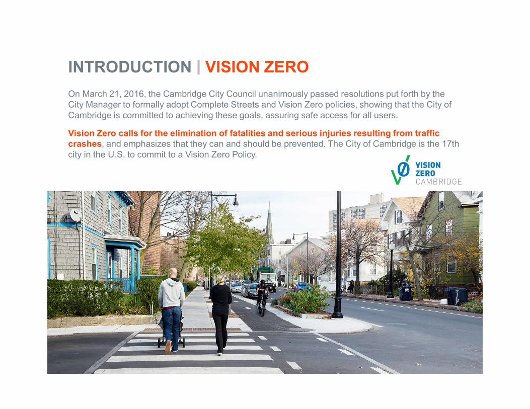
INTRODUCTION VISION ZERO
On March 21, 2016, the Cambridge City Council unanimously passed resolutions put forth by the City Manager to formally adopt Complete Streets and Vision Zero policies, showing that the City of Cambridge is committed to achieving these goals, assuring safe access for all users.
Vision Zero calls for the elimination of fatalities and serious injuries resulting from traffic crashes, and emphasizes that they can and should be prevented. The City of Cambridge is the 17th city in the U.S. to commit to a Vision Zero Policy.

INTRODUCTION GUIDING PLANS AND POLICIES
In addition to Complete Streets and Vision Zero
Cambridge Growth Policy emphasizes sustainable modes of transportation such as walking, biking and using transit and low-emission vehicles, which promote livability and help to improve air quality and reduce greenhouse gas emissions (1993/2007).
Vehicle Trip Reduction Ordinance established programs to encourage alternatives to single-occupancy vehicle travel (1992).

5 YEAR PLAN SCOPE OF WORKOur approach emphasizes streets designed and operated for everyone. Pedestrians, bicyclists, motorists, and transit users of all ages and abilities will be able to safely move along and across Complete Streets.
Emphasis on accessibility –pedestrian ramps, sidewalks
and universal design.
Additional street trees and green infrastructure.
Transit improvements –accessibility of bus stops and
transit priority, as feasible.
Network of bike facilities – support people of all ages and abilities to
bike safely throughout the city.
Maintain and improve city infrastructure, and coordinate with
private utilities to facilitate upgrades.
Vision Zero calls for the elimination of fatalities and
serious injuries resulting from traffic crashes.

RaisedCrosswalks
Flexi Pave[at trees]
Curb Extensions &Ramps
NewSidewalks
TOOLBOX DESIGNELEMENTS
STREET & SIDEWALK RECONSTRUCTION
New Tree Plantings
SidewalkConstruction
NewTreePlantings
Street and sidewalk contracts are funded locally and by the state. These contracts are managed by the Department of Public Works. Construction generally includes surface enhancements such as:
• Paving
• Sidewalk and pedestrian ramps
• Traffic calming
• Street trees
• Stormwater management and green infrastructure
• Bike and transit improvementsToolbox Design Elements
PROGRAMS STREET & SIDEWALK
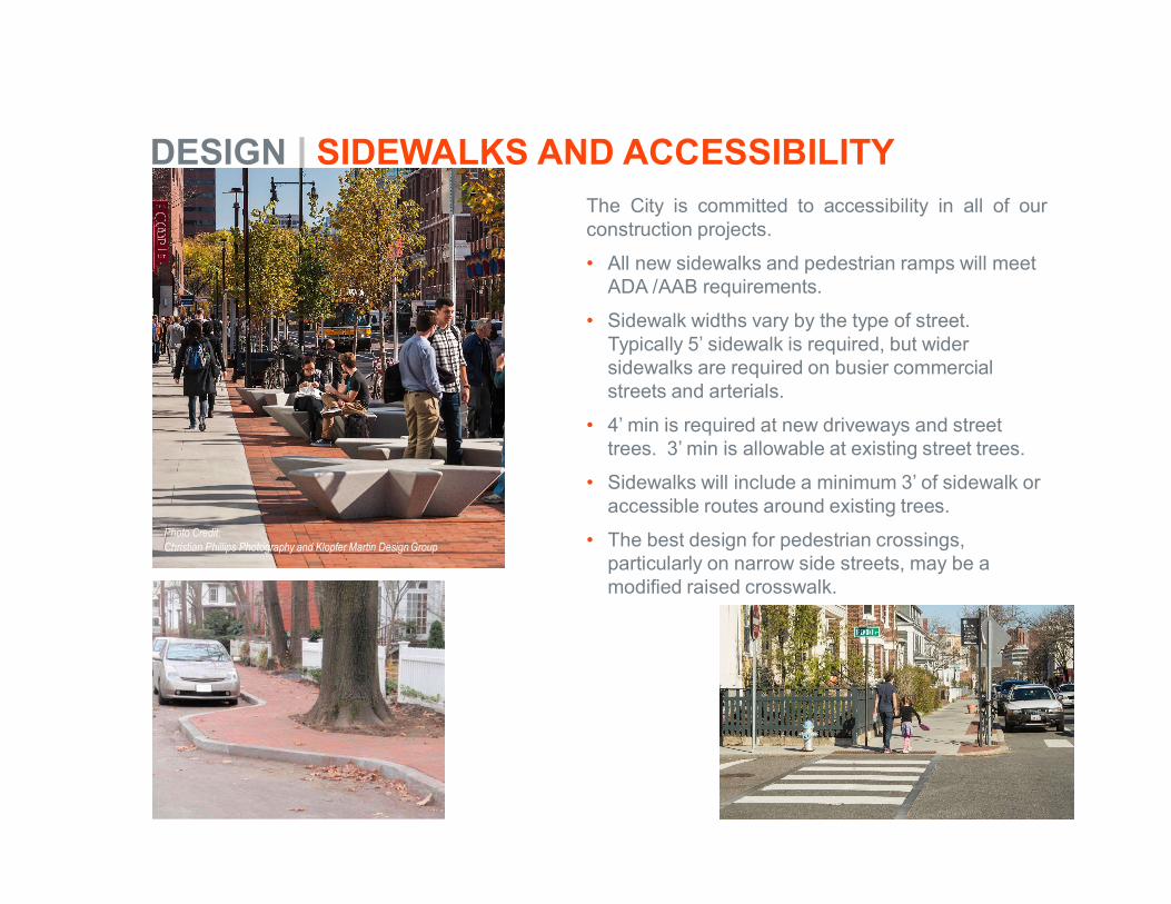
DESIGN SIDEWALKS AND ACCESSIBILITYThe City is committed to accessibility in all of ourconstruction projects.
• All new sidewalks and pedestrian ramps will meet ADA /AAB requirements.
• Sidewalk widths vary by the type of street. Typically 5’ sidewalk is required, but wider sidewalks are required on busier commercial streets and arterials.
• 4’ min is required at new driveways and street trees. 3’ min is allowable at existing street trees.
• Sidewalks will include a minimum 3’ of sidewalk or accessible routes around existing trees.
• The best design for pedestrian crossings, particularly on narrow side streets, may be a modified raised crosswalk.
Photo Credit:Christian Phillips Photography and Klopfer Martin Design Group
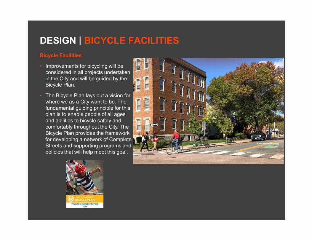
DESIGN BICYCLE FACILITIES
Bicycle Facilities
• Improvements for bicycling will be considered in all projects undertaken in the City and will be guided by the Bicycle Plan.
• The Bicycle Plan lays out a vision for where we as a City want to be. The fundamental guiding principle for this plan is to enable people of all ages and abilities to bicycle safely and comfortably throughout the City. The Bicycle Plan provides the framework for developing a network of Complete Streets and supporting programs and policies that will help meet this goal.
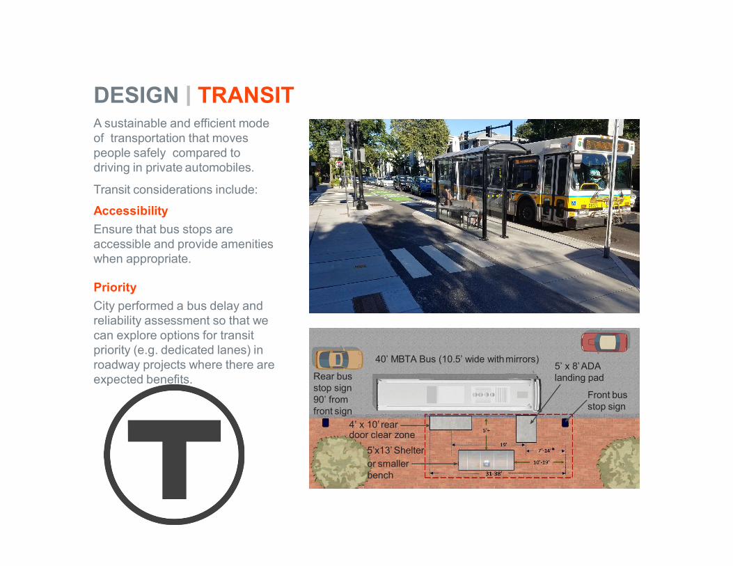
A sustainable and efficient mode of transportation that moves people safely compared to driving in private automobiles.
Transit considerations include:
Accessibility
Ensure that bus stops are accessible and provide amenities when appropriate.
Priority
City performed a bus delay and reliability assessment so that we can explore options for transit priority (e.g. dedicated lanes) in roadway projects where there are expected benefits.
40’ MBTA Bus (10.5’ wide withmirrors)5’ x 8’ADAlanding pad
Front bus stop sign
Rear bus stop sign 90’ from front sign
4’ x 10’ reardoor clear zone
5’x13’ Shelteror smaller bench
DESIGN TRANSIT

SCOPE STREET TREESExisting Street Trees
Existing street trees will be protected during construction and the sidewalks will be carefully evaluated to ensure adequate accessible routes through the neighborhood.
New Tree Plantings
The City Arborist will review each street andsidewalk project to determine tree planting opportunities; evaluating the location of overhead and underground utilities, proximity to intersections, site lines, building setbacks, locations of entrances, etc.
• On narrow sidewalks (less than 8’ wide), a minimum of 4’ of sidewalk width will be retained adjacent to new trees.
• On wider sidewalks (8’ wide or greater), a minimum of ½ of the overall sidewalk width will be retained for pedestrians.
Back of Sidewalk Trees
The Arborist will work with residents interested in back of sidewalk tree plantings.
GOALS
• Protect existing street trees during construction.
• Increase the number of street trees and maintain accessible sidewalks.

SCOPE GREEN INFRASTRUCTURE
The City is incorporating green infrastructure on projects, as conditions and space allow.
Goals
• Stormwater discharges are contributing to at least 55% of impairments to Massachusetts’ assessed waters.
• Goal: improve the water quality of stormwaterbefore discharging to outfalls at the Alewife Brook and Charles River.
Types of Improvements
• Porous asphalt
• Infiltrating catch basins
• Rain gardens/bio basins
Siting Evaluation
• Soil conditions
• Groundwater
• Space constraints
• Maintenance

SCOPE Construction
The City is committed to working with residents and businesses throughout the construction process.
Construction Coordination
• Project Manager and Community Relations Manager assigned to every project.
• Manage contractor and coordinate construction activities and community notifications.
• Standard Work Hours: Mon – Fri 7 am – 4 pm
• Maintain safe and effective traffic management plans to assist pedestrians, cyclists, drivers and buses travelling through project area.

Construction Project Scope• Reconstruct/repave street• Reconstruct sidewalks and curb ramps• New crosswalks, pavement markings• Evaluation and updating utilities
Project Objectives• Meet access codes• Improve safety for all users• Enhance appearance of the neighborhood• Enhance green areas/new trees

Meetings April 23rd and June 14th
• Vehicles speeding• Congestion due to signal timing – Huron Avenue
at Garden Street• Pedestrian safety –intersection of Huron and
Raymond• Additional crosswalk – at Holly Avenue• Evaluation of existing trees and possible new
trees• Bike Facilities
– Agreement on shared facilities (from Garden to Raymond) – Based on the bicycle vision plan
– Discussion about bike facilities (from Concord to Garden)

Bike Facilities:
• Project discussed with Bicycle, Pedestrian and Transit Committees at a meeting on May 14, 2018
• We were reminded that the Bicycle Network Vision Plan was a guidance document with specific designs developed as projects developed.
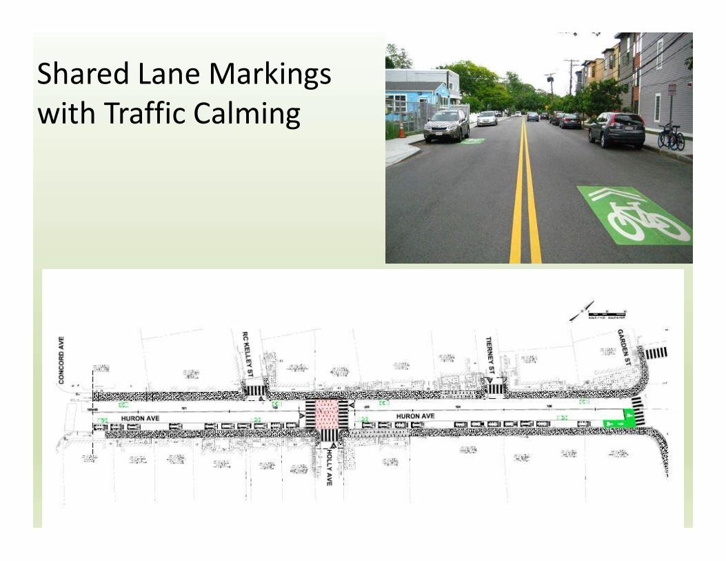
• Results of Meeting: Reviewing both the network and the specifics conditions on this stretch of Huron Avenue, the recommendation was that the portion of Huron Avenue between Concord Avenue and Garden Street be treated similarly to that section from Garden to Raymond Street, with traffic calming elements and strong green-back SLM markings. The project will connect to other streets with lower speeds/volumes, traffic calming elements, and bicycle priority designations.

Bike Lane
Low – Volume / Low-Speed / Traffic
Calming
Protected Bike Lane
• Protected bike lanes 6’-10’-10’-6’: Too narrow and significant issue for fire department. Removes all parking. Not viable option.
• Bike lanes 5’-11’-11’-5’: Fire department ok with this option. Removes 23 parking spaces. Not recommended by City or Bike Committee.
• City Recommendation at June 14th meeting: Shared lane / traffic calming: Supported at May 14th Bike / Ped / Transit Committee discussion. Fire Department ok with this option. Maintains all parking.
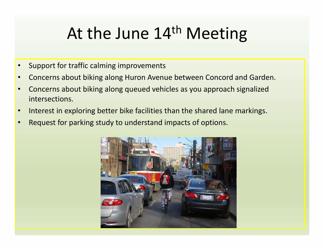
At the June 14th Meeting
• Support for traffic calming improvements• Concerns about biking along Huron Avenue between Concord and Garden.• Concerns about biking along queued vehicles as you approach signalized
intersections.• Interest in exploring better bike facilities than the shared lane markings.• Request for parking study to understand impacts of options.

Shared Lane Markings with Traffic Calming

Curbside Inventory and Project Limits

Types of Parking
• Commercial Uses – Loading zones for adjacent small businesses, general commercial activity.
• Residential

Study Area Parking Utilization

Since the MeetingParking Study & Petition
• Thursday June 21st, 7 am – midnight• Parking Usage Data
– Huron Ave – highest use 4 pm (71%)– Side Streets – highest use 7 am (76%)– Concord Ave Business – highest use – 3 pm
(76%)
• Concern about amount of parking loss(increases usage to over 85%) and also loading zones, access to businesses.
• City evaluated options to address the concerns about cyclists being squeezed between parked cars and queued vehicles.
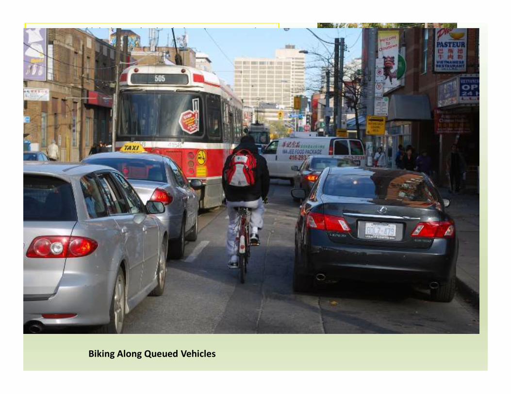
Biking Along Queued Vehicles
Low – Volume / Low-Speed / Traffic
Calming
Bike Lane
• Protected bike lanes 6’-10’-10’-6’: Too narrow and significant issue for fire department. Removes all parking. Not viable option.
• Bike lanes 5’-11’-11’-5’: Fire department ok with this option. Removes 23 parking spaces. Not recommended by City or Bike Committee.
• City Recommendation at June 14th meeting: Shared lane / traffic calming: Recommended at Bike / Ped / Transit Committee discussion. Fire Department ok with this option. Maintains all parking.
• Additional Options that address biking along queued vehicles as you approach signalized intersections.
Shared Lane Markings with Traffic Calming

Bike lanes approaching the signalized intersections

Bike lane on approaches to signalized intersections
• Provides space for cyclists adjacent to queuing vehicles
• Narrows travel lanes
• Does not require loss of any parking
Broadway approaching Prospect St

Bike lanes approachingsignalized intersections(relocating on-street parking)
• Provides space for cyclists adjacent to queuing vehicles• Shifts parking in 1 block. Eliminates squeeze between parked cars and
queued cars.

Bike Committee Meeting
Updated recommendations presented anddiscussed with Bicycle Committee at a meetingon September 13, 2018.
CONCLUSION:The proposed recommendation addresses themore significant concerns while accommodatingall users. Bike committee members supportedthe recommendation recognizing it is acompromise.

All Options have Traffic Calming
Low – Volume / Low-Speed / Traffic
Calming
Raised intersections reduce vehicle speed, improves accessibility and improves visibility

Huron Avenue Reconstruction Project(Garden St to Raymond Street)
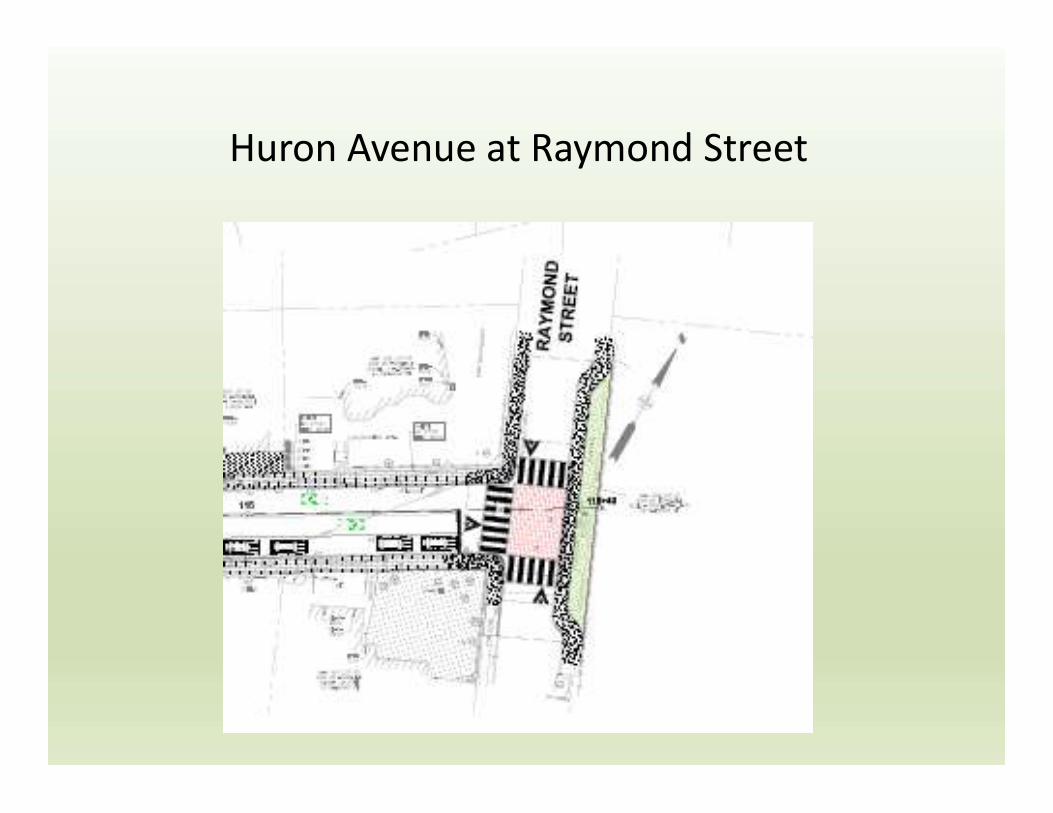
Huron Avenue at Raymond Street

Discussion
Next StepsFinalize Design
Bid project end of yearConstruction 2019 / 2020