the weather eye...the weather eye page 2 snow depth is reported to the nearest whole number (inch)....
TRANSCRIPT

The Weather Eye Page 1
The Weather Eye
A Southern New England
Cooperative Weather Observer Newsletter
January 2015 Editor: Kimberly Buttrick
WINTER/SPRING TIME CHECKS
It is good practice to check your innertube
and overflow can for leaks from time to
time. As a suggestion, check for leaks at the
beginning and at the end of the winter
season.
During the winter season, the funnel and
innertube should be removed from the
overflow can. This will enable any and all
snowflakes that fall at your station to
accumulate in your overflow can and ensure
an uninterrupted climate record.
When you hear that snow is in the forecast,
that’s your cue to remove the funnel and
innertube from your rain gauge.
Come spring, check your innertube once
again for any leaks. Mid April or early May
is a good time to place the innertube back
into the overflow can with funnel atop.
Climatologically speaking, mid April/early
May is usually when snow storms suspend
operations in our neck of the woods.
KEEP THOSE ZEROS COMING
If you have zero rainfall to report, report
0.00. If you have zero snowfall to report,
report 0.0. If you have zero snow on the
ground, report 0. In other words, don’t
leave a field blank and assume it is
interpreted as zero. A blank field is
interpreted as missing. So, if you have zero
to report, whether rainfall, snowfall or snow
on the ground, report it!
REPETITION MAKES FOR A GOOD
B91
During the summer months, it gets
repetitious and monotonous when you have
to enter zero every day for snowfall and
snow depth – unless of course you get a
good dousing of hail from a strong to severe
thunderstorm. But those repetitions of zeros
in the snowfall and snow depth fields make
for a good B91. Blank fields are not good as
they get interpreted as missing. So keep up
the good work and keep those zero
repetitions coming!
CHECK YOUR SNOW DEPTH
Part of winter time observing, includes
checking the snow on the ground, also called
snow depth. Some observers forget this key
piece of climate information. If you have
snow remaining on the ground, please
measure and report the snow depth daily.

The Weather Eye Page 2
Snow depth is reported to the nearest whole
number (inch). If you have no snow on the
ground, then report it as zero. If the ground
is mostly bare, but snow patches remain,
report as a Trace.
A FLURRY OF ACTIVITY = TRACE
SPOTTY DRIZZLE = TRACE
If you see flurries occurring at your station,
you should report a Trace of snowfall. And
a trace of snowfall means a trace of liquid
precipitation too! Even if the flurries do not
accumulate on the ground, you would record
a Trace of snowfall and a Trace of
precipitation. And of course, you would
also measure the snow depth and report to
the nearest whole inch. If there is no snow
on the ground, you would report 0. If your
snow depth is less than 0.5 inches, but there
still remains some snow on the ground, then
report a “T” for Trace.
We have a few observers who call in their
observation to our office each morning.
There have been a few instances when they
report either light rain or snow (drizzle or
flurries) for their current weather and then
report zero for precipitation. If it is
precipitating at the time of your observation,
you must record something for precipitation
– at least a Trace. The precipitation,
whether frozen or liquid, may not measure
up to anything in your rain gauge or on your
snow board, but a trace is a trace is a trace –
is a trace!
FREEZING RAIN AND FREEZING
DRIZZLE AND THE MAGIC OF 32
Reminder: If it is raining or drizzling at
your station at the time of your observation
and your current temperature is 32 degrees
or colder, then you would report freezing
rain or freezing drizzle as your current
weather.
WIRELESS EMERGENCY ALERTS
– WEATHER WARNINGS ON THE GO!
Imagine this: You’re driving down the
highway, humming along to your favorite
tunes or listening to your favorite talk radio
station, when the cell phone stowed in your
bag suddenly makes a strange noise. To
investigate, you take the next exit and safely
pull over to check the screen. Good thing
you did. Your phone just alerted you to a
tornado a few miles away in the same
county you’re driving through.
Sound plausible? It is. America’s wireless
industry is helping to build a Weather-Ready
Nation through a nationwide text emergency
alert system, called Wireless Emergency
Alerts (WEA), which will warn you when
weather threatens.
For more information on Wireless
Emergency Alerts, check out this web link:
http://www.weather.gov/wirelessalerts
UPDATED WEBPAGE
NWS Taunton’s website has changed. The
address is still the same but the home page
looks a bit different. Please check us out at:
www.weather.gov/boston
If you have a problem navigating the site,
please give us a call. We’d be glad to help
you.
NWS Taunton can be reached at:
508-823-2262 or 508-823-1983 or
800-243-1686.

The Weather Eye Page 3
HISTORICAL RECORDS
Historical records for all Cooperative
Weather Observing sites are available at the
National Climatic Data Center in Asheville,
North Carolina. They can be reached by
telephone at (828) 271-4800 or online at:
www.ncdc.noaa.gov. Historical records can
also be accessed at the Northeast Regional
Climate Center in Ithaca, New York. They
can be reached by telephone at (607)-255-
1751 or online at: www.nrcc.cornell.edu.
Climate information can also be accessed
via an applied climate information system
provided by the Northeast Regional Climate
Center: http://climodtest.nrcc.cornell.edu/.
This climate information system allows one
to query climate data in different ways
whether for a single station or multi-stations.
Here is a list of what you can query:
Almanac Data for a Day
Activity Planner for a Day
Daily Data for a Month
Daily Data Listing
Daily Degree Days
Calendar Day Summaries
Monthly Summarized Data
Seasonal Ranking
Frost/Freeze Summaries
Daily/Monthly Normals
Temperature Graph
Accumulation Graph
And yet another avenue to query climate
data from Coop sites as well as Automated
Service Observing Systems (ASOS) is
through what is called NOAA Online
Weather Data (NOWData). NOWData is an
applied climate information system
complements of the Northeast Regional
Climate Center.
NOWData can be accessed via WFO
Taunton’s website at:
http://www.nws.noaa.gov/climate/xmacis.ph
p?wfo=box
Here is a list of what is available to query in
NOWData for Coop and ASOS sites:
Daily data for a month
Daily almanac
Monthly summarized data
Calendar day summaries
Daily/monthly normals
Climatology for a day
First/last dates
Temperature graphs
Accumulation graphs
NWS TAUNTON NEWSLETTER LINK
Did you know that NWS Taunton issues an
office newsletter called Prevailing Winds?
While The Weather Eye is specifically
written and published for Coop Observers,
Prevailing Winds targets a wider audience.
You can check out recent and past issuances
of Prevailing Winds at:
http://www.weather.gov/box/prevailingwinds

The Weather Eye Page 4
MEMORY LANE - A GLIMPSE BACK AT A FEW SIGNIFICANT
WEATHER EVENTS FROM 2014
BLIZZARD JANUARY 2014
Here is a Public Information Statement issued by our office on January 7, 2014:
PUBLIC INFORMATION STATEMENT
NATIONAL WEATHER SERVICE TAUNTON MA
300 PM EST TUE JAN 07 2014
...BLIZZARD OF 2014 IN SOUTHEASTERN MASSACHUSETTS...
BLIZZARD CONDITIONS WERE REACHED AT FOUR LOCATIONS IN SOUTHEASTERN
MASSACHUSETTS DURING THE STORM THAT OCCURRED ON JANUARY 2 AND 3. THUS IT IS
SAFE TO CALL THIS A BLIZZARD.
THE STRICT DEFINITION OF A BLIZZARD IS THAT FALLING AND/OR BLOWING SNOW
REDUCES VISIBILITY TO BELOW 1/4 MILE ALONG WITH WINDS THAT FREQUENTLY GUST TO
35 MPH OR MORE...AND THAT THESE CONDITIONS ARE THE PREDOMINANT REPORTED
CONDITION FOR 3 CONSECUTIVE HOURS.
WHEN REVIEWING WHETHER A PARTICULAR OBSERVATION LOCATION HAD BLIZZARD
CONDITIONS...WE COUNTED VISIBILITIES EQUAL TO 1/4 MILE SINCE THAT IS QUITE
LOW FOR AN AUTOMATED VISIBILITY SENSOR TO BE ABLE TO DETECT.
AT HYANNIS...BLIZZARD CONDITIONS OCCURRED FROM 543 AM TO 849 AM ON JANUARY 3.
AT MARSHFIELD...BLIZZARD CONDITIONS OCCURRED FROM 555 PM JANUARY 2 TO 635 AM
ON JANUARY 3.
AT FALMOUTH...BLIZZARD CONDITIONS OCCURRED FROM 335 AM TO 855 AM ON
JANUARY 3.
AT NANTUCKET...BLIZZARD CONDITIONS OCCURRED FROM 729 AM TO 418 PM ON JANUARY
3. AT NANTUCKET...THE VISIBILITY REDUCTIONS AT TIMES WERE MORE FROM BLOWING
SNOW THAN FALLING SNOW WHICH ACCOUNTED FOR SOME OF THE HIGHER CEILINGS THAT
WERE REPORTED.
IT SHOULD BE NOTED THAT NEAR-BLIZZARD CONDITIONS WERE OBSERVED AT CHATHAM AND
PROVINCETOWN BUT VISIBILITY REDUCTIONS WERE NOT AS PERSISTENT.
$$

The Weather Eye Page 5
FREE INVENTORY LATE MARCH 2014
– NEARLY A MONTH’S WORTH OF RAIN IN A FEW DAYS
Earlier this year, observers reported nearly a month’s worth of rainfall over
3 days – March 30, March 31 and April 1. On Saturday, March 29, 2014, a
frontal boundary was draped across Southern New England while a low
pressure area approached from the southeast. Rain began spreading across
Southern New England during the afternoon hours but then became heavy at
times Saturday night into Sunday morning as the coastal storm tracked south
of New England. By Sunday afternoon, March 30, much of Southern New
England was recovering from the abundant rainfall received over 24 hours.
Rainfall totals ranged from 2.5 to as much as 5.5 inches of rain. The worst
hit areas were Rhode Island and Bristol County Massachusetts. Low
pressure just east of Atlantic City, NJ eventually passed south of New
England Sunday night and out to sea on Monday, March 31 but not before depositing more rain
(albeit light) across the region and a change to a wintry mix north and west of Boston.
Following is a list of some climate sites across Southern New England. The 3 columns adjacent
to the climate sites list:
1) 3-day rainfall (March 30-31 and April 1);
2) Normal March rainfall for the 1981-2010 time period; and
3) Departure from normal (3 day total compared to March normal).
3-day total March Normals Departure
Climate Site Mar 30-Apr 1 1981-2010 from Normal
MA Amherst 2.98 3.57 -0.59
Ashburnham North 3.24 3.84 -0.60
Barre Falls Dam 3.49 3.63 -0.14
Belchertown 4.06 3.77 +0.29
Birch Hill Dam 3.36 3.88 -0.52
Boston’s Logan Airport 3.64 4.32 -0.68
Bridgewater 3.99 4.82 -0.83
Brockton 4.51 5.18 -0.67
Buffumville Lake 3.91 4.45 -0.54
East Brimfield 4.35 4.32 +0.03
East Wareham 4.52 5.35 -0.83
Franklin 4.05 4.82 -0.77
Lowell 4.74 4.23 +0.51
Marblehead 4.02 4.84 -0.82
Maynard 4.15 4.62 -0.47
Milford 3.95 4.55 -0.60
Natick 4.00 4.08 -0.08
Northbridge 3.80 4.67 -0.87

The Weather Eye Page 6
Rochester 5.34 5.19 +0.15
Southbridge 4.13 4.60 -0.47
Ware 3.65 3.83 -0.18
Worcester Airport 4.01 4.21 -0.20
NH East Milford 3.27 3.61 -0.34
Greenville 3.64 4.50 -0.86
Hudson 4.01 4.28 -0.27
Massabesic Lake 3.35 3.01 +0.34
Nashua 3.99 4.30 -0.31
CT Bradley Intl Airport 3.30 3.62 -0.32
Hampton 4.10 4.54 -0.44
Staffordville 3.43 4.11 -0.68
Storrs 3.55 4.44 -0.89
RI
Kingston 5.98 5.54 +0.44
PVD T.F. Green Airport 5.59 5.01 +0.58
Tiverton 5.79 5.68 +0.11
THE REVERE TORNADO – JULY 28, 2014
Here is an excerpt of a Public Information Statement issued by our office on July 28, 2014:
PUBLIC INFORMATION STATEMENT
NATIONAL WEATHER SERVICE TAUNTON MA
432 PM EDT MON JUL 28 2014
...TORNADO CONFIRMED IN SUFFOLK COUNTY MA...
LOCATION...CHELSEA AND REVERE IN SUFFOLK COUNTY MA
DATE... JULY 28 2014
ESTIMATED TIME...9:32 - 9:36 AM EDT
MAXIMUM EF-SCALE RATING...EF2
ESTIMATED MAXIMUM WIND SPEED...120 MPH
MAXIMUM PATH WIDTH...3/8 OF A MILE
PATH LENGTH...2.0 MILES
BEGINNING LAT/LON...42.3980 / -71.0219
ENDING LAT/LON...42.4225 / -71.0037
* FATALITIES...0
* INJURIES...0
...SUMMARY...
THE NATIONAL WEATHER SERVICE IN TAUNTON MA HAS CONFIRMED THAT A TORNADO
TOUCHED DOWN ON THE MORNING OF JULY 28 2014 IN CHELSEA AND REVERE IN SUFFOLK
COUNTY MASSACHUSETTS. IT HAD A PATH LENGTH OF 2 MILES AND PATH WIDTH OF 3/8

The Weather Eye Page 7
OF A MILE. MOST DAMAGE HAD A RATING OF EF-1 ON THE ENHANCED FUJITA SCALE BUT
EF-2 DAMAGE WAS OBSERVED IN THE VICINITY OF REVERE BEACH PARKWAY. THUS THIS
EVENT IS CLASSIFIED AS AN EF-2 TORNADO. MAXIMUM WIND GUSTS WERE ESTIMATED AT
BETWEEN 100 AND 120 MPH. THANKFULLY AND MIRACULOUSLY THERE WERE NO
FATALITIES OR INJURIES REPORTED AS A RESULT OF THIS TORNADO.
ALTHOUGH THE TORNADO BEGAN IN CHELSEA...WHERE A WINDOW WAS REPORTED TO HAVE
BEEN BLOWN OUT ON DUDLEY STREET...THE OVERWHELMING MAJORITY OF DAMAGE
OCCURRED IN THE TOWN OF REVERE.
THE TORNADO MOVED ACROSS THE CHELSEA RIVER...DIRECTLY ACROSS THE PAUL CRONIN
MEMORIAL SKATING RINK...AND PORTIONS OF ITS ROOF WERE BLOWN NORTHEASTWARD
ACROSS ROUTE 16. NUMEROUS HOUSES ON REVERE BEACH PARKWAY WERE SEVERELY
IMPACTED...WITH ONE ROOF COMPLETELY BLOWN OFF. IN THAT VICINITY...LARGE OAK
TREES WERE SNAPPED MID-WAY UP. JUST TO THE EAST OF THE ONRAMP FROM ROUTE 107
TO ROUTE 16...TREES WERE DOWNED FROM WEST TO EAST. TREES JUST TO THE WEST OF
WILSON STREET WERE DOWNED FROM EAST TO WEST. THIS GAVE A CLEAR DELINEATION
OF THE TRACK OF THE TORNADO...WHICH IS LOW PRESSURE AND HAS TREES BLOWING IN
TOWARD THE TRACK. SOME TREES AND TREE LIMBS WERE LIFTED UP AND DEPOSITED ON
TOP OF HOUSES IMMEDIATELY BEHIND REVERE BEACH PARKWAY.
THE DAMAGE WAS WIDESPREAD THROUGHOUT MUCH OF THE CENTER OF REVERE. THE
TORNADO TRAVELED NORTHWARD...BASICALLY FOLLOWING ROUTE 107/BROADWAY. AT THE
TOWN HALL...WINDOWS WERE BLOWN OUT AND THERE WAS ROOF DAMAGE. A LARGE BIRCH
TREE WAS UPROOTED THERE. MORE THAN A HUNDRED HOMES HAD DAMAGE THAT RANGED
FROM SIDING TORN OFF TO PORTIONS OF ROOFS LIFTED OR BLOWN OFF. THERE WERE
SEVERAL STORE SIGNS THAT WERE DESTROYED. DEBRIS FROM HOMES COULD BE SEEN
COLLECTING ON FENCES. TREES FELL ON SEVERAL CARS WITH A FEW BEING CRUSHED.
THE POLICE REPORTED THAT A CAR HAD BEEN OVERTURNED...TO THE WEST OF BROADWAY
AT THE INTERSECTION OF MALDEN STREET AND CARLSON AVENUE. THE DAMAGE PATH
CONTINUED NORTHWARD TO JUST BEYOND THE ROTARY AT ROUTE 60. NEAR THAT ROTARY
THERE WAS A BILLBOARD LYING ON TOP OF SEVERAL CARS.
THE TOTAL PATH LENGTH WAS 2 MILES AND THE PATH WIDTH WAS APPROXIMATELY 3/8 OF
A MILE...WITH A SHARP CUTOFF OF THE DAMAGE JUST EAST OF AMERICAN LEGION
HIGHWAY/ROUTE 60.
THE NATIONAL WEATHER SERVICE WOULD LIKE TO EXTEND ITS APPRECIATION TO OUR
NORTH SHORE AND BOSTON SKYWARN AMATEUR RADIO COORDINATORS...THE MASSACHUSETTS
EMERGENCY MANAGEMENT AGENCY REGION 1 OFFICE...AND THE REVERE POLICE
DEPARTMENT FOR HELPING US TREMENDOUSLY WITH THIS STORM SURVEY.
FOR REFERENCE...THE ENHANCED FUJITA SCALE CLASSIFIES TORNADOES INTO THE
FOLLOWING CATEGORIES:
EF0...WIND SPEEDS 65 TO 85 MPH.
EF1...WIND SPEEDS 86 TO 110 MPH.
EF2...WIND SPEEDS 111 TO 135 MPH.
EF3...WIND SPEEDS 136 TO 165 MPH.
EF4...WIND SPEEDS 166 TO 200 MPH.
EF5...WIND SPEEDS GREATER THAN 200 MPH.

The Weather Eye Page 8
AN UNUSUALLY DRY SEPTEMBER 2014
– THE CLIMATE PENDULUM SWINGS IN THE OTHER DIRECTION
Here is an excerpt of a Public Information Statement issued by our office on October 1, 2014:
PUBLIC INFORMATION STATEMENT
NATIONAL WEATHER SERVICE TAUNTON MA
1024 AM EDT WED OCT 1 2014
...HOW DRY WAS SEPTEMBER?...
THE FOLLOWING IS A REVIEW OF RAINFALL TOTALS FOR THE MONTH OF SEPTEMBER.
RANKINGS OF THE TOP TEN WITH RESPECT TO DRIEST SEPTEMBERS ON RECORD ARE
PROVIDED - WITH 1 BEING THE DRIEST. LOWEST RAINFALL TOTALS FOR THE MONTH OF
SEPTEMBER AND THE YEAR OF OCCURRENCE ARE ALSO PROVIDED.
THE LIST INCLUDES MONTHLY RAINFALL TOTALS FROM COOPERATIVE OBSERVING STATIONS
ENDING 7 AM SEPTEMBER 30TH. THOSE STATIONS WITH RAINFALL TOTALS ENDING AT
1159 PM SEPTEMBER 30th ARE INDICATED WITH **.
* RECORDS WITH 50-YEARS OR MORE OF DATA.
MONTHLY RECORD RECORDS
ID LOCATION TOTAL RANK LOWEST BEGIN
-- -------- ------- ---- ------ -------
WESTERN MASSACHUSETTS...
INCLUDING FRANKLIN...HAMPSHIRE...HAMPDEN COUNTIES
AMHERST 1.34 9 0.52 1914 1893*
GREENFIELD 1.60 2 1.55 2009 2000
LEVERETT 1.15 2 0.57 2009 2009
SUNDERLAND 0.98 2 0.82 1984 1978
WESTFIELD 1.76 1 --------- 2007
WORTHINGTON 1.53 1 --------- 1994
CENTRAL MASSACHUSETTS...
INCLUDING WORCESTER COUNTY
BUFFUMVILLE LAKE 1.34 5 0.77 1959 1959*
HARDWICK 4.03 6 1.11 2009 2007
MILFORD 0.77 6 0.42 1941 1931*
NORTHBRIDGE 0.62 1 --------- 1964*
NORTHEAST MASSACHUSETTS...
INCLUDING MIDDLESEX...ESSEX...SUFFOLK COUNTIES
BEVERLY 1.78 5 1.45 1998 1996
JAMAICA PLAIN 0.76 1 --------- 1962*
MARBLEHEAD 1.25 2 1.19 1997 1984
READING** 1.32 3 0.64 1978 1960*
SOUTHEAST MASSACHUSETTS...
INCLUDING BRISTOL...NORFOLK...PLYMOUTH...BARNSTABLE...DUKES COUNTIES
BLUE HILL COOP 0.36 1 --------- 1885*
BRIDGEWATER 1.17 2 1.15 2003 2003
BROCKTON** 0.70 6 0.13 1930 1894*
CHATHAM 1.73 6 0.68 2001 1972
EAST SANDWICH 1.45 1 --------- 2010

The Weather Eye Page 9
FRANKLIN 0.65 3 0.26 1941 1926*
MIDDLEBORO 0.75 4 0.14 1941 1893*
NORTON 0.67 3 0.58 1930 1913*
ROCHESTER 0.85 3 0.48 1957 1952*
TAUNTON NWS 0.74 1 --------- 1997
WALPOLE 0.29 1 --------- 1948*
WOODS HOLE 2.13 1 --------- 2010
SOUTHWEST NEW HAMPSHIRE...
INCLUDING CHESHIRE COUNTY
JAFFREY SILVERRANCH 1.25 1 --------- 2011
OTTER BROOK 1.81 10 0.31 1964 1958*
SURRY MOUNTAIN 1.55 9 0.14 1948 1948*
WALPOLE 0.65 1 --------- 1979
SOUTH CENTRAL NEW HAMPSHIRE...
INCLUDING HILLSBOROUGH COUNTY
EAST MILFORD 1.61 2 1.20 2010 2008
EDWARD MACDOWELL LK 1.43 8 0.04 2002 1950*
FRANCESTOWN 2.31
GREENVILLE 1.66 5 1.28 1998 1988
HUDSON 2.08 8 0.94 2009 1986
JAFFREY 1.25 1 --------- 2011
MASSABESIC LAKE 1.39 9 0.22 1948 1942*
WEARE 0.62 1 --------- 2012
NORTH CENTRAL AND NORTHEAST CONNECTICUT...
INCLUDING HARTFORD...TOLLAND...WINDHAM...AND EASTERN LITCHFIELD COUNTIES
BARKHAMSTEAD 0.92 3 0.63 1948 1932*
BURLINGTON 1.68 9 0.24 1948 1932*
HAMPTON 1.71 3 1.39 2009 2004
STAFFORDVILLE 2.00 4 1.11 2010 2002
WEST THOMPSON LK 1.50 6 0.65 1986 1963*
RHODE ISLAND...
INCLUDING PROVIDENCE AND KENT COUNTIES
COVENTRY 1.00 1 --------- 2011
KINGSTON 0.88 4 0.35 1941 1893*
NORTH FOSTER** 0.74 1 --------- 1975
TIVERTON 1.17 1 --------- 1998
WOONSOCKET 0.62 1 --------- 1948*
$$
EARLY OCTOBER 2014 – A PROLONGED NORTHEAST WIND RAIN EVENT
Here is an excerpt of a Public Information Statement issued by our office on October 2, 2014:
PUBLIC INFORMATION STATEMENT...UPDATED FINAL
SPOTTER REPORTS
NATIONAL WEATHER SERVICE TAUNTON MA
225 PM EDT THU OCT 02 2014
THE FOLLOWING ARE OBSERVATIONS TAKEN DURING A 3-DAY RAIN EVENT. HIGH
PRESSURE ANCHORED OVER SOUTHEASTERN CANADA AND LOW PRESSURE WELL OFFSHORE OF
CAPE COD BROUGHT A PROLONGED COOL AND DAMP NORTHEAST WIND FLOW ACROSS
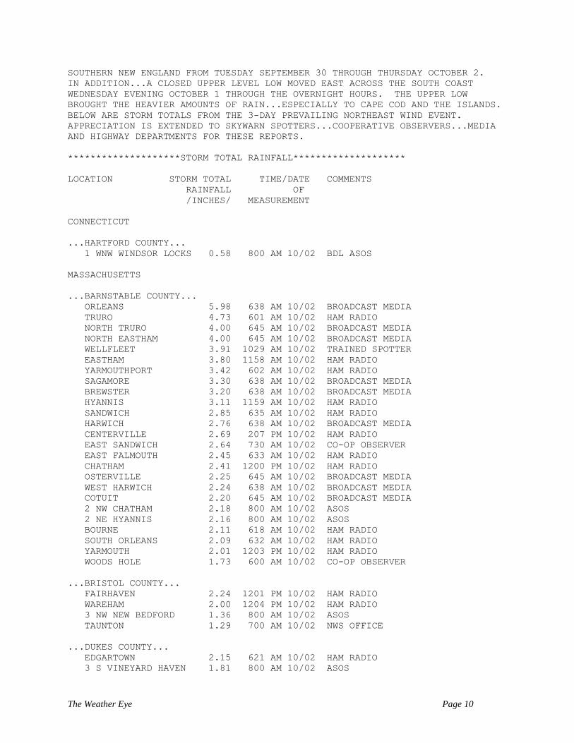
The Weather Eye Page 10
SOUTHERN NEW ENGLAND FROM TUESDAY SEPTEMBER 30 THROUGH THURSDAY OCTOBER 2.
IN ADDITION...A CLOSED UPPER LEVEL LOW MOVED EAST ACROSS THE SOUTH COAST
WEDNESDAY EVENING OCTOBER 1 THROUGH THE OVERNIGHT HOURS. THE UPPER LOW
BROUGHT THE HEAVIER AMOUNTS OF RAIN...ESPECIALLY TO CAPE COD AND THE ISLANDS.
BELOW ARE STORM TOTALS FROM THE 3-DAY PREVAILING NORTHEAST WIND EVENT.
APPRECIATION IS EXTENDED TO SKYWARN SPOTTERS...COOPERATIVE OBSERVERS...MEDIA
AND HIGHWAY DEPARTMENTS FOR THESE REPORTS.
********************STORM TOTAL RAINFALL********************
LOCATION STORM TOTAL TIME/DATE COMMENTS
RAINFALL OF
/INCHES/ MEASUREMENT
CONNECTICUT
...HARTFORD COUNTY...
1 WNW WINDSOR LOCKS 0.58 800 AM 10/02 BDL ASOS
MASSACHUSETTS
...BARNSTABLE COUNTY...
ORLEANS 5.98 638 AM 10/02 BROADCAST MEDIA
TRURO 4.73 601 AM 10/02 HAM RADIO
NORTH TRURO 4.00 645 AM 10/02 BROADCAST MEDIA
NORTH EASTHAM 4.00 645 AM 10/02 BROADCAST MEDIA
WELLFLEET 3.91 1029 AM 10/02 TRAINED SPOTTER
EASTHAM 3.80 1158 AM 10/02 HAM RADIO
YARMOUTHPORT 3.42 602 AM 10/02 HAM RADIO
SAGAMORE 3.30 638 AM 10/02 BROADCAST MEDIA
BREWSTER 3.20 638 AM 10/02 BROADCAST MEDIA
HYANNIS 3.11 1159 AM 10/02 HAM RADIO
SANDWICH 2.85 635 AM 10/02 HAM RADIO
HARWICH 2.76 638 AM 10/02 BROADCAST MEDIA
CENTERVILLE 2.69 207 PM 10/02 HAM RADIO
EAST SANDWICH 2.64 730 AM 10/02 CO-OP OBSERVER
EAST FALMOUTH 2.45 633 AM 10/02 HAM RADIO
CHATHAM 2.41 1200 PM 10/02 HAM RADIO
OSTERVILLE 2.25 645 AM 10/02 BROADCAST MEDIA
WEST HARWICH 2.24 638 AM 10/02 BROADCAST MEDIA
COTUIT 2.20 645 AM 10/02 BROADCAST MEDIA
2 NW CHATHAM 2.18 800 AM 10/02 ASOS
2 NE HYANNIS 2.16 800 AM 10/02 ASOS
BOURNE 2.11 618 AM 10/02 HAM RADIO
SOUTH ORLEANS 2.09 632 AM 10/02 HAM RADIO
YARMOUTH 2.01 1203 PM 10/02 HAM RADIO
WOODS HOLE 1.73 600 AM 10/02 CO-OP OBSERVER
...BRISTOL COUNTY...
FAIRHAVEN 2.24 1201 PM 10/02 HAM RADIO
WAREHAM 2.00 1204 PM 10/02 HAM RADIO
3 NW NEW BEDFORD 1.36 800 AM 10/02 ASOS
TAUNTON 1.29 700 AM 10/02 NWS OFFICE
...DUKES COUNTY...
EDGARTOWN 2.15 621 AM 10/02 HAM RADIO
3 S VINEYARD HAVEN 1.81 800 AM 10/02 ASOS

The Weather Eye Page 11
...NANTUCKET COUNTY...
2 ESE NANTUCKET 1.34 800 AM 10/02 ASOS
...NORFOLK COUNTY...
3 SSW MILTON 2.06 800 AM 10/02 BLUE HILL ASOS
BLUE HILLS 2.03 800 AM 10/02 CO-OP OBSERVER
QUINCY 1.70 1137 AM 10/02 GENERAL PUBLIC
NORWOOD 1.59 700 AM 10/02 NWS EMPLOYEE
1 ENE NORWOOD 1.47 800 AM 10/02 ASOS
...PLYMOUTH COUNTY...
PLYMOUTH 3.30 604 AM 10/02 HAM RADIO
DUXBURY 3.30 638 AM 10/02 BROADCAST MEDIA
WEST WAREHAM 2.11 645 AM 10/02 HAM RADIO
4 SW PLYMOUTH 2.01 800 AM 10/02 ASOS
MATTAPOISETT 2.00 630 AM 10/02 BROADCAST MEDIA
MIDDLEBORO 1.96 700 AM 10/02 CO-OP OBSERVER
BROCKTON 1.94 1243 PM 10/02 TRAINED SPOTTER
BRIDGEWATER 1.85 700 AM 10/02 CO-OP OBSERVER
ROCHESTER 1.75 800 AM 10/02 CO-OP OBSERVER
...SUFFOLK COUNTY...
1 N EAST BOSTON 1.49 800 AM 10/02 LOGAN ASOS
...WORCESTER COUNTY...
3 WNW WORCESTER 1.00 800 AM 10/02 ORH ASOS
AUBURN 0.71 450 AM 10/02 TRAINED SPOTTER
RHODE ISLAND
...KENT COUNTY...
2 NNW WARWICK 0.68 800 AM 10/02 PVD ASOS
EARLY SEASON NOREASTER HERALDS IN THANKSGIVING 2014
Here is an excerpt of a Public Information Statement issued by our office on November 27,
2014:
PUBLIC INFORMATION STATEMENT...FINAL
SPOTTER REPORTS
NATIONAL WEATHER SERVICE TAUNTON MA
1140 AM EST THU NOV 27 2014
AN EARLY SEASON NOREASTER BROUGHT A COMBINATION OF SNOW...SLEET...RAIN AND
WIND TO SOUTHERN NEW ENGLAND. THE ONSET OF PRECIPITATION OCCURRED ON
WEDNESDAY MORNING NOVEMBER 26 THEN TAPERED OFF IN THE EARLY MORNING HOURS OF
THANKSGIVING THURSDAY NOVEMBER 27.
THE FOLLOWING ARE OBSERVATIONS TAKEN DURING THE PAST 24 HOURS FOR THE
NOREASTER THAT AFFECTED OUR REGION. APPRECIATION IS EXTENDED TO SKYWARN
SPOTTERS...COOPERATIVE OBSERVERS...MEDIA...AND HIGHWAY DEPARTMENTS FOR THESE
REPORTS.

The Weather Eye Page 12
********************STORM TOTAL SNOWFALL********************
LOCATION STORM TOTAL TIME/DATE COMMENTS
SNOWFALL OF
/INCHES/ MEASUREMENT
CONNECTICUT
...HARTFORD COUNTY...
HARTLAND 10.4 620 AM 11/27 TRAINED SPOTTER
NORTH GRANBY 7.3 652 AM 11/27 TRAINED SPOTTER
COLLINSVILLE 6.0 815 AM 11/27 TRAINED SPOTTER
CANTON 6.0 924 AM 11/27 TRAINED SPOTTER
1 WNW WINDSOR LOCKS 5.0 753 AM 11/27 BDL AIRPORT
ENFIELD 4.0 912 AM 11/27 HAM RADIO
WEST HARTFORD 3.0 1013 AM 11/27 BROADCAST MEDIA
BURLINGTON 3.0 932 PM 11/26 TRAINED SPOTTER
...TOLLAND COUNTY...
STAFFORDVILLE 5.0 727 AM 11/27 CO-OP OBSERVER
TOLLAND 4.1 526 AM 11/27 TRAINED SPOTTER
COVENTRY 3.0 724 AM 11/27 SOCIAL MEDIA
...WINDHAM COUNTY...
POMFRET CENTER 2.0 920 AM 11/27 TRAINED SPOTTER
ASHFORD 1.8 952 AM 11/27 HAM RADIO
EASTFORD 1.3 951 AM 11/27 HAM RADIO
MASSACHUSETTS
...BRISTOL COUNTY...
NORTON 0.3 800 AM 11/27 CO-OP OBSERVER
...ESSEX COUNTY...
HAVERHILL 5.7 906 AM 11/27 AMATEUR RADIO
WEST NEWBURY 4.7 1039 AM 11/27 TRAINED SPOTTER
AMESBURY 4.0 1012 AM 11/27 SOCIAL MEDIA
SALISBURY 4.0 710 AM 11/27 COOP OBSERVER
BRADFORD 4.0 854 AM 11/27 HAM RADIO
TOPSFIELD 2.7 831 AM 11/27 TRAINED SPOTTER
...FRANKLIN COUNTY...
HAWLEY 16.0 839 AM 11/27 TRAINED SPOTTER
SHELBURNE 12.5 1008 AM 11/27 PUBLIC
LEYDEN 12.0 1235 AM 11/27 AMATEUR RADIO
ASHFIELD 10.5 830 AM 11/27 CO-OP OBSERVER
TURNERS FALLS 10.0 753 AM 11/27 TRAINED SPOTTER
SUNDERLAND 6.5 700 AM 11/27 CO-OP OBSERVER
GREENFIELD 6.5 1000 PM 11/26 GENERAL PUBLIC
...HAMPDEN COUNTY...
LUDLOW 8.0 1121 PM 11/26 TRAINED SPOTTER
HOLYOKE 7.0 1028 AM 11/27 HAM RADIO
SOUTHWICK 5.3 1035 AM 11/27 TRAINED SPOTTER
SPRINGFIELD 4.5 1000 PM 11/26 MEDIA

The Weather Eye Page 13
...HAMPSHIRE COUNTY...
PLAINFIELD 14.9 904 AM 11/27 HAM RADIO
WORTHINGTON 12.5 1002 PM 11/26 GENERAL PUBLIC
AMHERST 5.0 740 AM 11/27 CO-OP OBSERVER
WARE 4.5 911 AM 11/27 HAM RADIO
GRANBY 4.4 724 AM 11/27 SOCIAL MEDIA
SOUTH AMHERST 4.0 655 AM 11/27 GENERAL PUBLIC
...MIDDLESEX COUNTY...
PEPPERELL 9.0 719 AM 11/27 TRAINED SPOTTER
TYNGSBORO 7.4 913 AM 11/27 TRAINED SPOTTER
GROTON 7.0 641 AM 11/27 TRAINED SPOTTER
DRACUT 6.4 855 AM 11/27 GENERAL PUBLIC
WILMINGTON 5.5 925 AM 11/27 GENERAL PUBLIC
LITTLETON 5.0 1000 PM 11/26 TRAINED SPOTTER
AYER 4.9 906 AM 11/27 HAM RADIO
TEWKSBURY 4.6 829 AM 11/27 TRAINED SPOTTER
CARLISLE 4.5 439 AM 11/27 GENERAL PUBLIC
FRAMINGHAM 4.5 810 AM 11/27 HAM RADIO
ACTON 4.2 700 AM 11/27 TRAINED SPOTTER
LOWELL 4.1 745 AM 11/27 CO-OP OBSERVER
CONCORD 3.9 820 AM 11/27 TRAINED SPOTTER
NATICK 2.0 910 AM 11/27 GENERAL PUBLIC
WAKEFIELD 1.8 725 AM 11/27 TRAINED SPOTTER
...NORFOLK COUNTY...
FRANKLIN 2.5 744 AM 11/27 CO-OP OBSERVER
WALPOLE 1.6 700 AM 11/27 CO-OP OBSERVER
BLUE HILLS 1.5 758 AM 11/27 CO-OP OBSERVER
NORWOOD 1.3 900 AM 11/27 NWS EMPLOYEE
RANDOLPH 0.3 1037 AM 11/27 TRAINED SPOTTER
...PLYMOUTH COUNTY...
BROCKTON 0.3 950 AM 11/27 TRAINED SPOTTER
...SUFFOLK COUNTY...
BRIGHTON 1.0 800 AM 11/27 SOCIAL MEDIA
1 N EAST BOSTON 0.1 700 AM 11/27 LOGAN AIRPORT
WINTHROP 0.1 700 AM 11/27 TRAINED SPOTTER
...WORCESTER COUNTY...
ROYALSTON 14.0 759 AM 11/27 TRAINED SPOTTER
ASHBURNHAM 12.0 730 AM 11/27 CO-OP OBSERVER
HUBBARDSTON 10.0 752 AM 11/27 SOCIAL MEDIA
SOUTH GARDNER 9.8 905 AM 11/27 HAM RADIO
LUNENBURG 9.0 1127 PM 11/26 TRAINED SPOTTER
WESTMINSTER 8.8 941 PM 11/26 HAM RADIO
FITCHBURG 7.5 1008 PM 11/26 HAM RADIO
LEOMINSTER 6.6 800 AM 11/27 TRAINED SPOTTER
STERLING 6.5 553 AM 11/27 GENERAL PUBLIC
BOYLSTON 6.5 657 AM 11/27 TRAINED SPOTTER
SHREWSBURY 6.2 813 AM 11/27 TRAINED SPOTTER
3 WNW WORCESTER 6.2 940 AM 11/27 ORH AIRPORT
HOLDEN 6.0 751 AM 11/27 TRAINED SPOTTER
AUBURN 4.0 732 AM 11/27 TRAINED SPOTTER
WEST WARREN 4.0 950 AM 11/27 TRAINED SPOTTER
SPENCER 3.5 710 AM 11/27 TRAINED SPOTTER

The Weather Eye Page 14
SOUTHBRIDGE 3.4 741 AM 11/27 TRAINED SPOTTER
MILFORD 2.5 739 AM 11/27 CO-OP OBSERVER
NORTHBRIDGE 2.0 740 AM 11/27 CO-OP OBSERVER
NEW HAMPSHIRE
...CHESHIRE COUNTY...
JAFFREY 15.5 746 AM 11/27 CO-OP OBSERVER
RINDGE 10.5 1003 PM 11/26 HAM RADIO
WEST SWANZEY 10.0 741 AM 11/27 TRAINED SPOTTER
KEENE 9.8 745 AM 11/27 CO-OP OBSERVER
HINSDALE 9.0 946 AM 11/27 TRAINED SPOTTER
...HILLSBOROUGH COUNTY...
PETERBOROUGH 13.5 1112 PM 11/26 TRAINED SPOTTER
NEW BOSTON 12.3 808 AM 11/27 TRAINED SPOTTER
GREENVILLE 11.5 327 AM 11/27 TRAINED SPOTTER
FRANCESTOWN 11.0 1003 AM 11/27 CO-OP OBSERVER
MERRIMACK 8.3 908 AM 11/27 HAM RADIO
SOUTH MERRIMACK 7.5 1009 PM 11/26 HAM RADIO
HUDSON 7.2 711 AM 11/27 CO-OP OBSERVER
EAST MILFORD 7.0 757 AM 11/27 CO-OP OBSERVER
SOUTH HUDSON 6.7 714 AM 11/27 TRAINED SPOTTER
RHODE ISLAND
...KENT COUNTY...
2 NNW WARWICK T 700 AM 11/27 TF GREEN AIRPORT
...PROVIDENCE COUNTY...
WEST GLOCESTER 2.3 648 AM 11/27 TRAINED SPOTTER
NORTH FOSTER 2.0 1011 AM 11/27 CO-OP OBSERVER
BURRILLVILLE 2.0 715 AM 11/27 GENERAL PUBLIC
********************STORM TOTAL RAINFALL********************
LOCATION STORM TOTAL TIME/DATE COMMENTS
RAINFALL OF
/INCHES/ MEASUREMENT
MASSACHUSETTS
...BARNSTABLE COUNTY...
CENTERVILLE 2.71 1010 AM 11/27 HAM RADIO
EASTHAM 2.29 1031 PM 11/26 HAM RADIO
EAST FALMOUTH 2.25 847 AM 11/27 TRAINED SPOTTER
2 NE HYANNIS 2.17 700 AM 11/27 ASOS
EAST SANDWICH 2.08 800 AM 11/27 CO-OP OBSERVER
CHATHAM 2.00 700 AM 11/27 CO-OP OBSERVER
BREWSTER 2.00 1037 PM 11/26 HAM RADIO
2 NW CHATHAM 1.92 700 AM 11/27 ASOS
HARWICH 1.71 1035 PM 11/26 AMATEUR RADIO
HYANNIS 1.67 1035 PM 11/26 HAM RADIO
BOURNE 1.60 1032 PM 11/26 HAM RADIO
WEST CHATHAM 1.56 1033 PM 11/26 HAM RADIO
FORESTDALE 1.50 1036 PM 11/26 AMATEUR RADIO

The Weather Eye Page 15
...BRISTOL COUNTY...
4 ESE TAUNTON 2.09 700 AM 11/27 ASOS
FAIRHAVEN 2.06 1036 PM 11/26 HAM RADIO
ACUSHNET 1.84 632 AM 11/27 TRAINED SPOTTER
NORTON 1.73 800 AM 11/27 CO-OP OBSERVER
TAUNTON 1.69 700 AM 11/27 NWS OFFICE
...DUKES COUNTY...
3 S VINEYARD HAVEN 2.10 700 AM 11/27 ASOS
...ESSEX COUNTY...
5 WNW BEVERLY 1.57 700 AM 11/27 ASOS
BEVERLY 1.51 1040 PM 11/26 HAM RADIO
SWAMPSCOTT 1.50 1042 PM 11/26 AMATEUR RADIO
...NANTUCKET COUNTY...
2 ESE NANTUCKET 1.86 700 AM 11/27 ASOS
...NORFOLK COUNTY...
QUINCY 1.85 1041 AM 11/27 PUBLIC
BLUE HILLS 1.81 700 AM 11/27 CO-OP OBSERVER
NORWOOD 1.32 900 AM 11/27 NWS EMPLOYEE
FOXBORO 1.12 844 AM 11/27 CO-OP OBSERVER
...PLYMOUTH COUNTY...
PLYMOUTH 2.55 1011 AM 11/27 HAM RADIO
BRIDGEWATER 2.17 700 AM 11/27 CO-OP OBSERVER
MIDDLEBORO 2.10 700 AM 11/27 CO-OP OBSERVER
BROCKTON 2.03 945 AM 11/27 TRAINED SPOTTER
ROCHESTER 1.99 908 AM 11/27 CO-OP OBSERVER
4 SW PLYMOUTH 1.85 700 AM 11/27 ASOS
WEST WAREHAM 1.62 1030 PM 11/26 HAM RADIO
SCITUATE 1.50 1028 PM 11/26 HAM RADIO
...SUFFOLK COUNTY...
BOSTON 1.56 1003 PM 11/26 HAM RADIO
1 N EAST BOSTON 1.46 700 AM 11/27 LOGAN AIRPORT
RHODE ISLAND
...KENT COUNTY...
2 NNW WARWICK 1.54 700 AM 11/27 TF GREEN AIRPORT
...NEWPORT COUNTY...
4 NE NEWPORT 1.45 700 AM 11/27 ASOS
MIDDLETOWN 1.16 818 AM 11/27 TRAINED SPOTTER
...PROVIDENCE COUNTY...
RUMFORD 1.50 1038 PM 11/26 HAM RADIO
PROVIDENCE 1.50 1038 PM 11/26 AMATEUR RADIO

The Weather Eye Page 16
***********************PEAK WIND GUST***********************
LOCATION MAX WIND TIME/DATE COMMENTS
GUST OF
MPH MEASUREMENT
MASSACHUSETTS
...ANZ254...
1 E WELLFLEET BY THE 46 706 PM 11/26 MESONET
...BARNSTABLE COUNTY...
WELLFLEET 49 613 PM 11/26 HAM RADIO
FALMOUTH 48 855 PM 11/26 AWOS
ORLEANS 47 711 PM 11/26 HAM RADIO
2 NE HYANNIS 47 100 AM 11/27 ASOS
PROVINCETOWN 46 655 PM 11/26 AWOS
...BRISTOL COUNTY...
FAIRHAVEN 52 706 PM 11/26 HAM RADIO
...DUKES COUNTY...
3 S VINEYARD HAVEN 47 511 PM 11/26 ASOS
...NANTUCKET COUNTY...
2 ESE NANTUCKET 53 437 PM 11/26 ASOS
...NORFOLK COUNTY...
3 SSW MILTON 46 756 PM 11/26 ASOS
...PLYMOUTH COUNTY...
SCITUATE 49 612 PM 11/26 HAM RADIO
RHODE ISLAND
...WASHINGTON COUNTY...
BLOCK ISLAND 52 317 PM 11/26 HAM RADIO
***********************SUSTAINED WIND***********************
LOCATION WIND TIME/DATE COMMENTS
SPEED OF
MPH MEASUREMENT
MASSACHUSETTS
...BARNSTABLE COUNTY...
PROVINCETOWN 36 655 PM 11/26 AWOS
2 NE HYANNIS 35 100 AM 11/27 ASOS
FALMOUTH 31 855 PM 11/26 AWOS
...BRISTOL COUNTY...
3 NW NEW BEDFORD 37 352 PM 11/26 ASOS
...DUKES COUNTY...
3 S VINEYARD HAVEN 37 512 PM 11/26 ASOS

The Weather Eye Page 17
...NANTUCKET COUNTY...
2 ESE NANTUCKET 40 438 PM 11/26 ASOS
...PLYMOUTH COUNTY...
4 SW PLYMOUTH 35 957 PM 11/26 ASOS
...SUFFOLK COUNTY...
1 N EAST BOSTON 31 629 PM 11/26 ASOS
WE WELCOME
Two new Cooperative Weather Observing
Stations were established in 2014 – one in
Hancock, NH in May and the other in
Nashua, NH in September. In Hancock, it
was the Mathewson Company who agreed to
take on daily climate observations and in
Nashua, NH it was the FAA Air Routing
Traffic Control Center.
WE SAY GOODBYE
Jean Castles of Fitzwilliam, NH decided to
retire from weather observing at the end of
September 2014. Her last observation was
on the morning of September 30, 2014. Jean
began weather observing in March 1979,
thus she has fulfilled 35 years of climate
collection from her home in Fitzwilliam.
Much thanks to Jean for her years of
dedication and service. We wish her the
best in her retirement.
William Houghton of Walpole, NH also
decided to retire from weather observing at
the end of December 2014. His last
observation was on the morning of
December 31, 2014. Bill began weather
observing in January 1979. Thus he too has
fulfilled 35 years of climate collection from
his home atop a hill in Walpole, NH. Much
thanks to “Wild” Bill for his years of
dedication and service. We wish him the
best in his retirement.
Sadly, John Slamin of Natick, MA passed
away July 14, 2014. John began weather
observing in October 1989. During a site
visit/inspection in June 2014, John was
presented a 25 year Length of Service award
with his wife Cathy present to share in this
milestone. We wish Cathy and all of John’s
survivors – friends and family – all the best.
Cheshire and Hillsborough Counties
Transferred to NWS Gray, Maine
Effective Wednesday, December 3, 2014, at
800 AM Eastern Standard Time, 1300
Coordinated Universal Time, NWS
transferred all warning and forecast
responsibility for Cheshire and Hillsborough
counties, NH, to the NWS Weather Forecast
Office (WFO) in Gray, ME, from WFO
Taunton, MA. This transfer will enable
more efficient service to partners and users.
Coop Stations in Cheshire and Hillsborough
Counties were also part of this transfer of
responsibility. Change is not easy for some
but the Coop Observers of Cheshire and
Hillsborough Counties will be in good
hands. Their new Coop Program Manager is
Nichole Becker. All observers got the
opportunity to meet Nichole before the
official handoff.
WE at WFO Taunton sadly say goodbye to
the Coop Observers of Cheshire and
Hillsborough Counties, NH but wish them
and Nichole all the best in the future.

The Weather Eye Page 18
WE RECOGNIZE
Thanks to all of you for your dedication and
interest in weather data collection. Your
daily efforts are much appreciated. Look
ahead to view a number of fellow Coop
Observers that have received length of
service awards in 2014. Those not pictured
but who received awards are as follows:
Brian Shea
Operator at Westfield Water Treatment
Facility
– Westfield, MA
-40 year Length of Service Award
Stephen Preece
Treatment Plant Operator at the New
Bedford Water Department Quittacas
Water Treatment Plant
– Rochester, MA
-35 year Length of Service Award
Doug Williams
General Construction Inspector at
Department of Conservation and
Recreation, Quabbin Section
– Belchertown, MA
-30 year Length of Service Award
Michael Aksten
Operator at Pennichuck Water Works
– Nashua, NH
-30 year Length of Service Award
Raymond (Skip) Ceres
Operator at Danvers Water Treatment
Plant
– Middleton, MA
-30 year Length of Service Award
John Slamin
– Natick, MA
-25 year Length of Service Award
Charles Kennedy
Assistant Superintendent at the New
Bedford Water Department Quittacas
Water Treatment Plant
– Rochester, MA
-25 year Length of Service Award
Donald Ives
– Worthington, MA
-20 year Length of Service Award
Jim Delude
Maintenance Supervisor at Pennichuck
Water Works
– Nashua, NH
-20 year Length of Service Award
Chris Countie
Water Supply Manager at Pennichuck
Water Works
– Nashua, NH
-20 year Length of Service Award
John Asseng
Park Ranger at U.S. Army Corps of
Engineers
– Surry Mountain Lake, NH
-20 year Length of Service Award
Ed Pratt
Reservoir Caretaker at Westfield Water
Treatment Facility
– Granville Dam, MA
-20 year Length of Service Award
Dave Bergeron
Operator at Lowell Regional Water
Utility
– Lowell, MA
-15 year Length of Service Award
Sean Fernandez
Operator at Lowell Regional Water
Utility
– Lowell, MA
-15 year Length of Service Award

The Weather Eye Page 19
Rob Hartman
Operator at Westfield Water Treatment
Facility
– Westfield, MA
-15 year Length of Service Award
William Nelson
Operator at Pennichuck Water Works
– Nashua, NH
-15 year Length of Service Award
Peter McLaughlin
Head Operator at Westfield Water
Treatment Facility
– Westfield, MA
-15 year Length of Service Award
Kent Markel
Operator at Westfield Water Treatment
Facility
– Westfield, MA
-10 year Length of Service Award
Peter Ho
Operator Foreman at the Town of
Barnstable Water Pollution Control
Division
– Hyannis, MA
-10 year Length of Service Award
Eleanor Linkkila
– Hampton, CT
-10 year Length of Service Award
WE Welcome a New Climate Station in Nashua, NH
Nothing welcomes a new climate station more than a photo op of who’s who in weather and
aviation! Pictured above is a new climate station at the FAA’s Air Routing Traffic Control
Center (ARTCC) in Nashua, NH. Pictured from left to right are: Joe Dellicarpini, NWS
Taunton’s Science and Operations Officer, Scott Reynolds, ARTCC Center Weather Service
Unit’s (CWSU) Meteorologist-in-Charge, Brian Souza, Air Traffic Controller at Boston Center,
Hayden Frank, NWS Taunton’s Senior Forecaster and
Michael Abair, ARTCC CWSU’s Journeyman Forecaster.
Behind Scott is a small Cotton Region Shelter that houses a Taylor U-Tube thermometer.

The Weather Eye Page 20
JOHN CAMPANIUS HOLM AWARD PRESENTATIONS
Robert F. Skilling of Hingham, MA:
On February 26, 2014, Mr. Robert Skilling (Bob) a Cooperative Weather Observer from
Hingham, MA received the prestigious John Campanius Holm Award for outstanding
accomplishment in the field of meteorological observations. This award is named in honor of
John Campanius Holm, a Lutheran minister who was the first person known to have taken
systematic weather observations in the American Colonies (1644-1645). Each year up to 25
Cooperative Weather Observers are selected across our Nation for their outstanding public
service in the provision of daily observations in support of the climate and weather programs of
the National Weather Service (NWS).
Presenting Bob’s award were NWS Taunton’s Meteorologist-in-Charge Robert Thompson and
Cooperative Program Manager Kimberly Buttrick. Bob’s wife of 43 years, Beverly, and his
good friend and colleague, Hingham Fire Chief Mark Duff took part in the presentation and
celebration. To celebrate, Bob and company dined for lunch at Schooner’s in Hull, MA where a
favorite lunch combo was New England clam chowder with side Caesar Salad. And lunch
wouldn’t be complete for Bob without a trip to Dunkin Donuts for a cup of coffee!
Pictured above is Robert Skilling holding his John Campanius Holm award.
Pictured with Bob from left to right are: Cooperative Program Manager Kim Buttrick,
Bob, Bob’s wife Beverly and Hingham Fire Chief Mark Duff.

The Weather Eye Page 21
Stacey G. Swift of North Foster, RI:
On July 7, 2014, Mr. Stacey G. Swift, a Cooperative Weather Observer from North Foster, RI
received the prestigious John Campanius Holm Award for his outstanding accomplishment in the
field of meteorological observations. Presenting Stacey’s award were NWS Taunton’s
Meteorologist-in-Charge Robert Thompson, Hydrologist-in-Charge David Vallee and
Cooperative Program Manager Kimberly Buttrick. Stacey’s wife of 53 years, Marjory, was also
present. To celebrate, Stacy and company dined for lunch at Cindy’s Diner and Restaurant in
North Scituate, RI – a favorite of Stacey’s. Lunch was full of lovely, colorful and competing
stories from husband and wife! At NWS Taunton, Stacey is known for being anything but
“swift” when he calls in his weather reports. As a weather enthusiast, Stacey always adds
multiple layers of detail – the story behind the story. At age 83, Stacey’s zest for life spills over
in the community where he is a substitute school teacher and where he volunteers with the
Swamp Meadow Community Theatre as an actor and singer.
Pictured above is Stacey G. Swift (center) holding his John Campanius Holm award
with his wife Marjory (2nd
from left). Also pictured from left to right are:
NWS Taunton’s Cooperative Program Manager Kim Buttrick, Marjory, Stacey,
NWS Taunton’s Meteorologist-in-Charge Robert Thompson and
Northeast River Forecast Center’s Hydrologist-in-Charge David Vallee.

The Weather Eye Page 22
Douglas A. Webster of Hudson, NH:
On October 15, 2014, Mr. Douglas A. Webster, a Cooperative Weather Observer from Hudson,
NH, received the prestigious John Campanius Holm Award for his outstanding accomplishment
in the field of meteorological observations. Presenting Doug’s award were personnel from 2
NWS offices – NWS Taunton’s Meteorologist-in-Charge Robert Thompson and Cooperative
Program Manager Kimberly Buttrick and NWS Gray’s Meteorologist-in-Charge Hendricus
Lulofs and Observation Program Leader, Nichole Becker. Also presenting was Doug’s former
colleague, Michael Abair, a Meteorologist with the FAA’s Air Routing Traffic Control Center in
Nashua, NH. Doug’s wife Linda was also present for this celebratory event. To honor Doug, all
parties rendezvoused at his home for a more intimate gathering. It was an afternoon of good
company and good conversation over sandwiches, chips and Dunkin Donuts’ donuts and coffee.
For Doug, weather is a passion that is not just his hobby but his full time job as well. Doug
works for DTN/The Progressive Farmer out of Andover, MA where he is a Senior Agricultural
Meteorologist. Doug provides agricultural forecasts for North and South America.
Pictured above is Douglas A. Webster (3rd
from right) being presented with the
John Campanius Holm Award by NWS Taunton’s Meteorologist-in-Charge Robert M.
Thompson. Doug’s wife Linda (2nd
from right) is by his side. Also pictured from left to right
are: NWS Taunton’s Coop Program Manager Kim Buttrick, NWS Gray’s Observation Program
Leader Nichole Becker and NWS Gray’s Meteorologist-in-Charge Hendricus Lulofs.

The Weather Eye Page 23
The University of Connecticut (UCONN) College of Agriculture and Natural Resources
received a 125 Year Honored Institution Award for 125 years of climate monitoring.
The weather station is located in Storrs, CT at UCONN's Department of Plant Science Research
and Education Facility where daily temperature and precipitation are measured.
The Storrs weather station is part of our Nation’s Historical Climate Network with weather
records dating back to June 1888! Accepting this milestone award are Stephen Olsen (pictured
left), Research Farm Manager and Greg Tormey (pictured right), Horticulturalist.
Presenting the award on behalf of the National Weather Service is William Simpson (pictured
center), Meteorologist Technician. Steve Olsen also received a 25 Year Length of Service
Award for his daily diligence in recording the weather from Storrs.
The above picture was taken on January 7, 2014 during a “Polar Vortex” episode. It was 9
degrees during this Kodak moment and that was the high temperature that day in Storrs, CT!

The Weather Eye Page 24
The Bridgewater Water
Pollution Control Facility at the
Bridgewater Correctional
Complex was presented with a
75 year Honored Institution
Award. Pictured right is the
“working crew” who keep the
facility in top notch shape and
who take the daily weather
readings. Those pictured
clockwise from top left are:
Plant Manager Guy Bettencourt,
Operator Frank Crofton (holding
the 75 year award), Operator
David Poulin (dressed in black),
Operator Ken Mello and
Chief Operator Bobby Dermody
who received a 15 year Length
of Service award.
The operators asked to have their
picture taken in front of a plaque
(pictured left as a close up and pictured
above hung against the cement wall in
the background). This plaque depicts
the name of the building in honor of
retired Plant Manager
Leo L. DuBois. Leo worked at the
facility for more than 60 years from
1945 to 2009! He started at the
Bridgewater Correctional Complex
Water Pollution Control Facility on
April 17, 1945 and took over the
weather portion in June 1950. Thus a
major chunk of Bridgewater’s 75 year
climate record is thanks to Leo!
Thanks to all the “working crew” at
Bridgewater – past and present!

The Weather Eye Page 25
Stacey G. Swift of North Foster, RI received the Dick Hagemeyer award for serving 45 years as
a Cooperative Weather Observer. This award was presented to Stacy in honor of
Dick Hagemeyer (1924-2001), whose career in NOAA spanned 51 years, the last 20 as
Director, Pacific Region. Early in Mr. Hagemeyer’s career, he served as Cooperative Program
Manager and was an ardent supporter of the Cooperative Observer Program.
Pictured above from left to right are: Marjory (Stacey’s wife of 53 years), Stacey, and
NWS Taunton’s Coop Program Manager Kim Buttrick.
Ed Engelsen (above center), Chief Operator at the Town of Barnstable Water Pollution Control
Division located in Hyannis, MA, received a 35 year Length of Service Award. Ed is joined by
his co-workers, Brian Fortin (left), Operator Foreman and Erin McRae (right), Lab Technician.

The Weather Eye Page 26
Peter Izyk (pictured above center) accepted a 25 year Length of Service Award from NWS
Taunton’s Meteorologist Technician, William Simpson (left). Pete’s colleague Kim Garvey
(right) was in attendance. Pete and Kim are both Civil Engineers with the Department of
Conservation and Recreation in Massachusetts. They work at the Quabbin Reservoir (pictured in
the background), a vast water supply for the city of Boston and many of its neighboring towns.
Richard H.W. Tracy (pictured
right) of Groveland, MA received
a 30 year Length of Service
Award. Weather observing is
Rick’s hobby but is also a crucial
part of his full time job as a
Greenskeeper at Ould Newbury
Golf Club in Newbury, MA.
Golf course maintenance relies
heavily on the right weather
to provide the golfer the best
greens – whether you are a
golf pro or part time enthusiast!

The Weather Eye Page 27
Christie Baker (pictured above center), Park Ranger at the U.S. Army Corps of Engineers – Otter
Brook Lake, NH, received a 15 year Length of Service Award. Christie was lucky enough to
receive this award from representitives from 2 nearby NWS offices – one from Taunton, MA and
one from Gray, ME. Presenting the award were NWS Taunton’s Cooperative Program Manager
Kimberly Buttrick (left) and NWS Gray’s Observation Program Leader Nichole Becker (right).
Jason Robinson (left), Park Ranger at the U.S. Army Corps of Engineers – West Thompson
Lake, CT, received a 10 year Length of Service Award and Park Ranger Cathy St. Andre (right)
also received a 10 year Length of Service Award.

The Weather Eye Page 28
Jason Tremblay (pictured above right), Project Manager at the U.S. Army Corps of Engineers –
Edward MacDowell Lake, NH, received a 10 year Length of Service Award from
NWS Taunton’s Cooperative Program Manager Kimberly Buttrick (left).
Thanks to all of You!
CONTACT INFORMATION
National Weather Service
445 Myles Standish Blvd.
Taunton, MA 02780
508-823-2262 or 508-823-1983 or
800-243-1686
Fax: 508-823-2321
Email: [email protected]
Web: http://www.erh.noaa.gov/box/
Facebook: https://www.facebook.com/U.S.NationalWeatherService.Boston.gov
Twitter: https://twitter.com/NWSBoston