the use of geotechnology, as a proposal for the ... · the use of geotechnology, as a proposal for...
TRANSCRIPT

THE USE OF GEOTECHNOLOGY, AS A PROPOSAL FOR THEDISSEMINATION, INTERACTIVITY, AND KNOWLEDGE ABOUT
THE PANTANAL BIOME, IN ELEMENTARY SCHOOL
Denise Maria VIEIRA1
Maíra Vieira ZANI2
Vânia Maria Salomon Guaycuru de CARVALHO²
Dilene Fernandes Machado da COSTA3
Abstract
The search for an integrated school to an increasingly dynamic reality has been perhapsthe greatest challenge faced by education professionals nowadays. In this context; technologicalinnovations have played an important role to obtain more effective results in the process ofunderstanding and possible spreading of knowledge. That demand has made possible in recentdecades, the development of several work proposals using new technologies, such as RemoteSensing. In this sense, this work is characterized as a development of the project on Psychomotoractivities and Animation Remote Sensing for the 5th and 6th grades of elementary school - theCase Study was carried out at the Municipal School Rondon (VIEIRA, 2011), in which foundationsand Remote Sensing activities were combined with a playful and interactive approach. This newstep aimed at identifying the major biomes of Brazil, with emphasis on the Pantanal. The use ofcomputer animation was maintained with the same characters from previous work, at this stage,focusing on the interpretation of satellite images in the presentation and identification of thebiome with its diversities and changes, covering the impacts generated by human activities. It ishoped that this work generates educational material that serves as support to educators in theuse of new technologies for the study of this and other Brazilian environments.
Key-words: Geotechnology. Education. Pantanal biome.
1 Prefeitura do Rio de Janeiro/S.M.E. Praça Ricardo Gonçalves � s/no � Realengo - 21751-420 � Rio deJaneiro � RJ, Brasil
² Universidade Federal do Rio de Janeiro � UFRJ - Instituto de Geociências - Av. Athos da Silveira Ramos,149. Prédio do Centro de Geociências Matemáticas e da Natureza, Bloco F, Ilha do Fundão. CidadeUniversitária - 21941-909 � Rio de Janeiro, RJ � Brasil
3Prefeitura do Rio de Janeiro/S.M.E. Rua Teófilo Guimarães � 604�Jardim Sulacap - 21741-040 � Rio deJaneiro � RJ, Brasil
GEOGRAFIA, Rio Claro, v. 38, Número Especial, p. 71-80, ago. 2013.

72 GEOGRAFIAThe use of geotechnology, as a proposal for the dissemination, interactivity,
and knowledge about the Pantanal biome, in elementary school
Resumo
Estudo do bioma Pantanal no ensino fundamental utilizando recursos desensoriamento remoto e animação gráfica
A busca de uma escola integrada a uma realidade cada vez mais dinâmica tem sido, talvez,o maior desafio encontrado pelos profissionais da educação atualmente. Neste contexto, asinovações tecnológicas têm assumido papel relevante para a obtenção de resultados mais eficazesno processo de apreensão e difusão do conhecimento. Essa demanda possibilitou nas últimasdécadas, o desenvolvimento de várias propostas de trabalho utilizando novas tecnologias como,por exemplo, o Sensoriamento Remoto. Seguindo nessa direção, o presente trabalho se caracterizacomo desdobramento do projeto Atividades Psicomotoras utilizando a animação de personagenspor computação gráficas bi dimensional, e imagens de satélite, para as classes do 5o e 6o anos doEnsino fundamental � Estudo de caso da Escola Municipal Rondon (VIEIRA, 2011), no qual,fundamentos e atividades de Sensoriamento Remoto foram combinados a uma abordagem lúdicae interativa. No desenvolvimento desta nova etapa, apresentada neste artigo, o objetivo foidesenvolver uma metodologia de estudo dos principais biomas do território brasileiro, com ênfaseno bioma Pantanal, adequada para alunos do ensino fundamental, utilizando recursos deSensoriamento Remoto e animação gráfica. Nesta animação gráfica foram mantidos os mesmospersonagens do trabalho anterior, priorizando nesta fase a interpretação das imagens de satélitena apresentação e identificação da diversidade e dinâmica do bioma Pantanal, bem como da suatransformação e dos impactos, decorrentes das atividades humanas. Os resultados obtidosindicaram a viabilidade da metodologia utilizada. Espera-se que a metodologia apresentada nestetrabalho sirva como suporte aos educadores, no uso de novas tecnologias, para o estudo destee de outros ambientes brasileiros.
Palavras-chave: Ensino fundamental. Bioma Pantanal. Imagens de satélite. Animaçãográfica.
INTRODUCTION
According to data from the Brazilian Institute of Geography and Statistics (IBGE) thePantanal biome covers an area of approximately 150,355 km2, corresponding to1.76% of thenational territory, extending even to small parts of Bolivia and Paraguay. Considered anational treasure by the Constitution of 1988 and, more recently, entitled Mankind Heritageand Biosphere Reserve by the United Nations, this biome occupies the largest continuousflooded area of the planet. It is ruled by the same laws of other Brazilian regions and hasbeen explored according to old concepts and traditions. Its integrity, however, has beenthreatened by human activities conducted in the highlands of Alto Paraguai watershed forthe last three decades (VIEIRA, 2001). Thus, the constant monitoring of these areascontributes to enforcement actions and more effective management in that region.
We have been living in recent years, a new threshold regarding social and technologicalaccess to information. In this context, geotechnology dissemination has become increasinglycommon in different types of media. Technological innovations have played an important rolein achieving more effective results in teaching, learning, and knowledge building. However,the huge amount and speed in which information has been reaching an increasingly significantportion of students, still makes it difficult to select, systematize, and turn it into knowledge.Therefore, ,in order to contribute to the improvement of teaching and learning as well as toincrease students� participation in the process, many education professionals have beeninserting the use of technology, such as remote sensing, in the development of projects andactivities.
73Vieira, D. M. / Zani, M. V. /
Carvalho, V. M. S. G. de / Costa, D. F. M. dav. 38, Número Especial ago. 2013
The interpretation and analysis of satellite imagery, in this context, are justified,not only by its multidisciplinary characteristics, contributing to the expansion of cartographicunderstanding in teaching different areas of knowledge, but also mainly because, accordingto Carvalho (2012), they may greatly contribute to the cognitive development of students,to the extent that several cognitive functions are required to carry out the process of imageinterpretation. Using this feature can also serve as a �motivational tool� for the teachingand learning process, allowing the teacher to check the students� prior knowledge of thecontent to be worked (CARVALHO,2012). Remote sensing has become an important tool forunderstanding the intervention process and the impact of social relationships in a balanced/imbalanced environment and it also allows overcoming the current approach, stillrestricted to Natural Sciences ,common when dealing with this issue, and advancingtowards Social Sciences and Pedagogy communication, Santos says (2002).
It is also essential to highlight the importance of environmental education today, atheme which has been in all relevant meetings to discuss issues of both scientific researchand planning and environmental management. (ABDON et al,2007). Therefore, stimulating itin the environment of elementary school, using new technological resources, becomes urgentin the face of major social and environmental challenges of this new century, becoming abasis for building a just and sustainable society.
Although many of the Public School Units of the municipality of Rio de Janeiro alreadyrely on various multimedia devices, it has been observed that this fact alone has notcontributed to the generation of a real interface with its users. It is also important to notethat many professionals who now work in teaching have not been trained in this reality,staying on the sidelines of the mentioned process.
The change in this scenario is possible through investments in teachers� training anddevelopment of teaching materials freely accessible, which would support these professionals.That could contribute to the use of available resources and improve the quality of education,because they would not only be limited to presenting and discussing the specific contents ofthe subjects in each grade. Furthermore, the use of new methods that add technology canindeed function as a motivational factor not only for students but also for teachers. Xavierda Silva (2011) points out that the process of education and retrainingof teachers is a keyfactor to fulfill the requirements and potentials of this new form of communication.In this context, the aim of this research has been to develop a methodology for the study ofbiomes, taking the example of Pantanal, for elementary students,using resources of RemoteSensing and Graphic Animation. Through the use of these resources, we tried to identify theelements that form the geographical landscape of the wetland biome, to understand itsdynamics and impacts produced by human actions to promote socio-spatial transformations.
This work was undertaken with a group of 7th graders from the Elementary MunicipalSchool called Visconde de Porto Seguro in Sulacap, in Rio de Janeiro, where we usedsatellite images of the region and applied a methodology that enabled the active participationof the students as effective constructors of their knowledge.
It is noteworthy that, this work is a Project offshoot of Psychomotor Activities andAnimation in Remote Sensing for classes of the 5th and 6th years of Elementary School -Case Study of the Rondon Municipal School (VIEIRA, 2011), in which, foundations andactivities of Remote Sensing were combined with a funny and interactive approach.
In developing the teaching material offered, besides the use of satellite images, wechose to include graphic animation features, in accordance with the guidelines of the NationalCurriculum Parameters (NCP), pointing to the use of different sources of information andtechnological resources. The action of animation allowed using characters in the presentationof historical and natural features of the Pantanal biome, as well as addressing adequatequestions and observations considerin the seventh graders� age with simple and currentlanguage, providing an identification between themselves and the characters, therefore,awakening greater interest. According to Gurgel (2009),�audiovisual production in school

74 GEOGRAFIAThe use of geotechnology, as a proposal for the dissemination, interactivity,
and knowledge about the Pantanal biome, in elementary school
spaces reminds us of the emotional dimension, the imaginary and the mythologies of ourtime, introducing disturbing elements to classical disciplines. One must considerthat�turbulence� may generate a renewal.
MATERIALS AND METHODS
In developing the work we employed the following materials:
� TM and Modis Images from the study area, obtained from LANDSAT 5 and EARTH,respectively, available for free on GOOGLE EARTH;
� 1 computer;� Multimedia Projector;� Wetland photos freely obtained on travel blogs;� Whiteboard;� Marker pens.
The procedures developed in this project were divided into five stages, as shown infigure 1. The first three steps are dedicated to research and development of material andactivity by the teacher. The two later stages refer to students� activities.
Figure 1 - Flowchart of the methodological procedures

75Vieira, D. M. / Zani, M. V. /
Carvalho, V. M. S. G. de / Costa, D. F. M. dav. 38, Número Especial ago. 2013
1stStep - Data Collection
This first stage was conducted with the selection of themes and a bibliographicalsurvey on wetland biome was made. Furthermore, we selected and acquired the remotesensing data of the study area. This stage was the longest of all as the work, lasted almosttwo months. .In the survey of the themes dealt within this work, the suggestions containedin the NCP (1998) were taken into account for the area of Geography in Elementary School.Also a survey was conducted on concepts related to the Pantanal region. The followingtopics were then selected:
� Locationof the study area (using GPS / Geographic coordinates);� Characterization of the major morphoclimatic elements;� Identification of the main aspects of biodiversity;� Establishing relationship between the Paraguay river watershed and the dynamic
flow presented by the river;� Establishing relationship between the environmental and human activities,especially
in the area for cattle and commercial agriculture.
At this stage, images and photographs o that could better illustrate the region werealso didactically chosen from the pre-selected themes. A selection of photographic materialused in the project was made through research on blogs of people who traveled to thePantanal region and provided the photos for free. The satellite images were also obtained forfree on the website of the National Institute for Space Research (INPE) and NASA (NationalAeronautics andSpace Administration). The combination of these two forms of representationof the landscape, as shown in figure 2, served as support for the work of identifying thedifferent elements that make up the landscape of wetland and to encourage the establishmentof relations in the environment.
Figure 2 -Example of satellite imagery and aerial photo used in the recognitionand location of the study area
(Source: Google Earth andww.blogspot.com.br/2010/12/parque-nacional-do-pantanal.html)

76 GEOGRAFIAThe use of geotechnology, as a proposal for the dissemination, interactivity,
and knowledge about the Pantanal biome, in elementary school
2ndStep -Building the narrative
The elaboration of the video text was careful not to be based only on the approachof the concepts previously selected, which could become boring for students. Relying onsimple current language, which is adequate for the target age of this work, ranging from 11to 13 year- old students, the narrative prioritized the playful aspect of the learning process,acting as a stimulus for greater interaction among students and the topics discussed. Thus,we used the graphic animation of two characters: Estela (represented by the figure of astar) and Zoião (an artificial satellite representation) which had been created in previouswork (VIEIRA et. Al. 2011). Their usage aimed to approach the information and questionsabout the wetland biome to students�reality as it is illustrated in figure 3.
Figure 3 - Image and animation used to identifying the study areathreatened with extinction
(Source: Wikipedia)
In the approach adopted, we tried to emphasize the aspects on which the teacherwanted the students to take a stand, making them ask questions about it. To finalize thetext, there was an audio recording in a studio provided by private collaborators where theauthors of this work dubbed the voices of the characters Estela and Zoião.
3rdStep - Audiovisual material production
Adobe Flash Professional CS5 was used in the elaboration of animation materials. Forthe treatment of images, we resorted to the Adobe Illustrator CS5 and Adobe PhotoshopCS5 for pixel images. For almost two months, from studio recordings and appropriateness oftext and images to the movements of the characters in the scenes, the Project receivedvolunteer technical support from other professionals outside the school unit. Interactingwith TM and Modis from Landsat 5 and EARTH satellites, respectively, among others thatwere available on Google Earth and photographs, the characters presented questions,

77Vieira, D. M. / Zani, M. V. /
Carvalho, V. M. S. G. de / Costa, D. F. M. dav. 38, Número Especial ago. 2013
and suggested possible solutions regarding the process of socio-spatial transformation inorder to encourage the students to observe the various aspects involved in the study area.figure 4 illustrates one of these relationships, overlapping the character Zoião in a satelliteimage where it is possible to observe several outbreaks of fire occurring simultaneously indifferent parts of the region.
Figure 4 - TERRA (satellite image / NASA of fires in the BR 163/2008)Combined with the character Zoião from the graphic animation
4thStep -Application of practical activities
At this stage, students� participation becomes effective. The resulting material produceda 6-minute video. It is presented in multimedia projector in the classroom to seventh graders,Class 1701, formed by 38 students at Visconde de Porto Seguro Municipal School. After thepresentation, students were divided into small groups consisting of 4 or 5 members and wereengaged in the discussion of the main issues addressed in the video. Then the groups wereasked to prepare a collective text with suggestions and alternatives for land use in thePantanal region. During this time, the teacher served as a mediator who encouraged students�participation, so that everyone�s opinion was respected in the groups. This step was performedduring a 1hour and 40-minute class (twice the regular class time).
5th Step-Debate and opinion research
In this final step, which lasted a regular class time, each group was asked to choosea student representative for the reading of the material produced by the group. This momentof the socialization is essential to encourage the students to respect each other�s opinions.Afterwards, there was a debate on the best suggestions highlighted by all groups and thestudents were then asked to try to extrapolate what was learned there to other areaswhere similar problems may occur. As a conclusion of the activities, all participants completeda survey (Figure 5) previously prepared by the teacher, considering the questions posed by

78 GEOGRAFIAThe use of geotechnology, as a proposal for the dissemination, interactivity,
and knowledge about the Pantanal biome, in elementary school
the students during the presentation / discussion groups in the previous step by numbering,in order of priority, the main alternatives to minimize the environmental degradation of thestudy area.
RESULTS AND DISCUSSION
The results showed a greater interest of students in class participation and in thediscussion of the issues highlighted by the video and a greater for debating them. The use ofsatellite imagery in this work, and not simply of maps identifying the main landscape elements,functioned as an important tool to acquire more information about the study area, sincevarious types of information can be obtained from the image interpretation: raised signage,drainage, vegetation cover and land use were in the spotlight, as it was also observed byLimaet al (2011). Moreover, the data as textures, colors and forms mainly observed in thesatellite images can be used as facilitating aspects to identify different types of targets onthe earth�s surface.
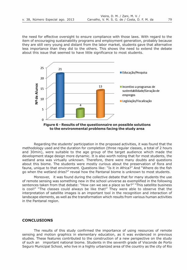
Another important point observed and also pointed out by Zocoler (2005) is that,after carrying out the activities with satellite images, students said they felt the need formore specific teaching materials, which could facilitate the understanding of concepts relatedto remote sensing, especially in the case of those who have had contact with this type ofactivity for the first time. Regarding the results of students� critical positioning about theissues discussed, it can be observed in the chart of figure 6, more than 50% of intervieweesindicated that support for education and research is the main road in attempting to reduceimpacts of human activities in the region. Students are also greatly concerned about newenvironmental legislation, still quite unknown to the general population, because they know
Figure 5 -Questionnaire prepared for the survey
79Vieira, D. M. / Zani, M. V. /
Carvalho, V. M. S. G. de / Costa, D. F. M. dav. 38, Número Especial ago. 2013
the need for effective oversight to ensure compliance with those laws. With regard to theitem of encouraging sustainability programs and employment generation, probably becausethey are still very young and distant from the labor market, students gave that alternativeless importance than they did to the others. This shows the need to extend the debateabout this issue that seemed to have little significance to most students.
Figure 6 - Results of the questionnaire on possible solutionsto the environmental problems facing the study area
Regarding the students� participation in the proposed activities, it was found that themethodology used and the duration for completion (three regular classes, a total of 2 hoursand 30min), were suitable to the age group of the target audience which made thedevelopment stage design more dynamic. It is also worth noting that for most students, thewetland area was virtually unknown. Therefore, there were many doubts and questionsabout this biome. The students were mostly curious about the preservation of flora andfauna, unique to that environment. Questions like: �Is it in Africa?� And �Where do the fishgo when the wetland dries?� reveal how the Pantanal biome is unknown to most students.
Moreover, it was found during the collective debate that for many students the useof remote sensing was something new in the school universe as exemplified in the followingsentences taken from that debate: �How can we see a place so far?� �This satellite businessis cool!� �The classes could always be like that!� They were able to observe that theinterpretation of satellite images is an important tool in the recognition and interaction oflandscape elements, as well as the transformation which results from various human activitiesin the Pantanal region.
CONCLUSIONS
The results of this study confirmed the importance of using resources of remotesensing and motion graphics in elementary education, as it was evidenced in previousstudies. These features contributed to the construction of a new perspective on the studyof such an important national biome. Students in the seventh grade of Visconde de PortoSeguro Municipal School, who live in a highly urbanized area of the country as the city of Rio

80 GEOGRAFIAThe use of geotechnology, as a proposal for the dissemination, interactivity,
and knowledge about the Pantanal biome, in elementary school
de Janeiro, had only restricted information about their immediate environment. This factorworked as an inhibitor in the early debates, requiring greater intervention by the teacherwho asked questions about the issues presented in the video and used games with the classso that everyone would feel safe to speak. The use of the teaching materials and methodologyproposed in this paper contributed to the process of learning about other environments, farfrom their reality, and it happened in a more playful way generating greater participation andinterest.
It is noteworthy that, during the course of this work, School Unit teachers tried tolearn about the use of these new teaching tools and how they might incorporate them intheir disciplines. Some of them even reported that the students began to suggest the use ofremote sensing after they realized that the technique could be used as a tool to maketheir classes more attractive.
It is expected that this research promote the generation and dissemination of neweducational material that can serve as support to educators in the use of new technologiesfor the study of this and other Brazilian environments.
REFERENCES
ABDON,M. de M; SILVA, J. S. V; SALES; G. M. M. Geotecnologiana educação ambiental: aDiversidade da Vegetação do Pantanal Brasileiro. In:VI JORNADAS DE EDUCACIÓN EMPERCEPCIÓN REMOTA EM EL ÁMBITO DEL MERCOSUR Y URUGUAYAS DE EDUCACIÓN EMPERCEPCIÓN REMOTA - Montevideo, 22 a 24 de novembrode 2007. SELPER capítulo Uruguay,2007. Não paginado.
CARVALHO,V.S.G. O sensoriamento remoto no ensino básico da geografia � Definindonovas estratégias. Rio de Janeiro, APED,2012.
GURGEL,E. P. A Experiência Audiovisual nos espaços educativos: possíveis interseções entreeducação e comunicação. Disponível em: <www.mnemocine.com.br>. Acesso em: 04 deabril de 2012.
INSTITUTONACIONAL DE PESQUISAS ESPACIAIS (INPE). Disponível emhttp://www.dgi.inpe.br/CDSR/. Acesso em 10 de Março de 2012.
LIMA, S. F. S; FLORENZANO, T. G; MORAES, E. C.; COSTA,D. F. M. Uso Escolar do SensoriamentoRemoto no Estudo da Dengue. Geonordeste, v. 1, p. 93-110, 2011.
ParâmetrosCurriculares Nacionais: Geografia (5a a 8a séries). Brasília,Brasil: MEC/ Secretariada Educação Fundamental SEF, 1998. In: SANTOS,V.M.N. dos. Escola, cidadania e novastecnologias: o sensoriamento remoto no ensino. São Paulo: Paulinas, 2002.
VIEIRA,D. M; ZANI, M.V. Atividades psicomotora se de animação em sensoriamento remotopara as classes do 5º ano do ensino fundamental � Estudo de caso da Escola MunicipalRondon, In VIII JORNADAS DE EDUCACIÓN EM PERCEPCIÓN REMOTA EM EL ÁMBITO DELMERCOSUR, 2011. Córdoba �Argentina. Não paginado.