the marine delimitation - ghent...
TRANSCRIPT

1
Faculteit Rechtsgeleerdheid Universiteit Gent
Academiejaar 2010-2011
The Marine Delimitation
An evolution of the concept.
The effect of islands and low-tide elevations on the
marine delimitation.
Masterproef van de opleiding ‘Master in de rechten’
Ingediend door
Pieter DELMOITIE
(Studentennummer.: 00604126)
(Major Internationaal en nationaal Publiekrecht en Milieurecht)
Promotor: Prof. Dr. Eddy SOMERS
Commissaris: Drs. Jasmine COPPENS

2

3
PREFACE
The marine delimitation is an interesting and continuously evolving part of the Law of the Sea. It is of
the utmost importance for States to bring or receive as much as possible of the water surface under
their jurisdiction. Although it is hard enough for States to bring this to a good end in a pure coast to
coast delimitation, our geographic reality provides us with all sort of features, small and big,
impeding the delimitation questions. Moreover, these various insular features all generate different
effects on the marine delimitation. Since States have not always been able to settle the latter
between them, International Courts and Tribunals had to provide a solution in many cases.
Therefore, we found it most interesting to examine the effects generated by the several insular
features and how the Courts and Tribunals resolved the delimitation questions arising from those
insular features.
First of all, I would like to express my sincere gratitude to Prof. dr. SOMERS for promoting this thesis
and thereby giving me the opportunity to get more insight in the international law aspect that clearly
interests me the most. I also owe him much gratitude for allowing me to write this thesis in English.
This clearly forms an indispensible skill for my future, which I hope to find in international law.
It would however be unforgivable not to place a word of sincere gratitude to Drs. COPPENS, who
instantly responded to every single mail and question I have send her over the last ten months. Her
ever friendly and targeted answers stimulated me to continue the work to be done on what now
seems to have been my favorite activity over the last year.
Finally, I must thank my parents, family and friends for supporting me in writing this thesis. And last
but not least, I would like to thank my girlfriend for supporting me and guiding me through some
essential elements of lay-out in order to make this thesis more presentable.
Pieter DELMOITIE
Aalst, 1 May 2011

4
KORTE INHOUD
De Mariene Delimitatie. Evolutie van het begrip.
De mariene delimitatie is een zeer belangrijk element van het internationaal zeerecht. Het geeft
staten de mogelijkheid mariene claims te uiten t.a.v. de aanwezige wateroppervlakte. Om
verschillende redenen is soevereiniteit over deze wateren zeer gegeerd. De statenpraktijk ontpopte
zich al snel tot een kluwen van verschillende breedtes en definiëringen. Daarom voelde de Verenigde
Naties de nood aan om op te treden en uniformiteit te bewerkstelligen. De eerste poging die deze
ondernam draaide uit op de 4 Geneefse Conventies van 1958. Hoewel deze op succes werden
onthaald, slaagden ze er niet in duidelijkheid, laat staan uniformiteit, in het leven te roepen m.b.t. de
respectievelijke breedtes van de verschillende mariene zones. De enige voorziene afstand was deze
van een vaste 12 Nm voor een additionele Aansluitende Zee, afhankelijk van de reeds geclaimde
Territoriale Zee. De Geneefse Conventies maakten zelfs geen melding van een visserijzone (later de
Exclusieve Economische Zone). In de nasleep van deze Conventies bleven er verschillende claims
bestaan en ontstaan. De tweede Zeerechtconferentie van 1960 draaide uit tot niets. Het was dus
wachten geblazen op het Zeerecht verdrag van Montego Bay 1982, ter afsluiting van de 9 jaar
durende Derde Zeerechtconferentie. De grote waarde van dit verdrag ligt in de conventionele
regeling van de respectievelijke breedtes. Elke zone werd ditmaal duidelijk en ondubbelzinnig
afgebakend.
Over het gewoonterechtelijke karakter van dit laatste zijn verscheidene doctrinale meningen terug te
vinden. Sommige auteurs hebben beargumenteerd dat dit verdrag in zijn totaliteit deel uitmaakt van
het internationale gewoonterecht. Andere auteurs konden zich hier niet in vinden en verwijzen
daarbij vooral naar de positie van het Diepzeebed regime. Nochtans lijkt het gewoonterechtelijke
karakter van de bepalingen betreffende de Territoriale Zee, Aansluitende Zone, Exclusieve
Economische Zone en het Continentaal Plateau voldoende steun te vinden in de rechtsleer.
Het Zeerechtverdrag regelde ook de regels inzake interstatelijke delimitatie. Gezien de soms
beperkte waterhoeveelheden tussen aanliggende en tegenoverliggende staten, is het vaak
onmogelijk om beide te voorzien van (alle) mariene zones. Daarom was een conventionele regeling
daaromtrent noodzakelijk in dit nieuwe Zeerechtverdrag.
Het hoeft dus geen betoog dat de Zeerechtconventie van onmetelijke waarde is geweest in de
totstandkoming van het (conventioneel geregelde) internationale zeerecht. Desalniettemin zijn er
enkele praktijken die niet geregeld zijn in het Zeerechtverdrag, maar toch een grote rol spelen in het
hedendaagse delimitatierecht. Zo is er de, door statenpraktijk ontstane en door het Internationaal

5
Gerechtshof erkende, praktijk die de EEZ en het CP in één lijn afbakenen. Dit is nergens voorzien in
het Zeerechtverdrag, maar is zeker en vast een vaste regel geworden in delimitatiezaken. Een ander
aspect vormt de niet aflatende pogingen van staten om additionele hoeveelheden wateroppervlakte
(en de onderliggende bodem) onder hun bevoegdheid te krijgen. Denken we maar aan Canada die,
omwille van natuurbehouds- en milieudoelstellingen, haar EEZ onaflatend tracht uit te breiden
voorbij de 200 Nm limiet. De mariene delimitatie is dus een constant evoluerende tak van het
internationale zeerecht waar de eindstreep inzake conformiteit nog lang niet in bereikt.
De Mariene Delimitatie. Het effect van eilanden en droogvallingen op de mariene delimitatie
Het vastleggen van de delimitatie tussen staten loopt uiteraard niet altijd van een leien dakje. Het
hoeft dus geen betoog dat eilanden en droogvallingen, en andere insulaire gebieden, de delimitatie
enorm kunnen bemoeilijken. Aangezien de delimitatie van wezenlijk belang is voor de staten, spreekt
het voor zich dat de aanwezigheid van eilanden en droogvalling van zeer groot belang kan zijn.
Vermits deze verschillende insulaire gebieden elk een ander effect ressorteren op de mariene
gebieden, is een heldere begripsduiding noodzakelijk. Men maakt –inzake aanspraken en delimitatie-
een onderscheid tussen respectievelijk eilanden/rotsen, niet bewoonbare rotsen, droogvallingen,
riffen,… Daarbij komt men tot verschillende conclusies.
Inzake de aanspraak op eigen mariene zones kan men concluderen dat eilanden elke zone kunnen
claimen voor zichzelf, terwijl daar voor onbewoonbare rotsen speciale regels gelden. Droogvallingen
daarentegen zijn niet gerechtigd aanspraak te maken op eigen mariene zones. Deze zijn slechts in
staat de grenslijn van de mariene zones van het vasteland of eiland waaronder zij ressorteren uit te
breiden. Doordat deze geïncorporeerd worden in de basislijn, zijn ze dus in staat de lijnen verder
zeewaarts te duwen. Naast de normale basislijn, kunnen beide insulaire gebieden ook gebruikt
worden voor het trekken van rechte basislijnen, zij het dat de droogvallingen onderworpen zijn aan
striktere vereisten. Het gebruik ervan in rechte basislijnen, neigt tot de conclusie dat deze ook
kunnen gebruikt worden in de sluitingslijnen van baaien, zij het wederom onderhevig aan speciale
vereisten voor droogvallingen. Maar meteen valt ook op dat de mogelijkheden voor droogvallingen
om een effect te genereren beduidend minder zijn als bij eilanden. Dit is uiteraard het logische
gevolg van de tijdelijke onderdompeling die een droogvalling ondergaat bij hoog tij.
Het grootste verschil in behandeling, vinden we echter terug op het vlak van het grootste belang van
hun aanwezigheid. Wanneer eilanden en droogvallingen de delimitatie tussen twee staten
bemoeilijken, dan zullen deze twee staten er niet altijd in slagen deze problemen op te lossen.
Daarom hebben zowel het Internationale Gerechtshof, het Permanente Hof van Arbitrage en andere

6
Arbitragetribunalen zich reeds moeten uitspreken over het effect van eilanden en droogvallingen in
verscheidene zaken. Hier is het nodig de effecten van de respectievelijke gebieden op te delen.
M.b.t. eilanden dienen we allereerst te benadrukken dat deze gelijke rechten hebben als enig ander
gebied van vasteland. Beide hebben recht op (gelijke delen van) de mariene zones. Dit kan men een
“vol effect” voor eilanden noemen. Hoewel dit principe een conventionele grondslag heeft, heeft
men dit “vol effect” in het verleden als onbillijk ervaren, waardoor men geneigd was deze onbillijke
effecten te willen remediëren. Deze remediëring vertaalde zich dan in een “geen effect”, een
“gedeeltelijk effect” of een “enclave oplossing”. Het mag nochtans duidelijk zijn dat een “geen
effect” eveneens onbillijk kan zijn. Deze verschillende remedies zijn door de verschillende Hoven en
Tribunalen toegepast geweest. Het is echter een spijtige zaak dat er vanuit de verschillende arresten
geen duidelijke voorspelbaarheidratio te distilleren is. Iedere zaak dient op zijn eigen merites
beoordeeld te worden en neigt dus tot andere conclusies. Bovendien zijn verschillende zaken in
gelijklopende situaties anders beslecht geweest, wat het extreem bemoeilijkt daar enige conclusie uit
te halen.
Voor droogvallingen liggen de zaken echter anders. Daar deze niet zelf gerechtigd zijn mariene zones
te claimen, zijn zij dus enkel in staat de grenzen van het vasteland of nabijgelegen eiland (of rots)
verder zeewaarts te duwen. Daardoor kan er dus ook nauwelijks sprake zijn van een “vol effect” of
een “geen effect”, laat staan een “gedeeltelijk (of half) effect”. Een enclave oplossing is echter
ondenkbaar. Een “vol effect” zou hier enkel betekenen dat de droogvalling wordt gebruikt als
basispunt in de basislijn. Het niet gebruiken ervan is dan een “geen effect”. Desalniettemin is er
evolutie waarneembaar in de effecten dat deze gebieden kunnen ressorteren. Zo heeft het
Internationaal Gerechtshof in een zaak beslist dat eilanden en droogvallingen als één geheel
gerechtvaardigd waren om een half effect te genereren. Toegegeven, de draagwijdte hiervan is
uiterst beperkt, maar het vormde een eerste stap naar meer erkenning van droogvallingen in de
mariene delimitatie. In een andere zaak voor het Internationaal Gerechtshof kende het voor de
eerste maal een half effect toe aan een droogvalling an sich. De draagwijdte van dit arrest voor
droogvallingen is dan ook enorm. Tot op heden is er geen enkele zaak geweest die deze tendens
heeft verder gezet. Het is dan ook wachten geblazen op meer erkenning om gewaag te maken van
een nieuwe evolutie.
De verschillende effecten die deze gebieden ressorteren worden nogmaals bemoeilijkt door
milieurechtelijke problemen, waaronder dan vooral de stijging van het zeepeil. Hierdoor is het
denkbaar geworden dat droogvallingen te allen tijde kunnen ondergedompeld worden door het
water. Een eiland zou dan tijdelijk ondergedompeld kunnen zijn en daardoor een droogvalling
worden. Het is echter angstvallig wachten op enkele toepassingsgevallen om te ervaren welk gevolg

7
hieraan gegeven zal worden door de statenpraktijk of eventueel door het Internationaal Gerechtshof
of een Arbitragetribunaal. Maar zelfs zonder deze milieuontwikkelingen is de algemene conclusie dat
het delimitatierecht inzake eilanden en droogvallingen constant in evolutie is. Daarvan getuigen
ondermeer de steeds meer en nieuwe delimitatie-akkoorden en uitspraken van het Internationaal
Gerechtshof en andere Arbitragetribunalen. Het is dus voorlopig nog onmogelijk gebleken om een
heldere voorspelbaarheidratio op te stellen inzake hun effect. Maar, zelfs nieuwe zaken en
akkoorden sluiten zoiets in de toekomst uiteraard niet uit.

8
TABLE OF CONTENTS
LIST OF ABBREVIATIONS xi
LIST OF FIGURES xiii
THE MARINE DELIMITATION: AN EVOLUTION OF THE CONCEPT 1
INTRODUCTION 2
I. The Territorial Sea 3
1. The 1958 Geneva Convention on the Territorial Sea and the Contiguous Zone 3
2. The 1982 United Nations Convention on the Law of the Sea 3
3. Doctrine 4
4. State practice 6
II. The Contiguous Zone 7
1. The 1958 Geneva Convention on the Territorial Sea and the Contiguous Zone 7
2. The 1982 United Nations Convention on the Law of the Sea 8
3. Doctrine 9
4. State practice 10
III. The Exclusive Economic Zone 10
1. Pre – Law of the Sea Convention 10
2. The 1982 United Nations Convention on the Law of the Sea 11
3. Doctrine 12
4. Further developments 12
IV. The Continental Shelf 13
1. The 1958 Geneva Convention on the Continental Shelf and Jurisprudence 13
2. The 1982 United Nations Convention on the Law of the Sea and Jurisprudence 14
3. Doctrine 16
4. State Practice 16
V. The single delimitation line for the EEZ and the CS 17
CONCLUSION 20
THE MARINE DELIMITATION:
THE EFFECT OF ISLANDS AND LOW-TIDE ELEVATIONS ON THE MARINE DELIMITATION 21
INTRODUCTION 22
I. Definitions 23
1. Islands 23
2. Low-tide elevations 26
3. Current developments 28
II. Entitlement of islands and low-tide elevations for maritime areas 29

9
1. Territorial Sea 29
1.1. Islands 29
1.2. Low-tide Elevations 30
2. Contiguous Zone 33
2.1. Islands 33
2.2. Low-tide Elevations 33
3. Exclusive Economic Zone 35
3.1. Islands 35
3.2. Low-tide Elevations 38
4. Continental Shelf 39
4.1. Islands 39
4.2. Low-tide Elevations 39
III. The effect of islands and low-tide elevations on the marine delimitation 39
1. Bays 39
1.1. The effect of islands 39
1.2. The effect of low-tide elevations 43
2. Straight baselines 45
2.1. The effect of islands 45
2.2. The effect of low-tide elevations 48
3. Interstate marine delimitation 53
3.1. General delimitation principles: equidistance and equitable delimitation 53
3.1.1. Boundary delimitation concerning the Continental Shelf 53
3.1.2. Boundary delimitation in the Territorial Sea 61
3.1.3. Boundary delimitation in the Contiguous Zone 62
3.1.4. Boundary delimitation concerning the Exclusive Economic Zone 63
3.2. Islands in interstate marine boundary delimitation 63
3.2.1. Inequity and full effect 65
- The Korean Island Dispute: exemplary situation? 66
(a) The dispute 66
(b) Commentary 67
- Case concerning Maritime Delimitation and Territorial
Questions 2001 (Qatar/Bahrain) 68
(a) Decision of the Court 68
(b) Commentary 70
3.2.2. Abating inequity 70

10
3.2.2.1. No effect rule 70
- Continental Shelf Case 1982 (Tunisia/Libya) 71
(a) Decision of the Court 71
(b) Commentary 72
- Award of the Arbitral Tribunal-Maritime Delimitation
1998-1999 (Eritrea/Yemen) 72
(a) Decision of the Tribunal 73
(b) Commentary 73
- Case concerning Maritime Delimitation and Territorial
Questions 2001 (Qatar/Bahrain) 74
(a) Decision of the Court 74
(b) Commentary 74
- Land and Maritime Boundary Case 2002
(Cameroon/Nigeria) 75
(a) Decision of the Court 75
(b) Commentary 75
- Black Sea Case 2009 (Ukraine/Romania) 76
(a) Decision of the Court 76
(b) Commentary 77
3.2.2.2. ‘Partial’ or ‘half’ effect rule 77
- Anglo-French Arbitration 1977 78
(a) Decision of the Tribunal 79
(b) Commentary 80
- Continental Shelf Case 1982 (Tunisia/Libya) 80
(a) Decision of the Court 80
(b) Commentary 80
- Continental Shelf Case 1984 (Libya/Malta) 82
(a) Commentary 82
- Gulf of Maine Case 1984
(Canada/United States of America) 85
(a) The issue of the Machias Seal Island and the
Court’s decision 85
(b) Commentary 86
- Case concerning Maritime Delimitation in the Area
between Greenland and Jan Mayen 1993

11
(Denmark/Norway) 86
(a) Decision of the Court 86
(b) Commentary 88
- Award of the Arbitral Tribunal-Maritime Delimitation
1998-1999 (Eritrea/Yemen) 90
(a) Decision of the Tribunal 90
(b) Commentary 91
3.2.2.3. Enclave solution 92
- Anglo-French Arbitration 1977 93
(a) Decision of the Tribunal 93
(b) Commentary 94
- French Canadian Arbitration 1992
(Islands of Saint Pierre et Miquelon) 95
(a) Decision of the Tribunal 95
(b) Commentary 96
- Territorial and Maritime Caribbean Sea Dispute 2007
(Nicaragua/Honduras) 97
(a) Decision of the Court 97
(b) Commentary 98
3.3. Low-tide elevations in interstate marine boundary delimitation 99
3.3.1. Abating inequity? 100
3.3.1.1. No effect rule 101
- Case Concerning Marine Delimitation and Territorial
Questions 2001 (Qatar/Bahrain) 101
(a) Decision of the Court 101
(b) Commentary 102
- Bangladesh v. India before the PCA 102
(a) Problems arising in the maritime delimitation
(b) Commentary 103
3.3.1.2. Partial effect rule 104
- Continental Shelf Case 1982 (Tunisia/Libya) 104
(a) Decision of the Court 104
(b) Commentary 104
- Case Concerning Marine Delimitation and Territorial
Questions 2001 (Qatar/Bahrain) 105

12
(a) Decision of the Court 105
(b) Commentary 105
3.3.1.3. Enclave solution? 106
CONCLUSION 108
BIBLIOGRAPHY 112

13
LIST OF ABBREVIATIONS
AJIL American Journal of International Law
ASIL American Society of International Law
ASIL Proc. American Society of International Law Proceedings
Cal. W. Int’l L. J. California Western International Law Journal
Ch. J. Int’l L. Chinese Journal of International Law
Ch. (Taiwan) Y.B. Int’l L.& Aff. Chinese (Taiwan) Yearbook on International Law and Affairs
Colum. L. Rev. Columbia Law Review
Conn. J. Int’l L. Connecticut Journal of International Law
CS Continental Shelf
CSC Convention on the Territorial Sea and the Contiguous Zone, 1958
CZ Contiguous zone
Denv. J. Int’l L. & Pol’y Denver Journal of International Law and Policy
Dig.Int’l L Digest of International Law
EEZ Exclusive Economic Zone
Geo. Wash. Int’l L. Rev. George Washington International Law Review
Fordham Int’l L. J. Fordham International Law Journal
IBRU International Boundaries Research Unit
ICJ International Court of Justice, The Hague
I.E.L.T.R. International Energy Law and Taxation Review
IJMCL International Journal of Marine and Coastal Law
ILC International Law Commission, New York
ILM International Legal Materials
ILR International Law Reports
ITLOS International Tribunal of the Law Of the Sea, Hamburg
J. Transnat’l L. & Pol’y Journal of Transnational Law & Policy
La. L. Rev. Louisiana Law Review
LOS Bull. Law of the Sea Bulletin
LOSC The Law of the Sea Convention, Montego Bay, 1982
Mar. Pol’y. Rep. Marine Policy Reports
Mich. St. J. Int’l L. Michigan State Journal of International Law
Nm Nautical mile
Ocean Devel. & Int’l L. Ocean Development and International Law
Oil & Gas L. & Tax’n Rev. Oil & Gas Law and Taxation Review
Pace Int’l L. Rev. Pace International Law Review

14
PCA Permanent Court of Arbitration, The Hague
RGDIP Revue Générale de Droit International Public
San Diego Int’l L. J. San Diego International Law Journal
Temp. Int’l & Comp. L.J Temple International and Comparative Law Journal
TS Territorial Sea
TSC Convention on the Territorial Sea and the Contiguous Zone, 1958
U. Miami L. Rev. University of Miami Law Review
U.C. Davis J. Int’l L. & Pol’y University of California Davis Journal on International Law and Policy
UCLA J. Envt’l L. & Pol'y University of California, Los Angeles Journal of Environmental law and
Policy
UNCLOS III (Third) United Nations Conference on the Law of the Sea, 1982
U.N.T.S. United Nations Treaty Series
U.S.F. Mar. L.J. University of San Francisco Maritime Law Journal
Vand. J. Transnat’l L Vanderbilt Journal of Transnational Law
Wash. L. Rev. Washington Law Review

15
LIST OF FIGURES
Figure 1 The use of the leapfrogging method 32
Figure 2 LTE pushing the outer TS and CZ limits further seawards 34
Figure 3 Bay closing line constituted by Islands 40
Figure 4 Screening Islands closing a bay 42
Figure 5 Islands forming the arms of a bay 42
Figure 6 Closely related islands, creating a bay (left) 43
Figure 7 Closely related islands, creating a bay (right) 43
Figure 8 A LTE creates a bay at low tide 44
Figure 9 A fringe of Islands: the Norwegian Skjærgaard 47
Figure 10 A fringe of Low-Tide Elevations 52
Figure 11 The equidistance line between opposite States 54
Figure 12 The equidistance line between adjacent States 54
Figure 13 The coastal configurations in the North Sea Continental Shelf Cases 56
Figure 14 The Northern Limit Line and DPRK’s boundary limit line 1999 67
Figure 15 Qatar-Bahrain Case: full effect to the Hawar Island Group 70
Figure 16 The equidistance lines applying no effect rule for islands 71
Figure 17 Black Sea Case: no effect to the Serpents’ Island 77
Figure 18 Anglo-French Arbitration: half effect to the Scilly Isles 79
Figure 19 Continental Shelf Case (Tunisia/Libya): half effect to the Kerkennah Island 82
Figure 20 Continental Shelf Case (Libya/Malta): the adjusted median line 85
Figure 21 Greenland-Jan Mayen Case: the adjusted median line 88
Figure 22 Eritrea-Yemen Arbitration: drawing the median line 91
Figure 23 The (semi-) enclave solution for islands 93
Figure 24 Anglo-French Arbitration: enclave solution for the British Channel Islands 94
Figure 25 Canada-France Arbitration: St. Pierre et Miquelon 96
Figure 26 Nicaragua-Honduras Case: enclaving the Cays 98
Figure 27 India v. Bangladesh: the South Talpatty “Island” 103
Figure 28 Qatar-Bahrain Case: half effect to Fasht al Azm 106

16
THE MARINE DELIMITATION.
AN EVOLUTION OF THE CONCEPT

17
INTRODUCTION
In order to put the reader wise in the effects that islands and low-tide elevations generate on the
marine delimitation, some general principles on marine delimitation are indispensible. Therefore, the
intent of this first part is to provide the reader with some general principles on the concept of marine
delimitation. A step-wise evaluation of the four marine zones – territorial sea, contiguous zone,
exclusive economic zone and continental shelf - will be set out. For the delimitation depends on the
States’ possibilities of forming claims, this outset will mainly focus on the distance and characteristics
of these zones. These several and distinct zones will be dealt with by using the same evaluation
method. The first thing to examine is their delimitation within the Geneva Conventions (except for
the exclusive economic zone because that was not yet foreseen within the Geneva Conventions). The
reader will then be provided with a comparison of their delimitation provisions under the Law of the
Sea Convention 1982 (1. The 1958 Geneva Convention and 2. The 1982 Law of the Sea Convention).
Having determined their scope of delimitation, the reader might start wondering how these
provisions are reflected and what their value is in the ‘real life’. Therefore, some attention will be
attributed to the consensus on these provisions. The outset will provide some considerations on the
customary law character of the respective maritime zones (3. Doctrine). Clearly, all the previous is
mere theory. Hence, the last step will highlight how states will determine their delimitation issues
when the interlaying waters are insufficient to provide them all with all the marine zones (4. State
practice). This will not be the case in the evaluation of the exclusive economic zone. There, attention
will be given to the creeping jurisdiction on its breadth. As the reader might come to notice, when
looking into part 1, there are a lot of similarities between the exclusive economic zone and the
continental shelf concept. Therefore, due attention will be attributed to the delimitation of those
zones by using a single delimitation line.

18
I. THE TERRITORIAL SEA
1. The 1958 Geneva Convention on the Territorial Sea and the Contiguous Zone
States have always looked upon the seas as the natural prolongation of their territory, and thus
within their sovereignty1. But how far did that prolongation go? States used different ways2 for
delimiting the sea area within their power. This situation of different claims could not be upheld.
Thus, in order to cope with these issues and to reach international conformity on maritime
delimitation, a convention3 (hereinafter as TSC) was set up, under the auspices of the United Nations.
There were 74 participants to the convention, which was signed by 41 States (of which only 19
ratified). There are now 52 State parties to the convention4.
Although considered as a success, the convention was far from complete5. Article 6 TSC provides:
“The outer limit of the territorial sea is the line every point of which is at a distance from the nearest
point of the baseline equal to the breadth of the territorial sea”. The convention provided States with
a system of delimitation, however did not foresee a breadth.
Articles 3 and 4 TSC described the methods of forming the inner limit of the territorial sea by
installing the ‘normal’ and ‘straight’ baselines. However, there was still no sign of an outer limit.
2. The 1982 United Nations Convention on the law of the Sea
The lack of a vast limit resulted in several claims6, varying in distance. A second United Nations
Conference on the Law of the Sea, in 1960, failed to bring international stabilization.
The uncertainty concerning the breadth of the territorial sea led the United Nations to installing a
new conference, the Third United Nations Conference on the Law of the Sea. Although the
1 This principle was generalized by some eminent scholars/jurists, such as AZO, BARTOLUS, GENTILI and others.
2 The canon shot rule, view from the coast, the “marine league”.
3 Convention on the Territorial Sea and the Contiguous Zone, Geneva, 29 April 1958, United Nations Treaty
Series (U.N.T.S.), vol. 516, 205. 4 Convention on the Territorial Sea and the Contiguous Zone, Geneva, 29 April 1958,
http://treaties.un.org/pages/ViewDetails.aspx?src=UNTSONLINE&tabid=1&mtdsg_no=XXI-1&chapter=21&lang=en#top. 5 LEVICK, A.J., “From sovereignty to fishing rights: the historical evolution of the law of the territorial sea”, 3
Dig.Int’l L. 1995-1996, 36. 6 “22 States claimed a [TS] of 3 Nm, 4 States claimed 5 Nm, 10 States claimed 6 Nm, 13 States claimed 12 Nm, 2
States claimed 200 Nm, and 5 States claimed to establish their territorial sea in accordance with international law” in LEVICK, A.J., “From sovereignty to fishing rights: the historical evolution of the law of the territorial sea”, 3 Dig.Int’l L 1995-1996, 36. A listing is provided as well by the UN in UNITED NATIONS, Second United Nations
Conference on the Law of the Sea, Official records, Vol. I, Geneva, United Nations Publications, A/CONF.19.8, 1960, 157-163.

19
discussions took over 9 years, the outcome was a new convention7 (hereinafter as LOSC) which was
signed by 157 States of the 179 participants. 141 of the 157 signatory States ratified the convention.
Up to today, there are 161 parties to the convention. The convention provided an outer territorial
sea limit of 12 nautical miles8 (hereinafter as Nm). The provision of article 6 of the Geneva
Convention was upheld in the new article 4, but LOSC inserted a new article 3. Article 3 of LOSC
states: “Every State has the right to establish the breadth of its territorial sea up to a limit not
exceeding 12 Nm, measured from baselines determined in accordance with this Convention”.
Therefore, it is the merit of UNCLOS III and LOSC to have brought international consensus on the
breadth of the territorial sea.
3. Doctrine
The LOSC has become the international framework concerning the use and regime of the oceans and
seas. However, not all countries have ratified, or even signed this Convention. Obviously, this brings
along a lot of difficulties, concerning the applicability of rules, rights and duties for State parties,
when interfering with the rights of non-parties. The LOSC (or at least part I to X) is said to form part
of customary international law. It does not fall under the scope of this outset to provide a detailed
examination on the customary law characteristics. A concise review, however, is indispensible. For a
rule to become customary international law, 2 main elements are required: state practice and opinio
juris9. It is widely recognized that conventions, under some circumstances, can generate customary
7 United Nations Convention on the Law of the Sea (LOSC), Montego Bay, 10 December 1982, U.N.T.S. vol.
1833, 3; Countries that are not State parties to LOSC: 1. Countries that have no direct access to any Sea Area (rivers not included): Andorra, Holy See (Vatican), San Marino, Tajikistan; 2. Countries with no direct access to the High Seas but with access to Sea Area (rivers not included): Azerbaijan (Caspian Sea, lake), Kazakhstan (Caspian and Aral Sea, lakes), Kyrgyzstan (lakes) Turkmenistan (Caspian Sea, lakes), Uzbekistan (Aral Sea, lakes); 3. Others: Ecuador, Eritrea, Israel, Peru, Syria, Taiwan (referred to by China in Article 2 of its Law on the Territorial Sea and the Contiguous Zone of 25 February 1992, http://www.un.org/Depts/los/LEGISLATIONANDTREATIES/PDFFILES/CHN_1992_Law.pdf), Turkey, Western Sahara. Not yet a party to the Convention: Kosovo, East-Timor (However, Portugal expressed that the Convention shall fully apply for the non-self-governing territory of East-Timor), Data based on http://nl.alumnieeni.com/ and http://treaties.un.org/pages/ViewDetailsIII.aspx?&src=UNTSONLINE&mtdsg_no=XXI~6&chapter=21&Temp=mtdsg3&lang=en#EndDec. 8 1 Nautical mile = 1852 metres according to the First International Extraordinary Hydrographic Conference,
Monaco 1929. There is no international agreement on which abbreviation is to be used for it (M, NM, Nm, nmi are all used), Bureau International des Poids et Mesures, http://www.bipm.org/en/si/si_brochure/chapter4/table8.html (last visited, February 17, 2011). 9 CHURCHILL, R.R. and LOWE, A.V., The Law of the Sea. 3
rd edition, Manchester, Manchester University Press,
1999, 5-6; SHAW, M.N., International Law. 4th edition, Cambridge, Cambridge University Press, 1997, 58-59; LEE, M.L., “The interrelation between the Law of the Sea Convention and Customary International Law”, 7 San
Diego Int’l L.J., 2006, 407.

20
rules, binding on all states (even the non-parties to the convention)10. LOWE11 as well concluded that,
following the Nicaragua case12, it is possible for treaty provisions to have a parallel existence as rules
of customary international law. There are 3 possible ways, set out by the ICJ, in which international
conventions can become international customary law: (1) the convention codifies existing customary
international law, (2) it crystallizes customary international law and (3) it initiates the progressive
development of new customary international law13. According to some scholars14, the LOSC brought
along a new method, namely, “the package deal theory”. CAMINOS and MOLITOR15 described it as
follows; “the new comprehensive convention has been elaborated as a single and indivisible
instrument, as a package of closely interrelated compromise decisions”.
The question then emerges whether the LOSC can be seen as customary international law. LEE16
demonstrated that, in the LOSC, customary rules follow from the different methods (eg. innocent
passage is preexistent customary law, transit passage has been crystallized,…). It is undisputable that
some elements of the LOSC (at least part I to X) have (obtained) a customary law character17. For
other parts of the LOSC this is disputed, not in the least for part XI on the Deep Seabed Regime. It is
clear that the Deep Seabed Regime does not fall under either one of the three conditions, set out by
the ICJ. Moreover, it could not be traditional custom, since there is a lack of state practice (however,
even opinio juris is highly questionable in this respect). Nevertheless, LEE believed that, based on this
package deal theory, “Part XI may have already become customary international law since the
majority of the LOSC was adopted as customary international law” and “that through the combined
force of these four methods, the LOSC represents customary international law to a very wide extent,
and consequently binds all States to its provisions, governing human activities on the ocean”18. REMY
10
SURACE-SMITH, K., “United States Activity Outside of the Law of the Sea Convention: Deep Seabed mining and Transit Passage”, 84 Colum. L. Rev. 1984, 1035. 11
LOWE, A.V., International Law, Oxford, Oxford University Press, 2007, 86. 12
ICJ, 27 June 1986, Case Concerning Military and Paramilitary Activities in and against Nicaragua. Merits.
Judgment, Nicaragua/United States of America, ICJ Reports 1986, 95-96, par. 178-179. 13
Categorization by CHARNEY, J.I., “International Agreements and the Development of Customary Law”, 61 Wash. L. Rev. 1986, 971, based on ICJ, 20 February 1969, North Sea Continental Shelf Case. Judgment, Federal Republic of Germany/Denmark and the Netherlands, ICJ Reports 1969, 37-39, adopted by LEE, M.L., “The interrelation between the Law of the Sea Convention and Customary International Law”, 7 San Diego Int’l L.J. 2006, 408. 14
LEE, L.T., “The Law of the Sea Convention and Third States”, 77 AJIL 1983, 566-567; LEE, M.L., “The interrelation between the Law of the Sea Convention and Customary International Law”, 7 San Diego Int’l L.J. 2006, 408. 15
CAMINOS, H. and MOLITOR, M.R., “Perspectives on the Law of the Sea: Progressive Development of International Law and the Package Deal”, 79 AJIL 1985, 882. 16
LEE, M.L., “The interrelation between the Law of the Sea Convention and Customary International Law”, 7 San Diego Int’l L.J. 2006, 410-418. 17
LOWE, LEE; WOUTERS, J. en BOSSUYT, M., Grondlijnen van internationaal recht, Antwerpen, Intersentia, 2005, 338. 18
LEE, M.L., “The interrelation between the Law of the Sea Convention and Customary International Law”, 7 San Diego Int’l L.J. 2006, 418 and 420.

21
already postponed this thought, “UNCLOS III is the result of twelve years of U.N. conferences and
codifies much of what participating nations consider to be customary international law of the sea”19.
This leads to the conclusion that there is a wide consensus that most parts of the LOSC are customary
international law and thus binding upon all states, including non-parties. But it cannot be upheld that
any provision of the LOSC will unequivocally be deemed to bind every State, in its extreme the Deep
Seabed Regime. All will depend on the exact provision and the customary character of that provision
to make it applicable as a customary rule next to a conventional rule. The most comprehensive
conclusion seems thus to be that there is no general consensus on whether there is a general
consensus on the LOSC.
If we take this customary character to the extent of the territorial sea, there is not much dispute
about it. There is a general consensus that the territorial sea concept has (obtained) a customary law
character through the various methods described above. Or, as LEE postponed, “the twelve-mile
territorial sea limit at the UNCLOS III may be regarded as both crystallizing the emergent customary
international law and codifying and modifying the preexisting norm”20. According to ARRUDA the 12
Nm TS had already obtained its customary law character before UNCLOS III, “Since UNCLOS I and II
were unable to establish a territorial sea limit and the majority of the states claimed a twelve-mile
limit, the twelve-mile limit became the new standard in customary international law”21.
4. State practice
Even though the 12 nautical mile-rule is generally accepted, and probably codified international
customary law, it is not always applicable. Where possible, States will gladly claim the full maritime
zones they are entitled to claim, such as a 12 Nm territorial sea zone. Adjacent or opposite States
can, however, be confronted with an amount of water between them, that would render it
impossible to provide both countries with a 12 Nm territorial sea. International law (of the sea)
entitles them both to a 12 Nm zone. But clearly this would create overlapping claims. In order to
resolve this issue, both the Geneva Convention22 as the LOSC23 state that neither one of those States
is entitled to extend its territorial sea beyond the line of equidistance. This equidistant line is the line
that would normally divide the present water surface between them, leaving them both with equal
19
REMY, C.E., “U.S. Territorial Sea Extension: Jurisdiction and International Environmental Protection”, 16 Fordham Int’l L.J. 1993, 1214. 20
LEE, M.L., “The interrelation between the Law of the Sea Convention and Customary International Law”, 7 San Diego Int’l L.J. 2006, 419. 21
ARRUDA, H.M., “The Extension of the United States Territorial Sea: Reasons and Effects”, 4 Conn. J. Int’l L.
1989, 709. 22
Article 12 TSC. 23
Article 15 LOSC.

22
shares. Nevertheless, this equidistant line does not apply automatically. Both articles refer to the use
of an agreement as the most plausible solution, so as to divide the waters between them. It is up to
those States to reach an agreement on how the interstate delimitation line between them, based on
equitable principles, would be the most plausible. Of course, these agreements do not always
present equitable solutions. It is rather obvious that economically or politically stronger States might
oppress the weaker States or put a lot of pressure on them to get a delimitation line of which the
stronger State clearly benefits the most. In many cases, stronger States will probably succeed in their
attempt and will be granted with a disproportionate amount of the waters between them. As will be
examined throughout this text, certain delimitation issues will be brought before an international
Court or before an Arbitrary Tribunal, in order to examine the given circumstances. This enlarges the
possibility for an equitable solution. Nevertheless, delimitation agreements are still the main source
of boundary delimitation, leaving room for inequity in maritime interstate boundary delimitation.
Politics and economic power continue to dominate interstate relationships, maritime boundary
delimitation does not constitute an exception to the latter.
II. THE CONTIGUOUS ZONE
1. The 1958 Geneva Convention on the Territorial Sea and the Contiguous Zone
The first notions of a contiguous zone were installed, for states “to establish zones in which they
could exercise certain powers with respect to foreign vessels to prevent infringement of and, punish
offenses against, their respective internal laws and regulations”24.
This zone was then codified in the Geneva Convention. Apart from the territorial sea, it thus created
a contiguous zone. This zone was created to ensure that coastal States could exercise jurisdiction in
an additional amount of water mass, behind the territorial sea, whenever new developments or
exploitation possibilities urged them to do so25. The Geneva Convention installed this zone in its
article 24, of which paragraph 2 reads as follows: “The contiguous zone may not extend beyond
twelve miles from the baseline from which the breadth of the territorial sea is measured”. Thus, every
State had a contiguous zone reaching up to 12 Nm. This was, however, a vast breadth. Countries that
had already installed a territorial sea of 12 Nm, or more, could not claim an additional 12 Nm
contiguous zone26. This zone was only valid for those countries having a territorial sea of less than 12
Nm, and only up to the line of 12 Nm. Taken from article 24 TSC, the purpose of this zone was to
24
These followed from the British Hovering Acts and later on also United States’ Acts; SYMONIDES, J., “Origin and Legal Essence of the Contiguous Zone”, 20 Ocean Devel. & Int’l L. 1989, 203. 25 SOMERS, E., Inleiding tot het internationaal zeerecht, 5de herwerkte uitgave, Mechelen, Kluwer, 2010, 105. 26
SOMERS, E., Inleiding tot het internationaal zeerecht, 5de herwerkte uitgave, Mechelen, Kluwer, 2010, 108.

23
install a zone, merely to prevent and punish infringement of customs, fiscal, immigration or sanitary
regulations within its territory or territorial sea.
In the light of these perceptions, it is rather clear that the CZ was not seen as a clearly separated and
autonomous maritime zone. There was a possibility for a CZ, but only if the TS did not already extend
to that breadth. It was a zone, created merely to provide the possibility to extend the TS further
seawards when the need for that emerged. Since it was not part of the territorial sea, the CZ-concept
in the TSC was part of the high seas27.
2. The 1982 United Nations Convention on the Law of the Sea
While negotiating the LOSC, several sessions were held. During the second session of the Conference
(1974), “the question was raised whether such a contiguous zone would still be necessary”28. The
questioning of the concept was based on two expressions29. One of them stated that it would no
longer be needed, since there was an emerging consensus on the 12 Nm TS30 (if they were all 12 Nm,
there would be no extension anymore to a 12 Nm limit adjacent to the TS). The other one was based
upon the thought that with the establishment of the EEZ concept, “adjacent to the [TS], would render
the [CZ] superfluous and unnecessary”31. According to some other States’ delegates, this zone would
still have been relevant, even under the new convention32. At the same time, there even were
proposals to extend the contiguous zone33. The latter was finalized at the Committee’s 31st meeting,
of which the debate indicated “that there was no reason for not including the contiguous zone in the
new law of the sea”34. This thought was based upon the fact that “it relates to certain specific powers
and controls which are not included in the regime of coastal State rights and jurisdiction in the
[EEZ]”35. A majority of States favored adopting provisions on the contiguous zone.
27
Article 24 (1) TSC: “In a zone of the High Seas (…)”. 28
NORDQUIST, United Nations Convention on the Law of the Sea 1982. A commentary. Vol. II, Dordrecht, Martinus Nijhoff Publishers, 1993, 269. 29
States in favor of rejecting the zone: Cameroon, Kenya, Lebanon, Mexico, El Salvador, Togo. States in favor of keeping the zone: Algeria, Bahrain, Egypt, India, Indonesia, Iraq, Nigeria and Pakistan; SYMONIDES, J., “Origin and Legal Essence of the Contiguous Zone”, 20 Ocean Devel. & Int’l L. 1989, 206. 30
Eg. The Israelian statements at the 9th
Meeting: Second Committee, 9th meeting (1974), par. 5, II Off. Rec. 121. 31
Eg. The Mexican statements at the 9th
Meeting (par. 2), the Indonesian statements (par. 4): Second Committee, 9th meeting (1974), II Off. Rec. 121. 32
Eg. The Egyptian statements at the 9th
Meeting: Second Committee, 9th meeting (1974), par. 8, II Off. Rec. 121; the Algerian statement (par. 12), the Bahraini statement (par. 19) and the Spanish statement (par. 24): Second Committee, 9th meeting (1974), par. 8, II Off. Rec. 122. 33
India, Honduras, Bahrain; SYMONIDES, J., “Origin and Legal Essence of the Contiguous Zone”, 20 Ocean Devel.
& Int’l L., 1989, 207. 34
Second Committee, 31st
meeting (1974), par. 34-48, II Off. Rec. 234. 35
NORDQUIST, United Nations Convention on the Law of the Sea 1982. A commentary. Vol. II, Dordrecht, Martinus Nijhoff Publishers, 1993, 270.

24
The authors of the LOSC brought a new continuous zone to life. This zone is now to be seen as a
merely supplementary zone for the territorial sea36, no longer as an extension field for it. Article 33
(2) states: “The contiguous zone may not extend beyond 24 nautical miles from the baselines from
which the breadth of the territorial sea is measured”. Thus, next to the 12 Nm territorial sea, every
coastal State also has a 12 Nm contiguous zone. This zone is no longer dependant from or additional
to the chosen breadth of the territorial sea. It is now an autonomous maritime area of (no more
than) 12 Nm. After the LOSC, the CZ concept was no longer part of the high seas37. However, it had
not become an absolute isolated zone either. NORDQUIST stated that for those coastal States that
established an EEZ, “the [CZ] will be included in the waters of the [EEZ]”38. The scope of control, for
which this zone was installed at Geneva, was upheld in the new CZ-concept. Thus, now, States can
exercise those rights in a whole additional zone.
Through the LOSC, this concept has become an autonomous zone of 12 Nm, to be installed by every
State that has the possibility (provided that there is more than 48 Nm interstate waters). Although
every State has the right for a CZ, the States willing to install this zone had and have to declare the
installation of this zone39.
3. Doctrine
The question now to be dealt with is the customary character of this zone. It is shown above that the
LOSC has become at least partially recognized customary law. Concerning the CZ, there is no doubt
on this customary character. According to SYMONIDES40, this had already become customary before
the LOSC entered into force, however, with reservations for when this zone was established for other
purposes.
4. State Practice
There is now a general consensus that every State can claim a CZ up to 24 Nm from the baseline.
International State practice shows that some States had established these zones even before the
36
SOMERS, E., Inleiding tot het internationaal zeerecht, 5de herwerkte uitgave, Mechelen, Kluwer, 2010, 108. 37
The phrase “In a zone of the High Seas” was not upheld in the LOSC. 38
NORDQUIST, United Nations Convention on the Law of the Sea 1982. A commentary. Vol. II, Dordrecht, Martinus Nijhoff Publishers, 1993, 275. 39
CARLSON, J., “Presidential Proclamation 7219: Extending the United States’ Contiguous Zone – Didn’t someone say this had something to do with pollution?”, 55 U. Miami L. Rev. 2001, 500. 40
SYMONIDES, J., “Origin and Legal Essence of the Contiguous Zone”, 20 Ocean Devel. & Int’l L. 1989, 208.

25
third United Nations Conference on the Law of the Sea had ended: Malta, India, Pakistan, Sri Lanka,
Democratic Yemen, Dominican Republic, Burma and Vietnam41.
The delimitation between adjacent and opposite States for CZ is a remarkable something. The TSC
applied the same rule for CZ as for TS in delimiting the maritime area between opposite and adjacent
States. It is up to the littoral States to achieve agreement. In case of non-agreement, the line, as
described in article 24 (3) TSC, will divide the waters between the littoral States. There is, however,
no corresponding provision in LOSC. The exact reason for that cannot be pointed out with certainty42.
SYMONIDES43 explained, in this respect, that “[t]he Chairman of Committee II failed to explain whether
a paragraph concerning delimitation was regarded as superfluous on account of articles delimitating
the exclusive economic zone or whether a conclusion was reached that the delimitation of the
contiguous zone without a simultaneous establishment of the economic zone would occur very
rarely”.
III. THE EXCLUSIVE ECONOMIC ZONE
1. Pre – Law of the Sea Convention
The creation of an EEZ was the result of coastal States’ claims, after WW II, to extend their marine
areas, for several purposes44. The first attempt to actually claim a zone similar to the concept of the
EEZ, that was considered to be part of international waters45, came from the US’ Truman
Proclamation(s)46 (It is, however, noteworthy that the Declaration that proclaimed jurisdiction over
coastal fisheries in areas of the High Seas, was never applied47). The next steps were taken by some
Latin American States that started with claiming extensive zoning48. But actually, they claimed
continental shelf areas and claimed sovereignty over the waters above it for fishing interests. These
claims were “challenged generally on the ground that they violated the freedoms of the High Seas”49.
More and more States in all of the world started to extend their sovereignty into areas (of various
breadths) of the High Seas, for fishing or other interests. The first attempt to generalize and legalize
this, and to put down some rules concerning maritime zoning, was the First United Nations Law of
41
SYMONIDES, J., “Origin and Legal Essence of the Contiguous Zone”, 20 Ocean Devel. & Int’l L. 1989, 208. 42
SOMERS, E., Inleiding tot het internationaal zeerecht, 5de herwerkte uitgave, Mechelen, Kluwer, 2010, 109. 43
SYMONIDES, J., “Origin and Legal Essence of the Contiguous Zone”, 20 Ocean Devel. & Int’l L. 1989, 210-211, footnote 30. 44
Particularly resource control in ATTARD, D., The Exclusive Economic Zone in International Law, New York, Oxford University Press, 1987, 1. 45
BINGHAM, J.W., “The Continental Shelf and the Marginal Belt”, 40 AJIL 1946, 173. 46
TRUMAN, H.S., Proclamation 2667, 28 September 1945, http://www.trumanlibrary.org/proclamations/index.php?pid=252&st=&st1=. 47
ATTARD, D., The Exclusive Economic Zone in International Law, New York, Oxford University Press, 1987, 2. 48
ATTARD, D., The Exclusive Economic Zone in International Law, New York, Oxford University Press, 1987, 2-6. 49
ATTARD, D., The Exclusive Economic Zone in International Law, New York, Oxford University Press, 1987, 6.

26
the Sea Conference at Geneva 1958. However, famous for its 4 Conventions, it failed on reaching
agreement on two major issues: the territorial sea’s maximum breadth and the extent of a State’s
exclusive fishery rights50. Since UNCLOS I did not manage to codify the extensions, after Geneva new
unilateral claims51 were issued. At this stage, apart for several claims before and after Geneva, there
was still no general consensus on the use of a national fishing zone, let alone an international
approval. The ICJ recognized the use of it in the Fisheries Jurisdiction Case, deciding that although the
50 Nm were not opposable to the UK, Iceland could claim preferential rights with respect to the
fishery resources in question52. ATTARD53 deplored the Court’s failure “to take any position on
extended coastal State jurisdiction” en found that this “indecision encouraged further extensive State
claims54”. The latter was discussed upon in the Sea Bed Committee of the UNCLOS III, which came to
conclude that there was general agreement on three points concerning the newly adopted EEZ: the
concept would include the waters, sea bed and sub-soil of an area beyond the territorial Sea;
secondly, almost all the proposals held that the maximum breadth of this zone would be 200 Nm;
thirdly, the coastal States’ rights referred to the resources of the zone and not to the zone itself55.
2. The 1982 United Nations Convention on the Law of the Sea
With the adoption of the LOSC, the latter was finally internationally codified, providing a uniform rule
generating uniform applicability. Concerning the delimitation of the EEZ, the inner limit is the same
as for all of the other maritime zones: the baseline from which the breadth of the territorial sea is
measured56. On the outer limit, there was already a general consensus in the preparatory
negotiations. Therefore, it did not come as a surprise that the final text of article 57 LOSC provides an
EEZ which shall not extend beyond 200 Nm. The LOSC thus institutionalized the EEZ regime. Today,
this EEZ is “usually categorized as a sui generis zone (not be assimilated with the well-known concepts
of the territorial sea or the high seas)”57.
50
Fifty-Fourth Meeting, United Nations Conference on the Law of the Sea (A/CONF.13/39), 3 Official Records (1958), 168, par. 8. 51
Eg. 1965 Nicaragua Decree No. II expressing the claim for 200-mile national fishing zone. 52 ICJ, 25 July 1974, Fisheries Jurisdiction Case. Merits, Judgment, United Kingdom/Iceland, I.C.J. Reports 1974,
29, par. 68. 53
ATTARD, D., The Exclusive Economic Zone in International Law, New York, Oxford University Press, 1987, 30. 54
Even Iceland further extended its fishery jurisdiction zone. 55
ATTARD, D., The Exclusive Economic Zone in International Law, New York, Oxford University Press, 1987, 28. 56
Article 57 LOSC. 57
CASTANEDA, J, “Negotiations on the Exclusive Economic Zone at the Third United Nations Conference on the Law of the Sea” in MAKARCZYK, J (ed.), Essays in International Law in Honor of Judge Manfred Lachs, Dordrecht, Martinus Nijhoff Publishers, 1984, 612.

27
This newly installed zone provided coastal States an exclusive right of access to non-living resources
and a priority of access to living resources58. O’CONNELL59 stated that the attempt was to “secure for
the coastal state the resources of sea, seabed and subsoil irrespective of variations in geographic or
economic or ecological circumstances”.
3. Doctrine
The EEZ concept was only internationally codified with the LOSC. There was no mentioning the zone
in the first, nor the second Law of the Sea Conferences. Since this zone is of a more recent date than
the other zones, has this concept already turned into customary law? According to some scholars, it
does60. This thought follows from the fact that the ICJ had already recognized the EEZ concept as
customary international law in 1982 and 198461, both before the LOSC came into force. Since the
LOSC has now entered into force, “at least the basic provisions of the EEZ (…) have a fortiori entered
into customary international law”62. CARLSON admitted that there were dissident opinions, stating the
““non-traditional” rules” are “only “arguably reflective” of customary international law”63.
4. Further developments
The LOSC, thought to be the constitution of the seas, regulated the EEZ concept. Does this, however,
invoke that there is not to be touched to the principles therein set out? Does the high number of
ratifications provide a general acceptance of these provisions? Or, are there States, whether
unilateral, bilateral or multilateral, extending their sovereign rights outside the established border
line of 200 Nm? This was dealt with by FRANCKX64, in his research to find out whether there is creeping
jurisdiction in EEZ boundary. In his text, he also examined the possibility of creeping common
heritage. Some States have unilaterally altered the EEZ boundary line for purposes of sovereignty
extension, eg. the Chilean introduction of the mar presencial, which clearly had an impact on the
58
BAILEY, J.E. III, “Comment: The Exclusive Economic Zone: Its Development and Future in International and Domestic Law”, 45 La. L. Rev. 1985, 1270. 59
O’CONNELL, D.P., The International Law of the Sea. Vol I, Oxford, Clarendon Press, 1982, 552. 60
MACREA, GROLIN, BURKE, O’CONNELL in BAILEY, J.E. III, “Comment: The Exclusive Economic Zone: Its Development and Future in International and Domestic Law”, 45 La. L. Rev. 1985, 1270 and CARLSON (footnote 62). 61
These cases were the Tunisia/Lybia Continental Shelf Case (par. 100) and the Gulf of Maine Case (par. 94). 62
CARLSON, J., “Presidential Proclamation 7219: Extending the United States’ Contiguous Zone – Didn’t someone say this had something to do with pollution?”, 55 U. Miami L. Rev. 2001, 506-507. 63
For this, he refers to ATTARD, D., The Exclusive Economic Zone in International Law, New York, Oxford University Press, 1987, 306. 64
FRANCKX, E, “The 200-Mile Limit: Between Creeping Jurisdiction and Creeping Common Heritage? Some Law of the Sea Considerations from Professor Louis Sohn’s former LL.M. Student”, 39 Geo. Wash. Int’l L. Rev. 2007, 467-498.
28
Chilean competence beyond the 200 Nm EEZ65. Argentina followed with this 200 Nm expanding
competence. Another unilateral action, and according to FRANCKX a way more important, was the
Canadian Royal Assent to the legislative enactment66. There are multilateral actions to be found as
well, one example of which is the U.N. Fish Stocks Agreement67. This agreement provided the coastal
States with extra powers68.
Although TREVES69 stated that “undeniably the limit of 200 miles set by the [1982] Convention as the
external border of State jurisdiction in the economic zone, and consequently the freedoms of the high
seas, are under attack”, FRANCKX70 is more careful in interpreting the post-LOSC developments. He
believed that “State practice suggests that in most, if not all cases, the flag of creeping jurisdiction,
and certainly that of creeping common heritage, does not fully cover the cargo”. At the time of
writing his article, it seemed to him that it was “premature to talk about a clear instance of creeping
jurisdiction”, for “Canada is the only country which so far has proved willing to start implementing its
national fishery legislation outside the 200-mile in 1995”.
IV. THE CONTINENTAL SHELF
1. The 1958 Geneva Convention on the Continental Shelf and Jurisprudence
At Geneva, there was a separate convention established for the continental shelf, the Convention on
the Continental Shelf71 (hereinafter as CSC). There were 43 signatory states out of the 79
participants. Only 22 States ratified the convention. In total there are 58 parties. This continental
shelf convention provided an exploitation-based definition of the continental shelf concept. There
was no description at all concerning the breadth of this zone, making it extremely difficult to find a
general consensus on the latter. This convention merely described this zone as ‘adjacent to the
65
CLINGAN, T., “Mar Presencial (The Presential Sea): Déjà Vu All Over Again? A Response to Francisco Orrega Vicuña”, 24 Ocean Devel. & Int’l L.J. 1993, 93. 66
FRANCKX, E, “The 200-Mile Limit: Between Creeping Jurisdiction and Creeping Common Heritage? Some Law of the Sea Considerations from Professor Louis Sohn’s former LL.M. Student”, 39 Geo. Wash. Int’l L. Rev. 2007, 484. 67 The United Nations Agreement for the Implementation of the Provisions of the United Nations Convention on the Law of the Sea of 10 December 1982 relating to the
Conservation and Management of Straddling Fish Stocks and Highly Migratory Fish Stocks (in force as from 11 December 2001), UN Doc., A/CONF.164/37,
8 September 1995. 68
ZUMWALT, A., “Straddling Stock Spawn Fish War on the High Seas”, 3. U.C. Davis J. Int’l. L & Pol. 1997, 42-43 and 54-56. 69
TREVES, T., “The Law of the Sea Convention Ten Years after Entry into Force: Positive Developments and Reasons for Concern” in CARON, D. and SCHEIBER, H., Bringing New Law to Ocean Waters in Publications on
Ocean Development, Dordrecht, Martinus Nijhoff Publishers, 2004, 352. 70
FRANCKX, E, “The 200-Mile Limit: Between Creeping Jurisdiction and Creeping Common Heritage? Some Law of the Sea Considerations from Professor Louis Sohn’s former LL.M. Student”, 39 Geo. Wash. Int’l L. Rev. 2007, 497 and 489-490. 71
Convention on the Continental Shelf, Geneva, 29 April 1958, U.N.T.S., vol. 499, 311.

29
coast’72. This invokes that the CS was thought to be the natural prolongation of the coastal mainland.
Clearly, this constituted an extremely vague delimitation possibility of the shelf. The natural
prolongation was upheld in international jurisprudence. In the North Sea Continental Shelf Cases, the
ICJ stipulated that “each Party [is to be left as much as possible] all those parts of the continental
shelf that constitute a natural prolongation of its land territory into and under the sea”73. This was
also the case in the Anglo-French Arbitration Case, only with the addition that the natural
prolongation was to be seen from a geographic point of view rather than a geological one74.
The natural prolongation of the CS was, however, an extremely vague consideration. It did not say
anything about the outer limit to be applied in delimiting the CS zone. How far did this natural
prolongation actually go? Moreover, this consideration brought along inequities between different
States, for this natural prolongation could differ in length and depth given the respective
geographical configurations of the seabed. Thus, the natural prolongation, following the CSC, was a
vague and discriminating provision. It therefore needed to be refashioned during the negotiations of
the new Law of the Sea Conference.
2. The 1982 United Nations Convention on the Law of the Sea and State practice
This maritime zone is an interesting one, for the coastal State can exercise sovereign rights over the
continental shelf for the purpose of exploring it and exploiting its natural resources75.
With the new Law of the Sea, a new provision on the CS was adopted in its article 76. This provision
however reinstalled the natural prolongation of the CS. The CS is a zone that is the natural
prolongation of the mainland, up to the continental margin. New, however, was the following
insertion: “or to a distance of 200 nautical miles from the baselines from which the breadth of the
territorial sea is measured where the outer edge of the continental margin does not extend up to that
distance”. Thus, where the natural prolongation up to the continental margin is less than 200 Nm,
the outer limit of the coastal State’s CS will be put at a 200 Nm distance from the baseline (from
which the territorial sea is measured). Nevertheless, there is not always a real continental shelf.
Where there is a geological continental shelf, the coastal State can exploit this marine area, up to the
point where the continental shelf ends (or at a distance of 200 Nm) and the Deep Seabed begins. The
72
Article 1 CSC. 73
ICJ, 20 February 1969, North Sea Continental Shelf Case. Judgment, Federal Republic of Germany/Denmark and the Netherlands, ICJ Reports 1969, 53. 74
SOMERS, E., Inleiding tot het internationaal zeerecht, 5de herwerkte uitgave, Mechelen, Kluwer, 2010, 162. 75
Article 77 (1) LOSC.

30
International Law Commission (hereinafter as ILC)76 pointed out that “it would be unjust to countries
having no continental shelf, if the granting of the rights in question were made dependant on the
existence of such a shelf”. Therefore, (coastal) States not having a (geological) continental shelf have
the right to exploit the seabed to an extent of 200 Nm77.
Providing this 200 Nm zone, the LOSC clearly established the minimum outer limit of the CS to the
extent of, for all States able to claim such a portion, a 200 Nm zone. However, the natural
prolongation up to the continental margin, can extend (far) beyond this 200 Nm, making it somewhat
difficult to determine the maximum outer limit of the CS. Therefore, the LOSC, regulated the
outermost limit of the CS in article 76 (4) (a) i and ii, 76 (5) – (7), from which we can conclude that the
outer limit is never to exceed “either (…) 350 nautical miles from the baselines from which the
breadth of the territorial sea is measured or shall not exceed 100 nautical miles from the 2,500 metre
isobath, which is a line connecting the depth of 2,500 metres”78. The creators of these articles were
however well aware of the flexibility of this provision. If States were to determine where its
continental margin ended on a pure solely basis, there was no consistency left. Therefore, they
added that if a coastal State wishes to delineate its continental shelf beyond 200 nautical miles from
the baselines (from which the breadth of the territorial sea is measured), it has to submit relevant
data and information, on the basis of equitable geographical representation, to the Commission on
the Limits of the Continental Shelf, set up under Annex II. The Commission’s recommendations are
final and binding79.
Thus, the LOSC inserted next to the natural prolongation provision a 200 Nm limit provision. Yet, at
the beginning, the CS was still seen as the natural prolongation of the mainland. The 200 Nm limit
only came into consideration in a stepwise manner. The ICJ only recognized and used this distance
criterion for the first time in the Libya/Malta case.
Concerning the Continental Shelf delimitation between the littoral States, the parties had different
views. According to Malta, the legal title for claims is the 200 Nm distance criterion, Libya for its part,
objected that the natural prolongation was the immanence of customary international law and that
distance from the coast was not an element of continental shelf delimitation under customary
76
Preparatory work of the ILC leading to its Report to the U.N. General Assembly, 1950 I.L.C. Yearbook, Vol. II, 384. 77
Starting from the baseline (low-water mark). 78
Article 76 (5) LOSC. 79
Article 76 (8) LOSC and JARES, V., “Symposium Mounting Tension and Melting Ice: Exploring the Legal and Political Future of the Arctic. The Continental Shelf Beyond 200 Nautical Miles: The Work of the Commission on the Limits of the Continental Shelf and the Arctic”, 42 Vand. J. Transnat’l. L., 2009, 1265.

31
international law80. The Court found the concepts to be complementary instead of opposed. It
further stated: “Each coastal State is entitled to exercise sovereign rights over the continental shelf
off its coasts for the purpose of exploring it and exploiting its natural resources (Art. 77 of the
Convention) up to a distance of 200 miles from the baselines - subject of course to delimitation with
neighbouring States - whatever the geophysical or geological features of the sea-bed within the area
comprised between the Coast and the 200-mile limit”81.
3. Doctrine
The continental shelf concept has been altered from the 1958 Convention to the LOSC 1982. The
provisions that were upheld in LOSC (stemming from Geneva) can be thought to have a customary
character82, but what about the newly inserted 200 Nm limit? FINLAY argued that “[i]n its Judgment in
the Libya/Malta Continental Shelf (…), the ICJ held that as a result of the general consensus in the
Third United Nations Conference on the Law of the Sea on a 200-nautical mile exclusive economic
zone, Continental Shelf jurisdiction now extends at least to that distance as a matter of customary
international law, without regard to the geomorphology of the intervening ocean floor”83. For States
with a continental shelf extending beyond 200 Nm, MCDORMAN stated that “these substantive rights
are part of customary international law”84.
4. State practice
A lot of international disputes and cases before the ICJ and Arbitral Tribunals were issued to the
continental shelf, due to the lack of a (more than) 400 Nm zone between the littoral States. Opposite
or adjacent States need to find a solution for the division of continental shelf between them. In
article 6 CSC the principles for dividing the CS were set out. The most preferable solution was that of
a mutual agreement between the opposite or adjacent States. When there was no agreement, the
median line was to be used, unless another boundary line was justified by special circumstances.
These circumstances were exceptional configuration of the coastline, the presence of islands,… The
median line is the line every point of which is equidistant from the nearest points of the baselines
from which the breadth of the territorial sea of each State is measured. The interstate delimitation
80
ICJ, 3 June 1985, Continental Shelf Case. Judgment, Libya/Malta, ICJ Reports 1985, 33, par. 34. 81
ICJ, 3 June 1985, Continental Shelf Case. Judgment, Libya/Malta, ICJ Reports 1985, 56, par. 77. 82
Eg. MCDORMAN, T., “The Continental Shelf Beyond 200 Nm: Law and Politics in the Arctic Ocean”, 18 J.
Transnat’l L & Pol’y 2009, 164. 83
FINLAY, L.W., “Correspondence”, 80 AJIL 1986, 601. 84
MCDORMAN, T., “The Continental Shelf Beyond 200 Nm: Law and Politics in the Arctic Ocean”, 18 J. Transnat’l
L. & Pol’y 2009, 162.

32
principles concerning the CS will not be discussed in this paragraph, they are set out in Part II, 3.1.1.:
Boundary Delimitation concerning the CS.
V. THE SINGLE DELIMITATION LINE FOR THE EEZ AND THE CS
Although two notionally distinct concepts, there is something to say about a single delimitation line
for the EEZ and CS. The relevant articles in the LOSC85 provided coastal States with a 200 Nm EEZ and
a CS, reaching up to the continental margin or up to 200 Nm. They may generate different rights
concerning the use of it. Still, in many cases, their outer limit line is the same: one of 200 Nm from
the baselines (from which the breadth of the territorial sea is measured). When the waters situated
between opposite States are not sufficient to supply them both a full 200 Nm zone, there needs to be
a(n) (equitable) delimitation line dividing the waters. This delimitation line is to be achieved in first
instance by agreement. By lack of such an agreement, it is to be resolved by a Court or Tribunal.
Since these two notionally distinct zones need to be delimited, why not delimit them by one single
line? After all, it is (mostly) the same distance to be applied.
ATTARD pointed out that most maritime boundary agreements, concluded before finalizing its opus
magnum, adopted a common seabed/superjacent waters boundary, i.e. a single delimitation line86.
Eg. the India/Sri Lanka Agreement 197687, the Colombia/Haiti Agreement 197788,… In its Separate
Opinion89 to the 1982 Continental Shelf Case between Tunisia and Libya, Judge JIMÉNEZ DE ARÉCHAGA
stated that “at least in the large majority of normal cases, the delimitation of the Exclusive Economic
Zone and that of the continental shelf would have to coincide. The reason is that both of these
delimitations are governed by the same rules, as is shown by the fact that at the Third UNCLOS the
corresponding Articles 74 and 83 are identical, and have been discussed jointly”.
The first time the ICJ actually applied the single maritime boundary delimitation line was in the Gulf
of Maine Case 1981. This case between Canada and the United States of America was a very
important one, for the Court’s task was a very innovative one. It was not just the first case in which
the ICJ was asked to actually draw the delimitation line (instead of limiting itself to declaring the
applicable principles of international law to be used for delimiting the given area), it was also the first
one in which the ICJ had to provide a single delimitation line for these two distinct zones. It should
85
Article 57 and 76 (1) LOSC. 86
ATTARD, D., The Exclusive Economic Zone in International Law, New York, Oxford University Press, 1987, 212. 87
Agreement on the maritime boundary between the two countries in the Gulf of Mannar and the Bay of
Bengal and related matters (with map), India/Sri Lanka, 23 March 1976, U.N.T.S., Vol. 1049, I-15804, 43-47. 88
Agreement on the delimitation of the maritime boundaries (with annexed chart), Colombia/Haiti, Port-au-
Prince, 17 February 1978, U.N.T.S., vol. 1155, I-18229, 261-263. 89
JIMÉNEZ DE ARÉCHAGA, Separate Opinion in ICJ, 24 February 1982, Continental Shelf Case. Judgment, Tunisia/Libya, ICJ Reports 1982, 101-102, par. 56.

33
however be noted that this innovation was introduced by the disputing States90 and not by the ICJ
itself.
A new principle was set; the single delimitation line became a popular request at the ICJ. In the Case
between Denmark and Norway concerning the delimitation line between Greenland and Jan Mayen,
the Court was again called upon to draw the single delimitation line91. Nicaragua requested a single
delimitation line in the case against Honduras92 (here, the single delimitation line was also to be
applied for the territorial sea delimitation) and the case against Colombia93. In the Black Sea Case
between Ukraine and Romania, the single delimitation line was requested as well94.
IGIEHON concluded that it is “appropriate and consistent with contemporary practice to jointly
consider the delimitation of CS and EEZ”95. Of course this is appropriate and consistent with State
practice, for it is State practice that introduced this principle. SHI96 noted that the ICJ found “the
concept of a single maritime boundary does not stem from multilateral treaty law but from State
practice, and that it finds its explanation in the wish of States to establish one uninterrupted
boundary line delimiting the various – partially coincident – zones of maritime jurisdiction
appertaining to them”.
Then, the question remains on how to draw this single boundary delimitation line. CHIU97 described
two methods: “One possible solution is to absorb the regime of continental shelf within 200 miles into
the EEZ. Thus, if the distance between two States of opposite coasts is within 400 miles, then the EEZ
should be delimited regardless of the continental shelf between them”. However, “[o]n the other
hand, a State with a broad shelf vis-á-vis an opposite state is likely to oppose this view. Under such
circumstances, it is possible for that state not to declare an EEZ, but to base its claim on the doctrine
of the continental shelf. Moreover, even if a State makes a declaration on an EEZ, it can still assert its
rights on a continental shelf based on conventional and customary rules of international law”.
90
ICJ, 12 October 1984, Delimitation of the Maritime Boundary in the Gulf of Maine Area. Judgment, Canada/United States of America, ICJ Reports 1984, 252. 91
ICJ, 14 June 1993, Maritime Delimitation Case in the Area between Greenland and Jan Mayen. Judgment, Denmark/Norway, ICJ Reports 1993, 42. 92 ICJ, 8 October 2007, Case concerning Territorial and Maritime Dispute between Nicaragua and Honduras in
the Caribbean Sea. Judgment, Nicaragua/Honduras, I.C.J. Reports 2007, 666. 93 ICJ, 13 December 2007, Territorial and Maritime Dispute. Preliminary Objections. Judgment,
Nicaragua/Colombia, I.C.J. Reports 2007, p. 838. 94
ICJ, 3 February 2009, Case concerning Maritime Delimitation in the Black Sea. Judgment, Romania/Ukraine, I.C.J. Reports 2009, 66. 95
IGIEHON, M.O., “Present international law on delimitation of the continental shelf”, I.E.L.T.R. 2006, 8/9, 210. 96
SHI, J., “The Wang Tieya Lecture in Public International Law: Maritime Delimitation in the Jurisprudence of the International Court of Justice”, 9 Ch. J. Int’l L. 2010, 281, par. 40, referring to Qatar/Bahrain Case (93, par. 173). 97 CHIU, H., “Some Problems Concerning the Application of the Delimitation of Maritime Boundary Provisions of
the 1982 United Nations Convention on the Law of the Sea”, 4 Chinese (Taiwan) Y.B. Int’l.L.& Aff. 1984, 77.

34
We conclude, in which we share the same vision as IGIEHON, that one of the merits of this evolution is
to have (preliminary?) ended the debate on how the CS is to be looked upon. By utilizing a single
delimitation line for EEZ and CS, the demarcation falls back to a 200 Nm zone (or another distance,
subject to the interstate delimitation). By virtue of that, the CS will rather be a question of distance
from the baseline than regarded as the natural prolongation of the land. Obviously, this conclusion
only stands when EEZ delimitation absorbs the CS delimitation. When one of the States has a big CS
and is reluctant to do so, then the parties will have to agree on how this single boundary line is to be
drawn.
35
CONCLUSION
There are some general conclusions to be drawn from the latter. The Geneva Conventions 1958,
which were the first attempts to codify an international consensus on the oceans and seas, were not
unsuccessful, but neither did they bring along certainty. It was compiled of rather vague provisions,
not in the least on the issue of their breadth. These conventions did not foresee a breadth in
determining the several marine zones (except for a possible CZ, not exceeding a joint TS and CZ limit
of 12 Nm). The EEZ was even not installed in the Geneva Conventions. With the LOSC, state practice
was inserted in the new provisions, rendering it a consensual character. It inserted a breadth of 12
Nm for the TS and for the –now autonomous- CZ. The Convention added a 200 Nm distance criterion
next to the natural prolongation in the continental shelf concept. State practice was inserted as well
with the creation of an EEZ to a distance of 200 Nm. All of these breadths are to be measured from
the baseline from which the breadth of the TS is measured. Thus, it was one of the merits of the
LOSC to bring along consensus and certainty on several aspects, under which the respective
breadths.
Although one cannot postpone with certainty that the LOSC has totally become part of customary
international law, there is however general consensus that the provisions concerning the four marine
zones have entered into customary law.
The delimitation principles are generally the same for the distinct zones. Nevertheless, the LOSC has
no provision to the latter in case of CZ.
However regarded as customary rules, State practice shows the willingness of States to push the
outermost limits of the zones bordering the international areas (EEZ and CS) further and further
seawards. States are continuously trying to extend their jurisdiction outside the 200 Nm zone. For
purposes of mainly environmental and biodiversity protection, they are trying to obtain rights over
waters outside the genuine EEZ. States are also trying to extend their CS beyond 200 Nm, this is
however a conventional possibility following the natural prolongation.
A final conclusion to be drawn, and probably the most interesting, is the emerging practice of using a
single maritime boundary delimitation line for the EEZ and the CS. This practice has not been
foreseen in any convention and was created by States. Nevertheless, the ICJ has confirmed the use of
it and has consequently even used it in almost all of her following cases. Legal scholars have
subscribed to this practice and have outlined the benefits of it. We can conclude that this practice
has become a general rule for delimitation issues over both EEZ and CS. There is however no
consensus yet on how this single boundary line is to be drawn.

36
THE MARINE DELIMITATION.
THE EFFECT OF ISLANDS AND LOW-TIDE ELEVATIONS ON THE MARINE DELIMITATION.

37
INTRODUCTION
After providing a general introduction in part I, part II will now deal with the main purpose of this
outset: the effect of islands and low-tide elevations for the marine delimitation. In order to help the
reader to fully understand the following outset, it is indispensable to provide him first with the
elementary definitions of the insular features at stake. Serving completeness, the island concept with
be linked with the one of rocks and the part on low-tide elevations will be completed with some
remarks on reefs. Hence, a good understanding requires the possibility to clearly distinguish the
various marine features. With these skills in the back of the head, the reader will be guided through
the different effects island and low-tide elevations might generate in marine delimitation. A first
important step is to examine whether these features are entitled to marine zones of their own.
Therefore, a step-wise categorization of the four marine areas will deal with islands and low-tide
elevations separately. Once the respective claims of entitlement are clarified, the outset will then
fully focus on their effects on maritime delimitation. The outset will provide this assessment in a
shoreward to seaward order. Starting from the shoreward side of the baseline, the reader will be
provided with the effects these insular features might generate in the closing lines of bays. For
separating the internal waters and the territorial sea area through the baseline, it is important to give
due notice to the effect of islands and low-tide elevations for the drawing of straight baselines. For it
is not possible for every state to claim all of the marine areas, the effect of the features emerge in
interstate boundary delimitation. Since a clear view on the delimitation principles is necessary, the
reader will first be introduced to the equidistance-equitable delimitation evolution. Where an island
impedes the interstate delimitation, there are some effects possible for this feature. The outset will
therefore examine the respective effect – full effect, no effect, partial effect, enclave solution - by
providing examples of State practice. On the one hand, some examples of bilateral or multilateral
Agreements will be mentioned. On the other hand, it will thoroughly discuss all the relevant cases
before the International Court of Justice, the Permanent Court of Arbitration and some other Arbitral
Awards (chosen on their merits). The reader will be provided with a concise overview of the decision
and a commentary thereof. Although low-tide elevations do not generally walk the same line as
islands, for reasons of clarity, they will be dealt with in a similar manner. In this respect, their
possible impacts will be compared to those of islands.

38
I. DEFINITIONS
1. Islands
“An island is a naturally formed area of land, surrounded by water, which is above water at high tide”98. Before examining the effect islands can generate in maritime boundary delimitation, it is of the
utmost importance to determine what actually constitutes an island. The difficulty in determining
what constitutes an island is to be found in the different treatment of certain rocks. Since the general
islands-definition can be applicable on rocks as well and since there is no definition of a rock, it is
very difficult to determine whether an insular feature is to be seen as a rock or as an island.
Paragraph 3 of article 121 LOSC even impedes this distinction to be made, since certain rocks are not
entitled to all maritime zones. It is therefore logic that most States will argue that their insular
features are islands, so that they can claim –without any trouble- all maritime zones for them. Being
qualified as a rock leaves substantial difficulties, for the State must then go on proving that its rock
does not fall under article 121 (3).Thus, the main focus is not to determine whether the feature is a
rock or an island. It does not matter because they are both entitled to the same maritime zones and
they both fall under the definition provided above. The real interest of States is to clarify that their
insular features –although looked upon as a rock- are not an article 121 (3) rock. The next paragraphs
will therefore first give scholar grounds for the interpretation made above and then focus on when a
rock is to be considered a 121 (3) rock.
Article 121 (1) LOSC provides a clear definition of an island, allowing to determine which features are
entitled to all of the marine zones. In its article 121 (3) it stated that “rocks which cannot sustain
human habitation or economic life of their own shall have no exclusive zone or continental shelf”.
Following this insertion, rocks are, according to CHARNEY99, islands as well. Unfortunately, there is no
definition of rocks itself100. Yet, because islands are entitled to all maritime zones, article 121 (3) was
inserted to ensure that insignificant features or (also described as) rocks and uninhabitable islets,
would not generate broad zones of national jurisdiction in the middle of the ocean101. But, what are
98
Article 10 TSC and article 121(1) LOSC. 99 CHARNEY, J.I., “Rocks that cannot sustain human habitation”, 93 AJIL 1999, 864. 100
Not in de LOSC, not in the travaux préparatoires. 101
BROWN, E.D., The International Law of the Sea. Volume 1 Introductory Manuel, Dartmouth, Aldershot, 1994, 148; DUBNER, B.H., “The Spratly “Rocks” Dispute – A “Rockapelago” defies norms of International Law”, 9 Temp.
Int’l & Comp. L.J. 1995, 300; DIAZ, L., DUBNER, B.H. and PARENT, J., “When is a “rock” an “island”? – Another unilateral declaration defies “norms” of International Law”, 15 Mich. St. J. Int’l L. 2007, 531; CHARNEY, J.I., “Rocks that cannot sustain human habitation”, 93 AJIL 1999, 866.

39
those insignificant features? In order to determine so, two aspects will be reviewed: the size-aspect
and the human habitation or economic life-aspect.
Concerning size, there have been attempts to categorize the various types of insular features. The
International Hydrographic Bureau described islets (the smallest features) as 1 to 10 square
kilometers102. Since DUBNER103 believed that a rock is even smaller, a rock has to be less than 1 sq. km
(= 0.3906 sq. mile)104. DIAZ, DUBNER and PARENT105
stated that their size could even be narrowed to less
than 0.001 square mile. This size would obviously render any rock incapable of sustaining human
habitation or economic life. It is, however, difficult to categorize this, due to various geographical
differences. Size will thus not contribute in defining rocks’ claims on maritime zones.
The other aspect –‘human habitation’ or106 ‘economic life’- is not unequivocal. What constitutes
these criteria is open for discussion. Yet, it is important to determine whether these conditions are
fulfilled. Article 121 (3) rocks are, according to WEI SU107, “a special kind of island, satisfying article
121 (1) but bearing some special attributes”. These special kinds of islands were described, by
CARLETON and SCOFIELD as a “disadvantaged sub-category of island whose zone-generating capacity,
and thus value to a potential claimant is significantly reduced”108. There is argumentation that human
habitation invokes tillable and cultivable soil and sufficient potable water and that economic life is
not limited to traditional agrarian activities109. WEI SU added “enough space for accommodating a
community”. BROWN questioned whether the rock must be able “to produce the minimum necessities
102
DIAZ, DUBNER and PARENT refer to the IHB in “When is a “rock” an “island”? – Another unilateral declaration defies “norms” of International Law”, 15 Mich. St. J. Int’l L. 2007, 534. 103
DUBNER, B.H., “The Spratly “Rocks” Dispute – A “Rockapelago” defies norms of International Law”, 9 Temp.
Int’l & Comp. L.J. 1995, 304. 104
DIAZ, L., DUBNER, B.H. and PARENT, J., “When is a “rock” an “island”? – Another unilateral declaration defies “norms” of International Law”, 15 Mich. St. J. Int’l L. 2007, 535. 105
DIAZ, L., DUBNER, B.H. and PARENT, J., “When is a “rock” an “island”? – Another unilateral declaration defies “norms” of International Law”, 15 Mich. St. J. Int’l L. 2007, 535. 106
One of the two must be fulfilled to fail the definition of article 121 (3) LOSC. There have been discussions on whether it should be ‘or’ or ‘and’, see CHARNEY, J.I., “Rocks that cannot sustain human habitation”, 93 AJIL 1999, footnote 26 at 868. The LOSC ended the discussion by clearly stating human habitation or economic life. 107
WEI SU, S., “The Tiaoyu Islands and Their Possible Effect on the Maritime Boundary Delimitation between China and Japan”, 3 Ch. J. Int’l. L. 2004, 392. 108
CARLETON, C. and SCOFIELD, C., “Developments in the Technical Determination of Maritime Space: Delimitation, Dispute Resolution, Geographical Information System and the Role of the Technical Expert”, 3 Maritime Briefing 2002, No. 4, 35-36. 109
If a rock contains valuable gases or resources in its soil, which would make it economically profitable to exploit them, yet there is no agrarian activity possible so that it cannot be a surviving unit on its own for human habitation, it can still have an economic life of its own, because the profits generated from the exploitation can render it an economical surviving status, CHARNEY, J.I., “Rocks that cannot sustain human habitation”, 93 AJIL
1999, 870. I believe that resources such as fisheries and seabed hydrocarbons in the adjacent territorial sea could be included in the calculation if the rock is, or has the resources necessary for use as, an economically viable base for operations, CHARNEY, footnote 38 at 734.

40
of life independent of outside supplies before it can be regarded as habitable?”110. CHARNEY provided
us with a sort of definition: “rocks should have enough current economic value so that, without
outside assistance, they can be economically viable--even to import food and supplies if necessary for
human survival”111. Following the previous outset, rocks –that cannot sustain human habitation but
that can generate an economic life- can have an effect on maritime boundaries. According to BROWN,
however, “‘capable of use’ should mean capable, without artificial addition, of being used throughout
all seasons for some definite commercial or defense purpose, and that ‘capable of habitation’ should
mean capable, without artificial addition, of permanent human habitation”112. Due notice should be
given to the fact that it is the “capability, rather than the actual inhabitation or economic life, [that] is
the test”113. Probably, already half a forest was slaughtered to provide the paper on this debate.
Although the discussion is not complete in this brief concept interpretation, and the debate is far
from complete in doctrine and State practice, CLAGGETT made one thing clear: “It would be an obvious
abuse of the [LOS] Convention for a State to attempt to upgrade the status of an article 121 (3) ‘rock’
by artificially introducing a population, supplied from outside, for the sole purpose of enhancing the
State’s argument that the rock was entitled to command broad areas of maritime space”114. This was
already set forward by ATTARD as well; “no State may artificially create the necessary conditions. Nor
may States artificially extend the rocks for the purposes of delimitation”115.
Article 121 does not forbid their entitlement to a territorial sea or continuous zone. Rocks, “as [well
as] islands are entitled to those zones”116. CHARNEY117 believed that “[i]f the lesser features of low-tide
elevations may be used for these purposes, certainly islands that are Article 121, paragraph 3 rocks
may be so used”.
Clearly, a non article 121 (3) – rock is entitled to all maritime zones, of course when above water at
high tide118. However, geological situations can alter over the years, making previous non article 121
110
BROWN, E.D., The International Law of the Sea. Volume 1 Introductory Manuel., Dartmouth, Aldershot, 1994, 150. 111
CHARNEY, J.I., “Central East Asian Maritime Boundaries and the Law of the Sea”, 89 AJIL 1995, 733-734. 112
BROWN, E.D., The International Law of the Sea. Volume 1 Introductory Manuel, Dartmouth, Aldershot, 1994, 151; DIAZ, L., DUBNER, B.H. and PARENT, J., “When is a “rock” an “island”? – Another unilateral declaration defies “norms” of International Law”, 15 Mich. St. J. Int’l L. 2007, 536. 113
WEI SU, S., “The Tiaoyu Islands and Their Possible Effect on the Maritime Boundary Delimitation between China and Japan”, 3 Ch. J. Int’l L. 2004, 399. 114
CLAGGETT, B.M., “Competing Claims of Vietnam and China in the Vanguard Bank and Blue Dragon Areas of the South China Sea: Part I”, 13 Oil & Gas L. & Tax’n Rev. 1995, 386. 115
ATTARD, D., The Exclusive Economic Zone in International Law, New York, Oxford University Press, 1987, 260. 116
CHARNEY, J.I., “Central East Asian Maritime Boundaries and the Law of the Sea”, 89 AJIL, 1995, 734. 117
CHARNEY, J.I., “Central East Asian Maritime Boundaries and the Law of the Sea”, 89 AJIL, 1995, 735. 118
Following the definition of article 121 (1) LOSC.
41
(3) rocks suddenly falling under the definition and vice versa. The basic requirements for speaking of
a ‘rock’, the human habitation or economic life must be evaluated at the moment of the claim (for
delimitation purposes).
As stated above, the difficulties are not lying within a rocks’ capacity to generate maritime areas, the
trouble is to determine whether they are internationally considered as an island/rock or an article
121 (3) rock, for States will look upon them, as benefits them the most. Eg. the Okinotori Rocks.
Although quite clear that these features cannot sustain neither habitation, nor economic life –due in
essence to their size119- Japan treats them as islands, beneficiary to 200 Nm EEZ. By virtue of that
treatment Japan would be allocated with an additional 160.000 sq. miles of ocean. Therefore, Japan
has undertaken lots of efforts to provide them with the status of islands (122 Japanese citizens have
registered Okinotori as their place of origin and it has “protected” the “islands” from typhoons and
erosion with an 83-foot-thick concrete layer)120. Nevertheless, this situation is a clear example of
what is in non-conformity with international law as was set out by CLAGGETT and ATTARD. Thus,
international law does not support the Japanese EEZ claim for Okinotori. Moreover, by artificially
creating the necessary conditions it is more likely to be seen as the creation of an artificial island. In
that case, the Okinotori will certainly not have an EEZ (not even influence the EEZ) as postponed in
article 60 (8) of the LOSC.
Apart from the entitlement claim, a rock –in general- can also be used as a base point for the drawing
of straight baselines. Thus, obviously, they have an effect on the maritime zones’ limits, including
those of the EEZ and CS. This could however be inconsistent with the prohibition on their use to
generate an EEZ or CS, but their impact is limited – “straight baselines may not be drawn to distant
features because they must not depart to any appreciable extent from the general direction of the
coast, and the sea areas lying within the lines must be sufficiently closely linked to the land domain to
be subject to the régime of internal waters”121.
2. Low-tide elevations
“A low-tide elevation is a naturally formed area of land which is surrounded by and above water at low tide but submerged at high tide”122.
119
The biggest one of them is not bigger than an average bedroom, ONISHI, N., “Japan and China Dispute a Pacific Islet”, N.Y. Times, 10 July 2005, 4. 120
DIAZ, L., DUBNER, B.H. and PARENT, J., “When is a “rock” an “island”? – Another unilateral declaration defies “norms” of International Law”, 15 Mich. St. J. Int’l L. 2007, 523-524. 121
CHARNEY, J.I., “Central East Asian Maritime Boundaries and the Law of the Sea”, 89 AJIL, 1995, 734. 122
Article 11 (1) TSC and article 13 (1) LOSC.

42
In defining what constitutes a low-tide elevation, we will first compare it with an island. Since the
both are separately dealt with in Conventions, scholar discussions,… it is rather clear that a low-tide
elevation is not an island. This vision was set out by the ILC123 in its discussion text and commentary
with respect to islands:
“ 2. An island is understood to be any area of land surrounded by water which, except in abnormal
circumstances, is permanently above high-water mark.
> this already implicitly excludes low-tide elevation124
Consequently, the following are not considered islands and have no territorial sea:
(i) Elevations which are above water at low tide only.
> low-tide elevations are not the same as islands, which is now also explicitly stated
Even if an installation is built on such an elevation and is itself permanently above water – a
lighthouse, for example – the elevation is not an “island” as understood in this article.”
As was pointed out above, States may have undertaken efforts to upgrade a 121 (3) rock to that of an
island or a not 121 (3) rock, for delimitation purposes. It may, however, not be allowed or recognized
by international law, still it has given rise to difficulties. Although island and low-tide elevations are
two completely different features, the ILC has, nevertheless, explicitly stated that low-tide elevations
can never obtain the island-status, not even by artificial measures to upgrade them. By stating this,
the rock dispute cannot be transferred to the low-tide elevations. There is no need for stating that
artificial measures to upgrade this feature are not valid, because they stay LTE and can never obtain
the island-status. Thus, there is a widespread acceptance that a low-tide elevation is not an island, let
alone that it can become one. There are, however, according to LAVALLE, similarities between low-tide
elevations and rocks as well125. Yet, they are not treated equally. Whereas rocks can have the same
effect as islands, low-tide elevations cannot. This is rather logical if we follow the considerations
made by BROWN126
THAT a feature should be able to be used throughout all seasons. Obviously, low-
tide elevations do not fit that definition. Since it is submerged at high tide, how could it then be
thought to sustain permanent habitation? CHARNEY127 even stated that a low-tide elevation is a lesser
feature than an article 121 (3) rock.
123
Report of the International Law Commission Concerning the Work of its Eight Session, U.N. GAOR 11th
Sess., Supp. No. 9, 16-17, U.N. Doc., A/3159 (1956). 124
Inserted conclusion to the latter. 125
LAVALLE, R., “Not Quite a Sure Thing: The Maritime Areas of Rocks and Low-Tide Elevations Under the UN Law of the Sea Convention”, 19 IJMCL 2004, 45. 126
See: definition of islands. 127
See: definition of islands.

43
Determining what constitutes a low-tide elevation cannot be considered very difficult. It is an island-
like feature, which happens to be submerged at high tide. Since it is only above water at low tide, it
has a total different effect on baseline drawing and interstate maritime delimitation than islands.
Special reference can be made to a reef. WALKER and NOYES128 based themselves on the International
Hydrographic Organization’s consolidated Glossary129 to provide the following definitions on a reef.
Generally, a reef can be described as follows: “a mass of rock or coral which either reaches close to
the sea surface or is exposed at low-tide”. This means that there are 2 types of reefs. One type is the
“drying reef”. Such a reef is described as “that part of a reef which is above water at low tide but
submerged at high tide”. The other one is the “fringing reef”: “a reef attached directly to the shore or
continental land mass, or located in their immediate vicinity”. Concerning these features, LOSC has
been innovative, for article 6 provides something that was not yet foreseen in the previous
conventions. Article 6 reads as follows: “In the case of islands situated on atolls or of islands having
fringing reefs, the baseline for measuring the breadth of the territorial sea is the seaward low-water
line of the reef, as shown by the appropriate symbol on charts officially recognized by the coastal
State”. Drying reefs can be used as base points in Archipelagic straight baselines130. This clearly
invokes that a reef can also have an effect on maritime boundary delimitation. Their low-water line
can be used as the mainland’s low-water line, pushing the outer sea limits of the core
mainland/island further seawards. Assessing a reef’s impact on delimitation law is dual. A reef that is
not submerged at low tide will be treated equal to a low-tide elevation. When a reef is submerged at
any state of the tide, this reef will not provide this impact. This can be found in article 6 LOSC itself:
“the seaward low-water line of the reef”. A reef that is submerged at any state of the tide cannot
have a low-water line for baseline purposes.
3. Current developments
Due to climate change and other environmental disturbances (eg. loss of biodiversity), the sea level is
rising131. Clearly, sea level rise could give rise to lots of problems concerning boundary
128
WALKER, G.K. and NOYES, J.E., “Definitions for the 1982 Law of the Sea Convention – Part II”, 33 Cal. W. Int’l
L.J. 2003, 251, 257 and 284. 129
INTERNATIONAL HYDROGRAPHIC ORGANIZATION TECHNICAL ASPECTS ON THE LAW OF THE SEA WORKING GROUP, “Consolidated Glossary of Technical Terms Used in the United Nations Convention on the Law of the Sea”, 51 International Hydrographic Bureau Special Publication 1989. 130
Article 47 (1) LOSC. 131
WARRICK, R.A. and OERLEMANS, J “Sea level rise” in HOUGHTON, J.T., JENKINS, G.J. and EPHRAUMS, J.J. (eds.), Climate Change – The IPCC scientific Assessment, Cambridge, Cambridge University Press, 1990, 257-281.

44
delimitation132, for the difference between islands/rocks, article 121 (3) rocks, low-tide elevations,
reefs are all dependant on the state of the tide and the sea level. It is quite obvious that through this
development a shift in insular feature status can impose itself. A low-tide elevation could, due to the
sea level rise, become submerged at any state of the tide. Islands that narrowly fit the definition -
because they are just above sea level at high tide- and rocks that narrowly fulfill the human
habitation or economic life condition can easily become low-tide elevations. Due to this sea level
rise, islands and low-tide elevation could disappear under water, rendering some archipelagic States
or Island States (mainly in the Pacific Ocean) without territory. Of course, this would only be the case
in Archipelagic States which are just above the sea level. Yet, since all of these features have different
outcomes for the drawing of interstate boundary delimitation lines, these current developments will
also affect maritime boundary delimitation in the rest of the world; delimitation yet to be negotiated
or decided upon as well as already established boundary lines. Let us take the example of St. Pierre
et Miquelon. If sea level rise would render these features to the status of low-tide elevations, it is
rather obvious that Canada would no longer agree with the maritime boundary entitlement
generated by the ICJ. Would the Court’s judgment then be upheld for it is decided by the ICJ itself, or
would this changed circumstance require the Court to re-examine its judgment? Would every
bilateral or multilateral boundary agreement made in the past (creating eg. important fisheries
boundaries) based upon insular features be renegotiated to give due effect to these developments or
would they be upheld since they were lawfully negotiated and enforced? These developments will
not be dealt with in this outset on maritime delimitation law, but it clearly shows that there is still
some scholar work to be done in delimitation law.
II. ENTITLEMENT OF ISLANDS AND LOW-TIDE ELEVATIONS FOR MARITIME AREAS
1. Territorial Sea
1.1. ISLANDS
Ever since the early nineteenth century, steps were set for the recognition of islands’ territorial
sea133. By the time the Sub-Committee of Experts of the Hague Preparatory Committee published its
132
For an extensive review, see: BIRD, E. and PRESCOTT, V., “Rising Global Sea Levels and National Maritime Claims”, 1 Mar. Pol’y. Rep. 1989, 177-196; MENEFEE, S.P., ““Half Seas Over”: The Impact of Sea Level Rise on International Law and Policy”, 9 UCLA J. Envt’l. L. & Pol'y. 1991, 175-218. 133
The case of the Anna, 1805; dispute between England and Spain, 1852; the Law Officers of Great Britain, 1875; United States Secretary Bayard, 1886, the United States v. Middleton case, 1929 in JAYEWARDENE, H.W., The Regime of Islands in International Law in Publications on Ocean Developments, Dordrecht, Martinus Nijhoff Publishers, 1990, 9-11.

45
report, it was generally accepted that “each island has its own territorial waters”134. This report was
adopted by the ILC, while preparing the First Law of the Sea Conference 1958. In the established
convention (TSC), article 10 was dedicated to islands. Article 10 (2) states, “the territorial sea of an
island is measured in accordance with the provisions of these articles”. By saying so, islands are
completely equal to greater land mass. Not only do they generate territorial sea of their own, the
principles for measuring their zones are also equal. The LOSC restated this principle in its article 121
(2).
It should be noted that, during the higher mentioned evolution, islands were to be (partly) above
water at all times. The general acceptance did not include low-tide elevations. For the latter, a
different approach was used (see further, 1.2 Low-tide elevations). Requirements to restrict the
effect of islands’ territorial sea, such as habitation and ‘capable of effective use and control’, were
not accepted135 at the Hague Conference and in the ILC.
However, the principle is not upheld when facing delimitation problems between an island on the
one hand and its mainland on the other hand136. The solution to the latter is a distinction, based on
its distance from the mainland. When the island is situated further than 24 Nm, the island has its
own territorial sea. Situated within 12 Nm, it merely extends the mainland’s baseline to the island’s
low-water line. When the island is located within 24 Nm, but exceeding 12 Nm, the island can be
used for the drawing of straight baselines137.
1.2. LOW-TIDE ELEVATIONS
In order to generate a territorial sea, a low-tide elevation must live up to the conditions set out in
article 13 LOSC. The article created two conditions, taking into account, the distance of the low-tide
elevation from the dominant mainland or island.
The low-tide elevation can be situated –wholly or partly- within the breadth of the territorial sea
from the mainland or an island. In that case, the low-water line of the low-tide elevation can be used
as the baseline for measuring the breadth of the territorial sea138. However, technically speaking, in
this case a low-tide elevation does not generate a territorial sea of its own, but merely extends the
territorial sea of the dominant mainland or island located within a distance not exceeding 12 Nm.
134
L.N. Doc. C. 74 M 39, 1929 V. 2, 48 in JAYEWARDENE, H.W., The Regime of Islands in International Law in Publications on Ocean Developments, Dordrecht, Martinus Nijhoff Publishers, 1990, 22, footnote 60. 135
Proposal of Great Britain in respect of Basis of Discussion No. 14, L.N. Doc C.74, M. 39, 1929, V.2, 48 and suggestion of LAUTERPACHT, 1954 I.L.C. Yearbook, Vol. I, 92 in JAYEWARDENE, H.W., The Regime of Islands in
International Law in Publications on Ocean Developments, Dordrecht, Martinus Nijhoff Publishers, 1990, 12. 136
For the delimitation problems between islands and other (mainland) countries, see further. 137
Article 7(1) LOSC. 138
Article 13(1) LOSC.

46
The ICJ has even “authorized the use of the low-water line of a low-tide elevation as the [normal]139
baseline for measuring the breadth of the [TS], [CS] and [EEZ], a right that normally corresponds to
islands”. But, the ICJ tempered the importance: “[n]otwithstanding, this had no practical effect
because the ICJ finally decided not to give effect to [it]”140.
When exceeding the breadth of the territorial sea, the low-tide elevation does not generate a
territorial sea of its own141, nor does it extend the territorial sea of the mainland or the island.
This leads to the conclusion that a low-tide elevation is not capable of generating a territorial sea for
its own purposes. This vision was clearly expressed by the ILC’s discussion regarding islands:
“Consequently, the following are not considered islands and have no territorial sea: (i) Elevations
which are above water at low tide only. Even if an installation is built on such an elevation and is itself
permanently above water, a lighthouse for example, the elevation is not an island”142. However, by
fulfilling the distance requirement, its low-water line can be used as baseline143. Like BOWETT
suggested: “rocks, reefs and low-tide elevations represent the landmass [for drawing the baseline]144
and have no autonomous title to maritime areas”145.
According to article 13 of the LOSC, a low-tide elevation should be located wholly or partly at a
distance not exceeding the breadth of the territorial sea from the mainland or an island. The insertion
of ‘from the mainland or an island’ has an important meaning; this clearly precludes the use of the
leapfrogging method. When an elevation is located within the vicinity of the mainland or an island (or
even a rock when there is no nearer island and the mainland is at greater distance from the elevation
than the rock146), it creates a bulge in the territorial sea. If it is a low-tide elevation generating the
139
Emphasis added. 140
Concerning Fasht al Jarim, a Bahraini low-tide elevation, partially within Bahrain’s territorial sea, though relatively far from the coast was denied effect by the ICJ because taking it into account would have produced a distortion, leading to an inequity in LLANOS, H.I., “Low-Tide Elevations: Reassessing their impact on Maritime Delimitation”, 14 Pace Int’l L. Rev. 2002, 269. The use of it for the baseline and the not granting it any effect can be found in ICJ, 16 March 2001, Case concerning Maritime Delimitation and Territorial Questions between
Qatar and Bahrain, Merits, Judgment, Qatar/Bahrain, ICJ Reports 2001, 114-115, par. 245 and 248. 141
Article 13 (2) LOSC. 142
Report of the International Law Commission Concerning the Work of its Eight Session, U.N. GAOR 11th
Sess., Supp. No. 9, 16-17, U.N. Doc., A/3159 (1956). 143
LLANOS, H.I., “Low-tide elevations: reassessing their impact on marine delimitation”, 14 Pace Int'l L. Rev. 2002, 255. 144
Emphasis added. 145
LLANOS refers to BOWETT, D, “Islands, Rocks, Reefs and Low-Tide Elevations in Maritime Boundary Delimitation” in CHARNEY, J.I. and ALEXANDER, L.M., International Maritime Boundaries vol. 1, Dordrecht, Nijhoff Publishers, 1993, 147-148. 146
LAVALLE, R., “Not Quite a Sure Thing: The Maritime Areas of Rocks and Low-Tide Elevations Under the UN Law of the Sea Convention”, 19 IJMCL 2004, 57.

47
bulge and another low-tide elevation is situated within that bulge, but exceeding the distance
requirement towards the mainland or island, this second low-tide elevation cannot be used for
extending the territorial sea a second time147. Thus, the wording of article 13 precludes the use of the
leapfrogging method.
Clearly, this does not preclude the use of several low-tide elevations when all fulfilling the distance
requirement. In case there is more than one LTE, located within the territorial sea of the mainland or
island, the low-water line of the most seawards low-tide elevations can be used for extending the
mainland’s low-water line.
Since a non-proximate elevation does not influence the baseline, it has no effect whatsoever on the
measuring of the marine areas. Some elevations are built upon, so as to be above sea level at high
tide. By placing all kinds of installations (mostly lighthouses or similar installations) on the elevation,
it is permanently above water. Will this non-proximate elevation, which is now permanently above
sea level, generate maritime areas? According to LAVALLE148, this would prima facie fit the island
definition, capped in article 121 (1) LOSC. But, he equally objected to that reasoning by stating that
“it is reasonable to consider that Article 121 (1), by requiring that a part of an island be permanently
above water, refers to something that can, at least to some extent, be deemed to be a constituent
part of the “naturally formed” island”. For LTE, the ILC has made clear that they can never obtain the
147
LAVALLE, R., “Not Quite a Sure Thing: The Maritime Areas of Rocks and Low-Tide Elevations Under the UN Law of the Sea Convention”, 19 IJMCL 2004, 57. 148
LAVALLE, R., “Not Quite a Sure Thing: The Maritime Areas of Rocks and Low-Tide Elevations Under the UN Law of the Sea Convention”, 19 IJMCL 2004, 58.
Figure 1: A LTE pushes
the outer TS limit further
seawards (left) and the
use of the leapfrogging
method that pushes it in
a disproportionate
manner.
[drawing made by the
author]

48
island-status, not even when built upon149. Unlike a non-proximate elevation, a proximate one, which
is built upon, would fall under article 13 of the LOSC.
2. Contiguous Zone
2.1. ISLANDS
The 1958 TSC installed a new marine area, called the contiguous zone. Since this was a new concept,
there was no prior general acceptance on whether an island can generate a contiguous zone of its
own. The relevant article150 gave no clear indication for the use of CZ by islands. According to
JAYEWARDENE, the solution needs to be found in an a fortiori reasoning. In article 1 of the convention,
islands are not expressly entitled to a territorial sea, nonetheless, it is generally accepted that they
do. This reasoning can also be used for the contiguous zone151. The LOSC152 provides a legal ground
for islands to generate contiguous zone: “the territorial sea, the contiguous zone, the exclusive
economic zone and the continental shelf of an island are determined in accordance with the
provisions of this Convention applicable to other land territory”.
When an island is located within the mainland’s CZ, it will probably not be entitled to a CZ of its own.
In this case, it can be used as a base point for the drawing of a straight baseline153. It will then extend
the baselines from the mainland instead of generating maritime zones of its own.
It should be noted that, for generating contiguous zone, as well as for generating territorial sea, there
is no habitation or effective use requirement.
2.2. LOW-TIDE ELEVATIONS
Since a low-tide elevations does not generate a territorial sea of its own (nor in isolated
circumstances, neither in the vicinity of the mainland), we believe that it, certainly, cannot generate
a contiguous zone of its own. As elaborated above (1.2.), a low-tide elevation can merely influence
the outcome of the delimitation line trough creating a bulge in the baseline, because this low-tide
elevation will be used as the low water line for the mainland or island. This leads us to the question:
can a low-tide elevation then influence the outcome of the contiguous zones’ outer limit? We will
evaluate this from two different angels. From the first point of view, we believe that this is rather
149
See higher, definition of LTE. 150
Article 24 TSC and article 121(1) LOSC. 151
JAYEWARDENE, H.W., The Regime of Islands in International Law in Publications on Ocean Developments, Dordrecht, Martinus Nijhoff Publishers, 1990, 13. 152
Article 121 LOSC, unchanged version of the Informal Single Negotiating Text. 153
Article 4 TSC and article 7 (1) LOSC.

49
evident. When a low-tide elevation pushes the outer limit of the territorial sea seawards in relation
with the outcome for when there would have been no low-tide elevation, this implies that the outer
limit of the contiguous zone is also pushed seawards in relation with its outer limit when there were
no low-tide elevation(s). Thus, from this angel, low-tide elevations do influence the contiguous zone
(as well as EEZ and CS). This implies of course that the low-tide elevation is situated within 12 Nm
from the mainland or island as prescribed in article 13 LOSC.
The other angle we will examine is purely a theoretical one; what’s the effect of a low-tide elevation
when situated within a mainland or island’s contiguous zone? We find a strict interpretation of article
13 LOSC to render this question completely irrelevant, for article 13 excludes effect for low-tide
elevations exceeding the breadth of the territorial sea. Thus, a sole LTE, located within the
mainland’s CZ, will not generate an effect on the boundary delimitation lines of the mainland. Taken
from a broader point of view, this would bring us back to what is all ready set out above (1.2.). This
broad view could introduce a leapfrogging method, according to which a low-tide elevation in the
vicinity of another low-tide elevation, but located in the contiguous zone of the mainland or island,
would create an even greater bulge in the low water line and bring a disproportionate amount of
water under the mainland’s jurisdiction. Therefore the ICJ154 has expressly rejected this method:
“Whereas a low-tide elevation which is situated within the limits of the territorial sea may be used for
the determination of its breadth, this does not hold for a low-tide elevation which is situated less than
12 nautical miles from that low-tide elevation but is beyond the limits of the territorial sea. (…) The
law of the sea does not in these circumstances allow application of the so-called "leapfrogging"
method”.
3. Exclusive Economic Zone
154 ICJ, 16 March 2001, Case concerning Maritime Delimitation and Territorial Questions between Qatar and
Bahrain, Merits, Judgment, Qatar/Bahrain, ICJ Reports 2001, 102, par. 207.
Figure 2: A LTE pushes the outer TS
and CZ limit further seawards (B) in
relation to the delimitation where
there is no LTE (A).
[drawing made by the author]

50
3.1. ISLANDS
For the continental shelf and the exclusive economic zone, there were some objections to granting
this zones to (all) islands. The objections were primarily faced against the fact that also the very small
islands would generate a vast area of marine jurisdiction (200 Nm EEZ and CS). For the LOSC, a
compromise was to be sought between several opinions. Some intended to make a distinction
between islands on the basis of size, eg., the African draft made a distinction between ‘Island States’
and ‘islands and islets’, granting CS and EEZ only to the first. Others, States with lots of insular
features, were against restricting the entitlement, eg. New Zealand proposed to grant them to all
islands155. Micronesia (an Archipelagic State) objected to the exclusion for small islands, by reversing
the whole idea. Instead of subjecting it to big islands only, it should essentially and primarily be
subjected to the smallest ones. The Micronesian spokesman at the Second session156 for the UNCLOS
III stated that: “Small islands which have no land resources to speak of need the benefits of an
economic zone and the sea’s resources within it more desperately than other territories. It would not
be equity to deny the sea’s resources to those who need them most”157. In the same text, he also
objected to the inhabitance-rule, for most of the Micronesian islands are uninhabited. All of these
different opinions impeded the negotiations. During the third Conference negotiations, there also
were attempts by delegates of certain nations to reduce, circumscribe or even eliminate the
entitlements of islands to maritime areas158. One effort, made by nine States159, was the following:
Islands which are situated on the continental shelf of another State, or which on the basis of
their geographical location affect the normal continental shelf or EEZ of another State shall have no
economic zone or continental shelf of their own.160
Another preposition was made by Turkey:
[islands] situated in the economic zone or the continental shelf of other States shall have no
economic zone or continental shelf of its own if it does not contain at the least one tenth of the land
area and population of the State to which it belongs.161
155
Out of (4) The Exclusive Economic Zone of Islands in JAYEWARDENE, H.W., The Regime of Islands in
International Law in Publications on Ocean Developments, Dordrecht, Martinus Nijhoff Publishers, 1990, 15-16. 156
Caracas, from the 20th
of June till the 29th
of August 1974. 157
Statement by the Chairman of the Joint Committee of the Congress of Micronesia submitted on behalf of the Congress by the United States of America, 60/ in UNITED NATIONS, OFFICE FOR OCEAN AFFAIRS AND THE LAW OF THE
SEA, Régime of islands, New York, United Nations Publications, 1988, 28. 158
KOZYRIS, P.J., “Lifting the veils of equity in maritime entitlements: equidistance with proportionality around the islands”, 26 Denv. J. Int’l L. & Pol’y. 1998, 375. Generally: SYMMONS, C.R., The Maritime Zones of Islands in
International Law, Nijhoff, The Hague, 1979, 307; KARL, D.E., “Islands and the Delimitation of the Continental Shelf: A framework for Analysis”, 71 AJIL 1977, 642-673. 159
Algeria, Iraq, Ireland, Libyan Arab Jamahiriya, Madagascar, Nicaragua, Romania, Turkey and United republic of Cameroon. 160
A/CONF.62/c.2/L 96, Platzöder, R., Third United Nations Conference on the Law of The Sea: Documents.
Volume V, New York, Oceana Publications Inc, 1984, 203.
51
Clearly, living up to this proposal would have rather perverse and extreme effects. Let us take the
situation of Libya and Malta as an example. On the one hand, every island belonging to Libya,
situated in another country’s EEZ or CS (or Malta’s) would be denied entitlement to an own EEZ or
CS, because the island would be required to have a tenth of the Libyan surface162 of 1.759.540 km²
and a tenth of its 5.657.692 heads of population163. This invokes entitlement only for the Libyan
islands, which are bigger than neighboring Tunisia164 and have a greater population than Malta165
itself, while an island belonging to Malta166 must only be about 32 km² and have a population of
about 40.496, making the Maltese Island of Gozo almost meeting the conditions. Therefore, this
provision would render any claim of big States for their islands almost impossible, whilst little States
with little population could see their tiny little features entitled to an EEZ or CS. This situation would
even be more absurd when a small country and a very big one have islands in each other’s EEZ or CS,
for only the islands of the small State would be entitled. It is rather clear that Turkey, by proposing
this provision, had in fact a secret agenda. There is –still- an unresolved dispute between Turkey and
Greece over the several insular features in the Aegean Sea167. Greece claims a CS for all of these
features, whereas Turkey opposes that thought because they believe that the Greek Islands are mere
protuberances of the Turkish CS. If Turkey managed to get this provision into the LOSC, the LOSC
itself would have ended the Greek-Turkish dispute. According to the convention, the Greek Islands
would not be entitled to CS or EEZ.
And yet another proposal stated that non-adjacent islands
2. The marine spaces of islands considered non-adjacent, in accordance with paragraphs 1
and 6, shall be delimited on the basis of relevant factors taking into account equitable criteria.
3. These equitable criteria should notably relate to: (a) the size of these normally formed
areas of land (b) their geographical configuration and their geological and geomorphological
structure (c) the needs and interests of the population living thereon (d) the living conditions which
161
A/CONF.62/c.2/L 55 (Article 3.2), Platzöder, R., Third United Nations Conference on the Law of The Sea:
Documents. Volume V, New York, Oceana Publications Inc, 1984, 173. 162
Libyan Arab Jamahiriya, UN Facts, http://data.un.org/CountryProfile.aspx?crName=Libyan%20Arab%20Jamahiriya. 163
Population, latest available census and estimates (2008 - 2009), Last updated 16 February 2011: Libyan Arab Jamahiriya, 15 Apr 2006: 5 657 692, http://unstats.un.org/UNSD/Demographic/products/vitstats/serATab2.pdf. 164
Tunisia = 163.610 km², http://data.un.org/CountryProfile.aspx?crName=Tunisia. 165
Population, latest available census and estimates (2008 - 2009), Last updated 16 February 2011: Malta, 27 Nov 2005: 404 962, http://unstats.un.org/UNSD/Demographic/products/vitstats/serATab2.pdf. 165
Tunisia = 163.610 km², http://data.un.org/CountryProfile.aspx?crName=Tunisia. 166
Malta: 316 km², http://data.un.org/CountryProfile.aspx?crName=Malta. 167
The latter was brought before the ICJ in 1977, but the ICJ found itself to be without jurisdiction; ICJ, 19 December 1978, Aegean Sea Continental Shelf Case. Judgment, Greece/Turkey, I.C.J. Reports 1978, 3-45.

52
prevent a permanent settlement of population (e) whether these islands are situated within, or in the
proximity of, the maritime space of another State (f) whether, due to their situation far from the
coasts, they may influence the equity of the delimitation168.
None of these criteria ever made it. Some were rejected, others were not even taken into
consideration. The reason for that is quite clear; “these propositions were intended to promote
national interests rather than to reflect an opinio juris”169.
Therefore, the negotiations led the LOSC to adopt the following (in article 121 (2)):
Except as provided for in paragraph 3, the territorial sea, the contiguous zone, the exclusive
economic zone and the continental shelf of an island are determined in accordance with the
provisions of this Convention applicable to other land territory.
Despite the efforts made to deny EEZ and CS to islands in particular cases, it is now an unequivocal
certainty that (all) islands are entitled to the same rights as any other territory. According to KOZYRIS,
article 121 [(2)] of the LOSC has become codified customary international law170.
Islands have a CS and an EEZ of their own (article 121 (2) LOSC), but, for these marine areas, the
habitation and effective use requirements were posed (article 121 (3)).
Even though all islands are entitled to maritime areas, it is clearly stated by the ICJ that the presence
of islets, rocks and minor coastal projections that have a disproportionally distorting effect ought to
be ignored171. Even small islands were sometimes ignored when producing an inequitable result,
even if they were a non art 121 (3) feature172. However, CHARNEY is contesting this judicial practice as
a rule of law in all circumstances. Every particular situation is to be examined on its own
characteristics.
168
A/CONF.62/c.2/L 62/Rev. 1., PLATZÖDER, R., Third United Nations Conference on the Law of the Sea:
Documents. Volume V, New York, Oceana Publications Inc, 1984, 175-176. 169
Citation of KOZYRIS, P.J., “Lifting the veils of equity in maritime entitlements: equidistance with proportionality around the islands”, 26 Denv. J. Int’l L. & Pol’y. 1998, 376, footnote 279. The author also pointed out that for the same reasons, the Iranian and Italian proposals at the first UNCLOS were heavily defeated. 170
KOZYRIS, P.J., “Lifting the veils of equity in maritime entitlements: equidistance with proportionality around the islands”, 26 Denv. J. Int’l L. & Pol’y. 1998, 377. 171
ICJ, 20 February 1969, North Sea Continental Shelf Case. Judgment, Federal Republic of Germany/Denmark and the Netherlands, ICJ Reports 1969, 37, par. 57. 172
CHARNEY, J.I., “Rocks that cannot sustain human habitation”, 93 AJIL 1999, 875: referring to the Anglo/French Arbitration, the Tunisia/Libya Case, the Libya/Malta Case, Gulf of Maine Case and the Guinea/Guinea-Bissau Arbitration.

53
Nevertheless, most States did not adopt the 1982 LOSC distinction (in island types) and claim an EEZ
for all their islands173. Therefore, one cannot unequivocally declare article 121 as customary
international law.
3.2. LOW-TIDE ELEVATIONS
Article 13 of the LOSC clearly stated that proximate low-tide elevations, these are lying within the
territorial sea of the mainland (or an island), may be used as the baseline for measuring the breadth
of the territorial sea. A non-proximate low-tide elevation, which is situated beyond the territorial sea
of the mainland (or an island), has no territorial sea of its own. This gave no rise to interpretation
questions of article 11 of the TSC, simply because there was no exclusive economic zone yet.
It is a wide spread principle that a low-tide elevation cannot generate maritime areas174. However,
technically speaking, although a proximate low-tide elevation cannot generate maritime areas of its
own, when closely linked to the mainland, it can be used to extend the territorial sea. Whilst it
cannot generate marine areas of its own, it can influence the width of the marine areas. It
constitutes the low-water baseline. This line is used for measuring the breadth of the various marine
zones, under which the exclusive economic zone (and sometimes the continental shelf). Thus, by
using the proximate elevation for the baseline, it does not only create a bulge in the territorial sea,
the proximate elevation will be the starting point for the measuring of the 200 Nm exclusive
economic zone and by virtue extends all marine zones175.
4. Continental Shelf
4.1. ISLANDS
In 1951, the ILC stated that the continental shelf-principle also includes the submarine areas around
islands176. This principle was later inserted in the 1958 Geneva Convention: “the Continental Shelf is
173
Eg. Democratic Yemen in its Act No. 45 (1977), articles 2 and 18 in ATTARD, D., The Exclusive Economic Zone in
International Law, New York, Oxford University Press, 1987, 260. 174
LAVALLE, R., “Not Quite a Sure Thing: The Maritime Areas of Rocks and Low-Tide Elevations Under the UN Law of the Sea Convention”, 19 IJMCL 2004, 57-64. 175
This principle is described by various authors: LAVALLE, R., “Not Quite a Sure Thing: The Maritime Areas of Rocks and Low-Tide Elevations Under the UN Law of the Sea Convention”, 19 IJMCL 2004, 60; CHURCHILL, R.R. and LOWE, A.V., The Law of the Sea. Third edition, Manchester, Manchester University Press, 1999, 50 (according to LAVALLE, this is an implicit acceptance); KOLB, R., “L’interprétation de l’Article 212, Paragraphe 3, de la Convention de Montego Bay sur le Droit de la Mer: ‘Les “Rochers qui ne se Prêtent pas à l’Habitation Humaine ou à une Vie Économique Propre…”’”, 40 Annuaire Français de Droit International 1994, 904-905. 176
JAYEWARDENE, H.W., The Regime of Islands in International Law in Publications on Ocean Developments, Dordrecht, Martinus Nijhoff Publishers, 1990, 14.

54
used as referring (…) (b) to the seabed and subsoil of similar submarine areas to the coasts of
islands”177. The latter is also to be found in the island-article178 of LOSC: “the continental shelf of an
island [is] determined in accordance with the provisions of this convention applicable to other land
territory”.
4.2. LOW-TIDE ELEVATIONS
Equally to low-tide elevations in the EEZ, an elevation will not generate a continental shelf of its own.
A proximate one, however, can create a bulge in the drawing of the baseline. For States not having a
geological continental shelf, but a 200 Nm zone starting from the baseline, the presence of a
proximate elevation can extend States’ jurisdiction over continental shelf area.
III. THE EFFECT OF ISLANDS AND LOW-TIDE ELEVATIONS ON THE MARINE DELIMITATION
1. Bays
1.1. THE EFFECT OF ISLANDS
A bay, as described in TSC179 and LOSC180, is “a well-marked indentation whose penetration is in such
proportion to the width of its mouth as to contain land-locked waters and constitute more than a
mere curvature of the coast”. “An indentation shall not, however, be regarded as a bay unless its area
is as large as, or larger than, that of the semi-circle whose diameter is a line drawn across the mouth
of that indentation”. In order to use the straight baseline as a closing line of the bay, the distance
between the natural entrance points, at low tide, may not exceed 24 Nm181. Serving completeness,
article 10 (1) provides “This article relates only to bays the coasts of which belong to a single State”.
These principles for closing the bay with a straight baseline are undoubtedly impeded by the
presence of islands. Several questions can arise from the presence of islands.
An island can be located within the bay waters. When this indentation then fulfills the requirements
for being a juridical bay, an island, that is situated shoreward of the closing line, and thus inside the
bay, not influencing the closing line, will be ignored182. The island will merely be looked upon as
water, for the evaluation of the bay-criteria. Its presence does not, in any way, create any effect. The
177
Article 1 CSC. 178
Article 121 LOSC. 179
Article 7.2 TSC. 180
Article 10 (2) LOSC. 181
Article 10 (4) LOSC. 182
JAYEWARDENE, H.W., The Regime of Islands in International Law in Publications on Ocean Developments, Dordrecht, Martinus Nijhoff Publishers, 1990, 31.

55
LOSC subscribed this thought, “Islands within an indentation shall be included as if they were part of
the water area of the indentation”183.
Islands can also be situated on the imaginary closing line of the bay. In that case, islands have a
positive effect on the breadth of the natural entrance. The closing line may not exceed 24 Nm, not
even when there are islands situated in the opening. However, in case of a multi-mouthed entrance,
this 24 Nm line will be the sum of all the closing lines connecting the several islands184. Obviously,
islands can be most wanted for closing purposes. When an island is widening the closing line, which
could not be applied if the islands were not there, the mainland will be provided with an enlarged
share of internal waters constituting the bay. Thus, in this case, islands have a significant and positive
effect. They can bring a greater amount of water under the mainland’s jurisdiction. The LOSC states
that “[w]here, because of the presence of islands, an indentation has more than one mouth, the semi-
circle shall be drawn on a line as long as the sum total of the lengths of the lines across the different
mouths”185.
There is however a reason for the granting of increased amounts of water through the use of islands:
“islands at the mouth increase the ‘land-locked’ nature of such waters”186. The presence of these
islands negates the indentation-character of a bay. The water no longer cuts into the land, the waters
are now seen to be within the land borders.
183
Article 10 (3), third sentence LOSC. 184
SOMERS, E., Inleiding tot het internationaal zeerecht, 5de herwerkte uitgave, Mechelen, Kluwer, 2010, 26. 185
Article 10 (2), second sentence LOSC. 186
JAYEWARDENE, H.W., The Regime of Islands in International Law in Publications on Ocean Developments, Dordrecht, Martinus Nijhoff Publishers, 1990, 31.
Figure 3: The presence of
islands can give rise to
the existence of a
juridical bay.
[drawing made by the
author]

56
A special situation arises when the bay is closed by screening islands. These are islands, blocking
more than one half of a bay187. Examples of such island screens can be found at the closure of the
Kvarner Bay (Croatia), the Moreton Bay (Queensland, Australia), the Tampa Bay (Florida, USA) and
the Hudson Bay (Canada)188. Taking into account that the semi-circle test is fulfilled, this island screen
must be used as the closing line189 of the bay. JAYEWARDENE described two possibilities.
The island screen can be located seaward or shoreward of the normal closing line. In case it is
situated seaward, then the screen will be used as the closing line. The mainland then benefits from
this screen, for the waters lying shoreward’s from the screen, but seawards from the normal closing
line to be applied, are found to be internal waters. In this case as well, the presence of islands
enlarges the mainland’s jurisdiction boundaries.
When the island screen is located shoreward from the normal closing line, the screen is said to be
utilized for the bay closing line190. However, using this screen as the closing line, would clearly
disadvantage the mainland, for the bay has became smaller and less water is locked in as internal
waters. Therefore, the water area situated seawards from the island screen and shoreward from the
normal closing line, may also be regarded as internal waters191. This invokes that the island screen is
not forming the definitive closing line. That task is reserved for the closing line normally to be
applied. That is why BEAZLEY concluded that the screen lying shoreward of the normal closing line can
be looked upon as nothing more than islands within a bay192. Thus, the island screen, for that reason,
should be regarded as internal waters or ignored for closing purposes.
187
HODGSON, R.D. and ALEXANDER, L.M., Towards an Objective Analysis of Special Circumstances: Bays, Rivers,
Coastal and Oceanic Archipelagos and Atolls, Rhode Island, Law of the Sea Institute, 1972, 17. 188
Hudson Bay, however, is a historical Bay, but the islands at the closure of the bay can be seen as an island screen. 189
JAYEWARDENE, H.W., The Regime of Islands in International Law in Publications on Ocean Developments, Dordrecht, Martinus Nijhoff Publishers, 1990, 33. 190
HODGSON, R.D. and ALEXANDER, L.M., Towards an Objective Analysis of Special Circumstances: Bays, Rivers,
Coastal and Oceanic Archipelagos and Atolls, Rhode Island, Law of the Sea Institute, 1972, 17 and 20. 191
JAYEWARDENE, H.W., The Regime of Islands in International Law in Publications on Ocean Developments, Dordrecht, Martinus Nijhoff Publishers, 1990, 35. 192
BEAZLEY, P.B., Maritime Limits and Baselines; a guide to their delineation, Third revised edition, London, The Hydrographic Society, 1987, 19, par. 6.26.

57
Another possibility is that of islands located outside the bay, pushing the closing line further
seawards. The islands then form the arms of the closing line. Here, islands are seen as a prolongation
of the coastal configuration, enclosing a certain amount of water. The closing line will then be drawn
between the outermost islands. Obviously, islands generate, in this case as well, a positive effect for
the mainland, which is now able to enclose a greater amount of water area.
JAYEWARDENE193 also described the possibility of islands closely related to the mainland, and by virtue
of their position creative of a bay. For this, some criteria must be upheld: “(a) it must not be situated
at any great distance from the shore; (b) the area of the island should be greater than the surface of
the intervening water body; (c) the intervening water body should ideally be channel-like in
configuration; (d) this water body should not form a principal channel of navigation”. However, he is
aware of the massive effects this might generate (including an excessive amount of water). Above, it
is more likely, that these islands will be used in drawing a straight baseline or that their low-water
line is to be used as the mainland’s outer limit of internal waters than using them for creating bays.
By doing so, the interrelated waters have an internal water status anyhow.
193
JAYEWARDENE, H.W., The Regime of Islands in International Law in Publications on Ocean Developments, Dordrecht, Martinus Nijhoff Publishers, 1990, 37.
Figure 4:
Screening islands
closing a bay.
[LALL, V.K. and
KHEMCHAND, D.,
Encyclopaedia of
International Law,
New Delhi, Anmol
Publications, 1997,
93.]
Figure 5: Islands forming
the arms of the bay,
pushing the closing line
further seawards.
[drawing made by the
author]

58
Article 10 LOSC does not apply in the case of historic bays or where straight baselines are being
applied194.
1.2. THE EFFECT OF LOW-TIDE ELEVATIONS
Since there is a lacuna in the 1982 Convention (the bay article195 does not mention the presence of
low-tide elevations the low-tide elevations-article196 does not mention their effect on bays), the
scrutiny of the interrelation between bays and low-tide elevations, is to be analyzed on the basis of
general principles of international law and common sense. We will now thoroughly examine this by
comparing it to the effect islands generate in the same circumstances.
The first situation is that of a low-tide elevation located within the bay waters. We believe that it is
rather logic that low-tide elevations do not generate any effect in this case. Islands are ignored and
looked upon as water, so low-tide elevations will certainly be ignored for that purpose.
But what about low-tide elevations at the closing line, ‘screening low-tide elevations’ or low-tide
elevations that form the arms of the mainland to enclose the bay? What possible effect could low-
tide elevations generate in these present situations? Therefore, we need to take a preview to what is
yet to come: the effect of low-tide elevations for the drawing of straight baselines. The conclusion to
the latter is that low-tide elevations, under certain circumstances, can be used for the drawing of
straight baselines. They can also be used as the extended low-water line. In this capacity, low-tide
elevations can have an effect on the outer territorial sea limit. Thus, why wouldn’t they have an
194
Article 10 (6) LOSC. 195
Article 10 LOSC. 196
Article 13 LOSC.
Figures 6 and 7: Closely
related islands, creative of
a bay.
[Left: JAYEWARDENE, H.W., The
Regime of Islands in
International Law in
Publications on Ocean
Developments, Dordrecht,
Martinus Nijhoff Publishers,
1990, 34]
[Right: drawing made by the
author]

59
effect on the TS in case of bays? This might lead to the conclusion that low-tide elevations generate
the same effect on bays as islands do. However, their effect on bays needs to be nuanced.
A bay could be enclosed if low-tide elevations on the closing line would render the enclosure less
than 24 Nm between the low-water marks. Thus, the low-water mark of a low-tide elevation can be
used for the closure of the baseline. Although this elevation is submerged at high tide, which might
lead to the fact that the closing line becomes more than 24 Nm, this shift is of no importance. Its low-
water line is to be used for the measuring of the 24 Nm closing line.
Screening low-tide elevations would then also enclose a bay if located seawards from the normal
closing line. And low-tide elevations located on the arms could enlarge the bay’s internal water.
The question then emerges whether these low-tide elevations would have to fulfill the conditions set
out in article 7 (4) of LOSC; “lighthouses or similar installations which are permanently above sea
level have been built on them or except in instances where the drawing of baselines to and from such
elevations has received general international recognition” or generate this effect on the basis of
article 13 LOSC (no requirements). If we take the closing line of a bay to be a straight baseline, the
answer is quite logical. It does not form the genuine low-water line, but installs a straight baseline so
as to render the water surface an internal water status. Since the use of LTE for straight baselines is
subject to the ‘built upon’ requirement of article 7, low-tide elevations enclosing a bay will have to
fulfill the requirements posed in article 7. CHARNEY197, however, came to a different conclusion: “Even
low-tide elevations that have no structure on them may serve as base points”. He came to this
conclusion because he departed from another presumption, ”may serve as base points for the
normal baseline (the low-water line and closing lines (at rivers) and internal water bays)”, under the
condition that “they are located within the territorial sea of a mainland or island”. Thus, CHARNEY
stated that the closing line of a bay is in fact a normal baseline. Following that presumption, it would
197
CHARNEY, J.I., “Central East Asian Maritime Boundaries and the Law of the Sea”, 89 AJIL 1995, 735.
Figure 8: A LTE creates
a bay at low tide were
it is no bay at high
tide.
[drawing made by the
author]

60
be quite logical to state that LTE do not need to fulfill the ‘built upon’ requirements, for article 13
LOSC provides that LTE can be used for the normal baseline without requirements. Taken that is a
straight baseline, the LTE must be built upon.
2. Straight baselines
2.1. THE EFFECT OF ISLANDS
The question of using islands for the drawing of straight baselines, clearly, does not require a
thorough examination. The existence of straight baselines is inherent to deep indentations and/or
the presence of islands along the coastline. “In localities where the coastline is deeply indented and
cut into, or if there is a fringe of islands along the coast in its immediate vicinity (…)”198. Thus, to
answer the question whether islands can be used for the drawing of straight baselines, one can
clearly notice that islands are one of the sole emergence reasons for which this baseline system is
shaped. Difficulties rather arise on the applicability of rocks and low-tide elevations for the drawing
of straight baselines.
The lawful basis for this (juridical) creation is the 1951 Fisheries Case199. In this case, the United
Kingdom of Great Britain and Northern Ireland filed an application before the ICJ against the
Kingdom of Norway. The UK did not agree with the delimitation of the Norwegian fisheries zones200.
According to the Court, there was no clear distinction line between the Norwegian land and water, so
that the outer line of the Skjærgaard formed the Norwegian coastline201. Taking into account the
formation of the Skjærgaard, the Court had to examine the delimitation rules to be used. Both
parties agreed on the use of the low-water line, but applied this rule in a different way (128). Norway
used a straight baseline system, which brought the fishery rights under the exclusive reservation for
Norwegian nationals (118-119). Concerning the use of straight baselines in general, the UK found
that it could only be done to enclose bays and historic waters. Norway obviously contested that view.
Even the Court did not support that view, stating that “straight baselines could also be drawn from
and to islands, islets, low-tide elevations and rocks” (130). By recognizing the drawing of such lines,
Norway was given a lot more internal waters.
The Fisheries Case thus became an important step in the path of international maritime boundary
delimitation law, recognizing the application of straight baselines in certain circumstances and thus
198
Article 7 (1) LOSC. 199
ICJ, 18 December 1951, Fisheries Case. Judgment, United Kingdom/Norway, I.C. J. Reports 1951, 116. 200 The Norwegian Royal Decree of July 12th, 1935, concerning the delimitation of the Norwegian fisheries
zone. 201
ICJ, 18 December 1951, Fisheries Case. Judgment, United Kingdom/Norway, I.C. J. Reports 1951, 127.

61
modifying baseline principles. However, REISMAN did not confirm to this view. He contested that “the
1951 Anglo-Norwegian Fisheries Case was not about baselines at all, but was a precursor of an
exclusive economic zone or a fishery zone”202. It is in his belief that the straight baseline system was
not a principle of international delimitation law. By describing it as one of the three legitimate ways
(first, the trace parallele203; second, the arcs of circles method204; third, straight baselines) of
determining a States’ coast, the Court pretended “that this was a method consistent with the trace
parallèle and with the arcs of circles methods that were derived from the low-water mark”, by virtue
of which, “the Court was in fact making its actual decision”205.
Whether contested are not, the principle of straight baselines became a fixed element in marine
boundary delimitation law, included in article 4 TSC and article 7 LOSC. The use of a fringe of islands
for straight baselines was a logical consequence thereof.
Before looking at the effects generated by a fringe of islands, rocks or a fringe of low-tide elevations
(see further: 2.2. The effect of low-tide elevations) it is rather important to be well aware of what
constitutes a “fringe”. When do insular features, located near the coastline, constitute a fringe? The
term “fringe of islands” implies, according to KAPOOR and KERR “a number of off-lying islands spread
over some distance so as to form a continuous fringe along the coast”206. A number of off-lying
islands is however rather vague. Nevertheless, as MUNAVVAR stated, it is clear that, in order to speak
of a fringe, it must be constituted of at least one island207. But, there is no further specification on the
minimum or the maximum. Therefore, BEAZLEY stated that “the exact number would depend partially
on size, (so that three large islands might constitute a fringe, whereas three islets over the same area
would not)”208. LAVALLE completed the debate: when constituted of very small, elevations-like islands,
“a greater number of them is required to form a valid fringe than in cases [of] larger features, i.e.
202
WESTERMAN, G.S. and REISMAN, W.M., “Straight baselines in international law: a call for reconsideration”, 82 ASIL Proc 1988, 260. 203 The method of the tracé parallèle, which consists of drawing the outer limit of the belt of territorial waters
by following the coast in all its sinuosities, ICJ, 18 December 1951, Fisheries Case. Judgment, United Kingdom/Norway, I.C. J. Reports 1951, 128. The Court concluded that this method was inappropriate for an irregular coastline such as Norway, WESTERMAN, G.S. and REISMAN, W.M., “Straight baselines in international law: a call for reconsideration”, 82 ASIL Proc 1988, 263. 204 The arcs of circles method, which is constantly used for determining the position of a point or object at sea,
is a new technique in so far as it is a method for delimiting the territorial sea, ICJ, 18 December 1951, Fisheries
Case. Judgment, United Kingdom/Norway, I.C. J. Reports 1951, 129. 205
WESTERMAN, G.S. and REISMAN, W.M., “Straight baselines in international law: a call for reconsideration”, 82 ASIL Proc 1988, 263. 206
KAPOOR, D.C. and KERR, A.J., A guide to Maritime Boundary Delimitation, Toronto, Carswell, 1986, 34. 207
MUNAVVAR, M., Ocean States: Archipelagic Regimes in the Law of the Sea in Publications on Ocean
Developments, Dordrecht, Martinus Nijhoff Publishers, 1994, 116. 208
BEAZLEY, P.B., Maritime Limits and Baselines; a guide to their delineation, Third revised edition, London, The Hydrographic Society, 1987, 11.

62
regular islands”209. According to PHARAND, the term “fringe of islands”, is “considered to be
reasonably accurate to describe the [above mentioned Norwegian] Skjærgaard”210 and MUNAVVAR
completed, “the Norwegian Skjærgaard would provide an inspiration, if not the direct source for the
interpretation of the term”211.
It seems quite obvious that also rocks are to be taken into account for the drawing of straight
baselines212. This follows from the fact that a rock is actually the same as an island and has the same
rights of entitlement213. Moreover, if a low-tide elevation can be used for the drawing of a straight
baseline (possible under article 7 (4) LOSC), a rock must certainly be capable of reinstalling the
baseline further seawards, for this feature is above water at all time. The conditions set out in article
7 (3) LOSC remain applicable: “the use of the straight baseline must not depart to any appreciable
extent from the general direction of the coast, and the sea areas lying within the lines must be
sufficiently closely linked to the land domain to be subject to the regime of internal waters”. We can
conclude from all this, that a single rock, located in the vicinity, not departing from the general
direction of the coast and closely linking the water to the land domain, will therefore allow the
drawing of a straight baseline, taking this rock as a base point for it. A well known example is that of
209
LAVALLE, R., “Not Quite a Sure Thing: The Maritime Areas of Rocks and Low-Tide Elevations Under the UN Law of the Sea Convention”, 19 IJMCL 2004, 52. 210
PHARAND, D., Canada’s Arctic Waters in International Law, Cambridge, Cambridge University Press, 1988, 134. 211
MUNAVVAR, M., Ocean States: Archipelagic Regimes in the Law of the Sea in Publications on Ocean
Developments, Dordrecht, Martinus Nijhoff Publishers, 1994, 118. 212 CHURCHILL, R.R. and LOWE, A.V., The Law of the Sea. 3rd edition, Manchester, Manchester University Press,
1999, 50; LAVALLE, R., “Not Quite a Sure Thing: The Maritime Areas of Rocks and Low-Tide Elevations Under the UN Law of the Sea Convention”, 19 IJMCL 2004, 53. 213
See: definition of islands, concerning rocks.
Figure 9: The Norwegian
Skjærgaard. The classical
example for “a fringe of islands”
generating straight baselines.
But also the cause for the Anglo-
Norwegian Fisheries Case.
[JAYEWARDENE, H.W., The Regime of
Islands in International Law in
Publications on Ocean
Developments, Dordrecht, Martinus
Nijhoff Publishers, 1990, 49.]

63
the Eddystone Rock214 in the Anglo-French Continental Shelf Case, were the Court of Arbitration
found it to be a relevant point for the delimitation215.
Since a single rock can generate this effect, it would seem rather clear that a fringe of rocks, which is
essentially the same as a fringe of islands, can be used as base point for a straight baseline. However,
this is contested216, arguing that it would not comply with the ‘close link’ requirement217. We believe,
however, that this contestation is not logical. Given the facts that rocks are islands, a single rock can
be used as base point and that an island fringes can be used as base point, we find that a fringe of
rocks may be used as base points for the drawing of straight baselines.
2.2. THE EFFECT OF LOW-TIDE ELEVATIONS
As mentioned above, straight baselines were adopted as a legal rule for the first time in the Fisheries
Case. The UK Government listed some considerations, which they believed, were binding for Norway,
and as so to be recognized by the ICJ. One of the submissions made by the Agent of the UK
Government stated: “where there is a low-tide elevation situated within 4 sea miles of permanently
dry land, or of the proper closing line of Norwegian internal waters, the outer limit of territorial
waters may be 4 sea miles from the outer edge (at low tide) of this low-tide elevation. In no other
case may a low-tide elevation be taken into account”218. Thus, the UK recognized the use of low-tide
elevations for drawing the low-water line, but only when it was situated within 4 Nm of the
permanent dry land. The Agent of the Norwegian Government declared that the principles, set out
by the UK Government (and their agent), were not to be seen as international recognized principles,
binding Norway as well (par. 126). They were merely propositions made by the UK. Furthermore,
Norway made use of its own delimitation rules, which were in conformity with international law
requirements.
Concerning the use of low-tide elevations for the delimitation, both parties agreed. The UK, however,
added a condition; such a low-tide elevation should be situated within 4 Nm from the mainland.
214
DUBNER, B.H., “The Spratly “Rocks” Dispute – A “Rockapelago” defies norms of International Law”, 9 Temp.
Int’l & Comp. L.J., 1995, 301. 215
Award of the Arbitral Tribunal, 30 June 1977/14 March 1978, Delimitation of the Continental Shelf between
the United Kingdom of Great Britain and Northern Ireland, and the French Republic, United Kingdom/France, UNRIAA, vol. XVIII, 74, par. 144. 216
REISMAN, W.M. and WESTERMAN, G., Straight baselines in International Maritime Boundary Delimitations, New York, St. Martin’s Press, 1992, 85. 217
LAVALLE, R., “Not Quite a Sure Thing: The Maritime Areas of Rocks and Low-Tide Elevations Under the UN Law of the Sea Convention”, 19 IJMCL 2004, 53. 218
ICJ, 18 December 1951, Fisheries Case. Judgment, United Kingdom/Norway, I.C. J. Reports 1951, 120, (4).

64
Since Norway had shown, on charts219, that none of the LTE was beyond 4 Nm, the Court did not find
it necessary to examine this condition, posed by the UK.
The applicability of low-tide elevations for straight baselines was recognized in the Fisheries Case.
However, there was not yet a consensus on their use as base point in straight baselines. The Court
had not brought certainty on this issue. Therefore, it had to be clearly and unequivocally adopted in
the Geneva Convention on the Territorial Sea. Article 4 (3) stated: “[Straight]220
[b]aselines shall not
be drawn to and from low-tide elevations, unless lighthouses or similar installations221
which are
permanently above sea level have been built on them”. The LOSC added a sentence in its article 7 (4):
“or except in instances where the drawing of baselines to and from such elevations has received
general international recognition”.
The general rule is thus quite simple. A low-tide elevation can only be used for the drawing of
straight baselines when a lighthouse or similar installation is built on it (and this installation is
permanently above water). The exceptions added in the LOSC, on the contrary, are anything but
simple.
One of them is the received general international recognition. Because of its vagueness, it leaves
room for discussion and individual interpretation. According to some authors222, this general
recognition, however, must not be a universal one; a widespread recognition by the major maritime
users over a period of time is sufficient. Moreover, this general recognition requires formal action of
the State concerned. That action shows the intention of using that point for the straight baseline,
which is necessary to achieve general recognition.
For using a low-tide elevation as a straight baseline base point, lighthouses or similar installations
which are permanently above sea level must be built on them. Otherwise, they cannot be used. The
use of a low-tide elevation for a system of straight baselines was rejected by an Arbitral Award223
219
ICJ, 18 December 1951, Fisheries Case. Judgment, United Kingdom/Norway, I.C. J. Reports 1951, 128. 220
Emphasis added. 221
“Installations similar to a lighthouse might include towers and buildings which look like a lighthouse without serving any purpose specifically connected with navigation, as well as installations, the functions of which are similar to those of lighthouses, which is to warn navigators of dangers and assist them in fixing their position” in UNITED NATIONS, OFFICE FOR OCEAN AFFAIRS AND THE LAW OF THE SEA, The Law of the Sea. Baselines: an examination
of the relevant provisions of the United Nations Convention on the law of the sea, New York, United Nations Publications, 1989, 25. 222
REISMAN, W.M. and WESTERMAN, G., Straight baselines in International Maritime Boundary Delimitations, New York, St. Martin’s Press, 1992, 93-94; LAVALLE, R., “Not Quite a Sure Thing: The Maritime Areas of Rocks and Low-Tide Elevations Under the UN Law of the Sea Convention”, 19 IJMCL 2004, 49; ROACH, J.A. and SMITH, R.W., “Straight Baselines: The Need for a Universally Applied Norm”, 31 Ocean Devel. & Int’l L. 2000, 51. 223
Commentary on the Award of the Arbitral Tribunal in the second stage of the proceedings – Maritime Delimitation, Eritrea/Yemen in KOLB, R., Case Law on Equitable Maritime Delimitation / Jurisprudence sur les

65
because it lacked permanent installations on it. However conceived as a clear rule, this is not an
unequivocal one. The installations that are built on them must actually serve a given cause and may
not be built merely to fulfill the (“built upon”) requirement224. Otherwise, this would clearly be a
violation of article 26 of the Vienna Convention on the Law of Treaties225: it is not performed in good
faith226. Nevertheless, there are countries using low-tide elevations on which there is no lighthouse
built or a similar installation and for which there is no general recognition227.
Whereas island fringes are used as base points and the use of rock fringes is highly contested, an
examination of low-tide elevation fringes imposes itself. There are two possibilities which we will
review. One possibility is the presence of a fringe existing solely of low-tide elevations. The other one
is a fringe composed of low-tide elevations on the one hand, and islands (or rocks, for they are both
considered to be regular islands) on the other hand.
In case the coastline is marked with a fringe that solely contains low-tide elevations, the answer looks
quite logical. Article 7 (1) LOSC expressly mentions “a fringe of islands”. It does not mention a fringe
of insular features, let alone a fringe of low-tide elevations. Since a low-tide elevation is essentially
different in treatment towards an island, this article can be thought to deliberately excluding low-
tide elevations from its scope. LAVALLE228 drew the same conclusion. Moreover, if a fringe of rocks is
already highly contested to provide a basis for straight baseline drawing, than it is rather naturally
that granting this effect to low-tide elevations would certainly not enjoy much support. LAVALLE also
refuted the applicability in a more complex situation. The TSC proclaimed that the building
requirement (for other purposes than merely to be used for a straight baseline) allows low-tide
elevations to be used for the drawing of straight baselines. The insertion from LOSC provided that
general international recognition could also render a low-tide elevation the status of base point.
Now, when these exceptions are gathered in the case of a fringe, “a fringe of uncapped elevations”
délimitations maritimes selon l'équité. Digest and Commentaries / Répertoire et commentares in Publications
on Ocean Developments, Dordrecht, Martinus Nijhoff Publishers, 2003, 414. 224
LAVALLE, R., “Not Quite a Sure Thing: The Maritime Areas of Rocks and Low-Tide Elevations Under the UN Law of the Sea Convention”, 19 IJMCL 2004, 51. 225
Convention on the Law of Treaties, Vienna, 23 May 1969, U.N.T.S., vol. 1155, 331. 226
REISMAN, W.M. and WESTERMAN, G., Straight baselines in International Maritime Boundary Delimitations, New York, St. Martin’s Press, 1992, 93. 227
Saudi-Arabia, Syria in CHURCHILL, R.R. AND LOWE, A.V., The Law of the Sea, Third edition, Manchester, Manchester University Press, 1999, 32. 228
“A state along the coast of which lies a fringe of elevations that are built up (…) but no regular islands or rocks (…), may not lawfully create for itself (…) a straight baseline system resting on these elevations”, LAVALLE, R., “Not Quite a Sure Thing: The Maritime Areas of Rocks and Low-Tide Elevations Under the UN Law of the Sea Convention”, 19 IJMCL 2004, 52.

66
from which “every [low-tide elevation] has received the “general international recognition””229, this
fringe cannot qualify as a fringe of islands.
A fringe can, however, also be compiled of 2 types of insular features. In case of these hybrid fringes,
low-tide elevations must obviously be a distinct minority. A fringe of islands, which has a few low-tide
elevations, is still a fringe of islands, generating a straight baseline system in which the low-tide
elevations are to be used as well. A fringe of low-tide elevations does not generate such a system. If
that fringe contains an island, it is still a fringe of low-tide elevations. Moreover, it is then more likely
for the island to extend the mainland’s low-water line or straight baseline to that of its own (if
located within 12 resp. 24 Nm of the mainland’s baseline). The low-tide elevations are then more
likely to extend the islands’ low-water line to the low-water line of the elevations at stake (if living up
to the conditions for that) instead of being looked upon as a fringe for straight baseline purposes.
When the island is incorporated within the mainland’s baseline, the fringe then becomes a fringe
solely composed of LTE and by virtue of that not capable of being used in straight baseline drawing.
Therefore a minority of low-tide elevations in a hybrid fringe still makes straight baselines applicable.
LAVALLE230 drew the conclusion that “it would also appear that a [S]tate along the coast of which lies a
fringe of elevations that are built upon (…) but no regular islands or rocks (…) may not lawfully create
for itself (…) a straight baseline system resting on these elevations” and that “a fringe of uncapped
elevations could not (…) qualify as a fringe of islands on the basis that every one of the elevations has
received the “general international recognition” (…)”.
Some critical remarks on these findings emerge. We found it, however, rather strange that a single
low-tide elevation can be used as a base point, whereas a fringe of low-tide elevations does not
generate that effect. Of course, one might argue that a fringe might bring along a disproportionate
amount of water surface under the internal water regime vis-à-vis the waters that would become
internal in case of a single low-tide elevation. However, a fringe of low-tide elevations (that fulfils the
building requirement) clearly renders the waters more closely related to the mainland, for this fringe,
at low tide, partially encloses these waters. Nevertheless, a fringe of low-tide elevations cannot
generate straight baselines. But, does it even matter? Because, when these low-tide elevations are
located within the breadth of the territorial sea, article 13 LOSC provides that the low-water line of
these low-tide elevations may be used as the mainland’s baseline. They might not be used for
straight baselines, but they are still to be taken into account in the drawing of the (normal) baseline. 229
LAVALLE, R., “Not Quite a Sure Thing: The Maritime Areas of Rocks and Low-Tide Elevations Under the UN Law of the Sea Convention”, 19 IJMCL 2004, 52. 230
LAVALLE, R., “Not Quite a Sure Thing: The Maritime Areas of Rocks and Low-Tide Elevations Under the UN Law of the Sea Convention”, 19 IJMCL 2004, 52.
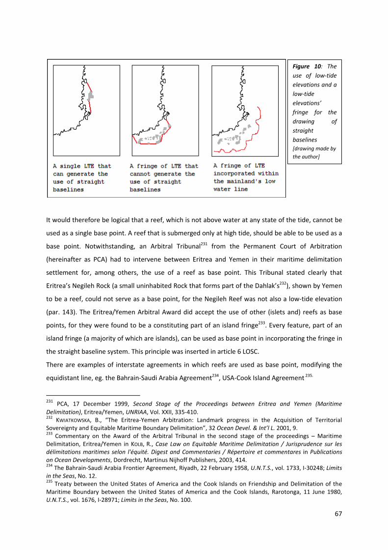
67
It would therefore be logical that a reef, which is not above water at any state of the tide, cannot be
used as a single base point. A reef that is submerged only at high tide, should be able to be used as a
base point. Notwithstanding, an Arbitral Tribunal231 from the Permanent Court of Arbitration
(hereinafter as PCA) had to intervene between Eritrea and Yemen in their maritime delimitation
settlement for, among others, the use of a reef as base point. This Tribunal stated clearly that
Eritrea’s Negileh Rock (a small uninhabited Rock that forms part of the Dahlak’s232), shown by Yemen
to be a reef, could not serve as a base point, for the Negileh Reef was not also a low-tide elevation
(par. 143). The Eritrea/Yemen Arbitral Award did accept the use of other (islets and) reefs as base
points, for they were found to be a constituting part of an island fringe233. Every feature, part of an
island fringe (a majority of which are islands), can be used as base point in incorporating the fringe in
the straight baseline system. This principle was inserted in article 6 LOSC.
There are examples of interstate agreements in which reefs are used as base point, modifying the
equidistant line, eg. the Bahrain-Saudi Arabia Agreement234, USA-Cook Island Agreement 235.
231 PCA, 17 December 1999, Second Stage of the Proceedings between Eritrea and Yemen (Maritime
Delimitation), Eritrea/Yemen, UNRIAA, Vol. XXII, 335-410. 232
KWIATKOWSKA, B., “The Eritrea-Yemen Arbitration: Landmark progress in the Acquisition of Territorial Sovereignty and Equitable Maritime Boundary Delimitation”, 32 Ocean Devel. & Int’l L. 2001, 9. 233
Commentary on the Award of the Arbitral Tribunal in the second stage of the proceedings – Maritime Delimitation, Eritrea/Yemen in KOLB, R., Case Law on Equitable Maritime Delimitation / Jurisprudence sur les
délimitations maritimes selon l'équité. Digest and Commentaries / Répertoire et commentares in Publications
on Ocean Developments, Dordrecht, Martinus Nijhoff Publishers, 2003, 414. 234
The Bahrain-Saudi Arabia Frontier Agreement, Riyadh, 22 February 1958, U.N.T.S., vol. 1733, I-30248; Limits
in the Seas, No. 12. 235
Treaty between the United States of America and the Cook Islands on Friendship and Delimitation of the Maritime Boundary between the United States of America and the Cook Islands, Rarotonga, 11 June 1980, U.N.T.S., vol. 1676, I-28971; Limits in the Seas, No. 100.
Figure 10: The
use of low-tide
elevations and a
low-tide
elevations’
fringe for the
drawing of
straight
baselines
[drawing made by
the author]

68
3. Interstate marine delimitation
3.1. GENERAL DELIMITATION PRINCIPLES: EQUIDISTANCE AND EQUITABLE DELIMITATION
International law (of the sea) has provided coastal States with some maritime zones to be claimed by
them. In providing these zones, all States are equal and they are entitled to the same (amount of
these) zones. Granting all of them a same amount would merely be ideological. The given State
configurations in the world cannot provide equal shares to every State. Adjacent States need to draw
a line between them. Opposite States often don’t have enough water area between them to provide
all of the maritime zones to all of them. Therefore, international law of the sea had to work out a
procedure to cope with the differences in configuration. In other words, delimitation principles of the
latter had to be installed.
The general principle for maritime boundary delimitation has altered over the years. However, one
principle has been upheld every time. The method of preference in achieving boundary delimitation
is the one of (mutual) agreement. But States do not always reach an agreement, so there is still a
need for further delimitation principles.
This problem mostly occurs in continental shelf boundaries. Therefore, the continental shelf will first
be examined instead of following the classical order of maritime areas.
3.1.1. BOUNDARY DELIMITATION CONCERNING THE CONTINENTAL SHELF
When there is a continental shelf, which is the same for adjacent or opposite States, the delimitation
issues shall be determined by agreement. When, on the other hand, States cannot come to an
agreement, delimitation principles were needed so as to provide Courts and Tribunals a definite rule
for settling delimitation problems236. As the CSC came into force, the international community was
bound upon the principle of ‘equidistance’. This principle was inserted in art. 6 of that convention
and reads as follows:
1. Where the same continental shelf is adjacent to the territories of two or more States whose
coasts are opposite each other, the boundary of the continental shelf appertaining to such
States shall be determined by agreement between them. In the absence of agreement, and
unless another boundary line is justified by special circumstances, the boundary is the median
line, every point of which is equidistant from the nearest points of the baselines from which
the breadth of the territorial sea of each State is measured.
236
JAYEWARDENE, H.W., The Regime of Islands in International Law in Publications on Ocean Developments, Dordrecht, Martinus Nijhoff Publishers, 1990, 315.

69
2. Where the same continental shelf is adjacent to the territories of two adjacent States, the
boundary of the continental shelf shall be determined by agreement between them. In the
absence of agreement, and unless another boundary line is justified by special circumstances,
the boundary shall be determined by application of the principle of equidistance from the
nearest points of the baselines from which the breadth of the territorial sea of each State is
measured.
Article 6 made a division between the delimitation of adjacent and opposite States. However, the
applicable rule is the same, that of the equidistance. This rule means that a median line is drawn
between the two States, which is at an equal distance of the nearest points of the baseline (from
which the breadth of the territorial sea of each State is measured).
The main goal of the equidistance line was to provide an equitable solution to boundary conflicts,
where States were either reluctant or incapable of reaching an equitable solution of their own.
Initially, following the Committee of Experts 1953, article 6 would have postponed “equidistance as a
general rule”, but on the suggestion of SPIROPOULOS, this was replaced by “unless another boundary
line is justified by special circumstances”237. Although first adhered as ‘a general rule’ for equitable
delimitation, equidistance clearly did not always provide equitable solutions. JAYEWARDENE238
explained239 “that there are circumstances where equidistance will not be equitable and where it
237
204th
meeting, 29 June 1953, 1953 I.L.C. Yearbook, Vol. 1, 130, 64. 238
JAYEWARDENE, H.W., The Regime of Islands in International Law in Publications on Ocean Developments, Dordrecht, Martinus Nijhoff Publishers, 1990, 329-334. 239
He refers to UN Doc., A/CONF.62/C.2/L.13, explanatory memorandum.
Figures 11 and 12: Equidistance lines between opposite and adjacent States
[CARLETON, C. and SCHOFIELD, C. “Developments in the Technical Determination of Maritime Space: Charts,
Datums, Baselines and Maritime Zones”, 3 Maritime Briefing 2001, 7 (opposite states) and 9 (adjacent
states).]

70
would be necessary to take into account all circumstances relevant for reaching an equitable
solution”. These relevant circumstances are geographical factors, coastal configurations, the
presence of islands, geology and geomorphology, natural resources and security.
Nonetheless, the applicability of the ‘equidistance-special circumstances’ rule was the subject of two
pre-LOSC international disputes of major importance concerning continental shelf delimitation.
The first international applications for this twofold delimitation principle were the North Sea
Continental Shelf Cases (1969) between on the one hand Denmark240 and the Netherlands241, and on
the other hand Germany242.
As it was postponed in article 6 of the CSC, Denmark and the Netherlands saw in the equidistance
line, not only a conventional rule, but also a general rule of public international law243: “The
delimitation (…) is governed by the principles and rules of international law which are expressed in
Article 6, paragraph 2, of the Geneva Convention of 1958 on the Continental Shelf” and “like other
rules of general or customary international law, is binding on the Federal Republic automatically and
independently of any specific assent, direct or indirect, given by the latter “244. However, Germany,
not being a party to the CSC, withheld245 that “(…) (equidistance method) is not a rule of customary
international law”. Furthermore, Germany went on stating that even if the rule were applicable
between the parties concerned, this rule would be excluded because of the special circumstances
(the respective configurations of the coastlines). Denmark and the Netherlands abated that thought
by stating that there were no special circumstances in this case246.
240
The Kingdom of Denmark signed CSC on 29 April 1958 and ratified it on 12 June 1963, http://treaties.un.org/pages/ViewDetails.aspx?src=UNTSONLINE&tabid=1&mtdsg_no=XXI-4&chapter=21&lang=en#4 (last visited 10 November 2010). 241
The Kingdom of the Netherlands signed CSC on 31 October 1958 and ratified it on 18 February 1966, http://treaties.un.org/pages/ViewDetails.aspx?src=UNTSONLINE&tabid=1&mtdsg_no=XXI-4&chapter=21&lang=en#4 (last visited 10 November 2010). 242
The Federal Republic of Germany signed the Convention on 30 October 1958, but did not ratify it. On 27 December 1973 it acceded to the Convention with a declaration (United Nations, Treaty Series, vol. 905, 82), http://treaties.un.org/pages/ViewDetails.aspx?src=UNTSONLINE&tabid=1&mtdsg_no=XXI-4&chapter=21&lang=en#4 (last visited 10 November 2010). 243 SOMERS, E., Inleiding tot het internationaal zeerecht, 5de herwerkte uitgave, Mechelen, Kluwer, 2010, 159, referring to North Sea Continental Shelf Case, ICJ Reports 1969, 11. 244
ICJ, 20 February 1969, North Sea Continental Shelf Case. Judgment, Federal Republic of Germany/Denmark and the Netherlands, ICJ Reports 1969, 29. 245
At the hearing on 5 November 1968. 246
ICJ, 20 February 1969, North Sea Continental Shelf Case. Judgment, Federal Republic of Germany/Denmark and the Netherlands, ICJ Reports 1969, 12 (Denmark and the Netherlands), 11, 2 (a) and (c) (Germany).

71
According to Germany, the present case(s) could not rely on the equidistance method, for it would
not lead to equitable apportionments. Therefore, the Court was asked “to decide what principles and
rules of international law are applicable to the delimitation as between the Parties of the areas of the
continental shelf in the North Sea”. The Court was, on the contrary, not asked to delimit the
boundaries, for that task was reserved for the Parties, achieving delimitation by agreement “on the
basis of, and in accordance with, the principles and rules of international law found by the Court to be
applicable” 247.
After long examinations, the Court found248 that the use of the equidistance line was not obligatory
to the parties and that there was no rule which appears to be obligatory in all circumstances. The
Court stated that – instead of the equidistance – the applicable principles of international law
generating the solution to the latter was “to be effected by agreement in accordance with equitable
principles, and taking account of all the relevant circumstances, in such a way as to leave as much as
possible to each Party all those parts of the continental shelf that constitute a natural prolongation of
its land territory into and under the sea (…)”.
247
ICJ, 20 February 1969, North Sea Continental Shelf Case. Judgment, Federal Republic of Germany/Denmark and the Netherlands, ICJ Reports 1969, 11, 3 (b) (Germany), 10 (Question to the Court), 13 (Court). 248
ICJ, 20 February 1969, North Sea Continental Shelf Case. Judgment, Federal Republic of Germany/Denmark and the Netherlands, ICJ Reports 1969, 54, conclusion (A), (B) and (C).1.
Figure 13: Map showing the respective
configurations of the coasts of the parties,
allotting Germany an exceptionally small part
of the continental shelf area.
delimitation line claimed by Germany
delimitation lines claimed by Denmark
and the Netherlands
[(part of) Map 3, paragraphs 5-9, ICJ, 20 February
1969, North Sea Continental Shelf Case. Judgment,
Federal Republic of Germany/Denmark and the
Netherlands, ICJ Reports 1969.]

72
The second boundary dispute was the Anglo-French Arbitration of 1977 concerning two disputed
areas, the Channel Islands and the Atlantic Continental Shelf Area249.
In this case, concerning the continental shelf delimitation between the United Kingdom and France,
the parties disagreed on whether the CSC in general and the equidistance principle of article 6 in
particular were applicable. Since the U.K. had rejected the French reservations to article 6, France
argued that the CSC had not entered into force between them. The Tribunal found the CSC to be in
force between the opponent States250. Concerning the Channel Islands region, the latter had to be
resolved in accordance with the rules of customary law. The applicability of the equidistance
principle, described in article 6 CSC, was to be seen as a treaty obligation, rendering it obligatory (a
status it would not have under customary law251). The Tribunal immediately thereafter recognized
the consistency between the equidistance line and the special circumstances. This was an elementary
consistency, because it was the combined rule of article 6 that expressed the general norm that
delimitation ought to be based on equitable principles252. The Arbitration Tribunal thus came to the
same conclusion as the ICJ in the North Sea Continental Shelf Cases, that there was no automatic
application of the equidistance-special circumstances rule, but that it could be applied when (given
all the circumstances) it would generate an equitable solution. Concerning the Channel Islands, OUDE
ELFERINK253 stipulated that they are “considered a ‘special circumstance’ within the meaning of article
6 or a circumstance creative of inequity, and it is on this consideration that the delimitation is
effected”.
Hence, for this matter it needs to be pointed out that the Tribunal of Arbitration did, for the first
area, take account of the equidistance line, but not in a stringent way as proposed by the United
Kingdom. The Tribunal saw an equitable solution in using the equidistance line, but, for that matter
ignoring the presence of the Channel Islands. These islands were looked upon by the Tribunal
following the French argumentation, as a relevant circumstance. Concerning the second area, the
249
Both disputed areas are mentioned below in respect of their effect to the interstate delimitation, page 78 and 92. 250
The Court found that a French reservation to the effect that there are special circumstances in the Bay of Granville covered the whole Channel Islands region in OUDE ELFERINK, A.G., The Law of Maritime Boundary
Delimitation. A Case Study of the Russian Federation. in Publications on Ocean Developments, Dordrecht, Martinus Nijhoff Publishers, 1994, 55, footnote 60; Award of the Arbitration Tribunal, 30 June 1977/14 March 1978, Delimitation of the Continental Shelf between the United Kingdom of Great Britain and Northern Ireland,
and the French Republic, UK/France, UNRIAA, Vol. XVIII, 46-47, par. 71-74. 251
OUDE ELFERINK, A.G., The Law of Maritime Boundary Delimitation. A Case Study of the Russian Federation. in Publications on Ocean Developments, Dordrecht, Martinus Nijhoff Publishers, 1994, 55. 252
Award of the Arbitration Tribunal, 30 June 1977/ 14 March 1978, Delimitation of the Continental Shelf
between the United Kingdom of Great Britain and Northern Ireland, and the French Republic, UK/France, UNRIAA, Vol. XVIII, 45, par. 70. 253
OUDE ELFERINK, A.G., The Law of Maritime Boundary Delimitation. A Case Study of the Russian Federation. in Publications on Ocean Developments, Dordrecht, Martinus Nijhoff Publishers, 1994, 57.

73
Tribunal postponed that the equidistance principle was applicable. Again, the Tribunal did not follow
the stringent equidistance line254. The Tribunal did, however, clearly state that the equidistance
principle is binding for the State parties to the CSC, but immediately thereafter stated that it only
remains binding, unless another boundary is justified by special circumstances255.
Following these developments in international boundary delimitation, SOMERS256 concluded that for
delimiting continental shelf area, whether based on art. 6 CSC or international customary law, in the
absence of agreement, achieving an equitable delimitation prevails on an automatic applicability of
any delimitation principle, including equidistance. Because of art 6 CSC, the equidistance principle
cannot be put aside, but circumstances can justify the use of other delimitation principles.
Nevertheless, BOWETT stated that, between CSC State parties as well as between non-State parties
the equidistance principle is used, although sometimes in a modified way257. WEIL described this as
follows, “according to reliable testimony, governments always begin the negotiation of a maritime
delimitation by considering an equidistance line, while at liberty subsequently to modify it”. He
immediately added that “there is no reason why this practice should not be taken into account in the
development of the customary law governing the delimitation process” 258.
With the new law of the sea (the LOSC) the international community had a (new) chance of
(re)formulating an accepted principle on continental shelf delimitation. And especially for that cause,
the negotiations on the subject were everything but simple. One the one hand, there were States
sanctifying the equidistance principle, on the other hand there were States arguing a complete
rejection of the equidistance method in favor of equitable principles. Quite logically, States
advocated the vision that benefited them the most. The negotiating States to UNCLOS III had a lot of
trouble achieving agreement on this issue. One attempt to reach acceptance were the thorough
discussions of it in Negotiating Group 7 under the chairmanship of Mr. MANNER, of Finland, that dealt
with the definition of maritime boundaries between adjacent and opposite States259. Document
NG7/39, that contained the report of the Chairman MANNER, stated that “(…) none of the proposals
for revision of the informal composite negotiating text offered a substantially improved prospect of a
254
The Court placed the equidistance line between the line that would have been generated if the Scilly Islands were to be taken into account and the line for when they were not to be taken into account, see further. 255
SOMERS, E., Inleiding tot het internationaal zeerecht, 5de herwerkte uitgave, Mechelen, Kluwer, 2010, 161. 256
SOMERS, E., Inleiding tot het internationaal zeerecht, 5de herwerkte uitgave, Mechelen, Kluwer, 2010, 161. 257
BOWETT, D.W., The legal Regime of Islands in International Law, New York, Oceana Publications, 1979, 157-160 and 170-183. 258
WEIL, P, Perspectives du droit de la délimitation maritime, Paris, Pedonne, 1988, 154; NELSON, L.D.M., “The Roles of Equity in the Delimitation of Maritime Boundaries”, 84 AJIL 1990, 844. 259
Report of the Chairman of the Second Committee, 27 April 1979, UN Doc., A/CONF.62/L.38, par. 3.
74
consensus”260. There was only a “widespread and substantial support” for the draft article of the
Chairman, Mr. KOH at the 10th Session at August 1981: delimitation is to be done by agreement on
the basis of International Law, in order to achieve an equitable solution261.
The latter was endorsed in article 83 LOSC:
1. The delimitation of the continental shelf between States with opposite or adjacent coasts
shall be effected by agreement on the basis of international law, as referred to in Article 38 of
the Statute of the International Court of Justice, in order to achieve an equitable solution.
2. If no agreement can be reached within a reasonable period of time, the States concerned
shall resort to the procedures provided for in Part XV.
Boundary delimitation still has to be the subject of an agreement, reached by the parties concerned.
This first rule seems to be sanctified throughout the years. The new law of the sea, however, did not
postpone any delimitation principle. Contrary to the CSC, it does not even mention a delimitation
principle. It merely states that parties are to achieve an equitable delimitation, leaving every possible
delimitation principle open for use, including equidistance, but not prevailing equidistance as the
principal delimitation principle. Ironically, that leads back to square one, for equitable delimitation
anteceded the 1958 equidistance-special circumstances rule262.
International jurisprudence before the ICJ and Arbitral Sentences has affirmed the principle of
equitable delimitation263. A brief review follows264. In the first case that was brought to the ICJ’s
260
Report of the Chairman of the Second Committee, 27 April 1979, UN Doc., A/CONF.62/L.38, par. 7. 261
SOMERS, E., Inleiding tot het internationaal zeerecht, 5de herwerkte uitgave, Mechelen, Kluwer, 2010, 163. 262
The ‘equitable delimitation’ was first postponed in the Truman Proclamation of 28 September 1945 were the boundary delimitation took place in accordance with equitable principles (U.N. Legislative Series, Law and Regulations on the Regime of the High seas, Vol. 1, 1951, 38). The American point of view was rapidly followed by various littoral states of the Arabian Gulf region (The Proclamations of the Sultan of Bahrain of 5 June 1949; The Proclamations of the Sheik of Qatar of 8 June 1949; The Proclamations of the Sheik of Kuwait of 12 June 1949; The Proclamations of the Ruler of Abu Dhabi of 10 June 1949; … ) and also by Nicaragua (Nicaragua Declaration of 28 May 1949). Gaining wide acceptance, the 1958 CSC would have endorsed this principle, taking into account the deliberations in the ILC, if it was not for the 1953 Committee of Experts that recommended the equidistance method. Rapporteur FRANÇOIS suggested even the wording ‘equidistance as a general rule’. Because of objection the latter had to be discussed and voted. The Commission adopted, by a majority, the equidistance principle. (for an extensive review on the historical development of the concept, see JAYEWARDENE, H.W., The Regime of Islands in International Law in Publications on Ocean Developments, Dordrecht, Martinus Nijhoff Publishers, 1990, 316-324 and footnotes 337 to 346 on page 503. 263
ICJ, 24 February 1982, Case concerning the Continental Shelf, Tunisia/Libya, ICJ Reports 1982, 17-323; ICJ, 12 October 1984, Gulf of Maine case, Canada/United States of America, ICJ Reports 1984, 246-390; ICJ, 3 June 1985, Case concerning the Continental Shelf, Libya/Malta, ICJ Reports 1985, 12-187; Arbitral Sentence for the delimitation of the single maritime boundary between Guinea and Guinea-Bissau, 14 February 1985, R.G.D.I.P. 1985, 484; Tribunal of Arbitration for the delimitation of maritime areas between Canada and France: Decision in case concerning delimitation of maritime areas (St. Pierre and Miquelon), 10 June 1992, I.L.M. 1992, 1145-

75
attention, Tunisia/Libya 1982, the Court stated that equitable principles are the primary grounds for
delimitation. It therefore stepped off of the equidistance trail. The outcome of the Court was,
however, contested. Not in the least through the dissenting opinions265 stating that the equitable
delimitation prejudiced the precision and the predictability from delimitation law, something that
was certainly not the case with the equidistance line. In its Gulf of Maine case 1984, the Court did not
use the equidistance line. On the contrary, it sought for the most equitable criteria to be used. After
drawing the delimitation line in regard of those criteria it finalized it by controlling whether the
outcome was an equitable result. In the Lybia/Malta Case 1984, the ICJ even rejected the existence
of a rule that the equidistance method was to be used. Delimitation is to be effected by using
equitable principles in all relevant circumstances; this will generate an equitable result. One of those
principles is that equity does not necessarily imply equality. An Arbitral Tribunal followed these
events by stating in its Arbitral Sentence on the Case between Guinea and Guinea-Bissau 1985 that
the equidistance line did not enjoy priority over other delimitation principles. In Canada/France
1992, the Tribunal stated to consider the case on the basis of equity and it confirmed that the
solution must always be equitable. In the Greenland/Jan Mayen Case 1993, the ICJ used the
equidistance line for the delimitation of the maritime zones, but, immediately corrected this line due
to special circumstances. The Court reaffirmed that the delimitation was to provide an equitable
solution.
SOMERS concluded that there is an institutionalized vagueness replacing the preferential treatment of
the equidistance principle266. IGIEHON added that each case is decided on, on what the Court –on that
moment- thought was good and equitable267. However, through these inconsistent and
unpredictable outcomes, a new principle is being applied. The jurisprudence coming from the ICJ and
Arbitral sentences use the equitable principles/relevant circumstances method, for the Court will
now start with an equidistance line, removing it, due to relevant circumstances, in order to achieve
an equitable result268.
In more recent cases before the ICJ, the Court provided solutions based on this newly installed
equitable principles/relevant circumstances-rule. This was the case for Qatar/Bahrain 2001 and
1219; ICJ, 11 September 1992, Case concerning the land, island and maritime frontier dispute, El Salvador/Honduras: Nicaragua intervening, ICJ Reports 1992, 350-761; ICJ, June 14, 1993, Maritime delimitation in the area between Greenland and Jan Mayen, Denmark/Norway, ICJ Reports 1993, 38-314. 264
This review will be mainly based on SOMERS, E., Inleiding tot het internationaal zeerecht, 5de herwerkte
uitgave, Mechelen, Kluwer, 2010, 164-177 and IGIEHON, M.O., “Present international law on delimitation of the continental shelf”, I.E.L.T.R.2006, 8/9, 208-215. 265
Judges GROS, ODA, EVENSEN, SCHWEBEL. 266
SOMERS, E., Inleiding tot het internationaal zeerecht, 5de herwerkte uitgave, Mechelen, Kluwer, 2010, 162. 267
IGIEHON, M.O., “Present international law on delimitation of the continental shelf”, I.E.L.T.R.2006, 8/9, 214. 268
SOMERS, E., Inleiding tot het internationaal zeerecht, 5de herwerkte uitgave, Mechelen, Kluwer, 2010, 174.

76
Cameroon/Nigeria 2002. The ICJ reaffirmed that this method was still the applicable rule in the
Nicaragua/Honduras Case 2007, but that it was not to be applied in the present case. Application
would render the resolution of the delimitation issue an inequitable one. The principle was last
applied in the Black Sea Case 2009 by the ICJ.
Thus, the final solution to the latter is a three-phase269 analysis for determining the boundary
delimitation line. This three-phase method is already applied (en thus affirmed) in several cases of
State practice, making it valuable as the contemporary delimitation method to be applied. The three
steps are the following270: the Court will first “establish a provisional equidistance line based on
methods that are geometrically objective” and also “appropriate for the geography of the area in
which the delimitation is to take place”. Secondly, it will then consider “whether there are factors
calling for the adjustment or shifting of the provisional equidistance line in order to achieve an
equitable result”. Thirdly, it must verify that “the provisional equidistance line, adjusted or not, does
not lead to an inequitable result by reason of any marked disproportion between the ratio of the
respective coastal lengths and the ratio between the relevant maritime area of each State”.
3.1.2. BOUNDARY DELIMITATION IN THE TERRITORIAL SEA
When the sea area between two or more adjacent or opposite States is insufficient for providing all
of them an equal part of territorial sea, States can negotiate in order to achieve an agreement,
granting them each an equitable part of the sea territory. But also for the territorial sea, a
delimitation principle was needed for situations where States were unable to reach such an
agreement. This was taken care of in article 12 TSC:
1.Where the coasts of two States are opposite or adjacent to each other, neither of the two
States is entitled, failing agreement between them to the contrary, to extend its territorial sea
beyond the median line every point of which is equidistant from the nearest points on the
baselines from which the breadth of the territorial seas of each of the two States is measured.
The provisions of this paragraph shall not apply, however, where it is necessary by reason of
historic title or other special circumstances to delimit the territorial seas of the two States in a
way which is at variance with this provision.
269
There is however an author that speaks of a two-step method (this is mentioned and explained further on while highlighting the semi-enclave solution in the Nicaragua/Honduras Case). See page 98 and footnote 416. 270
ICJ, 3 February 2009, Case concerning Maritime Delimitation in the Black Sea. Judgment, Romania/Ukraine I.C.J. Reports 2009, 101, par. 116-122; LATHROP, C. G., “Maritime delimitation in the Black Sea (Romania v Ukraine). At http://www.icj-cij.org. International Court of Justice, February 3, 2009”, 103 AJIL 2009, 546.

77
Failing agreement, the delimitation of the territorial sea, was also to be settled by using the
equidistance principle. Article 12 TSC shows that the equidistance rule, for territorial sea as well,
could be put aside for delimitation purposes, where it is necessary “by reason of historic title or other
special circumstances”271. Apart from some stylistic changes, article 15 LOSC did not bring along a
differed procedure for (opposite or adjacent) boundary delimitation in the territorial sea. There was
not much discussion about the territorial sea delimitation. ARNAUT stated that it “is governed by the
equidistance and the special circumstances rule which is embodied in the United Nations Convention
on the Law of the Sea (LOSC), and has been accepted without much controversy since the first
territorial sea convention”272.
3.1.3. BOUNDARY DELIMITATION IN THE CONTIGUOUS ZONE
Since the contiguous zone was installed as a supplementary zone for the territorial sea, it mostly
walked the same line. That was not different for opposite or adjacent boundary delimitation. Article
24 (3) of the TSC did not differ from the first sentence of art 12 (1) TSC:
3.Where the coasts of two States are opposite or adjacent to each other, neither of the two
States is entitled, failing agreement between them to the contrary, to extend its contiguous
zone beyond the median line every point of which is equidistant from the nearest points on
the baselines from which the breadth of the territorial seas of the two States is measured.
Contiguous zone delimitation was subject to the equidistance rule. Because of its supplementary
character, the assumption was that neither historic title nor special circumstances could be at stake.
Notwithstanding its supplementary character, the contiguous zone did not walk the line of the
territorial sea at the LOSC. Delimitation of contiguous zones was not even mentioned in the new
convention. Whatever the exact reason may be is not clear. There are two possible reasons. First,
since the contiguous zone is part of the EEZ, the delimitation rules of the EEZ should be applied273.
Second, the competences to be exercised in contiguous zone area could be practiced by several
States in a same maritime area, excluding the need for delimitation274.
3.1.4. BOUNDARY DELIMITATION CONCERNING THE EXCLUSIVE ECONOMIC ZONE
Opposite or adjacent State delimitation is mentioned in article 74 of the LOSC, stating:
271
ARNAUT, D, “Stormy Waters on the Way to the High Seas: The Case of the Territorial Sea Delimitation Between Croatia and Slovenia, 8 Ocean and Coastal L.J. 2002, 30. 272
ARNAUT, D, “Stormy Waters on the Way to the High Seas: The Case of the Territorial Sea Delimitation Between Croatia and Slovenia, 8 Ocean and Coastal L.J. 2002, 22. 273
SOMERS, E., Inleiding tot het internationaal zeerecht, 5de herwerkte uitgave, Mechelen, Kluwer, 2010, 108. 274
X, De Derde Zeerechtconferentie van de Verenigde Naties, (Ned) Ministerie van Buitenlandse Zaken, Den Haag, 1984, 83; SOMERS, E., Inleiding tot het internationaal zeerecht, 5de herwerkte uitgave, Mechelen, Kluwer, 2010, 109.

78
1. The delimitation of the exclusive economic zone between States with opposite or adjacent
coasts shall be effected by agreement on the basis of international law, as referred to in
Article 38 of the Statute of the International Court of Justice, in order to achieve an equitable
solution.
2. If no agreement can be reached within a reasonable period of time, the States concerned
shall resort to the procedures provided for in Part XV.
These provisions are literally the same as the continental shelf provisions of art. 83. Hence,
agreement needs to be reached in order to delimit the area. In case States do not reach agreement,
the dispute settlement body of Part XV of LOSC is applicable. Again, no delimitation principle is
mentioned, let alone prevailed. There is merely a reference to achieve an equitable solution.
3.2. ISLANDS IN INTERSTATE MARITIME BOUNDARY DELIMITATION
“[T]he territorial sea, the contiguous zone, the exclusive economic zone and the continental shelf of
an island are determined in accordance with the provisions of this Convention applicable to other land
territory”. Article 121 (2) LOSC is the basic ground for the equal treatment of islands and other
mainland. It is thus conventional, if not customary, that an island is to be seen and treated as equal
to mainland. By virtue of that, delimitation between them is to allot them both with equal shares.
This is the principle relating to islands.
As stated earlier, although not anymore the sole solution for boundary delimitation, State practice
shows the willingness of States to keep on using the equidistance-special circumstances rule. One of
the most important and occurring ‘special circumstances’ are, without a doubt, the presence of
islands275 within the marine area to be delimitated. Nevertheless, State practice276 and many
authors277 have shown that using the equidistance line, in cases where there are islands involved, can
lead to inequitable delimitation. When giving islands full effect for the purpose of delimitation,
inequitable distortions can take place. This is the sentiment in State practice relating to islands.
According to some scholar works, these points of view constitute a “major and irreconcilable
contradiction”: “On the one hand, the international treaties and the cases uniformly recognize the
equal status and rights of all coastal territory, including that of islands. On the other hand, we find in
some cases what appears to be the short-changing of minor or small islands through lesser effect,
275
CHURCHILL, R.R. and LOWE, A.V., The Law of the Sea. Third edition, Manchester, Manchester University Press, 1999, 154. 276
See further. 277
CHURCHILL and LOWE, BOWETT, JAYEWARDENE, SOMERS, … (this can be found in books and articles from the respective authors which are already mentioned earlier).

79
movement back or enclaving”278. Thus, whilst islands are totally equal to a continental mainland for
the purposes of delimitation, they are not treated equally because of the inequitable effect they
might generate. An explanation for this different treatment of islands can be found in their
location279.
There are various (geographical) situations in which this full effect would generate inequity based on
the location: islands lying at the shore of an opposite280 or adjacent281 State, islands located at the
equidistance line which would normally be applied282, delimitation between an island283 or an island
State284 and a State or island that is way larger, islands (subject to a greater landmass) located far
from the mainland285,…. Obviously, this brings along some major difficulties. KOZYRIS286 raised lots of
questions to this extent; What is an island? Is there a difference between Malta, Greenland, Australia
in defining an island? Should all islands be diminished, or only some? Is it important whether an
island is politically independent? The major question appears to be: are some islands more equal
than others?
In order to cope with these so-called inequities, several remedies are provided. These remedies vary
from a partial effect to no effect at all, or to the (semi-)enclave solution. The following outset will
provide an examination of the applicability of these remedies in the Cases decided upon by the ICJ287,
the PCA288 and some other Arbitral Tribunals289.
Nevertheless, equidistance is no longer the only method to be applied. There are other methods to
be applied as well, eg. the use of an azimuth, latitude parallels or rhumb lines290. This has an effect on
278
KOZYRIS, P.J., “Lifting the veils of equity in maritime entitlements: equidistance with proportionality around the islands”, 26 Denv. J. Int’l L. & Pol’y. 1998, 373-374. 279
“For lack of a better explanation” according to KOZYRIS, P.J., “Lifting the veils of equity in maritime entitlements: equidistance with proportionality around the islands”, 26 Denv. J. Int’l L. & Pol’y. 1998, 375. 280
Eg. the Bahraini Hawar Island Group at the Qatari coast. 281
Eg. the South Korean Yeonpyeong Island before the coast of North Korea. 282
Eg. the Islands of Partelleria, Lampedusa and Linosa between Italy and Tunisia 283
Eg. delimitation between Greenland (Denmark) and Jan Mayen (Norway). 284
Eg. delimitation between Malta and Libya (way larger in this case comes to an 8:1 ratio). 285
Eg. the French Islands of St. Pierre and Miquelon under the island of New Foundland (Canada). 286
KOZYRIS, P.J., “Lifting the veils of equity in maritime entitlements: equidistance with proportionality around the islands”, 26 Denv. J. Int’l L. & Pol’y. 1998, 374. 287
Tunisia/Libya, Libya/Malta, Gulf of Maine, Greenland/Jan Mayen, Qatar v. Bahrain, Cameroon/Nigeria, Nicaragua/Honduras and Ukraine/Romania. 288
Eritrea/Yemen and Bangladesh/India. 289
Only if important enough to be mentioned: Anglo-French Arbitration and French-Canadian Arbitration. 290
Azimuth: Angle measured clockwise between north and the object being sighted; Latitude parallels: A circle on the surface of the earth parallel to the plane of the equator and connecting all points of equal latitude; Rhumb Lines: A line on the earth's surface making the same angle with all meridians. A straight line on a Mercator projection chart, and the standard way of laying down a ship’s course. Definitions from NIKAS, R.J.,

80
the importance of the presence of islands. In most cases “where there is no reliance on equidistance,
the relevance of islands diminishes”291. Eg. the Brazil-France (French Guiana) Agreement uses an
azimuth292. The States involved can also choose not to settle the latter and install joint development
zones (and other arrangements)293, eg. the Japan-Korea Agreement294.
3.2.1. INEQUITY AND FULL EFFECT
As stated above, inequity can occur in different geographical situations. The inequity is mainly the
result of granting full effect to islands when situated in such a geographical situation. It has become a
principle of general international law that no full effect can be granted to islands295. Islands should
have limited capacity to affect a maritime boundary296 when this maritime area is to be divided
between an island and a continental State.
Nevertheless, there are situations granting a full effect to islands - as should be the case according to
codified customary international law - and treating them equally to greater mainland in maritime
boundary delimitation.
Interstate maritime boundary delimitation is primarily to be achieved by bilateral (or trilateral, …)
agreements amongst nations. There are thus many examples of such boundary agreements applying
the full effect granted to islands. BOWETT clarified that “the islands accorded full entitlement are both
independent States and dependant territories”297. Full effect to islands towards mainland states:
“Where The Street Meets The Sea: A Nautical Glossary For Maritime Lawyers” 9 U.S.F. Mar. L.J. 1996, 247, 267 and 269. 291
BOWETT, D., “Islands, Rocks, Reefs and Low-Tide Elevations in Maritime Boundary Delimitations” in CHARNEY, J.I. & ALEXANDER, L.M., International Maritime Boundaries. Volume I, ASIL, Martinus Nijhoff Publishers, 1993, 134. 292
Agreement Between the Government of Brazil and the Government of France Relating to the Maritime Delimitation Between Brazil and French Guiana; 30 January 1981, 25 ILM, 1986, 367. 293
JAYEWARDENE, H.W., The Regime of Islands in International Law in Publications on Ocean Developments, Dordrecht, Martinus Nijhoff Publishers, 1990, 349-363; BOWETT, D., “Islands, Rocks, Reefs and Low-Tide Elevations in Maritime Boundary Delimitations” in CHARNEY, J.I. & ALEXANDER, L.M., International Maritime
Boundaries. Volume I, ASIL, Martinus Nijhoff Publishers, 1993, 131-151. 294
Agreement between Japan and the Republic of Korea concerning joint development of the southern part of the continental shelf adjacent to the two countries, Seoel, 30 January 1974, U.N.T.S., vol. 1225, I-19778; Limits
in the Seas, No 75. 295
CHARNEY, J.I., “Central East Asian Maritime Boundaries and the Law of the Sea”, 89 AJIL 1995, 731. 296 VAN DYKE, J., “The Maritime boundary between North & South Korea in the Yellow (West) Sea,” 38 North,
U.S.-Korea Institute Johns Hopkins University School of Advanced International Studies, July 29, 2010, www.38north.org/?p=1232. 297
BOWETT, D., “Islands, Rocks, Reefs and Low-Tide Elevations in Maritime Boundary Delimitation” in CHARNEY, J.I. and ALEXANDER, L.M., International Maritime Boundaries vol. 1, Dordrecht, Nijhoff Publishers, 1993, 134.

81
tripartite agreement between India, Sri Lanka and the Maldives298; French (Corsica) Agreement with
Monaco299. Agreements on full effect concerning island to island delimitation: Australia-France
Agreement concerning Kerguelen Island and the Heard and Mc Donald Island300; Italy-Spain
Agreement over Sardinia and Menorca301.
The Korean Island Dispute: exemplary situation?
(a) The dispute
A full effect, although disputed, occurred in the delimitation between the Republic of Korea and the
Democratic People’s Republic of Korea. In 1953, after a civil war, a delimitation line (the Northern
Limit Line, shorted as NLL) was installed by the UN, in which the equidistance line was placed
between the DPRK’s coast line and the ROK’s Islands lying offshore thereof. Regardless of this line,
the DPRK installed its own delimitation line in 1999, arguing that the NLL was unilaterally drawn by
the UN, leaded by ROK’s ally, the USA. Obviously, this NLL created an inequity towards DPRK. VAN
DYKE302 stated that “if the two Koreas were to be regarded as independent countries (rather than as
two halves of a temporarily divided country), then this Line would not be viewed as a legitimate
maritime boundary under the “equitable principles” that govern boundaries, because it denies North
Korea access to adjacent sea areas”.
298
Agreement between Sri Lanka, India and the Maldives on the Determination of Trijunction Point between the three Countries in the Gulf of Mannar, Gulf of Mannar, 31 July 1976, UN Legislation Relating to the Law of
the Sea, ST/LEG/SER.B/19, 1980, 415. 299
Convention on Maritime Delimitation Agreement between the Government of His Serene Highness the Prince of Monaco and the Government of the French Republic, Paris, 16 February 1984, U.N.T.S., vol. 1411, I-23631; 9 LOS Bull. 1987, 58. 300
Agreement on Marine Delimitation between the Government of Australia and the Government of the French Republic, Melbourne, 4 January 1982, U.N.T.S., vol. 1329, I-22302. 301
Agreement between Italy and Spain Relating to the Delimitation of the Continental Shelf between the Two Countries, Madrid, 19 February 1974, Limits in the Seas, No 90. 302
VAN DYKE, J., “The Maritime boundary between North & South Korea in the Yellow (West) Sea,” 38 North, U.S.-Korea Institute Johns Hopkins University School of Advanced International Studies, July 29, 2010, www.38north.org/?p=1232.

82
According to the ROK and the NLL, the islands have a territorial sea of their own. The delimitation
line was drawn between those territorial sea waters and the territorial sea of DPRK. According to the
DPRK and its own delimitation line, the islands (north of that line) are looked upon as South Korean
but all the waters surrounding them are North Korean. When looking at the NLL as the delimitation
line to be applied, this is an example of the full effect rule. Hence, because of the disputed character
of the NLL, it is not totally correct to put in front as an example of full effect, for DPRK uses another
boundary line.
(b) Commentary
This difficult situation needs a solution, which would ideologically be an agreement between the two
Korea’s. Ideologically, because the two States are still in a state of war (since the Armistice
Agreement did not provide a definitive solution) and almost do not communicate.
According to the principles of international law, the following would be a plausible solution. Obvious,
granting both sights their claims is not possible, it is however possible to take them both into
account. Therefore, the enclave solution303 for these islands would solve most of the problems. By
doing so, the DPRK is granted its 12 Nm territorial sea and the ROK still has sovereignty over the
territorial waters surrounding its (geo-strategically important) Islands. There would still be an
agreement needed between the two Korea’s on the limit to the Islands’ territorial sea. The most
plausible solution for the waters seawards from the territorial seas is the institution of a joint
fishing/development zone in which both States have equal fishing rights304. This solution might even
force a breakthrough in their tensed bilateral relations, for they would be expected to take
appropriate joint measures to safeguard their mutual interests. It could also stabilize the region for
their would be no more, so called illegal, crossing each other’s boundary lines, even making their
303
See further, 3.1.1.3. Enclave solutions. 304
A similar solution can be found in the waters between Korea and Japan since 1965, KIM, S.P., Maritime
Delimitation and Interim Arrangements in North East Asia in Publications on Ocean Development, Martinus Nijhoff Publishers, Leiden, 2004, 249-250.
Figure 14: Map showing the
effect of the islands on the NLL
and the DPRK’s maritime
boundary line 1999.
[VAN DYKE, J., “The Maritime
boundary between North & South
Korea in the Yellow (West) Sea,” 38
North,
www.38north.org/?p=1232.]

83
boundary lines unnecessary. The Republic of Korea had already proposed this solution, facing North-
Korean reluctance305, leaving the latter still unresolved.
Case concerning Maritime Delimitation and Territorial Questions 2001 (Qatar/Bahrain)
The delimitation issue between the Arab States of Qatar and Bahrain was extremely hampered by
the presence of lots of islands, islets and low-tide elevations surrounding them. On above, this case is
an interesting one, for as Bahrain is an island-State itself, surrounded by other features. This was
even more hampered because both States were not a party to the 1958 TSC and only Bahrain was a
party to the LOSC, at the time the case was pending306. Therefore, the ICJ only applied conventional
law to the maritime delimitation307.
(a) Decision of the Court
One of the features at stake in this case was the Hawar Island group. Without a doubt, this group of
Islands seriously impeded the delimitation of the area. Located in the vicinity of the Hawars, is the
Janan Island, formed by two insular features: Janan and Hadd Janan. The parties agreed for Janan to
be an island and Hadd Janan to be a low-tide elevation. However, the Court did not spend special
consideration to this low-tide elevation because it declared to treat them as one island: “In any
event, since, for Qatar, Hadd Janan is "a small area of sandy bottom below water at low tide”, and,
for Bahrain, forms only one island with Janan at low tide, the Court considers itself entitled to treat
Janan and Hadd Janan as one island”308. Bahrain claimed the Janan Island to be part of the Hawar
group309. Both claimed sovereignty over the islands. Their location was the starting point for the
somewhat troublesome position. The Island group is “both geographically Qatari” and “wholly
305
The introduction of a joint fishing zone was already introduced by Moon Jae-in (Chief of Staff of the President of the Republic of Korea). On September 12, 2007, he announced to introduce this on the Inter-Korean Summit Meeting at Pyongyang, Korea Joongang Daily, http://joongangdaily.joins.com/article/view.asp?aid=2880502. Unfortunately, North Korea did not agree on the installation of a joint fishing zone, because of the existing NLL, The Hankyoreh, 29 November 2007, http://english.hani.co.kr/arti/english_edition/e_national/253571.html. 306
Bahrain ratified the Convention on May 30, 1985; Qatar only ratified it after the judgment, on December 9, 2002, http://treaties.un.org/pages/ViewDetailsIII.aspx?&src=UNTSONLINE&mtdsg_no=XXI~6&chapter=21&Temp=mtdsg3&lang=en. 307
LLANOS, H.I., “Low-Tide Elevations: Reassessing their impact on Maritime Delimitation”, 14 Pace Int’l L. Rev. 2002, 268, footnote 75. 308
ICJ, 16 March 2001, Case concerning Maritime Delimitation and Territorial Questions between Qatar and
Bahrain, Merits, Judgment, Qatar/Bahrain, ICJ Reports 2001, 86 and 150. 309 The Bahrain-Qatar Border Dispute: The World Court Decision: Part 2, XIII The International Estimate, No. 7,
2001 at http://www.theestimate.com/public/040601.html.

84
detached geographically from the State of Bahrain”310. Both States argued that Hawar and Janan fell
under its sovereignty. Whereas the Qatari based their Hawar claim on the location of the island
group, forming part of its coastline, the Bahraini claim was based on the continuously and
uninterrupted exercising of jurisdiction. The Court found the Hawar Island group to be under Bahraini
sovereignty and the Janan Island under Qatari sovereignty311. After declaring the sovereignty, the
Court passed on to the delimitation issues. Concerning these islands, the Court delivered the
following decision: “Taking account of all of the foregoing, the Court decides that (…) the boundary
will follow a north-easterly direction, then immediately turn in an easterly direction, after which it will
pass between Jazirat Hawar and Janan; it will subsequently turn to the north and pass between the
Hawar Islands and the Qatar peninsula and continue in a northerly direction” (par. 222). The solution
was thus one of a full effect granted to this Bahraini island group. Janan “was not considered to be a
special circumstance and was given full effect”312.
310
Judge TORRES BERNÁRDEZ, Dissenting Opinion, 442, par. 538 in ICJ, 16 March 2001, Case concerning Maritime
Delimitation and Territorial Questions between Qatar and Bahrain, Merits, Judgment, Qatar/Bahrain, ICJ
Reports 2001. 311
ICJ, 16 March 2001, Case concerning Maritime Delimitation and Territorial Questions between Qatar and
Bahrain, Merits, Judgment, ICJ Reports 2001: Hawar : 70, par. 99 (Qatar), 71, par. 101 (Bahrain) and 85, par. 147 (Court); Janan: 91, par. 165. 312
SHI, J., “The Wang Tieya Lecture in Public International Law: Maritime Delimitation in the Jurisprudence of the International Court of Justice”, 9 Ch. J. Int’l L. 2010, 279, par. 32 .
Figure 15: Map showing the Court’s
Judgment in the Qatar/Bahrain Case,
drawing the delimitation line between
the Hawar Islands group and Qatar.
[http://www.catnaps.org/islamic/islamgrap
hics/hawar.png]

85
(b) Commentary
Clearly, this outcome was creative of an extreme distorting inequitable result. The median line
running between the Hawars and Qatar does not leave a territorial sea for Qatar. At the time of the
judgment, dissenting Judge TORRES BERNÁRDEZ (par. 538) already thought it would have been better to
enclave the Hawar Islands (as the Arbitral Tribunal did for the Channel Islands), for this would have
avoided such an extraordinary distortion. KOLB as well, believed the enclave solution would have
avoided this situation313. Following maritime delimitation law and State practice, we can agree with
the enclave solution. This would have, indeed, brought along a more equitable result than drawing
the delimitation boundary between the Hawars and Qatar.
3.2.2. ABATING INEQUITY
3.2.2.1. No effect Rule
Islands can be totally ignored for delimitation purposes. This in one way of abating inequity. This rule
does not say anything about the islands’ position, it merely ignores it for the drawing of the
equidistance line. The equidistance method is applied as if there were no island located there.
According to JAYEWARDENE314, this rule can be applicable in several situations: off lying islands, islands
in the median zone, reciprocating islands, detached islands and disputed islands.
313
KOLB, R., Case Law on Equitable Maritime Delimitation / Jurisprudence sur les délimitations maritimes selon
l'équité. Digest and Commentaries / Répertoire et commentares in Publications on Ocean Developments, Dordrecht, Martinus Nijhoff Publishers, 2003, 561. 314
JAYEWARDENE, H.W., The Regime of Islands in International Law in Publications on Ocean Developments, Dordrecht, Martinus Nijhoff Publishers, 1990, 354-355.
Figure 16: Simplified drawing of the
equidistance line between opposite or
adjacent states applying the no effect
rule towards the present island(s).
[drawing made by the author]
86
State practice, existing of agreements, is also available for the no effect rule. BOWETT315 remarks that
ignoring an island for delimitation purposes is mostly the case when the sovereignty over the island is
disputed as well, the reason for which he describes as follows: “[t]his may be the ‘price’ one party has
to pay for having its sovereignty recognized”. This was the case eg. in the India-Sri Lanka
Agreement316. Nevertheless, there is State practice in which States agree on ignoring a non-disputed
island for delimitation purposes. Eg. the Spanish-French Conventions concerning the Bay of Biscay317.
Continental Shelf Case 1982 (Tunisia/Libya)
(a) The Court’s decision
In the present case, the ICJ had to evaluate the presence of islands as well as low-tide elevations in
interstate boundary delimitation (of the continental shelf). The features involved were the islands of
Djerba and Kerkennah and their low-tide elevations. Tunisia318 argued that the delimitation was to
“take account of all relevant circumstances which characterize the area”, in particular, “the fact that
the eastern coastal front of Tunisia is marked by the presence of a body of islands, islets and low-tide
elevations which form a constituent part of the Tunisian littoral”, thus, in other words, the Islands are
relevant circumstances to the Tunisian Republic. Obviously, Libya contested to that point of view. It
advocated that the Island of Djerba was not to be taken account of and that the Kerkennah Island
was to be excluded. Thus, it was up to the Court to describe their effect on this delimitation issue.
The Court did not give effect to the Djerba Island, as if Djerba were a promontory319. For the
conclusions on Kerkennah, see further.
(b) Commentary
The Djerba Island was not taken into account for the drawing of the maritime boundary delimitation
line. We find this to be a strange solution. An island of that size and importance, and located so
closely to the mainland could hardly be ignored. Following the delimitation principles (set out above),
this island was to push the baseline further seawards. But it did not, on the contrary, it was not to be
315
BOWETT, D., “Islands, Rocks, Reefs and Low-Tide Elevations in Maritime Boundary Delimitation” in CHARNEY, J.I. and ALEXANDER, L.M., International Maritime Boundaries vol. 1, Dordrecht, Nijhoff Publishers, 1993, 136-137. 316
Agreement between India and Sri Lanka on the Boundary in Historic Waters between the Two Countries and Related Matters, Colombo/New Delphi, 26 June 1974, U.N.T.S., vol. 1049, I-15802; Limits in the Seas, No 66. 317
Convention between France and Spain on delimitation of the territorial sea and contiguous zone in the Bay of Biscay and Convention between the Government of the French and Republic and the Government of the Spanish State on the delimitation of the continental shelves of the two states in the Bay of Biscay The Government of the French Republic and The Government of the Spanish State, Paris, 29 January 1974, National Legislative Series, UN Doc. No. ST/LEG/SER.B19, 1980, 395 and 445; Limits in the Seas, No 83. 318
ICJ, 24 February 1982, Continental Shelf Case. Judgment, Tunisia/Libya, ICJ Reports 1982, 26, 4 (a). 319
KOZYRIS, P.J., “Lifting the veils of equity in maritime entitlements: equidistance with proportionality around the islands”, 26 Denv. J. Int’l L. & Pol’y. 1998, 382.

87
taken into account. According to DUNDUA320, the reason for that is that it “had no influence on the
delimitation line because the conduct of parties indicated a result which obviated the need for it to be
considered as a relevant circumstance”. It is remarkable to see the difference in the decisions of the
Court in different cases. The ICJ found an island, as Djerba, located so closely to the mainland to have
no effect, whereas it found the Hawar Island in the Qatar/Bahrain Case, located extremely close to
the opposite State, to have a full effect. We must admit that the comparison is not completely
justified because Tunisia/Libya is a case of adjacency and Qatar/Bahrain one of oppositeness.
Nevertheless, we find both solutions to be creative of more inequity than the islands’ positions them
self.
Award of the Arbitral Tribunal-Maritime Delimitation 1998-1999 (Eritrea/Yemen)
The present Award had to determine the effect of several insular features between the parties in
order to achieve a delimitation solution to the latter. In the scope of the no effect rule, the Jabal al-
Tayr Island and the al-Zubayr Island group must be mentioned.
(a) Decision of the Tribunal
In this area to be delimitated there were islands running along the respective coastlines. There were
Jabal al-Tayr and al-Zubayr on the Yemeni side and the Dahlak’s on the Eritrean Side. Because the
Dahlak Islands were to be used as base points for Eritrea – the Tribunal321 recognized this by referring
to them as “a typical example of a group of islands that forms an integral part of the general coastal
configurations”. The Eritrean coast was thus formed by the outer Dahlak’s low-water line322 -, Yemen
wanted to use its islands likewise. It therefore suggested323 that “these islands should be used as base
points because they were as important, or even more important, than the very small uninhabited
outer islets of the Dahlak group”. Because both island groups would then be used in the drawing of
the baseline system, Yemen argued them to balance each other; “In this way, said Yemen, there
would be a “balance” in the treatment of island base points on the west and the east coasts, arguing
that in this northern area “each Party possesses islands of a comparable size, producing similar
320
DUNDUA, N., “Delimitation of maritime boundaries between adjacent states”, New York, United Nations – The Nippon Foundation Fellow, 2006-2007, 61. 321 PCA, 17 December 1999, Second Stage of the Proceedings between Eritrea and Yemen (Maritime
Delimitation), Eritrea/Yemen, UNRIAA, Vol. XXII, 43, par. 139. 322
KWIATKOWSKA, B., “The Eritrea-Yemen Arbitration: Landmark progress in the Acquisition of Territorial Sovereignty and Equitable Maritime Boundary Delimitation”, 32 Ocean Devel. and Int’l. L. 2001, 9. 323
PCA, 17 December 1999, Second Stage of the Proceedings between Eritrea and Yemen (Maritime
Delimitation), Eritrea/Yemen, UNRIAA, Vol. XXII, 4, par. 15.
88
coastal facades lying at similar distances from their respective mainlands” (par. 15). The Tribunal,
however, did not consent with the Yemeni argumentation and stated (par. 147) that these islands do
not constitute a part of Yemen’s mainland coast. Furthermore, these islands should have no effect on
the median line. The reason for which these islands were not to be taken into account, is found in the
fact that they were “far out to sea, arid and inhospitable”324.
(b) Commentary
It was the Yemeni attempt to get these islands into their baseline, so that the median line would be
drawn between the Eritrean coastline and these islands, by virtue of which, Yemen would have
succeeded in extending its jurisdiction over the interstate waters. By refusing the applicability of
them for the baseline system, the median line was to be drawn between the respective coastlines,
taking the Dahlak’s into account as the Eritrean coastline. Clearly that would produce a more
equitable result for the both, granting them with a more or less equal share of the interstate waters.
Since many of the features involved in this case were merely of interest for extending the baseline
system, they affected the baseline and by virtue of that they were able to push the outer limits of the
maritime zones a bit more seawards while extending the internal waters. Because of the distant
location of the Yemeni Islands from the mainland, an extension of their baseline was found to be
most disproportionate. They are, nevertheless, islands. And, islands are able to generate maritime
areas of their own. Wouldn’t it be better for the Yemeni to claim a direct effect to these islands
(enclaving them, a full or half effect towards Eritrea instead of extending the baseline)? The question
is rather whether this claim could have succeeded. Given the inherent characteristics of the islands
and the extreme proximity of the opposite coastlines towards each other, it is most likely that the
Tribunal would not have granted the islands any effect. Yemen must have foreseen this, thus it tried
to use them otherwise. However, this attempt seemed to fail as well.
Case concerning Maritime Delimitation and Territorial Questions 2001 (Qatar/Bahrain)
(a) Decision of the Court
In this case, the ICJ had to determine whether Qit’at Jaradah325, located within the territorial sea of
both States, was an island (Bahraini vision) or a low-tide elevation (Qatari vision) and under whose
sovereignty it fell326. The Court found Qit’at Jaradah to be in line with the provision of article 121 (1)
324
KOLB, R., Case Law on Equitable Maritime Delimitation / Jurisprudence sur les délimitations maritimes selon
l'équité. Digest and Commentaries / Répertoire et commentares in Publications on Ocean Developments, Dordrecht, Martinus Nijhoff Publishers, 2003, 414. 325
For the geographic location on a chart, see further: Figure 28, page 105. 326 LAUTERPACHT, E., GREENWOOD, C. and LEE, K., “QATAR v. BAHRAIN (MERITS)”, 139 ILR 2011, 1, 3 and 4.

89
LOSC and thus being an island. A small uninhabited island, devoid of vegetation327, that is. If this
island were to be taken fully into account as a base point for the equidistant line, this would clearly
generate a massive distortion in their respective maritime zones, leaving Qatar with only a small strip
of territorial sea. Luckily, for Qatar, the Court shared that thought. It therefore stated that “if its low-
water line were to be used for determining a base point in the construction of the equidistance line,
and this line taken as the delimitation line, a disproportionate effect would be given to an
insignificant maritime feature”328.
(b) Commentary
Concluding, Qit’at Jaradah is an island, under Bahraini sovereignty. However, it had, because of the
disproportionate effect that it would generate, no impact on the delimitation line329. As will be seen
later on, in many cases in which an island is situated within another State’s maritime zones, or on the
wrong side of the equidistant line, the island is (semi-) enclaved. However, the Court did not
establish one in this case. Although the Court found it to be an island, it was not unequivocally clear
in the past. Perhaps because it was seen by the Qatari to be a low-tide elevation, that the Court was
not willing to give this – as it stated itself- insignificant maritime feature an actual effect. In fact, it
looks like the Court did not want to dissatisfy any of the parties. By rendering it the status of an
island, Bahrain got what it wanted, and by denying it any effect, Qatar could not complain about the
island-status the Court gave to Qit-at Jaradah. This is a clear example of BOWETT’s remark that this is
“the price [Bahrain] has to pay for having its sovereignty recognized”330.
Land and Maritime Boundary Case 2002 (Cameroon/Nigeria)
(a) Decision of the Court
When the Court had to draw the delimitation line between Cameroon and Nigeria, Cameroon
impeded the examination by referring to the Bioko Island. Bioko Island is a constituting part of
Equatorial Guinea. Moreover, it is resident to the Nation’s capital. Although Bioko is part of
Equatorial Guinea and that last one was not a party to the case, the parties’ views on the island
327
SHI, J., “The Wang Tieya Lecture in Public International Law: Maritime Delimitation in the Jurisprudence of the International Court of Justice”, 9 Ch. J. Int’l L. 2010, 279, par. 32. 328
ICJ, 16 March 2001, Case Concerning Maritime Delimitation and Territorial Questions between Qatar and
Bahrain, Merits, Judgment, Qatar/Bahrain, I.C.J. Reports 2001, 104-109, par. 219. 329
LLANOS, H.I., “Low-Tide Elevations: Reassessing their impact on Maritime Delimitation”, 14 Pace Int’l L. Rev. 2002, 269. 330
BOWETT, D., “Islands, Rocks, Reefs and Low-Tide Elevations in Maritime Boundary Delimitation” in CHARNEY, J.I. and ALEXANDER, L.M., International Maritime Boundaries vol. 1, Dordrecht, Nijhoff Publishers, 1993, 136-137.

90
differed331. Cameroon contented that Bioko Island was to be seen as a relevant circumstance for the
purposes of delimitation; that it was to justify an adjustment of the equidistance line and that it was
not to be given a full effect for a "radical and absolute cut-off of the projection of [Cameroon's]
coastal front" must be avoided at all costs. Nigeria on the other hand contested that it was not
allowed for the Cameroonian adjusted line to refashion geography by eliminating the present island.
The fact that Bioko was part of an independent State, not a party to the case, rendered it impossible
to take it into account as a relevant circumstance. Cameroon thus postponed that Bioko Island was
not to be given effect, whereas Nigeria contested that the island could not be ignored. The Court
came to the following conclusion: “Bioko is not an island belonging to either of the two Parties. It is a
constituent part of a third State, Equatorial Guinea. North and east of Bioko the maritime rights of
Cameroon and Equatorial Guinea have not yet been determined. The part of the Cameroon coastline
beyond Debundsha Point faces Bioko. It cannot therefore be treated as facing Nigeria so as to be
relevant to the maritime delimitation between Cameroon and Nigeria”332.
(b) Commentary
Although not completely relevant to the scope of this outset, this case is nevertheless worth
mentioning. It was not up to the Court to determine which effect was to be given to Bioko Island in
the disputed interstate maritime delimitation, for it was not a part of the disputing countries.
Therefore, it was not a question of rendering it a partial or a full effect or enclaving it. The Court had
no jurisdiction on determining the effect of Bioko, for that would had to be determined between
Cameroon and Equatorial Guinea instead of between Cameroon and Nigeria333. Thus, without
granting a “no effect”, the Court had to ignore the Bioko Island in this case. Ignore it as a relevant
circumstance, not ignore its presence. The Court merely stated that it did not regard Bioko as a
relevant circumstance, justifying an adjustment of the equidistance line (par 299). The final
conclusion, to be drawn from this case for interstate maritime boundary delimitation, is that the
Court cannot take features, not belonging to the littoral States, into consideration, although they
have a distorting effect on their respective delimitation issues.
331
ICJ, 10 October 2002, Case Concerning the Land and Maritime Boundary Between Cameroon and Nigeria.
Judgment, Cameroon/Nigeria; Equatorial Guinea intervening, I.C.J. Reports 2002: 433-434, par 272-274 (Cameroon); 435-437, par. 279-280 (Nigeria). 332
ICJ, 10 October 2002, Case Concerning the Land and Maritime Boundary Between Cameroon and Nigeria.
Judgment, Cameroon/Nigeria; Equatorial Guinea intervening, I.C.J. Reports 2002, 442-443, par. 291. 333 SHI, J., “The Wang Tieya Lecture in Public International Law: Maritime Delimitation in the Jurisprudence of
the International Court of Justice”, 9 Ch. .J. Int’l L. 2010, 276-277, par. 13. An Agreement concerning Bioko Island was concluded between Equatorial Guinea and Nigeria: Treaty between the Federal Republic of Nigeria and the republic of Equatorial Guinea Concerning Their Maritime Boundary, Malabo, 23 September 2000, U.N.T.S., vol. 2205, I-39154.

91
Black Sea Case 2009 (Ukraine/Romania)
(a) Decision of the Court
The island at stake in the present case is the Ukrainian Serpents’ Island. The Court was asked to draw
the (single) delimitation line between the littoral States. Following the respective claims on the chart,
one can notice that Ukraine favored a full effect to the Serpents’ Island, granting it with all maritime
zones (incl. EEZ and CS) and by virtue of that pushing the delimitation line further south-west. Based
on its claim, Romania, did obviously recognize a (12 Nm) territorial sea to Serpents’ Island. However,
since it is ‘incapable of sustaining human habitation or economic life of its own’, Romania argued it to
be a rock334 and therefore not entitled to an EEZ or CS335. Therefore, the Court found that Serpents’
Island “should have no effect on the delimitation in this case, other than that stemming from the role
of the 12-nautical-mile arc of its territorial sea”336.
(b) Commentary
Apart from the fact that the ICJ did not render any effect to the Serpents’ Island, this judgment has
another importance, for it was not “in keeping with the recent procedural practice of international
Courts and Tribunals”337. The difference in this case, from all the previous ones, lies within its
qualification. Islands have always been relevant circumstances influencing the delimitation line. In
334
ICJ, 3 February 2009, Case concerning Maritime Delimitation in the Black Sea. Judgment, Romania/Ukraine, I.C.J. Reports 2009, 120, par. 180. 335
Article 121 (3) LOSC. 336
ICJ, 3 February 2009, Case concerning Maritime Delimitation in the Black Sea. Judgment, Romania/Ukraine, I.C.J. Reports 2009, 123, par. 188. 337
LATHROP, C. G., “Maritime delimitation in the Black Sea (Romania v Ukraine). At http://www.icj-cij.org. International Court of Justice, February 3, 2009”, 103 AJIL 2009, 548.
Figure 17: Map (left)
showing the Ukrainian
claim (blue line) and
Romanian Claim (red line)
and the Court’s delimitation
line (purple line, right map)
[Annex maps to ICJ,
(Unofficial) Press Release
2009/9, 3 February 2009,
http://www.icj-
cij.org/docket/files/132/14985
.pdf]

92
this case, according to LATHROP338, it was removed from the delimitation calculation at an early stage
by virtue of which, the Court had reduced the importance of Serpents’ island’s potential role as a
relevant circumstance.
3.2.2.2. ‘Partial’ or ‘half’ effect Rule
Some islands may generate inequity if given a full effect to them. However, given the circumstances,
the no effect rule would also be possible to create an inequitable solution for the latter. Therefore, a
remedy in between was needed, so as not to reach inequity. Thus, in order to delimit a boundary
conflict, a new line was drawn, between the no effect rule and the full effect rule. This line was called
the half effect rule. Mostly, this is indeed a ‘half’ effect rule, for the line is then placed (exactly) in
between the full effect equidistant line and the no effect equidistant line. It is however possible for
the remedy in between to be a partial effect instead of a half effect. In that case the final equidistant
line is put in between of the other equidistant lines, but not necessarily halfway. The partial effect
can also be one of a ¼ or a ¾ ratio. According to BOWETT, it is “size [that] may affect the weight to be
given to an island” as was the case in the Greece-Italy Agreement339.
This delimitation method of islands was used for the first time in the Continental Shelf Boundary
Agreement between Saudi-Arabia and Iran of December 13, 1965340. The agreement was set up to
delimit the continental shelf between them and take account of the several islands. Concerning the
Island of Khark, a half effect was given. In an analysis341 by the U.S. Department of State, this half
effect was described as follows: “The half-effect line is that line constructed so as to divide equally the
area between (1) a line equidistant from the Saudi Arabian mainland and the island of Khark (full
effect), and (2) a line equidistant from both the mainland of Iran and Saudi Arabia: Khark (no-effect),
that is, when Khark is given full-effect it is considered to be part of the mainland, and when Khark is
338
LATHROP, C. G., “Maritime delimitation in the Black Sea (Romania v Ukraine). At http://www.icj-cij.org. International Court of Justice, February 3, 2009”, 103 AJIL 2009, 548. 339
In this Agreement the large Islands of Corfu, Kefallinia and Zakynthos were granted a full effect, whilst the Islands of Fanos and Samothrake were granted a three-quarters effect and the Strofades group was granted a half effect, Agreement between the Italian Republic and the Hellenic Republic on the Delimitation of Zones of the Continental Shelf Belonging to Each of the Two States, Athens, 24 May 1977, U.N.T.S., vol. 1275, I-21048; Limits in the Seas, No. 96. Another example is the Indonesia-Malaysian Agreement, Agreement between the Government of Malaysia and the Government of Indonesia on the delimitation of the continental shelves between the two countries, Kuala Lumpur, 27 October 1969, 9 ILM 1970, 1173; Limits in the Seas, No. 1; BOWETT, D., “Islands, Rocks, Reefs and Low-Tide Elevations in Maritime Boundary Delimitation” in CHARNEY, J.I. and ALEXANDER, L.M., International Maritime Boundaries vol. 1, Dordrecht, Nijhoff Publishers, 1993, 139-140. 340
This agreement was never ratified and thus modified by the Agreement of 24 October 1968 (see footnote 396). 341
U.S. Department of state – Bureau of Intelligence and Research, Continental Shelf Boundary: Iran - Saudi Arabia, 24 Limits in the Sea, the Geographer, 6 July 1970, 5, (http://www.state.gov/documents/organization/61606.pdf (last visited 19 November 2010)).

93
given no-effect, it is ignored in determining the equidistant line”. However, this agreement was never
ratified, due to the Iranian vision that the solution was still creative of inequity342.
Anglo-French Arbitration 1977
The most well known outcome from this Arbitration is probably the effect granted to the British
Channel Islands. This is, however, not of the issue in this paragraph (but see further). The other
disputed issue in the Anglo-French Arbitration is that of the Scilly Isles in the Atlantic region.
(a) Decision of the Tribunal
The British Scilly Isles were found to be ‘special circumstances’ under article 6 CSC343 influencing the
median line that would normally be applied. Thus, it “does constitute an element of distortion which
is material enough to justify not delimiting the boundary by a strict median line”344. Therefore, the
United Kingdom suggested that the median line to be drawn was to divide the region in the following
manner. The line was to take full account of the British coastline, as projected seawards by the
Cornish peninsula and the Scilly’s on the one hand, and of the French coastline, projected seawards
by the Brittany peninsula and the Island of Ushant. France did not agree to this British attempt to
acquire 4.000 square Nm of additional continental shelf. The Court followed the French opinion that
the British projection leads further seaward to the Atlantic than the French projection does, thus
creating an inequitable median line (if following the British supposition). The Arbitration Tribunal
indicated that, for the delimitation purposes of the Scilly Isles, “the method to be applied has to
remedy the disproportionate effect of the Scilly Isles without disregarding either them (or Ushant)”345.
The final solution to the latter was an equidistance line following the half-effect rule for the Scilly
Isles.
342
The 1965 Agreement was never ratified because of the reluctance of the Iranians, who apparently felt that the Agreement did not provide an equitable division of the seabed resources; this view predominated after new mineral resources were discovered in the northern zone of the 1965 CSB, U.S. Department of state – Bureau of Intelligence and Research, Continental Shelf Boundary: Iran - Saudi Arabia, 24 Limits in the Sea, the Geographer, 6 July 1970, 4, (http://www.state.gov/documents/organization/61606.pdf (last visited 19 November 2010)). 343
OUDE ELFERINK, A.G., The Law of Maritime Boundary Delimitation. A Case Study of the Russian Federation. in Publications on Ocean Developments, Dordrecht, Martinus Nijhoff Publishers, 1994, 60. 344
Award of the Arbitration Tribunal, 30 June 1977 and 14 March 1978, Delimitation of the Continental Shelf
between the United Kingdom of Great Britain and Northern Ireland, and the French Republic, UK/France, UNRIAA, Vol. XVIII, 114, par. 244. 345
Award of the Arbitration Tribunal, 30 June 1977 and 14 March 1978, Delimitation of the Continental Shelf
between the United Kingdom of Great Britain and Northern Ireland, and the French Republic, UK/France, UNRIAA, Vol. XVIII, 116, par. 248.

94
(b) Commentary
The Scilly Isles provided a projection into the Atlantic that “extended the outer limits of English
baselines approximately twice as far as those of France as drawn to (…) Ushant”346. It is quite clear
that attributing the Isles with a full effect, would be disproportionate because this would attribute
too much of the waters under British sovereignty. However, ignoring the islands would also be
creative of inequity. Therefore, a partial effect was to be attributed to the Scillies. The most equitable
solution was that of a half effect. BERRY stated: “The median was thus drawn midway between the
medians that would have resulted from giving the Scillies full effect and from ignoring them
completely”347.
Continental Shelf Case 1982 (Tunisia/Libya)
(a) Decision of the Court
As stated above, the ICJ had to evaluate the presence of islands as well as low-tide elevations in
interstate boundary delimitation (of the continental shelf). The features involved were the islands of
Djerba and Kerkennah and their low-tide elevations. Tunisia348 argued that they were to be regarded
as relevant circumstances. Libya found that Djerba was not to be taken account of and Kerkennah
was to be excluded. Thus, it was up to the Court to describe their effect on this delimitation issue.
346
BERRY, K.B., “Delimitation and the Anglo-French arbitration”, 6 Australian Yearbook of International Law 1974, 146. 347
BERRY, K.B., “Delimitation and the Anglo-French arbitration”, 6 Australian Yearbook of International Law 1974, 146. 348
ICJ, 24 February 1982, Continental Shelf Case. Judgment, Tunisia/Libya, ICJ Reports 1982, 26, 4 (a).
Figure 18: The half-effect rule
in the case of the Scilly Isles.
[http://www.acls-
aatc.ca/files/english/books/4.1.j
pg]

95
In this section, the Kerkennah Island group is of the issue. In describing the Court’s findings to the
latter, we can be as short as the Judgment349 was itself, it found that “[t]o the east of this line,
however, lie the Kerkennah Islands, (…), and constituting by their size and position a circumstance
relevant for the delimitation, and to which the Court must therefore attribute some effect”, however,
a full effect “would, in the circumstances of the case, amount to giving excessive weight to the
Kerkennahs”. It therefore resolved the latter by giving a half-effect to the Kerkennah Islands.
(b) Commentary
The Court referred to the Kerkennah Islands as relevant circumstances for the marine delimitation.
LLANOS350, however, deplored that the Court, after taking them into account as relevant
circumstances, gave them only a half effect, without further explanation. Judge SCHWEBEL351 wrote, in
his dissenting opinion, that “the Court has not carried the burden of demonstrating why granting full
effect to the Kerkennahs would result in giving them ‘excessive weight’ ”. For similar reasons, Judge
GROS argued that the Kerkennah Islands are entitled to full effect352. FELDMAN353, stated that “[t]his
adjustment was effected by making the line of delimitation parallel to a line bisecting the angle
formed by a line drawn along the Tunisian coast and one drawn along the seaward coast of the
Kerkennah Islands”
There is thus a great consensus that the Kerkennahs should have been granted a full effect. Judge
ODA, on the other hand, did not share that thought. He would not give the Kerkennahs any effect in
developing the equidistant line, for they are “being elongated and far from parallel to the coast,
project far out to sea”354. According to KAYE355, however, the Kerkennah Islands “were not given any
effect by the ICJ, but the baseline used by the Court to represent the Tunisian coast was deliberately
angled out into the Mediterranean”. He stated that the islands themselves were not given any effect,
but they increased the mainland State’s effect on the boundary line.
349
ICJ, 24 February 1982, Continental Shelf Case. Judgment, Tunisia/Libya, ICJ Reports 1982, 88-89, par. 128-129. 350
LLANOS, H.I., “Low-Tide Elevations: Reassessing their impact on Maritime Delimitation”, 14 Pace Int’l L. Rev. 2002, 267. 351
Judge SCHWEBEL, Separate Opinion, 99 in ICJ, 24 February 1982, Continental Shelf Case. Judgment, Tunisia/Libya, ICJ Reports 1982. 352
Judge GROS, Dissenting Opinion, 143-156 in ICJ, 24 February 1982, Continental Shelf Case. Judgment, Tunisia/Libya, ICJ Reports 1982; sentence out of FELDMAN, M.B., “The Tunisia-Libya Continental Shelf Case: Geographic Justice or Judicial Compromise”, 77 AJIL 1983, 237. 353
FELDMAN, M.B., “The Tunisia-Libya Continental Shelf Case: Geographic Justice or Judicial Compromise”, 77 AJIL 1983, 237. 354
Judge ODA, Dissenting Opinion, 271, par. 183(2), in ICJ, 24 February 1982, Continental Shelf Case. Judgment, Tunisia/Libya, ICJ Reports 1982. 355
KAYE, S., “Lessons learned from the Gulf of Maine Case: The development of Maritime Boundary Delimitation Jurisprudence since UNCLOS III”, 14 Ocean and Coastal L. J. 2008, 84.
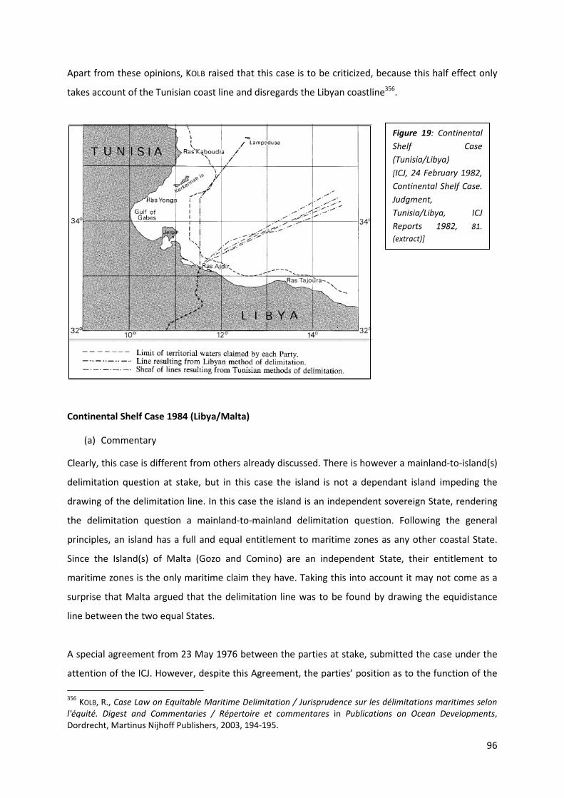
96
Apart from these opinions, KOLB raised that this case is to be criticized, because this half effect only
takes account of the Tunisian coast line and disregards the Libyan coastline356.
Continental Shelf Case 1984 (Libya/Malta)
(a) Commentary
Clearly, this case is different from others already discussed. There is however a mainland-to-island(s)
delimitation question at stake, but in this case the island is not a dependant island impeding the
drawing of the delimitation line. In this case the island is an independent sovereign State, rendering
the delimitation question a mainland-to-mainland delimitation question. Following the general
principles, an island has a full and equal entitlement to maritime zones as any other coastal State.
Since the Island(s) of Malta (Gozo and Comino) are an independent State, their entitlement to
maritime zones is the only maritime claim they have. Taking this into account it may not come as a
surprise that Malta argued that the delimitation line was to be found by drawing the equidistance
line between the two equal States.
A special agreement from 23 May 1976 between the parties at stake, submitted the case under the
attention of the ICJ. However, despite this Agreement, the parties’ position as to the function of the
356
KOLB, R., Case Law on Equitable Maritime Delimitation / Jurisprudence sur les délimitations maritimes selon
l'équité. Digest and Commentaries / Répertoire et commentares in Publications on Ocean Developments, Dordrecht, Martinus Nijhoff Publishers, 2003, 194-195.
Figure 19: Continental
Shelf Case
(Tunisia/Libya)
[ICJ, 24 February 1982,
Continental Shelf Case.
Judgment,
Tunisia/Libya, ICJ
Reports 1982, 81.
(extract)]

97
Court differed: Malta wanted the Court to actually draw the delimitation line, whereas Libya wanted
it merely to stipulate and clarify the applicable international law. In response, the Court noted that it
was “to name the method it found to be appropriate and that the Agreement would not be a bar to
the Court indicating an approximate line which could be illustrated on a map”357.
However important this judgment may be for continental shelf delimitation purposes, the interest in
this paragraph is mainly focused on the delimitation line with respect to the fact that Malta is an
Island State. Thus, the Court had to delimit the continental shelf between a mainland and an island
State. The question thus emerged whether the Court found them to be sovereign States, forcing the
equidistance line not to be influenced, or whether the Court found the divergence in coastline (8:1
ratio358) to be relevant for adjusting the equidistance line.
After drawing its provisional (equidistance) line, the Court “found that that line requires to be
adjusted in view of the relevant circumstances of the area, namely the considerable disparity between
the lengths of the coasts of the Parties here under consideration, the distance between those coasts,
the placing of the base points governing any equidistance line, and the general geographical context”
and that this adjusted line “gives a result which seems to the Court to meet the requirements of the
test of proportionality, and more generally to be equitable, taking into account all relevant
circumstances”359. This line was adjusted northwards360.
Fulfilling this proportionality requirement would mean that the lengths of the coastlines and their
ratio is be taken into account361. In this case the Court found the difference to be “so great as to
justify the adjustment of the median line so as to attribute a larger shelf area to Libya” (par. 68). In
this respect, YOSHIFUMI362 contested: “Why should a median line be modified because of the
disproportion between the length of two coasts?”. He posed that this might on the one hand lead to
no CS for the state with the smallest coastline. On the other hand, he noted that “the difference of
coastal lengths was already reflected in the surfaces of the two zones separated by the median line.
357
NORCHI, C.H., “Malta, Maine and beyond. Trends in the theory and practice of maritime boundary delimitation.” in MARTÍNEZ GUTIÉRREZ, N.A., Serving the Rule of International Maritime Law. Essays in Honour of
Professor David Joseph Attard, Oxon, Routledge, 2010, 84, referring to ICJ, 3 June 1985, Continental Shelf Case.
Judgment, Libya /Malta, ICJ Reports 1985, 24, par. 19. 358
The relevant coastal lengths are 192 miles for Libya and 24 miles for Malta. 359
ICJ, 3 June 1985, Continental Shelf Case. Judgment, Libya /Malta, ICJ Reports 1985, 56, par. 78. 360
The adjustment was some 18 miles towards Malta, CARLETON, C., “Maritime delimitation in complex island situations: a case study on the Caribbean Sea” in R. LAGONI. and D. VIGNES, Maritime Delimitation in Publications
on Ocean Developments, Dordrecht, Martinus Nijhoff Publishers, 2006, 161. 361
YOSHIFUMI, T., “Reflections on the Concept of proportionality in the Law of Maritime Delimitation”, 16 IJMCL 2001, 433-434. 362
YOSHIFUMI, T., “Reflections on the Concept of proportionality in the Law of Maritime Delimitation”, 16 IJMCL 2001, 441-443.

98
In fact, the northern part of the area delimited by the median line was considerably smaller than the
southern part because of the much shorter coasts of Malta and the much longer coast of Libya”363.
His vision was based on the “trapezium” view. He concluded by stating that “accordingly, it would
appear that there was no reason to give an additional area to Libya because its coastlines were
longer than Malta’s”.
NORCHI stated that the Court based this adjustment on “well-established equitable principles”: “(1)
there is not to be a refashioning of geography or a compensation for the inequalities of nature; (2) A
coastal State enjoys sovereign rights over its adjacent continental shelf and another party cannot
encroach upon the shelf of another; (3) respect must be paid to all relevant circumstances; (4) all
States are entitled to equal treatment, but this does not mean that inequality of nature can be
altered; (5) there can be no question of distributive justice”364. After evaluating the Gulf of Maine
Case and the Libya/Malta Case, ANTUNES365 proclaimed some delimitation trends, which are generally
the same as the ones set out above.
Thus, even though all States, including little Island States, are equal vis-à-vis maritime entitlement,
equity prevents them from being treated equally in factually delimiting the area concerned. Given
the set out principles, we still find this judgment to render some States more equal than others for
delimitation purposes. The final conclusion to be drawn in Island State-to-mainland delimitation can
be found in the words of ANTUNES366: “equity will not necessarily imply equality”.
363
On this vision, YOSHIFUMI refers to the dissenting opinion of Judge MOSLER, 121. 364
These principles are described in ICJ, 3 June 1985, Continental Shelf Case. Judgment, Libya /Malta, ICJ
Reports 1985, 39-40, par. 46 and neatly summarized in NORCHI, C.H., “Malta, Maine and beyond. Trends in the theory and practice of maritime boundary delimitation.” in MARTÍNEZ GUTIÉRREZ, N.A., Serving the Rule of
International Maritime Law. Essays in Honour of Professor David Joseph Attard, Oxon, Routledge, 2010, 86-87. 365
ANTUNES, N, Towards the Conceptualisation of Maritime Delimitation in Publications on Ocean Development,
Leiden, Martinus Nijhoff Publishers, 2003, 419. 366
ANTUNES, N, Towards the Conceptualisation of Maritime Delimitation in Publications on Ocean Development,
Leiden, Martinus Nijhoff Publishers, 2003, 425.

99
Gulf of Maine Case 1984 (Canada/United States of America)
(a) The issue of the Machias Seal Island and the Court’s decision
Without a doubt, the Gulf of Maine Case is, and will always be linked with the single boundary
delimitation line, for which it has become one of the most known cases of the ICJ. However, in this
section, it has another relevance: the delimitation line had to consider the Machias Seal Island. This
island, together with North Rock, has been the issue of dispute between Canada and the USA. Both
claim(ed) to have sovereignty over the island367. The parties, however, wanted to resolve this issue
in a bilateral way. “Canada and the United States agreed to exclude the question of the sovereignty
over and the sea area adjacent to Machias Seal Island and North Rock from the Gulf of Maine Case,
so this issue remains unsettled”368. Nevertheless, the ICJ had to draw the delimitation line. The Court
“considered that it could not discount Seal Island by reason both of its dimensions and, more
particularly, of its geographical position, as well as the fact that it is inhabited all the year round. It
367 MCDORMAN, T.L., “Canada-United States Cooperative Approaches to shared Marine Fishery Resources:
Territorial subversion?”, http://students.law.umich.edu/mjil/article-pdfs/v30n3-McDorman2.pdf (last visited on March 31, 2011), 685, following MC DORMAN, Salt Water Neighbors: International Ocean Law Relations Between the United States and Canada (2009). 368
MCDORMAN, T.L., “Canada-United States Cooperative Approaches to shared Marine Fishery Resources: Territorial subversion?”, http://students.law.umich.edu/mjil/article-pdfs/v30n3-McDorman2.pdf (last visited on March 31, 2011), 685.
Figure 20: Map showing the adjusted
median line in the Libya/Malta Case.
[http://www.sovereigngeographic.com/mari
time_pdf/1985-lib-mal-map.pdf]

100
was therefore given half-effect”369. However, the Court immediately thereinafter provided that
“[s]ince it is only a question of adjusting the proportion by reference to which the corrected median
line is to be located, the result of the effect to be given to the island is a small transverse
displacement of that line, not an angular displacement; and its practical impact therefore is
limited”370.
(b) Commentary
It is somewhat remarkable that the ICJ was not allowed to determine the sovereignty over the island.
Therefore, the latter remained unresolved. There is now a bilateral working group in place to resolve
the latter since 2002371. It is even more remarkable that the ICJ, without determining sovereignty,
granted the island a half effect. On what grounds did the Court base this effect, since it was unable to
regard the mainland-island interrelation and the islands position towards the opposite State? We
believe that an enclave solution would have been a better solution. Since the Court -still- does not
know who the sovereign State is, but had to determine an effect, it could just enclave it towards both
States so as not to make it extremely difficult. After determining the sovereignty issue, this enclave
could have been opened on the mainland side so as to connect the mainland’s waters. However, the
Court gave it half effect. It is a good thing that the Court did not give it a full effect. Granting it such
an effect would obviously have impeded the sovereignty dispute even more, because then it would
not be likely for either of the States to cede the island. Granting a no effect could have reduced the
States interest in the island, which could have postponed the sovereignty determination for a long
time.
Case concerning Maritime Delimitation in the Area between Greenland and Jan Mayen 1993
(Denmark/Norway)
(a) Decision of the Court
On August 16, 1988, Denmark filed an application before the ICJ, requesting the Court to “draw a
single line of delimitation of the fishing zone and continental shelf area of Greenland in the waters
between Greenland and Jan Mayen”372. Obviously Denmark found this line to be at a distance of 200
369
DEGHANI, R., “Continental Shelf Delimitation in the Persian Gulf”, The United Nations-Nippon Foundation Fellowship Programme, New York, 2008-2009, 76. 370
ICJ, 12 October 1984, Delimitation of the Maritime Boundary in the Gulf of Maine Area. Judgment, Canada/United States of America, ICJ Reports 1984, 337, par. 222. 371
NORCHI, C.H., “Introduction: Twenty-five years of the Gulf of Maine Judgment”, 15 Ocean and Coastal L.J. 2010, 182. 372
ICJ, 14 June 1993, Maritime Delimitation Case in the Area between Greenland and Jan Mayen. Judgment, Denmark/Norway, I.C.J. Reports 1993, 42.

101
Nm from the Greenlandic baseline373. This would leave a maritime area of 50 Nm to the Norwegian
Island of Jan Mayen. Norway, on the other hand, argued that equidistance is to be used and argued
that the Courts task merely existed in declaring “the basis of delimitation, leaving it to the parties to
negotiate the precise line of delimitation” and that there were two, although coincided, still
conceptually distant, zones to be delimited374. The Court followed the Norwegian statement and
found a single delimitation line to be applicable, only if the parties agree on the use of it375.
The Court adjusted the equidistance line in favor of Greenland, but did not allocate it a full 200 Nm
limit. The underlying thought was that “a delimitation that would give one State its full entitlement
and leave only the remainder for the other was found to be inappropriate when the coastlines of both
front on the area”376. The delimitation line between Greenland and Jan Mayen was drawn by the
Court as the lines dividing the several sectors (see map). This line (AONM) is found to be somewhere
between the Greenlandic claim (on the east) and the median line (on the west). Neither of both
islands is granted with a full effect, not even Greenland which is in a 9 to 1 ratio. By virtue of that,
none of the islands is ignored using a no effect rule. For that reason, this delimitation line is found to
be giving a partial effect.
373
This was probably based on the Delimitation Agreement between Jan Mayen and Iceland, where Jan Mayen’s entitlement was recognized, without, however, restricting the Icelandic claims. Iceland got a full 200 Nm zone, while Jan Mayen got a reduced effect , Additional Protocol to the Agreement of 28 May 1980 between Iceland and Norway concerning Fishery and continental shelf questions and the Agreement derived there from of 22 October 1981 on the continental shelf between Jan Mayen and Iceland, 11 November 1997, 43 LOS Bull., 2000, 109. 374
CHURCHILL, R.R., “The Greenland-Jan Mayen Case and its Significance for the International Law of Maritime Boundary Delimitation”, 9 IJMCL 1994, 6-7. 375
CHARNEY, J.I., “International Maritime Boundary Delimitation—Geneva Convention on the Continental Shelf—Equidistant Line—Special Circumstances. Maritime Delimitation in the Area Between Greenland and Jan Mayen (Den. v. Nor.) 1993 ICJ Rep. 38 International Court of Justice, June 14, 1993.”, 88 AJIL 1994, 108. 376
CHARNEY, J.I., “International Maritime Boundary Delimitation—Geneva Convention on the Continental Shelf—Equidistant Line—Special Circumstances. Maritime Delimitation in the Area Between Greenland and Jan Mayen (Den. v. Nor.) 1993 ICJ Rep. 38 International Court of Justice, June 14, 1993.”, 88 AJIL 1994, 108-109.

102
(b) Commentary
Without a doubt, this case is nothing like all the others (already treated and yet to come) concerning
the partial effect. Whereas the other cases were dealing with little islands impeding the delimitation
line between two sovereign States, this case is –theoretically- one between two dependant islands
from separate sovereign States. Moreover, the islands are both distant from the metropolitan
mainland, rendering the delimitation question one between two islands. Given the specific features,
the issue can, however, not just be narrowed to one between islands; Greenland is the largest island
in the world377 and has a permanent population (although only 6 % of the +/- 55.000 headed
population lives in the east of Greenland378), whereas Jan Mayen is a desolate little island without
permanent habitation379. Clearly, the outcome of this case is of extreme importance in international
maritime boundary delimitation.
Since this is not a mainland-to-island-delimitation question, the latter required a different approach
in evaluating the effect of islands in maritime boundary delimitation. Whereas, in previous cases,
islands were looked upon as special or relevant circumstances, this thought could not be upheld in
377
Provided that Australia is to be seen as a continent, rather than an island. 378
CHURCHILL, R.R., “The Greenland-Jan Mayen Case and its Significance for the International Law of Maritime Boundary Delimitation”, 9 IJMCL 1994, 2. 379
Apart from some scientific researchers: “about 25 people (…) live temporarily on the island (…)” in CHURCHILL, R.R., “The Greenland-Jan Mayen Case and its Significance for the International Law of Maritime Boundary Delimitation”, 9 IJMCL 1994, 2.
Figure 21: Delimitation line between
Greenland and Jan Mayen (AONM),
drawn by the ICJ.
[ICJ, 14 June 1993, Maritime Delimitation
Case in the Area between Greenland and Jan
Mayen. Judgment, Denmark/Norway, ICJ
Reports 1993, 80.]

103
the present case, for it is an island-to-island-delimitation question. Yet, the main principles remain,
after drawing the provisional equidistance line, there are still circumstances allowing, even obliging,
the equidistant line to be adjusted. Here, the relevant circumstances at stake are the lengths of the
respective coastlines (a 9:1 ratio380), the fishing resources, the presence of ice, security factors and
the conduct of the parties381. The Court expressly rejected population and other socio-economic
factors382. Taken all the previous into account, this is rather a case of evaluating the effect of small
islands vis-à-vis large islands.
When placing the judgment next to other judgments and assessing the merits thereof, one can
clearly find a lot of similarities with the Libya/Malta Case. Even though the present case played
between two dependant islands and the Libya/ Malta Case was one between two independent
States, the virtual outcome was the same. Based on the charts, unequivocally, the result was the
same: the provisional equidistance line was adjusted towards the smallest of the features, without,
however, granting the largest one a full effect. In both cases, the decisive reason for this adjustment
was the divergence in the respective coastal lengths, following the proportionality requirement.
CARLETON383, on the other hand, stated that “this adjustment was not uniform as it was in the
Malta/Libya case”. It may not use the same numeric adjustment ratio, but the outcome remains an
adjusted median line. Assessed on their merits, from a practical point of view, both cases presented
an equitable result by adjusting the equidistance line. SHI384 described it as follows: “the Court has
considered the equitableness of a provisional equidistance line by comparing the ratio between the
lengths of each Party’s coast and the maritime areas allocated to that Party by the provisional line.
Where one Party has a significantly longer coastline than the other, but the maritime area allocated
by the provisional line does not reflect the disparity in coastal lengths, the Court has, without
requiring precise mathematical proportionality, modified the provisional line in order to achieve a
more equitable ratio”. YOSHIFUMI385 reminded of the criticism in the Libya/Malta Case concerning this
proportionality. The applicability of proportionality to delimitations between States with opposite
380
The relevant coasts are the Greenlandic 504 km and the Jan Mayen 55 km. 381
CHURCHILL, R.R., “The Greenland-Jan Mayen Case and its Significance for the International Law of Maritime Boundary Delimitation”, 9 IJMCL 1994, 8. 382
ICJ, 14 June 1993, Maritime Delimitation Case in the Area between Greenland and Jan Mayen. Judgment, Denmark/Norway, I.C.J. Reports 1993, 74, par. 80. 383
CARLETON, C., “Maritime delimitation in complex island situations: a case study on the Caribbean Sea” in R. LAGONI. and D. VIGNES, Maritime Delimitation in Publications on Ocean Developments, Dordrecht, Martinus Nijhoff Publishers, 2006, 163. 384
SHI, J., “The Wang Tieya Lecture in Public International Law: Maritime Delimitation in the Jurisprudence of the International Court of Justice”, 9 Ch. J. Int’l L. 2010, 286, par. 58. 385
YOSHIFUMI, T., “Reflections on the Concept of proportionality in the Law of Maritime Delimitation”, 16 IJMCL 2001, 447.

104
coasts remains questionable386. From a human perspective, the outcomes are to be called equitable.
One could easily understand and agree to an adjustment based on their characteristics (Libya
towards Malta, Greenland towards Jan Mayen). Perhaps, one might even argue a greater share to
resp. Libya or Greenland. In this respect, one can argue that it is obvious that (dependant) islands are
treated in a total equal manner as States, in their interrelationship. The outcome in both cases was
the same, thus islands are treated equal.
Nevertheless contradictory, from a legal point of view, these cases are a breach of international
principles and bring along a divergence on the basis of types of islands. From the Libya/Malta Case
we can conclude that there is no such thing as equal treatment between continental mainland and
islands. Malta was an island and there was no equal division between the littoral states. From the
Greenland/Jan Mayen Case, we can also conclude that there is even no such thing as equal division
between islands. The greater island (Greenland) has received more than the small island. Thus, there
is a distinction made in delimitation claims, between mainland and islands en between islands on the
basis of surface. Didn’t customary law provide that all coastal territories are equal? Is it equitable to
find different treatments to different types of coastal territory? Should these cases not be resolved
with a strict equidistance line? No, not at all, that would assign the whole equitable result-relevant
circumstances theory to the garbage bin. The configurations of the respective situations are an exact
representation (they take it to the extreme and that is what constitutes their importance) of what
the equitable delimitation wanted to achieve. For a strict use of the equidistant line would be
creative of inequity itself, the respective configurations allow the line to be adjusted on the basis of
fairness. The fact that this invokes different treatment of different coastal territories is inherent to
the aim of the equitable result. Moreover, granting totally equal shares to eg. Greenland and Jan
Mayen would clearly be a refashioning of geography, for the restricted possibilities of Jan Mayen
would be placed on an equal ground as the massive Greenland. After all, it is as ANTUNES described it,
“equity will not necessarily imply equality”.
Award of the Arbitral Tribunal-Maritime Delimitation (Eritrea/Yemen) 1998-1999
(a) Decision of the Tribunal
One of the areas to be delimited in this case was the one of the central sector, massively impeded by
the presence of several islands, rocks, islets, …. The Tribunal’s first task was to decide upon the
question of sovereignty over the respective insular features, the outcome of which was to declare
386
Judge ODA, Separate Opinion, 115, par. 92; Judge SCHWEBEL, Separate Opinion, 125 in ICJ, 14 June 1993, Maritime Delimitation Case in the Area between Greenland and Jan Mayen. Judgment, Denmark/Norway, ICJ
Reports 1993; citation from YOSHIFUMI T., “Reflections on the Concept of proportionality in the Law of Maritime Delimitation”, 16 IJMCL 2001, 447.

105
Yemeni sovereignty over the Zuqar-Hanish group of Islands387 and Eritrean sovereignty over the
Mohabbakah Islands, High Island388, the Haycock Islands and Southwest Rocks389. In the same
paragraph of the Award, the Tribunal recognized both groups’ potential to claim territorial waters of
their own, however, immediately thereinafter, noticed that this allocation generated overlapping
territorial sea claims over the interstate water area. Thus, what the Tribunal had to do, was to
determine the effect of both sides’ island groups in an equal way, taking into account that there was
little to be divided. The Tribunal found the area to be delimited by using a median line boundary,
without however, expressly declaring an effect to any of the island groups (par. 158).
(b) Commentary
It is rather difficult to make an exact evaluation of the Tribunal’s outcome that would fit the
proposed framework of this outset because the Tribunal did not expressly mention the value it has
given to the respective island groups. Thus, we have to base ourselves on the wording of the Award
together with the provided charts. By doing so, we can only conclude that the Tribunal granted them
a partial effect. It is quite obvious that the median line did not ignore the presence of the Zuqar-
Hanish group (the isolated northern group), nor the presence of the Mohabbakah Islands, High
Island, the Haycock Islands and Southwest Rocks. Neither did it provide them with a full effect, for
that would not even be possible. However, one might argue that the islands at stake should have
387
For the Zubayr Group, see page 72. 388
This Island was not mentioned at the Hague Justice Portal, but it is listed with the others under Eritrean Sovereignty in PCA, 17 December 1999, PCA, Second Stage of the Proceedings between Eritrea and Yemen
(Maritime Delimitation), Eritrea/Yemen, UNRIAA, Vol. XXII, par. 154. 389
Eritrea/Yemen Arbitration, 9 October 1998, http://www.haguejusticeportal.net/eCache/DEF/6/153.html.
Figure 22: map
showing the median
line in the
Eritrea/Yemen Award
[PCA, the International
Maritime Boundary Line
– Chart 3,
http://www.pca-
cpa.org/upload/files/cha
rt3.gif]

106
been enclaved. We, however, agree with the vision set out in the Award390 and reaffirmed by KOLB391.
Enclaving the island groups or some of them would invoke distorting effects. The boundary line to be
drawn would be consistent of bulges which would interfere with the principle of non-encroachment
because of the small water area between them. Moreover, KOLB argued that this would clearly give
rise to security issues, for the enclaves would interfere with the navigational routes, bordered by
reefs.
3.2.2.3. Enclave solution
Another remedy for abating the inequity is the so called enclave solution. The enclave remedy can
either be a full enclave solution or a semi-enclave solution.
In case the full enclave solution is applied, an island or an island group will then be provided with a
[territorial sea]392 of its own, forming an enclave within the others State’s maritime zone, “where the
maritime belt accord to the island is wholly separated from the offshore zone of the mainland coast of
the State to which the island belongs”393.
The semi-enclave solution is mostly applied when islands are located near the equidistance line. This
remedy installs a corridor, connecting the enclave and the mainland’s maritime zone.
390
PCA, 17 December 1999, Second Stage of the Proceedings between Eritrea and Yemen (Maritime
Delimitation), Eritrea/Yemen, UNRIAA, Vol. XXII, par. 1157-158. 391
KOLB, R., Case Law on Equitable Maritime Delimitation / Jurisprudence sur les délimitations maritimes selon
l'équité. Digest and Commentaries / Répertoire et commentares in Publications on Ocean Developments, Dordrecht, Martinus Nijhoff Publishers, 2003, 519. 392
Other maritime areas can be inherent to the enclave situation as well. 393 DEGHANI, R., Continental Shelf Delimitation in the Persian Gulf, The United Nations – Nippon Foundation
Fellowship Programme, New York, 2008-2009, http://www.un.org/Depts/los/nippon/unnff_programme_home/fellows_pages/fellows_papers/dehghani_0809_iran.pdf.

107
The use of the enclave solution, however, should not be deemed applicable at all times. According to
ATTARD394, in the aftermath of the Case of St. Pierre et Miquelon, the use of enclaves should be
restricted to cases of narrow waters.
Agreements have been concluded in State practice for the enclave solution as well as the semi-
enclave solution. An example for the enclave solution is the Australia-Papua New Guinea Agreement
(1987)395, and for the semi-enclave solution, the Iran-Saudi Arabia Agreement396. In this last
Agreement, the State parties agreed to draw a preliminary equidistant line, which was then “bulged”
by the balancing semi-enclave solutions397.
The Anglo-French Arbitration 1977
(a) Decision of the Tribunal
For the interstate maritime delimitation between the U.K. and France, the Arbitration Tribunal was
to find a solution for the Channel Islands (Guernsey, Sark, Herm, Alderney and Jersey) closely linked
394
ATTARD, D., The Exclusive Economic Zone in International Law, New York, Oxford University Press, 1987, 262. 395
Treaty between Australia and the Independent State of Papua New Guinea Concerning Sovereignty and Maritime Boundaries in the Area between the Two Countries, Including the Area Known as Torres Strait, And Related Matters, 18 December 1978, 18 ILM 1979, 291. 396
Semi-enclave solution for the Iranian Island of Farsi and the Saudi Arabian Island of Al’Arabia: Agreement concerning the sovereignty over the Islands of Al-‘Arabiyah and Farsi and the delimitation of the boundary line separating the submarine areas between the Kingdom of Saudi Arabia and Iran, Teheran, 24 October 1968, U.N.T.S., vol. 696, I-9976; Limits in the Seas, No. 24. 397
BOWETT, D., “Islands, Rocks, Reefs and Low-Tide Elevations in Maritime Boundary Delimitation” in CHARNEY, J.I. and ALEXANDER, L.M., International Maritime Boundaries vol. 1, Dordrecht, Nijhoff Publishers, 1993, 142-143.
Figure 23: Simplified drawing of
the enclave solution for islands
belonging to State B in State A’s
EEZ or CS (drawing A) and the
semi-enclave solution for islands
belonging to State B, forming a
connecting corridor between the
TS of the islands and the EEZ or CS
of mainland B (drawing B).
[drawing made by the author]

108
to the French coastline and by virtue of their location impeding the delimitation issue. Consequently,
drawing a median line so as to provide equal shares of interstate waters was not an option when
taking account of the islands398. “The presence of the Channel Islands on the French side of the
median line disturbs the balance of geographical circumstances which would otherwise exist (…)”399.
Given its character as special circumstances, the Arbitration Tribunal could not deny them effect. In
its search for the most equitable solution for the latter, the Court accorded the Channel Islands400 a
12 Nm continental shelf401. This solution unequivocally generated a British enclave within French
Channel Waters.
(b) Commentary
Clearly, using a median line between France and the Channel Islands was not the most appropriate
solution. Ignoring the islands would have been inequitable. Thus, the Tribunal had to make use of
398
The islands were found to be ‘special circumstances’ in the delimitation. 399
OUDE ELFERINK, A.G., The Law of Maritime Boundary Delimitation. A Case Study of the Russian Federation. in Publications on Ocean Developments, Dordrecht, Martinus Nijhoff Publishers, 1994, 59. 400
Not a 12 Nm CS for each island, but a CS as an archipelago, surrounding the totality of the features. 401
Award of the Arbitration Tribunal, 30 June 1977/ 14 March 1978, Delimitation of the Continental Shelf between the United Kingdom of Great Britain and Northern Ireland, and the French Republic (UK, France), UNRIAA, Vol. XVIII, 94-95, par. 201-202. By virtue, this treatment is creative of an inequity in regard of the U.K., for BROWN stated that “circumstances which would constitute ‘special circumstances’ (…), would also constitute
‘factors creative of inequity’ under international customary law”, BROWN, E.D., The International Law of the Sea.
Volume 1. Introductory Manual, Aldershot, Dartmouth, 1994, 173.
Figure 24: Map showing the British Channel Islands Enclave Solution
[ILR, Vol. 54 (1979), 123.]

109
them. Granting them a full effect would have been totally disproportionate. Even a half effect rule
would have rendered the delimitation line inequitable. Therefore, enclaving them was the only valid
solution. Taking account of their location closer to the French mainland than to the median line, this
is a full enclave within French continental shelf. The British Channel Islands Enclave is the classical
example for the enclave solution in maritime delimitation law402.
French Canadian Arbitration 1992 (Islands of Saint Pierre et Miquelon)
(a) Decision of the Tribunal
The French Islands of Saint Pierre and Miquelon are situated at a distance of 12 Nm from the
southern Canadian coastline of Newfoundland403. Clearly, this distant location from the mainland and
its close vicinity to another State’s coastline, made it even more difficult for the Arbitration Tribunal
to easily settle the latter. It must be noticed that the true interest of the parties contained the fishing
rights in the area and the exploitation possibilities (of gas and oil resources) in this continental shelf
area, for which the littoral States had concluded many treaties and (interim) agreements over many
years, trying to settle the disputed interests404. Finally, both States agreed on bringing the issue
before an Arbitration Tribunal. Both parties agreed on asking the Tribunal to “establish a single
delimitation for all maritime zones” to be “in accordance with the principles and rules of international
law applicable in the matter”405, which “is binding” upon the parties406. Whereas France believed that
the delimitation should have taken place on the grounds of equidistance between the equal parties
at stake, Canada contested that the islands were only entitled to a 12 Nm zone407. They were thus to
be allotted with an enclave solution, for there is a massive difference in coastal lengths. In its Award,
402
JAYEWARDENE, H.W., The Regime of Islands in International Law in Publications on Ocean Developments, Dordrecht, Martinus Nijhoff Publishers, 1990, 360. 403
MCDORMAN, T.L., “The Canada-France Maritime Boundary Case: Drawing A Line Around St. Pierre and Miquelon”, 84 AJIL 1990, 158. 404
For a review, see MCDORMAN, T.L., “The Canada-France Maritime Boundary Case: Drawing A Line Around St. Pierre and Miquelon”, 84 AJIL 1990, 157-165. 405 Décision du Tribunal Arbitral, 10 Juin 1992, Affaire de la délimitation des espaces maritimes entre le Canada
et la République française, UNRIAA, Vol. XXI: "Aux principes et règles du droit international applicables en la
matière": 271, Article 2.1; "Delimitation unique": 282-283, par. 36-42. 406
MCDORMAN, T.L., “The Canada-France Maritime Boundary Case: Drawing A Line Around St. Pierre and Miquelon”, 84 AJIL 1990, 166-169. 407
SIDDON, T., Remarks, [1987] 3 Can. Parl. Deb, H.C., 33d Parl., 2nd
Sess. 2808-09. (Siddon was the Canadian Minister of Fisheries and Oceans).
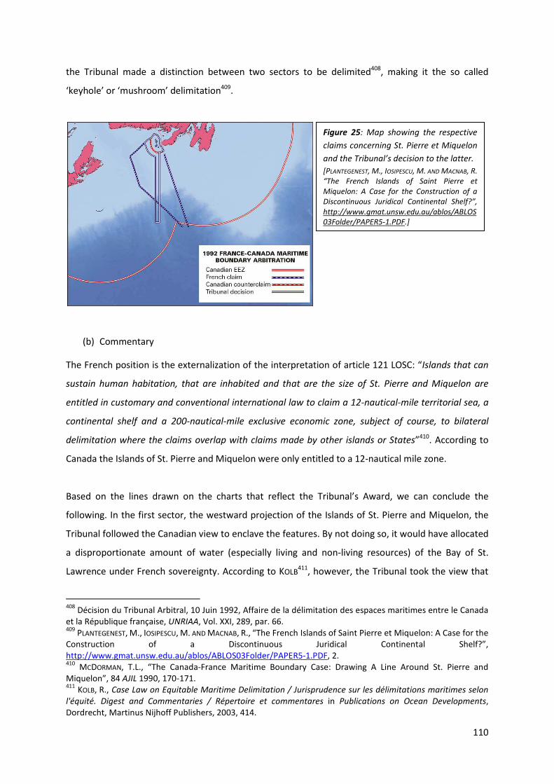
110
the Tribunal made a distinction between two sectors to be delimited408, making it the so called
‘keyhole’ or ‘mushroom’ delimitation409.
(b) Commentary
The French position is the externalization of the interpretation of article 121 LOSC: “Islands that can
sustain human habitation, that are inhabited and that are the size of St. Pierre and Miquelon are
entitled in customary and conventional international law to claim a 12-nautical-mile territorial sea, a
continental shelf and a 200-nautical-mile exclusive economic zone, subject of course, to bilateral
delimitation where the claims overlap with claims made by other islands or States”410. According to
Canada the Islands of St. Pierre and Miquelon were only entitled to a 12-nautical mile zone.
Based on the lines drawn on the charts that reflect the Tribunal’s Award, we can conclude the
following. In the first sector, the westward projection of the Islands of St. Pierre and Miquelon, the
Tribunal followed the Canadian view to enclave the features. By not doing so, it would have allocated
a disproportionate amount of water (especially living and non-living resources) of the Bay of St.
Lawrence under French sovereignty. According to KOLB411, however, the Tribunal took the view that
408
Décision du Tribunal Arbitral, 10 Juin 1992, Affaire de la délimitation des espaces maritimes entre le Canada et la République française, UNRIAA, Vol. XXI, 289, par. 66. 409
PLANTEGENEST, M., IOSIPESCU, M. AND MACNAB, R., “The French Islands of Saint Pierre et Miquelon: A Case for the Construction of a Discontinuous Juridical Continental Shelf?”, http://www.gmat.unsw.edu.au/ablos/ABLOS03Folder/PAPER5-1.PDF, 2. 410
MCDORMAN, T.L., “The Canada-France Maritime Boundary Case: Drawing A Line Around St. Pierre and Miquelon”, 84 AJIL 1990, 170-171. 411
KOLB, R., Case Law on Equitable Maritime Delimitation / Jurisprudence sur les délimitations maritimes selon
l'équité. Digest and Commentaries / Répertoire et commentares in Publications on Ocean Developments, Dordrecht, Martinus Nijhoff Publishers, 2003, 414.
Figure 25: Map showing the respective
claims concerning St. Pierre et Miquelon
and the Tribunal’s decision to the latter.
[PLANTEGENEST, M., IOSIPESCU, M. AND MACNAB, R.
“The French Islands of Saint Pierre et
Miquelon: A Case for the Construction of a
Discontinuous Juridical Continental Shelf?”,
http://www.gmat.unsw.edu.au/ablos/ABLOS
03Folder/PAPER5-1.PDF.]

111
the westward projection of St. Pierre and Miquelon encroached upon Newfoundland’s southern
projection. By virtue of this, KOLB believed that the Tribunal failed to adopt a neutral perspective,
because it treated one projection as dominant and thus applied an unequal conception of equity. For
the second sector, the southern projection of the Islands, it could have theoretically had a full 200
Nm zone, without obstructing Canadian coastline. In this sector, the Tribunal rather followed French
arguments of equidistance, in willing to grant them both a portion of EEZ and CS. The Tribunal,
however, provided a somewhat strange solution. Instead of using the common radial projection, the
Tribunal chose to make use of an axial projection, which must be limited to the width of the coasts of
St. Pierre and Miquelon412. We found this to be a very strange solution. According to KOLB (P.416)
there are obvious reasons to doubt the wisdom of this solution: “it was not a very practical one,
either for the purposes of economic exploitation or from the perspective of policing the zone”.
Territorial and Maritime Caribbean Sea Dispute 2007 (Nicaragua/Honduras)
(a) Decision of the Court
There have been disputes in interstate maritime delimitation between the littoral States for several
decades, leading Nicaragua to file an application before the ICJ (1999), requesting the course of the
(single) maritime boundary line. The Court was also to bring clarity on the issue of the disputed
islands between them. It was first to determine which was the sovereign State to this features, for
both had claimed sovereignty over Savanna Cay, Port Royal Cay, Bobbel Cay and South Cay. The
Court concluded, after an extensive review, that the features were under the sovereignty of
Honduras413. There was no dispute concerning Edinburgh Cay, which was accepted to be Nicaraguan.
The Court was then to delimit the interstate maritime boundary, taking account of the islands. After
applying the angle bisector method, it found the Honduras’ Cay’s to be on the Nicaraguan side of the
delimitation line. Because of their vicinity to the bisector line, the Court applied the semi-enclave
solution to the latter. The islands were granted a 12 Nm TS, running from the angle bisector line,
around the Cay’s and running to the line delimiting the Honduras’ Cay’s and the Nicaraguan
Edinburgh Cay.
412
KOLB, R., Case Law on Equitable Maritime Delimitation / Jurisprudence sur les délimitations maritimes selon
l'équité. Digest and Commentaries / Répertoire et commentares in Publications on Ocean Developments, Dordrecht, Martinus Nijhoff Publishers, 2003, 415. 413 ICJ, 8 October 2007, Case concerning Territorial and Maritime Dispute between Nicaragua and Honduras in
the Caribbean Sea. Judgment, Nicaragua/Honduras, I.C.J. Reports 2007, 727, par. 227.

112
(b) Commentary
However, the real value of this judgment is not to be found in its solution. A semi-enclave solution is
a perfectly defendable solution whenever features are found to be on the wrong side of the
equidistance line. This already became clear in the previous (Arbitration) Case concerning the British
Channel Isles. A more important aspect of this judgment is the method applied to delimit the
interstate boundary. The semi-enclave solution is the consequence of the applied method. LATHROP414
highlighted the switch in the Court’s reasoning. Over two decades415, the Court, as well as Tribunals
used “the [three]-step416 equidistance process” in which they have “given full effect to the base points
414
LATHROP, C.G., “Territorial and Maritime Dispute Between Nicaragua and Honduras in the Caribbean Sea (Nicaragua v. Honduras). At http://www.icj-cij.org. International Court of Justice, October 8, 2007”, 102 AJIL 2008, 118-119. 415
Eg; Maritime Delimitation in the Area Between Greenland and Jan Mayen (1993), Maritime Delimitation and Territorial Questions Between Qatar and Bahrain (2001), Land and Maritime Boundary Between Cameroon and Nigeria (2002). 416
In his text, Lathrop speaks of a two-step method (set out in the paragraph). However, most authors refer to this delimitation method as a three-step method. Eg. McDorman (“The Canada-France Maritime Boundary Case: Drawing A Line Around St. Pierre and Miquelon”, 171.) described this three step method as (1) determination of the criteria and methods that satisfied equitable principles and location of a provisional line by using such a method; (2) adjustment of the line to take relevant circumstances into account; and (3) examination of the line to see if it met the test of equitableness. Although worthy to mention this difference, it must be noted that this divergence has no important consequences.
Figure 26: Map showing the Lines drawn, by the ICJ, around the several Cays’. Savanna Cay, Port Royal
Cay, Bobbel Cay and South Cay in the North, creative of the big circle. Edinburgh Cay in the South,
creating its own delimitation circle (left map). Map showing the Court’s final solution to install a semi-
enclave solution around the Honduras’ Cay’s (right map).
[ICJ, 8 October 2007, Case concerning Territorial and Maritime Dispute between Nicaragua and Honduras in the
Caribbean Sea. Judgment, Nicaragua/Honduras, I.C.J. Reports 2007, 753-754.]

113
on all features, regardless of size, in the first step of the analysis: the construction of the provisional
equidistance line. In the second step of the analysis, the effect of these features on the equidistance
line has then been discounted either partially or fully, if necessary, to achieve an equitable result”. In
this case, however, the Court made use of the angle bisector method417. LATHROP stated; “the
macrogeographic angle bisector method presumes a mainland-to-mainland delimitation. Here, the
chosen method led the Court to treat the offshore features as an afterthought, enclaving them after
the mainland-to-mainland boundary had been decided”.
We believe that, even if the Court had used the three-step method, the enclave solution is the most
logical one, given the coastal configurations, the land frontier line and the localities of the Cay’s. If
the Court was first to take full account of the islands –which it found to be under Honduras’
sovereignty- it would have had to draw the equidistance line between the Honduras Cay’s and
Edinburgh Cay. This would obviously create a massive inequity towards Nicaragua418. If the Court was
then to evaluate the Cay’s effect on this equidistance line, for achieving an equitable result, a full
effect would be a clear distortion of maritime boundary delimitation. Clearly, granting such an effect
would be not be an option. Even a half effect would still be disproportionate in the light of the
frontier configurations, making it rather doubtful that the Court would grant such an effect to the
Cay’s. This would have led the Court to redrawing its equidistance line, for purposes of equity,
granting no effect to the islands. But this solution would not be equity either, because islands
lawfully affect the interstate maritime boundary delimitation. And the circumstances are not of that
kind, to make it admissible to ignore the presence of this Cay’s. Therefore, we believe that the Court,
ultimately, if using the three-step method, would have chosen an enclave solution for the Cay’s.
3.3. LOW-TIDE ELEVATIONS IN INTERSTATE MARITIME BOUNDARY DELIMITATION
Because there is not so much scholar work to find about low-tide elevations, the following
examination is primarily based on a conjunction of what is already said about low-tide elevations and
logical deduction.
Throughout the examination on islands, it is made clear that granting a full effect to islands might be
creative of inequity. Therefore, remedies were installed to reduce this effect and provide certain
417
Eg. Continental Shelf (Tunisia/Libya) (1982), Delimitation of the Maritime Boundary in the Gulf of Maine Area (1984). 418
The effect this line would generate, would be similar to the coastal configuration in the North Sea Continental Shelf Cases (where Germany found it’s amount of waters under jurisdiction limited, due to the Dutch and Danish claims and their respective coastal configurations, creating a half circle-like situation). In the present Case, the Nicaraguan coastline and land frontier run North-East. Granting full effect to the Cay’s would create a line running South-East and by virtue of that eliminating the equitable portion of water to the Nicaragua benefit.

114
solutions to islands impeding delimitation questions. These principles of international law and State
practice depart from the equal rights that islands have vis-à-vis coastal mainland. Low-tide
elevations, on the other hand, do not possess the ability of being treated equally to islands, let alone
to mainland. They generate a completely different effect to the marine delimitation. A low-tide
elevation will therefore never be able to generate a full effect in the same extent as an island does. In
order to fully understand this, an assessment of the term “effect” for these purposes imposes itself.
This “effect”, generated by low-tide elevations, cannot be compared with the effect that islands
generate, being an adjustment of the equidistant line on the basis of generating their own maritime
zones. It is set out above, that the only effect generated by a low-tide elevation, is the one of
creating a bulge in the maritime zones of the mainland or island. In order to do so, it even has to be a
proximate low-tide elevation. If that is the only effect a low-tide elevation can generate, it is rather
clear that there is less to say about them, than there is about islands. For a low-tide elevation to
create this bulge, under the precondition that it is a proximate low-tide elevation, is has to be used
as a base point for the baseline, i.e. the low water line. Low-tide elevations can also generate an
extension of the marine zones by being applied as a straight baseline base point, subject to the
relevant provisions419. A full effect granted to a low-tide elevation is thus the use of it as a relevant
base point. A no effect would then be not using it as a base point. It is rather difficult to speak of a
half effect, for it is either used or not used as a base point.
3.3.1. ABATING INEQUITY?
These features are merely creating a bulge through incorporation into the mainland’s or island’s
baseline system, in consistency with the relevant provisions. Therefore, a full effect can hardly be
creative of inequity. If a LTE is located at a distance which would render it unusable for the baseline,
granting it an effect in such desolate circumstances would clearly be creative of inequity. But this
effect is reserved for islands in interstate delimitation, not for LTE. The full effect to a LTE would
therefore not be inequity. However, it could become inequity when this LTE is used as a base point in
overlapping territorial sea claims. Then this LTE is not to be used and thus ‘granted’ with a no effect.
Thus, in all cases were the interstate delimitation does not concern overlapping territorial sea claims,
it would not be inequitable to give it a “full effect”. Therefore, there is not really a need for abating
the inequity in case of LTE. Nevertheless, we will examine the LTE’s impact on delimitation questions
in the same way as we did for islands.
419
Article 4 (3) TSC and article 7 (4) LOSC.
115
3.3.1.1. No effect
Case concerning Maritime Delimitation and Territorial Questions 2001 (Qatar/Bahrain)
(a) Decision of the Court
As set out above, in this case the ICJ had to determine whether Qit’at Jaradah, located within the
territorial sea of both States, was an island (Bahraini vision) or a low-tide elevation (Qatari vision) and
under whose sovereignty it fell420. The Court found Qit’at Jaradah to be in line with the provision of
article 121 (1) LOSC and thus being an island. However it had, because of the disproportionate effect
that it would generate, no impact on the delimitation line421.
Between Qatar and Bahrain there were also other low-tide elevations situated in the area were the
territorial sea claims overlapped. For these were proximate low-tide elevations, theoretically, both
states were entitled to use their respective low-water line for measuring the breadth of the
territorial sea422. The Court, however, stated that “a State could not acquire sovereignty by
appropriation over a low-tide elevation situated within the limits of its territorial sea where the same
low-tide elevation was also situated within the territorial sea of another State” and then “concluded
that these low-tide elevations could not be used as part of the baseline”423.
There also was the presence of the Fasht ad Dabil feature. It was agreed upon by the parties that this
feature was a low-tide elevation424. The Court related this feature to the outcome of the Qit’at
Jaradah issue. The Court stated that, however the Qit-at Jaradah issue was to be resolved, the Fasht
ad Dibal LTE would fall within Qatari TS and thus under Qatari sovereignty. It therefore stated that
the boundary delimitation line runs between these two features placing Qit’at Jaradah on the
Bahraini side and Fasht ad Dibal on the Qatari side.
A last low-tide elevation was the Bahraini Fasht al Jarim. For this feature, the Court expressly stated
that “if given full effect, would distort the boundary and have disproportionate effects” (par. 247). “In
the view of the Court, such a distortion, due to a maritime feature located well out to sea and of
which at most a minute part is above water at high tide, would not lead to an equitable solution
which would be in accord with all other relevant factors referred to above. In the circumstances of the
420 LAUTERPACHT, E., GREENWOOD, C. and LEE, K., “QATAR v. BAHRAIN (MERITS)”, 139 ILR 2011, 1, 3 and 4. 421
LLANOS, H.I., “Low-Tide Elevations: Reassessing their impact on Maritime Delimitation”, 14 Pace Int’l L. Rev. 2002, 269. 422
SHI, J., “The Wang Tieya Lecture in Public International Law: Maritime Delimitation in the Jurisprudence of the International Court of Justice”, 9 Ch. J. Int’l L. 2010, 277, par. 19. 423
Citation from SHI J., “The Wang Tieya Lecture in Public International Law: Maritime Delimitation in the Jurisprudence of the International Court of Justice”, 9 Ch. J. Int’l L. 2010, 277, par. 21, based on ICJ, 16 March 2001, Case concerning Maritime Delimitation and Territorial Questions between Qatar and Bahrain, Merits,
Judgment, Qatar/Bahrain, ICJ Reports 2001, 101-103, par. 204-209. 424
ICJ, 16 March 2001, Case concerning Maritime Delimitation and Territorial Questions between Qatar and
Bahrain, Merits, Judgment, Qatar/Bahrain, ICJ Reports 2001, 100, par. 200.

116
case considerations of equity require that Fasht al Jarim should have no effect in determining the
boundary line in the northern sector” (par. 248).
(b) Commentary
Defined to be an island, the Qit’at Jaradah-issue brings no new elements in maritime delimitation
principles concerning low-tide elevations.
Neither did the Court bring along a value to the LTE principles in marine delimitation concerning
Fasht ad Dibal. It made the issue completely dependent on the Jaradah outcome, therefore it could
not be thought to have any effect on the boundary delimitation.
For Fasht al Jarim, the Court found it to be a distortion if taken into account. This is a logical solution,
given the distant location of it from the Bahraini mainland. It is too far out to be used in the baseline
system (be it the normal or the straight one), so taking it into account as a relevant circumstance for
adjusting the median line would have been totally disproportionate. Therefore, the Court correctly
denied it any effect.
Bangladesh v. India before the PCA
(a) Problems arising in the marine delimitation
Following years of discussions on the respective maritime zones between Bangladesh, India and
Myanmar, Bangladesh instituted arbitral proceedings against India on 8 October 2009425. One of the
problem areas between them is a disputed island near Hariabhanga River. Bangladesh claims it to be
its South Talpatty Island, whereas India contests it to be the Indian New Moor Island. Both States
base their claims on the ‘Thalweg’ or mid-channel formula, arguing that the river stream and thus the
navigable channel are located respective on the eastern or western side of the island, making the
island falling under their territorial waters and thus within their sovereignty426. Obviously, “the
dispute over this island has more to do with the extent of the maritime zone to be potentially
acquired in the oil-rich delta of the Bay of Bengal than the island itself”427. The island of South
Talpatty, however, is supposed to have emerged after the 1970 Bohla Cyclone, as a result of
siltation428 and has thus no long standing history.
The PCA has not yet finalized its Award.
425
Bangladesh v. India, http://www.pca-cpa.org/showpage.asp?pag_id=1376 (last visited 5 April 2011). 426
ALAM, S. and AL FARUQUE, A., “The Problem of Delimitation of Bangladesh’s Maritime Boundaries with India and Myanmar: Prospects for a Solution”, 25 IJMCL 2010, 415. 427
ALAM, K., “The issue of South Talpatty”, The Daily Star, 12 May 2006, 13. 428
ALAM, S. and AL FARUQUE, A., “The Problem of Delimitation of Bangladesh’s Maritime Boundaries with India and Myanmar: Prospects for a Solution”, 25 IJMCL 2010, 415-416.

117
(b) Commentary
According to ALAM and AL FARUQUE this alleged island is merely a low-tide elevation, that is located to
the east of the deeper Channel and thus within Bangladesh’s territorial sea, for which Bangladesh
can legitimately claim sovereignty over it.
Even if this low-tide elevation would have classified as a proximate one, it would have been most
doubtful that the Tribunal would allow it to be used as base point. The elevation “had never been
permanently settled and was uninhabited, partly due to the dispute of ownership”429.
However, it does no longer impede the delimitation question, for the “island” has sunk under the sea
level. It is no longer a low-tide elevation, due to the sea level rise and global warming. (Here, we like
to bring in mind the considerations set out in I. Definitions, 3: Current developments). Therefore,
HAZRA430 stated: “[w]hat these two countries could not achieve from years of talking, has been
resolved by global warming”.
Since the alleged island is no more, the Tribunal will have no difficulty concerning the island and can
thus ignore its previous presence in the Bay of Bengal. Even if it were still there, but certainly since it
is no longer there, this low-tide elevation will be given a no effect.
429
Low-lying New Moore Island No Longer On The Map, 25 March 2010, http://weinterrupt.com/2010/03/low-lying-new-moore-island-no-longer-on-the-map/ (last visited 7 April 2011). 430
Professor Sugata HAZRA of the School of Oceanographic Studies at Jadavpur University in Calcutta at http://weinterrupt.com/2010/03/low-lying-new-moore-island-no-longer-on-the-map/ (last visited 7 April 2011).
Figure 27: map showing South
Talpatty between Bangladesh and
India. The orange line is the Main
flow of Hariahbanga River, clearly
locating the “island” on the
Bangladesh side. Nature has
settled the dispute for once and for
all.
[Low-lying New Moore Island No
Longer On The Map, 25 March 2010,
http://weinterrupt.com/2010/03/low-
lying-new-moore-island-no-longer-on-
the-map/ (last visited 7 April 2011)]

118
3.3.1.2. Partial effect Rule
Continental Shelf Case 1982 (Tunisia/Libya)
This case has already been discussed concerning the effects of islands. Here, a brief summary will be
given to the facts at stake so as to discuss the effects of low-tide elevations in this case.
(a) Decision of the Court
In the present case, the ICJ had to evaluate the presence of islands as well as low-tide elevations in
interstate boundary delimitation (of the continental shelf). The features involved were the islands of
Djerba and Kerkennah and their low-tide elevations. Thus, as stated above, Tunisia431 argued that the
delimitation was to “take account of all relevant circumstances which characterize the area”, in
particular, “the fact that the eastern coastal front of Tunisia is marked by the presence of a body of
islands, islets and low-tide elevations which form a constituent part of the Tunisian littoral”.
Therefore, the islands and low-tide elevations were relevant circumstances to the Tunisian Republic.
Libya did not confirm to that opinion, stating that the island of Djerba was not to be taken account of
and that the Kerkennah Island was to be excluded, without even mentioning their low-tide
elevations432, making it clear that Libya was not going to recognize some low-tide elevations as
relevant circumstances, so as to enlarge the Tunisian continental shelf claim. Thus, it was up to the
Court to describe their effect on this delimitation issue. The ICJ stated that “To the east of this line,
however, lie the Kerkennah Islands, surrounded by islets and low-tide elevations, and constituting by
their size and position a circumstance relevant for the delimitation, and to which the Court must
therefore attribute some effect”433.
(b) Commentary
As already mentioned, the Court referred to the Kerkennah Island as a relevant circumstance. But, in
this case, its low-tide elevations were not dissociated from the main island. The ICJ had thus found
low-tide elevations to be relevant circumstances as well. However, the value of this judgment must
not be overrated, concerning low-tide elevations. The Court did not say unequivocally that low-tide
elevations were relevant circumstances an sich, because they were never taken apart from their
main island, by virtue of which the Island of Kerkennah and its low-tide elevations were to be treated
as a unit. The Court resolved the latter by giving the Kerkennah Island and its low-tide elevations (as
a unit) a half-effect in interstate boundary delimitation434. It is thus not quite correct to categorize
431
ICJ, 24 February 1982, Continental Shelf Case. Judgment, Tunisia/Libya, ICJ Reports 1982, 26, 4 (a). 432
LLANOS, H.I., “Low-Tide Elevations: Reassessing their impact on Maritime Delimitation”, 14 Pace Int’l L. Rev. 2002, 266. 433
ICJ, 24 February 1982, Continental Shelf Case. Judgment, Tunisia/Libya, ICJ Reports 1982, 88-89, par. 128. 434
ICJ, 24 February 1982, Continental Shelf Case. Judgment, Tunisia/Libya, ICJ Reports 1982, 89, par 129.
119
this case as a half effect, provided to low-tide elevations. But, it is a start for the acknowledging of
low-tide elevations in maritime boundary delimitation.
Case concerning Maritime Delimitation and Territorial Questions 2001 (Qatar/Bahrain)
(a) Decision of the Court
One of the problems arising from the insular features was the “Fasht al Azm”-issue. Fasht al Azm is a
low-tide elevation near the Island of Sitrah. The dispute between the States was whether the low-
tide elevation was in connection with the island. Qatar believed that the low-tide elevation had
always been separated from the Island of Sitrah by a natural Channel, while Bahrain denied such a
separation (based on Bahraini and British maps)435. The Court436 then continued by providing both
hypotheses with the corresponding equidistant lines, for it could not determine whether Fasht al
Azm was part of the Island of Sitrah or a low-tide elevation. In both hypotheses, the Court concluded
that the equidistant lines generated a disproportionate effect disadvantaging Qatar. The Court
immediately thereinafter recognized the presence of special circumstances in both hypotheses.
(b) Commentary
The recognition by the Court that there were special circumstances in both hypotheses makes this
judgment extremely important on this matter. By saying so, the Court took an important step in the
role of low-tide elevations in the maritime delimitation principles. In its second hypothesis where
Fasht al Azm was a (separated) low-tide elevation, the Court still found it to be a relevant
circumstance for delimitation purposes and therefore generated a partial effect to be attributed to it.
LLANOS declared that “[t]he ICJ gave partial effect to a low-tide elevation, which had an impact on the
delimitation line, making this the first precedent in international case law to give effect to this type of
feature”437.
435
ICJ, 16 March 2001, Case Concerning Maritime Delimitation and Territorial Questions between Qatar and
Bahrain, Merits, Judgment, Qatar/Bahrain, I.C.J. Reports 2001, 98, par. 189. 436
ICJ, 16 March 2001, Case Concerning Maritime Delimitation and Territorial Questions between Qatar and
Bahrain, Merits, Judgment, Qatar/Bahrain, I.C.J. Reports 2001, 104 and 98, par. 218 and 190. 437
LLANOS, H.I., “Low-Tide Elevations: Reassessing their impact on Maritime Delimitation”, 14 Pace Int’l L. Rev. 2002, 268.

120
3.3.1.3. Enclave solution
The enclave solution granted to islands is based upon the presumption that an island is equally
entitled to maritime zones as a coastal mainland. It is shown above that a low-tide elevation is not
entitled to maritime zones, but that it is merely capable of creating a bulge. The enclave solution,
however, is founded on the whole idea that the island can claim maritime zones for its own. Since
low-tide elevations lack the capacity of generating these zones, an enclave solution provided to
them, would be a total disregard of international maritime delimitation principles. Therefore, there is
not much to say in this paragraph. A low-tide elevation cannot generate maritime zones, thus,
enclaving a low-tide elevation is out of the question.
From a legal point of view, this would thus be impossible, but if we take this to a purely theoretical
extent, we might have to nuance this. Speaking thus purely theoretical, granting an enclave solution
to a low-tide elevation remains possible. Delimitation of interstate maritime boundary is still, in first
order, to be achieved by agreement. If States should come to enclaving a low-tide elevation in their
interstate delimitation, for any reason they could think off438, that could be a perfectly legitimate
438
Some examples: both States have always regarded the low-tide elevation as being an island or qualifying that definition, be it on the ground of general international recognition; because the building requirement is fulfilled which makes the States look upon it as an island; for reasons of balancing low-tide elevation enclaves; the importance of the location for the one country and a “no-interest” or “goodwill” of the other state; for stemming a country because they obtain other benefits to be achieved in return.
Figure 28: Map showing
the partial effect of Fasht
al Azm in the
Qatar/Bahrain Case
[Modified drawing,
originating from
Kwiatkowska, B., “The Qatar
v. Bahrain Maritime
Delimitation and Territorial
Questions Case”, IBRU, 6
Maritime Briefing 2003, 31.]

121
solution between them. Would this enclave solution then come before a Court or Tribunal, it is most
likely that this enclave will not last very long. If, however, the parties have upheld this solution during
many years, and other States have also recognized this, it would be most interesting to see what the
ICJ, ITLOS or PCA or other Tribunal would make of it. This could then introduce a historic milestone in
the delimitation principles concerning low-tide elevations.
Nevertheless, we need to remain realistic. There is not much of a chance that any State would allow
a low-tide elevation to be enclaved within its own maritime zones. Furthermore, we have no
knowledge of any factual evidence.
122
CONCLUSION
In formulating the conclusions to the latter, we must clearly make a distinction between the effect
generated by islands and the effects generated by low-tide elevations.
For determining the effect of islands, a first important step is to determine their status, for its effect
depends on whether it is an island or a rock or a rock as described in article 121 (3) LOSC. For islands,
the conclusion is mainly that they are entitled to all maritime zones, in an equal manner as
continental mainland does. A rock falling under article 121 (3) LOSC does only generate a TS and a CZ.
Nevertheless, when located within certain breadths of the mainland, the island will merely extend
the continental mainland’s marine zones. In such case, they are used as the normal baseline. But, as
a general principle of law, the ‘genuine’ islands are creative of all marine zones. Clearly, this invokes
that such islands are capable of influencing a bay closing line. The presence of islands in and around
bays and their imaginary closing line may give rise to some effect, if meeting the distance
requirement. An island can even be creative of a bay in situations where there would otherwise not
be a bay. Since an island can be used in a normal baseline, and can influence or even create the
straight baseline of a bay, it is only logical that it can also be used as a base point in the drawing of
straight baselines.
Although islands are, as a general rule, equal to mainland in the entitlement of marine zones, their
presence in interstate boundary delimitation can give rise to lots of difficulties. If we take the
entitlement of dependant islands to a full extent, it has been argued that granting them such a full
effect might be creative of inequity. But their presence is however a special circumstance that does
not justify an automatic ignorance of the island. This all depends on the exact location of the island
towards the opposite State and its mainland. States are to determine their interstate delimitation by
achieving agreement. However, islands can impede the delimitation in such a manner, that no
agreement can be reached between the parties at stake. Therefore, the ICJ, PCA and other Arbitral
Tribunals were addressed to resolve such issues. These Courts and Tribunals were asked to
determine the effects of islands and sometimes to remedy their distorting effect. In almost every
case, the Court or Tribunal will start with a provisional equidistance line, adjusting the line in case of
special circumstances (of which islands are an example) and eventually assessing the equitableness
of this result. Several remedies for islands have been established in delimitation law. Islands can not
only be generated a full effect or ignored for delimitation purposes, they can also be attributed with
a partial effect (which is mostly a half effect) and they can be enclaved when located –at least
partially- on the wrong side of the equidistance line.

123
One of our desires was to provide a predictability rule on the effects of islands before the ICJ and
other Tribunals. However, no two cases are the same in geographical conditions, let alone that the
Courts and Tribunals decide on them in an equal manner, based on similar conditions. Unfortunately,
it is however impossible to draw a general conclusion from the decisions on marine delimitation in
respect of islands. Their effect needs to be (re)examined in every case, for every case justifies
another solution. Is there then a difference between small and bigger islands? The ICJ has given a full
effect to the large Hawar Islands, but no effect to the large Djerba Island. It has given no effect to the
very small Qit’at Jaradah, but a partial effect to the very small Machias Seal Island. If we take this to
the extreme extent however, we can see that the ICJ attributed a lesser effect to a lesser feature
where there is an island to island delimitation. The ICJ relocated the equidistance line further
towards the tiny Jan Mayen and further away from the massive Island of Greenland. The location of
the islands does not bring along a certain rule as well. There was no effect attributed to Zubayr and
to Qit’at Jaradah, and a partial effect to the Zuqar-Hanish group, all were located somewhere in
between of the area to be delimited. In case of islands situated on the “right side” of the
equidistance line, a no effect was attributed to Serpent Island whereas the Scilly Isles and the
Kerkennah Group were attributed with a partial effect. There is however one relative certainty, an
island (or island group) located on the wrong side of the equidistance line, the Channel Islands and
the Honduras’ Cays, or distant from the mainland, St. Pierre et Miquelon, will most likely generate an
enclave solution. Relative, because the Hawar Group was also on the wrong side, but was attributed
with a full effect. Nevertheless, to our opinion, the Courts and Tribunals do not always come to
equitable solutions or solutions respecting delimitation law, eg. the full effect to the Hawar Group,
the adjustment of the equidistance line between Greenland and Jan Mayen.
All of the above were dependant island situations. There is a major case in delimitation law were a
delimitation line was to be drawn between a coastal mainland and an independent Island State. In
this case the ICJ had adjusted the median line because Malta was a small island and therefore was
not entitled to the same amount of waters as Libya. Clearly, this is a violation of the equal
entitlement of islands and other coastal configurations. But there is something to say about the
adjustment. And that can become a single general conclusion to the latter. The marine delimitation is
to achieve an equitable solution in all situations, even were the special circumstances of islands are
impeding the delimitation. They are both to be taken into account and have equal entitlement rights
for the equitable solution. Therefore, we can conclude with the following words: equity will not
necessarily imply equality.
For low-tide elevations, a whole different set of conclusions is to be drawn from the latter. For these
features as well, the first step is to determine their status. A reef that is also a low-tide elevation has

124
the same effect as a low-tide elevation. However, the determination of status is not that of a low-
tide elevation or reef, but that of a low-tide elevation or an island. Many examples of State practice
have shown that States do not share the opinion on whether an insular feature is an island or a low-
tide elevation. The mainland State will obviously take them as an island, for that benefits them the
most. Courts and Tribunals had to intervene more than once to determine their status. One thing,
however, must be clear, it is prohibited for a State to take actions that would render a low-tide
elevation the status of an island, if these actions are only undertaken for the mere purposes of
regarding them as an island in the drawing of maritime boundary delimitation.
Once a feature is agreed to be a low-tide elevation, the effects this feature will generate are not the
same as the ones of islands. As a starter, these features are not autonomously entitled to maritime
zones. They do not generate TS, CZ, EEZ or CS for their own. They can only bulge the mainland’s
baseline if located in the vicinity (not exceeding the breadth of the TS) of the mainland. Once it is
located further away from the mainland, it will have no effect on the maritime zones. They can also
enlarge the maritime zones of islands, if located within the island’s TS. This already points out that a
low-tide elevation is a lesser feature than an island and thus generates different effects. That is the
case for bays as well. LTE can generate an effect on the closure of bays, but this effect different from
the effects of islands. Moreover, principally, low-tide elevations need to be built upon to be used for
the closure of bays (because they are straight baselines). For the drawing of straight baselines, low-
tide elevations can be used as well, but only if they are built upon or there is general recognition on
their use.
Since these features do not generate maritime areas of their own, there effect in interstate boundary
delimitation is a totally different one. Low-tide elevations are not equal to other coastal mainland,
thus a full effect would not be an equitable result for them. A full effect is simply their use as base
point (in the normal or straight baseline system). Since there is no “full effect”, there can hardly be
an inequitable result. Because of their characteristics, it is most likely for a single low-tide elevation
to be granted with a no effect in interstate boundary delimitation. However, low-tide elevations are
mostly situated in the vicinity of islands and thus forming part of them. In this case the group can be
granted with an effect, eg. the low-tide elevations near Kerkennah Island, they were granted a partial
effect, as a unit. Nevertheless, there might be some innovation in their effects, stemming from the
Qatar/Bahrain Case. In this case the ICJ found it to be a relevant circumstance even if it were a
separate low-tide elevation. This was the first time in delimitation history before the Court and other
Tribunals that a low-tide elevation was granted with an effect. This might have been the first step in
treating low-tide elevations the same as islands. However, this might be exaggerated and this case
could become the only case in which an effect was granted to this kind of feature. Nevertheless, it
remains possible for these features to have such an effect in interstate boundary agreements.
125
Another remedy provided for islands, cannot be transposed to low-tide elevations. Because of the
lack to generate maritime areas of their own, a low-tide elevation cannot be expected to be
enclaved. There is however not much scholar work about the effects generated by low-tide
elevations, thus much of the drawn conclusions are primarily based on interpretations of
conventional provisions, charts and common sense.
As one can clearly see, in the current situation, there is a massive difference in the treatment of
islands and low-tide elevations. There might ever be a shift to an equal treatment, but that is not
only far away, it is also far from likely to happen. There is however a shift in the islands geographical
situations. Due to climate change and disturbances of nature, the sea level is continuously rising and
forming a threat to lots of insular features. Through this sea level rise, low-tide elevations might
become features that are submerged at any state of the tide, making them unusable for maritime
delimitation purposes. Islands on the other hand might become submerged at low-tide and thus
becoming low-tide elevations. The question is whether these changes in features will lead to
renegotiated agreements between States or even to the reassessing of decision of Courts and
Tribunals.
Marine delimitation law relating to islands and low-tide elevations are thus far from static. It is a
continuously evolving part of international law, not in the least through the acceptance of boundary
agreements and the rulings of Courts and Tribunals adding new effects to features. Especially with
the Qatar/Bahrain Case, there is still room for evolution in the area of low-tide elevations. The lack of
general principles or a predictability rule for the effects of islands and low-tide elevations makes
every new decision a valuable one in assessing their effects. Due to sea level rise, the marine
delimitation law for islands and low-tide elevations cannot just be expected to crystallize rules. The
constant shift in geography makes it even more difficult. Thus, despite all the International Cases,
bilateral and multilateral agreements, the immense number of scholar works, the work to be done in
this matter is far from completed. It has not been possible yet to establish a predictability rule for
islands and low-tide elevations. However, this remains a possibility in the future.
126
BIBLIOGRAPHY
CONVENTIONS AND CONFERENCES
− First International Extraordinary Hydrographic Conference, Monaco, 1929.
− Convention on the Continental Shelf, Geneva, 29 April 1958, U.N.T.S., vol. 499, 311.
− Convention on the Territorial Sea and the Contiguous Zone, Geneva, 29 April 1958,
U.N.T.S., vol. 516, 205.
− Convention on the Law of Treaties, Vienna, 23 May 1969, U.N.T.S., vol. 1155, 331.
− Third United Nations Conference on the Law of the Sea, New York, 1973-1982.
− United Nations Convention on the Law of the Sea, Montego Bay, 10 December 1982,
U.N.T.S., vol. 1833, 3.
BILATERAL AND MULTILATERAL AGREEMENTS
− The Bahrain-Saudi Arabia Frontier Agreement, Riyadh, 22 February 1958, U.N.T.S., vol.
1733, I-30248; Limits in the Seas, No. 12.
− Agreement concerning the sovereignty over the islands of Al-'Arabiyah and Farsi and the
delimitation of the boundary line separating the submarine areas between the Kingdom
of Saudi Arabia and Iran, Teheran, 24 October 1968, U.N.T.S., vol. 696, I-9976; Limits in
the Seas, No. 24.
− Agreement between the Government of Malaysia and the Government of Indonesia on
the delimitation of the continental shelves between the two countries, Kuala Lumpur, 27
October 1969, 9 ILM 1970, 1173; Limits in the Seas, No. 1.
− Convention between France and Spain on delimitation of the territorial sea and
contiguous zone in the Bay of Biscay and Convention between the Government of the
French and Republic and the Government of the Spanish State on the delimitation of the
continental shelves of the two states in the Bay of Biscay The Government of the French
Republic and The Government of the Spanish State, Paris, 29 January 1974, National
Legislative Series, UN Doc. No. ST/LEG/SER.B19, 1980, 395 and 445; Limits in the Seas, No
83.
− Agreement between Japan and the Republic of Korea concerning joint development of
the southern part of the continental shelf adjacent to the two countries, Seoul, 30 January
1974, U.N.T.S., vol. 1225, I-19778; Limits in the Seas, No 75.
− Agreement between Italy and Spain Relating to the Delimitation of the Continental Shelf
between the Two Countries, Madrid, 19 February 1974, Limits in the Seas, No 90.

127
− Agreement between India and Sri Lanka on the Boundary in Historic Waters between the
Two Countries and Related Matters, Colombo/New Delphi, 26 June 1974, U.N.T.S., vol.
1049, I-15802; Limits in the Seas, No 66.
− Agreement between Sri Lanka, India and the Maldives on the Determination of Trijunction
Point between the three Countries in the Gulf of Mannar, Gulf of Mannar, 31 July 1976,
UN Legislation Relating to the Law of the Sea, ST/LEG/SER.B/19, 1980, 415.
− Agreement on the maritime boundary between the two countries in the Gulf of Mannar
and the Bay of Bengal and related matters (with map), India/Sri Lanka, New Delphi, 23
March 1976, U.N.T.S., vol. 1049, I-15804.
− Agreement between the Italian Republic and the Hellenic Republic on the Delimitation of
Zones of the Continental Shelf Belonging to Each of the Two States, Athens, 24 May 1977,
U.N.T.S., vol. 1275, I-21048; Limits in the Seas, No. 96.
− Agreement on the delimitation of the maritime boundaries (with annexed chart),
Colombia/Haiti, Port-au-Prince, 17 February 1978, U.N.T.S., Vol. 1155, I-18229.
− Treaty between Australia and the Independent State of Papua New Guinea Concerning
Sovereignty and Maritime Boundaries in the Area between the Two Countries, Including
the Area Known as Torres Strait, And Related Matters, Sydney, 18 December 1978, 18 ILM
1979, 291.
− Treaty between the United States of America and the Cook Islands on Friendship and
Delimitation of the Maritime Boundary between the United States of America and the
Cook Islands, Rarotonga, 11 June 1980, U.N.T.S., vol. 1676, I-28971; Limits in the Seas, No.
100.
− Agreement Between the Government of Brazil and the Government of France Relating to
the Maritime Delimitation Between Brazil and French Guiana, Paris, 30 January 1981, 25
ILM, 1986, 367.
− Agreement on Marine Delimitation between the Government of Australia and the
Government of the French Republic, Melbourne, 4 January 1982, U.N.T.S., vol. 1329, I-
22302.
− Convention on Maritime Delimitation between the Government of His Serene Highness
the Prince of Monaco and the Government of the French Republic, Paris, 16 February
1984, U.N.T.S., vol. 1411, I-23631; 9 LOS Bull., 1987, 58.
− Treaty between the Federal Republic of Nigeria and the republic of Equatorial Guinea
Concerning Their Maritime Boundary, Malabo, 23 September 2000, U.N.T.S., vol. 2205, I-
39154.
128
− The United Nations Agreement for the Implementation of the Provisions of the United
Nations Convention on the Law of the Sea of 10 December 1982 relating to the
Conservation and Management of Straddling Fish Stocks and Highly Migratory Fish Stocks
(in force as from 11 December 2001), A/CONF.164/37,8 September 1995.
REPORTS
− Preparatory work of the ILC leading to its Report to the U.N. General Assembly, 1950 I.L.C.
Yearbook, Vol. II, 384.
− Report of the International Law Commission Concerning the Work of its Eight Session,
U.N. GAOR 11th Sess., Supp. No. 9, 16-17, U.N. Doc A/3159 (1956).
− Report of the Chairman of the Second Committee, 27 April 1979, Document
A/CONF.62/L.38.
STATEMENTS
- Second Committee, 31st meeting (1974), par. 34-48, II Off. Rec. 234
− The Israelian statements, Second Committee, 9th meeting (1974), par. 5, II Off. Rec. 121.
− The Mexican statements, Second Committee, 9th meeting (1974), par. 2, II Off. Rec. 121.
− The Indonesian statements, Second Committee, 9th meeting (1974), par. 4, II Off. Rec. 121.
− The Egyptian statements, Second Committee, 9th meeting (1974), par. 8, II Off. Rec. 121.
− The Algerian statements, Second Committee, 9th meeting (1974), par. 12, II Off. Rec. 121.
− The Bahraini statements, Second Committee, 9th meeting (1974), par. 19, II Off. Rec. 121.
− The Spanish statements, Second Committee, 9th meeting (1974), par. 24, II Off. Rec. 122.
- Proposal of Great Britain in respect of Basis of Discussion No. 14, L.N. Doc C.74, M. 39,
1929, V.2, 48.
- Statement by the Chairman of the Joint Committee of the Congress of Micronesia
submitted on behalf of the Congress by the United States of America, 60/ in UNITED
NATIONS, OFFICE FOR OCEAN AFFAIRS AND THE LAW OF THE SEA, Régime of islands, New York,
United Nations Publications, 1988, 28.
JURISPRUDENCE
− ICJ, 18 December 1951, Fisheries Case. Judgment, United Kingdom/Norway, I.C. J. Reports
1951, 116-144.
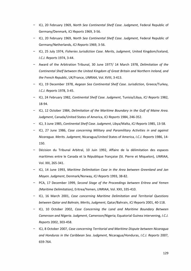
129
− ICJ, 20 February 1969, North Sea Continental Shelf Case. Judgment, Federal Republic of
Germany/Denmark, ICJ Reports 1969, 3-56.
− ICJ, 20 February 1969, North Sea Continental Shelf Case. Judgment, Federal Republic of
Germany/Netherlands, ICJ Reports 1969, 3-56.
− ICJ, 25 July 1974, Fisheries Jurisdiction Case. Merits, Judgment, United Kingdom/Iceland,
I.C.J. Reports 1974, 3-44.
− Award of the Arbitration Tribunal, 30 June 1977/ 14 March 1978, Delimitation of the
Continental Shelf between the United Kingdom of Great Britain and Northern Ireland, and
the French Republic, UK/France, UNRIAA, Vol. XVIII, 3-413.
− ICJ, 19 December 1978, Aegean Sea Continental Shelf Case. Jurisdiction, Greece/Turkey,
I.C.J. Reports 1978, 3-45.
− ICJ, 24 February 1982, Continental Shelf Case. Judgment, Tunisia/Libya, ICJ Reports 1982,
18-94.
− ICJ, 12 October 1984, Delimitation of the Maritime Boundary in the Gulf of Maine Area.
Judgment, Canada/United States of America, ICJ Reports 1984, 246-352.
− ICJ, 3 June 1985, Continental Shelf Case. Judgment, Libya/Malta, ICJ Reports 1985, 13-58.
− ICJ, 27 June 1986, Case concerning Military and Paramilitary Activities in and against
Nicaragua. Merits. Judgment, Nicaragua/United States of America, I.C.J. Reports 1986, 14-
150.
− Décision du Tribunal Arbitral, 10 Juin 1992, Affaire de la délimitation des espaces
maritimes entre le Canada et la République française (St. Pierre et Miquelon), UNRIAA,
Vol. XXI, 265-341.
− ICJ, 14 June 1993, Maritime Delimitation Case in the Area between Greenland and Jan
Mayen. Judgment, Denmark/Norway, ICJ Reports 1993, 38-82.
− PCA, 17 December 1999, Second Stage of the Proceedings between Eritrea and Yemen
(Maritime Delimitation), Eritrea/Yemen, UNRIAA, Vol. XXII, 335-410.
− ICJ, 16 March 2001, Case concerning Maritime Delimitation and Territorial Questions
between Qatar and Bahrain, Merits, Judgment, Qatar/Bahrain, ICJ Reports 2001, 40-118.
− ICJ, 10 October 2002, Case Concerning the Land and Maritime Boundary Between
Cameroon and Nigeria. Judgment, Cameroon/Nigeria; Equatorial Guinea intervening, I.C.J.
Reports 2002, 303-458.
− ICJ, 8 October 2007, Case concerning Territorial and Maritime Dispute between Nicaragua
and Honduras in the Caribbean Sea. Judgment, Nicaragua/Honduras, I.C.J. Reports 2007,
659-764.

130
− ICJ, 13 December 2007, Territorial and Maritime Dispute. Preliminary Objections.
Judgment, Nicaragua/Colombia, I.C.J. Reports 2007, p. 832-877.
− ICJ, 3 February 2009, Case Concerning Maritime Delimitation in the Black Sea. Judgment,
Romania/Ukraine, I.C.J. Reports 2009, 61-134.
− Judge SCHWEBEL, Separate Opinion, in ICJ, 24 February 1982, Continental Shelf Case.
Judgment, Tunisia/Libya, ICJ Reports 1982, 99.
− Judge JIMÉNEZ DE ARÉCHAGA, Separate Opinion, in ICJ, 24 February 1982, Continental Shelf
Case. Judgment, Tunisia/Libya, ICJ Reports 1982, 100-142.
− Judge GROS, Dissenting Opinion, in ICJ, 24 February 1982, Continental Shelf Case.
Judgment, Tunisia/Libya, ICJ Reports 1982, 143-156.
− Judge ODA, Dissenting Opinion, in ICJ, 24 February 1982, Continental Shelf Case. Judgment,
Tunisia/Libya, ICJ Reports 1982, 157-277.
− Judge ODA, Separate Opinion, in ICJ, 14 June 1993, Maritime Delimitation Case in the Area
between Greenland and Jan Mayen. Judgment, Denmark/Norway, ICJ Reports 1993, 89-
117.
− Judge SCHWEBEL, Separate Opinion, in ICJ, 14 June 1993, Maritime Delimitation Case in the
Area between Greenland and Jan Mayen. Judgment, Denmark/Norway, ICJ Reports 1993,
118-129.
− Judge TORRES BERNÁRDEZ, Dissenting Opinion in ICJ, 16 March 2001, Case concerning
Maritime Delimitation and Territorial Questions between Qatar and Bahrain, Merits,
Judgment, Qatar/Bahrain, ICJ Reports 2001, 257-450.
BOOKS AND CONTRIBUTIONS TO BOOKS
− UNITED NATIONS, United Nations Conference on the Law of the Sea. Official Records. Vol. III,
Geneva, United Nations Publications, A/CONF.13/39, 1958, 261.
− UNITED NATIONS, Second United Nations Conference on the Law of the Sea. Official Records.
Vol. I, Geneva, United nations Publications, A/CONF.19.8, 1960, 176.
− HODGSON, R.D. and ALEXANDER, L.M., Towards an Objective Analysis of Special
Circumstances: Bays, Rivers, Coastal and Oceanic Archipelagos and Atolls, Rhode Island,
Law of the Sea Institute, 1972, 54.
− SYMMONS, C.R., The Maritime Zones of Islands in International Law, Nijhoff, The Hague,
1979, 307.

131
− BOWETT, D.W., The legal Regime of Islands in International Law, New York, Oceana
Publications, 1979, 337.
− O’CONNELL, D.P., The International Law of the Sea. Vol. I, Oxford, Clarendon Press, 1982,
634.
− CASTANEDA, J, “Negotiations on the Exclusive Economic Zone at the Third United Nations
Conference on the Law of the Sea” in MAKARCZYK, J (ed.), Essays in International Law in
Honor of Judge Manfred Lachs, The Hague, Martinus Nijhoff Publishers, 1984, 760.
− PLATZÖDER, R., Third United Nations Conference on the Law of The Sea: Documents. Volume
V, New York, Oceana Publications Inc, 1984, 543.
− X, De Derde Zeerechtconferentie van de Verenigde Naties, (Ned) Ministerie van
Buitenlandse Zaken, ‘s-Gravenhage, Staatsuitgeverij, 1984, 263.
− KAPOOR, D.C. and KERR, A.J., A guide to Maritime Boundary Delimitation, Toronto, Carswell
Legal Publications, 1986, 123.
− ATTARD, D., The Exclusive Economic Zone in International Law, New York, Oxford University
Press, 1987, 416.
− BEAZLEY, P.B., Maritime Limits and Baselines; a guide to their delineation, Third revised
edition, London, The Hydrographic Society, 1987, 54.
− WEIL, P., Perspectives du droit de la délimitation maritime, Paris, Pedonne, 1988, 319.
− UNITED NATIONS, OFFICE FOR OCEAN AFFAIRS AND THE LAW OF THE SEA, Régime of islands, New
York, United Nations Publications, 1988, 124.
− PHARAND, D., Canada’s Arctic Waters in International Law, Cambridge, Cambridge
University Press, 1988, 288.
− UNITED NATIONS, OFFICE FOR OCEAN AFFAIRS AND THE LAW OF THE SEA, The Law of the Sea.
Baselines: an examination of the relevant provisions of the United Nations Convention on
the law of the sea, New York, United Nations Publications, 1989, 67.
− WARRICK, R.A. and OERLEMANS, J “Sea level rise” in HOUGHTON, J.T., JENKINS, G.J. and
EPHRAUMS, J.J. (eds.), Climate Change – The IPCC scientific Assessment, Cambridge,
Cambridge University Press, 1990, 410.
− JAYEWARDENE, H.W., The Regime of Islands in International Law in Publications on Ocean
Developments, Dordrecht, Martinus Nijhoff Publishers, 1990, 572.
− REISMAN, W.M. and WESTERMAN, G., Straight baselines in International Maritime Boundary
Delimitations, New York, St. Martin’s Press, 1992, 242.
− NORDQUIST, United Nations Convention on the Law of the Sea 1982. A commentary. Vol. II,
Dordrecht, Martinus Nijhoff Publishers, 1993, 1040.

132
− BOWETT, D., “Islands, Rocks, Reefs and Low-Tide Elevations in Maritime Boundary
Delimitations” in CHARNEY, J.I. & ALEXANDER, L.M., International Maritime Boundaries.
Volume I, ASIL, Martinus Nijhoff Publishers, 1993, 131-151.
− OUDE ELFERINK, A.G., The Law of Maritime Boundary Delimitation. A Case Study of the
Russian Federation. in Publications on Ocean Developments, Dordrecht, Martinus Nijhoff
Publishers, 1994, 431.
− MUNAVVAR, M., Ocean States: Archipelagic Regimes in the Law of the Sea in Publications
on Ocean Developments, Dordrecht, Martinus Nijhoff Publishers, 1994, 225.
− BROWN, E.D., The International Law of the Sea. Volume 1 Introductory Manuel, Aldershot,
Dartmouth, 1994, 494.
− LALL, V.K. and KHEMCHAND, D., Encyclopaedia of International Law, New Delhi, Anmol
Publications, 1997, 1852.
− SHAW, M.N., International Law. 5th edition, Cambridge, Cambridge University Press, 2003,
1297.
− CHURCHILL, R.R. and LOWE, A.V., The Law of the Sea. 3rd edition, Manchester, Manchester
University Press, 1999, 494.
− KOLB, R., Case Law on Equitable Maritime Delimitation / Jurisprudence sur les délimitations
maritimes selon l'équité. Digest and Commentaries / Répertoire et commentares in
Publications on Ocean Developments, Dordrecht, Martinus Nijhoff Publishers, 2003, 575.
− ANTUNES, N, Towards the Conceptualisation of Maritime Delimitation in Publications on
Ocean Development, Leiden, Martinus Nijhoff Publishers, 2003, 684.
− TREVES, T., “The Law of the Sea Convention Ten Years after Entry into Force: Positive
Developments and Reasons for Concern” in CARON, D. and SCHEIBER, H., Bringing New Law
to Ocean Waters in Publications on Ocean Development, Dordrecht, Martinus Nijhoff
Publishers, 2004, 349-354 (497).
− KIM, S.P., Maritime Delimitation and Interim Arrangements in North East Asia in
Publications on Ocean Development, Martinus Nijhoff Publishers, Leiden, 2004, 386.
− CARLETON, C., “Maritime Delimitation in Complex Island Situations: A Case Study on the
Caribbean Sea” in R. LAGONI and D. VIGNES, Maritime Delimitation in Publications on Ocean
Developments, Dordrecht, Martinus Nijhoff Publishers, 2006, 153-188 (241).
− LOWE, A.V., International Law, Oxford University Press, Oxford, 2007, 298.
− NORCHI, C.H., “Malta, Maine and beyond. Trends in the theory and practice of maritime
boundary delimitation.” in MARTÍNEZ GUTIÉRREZ, N.A., Serving the Rule of International

133
Maritime Law. Essays in Honour of Professor David Joseph Attard, Oxon, Routledge, 2010,
77-94 (404).
− SOMERS, E., Inleiding tot het internationaal zeerecht, 5de herwerkte uitgave, Mechelen,
Kluwer, 2010, 512.
ARTICLES
− BINGHAM, J.W., “The Continental Shelf and the Marginal Belt”, 40 AJIL 1946, 173-178.
− BERRY, K.B., “Delimitation and the Anglo-French arbitration”, 6 Australian Yearbook of
International Law 1974, 139-152.
− KARL, D.E., “Islands and the Delimitation of the Continental Shelf: A framework for
Analysis”, 71 AJIL 1977, 642-673.
− LEE, L.T., “The Law of the Sea Convention and Third States”, 77 AJIL, 1983, 541-568.
− FELDMAN, M.B., “The Tunisia-Libya Continental Shelf Case: Geographic Justice or Judicial
Compromise”, 77 AJIL 1983, 219-238.
− SURACE-SMITH, K., “United States Activity Outside of the Law of the Sea Convention: Deep
Seabed mining and Transit Passage”, 84 Colum. L. Rev. 1984, 1032-1058.
− BAILEY, J.E. III, “Comment: The Exclusive Economic Zone: Its Development and Future in
International and Domestic Law”, 45 La. L. Rev. 1985, 1269-1297.
− CHARNEY, J.I., “International Agreements and the Development of Customary Law”, 61
Wash. L. Rev. 1986, 971-996.
− WESTERMAN, G.S. and REISMAN, W.M., “Straight baselines in international law: a call for
reconsideration”, 82 ASIL Proc. 1988, 260-277.
− SYMONIDES, J., “Origine and Legal Essence of the Contiguous Zone”, 20 Ocean Devel. & Int’l
L. 1989, 203-211.
− ARRUDA, H.M., “The Extension of the United States Territorial Sea: Reasons and Effects”, 4
Conn. J. Int’l L. 1989, 697-727.
− BIRD, E. and PRESCOTT, V., “Rising Global Sea Levels and National Maritime Claims”, 1 Mar.
Pol’y. Rep. 1989, 177-196.
− INTERNATIONAL HYDROGRAPHIC ORGANIZATION TECHNICAL ASPECTS ON THE LAW OF THE SEA WORKING
GROUP, “Consolidated Glossary of Technical Terms Used in the United Nations Convention
on the Law of the Sea”, 51 International Hydrographic Bureau Special Publication 1989.
− NELSON, L.D.M., “The Roles of Equity in the Delimitation of Maritime Boundaries”, 84 AJIL
1990, 837-858.

134
− MCDORMAN, T.L., “The Canada-France Maritime Boundary Case: Drawing A Line Around St.
Pierre and Miquelon”, 84 AJIL 1990, 157-189.
− MENEFEE, S.P., ““Half Seas Over”: The Impact of Sea Level Rise on International Law and
Policy”, 9 UCLA J. Envtl. L. & Pol'y. 1991, 175-218.
− REMY, C.E., “U.S. Territorial Sea Extension: Jurisdiction and International Environmental
Protection”, 16 Fordham Int’l L.J. 1993, 1208-1252.
− CLINGAN, T., “Mar Presencial (The Presential Sea): Déjà Vu All Over Again? A Response to
Francisco Orrega Vicuña”, 24 Ocean Devel. & Int’l L.J., 1993, 93-97.
− CHARNEY, J.I., “International Maritime Boundary Delimitation -- Geneva Convention on the
Continental Shelf -- Equidistant Line -- Special Circumstances. Maritime Delimitation in the
Area Between Greenland and Jan Mayen (Den. v. Nor.) 1993 ICJ Rep. 38 International
Court of Justice, June 14, 1993.”, 88 AJIL 1994, 105-109.
− KOLB, R., “L’interprétation de l’Article 212, Paragraphe 3, de la Convention de Montego
Bay sur le Droit de la Mer: ‘Les “Rochers qui ne se Prêtent pas à l’Habitation Humaine ou à
une Vie Économique Propre…”’”, 40 Annuaire Français de Droit International 1994, 876-
909.
− CHURCHILL, R.R., “The Greenland-Jan Mayen Case and its Significance for the International
Law of Maritime Boundary Delimitation”, 9 IJMCL 1994, 1-29.
− DUBNER, B.H., “The Spratly “Rocks” Dispute – A “Rockapelago” defies norms of
International Law”, 9 Temp. Int’l & Comp. L.J., 1995, 291-331.
− CLAGGETT, B.M., “Competing Claims of Vietnam and China in the Vanguard Bank and Blue
Dragon Areas of the South China Sea: Part I”, 13 Oil & Gas L. & Tax’n Rev., 1995, 375.
− CHARNEY, J.I., “Central East Asian Maritime Boundaries and the Law of the Sea”, 89 AJIL
1995, 724-749.
− NIKAS, R.J., “Where The Street Meets The Sea: A Nautical Glossary For Maritime Lawyers”
9 U.S.F. Mar. L.J. 1996, 245-278.
− CAMPBELL, A.M., “International Law – Maritime Delimitation and Territorial Dispute –
Qatar v. Bahrain, 1994 I.C.J. 112 (July 1)”, 19 Suffolk Transnat’l L. Rev. 1996, 573-578.
− LEVICK, A.J., “From sovereignty to fishing rights: the historical evolution of the law of the
territorial sea”, 3 Dig.Int’l L, 1995-1996, 36 (no page numbers available on Westlaw).
− ZUMWALT, A., “Straddling Stock Spawn Fish War on the High Seas”, 3. U.C. Davis J. Int’l. L &
Pol. 1997, 35-56.
− KOZYRIS, P.J., “Lifting the veils of equity in maritime entitlements: equidistance with
proportionality around the islands”, 26 Denv. J. Int’l L. & Pol’y. 1998, 319-388.

135
− ROACH, J.A. and SMITH, R.W., “Straight Baselines: The Need for a Universally Applied
Norm”, 31 Ocean Devel and Int’l L. 2000, 47-80.
− CHARNEY, J.I., “Rocks that cannot sustain human habitation”, 93 AJIL 1999, 863-878.
− CARLSON, J., “Presidential Proclamation 7219: Extending the United States’ Contiguous
Zone – Didn’t someone say this had something to do with pollution?”, 55 U. Miami L. Rev.
2001, 487-526.
− YOSHIFUMI, T., “Reflections on the Concept of proportionality in the Law of Maritime
Delimitation”, 16 IJMCL 2001, 433-463.
− KWIATKOWSKA, B., “The Eritrea-Yemen Arbitration: Landmark progress in the Acquisition of
Territorial Sovereignty and Equitable Maritime Boundary Delimitation”, 32 Ocean Devel.
and Int’l L. 2001, 1-25.
− ARNAUT, D, “Stormy Waters on the Way to the High Seas: The Case of the Territorial Sea
Delimitation Between Croatia and Slovenia, 8 Ocean and Coastal L.J. 2002, 21-69.
− CARLETON, C. and SCOFIELD, C., “Developments in the Technical Determination of Maritime
Space: Delimitation, Dispute Resolution, Geographical Information System and the Role of
the Technical Expert”, 4 Maritime Briefing, 2002, Vol. 3, 1-62.
− LLANOS, H.I., “Low-Tide Elevations: Reassessing their impact on Maritime Delimitation”, 14
Pace Int’l L. Rev. 2002, 255-272.
− WEI SU, S., “The Tiaoyu Islands and Their Possible Effect on the Maritime Boundary
Delimitation between China and Japan”, 3 Ch. J. Int’l. L., 2004, 385-420.
− LAVALLE, R., “Not Quite a Sure Thing: The Maritime Areas of Rocks and Low-Tide Elevations
Under the UN Law of the Sea Convention”, 19 I.J.M.C.L. 2004, 43-69.
− ONISHI, N., “Japan and China Dispute a Pacific Islet”, N.Y. Times, 10 July 2005, 4.
− IGIEHON, M.O., “Present International Law on Delimitation of the Continental Shelf”,
I.E.L.T.R., 2006, 8/9, 208-215.
− LEE, M.L., “The interrelation between the Law of the Sea Convention and Customary
International Law”, 7 San Diego Int’l L.J. 2006, 405-420.
− DUNDUA, N., “Delimitation of maritime boundaries between adjacent states”, New York,
United Nations – The Nippon Foundation Fellow, 2006-2007,
http://www.un.org/Depts/los/nippon/unnff_programme_home/fellows_pages/fellows_p
apers/dundua_0607_georgia.pdf.
− FRANCKX, E, “The 200-Mile Limit: Between Creeping Jurisdiction and Creeping Common
Heritage? Some Law of the Sea Considerations from Professor Louis Sohn’s former LL.M.
Student”, 39 Geo. Wash. Int’l L. Rev. 2007, 467-498.

136
− DIAZ, L., DUBNER, B.H. and PARENT, J., “When is a “Rock” an “Island”? – Another unilateral
declaration defies “norms” of International Law”, 15 Mich. St. J. Int’l L. 2007, 519-555.
− KAYE, S., “Lessons learned from the Gulf of Maine Case: The development of Maritime
Boundary Delimitation Jurisprudence since UNCLOS III”, 14 Ocean and Coastal L. J. 2008,
73-99.
− LATHROP, C.G., “Territorial and Maritime Dispute Between Nicaragua and Honduras in the
Caribbean Sea (Nicaragua v. Honduras). At http://www.icj-cij.org. International Court of
Justice, October 8, 2007”, 102 AJIL 2008, 113-119.
− DEHGHANI, R., “Continental Shelf Delimitation in the Persian Gulf”, New York, The United
Nations – Nippon Foundation Fellowship Programme, 2008-2009,
http://www.un.org/Depts/los/nippon/unnff_programme_home/fellows_pages/fellows_p
apers/dehghani_0809_iran.pdf.
− JARES, V., “Symposium Mounting Tension and Melting Ice: Exploring the Legal and Political
Future of the Arctic. The Continental Shelf Beyond 200 Nautical Miles: The Work of the
Commission on the Limits of the Continental Shelf and the Arctic”, 42 Vand. J. Transnat’l.
L. 2009, 1265-1305.
− LATHROP, C. G., “Maritime delimitation in the Black Sea (Romania v Ukraine). At
http://www.icj-cij.org. International Court of Justice, February 3, 2009”, 103 AJIL 2009,
543-549.
− MCDORMAN, T.L., “Canada-United States Cooperative Approaches to shared Marine
Fishery Resources: Territorial subversion?”, http://students.law.umich.edu/mjil/article-
pdfs/v30n3-McDorman2.pdf (2009).
− VAN DYKE, J., “The Maritime boundary between North & South Korea in the Yellow (West)
Sea,” 38 North, U.S.-Korea Institute Johns Hopkins University School of Advanced
International Studies, July 29, 2010, www.38north.org/?p=1232.
− SHI, J., “The Wang Tieya Lecture in Public International Law: Maritime Delimitation in the
Jurisprudence of the International Court of Justice”, 9 Ch. J. Int’l L. 2010, 271-291.
− NORCHI, C.H., “Introduction: Twenty-five years of the Gulf of Maine Judgment”, 15 Ocean
& Coastal L.J. 2010, 177-184.
− ALAM, S. and AL FARUQUE, A., “The Problem of Delimitation of Bangladesh’s Maritime
Boundaries with India and Myanmar: Prospects for a Solution”, 25 IJMCL 2010, 405-423.
− LAUTERPACHT, E., GREENWOOD, C. and LEE, K., “QATAR v. BAHRAIN (MERITS)”, 139 ILR 2011,
1-10.

137
− PLANTEGENEST, M., IOSIPESCU, M. AND MACNAB, R., “The French Islands of Saint Pierre et
Miquelon: A Case for the Construction of a Discontinuous Juridical Continental Shelf?”,
http://www.gmat.unsw.edu.au/ablos/ABLOS03Folder/PAPER5-1.PDF, 11.
WEBSITES
− http://www.un.org.
− http://www.un.org/Depts/los/LEGISLATIONANDTREATIES.
− http://data.un.org/.
− http://unstats.un.org/ .
− http://treaties.un.org/ .
− http://www.icj-cij.org.
− http://www.pca-cpa.org.
− http://www.itlos.org.
− http://www.haguejusticeportal.net.
− http://www.38north.org.
− http://nl.alumnieeni.com/.
− http://www.bipm.org.
− http://joongangdaily.joins.com .
− http://english.hani.co.kr.
− http://www.theestimate.com.
− http://www.gmat.vnsw.edu.au.
− http://www.weinterrupt.com.