the lay of the land - center for land use … · the lay of the land n ... with kazys varnelis, ......
TRANSCRIPT

SUMMER2004
THE CENTER FOR LAND USE INTERPRETATION NEWSLETTER
TH
E CENTER FOR
LA
ND
USE INTERPRETATI
ONTHE LAY OF THE LAND
It was a dark night and there were no lights or shoulder markers, lines, railings, or anything at all except the dark pavement moving through the landscape of the fl ats, rimmed by hills in the distance, but punctuated by stacks, towers, fumes, and colored lights. This drive was a revealing experience. The road and much of the landscape was artifi cial, and yet it couldnʼt be called a work of art. On the other hand, it did something for me that art had never done. At fi rst I didnʼt know what it was, but its effect was to liberate me from many of the views I had had about art. It seemed that there had been a reality there that had not had any expression in art...I thought to myself, it ought to be clear that's the end of art. -Tony Smith, sculptor, on driving through the Meadowlands on the then unfi nished New Jersey Turnpike in the 1950's.
continued on page 16
FIRST RESPONDER TRAINING SITES THEMATIC EXHIBIT ON EMERGENCY ARCHITECTURE
Section of the Practical Combat Range at the LAPD's Police Academy. CLUI photo
Emergency State: First Responder and Law Enforcement Training Architecture was on display at the CLUI Los Angeles Exhibition Hall this summer. The exhibit, about police and emergency training structures, featured images taken by CLUI photographers depicting ten representative locations in Southern California. As with several recent exhibits at the Center, this was a digitally created and displayed production, with each of the sites described on a LCD or projection screen, along with printed text panels, enhanced by video and ambient sound.
Southern California’s training villages and emergency props range from the typical to the state of the art, as one would imagine they might in this place where movies are made and theme parks origi-nated. The training sites depicted in this exhibit showed different characteristics of this unusual form of architecture, a form which is increasing in its sophistication and occurrence across the country, as this era of preparedness progresses.
The Police AcademyOne of the earliest training towns still in use in the Los Angeles area is the situation simulation village at the Los Angeles Police Department Academy in Elysian Park. The Police Academy is the LAPD’s his-toric classroom and firearms training area. It was established in the late 1920’s as a private shooting range for officers, and evolved into the LAPD’s main training campus for over fifty years. Though it has long been staffed by LAPD employees, the grounds and the build-ings are still owned by the private Los Angeles Police Revolver and Athletic Club. Several years ago most recruit training moved to the new Ahmanson Recruit Training Center in Westchester, and now the Academy is used just for continuing police education, officer training, and graduations.
The Academy grounds have a swimming pool, café, dining club, rock garden, gymnasium, athletic field, classrooms, three firing ranges, two electronic simulation training rooms, and two outdoor tactical train-ing areas. The situation simulation (“SIT SIM”) village is on a hillside near the Rock Garden. It was built in 1975, with help from Universal
THE REMOTE AND NOTORIOUS Owens Valley was the focus of an exhibit, tour, and publication program at the CLUI in Los Angeles this spring. Diversions and Dislocations: California’s Owens Valley was on view at the CLUI April 9 to May 9, 2004, and presented several perspectives of this fabled “backspace” of California. From the preparation for the first Los Angeles aqueduct a hundred years ago to the recreational urban tourists of today, the Owens Valley has been an extension of the city, a fact phys-ically asserted on the ground, as more than 95% of the private land in the valley is owned by the Los Angeles Department of Water and Power.
The exhibit featured images of the area by four artists. Eva Castringus, a German photographer who has worked extensively in California, pho-tographed the aqueduct as it moves through the valley, on its 250-mile journey to Los Angeles. Delving into the complexities of this engi-neering marvel, Aaron Forrest displayed his epic Los Angeles Aqueduct Landscape Atlas as a large format bound book, viewable on a table in the exhibit. The photographer David Maisel showed his aerial images of the chaotic, dried up surface of Owens Lake as projections on the gallery wall, in front of which visitors could listen on headphones to a narra-tive and musical soundtrack he made for the exhibit. Also included was previously unseen work by Andy Freeman, a photographer who has been researching and photographing buildings that were relocated from the Manzanar Japanese-American Internment camp, which was built in the Owens Valley during World War II (one of ten such internment camps built in remote areas of the western United States). After the war, the buildings were sold and removed for scrap or reuse elsewhere. As a result, parts of this surprising chapter of American history are scat-tered around the Owens Valley, in the form of transformed architectural artifacts, that have been absorbed by and integrated with the social and architectural context of the valley.
In addition, the Center published a new guidebook, titled Points of Interest in the Owens River Valley, written and researched in association with Kazys Varnelis, an architectural historian and frequent contributor to CLUI programs. And a tour was conducted by the Center, taking a busload of interested people on a two day odyssey up and down the val-ley. ♦
View of some of the interpretive infrastructure in the Owens Valley. CLUI photo
CALIFORNIA’S OWENS VALLEY FOCUS OF MONTH-LONG PROGRAM AT CLUI LOS ANGELES
See the center insert of this newsletter for an account of the tour
SUMMER2004
THE CENTER FOR LAND USE INTERPRETATION NEWSLETTER
TH
E CENENE TNTN ERERE FOR
LA
LA
LN
AN
AD
ND
NUSE INTERERE PRPRP
ERER
TAT
AT
AIO
NTHE LAY OF THE LANDIt was a dark night and there were no lights or shoulder markers, lines, railings, or anything at all except the dark pavement moving through the landscape of the fl ats, rimmed by hills in the distance, but punctuated by stacks, towers, fumes, and colored lights. This drive was a revealing experience. The road and much of the landscape was artifi cial, and yet it couldnʼt be called a work of art. On the other hand, it did something for me that art had never done. At fi rst I didnʼt know what it was, but its effect was to liberate me from many of the views I had had about art. It seemed that there had been a reality there that had not had any expression in art...I thought to myself, it ought to be clear that's the end of art. -Tony Smith, sculptor, on driving through the Meadowlands on the then unfi nished New Jersey Turnpike in the 1950's.
continued on page 16continued on page 16
FIRST RESPONDER TRAINING SITES THEMATIC EXHIBIT ON EMERGENCY ARCHITECTURE
Section of the Practical Combat Range at the LAPD's Police Academy. CLUI photo
Emergency State: First Responder and Law Enforcement Training Architecturewas on display at the CLUI Los Angeles Exhibition Hall this summer. The exhibit, about police and emergency training structures, featured images taken by CLUI photographers depicting ten representative locations in Southern California. As with several recent exhibits at the Center, this was a digitally created and displayed production, with each of the sites described on a LCD or projection screen, along with printed text panels, enhanced by video and ambient sound.
Southern California’s training villages and emergency props range from the typical to the state of the art, as one would imagine they might in this place where movies are made and theme parks origi-nated. The training sites depicted in this exhibit showed different characteristics of this unusual form of architecture, a form which is increasing in its sophistication and occurrence across the country, as this era of preparedness progresses.
The Police AcademyOne of the earliest training towns still in use in the Los Angeles area is the situation simulation village at the Los Angeles Police Department Academy in Elysian Park. The Police Academy is the LAPD’s his-toric classroom and firearms training area. It was established in the late 1920’s as a private shooting range for officers, and evolved into the LAPD’s main training campus for over fifty years. Though it has long been staffed by LAPD employees, the grounds and the build-ings are still owned by the private Los Angeles Police Revolver and Athletic Club. Several years ago most recruit training moved to the new Ahmanson Recruit Training Center in Westchester, and now the Academy is used just for continuing police education, officer training, and graduations.
The Academy grounds have a swimming pool, café, dining club, rock garden, gymnasium, athletic field, classrooms, three firing ranges, two electronic simulation training rooms, and two outdoor tactical train-ing areas. The situation simulation (“SIT SIM”) village is on a hillside near the Rock Garden. It was built in 1975, with help from Universal
THE REMOTE AND NOTORIOUS Owens Valley was the focus of an exhibit, tour, and publication program at the CLUI in Los Angeles this spring. Diversions and Dislocations: California’s Owens Valley was on view at the CLUI April 9 to May 9, 2004, and presented several perspectives of this fabled “backspace” of California. From the preparation for the first Los Angeles aqueduct a hundred years ago to the recreational urban tourists of today, the Owens Valley has been an extension of the city, a fact phys-ically asserted on the ground, as more than 95% of the private land in the valley is owned by the Los Angeles Department of Water and Power.
The exhibit featured images of the area by four artists. Eva Castringus, a German photographer who has worked extensively in California, pho-tographed the aqueduct as it moves through the valley, on its 250-mile journey to Los Angeles. Delving into the complexities of this engi-neering marvel, Aaron Forrest displayed his epic Los Angeles Aqueduct Landscape Atlas as a large format bound book, viewable on a table in the exhibit. The photographer David Maisel showed his aerial images of the chaotic, dried up surface of Owens Lake as projections on the gallery wall, in front of which visitors could listen on headphones to a narra-tive and musical soundtrack he made for the exhibit. Also included was previously unseen work by Andy Freeman, a photographer who has been researching and photographing buildings that were relocated from the Manzanar Japanese-American Internment camp, which was built in the Owens Valley during World War II (one of ten such internment camps built in remote areas of the western United States). After the war, the buildings were sold and removed for scrap or reuse elsewhere. As a result, parts of this surprising chapter of American history are scat-tered around the Owens Valley, in the form of transformed architectural artifacts, that have been absorbed by and integrated with the social and architectural context of the valley.
In addition, the Center published a new guidebook, titled Points of Interest in the Owens River Valley, written and researched in association with Kazys Varnelis, an architectural historian and frequent contributor to CLUI programs. And a tour was conducted by the Center, taking a busload of interested people on a two day odyssey up and down the val-ley. ♦
View of some of the interpretive infrastructure in the Owens Valley. CLUI photo
CALIFORNIA’S OWENS VALLEY FOCUS OF MONTH-LONG PROGRAM AT CLUI LOS ANGELES
See the center insert of this newsletter for an account of the tour

Lay of the Land Summer 2004 Page 2
CLUI NORTHEAST OFFICE IN TROY NYPROGRAMS AND PROJECTS ABOUT NJ AND NY UNDERWAY
THE SPACE BETWEEN THOUGHTS ON THE NEW JERSEY MEADOWLANDS
Julia Christensen presenting lecture at the Center's Northeast Regional Office. CLUI photo
THE NORTHEAST REGIONAL OFFICE for the Center, which opened less than a year ago, is already becoming a critical base of operations for the development of programs and projects in the region. The office’s service area is the Northeastern United States Interpretive District, which includes the states of New England, New Jersey, New York, and Pennsylvania.
While the interior of the building is not open to the public during regularly scheduled hours, the CLUI Northeast Regional Office has a storefront window that is visible from the street. This wall of glass enables the public to view programming that has been prepared for the space, during the day or night, including static displays and auto-matic multimedia presentations. Occasional lectures and meetings are held in the space as well. The office is located at 53 Third Street, in downtown Troy.
One evening in April, Julia Christensen, a graduate student at Rennselaer Polytechnic University, gave a talk at the CLUI Northeast Office called Default Architecture: America’s Reuse of the Big Box. She discussed the ways in which communities deal with the empty “super-store” buildings that often get left behind when retailers like Super Kmart or Wal-Mart vacate them, as is happening with greater fre-quency throughout the country. These monolithic, nearly windowless structures are too large for most other single tenant uses, so the reuse of them often requires some serious “outside the box” thinking.
Christensen has been travelling the country, visiting communities where the local empty big box has found interesting new uses. She has found them converted into churches, indoor flea markets, town offices, and recreation centers. Curious notions about business and the chang-ing face of small towns in America are emerging from her study. For example, one of the most logical uses of an empty big box is another superstore retailer, but it seems that companies like Wal-Mart, which usually shuts its stores to move into another even bigger one nearby, keep control of their old buildings so that a competing retailer doesn’t move in. As a result, when they are not torn down, old Wal-Marts often end up with nonprofits like churches and municipal offices and services moving in. We look forward to seeing her completed study at the end of the next academic year.
The search continues for an interpretive park site in the Hudson River area, and discussions with various owners and agencies are ongoing. Meanwhile, a project focusing on the New Jersey Meadowlands is gaining ground. ♦
NEW JERSEY'S MEADOWLANDS are a broken hole in the densest state in the nation, with two distinct kinds of landscapes. There are structures built for movement, like traffic flowing along linear turnpikes, goods through railways and container yards, energy through electrical wires, and planes along runways. Then there are the static places, the eddies and stagnant pools between these areas of flow. These include the cul-de-sacs for burnt stolen cars, the closed dumps, and industrial relics, tangled in terminal litigation. The economic precipitate of the big city next door.
These two worlds are networked and mutually dependent, antithetical and divided. For every overpass there is an area passed over. Though bordered by high volume corridors, these static zones can be nearly impossible to reach by conventional methods. You may momentarily be within a few feet of something on the edge of turnpike, and it could take you an hour to get to it on the ground. The Meadowlands are either a place to get through without being there, or a place to end up for good. It is a place made from of other places. Artificial islands of solid ground amidst the transformed marsh are composed of concrete rubble, broken glass, and ground up architecture, including even parts of bombed London, brought as ballast on the return trip of WWII supply ships, and the fragments of the romantic ruin of the neoclassical Penn Station, exposed on the edges of muddy truck yards.
Once the Hackensack River, the spine of the Meadowlands, was an open sewer of the byproducts of industry, and two dozen garbage dumps, with underground fires from the heat of decay, emitted spires of smoke and zones of haze. It was a landscape at the distant end of civilization, where the frayed edge of the Great City was turning back into the organic muck from whence it came.
Today, most of the 2,500 acres of smoldering dumps have been extin-guished and closed. In some cases moats constructed at their bases collect the billion gallons of leachate ooze they collectively excrete each year, pumped out by trucks and redeposited in the sewers for treatment. Methane from the decomposition is collected to heat homes and busi-nesses in the area. The New Jersey Meadowlands Commission, estab-lished at the peak of the chaos in the late 1960’s, has indeed been busy.
But all is far from lost for the Meadowlands. In the future, as it simulta-neously gets paved over in some places and broken into protected wild-life marshland elsewhere, the contrast of the landscape may increase, but the grey zones will prevail. Waste is stubborn, archeology remains longer when buried, and not everything can be put back the way it was before you found it. The Pulaski Skyway, called the Nation's first super-highway, will continue to soar through the Meadowlands, providing furtive, tense and fleeting panoramic views for those heading elsewhere, while providing shelter, isolation, and fodder for the layers of accumu-lated wastes in the limited access land below. ♦
REPORTS FROM THE NORTHEAST INTERPRETIVE DISTRICT
Lay of the Land Lay of the Land Summer 2004 Page 2 Summer 2004 Page 2
CLUI NORTHEAST OFFICE IN TROY NYPROGRAMS AND PROJECTS ABOUT NJ AND NY UNDERWAYNJ AND NY UNDERWAYNJ AND NY UNDER
THE SPACE BETWEEN THOUGHTS ON THE NEW JERSEY MEADOWLANDS
Julia Christensen presenting lecture at the Center's Northeast Regional Office. CLUI photo
THE NORTHEAST REGIONAL OFFICE for the Center, which opened less than a year ago, is already becoming a critical base of operations for the development of programs and projects in the region. The office’s service area is the Northeastern United States Interpretive District, which includes the states of New England, New Jersey, New York, and Pennsylvania.
While the interior of the building is not open to the public during regularly scheduled hours, the CLUI Northeast Regional Office has a storefront window that is visible from the street. This wall of glass enables the public to view programming that has been prepared for the space, during the day or night, including static displays and auto-matic multimedia presentations. Occasional lectures and meetings are held in the space as well. The office is located at 53 Third Street, in downtown Troy.
One evening in April, Julia Christensen, a graduate student at Rennselaer Polytechnic University, gave a talk at the CLUI Northeast Office called Default Architecture: America’s Reuse of the Big Box. She discussed the ways in which communities deal with the empty “super-store” buildings that often get left behind when retailers like Super Kmart or Wal-Mart vacate them, as is happening with greater fre-quency throughout the country. These monolithic, nearly windowless structures are too large for most other single tenant uses, so the reuse of them often requires some serious “outside the box” thinking.
Christensen has been travelling the country, visiting communities where the local empty big box has found interesting new uses. She has found them converted into churches, indoor flea markets, town offices, and recreation centers. Curious notions about business and the chang-ing face of small towns in America are emerging from her study. For example, one of the most logical uses of an empty big box is another superstore retailer, but it seems that companies like Wal-Mart, which usually shuts its stores to move into another even bigger one nearby, keep control of their old buildings so that a competing retailer doesn’t move in. As a result, when they are not torn down, old Wal-Marts often end up with nonprofits like churches and municipal offices and services moving in. We look forward to seeing her completed study at the end of the next academic year.
The search continues for an interpretive park site in the Hudson River area, and discussions with various owners and agencies are ongoing. Meanwhile, a project focusing on the New Jersey Meadowlands is gaining ground. ♦
NEW JERSEY'S MEADOWLANDS are a broken hole in the densest state in the nation, with two distinct kinds of landscapes. There are structures built for movement, like traffic flowing along linear turnpikes, goods through railways and container yards, energy through electrical wires, and planes along runways. Then there are the static places, the eddies and stagnant pools between these areas of flow. These include the cul-de-sacs for burnt stolen cars, the closed dumps, and industrial relics, tangled in terminal litigation. The economic precipitate of the big city next door.
These two worlds are networked and mutually dependent, antithetical and divided. For every overpass there is an area passed over. Though bordered by high volume corridors, these static zones can be nearly impossible to reach by conventional methods. You may momentarily be within a few feet of something on the edge of turnpike, and it could take you an hour to get to it on the ground. The Meadowlands are either a place to get through without being there, or a place to end up for good.
It is a place made from of other places. Artificial islands of solid ground amidst the transformed marsh are composed of concrete rubble, broken glass, and ground up architecture, including even parts of bombed London, brought as ballast on the return trip of WWII supply ships, and the fragments of the romantic ruin of the neoclassical Penn Station, exposed on the edges of muddy truck yards.
Once the Hackensack River, the spine of the Meadowlands, was an open sewer of the byproducts of industry, and two dozen garbage dumps, with underground fires from the heat of decay, emitted spires of smoke and zones of haze. It was a landscape at the distant end of civilization, where the frayed edge of the Great City was turning back into the organic muck from whence it came.
Today, most of the 2,500 acres of smoldering dumps have been extin-guished and closed. In some cases moats constructed at their bases collect the billion gallons of leachate ooze they collectively excrete each year, pumped out by trucks and redeposited in the sewers for treatment. Methane from the decomposition is collected to heat homes and busi-nesses in the area. The New Jersey Meadowlands Commission, estab-lished at the peak of the chaos in the late 1960’s, has indeed been busy.
But all is far from lost for the Meadowlands. In the future, as it simulta-neously gets paved over in some places and broken into protected wild-life marshland elsewhere, the contrast of the landscape may increase, but the grey zones will prevail. Waste is stubborn, archeology remains longer when buried, and not everything can be put back the way it was before you found it. The Pulaski Skyway, called the Nation's first super-highway, will continue to soar through the Meadowlands, providing furtive, tense and fleeting panoramic views for those heading elsewhere, while providing shelter, isolation, and fodder for the layers of accumu-lated wastes in the limited access land below. ♦
REPORTS FROM THE NORTHEAST INTERPRETIVE DISTRICT

Lay of the Land Summer 2004 Page 3
continued on next page
AT A HILLTOP IN NEW JERSEY, within sight of New York City, is the site where the Great Inventor established his first major laboratory, the famous Menlo Park. He selected this site because it was far enough from New York to work undisturbed, but close enough that its capital and investors could come on the day train. Menlo Park was the name of an undeveloped housing development, part of the Raritan Township that would later have its name changed to Edison. In 1875, with financial help from his father, Edison bought the single model home (which was all of Menlo Park that had been constructed) and 34 acres of empty farmland around it, on which he built a few other structures, includ-ing the 100-foot long, 25-foot wide wooden lab building, where most of the work of his “invention factory” would take place over the next eight years.
While so much about Edison is hyped, due largely to his own mastery of showmanship and legend making, the significance of what transpired on this site is hard to overstate. In the few years that this place served as the main lab for Edison’s enterprises, from 1876-1884, he, along with just a couple dozen employees, developed new technologies related to electro-magnetics and sound, including the dynamic microphone mouthpiece for telephones, new wire and voice transmission technologies, and the phonograph, the first instrument to capture and play back sound.
It was here too that he developed the first constant voltage generators, and what would become the standard systems for distributing electric-ity, such as underground wires, junction boxes, fuses, switches, and out-lets (though it was, of course, all in DC current). And it was on this site in 1879, that he used an electrically charged carbonized cotton thread filament in a vacuum bulb to produce electric light for a sustained dura-tion (it glowed for 40 hours), in a manner that would soon be perfected and mass-produced, spurring the electrification and illumination of the planet.
EDISON’S MENLO PARK LABTHE ORIGINAL MODERN R&D COMPLEX
This is one in a series of reports about interpretive sites related to Thomas Edison, the inventor and industrialist whose work established the basis for much of the industrialization of the world that followed, and continues today. While much about how he did things is debated, the manner in which the sites related to his life are preserved instructs us about how his legacy continues to influence the story of the creation of the modern world.
View of Menlo Park lab as it looked in 1880, at the height of its productivity. Image courtesy of the Thomas Alva Edison Memorial Museum
The phonograph was the most immediately famous and popular inven-tion to come out of Menlo Park, and it led to Edison being referred to as the “Wizard of Menlo Park.” People came on a special train from New York City to gaze at the lab, hoping to catch a glimpse of the famous inventor walking between buildings. It was here that J.P. Morgan and other financial backers and industrialists consulted with Edison about their partnerships to change the world. And it was here that the most famous actress of the day, Sarah Bernhardt, visited him, later referring to him as the ”Napoleon of Invention.” As one of the interpretive plaques on site asserts today, “he was perhaps the nation’s first superstar.”
In 1886, much of Menlo Park lab’s contents and function was moved to the new, larger facility in Orange, New Jersey, which became the main invention and production center for Edison until his death in 1931. The lab complex there churned out ideas and prototypes, and was surround-ed by factory buildings that mass produced them into products, such as phonographs and movie cameras, employing ten thousand people by 1920. The lab is now a historic site preserved by the National Park Service, and is undergoing a two-year, $12 million rehabilitation.
As the Orange lab thrived and expanded, the old Menlo Park lab build-ings fell into disuse, disrepair, and eventually disappearance. The main lab building was used as a dance hall, then a chicken farm, and mostly collapsed in 1913. The two story office and library structure Edison built burned down in 1919. The brick machine shop slowly was tak-en apart by scavengers for its bricks. Its physical dissolution however, marked its shift in importance, from a material production site, to a historic, cultural site.
In 1929, its significance was acknowledged by Henry Ford, a friend of Edison, who was moving historic structures from several places in the United States, to his American history park at Greenfield Village, in Dearborn, Michigan. With the buildings at Menlo Park already gone, burned down, or looted to nonexistence, just a few bricks and planks were all that could be taken to Dearborn. Ford instead built recon-structions of the lab, the machine shop, and the office and library, all of which are still visible at Greenfield Village. (In addition, the small glass shop at Menlo Park, which had been removed by General Electric years before, was relocated to Dearborn, as was the old boarding house, which was located near the lab, where lab workers and visitors stayed).
NORTHEAST INTERPRETIVE SITE REPORTS
The cluttered interior of the tiny museum on site. CLUI photo
Lay of the Land Lay of the Land Summer 2004 Page 3 Page 3
continued on next page
AT A HILLTOP IN NEW JERSEYAT A HILLTOP IN NEW JERSEYA , within sight of New York City, is the site where the Great Inventor established his first major laboratory, the famous Menlo Park. He selected this site because it was far enough from New York to work undisturbed, but close enough that its capital and investors could come on the day train. Menlo Park was the name of an undeveloped housing development, part of the Raritan Township that would later have its name changed to Edison. In 1875, with financial help from his father, Edison bought the single model home (which was all of Menlo Park that had been constructed) and 34 acres of empty farmland around it, on which he built a few other structures, includ-ing the 100-foot long, 25-foot wide wooden lab building, where most of the work of his “invention factory” would take place over the next eight years.
While so much about Edison is hyped, due largely to his own mastery of showmanship and legend making, the significance of what transpired on this site is hard to overstate. In the few years that this place served as the main lab for Edison’s enterprises, from 1876-1884, he, along with just a couple dozen employees, developed new technologies related to electro-magnetics and sound, including the dynamic microphone mouthpiece for telephones, new wire and voice transmission technologies, and the phonograph, the first instrument to capture and play back sound.
It was here too that he developed the first constant voltage generators, and what would become the standard systems for distributing electric-ity, such as underground wires, junction boxes, fuses, switches, and out-lets (though it was, of course, all in DC current). And it was on this site in 1879, that he used an electrically charged carbonized cotton thread filament in a vacuum bulb to produce electric light for a sustained dura-tion (it glowed for 40 hours), in a manner that would soon be perfected and mass-produced, spurring the electrification and illumination of the planet.
EDISON’S MENLO PARK LABTHE ORIGINAL MODERN R&D COMPLEX
This is one in a series of reports about interpretive sites related to Thomas Edison, the inventor and industrialist whose work established the basis for much of the industrialization of the world that followed, and continues today. While much about how he did things is debated, the manner in which the sites related to his life are preserved instructs us about how his legacy continues to influence the story of the creation of the modern world.
View of Menlo Park lab as it looked in 1880, at the height of its productivity.View of Menlo Park lab as it looked in 1880, at the height of its productivity.V Image courtesy of the Thomas Alva Edison Memorial Museum
The phonograph was the most immediately famous and popular inven-tion to come out of Menlo Park, and it led to Edison being referred to as the “Wizard of Menlo Park.” People came on a special train from New York City to gaze at the lab, hoping to catch a glimpse of the famous inventor walking between buildings. It was here that J.P. Morgan and other financial backers and industrialists consulted with Edison about their partnerships to change the world. And it was here that the most famous actress of the day, Sarah Bernhardt, visited him, later referring to him as the ”Napoleon of Invention.” As one of the interpretive plaques on site asserts today, “he was perhaps the nation’s first superstar.”
In 1886, much of Menlo Park lab’s contents and function was moved to the new, larger facility in Orange, New Jersey, which became the main invention and production center for Edison until his death in 1931. The lab complex there churned out ideas and prototypes, and was surround-ed by factory buildings that mass produced them into products, such as phonographs and movie cameras, employing ten thousand people by 1920. The lab is now a historic site preserved by the National Park Service, and is undergoing a two-year, $12 million rehabilitation.
As the Orange lab thrived and expanded, the old Menlo Park lab build-ings fell into disuse, disrepair, and eventually disappearance. The main lab building was used as a dance hall, then a chicken farm, and mostly collapsed in 1913. The two story office and library structure Edison built burned down in 1919. The brick machine shop slowly was tak-en apart by scavengers for its bricks. Its physical dissolution however, marked its shift in importance, from a material production site, to a historic, cultural site.
In 1929, its significance was acknowledged by Henry Ford, a friend of Edison, who was moving historic structures from several places in the United States, to his American history park at Greenfield Village, in Dearborn, Michigan. With the buildings at Menlo Park already gone, burned down, or looted to nonexistence, just a few bricks and planks were all that could be taken to Dearborn. Ford instead built recon-structions of the lab, the machine shop, and the office and library, all of which are still visible at Greenfield Village. (In addition, the small glass shop at Menlo Park, which had been removed by General Electric years before, was relocated to Dearborn, as was the old boarding house, which was located near the lab, where lab workers and visitors stayed).
NORTHEAST INTERPRETIVE SITE REPORTS
The cluttered interior of the tiny museum on site. CLUI photo

Lay of the Land Summer 2004 Page 4
THERE AREN'T TOO MANY PLACES in America where a few footsteps transports a visitor to international territory. One of them is the United Nations, a building complex former Pentagon official Richard Perle characterized as the “Looming Chatterbox on the Hudson” (though he got his geography wrong - it’s actually on the East River).
Since the day the U.N. opened in 1952, accommodations have been made for visiting tourists with an interest in the architecture of interna-tional diplomacy. Reaching a peak of 1.2 million visitors in 1964, U.N. tour attendance is now down to around 400,000 a year. Tour groups are led by an international crew of guides, a job which used to be limited to women between the age of 20 and 30, but now includes a few men. Since the 1950s the guides have always sported uniforms resembling those worn by airline stewardesses. After diversions into mini-skirts in the 1960s and a Benetton designed 1980s outfit, the U.N. tour guide look is back to vintage air-travel chic with a blazer/skirt combo designed by the Italian fashion house Mondrian and accompanied by Italian shoes by Valleverde.
Continuing the air-travel vibe, to visit the international territory of the U.N. one must first go through airport style security in a tent just out-side the conference building. After purchasing a ticket, one can wander the General Assembly Lobby, which hosts changing exhibits. During a visit in April the displays included large photographs about the United Nations Food Program sponsored by Benetton and a number of smaller exhibits including a gift from the Islamic Republic of Iran of silk carpet portraits of the Secretary-Generals.
After meeting my guide, a young Brazilian woman fluent in five languages, our small group stepped through a glass door and into the architectural wonderworld of utopian modernism that is the U.N. compound. Guides receive daily briefings on the current activities of the various U.N. divisions, and the tour consists mostly of discussion of the U.N.’s current policies and goals. It is a tour not so much of a place as of an idea, a “tomorrowland” of international cooperation enveloped in a bubble of 50s modernism. It’s an optimistic architecture meant to evoke a new beginning after the horrors of World War II and fated to serve as a backdrop for the cold war. At once horribly dated and retro-hip, the place exudes a utopian ambiance that seems quaint considering its recent troubled history.
THE JET SET UN TOURAROUND THE WORLD IN 45 MINUTES AT THE UNITED NATIONS
continued on next page
The U.N. building, and a U.N. Guide, interpreting a land mine display. CLUI photo by Erik Knutzen
As part of the recognition of the significance of Menlo Park, and to pro-mote its reconstruction at Greenfield Village, a simultaneous ceremony, held to commemorate the 50th anniversary of electric light, was staged at Menlo Park and Dearborn. A metal tower built on the old lab site was topped by a giant light bulb, called the ”Eternal Light,” that was sup-posed to burn forever. It was symbolically lit, remotely, by Thomas Edi-son himself, from a ceremoniously –but otherwise un– connected switch in Dearborn.
Eight years later, the tower was destroyed in a storm. A new, more per-manent tower was finished in 1938, a 131 feet tall Art Deco spire, made of Portland cement (which was one of Edison’s patents). This new tower was a gift to the Thomas Alva Edison Foundation, from William Slo-cum Barstow, the Foundation’s president. The Eternal Light atop the new tower was a 13-foot diameter replica of the incandescent lamp, made of three tons of amber tinted Pyrex, two inches thick, and consuming 9500 watts of electricity, which was donated by the local electrical utility. A gate house was constructed near the base of the tower, where an admission charge to the site was levied.
The Eternal Light, which some historic newspaper accounts say stays on continuously, running on battery power during occasional power outages, has, in fact been off most of the time since the dedication of the new tow-er. The bulbs have burned out and been replaced many times. The current non-emitting light source is four burned out automobile headlights.
Today, the only structure left from what is called the “first organized research lab in the world,” is a buried underground vault, now empty, which Edison built under his office, to keep his most important papers safe from harm. The site is surrounded by a typical New Jersey residen-tial neighborhood. Much of the site is wooded, and a new walking trail, the “Thomas Alva Edison Information Trail,” makes a loop through the woods, with the occasional modest interpretive plaque. There is a small museum building, occupying the old gatehouse, with two cramped rooms, full of images and devices related to his inventions. Outside, the cement tower, with its burned out Eternal Light, is crumbling. ♦
The lab site today, with the commemorative tower, strands of local electrical distribution wires, and a small museum in the former gate house. CLUI photo
NORTHEAST INTERPRETIVE SITE REPORTS
MENLO PARK continued
Lay of the Land Lay of the Land Summer 2004 Page 4 Page 4
THERE AREN'T TOO MANY PLACES in America where a few footsteps transports a visitor to international territory. One of them is the United Nations, a building complex former Pentagon official Richard Perle characterized as the “Looming Chatterbox on the Hudson” (though he got his geography wrong - it’s actually on the East River).
Since the day the U.N. opened in 1952, accommodations have been made for visiting tourists with an interest in the architecture of interna-tional diplomacy. Reaching a peak of 1.2 million visitors in 1964, U.N. tour attendance is now down to around 400,000 a year. Tour groups are led by an international crew of guides, a job which used to be limited to women between the age of 20 and 30, but now includes a few men. Since the 1950s the guides have always sported uniforms resembling those worn by airline stewardesses. After diversions into mini-skirts in the 1960s and a Benetton designed 1980s outfit, the U.N. tour guide look is back to vintage air-travel chic with a blazer/skirt combo designed by the Italian fashion house Mondrian and accompanied by Italian shoes by Valleverde.
Continuing the air-travel vibe, to visit the international territory of the U.N. one must first go through airport style security in a tent just out-side the conference building. After purchasing a ticket, one can wander the General Assembly Lobby, which hosts changing exhibits. During a visit in April the displays included large photographs about the United Nations Food Program sponsored by Benetton and a number of smaller exhibits including a gift from the Islamic Republic of Iran of silk carpet portraits of the Secretary-Generals.
After meeting my guide, a young Brazilian woman fluent in five languages, our small group stepped through a glass door and into the architectural wonderworld of utopian modernism that is the U.N. compound. Guides receive daily briefings on the current activities of the various U.N. divisions, and the tour consists mostly of discussion of the U.N.’s current policies and goals. It is a tour not so much of a place as of an idea, a “tomorrowland” of international cooperation enveloped in a bubble of 50s modernism. It’s an optimistic architecture meant to evoke a new beginning after the horrors of World War II and fated to serve as a backdrop for the cold war. At once horribly dated and retro-hip, the place exudes a utopian ambiance that seems quaint considering its recent troubled history.
THE JET SET UN TOURAROUND THE WORLD IN 45 MINUTES AT THE UNITED NATIONS
continued on next page
The U.N. building, and a U.N. Guide, interpreting a land mine display. CLUI photo by Erik Knutzen
As part of the recognition of the significance of Menlo Park, and to pro-mote its reconstruction at Greenfield Village, a simultaneous ceremony, held to commemorate the 50th anniversary of electric light, was staged at Menlo Park and Dearborn. A metal tower built on the old lab site was topped by a giant light bulb, called the ”Eternal Light,” that was sup-posed to burn forever. It was symbolically lit, remotely, by Thomas Edi-son himself, from a ceremoniously –but otherwise un– connected switch in Dearborn.
Eight years later, the tower was destroyed in a storm. A new, more per-manent tower was finished in 1938, a 131 feet tall Art Deco spire, made of Portland cement (which was one of Edison’s patents). This new tower was a gift to the Thomas Alva Edison Foundation, from William Slo-cum Barstow, the Foundation’s president. The Eternal Light atop the new tower was a 13-foot diameter replica of the incandescent lamp, made of three tons of amber tinted Pyrex, two inches thick, and consuming 9500 watts of electricity, which was donated by the local electrical utility. A gate house was constructed near the base of the tower, where an admission charge to the site was levied.
The Eternal Light, which some historic newspaper accounts say stays on continuously, running on battery power during occasional power outages, has, in fact been off most of the time since the dedication of the new tow-er. The bulbs have burned out and been replaced many times. The current non-emitting light source is four burned out automobile headlights.
Today, the only structure left from what is called the “first organized research lab in the world,” is a buried underground vault, now empty, which Edison built under his office, to keep his most important papers safe from harm. The site is surrounded by a typical New Jersey residen-tial neighborhood. Much of the site is wooded, and a new walking trail, the “Thomas Alva Edison Information Trail,” makes a loop through the woods, with the occasional modest interpretive plaque. There is a small museum building, occupying the old gatehouse, with two cramped rooms, full of images and devices related to his inventions. Outside, the cement tower, with its burned out Eternal Light, is crumbling. ♦
The lab site today, with the commemorative tower, strands of local electrical distribution wires, and a small museum in the former gate house. CLUI photo
NORTHEAST INTERPRETIVE SITE REPORTS
MENLO PARK continued
Lay of the Land Summer 2004 Page 5continued on next page
Most of the large chambers are part of the tour with the exception of the Security Council, which is closed due to security. On our visit we passed through the Economic and Social Council chambers and the Trustee-ship Council, both of which were in session. After quickly traversing exhibits on weapons of mass destruction, decolonization, land mines, and U.N. peacekeeping efforts, the guided tour ended with a question and answer session with our guide in the empty General Assembly Hall.
Once the Q & A concluded our guide dropped us off in the expansive public concourse, which includes a book store, post office, coffee shop, and souvenir shop selling U.N. logo coffee mugs, shot glasses, t-shirts, ties and key chains with the flags of each of the 191 U.N. member na-tions among many other novelties. A visit to the bookstore provides next summer’s beach reading for the policy wonk; Disarming Iraq by Hans Blix, Human Development Report 2003, or on the lighter side, The United Nations Women’s Guild Cookbook.
The international style U.N. building was designed by an international team of 11 architects (led by the American Wallace K. Harrison), and though it seems so, well, modern, it is now over 50 years old. The U.N. plans on temporarily relocating in 2007 while the 39 story secretari-at building is upgraded. A recent New York Times story profiled the somewhat dilapidated condition of much of this modernist landmark. Asbestos, a lack of sprinklers, and outdated heating and air condition-ing systems plague the complex, which will be refurbished with a pro-posed $1.2 billion loan in Bush’s 2005 budget. The Times story also noted “East River water is pumped into the building as a coolant and . . . workers had collected eels, blue claw crabs and bluefish from the basement filters to take home to cook.” Just think about that the next time Kofi Annan invites you to dinner. ♦
THE CLUI GETS STUCK IN TRAFFICTRAFFIC IS SUBJECT OF EXHIBIT AND LECTURE MARCH 2004
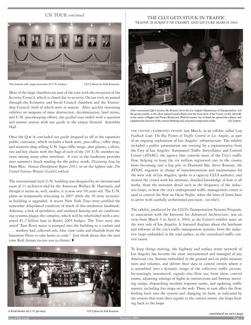
After a protracted Q&A session, Mr. Rostam, from the Los Angeles Department of Transportation, led the group outside, to the silver painted metal cabinet near the front door of the Center, on the sidewalk at the corner of Bagley and Venice Boulevard. With his master key in hand, he opened the cabinet, and explained the function of the various blinking rack mounted components inside. CLUI photo
The Iranian silk carpet portraits of U.N. leaders. CLUI photo by Erik Knutzen
THE CENTER CELEBRATED TRAFFIC last March, in an exhibit called Loop Feedback Loop: The Big Picture of Traffic Control in Los Angeles, as part of an ongoing exploration of Los Angeles’ infrastructure. The exhibit included a public presentation one evening by a representative from the City of Los Angeles’ Automated Traffic Surveillance and Control Center (ATSAC), the agency that controls most of the City’s traffic flow, helping to keep the six million registered cars in the county from becoming just a big pile in Diamond Bar. Steve Rostam, the ATSAC engineer in charge of instrumentation and maintenance for the west side of Los Angeles, spoke to a capacity CLUI audience, and wowed the crowd with his intimate, detailed knowledge of how it all works, from the minutest detail such as the frequency of the induc-tive loops, to how the city’s underground traffic management center is used to control the flow on Oscar Night, when the lines of limos have to arrive with carefully orchestrated precision - (or else!).
The exhibit, produced by the CLUI’s Transportation Systems Program, in association with the Institute for Advanced Architecture, was on view from March 5 to April 4, 2004, at the Center’s exhibit space on the west side of Los Angeles. It featured displays about the hardware and software of the city’s traffic management systems, from the induc-tive loops embedded in the road surface, to the centralized traffic con-trol rooms.
To keep things moving, the highway and surface street network of Los Angeles has become the most instrumented and managed of any American city. Sensors embedded in the ground and on poles measure rates and volumes, and deliver their data to control centers where it is assembled into a dynamic image of the collective traffic picture. Increasingly automated, signals also flow out from these control rooms, adjusting timings of lights at intersections and freeway meter-ing ramps, dispatching incident response teams, and updating traffic reports, including live maps on the web. These in turn effect the flow, feeding back into the system and changing its form, as indicated by the sensors that send their signals to the control rooms: the loops feed-ing back to the loops.
A World Market: the U.N. gift shop. CLUI photo by Erik Knutzen
UN TOUR continued
Lay of the Land Lay of the Land Summer 2004 Page 5 Page 5continued on next page
Most of the large chambers are part of the tour with the exception of the Security Council, which is closed due to security. On our visit we passed through the Economic and Social Council chambers and the Trustee-ship Council, both of which were in session. After quickly traversing exhibits on weapons of mass destruction, decolonization, land mines, and U.N. peacekeeping efforts, the guided tour ended with a question and answer session with our guide in the empty General Assembly Hall.
Once the Q & A concluded our guide dropped us off in the expansive public concourse, which includes a book store, post office, coffee shop, and souvenir shop selling U.N. logo coffee mugs, shot glasses, t-shirts, ties and key chains with the flags of each of the 191 U.N. member na-tions among many other novelties. A visit to the bookstore provides next summer’s beach reading for the policy wonk; Disarming Iraq by Hans Blix, Human Development Report 2003, or on the lighter side, The United Nations Women’s Guild Cookbook.
The international style U.N. building was designed by an international team of 11 architects (led by the American Wallace K. Harrison), and though it seems so, well, modern, it is now over 50 years old. The U.N. plans on temporarily relocating in 2007 while the 39 story secretari-at building is upgraded. A recent New York Times story profiled the somewhat dilapidated condition of much of this modernist landmark. Asbestos, a lack of sprinklers, and outdated heating and air condition-ing systems plague the complex, which will be refurbished with a pro-posed $1.2 billion loan in Bush’s 2005 budget. The Times story also noted “East River water is pumped into the building as a coolant and . . . workers had collected eels, blue claw crabs and bluefish from the basement filters to take home to cook.” Just think about that the next time Kofi Annan invites you to dinner. ♦
THE CLUI GETS STUCK IN TRAFFICTRAFFIC IS SUBJECT OF EXHIBIT AND LECTURE MARCH 2004
After a protracted Q&A session, Mr. Rostam, from the Los Angeles Department of Transportation, led the group outside, to the silver painted metal cabinet near the front door of the Center, on the sidewalk at the corner of Bagley and Venice Boulevard. With his master key in hand, he opened the cabinet, and explained the function of the various blinking rack mounted components inside. CLUI photo
The Iranian silk carpet portraits of U.N. leaders. CLUI photo by Erik Knutzen
THE CENTER CELEBRATED TRAFFIC last March, in an exhibit called Loop Feedback Loop: The Big Picture of Traffic Control in Los Angeles, as part of an ongoing exploration of Los Angeles’ infrastructure. The exhibit included a public presentation one evening by a representative from the City of Los Angeles’ Automated Traffic Surveillance and Control Center (ATSAC), the agency that controls most of the City’s traffic flow, helping to keep the six million registered cars in the county from becoming just a big pile in Diamond Bar. Steve Rostam, the ATSAC engineer in charge of instrumentation and maintenance for the west side of Los Angeles, spoke to a capacity CLUI audience, and wowed the crowd with his intimate, detailed knowledge of how it all works, from the minutest detail such as the frequency of the induc-tive loops, to how the city’s underground traffic management center is used to control the flow on Oscar Night, when the lines of limos have to arrive with carefully orchestrated precision - (or else!).
The exhibit, produced by the CLUI’s Transportation Systems Program, in association with the Institute for Advanced Architecture, was on view from March 5 to April 4, 2004, at the Center’s exhibit space on the west side of Los Angeles. It featured displays about the hardware and software of the city’s traffic management systems, from the induc-tive loops embedded in the road surface, to the centralized traffic con-trol rooms.
To keep things moving, the highway and surface street network of Los Angeles has become the most instrumented and managed of any American city. Sensors embedded in the ground and on poles measure rates and volumes, and deliver their data to control centers where it is assembled into a dynamic image of the collective traffic picture. Increasingly automated, signals also flow out from these control rooms, adjusting timings of lights at intersections and freeway meter-ing ramps, dispatching incident response teams, and updating traffic reports, including live maps on the web. These in turn effect the flow, feeding back into the system and changing its form, as indicated by the sensors that send their signals to the control rooms: the loops feed-ing back to the loops.
A World Market: the U.N. gift shop. CLUI photo by Erik Knutzen
UN TOUR continued

Lay of the Land Summer 2004 Page 6
Inductive loops are the electronic bedrock of the traffic management system, with more than fifty thousand of them in the metropolitan area. Loops are generally composed of an insulated wire, set into a shallow trough cut into the pavement to form a square or circular “loop” approximately six feet wide. Each loop is usually visibly linked to a connection point at the curb, and then wired to the traffic control system. The magnetic field generated by low voltage running through the loop is altered by large metal objects passing over it, and this disturbance is detected by the loop and registered by the electronics connected to it on the curb. Each vehicle passing over a loop is a click in the system. Complex intersections can have dozens of loops, and major streets and highways are dotted with them. A series of loops can measure the speed at which cars travel, as well as how many are on the road. Intersections can count the cars that line up before automatically triggering the signal.
The basic timing cycle for traffic lights, called the background cycle, is generally determined by the width of the road multiplied by a pedes-trian walking time of 3.2 feet per second. If no pedestrians are present, the cycle may be accelerated or reduced. Before the integration of sig-nalized intersections to a central control point, all intersections func-tioned autonomously, with loop counting circuitry and timers located in a pole box at the base of a traffic signal pole, or in a metal cabinet on the sidewalk. Though most intersections still possess the ability to operate in this manner, they are increasingly becoming connected by phone lines and dedicated copper wire to the computers at traffic man-agement centers. In the City of Los Angeles, 3,000 of the 4,200 signal-ized intersections in the city are connected to the Automated Traffic Surveillance and Control Center.
Video cameras are increasingly being deployed by traffic managers and are an important element in the feedback loop. Caltrans (the California Department of Transportation) has 350 cameras, of a planned 500, installed at the moment along the freeway system in Los Angeles. The City’s own Department of Transportation started installing them at high points all over the city, including the roof of City Hall and Patriotic Hall, and now has over 250, out of a planned 500, all of which are connected to the traffic control center. Though expensive, at almost $100,000 per installation, cameras provide a real-time image of the roadway, often providing visual evidence of the source of slowing at trouble spots of the area. New software enables cameras to be read by computers, counting cars and calculating flow. In this way, cameras are doing the job of loops, especially on bridges and overpasses where loops are more difficult to install.
Each municipality in the Los Angeles area has a system for control-ling its traffic intersections, or allows another regional authority to do so for them. As the circuitry in the control boxes at intersections gets connected to hubs on a network, these systems become controllable from a central point, and can add their data to the big picture of the regional traffic system. Small local city control centers can be as simple as a networked computer workstation. However the larger systems have a Traffic Management Center (TMC), characterized by rows of workstations facing a video wall. There are around a dozen TMCs in the region, operated by cities like Beverly Hills and Pasadena, trans-portation agencies such as the MTA and LAX, and regional authorities such as Orange County. In Los Angeles, two major TMCs monitor and control the traffic: the City’s ATSAC for streets, and Caltrans’ TMC for highways.
Inductive loops, one of the basic components of traffic control systems, can get very messy. CLUI photo by Fiona Whitton
Many traffic signals can be changed by approaching emergency vehicles. The city of Los Angeles favors a technology that uses secure radio signals, as the emergency vehicle light-detecting sensors that are commonly used (pictured above), can be activated with an inex-pensive and illegal device. CLUI photo by Steve Rowell
Traffic surveillance cameras come in several varieties, and usually have a pressurized enclo-sure to keep dust and condensation out. CLUI photos by Steve Rowell
ATSAC Contol Room. CLUI photo by Steve Rowell
TRAFFIC continued
continued on next page
Lay of the Land Lay of the Land Summer 2004 Page 6 Page 6
Inductive loops are the electronic bedrock of the traffic management system, with more than fifty thousand of them in the metropolitan area. Loops are generally composed of an insulated wire, set into a shallow trough cut into the pavement to form a square or circular “loop” approximately six feet wide. Each loop is usually visibly linked to a connection point at the curb, and then wired to the traffic control system. The magnetic field generated by low voltage running through the loop is altered by large metal objects passing over it, and this disturbance is detected by the loop and registered by the electronics connected to it on the curb. Each vehicle passing over a loop is a click in the system. Complex intersections can have dozens of loops, and major streets and highways are dotted with them. A series of loops can measure the speed at which cars travel, as well as how many are on the road. Intersections can count the cars that line up before automatically triggering the signal.
The basic timing cycle for traffic lights, called the background cycle, is generally determined by the width of the road multiplied by a pedes-trian walking time of 3.2 feet per second. If no pedestrians are present, the cycle may be accelerated or reduced. Before the integration of sig-nalized intersections to a central control point, all intersections func-tioned autonomously, with loop counting circuitry and timers located in a pole box at the base of a traffic signal pole, or in a metal cabinet on the sidewalk. Though most intersections still possess the ability to operate in this manner, they are increasingly becoming connected by phone lines and dedicated copper wire to the computers at traffic man-agement centers. In the City of Los Angeles, 3,000 of the 4,200 signal-ized intersections in the city are connected to the Automated Traffic Surveillance and Control Center.
Video cameras are increasingly being deployed by traffic managers and are an important element in the feedback loop. Caltrans (the California Department of Transportation) has 350 cameras, of a planned 500, installed at the moment along the freeway system in Los Angeles. The City’s own Department of Transportation started installing them at high points all over the city, including the roof of City Hall and Patriotic Hall, and now has over 250, out of a planned 500, all of which are connected to the traffic control center. Though expensive, at almost $100,000 per installation, cameras provide a real-time image of the roadway, often providing visual evidence of the source of slowing at trouble spots of the area. New software enables cameras to be read by computers, counting cars and calculating flow. In this way, cameras are doing the job of loops, especially on bridges and overpasses where loops are more difficult to install.
Each municipality in the Los Angeles area has a system for control-ling its traffic intersections, or allows another regional authority to do so for them. As the circuitry in the control boxes at intersections gets connected to hubs on a network, these systems become controllable from a central point, and can add their data to the big picture of the regional traffic system. Small local city control centers can be as simple as a networked computer workstation. However the larger systems have a Traffic Management Center (TMC), characterized by rows of workstations facing a video wall. There are around a dozen TMCs in the region, operated by cities like Beverly Hills and Pasadena, trans-portation agencies such as the MTA and LAX, and regional authorities such as Orange County. In Los Angeles, two major TMCs monitor and control the traffic: the City’s ATSAC for streets, and Caltrans’ TMC for highways.
Inductive loops, one of the basic components of traffic control systems, can get very messy. CLUI photo by Fiona Whitton
Many traffic signals can be changed by approaching emergency vehicles. The city of Los Angeles favors a technology that uses secure radio signals, as the emergency vehicle light-detecting sensors that are commonly used (pictured above), can be activated with an inex-pensive and illegal device. CLUI photo by Steve Rowell
Traffic surveillance cameras come in several varieties, and usually have a pressurized enclo-sure to keep dust and condensation out. CLUI photos by Steve Rowell
ATSAC Contol Room. CLUI photo by Steve Rowell
TRAFFIC continued
continued on next page

Lay of the Land Summer 2004 Page 7
Four levels under City Hall, next to the Emergency Operations Center for the city government, the City Department of Transportation’s Automated Traffic Surveillance and Control Center, ATSAC, was created to manage traffic around the Coliseum during the 1984 Olympics. It has evolved into the centralized control point for the city’s traffic man-agement systems, run by 20 or so engineers, which develop new and innovative software that they apply to their task.
A few blocks from ATSAC, at the California Department of Transportation building at 120 South Spring Street, Caltrans District 7, which manages the highways in Los Angeles and Ventura counties, has their Traffic Management Center. About 20 people work inside it, including dispatchers for freeway service patrols, signal manage-ment personnel, highway maintenance, and a few uniformed California Highway Patrol officers, serving primarily as liaisons to the media. Within a year or two this TMC, and the rest of the Art Deco build-ing that houses the District 7 headquarters, will be torn down, as the new Caltrans headquarters a block away is nearing completion. A new 88,000 square foot TMC will be collocated with the CHP’s Los Angeles
Communications Center, at another new facility, called the Los Angeles Regional Transportation Management Center, which will be mounted on earthquake shock-absorbing springs, and is under construction in Glendale. The current CHP Los Angeles Communications Center, where among other things all 911 calls made from cell phones in the region are received, is in a highly secure building on Rosewood Boulevard, near Vermont and the 101 Freeway.
The county of Los Angeles is building a traffic management center at the County Department of Public Works headquarters in Alhambra. The 9,000 square foot TMC will be located in an existing annex building on the property, and should open by 2005. It will contain fifteen consoles as well as the requisite video wall, with sixteen 50 inch monitors. The County is responsible for around 2,000 of the 10,000 intersections in Los Angeles County, including around 800 that are in unincorporated county areas. They are currently preparing to connect 750 of these inter-sections to the new TMC.
Caltrans District 7 Traffic Management Center CLUI photo
California Highway Patrol's Los Angeles Communication Center. CLUI photo by Steve Rowell
Los Angeles County is building its new Traffic Management Center in this building next to its headquarters in Alhambra. CLUI photo
TRAFFIC continued
Predictable, cyclical events like rush hours, and even traffic surges brought on by large sporting events, can be controlled automatically, however unpredictable, “non-recurrent” events are the main cause of interruptions to normal traffic flow. Incidents and incident response is therefore one of the most important elements of traffic management. This is why the state police (CHP) are involved so heavily in traffic control, with monitors and dispatchers at the Caltrans TMC and at the CHP Communications Center (there are no police at ATSAC). With over ten million people moving on 650 miles of freeway and 6,400 miles of surface streets in the region, incidents include nearly everything imagin-able.
Simplified and brief radio traffic reports have long been the primary way in which the picture of traffic flow is distributed to the public, with only a small percentage of drivers responding in a way that helps to alle-viate the stress on the system. As the physical landscape of traffic nears complete instrumentation and digitization, the picture of traffic flow can be easily distributed, and the methods for visualizing the picture can be altered by and for specific end users. Real-time, detailed and com-plete information on traffic, as it relates to the individual driver’s needs, will soon be available on the web, cell phones, and, eventually, onboard navigation systems, completing the informational feedback loop. The big picture will be integrated with the digits that compose it. ♦
Lay of the Land Lay of the Land Summer 2004 Page 7 Page 7
Four levels under City Hall, next to the Emergency Operations Center for the city government, the City Department of Transportation’s Automated Traffic Surveillance and Control Center, ATSAC, was created to manage traffic around the Coliseum during the 1984 Olympics. It has evolved into the centralized control point for the city’s traffic man-agement systems, run by 20 or so engineers, which develop new and innovative software that they apply to their task.
A few blocks from ATSAC, at the California Department of Transportation building at 120 South Spring Street, Caltrans District 7, which manages the highways in Los Angeles and Ventura counties, has their Traffic Management Center. About 20 people work inside it, including dispatchers for freeway service patrols, signal manage-ment personnel, highway maintenance, and a few uniformed California Highway Patrol officers, serving primarily as liaisons to the media. Within a year or two this TMC, and the rest of the Art Deco build-ing that houses the District 7 headquarters, will be torn down, as the new Caltrans headquarters a block away is nearing completion. A new 88,000 square foot TMC will be collocated with the CHP’s Los Angeles
Communications Center, at another new facility, called the Los Angeles Regional Transportation Management Center, which will be mounted on earthquake shock-absorbing springs, and is under construction in Glendale. The current CHP Los Angeles Communications Center, where among other things all 911 calls made from cell phones in the region are received, is in a highly secure building on Rosewood Boulevard, near Vermont and the 101 Freeway.
The county of Los Angeles is building a traffic management center at the County Department of Public Works headquarters in Alhambra. The 9,000 square foot TMC will be located in an existing annex building on the property, and should open by 2005. It will contain fifteen consoles as well as the requisite video wall, with sixteen 50 inch monitors. The County is responsible for around 2,000 of the 10,000 intersections in Los Angeles County, including around 800 that are in unincorporated county areas. They are currently preparing to connect 750 of these inter-sections to the new TMC.
Caltrans District 7 Traffic Management Center CLUI photo
California Highway Patrol's Los Angeles Communication Center. CLUI photo by Steve Rowell
Los Angeles County is building its new Traffic Management Center in this building next to its headquarters in Alhambra. CLUI photo
TRAFFIC continued
Predictable, cyclical events like rush hours, and even traffic surges brought on by large sporting events, can be controlled automatically, however unpredictable, “non-recurrent” events are the main cause of interruptions to normal traffic flow. Incidents and incident response is therefore one of the most important elements of traffic management. This is why the state police (CHP) are involved so heavily in traffic control, with monitors and dispatchers at the Caltrans TMC and at the CHP Communications Center (there are no police at ATSAC). With over ten million people moving on 650 miles of freeway and 6,400 miles of surface streets in the region, incidents include nearly everything imagin-able.
Simplified and brief radio traffic reports have long been the primary way in which the picture of traffic flow is distributed to the public, with only a small percentage of drivers responding in a way that helps to alle-viate the stress on the system. As the physical landscape of traffic nears complete instrumentation and digitization, the picture of traffic flow can be easily distributed, and the methods for visualizing the picture can be altered by and for specific end users. Real-time, detailed and com-plete information on traffic, as it relates to the individual driver’s needs, will soon be available on the web, cell phones, and, eventually, onboard navigation systems, completing the informational feedback loop. The big picture will be integrated with the digits that compose it. ♦

Lay of the Land Summer 2004 Page 8
The access portal, behind a soundwall. CLUI photo
CLUI GOES DOWN THE TUBETEAM VISITS THE SEWER BEFORE IT’S TOO LATE
A CLUI VIDEO TEAM WAS dispatched recently to interview the workers at an obscured construction site in the Baldwin Hills, near the Center’s main offi ce in Culver City, California. The site, it turned out, was an access shaft above a connection point in the City of Los Angeles’ new main sewer line, a massive and complex construction project that has been going on underneath the city for over ten years.
Though sometimes obscured by opaque sound absorbing material attached to 20 foot tall fencing (such as at the corner of La Brea and Jefferson Boulevards), vertical shafts like this one are visible at several sites around the city. They allow workers, materials, and equipment - including large tunnel boring machines - to descend the 50-100 feet into the ground to the level of the new sewer tunnel.
The tunnel is being built in three stages, and together each section will comprise a 30 mile long sewer pipe that runs from Glendale to the Hyperion Treatment plant, on the coast next to Los Angeles Air-port (where the waste is treated in one of the nation’s largest treatment facilities, then is pumped out to sea and dissipated through a series of shower head like diffusers). Once complete, this new main sewer line for the city, averaging 10-12 feet in diameter, will replace the old sys-tem of smaller pipes, some of which are brick lined tunnels made in the 1920s. The old system is so overwhelmed that in some areas, during storms, the city has parked trucks on the manhole covers, to keep raw sewage from spilling onto the streets.
The fi rst section of the new pipe to be built was a 12 mile long, 14 foot wide shaft called the North Outfall Replacement Sewer (NORS) pipe. Completed in 1993, this section of the pipe, between the Hyperion Plant and the Baldwin Hills, is already in use. The next phase, nearly complete, runs for 12 miles from the Baldwin Hills to the Los Ange-les River, near downtown. This is a 12 foot diameter, steel lined pipe called the East Central Interceptor Sewer (ECIS). Over the past two years, ECIS was bored through the saturated soils, gassy oilfi elds, and superfund plumes along a course averaging 80 feet below the surface of the city. Phase three is a tunnel currently under construction, that runs alongside the Los Angeles River, from downtown to Glendale. Together the three phases of the project will have cost over a half a bil-lion dollars.
The hole in the hills of Culver City is the connection point for the al-ready built and partially in use NORS tunnel (the fi st phase of the proj-ect), and the nearly completed ECIS tunnel (the second phase). At the bottom of the 70-foot deep rectangular shaft, with walls held in place by I-beams, sheet piling, and shotcrete, the two pipes are being joined with a valve installed between them. Like the other access portals, this one will be fi lled in once the pipe is complete, and the surface grade will be restored. Little will remain visible on the surface to indicate the buried highway of liquid waste fl owing under the city.
At the Culver City portal, workers for the primary contractor on the ECIS project, a consortium called Kenny-Shea-Traylor-Frontier Joint Venture, met the CLUI video team, and led them into a metal cage that was picked up by a crane, and lowered into the pit. Once inside, the interview was conducted some distance down the gleaming ECIS pipe, to avoid the noise of jackhammers.
The video and photographs obtained on this and subsequent visits were presented at the CLUI’s exhibit hall in February as an exhibit called East Central Interceptor Sewer: A View Into The Pipe, sponsored by the Center for Land Use Interpretation Underground Program, in association with the Waste Programs division. The video was the fi rst of a proposed series of video programs called “What Is This Place?” ♦
The 12 foot diameter tunnel, looking east - upstream, in the future. CLUI photo
Descending into the pit in the cage. CLUI photo
Lay of the Land Lay of the Land Summer 2004 Page 8 Page 8
The access portal, behind access portal, behind access po a soundwall. CLUI photo
CLUI GOES DOWN THE TUBETEAM VISITS THE SEWER BEFORE IT’S TOO LATE
A CLUI VIDEO TEAM WAS dispatched recently to interview the workers at an obscured construction site in the Baldwin Hills, near the Center’s main offi ce in Culver City, California. The site, it turned out, was an access shaft above a connection point in the City of Los Angeles’ new main sewer line, a massive and complex construction project that has been going on underneath the city for over ten years.
Though sometimes obscured by opaque sound absorbing material attached to 20 foot tall fencing (such as at the corner of La Brea and Jefferson Boulevards), vertical shafts like this one are visible at several sites around the city. They allow workers, materials, and equipment - including large tunnel boring machines - to descend the 50-100 feet into the ground to the level of the new sewer tunnel.
The tunnel is being built in three stages, and together each section will comprise a 30 mile long sewer pipe that runs from Glendale to the Hyperion Treatment plant, on the coast next to Los Angeles Air-port (where the waste is treated in one of the nation’s largest treatment facilities, then is pumped out to sea and dissipated through a series of shower head like diffusers). Once complete, this new main sewer line for the city, averaging 10-12 feet in diameter, will replace the old sys-tem of smaller pipes, some of which are brick lined tunnels made in the 1920s. The old system is so overwhelmed that in some areas, during storms, the city has parked trucks on the manhole covers, to keep raw sewage from spilling onto the streets.
The fi rst section of the new pipe to be built was a 12 mile long, 14 foot wide shaft called the North Outfall Replacement Sewer (NORS) pipe. Completed in 1993, this section of the pipe, between the Hyperion Plant and the Baldwin Hills, is already in use. The next phase, nearly complete, runs for 12 miles from the Baldwin Hills to the Los Ange-les River, near downtown. This is a 12 foot diameter, steel lined pipe called the East Central Interceptor Sewer (ECIS). Over the past two years, ECIS was bored through the saturated soils, gassy oilfi elds, and superfund plumes along a course averaging 80 feet below the surface of the city. Phase three is a tunnel currently under construction, that runs alongside the Los Angeles River, from downtown to Glendale. Together the three phases of the project will have cost over a half a bil-lion dollars.
The hole in the hills of Culver City is the connection point for the al-ready built and partially in use NORS tunnel (the fi st phase of the proj-ect), and the nearly completed ECIS tunnel (the second phase). At the bottom of the 70-foot deep rectangular shaft, with walls held in place by I-beams, sheet piling, and shotcrete, the two pipes are being joined with a valve installed between them. Like the other access portals, this one will be fi lled in once the pipe is complete, and the surface grade will be restored. Little will remain visible on the surface to indicate the buried highway of liquid waste fl owing under the city.
At the Culver City portal, workers for the primary contractor on the ECIS project, a consortium called Kenny-Shea-Traylor-Frontier Joint Venture, met the CLUI video team, and led them into a metal cage that was picked up by a crane, and lowered into the pit. Once inside, the interview was conducted some distance down the gleaming ECIS pipe, to avoid the noise of jackhammers.
The video and photographs obtained on this and subsequent visits were presented at the CLUI’s exhibit hall in February as an exhibit called East Central Interceptor Sewer: A View Into The Pipe, sponsored by the Center for Land Use Interpretation Underground Program, in association with the Waste Programs division. The video was the fi rst of a proposed series of video programs called “What Is This Place?” ♦
The 12 foot diameter tunnel, looking east -looking east -looking east upstream, in the future. - upstream, in the future. - CLUI photo
Descending into the pit in the cage. CLUI photo

AMIDST A PETROCHEMICAL WONDERLANDPOINTS OF VIEW ALONG THE HOUSTON SHIP CHANNEL
A VISIT TO THE HOUSTON Ship Channel is a compelling activity, highly recommended for anyone interested in current events. Here, in this petrochemical Mecca, the largest petrochemical complex in the United States, the full extent of our saturation in the oil economy can be seen, felt, smelled, and fathomed. From Houston, a tour can easily be done in a day, and there are numerous interpretive areas, monu-ments, markers and museums that help visitors understand this most complex complex.
The ship channel is an expanded version of an old muddy creek called the Buffalo Bayou, which connects downtown Houston to Galveston Bay and the Gulf. It was enlarged for shipping in stages over the past two centuries, initially to bring Southern cotton to the coast. It wasn’t until the US Congress officially declared Houston, fifty miles inland, a Port City, in 1870, that the dredging and widening projects really took off. With the work of the Army Corps of Engineers and the resources of the investor Charles Morgan, a shipping magnate eager to avoid Galveston’s dockage fees, the first ocean going vessel made it up the channel in 1876 (an event that no doubt rivaled the local celebra-tion of the nation's centennial in importance that year).
Today, the Port of Houston, which manages many of the ship channel’s terminal facilities, and includes the petrochemical plants of the area in its figures, is the one of the busiest ports in the country, handling more foreign tonnage than any other port in the U.S., primarily in the form of bulk materials, and most of it petrochemical. Approximately one quarter of the refining capacity of the United States is located along the ship channel, at over 20 petrochemical plants in the channel
Lay of the Land Summer 2004 Page 9
Futuristic canopy at the Sam Houston Pavilion, where the M/V Sam Houston takes visitors on the Sam Houston Ship Channel. ”Houston,” of course, was the first word uttered from an extraterrestrial land, by astronauts on the moon speaking with the Johnson Space Center, also located in the Ship Channel area.
area. They are linked by pipelines, selling streams of liquid product to one another, and bringing in crude from hundreds of platforms in the Gulf, as well as heavier, cheaper crude from Mexico.
Some of this superlative industrial land and seascape can be viewed on the Port of Houston’s free public boat tour aboard the M/V Sam Houston. The 90 minute tour leaves from the port’s Sam Houston Pavilion, and accommodates up to 100 people. It is often crowded with school kids. The tour covers the turning basin area, the most inland portion of the navigable ship channel, and passes the 610 high-way bridge. A few petrochemical plants are visible along the way, but the most impressive sights may be a large U.S. Gypsum shed full of Mexican gypsum, the old Deepwater Power Plant, and the massive Public Grain Elevator #2.
continued on next page
CLUI FIELD RESEARCHER REGIONAL REPORTS
The Houston Ship Channel, as seen from the San Jacinto Monument. CLUI photo
Up the creek, on what used to be Buffalo Bayou, on the Port of Houston's tour of the Ship Channel. CLUI photo
The boat turns around soon after passing the first major refinery on the ship channel, the Lyondell-Citgo refinery, a medium sized plant that processes crude from Venezuela. Though based in Tulsa Oklahoma, Citgo is owned by the government of Venezuela, through its national oil company Petroleos de Venezuela (PDVSA). The Houston refinery is one of two that are mostly owned by the company in Texas (the other is at Corpus Christie) and one of four mostly owned by the company in the USA (the other two are in Lake Charles, Louisiana and Lemont Illinois). With a capacity of around 270,000 barrels per day, it is the fourth largest in the Ship Channel area, and the 11th largest refinery in the nation.
To get into the heart of ship channels’ petrochemical countryside, land is the preferred route, and there are several spectacular viewing oppor-tunities and interpretive facilities provided by the state historical and transportation agencies.
From the 610 loop, south of the channel, head east on La Port Freeway (Highway 225) through the town of Pasadena, where you can see the Crown Central Petroleum Corporation’s refinery (one of two in the country owned by this small, independent oil company) off Shaver Street, and numerous industrial parks and pipeline facilities, until you reach the monumental Shell Deer Park facility. Shell Deer Park is a 1,500-acre complex located in Deer Park, comprised of an oil refinery and a chemical plant. The refinery employs around 1,000 people, and is the sixth largest in the nation, with a capacity of 340,000 barrels per day. The refinery is half owned by Pemex, the Mexican state oil com-pany, and approximately 70% of the crude processed at the refinery
AMIDST A PETROCHEMICAL WONDERLANDPOINTS OF VIEW ALONG THE HOUSTON SHIP CHANNEL
A VISIT TO THE HOUSTON Ship Channel is a compelling activity, highly recommended for anyone interested in current events. Here, in this petrochemical Mecca, the largest petrochemical complex in the United States, the full extent of our saturation in the oil economy can be seen, felt, smelled, and fathomed. From Houston, a tour can easily be done in a day, and there are numerous interpretive areas, monu-ments, markers and museums that help visitors understand this most complex complex.
The ship channel is an expanded version of an old muddy creek called the Buffalo Bayou, which connects downtown Houston to Galveston Bay and the Gulf. It was enlarged for shipping in stages over the past two centuries, initially to bring Southern cotton to the coast. It wasn’t until the US Congress officially declared Houston, fifty miles inland, a Port City, in 1870, that the dredging and widening projects really took off. With the work of the Army Corps of Engineers and the resources of the investor Charles Morgan, a shipping magnate eager to avoid Galveston’s dockage fees, the first ocean going vessel made it up the channel in 1876 (an event that no doubt rivaled the local celebra-tion of the nation's centennial in importance that year).
Today, the Port of Houston, which manages many of the ship channel’s terminal facilities, and includes the petrochemical plants of the area in its figures, is the one of the busiest ports in the country, handling more foreign tonnage than any other port in the U.S., primarily in the form of bulk materials, and most of it petrochemical. Approximately one quarter of the refining capacity of the United States is located along the ship channel, at over 20 petrochemical plants in the channel
Lay of the Land Lay of the Land Summer 2004 Page Page 9
Futuristic canopy at the Sam Houston Pavilion, where the M/V Sam Houston takes visitors on the Sam Houston Ship Channel. ”Houston,” of course, was the first word uttered from an extraterrestrial land, by astronauts on the moon by astronauts on the moon by astr speaking with the Johnson Space Center, also located in the Ship Channel speaking with the Johnson Space Center, also located in the Ship Channel speaking with the Johnson Space Center, also located in the Ship Chaarea.
area. They are linked by pipelines, selling streams of liquid product to one another, and bringing in crude from hundreds of platforms in the Gulf, as well as heavier, cheaper crude from Mexico.
Some of this superlative industrial land and seascape can be viewed on the Port of Houston’s free public boat tour aboard the M/V Sam Houston. The 90 minute tour leaves from the port’s Sam Houston Pavilion, and accommodates up to 100 people. It is often crowded with school kids. The tour covers the turning basin area, the most inland portion of the navigable ship channel, and passes the 610 high-way bridge. A few petrochemical plants are visible along the way, but the most impressive sights may be a large U.S. Gypsum shed full of Mexican gypsum, the old Deepwater Power Plant, and the massive Public Grain Elevator #2.
continued on next page
CLUI FIELD RESEARCHER REGIONAL REPORTS
The Houston Ship Channel, as seen from the San Jacinto Monument. CLUI photo
Up the creek, on what used to be Buffalo Bayou, on the Port of Houston's tour of the Ship Channel. CLUI photo
The boat turns around soon after passing the first major refinery on the ship channel, the Lyondell-Citgo refinery, a medium sized plant that processes crude from Venezuela. Though based in Tulsa Oklahoma, Citgo is owned by the government of Venezuela, through its national oil company Petroleos de Venezuela (PDVSA). The Houston refinery is one of two that are mostly owned by the company in Texas (the other is at Corpus Christie) and one of four mostly owned by the company in the USA (the other two are in Lake Charles, Louisiana and Lemont Illinois). With a capacity of around 270,000 barrels per day, it is the fourth largest in the Ship Channel area, and the 11th largest refinery in the nation.
To get into the heart of ship channels’ petrochemical countryside, land is the preferred route, and there are several spectacular viewing oppor-tunities and interpretive facilities provided by the state historical and transportation agencies.
From the 610 loop, south of the channel, head east on La Port Freeway (Highway 225) through the town of Pasadena, where you can see the Crown Central Petroleum Corporation’s refinery (one of two in the country owned by this small, independent oil company) off Shaver Street, and numerous industrial parks and pipeline facilities, until you reach the monumental Shell Deer Park facility. Shell Deer Park is a 1,500-acre complex located in Deer Park, comprised of an oil refinery and a chemical plant. The refinery employs around 1,000 people, and is the sixth largest in the nation, with a capacity of 340,000 barrels per day. The refinery is half owned by Pemex, the Mexican state oil com-pany, and approximately 70% of the crude processed at the refinery

Lay of the Land Summer 2004 Page 10
Amid the very same refineries damaged by the Texas City explosion of 1947 is a commemo-rative marker and the propeller from the SS Highflyer, an ammonium nitrate-filled ship which exploded 16 hours after being set ablaze by the explosion of the SS Grandcamp, in the Port of Texas City. CLUI photo
continued on next page
PETROCHEMICAL WONDERLAND continued
is Maya and Olmeca crude oil imported from Mexico. The balance is domestic crude oil, mostly from Texas and Louisiana. The chemical plant employs 800, and is a major national supplier of base chemicals for plastics, paints, and other products. North off the 225 on Route 134, visitors will pass the Rhom and Haas Deer Park Chemical Plant which makes acrylic adhesives, plastics, and paint. This is the way to the finest viewing site in the Ship Channel area: the Battle of San Jacinto Monument.
This state historic monument is an Art Deco obelisk that is the tall-est free-standing column in the world. It is located on the battle-grounds, which happen to be, now, on the edge of the Ship Channel. Built in 1939, it is 570 feet tall (15 feet higher than the Washington Monument, due to a large Texas star at its top). It has an elevator that takes visitors to an observation deck near the tip, from which a dramatic 360 degree view can be had, albeit through fairly small win-dows, of the low flat land of eastern Texas.
CLUI FIELD RESEARCHER REGIONAL REPORTS
ExxonMobil Baytown: the largest refinery in the USA. CLUI photo
Visible to the east of the Monument, further down the Ship Channel, is the largest oil refinery in the country, ExxonMobil’s Baytown com-plex. Of the 150 or so oil refineries in the USA, the average processing capacity is less than 150,000 barrels of crude oil per day. The Baytown refinery’s capacity is 525,000 barrels per day. In addition, the plant has two research centers and two chemical production facilities making plas-tics such as polypropylene and synthetic rubber, and specialty fluids for paint and household cleaners. It employs nearly 6,000 people.
After Baytown, the ship channel passes the DuPont’s La Porte plant, which since the mid-1950’s has been making weed killers, formalde-hyde, and other biochemicals, and is the world’s largest polyvinyl alco-hol plant, a substance that is used in the clothing industry for weaving polyester blends into synthetic fabrics like Lycra and Spandex, and for acetates that are used in things like car windshields. The plant employs around 1,000 people.
Highway 225 ends at DuPont, at the intersection of Highway 146, where a great view can be had off the Fred Hartman Bridge, whose eight lanes of roadway soar over the Ship Channel. The bridge is the larg-est cable-stayed span in the country (though the Dame Point bridge in Jacksonville, Florida is 50 feet longer, it is not as wide as this one). It opened in 1995, replacing the narrow Baytown Tunnel, which was con-structed fifty years ago, and had become an obstruction for the effort to deepen the ship channel to accommodate larger ships. After the bridge opened, the middle section of the tubular tunnel was removed by flo-
tation, and barged to the Gulf, where it was sunk, joining numerous sunken oil rigs as an “artificial reef.” The two end sections of the tunnel, closer to the shore, were flooded and left in place.
At this point, the Ship Channel now flows in a dredged channel of the San Jacinto River, Buffalo Bayou having drained into San Jacinto Bay near the monument. The river winds through a series of small islands and bays, rounds Morgan’s Point, with the Port of Houston’s large con-tainer facility at Barbours Cut, then it spills into Galveston Bay. The oil industry picks up again dramatically at Texas City, and Highway 146 takes you there.
Texas City has three refineries: Valero's, which is of mid to large size at 215,000 barrels per day capacity; Marathon Ashland Petroleum LLC, a joint venture between Marathon Oil Corp., and Ashland Inc., which operates a smallish refinery with a 76,000 barrels per day capacity; and British Petroleum (BP) which has its largest refinery here, with a capacity of over 450,000 barrels per day, making it the third largest in the nation.
Across from the Valero and Marathon refineries at the entrance to the port of Texas City is one of two monuments that discuss the thing Texas City is most famous for: blowing up. In 1947, a French ship filled with ammonium nitrate (which had been converted from explosives to fertil-izer at chemical plants in the area for shipment to Europe), caught fire in the harbor and soon exploded. The shockwaves from the explosion dam-aged the industrial plants and refineries in the region, many of which, since they deal with extremely volatile material, also caught fire and had their own cascading series of explosions, lasting for days. 15 foot high water waves generated by the explosion washed through town, and later that night, another ammonium nitrate ship in the harbor, that had been on fire all day, exploded, sending the worst of the shockwaves across the ruined city. It took a week to put out all the fires. One third of the homes in the town of 16,000 were condemned. A total of nearly 600 people were killed.
The main memorial for the disaster is located at the cemetery, just east of Highway 146, on the north side of Loop 197. Continue down loop 197
Lay of the Land Lay of the Land Summer 2004 Page Summer 2004 Page 10
Amid the very same refineries damaged by the Texas City explosion of 1947 is a commemo-rative marker and the propeller from the SS Highflyer, an ammonium nitrate-filled ship which exploded 16 hours after being set ablaze by the explosion of the SS Grandcamp, in the Port of Texas City. CLUI photo
continued on next page
PETROCHEMICAL WONDERLAND continued
is Maya and Olmeca crude oil imported from Mexico. The balance is domestic crude oil, mostly from Texas and Louisiana. The chemical plant employs 800, and is a major national supplier of base chemicals for plastics, paints, and other products. North off the 225 on Route 134, visitors will pass the Rhom and Haas Deer Park Chemical Plant which makes acrylic adhesives, plastics, and paint. This is the way to the finest viewing site in the Ship Channel area: the Battle of San Jacinto Monument.
This state historic monument is an Art Deco obelisk that is the tall-est free-standing column in the world. It is located on the battle-grounds, which happen to be, now, on the edge of the Ship Channel. Built in 1939, it is 570 feet tall (15 feet higher than the Washington Monument, due to a large Texas star at its top). It has an elevator that takes visitors to an observation deck near the tip, from which a dramatic 360 degree view can be had, albeit through fairly small win-dows, of the low flat land of eastern Texas.
CLUI FIELD RESEARCHER REGIONAL REPORTS
ExxonMobil Baytown: the largest refinery in the USA. CLUI photo
Visible to the east of the Monument, further down the Ship Channel, is the largest oil refinery in the country, ExxonMobil’s Baytown com-plex. Of the 150 or so oil refineries in the USA, the average processing capacity is less than 150,000 barrels of crude oil per day. The Baytown refinery’s capacity is 525,000 barrels per day. In addition, the plant has two research centers and two chemical production facilities making plas-tics such as polypropylene and synthetic rubber, and specialty fluids for paint and household cleaners. It employs nearly 6,000 people.
After Baytown, the ship channel passes the DuPont’s La Porte plant, which since the mid-1950’s has been making weed killers, formalde-hyde, and other biochemicals, and is the world’s largest polyvinyl alco-hol plant, a substance that is used in the clothing industry for weaving polyester blends into synthetic fabrics like Lycra and Spandex, and for acetates that are used in things like car windshields. The plant employs around 1,000 people.
Highway 225 ends at DuPont, at the intersection of Highway 146, where a great view can be had off the Fred Hartman Bridge, whose eight lanes of roadway soar over the Ship Channel. The bridge is the larg-est cable-stayed span in the country (though the Dame Point bridge in Jacksonville, Florida is 50 feet longer, it is not as wide as this one). It opened in 1995, replacing the narrow Baytown Tunnel, which was con-structed fifty years ago, and had become an obstruction for the effort to deepen the ship channel to accommodate larger ships. After the bridge opened, the middle section of the tubular tunnel was removed by flo-
tation, and barged to the Gulf, where it was sunk, joining numerous sunken oil rigs as an “artificial reef.” The two end sections of the tunnel, closer to the shore, were flooded and left in place.
At this point, the Ship Channel now flows in a dredged channel of the San Jacinto River, Buffalo Bayou having drained into San Jacinto Bay near the monument. The river winds through a series of small islands and bays, rounds Morgan’s Point, with the Port of Houston’s large con-tainer facility at Barbours Cut, then it spills into Galveston Bay. The oil industry picks up again dramatically at Texas City, and Highway 146 takes you there.
Texas City has three refineries: Valero's, which is of mid to large size at 215,000 barrels per day capacity; Marathon Ashland Petroleum LLC, a joint venture between Marathon Oil Corp., and Ashland Inc., which operates a smallish refinery with a 76,000 barrels per day capacity; and British Petroleum (BP) which has its largest refinery here, with a capacity of over 450,000 barrels per day, making it the third largest in the nation.
Across from the Valero and Marathon refineries at the entrance to the port of Texas City is one of two monuments that discuss the thing Texas City is most famous for: blowing up. In 1947, a French ship filled with ammonium nitrate (which had been converted from explosives to fertil-izer at chemical plants in the area for shipment to Europe), caught fire in the harbor and soon exploded. The shockwaves from the explosion dam-aged the industrial plants and refineries in the region, many of which, since they deal with extremely volatile material, also caught fire and had their own cascading series of explosions, lasting for days. 15 foot high water waves generated by the explosion washed through town, and later that night, another ammonium nitrate ship in the harbor, that had been on fire all day, exploded, sending the worst of the shockwaves across the ruined city. It took a week to put out all the fires. One third of the homes in the town of 16,000 were condemned. A total of nearly 600 people were killed.
The main memorial for the disaster is located at the cemetery, just east of Highway 146, on the north side of Loop 197. Continue down loop 197

WESTERN SOUTH DAKOTALAND OF AMERICA AS ATTRACTION
IN CERTAIN PARTS OF THE COUNTRY, strains of the American identity align themselves into a partially coincidental confluence that creates a cohesive and evocative portrait of the whole. These regions become a gallery of material landscape artifacts that express more than the sum of their parts. Such is the case in western South Dakota, where topog-raphy, geology, and history have provided a platform for an intensified manifestation of prevailing characteristics of our culture. This is a place where America visits itself, in virtual isolation, on a grand scale. This is a place created to attract, and to draw attention to the great issues of the American past and present.
Some of the regional attractions include the annual motorcycle meet at Sturgis, which started in the 1930s as a local racing event and has evolved into the largest gathering of motorcyclists on the planet, where literally hundreds of thousands of bikers descend on one small South Dakota town. The truly strange-looking volcanic plug called Devil's Tower, just over the line in Wyoming, attracts thousands of native Americans (to whom it is a sacred place), foreign tourists, and extraterrestrial watchers. The KOA campground at its base screens Close Encounters of the Third Kind every night. In the other direction, on Interstate 90 near the Badlands, is Wall Drug, one of the ultimate American roadside attractions, established by the aggressive advertis-ing of itself, primarily with the placement of hundreds of billboards on the Interstate, and ads that have spread from London buses to the Taj Majal and the South Pole (thousands of its billboards were removed from the highways following the Highway Beautification Act of 1965, established by Lady Bird Johnson. The owner of Wall Drug, Bill Hustead, responded by becoming the Chairman of the South Dakota Transportation Commission). And though it is not visited too much anymore, the geographic center of the USA (if you include all 50 states) is located 17 miles north of Belle Fourche, and was ceremoniously marked with a lighted flagpole when Alaska and Hawaii joined the union in 1959.
Another national attraction developing in the region once attracted attention of a different sort. The Park Service is slowly transforming an ICBM missile silo and launch control center into a visitable park, the only contemporary (Minuteman) missile silo that is open to the public. Once the target of their Russian counterparts, all the South Dakota mis-
Lay of the Land Summer 2004 Page 11
A Park Service Ranger shows Sarah Simons of the CLUI the ICBM inside a glass canopy-covered silo. CLUI photo
continued on next page
CLUI FIELD RESEARCHER REGIONAL REPORTS
through town to the refineries and the port on the south side of town, then back on to Highway 146, and to Interstate 45, the Gulf Freeway, which leads to the last interpretive site on this remarkable chain of pet-rochemical production, the Ocean Star Museum.
PETROCHEMICAL WONDERLAND continued
The refineries of the Ship Channel are referred to by the oil industry as the “downstream” end of the industry, where the raw material is processed into saleable products. As we flow downstream on the Ship Channel, we get to the “upstream” end of the industry, at Galveston and the adjacent Gulf of Mexico, where the crude oil is extracted from the earth. The Galveston Channel, the sheltered inland side of the Island, is littered with oil rigs, towed in from the gulf for repair or scrap. Some are used for parts, some are reconditions, and some seem to remain for use as movie locations. One has been turned into the Ocean Star Offshore Drilling Rig and Museum, a most remarkable and unique museum about this startlingly complex and dramatic part of the petrochemical industry.
The Galveston Channel usually has a few oil rigs tied up along its shores. This one was used as a film location, for the the meteor-blown-up-with-a-nuclear-bomb movie Armageddon. CLUI photo
One of the dozens of impressive displays, models, and artifacts at the Ocean Star Offshore Oil Museum.CLUI photo
After a visit to the Ocean Star, visitors to the petrochemical corridor around the Houston Ship Channel will have completed their immersion in the land of oil. The return trip to Houston via Interstate 45 takes only an hour. Back in Houston, a tour of oil, oil services, and energy company headquarters shows another aspect of the industry. But that will have to wait for another day. ♦
WESTERN SOUTH DAKOTALAND OF AMERICA AS ATTRACTION
IN CERTAIN PARTS OF THE COUNTRY, strains of the American identity align themselves into a partially coincidental confluence that creates a cohesive and evocative portrait of the whole. These regions become a gallery of material landscape artifacts that express more than the sum of their parts. Such is the case in western South Dakota, where topog-raphy, geology, and history have provided a platform for an intensified manifestation of prevailing characteristics of our culture. This is a place where America visits itself, in virtual isolation, on a grand scale. This is a place created to attract, and to draw attention to the great issues of the American past and present.
Some of the regional attractions include the annual motorcycle meet at Sturgis, which started in the 1930s as a local racing event and has evolved into the largest gathering of motorcyclists on the planet, where literally hundreds of thousands of bikers descend on one small South Dakota town. The truly strange-looking volcanic plug called Devil's Tower, just over the line in Wyoming, attracts thousands of native Americans (to whom it is a sacred place), foreign tourists, and extraterrestrial watchers. The KOA campground at its base screens Close Encounters of the Third Kind every night. In the other direction, Close Encounters of the Third Kind every night. In the other direction, Close Encounters of the Third Kindon Interstate 90 near the Badlands, is Wall Drug, one of the ultimate American roadside attractions, established by the aggressive advertis-ing of itself, primarily with the placement of hundreds of billboards on the Interstate, and ads that have spread from London buses to the Taj Majal and the South Pole (thousands of its billboards were removed from the highways following the Highway Beautification Act of 1965, established by Lady Bird Johnson. The owner of Wall Drug, Bill Hustead, responded by becoming the Chairman of the South Dakota Transportation Commission). And though it is not visited too much anymore, the geographic center of the USA (if you include all 50 states) is located 17 miles north of Belle Fourche, and was ceremoniously marked with a lighted flagpole when Alaska and Hawaii joined the union in 1959.
Another national attraction developing in the region once attracted attention of a different sort. The Park Service is slowly transforming an ICBM missile silo and launch control center into a visitable park, the only contemporary (Minuteman) missile silo that is open to the public. Once the target of their Russian counterparts, all the South Dakota mis-
Lay of the Land Lay of the Land Summer 2004 Page Summer 2004 Page 11
A Park Service Ranger shows Sarah Simons of the CLUI the ICBM inside a glass canopy-covered silo. CLUI photo
continued on next page
CLUI FIELD RESEARCHER REGIONAL REPORTS
through town to the refineries and the port on the south side of town, then back on to Highway 146, and to Interstate 45, the Gulf Freeway, which leads to the last interpretive site on this remarkable chain of pet-rochemical production, the Ocean Star Museum.
PETROCHEMICAL WONDERLAND continued
The refineries of the Ship Channel are referred to by the oil industry as the “downstream” end of the industry, where the raw material is processed into saleable products. As we flow downstream on the Ship Channel, we get to the “upstream” end of the industry, at Galveston and the adjacent Gulf of Mexico, where the crude oil is extracted from the earth. The Galveston Channel, the sheltered inland side of the Island, is littered with oil rigs, towed in from the gulf for repair or scrap. Some are used for parts, some are reconditions, and some seem to remain for use as movie locations. One has been turned into the Ocean Star Offshore Drilling Rig and Museum, a most remarkable and unique museum about this startlingly complex and dramatic part of the petrochemical industry.
The Galveston Channel usually has a few oil rigs tied The Galveston Channel usually has a few oil rigs tied The Galveston Channel up along its shores. This one was used as a film location, for the the meteor-blown-up-with-a-nucleafor the the meteor-blown-up-with-a-nucleafor the the met r-bombeor-blown-up-with-a-nuclear-bombeor-blown-up-with-a-nuclea movie r-bomb movie r-bomb Armageddon. CLUI photo
One of the dozens of impressive displays, models, and artifacts at the Ocean Star facts at the Ocean Star facts at t Offshore Oil Museum.CLUI photo
After a visit to the Ocean Star, visitors to the petrochemical corridor around the Houston Ship Channel will have completed their immersion in the land of oil. The return trip to Houston via Interstate 45 takes only an hour. Back in Houston, a tour of oil, oil services, and energy company headquarters shows another aspect of the industry. But that will have to wait for another day. ♦

Lay of the Land Summer 2004 Page 12
CLUI FIELD RESEARCHER REGIONAL REPORTS
WESTERN SOUTH DAKOTA continued
sile silos have been decommissioned (though hundreds remain on alert in North Dakota, presumably pointing at the Russians, who, presum-ably, still have some of theirs pointed at North Dakota). Nearby, another target, Ellsworth Air Force Base, houses the nation's fleet of B1 bombers, and has a museum and base tours.
But it is in western South Dakota’s Black Hills where one of the most famous of all American attraction-for-attraction’s-sake lies, second per-haps only to the Washington Monument: Mount Rushmore. The mas-sive carving of the four presidential heads out of solid rock was declared complete on Halloween, 1941, as America’s involvement in the war deepened. After the war and into the 1950s and ‘60’s, as newly prosper-ous and mobile Americans took to the nation's highways for recreation, visiting Mount Rushmore became a right of passage and a patriotic duty. As a result, attractions attracted to this attraction sprang up all over the Black Hills, which today are full of western-themed fun towns, gift shops, and natural feature enhancements. Exaggerated, constructed, and distorted history and geography is enjoyed at the classic American tour-ist sites that include petrified forests, historic railroad rides, Flintstone Bedrock City, dinosaur park, miniature golf, reptile gardens, aerial tram-ways, eight tourist caves, water parks, wax museums, scenic loops, mine tours, and the requisite gravitational anomaly attraction the Cosmos Mystery Area. In Rapid City, there is a Berlin wall memorial with a rec-reation of the wall, as the real thing was too full of asbestos to be used. A passion play is performed daily in Spearfish, where 150 volunteer actors play out the last days of Jesus on the “largest outdoor stage in the nation.”
One of the many faces of Deadwood, South Dakota. This reconstruction for tourists, with its freshly milled unpainted wood, is probably closer to the way Deadwood looked at its peak in 1876, than either the rest of downtown, or the Melody Ranch, the western movie set in Southern California where HBO's Deadwood is shot. CLUI photo
In Deadwood, the classic western town where Wild Bill was shot and buried, versions of western history are played out in gunfights and reenactments. The town has been fixing itself up as a tourist attraction since the 1980’s, shutting the last legal brothel in 1980, and legalizing gambling in 1989. Its identity is increasingly effected by the legends it promotes, through films like Dances With Wolves, shot in the area (now Kevin Costner owns a casino and restaurant downtown, and Tatanka, a “story of the bison” attraction he built nearby), and recently with the HBO television series Deadwood, which has tripled visitation to the town, according to several reports.
And then there is Crazy Horse, the world's largest mountain carving, under construction since 1948, and likely to continue to be under con-struction by 2048. The sculptor Korczak Ziolkowski was invited to make the Crazy Horse sculpture by the Lakota Indians, as a counterpoint to Mount Rushmore. Ziolkowski visited the area in 1939, working for a summer with Borghlum on Rushmore. He moved to the Crazy Horse site after serving in the war, and made it his life’s work. He died at 74 in 1982, and his wife and children have been carrying on the work. Crazy Horse’s face, the only really recognizable part so far, was completed in 1998. It is 87 feet tall. Currently, work is focused on the horse’s head which will be 22 stories tall. When completed the Crazy Horse moun-tain carving will be 641 feet long by 563 feet high.
An extensive tourist complex has been built near the work site, includ-ing an Indian Museum of North America, a Native American Cultural Center, and a new 40,000 square foot Orientation Center, with a the-ater, gift shop and restaurant. The project, a nonprofit corporation, has refused all federal financial support, and is supported by donations and the $20 per carload charged to the million people who visit the site each year. ♦
Crazy Horse, the world's largest mountain carving, under construction for the forseeable future. CLUI photo
A welcome counterpart to the loud and crowded Mount Rushmore (above), is the quiet and contempla-tive President's Park (below), a new Black Hills attraction, where visitors can stroll through a grove of twenty-foot tall busts of all the presidents, in chronological order. CLUI photo
Lay of the Land Lay of the Land Summer 2004 Page Page 12
CLUI FIELD RESEARCHER REGIONAL REPORTS
WESTERN SOUTH DAKOTA continued
sile silos have been decommissioned (though hundreds remain on alert in North Dakota, presumably pointing at the Russians, who, presum-ably, still have some of theirs pointed at North Dakota). Nearby, another target, Ellsworth Air Force Base, houses the nation's fleet of B1 bombers, and has a museum and base tours.
But it is in western South Dakota’s Black Hills where one of the most famous of all American attraction-for-attraction’s-sake lies, second per-haps only to the Washington Monument: Mount Rushmore. The mas-sive carving of the four presidential heads out of solid rock was declared complete on Halloween, 1941, as America’s involvement in the war deepened. After the war and into the 1950s and ‘60’s, as newly prosper-ous and mobile Americans took to the nation's highways for recreation, visiting Mount Rushmore became a right of passage and a patriotic duty. As a result, attractions attracted to this attraction sprang up all over the Black Hills, which today are full of western-themed fun towns, gift shops, and natural feature enhancements. Exaggerated, constructed, and distorted history and geography is enjoyed at the classic American tour-ist sites that include petrified forests, historic railroad rides, Flintstone Bedrock City, dinosaur park, miniature golf, reptile gardens, aerial tram-ways, eight tourist caves, water parks, wax museums, scenic loops, mine tours, and the requisite gravitational anomaly attraction the Cosmos Mystery Area. In Rapid City, there is a Berlin wall memorial with a rec-reation of the wall, as the real thing was too full of asbestos to be used. A passion play is performed daily in Spearfish, where 150 volunteer actors play out the last days of Jesus on the “largest outdoor stage in the nation.”
One of the many faces of Deadwood, South Dakota. This reconstruction for tourists, with its freshly milled unpainted wood, is probably closer to the way Deadwood looked at its peak in 1876, than either the rest of downtown, or the Melody Ranch, the western movie set in Southern California where HBO's Deadwood is shot.Deadwood is shot.Deadwood CLUI photo
In Deadwood, the classic western town where Wild Bill was shot and buried, versions of western history are played out in gunfights and reenactments. The town has been fixing itself up as a tourist attraction since the 1980’s, shutting the last legal brothel in 1980, and legalizing gambling in 1989. Its identity is increasingly effected by the legends it promotes, through films like Dances With Wolves, shot in the area (now Kevin Costner owns a casino and restaurant downtown, and Tatanka, a “story of the bison” attraction he built nearby), and recently with the HBO television series Deadwood, which has tripled visitation to the town, according to several reports.
And then there is Crazy Horse, the world's largest mountain carving, under construction since 1948, and likely to continue to be under con-struction by 2048. The sculptor Korczak Ziolkowski was invited to make the Crazy Horse sculpture by the Lakota Indians, as a counterpoint to Mount Rushmore. Ziolkowski visited the area in 1939, working for a summer with Borghlum on Rushmore. He moved to the Crazy Horse site after serving in the war, and made it his life’s work. He died at 74 in 1982, and his wife and children have been carrying on the work. Crazy Horse’s face, the only really recognizable part so far, was completed in 1998. It is 87 feet tall. Currently, work is focused on the horse’s head which will be 22 stories tall. When completed the Crazy Horse moun-tain carving will be 641 feet long by 563 feet high.
An extensive tourist complex has been built near the work site, includ-ing an Indian Museum of North America, a Native American Cultural Center, and a new 40,000 square foot Orientation Center, with a the-ater, gift shop and restaurant. The project, a nonprofit corporation, has refused all federal financial support, and is supported by donations and the $20 per carload charged to the million people who visit the site each year. ♦
Crazy Horse, the world's largest mountain carving, under construction for the forseeable future. CLUI photo
A welcome counterpart to the loud and crowded Mount Rushmore (above), is the quiet and contempla-tive President's Park (below), a new Black Hills attraction, where visitors can stroll through a grove of twenty-foot tall busts of all the presidents, in chronological order. CLUI photo
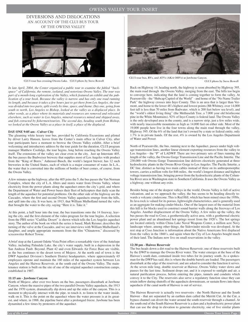
Lay of the Land Summer 2004 Owens Tour Insert Page 1
Back on Highway 14, heading north, the highway is soon absorbed by Highway 395, the main road through the Owens Valley, merging from the east. The hills too begin to converge here, indicating that the land is coming together to form the valley. At Pearsonville - the “Hubcap Capitol of the World” - and home of the “No Name Trailer Park” the highway crosses into Inyo County. This is an area that is larger than Ver-mont, and home to the lower 48ʼs highest and lowest points (Mt Whitney, over 14,000 feet tall is less than 70 miles from Badwater, which is 200 feet below sea level), and the “worldʼs oldest living thing” (the Methuselah Tree, a 7,000 year old bristlecone pine in the White Mountains). 92% of Inyo County is federal land. The Owens Valley is the only developed area in the county, and is a narrow strip, just a few miles wide, with nearly inaccessible mountains as high as 14,000 feet on either side. Most of the 19,000 people here live in the four towns along the main road through the valley, Highway 395. Of the 6% of the land that isnʼt owned by a state or federal entity, only 1.7% is in private hands. Of the rest, 4% is owned by the Los Angeles Department of Water and Power.
North of Pearsonville, the bus, running next to the Aqueduct, passes under high volt-age transmission lines, another linear element exporting resources from the valley to Los Angeles - the “P” of LADWP. There are two primary sets of lines running the length of the valley, the Owens Gorge Transmission Line and the Pacifi c Intertie. The 230,000 volt Owens Gorge Transmission line delivers electricity generated at three hydroelectric plants in the Owens River Gorge to Los Angeles. The Pacifi c Intertie, a DC line, distinct as having two main cables instead of three on its anthropomorphic towers, carries a million volts for 846 miles, the worldʼs longest distance and highest voltage transmission line, bringing power from the hydroelectric plants of the Colum-bia River area in Washington state to Southern California. It uses the Owens Valley as a highway, one without any exits.
Besides being one of the deepest valleys in the world, Owens Valley is full of active vulcanism, and as we approach the valley, the bus seems to be heading directly to-wards a volcanic cindercone. This is Red Hill, which has been mined since the 1950s. Its lava rock is valued for its porous, lightweight characteristics, and is generally used as an aggregate for making cinder blocks. One of the largest uses of the material from this hill is for blocks used to construct sound barrier walls along the freeways of Los Angeles. Another displacement of the Owens Valley. A few miles up the valley, the bus passes the road to Coso, a geothermically active area, with a geothermal electric power plant and an abandoned hot springs resort from the 1920ʼs. The hot springs are located entirely within China Lake Naval Weapons Center, a million acre Navy landscape where, among other things, the Sidewinder missile was developed. At the rest stop at Coso Junction is information about the Native Americans fi rst displaced from the valley in the 1860ʼs, and again when the City of Los Angeles bought much of their land. The Indians now live on small reservations in the valley.
12:30 pm - Haiwee ReservoirThe bus heads down a dirt road to the Haiwee Reservoir, one of three reservoirs built by the DWP to manage the Owens River water. The water emerges at the base of the Haiweeʼs south dam, contained inside two tubes for its journey south. As a spokes-man for the DWP has said, this is where the double barrels are loaded. The passengers disembark at the edge of the reservoir, and are asked to consider the function it serves. At the seven mile long, double reservoir at Haiwee, Owens Valley water slows and pauses for the last time. Sediment drops out, and it is exposed to sunlight and air, a natural purifi cation process, before entering the pipes, tunnels and conduits which convey it to the City. The reservoirs also serve a regulatory function since they can retain infl ow during shutoffs of the aqueducts downstream, or sustain fl ows into these aqueducts if the canal north of Haiwee is out of service.
The Haiwee Reservoir is actually two reservoirs - the North Haiwee and the South Haiwee - that are separated by an earthen dam called the Merritt Cut. At the Cut, a bypass channel can divert the water around the south reservoir through a channel. At the south end of the South Haiwee Reservoir is a dam and a hydroelectric power plant that can use the drop in elevation to generate electricity, one of fi ve similar plants
CLUI tour bus crossing Owens Lake. CLUI photo by Steve Rowell
DIVERSIONS AND DISLOCATIONSAN ACCOUNT OF THE CLUI BUS TOUR
OF THE OWENS VALLEY
In late April, 2004, the Center organized a public tour to examine the fabled “back-space” of California, the remote, isolated, and notorious Owens Valley. The tour was part of a month-long exploration of the Valley, which featured an exhibit and the pub-lication of a tour book. Because the valley is narrow and has only one road running its length, and because it takes a few hours just to get there from Los Angeles, the tour was divided into two parts, split evenly by time, space, and theme. Day one, going from south to north, Los Angeles to Bishop, looked at the valley as a displaced place. In other words, as a place where its materials and resources are removed and relocated elsewhere, such as water to Los Angeles, mineral resources mined and shipped away, and fi sh extracted by fi shermen/tourists. The second day, heading south from Bishop, we looked at the Owens Valley as a place in itself, a place of the displaced.
DAY ONE 9:05 am - Culver CityThe gleaming white luxury tour bus, provided by California Excursions and piloted by driver Larry Hansen, leaves from the Centerʼs main offi ce in Culver City, after tour participants have a moment to browse the Owens Valley exhibit. After a brief welcoming and introductory address by the tour guide for the duration, CLUI program manager Matthew Coolidge, the tour begins, long before reaching the Owens Valley itself. The extensions of the valley are clear even in the city. Just up Interstate 405, the bus passes the Budweiser brewery that supplies most of Los Angeles with product from the “King of Beers.” Anheuser-Busch, the worldʼs largest brewer, has 12 such breweries in the United States, each of which is a major consumer of water. In L.A., the water that is converted into the millions of bottles of beer comes, of course, from the Owens Valley.
A few minutes up the highway, after the 405 joins the 5, the bus passes the Van Norman Complex, where the city of L.A. fi lters and stores water from Owens Valley, where electricity from the power plants along the aqueduct enters the cityʼs grid, and where the Department of Water and Power bases their fl eet of helicopters that daily scan the length of the aqueduct for potential problems. On the other side of the highway are the Cascades, where the fi rst and second Owens Valley aqueducts emerge from the hills, and spill into the city. It was here, in 1913, that William Mulholland turned the valve that brought the water to the city, saying “Here it is. Take it.”
At this point, a half hour into the tour, the bus transitions onto the 14 freeway, leav-ing the city, and the fi rst element of the video program for the tour begins. A selection from the PBS series “Cadillac Desert” is shown which tells the Los Angeles aqueduct story. The author of the book on which the series is based, Mark Reisner, describes the turning of the valve at the Cascades, and we see interviews with William Mulhollandʼs daughter, and ample appropriate moments from the fi lm “Chinatown,” discussed by screenwriter Robert Towne.
A brief stop at the Lamont Odette Vista Point offers a remarkable view of the Antelope Valley, including Palmdale Lake, the cityʼs water supply, built in a depression in the San Andreas Fault. Beyond, Plant 42 and even Edwards Air Force Base are visible, as the bus continues to the desert town of Mojave. At the north end of town is the DWP Aqueduct Divisionʼs Southern District headquarters, where approximately 65 employees operate and maintain the 160 miles of the aqueduct system between Los Angeles and the Haiwee Reservoir, at the south end of the Owens Valley. The main-tenance station is built on the site of one of the original aqueduct construction camps, established in 1907.
11:15 am - Jawbone CanyonNorth of Mojave, after over two hours on the bus, passengers disembark at Jawbone Canyon, where the massive pipes of the two parallel Owens Valley aqueducts, the 1913 and the 1970 system, dramatically dip down and up the sides of the canyon. This is a moment to physically interact with the pipe, to touch it, to listen to the water inside, walk on it. This is the point on the aqueduct where the water pressure is at its great-est, and where, in 1988, the pipeline burst after a prolonged freeze. Jawbone has been dynamited a few times by protesters of the aqueduct.
CLUI tour bus, RVs, and ATVs (AKA OHVs) at Jawbone Canyon. CLUI photo by Steve Rowell
OWENS VALLEY TOUR INSERT
Lay of the Land Lay of the Land Summer 2004 Owens Tour Insert Page 1Insert Page 1
Back on Highway 14, heading north, the highway is soon absorbed by Highway 395, the main road through the Owens Valley, merging from the east. The hills too begin to converge here, indicating that the land is coming together to form the valley. At Pearsonville - the “Hubcap Capitol of the World” - and home of the “No Name Trailer Park” the highway crosses into Inyo County. This is an area that is larger than Ver-mont, and home to the lower 48ʼs highest and lowest points (Mt Whitney, over 14,000 feet tall is less than 70 miles from Badwater, which is 200 feet below sea level), and the “worldʼs oldest living thing” (the Methuselah Tree, a 7,000 year old bristlecone pine in the White Mountains). 92% of Inyo County is federal land. The Owens Valley is the only developed area in the county, and is a narrow strip, just a few miles wide, with nearly inaccessible mountains as high as 14,000 feet on either side. Most of the 19,000 people here live in the four towns along the main road through the valley, Highway 395. Of the 6% of the land that isnʼt owned by a state or federal entity, only 1.7% is in private hands. Of the rest, 4% is owned by the Los Angeles Department of Water and Power.
North of Pearsonville, the bus, running next to the Aqueduct, passes under high volt-age transmission lines, another linear element exporting resources from the valley to Los Angeles - the “P” of LADWP. There are two primary sets of lines running the length of the valley, the Owens Gorge Transmission Line and the Pacifi c Intertie. The 230,000 volt Owens Gorge Transmission line delivers electricity generated at three hydroelectric plants in the Owens River Gorge to Los Angeles. The Pacifi c Intertie, a DC line, distinct as having two main cables instead of three on its anthropomorphic towers, carries a million volts for 846 miles, the worldʼs longest distance and highest voltage transmission line, bringing power from the hydroelectric plants of the Colum-bia River area in Washington state to Southern California. It uses the Owens Valley as a highway, one without any exits.
Besides being one of the deepest valleys in the world, Owens Valley is full of active vulcanism, and as we approach the valley, the bus seems to be heading directly to-wards a volcanic cindercone. This is Red Hill, which has been mined since the 1950s. Its lava rock is valued for its porous, lightweight characteristics, and is generally used as an aggregate for making cinder blocks. One of the largest uses of the material from this hill is for blocks used to construct sound barrier walls along the freeways of Los Angeles. Another displacement of the Owens Valley. A few miles up the valley, the bus passes the road to Coso, a geothermically active area, with a geothermal electric power plant and an abandoned hot springs resort from the 1920ʼs. The hot springs are located entirely within China Lake Naval Weapons Center, a million acre Navy landscape where, among other things, the Sidewinder missile was developed. At the rest stop at Coso Junction is information about the Native Americans fi rst displaced from the valley in the 1860ʼs, and again when the City of Los Angeles bought much of their land. The Indians now live on small reservations in the valley.
12:30 pm - Haiwee ReservoirThe bus heads down a dirt road to the Haiwee Reservoir, one of three reservoirs built by the DWP to manage the Owens River water. The water emerges at the base of the Haiweeʼs south dam, contained inside two tubes for its journey south. As a spokes-man for the DWP has said, this is where the double barrels are loaded. The passengers disembark at the edge of the reservoir, and are asked to consider the function it serves. At the seven mile long, double reservoir at Haiwee, Owens Valley water slows and pauses for the last time. Sediment drops out, and it is exposed to sunlight and air, a natural purifi cation process, before entering the pipes, tunnels and conduits which convey it to the City. The reservoirs also serve a regulatory function since they can retain infl ow during shutoffs of the aqueducts downstream, or sustain fl ows into these aqueducts if the canal north of Haiwee is out of service.
The Haiwee Reservoir is actually two reservoirs - the North Haiwee and the South Haiwee - that are separated by an earthen dam called the Merritt Cut. At the Cut, a bypass channel can divert the water around the south reservoir through a channel. At the south end of the South Haiwee Reservoir is a dam and a hydroelectric power plant that can use the drop in elevation to generate electricity, one of fi ve similar plants
CLUI tour bus crossing Owens Lake. CLUI photo by Steve Rowell
DIVERSIONS AND DISLOCATIONSAN ACCOUNT OF THE CLUI BUS TOUR
OF THE OWENS VALLEY
In late April, 2004, the Center organized a public tour to examine the fabled “back-space” of California, the remote, isolated, and notorious Owens Valley. The tour was part of a month-long exploration of the Valley, which featured an exhibit and the pub-lication of a tour book. Because the valley is narrow and has only one road running its length, and because it takes a few hours just to get there from Los Angeles, the tour was divided into two parts, split evenly by time, space, and theme. Day one, going from south to north, Los Angeles to Bishop, looked at the valley as a displaced place. In other words, as a place where its materials and resources are removed and relocated elsewhere, such as water to Los Angeles, mineral resources mined and shipped away, and fi sh extracted by fi shermen/tourists. The second day, heading south from Bishop, we looked at the Owens Valley as a place in itself, a place of the displaced.
DAY ONE 9:05 am - Culver CityThe gleaming white luxury tour bus, provided by California Excursions and piloted by driver Larry Hansen, leaves from the Centerʼs main offi ce in Culver City, after tour participants have a moment to browse the Owens Valley exhibit. After a brief welcoming and introductory address by the tour guide for the duration, CLUI program manager Matthew Coolidge, the tour begins, long before reaching the Owens Valley itself. The extensions of the valley are clear even in the city. Just up Interstate 405, the bus passes the Budweiser brewery that supplies most of Los Angeles with product from the “King of Beers.” Anheuser-Busch, the worldʼs largest brewer, has 12 such breweries in the United States, each of which is a major consumer of water. In L.A., the water that is converted into the millions of bottles of beer comes, of course, from the Owens Valley.
A few minutes up the highway, after the 405 joins the 5, the bus passes the Van Norman Complex, where the city of L.A. fi lters and stores water from Owens Valley, where electricity from the power plants along the aqueduct enters the cityʼs grid, and where the Department of Water and Power bases their fl eet of helicopters that daily scan the length of the aqueduct for potential problems. On the other side of the highway are the Cascades, where the fi rst and second Owens Valley aqueducts emerge from the hills, and spill into the city. It was here, in 1913, that William Mulholland turned the valve that brought the water to the city, saying “Here it is. Take it.”
At this point, a half hour into the tour, the bus transitions onto the 14 freeway, leav-ing the city, and the fi rst element of the video program for the tour begins. A selection from the PBS series “Cadillac Desert” is shown which tells the Los Angeles aqueduct story. The author of the book on which the series is based, Mark Reisner, describes the turning of the valve at the Cascades, and we see interviews with William Mulhollandʼs daughter, and ample appropriate moments from the fi lm “Chinatown,” discussed by screenwriter Robert Towne.
A brief stop at the Lamont Odette Vista Point offers a remarkable view of the Antelope Valley, including Palmdale Lake, the cityʼs water supply, built in a depression in the San Andreas Fault. Beyond, Plant 42 and even Edwards Air Force Base are visible, as the bus continues to the desert town of Mojave. At the north end of town is the DWP Aqueduct Divisionʼs Southern District headquarters, where approximately 65 employees operate and maintain the 160 miles of the aqueduct system between Los Angeles and the Haiwee Reservoir, at the south end of the Owens Valley. The main-tenance station is built on the site of one of the original aqueduct construction camps, established in 1907.
11:15 am - Jawbone CanyonNorth of Mojave, after over two hours on the bus, passengers disembark at Jawbone Canyon, where the massive pipes of the two parallel Owens Valley aqueducts, the 1913 and the 1970 system, dramatically dip down and up the sides of the canyon. This is a moment to physically interact with the pipe, to touch it, to listen to the water inside, walk on it. This is the point on the aqueduct where the water pressure is at its great-est, and where, in 1988, the pipeline burst after a prolonged freeze. Jawbone has been dynamited a few times by protesters of the aqueduct.
CLUI tour bus, RVs, and ATVs (AKA OHVs) at Jawbone Canyon. CLUI photo by Steve Rowell
OWENS VALLEY TOUR INSERT

Lay of the Land Summer 2004 Owens Tour Insert Page 2
1:10 pm - CartagoCartago, 130 years ago, was a port on the west side of Owens Lake, where steam-ships, such as the “Bessie Brady” and the “Molly Stevens” docked, unloading silver from the Cerro Gordo mines, in the mountains across the lake, to be transferred to the roads and rails leading to Los Angeles. When the 100 square mile lake dried up after the aqueduct was built, soda ash plants processed brine at Cartago. The Ameri-can Potash company plant, which once had a 600 foot tall stack, is now enigmatic walls, blocks, and stepped stabs of concrete, next to a gleaming mountain of unused soda. The bus lumbers through these ruins and stops for a picnic lunch. Sandwiches, prepared by the Ranch House restaurant in Olancha, are laid out in a chow line on the edge of an empty slab.
After we have lunch, the bus heads out onto the lakebed itself. This side of the lake surface is dominated by its history as an extractive resource. DWP diversion of the sources of water that fed the lake, starting in 1910 or so, accompanied by a severe drought in the early 1920ʼs, caused Owens Lake to desiccate completely by 1928. By this time, companies had already established mining processes on the lake bed, using the dry air to evaporate water and concentrate material in evaporation ponds. With the entire lake bed exposed, the job of mining it just became easier.
Sodium carbonate mined from the lake has been used in the production of fi berglass, in powdered detergents, in medicine, as a food additive, in photographic chemicals, for pH control of water, and in a host of chemical industry applications from scrub-bing sulfur from smokestack emissions to explosives. The primary use of the mate-rial has been to make glass, and a large abandoned Pittsburgh Plate Glass Company plant, between the highway and the lake, is the most scenic ruin in the valley. The active mining areas of the lake are now operated by the US Borax Company, which leases over 16,000 acres on the west side of the lake, and has an extensive network of ponds, dikes, roads, and storage pans. The owner of the 100 or so square miles of the lake surface is the State of California, which owns all navigable waterways within the state. Owens Lake of course was one, in 1913, when the lake area was surveyed before its disappearance.
2:00 pm - US Borax Owens Lake OperationsAt the gate of the US Borax property, we are met by Paul Lamos, who boards the bus to guide us through the startling landforms of the mining operation, where pools of bright red water enclosed by crystalline crusts and accreted salt cones create a land-scape of severe desiccation.
Back on 395 North, the bus passes the Cottonwood Hydroelectric Power Station, the oldest DWP power station in service today. The fi rst of two turbine generators there went “on line” November 13, 1908, to power the electric dredges building the aqueduct, and is still producing energy for the DWPʼs Owens Valley electric system. As at other remote hydroelectric plants and pumping stations, the DWP has a small
village of a few houses for the maintenance crew of the plant and their families. At Cottonwood, the old wooden houses and the tree lined street is illuminated at night by the same old lamp posts that have long since been removed from most neighborhoods in Los Angeles.
Three miles further up the road the ruins of the Pittsburgh Plate Glass plant appear, with its low slung modernist lab and administration building near the road, and its Sheeler-esque metal sheds and silo complex behind. The number of disabled RVs at the plant has increased dramatically in recent years, indicating a change in tenants, and the emergence of a new chapter in the intriguing and unformed history of this place. For most of the time since its closure in 1968, it was owned by a Dr. McCabe, who invented some sort of heart valve, and who had some connection to a community of Hollywood actors, who seemed to use the buildings as a place for interesting parties. Since his passing, the buildings, which by now have been disconnected from any utilities, have changed hands a few times, but have continued to be a residence for some remnants of this social circle. Upstairs in the old lab building is an unpacked museum of the accomplishments of Dr. McCabe. As we pass the plant, we leave its mysteries intact, and now Owens Lake is behind us. We look forward to the rest of the sites of displacement in the valley ahead.
One of the most famous sites of the ongoing battle between Owens Valley residents and the Department of Water and Power is the Alabama Gates, a set of valves on the aque-duct with the ability to divert the fl ow of the aqueduct into a spillway that leads to the old Owens River channel. Located next to the highway, they still look as they did in 1924 when a few dozen locals took control of the site, and opened the gates. The local occupa-tion of the site was well publicized, and as the crowds swelled, it became a festive period lasting for days. The fi lm star Tom Mix sent a band to entertain the crowd. Eventually, of course, order was restored, and the gates were closed. With the construction of Crowley Lake, above the north end of the valley, which can hold large amounts of water, the func-tion of the gates, to remove water from the aqueduct in times of over abundance, has ended. But someone still lives on the premises for security and maintenance.
3:15 pm - Mount Whitney Fish HatcheryContinuing up the road of displacement, we arrive at the next subject of the tour, and a major resource extracted from the Owens Valley - fi sh. While no fi gures exist for the Owens Valley itself, state-wide the sport fi shing industry is a three billion dollar per year activity. Our tour was held on the opening of the trout fi shing season, and people could be seen wading in streams and fl oating on reservoirs throughout the valley. The bus pulls up to the Mount Whitney Fish Hatchery, a stone institutional building with a three story tower, built in 1917, the grandest and the oldest of the three state run fi sh hatcheries in the valley. Here we meet with the only employee on site, who shows us around the cav-ernous hatchery room, with rows of tanks and tables, only a few of which were in use. In fact, this hatchery hasnʼt hatched any fi sh in over a decade, and will not ever again, as in the late 1980s it tested positive for whirling disease, a parasite that attacks the nervous system of fi sh and makes them swim in spirals. Though it still manages unhatched eggs, the echoing, hatchless hatchery feels more like a mausoleum then a nursery.
Not that there ever was any trout in the Owens Valley to begin with. All the game fi sh here were created by the state run Department of Fish and Game to generate a rec-reational industry, which is now supported largely through fees collected for fi shing licenses. The Owens Valley, while it drains the snowy eastern Sierra, is dry, and has been connected to the ocean for less than a hundred years, through the plumbing constructed by the DWP. Its drainage channel, the Owens River, historically terminated at Owens Lake, or in the desert beyond. The fi sh that are indigenous are more like those found in desert waterways, small pup fi sh and suckers, left over from the larger lakes and rivers of the last ice age. Trout, and other game fi sh now in the streams and lakes of the valley were artifi cially introduced to the watershed in the 1870s, brought over from the western Sierras or elsewhere. The golden trout, for example, the offi cial State Fish of California, was said to have been introduced to the eastern Sierra from the Kern River, which used to connect to the ocean, via the Golden Gate, but which now dissipates into the industrial agriculture of the San Joaquin Valley. Like other game fi sh here, the golden trout has its eggs collected from pregnant females in the lakes, then the eggs are fertilized at the Mount Whitney Hatchery, then moved to other hatcheries to hatch and be raised into fi n-gerlings that are loaded on board a tanker airplane that takes off from Mammoth Lakes Airport and dumps the fi sh back into lakes in the Sierras. If this cycle were to stop, all game fi sh in the eastern Sierra would soon disappear.
The tour continues on, while contemplating the implications of this artifi cially created and maintained system, and the assumption by many that it is a natural phenomenon. Further evidence, as if more were needed, of the involvement of humans in the “natural” order.
5:00 pm - Los Angeles Aqueduct IntakeThe bus arrives at the last stop for the day, at perhaps the most iconic landmark of dis-placement in the valley: the Los Angeles Aqueduct Intake gate. It is here that the Owens River, coming in from the north, is diverted towards this structure and offi cially enters the original Los Angeles Aqueduct system. By now, the system has been extended to the Mono Basin to the north, and a second aqueduct has been built. But this isolated cement structure still looks, feels and is, signifi cant. The Owens River rounds an artifi cially con-structed and leveed right angle turn into the concrete archway of the gate, fl owing under the words and letters “Los Angeles Aqueduct Intake MCMXI” etched into the concrete above, and into a concrete lined channel. Besides the bermed up waterway, the land is
built by the DWP in the valley. At the north end of the North Haiwee Reservoir is an-other dam, next to the channel where the aqueduct water enters the reservoir. Swimming is not allowed in the Haiwee, though fi shing with rubberized waders is permitted.
Back on the highway heading north, Owens Lake comes into view, and we approach the settlements of Olancha and Cartago. We pass the Cabin Bar Ranch, which looks aban-doned. It was bought by Anheuser-Busch in 1986 for the water rights, during a drought. Apparently, by not pumping water from the wells it owns in the valley, the company has been able to negotiate with the DWP for a water credit that allows it to use more of the Aqueduct water downstream, at the big beer plant we passed in Van Nuys. Some local residents talk bitterly about other stealthy corporate land purchases like this, for com-panies that bottle water from municipal sources in Los Angeles. One company that still bottles water at its spring source, for the most part, is Crystal Geyser, the most popular bottled brand in Southern California. In Olancha, the bus passes the sprawling blue plant on the east side of the highway, which sits on top of the captured spring, near the shore of the dried up Owens Lake. Truckloads of Crystal Geyser water drive south on the 395, carrying water from this plant, paralleling the Aqueduct.
Chow line set up on a slab of the ruins at Cartago. CLUI photo by Steve Rowell
Lay of the Land Lay of the Land Summer 2004 Owens Tour Insert Page Insert Page 2
1:10 pm - CartagoCartago, 130 years ago, was a port on the west side of Owens Lake, where steam-ships, such as the “Bessie Brady” and the “Molly Stevens” docked, unloading silver from the Cerro Gordo mines, in the mountains across the lake, to be transferred to the roads and rails leading to Los Angeles. When the 100 square mile lake dried up after the aqueduct was built, soda ash plants processed brine at Cartago. The Ameri-can Potash company plant, which once had a 600 foot tall stack, is now enigmatic walls, blocks, and stepped stabs of concrete, next to a gleaming mountain of unused soda. The bus lumbers through these ruins and stops for a picnic lunch. Sandwiches, prepared by the Ranch House restaurant in Olancha, are laid out in a chow line on the edge of an empty slab.
After we have lunch, the bus heads out onto the lakebed itself. This side of the lake surface is dominated by its history as an extractive resource. DWP diversion of the sources of water that fed the lake, starting in 1910 or so, accompanied by a severe drought in the early 1920ʼs, caused Owens Lake to desiccate completely by 1928. By this time, companies had already established mining processes on the lake bed, using the dry air to evaporate water and concentrate material in evaporation ponds. With the entire lake bed exposed, the job of mining it just became easier.
Sodium carbonate mined from the lake has been used in the production of fi berglass, in powdered detergents, in medicine, as a food additive, in photographic chemicals, for pH control of water, and in a host of chemical industry applications from scrub-bing sulfur from smokestack emissions to explosives. The primary use of the mate-rial has been to make glass, and a large abandoned Pittsburgh Plate Glass Company plant, between the highway and the lake, is the most scenic ruin in the valley. The active mining areas of the lake are now operated by the US Borax Company, which leases over 16,000 acres on the west side of the lake, and has an extensive network of ponds, dikes, roads, and storage pans. The owner of the 100 or so square miles of the lake surface is the State of California, which owns all navigable waterways within the state. Owens Lake of course was one, in 1913, when the lake area was surveyed before its disappearance.
2:00 pm - US Borax Owens Lake OperationsAt the gate of the US Borax property, we are met by Paul Lamos, who boards the bus to guide us through the startling landforms of the mining operation, where pools of bright red water enclosed by crystalline crusts and accreted salt cones create a land-scape of severe desiccation.
Back on 395 North, the bus passes the Cottonwood Hydroelectric Power Station, the oldest DWP power station in service today. The fi rst of two turbine generators there went “on line” November 13, 1908, to power the electric dredges building the aqueduct, and is still producing energy for the DWPʼs Owens Valley electric system. As at other remote hydroelectric plants and pumping stations, the DWP has a small
village of a few houses for the maintenance crew of the plant and their families. At Cottonwood, the old wooden houses and the tree lined street is illuminated at night by the same old lamp posts that have long since been removed from most neighborhoods in Los Angeles.
Three miles further up the road the ruins of the Pittsburgh Plate Glass plant appear, with its low slung modernist lab and administration building near the road, and its Sheeler-esque metal sheds and silo complex behind. The number of disabled RVs at the plant has increased dramatically in recent years, indicating a change in tenants, and the emergence of a new chapter in the intriguing and unformed history of this place. For most of the time since its closure in 1968, it was owned by a Dr. McCabe, who invented some sort of heart valve, and who had some connection to a community of Hollywood actors, who seemed to use the buildings as a place for interesting parties. Since his passing, the buildings, which by now have been disconnected from any utilities, have changed hands a few times, but have continued to be a residence for some remnants of this social circle. Upstairs in the old lab building is an unpacked museum of the accomplishments of Dr. McCabe. As we pass the plant, we leave its mysteries intact, and now Owens Lake is behind us. We look forward to the rest of the sites of displacement in the valley ahead.
One of the most famous sites of the ongoing battle between Owens Valley residents and the Department of Water and Power is the Alabama Gates, a set of valves on the aque-duct with the ability to divert the fl ow of the aqueduct into a spillway that leads to the old Owens River channel. Located next to the highway, they still look as they did in 1924 when a few dozen locals took control of the site, and opened the gates. The local occupa-tion of the site was well publicized, and as the crowds swelled, it became a festive period lasting for days. The fi lm star Tom Mix sent a band to entertain the crowd. Eventually, of course, order was restored, and the gates were closed. With the construction of Crowley Lake, above the north end of the valley, which can hold large amounts of water, the func-tion of the gates, to remove water from the aqueduct in times of over abundance, has ended. But someone still lives on the premises for security and maintenance.
3:15 pm - Mount Whitney Fish HatcheryContinuing up the road of displacement, we arrive at the next subject of the tour, and a major resource extracted from the Owens Valley - fi sh. While no fi gures exist for the Owens Valley itself, state-wide the sport fi shing industry is a three billion dollar per year activity. Our tour was held on the opening of the trout fi shing season, and people could be seen wading in streams and fl oating on reservoirs throughout the valley. The bus pulls up to the Mount Whitney Fish Hatchery, a stone institutional building with a three story tower, built in 1917, the grandest and the oldest of the three state run fi sh hatcheries in the valley. Here we meet with the only employee on site, who shows us around the cav-ernous hatchery room, with rows of tanks and tables, only a few of which were in use. In fact, this hatchery hasnʼt hatched any fi sh in over a decade, and will not ever again, as in the late 1980s it tested positive for whirling disease, a parasite that attacks the nervous system of fi sh and makes them swim in spirals. Though it still manages unhatched eggs, the echoing, hatchless hatchery feels more like a mausoleum then a nursery.
Not that there ever was any trout in the Owens Valley to begin with. All the game fi sh here were created by the state run Department of Fish and Game to generate a rec-reational industry, which is now supported largely through fees collected for fi shing licenses. The Owens Valley, while it drains the snowy eastern Sierra, is dry, and has been connected to the ocean for less than a hundred years, through the plumbing constructed by the DWP. Its drainage channel, the Owens River, historically terminated at Owens Lake, or in the desert beyond. The fi sh that are indigenous are more like those found in desert waterways, small pup fi sh and suckers, left over from the larger lakes and rivers of the last ice age. Trout, and other game fi sh now in the streams and lakes of the valley were artifi cially introduced to the watershed in the 1870s, brought over from the western Sierras or elsewhere. The golden trout, for example, the offi cial State Fish of California, was said to have been introduced to the eastern Sierra from the Kern River, which used to connect to the ocean, via the Golden Gate, but which now dissipates into the industrial agriculture of the San Joaquin Valley. Like other game fi sh here, the golden trout has its eggs collected from pregnant females in the lakes, then the eggs are fertilized at the Mount Whitney Hatchery, then moved to other hatcheries to hatch and be raised into fi n-gerlings that are loaded on board a tanker airplane that takes off from Mammoth Lakes Airport and dumps the fi sh back into lakes in the Sierras. If this cycle were to stop, all game fi sh in the eastern Sierra would soon disappear.
The tour continues on, while contemplating the implications of this artifi cially created and maintained system, and the assumption by many that it is a natural phenomenon. Further evidence, as if more were needed, of the involvement of humans in the “natural” order.
5:00 pm - Los Angeles Aqueduct IntakeThe bus arrives at the last stop for the day, at perhaps the most iconic landmark of dis-placement in the valley: the Los Angeles Aqueduct Intake gate. It is here that the Owens River, coming in from the north, is diverted towards this structure and offi cially enters the original Los Angeles Aqueduct system. By now, the system has been extended to the Mono Basin to the north, and a second aqueduct has been built. But this isolated cement structure still looks, feels and is, signifi cant. The Owens River rounds an artifi cially con-structed and leveed right angle turn into the concrete archway of the gate, fl owing under the words and letters “Los Angeles Aqueduct Intake MCMXI” etched into the concrete above, and into a concrete lined channel. Besides the bermed up waterway, the land is
built by the DWP in the valley. At the north end of the North Haiwee Reservoir is an-other dam, next to the channel where the aqueduct water enters the reservoir. Swimming is not allowed in the Haiwee, though fi shing with rubberized waders is permitted.
Back on the highway heading north, Owens Lake comes into view, and we approach the settlements of Olancha and Cartago. We pass the Cabin Bar Ranch, which looks aban-doned. It was bought by Anheuser-Busch in 1986 for the water rights, during a drought. Apparently, by not pumping water from the wells it owns in the valley, the company has been able to negotiate with the DWP for a water credit that allows it to use more of the Aqueduct water downstream, at the big beer plant we passed in Van Nuys. Some local residents talk bitterly about other stealthy corporate land purchases like this, for com-panies that bottle water from municipal sources in Los Angeles. One company that still bottles water at its spring source, for the most part, is Crystal Geyser, the most popular bottled brand in Southern California. In Olancha, the bus passes the sprawling blue plant on the east side of the highway, which sits on top of the captured spring, near the shore of the dried up Owens Lake. Truckloads of Crystal Geyser water drive south on the 395, carrying water from this plant, paralleling the Aqueduct.
Chow line set up on a slab of the ruins at Cartago. CLUI photo by Steve Rowell

Lay of the Land Summer 2004 Owens Tour Insert Page 3
fl at and reedy, and there are no other structures in the area. Its a lonely place, with the aqueduct quietly, perpetually, at work, whether anyone is there to see it or not. From here the water fl ows by gravity 233 miles, through power plants, siphons, tunnels, and reservoirs, until it spills out of the hillside in the north end of the San Fernando Valley, next to the new Cascades offi ce park.
The bus pulls into the visitor center parking lot in Bishop, in the middle of the main (and only) drag in the largest and northernmost town in the Owens Valley. The pas-sengers disembark for the brief walk to their motels, where despite the quantity of rooms in this relatively small town, reservations had to be made in advance, because this was, after all, the opening weekend of fi shing season.
DAY TWO 9:00 am - BishopOn the morning of the next day, after loading up with baked goods from Schats, ev-eryone is back on the bus for the return journey. Though we travel on the same road we came in on, we now look, fi guratively, at another side of the Owens Valley. Instead of focusing on the things removed from it - the valley as source and resource - we now examine the things that came to it - its constituents, its places, communities, and history - and we see how so much of the valley is made from things that have their ori-gins elsewhere. Isolated by geography and topography, the valley serves as an away place for the distant cities. As such, a culture of relocation and isolation is in evidence here. On the way back, we look at Owens Valley as a Place of the Displaced.
9:30 am - Owens Valley Radio Astronomy ObservatoryAt the Owens Valley Radio Astronomy Observatory, we arrive on time for our appoint-ment with a representative who had arranged to meet us for a briefi ng, but he was no-where to be found. The bus moves to the various complexes and idles while someone goes in to look for someone. All the offi ces and labs are unlocked and deserted. In one building, nobody sat in front of the rows of computer monitors, in front of a wide win-dow that overlooks one of the antenna arrays. In another, a laboratory or maintenance building, complex equipment and parts surrounds partially assembled portions of some sort of astronomical instrumentation, next to racks of blinking electronics. Outside, huge radio dishes with distinct functions loom enigmatically, pointed towards distant points unknown. Eventually we disembark and wander around this unpeopled place, among these potent emblems of the mysteries of the universe.
Then, from nowhere, someone appears and asked the ultimate, universal question: why were we here? To learn about this place, of course, was the unsaid response. Erik Leitch, an astronomer from the University of Chicago, working on a new antenna array that will soon be installed up the hill, kindly offers to serve as interpreter of the observatory, and guides us around, pointing things out and explaining the function of the facility from the front of the bus. The observatory is here because the region is remote, and the mountains cut off a lot of the stray radio signals that can interfere with radio astronomy. It is also dry, which makes for clearer skies. Most of the site is operated by Caltech. The different antenna systems at the site include the Millimeter Array, which consists of six 10-meter dishes on a confi gurable track, which will soon be expanded and moved to a new loca-tion, higher up the mountains, at an elevation of 8,000 feet. There is a solar interferom-eter antenna array, with two 27-meter dishes, which make observations of solar weather; two Cosmic microwave background antennas, including the largest antenna on site, a 140 foot wide steerable dish; and at the east end of the site is the Very Long Baseline Ar-ray (VLBA) antenna, which is one of a network of ten similar antennas located at sites across the United States that make up the VLBA, a National Science Foundation project. Together, these antennas make this one of the largest radio astronomy sites in the na-tion. Out on the fl ats, near the Owens River, this site draws the faintest and most distant places that we can detect, the furthest reaches of the universe, into the human realm. The site even displaces time, as the further out into space you look, the further back in time you go - you get closer to the Big Bang, the current word for the origin of everything.
The past also comes to the present in the mountains above the Observatory, in a grove of withered, desiccated, but tenacious bristlecone pine trees. Among them is the Me-thuselah Tree, which at 4,723 years old, has been called the oldest living thing in the world. Despite the notoriety of the tree, its identity is not indicated on the walking trail,
CLUI tour bus at empty Owens Valley Radio Astronomy Observatory. CLUI photo by Steve Rowell
in order to protect it from souvenir-hunters and vandals, which have already left their mark. The tree is a sort of invisible attraction. Its status as the “oldest living thing” is of course debatable. A recently discovered, but less dramatic creosote bush in the Mojave is said to be 11,700 years old.
Above the bristle cone pines, higher up the spine of the White Mountains, is the White Mountain Research Station, a high altitude and alpine research complex, composed of four facilities, located at different elevations on the peaks. The highest of these stations, the Summit Laboratory, is a small building 14,250 feet above sea level and is the highest high-altitude lab in North America (and fourth highest in the world). Research is conducted in a variety of disciplines, including archeology, physiology, biology, and aerospace. The research station was founded by the Navy in 1940, and is operated by the University of California.
But these lofty sites, though they represent the valleyʼs rim, are out of range of the tour. So the bus heads back out to the 395, and south again. North of the town of Big Pine is a big pine tree, which is often assumed to be THE big pine, from which the town gets its name. But this big pine (actually a Sequoia) at the intersection of High-way 168, was planted later, in 1913, to commemorate the opening of the Westgard Pass road, one of few roads that make it out of the Owens Valley, and which was promoted by hopeful locals at the time as a possible transcontinental thoroughfare. Connecting to an even more remote valley (Nevadaʼs Fish Lake Valley) the highway is used mostly for local traffi c. Even so, the only settlement along it is Deep Springs College, a school that while replete with quality (with full tuition paid for all students and average SAT scores around 1500), is lacking in quantity (with a student body of around 26 people). The big pine that DID give the town its name, incidentally, is said to have been cut down to make way for a gas station.
South of Big Pine, the highway passes through an area where a displaced herd of Tule Elk roams freely, placed here by the state, despite not being native to the Owens Valley. Tule are the smallest form of elk, and once roamed the Central Valley and Coast Range of California, their main habitat, until being hunted nearly to extinction by 1870, forced off their land by the rapidly spreading agricultural industry. Owens Valleyʼs Tule Elk herd had originally been relocated in the Yosemite Valley, but were later evicted by the Park Service, as they are not native to Yosemite either. Though exotics, like the students of Deep Springs College, the original 27 elk brought here in the 1930ʼs have done well, and their progeny are often visible from the road.
The next town on the highway is Independence, the seat of Inyo County. We take a loop through town to look at some of the sights, which include the house where Mary Austin lived, author of a well known book about the Owens Valley called “Land of Little Rain.” Nearby is the Eastern California Museum, the regional museum for the Owens Valley, where rusting old farm equipment lies across the street from a large, and more functional, DWP maintenance supply and equipment yard. Also in town are a number of buildings that originally came from Manzanar, the Japanese-American internment camp, built nearby during World War II. When the camp was closed after the war, the buildings were sold to the public, and many were moved into the surrounding communities, and assumed new functions, their origin and con-nection to this dark part of American history often unknown to their current owners. The photographer Andy Freeman has been studying and documenting these replaced buildings of the displaced Japanese-Americans of Manzanar, and he was on the bus to help pick them out from among their neighbors. Though the buildings have often been transformed by their 60 years of subsequent uses, the distinctive WWII barracks type form is often discernible, more easily as they eye learns what to look for. One is a home, another is now a motel, and another a community center.
11:15 am - Manzanar Relocation CampThen on to Manzanar itself, where the tour bus creeps along the dirt street grid, past rows and rows of buildings that are no longer there, but whose functions are occasion-ally presented on signs, saying things like “Camoufl ague [sic] Net Factory.” Some of the 10,000 people who were uprooted from their lives elsewhere and forced to live here for the duration of the war come here every year, with members of their fami-lies, as part of a ritual pilgrimage. Arriving the day after the pilgrimage, we pass the fresh remnants of commemoration, like fl owers for the dead, wilting at the graveyard. Now operated by the National Park Service, the site has a large visitor center inside the old auditorium, the only building that was left on the site. The visitor center is brand new, with state of the art interpretive displays about life at the camp. As it had opened just the day before, there was an unusual freshness to the displays. It felt like the information they presented hadnʼt yet been totally consumed, let alone digested, and there was a tangible sense of urgency, of voraciousness, among the numerous visitors in the space.
After loading up at the visitor center gift shop, we head south again on 395. As we ap-proach Lone Pine, the last of the four towns (of over a thousand people) in the Owens Valley, we follow an escarpment that was formed in the earthquake of 1872, which, at 8.3 on the Richter Scale, is still (so far) the largest earthquake in California history. A graveyard with the 27 citizens of Lone Pine killed in the quake rests on top of the escarpment. Today, Lone Pine, a town of 1,600 people, is known primarily as the gateway to Mount Whitney, and an energetic, outdoorsey energy exists on its streets. We turn up Whitney Portal Road, which leads to the parking lot, snackbar, and trail-head for the ten mile climb up the tallest peak in the lower 48, something that around
Lay of the Land Lay of the Land Summer 2004 Owens Tour Insert Page Insert Page 3
fl at and reedy, and there are no other structures in the area. Its a lonely place, with the aqueduct quietly, perpetually, at work, whether anyone is there to see it or not. From here the water fl ows by gravity 233 miles, through power plants, siphons, tunnels, and reservoirs, until it spills out of the hillside in the north end of the San Fernando Valley, next to the new Cascades offi ce park.
The bus pulls into the visitor center parking lot in Bishop, in the middle of the main (and only) drag in the largest and northernmost town in the Owens Valley. The pas-sengers disembark for the brief walk to their motels, where despite the quantity of rooms in this relatively small town, reservations had to be made in advance, because this was, after all, the opening weekend of fi shing season.
DAY TWO 9:00 am - BishopOn the morning of the next day, after loading up with baked goods from Schats, ev-eryone is back on the bus for the return journey. Though we travel on the same road we came in on, we now look, fi guratively, at another side of the Owens Valley. Instead of focusing on the things removed from it - the valley as source and resource - we now examine the things that came to it - its constituents, its places, communities, and history - and we see how so much of the valley is made from things that have their ori-gins elsewhere. Isolated by geography and topography, the valley serves as an away place for the distant cities. As such, a culture of relocation and isolation is in evidence here. On the way back, we look at Owens Valley as a Place of the Displaced.
9:30 am - Owens Valley Radio Astronomy ObservatoryAt the Owens Valley Radio Astronomy Observatory, we arrive on time for our appoint-ment with a representative who had arranged to meet us for a briefi ng, but he was no-where to be found. The bus moves to the various complexes and idles while someone goes in to look for someone. All the offi ces and labs are unlocked and deserted. In one building, nobody sat in front of the rows of computer monitors, in front of a wide win-dow that overlooks one of the antenna arrays. In another, a laboratory or maintenance building, complex equipment and parts surrounds partially assembled portions of some sort of astronomical instrumentation, next to racks of blinking electronics. Outside, huge radio dishes with distinct functions loom enigmatically, pointed towards distant points unknown. Eventually we disembark and wander around this unpeopled place, among these potent emblems of the mysteries of the universe.
Then, from nowhere, someone appears and asked the ultimate, universal question: why were we here? To learn about this place, of course, was the unsaid response. Erik Leitch, an astronomer from the University of Chicago, working on a new antenna array that will soon be installed up the hill, kindly offers to serve as interpreter of the observatory, and guides us around, pointing things out and explaining the function of the facility from the front of the bus. The observatory is here because the region is remote, and the mountains cut off a lot of the stray radio signals that can interfere with radio astronomy. It is also dry, which makes for clearer skies. Most of the site is operated by Caltech. The different antenna systems at the site include the Millimeter Array, which consists of six 10-meter dishes on a confi gurable track, which will soon be expanded and moved to a new loca-tion, higher up the mountains, at an elevation of 8,000 feet. There is a solar interferom-eter antenna array, with two 27-meter dishes, which make observations of solar weather; two Cosmic microwave background antennas, including the largest antenna on site, a 140 foot wide steerable dish; and at the east end of the site is the Very Long Baseline Ar-ray (VLBA) antenna, which is one of a network of ten similar antennas located at sites across the United States that make up the VLBA, a National Science Foundation project. Together, these antennas make this one of the largest radio astronomy sites in the na-tion. Out on the fl ats, near the Owens River, this site draws the faintest and most distant places that we can detect, the furthest reaches of the universe, into the human realm. The site even displaces time, as the further out into space you look, the further back in time you go - you get closer to the Big Bang, the current word for the origin of everything.
The past also comes to the present in the mountains above the Observatory, in a grove of withered, desiccated, but tenacious bristlecone pine trees. Among them is the Me-thuselah Tree, which at 4,723 years old, has been called the oldest living thing in the world. Despite the notoriety of the tree, its identity is not indicated on the walking trail,
CLUI tour bus at empty Owens Valley Radio Astronomy Observatory. CLUI photo by Steve Rowell
in order to protect it from souvenir-hunters and vandals, which have already left their mark. The tree is a sort of invisible attraction. Its status as the “oldest living thing” is of course debatable. A recently discovered, but less dramatic creosote bush in the Mojave is said to be 11,700 years old.
Above the bristle cone pines, higher up the spine of the White Mountains, is the White Mountain Research Station, a high altitude and alpine research complex, composed of four facilities, located at different elevations on the peaks. The highest of these stations, the Summit Laboratory, is a small building 14,250 feet above sea level and is the highest high-altitude lab in North America (and fourth highest in the world). Research is conducted in a variety of disciplines, including archeology, physiology, biology, and aerospace. The research station was founded by the Navy in 1940, and is operated by the University of California.
But these lofty sites, though they represent the valleyʼs rim, are out of range of the tour. So the bus heads back out to the 395, and south again. North of the town of Big Pine is a big pine tree, which is often assumed to be THE big pine, from which the town gets its name. But this big pine (actually a Sequoia) at the intersection of High-way 168, was planted later, in 1913, to commemorate the opening of the Westgard Pass road, one of few roads that make it out of the Owens Valley, and which was promoted by hopeful locals at the time as a possible transcontinental thoroughfare. Connecting to an even more remote valley (Nevadaʼs Fish Lake Valley) the highway is used mostly for local traffi c. Even so, the only settlement along it is Deep Springs College, a school that while replete with quality (with full tuition paid for all students and average SAT scores around 1500), is lacking in quantity (with a student body of around 26 people). The big pine that DID give the town its name, incidentally, is said to have been cut down to make way for a gas station.
South of Big Pine, the highway passes through an area where a displaced herd of Tule Elk roams freely, placed here by the state, despite not being native to the Owens Valley. Tule are the smallest form of elk, and once roamed the Central Valley and Coast Range of California, their main habitat, until being hunted nearly to extinction by 1870, forced off their land by the rapidly spreading agricultural industry. Owens Valleyʼs Tule Elk herd had originally been relocated in the Yosemite Valley, but were later evicted by the Park Service, as they are not native to Yosemite either. Though exotics, like the students of Deep Springs College, the original 27 elk brought here in the 1930ʼs have done well, and their progeny are often visible from the road.
The next town on the highway is Independence, the seat of Inyo County. We take a loop through town to look at some of the sights, which include the house where Mary Austin lived, author of a well known book about the Owens Valley called “Land of Little Rain.” Nearby is the Eastern California Museum, the regional museum for the Owens Valley, where rusting old farm equipment lies across the street from a large, and more functional, DWP maintenance supply and equipment yard. Also in town are a number of buildings that originally came from Manzanar, the Japanese-American internment camp, built nearby during World War II. When the camp was closed after the war, the buildings were sold to the public, and many were moved into the surrounding communities, and assumed new functions, their origin and con-nection to this dark part of American history often unknown to their current owners. The photographer Andy Freeman has been studying and documenting these replaced buildings of the displaced Japanese-Americans of Manzanar, and he was on the bus to help pick them out from among their neighbors. Though the buildings have often been transformed by their 60 years of subsequent uses, the distinctive WWII barracks type form is often discernible, more easily as they eye learns what to look for. One is a home, another is now a motel, and another a community center.
11:15 am - Manzanar Relocation CampThen on to Manzanar itself, where the tour bus creeps along the dirt street grid, past rows and rows of buildings that are no longer there, but whose functions are occasion-ally presented on signs, saying things like “Camoufl ague [sic] Net Factory.” Some of the 10,000 people who were uprooted from their lives elsewhere and forced to live here for the duration of the war come here every year, with members of their fami-lies, as part of a ritual pilgrimage. Arriving the day after the pilgrimage, we pass the fresh remnants of commemoration, like fl owers for the dead, wilting at the graveyard. Now operated by the National Park Service, the site has a large visitor center inside the old auditorium, the only building that was left on the site. The visitor center is brand new, with state of the art interpretive displays about life at the camp. As it had opened just the day before, there was an unusual freshness to the displays. It felt like the information they presented hadnʼt yet been totally consumed, let alone digested, and there was a tangible sense of urgency, of voraciousness, among the numerous visitors in the space.
After loading up at the visitor center gift shop, we head south again on 395. As we ap-proach Lone Pine, the last of the four towns (of over a thousand people) in the Owens Valley, we follow an escarpment that was formed in the earthquake of 1872, which, at 8.3 on the Richter Scale, is still (so far) the largest earthquake in California history. A graveyard with the 27 citizens of Lone Pine killed in the quake rests on top of the escarpment. Today, Lone Pine, a town of 1,600 people, is known primarily as the gateway to Mount Whitney, and an energetic, outdoorsey energy exists on its streets. We turn up Whitney Portal Road, which leads to the parking lot, snackbar, and trail-head for the ten mile climb up the tallest peak in the lower 48, something that around

Lay of the Land Summer 2004 Owens Tour Insert Page 4
20,000 people do every year. While reservations are required, and the mountain is often offi cially booked up all season, there is no fence surrounding the peak.
1:00 pm - Movie FlatsBut without a road big enough for the bus, we stop along the road long before the portal, at what we came to see - an area known as “Movie Flats.” This part of the Alabama Hills, just west of Lone Pine, has been used as a location for hundreds of movies and televi-sion shows. The bouldery mounds, with snow capped mountains in the background, play either a generic, Western American landscape, or is fi lmed to look like somewhere else entirely. It has been used in hundreds of Westerns and British-army-in-India fi lms, featuring stars from John Wayne to Clint Eastwood, and was the location for more recent fi lms such as “Tremors,” which featured an underground, tube-like monster menacing the local population, which could be interpreted as a metaphor of the confl ict between the Los Angeles Aqueduct and residents of the Owens Valley.
While idling at a dirt turnout we watch part of a video called “On Location in Lone Pine” made by Dave Holland, an energetic promoter of the cinematic history of the Alabama Hills, as we contemplate this landscape. In a number of remarkable moments, the video shows scenes from Western fi lms, cross-faded with scenes of the same view of the valley today, merging with the views out the windows of the bus. Back in Lone Pine, we pass the site where a sign promises the coming of the “Lone Pine Film History Museum,” and also pass the site of a tribal offi ce of the local Native Americans, housed in a relocated Manzanar building. We pick up a picnic lunch, prepared for us by the Totem Cafe, then head to a nearby roadside regional information center, operated by the Forest Service and others, with outdoor tables, to feed on lunch, and on the information available inside.
After lunch, we head south on Highway 136, to look at the east side of Owens Lake. Unlike the extractive activities of US Borax and Crystal Geyser on the west side, the east and south ends of the lake have a more accumulative nature. Once, however, the mines above the lake were a major producer of silver, lead, zinc, and other minerals, and the east shore of the lake had several large processing centers for this material. An aerial tramway operated for a few decades, bringing ore from the mines at Cerro Gordo, as high up as 9,000 feet, down to the shores of Owens Lake, where it was transported across the lake by steamships to the landing at Cartago. Later, the railway was brought around the lake to Keeler and Swansea, which had smelters and processing facilities for the mine. Now Cerro Gordo is a privately owned, partially restored historic site, reach-able on a treacherous dirt road, and the shoreline processing sites are low ruins, slabs and piles, though there is some minor activity at the base of the mountains on Dolomite Road.
2:30 pm - KeelerBut it is the legacy of the DWP that reigns on the east side of the lake. Storms of dust blown from the exposed sediment of the lake can cause blizzard-like conditions here, and the lake has been called the largest point source of particulate air pollution in the United States. In addition to accumulating in drifts and mounds, the particles of dust are aspirable, and thus enter the lungs when breathed. After listening to a recorded radio program of interviews with some of the residents of Keeler, the only town on the east side of the lake, and watching a video about the dust problem, we pick up our local briefer in Keeler, who is waiting for us, standing next to his pickup truck. His name is Mike Patterson, and he has been around this area for some time. He owns the ruins of the town of Swansea, and has a residence and offi ce there. Mike guides the bus around the town, pointing out the old buildings, and the curious habitations, some of which though obscured by bushes, are carefully ornamented with clutter and sculptures formed with found objects, as Keeler is a town of colorful characters and hardy desert rats. Though few of the couple of hundred inhabitants were born and raised here, and thus arrived here mostly by choice long after the dusty winds started blowing, there is still a lot of bitterness about the DWP, and questions about the effi cacy of their dust mitigation projects.
After saying goodbye to Mr. Patterson, whose insights into the history and current con-ditions here were vivid and articulate, we leave Keeler (pointing out a picturesque trailer for sale on a small lot, in case anybody wants to stay), and pass the cluster of offi ce trail-ers and equipment of the Keeler Research Center, run by the company CH2M Hill, the main contractors for the DWP dust control projects at Owens Lake. For the ten minute journey down Highway 138 and Highway 190, we watch the DWP produced video about the dust control project we are on our way to see. In 1998, after years of negotia-tions with local action groups and state and federal agencies, the DWP agreed to dust reduction programs on the 30 square miles of lakebed that was identifi ed as especially “dust emissive.” The project involves installing a network of buried pipes supplying two parts of the lake, in the north and in the south, with water from the aqueduct. Dust reduction consists of two techniques: shallow fl ooding and revegitation. The project is estimated to cost more than $500 million by the time it is done in 2006, a date set by a federal clean air mandate. To date they have covered around 20 square miles, and are therefore two thirds complete.
3:15 pm - DWP Construction Camp, Dirty Sock Hot SpringsBy the time we arrive at Dirty Sock, where the main road out to the revegitation project begins, we have heard about the project from two sides. Our briefer, Pat Brown, who is the operations manager for the whole project, boards the bus and guides us around the transformed lakebed. We pass by rows and rows of saltgrass planted by the DWP for
the managed vegetation part of the dust control program, a strange site amid the cakey white alkali of the lake. Nearly 30 million plugs of this salt resistant grass were planted here, and are perpetually irrigated with drip pipes integrated into the low furrows, cover-ing a four square mile area. We also pass part of the shallow fl ooding area, where rows of large sprinkler heads protrude from the ground, each spewing an umbrella shaped cone of water onto the ground. At this part of the project, covering under two square miles at the southern end of the lake, the ground has been graded to minimize the slope, and increase the area that stays soaked in a thin blanket of water. In the northern part of the lake, the fi rst attempt at shallow fl ooding covers more than ten square miles.
To fuel this massive irrigation project, two connections to the Los Angeles Aqueduct were made, at the Cartago Spillgate, feeding the southern lake areas, and the Lubkin Val-ley Spillgate, in the north. Buried pipelines a few feet in diameter carry the water under Highway 395 and into the networks of smaller buried pipes in the lakebed, and an 8 mile pipeline is currently being built to connect the north and south parts. To maintain this system, an estimated 50,000 acre feet out of the 450,000 acre feet of the total volume of the aqueduct - more than ten percent - will be spilled back into Owens Lake, in perpetu-ity. Despite all the efforts so far by the DWP, 2004 was one of the worst dust years on the lake yet, due simply to rainstorms breaking up the hard crust on the lake, and windstorms blowing it around.
Leaving the lake for “dry land,” we dropped off Mr. Brown at the Dirty Socks construc-tion trailer camp, then return to Highway 395 at Olancha, enroute to our last stop at Indian Wells. Along the way, we watch a video that addresses an important aspect of the Owens Valley as place of the displaced: the valley as tourist attraction. As it became clear to the residents of the Valley that the loss of water and land to the DWP was going to limit the commercial prospects of the Valley, the move to promote it as a place to visit and recreate began. The most famous and effective of the Owens Valley boosters was Father Crowley, also known as “the desert padre,” whose diocese ranged from Death Valley to the Ow-ens Valley. Especially in the 1930ʼs, Father Crowley worked to inspire and raise hope, throughout the valley, for a brighter future based on a positive promotion of the region's attributes - the mountains, clean air, wildlife, etc. - and the subsequent visitors that would be attracted as a result, who would come to hike, to fi sh, to hunt, ride horses, and eat in the restaurants, stay in the motels, and shop in the stores.
As part of his efforts to boost civic pride and a sense of community, and celebrate the wonders of the region, Father Crowley staged a remarkable public event in 1937, at the opening of the highway (which we were just on), that connects Lone Pine with Death Valley. Known as the “Wedding of the Waters,” the pageant started by fi lling a gourd with water at Lake Tulainyo, a lake on Mount Whitney, the highest point of the region (and, at that point, in all of the USA), and ended after a three day long journey, dumping it out in the lowest point in the nation, at Badwater in Death Valley. Along the way, the gourd was carried by a series of modes of travel - foot, pony, burro, oxcart, 20-mule team, stagecoach, train, car, and airplane - representing the development of different transporta-tion technologies over time, and symbolizing the settlement and development of the West (Indian scout on foot, pony express, miner, pioneer, industrial mining, etc...). Each leg of this symbolic spatiotemporal performance was carried out by local historical fi gures and dignitaries that included the Governor of the State of California and Hopalong Cassidy. It seems to have been a great success.
This story of the Wedding of the Waters was rediscovered by the Los Angeles area public television personality Huell Howser, whose popular “Californiaʼs Gold” series of upbeat explorations throughout the state has made him the modern equivalent of the Desert Pa-dre, on a statewide scale. In this role, Huell recreated the event in the 1990ʼs, bringing in as many of the original participants, or their relatives, as he could, interviewing everyone the whole time for the production of a video, called Wedding of the Waters, funded by the US Borax Corporation, who in addition to profi ting from the exposed bottom of Owens Lake, sponsored the 1950s TV series of pioneers and miners called “Death Valley Days,” hosted by Ronald Reagan, the future booster of all of America.
Through the establishment of scenic corridors, interpretive driving tours, overlooks, more museums and visitor centers, and newly staffed and managed attractions, the selling of the wonders of the Owens Valley is now careening into the tourist age. Like much of America, the valley is set to become a version of itself. Tragically and ironically, Father Crowley, the fabled promoter of tourism and roads, died in a car accident.
5:30 pm - Indian Wells BreweryOutside the southern reaches of the valley now, the bus stops at Indian Wells, a natural spring on the hillside overlooking the desert of Inyokern, Ridgecrest and China Lake Naval Weapons Center. The spring has recently been developed into a source for a micro-brewery, built on the site by a disabilitied former local police offi cer. The brewery makes Sidewinder Missile Ale, Lobotomy Bock, and Mojave Red, which is sold by Trader Joeʼs. The owner shows us around, and tells us about how Anheuser-Busch has tried to buy him out, not for the beer, but for the water. We eat dinner at the steakhouse next door, at long tables in front of plate glass windows, and watch the desert fade from view. Then, head-ing back to Los Angeles, we watch Race with the Devil, where Peter Fonda and Warren Oates pilot a RV through the plains of Texas, lurching and veering wildly throughout, in an ultimately unsuccessful attempt to escape an encroaching Satanist conspiracy. The rectilinear interior of the screeching and careening RV seems metabolically connected to the tour bus, sensoramically emphasizing our empathetic connection with the protago-nists on screen. ♦
Lay of the Land Lay of the Land Summer 2004 Owens Tour Insert Page Insert Page 4
20,000 people do every year. While reservations are required, and the mountain is often offi cially booked up all season, there is no fence surrounding the peak.
1:00 pm - Movie FlatsBut without a road big enough for the bus, we stop along the road long before the portal, at what we came to see - an area known as “Movie Flats.” This part of the Alabama Hills, just west of Lone Pine, has been used as a location for hundreds of movies and televi-sion shows. The bouldery mounds, with snow capped mountains in the background, play either a generic, Western American landscape, or is fi lmed to look like somewhere else entirely. It has been used in hundreds of Westerns and British-army-in-India fi lms, featuring stars from John Wayne to Clint Eastwood, and was the location for more recent fi lms such as “Tremors,” which featured an underground, tube-like monster menacing the local population, which could be interpreted as a metaphor of the confl ict between the Los Angeles Aqueduct and residents of the Owens Valley.
While idling at a dirt turnout we watch part of a video called “On Location in Lone Pine” made by Dave Holland, an energetic promoter of the cinematic history of the Alabama Hills, as we contemplate this landscape. In a number of remarkable moments, the video shows scenes from Western fi lms, cross-faded with scenes of the same view of the valley today, merging with the views out the windows of the bus. Back in Lone Pine, we pass the site where a sign promises the coming of the “Lone Pine Film History Museum,” and also pass the site of a tribal offi ce of the local Native Americans, housed in a relocated Manzanar building. We pick up a picnic lunch, prepared for us by the Totem Cafe, then head to a nearby roadside regional information center, operated by the Forest Service and others, with outdoor tables, to feed on lunch, and on the information available inside.
After lunch, we head south on Highway 136, to look at the east side of Owens Lake. Unlike the extractive activities of US Borax and Crystal Geyser on the west side, the east and south ends of the lake have a more accumulative nature. Once, however, the mines above the lake were a major producer of silver, lead, zinc, and other minerals, and the east shore of the lake had several large processing centers for this material. An aerial tramway operated for a few decades, bringing ore from the mines at Cerro Gordo, as high up as 9,000 feet, down to the shores of Owens Lake, where it was transported across the lake by steamships to the landing at Cartago. Later, the railway was brought around the lake to Keeler and Swansea, which had smelters and processing facilities for the mine. Now Cerro Gordo is a privately owned, partially restored historic site, reach-able on a treacherous dirt road, and the shoreline processing sites are low ruins, slabs and piles, though there is some minor activity at the base of the mountains on Dolomite Road.
2:30 pm - KeelerBut it is the legacy of the DWP that reigns on the east side of the lake. Storms of dust blown from the exposed sediment of the lake can cause blizzard-like conditions here, and the lake has been called the largest point source of particulate air pollution in the United States. In addition to accumulating in drifts and mounds, the particles of dust are aspirable, and thus enter the lungs when breathed. After listening to a recorded radio program of interviews with some of the residents of Keeler, the only town on the east side of the lake, and watching a video about the dust problem, we pick up our local briefer in Keeler, who is waiting for us, standing next to his pickup truck. His name is Mike Patterson, and he has been around this area for some time. He owns the ruins of the town of Swansea, and has a residence and offi ce there. Mike guides the bus around the town, pointing out the old buildings, and the curious habitations, some of which though obscured by bushes, are carefully ornamented with clutter and sculptures formed with found objects, as Keeler is a town of colorful characters and hardy desert rats. Though few of the couple of hundred inhabitants were born and raised here, and thus arrived here mostly by choice long after the dusty winds started blowing, there is still a lot of bitterness about the DWP, and questions about the effi cacy of their dust mitigation projects.
After saying goodbye to Mr. Patterson, whose insights into the history and current con-ditions here were vivid and articulate, we leave Keeler (pointing out a picturesque trailer for sale on a small lot, in case anybody wants to stay), and pass the cluster of offi ce trail-ers and equipment of the Keeler Research Center, run by the company CH2M Hill, the main contractors for the DWP dust control projects at Owens Lake. For the ten minute journey down Highway 138 and Highway 190, we watch the DWP produced video about the dust control project we are on our way to see. In 1998, after years of negotia-tions with local action groups and state and federal agencies, the DWP agreed to dust reduction programs on the 30 square miles of lakebed that was identifi ed as especially “dust emissive.” The project involves installing a network of buried pipes supplying two parts of the lake, in the north and in the south, with water from the aqueduct. Dust reduction consists of two techniques: shallow fl ooding and revegitation. The project is estimated to cost more than $500 million by the time it is done in 2006, a date set by a federal clean air mandate. To date they have covered around 20 square miles, and are therefore two thirds complete.
3:15 pm - DWP Construction Camp, Dirty Sock Hot SpringsBy the time we arrive at Dirty Sock, where the main road out to the revegitation project begins, we have heard about the project from two sides. Our briefer, Pat Brown, who is the operations manager for the whole project, boards the bus and guides us around the transformed lakebed. We pass by rows and rows of saltgrass planted by the DWP for
the managed vegetation part of the dust control program, a strange site amid the cakey white alkali of the lake. Nearly 30 million plugs of this salt resistant grass were planted here, and are perpetually irrigated with drip pipes integrated into the low furrows, cover-ing a four square mile area. We also pass part of the shallow fl ooding area, where rows of large sprinkler heads protrude from the ground, each spewing an umbrella shaped cone of water onto the ground. At this part of the project, covering under two square miles at the southern end of the lake, the ground has been graded to minimize the slope, and increase the area that stays soaked in a thin blanket of water. In the northern part of the lake, the fi rst attempt at shallow fl ooding covers more than ten square miles.
To fuel this massive irrigation project, two connections to the Los Angeles Aqueduct were made, at the Cartago Spillgate, feeding the southern lake areas, and the Lubkin Val-ley Spillgate, in the north. Buried pipelines a few feet in diameter carry the water under Highway 395 and into the networks of smaller buried pipes in the lakebed, and an 8 mile pipeline is currently being built to connect the north and south parts. To maintain this system, an estimated 50,000 acre feet out of the 450,000 acre feet of the total volume of the aqueduct - more than ten percent - will be spilled back into Owens Lake, in perpetu-ity. Despite all the efforts so far by the DWP, 2004 was one of the worst dust years on the lake yet, due simply to rainstorms breaking up the hard crust on the lake, and windstorms blowing it around.
Leaving the lake for “dry land,” we dropped off Mr. Brown at the Dirty Socks construc-tion trailer camp, then return to Highway 395 at Olancha, enroute to our last stop at Indian Wells. Along the way, we watch a video that addresses an important aspect of the Owens Valley as place of the displaced: the valley as tourist attraction. As it became clear to the residents of the Valley that the loss of water and land to the DWP was going to limit the commercial prospects of the Valley, the move to promote it as a place to visit and recreate began. The most famous and effective of the Owens Valley boosters was Father Crowley, also known as “the desert padre,” whose diocese ranged from Death Valley to the Ow-ens Valley. Especially in the 1930ʼs, Father Crowley worked to inspire and raise hope, throughout the valley, for a brighter future based on a positive promotion of the region's attributes - the mountains, clean air, wildlife, etc. - and the subsequent visitors that would be attracted as a result, who would come to hike, to fi sh, to hunt, ride horses, and eat in the restaurants, stay in the motels, and shop in the stores.
As part of his efforts to boost civic pride and a sense of community, and celebrate the wonders of the region, Father Crowley staged a remarkable public event in 1937, at the opening of the highway (which we were just on), that connects Lone Pine with Death Valley. Known as the “Wedding of the Waters,” the pageant started by fi lling a gourd with water at Lake Tulainyo, a lake on Mount Whitney, the highest point of the region (and, at that point, in all of the USA), and ended after a three day long journey, dumping it out in the lowest point in the nation, at Badwater in Death Valley. Along the way, the gourd was carried by a series of modes of travel - foot, pony, burro, oxcart, 20-mule team, stagecoach, train, car, and airplane - representing the development of different transporta-tion technologies over time, and symbolizing the settlement and development of the West (Indian scout on foot, pony express, miner, pioneer, industrial mining, etc...). Each leg of this symbolic spatiotemporal performance was carried out by local historical fi gures and dignitaries that included the Governor of the State of California and Hopalong Cassidy. It seems to have been a great success.
This story of the Wedding of the Waters was rediscovered by the Los Angeles area public television personality Huell Howser, whose popular “Californiaʼs Gold” series of upbeat explorations throughout the state has made him the modern equivalent of the Desert Pa-dre, on a statewide scale. In this role, Huell recreated the event in the 1990ʼs, bringing in as many of the original participants, or their relatives, as he could, interviewing everyone the whole time for the production of a video, called Wedding of the Waters, funded by the US Borax Corporation, who in addition to profi ting from the exposed bottom of Owens Lake, sponsored the 1950s TV series of pioneers and miners called “Death Valley Days,” hosted by Ronald Reagan, the future booster of all of America.
Through the establishment of scenic corridors, interpretive driving tours, overlooks, more museums and visitor centers, and newly staffed and managed attractions, the selling of the wonders of the Owens Valley is now careening into the tourist age. Like much of America, the valley is set to become a version of itself. Tragically and ironically, Father Crowley, the fabled promoter of tourism and roads, died in a car accident.
5:30 pm - Indian Wells BreweryOutside the southern reaches of the valley now, the bus stops at Indian Wells, a natural spring on the hillside overlooking the desert of Inyokern, Ridgecrest and China Lake Naval Weapons Center. The spring has recently been developed into a source for a micro-brewery, built on the site by a disabilitied former local police offi cer. The brewery makes Sidewinder Missile Ale, Lobotomy Bock, and Mojave Red, which is sold by Trader Joeʼs. The owner shows us around, and tells us about how Anheuser-Busch has tried to buy him out, not for the beer, but for the water. We eat dinner at the steakhouse next door, at long tables in front of plate glass windows, and watch the desert fade from view. Then, head-ing back to Los Angeles, we watch Race with the Devil, where Peter Fonda and Warren Oates pilot a RV through the plains of Texas, lurching and veering wildly throughout, in an ultimately unsuccessful attempt to escape an encroaching Satanist conspiracy. The rectilinear interior of the screeching and careening RV seems metabolically connected to the tour bus, sensoramically emphasizing our empathetic connection with the protago-nists on screen. ♦

Lay of the Land Summer 2004 Page 13
CLUI FIELD RESEARCHER REGIONAL REPORTS
Like a yard sale from hell, an area on the edge of town contains the burned contents of some of the homes in the Dixie Valley. CLUI photo
Some of the buildings left to be used as visual targets, make for a mise en scene that resembles the sur-realist renderings of Dali and de Chirico. CLUI photo
Like a historic fountain commemorating the valley's ranching past, water spews out a faucet continu-ously, near a foreign military tank, forming a marsh at a ranch site in the Dixie Valley. CLUI photo
NEVADA'S DIXIE VALLEYA DRIVE-THRU ENEMY LANDSCAPE
THE DIXIE VALLEY IS A remote part of northern Nevada that is a rare ex-ample of a simulated hostile nation on American soil, open to the pub-lic. Military equipment, both functional and not, is scattered among the ruins of old homesteads and ranches, a landscape that represents an integrated air defense system comprised of 37 real or simulated radars, the defenses of a generic hostile land.
It is part of a network of training ranges used primarily by the Navy, that includes fi ve closed and fenced ranges totaling over 80,000 acres (Bravo 16, 17, 19, 20, and the Wilson Electronic Combat Range), under a military airspace of over 6 million acres. Unlike these closed ranges, however, the Dixie Valley is still accessible to the public, though it is so remote few make the journey.
The Valley is more than fi fty miles from the nearest town, and that town is Fallon, home of the Fallon Naval Air Station, with the Navy’s Top Gun pilot school, and one of the busiest military aviation training bases in the country. Fallon has been using ranges in the area since the 1940s, including Bravo 20, photographed and described by the photographer Richard Misrach and his wife Myriam in the 1980s, who proposed turn-ing the blasted range into a National Park of bombing, in their book Bravo 20. When the Navy’s use of Bravo 20 was up for Congressional review in 1999, Misrach made one more heroic, quixotic, and failed attempt to get his proposal seriously considered. Instead, the Navy has increased its use of Bravo 20, and the four other ranges around Fallon, and has been authorized to expand their terrestrial holdings in the area by over 100,000 acres.
Some of this acreage is made up of piece-meal purchases of land in the Dixie Valley. Starting in the 1980s, the Navy was making so many sonic booms and low supersonic fl ights over the Dixie Valley that the residents of the small community of around 100 people protested, and fi nally brought national attention to their plight. Stories appeared in the Wall Street Journal, and locals went on the national television news (PBS). Eventually though, they gave up, selling their ranches and farms to the Navy, if they were lucky, for what most people now say was far less than the land was worth. The Navy began burning down the home-steads it bought, replacing them with Soviet radar and military equip-ment to simulate an enemy landscape.
Because their use of this range includes electronic warfare and training, without the use of live bombs, the Navy has been able to construct a new type of range, with a few dozen fenced off “islands” containing critical infrastructure such as live radar and other clusters of hardware. The rest of the land, somewhere around 85,000 acres of it, designated as “Category B” type, is open for mining, grazing, and transit by the public, making for an open air gallery of active warfare props within a simulated enemy landscape (used, in the Navy’s words, for “integrated Combat Search and Rescue, Close Air Support training, visual cueing, integrated ground forces support, and the installation of Electronic Warfare and tracking systems.”)
Today the Dixie Valley is quite a sight. No one lives here, yet the land is irrigated. The valley has such good groundwater that spigots coming out of the ground are left to fl ow continuously creating accidental marsh-lands. The Navy hasn’t bothered posting most of its ranches, so they just sit there, enigmatically empty. Burned homestead sites are marked by a cluster of damaged trees that once shaded the house. Outbuildings, farm equipment and old vehicles spared from destruction are spray painted with the letters “TCT” designating that they should remain for visual target and prop purposes.
It is unlikely that Misrach's Bravo 20 park plan will be realized any time soon. But at least we have the nearby Dixie Valley, the nation's only Drive-Thru Electronic Warfare Park. ♦
Lay of the Land Lay of the Land Summer 2004 Page Page 13Summer 2004
CLUI FIELD RESEARCHER REGIONAL REPORTS
Like a yard sale from hell, an areaLike a yard sale from hell, an areaLike a yard sale from hell, a on the edn area on the edn area ge of town contains the on the edge of town contains the on the ed burned contents of some of the homes in the Dixie Valley. CLUI photo
Some of the buildings left to be used as visual targets, make for a mise en scene that resembles the sur-mise en scene that resembles the sur-mise en scenerealist renderings of Dali and de Chirico. CLUI photo
Like a historic fountain commemorating the valley's ranching past, water spews out a faucet continu-ously, near a foreign military tank, forming a marmilitary tank, forming a marmilitary tank, f sh at sh at sh a ranch site in the Dixie Valley. CLUI photo
NEVADA'S DIXIE VALLEYA DRIVE-THRU ENEMY LANDSCAPE
THE DIXIE VALLEY IS A remote part of northern Nevada that is a rare ex-ample of a simulated hostile nation on American soil, open to the pub-lic. Military equipment, both functional and not, is scattered among the ruins of old homesteads and ranches, a landscape that represents an integrated air defense system comprised of 37 real or simulated radars, the defenses of a generic hostile land.
It is part of a network of training ranges used primarily by the Navy, that includes fi ve closed and fenced ranges totaling over 80,000 acres (Bravo 16, 17, 19, 20, and the Wilson Electronic Combat Range), under a military airspace of over 6 million acres. Unlike these closed ranges, however, the Dixie Valley is still accessible to the public, though it is so remote few make the journey.
The Valley is more than fi fty miles from the nearest town, and that town is Fallon, home of the Fallon Naval Air Station, with the Navy’s Top Gun pilot school, and one of the busiest military aviation training bases in the country. Fallon has been using ranges in the area since the 1940s, including Bravo 20, photographed and described by the photographer Richard Misrach and his wife Myriam in the 1980s, who proposed turn-ing the blasted range into a National Park of bombing, in their book Bravo 20. When the Navy’s use of Bravo 20 was up for Congressional review in 1999, Misrach made one more heroic, quixotic, and failed attempt to get his proposal seriously considered. Instead, the Navy has increased its use of Bravo 20, and the four other ranges around Fallon, and has been authorized to expand their terrestrial holdings in the area by over 100,000 acres.
Some of this acreage is made up of piece-meal purchases of land in the Dixie Valley. Starting in the 1980s, the Navy was making so many sonic booms and low supersonic fl ights over the Dixie Valley that the residents of the small community of around 100 people protested, and fi nally brought national attention to their plight. Stories appeared in the Wall Street Journal, and locals went on the national television news (PBS). Eventually though, they gave up, selling their ranches and farms to the Navy, if they were lucky, for what most people now say was far less than the land was worth. The Navy began burning down the home-steads it bought, replacing them with Soviet radar and military equip-ment to simulate an enemy landscape.
Because their use of this range includes electronic warfare and training, without the use of live bombs, the Navy has been able to construct a new type of range, with a few dozen fenced off “islands” containing critical infrastructure such as live radar and other clusters of hardware. The rest of the land, somewhere around 85,000 acres of it, designated as “Category B” type, is open for mining, grazing, and transit by the public, making for an open air gallery of active warfare props within a simulated enemy landscape (used, in the Navy’s words, for “integrated Combat Search and Rescue, Close Air Support training, visual cueing, integrated ground forces support, and the installation of Electronic Warfare and tracking systems.”)
Today the Dixie Valley is quite a sight. No one lives here, yet the land is irrigated. The valley has such good groundwater that spigots coming out of the ground are left to fl ow continuously creating accidental marsh-lands. The Navy hasn’t bothered posting most of its ranches, so they just sit there, enigmatically empty. Burned homestead sites are marked by a cluster of damaged trees that once shaded the house. Outbuildings, farm equipment and old vehicles spared from destruction are spray painted with the letters “TCT” designating that they should remain for visual target and prop purposes.
It is unlikely that Misrach's Bravo 20 park plan will be realized any time soon. But at least we have the nearby Dixie Valley, the nation's only Drive-Thru Electronic Warfare Park. ♦

Lay of the Land Summer 2004 Page 14
Ryan McKinley, the Center's Geographic Information Systems Program Director, takes time out to use Simparch's solar-powered Southbase Waterbike to wash doodles off the Enola Gay hangar. CLUI photo
REPORT FROM THE GREAT BASIN CLUI WENDOVER REPORTS MORE VISITORS TO ”NOWHERE”
WITH THE SPIRAL JETTY currently above water, there have been several CLUI-led visits to the site, which is four hours from the CLUI inter-pretive center in Wendover -in the neighborhood, by Great Salt Lake standards. (Park Service staff at the Golden Spike National Historic Site, which most people stop at on their way to the Jetty, say that Jetty visitation peaked a few months ago at fifty people a day). In April, Matthew Coolidge led a group from the University of Utah on an excursion to some unusual sites on the eastern side of the Great Salt Lake, including the Westinghouse Zirconium Plant, the Little Mountain Test Annex, and Trestlewood, on the tip of Promontory Point, where the wooden piles from the railway's defunct part of the Lucin Cutoff are being salvaged for use as a construction material. Then it was out to the Spiral Jetty, to begin a project examining the history of the objects that surround the Jetty, such as the abandoned oil jetty, the old wrecked trailer, and the immobile amphibious vehi-cle. Due to the increased visitation and heightened attention of the visitors to the Jetty, these once functional objects are becoming iconic cultural artifacts as well. This is an example of a perceptual phenom-enon we call the “land art spill-over effect.”
It's been another busy spring at the Center’s compound in Wendover, with residents coming by from near and far. Cathy Ward and Eric Wright, artists from England, visited for a few weeks, and retraced some of the Donner-Reed party’s trek across the flats, as part of their study of folklore and American mythology. Elizabeth Withstandley and Patrick Ford worked on a film in the area, and Vicky Sambunaris, a photographer from New York, spent a few weeks photographing. Other visitors and users of the facility this summer include Christian Stayner, a graduate student from Harvard’s Graduate School of Design, William Wylie, from the University of Virginia, Paula Poole and Brett Stalbaum from UC San Diego, and an inventive German group known as e-team, which works on Utah land it buys off of eBay.
This Fall will be busy too, with classes and more residents visiting Wendover, straight through until the beginning of November. The Land Arts of the American West class will be stopping by for a week long visit, as they did last year. This remarkable field session takes students in art and design from the University of Texas and University of New Mexico on a semester- long field trip, looking at art and cultural sites in the landscape. They use the CLUI facilities at Wendover as a base to look at sites of note in the region, and to work on individual inter-pretive projects. A graduate class from the California College of the Arts will use Wendover as a base for a week in September, as part of a course on landscape curating being taught by CLUI Program Director Matthew Coolidge.
Upcoming Events at Wendover:There will be an open house for CLUI Wendover, scheduled for Saturday September 18th, the same day as the always entertain-ing Wendover Airfield Airshow. Look for new exhibits by CLUI Wendover Residence Program alumni Wayne Barrar, Jessica Sowles, and Catherine Harris, as well as several permanent installations and ongoing projects, like the Wendover Airbase Autotour, Deborah Stratman’s radio tower, and Simparch’s Southbase project.
In early October, the CLUI will be leading a public bus tour called A Tour of the Monuments of the Great American Void, which will look at the Great Salt Lake Desert as phantasmagoric miasma, inspiring things like Spiral Jetty, Sun Tunnels, and radioactive waste burying. The tour is part of the Museum of Contemporary Art, Los Angeles’ retrospective about Robert Smithson, opening in September. Tickets will go on sale in September through the MOCA box office. ♦
CLUI INTERPRETIVE DISTRICT REPORTS
REPORT FROM THE CLUI MOJAVE DESERT OUTPOSTACTIVITIES IN THE HIGH DESERT CONTINUE TO ASTOUND
THE SKY ABOVE THE Center's Desert Research Station is blossom-ing with sonic booms and exotic military birds of prey, such as V-22 Ospreys and F-16 Falcons. Events out here in the high desert continue to challenge our imaginations and compromise our preconceptions. Down the road, the Army is in full swing on a simulated middle east-ern battlescape at Fort Irwin. To the west, at Mojave Airport, Burt Rutan’s Scaled Composites just sent a private aircraft into space for the first time, a rocket powered winged egg that went 100 kilometers up, apogeed, and glided back down to a safe landing back on the run-way. The right stuff redux. But one recent event out here stands out as being particularly spectacular, in all senses of the word.
In the old days, before the desert tortoise was elected as ruler of the land, dirt bikes could race from Barstow to Vegas, and did so quite
The CLUI's Desert Research Station near Barstow. CLUI photo
continued on next page
Lay of the Land Lay of the Land Summer 2004 Page Page 14
Ryan McKinley, the Center's Geographic Information Systems Program Director, takes time out to use Simparch's solar-powered Southbase Waterbike to wash doodles off the Enola Gay hangar. CLUI photo
REPORT FROM THE GREAT BASIN CLUI WENDOVER REPORTS MORE VISITORS TO ”NOWHERE”
WITH THE SPIRAL JETTY currently above water, there have been several ITH THE SPIRAL JETTY currently above water, there have been several ITH THE SPIRAL JETTY
CLUI-led visits to the site, which is four hours from the CLUI inter-pretive center in Wendover -in the neighborhood, by Great Salt Lake standards. (Park Service staff at the Golden Spike National Historic Site, which most people stop at on their way to the Jetty, say that Jetty visitation peaked a few months ago at fifty people a day). In April, Matthew Coolidge led a group from the University of Utah on an excursion to some unusual sites on the eastern side of the Great Salt Lake, including the Westinghouse Zirconium Plant, the Little Mountain Test Annex, and Trestlewood, on the tip of Promontory Point, where the wooden piles from the railway's defunct part of the Lucin Cutoff are being salvaged for use as a construction material. Then it was out to the Spiral Jetty, to begin a project examining the history of the objects that surround the Jetty, such as the abandoned oil jetty, the old wrecked trailer, and the immobile amphibious vehi-cle. Due to the increased visitation and heightened attention of the visitors to the Jetty, these once functional objects are becoming iconic cultural artifacts as well. This is an example of a perceptual phenom-enon we call the “land art spill-over effect.”
It's been another busy spring at the Center’s compound in Wendover, with residents coming by from near and far. Cathy Ward and Eric Wright, artists from England, visited for a few weeks, and retraced some of the Donner-Reed party’s trek across the flats, as part of their study of folklore and American mythology. Elizabeth Withstandley and Patrick Ford worked on a film in the area, and Vicky Sambunaris, a photographer from New York, spent a few weeks photographing. Other visitors and users of the facility this summer include Christian Stayner, a graduate student from Harvard’s Graduate School of Design, William Wylie, from the University of Virginia, Paula Poole and Brett Stalbaum from UC San Diego, and an inventive German group known as e-team, which works on Utah land it buys off of eBay.
This Fall will be busy too, with classes and more residents visiting Wendover, straight through until the beginning of November. The Land Arts of the American West class will be stopping by for a week long Land Arts of the American West class will be stopping by for a week long Land Arts of the American Westvisit, as they did last year. This remarkable field session takes students in art and design from the University of Texas and University of New Mexico on a semester- long field trip, looking at art and cultural sites in the landscape. They use the CLUI facilities at Wendover as a base to look at sites of note in the region, and to work on individual inter-pretive projects. A graduate class from the California College of the Arts will use Wendover as a base for a week in September, as part of a course on landscape curating being taught by CLUI Program Director Matthew Coolidge.
Upcoming Events at Wendover:There will be an open house for CLUI Wendover, scheduled for Saturday September 18th, the same day as the always entertain-ing Wendover Airfield Airshow. Look for new exhibits by CLUI Wendover Residence Program alumni Wayne Barrar, Jessica Sowles, and Catherine Harris, as well as several permanent installations and ongoing projects, like the Wendover Airbase Autotour, Deborah Stratman’s radio tower, and Simparch’s Southbase project.
In early October, the CLUI will be leading a public bus tour called A Tour of the Monuments of the Great American Void, which will look at the Great Salt Lake Desert as phantasmagoric miasma, inspiring things like Spiral Jetty, Sun Tunnels, and radioactive waste burying. The tour is part of the Museum of Contemporary Art, Los Angeles’ retrospective about Robert Smithson, opening in September. Tickets will go on sale in September through the MOCA box office. ♦
CLUI INTERPRETIVE DISTRICT REPORTS
REPORT FROM THE CLUI MOJAVE DESERT OUTPOSTACTIVITIES IN THE HIGH DESERT CONTINUE TO ASTOUNDACTIVITIES IN THE HIGH DESERT CONTINUE TO ASTOUNDACTIVITIES
THE SKY ABOVE THE Center's Desert Research Station is blossom-ing with sonic booms and exotic military birds of prey, such as V-22 Ospreys and F-16 Falcons. Events out here in the high desert continue to challenge our imaginations and compromise our preconceptions. Down the road, the Army is in full swing on a simulated middle east-ern battlescape at Fort Irwin. To the west, at Mojave Airport, Burt Rutan’s Scaled Composites just sent a private aircraft into space for the first time, a rocket powered winged egg that went 100 kilometers up, apogeed, and glided back down to a safe landing back on the run-way. The right stuff redux. But one recent event out here stands out as being particularly spectacular, in all senses of the word.
In the old days, before the desert tortoise was elected as ruler of the land, dirt bikes could race from Barstow to Vegas, and did so quite
The CLUI's Desert Research Station near Barstow.Barstow.Barstow CLUI photo
continued on next page

Lay of the Land Summer 2004 Page 15
The Defense Department's Advanced Research Project Agency takes over the Slash X Ranch, the ulti-mate off-road biker bar south of Barstow, to stage a computer-controlled robot race across the desert to the Nevada State Line. No, this is not a B-movie film plot - it's a sign of the times. CLUI photo
often (just ask Hunter S. Thompson- he might remember). In a futur-istic flashback worthy of the fearsome and loathsome gonzoist himself, a race of robots, guided by machines in space (GPS satellites), took off across the desert last March, from Barstow (more or less) to Las Vegas (more or less). This was the notorious media feeding frenzy called the Grand Challenge, conceived and funded by the Defense Advanced Research Projects Agency (DARPA), and executed, primarily, by the subcontractor hired to run the event, Southern California Off Road Enthusiasts (SCORE) International, an off-road racing events organizer and promoting company.
This historic, histrionic event, officially subtitled the Autonomous Robotic Ground Vehicle Field Test, started with the full and unchal-lenged takeover of the off-road oasis known as the Slash X Ranch, a dirtbiker bar on highway 247 between Lucerne and Barstow, at the crossroads of the paved and unpaved Mojave. The grounds around the Slash X were turned into high-tech pit areas and parking lots, with event tents, rows of portapotties, a press pit, and grandstands. On event day, as the sun rose over the 6am kickoff ceremony, helicopters with gyrocams buzzed overhead, and cammo-clad military personnel mingled with the government and corporate administrators in customized Grand Challenge golf jackets. The public crammed the roadside grandstands, and the press, from all over the world, and all forced to wear plastic don’t hit me day-glow vests, pointed their lenses towards the starting line, and they were off.
One at a time, one every five or ten minutes, or however long it took to clear the track of the stalled, stuck, or broken ‘bot that preceded. In a few hours, all of the 15 entrants that qualified for the race had given it their best shot, and failed. Some went for several miles through the 142 mile long winding course, such as the Red Team from Carnegie Mellon, which had a half million dollars of gear in a converted Humvee, and contractors like SAIC backing them up. Their vehicle, Sandstorm, went for 7.4 miles before a wheel caught fire after steering off course. Others leapt out of the starting area and headed straight for the k-rail in front of the press pit, or hesitated terminally in front of a bush. One flipped over on the first turn, and one - the only two-wheeled entrant - simply fell over without leaving the starting gate.
Of course, building and fielding, without any military funding, a totally autonomous vehicle - no remote control - that can drive an unknown course of rough and varied terrain, is a difficult, indeed a grand, chal-lenge. It's amazing that some made it as far as they did.
But there was a finish line all set up with grandstands and press pits, ready to go, though not in Las Vegas, but instead in the parking lot of Buffalo Bills Casino in Primm Nevada, just a few feet over the state line. So most of the vehicles were trucked out there on trailers and flat-beds, and set up in a roped off corner of the lot, on display to whomever wanted to look and whatever was left of the press. Meanwhile, as the sun gave out to the flashing casino signs, a curiously innocuous trailer was seen, by just a few, being towed around the streets of Primm, leaving a digital-looking text on the pavement behind it, with six-foot white let-tering, spelling out a simple, repeated phrase that seemed to evoke the science fiction writer Isaac Asimov’s law of robotics: “Robots must not kill.”
CLUI INTERPRETIVE DISTRICT REPORTS
Other Goings ons at the Desert Research StationThe Moisture group continues its experimentations and monitorings out at the DRS's northwest site, where a solar powered data collectors trans-mit information about the experiments via the cell network. Information such as the moisture content of the ground can thus be tracked remotely, and plotted on graphs that show variations in water content over time (see http://moisture.greenmuseum.org/blog/ for more information).
Another unrelated self contained system was installed at a remote loca-tion northwest of the DRS by Martin Howse and Jonathan Kemp, researchers from England. This system involves a network of solar powered sensor/transmitter pods that communicate with one another. Variations in external influences on each pod, including electromagnetic, sonic, physical vibrations, and temperature change, effect a signal which is transmitted at a frequency shared by each pod. This signal in turn effects the state of each pod, which responds with a variation, which in turn effects the signal, and so on. This compounded dynamic language system unites the individual units into a “community” that is responsive to its environment and to one another, but is unintelligible outside of this system.
A new building was delivered to the DRS a month ago, a structure that will become a multipurpose screening room and lecture hall. The unique, premanufactured structure, which was disassembled for shipment from the Whitney Museum in New York, was made by the Simparch group, which has designed and built other functional spaces for the Center. This building, called a Tubo Completo, uses premanufac-tured corrugated steel sheets to form a tube 20 feet in diameter and thirty feet long. The tube rests on four cradle like stands, and has floor, lighting, sound and projection system built into it.
The Austrian composer Georg Nussbaumer visited the DRS in May in order to work on a sound and video research piece about the desert. The project involved the use of a cello as a resonator that amplified and formed sound from the vibrations caused by inserting the metal stand at the base of the cello into different soil types around the DRS. In the process, the sensitive and highly tuned classical instrument became a tool for creating sound formed by an interaction with the landscape of the desert. The piece was presented as video, with additional accompa-niment performed by members and guests of symphoid (an ensemble for music and its derivatives) in a public presentation of his work in June at the Villa Aurora in Los Angeles. ♦
REPORT FROM MOJAVE continued
Lay of the Land Lay of the Land Summer 2004 Page 15 Page 15
The Defense Department's Advanced Research Project Agency takes over the The Defense Department's Advanced Research Project Agency takes over the The Defense Department's Advanced Research Project Agency takes o Slash X Ranch, the ulti-mate off-road biker bar south of Barstow,mate off-road biker bar south of Barstow,mate of to stage a computer-controlled robot f-road biker bar south of Barstow, to stage a computer-controlled robot f-road biker bar south of Barstow, race across the desert to the Nevada State Line. No, this is not a B-movie film plot - it's a sign of the times. CLUI photo
often (just ask Hunter S. Thompson- he might remember). In a futur-istic flashback worthy of the fearsome and loathsome gonzoist himself, a race of robots, guided by machines in space (GPS satellites), took off across the desert last March, from Barstow (more or less) to Las Vegas (more or less). This was the notorious media feeding frenzy called the Grand Challenge, conceived and funded by the Defense Advanced Research Projects Agency (DARPA), and executed, primarily, by the subcontractor hired to run the event, Southern California Off Road Enthusiasts (SCORE) International, an off-road racing events organizer and promoting company.
This historic, histrionic event, officially subtitled the Autonomous Robotic Ground Vehicle Field Test, started with the full and unchal-lenged takeover of the off-road oasis known as the Slash X Ranch, a dirtbiker bar on highway 247 between Lucerne and Barstow, at the crossroads of the paved and unpaved Mojave. The grounds around the Slash X were turned into high-tech pit areas and parking lots, with event tents, rows of portapotties, a press pit, and grandstands. On event day, as the sun rose over the 6am kickoff ceremony, helicopters with gyrocams buzzed overhead, and cammo-clad military personnel mingled with the government and corporate administrators in customized Grand Challenge golf jackets. The public crammed the roadside grandstands, and the press, from all over the world, and all forced to wear plastic don’t hit me day-glow vests, pointed their lenses towards the starting line, and they were off.
One at a time, one every five or ten minutes, or however long it took to clear the track of the stalled, stuck, or broken ‘bot that preceded. In a few hours, all of the 15 entrants that qualified for the race had given it their best shot, and failed. Some went for several miles through the 142 mile long winding course, such as the Red Team from Carnegie Mellon, which had a half million dollars of gear in a converted Humvee, and contractors like SAIC backing them up. Their vehicle, Sandstorm, went for 7.4 miles before a wheel caught fire after steering off course. Others leapt out of the starting area and headed straight for the k-rail in front of the press pit, or hesitated terminally in front of a bush. One flipped over on the first turn, and one - the only two-wheeled entrant - simply fell over without leaving the starting gate.
Of course, building and fielding, without any military funding, a totally autonomous vehicle - no remote control - that can drive an unknown course of rough and varied terrain, is a difficult, indeed a grand, chal-lenge. It's amazing that some made it as far as they did.
But there was a finish line all set up with grandstands and press pits, ready to go, though not in Las Vegas, but instead in the parking lot of Buffalo Bills Casino in Primm Nevada, just a few feet over the state line. So most of the vehicles were trucked out there on trailers and flat-beds, and set up in a roped off corner of the lot, on display to whomever wanted to look and whatever was left of the press. Meanwhile, as the sun gave out to the flashing casino signs, a curiously innocuous trailer was seen, by just a few, being towed around the streets of Primm, leaving a digital-looking text on the pavement behind it, with six-foot white let-tering, spelling out a simple, repeated phrase that seemed to evoke the science fiction writer Isaac Asimov’s law of robotics: “Robots must not kill.”
CLUI INTERPRETIVE DISTRICT REPORTS
Other Goings ons at the Desert Research StationThe Moisture group continues its experimentations and monitorings out at the DRS's northwest site, where a solar powered data collectors trans-mit information about the experiments via the cell network. Information such as the moisture content of the ground can thus be tracked remotely, and plotted on graphs that show variations in water content over time (see http://moisture.greenmuseum.org/blog/ for more information).
Another unrelated self contained system was installed at a remote loca-tion northwest of the DRS by Martin Howse and Jonathan Kemp, researchers from England. This system involves a network of solar powered sensor/transmitter pods that communicate with one another. Variations in external influences on each pod, including electromagnetic, sonic, physical vibrations, and temperature change, effect a signal which is transmitted at a frequency shared by each pod. This signal in turn effects the state of each pod, which responds with a variation, which in turn effects the signal, and so on. This compounded dynamic language system unites the individual units into a “community” that is responsive to its environment and to one another, but is unintelligible outside of this system.
A new building was delivered to the DRS a month ago, a structure that will become a multipurpose screening room and lecture hall. The unique, premanufactured structure, which was disassembled for shipment from the Whitney Museum in New York, was made by the Simparch group, which has designed and built other functional spaces for the Center. This building, called a Tubo Completo, uses premanufac-tured corrugated steel sheets to form a tube 20 feet in diameter and thirty feet long. The tube rests on four cradle like stands, and has floor, lighting, sound and projection system built into it.
The Austrian composer Georg Nussbaumer visited the DRS in May in order to work on a sound and video research piece about the desert. The project involved the use of a cello as a resonator that amplified and formed sound from the vibrations caused by inserting the metal stand at the base of the cello into different soil types around the DRS. In the process, the sensitive and highly tuned classical instrument became a tool for creating sound formed by an interaction with the landscape of the desert. The piece was presented as video, with additional accompa-niment performed by members and guests of symphoid (an ensemble for symphoid (an ensemble for symphoidmusic and its derivatives) in a public presentation of his work in June at the Villa Aurora in Los Angeles. ♦
REPORT FROM MOJAVE continued

Lay of the Land Summer 2004 Page 16
EMERGENCY ARCHITECTURE continued
The SIT SIM village at the LAPD's Police Academy is one of the earliest police training villages still in use in Southern California. CLUI photo
Studios volunteers. It consists of a series of connected facades with individual doors. The interior rooms are all connected by inside door-ways, enabling a continuous search scenario to be played out from one end of the complex to the other. Props inside are minimal, and the building is fairly simply constructed. Only “simunition” rounds - high velocity mini-paintball bullets - are used in this facility.
Another tactical training area at the Police Academy, located between two shooting ranges, is the Practical Combat Range at the Tactical Training Center. This is a small “Hogan’s Alley” – type facility (a name which comes from the FBI’s training town in Virginia), with a number of corridors that terminate at fixed and moving targets. Unlike SIT SIM village, this is a live fire range, with a large bullet trap consisting of piles of shredded tires, faced by a painted rubber mat. It was improved and modified following the notorious 1999 North Hollywood shootout involving heavily armed and armored bank robbers that alarmed police with their firepower.
Ed Davis Training FacilityAnother major LAPD site is the Edward M. Davis Emergency Vehicle Operations Center & Tactics/Firearms Training Facility, located next to the 405 Freeway in Granada Hills. It opened in 1998, the newest and most elaborate LAPD training facility. Much of the grounds are occu-pied by the 4.4 miles of vehicle training track of the LAPD’s Emergency Vehicle Operations Course (EVOC), used to teach driving techniques.
The Situation Simulator Village at the LAPD's Ed Davis facility is the newest of the police training villages in the region. CLUI photo
One of only two large EVOCs in Southern California, the Ed Davis facility has two skid pans, a collision avoidance simulator, an inner city street grid, and a high speed track with blind driveways, sharp turns, and elevation changes. The 137,000 square foot main building has electronic driving simulators, offices, classrooms, firing ranges, and a maintenance garage for EVOC vehicles.
Located between the main building and the EVOC is the most post-modern civilian tactical training village in Southern California. The “Simulation-Simulator Village,” as it is also called, has a gas station, bank, bar, convenience store, hotel, house, and coffee shop. The vil-lage is used by recruits, by officers for advanced training, and for the production of training videos. Trainees use simunition rounds and are fully protected with face shields and vests. The interior walls of the buildings are coated with vinyl, making it easier to wipe off the mul-ticolored simunition splatter.
The roof training prop at the Fire Department's Hotchkin Training Center. CLUI photo
The ”Coffee Shop” at the Situation-Simulator Village. CLUI photo
Hotchkin Training CenterThe Los Angeles City Fire Department’s main training center for “In-service” training (training for fire department personnel, not new recruits) is in a grand Art Deco building near Dodger Stadium that once housed a Naval and Marine Corps Reserve Center. In 1995, the building was vacated by the military, and transferred to the Fire Department. It is named the Frank Hotchkin Memorial Training Center, after a firefighter who died while fighting a fire there in 1980, after falling through a fire-weakened roof.
continued on next pageLay of the Land Lay of the Land Summer 2004 Page Page 16
EMERGENCY ARCHITECTURE continued
The SIT SIM village at the LAPD's Police Academy is one of the earliest police training villages still in use in Southern California. CLUI photo
Studios volunteers. It consists of a series of connected facades with individual doors. The interior rooms are all connected by inside door-ways, enabling a continuous search scenario to be played out from one end of the complex to the other. Props inside are minimal, and the building is fairly simply constructed. Only “simunition” rounds - high velocity mini-paintball bullets - are used in this facility.
Another tactical training area at the Police Academy, located between two shooting ranges, is the Practical Combat Range at the Tactical Training Center. This is a small “Hogan’s Alley” – type facility (a name which comes from the FBI’s training town in Virginia), with a number of corridors that terminate at fixed and moving targets. Unlike SIT SIM village, this is a live fire range, with a large bullet trap consisting of piles of shredded tires, faced by a painted rubber mat. It was improved and modified following the notorious 1999 North Hollywood shootout involving heavily armed and armored bank robbers that alarmed police with their firepower.
Ed Davis Training FacilityAnother major LAPD site is the Edward M. Davis Emergency Vehicle Operations Center & Tactics/Firearms Training Facility, located next to the 405 Freeway in Granada Hills. It opened in 1998, the newest and most elaborate LAPD training facility. Much of the grounds are occu-pied by the 4.4 miles of vehicle training track of the LAPD’s Emergency Vehicle Operations Course (EVOC), used to teach driving techniques.
The Situation Simulator Village at the LAPD's Ed Davis facility is the newest of the police training villages in the region. CLUI photo
One of only two large EVOCs in Southern California, the Ed Davis facility has two skid pans, a collision avoidance simulator, an inner city street grid, and a high speed track with blind driveways, sharp turns, and elevation changes. The 137,000 square foot main building has electronic driving simulators, offices, classrooms, firing ranges, and a maintenance garage for EVOC vehicles.
Located between the main building and the EVOC is the most post-modern civilian tactical training village in Southern California. The “Simulation-Simulator Village,” as it is also called, has a gas station, bank, bar, convenience store, hotel, house, and coffee shop. The vil-lage is used by recruits, by officers for advanced training, and for the production of training videos. Trainees use simunition rounds and are fully protected with face shields and vests. The interior walls of the buildings are coated with vinyl, making it easier to wipe off the mul-ticolored simunition splatter.
The roof training prop at the Fire Department's Hotchkin Training Center. CLUI photo
The ”Coffee Shop” at the Situation-Simulator Village. CLUI photo
Hotchkin Training CenterThe Los Angeles City Fire Department’s main training center for “In-service” training (training for fire department personnel, not new recruits) is in a grand Art Deco building near Dodger Stadium that once housed a Naval and Marine Corps Reserve Center. In 1995, the building was vacated by the military, and transferred to the Fire Department. It is named the Frank Hotchkin Memorial Training Center, after a firefighter who died while fighting a fire there in 1980, after falling through a fire-weakened roof.
continued on next page

Lay of the Land Summer 2004 Page 17
EMERGENCY ARCHITECTURE continued
Part of the LA Sheriff's shopping plaza, office, and residential prop buildings in the Laser Village, still in use, though officially condemned by the building department. CLUI photo
Among the props in the training areas outside the building is what may be the largest rooftop training prop in Southern California. It is a structural skeleton of a building, with a large flat roof area, and a tall pitched roof area. Firefighters practice shoring and cutting through roofing and flooring material, something often done in fighting struc-tural fires in order to vent gases and smoke, and to prevent potential flashovers. Also on site is a five story metal drill tower, which was recently ordered from a company that premanufactures them and then assembles them on site. This drill tower has “hot house” capability, meaning that portions of it can ignite with propane in order to create more realistic training conditions.
Officer-down dummy on the floor, littered with simunition rounds, in the ”hotel” building at Laser Village. CLUI photo
Los Angeles County Laser VillageThe Los Angeles County Sheriff Department is the largest Sheriff’s department in the world, with over 14,000 employees (8,500 sworn, 5,800 civilian). One of the major locations for the Sheriff’s Department is at City Terrace, a former garbage mound east of downtown Los Angeles, later developed into a county complex. In addition to shooting ranges, fire training facilities, correctional facilities, and emergency com-mand centers, the County operates their only active training simulation village, which is still referred to as “Laser Village,” though the laser-based training weapons were replaced with simunition-firing weapons several years ago.
The village consists of a shopping plaza-type structure, with a second floor and balcony, and an adjacent home and garage. The main build-ing was constructed in the 1980’s for this purpose, and rests on the asphalt without any foundation. Though it is still in use, it was recently officially condemned by county building inspectors for being structur-ally unsound. The building has a simulated bar, liquor store, escrow company office, check cashing store, hotel, drive up ATM, and women’s medical clinic.
Car and bus accident scenario props are among the many features of L.A. County's Del Valle Training Center, near Castaic. CLUI photo
The roof training prop at the Fire Department's Hotchkin Training Center. CLUI photo
Del Valle Training CenterThe Fire Department of Los Angeles County has five training sites: the department headquarters and command center on Eastern Avenue, known as “the Hill” (next to the Sheriff’s complex); an east county train-ing center in Pomona, used for recruit training; a north county training site in Lancaster, with the county’s only active live fire tower; a class-room site in La Quinta; and the Del Valle Training Center, near Castaic, the largest and most diversified fire training prop site in the LA region.
Del Valle is located on a hill top and uses 160 acres of land that the county bought from Unocal in 1984. Much of the focus of Del Valle is technical rescue training. There are industrial props (including a portion of an oil refinery), vehicle accident props (including propane-powered bus collisions), construction site accident props, confined space rescue props, and other urban search and rescue facilities. There is also a hazmat training area with railcars and a chemical storage building, and a fire extinguisher training area. continued on next page
Lay of the Land Lay of the Land Summer 2004 Page Page 17
EMERGENCY ARCHITECTURE continued
Part of the LA Sheriff's shopping plaza, office, and residential propand residential propan buildingd residential prop buildingd residential prop s in the Laser Village, still in buildings in the Laser Village, still in buildinguse, though officially condemned by the building department. CLUI photo
Among the props in the training areas outside the building is what may be the largest rooftop training prop in Southern California. It is a structural skeleton of a building, with a large flat roof area, and a tall pitched roof area. Firefighters practice shoring and cutting through roofing and flooring material, something often done in fighting struc-tural fires in order to vent gases and smoke, and to prevent potential flashovers. Also on site is a five story metal drill tower, which was recently ordered from a company that premanufactures them and then assembles them on site. This drill tower has “hot house” capability, meaning that portions of it can ignite with propane in order to create more realistic training conditions.
Officer-downOfficer-downOfficer dummy on the floor, littered with simunition rounds, in the ”hotel” building at Laser Village. CLUI photo
Los Angeles County Laser VillageThe Los Angeles County Sheriff Department is the largest Sheriff’s department in the world, with over 14,000 employees (8,500 sworn, 5,800 civilian). One of the major locations for the Sheriff’s Department is at City Terrace, a former garbage mound east of downtown Los Angeles, later developed into a county complex. In addition to shooting ranges, fire training facilities, correctional facilities, and emergency com-mand centers, the County operates their only active training simulation village, which is still referred to as “Laser Village,” though the laser-based training weapons were replaced with simunition-firing weapons several years ago.
The village consists of a shopping plaza-type structure, with a second floor and balcony, and an adjacent home and garage. The main build-ing was constructed in the 1980’s for this purpose, and rests on the asphalt without any foundation. Though it is still in use, it was recently officially condemned by county building inspectors for being structur-ally unsound. The building has a simulated bar, liquor store, escrow company office, check cashing store, hotel, drive up ATM, and women’s medical clinic.
Car and bus aar and bus aar and b ccident scenario us accident scenario us a props are among the many features of L.A. County's Del Valle Training Center, near Castaic. CLUI photo
The roof training prop at the Fire Department's Hotchkin Training Center. CLUI photo
Del Valle Training CenterThe Fire Department of Los Angeles County has five training sites: the department headquarters and command center on Eastern Avenue, known as “the Hill” (next to the Sheriff’s complex); an east county train-ing center in Pomona, used for recruit training; a north county training site in Lancaster, with the county’s only active live fire tower; a class-room site in La Quinta; and the Del Valle Training Center, near Castaic, the largest and most diversified fire training prop site in the LA region.
Del Valle is located on a hill top and uses 160 acres of land that the county bought from Unocal in 1984. Much of the focus of Del Valle is technical rescue training. There are industrial props (including a portion of an oil refinery), vehicle accident props (including propane-powered bus collisions), construction site accident props, confined space rescue props, and other urban search and rescue facilities. There is also a hazmat training area with railcars and a chemical storage building, and a fire extinguisher training area. continued on next page
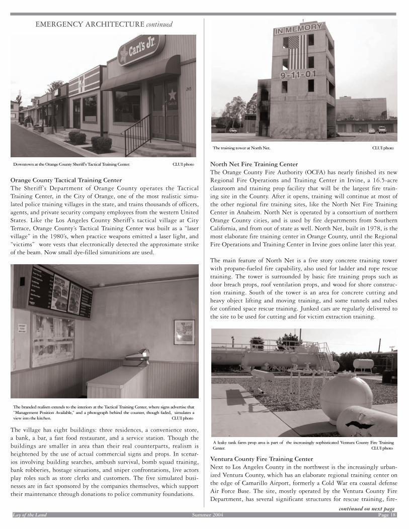
Lay of the Land Summer 2004 Page 18
EMERGENCY ARCHITECTURE continued
Orange County Tactical Training CenterThe Sheriff ’s Department of Orange County operates the Tactical Training Center, in the City of Orange, one of the most realistic simu-lated police training villages in the state, and trains thousands of officers, agents, and private security company employees from the western United States. Like the Los Angeles County Sheriff’s tactical village at City Terrace, Orange County’s Tactical Training Center was built as a “laser village” in the 1980’s, when practice weapons emitted a laser light, and “victims” wore vests that electronically detected the approximate strike of the beam. Now small dye-filled simunitions are used.
The village has eight buildings: three residences, a convenience store, a bank, a bar, a fast food restaurant, and a service station. Though the buildings are smaller in area than their real counterparts, realism is heightened by the use of actual commercial signs and props. In scenar-ios involving building searches, ambush survival, bomb squad training, bank robberies, hostage situations, and sniper confrontations, live actors play roles such as store clerks and customers. The five simulated busi-nesses are in fact sponsored by the companies themselves, which support their maintenance through donations to police community foundations.
The training tower at North Net. CLUI photo
A leaky tank farm prop area is part of the increasingly sophisticated Ventura County Fire Training Center. CLUI photo
The branded realism extends to the interiors at the Tactical Training Center, where signs advertise that ”Management Position Available,” and a photograph behind the counter, though faded, simulates a view into the kitchen. CLUI photo
Downtown at the Orange County Sheriff's Tactical Training Center. CLUI photo North Net Fire Training CenterThe Orange County Fire Authority (OCFA) has nearly finished its new Regional Fire Operations and Training Center in Irvine, a 16.5-acre classroom and training prop facility that will be the largest fire train-ing site in the County. After it opens, training will continue at most of the other regional fire training sites, like the North Net Fire Training Center in Anaheim. North Net is operated by a consortium of northern Orange County cities, and is used by fire departments from Southern California, and from out of state as well. North Net, built in 1978, is the most elaborate fire training center in Orange County, until the Regional Fire Operations and Training Center in Irvine goes online later this year.
The main feature of North Net is a five story concrete training tower with propane-fueled fire capability, also used for ladder and rope rescue training. The tower is surrounded by basic fire training props such as door breach props, roof ventilation props, and wood for shore construc-tion training. South of the tower is an area for concrete cutting and heavy object lifting and moving training, and some tunnels and tubes for confined space rescue training. Junked cars are regularly delivered to the site to be used for cutting and for victim extraction training.
Ventura County Fire Training CenterNext to Los Angeles County in the northwest is the increasingly urban-ized Ventura County, which has an elaborate regional training center on the edge of Camarillo Airport, formerly a Cold War era coastal defense Air Force Base. The site, mostly operated by the Ventura County Fire Department, has several significant structures for rescue training, fire-
continued on next pageLay of the Land Lay of the Land Summer 2004 Page Page 18
EMERGENCY ARCHITECTURE continued
Orange County Tactical Training CenterThe Sheriff ’s Department of Orange County operates the Tactical Training Center, in the City of Orange, one of the most realistic simu-lated police training villages in the state, and trains thousands of officers, agents, and private security company employees from the western United States. Like the Los Angeles County Sheriff’s tactical village at City Terrace, Orange County’s Tactical Training Center was built as a “laser village” in the 1980’s, when practice weapons emitted a laser light, and “victims” wore vests that electronically detected the approximate strike of the beam. Now small dye-filled simunitions are used.
The village has eight buildings: three residences, a convenience store, a bank, a bar, a fast food restaurant, and a service station. Though the buildings are smaller in area than their real counterparts, realism is heightened by the use of actual commercial signs and props. In scenar-ios involving building searches, ambush survival, bomb squad training, bank robberies, hostage situations, and sniper confrontations, live actors play roles such as store clerks and customers. The five simulated busi-nesses are in fact sponsored by the companies themselves, which support their maintenance through donations to police community foundations.
The training tower at North Net.training tower at North Net.trainin CLUI photo
A leaky tank farm prop area is part of tA leaky tank farm prop area is part of tA l he eaky tank farm prop area is part of the eaky tank farm prop area is part of t increasingly sophisticated Ventura County Fire Training Center. CLUI photo
The branded realism extends to the interiors at the Tactical Training Center, where signs advertise thatThe branded realism extends to the interiors at the Tactical Training Center, where signs advertise thatThe branded realism extends to the interiors”Management Position Available,” and a photograph behind the counter, though faded, simulates a view into the kitchen.view into the kitchen.view into t CLUI photo
Downtown at the Orange County Sheriff's Tactical Training Center. CLUI photo North Net Fire Training CenterThe Orange County Fire Authority (OCFA) has nearly finished its new Regional Fire Operations and Training Center in Irvine, a 16.5-acre classroom and training prop facility that will be the largest fire train-ing site in the County. After it opens, training will continue at most of the other regional fire training sites, like the North Net Fire Training Center in Anaheim. North Net is operated by a consortium of northern Orange County cities, and is used by fire departments from Southern California, and from out of state as well. North Net, built in 1978, is the most elaborate fire training center in Orange County, until the Regional Fire Operations and Training Center in Irvine goes online later this year.
The main feature of North Net is a five story concrete training tower with propane-fueled fire capability, also used for ladder and rope rescue training. The tower is surrounded by basic fire training props such as door breach props, roof ventilation props, and wood for shore construc-tion training. South of the tower is an area for concrete cutting and heavy object lifting and moving training, and some tunnels and tubes for confined space rescue training. Junked cars are regularly delivered to the site to be used for cutting and for victim extraction training.
Ventura County Fire Training CenterNext to Los Angeles County in the northwest is the increasingly urban-ized Ventura County, which has an elaborate regional training center on the edge of Camarillo Airport, formerly a Cold War era coastal defense Air Force Base. The site, mostly operated by the Ventura County Fire Department, has several significant structures for rescue training, fire-
continued on next page

Lay of the Land Summer 2004 Page 19
EMERGENCY ARCHITECTURE continued
In California, perhaps suitably in this car-oriented state, the state police department is the California Highway Patrol. The CHP Academy, in West Sacramento, is the main driving training site for the agency. It has a 2.3 mile EVOC, and outdoor ranges with mechanical targets. CLUI photo
Hazardous material rail car accident props at the CSTI, which uses rail cars recovered from real world accidents. CLUI photo
Simulated rail crossing at the San Bernardino County's Emergency Vehicle Operations Center. CLUI Photo
Industrial props and confined space tunnels make up an integrated habitrail-like training environment, next to the ladder and climbing prop called Ladder Land. CLUI photo
fighting training, and hazardous material response training. These facili-ties include several climbing and rappelling props, including a five story tower (for urban search and rescue); an elaborate confined space rescue tunnel network; two simulated roof structures; and an electrical trans-mission system prop.
The hazardous material training area is especially advanced, and is used for training by fire departments and law enforcement agencies from within and from outside Ventura County. There are several hazardous tanker and rail car accident and spill props; an industrial tank farm leak prop area; and a simulated methamphetamine lab, built inside a ship-ping container, and situated in a miniature orange grove.
San Bernardino County EVOCThe Sheriff’s Department of San Bernardino County, east of Los Angeles County, operates what may be the largest dedicated Emergency Vehicle Operations Center (EVOC) in the nation, a 78 acre site which opened in 1991. In California, the only EVOC approaching it in size and diversity is the 43 acre California Highway Patrol EVOC at their training site outside Sacramento. Unlike the CHP and the EVOC at the LAPD’s Ed Davis Center, the San Bernardino County EVOC is a single purpose facility, not part of a larger training site. It sits in a dusty plain, next to a wash and an off-highway vehicle recreation area, south of Glen Helen.
Police departments from all over the country send their training officers here for instruction.
This EVOC has a mile long high speed track, a large skid pan made of polished concrete that, when watered, becomes as slick as ice. A large asphalt lot in the middle of the track is primarily used as a motorcycle obstacle course. It also has a residential street grid with numerous inter-sections, a few 4 wheel drive obstacle courses, and a simulated rail cross-ing. Overseeing it all is an observation tower atop the administration and classroom building. The EVOC has a fleet of several dozen cars, including some that have been especially modified to practice the PIT maneuver, a police tactic for nudging cars into a skid.
CSTIIn addition to city and county agencies, the state operates a number of training sites for emergency personnel and police. The Office of Emergency Services of the State of California operates a multifaceted training site called the California Specialized Training Institute (CSTI). It exists to train law enforcement, emergency management, and other first responders in emergency procedures and tactics, including responses to earthquakes, terrorism, and hazmat spills. It is located on the grounds
continued on next page
Lay of the Land Lay of the Land Summer 2004 Page Page 19
EMERGENCY ARCHITECTURE continued
In California, perhaps suitably in this car-oriented state, the state police department is the California Highway Patrol. The CHP Academy, in West Sacramento, is the main driving training site for the agency. It has a 2.3 mile EVOC, and outdoor ranges with mechanical targets. CLUI photo
Hazardous material rail car accident props at the CSTI, which uses rail cars recovered from real world accidents. CLUI photo
Simulated rail crossing at the San Bernardino County's Emergency Vehicle Operations Center. CLUI Photo
Industrial props and confined space tunnels make up an integrated Industrial props and confined space tunnels make up an integrated Industrial props and confined space tunnels make up a habitrail-like training environment,habitrail-like training environment,habitrailnext to the ladder and climbing prop called Ladder Land. CLUI photo
fighting training, and hazardous material response training. These facili-ties include several climbing and rappelling props, including a five story tower (for urban search and rescue); an elaborate confined space rescue tunnel network; two simulated roof structures; and an electrical trans-mission system prop.
The hazardous material training area is especially advanced, and is used for training by fire departments and law enforcement agencies from within and from outside Ventura County. There are several hazardous tanker and rail car accident and spill props; an industrial tank farm leak prop area; and a simulated methamphetamine lab, built inside a ship-ping container, and situated in a miniature orange grove.
San Bernardino County EVOCThe Sheriff’s Department of San Bernardino County, east of Los Angeles County, operates what may be the largest dedicated Emergency Vehicle Operations Center (EVOC) in the nation, a 78 acre site which opened in 1991. In California, the only EVOC approaching it in size and diversity is the 43 acre California Highway Patrol EVOC at their training site outside Sacramento. Unlike the CHP and the EVOC at the LAPD’s Ed Davis Center, the San Bernardino County EVOC is a single purpose facility, not part of a larger training site. It sits in a dusty plain, next to a wash and an off-highway vehicle recreation area, south of Glen Helen.
Police departments from all over the country send their training officers here for instruction.
This EVOC has a mile long high speed track, a large skid pan made of polished concrete that, when watered, becomes as slick as ice. A large asphalt lot in the middle of the track is primarily used as a motorcycle obstacle course. It also has a residential street grid with numerous inter-sections, a few 4 wheel drive obstacle courses, and a simulated rail cross-ing. Overseeing it all is an observation tower atop the administration and classroom building. The EVOC has a fleet of several dozen cars, including some that have been especially modified to practice the PIT maneuver, a police tactic for nudging cars into a skid.
CSTIIn addition to city and county agencies, the state operates a number of training sites for emergency personnel and police. The Office of Emergency Services of the State of California operates a multifaceted training site called the California Specialized Training Institute (CSTI). It exists to train law enforcement, emergency management, and other first responders in emergency procedures and tactics, including responses to earthquakes, terrorism, and hazmat spills. It is located on the grounds
continued on next page

Lay of the Land Summer 2004 Page 20
EMERGENCY ARCHITECTURE continued
An abandoned school in Huntington Beach (at 16940 B Street) was recently used for a train-ing program developed for law enforcement by the JS Training Institute, involving “bus interdiction, command post operations, ground tactics course, knife defense, patrol defen-sive tactics, school shooting first responder, SWAT defense tactics, terrorism preparedness, and WMD force protection.” CLUI photo
One of the rooms in the meth lab scenario building on the grounds of the CSTI. Interior decorations were done by prisoners from the California Men's Colony across the highway. CLUI photo
of Camp San Luis Obispo, a large National Guard training base in the mid coast of California. CSTI has several training areas with different functions, and has the only “mock emergency operations center” in the state, where disaster scenarios are played out in a town called Santa Luisa Del Mar, a fictional disaster town modeled after Santa Barbara, but with the addition of a harbor.
A portion of Santa Luisa Del Mar has been assembled in three dimensions for police scenario training using simunitions, out of buildings relo-cated from other parts of the base. Other training areas at CSTI include a large and scattered hazmat training yard, with prop rail cars brought in from actual derailment sites. The Criminal Justice Program at CSTI has developed one of the open shooting ranges on base with some struc-tural props, used for live fire weapons training. The Department of Toxics and Substance Patrol has created what is probably the most elaborate mock clandestine drug lab in the state. Also referred to as a “clan lab” or “meth lab,” prisoners from the state penitentiary across the highway were brought in to decorate it.
Private and Federal Training SitesPrivate companies also provide training for public law enforcement officers, as well as for private security, and even for interested members of the public. These companies are sometimes hired to run programs at existing police training sites, or to run training programs for police at rented classroom spaces, or at public shooting ranges, such as Burro Canyon Shooting Park in Azusa, where high risk entry training, warrant serving, and close quarter battle training classes are held. Full scale real-istic scenario training by private companies can also take place at unused or soon to be demolished buildings, wherever they may be. Though not in California, Thunder Ranch, with locations in Texas and Oregon, may have the most sophisticated private weapons and tactics training sites in the country. Private companies and educational institutions also run fire and hazmat training sites, such as the Fire Science Academy in Carlin, Nevada, and at many larger chemical plants, like Chevron’s Live Fire Training Center at its refinery in El Segundo, next to LAX.
Southern California’s history of creating superlative simulated environ-ments is poetically emphasized by the fact that when the first SWAT team in the USA was established (in Los Angeles by a young LAPD inspector named Daryl Gates, in response to the 1965 Watts riots) their first training site was at the back lot of Universal Studios. These days SWAT trains at a number of places, including an abandoned military housing area near San Pedro. SWAT also uses some of the elaborate mock towns at the Marine Corps’ Camp Pendleton, which are among the most sophisticated in the country. These defense department training towns, sometimes called “MOUT” facilities (Military Operations in Urban Terrain) usually consist of a large, “European-style” row building or even several city blocks of buildings that evoke a generic international war torn city. Though built by and for military training, sometimes civilian law enforcement agencies, especially those that employ military tactics like SWAT, are permitted to use them. A new MOUT facility to be built for the SEALs on the Navy’s San Clemente Island, off the coast of California, will be based on “European and Third World urban patterns,” and will include features like an embassy, international hotel, and a soc-cer field.
Of course, the DoD isn’t the only federal agency operating mock towns for training purposes. The FBI’s mock town in Quantico, Virginia, per-haps the original Hogan’s Alley, is a nearly complete North American
View of the mock town Santa Luisa Del Mar at the California Specialized Training Institute. CLUI photo
continued on next page
Lay of the Land Lay of the Land Summer 2004 Page Page 20
EMERGENCY ARCHITECTURE continued
An abandoned school in Huntington Beach (at 16940 B Street) was recently used for a train-ing program developed for law enforcement by the JS Training Institute, involving “bus interdiction, command post operations, ground tactics course, knife defense, patrol defen-sive tactics, school shooting first responder, SWAT defense tactics, terrorism preparedness, and WMD force protection.” CLUI photo
One of the rooms in the One of the rooms in the One of the rooms in t meth lab scenario building on the grounds of the CSTI. Interior decorations were done by prisoners from the California Men's Colony across the highway. CLUI photo
of Camp San Luis Obispo, a large National Guard training base in the mid coast of California. CSTI has several training areas with different functions, and has the only “mock emergency operations center” in the state, where disaster scenarios are played out in a town called Santa Luisa Del Mar, a fictional disaster town modeled after Santa Barbara, but with the addition of a harbor.
A portion of Santa Luisa Del Mar has been assembled in three dimensions for police scenario training using simunitions, out of buildings relo-cated from other parts of the base. Other training areas at CSTI include a large and scattered hazmat training yard, with prop rail cars brought in from actual derailment sites. The Criminal Justice Program at CSTI has developed one of the open shooting ranges on base with some struc-tural props, used for live fire weapons training. The Department of Toxics and Substance Patrol has created what is probably the most elaborate mock clandestine drug lab in the state. Also referred to as a “clan lab” or “meth lab,” prisoners from the state penitentiary across the highway were brought in to decorate it.
Private and Federal Training SitesPrivate companies also provide training for public law enforcement officers, as well as for private security, and even for interested members of the public. These companies are sometimes hired to run programs at existing police training sites, or to run training programs for police at rented classroom spaces, or at public shooting ranges, such as Burro Canyon Shooting Park in Azusa, where high risk entry training, warrant serving, and close quarter battle training classes are held. Full scale real-istic scenario training by private companies can also take place at unused or soon to be demolished buildings, wherever they may be. Though not in California, Thunder Ranch, with locations in Texas and Oregon, may have the most sophisticated private weapons and tactics training sites in the country. Private companies and educational institutions also run fire and hazmat training sites, such as the Fire Science Academy in Carlin, Nevada, and at many larger chemical plants, like Chevron’s Live Fire Training Center at its refinery in El Segundo, next to LAX.
Southern California’s history of creating superlative simulated environ-ments is poetically emphasized by the fact that when the first SWAT team in the USA was established (in Los Angeles by a young LAPD inspector named Daryl Gates, in response to the 1965 Watts riots) their first training site was at the back lot of Universal Studios. These days SWAT trains at a number of places, including an abandoned military housing area near San Pedro. SWAT also uses some of the elaborate mock towns at the Marine Corps’ Camp Pendleton, which are among the most sophisticated in the country. These defense department training towns, sometimes called “MOUT” facilities (Military Operations in Urban Terrain) usually consist of a large, “European-style” row building or even several city blocks of buildings that evoke a generic international war torn city. Though built by and for military training, sometimes civilian law enforcement agencies, especially those that employ military tactics like SWAT, are permitted to use them. A new MOUT facility to be built for the SEALs on the Navy’s San Clemente Island, off the coast of California, will be based on “European and Third World urban patterns,” and will include features like an embassy, international hotel, and a soc-cer field.
Of course, the DoD isn’t the only federal agency operating mock towns for training purposes. The FBI’s mock town in Quantico, Virginia, per-haps the original Hogan’s Alley, is a nearly complete North American
View of the mock town Santa Luisa Del Mar at the Calithe mock town Santa Luisa Del Mar at the Calithe mock town Santa Luisa Del Mar fo at the Califo at the Cali rnia Spefornia Spefo cialized Training Institute. CLUI photo
continued on next page

Lay of the Land Summer 2004 Page 21
CLUI TALKS AND EXHIBITS ON THE ROAD
VARIOUS EXISTING CLUI EXHIBITS were displayed here and there this spring and summer. The Nellis Range Complex: A Global Bombing Micro-cosm exhibit, recently updated with the help of the Royal College of Art in London, was shown at the PhotoEspana exhibit in Madrid, Spain in June and July. Formations of Erasure: Earthworks and Entropy, an exhibit about the transformation of land art, recently returned from being dis-played at the Princeton School of Architecture, and is being serviced before its next deployment.
Some new commissioned projects for other venues include an automatic digital presentation about some of the American Land Museum artifacts on display at Southbase, in Wendover, Utah, organized for an exhibi-tion called The End of the End of the Line, at the Soap Factory in Minne-apolis. Also, for the University of the Pacifi c in Stockton, California, as part of an exhibit called Aquatopia, the Center created a digital display about water-related sites in the Central Valley of California. In Denver, Colorado, the Center devised an underground tour system for a new urbanist community called Bel Mar, being built in the suburbs in Lake-wood, on the site of a formerly dead mall.
In addition to addressing visiting groups and classes at the Center’s main offi ce in Los Angeles, members of the CLUI administrative staff are often asked to talk about the Center at schools, universities, to sit on panels, and participate in symposia.
Erik Knutzen, for example, has addressed audiences in New York City, Los Angeles, and Holland, where he is making another visit this sum-mer. In the past few months, Matthew Coolidge has lectured at the University of the Pacifi c in Stockton, California, the Vancouver Art Gallery in Vancouver, Canada, the University of Utah Art Department, the Aurora Picture Show in Houston, (as part of Houston’s Photofest), San Diego State University’s Art Department, the University of Cali-fornia, Irvine, the University of California, Santa Barbara, the Architec-ture Department at the federal academy in Zurich, Switzerland, and at the Princeton School of Architecture and Harvard’s Graduate School of Design, as part of a bushwhack through the Ivy League. He was very sorry to have missed his talk at the Walker Art Center in Minneapolis in July, however. The plane he was in had an engine failure while fl y-ing over the Rocky Mountains (though it was described by the fl ight attendant at the time as a ”minor maintenance problem”). After an im-mediate and steep descent, the plane landed safely and quickly at the small airport at Colorado Springs, too far to make it to Minneapolis on time. ♦
small town, with three storey brick houses, a bank (the “Bank of Hogan” called the “most robbed bank in America”), the “Biograph” movie the-ater, Honest Jim’s Used Cars (“We Stand Behind Our Cars,” says the sign), a courthouse, and a post office. And the Federal Law enforcement Training Center in Glynco, Georgia, has a 34-building “practical exer-cise complex,” used by federal agencies of all kinds.
These state and federal training facilities will be the subject of future exhibits at the CLUI, as we continue to examine the expanding land-scape of preparedness. By doing so, we learn more about how modeling our communities in this manner is an incidental, complex, and compel-ling expression of an institutional interpretation of public and architec-tural space. ♦
EMERGENCY ARCHITECTURE continued UNUSUAL REAL ESTATE LISTING #2764
THE BLACK HILLS TOWN of Rockerville is listed for sale. It is a ghost town ghost town tourist attraction, abandoned after its last owners fi -nally gave up on the business several years ago. It has fallen into disre-pair, and is awaiting its third incarnation.
Like nearby Deadwood, Rockerville was a boomtown in the 1870’s. Gold was discovered in 1876, and by 1880 it had 100 buildings and around 1,000 people. Scandals, bad infrastructure schemes, and a gen-eral lack of gold led to the town's demise. By 1930, the town was in ruins.
In the 1950s, Rockerville was born again with the new Black Hills economy of tourism. Highway 16, which goes from Rapid City, on the Interstate, to Mount Rushmore, passes right through town. The historic mining town was resurrected as a version of itself for tourists, with shootouts, gift shops, and old time relics. Two rows of western town façade were built next to the ruins of the original mining town, which by then were just a few buildings, a shack, the jail, and the old school house. A wooden sidewalk out front connected the dozens of buildings, labeled and decorated as things like Saloon, Bank, Casino, and Company Store.
The Black Hills fi lled up to the brim with attractions, and Rockerville failed to keep up with the times. To deal with the increased fl ow of visi-tors going up the hill, Highway 16 was enlarged and rerouted, and the new alignment passed around Rockerville, leaving it off the main drag. The tourists stopped coming and kept on going.
Today, Rockerville is abandoned again. The property includes 26 acres of the old town, all the buildings, the remaining relics, and camping grounds in the woods. It includes a few hundred yards of frontage with false fronts on either side of the road, but it is still the road less traveled.Each store is platted and can be separately leased, though the roofs may or may not make it through the next winter. And the new owners will have to deal with the ghosts of Rockerville, who are are now tourists, as well as miners.
Asking price: $1,100,000.
Call Pat Hall, Coldwell Banker (605) 719-9787.
The tourist ghost town of Rockerville, South Dakota. CLUI photo
Lay of the Land Lay of the Land Summer 2004 Page Summer 2004 Page 21
CLUI TALKS AND EXHIBITS ON THE ROAD
VARIOUS EVARIOUS EV XISTING CLUI EXHIBITS were displayed here and there this spring and summer. The Nellis Range Complex: A Global Bombing Micro-cosm exhibit, recently updated with the help of the Royal College of Art in London, was shown at the PhotoEspana exhibit in Madrid, Spain in June and July. Formations of Erasure: Earthworks and Entropy, an exhibit about the transformation of land art, recently returned from being dis-played at the Princeton School of Architecture, and is being serviced before its next deployment.
Some new commissioned projects for other venues include an automatic digital presentation about some of the American Land Museum artifacts on display at Southbase, in Wendover, Utah, organized for an exhibi-tion called The End of the End of the Line, at the Soap Factory in Minne-apolis. Also, for the University of the Pacifi c in Stockton, California, as part of an exhibit called Aquatopia, the Center created a digital display about water-related sites in the Central Valley of California. In Denver, Colorado, the Center devised an underground tour system for a new urbanist community called Bel Mar, being built in the suburbs in Lake-wood, on the site of a formerly dead mall.
In addition to addressing visiting groups and classes at the Center’s main offi ce in Los Angeles, members of the CLUI administrative staff are often asked to talk about the Center at schools, universities, to sit on panels, and participate in symposia.
Erik Knutzen, for example, has addressed audiences in New York City, Los Angeles, and Holland, where he is making another visit this sum-mer. In the past few months, Matthew Coolidge has lectured at the University of the Pacifi c in Stockton, California, the Vancouver Art Gallery in Vancouver, Canada, the University of Utah Art Department, the Aurora Picture Show in Houston, (as part of Houston’s Photofest), San Diego State University’s Art Department, the University of Cali-fornia, Irvine, the University of California, Santa Barbara, the Architec-ture Department at the federal academy in Zurich, Switzerland, and at the Princeton School of Architecture and Harvard’s Graduate School of Design, as part of a bushwhack through the Ivy League. He was very sorry to have missed his talk at the Walker Art Center in Minneapolis in July, however. The plane he was in had an engine failure while fl y-ing over the Rocky Mountains (though it was described by the fl ight attendant at the time as a ”minor maintenance problem”). After an im-mediate and steep descent, the plane landed safely and quickly at the small airport at Colorado Springs, too far to make it to Minneapolis on time. ♦
small town, with three storey brick houses, a bank (the “Bank of Hogan” called the “most robbed bank in America”), the “Biograph” movie the-ater, Honest Jim’s Used Cars (“We Stand Behind Our Cars,” says the sign), a courthouse, and a post office. And the Federal Law enforcement Training Center in Glynco, Georgia, has a 34-building “practical exer-cise complex,” used by federal agencies of all kinds.
These state and federal training facilities will be the subject of future exhibits at the CLUI, as we continue to examine the expanding land-scape of preparedness. By doing so, we learn more about how modeling our communities in this manner is an incidental, complex, and compel-ling expression of an institutional interpretation of public and architec-tural space. ♦
EMERGENCY ARCHITECTURE continued UNUSUAL REAL ESTATE LISTING #2764
THE BLACK HILLS TOWN of Rockerville is listed for sale. It is a ghost town ghost town tourist attraction, abandoned after its last owners fi -nally gave up on the business several years ago. It has fallen into disre-pair, and is awaiting its third incarnation.
Like nearby Deadwood, Rockerville was a boomtown in the 1870’s. Gold was discovered in 1876, and by 1880 it had 100 buildings and around 1,000 people. Scandals, bad infrastructure schemes, and a gen-eral lack of gold led to the town's demise. By 1930, the town was in ruins.
In the 1950s, Rockerville was born again with the new Black Hills economy of tourism. Highway 16, which goes from Rapid City, on the Interstate, to Mount Rushmore, passes right through town. The historic mining town was resurrected as a version of itself for tourists, with shootouts, gift shops, and old time relics. Two rows of western town façade were built next to the ruins of the original mining town, which by then were just a few buildings, a shack, the jail, and the old school house. A wooden sidewalk out front connected the dozens of buildings, labeled and decorated as things like Saloon, Bank, Casino, and Company Store.
The Black Hills fi lled up to the brim with attractions, and Rockerville failed to keep up with the times. To deal with the increased fl ow of visi-tors going up the hill, Highway 16 was enlarged and rerouted, and the new alignment passed around Rockerville, leaving it off the main drag. The tourists stopped coming and kept on going.
Today, Rockerville is abandoned again. The property includes 26 acres of the old town, all the buildings, the remaining relics, and camping grounds in the woods. It includes a few hundred yards of frontage with false fronts on either side of the road, but it is still the road less traveled.Each store is platted and can be separately leased, though the roofs may or may not make it through the next winter. And the new owners will have to deal with the ghosts of Rockerville, who are are now tourists, as well as miners.
Asking price: $1,100,000.
Call Pat Hall, Coldwell Banker (605) 719-9787.
The tourist ghost town of Rockerville, South Dakota. CLUI photo

Lay of the Land Summer 2004 Page 22
Lots of Parking: Land Use in a Car Culture, John A. Jakle and Keith A. Sculle, Center for American Places/University of Virginia Press, 2004A great title, a great subject, and a great book. Just the other day we were say-ing “why aren’t there more books about parking?” Well now there are.
Window Seat: Reading the Landscape from the Air, Gregory Dicum, Chronicle Books, 2004Another one of those “Geez, we should have thought of that” titles. But there is room for more, as this is a very basic overview, and dwells much on read-ing the natural topographic features. We recommend that the author does a sequel: “Guide to Using Your GPS Receiver to Figure Out The Exact Location of the Places You See Out the Window of the Airplane.”
Houston Freeways: A Historical and Visual Journey, Erik Slotboom, 2003One of the best publications to come out of any press in 2003 is this self-pub-lished textbook about the freeway system of the nation’s fourth largest city. The author, a Houstonian in his mid thirties, worked in the energy industry, then the software industry, started a website on Houston highways in 2000, and after being let go in the dotcom bust, set to work on this epic work of stunning clarity, modesty, and honesty.
The Lake Project, David Maisel, Nazraeli Press, 2004A big square flat thin book, like we have come to expect from Nazraeli, with 77 images of the multicolored phantasmagoric swirls, ponds, puddles, pools, and piles of Owens Lake, as seen through the lens of David Maisel's camera, while flying above the lakebed. This work was featured as part of a digital projection in the CLUI exhibit Diversions and Dislocations: California’s Owens Valley.
Invisible Frontier: Exploring the Tunnels, Ruins, and Rooftops of Hidden New York, L.B. Deyo and David “Lefty” Leibowitz, Three Rivers Press, 2004The overdressed hipsters behind the infiltrative Jinx Project discuss some of their urban and infrastructural spelunking and surmountings, as if they were doing us a favor, which they are, of course – saving the rest of us the trouble of having to climb on to the roof of the Tweed Courthouse and such. The value of the research, thoughtstyling, and ground-truthing inherent in the project would be a lot easier to ingest without the faux-secret-government-speak and the conquering attitude.
Killing Ground, John Huddleston, Center for American Places/Johns Hopkins, 2002Historical images from the Civil War are juxtaposed with contemporary color photographs of the same places by the author. Not a rephotographic project, but rather a site selection project, where the images reveal the ghosts that lurk in everyday areas, the residential streets, strip malls, playing fields, parking lots, and places in between these places, that are now, still and will always be those same killing fields.
BRIEF REVIEWS
BOOKS NEW TO THE SHELVES OF THE CLUIMANY OF THESE TITLES ARE AVAILABLE FOR SALE FROM THE CLUI SHOP AT WWW.CLUI.ORG
Face to Face with the Bomb: Nuclear Reality After the Cold War, Paul Shambroom, Center for American Places/Johns Hopkins University Press, 2003Like Robert Del Tredici’s mid 1980’s books like At Work in the Field of the Bombs, this new book shows the state of the nuclear warfare landscape of the US today – in 2003. Big clear photos in vivid color, just as they should be. Another great book from the Center for American Places’ Creating the North American Landscape series, published by Johns Hopkins.
Delta Primer: A Field Guide to the California Delta, by Jane Wolff, William Stout Publishers, 2003This elusive and mysterious part of California is perfectly captured in this unusual publication, which presents the Delta as a set of playing cards, each describing a feature of the region for consideration.
The Vatican to Vegas: A History of Special Effects, Norman Klein, The New Press, 2004Norman Klein’s new masterwork is a freefalling epic. The 73 pages of notes make for a bonus enumerated book within a book. Our only complaint about this book is the linearity of the format - it’s a book.
Ant Farm 1968-1978, Constance M. Lewallen and Steve Seid, University of California Press, 2004Ant Farm somehow possessed the commendable post-hippie characteristics of activist pranksterism, mock corporeity, optimistic modernism, innovative design, and pragmatic utopianism, without seeming conflicted about it. This is the catalog of the retrospective of the work of Ant Farm that is currently traveling around the country.
Urban Forest: Images of Trees in the Human Landscape, David Paul Bayles, Sierra ClubOccasionally the Sierra Club puts out a real winner, like Dead Tech, or this one. The trees photographed in this book - contorted, pruned, truncated, and mutated - are absurd, humorous, tragic, resilient, dignified and heroic - living, incidental sculptures of characteristics we humans usually ascribe to ourselves.
Unknown Quantity, Paul Virilio, Thames & Hudson, 2004Pictures and words of death and destruction from the French philosopher. A voyeuristic harangue that is totally savant and au courant.
Lab 257: The Disturbing Story of the Government’s Secret Plum Island Germ Laboratory, Michael Christopher Carroll, William Morrow, 2004The extremities of Long Island contain extremes of human behavior, pushed to the edge, but still, it seems, too close to everyone else. Just off Orient Point at the northeast tip is 840 acre Plum Island, a US Department of Agriculture animal disease research center which has been involved in bacterial and viral projects that are capable of escaping to the outside world, and may have done so already.
Waiting for the End of the World, Richard Ross, Princeton Architectural Press, 2004The interiors of bomb shelters of the world are explored in this photo book, from the still maintained public shelters in Zurich to the de-radicalized Church Universal and Triumphant in Montana. One impression that lingers after reading this book is how small this underground world is, even though it is spread out around the globe.
Baja to Vancouver: The West Coast and Contemporary Art, CCA Wattis Institute, 2004The catalog of the exhibit of the same name, which is now traveling up and down the coast, would have been great, except for that CLUI “essay” in the back.
A few months ago, we learned of the tragic and untimely death of a remarkable man named Charles Barile, a longtime friend of this organization, who contributed to this newsletter on occasion, and graced us with his charming presence at every single public event we held in Los Angeles. While still in shock after learning why we hadn’t seen him recently, we were told that he had honored us by considering the Center in his last will and testament: He had left us his library. Charles had far reaching interests, and many of the titles were signed by their authors (Charles worked in the entertainment industry and knew a lot of creative people). The majority of the books, we thought, would be better off in the hands of his loving family, or in more broadminded libraries or collections where they would be properly cared for. However, when it came to a few of his favorite subjects, there was some overlap with the CLUI library of land use. We now have a substantially aug-mented collection of books on aerospace technology and atomic history, to name a few subjects with a direct impact on the ground, in one way or another. Everytime we look up at a jet soaring into the sky above Edwards Air Force Base, or down into the radioactive waste tombs of the Southwestern desert, we will be reminded of Charles and his kindness to us.
Lay of the Land Lay of the Land Summer 2004 Page 22 Summer 2004 Page 22
Lots of Parking: Land Use in a Car Culture, John A. Jakle and Keith A. Sculle, Center for American Places/University of Virginia Press, 2004A great title, a great subject, and a great book. Just the other day we were say-ing “why aren’t there more books about parking?” Well now there are.
Window Seat: Reading the Landscape from the Air, Gregory Dicum, Chronicle Books, 2004Another one of those “Geez, we should have thought of that” titles. But there is room for more, as this is a very basic overview, and dwells much on read-ing the natural topographic features. We recommend that the author does a sequel: “Guide to Using Your GPS Receiver to Figure Out The Exact Location of the Places You See Out the Window of the Airplane.”
Houston Freeways: A Historical and Visual Journey, Erik Slotboom, 2003One of the best publications to come out of any press in 2003 is this self-pub-lished textbook about the freeway system of the nation’s fourth largest city. The author, a Houstonian in his mid thirties, worked in the energy industry, then the software industry, started a website on Houston highways in 2000, and after being let go in the dotcom bust, set to work on this epic work of stunning clarity, modesty, and honesty.
The Lake Project, David Maisel, Nazraeli Press, 2004A big square flat thin book, like we have come to expect from Nazraeli, with 77 images of the multicolored phantasmagoric swirls, ponds, puddles, pools, and piles of Owens Lake, as seen through the lens of David Maisel's camera, while flying above the lakebed. This work was featured as part of a digital projection in the CLUI exhibit Diversions and Dislocations: California’s Owens Valley.
Invisible Frontier: Exploring the Tunnels, Ruins, and Rooftops of Hidden New York, L.B. Deyo and David “Lefty” Leibowitz, Three Rivers Press, 2004The overdressed hipsters behind the infiltrative Jinx Project discuss some of their urban and infrastructural spelunking and surmountings, as if they were doing us a favor, which they are, of course – saving the rest of us the trouble of having to climb on to the roof of the Tweed Courthouse and such. The value of the research, thoughtstyling, and ground-truthing inherent in the project would be a lot easier to ingest without the faux-secret-government-speak and the conquering attitude.
Killing Ground, John Huddleston, Center for American Places/Johns Hopkins, 2002Historical images from the Civil War are juxtaposed with contemporary color photographs of the same places by the author. Not a rephotographic project, but rather a site selection project, where the images reveal the ghosts that lurk in everyday areas, the residential streets, strip malls, playing fields, parking lots, and places in between these places, that are now, still and will always be those same killing fields.
BRIEF REVIEWS
BOOKS NEW TO THE SHELVES OF THE CLUIMANY OF THESE TITLES ARE AVAILABLE FOR SALE FROM THE CLUI SHOP AT WWW.CLUI.ORG
Face to Face with the Bomb: Nuclear Reality After the Cold War, Paul Shambroom, Center for American Places/Johns Hopkins University Press, 2003Like Robert Del Tredici’s mid 1980’s books like At Work in the Field of the Bombs, this new book shows the state of the nuclear warfare landscape of the US today – in 2003. Big clear photos in vivid color, just as they should be. Another great book from the Center for American Places’ Creating the North American Landscape series, published by Johns Hopkins.
Delta Primer: A Field Guide to the California Delta, by Jane Wolff, William Stout Publishers, 2003This elusive and mysterious part of California is perfectly captured in this unusual publication, which presents the Delta as a set of playing cards, each describing a feature of the region for consideration.
The Vatican to Vegas: A History of Special Effects, Norman Klein, The New Press, 2004Norman Klein’s new masterwork is a freefalling epic. The 73 pages of notes make for a bonus enumerated book within a book. Our only complaint about this book is the linearity of the format - it’s a book.
Ant Farm 1968-1978, Constance M. Lewallen and Steve Seid, University of California Press, 2004Ant Farm somehow possessed the commendable post-hippie characteristics of activist pranksterism, mock corporeity, optimistic modernism, innovative design, and pragmatic utopianism, without seeming conflicted about it. This is the catalog of the retrospective of the work of Ant Farm that is currently traveling around the country.
Urban Forest: Images of Trees in the Human Landscape, David Paul Bayles, Sierra ClubOccasionally the Sierra Club puts out a real winner, like Dead Tech, or this one. The trees photographed in this book - contorted, pruned, truncated, and mutated - are absurd, humorous, tragic, resilient, dignified and heroic - living, incidental sculptures of characteristics we humans usually ascribe to ourselves.
Unknown Quantity, Paul Virilio, Thames & Hudson, 2004Pictures and words of death and destruction from the French philosopher. A voyeuristic harangue that is totally savant and savant and savant au courant.
Lab 257: The Disturbing Story of the Government’s Secret Plum Island Germ Laboratory, Michael Christopher Carroll, William Morrow, 2004The extremities of Long Island contain extremes of human behavior, pushed to the edge, but still, it seems, too close to everyone else. Just off Orient Point at the northeast tip is 840 acre Plum Island, a US Department of Agriculture animal disease research center which has been involved in bacterial and viral projects that are capable of escaping to the outside world, and may have done so already.
Waiting for the End of the World, Richard Ross, Princeton Architectural Press, 2004The interiors of bomb shelters of the world are explored in this photo book, from the still maintained public shelters in Zurich to the de-radicalized Church Universal and Triumphant in Montana. One impression that lingers after reading this book is how small this underground world is, even though it is spread out around the globe.
Baja to Vancouver: The West Coast and Contemporary Art, CCA Wattis Institute, 2004The catalog of the exhibit of the same name, which is now traveling up and down the coast, would have been great, except for that CLUI “essay” in the back.
A few months ago, we learned of the tragic and untimely death of a remarkable man named Charles Barile, a longtime friend of this organization, who contributed to this newsletter on occasion, and graced us with his charming presence at every single public event we held in Los Angeles. While still in shock after learning why we hadn’t seen him recently, we were told that he had honored us by considering the Center in his last will and testament: He had left us his library. Charles had far reaching interests, and many of the titles were signed by their authors (Charles worked in the entertainment industry and knew a lot of creative people). The majority of the books, we thought, would be better off in the hands of his loving family, or in more broadminded libraries or collections where they would be properly cared for. However, when it came to a few of his favorite subjects, there was some overlap with the CLUI library of land use. We now have a substantially aug-mented collection of books on aerospace technology and atomic history, to name a few subjects with a direct impact on the ground, in one way or another. Everytime we look up at a jet soaring into the sky above Edwards Air Force Base, or down into the radioactive waste tombs of the Southwestern desert, we will be reminded of Charles and his kindness to us.

Stalacpipe Organ TapeA recording of the “World’s largest musical instrument,” the Great Stalacpipe Organ, in Luray Caverns, Virginia. Hymns and traditionals played by the creator of the wondrous instrument, Mr. Leland W. Sprinkle (deceased.) Music generated by the Earth itself! Complete with dripping sounds.25 minute cassette tape, produced by Luray Caverns.
Suggested Photo Spot Post Card and Tour BookFull color book with 20 Suggested Photo Spot post cards, depicting the sites with the Photo Spot sign in the foreground. Also contains directional information to the Photo Spots across the United States. 46pp, Color illustrations, spiral bound. $14.95
Route 58: A Cross-Section of CaliforniaIllustrated tourbook to this remarkable, 210-mile roadway. A perfect weekend-long trip from Los Angeles. Revised Edition.80pp, illustrated. $15.00
Subterranean Renovations: The Unique Architectural Spaces of Show CavesExamines underground built structures and depicts some of the best tour-ist cave environments in the United States, with contact and visitation information. From the CLUI exhibit.38pp, illustrated. $5.00
Points of Interest in the California Desert Region With Visitation InformationOver 100 interesting places in the California desert. 60pp, illustrated. $7.50
Please make check or money order payable to the Center for Land Use Interpretation, or log on to our online shop and use your credit card. Shipping and handling charges: $3.50 for the first item, .50 for each additional item, and 8.25% tax if ordering in CA. International shipping: $10.00 for first item, $1.00 for each additional item.
The Center for Land Use Interpretation 9331 Venice Boulevard, Culver City, CA 90232 Tel: (310) 839-5722 Email: [email protected]
www.clui.org
H O W T O O R D E R
CLUI Pocket T-ShirtQuality grey 100% cotton T with CLUI emblem on the pocket.Specify size: (XXL, XL, L, M, S)
$15.00
CLUI MugStandard issue mug, with CLUI emblem. We guarantee that you will get out of it everything you put into it.
$5.00FOREVER ON SALE!
$3.99
N O V E L T I E S
C L U I P U B L I C A T I O N S
5th Avenue Peninsula TourAn inexhaustive investigation of urban content. Self-guided tour of a portion of Oakland, California’s industrial waterfront. 24pp, illustrated. $5.00
The Chesapeake Bay Hydraulic ModelAn illustrated history of this remarkable engineering accomplishment, the largest indoor hydraulic model in the world, now abandoned.30pp, illustrated. $5.00
Nuclear Proving Grounds of the WorldA report on the primary nuclear test sites across the globe, and the hundreds of other sites where single nuclear blasts took place on, under, and above the earth, in the former USSR, USA, Africa, Australia, Pacific Ocean and elsewhere.30pp, illustrated. $7.50
One Hundred Places in Washington100 exemplary land use sites in Washington state. From the 1999 exhibition presented at the Center on Contemporary Art in Seattle. 102pp, illustrated. $15.00
The Nevada Test Site: A Guide to America’s Nuclear Proving GroundThe only book available that describes in detail the nation’s foremost weap-ons and R&D field test facility. Praised by both antinuclear activists and Department of Energy officials!60pp, with fold-out map and over 100 illustrations. $15.00
A COMPLETE SET OFTHE LAY OF THE LAND BACK-ISSUES,
IN STURDY REUSABLE CARRYING CASE - ONLY $12
GET A YEAR’S WORTH OF THE LAY OF THE LAND THE CENTER FOR LAND USE INTERPRETATION’S NEWSLETTER
FOR A MINIMUM DONATION OF $25.00
THE CENTER FOR LAND USE INTERPRETATION BOOKSTORE
Back to the Bay: Exploring the Margins of the San Francisco Bay RegionA catalog and guidebook of the 2001 CLUI exhibit, at the Yerba Buena Center for the Arts in San Francisco.110 pp, illustrated. $15.00
The Nellis Range Complex: Landscape of ConjectureCD-ROM of the CLUI exhibit.Includes “clickable map” of range.Works on Mac and PC’s $12.50
Antarctic 1: Views Along Antarctica’s First HighwayCD-ROM of the CLUI exhibit, with text by Bill Fox. Includes “clickable map” of McMurdo Station.Works on Mac and PC’s $12.50
NEW FOR FALL 2004 Points of Interest in the Owens River ValleyDozens of interesting places in the Owens River Valley region, the scenic and compelling back space of California. 56pp, illustrated. $15.00
Stalacpipe Organ TapeA recording of the “World’s largest musical instrument,” the Great Stalacpipe Organ, in Luray Caverns, Virginia. Hymns and traditionals played by the creator of the wondrous instrument, Mr. Leland W. Sprinkle (deceased.) Music generated by the Earth itself! Complete with dripping sounds.25 minute cassette tape, produced by Luray Caverns.
Suggested Photo Spot Post Card and Tour BookFull color book with 20 Suggested Photo Spot post cards, depicting the sites with the Photo Spot sign in the foreground. Also contains directional information to the Photo Spots across the United States. 46pp, Color illustrations, spiral bound. $14.95
Route 58: A Cross-Section of CaliforniaIllustrated tourbook to this remarkable, 210-mile roadway. A perfect weekend-long trip from Los Angeles. Revised Edition.80pp, illustrated. $15.0080pp, illustrated.
Subterranean Renovations: The Unique Architectural Spaces of Show CavesExamines underground built structures and depicts some of the best tour-ist cave environments in the United States, with contact and visitation information. From the CLUI exhibit.38pp, illustrated. $5.0038pp, illustrated.
Points of Interest in the California Desert Region With Visitation InformationOver 100 interesting places in the California desert.60pp, illustrated. $7.50
Please make check or money order payable to the Center for Land Use Interpretation, or log on to our online shop and use your credit card. Shipping and handling charges: $3.50 for the first item, .50 for each additional item, and 8.25% tax if ordering in CA. International shipping: $10.00 for first item, $1.00 for each additional item.
The Center for Land Use Interpretation 9331 Venice Boulevard, Culver City, CA 90232 Tel: (310) 839-5722 Email: [email protected]
www.clui.org
H O W T O O R D E R
CLUI Pocket T-ShirtQuality grey 100% cotton T with CLUI emblem on the pocket.Specify size: (XXL, XL, L, M, S)
$15.00
CLUI MugStandard issue mug, with CLUI emblem. We guarantee that you will get out of it everything you put into it.
$5.00FOREVER ON SALE!FOREVER ON SALE!
$3.99
N O V E L T I E S
C L U I P U B L I C A T I O N S
5th Avenue Peninsula TourAn inexhaustive investigation of urban content. Self-guided tour of a portion of Oakland, California’s industrial waterfront. 24pp, illustrated. $5.00
The Chesapeake Bay Hydraulic ModelAn illustrated history of this remarkable engineering accomplishment, the largest indoor hydraulic model in the world, now abandoned.30pp, illustrated. $5.00
Nuclear Proving Grounds of the WorldA report on the primary nuclear test sites across the globe, and the hundreds of other sites where single nuclear blasts took place on, under, and above the earth, in the former USSR, USA, Africa, Australia, Pacific Ocean and elsewhere.30pp, illustrated. $7.50
One Hundred Places in Washington100 exemplary land use sites in Washington state. From the 1999 exhibition presented at the Center on Contemporary Art in Seattle. 102pp, illustrated. $15.00
The Nevada Test Site: A Guide to America’s Nuclear Proving GroundThe only book available that describes in detail the nation’s foremost weap-ons and R&D field test facility. Praised by both antinuclear activists and Department of Energy officials!60pp, with fold-out map and over 100 illustrations. $15.00
A COMPLETE SET OFTHE LAY OF THE LAND BACK-ISSUES,
IN STURDY REUSABLE CARRYING CASE - ONLY $12
GET A YEAR’S WORTH OF THE LAY OF THE LAND THE CENTER FOR LAND USE INTERPRETATION’S NEWSLETTER
GET A YEAR’S WORTH OF THE CENTER FOR LAND USE INTERPRETATION’S NEWSLETTER
GET A YEAR’S WORTH OF THE LAY OF THE LAND THE CENTER FOR LAND USE INTERPRETATION’S NEWSLETTER
THE LAY OF THE LAND THE CENTER FOR LAND USE INTERPRETATION’S NEWSLETTER
FOR A MINIMUM DONATION OF $25.00
THE CENTER FOR LAND USE INTERPRETATION BOOKSTORE
Back to the Bay: Exploring the Margins of the San Francisco Bay RegionA catalog and guidebook of the 2001 CLUI exhibit, at the Yerba Buena Center for the Arts in San Francisco.110 pp, illustrated. $15.00
The Nellis Range Complex: Landscape of ConjectureCD-ROM of the CLUI exhibit.Includes “clickable map” of range.Works on Mac and PC’s $12.50
Antarctic 1: Views Along Antarctica’s First HighwayCD-ROM of the CLUI exhibit, with text by Bill Fox. Includes “clickable map” of McMurdo Station.Works on Mac and PC’s $12.50
NEW FOR FALL 2004 Points of Interest in the Owens River ValleyDozens of interesting places in the Owens River Valley region, the scenic and Dozens of interesting places in the Owens River Valley region, the scenic and Dozens ofcompelling back space of California. back space of California. back space56pp, illustrated. $15.00

This is our largest issue yet, not because we are getting increasingly verbose (though that may be), but to make up for the fact that it is coming out later than we had hoped (which is something we now have come to expect). Some of the themes that run through a number of the stories in this issue are about international lands in the United States, and about how we see America seeing itself, in a general way, as expressed on the ground, at least. There is a report on an internationally significant part of the country, the Houston Ship Channel, especially linked to current events in two ways, by being about oil, and about Texas. You will find reports from the Center’s offices in the Great Basin, Northeast, and from the Mojave Desert. And because our main office is located there - and because it is an amazingly interesting place - you will find articles about Los Angeles, a city we continue to examine through projects that look at the city’s infrastructure, and impact on a wider scale, through its industries such as defense and entertainment, still two of the Nation's largest exports. Currently on view at the CLUI’s Los Angeles Exhibit Hall is an exhibit about emergency training architecture in Southern California, discussed in this newsletter. This form of stylized, representational building is a com-bination of set-building and disaster preparedness, another reflection of these times. Los Angeles, like it or not, is increasingly everyone’s city. -Lay of the Land Editors
clu
i co
rps The Center for Land Use Interpretation is a nonprofit research organiza-
tion dedicated to improving the collective understanding of the human/land dialectic. If you would like to assist with any of the projects mentioned in this newsletter, or any other project mentioned in CLUI literature, please contact the Center. Gifts are tax-deductible.
Newsletters are distributed to individuals and institutions for a minimum contribution to The Center of $25.00 per year, or the equivalent in goods, services, or support. The contents of this newsletter are protected by copyright. All we ask of you is that you just ask us.
edit
oria
l com
men
tary
THE CENTER FOR LAND USE INTERPRETATION 9331 VENICE BOULEVARD, CULVER CITY, CA 90232 USATEL: 310.839.5722 FAX: 310.839.6678 E-MAIL: [email protected] www.clui.org
THE CENTER FOR LAND USE INTERPRETATION NEWSLETTER
TH
E CENTER FOR
LA
ND
USE INTERPRETATI
ONTHE LAY OF THE LAND
Lisa Boulanger, Ewan Branda, Matthew Coolidge, Mark Curtin, Sean Dockray, John Fitchen, Heather Frazar, Jennifer Gabrys, Jon Hartzog, Chris Kahle, Michael Kassner, Erik Knutzen, Zelig Kurland, Karl Loescher, Angela Loughry, Ryan McKinley, Lize Mogel, Richard Pell, John Reed, Steve Rowell, Bianca Siegl, Sarah Simons, Melinda Stone, Igor Vamos, Kazys Varnelis, Fiona Whitton. Newsletter Editors: Matthew Coolidge, Sarah Simons.
SUMMER 2004
Meadowlands looking east over the New Jersey Turnpike towards the Pulaski Skyway and New York City CLUI photo
THE CENTER FOR LAND USE INTERPRETATION 9331 VENICE BOULEVARD, CULVER CITY, CA 90232 This is our largest issue yet, not because we are getting increasingly verbose (though that may be), but to make up for the fact that it is coming out later than we had hoped (which is something we now have come to expect). Some of the themes that run through a number of the stories in this issue are about international lands in the United States, and about how we see America seeing itself, in a general way, as expressed on the ground, at least. There is a report on an internationally significant part of the country, the Houston Ship Channel, especially linked to current events in two ways, by being about oil, and about Texas. You will find reports from the Center’s offices in the Great Basin, Northeast, and from the Mojave Desert. And because our main office is located there - and because it is an amazingly interesting place - you will find articles about Los Angeles, a city we continue to examine through projects that look at the city’s infrastructure, and impact on a wider scale, through its industries such as defense and entertainment, still two of the Nation's largest exports. Currently on view at the CLUI’s Los Angeles Exhibit Hall is an exhibit about emergency training architecture in Southern California, discussed in this newsletter. This form of stylized, representational building is a com-bination of set-building and disaster preparedness, another reflection of these times. Los Angeles, like it or not, is increasingly everyone’s city. -Lay of the Land Editors
clu
i co
rps The Center for Land Use Interpretation is a nonprofit research organiza-
tion dedicated to improving the collective understanding of the human/land dialectic. If you would like to assist with any of the projects mentioned in this newsletter, or any other project mentioned in CLUI literature, please contact the Center. Gifts are tax-deductible.
Newsletters are distributed to individuals and institutions for a minimum contribution to The Center of $25.00 per year, or the equivalent in goods, services, or support. The contents of this newsletter are protected by copyright. All we ask of you is that you just ask us.
edit
oria
l com
men
tary
THE CENTER FOR LAND USE INTERPRETATION 9331 VENICE BOULEVARD, CULVER CITY, CA 90232 USATEL: 310.839.5722 FAX: 310.839.6678 E-MAIL: [email protected] www.clui.org [email protected] www.clui.org
VENICE BOULEVARD, CULVER CITY, CA [email protected] www.clui.org
VENICE BOULEVARD, CULVER CITY, CA
THE CENTER FOR LAND USE INTERPRETATION NEWSLETTER
TH
E CENENE TNTN ERERE FOR
LA
LA
LN
AN
AD
ND
NUSE INTERERE PRPRP
ERER
TAT
AT
AIO
NTHE LAY OF THE LAND
Lisa Boulanger, Ewan Branda, Matthew Coolidge, Mark Curtin, Sean Dockray, John Fitchen, Heather Frazar, Jennifer Gabrys, Jon Hartzog, Chris Kahle, Michael Kassner, Erik Knutzen, Zelig Kurland, Karl Loescher, Angela Loughry, Ryan McKinley, Lize Mogel, Richard Pell, John Reed, Steve Rowell, Bianca Siegl, Sarah Simons, Melinda Stone, Igor Vamos, Kazys Varnelis, Fiona Whitton. Newsletter Editors: Matthew Coolidge, Sarah Simons.
SUMMER 2004
Meadowlands looking east over the New Jersey Turnpike towards the Pulaski Skyway and New York City CLUI photo
THE CENTER FOR LAND USE INTERPRETATION 9331 VENICE BOULEVARD, CULVER CITY, CA 90232