the kola peninsula: geography, history and resources
TRANSCRIPT
VOL. 47, NO. 1 (MARCH 1994) P. 1-15 ARCTIC
The Kola Peninsula: Geography, History and Resources GENNADY P. LUZIN, MICHAEL PRETES* and VLADIMIR V. VASILIEV’
(Received 2 7 August 1992; accepted in revised form 25 May 1993)
ABSTRACT. The Kola Peninsula in northwest Russia is one of the most important economic regions in the circumpolar North. The region contains valuable natural resources, including a wide variety of mineral and fish resources, and is proximate to the large gas fields of the Barents Sea. A large population, industrial complexes, and military infrastructure are also characteristic of the region. The Kola Peninsula developed rapidly during the Soviet period (1917-92) under the principles of socialist development policy. This policy favoured extensive resource extraction and industrialization and resulted in increased northern settlement, much of it involuntary. Soviet development policy prompted the opening of new mines and the construction of smelters and refining facilities, while Soviet military policy necessitated the establishment of large military basing operations. Resource development and processing have led to severe environmental damage in the region and beyond. This paper describes the geographical features of the Kola Peninsula and the region’s development history and contains data on natural and labour resources. Key words: Kola Peninsula, Murmansk Region, Murmansk, Russian Arctic, Soviet Arctic, natural resources, economic development, militarization
&SUMÉ. La presqu’île de Kola dans le nord-ouest de la Russie est l’une des plus importantes zones économiques du Grand Nord circumpolaire. La région contient de précieuses ressources naturelles, y compris une grande variété de ressources minières et de poisson, et elle est proche des champs gaziers de la mer de Barents. Cette région se caractérise aussi par une forte population, ainsi que par la présence de complexes industriels et d’une infrastructure militaire. La presqu’île de Kola s’est développée rapidement au cours de I’ère soviétique (1917-1992), selon les principes des politiques socialistes de développement. Ces dernières, qui mettaient l’accent sur une intensification de l’exploitation des ressources et de l’industrialisation, ont accru la colonisation - en grande partie forcée - dans le Nord. Les politiques soviétiques de développement ont amené l’ouverture de nouvelles mines et la construction de fours de fusion et de raffineries, tandis que les politiques militaires soviétiques ont rendu nécessaire l’édification d’importantes installations pour des bases militaires. L’exploitation et le traitement des ressources ont causé dans la région immMiate et au-del8 de sérieux dommages écologiques. Cet article décrit les caractéristiques géographiques de la presqu’île de Kola et l’histoire du développement de la région, et il présente des données sur les ressources naturelles et en main-d’oeuvre. Mots clés : uresau’île de Kola, région de Mourmansk. Mourmansk, Arctique russe, Arctique sovibtique, ressources naturelles, développement . . - économique, militarisation
Traduit pour le Journal par Nésida Loyer.
INTRODUCTION
The Kola Peninsula (Kol’skiy Poluostrov) in the Russian Arctic is one of the most heavily militarized areas in the world and contains the world’s largest concentration of nuclear weapons. The region has long been associated with large missile and nuclear submarine fleets and with the strategic advance post for military action against northern Europe and North America. The Kola Peninsula is one of the most important sources of minerals and fish products in Russia, is an important trade centre, and contains the only non-freezing harbours in the Russian Arctic. The city of Murmansk is the largest city north of the Arctic Circle, with a population approaching a half million, and the city is the terminus of the Northern Sea Route (Northeast Passage). The region also has some of the most serious environmental problems in Russia. With the collapse of the Soviet Union and a new military policy in Russia, the military importance of the Kola Peninsula will possibly decline and the economic aspects of the region assume greater importance. The economic factors and the favourable geographic location of the Kola region at the northern juncture of the European Economic Area and Russia give the region great potential. Despite the region’s importance, it is little known outside Russia.
Data on the Kola Peninsula is not readily available in English, and even Russian language sources are scanty. During the Soviet period the region’s sensitive security interests militated against any dissemination of data. We provide here some basic historical, social, and economic data in the hope that Western readers will utilize them in their research. Most of the data in this paper, unless otherwise indicated, are based on estimates of the Institute of Economic Problems of the Kola Science Centre of the Russian Academy of Sciences (IEP) or on material from the Official Yearbook of Statistics for Mumanskaya Oblast’ (1991, 1992) (OYSMO), which has a limited circulation.
GEOGRAPHICAL OVERVIEW
The Kola Peninsula is part of the Fenno-Scandian crystal- line shield. The peninsula’s geological origin, physical geographic aspects, outcrops of bed granite massifs, high dissection of relief, significant development of the aquatic network, great number of lakes, and relatively mild and damp climate are similar to the adjacent regions of Scandinavia and Karelia. From the north, east, and partially south the peninsula is washed by the waters of the Barents and White seas and in the west it borders on Finland and Norway. The Kola region is officially known as Murmanskaya Oblast’ and
‘Institute of Economic Problems, Kola Science Centre, 14 Fersman Street, 184200 Apatity, Murmansk Province, Russia *Arctic Centre, University of Lapland, P.O. Box 122, 96101 Rovaniemi, Finland; please address all correspondence to M. Pretes @The Arctic Institute of North America
~~
2 / G.P. LUZIN et al.
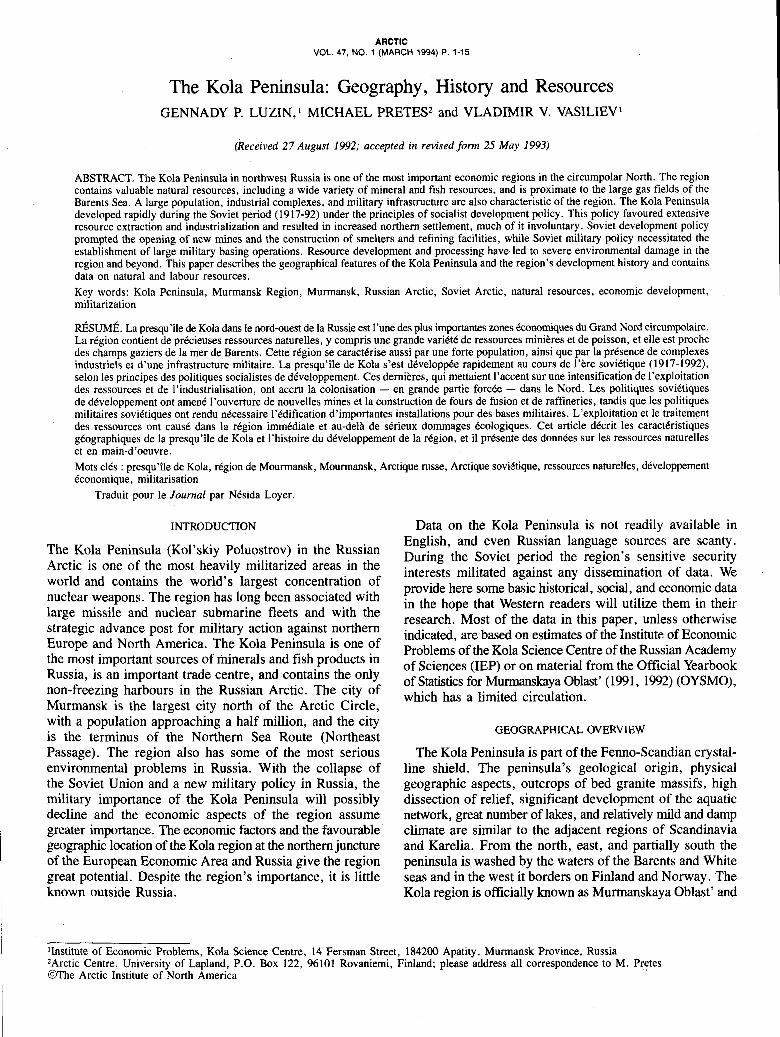
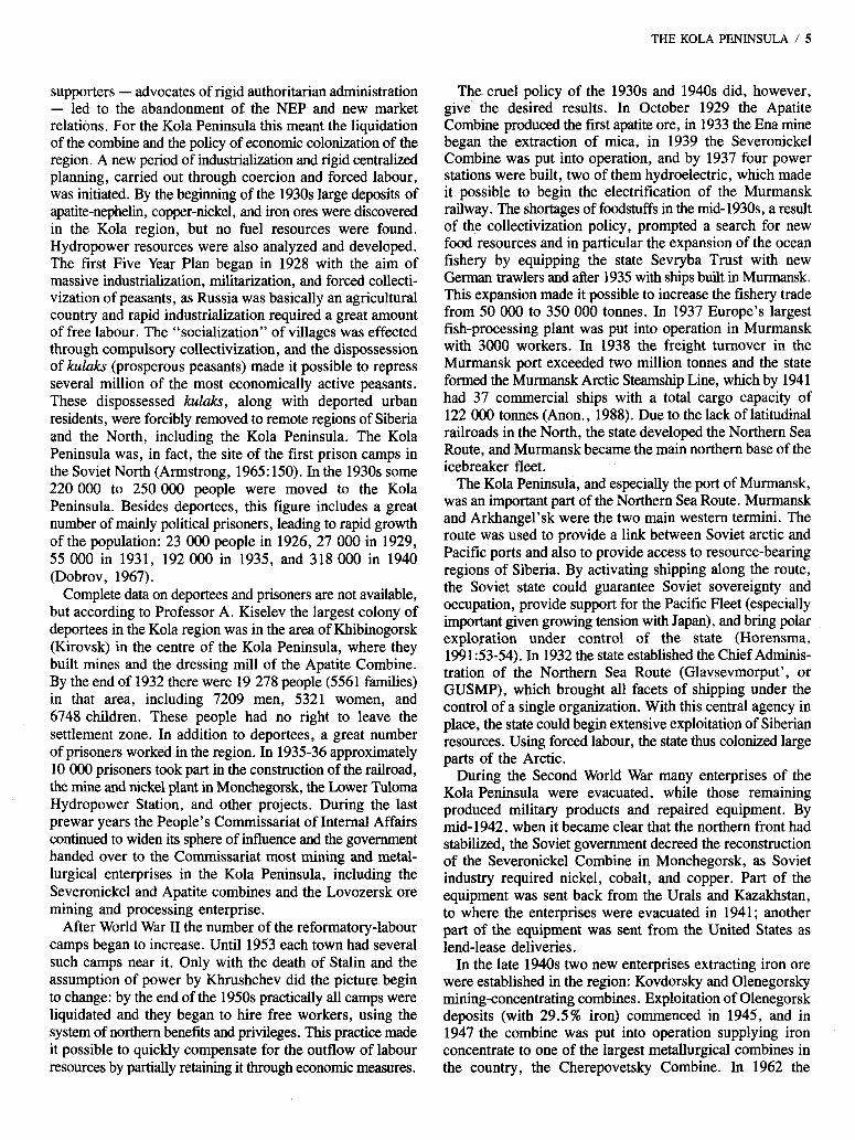
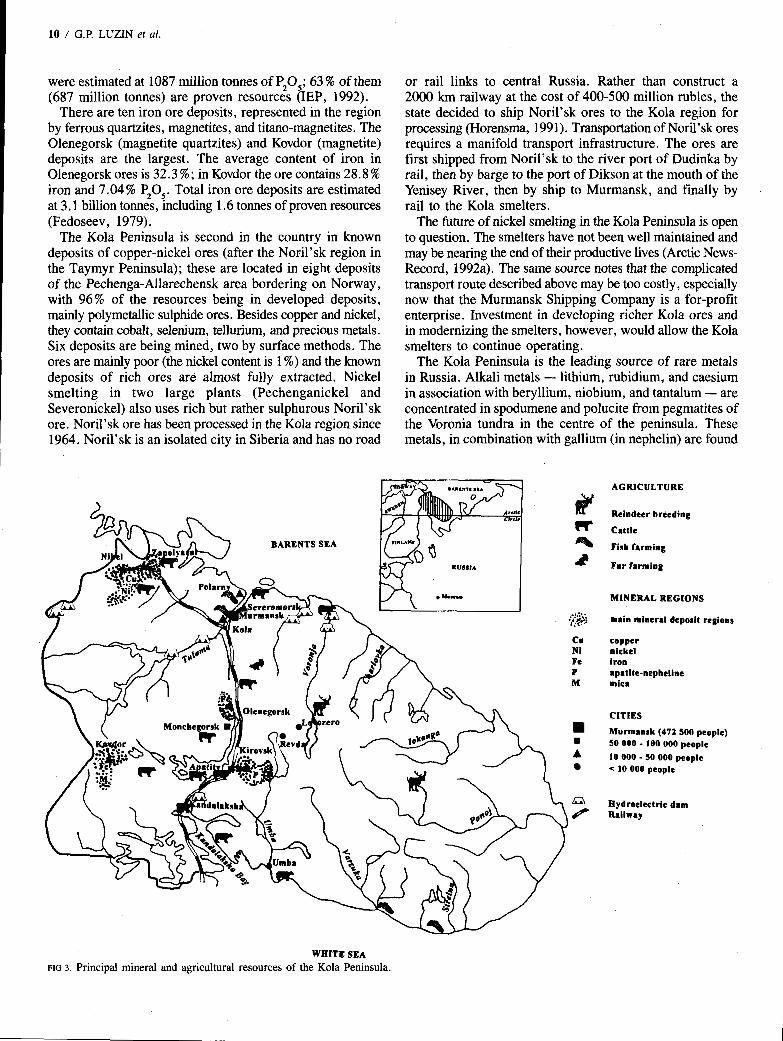
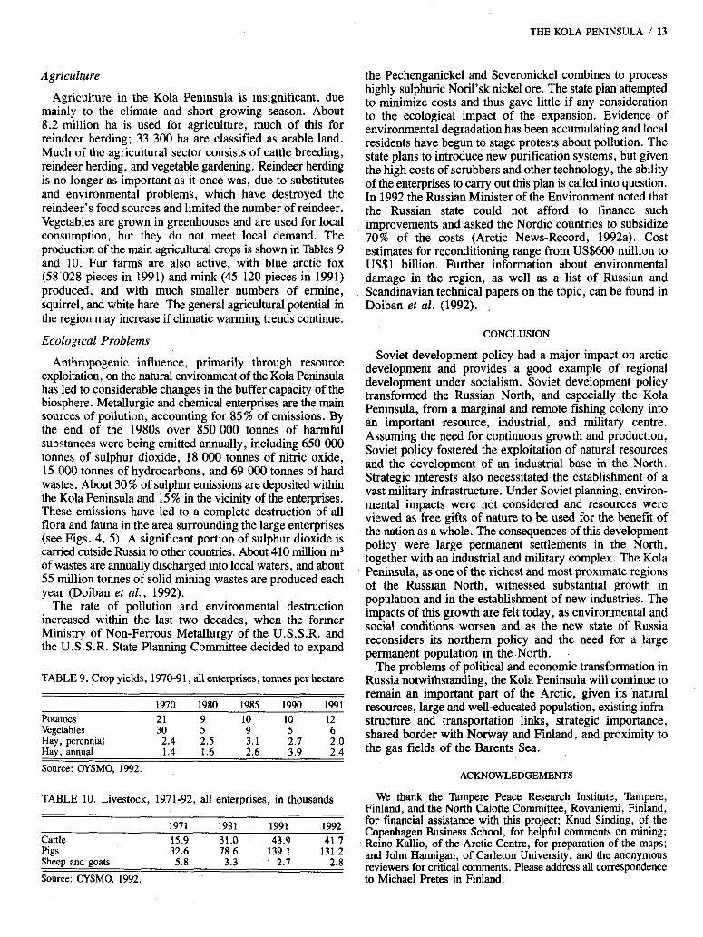
the regional capital is Murmansk. The region is almost entirely situated above the Arctic Circle, with a total area of 144 900 k m 2 . The Kola region extends for 390 km from south to north (66” to 69”N) and about 550 km from west to east (28” to 41”E) and belongs to the “Northern Zone” of Russia, which covers almost half of the country. The Kola Peninsula accounts for only 0.6 % of the northern zone; nevertheless, the Kola region is three to four times the size of such countries as Belgium, the Netherlands, and Denmark. According to the Russian regional classification, the Kola Peninsula, despite its polar location, belongs to the “Near North,” since it is well developed and populated, located relatively close to the country’s industrial centres (1500 km from St. Petersburg, 1800 km from Moscow), and connected to them by a rail, road, and air network. Figure 1 shows the basic geographic features.
Development and settlement of the region have been influenced by its geographical position and climate. The Kola Peninsula is the most accessible part of the Russian Arctic and - due to the influence of the Gulf Stream, which washes the northern shores of the peninsula with one of its peripheral branches - contains an ice-free coast and a relatively mild and stable climate. The presence of the Gulf Stream also explains the absence of permafrost. The climate is normally
cool, with low summer and winter air temperatures: the average temperature in January is - 8°C along the northern coast and - 12 to - 15°C in the centre of the peninsula. Winter is characterized by frequent blizzards, causing large snowdrifts. The summer is short, lasting only a few months, and is generally cool and rainy, with average June temperatures ranging from 8 to 14°C. Three-quarters of all precipitation occurs between June and October, with an annual total of 400 mm. February is the coldest and windiest month; July is the warmest and most calm. In winter the sun remains below the horizon between 1 December and 13 January (at Murmansk), while in summer the sun does not set between 23 May and 2 1 July (at Murmansk). In the south this period is shorter and lasts from 2 June to 11 July.
Forests cover about half of the peninsula, ranging from northwest to southeast, and are composed of coniferous trees such as Scots pine and Norway spruce and deciduous trees such as birch, mountain ash, and alder. The severe climate and difficult soil conditions lead to slow tree growth, which, however, produces a dense, fine-layered wood suitable for furniture. The region’s flora is varied and numbers about 600 species. The western and the central parts of the peninsula are the richest in plant species, where coniferous forest and mountain tundra vegetation are both found. The Kola
MILITARY INFRASTRUCTURE
3 Naval base
~ 1 SAM battalions Ground Forces basing area
CITIES
H Murmansk (472 SO0 people) so 080 - 100 000 people
A 10 000 - SO 000 people 10 000 people
a. Hydroelectric dam Railway
WHITE SEA
FIG 1 . Main geographical and military features of the Kola Peninsula.
Peninsula contains a variety of berries, such as cawberry, bilberry, cloudberry, and great bilberry, all of which are important wild foods, and there is a variety of mosses and lichens. Misuse of forest resources, industrial expansion, and the absence of pollution abatement measures, especially during the last 30-year period, have severely damaged the forests, especially in the vicinity of the large industrial centres of Murmansk, Monchegorsk, Olenegorsk, and the Pechenga area (including Nikel’).
HISTORY OF SETTLEMENT AND DEVELOPMENT
The Simi, or Lapps, are the indigenous people of the Kola Peninsula. The generally accepted view is that they originally lived on the banks of Lake Onega but gradually migrated to the Kola Peninsula and northern Scandinavia. The first information about the Saini in the Russian Novgorod chronicles dates from the 13th century (12 16). The chronicles show that even then the Simi living in the southeast of the Kola Peninsula were tributaries to the Novgorod Republic (Maksimov, 1859). The Simi were mainly hunters and fishermen and later turned to reindeer herding. By 1895 the number of reindeer on the Kola Peninsula amounted to 40 000, of which 25 OOO belonged to the SBmi. According to the all-Russia general census, the number of Simi was 1724 in 1897 and 2070 in 1907. During the period 1782-1907 the number of Simi increased by 83% (Sidepsner, 1909).
The Simi were followed by the first settlers from Novgorod, which for a long period was the jumping-off point for the development and settling of the Russian European North. Novgorod citizens were attracted to the Kola Peninsula by its plentiful animals and fish (salmon, herring, cod) and relatively mild climate, and thus settled on the coast. The Russian settlement Varzuga, on the southern coast of the peninsula, was one of the earliest. The most intensive Russian settlement took place during the 15th and 16th centuries, wtien monks from the Solovetsky Islands in the White Sea built monasteries in the north of the Kola Peninsula near the Kola and Pechenga rivers. The first of these monasteries was established on the Kola River in 1542 but only lasted a few years. A second monastery was built near Pechenga Bay in 1553 but was destroyed by the Swedes in 1590 (Armstrong, 1965).
The city of Kola, at that time the northernmost city in Russia, was built to the east of the confluence of the Kola and Tuloma rivers; the first mention of the town was made in 1565 (Armstrong, 1965). The city was for many years the centre of development for the northern territories. Despite the difficult political situation (the unification of the Muscovy state took place at this time), the city of Kola flourished in the 16th century and was an important port for European trade. Traders brought goods from all parts of the Muscovy state. The city established a customs office and built a small wooden fortress. The city of Kola facilitated the settlement of the western and eastern shores of the Murman coast (the northern coast of the Kola Peninsula). Much of the population was seasonal, moving between the city of Kola and the seasonal fishing ports. The annual number of such seasonal
THE KOLA PENINSULA / 3
fishermen reached 1500 men, who fished for cod and salmon. With the development of trade in the city of Kola, this small settlement became a town and was well known in Europe, with its trade extending to Denmark, the Netherlands, Norway, England, and other places.
Trade along the Murman coast declined towards the end of the 16th century. In 1586 the Moscow government, fearing that it could not protect its interests in this remote region, decided to create a new and more proximate centre of development: the city of Arkhangel’sk (Archangel) on the Severnaya Dvina River. Trade in Kola was prohibited. The Murman harbours were closed and Arkhangel’sk was granted a trade monopoly. The flourishing communities along the Murman coast were eclipsed by Arkhangel’sk for two centuries; they only began to recover in the 19th century. In 1860 the Kola region’s permanent population was about 500 people but reached 880 by 1880, 790 of these living in small colonies between the Norwegian border and the Kola Bay. The intensification of cattle breeding in 1895 further increased the population. Finns were prominent among the new settlers and were concentrated on the shores of Kola Bay. The Norwegians and Simi were concentrated on the western Murman coast, and the Russians on the eastern coast. In 1899, out of a permanent population of 780, the population consisted of 40.8% Finns, 27.1 % Russians, 17.4% Karelians, 7.4% Norwegians, and 5% S h m i (Dobrov, 1967).
In the summer of 1899,6700 people lived on the Murman coast, including the seasonal population, of which 4100 were engaged in various trades. Russians, numbering 3200, were the most numerous group and were engaged in fishing on the eastern Murman coast. The largest catch of fish took place in the period 1892-97, when it reached 160 000 tonnes. Russian fishermen fished in the offshore zone using traditional primitive methods and sailing in small oar or sail boats. Their productivity was low and the catches were unstable. The Norwegian colonists were equipped with motor boats and more advanced tools, thus enabling them to catch fish not only in the offshore zone but also on the banks of the Norwegian and Barents seas. As a result, in 1913 the Russians caught about 80 O00 tonnes of fish, whereas the Norwegians brought to the Arkhangel’sk market about 3.5 times as much (IEP, 1992). Russia even began to import Norwegian fish.
In the period prior to World War I the total population (including permanent and seasonal residents) doubled, growing from 5200 in 1858 to 10 OOO in 1913, of which 2 100 were S h i (Dobrov , 1967). The region still remained poorly developed and settled. There were no real cities; Kola and Alexandrovsk were only small fishing settlements. Most of the population lived in small settlements along the shores of the White and Barents seas, while the continental areas were poorly populated as there were few roads. The Kola Peninsula remained in the periphery of Russia and did not play an important role in its development. At the erid of the 19th and beginning of the 20th centuries small sawmills were built in the south of the Kola Peninsula and along the banks of the large rivers. By 1909 there were six sawmills. A significant portion of the lumber was exported to Great Britain and Norway.
4 / G.P. LUZIN et al.
Even at the end of the 19th century the location of the future main military port, Libava (Liepaya) or Murman, was still in question. Such a port was advocated in order to stop the eastward advancement of Norwegian settlers. The minister of finance at that time, Count Sergei Witte, in the report presented to Emperor Alexander I11 in August 1894, suggested that the port be constructed in Kola Bay because of its favourable strategic location, ice-free harbour, and mild climate. The unexpected death of the emperor in October 1894 hampered the realization of the project, however, as the new Emperor Nicholas I1 favoured the building of the port in Libava. Only one of the measures in Witte’s report was realized: in 1899 a small town, Alexandrovsk, was built in Yekaterina harbour on Kola Bay. The First World War, having demonstrated the vulnerability of the southern and western ports of Russia (which were blocked by Turkey and Germany, cutting off the country from its allies), led to renewed interest in the construction of a large port on the Kola Peninsula and a railway to reach it from St. Petersburg. The perceived threat and need for access to Europe and the high seas was an important factor stimulating the development of the Kola region and especially in connecting it to central Russia.
World War I saw the construction of a railway to the Murman coast. Construction of the railway from St. Petersburg to Petrozavodsk, 300 km in length, started in June 1914, financed by French credit, and was finished in the summer of 19 15. State funds financed the second stretch of the railway from Petrozavodsk to Kola Bay, 1044 km in length. A new port and town - Romanov-on-Murman, which after the February revolution of 1917 was called Murmansk - was built along Kola Bay 70 km from the sea (Slavin, 1961).
The railway was built in only a year and a half and was put into operation on 3 November 1916. This phenomenon can be explained by the emergency war situation. The rapid rate of construction in extremely difficult conditions, crossing uninhabited rocky territory, marshes and lakes, and thick taiga is an outstanding event in the history of railway construction. Out of 1044 km, 266 km were laid in marshes, which required difficult irrigation and soil operations. To cross multiple rivers about 1 1 0 0 bridges and artificial dikes were built (Chirkin, 1929). The labour force was a difficult problem since the territory was sparsely inhabited. The railway hired about 30 OOO peasants from all over Russia, and because of the war and the lack of a free labour force the railway used about 40 OOO Austrian prisoners of war and several thousand Chinese workers. Many sections of the railway were built in a hurry and required additional construction. The total cost was 180 million rubles (at the exchange rate in 1913). By 1917 seven unloading moorages operated in Murmansk harbour, and these could accommodate ten large ships simultaneously. The operating capacity of the port was one million tonnes per year. The construction of the railway and port in Kola Bay changed not only the military-strategic situation but also the economic situation of the Kola region, providing infrastructure for future development. The 1917 revolution and civil war reduced the potential for immediate development, however. The railway
and port fell into decay and the population was reduced to about 14 000 people (2500 in Murmansk) in 1920 (Alymov, 1925).
The role of the Murmansk railway and port in the settlement and development of the region was renewed only during the so-called New Economic Policy (NEP), pursued in Soviet Russia from 1921 to 1928, when the role of the state was reduced and private ownership as well as small- and medium- sized businesses were permitted. Lenin himself took a great interest in northern development and was instrumental in establishing the Floating Marine Research Institute (Plavmornin) and in supporting northern exploration, research, and resource development (Slavin, 1972). The half-state-owned firm, the Murmansk Industrial and Trans- portation Colonization Combine, formed in 1923 by the amalgamation of the Murmansk railway and Murmansk and Kemsk seaports, played an important role in the economic development of the Kola Peninsula. In the Kola region the soils and climate were unsuitable for agriculture, so the colonization assumed an industrial form. The Kola Peninsula developed as an industrial colony, and attention was directed to the development of foreign trade, fishery and mineral resources, and forestry. The combine hired labourers from other parts of the country on a contract basis, and the develop- ment of agriculture was exclusively to service the population.
According to the colonization regulations, the combine was granted a territory of 3.2 million hectares along the Murmansk railway, including forests and mineral resources, for a ten-year period (Chirkin, 1929). The combine was financed independently without any assistance from the state. Fees for wood and the resource rights, as well as industrial activity, constituted the income of the combine. Part of the combine’s revenues were used to finance colonization aims, such as attracting and equipping settlers and the construction of settlements and enterprises; the other part was channelled to the restoration of the railway and the port.
Within three years the Murmansk Industrial and Transpor- tation Colonization Combine controlled the fishing industry, recovery of mica, stocking and processing of wood, and export of lumber to England. Funds provided by these operations were used for restoring the railway and for settling the Kola Peninsula. The trade port was successfully restored. The port’s freight turnover increased tenfold and reached 500 000 tonnes by 1928. By 1927 Murmansk was one of the country’s leading ports and only 6% behind Leningrad (St. Petersburg) (Chirkin, 1929). Murmansk became one of the most important foreign trade ports in the country.
In 1924 the Northern State Fishery Trust was formed in Murmansk.and was reinforced by a trawler fleet brought in from Arkhangel’sk. The fleet was modernized through the purchase of new German trawlers and seiners. These additions made it possible to harvest up to 50 000 tonnes of fish annually by 1928. All of these factors favoured the quick settling of the region, and by 1928 the population reached 27 000 people, or twice the 1920 population.
In 1928 a new, lasting, and negative stage in the life of the U.S.S.R. and the Kola Peninsula began. The seizing at the end of the 1920s of unlimited power by Stalin and his
supporters - advocates of rigid authoritarian administration - led to the abandonment of the NEP and new market relations. For the Kola Peninsula this meant the liquidation of the combine and the policy of economic colonization of the region. A new period of industrialization and rigid centralized planning, carried out through coercion and forced labour, was initiated. By the beginning of the 1930s large deposits of apatite-nepheli, copper-nickel, and iron ores were discovered in the Kola region, but no fuel resources were found. Hydropower resources were also analyzed and developed. The first Five Year Plan began in 1928 with the aim of massive industrialization, militarization, and forced collecti- vization of peasants, as Russia was basically an agricultural country and rapid industrialization required a great amount of free labour. The “socialization” of villages was effected through compulsory collectivization, and the dispossession of kulaks (prosperous peasants) made it possible to repress several million of the most economically active peasants. These dispossessed kulaks, along with deported urban residents, were forcibly removed to remote regions of Siberia and the North, including the Kola Peninsula. The Kola Peninsula was, in fact, the site of the first prison camps in the Soviet North (Armstrong, 1965: 150). In the 1930s some 220 OOO to 250 000 people were moved to the Kola Peninsula. Besides deportees, this figure includes a great number of mainly political prisoners, leading to rapid growth of the population: 23 OOO people in 1926, 27 000 in 1929, 55 OOO in 1931, 192 OOO in 1935, and 318 000 in 1940 (Dobrov, 1967).
Complete data on deportees and prisoners are not available, but according to Professor A. Kiselev the largest colony of deportees in the Kola region was in the area of Khibinogorsk (Kirovsk) in the centre of the Kola Peninsula, where they built mines and the dressing mill of the Apatite Combine. By the end of 1932 there were 19 278 people (5561 families) in that area, including 7209 men, 5321 women, and 6748 children. These people had no right to leave the settlement zone. In addition to deportees, a great number of prisoners worked in the region. In 1935-36 approximately 10 OOO prisoners took part in the construction of the railroad, the mine and nickel plant in Monchegorsk, the Lower Tuloma Hydropower Station, and other projects. During the last prewar years the People’s Commissariat of Internal Affairs continued to widen its sphere of influence and the government handed over to the Commissariat most mining and metal- lurgical enterprises in the Kola Peninsula, including the Severonickel and Apatite combines and the Lovozersk ore mining and processing enterprise.
After World War 11 the number of the reformatory-labour camps began to increase. Until 1953 each town had several such camps near it. Only with the death of Stalin and the assumption of power by Khrushchev did the picture begin to change: by the end of the 1950s practically all camps were liquidated and they began to hire free workers, using the system of northern benefits and privileges. This practice made it possible to quickly compensate for the outflow of labour resources by partially retaining it through economic measures.
THE KOLA PENINSULA / 5
The. cruel policy of the 1930s and 1940s did, however, give the desired results. In October 1929 the Apatite Combine produced the first apatite ore, in 1933 the Ena mine began the extraction of mica, in 1939 the Severonickel Combine was put into operation, and by 1937 four power stations were built, two of them hydroelectric, which made it possible to begin the electrification of the Murmansk railway. The shortages of foodstuffs in the mid-l93Os, a result of the collectivization policy, prompted a search for new food resources and in particular the expansion of the ocean fishery by equipping the state Sevryba Trust with new German trawlers and after 1935 with ships built in Murmansk. This expansion made it possible to increase the fishery trade from 50 OOO to 350 000 tonnes. In 1937 Europe’s largest fish-processing plant was put into operation in Murmansk with 3000 workers. In 1938 the freight turnover in the Murmansk port exceeded two million tonnes and the state formed the Murmansk Arctic Steamship Line, which by 1941 had 37 commercial ships with a total cargo capacity of 122 OOO tonnes (Anon., 1988). Due to the lack of latitudinal railroads in the North, the state developed the Northern Sea Route, and Murmansk became the main northern base of the icebreaker fleet.
The Kola Peninsula, and especially the port of Murmansk, was an important part of the Northern Sea Route. Murmansk and Arkhangel’sk were the two main western termini. The route was used to provide a link between Soviet arctic and Pacific ports and also to provide access to resource-bearing regions of Siberia. By activating shipping along the route, the Soviet state could guarantee Soviet sovereignty and occupation, provide support for the Pacific Fleet (especially important given growing tension with Japan), and bring polar exploration under control of the state (Horensma, 199153-54). In 1932 the state established the Chief Adminis- tration of the Northern Sea Route (Glavsevmorput’, or GUSMP), which brought all facets of shipping under the control of a single organization. With this central agency in place, the state could begin extensive exploitation of Siberian resources. Using forced labour, the state thus colonized large parts of the Arctic.
During the Second World War many enterprises of the Kola Peninsula were evacuated, while those remaining produced military products and repaired equipment. By mid-1942, when it became clear that the northern front had stabilized, the Soviet government decreed the reconstruction of the Severonickel Combine in Monchegorsk, as Soviet industry required nickel, cobalt, and copper. Part of the equipment was sent back from the Urals and Kazakhstan, to where the enterprises were evacuated in 1941 ; another part of the equipment was sent from the United States as lend-lease deliveries.
In the late 1940s two new enterprises extracting iron ore were established in the region: Kovdorsky and Olenegorsky mining-concentrating combines. Exploitation of Olenegorsk deposits (with 29.5% iron) commenced in 1945, and in 1947 the combine was put into operation supplying iron concentrate to one of the largest metallurgical combines in the country, the Cherepovetsky Combine. In 1962 the
6 / G.P. LUZIN et al.
construction of the Kovdorsky mining-concentrating combine was completed. The total output of iron concentrate at these two enterprises is 12 million tonnes at present. In summer 1943 the reconstruction of another large enterprise, the Apatite Combine, was begun. By the end of the year the combine began to produce apatite concentrate. Apatite and baddelite concentrate production began at Kovdorsky in 1974. Large changes took place in the Kola Peninsula industry in the post-war years. In the 1960s the construction of several mines and enriching plants was completed. As a result the ore extraction increased from 2.9 million tonnes in 1950 to 55 million tonnes in 1990, and concentrate production increased to 29 million tonnes (IEP, 1992).
In the post-war years non-ferrous metallurgy was established at a rapid pace. In addition to the above-mentioned Severonickel Combine at Monchegorsk, which used its own nickel, a new plant, the Pechenganickel Combine, was formed in Pechenga from former Finnish copper-nickel enterprises at Petsamo, a region annexed by the Soviet Union after the Soviet-Finnish peace treaty in 1945. The rich Petsamo nickel deposits were discovered in 1921 but exploitation did not begin until the late 1930s, when the territory was still part of Finland. The smelters and necessary hydropower came into operation in late 1942, with the International Nickel Company (INCO) of Canada as the principal concession holder (Vuorisjarvi, 1989). The Petsamo mines were Germany’s only wartime source of nickel and thus access to them was of great international importance during World War II.
After the defeat of Finland, a German ally, in the Continu- ation War of 1941-44 (an extension of the 1939-40 Winter War between Finland and the Soviet Union), the Finns attempted to destroy the facilities. The Soviets were able to rebuild and the Petsamo (renamed Pechenga) region mines became one of the principal Soviet sources of nickel. A new large copper-nickel deposit, Zhdanov, was also discovered nearby. New mines and a concentrating plant were put into operation in the town of Nikel’ . In 195 1 two more non-ferrous metallurgy enterprises were built in other parts of the Kola Peninsula: the Lovozersky Mining-Concentrating Combine, which produced rare-metal concentrate, and the Kandalakshsky Aluminium Plant, which used alumina produced from Khibiny Mountain concentrate in Pikalyovo, Leningrad.
All these enterprises required extensive power construction. Six hydroelectric stations were built, some by Norwegian and Finnish firms (e.g., those on the Paz and Tuloma rivers). Now 17 hydroelectric stations of more than 1800 MW total capacity operate in the region. The state built a large thermal power station (Kirovskaya State District Power Station, with 0.5 MW installed capacity) in the 1960s to ensure a reliable and stable power supply, and in the early 1970s the Kola Nuclear Power Station was built at Polyarnye Zori (the first in the North) with four small water-cooled reactors of 440 MW capacity. At present the annual production of electric energy in the region reaches almost 20 000 GWh, part of which goes to Karelia and Finland (IEP, 1992). The Kola region is on a single power grid.
During the Soviet period (1917-92) the North was developed under the principles of state socialism. Development policy was based on the exploitation of natural resources for the benefit of the state; this required the settling of the region and the development of infrastructure. As S.V. Slavin (1972, 1982), head of the Economic Research Bureau of Glavsevmorput’ , argued, the criterion of effectiveness under socialism was advantage to the national economy - this in contrast to capitalism, under which the main criterion, he argued, was the rate of profit. Slavin noted that the development of the North was “a question of distributing the productive forces in the most rational way” (1972:59), something that could only be achieved under a strict, centrally planned economy. Resource exploitation in all regions of the country was justified on the grounds of building socialism:
The basic economic law of socialism - the law of the continuous growth and improvement of socialist production on the basis of superior techniques for the purpose of satisfying to the fullest the constantly growing material and cultural requirements of the whole of society - determines the need to draw ever new raw material and power resources into economic use (Slavin, 1972:60).
Industrialization was a major component of the development strategy. The Kola Peninsula became heavily industrialized after important ferrous and non-ferrous mineral resources were discovered and extracted. All of these development plans were in keeping with the general objectives of the Soviet state. The isolation of the U.S.S.R. from world markets required development of domestic raw materials, exports of these materials provided a source of foreign currency, strategic considerations required permanent settlement in the North, and the large size of the country required that a certain self-sufficiency within regions be reached.
MILITARIZATION IN THE KOLA PENINSULA
At present the Kola region is extremely militarized. Rapid militarization began after World War I1 and was associated with the beginning of the Cold War. The Kola Peninsula’s important military-strategic position was the principal factor in siting military installations. The northern coast of the penin- sula is one of the few warm-water coasts in Russia with direct access to the high seas. The creation and development of the Northern Navy began in 1916 and was associated with the necessity to protect the northern sea routes connecting Russia with England from German submarines. For this purpose the Arctic Ocean Fleet was formed in 1916 with its bases in the ports of Murmansk and Iokanga. The fleet was composed of ships from the Soviet Far East and purchased in allied countries, and it comprised 1 battleship, 2 cruisers, 6 destroyers, 2 submarines, and auxiliary ships amounting to a total of 90 by 19 18. During the civil war almost all the ships were captured by England or destroyed.
A revival of the Northern Navy took place in the Soviet period, when in 1933 the government ordered its establish- ment in the Kola Peninsula. Three destroyers, 3 patrol ships, 3 submarines, and 2 mine-sweepers were sent along the recently built White Sea-Baltic Sea channel (built using forced
labour) from the Baltic Sea in 1933. On the basis of these ships the Northern Navy Fleet was created and in May 1937 was named the Northern Fleet. The town of Polyarnyi (Alexandrovsk) at the entrance to Kola Bay was used as its base. The navy established a network of shore and anti- aircraft defences, built a marine airfield in Vaenga, and equipped the fleet with new ships. By the summer of 1941 the Northern Fleet comprised 8 destroyers, 15 submarines, 2 torpedo boats, 7 patrol ships, 2 mine-sweepers and 116 aircraft (BSE, 1976). During the war the fleet supported the 14th Army, defended Murmansk, tried to attack German marine communications in northern Norway, and took part in the defence of northern allied convoys, together with the British. Despite its small size the Northern Fleet played an important role and could handle its main task - to escort and defend convoys to Murmansk and Arkhangel’sk - which was very important for the Red Army, and especially critical in 194 1-42. The fleet played an important role in defeating the German forces in the areas of Petsamo (Pechenga) and Kirkenes in 1944. Until the middle of the 1950s the militarization of the region was relatively small and was characterized by the development of the Navy. Previously most basic ground forces had been sent to the Far East to fight against Japan.
During World War I1 the military actions on the Kola Peninsula began one week later than on the Soviet-German front. On 29 June 194 1 the German forces began the advance on the Murmansk line and on 1 July on the Kandalaksha line. Their purpose was to take possession of the seaport and military base in Murmansk and to capture the strategically important railway station and the town of Kandalaksha in order to surround all Russian land and naval forces in this polar region. The attacks were bitter and long, but in spite of the thoroughness of the military action’s preparation and the availability of considerable land and air forces, the Germans were a failure; none of their goals was achieved.
In 1959 the headquarters of the Northern Fleet was transferred from Polyarnyi to the new town of Severomorsk (Vaenga), located inside Kola Bay, near Murmansk. The extensive militarization of the region prompted construction of new settlements with various service enterprises and bases, located as a rule in remote areas of the peninsula. The population of these settlements consists of servicemen and their relatives with small numbers of civilians. The required labour force is supplied by the soldiers and sailors who are used in construction and restoration, which greatly increases the size of the Army and Navy. According to the prevailing doctrine, it was cheaper to use forced soldier labour than to hire civilians. ’
Militarization of the region increased at the end of the 1950s, when the Soviet Army was equipped with missiles. The quantitative and qualitative rise of the Northern Fleet belongs to a later period and is associated with Leonid Brezhnev and Admiral Sergei Gorshkov, the latter especially a strong proponent of maritime development. From this period until the middle of the 1980s there was a constant increase in the armed forces in the region, and new missile, aircraft, marine, and land armed forces were established
THE KOLA PENINSULA / 7
(see Ries and Skorve, 1987). The reappraisal of the military position in the 1990s will possibly lead to reduced employ- ment and a contraction of military bases in the region, but data on this topic are not publicly available.
POPULATION AND LABOUR RESOURCES
The growth, dimensions, and structure of the population of the Kola Peninsula are closely linked with the develop- ment of its economy. At the beginning of 1992 the number of residents reached 1 165 300 - it had doubled within 30 years (population figures may vary in the tables due to different estimates). Due to the arctic location, industrial orientation of the economy, and militarization of the region, 92.1 % of the population is urban and only 7.9% is rural, with this structure remaining constant (Table 1). Analysis of the population increase from 1960 to 1990 shows, despite some fluctuations in 1980, a steady tendency to diminish more than eight times (from 24 200 in 1960 to 3900 in 1990) (OYSMO, 1991). This can be explained by a decrease in capital investments and the concomitant slowdown in labour demand.
At present the Shmi population is approximately 1800 (but estimates vary based on identification criteria). The remainder of the population consists mainly of migrants from central Russia, Ukraine, and Byelorussia (Belorus) (Table 2). Migration has consistently accounted for over 50% of the total population increase and migrants have always exceeded the number of people leaving the region. Only in 1990, with the economic recession, did these figures change. In that year
TABLE 1. Population dynamics
1960 1990 % (000) %
Total population 609.3 100.0 1159.0 100.0 Urban 561.2 92.1 1067.8 92.1 Rural 48.1 7.9 91.2 7.9
Total annual increment 24.2 100.0 3.9 100.0 Born 15.1 13.3 Died 2.8 6.9 Natural increment 12.3 50.8 6.4 100.0 Migrational increment 11.9 49.2 (2.5) Arrived in region 59.5 44.1 Left region 50.9 46.7 Mechanical increment 8.6 (2.6)
Source: OYSMO, 1991; IEP, 1992.
TABLE 2. Population by nationality
Nationality Persons % of total Russians 965 727 82.9 Ukrainians 105 079 9.0 Byelorussians 38 794 3.3 Tatars 1 1 -459 1 .o Mordovians 4 214 0.4 Karelians 3 505 0.3 Sdmi 1 615 0.2 Finns 590 0.1 Others 33 603 2.8 Total 1 164 586 100.0 Source: OYSMO, 1992.
8 / G.P. LUZIN et al.
the migration balance was a negative 2500, and the total population increase of 3900 people was due to natural increases. The population is expected to decrease slightly in future.
Incentives for settlement in the Russian North were first used in 1869, when the government issued the first decree on the advantages for settlers along the Murman coast. Settlers were freed from taxes and military service. The system of incentives was revised twice before 1907. During the Soviet period the state continued the policy of compulsion and incentives to develop a northern labour force. At present there is a system of incentives for workers and employees of state enterprises and organizations. The incentives include salary bonuses (for the Kola Peninsula this coefficient equals 1.5 times the national average), an additional 18-day leave, reservation of a flat at the previous place of residence, retirement 5 years early, and a number of other advantages.
Recently, however, the revision of salary scales and salary increases across the country has tended to equalize salary rates, causing people to leave the region. In April 1992 the Russian government, following a speech by Vladimir Kuramin, chair of Goskomsever, discussed a new policy for the North. This policy, if implemented, would encourage the non-productive northern population to resettle in the South, where they would be less costly to the state (Economist, 1993). (The amount of state pension payments in the Kola region increased from 144 300 rubles in 1985 to 193 O00 rubles in 1991 .) The plan involves the voluntary resettlement of up to one million northerners in central and southern Russia at a projected cost of 27 billion to 30 billion rubles (People's Congress Proceedings, 1992:35). Already the population of some parts of Chukotka in northeastern Russia has been reduced by 20% (John Hannigan, pers. cornm. 1993). Various reasons account for this exodus. Some people are leaving to ensure that they retain a flat in their home community or citizenship in a non-Russian republic. Others, especially pensioners, find the costs of living to be lower in the South, 'while some professionals, such as medical doctors, are leaving because of the lack of adequate supplies in the North (John Hannigan, pers. comm. 1993).
The Kola Peninsula is the most densely populated part of the Russian North and contains 66% of the population of the Russian Arctic. In 1992 the population density in the Kola Peninsula was 7.9 peoplekm2, which exceeded the other polar areas of the country by 30-50 times (OYSMO, 1992). There are more than 200 settlements in the region, with 92 % of the population living in 12 cities and 42 % in the adminis- trative centre of Murmansk, which has a population of almost a half million (472 900) (Fig. 2). Three cities, Apatity , Severomorsk, and Monchegorsk, have a population between 60 000 and 90 000, and the others have fewer than 60 O00 people (Table 3). The cities and villages are unevenly distributed in the territory and mainly cluster along the Murmansk railway and along the coast. The eastern part of the peninsula, or almost half the territory, is virtually uninhabited due to the severe climate and lack of roads.
The educational level in the Kola Peninsula is high: in 1987 the number of specialists with advanced and technical educa- tion amounted to 160 000, or one-third of all workers and
hi
FIG 2. Kola Bay, near the city of Kola.
employees, including 62 O00 people with a higher university degree. This number increased by a factor of 2.65 between 1970 and 1987; however, at many state enterprises up to 40% of these specialists did not work according to their profes- sion, which speaks of their ineffective use (Lazarev and Korchak, 1991). Ninety percent of the Kola region's popu- lation has at least a secondary level education, and this figure is above 99 % for those aged 20-39. The Kola region contains 252 full-time schools, 21 evening schools, 27 vocational schools, 10 special secondary schools, and 2 institutions of higher learning.
About 730 O00 people were employed in the Kola region in 1990, of which 75% (548 000) were engaged in the national economy. The distribution of labour resources is shown in Table 4. The number of workers increased as the economy developed. From 1960 to 1990 the level increased 1.9 times, reaching 468 400 by 1991. As the Kola Peninsula is industrially developed, the greatest number of workers and employees have been engaged in material production:
TABLE 3. Settling in the Kola Peninsula
1960 1970 1980 1990 Total settlements 418l 300 222 183l Total cities 7 1 1 1 1 12 Total settlement population (OOO) 561.2 720.7 927.8 1067.8 Murmansk population (OOO) 235.0 316.0 394.0 472.9
Source: OYSMO, 1991; IEP, 1992. IEstimates.
TABLE 4. Labour distribution, 1990
% % Labour resources, total 730.3 100.0
Engaged in national economy 548.2 75.1 State sector 534.4 97.5 Kolkhozes 2.2 0.4 Cooperatives 10.8 2.0 Private sector 0.8 o. 1
Students over 16 33.6 4.6 Others 148.5 20.3 Source: OYSMO, 1991; IEP, 1992.
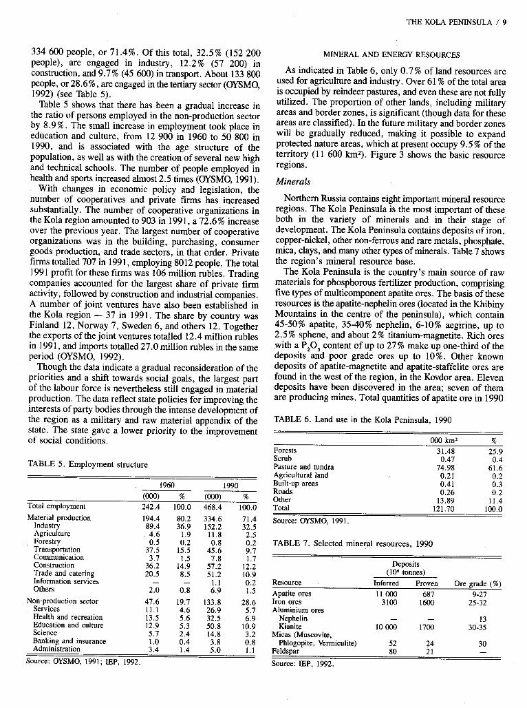
334 600 people, or 71.4%. Of this tots 11. 3 12.5’ % (152 200 people), are engaged in industry, 12.2% -(57 200) in construction, and 9.7% (45 600) in transport. About 133 800 people, or 28.6%, are engaged in the tertiary sector (OYSMO, 1992) (see Table 5) .
Table 5 shows that there has been a gradual increase in the ratio of persons employed in the non-production sector by 8.9 % . The small increase in employment took place in education and culture, from 12 900 in 1960 to 50 800 in 1990, and is associated with the age structure of the population, as well as with the creation of several new high and technical schools. The number of people employed in health and sports increased almost 2.5 times (OYSMO, 1991).
With changes in economic policy and legislation, the number of cooperatives and private firms has increased substantially. The number of cooperative organizations in the Kola region amounted to 903 in 199 1 , a 72.6 % increase over the previous year. The largest number of cooperative organizations was in the building, purchasing, consumer goods production, and trade sectors, in that order. Private firms totalled 707 in 199 1, employing 8012 people. The total 1991 profit for these firms was 106 million rubles. Trading companies accounted for the largest share of private firm activity, followed by construction and industrial companies. A number of joint ventures have also been established in the Kola region - 37 in 1991. The share by country was Finland 12, Norway 7, Sweden 6, and others 12. Together the exports of the joint ventures totalled 12.4 million rubles in 199 1, and imports totalled 27.0 million rubles in the same period (OYSMO, 1992).
Though the data indicate a gradual reconsideration of the priorities and a shift towards social goals, the largest part of the labour force is nevertheless still engaged in material production. The data reflect state policies for improving the interests of party bodies through the intense development of the region as a military and raw material appendix of the state. The state gave a lower priority to the improvement of social conditions.
TABLE 5 . Employment structure -
1960 1990 (OOO) % (OOO) %
Total employment 242.4 100.0 468.4 100.0 Material production 194.4 80.2 334.6 71.4
Industry 89.4 36.9 152.2 32.5 Agriculture 4.6 1.9 11.8 Forestry
2.5 0.5 0.2 0.8
Transportation 37.5 15.5 45.6 0.2 9.7
Communication 3.7 1.5 7.8 1.7 Construction 36.2 14.9 57.2 12.2 Trade and catering 20.5 8.5 51.2 10.9 Information services - - 1 . 1 0.2 Others 2.0 0.8 6.9 1.5
Non-production sector 47.6 19.7 133.8 28.6 Services 1 1 . 1 4.6 26.9 5.7 Health and recreation 13.5 5.6 32.5 6.9 Education and culture 12.9 5.3 50.8 10.9 Science 5.7 2.4 14.8 3.2 Banking and insurance 1.0 0.4 3.8 Administration
0.8 3.4 1.4 5.0 1 . 1
Source: OYSMO, 1991; IEP, 1992.
THE KOLA PENINSULA / 9
MINERAL AND ENERGY RESOURCES
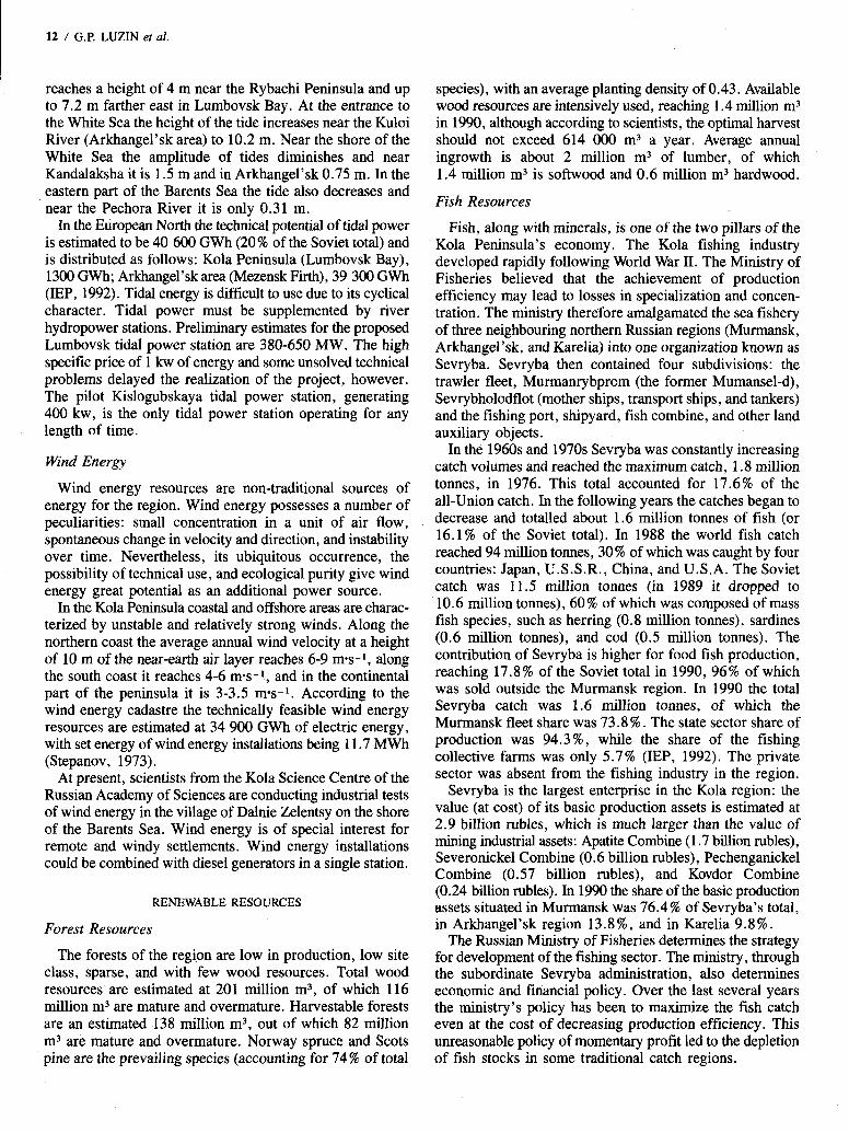
As indicated in Table 6, only 0.7% of land resources are used for agriculture and industry. Over 61 % of the total area is occupied by reindeer pastures, and even these are not fully utilized. The proportion of other lands, including military areas and border zones, is significant (though data for these areas are classified). In the future military and border zones will be gradually reduced, making it possible to expand protected nature areas, which at present occupy 9.5 % of the territory (1 1 600 km,). Figure 3 shows the basic resource regions.
Minerals
Northern Russia contains eight important mineral resource regions. The Kola Peninsula is the most important of these both in the variety of minerals and in their stage of development. The Kola Peninsula contains deposits of iron, copper-nickel, other non-ferrous and rare metals, phosphate, mica, clays, and many other types of minerals. Table 7 shows the region’s mineral resource base.
The Kola Peninsula is the country’s main source of raw materials for phosphorous fertilizer production, comprising five types of multicomponent apatite ores. The basis of these resources is the apatite-nephelin ores (located in the Khibiny Mountains in the centre of the peninsula), which contain 45-50% apatite, 35-40% nephelin, 6-10% aegirine, up to 2.5 % sphene, and about 2 % titanium-magnetite. Rich ores with a P,O, content of up to 27% make up one-third of the deposits and poor grade ores up to 10%. Other known deposits of apatite-magnetite and apatite-staffelite ores are found in the west of the region, in the Kovdor area. Eleven deposits have been discovered in the area; seven of them are producing mines. Total quantities of apatite ore in 1990
TABLE 6 . Land use in the Kola Peninsula, 1990
000 km2 % Forests Scrub Pasture and tundra Agricultural land Built-up areas Roads Other
31.48 25.9 0.47 0.4
74.98 61.6 0.21 0.2 0.41 0.3 0.26 0.2
13.89 11.4
~~~~
Total 121.70 lW.0
Source: OYSMO. 1991.
TABLE 7. Selected mineral resources, 1990
Deposits (lo6 tomes)
Resource Inferred Proven Ore grade (%) Apatite ores 1 1 OOO 687 9-27 Iron ores 3100 1600 25-32 Aluminium ores
Nephelin - - 13 Kianite 10 OOO 1700 30-35
Micas (Muscovite, Phlogopite, Vermiculite) 52 24 30
Feldspar 80 21 - Source: IEP, 1992.
10 / G.P. LUZIN et al.
were estimated at 1087 million tonnes of P205; 63 % of them (687 million tonnes) are proven resources (IEP, 1992).
There are ten iron ore deposits, represented in the region by ferrous quartzites, magnetites, and titano-magnetites. The Olenegorsk (magnetite quartzites) and Kovdor (magnetite) deposits are the largest. The average content of iron in Olenegorsk ores is 32.3 % ; in Kovdor the ore contains 28.8 % iron and 7.04% P20,. Total iron ore deposits are estimated at 3.1 billion tonnes, including 1.6 tonnes of proven resources (Fedoseev, 1979).
The Kola Peninsula is second in the country in known deposits of copper-nickel ores (after the Noril’sk region in the Taymyr Peninsula); these are located in eight deposits of the Pechenga-Allarechensk area bordering on Norway, with 96% of the resources being in developed deposits, mainly polymetallic sulphide ores. Besides copper and nickel, they contain cobalt, selenium, tellurium, and precious metals. Six deposits are being mined, two by surface methods. The ores are mainly poor (the nickel content is 1 %) and the known deposits of rich ores are almost fully extracted. Nickel smelting in two large plants (Pechenganickel and Severonickel) also uses rich but rather sulphurous Noril’sk ore. Noril’sk ore has been processed in the Kola region since 1964. Noril’sk is an isolated city in Siberia and has no road
or rail links to central Russia. Rather than construct a 2000 km railway at the cost of 400-500 million rubles, the state decided to ship Noril’sk ores to the Kola region for processing (Horensma, 1991). Transportation of Noril’sk ores requires a manifold transport infrastructure. The ores are first shipped from Noril’sk to the river port of Dudinka by rail, then by barge to the port of Dikson at the mouth of the Yenisey River, then by ship to Murmansk, and finally by rail to the Kola smelters.
The future of nickel smelting in the Kola Peninsula is open to question. The smelters have not been well maintained and may be nearing the end of their productive lives (Arctic News- Record, 1992a). The same source notes that the complicated transport route described above may be too costly, especially now that the Murmansk Shipping Company is a for-profit enterprise. Investment in developing richer Kola ores and in modernizing the smelters, however, would allow the Kola smelters to continue operating.
The Kola Peninsula is the leading source of rare metals in Russia. Alkali metals - lithium, rubidium, and caesium in association with beryllium, niobium, and tantalum - are concentrated in spodumene and polucite from pegmatites of the Voronia tundra in the centre of the peninsula. These metals, in combination with gallium (in nephelin) are found
BARENTS SEA
P a
WHITE SEA FIG 3. Principal mineral and agricultural resources of the Kola Peninsula.
AGRICULTURE
Reindeer breedine ” Cattle * Fish farming * Fur farming
MINERAL REGIONS
.&y -..:. . main mineral deposit regions
Cu copper Ni nickel Fe iron P apatite-nepheline M mica
CITIES Murm8nrk (472 500 people)
A 10 000 - SO 000 people < 10 000 people
50 000 - 100 000 people
Aydroelectric d8m Railway
in ores of the Khibiny Mountains but are not exploited except for gallium.
The Khibiny apatite-nephelin ores are combined raw material. Besides phosphorus they contain fluorine, lantanoids, and strontium; in nephelin, gallium, caesium, and rubidium; and in sphene, titanium, niobium, and tantalum. Titanous raw materials occur in titanomagnetite and sphene in combined Khibiny ores and in great amounts in the tailings (up to 500 million tonnes) of the Apatite Combine. The region also contains deposits of titanium-bearing ores with niobium (Afrikanda, Seblyavr) and with apatite (Gremiaha-Vyrmes, Lesnaja Varaka). Geological conditions make it possible to mine them. Zirconium minerals occur as baddelite (Kovdor) and eudialite (Lovozersk mountains). Large deposits of combined rare metals are in the deposits extracted by the Lovozersk ore extracting and processing combine in the centre of the Kola Peninsula, which is the principal supplier of this raw material in the country (IEP, 1992).
Aluminium-bearing raw materials occur as nephelins in Khibiny and kianites of Keiv in the east of the region. The content of A1,03 in apatite-nephelin ores is 13-14%. The enrichment plants of the Apatite Combine contain an even higher content, which amounts to more than 500 million tonnes. At present a small portion (about 1.6 million tonnes of nephelin concentrate) is processed into alumina at the Volhov and Pikalevsk plants near St. Petersburg. The aluminium resources of the Keiv area at the east of the Kola Peninsula are promising, where total reserves of rich kianite ores are estimated at 3.4 billion tonnes and are found in 23 deposits, 5 of which are already prospected (0.9 billion tonnes) . The average content of kianite is 35.3 % , of alumina 30-35 % , and of silica 60-65 % (Fedoseev, 1979). Enriching ores and obtaining kianite concentrate with 56-57% A1,.03 content (and its processing into silumine and alumma refractories) is mastered in test-industrial volume. The mastering is hampered by the lack of roads and basic infra- structure in the east of the peninsula.
By volume of proven resources and the variety of non-ore raw materials - such as micas (muscovite, phlogopite, and vermiculite), ceramic and quartz raw material, carbonates (carbonatites and dolomites), facing and lining materials, and semi-precious stones - the Kola Peninsula is one of the leading regions in the country. Micas occur mainly in the Kovdor phlogopite-vermiculite area at the west of the peninsula, but are also found in other areas; however, only the first is of industrial importance. Mica resources are estimated at 24 million tonnes. These deposits are currently being extracted.
Non-ore building materials are practically unlimited and are represented by building stones such as granite, diabase, olivine, sienite, quartzite, and shales. Proven resources include 21 deposits of building stone, 35 of sandy gravel- boulder formations, and 17 sand deposits including 7 quartzy . Total resources are about 21 million tonnes (IEP, 1992).
Petroleum
Despite such variable and vast resources in the Kola Peninsula, it was long impossible to discover deposits of
THE KOLA PENINSULA / 11
hydrocarbons. Recently large natural gas and oil deposits were discovered offshore in the Barents Sea. Russian and Western estimates have ranged as high as 4000 billion m3 for natural gas and the fields have been described as “supergiant” (Arctic News-Record, 1992b). Preliminary prospecting has shown the promising character of these deposits; however, these require more detailed study and reliable estimation. The potential development is nevertheless substantial.
Water and Hydropower Water resources of the region are represented by annual
river flow, which is estimated for the Kola Peninsula to be 79 k m 3 , of which 53.6 k m 3 are formed within the region and the remaining 25.4 k m 3 outside the region. The assumed potential resources of ground water are 6 million m3 per day. At present the water supply for the population and economy is 2.5 k m 3 of water resources per year, of which 92% is used by industry. During the past 15 years water consumption in the region increased by 250% (IEP, 1992).
Hydropower resources of the Kola Peninsula comprise 28 rivers with potential resources of 2500 MW, or 92% of all hydro resources of the region. The rivers are characterized by small water catchment areas and a spillway type of longitu- dinal profile, which ensures the relatively small power of their branches and which cannot be considered as indepen- dent sources of hydropower. In the region 7 large rivers concentrate 66% of summary power and 21 medium rivers the remaining 34%. The northeast of the peninsula has the greatest potential for hydropower. This area represents 27 % of the peninsula but contains 41 % of all hydro resources; the west represents 57 % of territory and 45 % of hydropower, and the southeast 14% of territory and 16% of hydropower. The main factor influencing the high content of hydropower in the northeast is the great value of the absolute fall of the water surface, the sheer spillway profile, and the high average modulus of river flow: 12.4 1 ~ k m - ~ instead of 11.5 1 ~ * k m - ~ in other areas. The most powerful river in the Kola Peninsula is the Pona (in the east), containing 12.4% of all hydro resources. Other large rivers are the Voronia, Iokanga, and Tuloma. Hydro resources of the region are well developed. There are 17 hydraulic power stations with a total capacity of 1800 MW (IEP, 1992). The distribution of hydro resources is shown in Table 8.
Tidal Power
The Kola Peninsula has significant tidal power potential along its northern coast, which in the form of tidal waves
TABLE 8. Territorial distribution of potential hydro resources
Large rivers Medium rivers Resources Resources
Areas Number MW % Number MW % Western 4 712 84.4 5 112 13.6 Northeastern 3 494 66.2 7 253 33.8 Southeastern - - - 9 252 100.0 Source: Hydropower Resources of the Kola Peninsula, Issue 3. Leningrad: U.S.S.R. Academy of Sciences, 1970.
12 / G.P. LUZIN er al.
reaches a height of 4 m near the Rybachi Peninsula and up to 7.2 m farther east in Lumbovsk Bay. At the entrance to the White Sea the height of the tide increases near the Kuloi River (Arkhangel’sk area) to 10.2 m. Near the shore of the White Sea the amplitude of tides diminishes and near Kandalaksha it is 1.5 m and in Arkhangel’sk 0.75 m. In the eastern part of the Barents Sea the tide also decreases and near the Pechora River it is only 0.31 m.
In the European North the technical potential of tidal power is estimated to be 40 600 GWh (20% of the Soviet total) and is distributed as follows: Kola Peninsula (Lumbovsk Bay), 1300 GWh; Arkhangel’sk area (Mezensk Firth), 39 300 GWh (EP, 1992). Tidal energy is difficult to use due to its cyclical character. Tidal power must be supplemented by river hydropower stations. Preliminary estimates for the proposed Lumbovsk tidal power station are 380-650 MW. The high specific price of 1 kw of energy and some unsolved technical problems delayed the realization of the project, however. The pilot Kislogubskaya tidal power station, generating 400 kw, is the only tidal power station operating for any length of time.
Wind Energy
Wind energy resources are non-traditional sources of energy for the region. Wind energy possesses a number of peculiarities: small concentration in a unit of air flow, spontaneous change in velocity and direction, and instability over time. Nevertheless, its ubiquitous occurrence, the possibility of technical use, and ecological purity give wind energy great potential as an additional power source.
In the Kola Peninsula coastal and offshore areas are charac- terized by unstable and relatively strong winds. Along the northern coast the average annual wind velocity at a height of 10 m of the near-earth air layer reaches 6-9 m-s- l, along the south coast it reaches 4-6 m-s-1, and in the continental part of the peninsula it is 3-3.5 mas-’. According to the wind energy cadastre the technically feasible wind energy resources are estimated at 34 900 GWh of electric energy, with set energy of wind energy installations being 1 1.7 MWh (Stepanov, 1973).
At present, scientists from the Kola Science Centre of the Russian Academy of Sciences are conducting industrial tests of wind energy in the village of Dalnie Zelentsy on the shore of the Barents Sea. Wind energy is of special interest for remote and windy settlements. Wind energy installations could be combined with diesel generators in a single station.
RENEWABLE RESOURCES
Forest Resources
The forests of the region are low in production, low site class, sparse, and with few wood resources. Total wood resources are estimated at 201 million m3, of which 116 million m3 are mature and overmature. Harvestable forests are an estimated 138 million m3, out of which 82 million m3 are mature and overmature. Norway spruce and Scots pine are the prevailing species (accounting for 74 % of total
species), with an average planting density of 0.43. Available wood resources are intensively used, reaching 1.4 million m3 in 1990, although according to scientists, the optimal harvest should not exceed 614 000 m3 a year. Average annual ingrowth is about 2 million m3 of lumber, of which 1.4 million m3 is softwood and 0.6 million m3 hardwood.
Fish Resources
Fish, along with minerals, is one of the two pillars of the Kola Peninsula’s economy. The Kola fishing industry developed rapidly following World War 11. The Ministry of Fisheries believed that the achievement of production efficiency may lead to losses in specialization and concen- tration. The ministry therefore amalgamated the sea fishery of three neighbouring northern Russian regions (Murmansk, Arkhangel’sk, and Karelia) into one organization known as Sevryba. Sevryba then contained four subdivisions: the trawler fleet, Murmanrybprom (the former Mumansel-d), Sevrybholodflot (mother ships, transport ships, and tankers) and the fishing port, shipyard, fish combine, and other land auxiliary objects.
In the 1960s and 1970s Sevryba was constantly increasing catch volumes and reached the maximum catch, 1.8 million tonnes, in 1976. This total accounted for 17.6% of the all-Union catch. In the following years the catches began to decrease and totalled about 1.6 million tonnes of fish (or 16.1 % of the Soviet total). In 1988 the world fish catch reached 94 million tonnes, 30% of which was caught by four countries: Japan, U.S.S.R., China, and U.S.A. The Soviet catch was 11.5 million tonnes (in 1989 it dropped to 10.6 million tonnes), 60 % of which was composed of mass fish species, such as herring (0.8 million tonnes), sardines (0.6 million tonnes), and cod (0.5 million tonnes). The contribution of Sevryba is higher for food fish production, reaching 17.8 % of the Soviet total in 1990, 96% of which was sold outside the Murmansk region. In 1990 the total Sevryba catch was 1.6 million tonnes, of which the Murmansk fleet share was 73.8 % . The state sector share of production was 94.3%, while the share of the fishing collective farms was only 5.7 % (IEP, 1992). The private sector was absent from the fishing industry in the region.
Sevryba is the largest enterprise in the Kola region: the value (at cost) of its basic production assets is estimated at 2.9 billion rubles, which is much larger than the value of mining industrial assets: Apatite Combine (1.7 billion rubles), Severonickel Combine (0.6 billion rubles), Pechenganickel Combine (0.57 billion rubles), and Kovdor Combine (0.24 billion rubles). In 1990 the share of the basic production assets situated in Murmansk was 76.4% of Sevryba’s total, in Arkhangel’sk region 13.8 % , and in Karelia 9.8 % .
The Russian Ministry of Fisheries determines the strategy for development of the fishing sector. The ministry, through the subordinate Sevryba administration, also determines economic and financial policy. Over the last several years the ministry’s policy has been to maximize the fish catch even at the cost of decreasing production efficiency. This unreasonable policy of momentary profit led to the depletion of fish stocks in some traditional catch regions.
THE KOLA PENINSULA / 13
Agriculture
Agriculture in the Kola Peninsula is insignificant, due mainly to the climate and short growing season. About 8.2 million ha is used for agriculture, much of this for reindeer herding; 33 300 ha are classified as arable land. Much of the agricultural sector consists of cattle breeding, reindeer herding, and vegetable gardening. Reindeer herding is no longer as important as it once was, due to substitutes and environmental problems, which have destroyed the reindeer’s food sources and limited the number of reindeer. Vegetables are grown in greenhouses and are used for local consumption, but they do not meet local demand. The production of the main agricultural crops is shown in Tables 9 and 10. Fur farms are also active, with blue arctic fox (58’028 pieces in 1991) and mink (45 120 pieces in 1991) produced, and with much smaller numbers of ermine, squirrel, and white hare. The general agricultural potential in the region may increase if climatic warming trends continue.
Ecological Problems
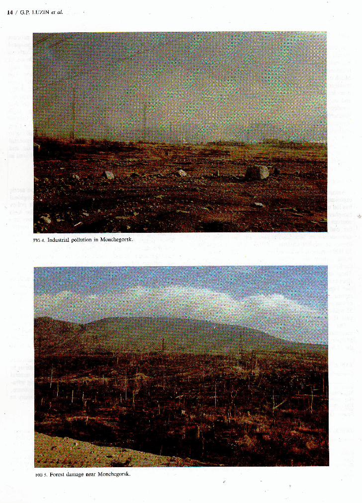
Anthropogenic influence, primarily through resource exploitation, on the natural environment of the Kola Peninsula has led to considerable changes in the buffer capacity of the biosphere. Metallurgic and chemical enterprises are the main sources of pollution, accounting for 85 % of emissions. By the end of the 1980s over 850 OOO tonnes of harmful substances were being emitted annually, including 650 000 tonnes of sulphur dioxide, 18 OOO tonnes of nitric oxide, 15 000 tonnes of hydrocarbons, and 69 000 tonnes of hard wastes. About 30% of sulphur emissions are deposited within the Kola Peninsula and 15 % in the vicinity of the enterprises. These emissions have led to a complete destruction of all flora and fauna in the area surrounding the large enterprises (see Figs. 4, 5). A significant portion of sulphur dioxide is carried outside Russia to other countries. About 4.10 million m3 of wastes are annually discharged into local waters, and about 55 million tonnes of solid mining wastes are produced each year (Doiban et al., 1992).
The rate of pollution and environmental destruction increased within the last two decades, when the former Ministry of Non-Ferrous Metallurgy of the U.S.S.R. and the U.S.S.R. State Planning Committee decided to expand
TABLE 9. Crop yields, 1970-91, all enterprises, tonnes per hectare
1970 1980 1985 1990 1991 ~ ~~~~~~
Potatoes 21 9 10 10 12 Vegetables 30 5 9 5 6 Hay, perennial 2.4 2.5 3.1 2.7 2.0 Hay, annual 1.4 1.6 2.6 3.9 2.4 Source: OYSMO, 1992.
TABLE 10. Livestock, 1971-92, all enterprises, in thousands
1971 1981 1991 1992 Cattle 15.9 31 .O 43.9 41.7 Pigs 32.6 78.6 139.1 131.2 Sheep and goats 5.8 3.3 2.7 2.8 Source: OYSMO, 1992.
the Pechenganickel and Severonickel combines to process highly sulphuric Noril’sk nickel ore. The state plan attempted to minimize costs and thus gave little if any consideration to the ecological impact of the expansion. Evidence of environmental degradation has been accumulating and local residents have begun to stage protests about pollution. The state plans to introduce new purification systems, but given the high costs of scrubbers and other technology, the ability of the enterprises to carry out this plan is called into question. In 1992 the Russian Minister of the Environment noted that the Russian state could not afford to finance such improvements and asked the Nordic countries to subsidize 70% of the costs (Arctic News-Record, 1992a). Cost estimates for reconditioning range from US$600 million to US$1 billion. Further information about environmental damage in the region, as well as a list of Russian and Scandinavian technical papers on the topic, can be found in Doiban et al. (1992). .
CONCLUSION
Soviet development policy had a major impact on arctic development and provides a good example of regional development under socialism. Soviet development policy transformed the Russian North, and especially the Kola Peninsula, from a marginal and remote fishing colony into im important resource, industrial, and military centre. Assuming the need for continuous growth and production, Soviet policy fostered the exploitation of natural resources and the development of an industrial base in the North. Strategic interests also necessitated the establishment of a vast military infrastructure. Under Soviet planning, environ- mental impacts were not considered and resources were viewed as free gifts of nature to be used for the benefit of the nation as a whole. The consequences of this development policy were large permanent settlements in the North, together with an industrial and military complex. The Kola Peninsula, as one of the richest and most proximate regions of the Russian North, witnessed substantial growth in population and in the establishment of new industries. The impacts of this growth are felt today, as environmental and social conditions worsen and as the new state of Russia reconsiders its northern policy and the need for a large permanent population in the North. .
The problems of political and economic transformation in Russia notwithstanding, the Kola Peninsula will continue to remain an important part of the Arctic, given its natural resources, large and well-educated population, existing infra- structure and transportation links, strategic importance, shared border with Norway and Finland, and proximity to the gas fields of the Barents Sea.
ACKNOWLEDGEMENTS
We thank the Tampere Peace Research Institute, Tampere, Finland, and the North Calotte Committee, Rovaniemi, Finland, for financial assistance with this project; Knud Sinding, of the Copenhagen Business School, for helpful comments on mining; Reino Kallio, of the Arctic Centre, for preparation of the maps; and John Hannigan, of Carleton University, and the anonymous reviewers for critical comments. Please address all correspondence to Michael Pretes in Finland.
THE KOLA PENINSULA / 15
REFERENCES
ALYMOV, V. 1925. The population of Murmansk at the beginning of 1925.
ANON. 1988. The Murmansk region is fifty years old. Murmansk:
ARCTIC NEWS-RECORD. 1992a. Russia nyets Kola clean-up. 8(7). - . 1992b. The perils of northern resource development. 8(3). ARMSTRONG, T. 1965. Russian settlement in the North. Cambridge:
Cambridge University Press. BSE. 1976. Soviet Encyclopaedia. Vol. 23. Moscow: Soviet Encyclopaedia.
In Russian. CHIRKIN, G. 1929. The awakening of Murman. Moscow: Moskovski
rabochi. In Russian. DOBROV, V. 1967. The population of the Kola North. Murmansk. In
Russian. DOIBAN, V., PRETES, M., and SEKAREV, A. 1992. Economic
development in the Kola Region, USSR: An overview. Polar Record
Murmansk. In Russian.
Murmansk Publishing House. In Russian.
28(164):7-16. ECONOMIST. 1993. Northern lights-out. 6 March. FEDOSEEV, V. 1979. Efficiency of using mineral raw material in the
extreme North. Leningrad: Nauka. In Russian. HORENSMA, P. 1991. The Soviet Arctic. London: Routledge. INSTITUTE OF ECONOMIC PROBLEMS (IEP). 1992. Unpublished
estimates. Apatity: Institute of Economic Problems, Kola Science Centre.
LAZAREV, E., and KORCHAK, A. 1991. Labour potential of the Murmansk area. In: Economic and social aspects of using production forces of the Kola region. Apatity: Kola Science Centre. In Russian.
MAKSIMOV, S.A. 1859. A year in the North. Vol. I. St. Petersburg. In
OFFICIAL YEARBOOK OF STATISTICS FOR MURMANSKAYA Russian.
OBLAST’ (OYSMO). 1991, 1992. Murmansk: Goskomstat. In Russian. PEOPLE’S CONGRESS PROCEEDINGS. 1992. Kuramin addresses
Congress on North. FBIS-SOV-92-0784. Moscow: Congress of People’s Deputies. 22 April.
RIES, T., and SKORVE, J. 1987. Investigating Kola: A study of military bases using satellite photography. London: Brassey’s Defence.
SIDEPSNER, A. 1909. A description of the M u m coast. St. Petersburg. In Russian.
SLAW, S . 1961. Industrial and transport development of the USSR North. Moscow: Economica. In Russian. - . 1972. The Soviet North: Present developments and prospects.
Moscow: Progress. Trans. by D. Danemanis. - . 1982. Exploration of the North of the Soviet Union. Moscow:
Nauka. In Russian. STEPANOV, N. 1973. Problems of power of the North. Leningrad: Nauka.
In Russ@n. VUORISJARVI, E. 1989. Petsamo’s nickel in international politics.
Helsinki: Otava. In Finnish.