the kent compendium of historic parks and gardens for dover · gardens trust as part of its wider...
TRANSCRIPT
The Kent Compendium of Historic Parks and Gardens
for Dover
Fredville Park
May 2017

Fredville Park Nonington, Dover, Kent
TABLE OF CONTENTS INTRODUCTION STATEMENT OF SIGNIFICANCE SUMMARY OF HISTORIC INTEREST CHRONOLOGY OF THE HISTORIC DEVELOPMENT SITE DESCRIPTION LIST OF FIGURES
FIGURE 1: Boundary map FIGURE 2: Key views map FIGURE 3: OS 1st Edition 25” map (1862-1875) FIGURE 4: OS 2nd Edition 25” map (1897 - 1900) FIGURE 5: OS 3rd Edition 25” map (1907 - 1923) FIGURE 6: OS 4th Edition 25” map (1929 - 1952) FIGURE 7: Fredville oak FIGURE 8: Sweet chestnut tree FIGURE 9: Avenue of Spanish chestnut trees FIGURE 10: View across Fredville park
INTRODUCTION This site description and accompanying dossier have been prepared by the Kent Gardens Trust as part of its wider review of The Kent Compendium of Historic Parks and Gardens. This part of the review was carried out for Dover District Council (DDC) from 2015-2017 and covers sites within the Dover local authority area. The reports detail the historic nature, content, current state and significance of the sites currently identified in the Kent Compendium of Historic Parks and Gardens for the Dover local authority area along with others identified by DDC. Dover District Heritage Strategy. The Dover District Heritage Strategy 2013 (DDHS) seeks to ensure that heritage plays a clear role in shaping any future regeneration, development and management decisions. To achieve this aim the DDHS contains a series of recommendations intended to promote and enhance the protection and enjoyment of the Districts heritage assets. A heritage asset is defined as a “building, monument, site, place, area or landscape identified as having a degree of significance meriting consideration in planning decisions, because of its heritage interest. Heritage asset includes designated heritage assets and assets identified by the local planning authority (including local listing)”1. The review carried out by the Kent Gardens Trust supports the following DDHS recommendations:
Recommendation 9: Systems should be put in place to ensure that historic environment information and advice is readily accessible to local communities to help them shape the places in which they live.
Recommendation 14: a Local List of Heritage Assets should be developed...gardens identified within the Kent Gardens Compendium and any enhancement of the Compendium should be included in the Local List.
Recommendation 23: Opportunities should be sought and support given to local communities, groups and individuals in researching their past, develop projects with them that identify, enhance understanding of the Districts heritage assets and involve them in condition assessment, monitoring, management, promotion and interpretation of the assets:
How was the review carried out? The review has been undertaken using Historic England’s criteria for identifying the significance of local heritage assets to provide a consistent approach2. A template for the reports was developed by DDC, building on the experience of previous work by the Kent Gardens Trust. The heritage values of the historic
1 National Planning Policy Framework 2012 2 Historic England “Conservation Principles: Policy and Guidance” 2008
park or garden subject to the report are defined within the Statement of Significance. The extent of the area identified represents the current surviving area of the designed landscape, the boundary line generally reflecting the maximum extent of the historic gardens or parkland (although there are exceptions such as where land has been irreversibly lost to development). The boundary line takes no account of current ownership. How will the reports be used?
a) The revised list of sites has the potential to support development of a Local List3 of Heritage Assets in Dover, should the Council progress with the recommendation in the DDHS in the future. The list of sites researched and evaluated in this review would be subject to consultation as part of any Local List development and is therefore not intended to be final.
b) In response to recommendation 9 of the DDHS, the reports will be made publically available both on the DDC website and to the Historic Environment Record held by Kent County Council.
c) The reports will help to inform future funding applications for historic
spaces by the identification of significance.
d) The review will help to inform future policy making, conservation and/or any development of sites, and contribute to the understanding, and where possible enjoyment, of these heritage assets by the identification of the significance of key historic character, features and association including that of setting and viewpoints.
Further information is available from the contacts listed below. The partnership would like to thank the volunteers and owners who have participated in this project and given so much of their time, effort and hospitality to complete this challenging and rewarding task. Dover District Council White Cliffs Business Park Dover CT16 3PJ www.dover.gov.uk
Kent County Council Heritage Conservation Invicta House County Hall Maidstone ME14 1XX www.kent.gov.uk
Kent Gardens Trust www.kentgardenstrust.org.uk
3 Historic England “Local Heritage Listing”: Historic England Advice Note 7 2016

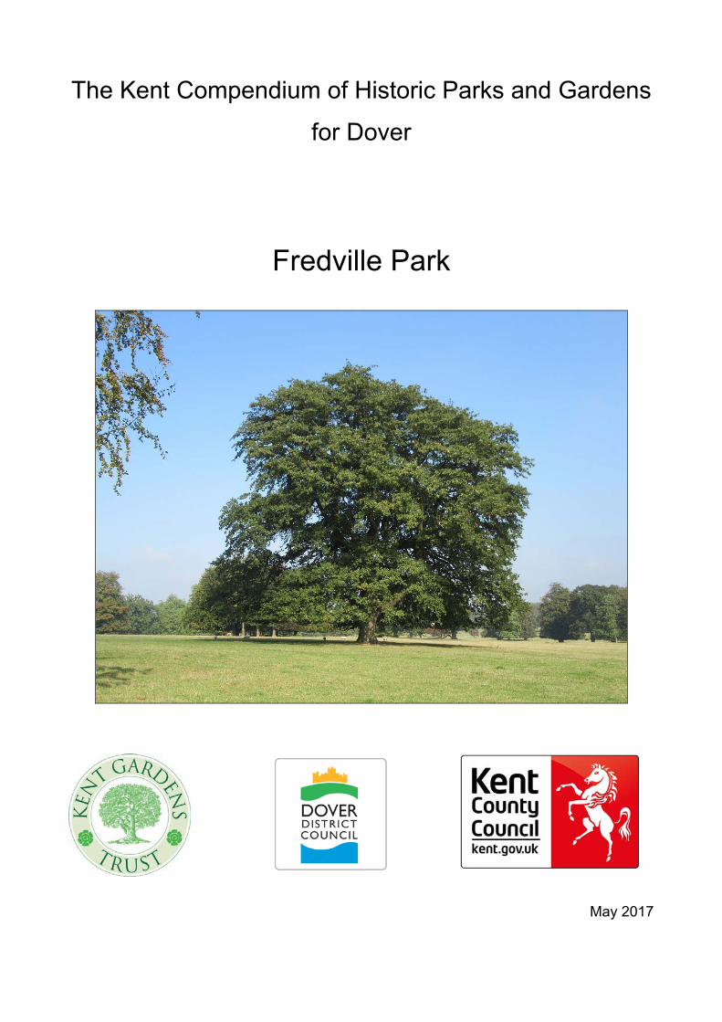
KENT FREDVILLE PARK NONINGTON DOVER TR 259 513 STATEMENT OF SIGNIFICANCE EVIDENTIAL Fredville Park has several perimeter belts of plantations, both deciduous and coniferous, which are already shown on OS 1st edition, and many parkland trees survive. Not far from the former mansion are the remains of a Spanish chestnut avenue, planted at least 250 years ago. Many of these trees are still in very good condition (2017). The boundary of the C18 pleasure ground enclosure is intact and encompasses the remaining historic structures including the walled kitchen garden, stables and ice house as well as potential archaeological remains of the mansion. Of particular note, within the immediate grounds of the former mansion, are three large ancient oak trees, probably 500 years old, and a mid-late C19 Wellingtonia. One of these oaks, named “Majesty” or “The Fredville Oak”, is believed to have the largest girth in England. HISTORICAL Fredville was owned by a succession of families including the Boys, a well-known local family, who owned many estates in the area. In 1750 Fredville passed through marriage to the Plumptre family in whose ownership it remains (2017). Jane Austen often visited her brother Edward on the Goodnestone estate nearby. She was well acquainted with the Plumptres at Fredville and it seems probable that she visited the estate. The original farmhouse was enlarged c1750 into a two-storey house, then greatly extended in the latter part of the 19th century. The basic form of the park dates from at least the mid C19 (tithe map 1839) and it is likely to reflect the landscape that formed the setting for the Georgian house. The chestnut avenue suggests development from an earlier C17 landscape setting (HER record) and the ancient oaks probably predate the avenue. The main approaches from the north and south have changed only slightly since the 1839 tithe map with the early cherry orchard being replaced by pleasure grounds. The kitchen garden also exists on the 1839 tithe map. During the late C18, the mansion house and the Fredville Oak was represented in print and journals, and later the oak has been much photographed.
AESTHETIC The gently rising landscape provides pleasant vistas of parkland enhanced by the numerous old trees, with the boundary plantations visible in the distance. From the levelled platform on which Fredville mansion stood, were views over an extensive lawn to the east and to the parkland beyond. This landscape survives reflecting the choice of site, distribution of the main structural elements of boundaries, parkland plantings, approach drives, pleasure grounds and kitchen garden appropriate to a mid C18 country house. The minor modifications and additions made through time, particularly those linked with the late Victorian expansion of the mansion, being typical of their date, contribute to the interest of the site. COMMUNAL A public bridleway crosses the park from north to south and various public footpaths also cross the park. These provide access for the public who can thus enjoy the views across the park and see many of the ancient trees. There is no public access or view into the former mansion grounds nor to the Fredville Oak. SUMMARY OF HISTORIC INTEREST Fredville manor existed by 1250. The estate was held by a succession of families until 1750 when it passed through marriage to the Plumptre family. The original farmhouse was enlarged first, c 1750, to a two-storey house and then to a large late Victorian mansion which was abandoned in 1921. A fire destroyed most of the house during WWII and it was demolished in 1945. The structure of the landscape, with the pleasure grounds and kitchen garden close to the new 1750’s Georgian house and the large area of parkland surrounding it, probably dates from the late C18. The addition of woodland plantations continued throughout the C19, providing the setting for the considerable Victorian extensions of the house. Fredville is renowned for the large number of ancient oaks and sweet chestnuts in the parkland. Jane Austen was a frequent visitor to the nearby Goodnestone estate, visiting her brother Edward. She was well acquainted with the Plumptre family and it seems likely that she would have visited them at Fredville.
CHRONOLOGY OF THE HISTORIC DEVELOPMENT The origin of the name “Fredville” is not known for certain. Traditionally it is believed to be derived from the Old French: freide ville, meaning a cold place,
because of its cold, wet, low position. It could, however, be derived from the Old English: frith, meaning the outskirts of a wooded area, plus vill, meaning a manor or settlement, giving “a manor next to the wooded area”. Fredville House and park was originally part of Essewelle Manor. It is recorded in Domesday that in the time of Edward the Confessor it was held by a woman, Molleve, but in 1086 it was held by Ralph de Courbepine from Bishop Odo. De Courbepine’s holdings passed to the Maminot family and in the late 1100’s to the Barony de Saye. By 1250 Essewelle had been divided into Esol and Freydevill. The spelling varied over the centuries: Frydewill (1338), Fredeule (1396), Fredevyle (1407), Froydevyle (1430), ffredvile (1738). Hasted lists the families who held Fredville from the Colkins, in the reign of Edward I, to the Boys, in the reign of Richard III. William Boys’ descendant, Major Boys, had many of his estates confiscated for being a Royalist, but Fredville remained in the Boys family until two of his sons sold it to Denzill, Lord Holles in1673 in order to pay debts. In 1745, Thomas Holles sold it to Margaret, sister of Sir Brook Bridges, baronet of Goodnestone, which is nearby. Margaret Bridges married John Plumptre, a wool merchant of Nottinghamshire, in 1750, but they had no children. The estate passed to John Plumptre through the marriage. Margaret died in 1756 and her husband remarried in 1758 and had a son. John Plumptre rebuilt the manor as a Georgian house. Sir Brook Bridges’ daughter, Elizabeth, married the author Jane Austen’s brother, Edward. Jane Austen’s letters (1796-1814) show that she was a regular visitor to the Bridges’ estate at Goodnestone and later to Edward’s new home at Godmersham. She was well acquainted with the Plumptres of nearby Fredville (Jane Austen letters to her sister Cassandra, September - October 1813 and March 1814). John Pemberton Plumptre was for a time a suitor of Jane’s niece Fanny. Jane Austen wrote “Anything is to be preferred or endured rather than marrying without Affection; and if his deficiencies of Manner &c &c strike you more than all his good qualities, if you continue to think strongly of them, give him up at once.” (Jane Austen letter to Fanny November 1814). Fanny rejected John Pemberton. In the late 19th century the house was greatly enlarged, its 50 bedrooms accommodating the family of 11 children and the necessary staff. In 1921 Henry Western Plumptre built the much smaller “Little Fredville” nearby in the park as the family home and Fredville mansion was abandoned. It was requisitioned during WWII and occupied by a Canadian tank regiment. A fire destroyed most of the house in 1942 and after the war J H Plumptre, son of Henry Western, decided to demolish the building. Only the clock tower and some converted outbuildings now stand. The site remains in private ownership. SITE DESCRIPTION LOCATION, AREA, BOUNDARIES, LANDFORM, SETTING
Fredville Park lies at the southern edge of the village of Nonington, 3km south-east of Aylesham, 16 km south-east of Canterbury, 16 km north-west of Dover and 5 km east of the A2. The site, as here defined, is an area of 100ha in the parish of Nonington, lying within the square marked out by Holt Street to the north-west, Mill Lane to the north-east, Sandwich Lane to the south-east and Nightingale Lane to the south-west. The site boundary is formed by: to the west, field boundaries dividing the park fields from a 1ha area of farmland at the western, Holt Street, corner of the square; to the north-west, south-west, and south-east, by the public roads, excluding the private residences along these roads; to the north, field boundaries which separate off a 5ha field at the northern, Easole Street/Nonington tip of the area; to the north-east by the footpath that forms the continuation of Butchers Lane; and to the south by the plantation that lies 120m to the north of Frogham Farm dividing off a 2.25ha field at the southern, Frogham corner of the area. The boundary is mainly fenced, the fence in stretches being accompanied by hedging. The park occupies a shallow valley running north-south through the centre of the site, with the mansion having been situated on the east-facing slope. The gentle nature of the topography means that the views are mostly contained within the site. ENTRANCES AND APPROACHES The early C19 Lower Lodge (listed grade II), of painted brick and thatched, stands on Holt Street, 120m to the south-west of the junction with Vicarage Lane. From here a public bridleway leads up a gentle gradient, southwards through the park, taking the line of the former main approach drive, until it reaches a plateau. 550m to the south of the lodge, the track divides with one branch entering the fenced enclosure of the former house and pleasure grounds. Following the Victorian extensions to the house, the drive and carriage entrance accessed the pleasure grounds from the north while the main house entrance remained on the east (1872 OS). 380m south of the lodge, a scarcely visible path branches off the bridleway/former drive, leading around the western side of the fenced enclosure, then through a plantation to join with Nightingale Lane at Longlands. This is not an historic route and is not shown on C19 or C20 OS maps. From the mansion site enclosure, the main track continues southwards to meet with Nightingale Lane at Park Farm, at the north end of the hamlet of Frogham. The main drive is shown on the tithe map and the OS mapping sequence. A second path, from Easole Street in Nonington village, enters the site at the northern tip of the park and leads south for 560m. The route then turns abruptly westwards such that the path joins with the former drive at the eastern side of the former house enclosure. This approach is marked on the tithe map where it is
shown as crossing the main drive to enter the pleasure ground enclosure from the north thus providing access to the ancillary buildings. By the time of the 1872 OS, this track had been moved eastward such that it joined the main drive to the south-east of the house. Several other unsurfaced public footpaths provide access across the park. PRINCIPAL BUILDINGS AND STRUCTURES To west of centre in the park is a circular enclosure of 5ha, surrounded by cast iron fencing. This is the site of the former mansion house and its surrounding outbuildings, pleasure grounds and kitchen garden. Access to the enclosure is by a driveway leading west off the main bridleway. Soon after his marriage in 1750, John Plumptre enlarged the original farmhouse into a comfortable Adam style two storey house. His first wife, Margaret Bridges, died childless in 1756; he remarried in 1758 and had one son. John Plumptre stayed in the house until his death in 1791. In the latter part of the 19th century the house was greatly extended. It stood on a levelled platform with the main façade looking eastwards over a gently sloping lawn, then out across the park. The carriage entrance was at the north front. The tithe map suggests that prior to this, the entrance front was on the east façade and that the drive crossed through the eastern half of the pleasure ground enclosure. Fredville mansion was abandoned when the Plumptre family moved out but was used for a time as a girls’ school in the inter-war years. A Canadian tank regiment was stationed in the mansion during WWII. An accidental fire burnt down much of the house in 1942 and J H Plumptre, son of Henry Western, took the decision to demolish the rest in 1945. Although there are no visible above ground traces of the mansion house, the clock tower, stable blocks and some outbuildings survive within the fenced enclosure to the north of the house site. These have been converted into dwellings. The dwellings are reached from the driveway by passing under an archway in the northernmost building. 400m to the south of the former mansion, on the north side of Nightingale Lane, 350m north of the hamlet of Frogham, stands ‘Little Fredville’. This single-storey 12-bedroom horseshoe-shaped house was built in 1921 as the family home by Henry Western Plumptre, who found the Victorian house too big for his needs (shown on the 1937 OS). Between Little Fredville and the former mansion site stand Little Fredville cottages. Buildings are marked in this location on the tithe map, and on the 1872 OS where they accompanied a plant nursery. The former icehouse is said to be in reasonable repair although it has been filled in (www.nonington.org.uk). It was mentioned by a local man in 1948 (HER TR 25 SE 153) and was last shown on the 1909 OS on the edge of the pleasure ground enclosure, to the north-west of the house.
Mrs. Boys Behrens, a descendant of the Boys’ of Fredville, claimed in her book, Under Thirty-Seven Kings. Legends of Kent & Records of the family of Boys, (1926) that a secret passage supposedly led from a well in the kitchen to the old ice-house. GARDENS AND PLEASURE GROUNDS Map evidence suggests that the main area of pleasure grounds accompanying the Victorian house occupied the northern half of the fenced enclosure that surrounded the mansion. The fenced enclosure retained the same outline as that which accompanied the earlier Georgian house with the former cherry orchard (tithe map apportionment) being replaced in the mid C19 by the pleasure grounds. These appear to have been informally planted and well treed with both broad leaved and coniferous specimens (1872 OS). This area is now (2017) covered with laurel scrub and evergreens and young pheasants roam freely. Within the enclosure immediately to the south-east of the mansion site, stands “Majesty”, marked on historic maps (OS series) as the “Fredville Oak”. This pedunculate oak is said to be the largest maiden oak in England. (www.monumentaltrees.com): the exact age of the tree is not known but it was thriving in 1554 (Mrs Boys Behrens). Close to “Majesty”, within the grounds, are two other named notable oaks, “Beauty” and “Stately”. Until recently (c2007) there was a third such tree, named “Staghorn”. Nearby, also within the pleasure ground area, stands a c.150 year old Wellingtonia. There was a pump house in the area, shown on the OS 2nd edition. PARKLAND
Fredville Park is largely enclosed by perimeter belts with a continuous wooded planting along the eastern side. These mature wooded belts include Easole Field Plantation on the north-east perimeter (shown on the tithe map), and Summerhouse Plantation to the south-east (shown on the tithe map). By the 1870s (OS), Larch Plantation and Serpentine Plantation had been planted to the south of Summerhouse Plantation.
Along the southern boundary, between Little Fredville and Longlands (the site of the estate kennels, aviary and nursery; tithe map and C19 OS) lies Nightingale Wood, a C20 plantation. This would appear to be replanted on the site of the earlier Denvills Wood (1876 OS, present on the tithe map; renamed Nightingale Wood by 1898 OS). At the northern end of Nightingale Wood stand Nightingale Cottages, buildings having been present on this site by 1872 (OS) but not appearing on the tithe map.
A summerhouse is indicated on the OS maps up until the 1898 OS, but the feature does not appear on any later maps (nor is it marked on the tithe map). It stood at the highest point in the park and may have provided views north–westwards out over the park between Beech Plantation and Great Plantation, and westwards towards the mansion on the opposite side of the valley. No visible trace of it remains.
To the south-west of the Lodge at the northern end of the park is the cricket ground and associated pavilion of Nonington Cricket Club, which has occupied the site for over 100 years (noningtoncc.co.uk; pavilion present by 1929 OS).
While substantial areas within the park are under the plough, a number of large plantations survive, along with many parkland trees.
The C19 and C20 sequence of OS maps show the park as well wooded with many small groups of trees both broadleaved and coniferous, and many individual parkland specimens. The great storm of October 1987 caused considerable damage to the woodland belts and beech woods to the south-east as well as to holm oaks. Most of the parkland trees, however, were spared.
Within the park, surviving plantations include, in the eastern half of the site, Beech Plantation and Box Wood, the latter formerly known as The Great Plantation (OS series; both plantations are shown on the tithe map). Most of the plantations had been planted by 1872 (present on 1st edition OS).
Running south-eastwards across the park, 300m to the north-east of the mansion site, are the remains of an avenue of Spanish chestnuts. The age of the trees suggests that this feature may date from the 17th century (Kent County Council Monument HER records). One of these veteran sweet chestnuts was known as the “step-tree” as it formerly supported a stepladder arrangement leading up to a platform in its branches. The tree survives but the ladder has been removed.
Another notable tree was near Shireway Gate which is on the south-eastern edge of the park, at the road junction at the northern corner of Limekiln plantation: “there was a famous horn beam, which has a ‘spread’ of over 100 feet; and perhaps this is the most notable of all. It is possibly 500 years old” (www.nonington.org.uk Kent Archaeological Society excursion to Nonington in September, 1936). No further details of this tree were traced during research carried out for this description.
Two unretouched blades and flakes were found at a mesolithic site in Fredville park and are now in Canterbury Museum. A mediaeval gully and C13 or C14 potsherds were found in 1971, but their present location is unknown.
KITCHEN GARDEN
Immediately to the south-west of the house site, occupying the south-western quarter of the fenced enclosure, is the walled kitchen garden, 1ha in extent. Surrounded by 3.5m high brick walls, the garden is shown on the tithe map and could be of C18 date. For a time in the early C21 it was used for pheasant rearing, but it is now grassed (2017).
OTHER LAND
At the southern end of the site, beyond the public road (and outside the site as here defined), is Limekiln Plantation, also present by the time the tithe map was
drawn. To the south-west of the site are Rueberries Wood and Broomhill Plantation REFERENCES Estate owner, personal comment Publications
Edward Hasted, History and Topographical survey of Kent: Volume 9 Parishes: Nonington | British History Online Dover District Council, Dover District Heritage Strategy (June 2012)
Kent County Council Planning Department, Kent Gardens Compendium, Kent County Council Planning Department, The historic parks and gardens of Kent Parks & Gardens UK website, www.parksandgardens.org
Old parish of Nonington website, www.nonington.org.uk Kent online parish clerks website, www.kent-opc.org
Deirdre Le Faye, Jane Austen’s Letters (1995) Monumental trees website, www.monumentaltrees.com Kent County Council, Historic Environment Records Maps OS 2.5” to 1 mile 1st edition (1862-1875) 2nd edition (1897-1900) 3rd edition (1907-1923) 4th edition (1929-1952) Tithe map and apportionment (1839) Interpretation panels: Two panels have been erected by the bus stop in Holt Street opposite Vicarage Lane. The Tourism and Economic Development Unit of Dover District Council. Nonington “Historic Village” information panel The Coalfield Heritage Initiative in Kent (CHIK) in partnership with Dover Museum and The White Cliffs Countryside Project., “Miners Way Trail”

Research and written by Terri Zbyszewska Harriet Jordan (editor)
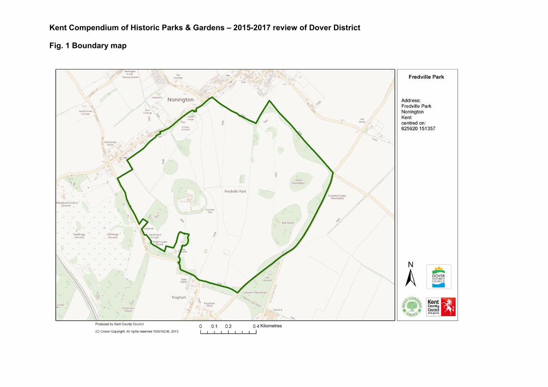
Kent Compendium of Historic Parks & Gardens – 2015-2017 review of Dover District Fig. 1 Boundary map
Kilometres
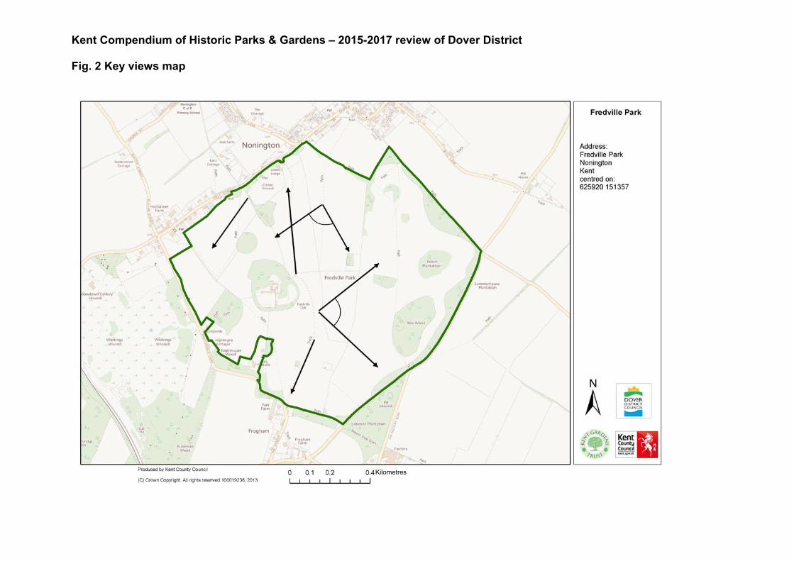
Kent Compendium of Historic Parks & Gardens – 2015-2017 review of Dover District Fig. 2 Key views map
Kilometres
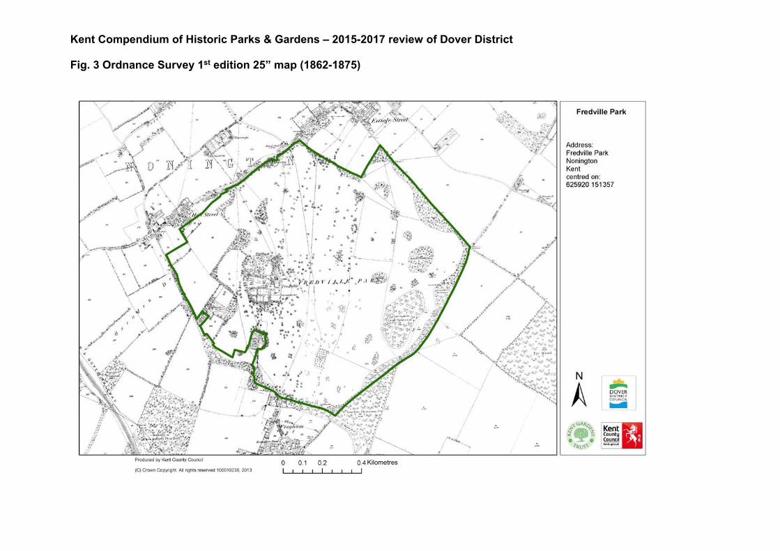
Kent Compendium of Historic Parks & Gardens – 2015-2017 review of Dover District Fig. 3 Ordnance Survey 1st edition 25” map (1862-1875)
Kilometres
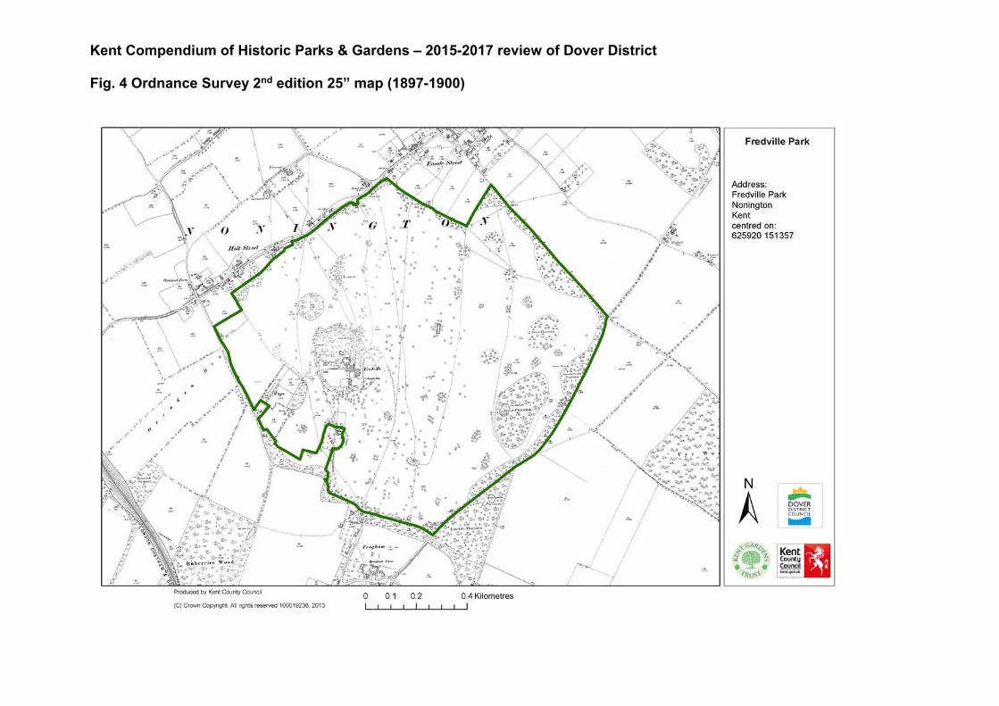
Kent Compendium of Historic Parks & Gardens – 2015-2017 review of Dover District Fig. 4 Ordnance Survey 2nd edition 25” map (1897-1900)
Kilometres
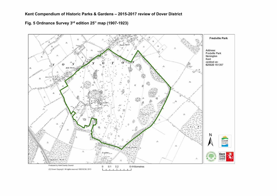
Kent Compendium of Historic Parks & Gardens – 2015-2017 review of Dover District Fig. 5 Ordnance Survey 3rd edition 25” map (1907-1923)
Kilometres
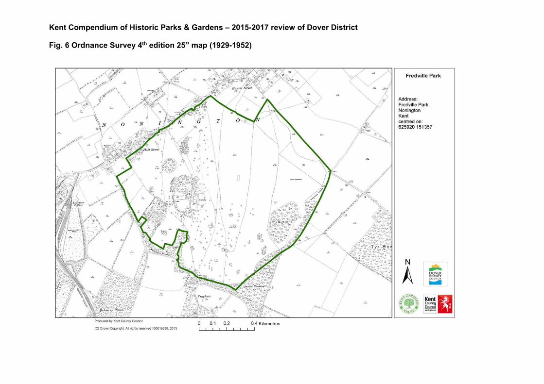
Kent Compendium of Historic Parks & Gardens – 2015-2017 review of Dover District Fig. 6 Ordnance Survey 4th edition 25” map (1929-1952)
Kilometres

Kent Compendium of Historic Parks & Gardens – 2015-2017 review of Dover District Fig. 7 Fredville Oak
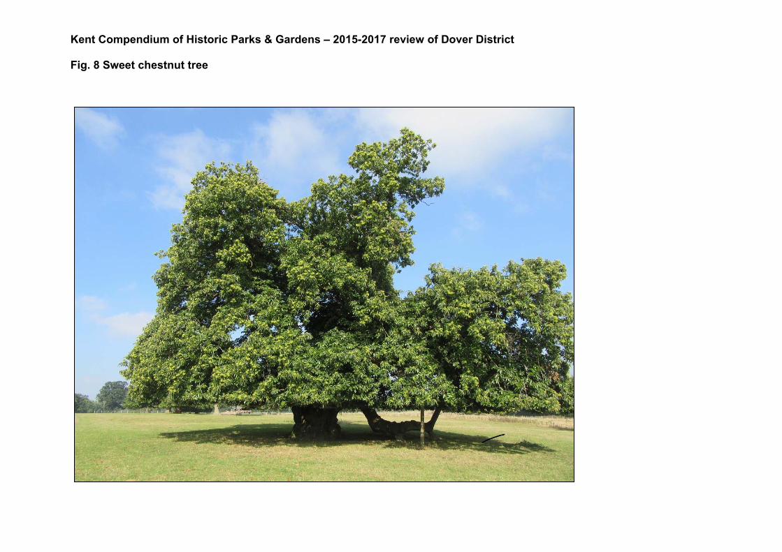
Kent Compendium of Historic Parks & Gardens – 2015-2017 review of Dover District Fig. 8 Sweet chestnut tree

Kent Compendium of Historic Parks & Gardens – 2015-2017 review of Dover District Fig. 9 Remains of avenue of Spanish chestnut trees

Kent Compendium of Historic Parks & Gardens – 2015-2017 review of Dover District Fig. 10 View across Fredville Park