the institute of archaeology field course 2014: the search ...discovery.ucl.ac.uk/1471064/1/roberts,...
TRANSCRIPT

The Institute’s Field CourseFieldwork is an essential and highly valued component of the undergraduate degree at UCL Institute of Archaeology. Students undertake seventy days of funded fieldwork, predominantly on excavations but also in museum, laboratory and archive placements. The practical work is intimately linked to the teaching of first year courses: ‘Field Methods’, which introduces the foundations for field-work, archiving and publication; and ‘Field Archaeology’, in which students build up a portfolio of their fieldwork and placements, culminating in two reports which are submit-ted in their final year of study. The combina-tion of taught and practical elements is part of a drive towards research-led teaching in
field archaeology at UCL. Another key aspect of the undergraduate field course is the train-ing of second and third year students as exca-vation and finds supervisors. Those selected are trained on-site with their first year peers, and each is responsible for their own area, finds and recording. The Masters’ students’ field course is a recent innovation, intended for students who have transferred from other disciplines, or those with archaeological degrees who wish to develop or expand their practical portfolio.
In 2014 the Institute of Archaeology’s Undergraduate and Masters’ students’ field courses commenced excavations in an attempt to discover the remains of a hunt-ing lodge within the perimeter (pale) of the Downley deer park, near Singleton in West Sussex (Fig. 1). The fieldwork took place between May and August 2014. An introduc-tion to the study and preliminary results are presented here.
Roberts, M 2014 The Institute of Archaeology Field Course 2014: The Search for the Lost Hunting Lodge of the Earls of Arundel at Downley, Singleton, West Sussex, UK. Archaeology International, No. 17: pp. 109-121, DOI: http://dx.doi.org/10.5334/ai.1722
RESEARCH ARTICLE
The Institute of Archaeology Field Course 2014: The Search for the Lost Hunting Lodge of the Earls of Arundel at Downley, Singleton, West Sussex, UKMark Roberts*
* UCL Institute of Archaeology, London WC1H 0PY, United Kingdom [email protected]
This paper discusses research into the area of the medieval and post-medieval deer park, at Downley in West Sussex, which is the focus of the Institute’s current training excavations. The excavations constitute part of a wider project attempt-ing to learn more about the development and function of the park through time. A range of information, which indicated the presence of a substantial lodge building within the park was considered and the 2014 excavations have revealed evidence almost certainly corroborating its presence. The project will continue both on and off site in 2015.

Roberts: The Institute of Archaeology Field Course 2014110
Downley Deer ParkThe deer park at Downley is one of a large number of medieval parks known from the County of Sussex (Cantor and Hatherly 1979; Dallaway 1815; Ellis 1885; Harris and Dawbis 1570). The park was constructed for and belonged to the earls of Arundel and their heirs, the Dukes of Norfolk, throughout its period of use. It then passed into other hands as part of a parcel of agricultural land in the 17th century. No licence to impark has yet been discovered but documentary evidence suggests that this must have happened sometime between 1272 and 1331. Downley was one of several downland parks within the Honor of Arundel (land, manors, tithes and rights associated with the earldom), and with the exception of Stansted, the most westerly in the county. Correspondence between the 10th and 11th earls of Arundel and prominent figures such as King Henry VIII, Wolsey and Thomas Cromwell maps and documentary evidence describing the lodge and its eventual ruins; together with chance archaeological discoveries and evidence from field walking over the past fifty years; all attested to the presence of a substantial
lodge building. This operated as a capital dwelling rather than simply a house for occa-sional entertaining, or quarters for the park servants.
The potential presence of a number of phased features, substantial and varied finds, the ability to combine archaeological and historical research, and clearly defined objec-tives, all contributed to making the site an ideal one to host a training excavation.
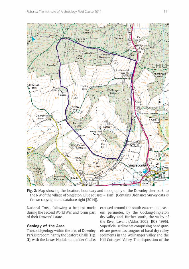
Location of the ParkThe deer park at Downley is located in the county of West Sussex (Central Grid Reference SU 486745 114750), 8km north of the county town of Chichester and 18km north of the present day English Channel coast at Pagham (Fig. 1). The park is situ-ated on the chalk hills of South Downs, the geographical and geological province, which in this area of southern England, is encompassed between the Coastal Plain to the south and the Weald to the north. The eastern two thirds of the park fall within Singleton Parish and the western third within West Dean (Fig. 2). The park perim-eter measures 6.622km, covering an area of 261.7 hectares or 646.5 acres. The exca-vations were carried out in an area of grass-land, designated as archaeological set-aside, where no invasive agricultural works may be undertaken. Some further trenches were located in a strip of game cover to the south of the set-aside in an attempt to assess the parameters of the lodge site.
Present day land use within the park pale is agricultural, with a mixture of arable and pasture fields, and strategically planted game crops for driven pheasant shooting. The northern part of the park is under commer-cial beech and softwood forestry. No trace has yet been found of medieval woodland man-agement methods such as wood pasture or coppice with standards, although the wood at Honeycomb Copse, mentioned in corre-spondence from Downley during the 16th century, is still present on the north-eastern slopes of Hat Hill. The park is owned by the
Fig. 1: Digital Terrain Model (DTM) and loca-tion map, showing the relationship of the site to the surrounding geological prov-inces and topography (Contains Ordnance Survey data © Crown copyright and data-base right [2014]).
Roberts: The Institute of Archaeology Field Course 2014 111
National Trust, following a bequest made during the Second World War, and forms part of their Drovers’ Estate.
Geology of the AreaThe solid geology within the area of Downley Park is predominantly the Seaford Chalk (Fig. 3); with the Lewes Nodular and older Chalks
exposed around the south-eastern and east-ern perimeter, by the Cocking-Singleton dry valley and, further south, the valley of the River Lavant (Aldiss 2002; BGS 1996). Superficial sediments comprising head grav-els are present as tongues of basal dry valley sediments in the Wellhanger Valley and the Hill Cottages’ Valley. The disposition of the
Fig. 2: Map showing the location, boundary and topography of the Downley deer park, to the NW of the village of Singleton. Blue squares = 1km2. (Contains Ordnance Survey data © Crown copyright and database right [2014]).

Roberts: The Institute of Archaeology Field Course 2014112
geology at Downley is of particular impor-tance when considering the availability of building materials and access to fresh water.
Topography and DrainageThe highest ground in the park is in the NW corner, known as Blind Stile, where the land attains 175m OD. The ground falls away southwards eventually rising again to meet a north-eastward trending spur that is con-jugate with Hat Hill. It is on this spur in the vicinity of the 140m contour that the lodge site is believed to be located.
The drainage pattern of the deer park is predominantly towards the south and east-ern boundaries into the main valley systems, although most of the surface water goes directly into and through the Chalk (Fig. 3). To the north of Cucumber Farm at SU 875 142, a spring rises, under certain conditions, which floods the valley southwards down to
the farm. Within the park pale, the geologi-cal and topographical evidence and surviving archaeological evidence suggests that water was available only via wells dug through the chalk; one such well is recorded in the environs of the lodge (Harris and Dawbis 1570) and is further mentioned by later writ-ers such as Elwes and Robinson (1876) and Dallaway (1815). However, inspection of the map drawn up on the order of Lord Lumley around 1630 (Fig. 4), indicates that two ponds might have existed within the park, one at Middle Barn and one further to the NW, both designated by green circles.
Past Archaeological Work in the AreaVery little previous archaeological work has been carried out at the site. From 1965 there is a record of a well-built drain found during ploughing, and reference to other structures
Fig. 3: Geology and location map for the Downley area. The lodge site is located on the Downs between Hat Hill and the Wellhanger Valley. (Contains Ordnance Survey data © Crown copyright and database right [2014]).

Roberts: The Institute of Archaeology Field Course 2014 113
such as a brick or tile floor, although the con-text of these latter discoveries is unknown. What is clear is that the observations of a spread of building material remain germane, as a vast quantity of building rubble is spread over the area of the set-aside field and into the surrounding arable land. In 2011 and 2012 geophysical surveys of the site were carried out by Neville and Mary Haskins (2011, 2012), working with local volunteers under the auspices of the Chichester District Council Archaeologist James Kenny. These however, failed to produce any definitive supporting evidence for the putative struc-tures reported in 1965. The most compre-hensive desk-based survey of the deer park was carried out for the National Trust by Joy Ede (1997a, b).
Documentary Evidence Relating to the ParkA wide range of documentary evidence con-cerning the existence of the park, extends back to the 13th century, the earliest men-tion of Downley discovered thus far coming
from the reign of Henry III. The evidence, some of which is discussed by Ede (1997a, b), can be found in State documents, such as the Pipe and Closed Rolls, Inquisitions Post Mortem, Letters Patent, the correspondence and letters of Henry VIII, and Arundel deeds and papers. Examples from two documents are quoted below:
[300] Edmund Fitzalan, Earl of Kent. Writ of certiorari 20th December 4 Edward III
Nomanes Land, 15th January 4 Edward III 1331. Sharp (1908).
The castle and borough extent given, including two windmills called “Tollelone and Piperinge” a watermill called “Swannebourne”, a fishery with a weir, a park called “le Rokes” with two crofts called “le Beddes”, a park called “le Michelpark”, a new park called “Shelerth”, another new park called “Breneskomb”, a park called “le Dunleye”, six woods with deer in the free chase of Aroundell……
Fig. 4: The Lumley map drawn up sometime around 1630 (MS 18,014: reproduced by kind permission of the West Sussex Record Office.) Note the field names, gates and the lodge site. The map is orientated with North to the left.
Roberts: The Institute of Archaeology Field Course 2014114
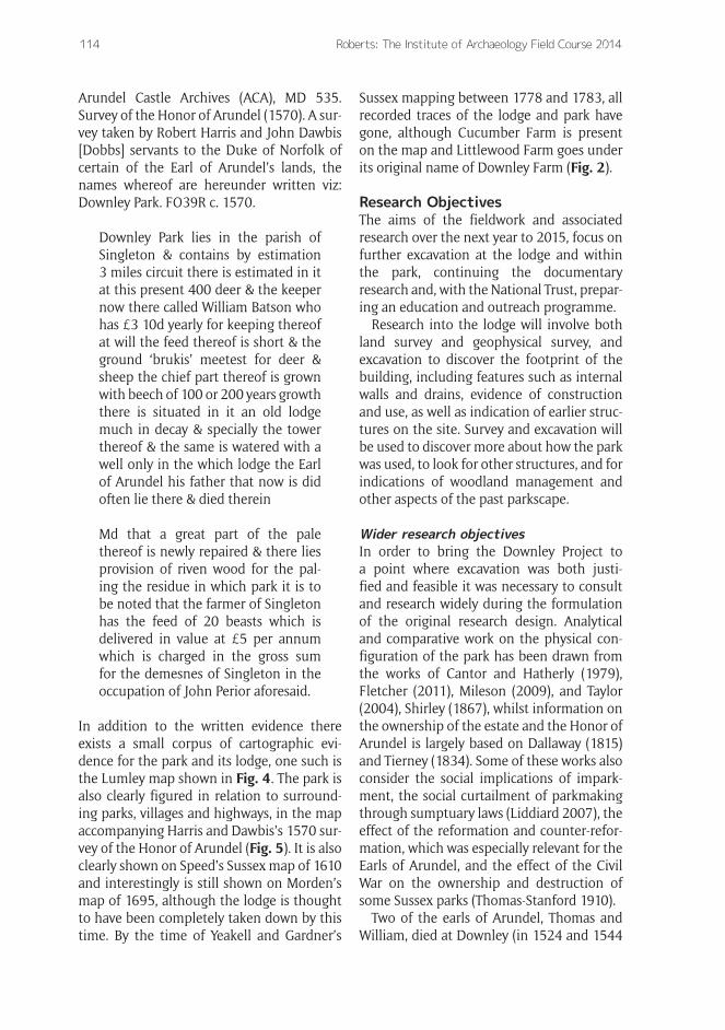
Arundel Castle Archives (ACA), MD 535. Survey of the Honor of Arundel (1570). A sur-vey taken by Robert Harris and John Dawbis [Dobbs] servants to the Duke of Norfolk of certain of the Earl of Arundel’s lands, the names whereof are hereunder written viz: Downley Park. FO39R c. 1570.
Downley Park lies in the parish of Singleton & contains by estimation 3 miles circuit there is estimated in it at this present 400 deer & the keeper now there called William Batson who has £3 10d yearly for keeping thereof at will the feed thereof is short & the ground ‘brukis’ meetest for deer & sheep the chief part thereof is grown with beech of 100 or 200 years growth there is situated in it an old lodge much in decay & specially the tower thereof & the same is watered with a well only in the which lodge the Earl of Arundel his father that now is did often lie there & died therein
Md that a great part of the pale thereof is newly repaired & there lies provision of riven wood for the pal-ing the residue in which park it is to be noted that the farmer of Singleton has the feed of 20 beasts which is delivered in value at £5 per annum which is charged in the gross sum for the demesnes of Singleton in the occupation of John Perior aforesaid.
In addition to the written evidence there exists a small corpus of cartographic evi-dence for the park and its lodge, one such is the Lumley map shown in Fig. 4. The park is also clearly figured in relation to surround-ing parks, villages and highways, in the map accompanying Harris and Dawbis’s 1570 sur-vey of the Honor of Arundel (Fig. 5). It is also clearly shown on Speed’s Sussex map of 1610 and interestingly is still shown on Morden’s map of 1695, although the lodge is thought to have been completely taken down by this time. By the time of Yeakell and Gardner’s
Sussex mapping between 1778 and 1783, all recorded traces of the lodge and park have gone, although Cucumber Farm is present on the map and Littlewood Farm goes under its original name of Downley Farm (Fig. 2).
Research ObjectivesThe aims of the fieldwork and associated research over the next year to 2015, focus on further excavation at the lodge and within the park, continuing the documentary research and, with the National Trust, prepar-ing an education and outreach programme.
Research into the lodge will involve both land survey and geophysical survey, and excavation to discover the footprint of the building, including features such as internal walls and drains, evidence of construction and use, as well as indication of earlier struc-tures on the site. Survey and excavation will be used to discover more about how the park was used, to look for other structures, and for indications of woodland management and other aspects of the past parkscape.
Wider research objectivesIn order to bring the Downley Project to a point where excavation was both justi-fied and feasible it was necessary to consult and research widely during the formulation of the original research design. Analytical and comparative work on the physical con-figuration of the park has been drawn from the works of Cantor and Hatherly (1979), Fletcher (2011), Mileson (2009), and Taylor (2004), Shirley (1867), whilst information on the ownership of the estate and the Honor of Arundel is largely based on Dallaway (1815) and Tierney (1834). Some of these works also consider the social implications of impark-ment, the social curtailment of parkmaking through sumptuary laws (Liddiard 2007), the effect of the reformation and counter-refor-mation, which was especially relevant for the Earls of Arundel, and the effect of the Civil War on the ownership and destruction of some Sussex parks (Thomas-Stanford 1910).
Two of the earls of Arundel, Thomas and William, died at Downley (in 1524 and 1544

Roberts: The Institute of Archaeology Field Course 2014 115
respectively) and were possibly temporar-ily interred in Singleton Church, where two memorials to them are preserved on either side of the altar. As mentioned above, there is a considerable volume of correspondence between the earls and Thomas Cromwell, Wolsey, and the King himself. An important question to consider is how the political and religious circumstances of the day might have led to the adoption of Downley over Arundel as the principal dwelling during the first half of the C16th. On a more prosaic level, it is hoped that the internal investiga-tions within the park will shed more light on its function over time and allow comparison
with recent research into other parks, such as those in the Forest of Bowland (Lancashire), Dinefwe (Camarthenshire), and at Ravensdale (Derbyshire) (Neil and Thurnhill 2013; Schlee 2008; Taylor 2004).
The actual use of parks and the surround-ing forest in the practice of hunting and the supply of venison and other game, such as boar, has drawn largely on the works of Fletcher (2011) and Sykes (2007); many of the technicalities of the medieval hunt are explained by Burrell (1850), and the applica-tion of forest law by Nelson (1717). Future work on the site will also require that the archaeological data is considered alongside
Fig. 5: Arundel Archive Map ( PM 193). The park at Downley can be seen on the left of the image adjacent to the Chichester to Midhurst road. (From the Arundel Castle Archives, reproduced by kind permission of His Grace the Duke of Norfolk).
Roberts: The Institute of Archaeology Field Course 2014116
an assessment of the environmental and eco-logical development of the park landscape through time (Rackham 2006; Rotherham 2007). This study will become particularly important when considering the intra and inter economic viability of the park.
The work at Downley provides the opportu-nity to draw together the management aims of the National Trust, the Goodwood, West Dean and Arundel Estates, with the Institute’s academic research objectives. This powerful grouping has the potential to provide the driver for a concentrated landscape scale investigation at Downley and thence into the surrounding area, one of the most chronolog-ically and archaeologically diverse pieces of landscape in southern England. Although not in receipt of external funding, the Downley Project is run and managed following the MoRPHE (Management of Research Projects in the Historic Environment) and SHAPE (Strategic framework for Historic environ-ment Activities and Programmes in English heritage) guidelines designed by English Heritage (2006, 2008b) which provides rel-evant experience for the students.
Results of the 2014 Survey and ExcavationsLandscape surveyStudents and staff examined the landscape around the lodge site to look for other fea-tures such as the pale, salters (Cooper 2013), lynchets and cross dykes, and piles of flint (Brown 2008) which are normally indicative of field boundaries (English Heritage 2007), and thus particularly relevant in the case of deer parks and rabbit warrens (Tittensor and Tittensor 1985). The project was able to assess the full perimeter of the pale, prove the old pond at Middle Barn (Fig. 4) and identify the landscaped area around the northern spring at Cucumber Farm, which might contain evi-dence for duck and stew ponds.
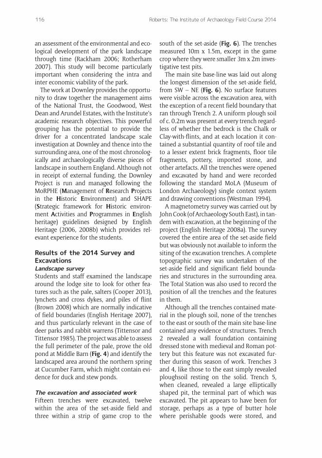
The excavation and associated workFifteen trenches were excavated, twelve within the area of the set-aside field and three within a strip of game crop to the
south of the set-aside (Fig. 6). The trenches measured 10m x 1.5m, except in the game crop where they were smaller 3m x 2m inves-tigative test pits.
The main site base-line was laid out along the longest dimension of the set-aside field, from SW – NE (Fig. 6). No surface features were visible across the excavation area, with the exception of a recent field boundary that ran through Trench 2. A uniform plough soil of c. 0.2m was present at every trench regard-less of whether the bedrock is the Chalk or Clay-with-flints, and at each location it con-tained a substantial quantity of roof tile and to a lesser extent brick fragments, floor tile fragments, pottery, imported stone, and other artefacts. All the trenches were opened and excavated by hand and were recorded following the standard MoLA (Museum of London Archaeology) single context system and drawing conventions (Westman 1994).
A magnetometry survey was carried out by John Cook (of Archaeology South East), in tan-dem with excavation, at the beginning of the project (English Heritage 2008a). The survey covered the entire area of the set-aside field but was obviously not available to inform the siting of the excavation trenches. A complete topographic survey was undertaken of the set-aside field and significant field bounda-ries and structures in the surrounding area. The Total Station was also used to record the position of all the trenches and the features in them.
Although all the trenches contained mate-rial in the plough soil, none of the trenches to the east or south of the main site base-line contained any evidence of structures. Trench 2 revealed a wall foundation containing dressed stone with medieval and Roman pot-tery but this feature was not excavated fur-ther during this season of work. Trenches 3 and 4, like those to the east simply revealed ploughsoil resting on the solid. Trench 5, when cleaned, revealed a large elliptically shaped pit, the terminal part of which was excavated. The pit appears to have been for storage, perhaps as a type of butter hole where perishable goods were stored, and

Roberts: The Institute of Archaeology Field Course 2014 117
would most likely to have had a wooden plank roof during the time it was in use. The pit seems to have been deliberately backfilled over a short period of time when the site was levelled sometime in the 17th century.
Trench 11 contained two linear features that ran approximately N-S, perpendicular to the long axis of the trench (Fig. 7). The one running through the centre of this trench is clearly a foundation trench for a major wall, possibly the south eastern wall of the lodge itself. The stone that comprised the main wall was robbed upon abandonment or destruction of the site; its presence attested to by small flaked shards of stone, some of which exhibit dressed faces, and a large piece of building stone, probably some type of Wealden sandstone that was found at the surface of the trench.
Next to the main wall a narrow retaining or supporting wall, largely comprising chalk
blocks in a lime mortar cement, still survives. Fig. 7 shows how these blocks have col-lapsed into the void left by the robbing of the main wall. The robber trench, in addition to the stone flakes, contained a large amount of bone, pottery, charcoal and other domes-tic rubbish, along with the same type of demolition debris found across the site and in the pit in Trench 5. There was a noticeable amount of brick from this feature but as else-where on the site, no complete bricks were found; complete bricks were almost certainly cleaned of their mortar and removed from the site along with the dressed stone.
Immediately to the south of Trench 11 (Fig. 6), a largely empty Trench 13 revealed, in addition to some Tudor postholes, a pre-historic ditch that contained a few sherds of late Neolithic – Early Bronze Age pottery and a number of pieces of knapped flint, includ-ing two end scrapers.
Fig. 6: Aerial image of the archaeological set-aside area and surrounding arable fields at Downley, showing the position of the 2014 trenches.

Roberts: The Institute of Archaeology Field Course 2014118
Trench 14 to the west revealed a series of shallow linear structures and was dou-bled in size to include Trench 14b, which in addition to linear structures also contained a number of post holes and pits (Fig. 8). Initial interpretation of this partially exca-vated area suggests that these are internal building structures and that the main west-ern wall of the lodge must lie to the west of them towards the edge of the set-aside field. In a similar manner to elsewhere on site, the primary sedimentation in the fea-tures was overlain by demolition debris, which was presumably used to level the site off. The linear trenches might well have been for the siting of oak sill beams upon
which the internal walls of the lodge were constructed.
The findsFinds were recovered either directly from the excavation (Fig. 9), with the exception of the die which was recovered by flotation, or from the flotation of the sediment from cut features.
The bulk of the finds are roof tiles and mortar, much of which is assumed to have been cleaned from the bricks as the lodge was taken down, but other finds such as glassware and some of the pottery attest to the high status of the site in the 16th cen-tury. The most common evidence of food-stuff consists of oyster shells and the bones of deer, bovids and other domesticates. Finds from flotation samples were sent off to rel-evant specialists and full analysis is awaited. Preliminary analysis of the fish remains indi-cates that some at least are marine in ori-gin and include clear identifiers such as ray spines and wrasse teeth.
The students attending the field courses process the finds as part of specialist teach-ing but also as part of their general excava-tion activities (Fig. 10). They also participate in flotation and the sorting of residues and thus see all the major components of the excavation process.
The field course aims to equip the students and supervisors with the experience and skills required not just to attend other pro-jects but to devise and run their own field-work. The combination of living in camp and working with their peers outside the normal academic milieu, adds a new element to the course and together with the experience of excavation provides what is generally agreed to be an enjoyable introduction to the practi-cal side of the discipline.
ConclusionsThe excavation during 2014 has revealed evidence for a high status Tudor build-ing, which is almost certainly the capital messuage or hunting lodge of the earls of Arundel at Downley. The building sits within
Fig. 7: The wall footings in Trench 11. The main wall cut on the right has been robbed of its stones and the carved chalk blocks of the retaining wall (centre) have collapsed into the resulting void. Note the difference in the disposition of the demolition rubble either side of the wall.
Fig. 8: Trenches 14a and b looking SE, show-ing internal footing trenches, postholes and pits.

Roberts: The Institute of Archaeology Field Course 2014 119
a well-defined park pale, although there is a suspicion that the south eastern part of the pale may have contracted at the end of the 16th or early 17th centuries, allowing the land around Cucumber Farm to be let out for grazing to the villagers of Singleton. The park, in terms of its game probably had a dual role, as a place where controlled hunt-ing took place, especially when the Earls of Arundel were entertaining:-
…and whilst at Arundel in August 1526, Lord De La Warr declared that
he was determined to make the king “right greater cheer”. The king stayed with him at Halnaker, near Chichester, where De La Warr had imparked 300 acres in 1517. The court moved on to Downley, another residence of the earl of Arundel, and subsequently to Warblington, home of the countess of Salisbury (Samman 1995).
but also as a place that, along with the other Fitzalan parks to the east, could supply game to the great Forest of Arundel, where the ultimate form of hunting or free chase was practised (White 2012).
The period of the abandonment and destruction of the lodge is unknown, the ruins were still extant in 1739, when the ‘Grand Chase’ of the Charlton Hunt passed by the site (Rees 1998), further 18th century evidence of the ruins being still visible, is found in the West Dean Parish perambula-tion records (Ede 1997a). By 1896 (Anon) the site had passed into mystery and was sometimes known as ‘Troy Town’, and the connection with the earls of Arundel almost forgotten.
From the initial excavations it may be stated that the building was probably largely brick built on stone sills. From the surviving brick fragments it is clear that some black glazed bricks were used and that these were probably laid in patterns in the external walls. The roof comprised clay peg tiles, most of which were apparently broken when the roof collapsed. The presence of a brick built tower is as yet unsubstantiated by excavation but is described in the survey of the Honor of Arundel (Harris and Dawbis 1570). Very few pieces of wall plaster have been recovered but some of these exhibit a faint trace of pig-ment. There are at least three types of floor-ing recovered from the site: glazed floor tiles, plain floor tiles and stone flags; the floor tiles all have the characteristic nail impressions on their underside to stop explosions in the kiln from destroying a whole batch of tiles.
The excavations at Downley in 2014 have proved a substantial success from both
Fig. 9: Various finds from the site, from top left; Venetian glassware, a musket ball, an ivory die, lead came (window lead), a sherd of Sieberg ware, copper alloy pins, the rim of a lacquer drinking cup, and a boar tusk.
Fig. 10: Processing finds at the West Dean excavation headquarters.

Roberts: The Institute of Archaeology Field Course 2014120
teaching and research perspectives and have gone a long way to achieving the research objectives set out earlier in this paper. The Institute’s field courses are set to return to the site in the summer of 2015, when the objectives will be to trace and delineate the outer walls and map the internal structures of the house.
AcknowledgementsI am grateful to the Chichester District Council Archaeologist, James Kenny, whose assistance in setting up this project has been invaluable. Elizabeth and David Benson, together with David Penny of Cucumber Farm have been keen supporters and most gener-ous with their assistance. Tom Dommett and Richard Pailthorpe, the National Trust Archaeologist and Director of the Weald and Downland Museum respectively, have both facilitated the project and been provid-ers of much helpful advice and encourage-ment. I am also indebted to the West Dean Estate, who provide immeasurable help with our facilities and access to sites, through the Chief Executive Peter Pearce, his assis-tant Jackie Herrington, and Farm Manager Richard Brook.
At the Institute of Archaeology, I would like to thank Mariana Nabais my Assistant Director; Brigid Geist, my surveyor; Michelle Statton, post excavation director; Elin Price, Nicole Barber, Nuala Shiels McNamee, Letty Ingrey, Marta, Krzyzanska, Lydia Ng, Miles Clemson and Jordan Hassell (supervi-sors; at the Institute in London), Charlotte Frearson the Fieldwork Administrator; Judy Medrington, Bill Sillar, Sandra Bond, George Davies, Thom Rynsaard, Stuart Laidlaw, and James Hales. I also thank Daryll Palmer, Alice Dowsett, John Cook and Trista Clifford from Archaeology South East. Finally thank you to the current AI editor Liz Pye for her help and patience.
ReferencesAldiss, D T 2002 Geology of the Chichester
and Bognor District. Sheet description of the British Geological Survey, 1(50): 000.
Anon 1896 Account of the villages of Sin-gleton and Charlton. Singleton Parish Magazine.
British Geological Survey 1996 Chiches-ter and Bognor. England and Wales Sheet 317/332. Solid and Drift Geology. 1: 50 000 Series. Keyworth: British Geological Survey.
Brown, G 2008 Richmont Castle, East Harp-tree: An Analytical Earthwork Survey. Swindon: English Heritage.
Burrell, C M 1850 Documents Relating to Knepp Castle. Sussex Archaeological Col-lections, 3: 1–12.
Cantor, L M and Hatherly, J 1979 The Medi-eval Parks of England. Geography, 64 (2): 71–85.
Cooper, G 2013 Salters in Leagram Deer-Park, 1608. Available at: http://www.forestofbowland.com/files/uploads/pdfs/salters_leagram_kenyon1608_ver4_aonb_template.pdf
Dallaway, J 1815 The History of the Western Division of the County of Sussex. London: T. Bensley.
Ede, J 1997a Drovers Estate, West Sussex: An Archaeological and Land Use History Report. Southern Region: National Trust.
Ede, J 1997b Drovers Estate, West Sussex: Archaeological Sites and Monuments Inven-tory. Southern Region: National Trust.
Ellis, W S 1885 The parks and Forests of Sus-sex. Lewes: H. Wolff.
Elwes, D G C and Robinson, C J 1876 A His-tory of the Castles, Mansions and Manors of Western Sussex. Lewes: G.P. Bacon.
English Heritage 2006 Management of Research Projects in the Historic Environ-ment: the MoRPHE Project Managers’ Guide. Swindon: English Heritage.
English Heritage 2007 Understanding the archaeology of landscapes: a guide to good recording practices. Swindon: Eng-lish Heritage.
English Heritage 2008a Geophysical survey in archaeological field evaluation. Swin-don: English Heritage.
English Heritage 2008b SHAPE 2008: a stra-tegic framework for historic environment

Roberts: The Institute of Archaeology Field Course 2014 121
activities and programmes in English Her-itage. London: English Heritage.
Fletcher, J 2011 Gardens of Earthly Delight: the History of Deer Parks. Oxford: Oxbow Books.
Harris, R and Dawbis, J c. 1570 A survey of the Honor of Arundel. Arundel Castle Archives MD 535: Fo. 26v-27r.
Haskins, N and Haskins, M 2011 An Initial Geophysical Survey of Cucumber Farm, Singleton, West Sussex. National Trust and Chichester District Council.
Haskins, N and Haskins, M 2012 Geophysi-cal Survey of Cucumber Farm, Singleton, West Sussex. National Trust and Chiches-ter District Council.
Liddiard, R (ed.) 2007 The Medieval Park: new perspectives. Macclesfield: Windgather.
Mileson, S A 2009 Parks in Medieval Eng-land. Oxford: Oxford University Press. DOI: http://dx.doi.org/10.1093/acprof:oso/9780199565672.001.0001
Neil, N and Thurnhill, R 2013 Deer Parks in the Forest of Bowland. Forest of Bowland: AONB. Available at: http://www.forestof-bowland.com/files/uploads/pdfs/FOB-Deer-parks_Final-report-Apr-2013.pdf
Nelson, W 1717 Manwood’s Treatise of the Forest Laws. London: J. Nutt.
Rackham, O 2006 Woodlands: The New Natu-ralist Library 100. London: Harper Collins.
Rees, S 1998 The Charlton Hunt: A History. Chichester: Phillimore & Co. Ltd.
Rotherham, I D 2007 The Ecology and Eco-nomics of Medieval Deer Parks. Landscape Archaeology and Ecology. 6: 86–102.
Samman, N 1995 The progresses of Henry VIII, 1509–1529. In MacCullough, D (ed.) The reign of Henry VIII: Politics, Policy and Piety. New York: St. Martin’s Press. 59–74.
Schlee, D 2008 Excavation and Survey at Dinefwe Park, Llandeilo, Carmarlnenshire. Dyfed Archaeological Trust.
Sharp, J E E S 1908 Calendar of Inquisitions Post Mortem Edward III, Volume VII. Lon-don: HMSO. 226–227.
Shirley, E P 1867 Some Account of English Deer Parks. London: John Murray.
Sykes, N 2007 Animal Bones and Animal Parks. In Liddiard, R (ed.) The Medieval Park: New perspectives. Macclesfield: Windgather. 49–62.
Taylor, C 2004 Ravensdale Park, Derbyshire, and Medieval Deer Coursing. Landscape History. 26 (1): 37–57. DOI: http://dx.doi.org/10.1080/01433768.2004.10594561
Thomas-Stanford, C 1910 Sussex in the Great Civil War and the Interregnum 1642–1660. London: Chiswick Press
Tierney, M A 1834 The History and Antiqui-ties of the Castle and Town of Arundel – Vols. 1 & 2. London: G. and W. Nicol.
Tittensor, A M and Tittensor, R M 1985 The Rabbit Warren at West Dean near Chich-ester. Sussex Archaeological Collections, 123: 151–185.
Westman, A (ed.) 1994 Archaeological Site Manual. London: Museum of London.
White, G 2012 The Medieval English Land-scape. London: Bloomsbury.
How to cite this article: Roberts, M 2014 The Institute of Archaeology Field Course 2014: The Search for the Lost Hunting Lodge of the Earls of Arundel at Downley, Singleton, West Sussex, UK. Archaeology International, No. 17: pp. 109-121, DOI: http://dx.doi.org/10.5334/ai.1722
Published: 23 October 2014
Copyright: © 2014 The Author(s). This is an open-access article distributed under the terms of the Creative Commons Attribution 3.0 Unported License (CC-BY 3.0), which permits unrestricted use, distribution, and reproduction in any medium, provided the original author and source are credited. See http://creativecommons.org/licenses/by/3.0/. Archaeology International is a peer-reviewed open access journal
published by Ubiquity Press OPEN ACCESS