the imars webgis co-registered data of...
TRANSCRIPT
The iMars WebGIS –
A Central Hub for Displaying and DistributingCo-Registered Data of Mars
S. van Gasselt (1), J. Morley (2), R. Houghton (3), S. Bamford (4), A. Ivanov (5), J.-P. Muller (6), V. Yershov (6), P.Sidiripoulos (6), K. Gwinner (7), M. Wählisch (7), and J. R. Kim (8)(1) Freie Universitaet Berlin, Institute of Geological Sciences, Berlin, DE, (2) The University of Nottingham, Faculty of SocialSciences, Nottingham Geospatial Institute, Nottingham, GB, (3) University of Nottingham, Faculty of Engineering,Nottingham, GB, (4) University of Nottingham, Faculty of Science, Centre for Astronomy and Particle Theory, Nottingham,GB, (5) École Polytechnique Fédérale de Lausanne, Swiss Space Center, Lausanne, CH, (6) University College London,Mullard Space Science Laboratory, Space and Climate Physics, Holmbury St Mary, GB, (7) German Aerospace Center(DLR), Institute of Planetary Research, Berlin, DE, (8) University of Seoul, Department of Geoinformatics, KR,
Project BackgroundThe iMars-project [1] is an EU funded R&D projectwhich has started in 2014 and which is aimed at de-veloping an automated processing system for gener-ating image stacks of high-precision, co-registered,terrain-corrected and multi-temporal data of Mars ob-tained since 1977. It is anticipated that the entireNASA and ESA record of orbital image data willbe co-registered and terrain-corrected in 2015 [1] sothat time-series data can be generated for subsequentanalyses. Such analyses will be conducted automat-ically using change-detection algorithms or interac-tively and visually using the citizen-science conceptimplemented at Zooniverse [2]. For more detailedinformation see [1] and visit the project’s website athttp://www.i-Mars.eu.
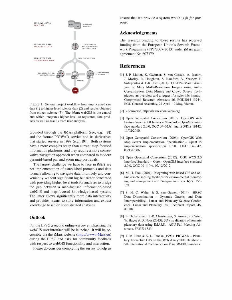
Close user interaction plays a paramount role withiniMars which requires sophisticated concepts for datahandling and communication allowing users to inte-grate, analyse and visualise data from a central loca-tion. This interactive data hub will be realised throughopen-source webGIS implementations and by provid-ing webGIS services to the user community using es-tablished OGC-protocols (see Fig. 1, [3, 4, 5]).
Navigation Concepts and RequirementsA common understanding of requirements is of ut-most importance for project success and its accep-tance in the user community. Requirements put for-ward by developers and the general project aims areweighed against user requirements that have been (and
are being) collected through processes such as userworkshops or community discussions. Finally, these– mostly functional – requirements are complementedby project-internal and technical requirements. Thefirst official workshop was held at the EGU 2014 Gen-eral Assembly in Vienna in May 2014 [1] and is (at thetime of writing) accompanied by an online user surveybased on a questionnaire.
As a central component of iMars, the webGIS willneed to handle a massive amount of data and data lay-ers streamed from different sources over the web. Ad-ditionally, it requires to be slick in terms of design, andintuitive in terms of navigation and speed while offer-ing high-level functionality for raster data display andanalysis.
For planetary data (and user community) only afew web-based GIS have been implemented during thelast decade and even fewer can be considered as be-ing established in and accepted by the user commu-nity. Most web-based services today are either archivesystems providing data gateways and form-based ex-traction of meta-information (data- and clearinghouse-type implementations, see [6]) as realised in the Plan-etary Data System (PDS) and the Planetary ScienceArchive (PSA) nodes. Or, alternatively, web-basedservices are map-focussed systems targeted at visual-isation rather than ancillary data and metadata access(e.g., [7] or Google Mars). Both form either so-calledData Sharing or Information Sharing types of InternetGIS [6].
Options for higher-level analyses, i.e. the Knowl-edge Sharing type of Internet GIS, are currently only
EPSC AbstractsVol. 9, EPSC2014-693, 2014European Planetary Science Congress 2014c© Author(s) 2014
EPSCEuropean Planetary Science Congress
C I T I Z E N SCIENCEZOONIVERSE
CO-REGISTRATIONAND GENERATION OF TIME-SERIES DATA
CHANGE DETECTIONAND DATA MINING
1 S T- L E V E L D ATAR AW D ATA P D S
P S A
2 N D - L E V E L D ATAH I G H - L E V E L D ATA
3 R D - L E V E L D ATAU S E R / S C I E N C E D ATA
WEBGIS
DBDB DB
PLANETARYARCHIVES
USER
DATA D I S T R I B U T I O N
Figure 1: General project workflow from unprocessed rawdata (1) to higher level science data (2) and results obtainedfrom citizen science (3). The iMars webGIS is the centralhub which integrates higher-level co-registered data prod-ucts as well as results from user analysis.
provided through the JMars platform (see, e.g. [8])and the former PIGWAD service and its derivativesthat started service in 1999 (e.g., [9]). Both systemshave a more complex setup than current map-focusedinformation platforms, and they require a more conser-vative navigation approach when compared to modernpyramid-based pan and zoom map portrayals.
The largest challenge we have to face in iMars arenot implementation of established protocols and dataformats allowing to navigate data intuitively and con-veniently without significant lag but rather concernedwith providing higher-level tools for analyses to bridgethe gap between a map-focused information-basedwebGIS and map-focused knowledge-based system.The latter allows significantly more data interactivityand provides means to store information and extractknowledge based on sophisticated analyses.
Outlook
For the EPSC a second online-survey emphasising thewebGIS user interface will be launched. It will be ac-cessible via the iMars website (http://www.i-Mars.eu)during the EPSC and asks for community feedbackwith respect to webGIS functionality and interaction.
Please do consider completing the survey to help us
ensure that we provide a system which is fit for pur-pose.
AcknowledgementsThe research leading to these results has receivedfunding from the European Union’s Seventh Frame-work Programme (FP7/2007-2013) under iMars grantagreement Nr. 607379.
References[1] J.-P. Muller, K. Gwinner, S. van Gasselt, A. Ivanov,
J. Morley, R. Houghton, S. Bamford, V. Yershov, P.Sidirpoulos & J.-R. Kim (2014): EU-FP7-iMars: Anal-ysis of Mars Multi-Resolution Images using Auto-Coregistration, Data Mining and Crowd Source Tech-niques: an overview and a request for scientific inputs.–Geophysical Research Abstracts 16, EGU2014-13744,EGU General Assembly, 27 April – 2 May, Vienna.
[2] Zooniverse, https://www.zooniverse.org
[3] Open Geospatial Consortium (2010): OpenGIS WebFeature Service 2.0 Interface Standard.– OpenGIS inter-face standard 2.0.0, OGC 09–025r1 and ISO/DIS 19142,11/02/2010.
[4] Open Geospatial Consortium (2006): OpenGIS WebMap Server Implementation Specification.– OpenGISimplementation specification 1.3.0, OGC 06–042,03/15/2006.
[5] Open Geospatial Consortium (2012): OGC WCS 2.0Interface Standard – Core.– OpenGIS interface standard2.0.0, OGC 09-110r4, 07/12/2012.
[6] M. H. Tsou (2004): Integrating web-based GIS and on-line remote sensing facilities for environmental monitor-ing and management.– J. Geographical Sys. 6(2): 155-174.
[7] S. H. C. Walter & S. van Gasselt (2014): HRSCData Dissemination – Dynamic Queries and DataInteroperability.– Lunar and Planetary Science Confer-ence, Lunar and Planetary Inst. Technical Report, 45,#1088.
[8] S. Dickenshied, P.-R. Christensen, S. Anwar, S. Carter,W. Hagee & D. Noss (2013): 3D visualization of numericplanetary data using JMARS.– AGU Fall Meeting Ab-stracts, #P23E-1823.
[9] T. M. Hare & K. L. Tanaka (1999): PIGWAD – Plane-tary Interactive GIS on the Web Analyzable Database.–5th International Conference on Mars, #6139, Pasadena.