the global hydrological cycle. inputs: precipitation (eg. rain, hail, snow, sleet, dew, fog) flows:...
TRANSCRIPT

The Global Hydrological
Cycle


Inputs:•Precipitation (eg. Rain, hail, snow, sleet, dew, fog)Flows:•Throughflow, Groundwater Flow, Overland Flow•Rivers (also a Store)•Infiltration, Percolation (I.e. water seeping into the ground)Stores:•Lake, Sea•Vegetation (I.e. water taken up by plants through roots)•SoilOutputs:•Evaporation•Evapo-transpiration (from the stomata on the leaves of plants)


Issue 2: Natural Landforms
Fluvial (River) Processes
1. Fluvial processes create landforms.
2. These processes are affected by specific factors.


Can you work out what the river is trying to do by using this diagram?

Flooding Cause 1
Flooding occurs in the lower course where land is flattest.

Interlocking Spurs
In the Upper Course, the river is fast flowing, but there is little water and load. The river is often called a stream and does not have the erosive power to remove the hillsides (spurs), but erodes downwards instead.
EROSION TYPE: Vertical and Headward

Potholes
Boulders broken off by erosion that sit on the river bed create swirling eddy currents as the water flows past as the river is not strong enough yet to move the boulders by TRACTION. These eddies swirl the boulder round and erode a pothole in the river bed by ABRASION.
EROSION TYPE: Vertical
(by EDDY CURRENTS)

Waterfall
and Gorge 1
(OBLIQUE AERIAL VIEW)EROSION
TYPE: Vertical and Headward

Waterfall
and Gorge 2
(PROFILE VIEW)EROSION
TYPE: Vertical and Headward

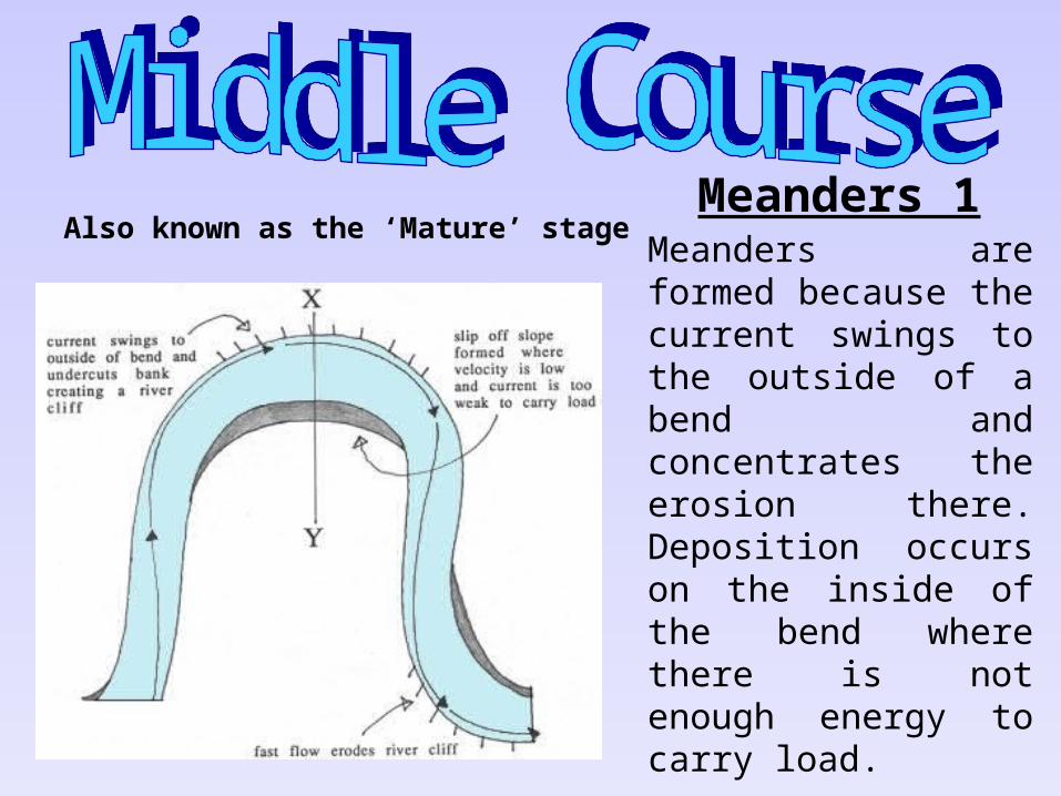
Meanders are formed because the current swings to the outside of a bend and concentrates the erosion there. Deposition occurs on the inside of the bend where there is not enough energy to carry load.
EROSION TYPE: Lateral
Also known as the ‘Mature’ stageMeanders
1

Meanders 2
(Profile View / Cross Section X - Y)
EROSION TYPE: Lateral
This cross section clearly shows the eddy current (near ’X’) formed by the velocity of the river being concentrated on the outside of the bend. These UNDERCUT the bank causing the formation of a RIVER CLIFF. On the inside (NEAR ‘Y’), a SLIP-OFF-SLOPE is formed where current is too slow to carry any load.

Ox-Bow Lake 1
EROSION TYPE: Lateral
Ox-bow lakes are formed when two meander RIVER CLIFFS are being eroded towards each other. These will eventually meet, during time of flooding causing the river to then flow across the neck of the meander. This cuts off part of the water = Oxbow Lake

Ox-Bow Lake 2 (Aerial View)

Leveés and Raised Beds 1 (Front View)
DEPOSITION FEATURE: no
erosion in the Lower
Course
Leveés are formed when rivers flood. The river water overflows the banks of the river and immediately slows down due to friction with the FLOODPLAIN. This drops the larger particles first, building up a raised river bank called a LEVEÉ.

Leveés and Raised Beds 2 (Front View)
DEPOSITION FEATURE: no
erosion in the Lower
Course
Raised beds form in the Summer months when the river volume and energy are low and load is dropped onto the river bed. The bed raises up and the capacity of the river reduces, causing flooding in the winter. This in turn builds up the leveés and the whole process raises up the level of the river in the landscape.

Braided Channels (Oblique Side View)
DEPOSITION FEATURE: no
erosion in the Lower
Course
In the Summer months, load is dropped by the low volume of low-energy water in the river. These build up to form obstructions in the river and it divides up to flow around them. In the winter, it is likely that the river volume will increase and remove these obstructions.

Delta(Aerial View)
This deposition feature is one of the largest. When the flowing river hits the non-flowing sea, energy is suddenly lost. This causes all of the load in the river to drop in the river MOUTH. This builds up over time to create a delta – an area of land. The river divides into DISTRIBUTARIES to continue to the sea, which is now some way away from its original meeting point.


Flooding Case Study
Western European Floods
1994-5

Stage 1:

Stage 2:

Stage 3:

Flooding risk is measured in MAGNITUDES (amount) and FREQUENCIES (how often) and usually floods fall into categories such as:
1.high frequency - low magnitude (happening often, but only small) or
2.low frequency - high magnitude (don't happen often, but are major floods when they do) events.

2: Dendritic
WatershedTributary
Main RiverConfluence

3: Trellised
Tributary
Main River Confluence
Watershed

Issue 1: Hydrosphere
Water Excess: Flooding
1. Flooding occurs over various scales.
2. Flooding can affect human activities.
3. Humans attempt to prevent flooding.

Where is flooding likely in an area of trellised drainage?
Flooding is most likely in the low-lying areas at the bottom of the slope

Where is flooding likely in an area of dendritic drainage?
Flooding is most likely on the main river in the low-lying land

Where is flooding likely in an area of radial drainage?
Flooding is most likely in the low-lying areas at the bottom of the hill

Three Types of Drainage
1: Radial Watershed
Flooding Cause 2