the eulf energy pilot project and citygml energy ade: a
TRANSCRIPT

The European Commission’s
science and knowledge service
Joint Research Centre
The EULF Energy Pilot
project and CityGML
Energy ADE: a possible
collaboration scenario
Francesco Pignatelli,
Giacomo Martirano (external consultant)
Ferrara (IT), 25 September 2016
6th Workshop CityGML Energy ADE

2
Outline
• Geospatial technologies fuel the data economy
• The role of INSPIRE
• ISA, EULF, ISA2, ELISE
• Overview of EULF Pilots (Transport and Marine)
• The EULF Energy Pilot • Pilot overview
• Overview of Use Case 1
• INSPIRE core schemas extension
• Re3gistry implementation
• Data transformation
• Data validation
• Data publication
• Data use
• Next steps

3
Geospatial technologies fuel the data economy
http://government-2020.dupress.com/driver/geospatial-technology//

4
Geospatial technologies fuel the data economy
• In 2020, the location-based service market will be a US$1.3 trillion industry(1)
• In 2020, use of geo-location data, including GPS, will generate US$500 billion in consumer value(2)
• Geographer jobs will grow by 35% per annum, while those of cartographers and photogrammetrists will grow by 22% between 2010 and 2020(3)
1. ”Location Based Services – Market and Technology Outlook – 2013-2020,” Market Info Group LLC, http://www.marketinfogroup.com/location-based-services-market-technology/
2. ”Implications of the ICT Skills Gap for the Mobile Industry,” MacLeod Consulting, http://www.gsma.com/events/wp-content/uploads/2013/08/ICT-Skills-Gap-Research.pdf
3. $3.7 Billion Reasons Why GIS Technology is The Future,” American Sentinel University, http://www.americansentinel.edu/about-american-sentinel-university/newsroom/3-7-billion-reasons-why-gis-technology-is-the-future
Location-based services market forecast – 2013-2020

5
INSPIRE, Europe’s lingua franca for anything geospatial
Directive 2007/2/EC of the European Parliament and of the Council of 14 March 2007 establishing an Infrastructure for Spatial Information in the European Community (INSPIRE)
Directive 2013/37/EU of 26 June 2013
amending Directive 2003/98/EC on the re-use of public sector information (PSI)
Directive 2003/98/EC
Communication from the Commission to the European Parliament, the Council, the European Economic and Social Committee, and the
Committee of the Regions: A Digital Agenda for Europe - COM(2010) 245 final/2
EU Open Data Strategy
Towards interoperability for European public services COM(2010) 744
EU implementation of the G8 Open Data Charter
Digital Single Market Communication from the Commission to the European Parliament, the
Council, the European Economic and Social Committee, and the
Committee of the Regions: EU eGovernment Action Plan 2016-2020 COM(2016) 179 final

6
It should be possible to combine seamless
spatial information from different sources across
Europe and share it with many users and
applications
It should be possible for information collected at
one level/scale to be shared with all
levels/scales; detailed for thorough
investigations, general for strategic purposes
Data should be collected only once and
kept where it can be maintained most
effectively
Geographic information* needed for good governance at all
levels should be readily and transparently
available.
Easy to find what geographic information* is available, how it can
be used to meet a particular need, and
under which conditions it can be acquired and
used.
The INSPIRE five principles apply also to
e-Government
6
1 2 3
4 5
* This could apply to any other kind of information/data

7
e-Government and INSPIRE implementation share
common needs
• Guiding principles to open up data
• Guidelines on how to make data available in machine-readable formats
• Share DOs and DON'Ts to uncover good practices and potential mistakes that others have learnt from
• Common shared infrastructure e.g. Cloud could host and connect all stakeholders which could save resources
• Share standardisation principles to be used across different sectors e.g. persistent identifiers are important in INSPIRE and other infrastructures
• e-Reporting: i.e. guidelines on how to use INSPIRE data for reporting purposes

8
e-Government and INSPIRE implementation face
common challenges
• Better access for consumers and businesses to online goods and services across Europe
• Create the right conditions for digital networks and services to flourish
• Maximise the growth of the European Digital Economy by investing in ICT infrastructure
• Need to raise awareness about the approaches, experience and solutions coming from INSPIRE, including those outside the environmental domain, such as e-Government
• Need to create opportunities for synergies and efficiencies between INSPIRE and e-Government

9
Principles E u r o p e a n I n t e r o p e r a b i l i t y F r a m e w o r k
Solutions E u r o p e a n I n t e r o p e r a b i l i t y C a r t o g r a p h y
Arch
itectu
re
Eu
ro
pe
an
I
nte
ro
pe
ra
bility
R
efe
re
nc
e A
rc
hite
ctu
re
EIF
INSPIRE Creating a Spatia l Data Infrastructure (SDI) for Europe Leg i s la t i ve and techn ica l f r amework Data and serv i ce pub l i cat ion Env i ronmental po l i cy
EU Location Framework (EULF) Loca t ion enab l ing e -government Using the SDI to serve government , c i t i zens and bus inesses: c ross -sector and c ross -border S t rateg i c F ramework (gu idance , bes t p ract i ces , capac i ty bu i ld ing, p rob lem so lv ing, benef i t s…)
A Reusable INSPIRE Reference Platform (ARE3NA) Creating and shar ing reusable geospatia l in teroperabi l i ty so lut ions f o r INSPIRE and beyond; a s takeholder ‘ a rena ’ and common re ference f rame for so lu t ion p rov iders , imp lementers and users
ISA Programme: Geospatial ISA Actions

10
Business as unusual:
the European Union Location Framework
Removes obstacles for the free flow of data in support of the Digital Single Market
Promotes INSPIRE as a multi-purpose infrastructure for a range of policy areas, including e-government, transport, marine, and energy
Identifies and promotes opportunities for the private sector
Working together with
MS to address priorities
Practical problems solved
through pilot studies
Strategic framework
based on EU survey
Recommendations and
guidance in 5 focus areas
Part of the ISA Programme Linking INSPIRE and e-Government

11
How has the EULF evolved?
Vision Survey &
Assessment
Benefits approach
Blueprint Pilots
Detailed Guidance
Case Study Factsheets
Process Improvement
Approach
Solutions Inventory Approach
References Feasibility Studies
Strategic Framework
Guidance Framework
Methodologies
Landscape Analysis Applications

12
EULF Guidance Framework: Detailed Guidance
EULF Policy Alignment Guidelines
EULF Location Privacy Guidelines
Public Procurement of Geospatial Technologies
Design of Location Enabled e-Government Services
Architectures and Standards for SDIs and e-Government

13
ISA2 Programme
INSPIRE Directive
INSPIRE contribution to EU Policies and initiatives:
selected cases
Digital Single Market Strategy
Better Regulation for Better Results Strategy
ELISE action
Energy Efficiency Directive
Energy Performance of Buildings Directive
Marine Strategy Framework Directive
Intelligent Transport Systems Directive
EU-wide real-time traffic information services Delegated Regulation
European Intelligent Transport Systems Platform
Connecting Europe Facility Regulation
Public Sector Information Directive

14
Value development path
ISA2
INSPIRE contribution via new ISA2 Action ELISE (2016-2020)
14
To build solutions for e-Government based on INSPIRE, EULF and ARE3NA and act as ‘geo’ knowledge-base for ISA2
Support to Digital Single Market, Better Regulation and Public Sector Modernisation
Implementation of 'common services' such as geo-names and addresses to support multiple use cases in portals and applications
Link geo-data and statistics, addresses barriers in the free flow of location-related information, including private sector processes/products
Efficient and effective electronic G2G/C/B cross-border/sector interactions, through studies, frameworks, applications and services
eGovernment
community
Solution providers

15
EULF: provides the strategic framework, turning its recommendations into action and learning from the results
JRC
DG MOVE
ITS Directive
INSPIRE Directive
Environmental Sector
Transport Sector
DG ENV DG MARE
MSFD Directive Marine Knowledge 2020
Marine Sector
DG ENER
COM SEAPs, EPBD and EED Directives
Energy Sector
INSPIRE… and beyond: EULF Pilots
G2G

16
Pilots for Business opportunities
16
Commercial map providers like HERE and TomTom need road network data that are
consistent accurate up-to-date
In the Transportation Pilot, INSPIRE standards are used to get geospatial data from public administrations
Significant reduced error rates in maps of from 25% to 7%, and Road Authorities (SE, NO) upgraded from Quarterly to Daily updates to map providers
Commercial map providers able to move from disparate national processes to more standardised processes in different EU countries
https://www.youtube.com/watch?v=jnny5ATwTYE
Transportation Pilot
Up-to-date flow of road safety data between Road Authorities and private map providers

17
Member States
INSPIRE MSFD WFD OTHER DIRs
obligations
DG ENV
EEA
INSPIRE EEA-eRep
INSPIRE
Member States have to report to different Directives, including INSPIRE
If INSPIRE is used to report to the other Directives (e.g. WFD, MSFD, Habitat, …):
• processes to provide the reporting can be established at EU level and not at MS level
• MS will provide their data through INSPIRE to be exploited by the EC and/or other institutions for reporting to the other governmental processes or directives
Marine pilot
18
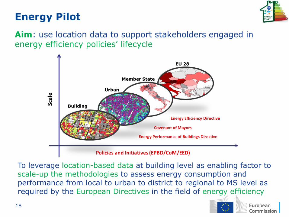
Energy Pilot
Aim: use location data to support stakeholders engaged in energy efficiency policies’ lifecycle
To leverage location-based data at building level as enabling factor to scale-up the methodologies to assess energy consumption and performance from local to urban to district to regional to MS level as required by the European Directives in the field of energy efficiency

19
Focus on Buildings
According to studies conducted by BPIE (Buildings Performance Institute Europe):
• Buildings are responsible for the 40% of final energy consumption
• Over 75% of building stock is older than 25 years
• Averaged final energy consumption data: 185 kWh/m2 for residential buildings and 280 kWh/m2 for non-residential buildings
• Deep renovation of buildings could cut 36% of their energy consumption by 2030

20
Energy Pilot specific objectives
Showing the benefits of an integrated approach for reporting, monitoring and planning, to handle multiple aspects of energy (energy performance of buildings, energy consumption and production at local level – renewable/non renewable, etc.) by:
• Adoption of common structured data models (extending few INSPIRE core data models) and of common data access mechanisms (INSPIRE Network Services)
• Re-use of (parts of) datasets for different reporting, monitoring or planning purposes
• Use of both centralized and distributed IT infrastructures which make accessible data needed to fulfil reporting, monitoring and planning requirements

21
Energy Pilot Roadmap
JRC concluded a Feasibility Study “Location Data for Buildings related Energy Efficiency Policies” in 2015
• Identified an approach to compare different methodologies to support EPBD, EED and CoM policy instruments, based on the re-use of INSPIRE components
• Made an initial analysis of the data flows relevant to EPBD, EED and CoM, has identified the relevant INSPIRE data themes best fitting for purpose and has made an initial mapping exercise
• Outlined scope and content of a full pilot project, started in 2016
http://publications.jrc.ec.europa.eu/repository/handle/JRC96946

22
Possible Use Cases of the Energy Pilot
1) INSPIRE harmonization of existing Energy Performance
Certificate datasets
2) Comparing different buildings' Energy Performance Labelling
3) Assessing energy flows at different geographical scales with
dynamic measured data
4) Supporting buildings' energy efficiency driven refurbishment
planning at local level
5) Supporting integrated energy planning and monitoring at
urban/local level (SEAP BEI/MEI)
6) Supporting the design and implementation of a regional
energy strategy
The pilot will be tested by means of a set of Use Cases (under finalization), involving different actors (public authorities at regional and local level, businesses working in the energy sector, citizens)

23
Overview of Use Case 1
• Name: INSPIRE Harmonization of existing Energy
Performance Certificate datasets and creation of a
web application for accessing them.
• Goal: To establish an accessible and interoperable
common knowledge base for EPC datasets to
support local government and private sector
involved in energy efficiency policies.
• Description: To harmonize according to INSPIRE
existing EPC datasets and to create a user friendly
web application to make them accessible and re-
usable.

24
Overview of Use Case 1

25
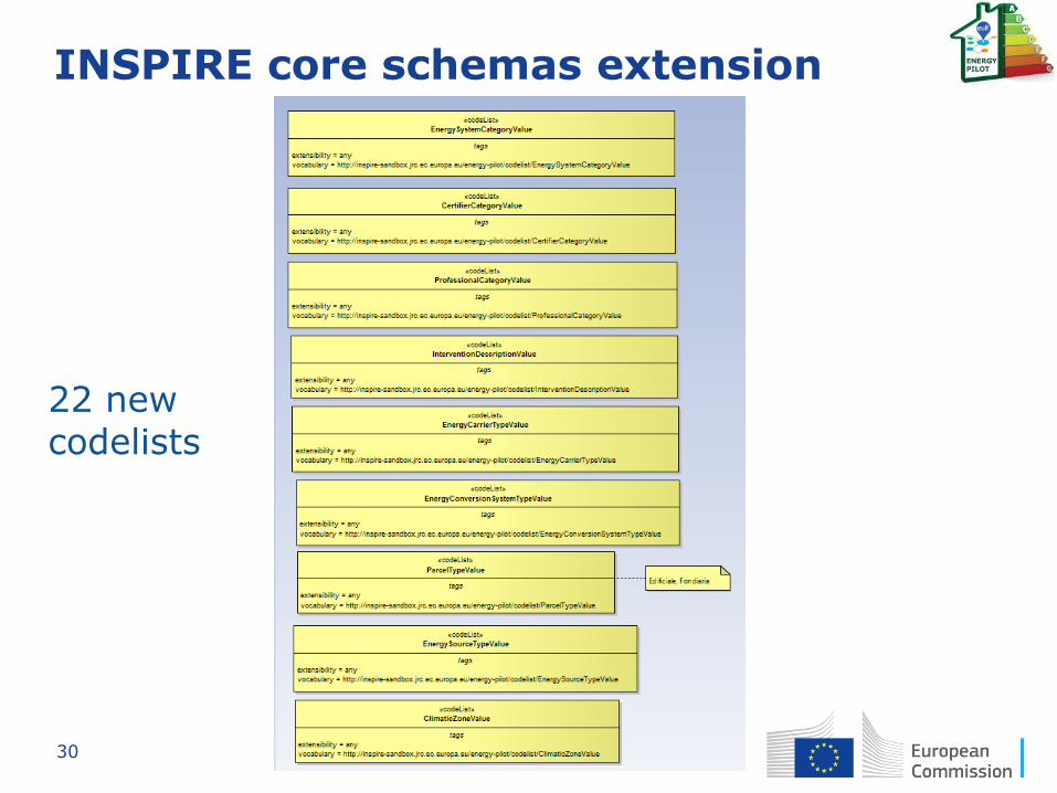
INSPIRE core schemas extension
• Content and structure of INSPIRE application
schemas for theme Buildings

26
INSPIRE core schemas extension
INSPIRE core data models
INSPIRE extended data models Energy Pilot
extended data models
CityGML Energy ADE

27
INSPIRE core schemas extension

28
INSPIRE core schemas extension
INSPIRE
CORE DRAFT INSPIRE
EXTENDED
NEW
FEATURE
TYPES

29
INSPIRE core schemas extension
INSPIRE CORE
NEW DATA
TYPES
30
INSPIRE core schemas extension
22 new codelists

31
INSPIRE core schemas extension
In green background are shown the attributes of the use case extended data model taken as-is from CityGML Energy ADE modules
FeatureType Attribute Values
Building costructionStyle CostructionStyleValue Building buildingType BuildingTypeValue Certificate climaticZone ClimaticZoneValue
EnergyConversionSystem yearOfInstallation Date
EnergyConversionSystem energyCarrierType EnergyCarrierTypeValue
EnergyConversionSystem energyAmountProduced Measure
EnergyConversionSystem energyConversationSystemCode
CharacterString
EnergyConversionSystem registrationNumber CharacterString
EnergyConversionSystem energyCarrierNotes CharacterString
EnergyConversionSystem otherConversionSystemTypeNotes
CharacterString
EnergyConversionSystem nominalPower Measure
EnergyConversionSystem energySourceType EnergySourceTypeValue
EnergyConversionSystem energyConversionSystemType
EnergyConversionSystemTypeValue
EnergySystem energySystemCategory EnergySystemCategoryValue
hasEnergyConversionSystem
EnergyConversionSystem
EnergySystem nominalEfficiency Measure EnergySystem systemNominalPower Measure

32
Building unit
A BuildingUnit is a subdivision of Building with its own lockable access from the outside or from a common area (i.e. not from another BuildingUnit), which is atomic, functionally independent, and may be separately sold, rented out, inherited, etc.

33
Re3gistry implementation

34
Re3gistry implementation

35
Data transformation

36
Data transformation

37
Data validation

38
Data publication

39
Data use

40
Data use

41
Data use
42
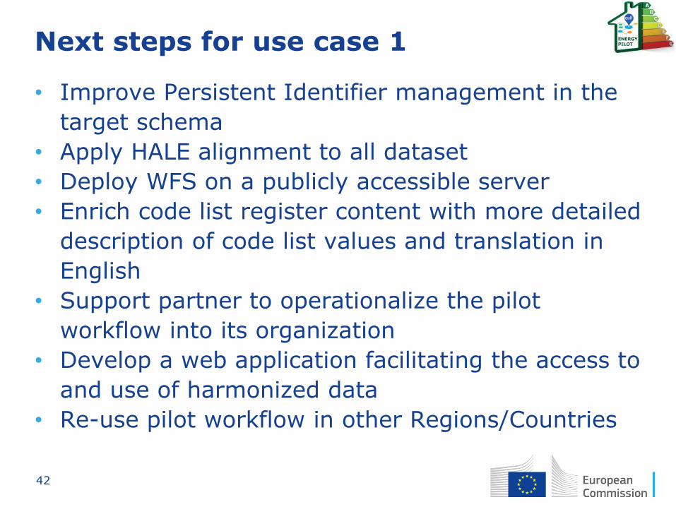
Next steps for use case 1
• Improve Persistent Identifier management in the
target schema
• Apply HALE alignment to all dataset
• Deploy WFS on a publicly accessible server
• Enrich code list register content with more detailed
description of code list values and translation in
English
• Support partner to operationalize the pilot
workflow into its organization
• Develop a web application facilitating the access to
and use of harmonized data
• Re-use pilot workflow in other Regions/Countries

43
Next steps for use cases 1 & 2
http://www.energielabelatlas.nl/

44
Next steps with CityGML ADE ?
• Use case 2 aims at comparing different buildings'
Energy Performance Labelling
• JRC welcomes partners willing to contribute,
providing data and expertise on energy
performance labelling methodologies (contacts
with partners from NL and BE have been already
started)

45
JRC Science Hub: www.ec.europa.eu/jrc
website: http://ec.europa.eu/isa/actions/02-interoperability-architecture/2-13action_en.htm
Twitter: @EU_ScienceHub @EULocation
LinkedIn: european-commission-joint-research-centre
YouTube: JRC Audiovisuals
Vimeo: Science@EC
Email: [email protected]
EULF Joinup Community: https://joinup.ec.europa.eu/community/eulf/description
http://inspire.ec.europa.eu/
Stay in touch