the dry moat the south rock wall of the ...nabilswelim.com/downloads/363_376 vol 1 swelim low...
TRANSCRIPT

1 N. SWELIM, 1988, The Dry Moat of the Netjerykhet Com-plex, in: J. BAINES, T.G.H. JAMES, A. LEAHY, A.F. SHORE
(eds.), Pyramid Studies and Other Essays Presented to I.E.S.Edwards; 1995, F.D. FRIEDMAN, JARCE 32, 41.
2 N. SWELIM, Some Remarks on the Great Rectangular Mon-uments of Middle Saqqara, MDAIK 47 Festschrift Für Wern-er Kaiser, 389–402, Mainz, 1991.
3 Before 1924 in, J. CAPART, Memphis à l’ombre des Pyramides, pl.
XIV; June 1924 in C.M. FIRTH and J.E. QUIBELL, 1935, The StepPyramid II pl. 6 #1; December 1927 in: J.PH. LAUER, La Pyramidà degrés II, 1936 pl. II # 1 and 1933–1934 in: BREASTED JR., FieldMuseum of Natural History Bulletin, November 1981, 3.
4 Z. GONEIM, 1957 Horus Sekhemkhet, pl. 1; W.B. EMERY,JEA 51, 1965, pl. 2.
5 J.-PH. LAUER, 1962, Histoire monumentale des pyramid d’Egyp-te I, 182, fig. 55, note that channel (cc) is 40 metres wide.
Nabil Swelim
TTHHEE DDRRYY MMOOAATT,, TTHHEE SSOOUUTTHH RROOCCKK WWAALLLL OOFF TTHHEE IINNNNEERR SSOOUUTTHH CCHHAANNNNEELL
I am honoured to contribute to the Festschrift ofManfred Bietak. He has thrown light on a dark epi-sode of our Ancient History; very exciting wereMinoan paintings which he found at Tell el-Dabaca.These paintings were the subject for a seminar in thesummer of 1997 at the beautiful island of Corfu inthe Ionic sea; apart from the pleasure of our work atthe lecture hall we had a wonderful time.
My present article considers the little evidencethere is from the site of the dry moat. In fact: the tipof an iceberg buried in the desert surrounding the steppyramid complex. In the late seventies – of the lastcentury, during my visits to Saqqara and investigatingaerial photographs, I noticed the presence of a greattrench surrounding the step pyramid complex. Itreminded me of medieval moats; but with no water! Ithought of it as a ‘dry moat’. In 1985 I presented apaper in Munich, in 1988 an article in London, and in1995 the meaning of the plan was discussed in RhodeIsland.1 The dry moat is a subsidiary to the step pyra-mid complex, and its diagonal, axis and corners haveremarkable relationships with the monuments of theearly Old Kingdom at middle Saqqara.2 Adding tothose studies, my present article points out that:
At the bottom of the south rock wall of the innersouth channel, some spectacular compartments weretunnelled at 4 levels.
The inner south channel was completely buriedand could not be seen on the maps of Lepsius and deMorgan, and does not appear on early aerial photo-graphs in: Capart, Firth–Quibell, Lauer and BreastedJr.3 It was due to the large-scale excavations by thelate Selim Hassan in 1937–1938 and the late ZakiSaad in 1939–1943 that some parts of this channelwere revealed, though never considered as part of a
greater trench (dry moat) surrounding the step pyra-mid complex. Since then the inner south channelappeared as 2 depressions on aerial photographs inpublications by: Goneim and Emery4 and on the mapLe Caire, H-22.
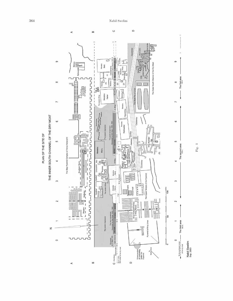
The present plan of the inner south channel of thedry moat (Figs. 1, 2) will help find positions mentio-ned in the text by their names or coordinates. It goesas far as the pyramid of Unas. Some distances areestimated with respect to the monuments in thebackground of reference photographs.
Similar to the other channels it is an artificiallyrock cut trench measuring about 410 metres in lengthand 40 meters in width. Over the centuries it was fil-led with debris and wind blown sand; but at 2 placesit had been filled up intentionally as foundations for2 groups of mastabas in the positions B–C, 7–9 and2–5 on the plan. They are referred to as the ‘easternfilling’ about 100 metres and the ‘western filling’about 90 metres. Alternating with the fillings are the‘eastern depression’, about 80 metres and the‘western depression’ about 140 metres.
The eastern limit cannot be determined: it issomewhere near the mastaba of Bebi, in an areawhich has not been investigated. The western limit isthe southwest corner of the dry moat, a short distan-ce from the complex of Sekhemkhet.
A short investigation of the north bank of the chan-nel is followed by a more detailed one of the south bankof the channel. Both banks are divided into 3 areas.
TTHHEE NNOORRTTHH BBAANNKK OORR RROOCCKK WWAALLLL OOFF TTHHEE DDRRYY MMOOAATT
To the north of the channel-bank are the rock foun-dation-platform and the temenos wall of the steppyramid complex.5 The channel extends beyond the
363_376 vol 1.qxd 10.10.2005 14:30 Seite 363
Nabil Swelim364
Fig
. 1
363_376 vol 1.qxd 10.10.2005 14:30 Seite 364
The Dry Moat, the South Rock Wall of the Inner South Channel 365
Fig
. 2
363_376 vol 1.qxd 10.10.2005 14:30 Seite 365

Nabil Swelim366
6 In the references on this area there are a few unnamedmastabas or they are given uncertain names. To avoid anyconfusion I have referred to them by letters between brack-ets. In the corridor between the mastabas (X) and Bebi liesa block with an inscription of Metri. His tomb is certainlyin this area, but there are conflicting reports whethermastabas (X) or (Z) belong to him. Other mastabas are
referred to in the present plan as (V), (W) and (Y).7 Unfortunately a survey carried out by Ana Tavares in 1993
has not appeared during the last 10 years.8 S. HASSAN, Z. ISKANDER (ed.), 1937–1938, Excavations at
Saqqara, 3 vols., Cairo 1975.9 S. HASSAN, vol. III, pl. XXXV a, b.
limits of the temenos to the east and to the west; seeposition B 0–9 on the plan.
The first area runs for a distance of about 100metres, along the mastabas of Simery, Nykauptah,Bebi, (X), (W) probably built on rock,6 to the masta-ba of Kairer, partly built on the ‘eastern filling’; seeposition B 9–7 on the plan.
The second area runs for a distance of about 170metres along a row of rock tomes of: Iarti, Ankhi,Snofruhotep, Nedjem, and the mastaba of Mehu inthe ‘eastern depression’; and the mastabas of: Seshse-shet, Idut, Unasankh, Iynefret and Haishtef, on the‘western filling’; see their positions B 7–2 on the plan. The third area runs for a distance of about 140metres along the ‘western depression’; from west ofthe mastaba of Haishtef to the inner south west cor-ner of the dry moat. No investigations have takenplace here and in modern times it became a conve-nient low level area for archaeological dumps. Seeposition B west of 2 on the plan.
TTHHEE SSOOUUTTHH BBAANNKK OORR RROOCCKK WWAALLLL OOFF TTHHEE DDRRYY MMOOAATT
To the south on the opposite bank are severalmastabas of high officials, at least 2 undergroundgalleries of tombs of 2nd dynasty kings, 2 mastabasof 5th dynasty queens, one mastaba of a princess andthe pyramid complex of Unas;7 see position C 0–9 onthe plan.
At this site the apparent sections made in thedesert rock, revealed that at the surface and at a fewmetres below are hard rock strata of limestone,below each are soft layers. These hard rock strataserve as foundations, roofs and lintels throughout.They will be referred to as the ‘upper hard rock stra-tum’ and the ‘lower hard rock stratum’.
TThhee ffiirrsstt aarreeaa aalloonngg tthhee ssoouutthh rroocckk wwaallll
The ancient project of constructing the dry moat wasprobably left incomplete. Patches of rock were notremoved from the east of the channel. Later whenthe site became vulnerable, the mastabas of Bebi,(X), (Y), Hotep and 10 shafts were founded in suchpatches; while the mastabas of Kairer, (W), and (Z)were partly founded in the ‘eastern filling’.
The first area runs for about 100 metres; 40metres of which were excavated. See position C 9–7on the plan. By the south rock wall are a series ofdeep and narrow compartments in line. At the east-ern end rubble partly covers the eastern compart-ment and at the western end the western compart-ment is blocked with rubble.
The only work conducted on these compartmentswas during the excavations of Selim Hassan in1937–8. By his death in September 1961 the reporthad not appeared, and not until February 1974 didthe late Zaki Iskander rescue some field notes andedit a manuscript which appeared in 3 volumes. Theysaved a lot of primary material from being lost.Unfortunately the volumes were not as good as theauthor or the editor would have liked them to be. Inthe editor’s note he mentions ‘The unprepared pageswere in most cases those dealing with the description...’ it was such descriptions that would have providedinformation and perhaps measurements of the com-partments.8 Important photographs from this report,however, are referred to. They will help understandrelative positions at the site and appreciate the mag-nitude of such an excavation, but they cannot becopied.
TThhee eeaasstteerrnn ccoommppaarrttmmeenntt
No one knew of this compartment until it was exca-vated in 1937. In S. Hassan’s report two pho-tographs, taken before the clearance began, show therails of his decauville going over a flat area towardsmastaba (Z), 9 in other words, running over the com-pletely buried mastaba of Ankhi, 10 shafts, the east-ern and middle compartments. The clearance of theeastern compartment brought 3 rock walls to light,the 4th to the east, if it exists is still buried, see Pl. 1.
The north rock wall is directly under the southwall of the mastaba of Bebi which was built on the‘upper hard rock stratum’. Under it is: a long hori-zontal and a short square cavity, with shores ofwood and bricks to support the roof. Beyond the cor-ner of the mastaba to the east is a cut in the rockwall, patched up with bricks which disappear in therubble.
363_376 vol 1.qxd 10.10.2005 14:30 Seite 366

The Dry Moat, the South Rock Wall of the Inner South Channel 367
Plate 1
363_376 vol 1.qxd 10.10.2005 14:31 Seite 367

The south rock wall runs in a curved line and itsvertical plane bulges in. Very close to it are 10 deepshafts. The sides of 4 eastern shafts were cut into thecompartment wall. Above the west part of the wallthe ‘upper hard rock stratum’ was destroyed. Conse-quently some shafts, part of the mastabas of Ankhiand Hotep were founded at a lower level, see Pl. 1.
The west rock wall separates the eastern compart-ment from the middle one. The upper part of thiswall was cut in a more regular manner and has a win-dow-corridor half way from the surface. The ‘upperhard rock stratum’ above extends a little over thewest rock wall, suggesting that this was part of adestroyed rock roof.
In Pl.1, we see 5 shafts, the lower courses of theeast wall of Hotep, and some brickwork of Ankhi. Tothe south in line with the west wall below the masta-
ba of Hotep, is a cave roofed by the ‘upper hard rockstratum’.
The north side of the mastaba of Hotep was builton the filling in the compartment.10 The south sidewas built on the ‘upper hard rock stratum’. The eastside was founded on a lower level. The west sideextends north over the west rock wall of this com-partment. Three corners have survived but the 4th,the northeast corner was destroyed by removing thefilling in the compartment below.11
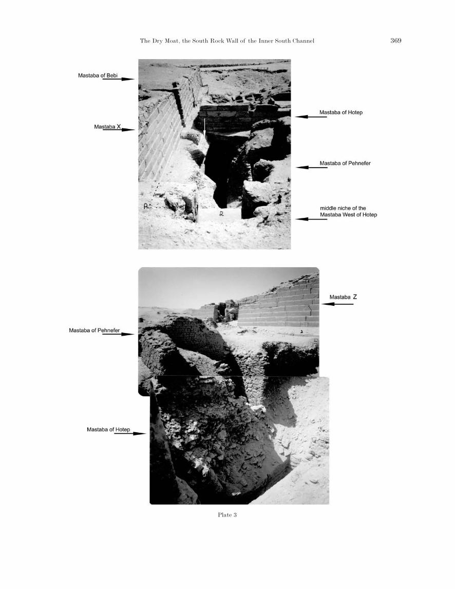
TThhee mmiiddddllee ccoommppaarrttmmeenntt
The middle compartment is a short rock cut trenchover the rock wall, to the north and south are masta-ba (X) to the north and (Y) to the south. Over therock walls to the east and west are the mastabas ofHotep and (Z). Three rock walls are level with the‘upper hard rock stratum’, the 4th, to the south, islower because the stratum was removed. Mastaba (Y)is on this lower level, it looks confusing.
Like the eastern compartment, the south rockwall runs in a curved line and its vertical plane bulgesin. Through the eastern and the western walls are 2similar window-tunnels in line connecting this com-partment to the eastern and the western, see Pl. 2.
In the west rock wall below the window-tunnel isan opening where the burial chamber, probably ofmastaba (Y) or (Z) had broken into the middle com-partment. The chamber lies under the western com-partment and houses a large limestone sarcophaguswhich had been plundered. The roof had been shoredby wooden beams in modern times.
Plates 3 and 4 show that the ‘upper hard rockstratum’; not only tops the 3 walls mentioned, butalso extends over parts of the compartment. Themiddle compartment was most probably tunnelledthrough the window-tunnels!
TThhee wweesstteerrnn ccoommppaarrttmmeenntt
The middle and western compartments are separatedby a rock wall, with a window-tunnel, 5 metres long.The floors of the compartment and the window-tun-nel seem to be level and extend under mastaba (Z).The western compartment is filled with rubble; a lim-ited clearance reveals neatly cut corners to the eastand a light brown coloured rock roof.
Mastaba (Z) is a great monument built on a plat-
Nabil Swelim368
10 S. HASSAN, vol. III, 53–58.11 S. HASSAN, vol. III, pl. XXXVII b, is a photograph show-
ing that the northeast corner of the mastaba was in tact
before the clearance; the caption refers to the compartmentas ‘the great passage under this Mastaba’.
Plate 2
363_376 vol 1.qxd 10.10.2005 14:31 Seite 368
The Dry Moat, the South Rock Wall of the Inner South Channel 369
Plate 3
363_376 vol 1.qxd 10.10.2005 14:33 Seite 369

form of large blocks of limestone which bridge thecompartment.12 Vertical cracks in line with the axisof the 3 compartments are seen on the east and westsides of its superstructure. 13 Consequently it is logi-cal to believe that the length of the western com-partment will exceed the width of the mastaba.
WWeesstt ooff tthhee wweesstteerrnn ccoommppaarrttmmeenntt
West of mastaba (Z), are the mastabas of Kairer and(V). The former was partly or totally built on the ‘east-ern filling’. The latter was built on the desert rock sur-face by the causeway of Unas. The narrow passagebetween these mastabas is in line with the 3 compart-ments. Without an investigation or by the removal ofthe rubble inside the western compartment we will be
unable to know what lies beneath. Whether we have anextension of the western compartment, an additionalone or nothing will remain unknown.
It is for certain that the level of the northern rockwall in this area declines, to continue topped by the‘lower hard rock stratum’. The south wall maintains itsoriginal level; topped by the ‘upper hard rock stratum’.
TThhee sseeccoonndd aarreeaa aalloonngg tthhee ssoouutthh rroocckk wwaallll
The greater parts of the second and third areas wereexcavated by Zaki Saad at the beginning of WorldWar II. He spent 2 interrupted seasons: 1938–1939and 1942–1943.14 Plates 5, 7–10 illustrate part of hiswork. They were printed from negatives at theSaqqara inspectorate # 1906, 2097, 2095, 2776 and
12 Mastaba (Z), sometimes called Metri. It occupies an areafrom the causeway of Unas, over the west compartment tillmastaba (W). It was built on a platform the upper coursesof which were dressed while the lower courses were rough.The superstructure is made of walls retaining a rubble corewith an outer casing; 3 courses of which have survived onthe west side.
13 The crack on the eastern side can be seen since 1937, S.HASSAN, vol. III, pls. XXXV and XXXVI.
14 Z. SAAD, 1940, A preliminary report on the excavations atSaqqara, 1939–1940, ASAE 40, 692; 1947, Royal Excava-tions at Saqqara and Helwan (1941–1945), SupplementASAE Cahier No. 3, 55–67.
Nabil Swelim370
Plate 4
363_376 vol 1.qxd 10.10.2005 14:34 Seite 370

The Dry Moat, the South Rock Wall of the Inner South Channel 371
Plate 5
Plate 6
363_376 vol 1.qxd 10.10.2005 14:36 Seite 371

2790. Other photographs referred to but not publishedwere printed from negatives # 2143, 2144, 2778 and2791, illustrating his excavations at the third area.
The second area begins at an undetermined point‘west of the west compartment’ by the south rock wallof the inner south channel, through the ‘eastern fill-ing’’,, the ‘eastern depression’ and the ‘western filling’;covering a distance of about 170 metres. In otherwords from the mastaba of Kairer to the mastabas ofqueens Nebet and Khenut, see position C 7– 2 on theplan. The queen’s mastabas were built partly on therock and partly on the ‘western filling’. On the southside of the channel are the mastabas of Niankhba,
Nebkauhor, Iy, Isi, Khenu and the galleries of kingNynetjer. Here the great compartment was excavated.
In 1939 Z. SAAD worked from west to east andreports that: ‘To the south east of the mastaba ofqueen Nebet we came upon a very big descent cut inthe rock. At a depth of 25 metres from the groundlevel we reached steps leading westward. It resemblesvery much the descent leading to the south mastabaof Zoser (Neter-khet). We were obliged to stop thework in this place until next season’.15
In his report of season 1942 he mentions that thearea ‘….. already excavated from the east to themastaba of queen Nebet in the west was about 80metres’.16 This means that there are 120 metres in thesecond area which could not be excavated: at: ‘east-
Nabil Swelim372
15 Z. SAAD, 1940, 692; we cannot determine to what extentwas that similarity? The stairway of the southern tombdescends in the opposite direction and the north wall wasbuilt of stone masonry to narrow the rock cut corridor, asthe situation is at the entrance of the pyramid ofSekhemkhet. In that respect we can refer to the illustra-
tions published in C.M. FIRTH, J.E. QUIBELL and J.-PH.LAUER, 1935, The step pyramid II, Plates, Cairo, pl. 36 I,and pl. 47 ‘K’. (Position A–B 3–4 on the plan). GONEIM,1957, Excavations at Saqqara, Horus Sekhemkhet, The Unfin-ished Step Pyramid at Saqqara, Cairo, pls. XX, XXI. Themasonry blocks the entrance corridor only.
Plate 7
Plate 8
363_376 vol 1.qxd 10.10.2005 14:38 Seite 372

The Dry Moat, the South Rock Wall of the Inner South Channel
ern filling’, part of the ‘eastern depression’ and the‘western filling’.
Pl. 5 shows the excavation; at the positions C 7–4on the plan. Investigating Pl. 5, we see: a clearanceunderway and the great compartment beginning toappear. The excavation has shown that the southrock wall is taller than the north one. The ‘lower hardrock stratum’ projects out of the south rock wall con-tinuously.17 To day the protrusion is still exposedbelow the area of the mastaba of Iy, on Pl. 6 and inposition C 5 on the plan. If this protrusion is theremaining part of a destroyed roof, we have toremember the levels: the great compartment liesbeneath the ‘lower hard rock stratum’; and that the3 compartments lie beneath the ‘upper hard rockstratum’. The change level would be found in the‘eastern filling’.
On Pls. 5 and 6 a rough rock niche is seen; it is sim-ilar to, and at the same level as 10 niches in the thirdarea, see below.
TThhee tthhiirrdd aarreeaa aalloonngg tthhee ssoouutthh rroocckk wwaallll
The third area runs from the mastaba of queenKhenut at position C 2 on the plan to the south westcorner of the dry moat, for a distance of about 140metres.
In the report of 1942–1943, Z. Saad mentions thathe had already excavated 30 metres of a new com-partment west of the mastaba of Khenut 2 years ear-lier.18 This excavation would be almost 90 metres westof the stairway of the great compartment in the sec-ond area and at position C 1 on the plan.
During the season 1939–1940, on Pl. 7 we see themastaba of queen Khenut in the background and
373
Plate 9
16 Z. SAAD, 1947, 55–6717 A section at the opposite side in the ‘eastern depression’,
shows rubble and bricks above which is a red layer, more
rubble and a second red layer on top. The red layers comefrom the desert crust, but the presence of bricks is curious.
18 Z. SAAD 1947, 65.
363_376 vol 1.qxd 10.10.2005 14:39 Seite 373

19 This estimate is based on a study of photographs printedfrom negatives # 2143 and 2144 at Saqqara; (not pub-lished).
20 Z. SAAD 1947, believes it dates to the fifth dynasty, anddescribes ‘It was built partly with mud bricks and partlywith limestone. This mastaba had been previously foundand published by BARSANTI (ASAE 1, 150) and thenreburied.’
21 Z. SAAD 1947, reports that the owner was ‘The elder daugh-
ter of the King, of his body, Khent Kaw-Es. We noted thatthe chapel and burial place of Khent-Kaw-Es were exactlyin the line of the trench, and came to the conclusion that itsend would be to the east of this mastaba.’
22 On a photograph printed from negative # 2668 at Saqqara;(not published) the east end of the rough construction is inline with a point, 20 metres east of the northwest corner ofthe pyramid of Unas; in the background.
the new compartment in the foreground. The westrock wall extends beyond the east rock wall to dis-appear in the ‘western filling’. Both the northernand eastern rock walls are short of the ‘lower hardrock stratum’. No window-tunnel or stairway can beseen. The projection of the ‘lower hard rock stratum’appears as a continuation of the one at the secondarea and suggests a destroyed rock roof covered thenew compartment.
On Pl. 8 we are looking at the new compartment
from the opposite direction. We can see, much rubblenorth of the pyramid of Unas and the first pit of thegalleries of king Hotepsekhemwy. From these pho-tographs we learn that the excavation of the newcompartment was not finished and the work wasresumed 2 years later.
In season 1942–1943, Z. Saad reports that hisintension ‘…. was to clear the area to the northwestof the Pyramid of Unas in order to reach the end ofthis great trench (the new compartment)’.
According to our estimation Z. Saad started exca-vating 20 metres east of the corner of the dry moat.19
He cleared 60 metres and discovered the tombs ofSeshemnefer20 and Princess Khentkawes.21 In asearch for the entrance of the latter’s tomb, heuncovered ‘… a rough construction of local stone andmortar. It resembled the buildings … under thetemenos wall of the step pyramid’ and it was about14 metres long. On Pl. 9 one sees that it was built overthe ‘lower hard rock stratum’ and preserves at least 5courses. The bulk of it seems to be composed of 2 or3 accretion layers along the south rock wall.22
East of this construction at the end of the 60metres, Z. Saad found that the rock had been exca-vated to a depth of 26 metres and finally realisedthat here was the west end of the new compartmentwhich he began clearing in 1939– 1940. It measured 3metres across. At the bottom he found a pavement ofstone and mortar which he removed to reach the nat-ural rock at a new depth of 27.5 metres. Then he pro-ceeded to complete the clearance of the new com-partment. We note from a sketch in the report(Z. SAAD 1947, fig. 7) that the floor was irregular andunfinished. According to our estimate, the length ofthe new compartment was about 60 metres.
In Z. Saad’s report nothing was mentioned aboutthe west end; Pl. 10 however, illustrates the southrock wall with the ‘lower hard rock stratum’ pro-jecting. Similar to the east end the rock walls to thewest and to the north stand short of the ‘lower hardrock stratum’. Here the projection stretches to spanthe cavity above the west rock wall like a rock vault.
Nabil Swelim374
Plate 10
363_376 vol 1.qxd 10.10.2005 14:40 Seite 374
The Dry Moat, the South Rock Wall of the Inner South Channel
The cavity was blocked by modern masonry. On thesame plate over the north rock wall is a small blockof ancient masonry supporting another cavity.
The sketch mentioned in the report shows that arow of ‘niches cut in the face of the southern rockwall of the trench from above the end of the trenchtowards the east. There are ten of these niches all-similar with the exception of the ninth which is larg-er. Nine metres below these niches were found threesimilar ones. The first to the west is in one line withthe ninth niche above it. The distances are equal.’
A print of negative 2791, not published, showsthat the upper 10 niches were roughly cut in claylike layer in the limestone above the ‘lower hardrock stratum’; similar to the one mentioned in thesecond area, the lower 3 niches would be below therock roof. One also sees a sharply cut part of the‘lower hard rock stratum’ above the east rock wall,as far as I can tell, it looks like the corner of anopening in the rock roof.
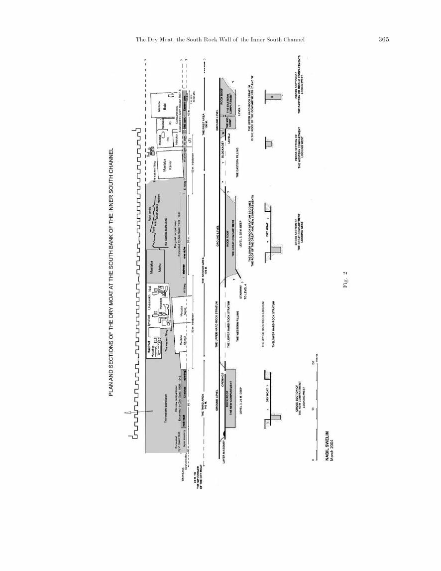
AANN OOVVEERRVVIIEEWW (Figs. 1, 2)
The excavators of the inner south channel wereunable to achieve a thorough clearance; because theidea of a great trench did not present itself and theywere more concerned with other parts of their exca-vation. The plan shows that out of 410 metres alongthe south rock wall only 240 metres were excavated.They were unable to work at 4 areas measuring atleast 170 metres in length: an unknown distance eastof the eastern compartment, 60 metres in the ‘east-ern filling’ between the excavations of S. Hassan andZ. Saad, 90 metres in the ‘western filling’ between the2 excavations of Z. Saad and 20 metres before thecorner of the dry moat. 23
In the first area, mastabas at position A–B 7–9 onthe plan were constructed on a rock surface and onthe ‘eastern filling’. Thus the east ends and depths ofthe channel and the eastern compartment within arenot known. At the second area by the north bank: therock tombs at position B 6 on the plan are cut in anunfinished part; to the south the work on the greatcompartment had made much progress. This situa-
tion makes it difficult to decide where the ‘easternfilling’ begins and where it ends. One could think,however, that the depth of the finished parts of thechannel between the north and south banks in thetwo depressions is a few metres to the level of the‘lower hard rock stratum’.
The south rock wall at all the areas was topped bythe ‘upper hard rock stratum’ while the north rockwall of the compartments was toped by the same stra-tum at the first area and by the ‘lower hard rock stra-tum’ at the second and third areas. The drop in level ofthis wall should be found in the ‘eastern filling’.
The excavators brought 5 compartments to light,2 of them: the middle compartment in the first areaand the new compartment in the third area wereprobably cleared. The others were not: the east end ofthe eastern compartment, the west end of the west-ern compartment in the first area and both ends ofthe great compartment in the second area were notreached. The compartments were about 3 metreswide. They revealed: 2 window-tunnels, a stairway, apossible opening in the roof, 14 niches, a pavementand layers of masonry.
In the first area, the floors of the eastern and themiddle compartments are deep below the window-tunnels but the floors of the western compartmentand the window-tunnel are level. In the second area,the bottom of the great compartment is 25 metresdeep and a stairway descends to a lower level which islost in the ‘western filling’. In the third area the depthof the compartment reached a pavement at a depth of26 metres and by its removal 27.5 metres. Thus wehave 4 levels at the compartments discovered.
The ‘upper hard rock stratum’ was probably therock roof of the compartments in the first area; whilethe ‘lower hard rock stratum’ was probably the rockroof of the compartments in the second and thirdareas.24
As far as I know there are no parallels to thisextensive plan in the Old Kingdom. The depths exca-vated here are comparable to those beneath: the steppyramid, the southern tomb, Sekhemkhet, andZawyet el Aryan south.25
375
23 Our estimate of the work of Z. Saad adds up to 200 metresonly; it does not balance the figures he reports: ‘the overalllength of the trench from where we started in 1939 to thesection to the east of the tomb of Seshem-nefer, is 235metres’ and our estimate of the work of S. HASSAN is 40metres. Thus our total of 240 metres.
24 We unfortunately do not know if parts of the destroyed
roofs were found in the course of the clearance to conformthe subterranean nature of the compartments.
25 This marks a sharp contrast with the subterraneangalleries of the royal tombs of the 2nd dynasty, which aretunnelled below the ‘upper hard rock stratum’, or by dig-ging shallow trenches and roofing them with limestoneblocks; as seen at the galleries of king Hotepskhemwy.
363_376 vol 1.qxd 10.10.2005 14:40 Seite 375
The step pyramid, subsidiary buildings, galleriesand dry moat are unique for being oriented 6o east ofnorth. Close by, the royal galleries of the 2nd dynastyare oriented north. Due to the difference in orienta-tion, and without evidence, it is difficult to believethat the dry moat or parts of the step pyramid com-plex date to the 2nd dynasty.
So far we know a little about the archaeology of thedry moat. An explanation of the discoveries is prema-ture and the religious significance is hithertounknown. Nevertheless, the dry moat developed from
trenches surrounding earlier funerary monuments andphysically separated the step pyramid complex fromthe royal tombs of the 2nd dynasty. It was, perhaps,meant to protect the complex from future intrusions.The absence of remains of the 3rd and the 4th dynas-ties are the best proof of that. Then kings Userkafand Unas violated the taboo and the spaces betweenthe dry moat and the temenos wall were invaded bysubsequent dynasties. Notably within the temenoswall there were only a few intrusions although itbecame a source of building material for others.
Nabil Swelim376
363_376 vol 1.qxd 10.10.2005 14:40 Seite 376