the corps environment...w. curry graham director of public affairs karen baker executive editor gene...
TRANSCRIPT

EnvironmentThe Corps
VOLUME 17, ISSUE 3 JULY 2016
Non-standard Rangers for non-standard projectsBy Eileen WilliamsonU.S. Army Corps of Engineers Omaha District
Over the past 10 years, oil and gas extraction from North Dakota’s Bakken shale formation created an oil boom that was followed by a huge increase in requests for outgrants to use federal water and land.
The region, now home to 13,000 wells producing more than 1 million barrels of oil daily, is also home to the Garrison Dam, which forms Lake Sakakawea, the third-largest reservoir in the U.S. and the largest U.S. Army Corps of Engineers reservoir.
The Bakken formation extends below Lake Sakakawea and, in many cases, building the infrastructure required to support the oil fields requires access to federal properties through non-recreation outgrants.
“If it isn’t a boat ramp, dock or fishing pier, it’s considered non-recreational,” said Jeremy Thury, who leads a team of natural resource specialists (Rangers) who assist with the high demand of non-recreation applications and requests fielded by the Garrison Project. His team’s efforts are focused on processing
Natural Resource Specialist Jeremy Thury meets with Three Affiliated Tribes Pipeline Safety Director Travis Hallam and Contour representative Blake Bond to discuss a proposed project within the boundary of the Fort Berthold Indian Reservation. (Courtesy photo)
Beyond the campgrounds
these outgrants at the Garrison Project. Non-recreation outgrants may be issued for projects with a direct benefit to
the government, such as improving project infrastructure or for projects where there is no viable alternative other than to use federal lands. Example projects include highway construction and maintenance, power lines, railroads, water intakes, oil and gas pipelines, pipeline inspections, surveys and spill response exercises. In any case, an application requesting an easement to perform work on USACE-managed properties is required.
Thury came to the Garrison Project as the NRO coordinator and his first task was to develop a system for tracking and coordinating the large volume of NRO queries and requests.
“The system provides a single point for tracking queries, technical assistance, applications, application documents, and for logging activity through an easement being granted,” said Casey Buechler, a natural resource specialist who monitors oil and gas projects to ensure compliance with oil and gas
Continued on Page 13
By Eric HamiltonU.S. Army Corps of Engineers Far East District
Recent vehicle turn-ins at the Far East District compound at first seem no different than any others. As a testament to tight budgets and exacting regulations, the SUVs, sedans and vans being hauled off are
all obsolete, a multitude of miles on each odometer.Since the hauling off process happens in pre-dawn hours, much of
what’s wrong with these vehicles is obscured by the dim lighting. Even after the dawn breaks, it can be hard to gauge what, exactly, is wrong with some of these vehicles. But this process isn’t secretive, and is by no means unusual. The preparation for the arrival of new vehicles requires turning in the old and obsolete, common all across the Army.
The Far East District and its motor pool are located in downtown Seoul, so large hauling operations have to be concluded early in the morning, so as not to conflict with commuters.
And just as every operational vehicle must undergo a Preventive Maintenance Checks and Services inspection before use, each vehicle being turned in must also undergo an extensive inspection. This is a final inspection, detailing every mechanical and physical problem, estimating the costs of parts and repair, and verifying odometer readings as meeting the mandated limits, said Ken Pickler, transportation chief for the district’s Logistics Management Office.
What is unusual is that these vehicles being turned in by the Far East District have been down this road before. Each of 27 vehicles recently turned in by Pickler’s motor pool was searched out and salvaged from the turn-in areas of other U.S. Army motor pools across the Korean peninsula, said Edward J. Minnerly, chief of logistics. He said reusing excess vehicles like this began in March 2012. Whether from other units or from the Defense Logistics Agency Distribution Reutilization program, the vehicles were obtained at no cost. These older vehicles were then put back into service and maintained with the rest of the fleet.
“Those 27 vehicles represent a procurement savings ... of over $185,110,” Minnerly said. “The mechanics in the motor pool have gone above and beyond to maintain the district’s fleet of vehicles.”
The work done by the motor pool team ensured the mission was met, by using innovation and ingenuity to re-use vehicles others had discarded.
“All my mechanics are great employees with phenomenal knowledge, skills and work ethics,” Pickler said. Several of the mechanics who worked on the vehicles were now the same team preparing them for turn-in.
The vehicles were loaded onto tractor-trailers contracted by the 25th Transportation Battalion and hauled to Defense Logistics Agency Disposition Services Gimcheon (also known by its old name, DRMO) for final disposition. Regardless of where they end up, these vehicles prove the skill and talent of the mechanics who fixed them for re-use and gave them second lives. It also demonstrates the Far East District’s commitment to the principles of responsible stewardship, both of the environment and of taxpayer dollars.
Motor pool mastery manifested at vehicle turn-in

JULY 2016
SubmissionsThe Corps Environment welcomes submissions with an environmental, sustainability or energy focus from USACE and Army units worldwide. Send your articles, photos, events, letters or questions to the editor at [email protected].
Deadline for submissions:Nov. 15 (January issue)
Feb. 15 (April issue)May 15 (July issue)
Aug. 15 (October issue)
www.usace.army.mil/Missions/Environmental.aspx
Whenever possible, please enjoy The Corps Environment
without using paper.
is an online quarterly publication produced by the U.S. Army Corps of Engineers as an unofficial newsletter under the provisions of AR 360-1. The purpose of this newsletter is to provide information about USACE and Army environmental actions, issues, policies and technologies. Opinions expressed are not necessarily those of the U.S. Army. Inquiries can be addressed to U.S. Army Corps of Engineers, ATTN: CEHNC-PA, P.O. Box 1600, Huntsville, AL 35807-4301. Phone: 256-895-1809.
Lt. Gen. Todd T. Semonite Commanding General
PublisherW. Curry Graham
Director of Public AffairsKaren Baker
Executive EditorGene Pawlik
Managing EditorJulia Bobick
Editor
The Corps EnvironmentCONTENTS
A herd of goats arrived in early May to remove weeds and other vegetation growing on levees that border the creek shoreline extending from the Mill Creek diversion dam downstream to the metal division works foot bridge near the Mill Creek Office in Walla Walla, Washington. By reducing vegetation, this project helps U.S. Army Corps of Engineers staff safely inspect portions of the levee later this year during periods of flood risk. A contract for the vegetation removal was awarded to Northwest Goat Grazers of Lostine, Oregon, for one base year plus four option years, with work starting in May 2016. The first year of contract performance is valued at $9,890. Goat grazing is an effective way to control vegetation without using herbicides or burning. Grazing also lessens future maintenance by reducing seed production. (Photo by Jeremy Nguyen)
6 CPCX assists teams with stakeholder engagement, public participation, collaboration
17 Baltimore District completes high probability operations at Spring Valley neighborhood site
U.S., Canada celebrate Migratory Bird Treaty milestone
10ERDC demonstrates new equipment to protect sea turtles during dredging operations
11
Second wind turbine brings Utah depot closer to Net Zero energy
4Reducing office paper involves changing old habits, takes time
5
When certifiable is a good thing: LEED in the Far East District
8
Team assists Liberia with hydropower plant rehabilitation
16
Taking out the trash: Improved reporting increases waste diversion across Army Reserve
14
New Fort Knox elementary filled with innovative green learning opportunities for students
7
New England District restores environmentally degraded pond
19

PAGE 3RETURN TO TABLE OF CONTENTSTHE CORPS ENVIRONMENT JULY 2016
It’s a simple word: impact. Webster defines the verb as:• to have a strong and often bad effect on (something or someone)• to hit (something) with great force
When development adversely impacts aquatic resources and no avoidance or minimization of these resources is possible, then the world of mitigation banking comes to light. Since a memorandum of agreement signed in 1990
by the U.S. Army Corps of Engineers and Environmental Protection Agency (EPA), mitigation was defined as a sequential process of avoiding, minimizing and then compensating for adverse impacts to the aquatic ecosystem.
Three important words here are more closely defined: Avoid: Take all appropriate and practicable measures to avoid those adverse
impacts to the aquatic ecosystem that are not necessary. Minimize: Take all appropriate and practicable measures to minimize those
adverse impacts to the aquatic ecosystem that cannot reasonably be avoided. Compensate: Implement appropriate and practicable measures to compensate
for adverse project impacts to the aquatic ecosystem that cannot reasonably be avoided or further minimized. This step is also referred to as compensatory mitigation. The purpose of compensatory mitigation is to replace those aquatic ecosystem functions that would be lost or impaired as a result of a USACE-authorized activity.
In 2008, the USACE and EPA finalized the Compensatory Mitigation for Losses of Aquatic Resources (under Section 404 of the Clean Water Act). The rule is intended to improve the planning, implementation and management of compensatory mitigation including mitigation banks, by creating higher standards for compensatory mitigation.
The person who oversees the Fort Worth District Mitigation Banking Program is Brent Jasper. The Corps, with input from an Interagency Review Team, evaluates proposals for new mitigation banks and proposals to modify existing mitigation banks, according to Jasper.
“Just like a bank that holds money, mitigation banks hold land that may be used for compensatory mitigation when impacts to the aquatic environment are not able to be avoided or minimized,” Jasper said.
The Corps also monitors mitigation banks to ensure they are in compliance with the Mitigation Banking Instruments. The day-to-day management of the individual mitigation banks is the responsibility of the mitigation bank sponsor.
Fort Worth District Regulatory Project Manager and Mitigation Banking Coordinator Brent Jasper (right) discusses restoration activities in east Texas during a recent compliance inspection.
Avoiding, minimizing, compensating for adverse
“Currently there are 36 banks that are being managed by the district to ensure compliance with all ecological performance standards specified in the instruments,” said Jennifer Walker, chief of the district’s Evaluation Branch Regulatory Division.
Banks normally range in size from a few hundred acres to 2,000 acres, but one of the largest banks in the country — Pineywoods Mitigation Bank in east Texas — has just over 19,000 acres, she added.
Once land is designated as a mitigation bank, it is protected in perpetuity through a conservation easement. There are some instances, however, where certain activities could potentially occur at a mitigation area.
Eminent domain and condemnation could potentially occur for utility or transportation corridors. Also, owners of subsurface mineral rights (mainly oil and gas) and surface rights (mainly sand, gravel and coal) may potentially exercise these rights within a mitigation area. If any of these are contemplated, USACE works with the mitigation bank sponsor to minimize the effects and determine the appropriate actions to take. When impacts to the aquatic environment are unavoidable, then mitigation banks become an option for compensatory mitigation.
Additional information concerning mitigation and mitigation banking is available online at www.swf.usace.army.mil/Missions/Regulatory/Permitting/Mitigation.aspx.
Story and photo by Clayton ChurchU.S. Army Corps of Engineers Fort Worth District

PAGE 4RETURN TO TABLE OF CONTENTSTHE CORPS ENVIRONMENT JULY 2016
Story and photo by John PrettymanU.S. Army Corps of Engineers
Sacramento District
Second wind turbine brings depot closer to
A second wind turbine now towers nearly 300 feet above the rugged landscape of Utah’s Tooele Army Depot, part of a rapidly growing sustainable energy network
constructed by Sacramento District.When the $6.5 million wind turbine project is completed later
this year, it will generate almost 2 megawatts of power — enough to power 500 to 550 homes. Combined with the existing wind turbine completed in July 2010, both turbines will generate nearly 60 percent of the depot’s energy needs.
“The most fun part of this project was when they actually stood up the turbine,” said Wes James, a Sacramento District civil engineer. “The coordination that it took to lift the turbine as one unit was extremely fascinating.”
Tooele’s energy plans don’t stop there. A nearby 1.5 megawatt
A second wind turbine towers nearly 300 feet above the nearby Stirling solar array at Tooele Army Depot in Utah. The $6.5 million wind turbine project is scheduled to be complete later this year and begin generating power. The 1.5 megawatt solar array, consisting of 429 Stirling engine solar dishes spread across 15 acres, is scheduled to be fully operational in 2017.
Net Zero energysolar array, consisting of 429 Stirling engine solar dishes spread across 15 acres, is scheduled to be fully operational in 2017.
When the new turbines, solar array, backup generators, battery storage systems, a micro grid and other planned renewable sources are operational, Tooele expects to become net zero by 2020 — going off grid and producing all of its own energy needs.
The Corps’ work at Tooele is part of the Army’s Energy Conservation Investment Program and is designed to increase renewable energy consumption on military installations, ultimately providing an environmental and tactical benefit.
The U.S. Army Corps of Engineers’ partnership with the depot constructing renewable energy projects will one day allow the ammunition storage installation’s crucial operations to continue unburdened by traditional power grid failures or black outs.

PAGE 5RETURN TO TABLE OF CONTENTSTHE CORPS ENVIRONMENT JULY 2016
By Maj. Michael S. LohrenzU.S. Army Corps of Engineers Far East District Pyongtaek Resident Office
April begins with a day of pranks and japes, but of the jokes made about the modern workplace, the “paperless office” has to be one of the most ironic: the advent of computers was supposed to eliminate
the need for paper. While not a completely paperless office, the Pyongtaek Resident Office
(PRO) at Camp Humphreys, South Korea, found a lot of paper they no longer needed and recycled it, shredding almost 7 tons of waste April 5.
Judy Whitfield, the office administrative assistant, was the driving force behind this effort to eliminate excess paper and reduce the amount used in the future.
“We were able to conduct this shredding event by safely removing and properly disposing of mounds of paper, books and binders accumulated over the years,” Whitfield said.
Andrew Nimitz, PRO Office Engineer and Whitfield’s supervisor, said that the recycling effort “is an environmentally good thing to do, [because] it sends less waste to landfills and less trees need to be harvested.
“Shredding outdated document files and manuals will enable us to have a better performing office by improving operations, morale, security and safety,” Nimitz said. Examples of the improvements include fewer important files obscured by the outdated or obsolete; enhanced security by securely shredding discarded files; and increased morale by having a cleaner office.
The shredding event was also a symbolic milestone. While shredding alone wouldn’t result in a paperless office, it marked a change in doing business.
The Corps of Engineers directed all divisions and districts to begin using the Paperless Contract File to more effectively manage contracting files in 2012, but the practice of going paperless has been slow to take hold in the Far East District. After several months on the job, Whitfield decided to do something about the abundance of paper surrounding her.
Whitfield held regular meetings with the project engineers and quality assurance representatives to work through their concerns about reducing the amount of paper being used. She found out the systems were already in place, it was just a matter of training the staff and contractors to properly use the Resident Management System and Paperless Contract File system.
“Going paperless is an ongoing process that will take time and involves changing old habits,” she said. “By going paperless, PRO will be able to efficiently maximize the use of state-of-the-art software systems already in place, which will allow our construction projects to come together more efficiently.”
By Jonelle KimbroughArmy Reserve Sustainability Programs
If you have ever felt like you were drowning in a sea of white paper at your desk, you are not alone. The average American office annually
uses 12.1 trillion sheets of office paper. In terms of weight, Americans use 85 million tons of paper, or about 680 pounds for each person, every year.
Clearly, paper is a popular commodity, but its massive consumption has impacts on both our natural and fiscal resources.
According to Ecology Global Network, each year about 4 billion trees worldwide are felled to manufacture paper. Paper production is the third most energy-intensive of all manufacturing industries, accounting for 12 percent of energy consumption in the industrial sector. Paper mills are the fourth largest emitter of greenhouse gases in manufacturing. The creation of paper from virgin materials is also a water intensive industry, and it produces copious amounts of waste water.
The environmental impacts of paper do not end with its production, though. Paper accounts for half of business waste and is one of the largest single components of landfill waste. About 25 percent, or 30 million tons, of landfill waste is paper.
Paper does not come cheap, either. Businesses expend millions of dollars on paper supplies and paper management.
And, despite the constantly growing number of electronic mediums available to conduct business, worldwide paper consumption has increased by 400 percent in the past 40 years and is expected to double by the year 2030.
The Army Reserve could potentially reduce its paper use by 20 to 25 percent if everyone remains mindful of conservation.
“Paper usage reduction in the Army Reserve will help reduce operating costs and improve business efficiency,” said Tyrone Cook, Army Reserve solid waste and recycling coordinator. “Environmentally, it will help reduce the negative impacts associated with paper usage such as resource use, pollution from processing and production, transportation costs and disposal costs.”
Sustainability programs encourage office paper reduction throughout Army Reserve installations
Employees are encouraged to consider the following paper reduction tips for their office.
• Adopt a “think before you copy” attitude, and print or copy only what is truly needed.
• Print or copy on both sides of the paper and set office printers to double-sided (duplex) mode by default.
• Print documents that could become outdated — such as business cards and letterhead — on demand instead of storing stocks of documents.
• Store and share files electronically instead of maintaining hard copies.
• Archive emails in electronic folders instead of printing them.
• For document editing, use the electronic proofing features in word processing and PDF programs instead of editing on hard copies.
• Use electronic presentation programs or white boards instead of paper for briefings and presentations.
• Opt out of individual mailings of catalogs, journals, annual reports, magazines and other publications and instead share copies with colleagues.
• Read publications online instead of in hard copy.
• Reduce paper flow by conducting processes such as banking, invoicing and ordering online.
• Use labels to mark file folders instead of writing on the folders directly.
• Reuse paper supplies as much as possible. For instance, use a blank section of unneeded paper as a scratch pad.
• Share unneeded or unwanted paper supplies with colleagues.
• Choose the most environmentally sound paper possible when purchasing. Choose the lightest appropriate paper weight.
• Minimize use of packaging materials when shipping and reuse packaging materials such as cardboard boxes and foam peanuts as much as possible.
• Use reusable cups, dishes and utensils instead of disposable products. Replace paper napkins with cloth napkins and paper towels with sponges.
Visit usarsustainability.com for more ideas on reducing office paper.
Spring cleaning sparks transition toward paperless office goal

PAGE 6RETURN TO TABLE OF CONTENTSTHE CORPS ENVIRONMENT JULY 2016
CPCX assists with stakeholder engagement, collaboration, positive public participationU.S. Army Corps of Engineers Collaboration and Public Participation Center of Expertise
Who are your stakeholders and how frequently should you communicate with them? What will be the format and agenda of the planning
or design charrette for your study? Where do you find a facilitator? How will your team address and mitigate conflict at your next meeting? What materials and media will your team use to best present information at an upcoming public information meeting?
The Collaboration and Public Participation Center of Expertise (CPCX) can help address these questions and more.
The CPCX mission is to help USACE staff anticipate, prevent and manage water conflicts, and ensure the
interests of the public are addressed in the decision-making process. The U.S. Army Corps of Engineers opened the CPCX in 2009 at the Institute for Water Resources (IWR) in Alexandria, Virginia.
In 2015 the CPCX changed its name from the Conflict Resolution and Public Participation Center of Expertise to the Collaboration and Public Participation Center of Expertise. Why? According to the Office of Management and Budget (OMB) and Council on Environmental Quality (CEQ), the term Environmental Collaboration and Conflict Resolution “encompasses a range of assisted collaboration, negotiation, and facilitated dialogue processes and applications.”
Does conflict need to be present to engage the public? No! Studies show that involving the public in a study or project at the onset, early and often, actually reduces costs
and minimizes delays. According to the U.S. Institute for Environmental Conflict Resolution, 81 percent of surveyed participants of collaborative processes are more likely to work together in the future, and 80 percent believe the process led or will lead to a more informed public action or decision.
The CPCX believes that alternative dispute resolution, and collaborative planning tools and techniques can and should be used to prevent and minimize conflicts, rather than just employed once conflict emerges. In 2014 the CPCX selected a cadre of public involvement specialists representing each USACE division whose purpose is to serve as subject matter experts and provide services that support facilitation, collaboration, communication, public engagement and so much more. Furthermore, the cadre assists with the development of communication and public participation plans for a variety of projects and studies across the varied agency missions.
Public participation enables a community within the project area to better understand the proposed activity and often leads to a mutually beneficial decision. Community acceptance allows construction, operation and maintenance to occur more timely and efficiently. The USACE has come to recognize the need for collaboration, partnering and public participation in water resources. To manage customer relationships, the agency and study teams must focus on the needs of the stakeholders, community members and other federal, state and local agencies. It is also important for the USACE team to have the same message and speak with one voice. This consistency offers credibility to the agency, builds trust with the community and maintains project awareness to all who receive the synchronized message. Ultimately, improved understanding yields better service to the community, the region and the nation.
The value the agency now puts on public participation and engagement has resulted in the development of the CPCX at IWR and cadre of public involvement specialists. Contact the CPCX team to learn how they can assist teams with stakeholder engagement, collaboration and positive public participation.
Additional information about the CPCX can be found at www.iwr.usace.army.mil/About/TechnicalCenters.aspx.
For more information about public involvement specialists or to locate a specialist, visit www.iwr.usace.army.mil/Portals/70/docs/CPCX/PIS_Fact_Sheet.pdf.

PAGE 7RETURN TO TABLE OF CONTENTSTHE CORPS ENVIRONMENT JULY 2016
By Katie NewtonU.S. Army Corps of Engineers Louisville District
Students at the new Kingsolver Elementary School at Fort Knox, Kentucky, will have the unique opportunity to learn about sustainability from the building around them. Every aspect of the new 115,000-square-foot school
was designed with green features in mind — from energy dashboards that allow students to see how much water or energy their class is using to a composter that turns kitchen trash into plant food.
“The building’s design is meant to be a learning tool for the kids,” said Patrick Drury, Fort Knox Resident Office project engineer. “All of the features aim at teaching students the different environmental aspects of the building around them.”
The $32.7 million construction project, managed by Louisville District, is being constructed by AWA Wilson Joint Venture to meet requirements for Leadership in Energy and Environmental Design (LEED) Silver certification. Meeting LEED Silver certification means every aspect of the building’s design, construction techniques and its future use was taken into consideration, from using high-efficiency toilets to non-toxic paint on the walls. At least 75 percent of the construction waste must be recycled when removed from the site.
The Department of Defense Education Activity (DoDEA) 21st Century School will include 635 student stations within the new concept of learning hubs or neighborhoods, as well as learning studios and open-area common spaces for students. This type of innovative learning environment coupled with the educational green features is a game-changer for today’s students. There will be an interactive component to keep students engaged in the building around them and its effects on the environment with three energy dashboards showing energy and water usage for each neighborhood.
“It really shows the kids how much energy and water is being used in their neighborhood or by their class and gives them an appreciation for it,” Drury said.
The building is estimated to have a 61 percent energy savings due to all of its green features. It includes a geothermal system using the ground to help heat and cool the school. LED and natural lighting with the help of tubular light wells bring the sunlight in through holes in the roof, and light-colored roofing helps reflect the sun’s heat away from the building.
Twelve on-site solar collection panels heat more than 75 percent of the building’s hot water, which saves money and energy.
The building’s position on the 14.5-acre site also plays a role in energy conservation. The school is positioned horizontally across the site for optimal light and heat during different seasons. Learning spaces have north- and south-facing windows to take advantage of sunlight and provide picturesque views of the landscape, adorned with native plants.
Signage placed throughout the school will explain many of the features and green construction techniques. For example, one sign titled “Rain’s Journey” will be fixed to a large clear storm drain pipe coming from the roof so students can
New Fort Knox elementary designed for green, innovative learning
better understand the water’s path to the three large bioretention ponds for stormwater management.
Nothing has been overlooked. Even the kitchen has state-of-the-art equipment and a robust composter machine to grind up 90 percent of the school’s food waste and cardboard, such as milk cartons, into organic material that can be used for mulch in the landscaping.
“All parties have endured and continue to make this project a success, including the designer, Fort Knox DPW, DoDEA, the contractor and USACE,” Drury said. “This completed facility will be a great resource for DoDEA, the surrounding Fort Knox community, and the students of America’s Soldiers.”
The construction project is expected to be complete in August.
TOP: The new $32.7 million Kingsolver Elementary School at Fort Knox, Kentucky, is filled with green learning opportunities for students. LEFT: Adaptable open spaces and a flexible stage, which can be used for theater-in-the-round performances, were incorporated into the school to promote a versatile learning environment. ABOVE: Three energy dashboards throughout the school show energy and water use, allowing students to learn how the building around them affects the environment. (Photos courtesy of RS&H Inc.)

PAGE 8RETURN TO TABLE OF CONTENTSTHE CORPS ENVIRONMENT JULY 2016
CertifiableWhen is a good thingBy Eric Hamilton
U.S. Army Corps of Engineers Far East District
Leadership in Energy and Environmental Design is the full name of the certification offered by the U.S. Green
Building Council (USGBC). For buildings, LEED certification recognizes best-in-class strategies and practices, according to the USGBC’s website. LEED is also the name of a professional credential signifying leadership and active participation in the green building movement.
“LEED [certification] is nothing more than a validation process,” said George A. Ward III, chief of the Far East District’s Construction and Design Branch. “We still have to build to the standards. We just don’t always submit for LEED certification, particularly for host-nation-funded construction.”
One reason for this is funding, Ward said. It costs money to have the U.S. Green Building Council review the uploaded documentation for certification. The funding for such certification isn’t always authorized.
“In Korea, the term certifiable is used where achievement of LEED Silver is validated by the government,” said Sung Ho, a mechanical engineer in the Quality Assurance Branch.
The term LEED-certifiable means it’s built to the same standards as for Silver certification, even though funding wasn’t allocated for the review and certification process, Ward said.
“But where we do have the funding, we will pursue the certification,” he said.
A milestone for the U.S. Army Corps of Engineers was the publication of its LEED Implementation Guide in 2008, marking the start of incorporating environmentally friendly LEED-based concepts into its projects, said Sang P. Lee, an electrical engineer with the Quality Assurance Branch.
The basis is adherence to industry standards, Ward said. He said tri-service
standards, called Unified Facilities Guide Specifications (UFGS) and Unified Facilities Criteria (UFC), are the same for all projects, whether built for the Army, Navy or Air Force, although the memo directing projects to meet LEED Silver criteria is Army-specific.
Ward explained that the work at Camp Humphreys falls into one of two categories: U.S.-funded and host-nation funded. Host-nation funded projects are subdivided into two programs: YRP (Yongsan Relocation Program) and LPP (Land Partnership Program). For Korean Ministry of National Defense U.S. Forces Korea Relocation Office (MURO) projects, the district might do 30 percent design and specification, and the projects themselves are stood up by the Republic of Korea’s Ministry of National Defense. A MURO project example is the Department of Defense Education Activity schools on Camp Humphreys.
In contrast, Ward spoke of the LPP projects, which are more typical of the Corps’ traditional approach to host-nation construction projects. “These projects are also funded by Republic of Korea but the Corps of Engineers does 100 percent of the design, and DIA manages these projects, which will continue after YRP is concluded,” Ward said.
Ho and Lee began visiting LEED project sites and reviewing LEED documentation in 2010. Ho said one value of the LEED process is that it seems to break down stovepipes between diverse branches and sections of the Corps.
Lee said three versions of the Reference Guide for Building and Construction exist: 2.2, 3 and 4. The Far East District upgraded from version 2.2 to 3 in October 2015, and it will be using version 3 for the next four or five years. Version 2.2 is being used for MURO and YRP projects, while ROK-in-kind FC and MCA projects also use version 3.
The Far East District has designed
everything being constructed at Camp Humphreys to current LEED Silver standards.
Certification is based on a system of points. For each construction or design decision, points may be awarded for choices that support energy efficiency, recycling or other sustainable practices. Choices with more impact are worth greater amounts of points. Points can be earned during the design, construction and operational phases of a building’s existence.
Examples of what meets these standards set by the U.S. Green Building Council include installing electrical charging stations for electric vehicles, minimizing water usage or installing energy-efficient lighting. A newly added factor for certification has to do with recycling all construction waste and using materials made from recycled sources.
One challenge for building to this standard specific to Korea is finding channels to obtain these materials. Even if locally sourced material does use a certain amount of recycled material, it may not yet have certification proving it meets the standard, Ward said.
The whole point of this is to drive change, he said. Reducing waste, creating sustainable buildings, bringing natural light into buildings, capturing the sun’s heat and using shade to reduce heating and cooling costs — all are part of the larger effort to be responsible stewards, Ward said.
“We all follow industry standards,” Ward said, adding that while standards may change over time, they will continue building to standard regardless of whether they pursue certification.
By Eric HamiltonU.S. Army Corps of Engineers Far East District
Sung Ho and Sang P. Lee comprise the Far East District’s Construction Division LEED projects site visit and
documentation review team. Both Ho and Lee earned LEED Accredited Professional certification with Building Design + Construction specialty in June 2009. There are now at least a dozen LEED-certified engineers in the Far East District. They have provided their peers an in-depth overview of the changes between the LEED certification versions and detailed information on how LEED Silver certification standards are met.
In the Far East District, the certification process begins when the project manager and design manager sit down with the client to obtain requirements. Throughout the process, LEED specialists check the project’s prerequisite documentation to ensure it is present, current and accurate.
“When the project’s complete, we should not have any questions about whether or not the project has achieved the sustainable rating of LEED Silver level,” Lee said.
LEED specialists used to have the opportunity to visit projects every three months, but since transformation of Camp Humphreys began, this interval has increased to about once every 14 months. Fewer opportunities to visit demand greater diligence and attentiveness to detail.
Two-thirds of the points earned toward certification are derived from the design phase of a project; the remaining third
How to LEED: a detailed explanation of the Far East District processcomes from the actual construction itself. Because most of the points earned happen in the design phase, overshooting the goal of 50 points is common practice and helps compensate for any unforeseen setbacks during the construction phase. Lee said the common saying is, “Don’t stop at 50 points; go to 50 plus.”
As a result of this approach, a barracks project at Camp Carroll earned enough points for LEED Gold certification — an example of when “everything went right,” according to Lee.
Version 4, a significant revamp, is not yet in use. An industry-wide transformation based on the new standard is underway.
Version 3 requires 50 points for silver certification, plus all prerequisites. Version 3 widened the route to certification by incorporating separate tracks to certify different types of structures, like hospitals and schools, in addition to multi-purpose office buildings. Though the points required for 3.0 certification are higher than for 2.2, the actual differences are slight, because as much as 90 percent of the requirements are the same in both standards. While version 3 requires more, it also awards more points for similar things. Version 2.2 required 33 points for Silver certification, plus all prerequisites. Prerequisites don’t count for points, but all must be met for certification. Version 2.2 offered a single route to certification, which didn’t account for variations required by different types of buildings. It was somewhat a one-size-fits-all certification, and is still used for certain project types in Korea.

PAGE 9RETURN TO TABLE OF CONTENTSTHE CORPS ENVIRONMENT JULY 2016
“ Before I got involved in the operational energy program, I was the officer in charge of prime power. My whole job was to generate the power, through diesel generators. The operational energy program has changed my life. I’ve installed solar panels on my home and my electric bill went from $237 a month to $47 a month. For me, operational energy has become a way of life.
CWO3 Weaver ProsperU.S. Army Central
operational energy program managerb”
Story and photo by Sgt. James Bunn Camp Arifjan, Kuwait
During a nine-month period, the U.S. Army Central Operational Energy Program tested the effectiveness and
reliability of solar-powered light systems (SPLS) as an alternative to gas-powered systems.
The last of 250 SPLS in the initial test run arrived May 16. Their arrival marks the end of the test period led by Chief Warrant Officer 3 Weaver Prosper, the USARCENT operational energy program manager.
Prosper said the test period normally takes nine months to evaluate new systems, and credits the effective tracking methods of USARCENT Soldiers and the excellent functionality of the light systems as the reasons USARCENT authorized the purchase of more light systems.
“USARCENT noncommissioned officers collected data from the solar light systems and compared that data to the gas-powered light systems,” Prosper said. “Because of their efforts, we were able to get raw, real-time information from both types of light systems.”
Prosper said now that the SPLS concept has been validated, USARCENT will replace all of the gas-powered light systems on Camp Arifjan.
“We currently have 250 solar-powered light systems here in Kuwait,” Prosper said. “The way forward for us is to purchase approximately 1,000 more.”
Replacing the light systems is an easy way for USARCENT to reduce fuel consumption by 4 million gallons a year and save USARCENT tens of millions of dollars, according to Prosper.
“The operational energy program has four pillars to our approach: waste, water, energy and fuel,” Prosper said. “Following a report about energy usage on Camp Arifjan, we noticed fuel was a low-hanging fruit for us. Our initial analysis of the SPLS indicated that by replacing every diesel-powered light system in USARCENT with one powered by renewable energy, we would save approximately $56 million a year.”
The SPLS program is not the only USARCENT initiative that focuses on sustainability and good environmental practices. Staff Sgt. Adam Isdale, the noncommissioned officer in charge of the USARCENT forward engineers, said there are several ways that individual Soldiers help conserve energy and save the Army money every day.
“Being part of this program has definitely changed the way I look at operational energy,” Isdale said. “Not everyone can develop a million dollar energy-saving project, but Soldiers can use the waste management program here to help save. By doing something simple, like recycling, it can save the Army money that it can put back into other programs for Soldiers.”
Like Isdale, Prosper finds energy conservation has become a lifestyle and he works to help every Soldier adopt an environmentally conscious state of mind.
“Before I got involved in the operational energy program, I was the officer in charge of prime power,” said Prosper. “My whole job was to generate the power, through diesel generators.
“The operational energy program has changed my life. I’ve installed solar panels on my home and my electric bill went from $237
Chief Warrant Officer 3 Weaver Prosper, the U.S. Army Central Command operational energy program manager, and Staff Sgt. Adam Isdale, the noncommissioned officer in charge of the USARCENT forward engineers, inspect a solar-powered light system on Camp Arifjan, Kuwait, May 16.
Solar-powered lighting project to save U.S. Central Command millions in Kuwait
a month to $47 a month. For me, operational energy has become a way of life.”
In addition to replacing the gas-powered light systems, USARCENT plans to add solar charging stations for electric vehicles and build a solar array as it brings more renewable power to its area of responsibility.
“The whole intent of the operational energy program is a culture change,” Prosper said. “It’s simple things most of us can do every day. You don’t have to install a million-dollar solar project to make a difference.”

PAGE 10RETURN TO TABLE OF CONTENTSTHE CORPS ENVIRONMENT JULY 2016
By Lucas Cooksey and Rebekah RylanderU.S. Army Environmental Command
This year marks the 100th anniversary of the first migratory bird treaty between the U.S. and Canada. This centennial
year is being celebrated across the nation and is not only enhancing awareness of what the treaty entails, but also promoting the best management practices, known as BMPs, that can benefit these avian species.
Migratory birds are key indicators for the health of our ecosystems; thus protecting them as part of our national heritage is an action all U.S. citizens should be proud to take part in.
The Migratory Bird Treaty Act or MBTA, enacted by Congress two years after the treaty, served as a key protection measure to reduce and eliminate the unnecessary harvesting of colorful specimens to adorn hats and clothing at the turn of the last century. Though black and white photographs from the early 1900s reveal feathers as a major fashion statement for high society, this style came with a price to millions of birds killed every year for their plumes alone.
The MBTA has evolved throughout the past century and still stands as one of the longest natural resource related laws. Today the MBTA prohibits the unpermitted “take” of migratory birds and their parts, their active nests or eggs, and applies to all U.S. and Canadian citizens. This also applies to military installations, military training, and even residents on military bases, with few exceptions to the MBTA rules in certain scenarios.
In general, the Directorate of Public Works’ Environmental Division has responsibility for managing migratory birds on a military installation. This is accomplished through comprehensive and integrated plans to enhance habitats and minimize harm, as well as educational outreach initiatives.
Interestingly enough, there are only three situations on a military installation where migratory birds can be killed or harmed without violating the law.
Migratory bird protection treaty: 100 years and counting1) Military Readiness
Activities (50 CFR 21.3) including all training and operations of the Armed Forces that relate to combat, and the adequate and realistic testing of military equipment, vehicles, weapons and sensors for proper operation and suitability for combat use. This does not cover routine installation operating support functions such as: administrative offices, military exchanges, commissaries, water treatment facilities, storage facilities, schools, housing, motor pools, laundries or morale, welfare and recreation activities. The Military Readiness Activities exemption only applies when it is determined that the activities would not result in a significant adverse effect on a population of migratory birds.
2) Through a permit, research or areas that have no other alternative, may take birds, if necessary. Typically permits are only issued when there is a direct threat to life, health or safety related to people or property.
3) The permitted harvesting of migratory game birds through recreational hunting. The U.S. Fish and Wildlife Service (USFWS), through its rulemaking processes and publication in the Federal Register, prescribes the species and numbers that may be harvested annually by hunters. These include many dove, duck, geese, crane and other migratory game bird species whose populations are sufficient enough to support such harvest.
Since there are only a few closely controlled actions that allow the take of migratory birds, you may expect that their populations are thriving with the protection the MBTA provides. However, even with strict federal laws, migratory birds are rapidly declining due to many everyday occurrences that result in their incidental take to otherwise lawful activities.
Cars, building windows, power lines and free-roaming cats, just to name a few, have far greater impacts on migratory birds than all
permitted activities combined. The extent to which these additional stressors affect bird populations is difficult to determine and is just recently being assessed. Yet, being aware of these common hazards for migratory birds can help minimize unintentional impacts.
Here are a few of the top examples where people can help.
According to the USFWS, the No. 1 cause of bird mortality in the U.S. is cats, both feral and free-roaming. Cats, even those well-fed
by their owners, tend to indiscriminately kill due to their ingrained and instinctual behavior. While their hunting is not limited to just migratory birds, cats account for an estimated 2.4 billion avian deaths annually. The root cause of this issue is allowing domestic pets to roam free, which can ultimately result in unmanaged feral populations.
Unfortunately, the origin and solution to this problem is directly related to humans, and thus several programs have tried to reduce the number of outdoor cats. One such method is to trap-neuter-release, though research shows it is an ineffective way in managing feral cat populations and impacts. The best management practices to reduce feral and free-roaming cats can be supported by both the military installation as a whole. In accordance with the Armed Forces Pest Management Board Technical Guide 37, the installation should consider revising their overall cat policies to include a trap-euthanize program and mandatory microchipping program. Installation staff and residents can also do their part by keeping their cat indoors, microchipping, spay/neutering, and not feeding or harboring stray or feral animals. Failure to manage cat populations can have major impacts on both migratory birds and small mammal species.
Window collisions are the second leading cause of mortality for migratory birds, and on the low end, at least 300 million birds annually
die in this manner. Minimizing bird/window collisions is fairly easy and can be done simply by making the window more visible.
At an installation scale, applying a pattern to windows and large glass surfaces makes them more visible to birds.
Other alternatives are using window blinds and shades, as well as moving indoor plants and outdoor feeders away from windows, reducing attractants adjacent to them. Finally, turning out lights at night is the easiest action that greatly reduces window collisions. Many bird species migrate in the dark, and therefore the amount of ambient light can reduce their confusion during their long seasonal flights.
A few other considerations to help comply with the MBTA and minimize incidental take is to not remove active nests for any reason without the appropriate permit. Reduce outdoor entanglements/entrapments such as mesh, wires and open pipes. Properly use and store chemicals according to their labeled instructions to reduce accidental poisoning. Educate others about migratory birds, their threats and areas where every individual can make a difference.
As the MBTA celebrates this milestone, we can all do our part to reduce the impacts we have on migratory birds. Learn more at the MBTA Centennial page: www.fws.gov/birds/MBTreaty100/index.php.
Cooksey is a U.S. Army Environmental Command wildlife biologist and Rylander is a doctoral candidate researching migratory birds at Texas State University - San Marcos, Texas.
The Northern Hawk Owl resides primarily in Canada and has been known to locate food by sight at a distance of half a mile away. (Photo by Rebekah Rylander, Wood Buffalo National Park, Northwest Territories, Canada)

PAGE 11RETURN TO TABLE OF CONTENTSTHE CORPS ENVIRONMENT JULY 2016
Continued on Page 12
ABOVE: ERDC Research Hydraulic Engineer Tim Welp installs a GoPro camera to capture movements of the tickler chains designed to move sea turtles out of the way of dredging activities. TOP RIGHT: The chains form a curtain extending off the dredging drag arm approximately 25 feet ahead of the draghead. RIGHT: Sonogram monitoring of tickler chains designed to move sea turtles away from dredging areas. Clockwise from right are Stephen Willis, San Francisco District, Dena Dickerson, ERDC research biologist, and Tim Welp, ERDC research hydraulic engineer. (Photos by Jon Hosaka, Hawaii District)
ERDC demonstrates new equipment, approachto minimize risks during operations in HawaiiBy Patrice CreelU.S. Army Engineer Research and Development Center
F or more than 30 years the U.S. Army Engineer Research and Development Center (ERDC) has been leading research and technology development to
minimize the risk of entrainment of sea turtles (and other protected species) during dredging projects.
“Entrainment of sea turtles (direct uptake by the suction field generated at the draghead) during hopper dredging has been a potential issue during hopper dredging projects in the Southeastern U.S. since 1980,” said Environmental Laboratory Research Biologist Dena Dickerson, who is a leading researcher in these efforts as ERDC’s foremost turtle expert.
Developing efficient and effective protection systems for the seven species of sea turtles, which have existed since the time of the dinosaurs, continues as an ERDC research priority. With a streamlined shell design for swimming, these turtles differ from their land cousins, having no ability to retract heads and legs into their shells.
Dickerson and Research Hydraulic Engineer Tim Welp with the Coastal Hydraulics Laboratory have teamed up within the USACE Dredging Operations Environmental Research (DOER) Program to evaluate a new technique to protect sea turtles during hopper dredging. The field
testing team also included Biological Science Environmental Manager Stephen Willis, San Francisco District, and Doug Novy, Great Lakes Dredge and Dock Inc.
The sea turtle protection equipment tested was an array of chains forming a curtain that extends from the dredging drag arm approximately 25 feet ahead of the draghead. These “tickler” chains were designed after similar chain equipment used by the fishing industry and for aquatic biological sampling. For these applications, tickler chains are hung from fishing nets and dragged along the sediment to induce organisms to move up off the sediment and into the nets.
“We hung the tickler chains off the [Portland District dredge] Essayons’ drag arm and dragged
them along the seafloor ahead of the draghead to stimulate any turtles on or near the seafloor to move away from the draghead to prevent entrainment,” Dickerson said.
If shown to be effective in sea turtle protection, these tickler chains could potentially be used during some hopper dredging projects where the currently used protection equipment, such as draghead deflectors, cannot be used; in tandem with draghead deflectors to provide increased protection and allow for expanded dredging windows; or in lieu of draghead deflectors.
“The lighter-weight tickler chains would potentially provide more efficient, safer and productive dredging than the currently used draghead deflector,” Dickerson said.
The field testing team conducted evaluations of this new equipment March 24-25 aboard the Essayons at Barber’s Point in Oahu, Hawaii.
“Beginning in March, hopper dredging projects in Hawaii were required to implement the same sea turtle management and mitigation techniques required on Atlantic and Gulf of Mexico dredging projects,” Dickerson said.
“ERDC assisted Honolulu District and Pacific Islands National Marine Fisheries Service in five channels throughout Hawaii, establishing appropriate sea turtle and marine mammal protection equipment and protocols there. We are now monitoring programs for hopper dredging done during March and April.”
The Honolulu District contacted ERDC for assistance through the Dredging Operations Technical Support program, known as DOTS, because of its prior assistance to the district for protected species consultation work with NOAA related to the Hawaii dredging projects.
“The new approach to sea turtle protection required field validation, performed in Hawaii through the DOER program, since these mitigation techniques would be directly applicable to all U.S. coastal hopper dredging projects as well as international hopper dredging within sea turtle habitat,” Dickerson said.
The partnership between ERDC, the Honolulu and Portland districts, and the National Marine Fisheries Service (NMFS) provided a valuable opportunity to test innovative
Protecting sea turtles during dredging
PAGE 12RETURN TO TABLE OF CONTENTSTHE CORPS ENVIRONMENT JULY 2016
Sea turtlesContinued from Page 11
Land and sea turtle expert Dena Dickerson of ERDC’s Environmental Laboratory with her African spur tortoise pet of 20 years. (Photo by Dr. Jan Hoover)
equipment designed to provide additional protection to sea turtles and improve dredging efficiency.
“The DOER study evaluated the chains’ performance (fouling, entanglement) during actual dredging activities using three types of underwater camera systems for equipment monitoring, including a high-frequency acoustic camera (3.0 MHz high resolution/high definition imaging sonar) mounted on a pan/tilt rotator assembly, a high definition camera with lights, and GoPro cameras in underwater housings.
“All were mounted on the dragpipe near the draghead of the dredge. The study also evaluated the ability to utilize underwater camera systems to monitor dredging equipment during real-time dredging operations.
“While water turbidity really limited data quality of the high definition and GoPro camera systems, images collected with the acoustic camera were so good that we were able to discriminate individual links in the half-inch diameter chain and also ‘see’ sediment interactions with the draghead and chains that, to my knowledge, has not been done before,” Welp said.
“This study demonstrated that the chains could be deployed as designed on an operating dredge without entanglement or restriction to dredging activities,” Dickerson added.
The chains’ effectiveness in reducing
entrainment of sea turtles is still being evaluated through data collected by endangered species monitors on the dredge. The study also demonstrated for the first time that high-frequency acoustic cameras could be successfully used to monitor dredging equipment and operations, as well as sea life.
Dickerson emphasized that study results will have direct application for all hopper dredging projects with potential entrainment issues of protected resources.
“This is a new tool for the U.S. dredging industry to provide more flexibility in the management options for sea
turtle protection and potentially other species.
“Issues related to potential entrainment of sea turtles and other sea life during dredging projects is a primary concern for USACE, the dredging industry and regulatory agencies. Over the past 30 years, significant resources have been invested in developing methods to minimize impacts to protected resources, such as sea turtles, during dredging.
“This research is a prime example of how ERDC’s researchers can develop scientifically sound, innovative solutions to environmental challenges
from dredging projects. “One of ERDC’s key talents is that we are
a multi-discipline organization. That allows for across-laboratory and across-USACE teamwork — and, in this study, additional partnering with NMFS and the dredging industry — to address complex problems facing our nation,” Dickerson said.
By Jason TremblayU.S. Army Corps of Engineers New England District Edward MacDowell Lake
The Edward MacDowell Lake staff in Peterborough, New Hampshire, has been working with state and local
partners since September 2013 on a turtle nesting habitat project that will greatly benefit turtles and upland species. With the help and expertise of New Hampshire Fish and Game Department’s Wildlife Division and a collaboration of biologists, foresters and soil scientists, a Wildlife Habitat Prescription Plan was developed for this project.
Local partners such as the Monadnock Trail Breakers Snowmobile Club, Cub Scout Pack 8, Boy Scout Troop 308 and Venture Crew 308 will all be helping to execute the final stages of the project that involves preparing the site for plantings and securing the nesting area.
The project involves reclaiming an existing 3.5 acres of gravel pit in order to enhance critical turtle nesting habitat. The primary goal of the project is to provide a suitable nesting area at the gravel pit, thereby increasing turtle nesting rates and decreasing turtle mortality. The habitat prescription plan, developed by the New Hampshire Fish and Game Department, targets a variety of turtle species, including three species of turtles listed as Species of Concern in New Hampshire.
Edward MacDowell Lake supports nesting turtles at the gravel pit, located adjacent to the lake and a wetland area, and is the primary area for nest sites at the park, as identified by the New Hampshire Natural Heritage Inventory in 2000. Over time, natural succession of trees and shrubs and their associated cover has reduced the overall size of suitable nesting habitat.
The project would open the canopy to help the sun heat the area for turtle egg incubation. All New Hampshire freshwater turtle species require an open canopy with well-drained soils and sparse vegetation consisting of native sedges, grasses and less than 2 to 5 percent low growing shrub cover for nesting.
The New Hampshire Fish and Game
Department Wildlife Division’s habitat prescription plan will also benefit upland wildlife species such as smooth green snakes, grouse, turkey and a number of songbirds.
This project will be the first for turtle nesting habitat under the Handshake Partnership Program since the program’s inception in 2004.
The application for this Handshake Partnership Project went before a national committee and was awarded Nov. 19, 2014. By Aug. 3, 2015, the Challenge Partnership Agreement for Edward MacDowell Lake’s Turtle Habitat Restoration Project was officially signed by New Hampshire Fish and Game Department’s Executive Director Glenn
Normandeau, Monadnock Trail Breaker’s President Chris Raymond, Cub Scouts of America Pack 8 Cubmaster Jeffrey King, Boy Scouts of America Troop 308 Scoutmaster Michael Miller and Venture Crew Adviser Arianne Miller. Through a memorandum of delegation from the New England District commander, Operations Chief Frank Fedele provided the final signature.
The projected increase in turtle populations resulting from this project will provide the general public more opportunities for wildlife observation and photography at Edward MacDowell Lake and naturalist-led interpretive programs to demonstrate habitat enhancements.
Enhancing turtle nesting habitat in New Hampshire
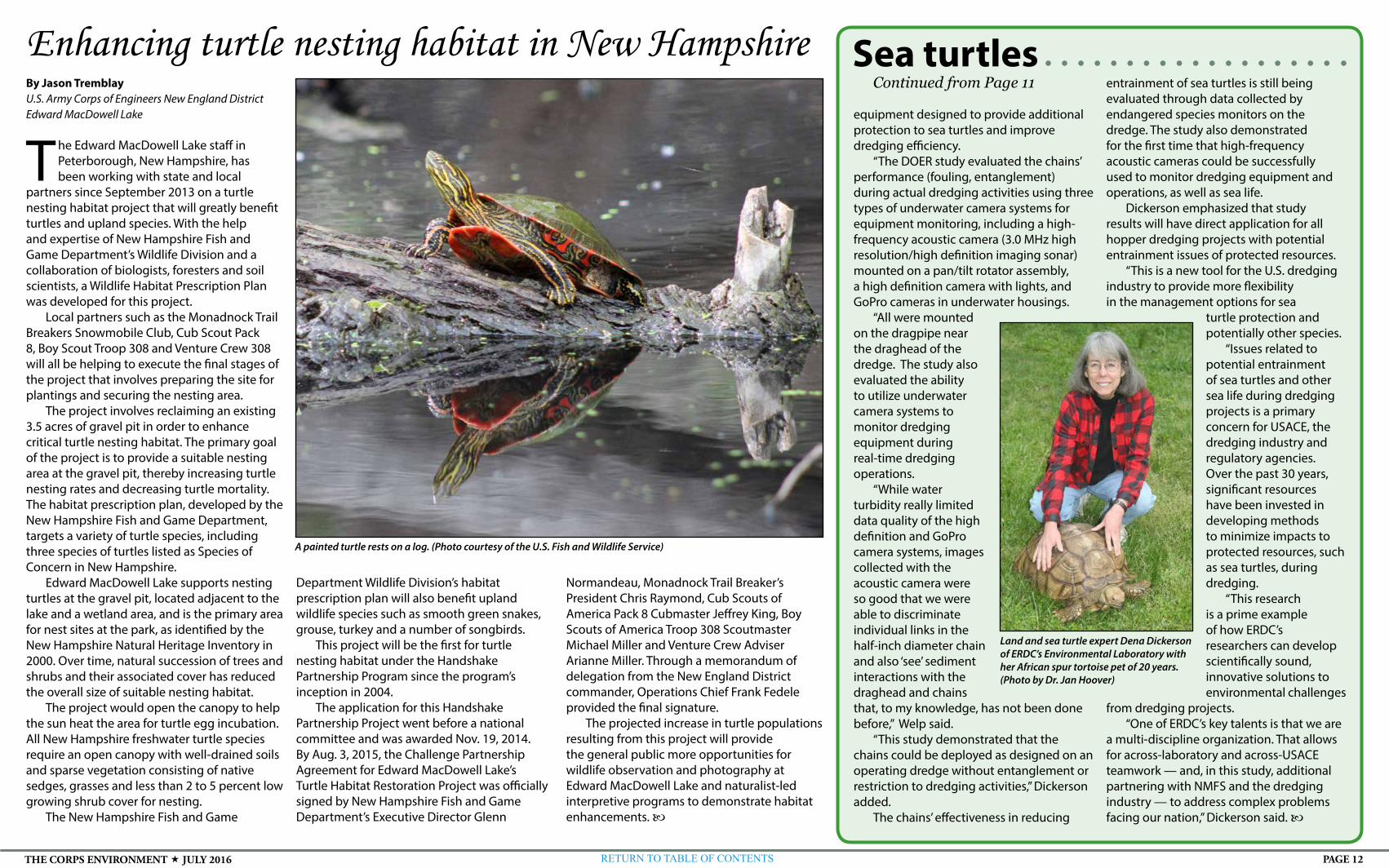
A painted turtle rests on a log. (Photo courtesy of the U.S. Fish and Wildlife Service)

PAGE 13RETURN TO TABLE OF CONTENTSTHE CORPS ENVIRONMENT JULY 2016
Non-standard RangersContinued from Page 1
management plans and policies. Once he developed the tracking system, Thury
became the non-recreation outgrant team leader with Mike Morris as co-lead, Jason Nelson as NRO coordinator tracking all outgrants and processes, and Andrew Lillejord assisting with mitigation and outgrant conditions.
Thury and Morris address queries that usually start with a phone call.
“We get 15 to 20 calls a month from people asking about access to use federal land,” Thury said.
“We’d rather assist potential applicants than have them try to start the process without talking to us,” Morris added.
Nelson tracks requests, enters them into the tracker, ensures projects receive complete reviews and organizes projects so reviews go smoothly.
The NRO team collaborates with Garrison Project Office teams, including Cultural Resources, Recreation, and Oil and Gas teams, to ensure proposed projects comply with federal regulations aimed at protecting the environment, cultural resources and threatened and endangered species. Requests that don’t impact or disturb Garrison Project resources — such as surveys, pipeline inspections, or spill response exercises — still require review and, if approved, receive a letter of permission to access property. Despite the diverse mix of projects,
having a streamlined process and tracking system has helped the team manage the volume of work.
If proposed project areas have a history or evidence of activity for threatened and endangered species or cultural resources, applicants are required to hire a third-party biologist or archaeologist to recommend alternatives for proceeding with the project.
“Our goal is to avoid cultural sites, to avoid, minimize, and mitigate for threatened and endangered species and minimize potential environmental impacts,” Morris said.
This might mean scheduling work to avoid nesting or spawning periods or changing a project’s alignment to avoid culturally significant sites.
After the Garrison Project Office reviews and approves the project, the Omaha District-level review team evaluates the NRO team’s efforts providing feedback and supplementing the review with disciplines not available at the project office. The evaluation and approval process requires nearly 30 different signatures before an easement can be granted.
Once an easement is granted and project work begins, the NRO team follows the project’s progress ensuring mitigation and restoration efforts are accomplished.
“There are several projects; each one requires field verification to ensure conditions outlined in the easement are met,” Thury said.
Lillejord assists with on-site inspections and is also tasked with enhancing habitats through pollinator and food plots for wildlife. He aims to balance the roles by encouraging mitigation projects that enhance wildlife
habitats. Nelson tracks mitigation and conditional requirements on a system he designed to simplify
monitoring the applicant’s required tasks.“It’s challenging and we have a tremendous
responsibility, but ultimately we guide each applicant through the process to ensure any
impacts to federal land and waters are minimized,” Thury said.
Story and photo by Scott T. SturkolFort McCoy, Wisconsin
Maintaining high water quality in Fort McCoy streams is important, especially because much of the water flows off post, said Fisheries Biologist John Noble
with the Directorate of Public Works (DPW) Environmental Division Natural Resources Branch (NRB).
Fort McCoy is nestled in Wisconsin’s Driftless Area, or Paleozoic Plateau. This region of the American Midwest is noted mainly for its deeply carved river valleys. Through agreements with the Wisconsin Department of Natural Resources (WDNR) and the U.S. Fish and Wildlife Service (USFWS), Fort McCoy has a part in maintaining the water integrity in a portion of the region, according to Noble.
“Fort McCoy is largely in the headwaters of the La Crosse River and Clear Creek watershed,” Noble said. “These headwater streams are important for brook trout production and also are of special interest to our partners. ... We ensure that the water that leaves the installation is monitored and is of high quality.”
Contracted Watershed Management Specialists Zach Woiak and Steve Rood with Colorado State University regularly complete water quality field work for NRB on several Fort McCoy waterways. In early March, both of them completed in-water surveys, including along Stillwell Creek on South Post.
Four U.S. Geological Survey stream-monitoring stations are also located at Fort McCoy, according to Rood, along the La Crosse River and Stillwell and Silver creeks. Data at monitoring stations is checked and the speed of the water flowing through the stream is measured.
“A couple of the stations are equipped to take water samples and provide us with data on water quality,” Rood said. “Over time, it has shown good water quality in those streams where water leaves the installation.”
With good water quality and trout fishing opportunities, Noble said Fort McCoy is setting the bar high for fisheries management.
“Our partnerships with the USFWS and WDNR for dam removal and stream habitat restoration work will continue as planned in 2016-17 along with DPW efforts to fix old crossings with degraded structures,” Noble said. “Crossings were designed to have a new culvert installed to satisfy weight loads for military-class vehicles and eliminate barriers to upstream fish movement. These efforts will continue to enhance our stream fisheries and water quality.
“Our success, for example, in brook trout management
Post dedicated to maintaining stream quality
Watershed Management Specialists Zach Woiak and Steve Rood record measurements as part of a water-and-stream survey along Stillwell Creek on Fort McCoy’s South Post.
has been proven,” Noble said. “We’ve improved the trout fishery in the upper La Crosse River watershed, and we have great naturally reproducing trout throughout the post for anglers to target.
“Also, now that the state has embraced a longer catch-and-release season and a longer harvest season for trout, we have the waters to support that kind of effort,” he said.
Stream biological monitoring, otherwise known as biomonitoring, also has been used to help determine where stream improvement work has needed to be done in recent years, Noble said.
Biomonitoring is defined as the use of a biological community to provide information on the quality or health of an ecosystem and can be used to assess the water quality in streams, lakes, ponds, reservoirs, estuaries and oceans. Macro invertebrates, fish and algae all are widely used in biomonitoring.
“We’ve been conducting biomonitoring assessments using the fish community as an indicator of water quality since the mid-1990s on many of our streams,” Noble said. “Beyond helping us target areas to restore stream habitats, these fish statistics can translate into angler interests for stream fishing quality. The 2015 monitoring results showed that there’s an abundance of quality-sized brook trout swimming in our waters.”
As water quality management and monitoring continue, Noble said it’s up to everyone who comes to Fort McCoy to make sure the water quality remains high. “We all have to be good stewards of this resource,” he said.
Close to the shoreline of Lake Sakakawea are several well
pads where oil is pumped from Bakken shale deposits.
(Courtesy photo)

PAGE 14RETURN TO TABLE OF CONTENTSTHE CORPS ENVIRONMENT JULY 2016
By Jane BensonNatick Soldier Research, Development and Engineering Center, Massachusetts
For Soldiers in remote locations, home is where the MILHUT is. The small shelter system provides a home-like environment while also reducing energy and water usage, as well as waste.
The Minimized Logistics Habitat Unit, or MILHUT, is a containerized shelter, which relies on renewable energy technologies, that enables warfighters to be deployed longer in remote areas without the need for resupply. The MILHUT system provides habitat, hygiene and meal preparation capabilities that are not usually available with deployments to remote, austere areas.
The MILHUT is well-suited for austere environments because it is easily transported and can be set up quickly. It is primarily self-sufficient and relies on renewable energy technologies, such as solar power and water recycling.
The Army Natick Soldier Research, Development and Engineering Center’s MILHUT is part of a larger Army effort called the Sustainability Logistics Basing, Science and Technology Objective — Demonstration, or SLB-STO-D. The goal of SLB-STO-D is to reduce fuel, water and waste in expeditionary base camps.
The Army Research, Development and Engineering Command leads SLB-STO-D. It is managed by NSRDEC and co-managed by the Engineering Research and Development Center Construction Engineering Research Laboratory. Gregg Gildea is the NSRDEC lead for SLB-STO-D.
The MILHUT also reflects another goal of SLB-STO-D. The initiative not only aims to reduce energy use and waste, it also aims to improve or maintain quality of life, which is an important factor in preserving Soldier readiness and morale.
Soldier input is key to ensuring quality of life is maintained. NSRDEC researchers are obtaining Soldier feedback on the MILHUT regarding quality-of-life items, such as showers and stovetops.
NSRDEC demonstrated MILHUT technologies at Fort Leonard Wood, Missouri,
Minimized Logistics Habitat Unit saves energy, preserves quality of life
and allowed Soldiers to use the system to garner their input and insights.“The things I liked most about it are the home functions that it makes
available in an austere environment,” Staff Sgt. James Aron Goolsby said. “It provides Soldiers a shower and a chance for extra hygiene while creating an area for them to feel comfortable in while away from home.”
“I do like the fact that it brings more of the comforts of the home environment inside a field environment,” Spc. Dylan Smith said. “For example, the shower, having hot water, being able to cook simple things, and the tent having temperature control so you don’t have to spend the entire time either freezing or being extremely hot.”
Both Goolsby and Smith also thought that perhaps some items, including the microwave and clothes washer, were unnecessary.
“Things that an operational Soldier would prefer to see would maybe include a larger refrigerator or perhaps a larger shower,” Goolsby said.
“The MILHUT is an innovative assortment of self-sufficient support and habitation equipment integrated into standard military shipping containers,” said Chris Aall, the MILHUT project officer and a mechanical engineer at NSRDEC. “Its expedient quality allows for rapid deployment in austere environments, with the intent of reducing the troop-to-task ratio, and extending remote military operations with limited fuel and water resupply. The system exhibits solar energy capture, an on-board generator, a high-speed, low-flow laundry system, a waste remediating latrine, a shower with water reuse capability, and an efficient kitchenette in a compact form factor, supporting up to 20 warfighters.”
“Reducing base camp resupply operations saves lives,” said Paul Carpenter, deputy, NSRDEC SLB-STO-D. “Understanding the relationships between fuel, water and waste is critical to reduce this demand for resupply. The SLB-STO-D analyzes these relationships through a Model Based Systems Engineering methodology. Technologies like the MILHUT also help [us] better understand the art of the possible and how they can be extended to larger systems.”
By Jonelle KimbroughArmy Reserve Sustainability Programs
o ften, recycling is considered one of the easiest ways to integrate sustainability into daily operations. The U.S. Army Reserve has been successful in implementing recycling programs at its installations,
Mission Support Command (MSC) and Regional Support Commands (RSCs). Due to their geographical dispersion and unique needs, however, RSCs face a challenge: to capture the recycling efforts at their sites every day, across the country. The Army Reserve Solid Waste Program is meeting those challenges to ensure that the Army Reserve will reach federally mandated solid waste diversion goals.
Currently, the municipal solid waste (MSW) diversion rate for the Army Reserve is 37 percent, which is 5 percent greater than the diversion rate for fiscal year 2014. So, even though there is still work to be done to reach the federal goal of 50 percent diversion from landfills, the Army Reserve is charting progress that can be attributed to improvements in reporting.
Many Army Reserve sites have established successful recycling programs, but according to Solid Waste Program Coordinator Tyrone Cook, “The challenge has always been in capturing the diversion at the MSC and RSC level due to their unique organizational structures.”
So, Cook and the Solid Waste Team sought solutions. They developed a Solid Waste Management and Recycling Profile Survey, which will be used to improve solid waste best management practices, identify areas within established programs that need improvement and identify additional diversion opportunities. In addition, the team added a solid waste management assessment to existing Comprehensive Energy and Water Evaluations to further identify diversion opportunities and program improvement areas, and they created a Solid Waste and Recycling Weight Estimation Tool and accompanying guidance to help sites more accurately report their diversion.
As a result, sites have markedly improved their diversion reporting in Solid Waste Annual Reporting on the Web. SWARWeb is an online system for tracking, analyzing and reporting information on the generation, recycling and disposal of non-hazardous solid waste at Department of Defense installations. Army Reserve installations, the MSC and RSCs are capturing a more complete set of data for the diversion that is taking place throughout the enterprise.
“We have improved processes that are helping to identify and include data that have been overlooked in the past,” Cook added. “Overall, Installations, the MSC and RSCs are prepared to increase their diversion reporting simply by capturing what is taking place within their fence lines and out in the field. We may find that we have already reached or exceeded the federally mandated goals.”
Visit www.usarsustainability.com or www.usar.army.mil for more information on Army Reserve sustainability initiatives.
Improved reporting increases Army Reserve waste diversiontaking out the trash
Natick’s Minimized Logistics Habitat Unit, or MILHUT, is a containerized shelter that relies on renewable energy technologies that enable warfighters to be deployed longer in remote areas without the need for resupply. (Photo by Jose A. Miletti, NSRDEC)

PAGE 15RETURN TO TABLE OF CONTENTSTHE CORPS ENVIRONMENT JULY 2016
Buffalo District biologists repair
common tern nesting habitat
Story and photo by Kathleen Buckler U.S. Army Corps of Engineers Buffalo District
Buffalo District Environmental Analysis Biologists Richard Ruby and Jay Miller, along with the Floating Plant Crew captained by Tim Colburn, were at the
Ashtabula Harbor east breakwater in Ohio May 4 repairing storm-damaged common tern (Sterna hirundo) habitat.
The common tern habitat was constructed two years ago in an effort to establish an additional breeding location along the southern shore of Lake Erie. The tern has been absent from this area for decades due to the lack of suitable habitat. Common tern nesting colonies are rare.
“Currently, the only existing nesting colonies are located at Buffalo Harbor and the western Lake Erie basin. Ashtabula Harbor is equidistant between Buffalo Harbor and the western Lake Erie basin breeding colonies, and so provides the perfect spot to establish a new nesting colony,” said Richard Ruby, the lead biologist.
Scheduled Ashtabula Harbor breakwater repair work provided the perfect opportunity for the Environmental Analysis team, directed by Ruby, to set up breeding habitat as part of Corps of Engineers’ green breakwater initiative.
The Ashtabula Breakwater Tern Nesting Habitat Demonstration Project is an example of the Corps of Engineers’ Engineering with Nature Program, which is the alignment of natural and engineering solutions that beneficially integrate engineering and natural systems to deliver economic, environmental and social benefits through collaborative processes.
Corps of Engineers biologists have employed a slew of tactics to encourage the state endangered common tern to nest on the Ashtabula Harbor east breakwater.
“Selecting appropriately sized gravel, which not only will be accepted by the terns as suitable nesting medium, but
will also withstand storm-driven waves, has been the most challenging aspect of this project,” Miller said.
The nesting habitat seems to include all the elements needed to establish and maintain a nesting colony: wire perimeter netting to keep chicks from tumbling to their deaths on the rocks below; predator deterrent features; driftwood to provide cover and to simulate natural beach conditions; decoy birds scattered throughout the habitat; and a continuously looping recording of common tern vocalizations. The only thing that seems to be missing are the terns themselves.
A strong late winter storm brought waves crashing onto the habitat, which washed away almost all of the nesting gravel and flooded the electronic devices used to monitor the habitat. Before the storm, terns were observed investigating the area possibly for the purpose of nesting.
District biologists will perform maintenance and monitoring of the habitat for one more year before handing the project over to the Ohio Nature Conservancy. If the project is successful, it will provide a means of returning the common tern to the local avian community.
Buffalo District Environmental Analysis Biologists Richard Ruby and Jay Miller, along with the Floating Plant Crew captained by Tim Colburn, repair storm-damaged common tern (Sterna hirundo) habitat May 4 at the Ashtabula Harbor east breakwater in Ohio.
Biologist selected to assist research laboratoryStory and photo by Kathleen BucklerU.S. Army Corps of Engineers Buffalo District
Buffalo District Biologist Melissa Tarasiewicz has been selected to assist with the development and management of the National Wetland Plant List
(NWPL) at the Cold Regions Research and Engineering Laboratory (CRREL) in Hanover, New Hampshire.
The National Wetland Plant List is a federal species list used in a three-factor approach with hydric soils, wetland vegetation and evidence of hydrology to make wetland determinations for the purposes of the Clean Water Act Section 404 Regulatory Program.
Management of the list, which includes updating the scientific names, performing annual reviews and updating wetland indicator status, is an interagency effort between the Corps of Engineers, U.S. Fish and Wildlife Service, Environmental Protection Agency and Natural Resource Conservation Service.
Robert Lichvar, a research botanist, director of the National Plant List and chairman of the Interagency Wetland Plant List panel, is a renowned botanist with more than 30 years of experience in mapping vegetation in wetlands in the Northeast and throughout the U.S., including Alaska. In his capacity as director of the NWPL, Lichvar has authored a veritable library of technical notes and technical reports and has conducted research studies in every geographic region of the United States.
Lichvar began his expansive Corps of Engineers career with the Buffalo District Regulatory Branch and has retained his ties with the district through a collaborative relationship with Harold Keppner, chief of the monitoring and enforcement section, and by conducting advanced plant identification courses directed at improving the plant identification skills of the regulatory staff.
“Not only were these plant identification courses beneficial for regulatory staff, but they also gave Bob a forum to field test a number of taxonomic keys he was developing,” Keppner said.
Over the years, there have been several occasions in which staff from CRREL have come to the western New York region to field test or research numerous topics. Most recently, in 2015, a group of CRREL researchers visited the region to field test remote sensing technology. The Buffalo District has been able to assist with these projects and has provided insights on field sites that would be most productive for the questions being addressed.
This working relationship between CRREL and LRB was
further cultivated four years ago. In seeking developmental opportunities for LRB staff, Keppner coordinated with Lichvar in seeking temporary detail positions at CRREL.
“Again, this symbiotic relationship has benefitted LRB staff and exposed them to a wide array of research topics specific to the Regulatory Program, and CRREL has benefitted from the presence of highly qualified biologists to support the ongoing research,” Keppner said.
The identification, development and cultivation of collaborative working relationships between USACE districts and research laboratories are essential in furthering the science that informs the Regulatory Program.
Buffalo District Biologist Melissa Tarasiewicz has been selected to assist with the development and management of the National Wetland Plant List (NWPL) at the Cold Regions Research and Engineering Laboratory.

PAGE 16RETURN TO TABLE OF CONTENTSTHE CORPS ENVIRONMENT JULY 2016
By Ann Marie R. HarvieU.S. Army Corps of Engineers New England District
A New England District team is consulting on the repair work currently underway on the Mount Coffee Hydropower Rehabilitation Project near Monrovia, Liberia.
The team traveled to Liberia in November 2015 and again from Jan. 24 to Feb. 2 to conduct a site visit of the project and the surrounding areas.
The invitation from the Millennium Challenge Corporation (MCC) came due to the outstanding efforts New England District put out to make one of their projects, the Nacala Dam Restoration in Nacala, Mozambique, such a success. MCC has entered into a five-year economic development compact with the government of Liberia. The district is providing independent engineering advice and due diligence support to MCC.
When work is complete, the Liberian capital city will receive its power from the project. In addition, Monrovia and nearby villages will have a reliable source of clean water.
Businesses in Monrovia are currently purchasing connections to generators from vendors.
“Many people do not have much choice but to be in the dark after sunset,” said Patrick Blumeris, hydraulic engineer on the project. “Since Monrovia is so close to the equator, this amounts to 10 to 12 hours per night.”
According to Blumeris, there are approximately 950,000 people who stand to
USACE team assists Liberia with hydropower plant rehabilitationbenefit from the cleaner water.
“There are people who will receive water from the piped system we are planning to re-install, from the reservoir to the treatment plant and then pumped into Monrovia,” he said. “For people around the lake, a separate set of water hand pumps is being installed. These should be able to find groundwater more easily than any other pumps, and should be cleaner than the widespread use of surface water which often gets muddy or goes dry in the dry season. There is also a possibility that there is sea salt in the water.”
Blumeris said the current water pipeline project would ensure water comes from a less turbid source than the river itself, and it is hoped that 100 liters per capita per day will be provided to nearly 1 million people.
“Our project ends at the White Plains Water Treatment Plant, which is undergoing a renovation of its own under the Liberia Water and Sewer Commission,” Blumeris said.
The 20-meter high dam was built in 1966. During the civil war in 1990, the dam was not allowed to operate, resulting in a dam breach. Because of the breach, 180 meters of material was eroded down to bedrock. Also, much of the electrical and mechanical equipment had either been stolen or destroyed.
Work to rehabilitate the dam and the power house will include, but is not limited to, repairing the breached portion of the forebay dam and repairing the generator floors and columns of the power house to support the crane and turbine/generator equipment during erection and future maintenance.
As a result of their visits, the team came up with numerous recommendations
in all areas of the $350+ million project, many of which were immediately implemented. It is anticipated that the project will be completed in August 2017.
In addition to Blumeris, the following district employees are supporting this effort: Team Leader and Geotechnical Engineer Siamac Vaghar, Electrical Engineer Brian Head, Biologist Mike Penko, Civil Engineer Matthew Tessier and Real Estate Division Appraisal Branch Chief Jeff Teller.
New England District team members get a briefing at the Mount Coffee Hydropower Dam in Liberia during their November 2015 site visit. (Photos by Mike Penko)

PAGE 17RETURN TO TABLE OF CONTENTSTHE CORPS ENVIRONMENT JULY 2016
By Chris GardnerU.S. Army Corps of Engineers Baltimore District
The large tan tent at 4825 Glenbrook Road in the Spring Valley neighborhood of Washington, D.C., will be coming down
about six months ahead of schedule, signifying the end of high probability operations at the U.S. Army Corps of Engineers’ cleanup site on this property.
The large tan tent — an Engineering Control Structure — has become a regular site in the neighborhood over the past three years. It is part of a multi-layered approach to public safety in place during high probability operations that involved expert teams digging up and removing items associated with the former American University Experiment Station (AUES) where the Army researched and tested chemical weapons during World War I.
The disassembling of the tent for the third and final time at the site since it was first erected in early 2013 will be the most noticeable symbol of the beginning of the end to what has been a complex effort to remediate contamination associated with a burial pit from roughly 100 years ago.
Baltimore District finishes high probability operationssix months ahead of schedule at 4825 Glenbrook Road
“We were very excited to be able to tell the surrounding neighbors that the high probability operations at the site were ahead of schedule. The early completion of our high probability operations that required the multiple layers of safety controls, including the tent, can now be removed from the site earlier than originally anticipated,” said Baltimore District Project Manager Brenda Barber.
The property at 4825 Glenbrook Road was the site of a former burial pit for both munitions-related items and laboratory-related items, and crews have removed more than 600 pounds of glass, 39 intact glass containers, 151 pounds of metal debris, 10 75mm munitions debris items and various other munitions-related items during high probability operations. In addition to the AUES-related items recovered from the site, nearly 2,000 total cubic yards of soil was also dug up and removed from the site during high probability operations.
“Safety was always our top priority on this project,” Barber said. “We employed a multi-layered approach to public safety and worked to keep the community constantly informed of our activities and all relevant safety protocols.”
All high probability excavations took place within the tent operating under negative pressure with three Chemical Agent Filtration Systems to reduce the risk of any chemicals escaping the tent and reaching the neighboring properties.
A Shelter-in-Place system was also used as an additional safety precaution in case a chemical release occurred at the same time the engineering controls failed.
As part of the Shelter-in-Place program, nearby residents were trained to stay in their homes in the case of an emergency until the U.S.
Army Corps of Engineers team provided an all clear. Notifications were provided to the residents through various communication forms, including text messages, emails, phone calls, etc. The system was tested monthly but there was never a need to activate the system as all of the engineering controls at the site operated as planned.
Crews first tore down the house that stood at 4825 Glenbrook Road in November 2012 and the ECS structure was initially erected in early 2013. Since then, it has been disassembled and reassembled twice, covering three different footprints on the lot where high probability operations took place.
When high probability work began at the third and final tent location in February, the Corps estimated it would continue through the following winter. As crews excavated under the third tent location though, they did not encounter nearly as much AUES-related material as under previous tents. While they removed concrete from the former structure’s basement floor and house footings and more than 300 additional cubic yards of soil, only 9 pounds of glass debris was removed and no munitions-related debris or metal scrap related to AUES was encountered.
With the lack of AUES-related material under the third tent location, crews progressed quickly and finished high probability operations at the end of May.
The next stages of the project are the careful decontamination and disassembly of the engineering controls and equipment used
during high probability operations. Then the site will be readied for the completion of low probability soil removal in the backyard area and in the footprint of the former driveway area of the residence.
The district estimates the entire 4825 Glenbrook Road Project will be finished in the summer of 2017. At completion, the lot will meet residential cleanup standards and be returned to the property owner.
ABOVE: U.S. Army Corps of Engineers crews began demolishing the house at 4825 Glenbrook Road Nov. 29, 2012, as part of cleanup efforts to remediate potential contamination associated with the former American University Experiment Station where the Army researched and tested chemical weapons during World War I. The final phase of high probability operations was completed in May. BELOW: A sign for the Shelter-in-Place system on Glenbrook Road on the day the third and final phase of high probability operations resumed Feb. 24. (Photos by Chris Gardner)
After being broken into small enough pieces to be inspected for contamination, concrete rubble from the basement footers of the house is shoveled into containers to be removed from the site. (Courtesy photo)
The Engineering Control Structure (the tan tent) and other aspects of the multi-layered approach to public safety USACE had in place during high probability operations at the Glenbrook Road cleanup site are visible among the homes in the Washington, D.C., Spring Valley neighborhood. (Courtesy photo)

PAGE 18RETURN TO TABLE OF CONTENTSTHE CORPS ENVIRONMENT JULY 2016
By 1st Lt. Erica MitchellU.S. Army Corps of Engineers Detroit District
During April, Detroit District and its partners celebrated the completion of two Great Lakes Restoration Initiative
projects in Wisconsin. The Menomonee and Pike rivers’ ecosystem
restoration projects have been completed through the continued partnership and environmental commitment of the U.S. Army Corps of Engineers, U.S. Environmental Protection Agency, the village of Mt. Pleasant, the Milwaukee Metropolitan Sewerage District (MMSD) and the city of Milwaukee.
The Menomonee River Ecosystem Restoration Project began in September 2014 in an effort to restore fish passage and access to historic spawning habitats. The project consisted of removing 2,900 feet of concrete that had lined the channel along the Menomonee River since the 1960s. Once removed, a natural riverbed was placed. This natural riverbed has opened access to over 37 miles and 125 acres of high value, upstream, shallow wetlands that various fish species use for spawning. The project also provides connectivity between previously restored sections of the Menomonee River, while reducing the risk of flooding. A recreational sport fishery has also been restored through this project, which extends along 17 miles of river and 20 miles of tributary in one of Wisconsin’s most populated and diverse watersheds.
In 2014, the district also partnered with the village of Mt. Pleasant to award the Pike River Ecosystem Restoration Project for tributary restoration and protection. This project restores and enhances a low-flow channel, 43 acres of wetlands and 30 acres of prairie land. It also implements in-stream improvements to habitats for approximately 1 mile of the Pike River by adding natural stream features such as meanders, shelter areas and deep riffle pool
Detroit District, federal, community partners bring nature back to Wisconsin waterways
The Pike River Ecosystem Restoration Project in Wisconsin moved more than 600,000 cubic yards of material to restore and enhance a low-flowing channel. In-stream improvements made to the Pike River help provide diverse habitats in the riverbed. (Courtesy photo)
complexes that provide a diverse habitat. The project significantly enhances aquatic macro-invertebrates, reduces the suspended solids of phosphorous and nitrogen, and improves water quality through overland filtration.
“Often, when I visit a project site, I’m surrounded by concrete, steel and huge machinery, so it’s a joy to come here and enjoy the serenity of this beautifully restored natural area,” said Detroit District Commander Lt. Col. Michael Sellers during the ceremonies. “The Army Corps of Engineers is the nation’s environmental engineer with one of the largest environmental restoration and environmental stability roles in the federal government.”
The funding for the $6.3 million
Menomonee River project is a 65 percent federal, 35 percent MMSD cost-share. The $5.7 million Pike River project funding was also a cost share: 65 percent federal and 35 percent from the Village of Mt. Pleasant. For both projects, the EPA’s Great Lakes Restoration Initiative (GLRI) contributed most of the federal funding. Federal agencies use GLRI resources to strategically target the biggest threats to the Great Lakes ecosystem and to accelerate progress toward long-term goals.
By combining GLRI resources with agency base budgets, the Army Corps and other federal agencies work with nonfederal partners to implement protection and restoration projects.
Installation Management Command - Europe
More than 100 representatives from the United States and countries throughout Europe attended a
NATO Net Zero forum April 25-29 at U.S. Army Garrison Wiesbaden, Germany.
Out of 80-some presentations delivered during the event, 10 were briefed from specialists assigned to Directorates of Public Works at garrisons Ansbach, Bavaria, Italy and Wiesbaden. Officially called the Advanced Net Zero Energy, Water and Waste Training Course, the weeklong session focused on many topics commonly discussed within civilian communities, such as smart energy supply and environmental awareness; however, with fuel and water considered a necessity alongside ammunition on the battlefield, talk also centered around the impact of sustainability on the war fighter.
Katherine Hammack, Assistant Secretary of the Army for Installations, Energy and Environment, explained to attendees from NATO nations and other partner countries that reducing energy and water usage can save lives, especially at isolated sites where supplies are often trucked or flown in under dangerous conditions.
She recalled how Net Zero supported an isolated outpost in Afghanistan by reducing the need for aerial resupply missions from one every three days to one every 10 days. Previously, Soldiers rushed from their secure locations at least twice a week to gather airdropped food, water and gear, putting all at risk and taking them
NATO Net Zero forum addresses impact of sustainabilityaway from their primary jobs. By tripling the time between resupply runs, Hammack said Soldiers remain focused on their critical mission.
Two weeks before participating in the NATO and Army-sponsored forum here, Hammack addressed the U.S. Senate Appropriations Committee, where she said, “It is operationally necessary … that the Army have assured access to the energy required to achieve our primary objectives. The Army has led the way toward …harnessing new energy technologies to lessen Soldier battery loads, and improving our operational capabilities to reduce the need for fuel convoys.”
Hammack also connected efficient installations with Army Chief of Staff Gen. Mark Milley’s No. 1 priority of readiness, telling forum participants that Army installations should be sized and resourced to meet global missions.
As part of her Net Zero presentation and visits to Installation Management Command-Europe garrisons and Army forward sites supporting Operation Atlantic Resolve, Hammack said she saw “firsthand the challenges and successes of European Infrastructure
Consolidation operations and Expeditionary Base Operations Support provided to eastern Europe military contingency bases.
“We are making great progress in reducing our footprint in Europe,” she said, “while retaining the ability to surge when, and if, necessary.”
(Additional information provided by the U.S. Army News Service)
Katherine Hammack, Assistant Secretary of the Army for Installations, Energy and Environment, speaks during the Advanced Net Zero Energy, Water and Waste Training Course. (Photo by Patrick Harris)

PAGE 19RETURN TO TABLE OF CONTENTSTHE CORPS ENVIRONMENT JULY 2016
By Ann Marie R. HarvieU.S. Army Corps of Engineers, New England District
New England District team members have transformed an environmentally degraded body of water and surrounding property into a rich, vibrant ecosystem
so birds and fish will return to the area and thrive.Problems at the Milford Pond in Milford, Massachusetts,
began as early as the 1970s when town residents began to see the once-deep open water areas becoming much shallower and filling in with aquatic plants and organic sediments. They also discovered the infiltration of an invasive aquatic weed species called milfoil start to take over the pond. The town studied the decline over the 1980s and 1990s, and when the 120-acre pond was choked with milfoil and the water depth was less than 2 feet, the town requested the district’s assistance in 2001.
“The Corps engaged in the project as part of our Section 206 Aquatic Ecosystem Restoration Program,” said Project Manager Adam Burnett.
New England District restores environmentally degraded pond
work is designed to restore this complex mix of aquatic ecosystems and enhance the wetland habitats needed for the four protected bird species.”
To make that happen, the district hydraulically dredged a thick layer of bottom sediment from a 17-acre corridor in the pond and disposed of the sediment in a 30-acre shallow backwater area. This disposal site had been a cedar swamp prior to being flooded with the impounded water behind the constructed dam. Approximately 168,000 cubic yards of organic-rich sediments were hydraulically dredged and pumped through floating pipes to the disposal area, which was contained by an innovative design using large stacked coir (coconut fiber) rolls surrounding the containment area. The 17-acre dredged area is now 12- to 13-feet deep and restored to open water and cleared of the choking milfoil. The deeper water discourages milfoil from returning since it normally can’t root into deep water areas. This restoration provides open water habitat for fish and waterfowl, including the four protected bird species living in the basin.
“The 30-acre disposal area for the dredged material was
The restoration has been years in the making. The district completed a detailed project report along with an Environmental Assessment and Finding of No Significant Impact in July 2005, according to Burnett. In August 2005, the district began preparing plans and specifications.
“The Corps of Engineers and the town of Milford as the local sponsor signed a project partnership agreement in 2013,” he said. “The designs, along with permitting and all necessary real estate acquisitions, were completed in 2014.”
The project benefits are many, including restoring the pond to an open-water habitat to emergent and wooded wetland habitats. The basin is critical habitat for protected species of native birds, including the least bittern, pied-billed grebe, king rail and common moorhen. The birds need a combination of open water and emergent wetlands, such as cattail marshes.
“Prior to getting artificially impounded a century ago, the Charles River Valley through Milford had a large, complex native Atlantic White Cedar swamp, marshland and open water bodies,” Burnett said. “The restoration
designed within the impounded footprint of Milford Pond and will restore emergent and wooded wetlands, including the possibility of restored native Atlantic white cedar community,” Burnett said.
The environmentally friendly design of the disposal area involved the use of 16-inch diameter coconut fiber rolls, stacked on top of each other around the disposal area perimeter within the pond to form biodegradable retaining walls for the sediment. The rolls were installed during the middle of the winter when there was a thick layer of ice on the pond.
“Now that the disposal area is completely filled with sediment, the coir rolls will decompose within a few years, and the entire disposal area — including the coir rolls —will become densely covered with native emergent wetlands plant species,” Burnett explained.
Palmer Federal Constructors Inc. of Lawrence, Massachusetts, was the contractor on the project. The $4 million cost was split between the town of Milford (35 percent) and the Corps of Engineers (65 percent).
Dredging Milford Pond was key to restoration efforts. (Photo by Adam Burnett)

PAGE 20RETURN TO TABLE OF CONTENTSTHE CORPS ENVIRONMENT JULY 2016
Governments collaborate to protect unique ecosystemBy Justin PummellU.S. Army Corps of EngineersInstitute for Water Resources/Pacific Ocean Division
On behalf of the U.S. Pacific Command (USPACOM), the U.S. Army Corps of Engineers collaborated with the
Maldives National Defence Force (MNDF) and the Maldives Environmental Protection Agency (EPA) to prepare an Environmental Sensitivity Index (ESI) atlas for Laamu Atoll in the Republic of Maldives.
ESI maps provide a concise summary of coastal resources that are at risk if an oil spill occurs. Examples of at-risk resources include biological resources, such as birds and fish; sensitive shorelines, such as marshes and tidal flats; and human-use resources, such as subsistence gathering or fish processing. According to the National Oceanic and Atmospheric Administration, ESI maps can help responders meet one of the main response objectives: reducing the environmental consequences of the spill and
the cleanup efforts. Additionally, ESI maps can be used by planners — before a spill happens — to identify vulnerable locations, establish protection priorities and identify cleanup strategies.
“The Maldives National Defence Force is profoundly grateful to the U.S. Pacific Command for conducting the ESI Project in Laamu Atoll,” said Brig. Gen. Ahmed Shahid, the MNDF Vice Chief of Defence Force. “The successful completion of the project provided the MNDF with vital information and resources that will greatly assist in shaping the response to an oil spill or any other natural disaster in the Laamu Atoll region.
“ESI mapping of the entire country remains the greater objective, and, therefore, MNDF will endeavor to build on this achievement working together with USPACOM,” Shahid said.
The Laamu Atoll ESI project took approximately 15 months to complete. The project commenced in December 2014,
following recommendations from the South Asia Regional Environmental Security Forum. The project was completed in three phases, which included a scoping trip, field work and the development and delivery of the final ESI Geographic Information System (GIS) database and atlas. The result is an interactive electronic atlas, hard-copy maps and a robust GIS database. The MNDF Coast Guard will use the final products to prioritize its oil spill response actions in the atoll. EPA will use the atlas to define new environmental sensitivity areas in the atoll, reference its resource as an environmental baseline, and increase awareness of the biological diversity of Laamu Atoll. MNDF and EPA are also now well equipped to replicate the ESI methodology in other atolls, if necessary.
“The Laamu Atoll ESI project serves as a great example of civil-military cooperation between the U.S. and Maldives,” said Christopher Sholes, USPACOM environmental program manager. “All core team members
needed to leverage each other’s capabilities to succeed. It demonstrates that USPACOM, MNDF, and the Maldives EPA prioritize environmental security in a changing world.”
The Laamu Atoll ESI atlas includes detailed biological resources, shoreline and human-use mapping for more than 44 islands in the atoll. The team conducted the field work in August 2015, walking over 150 kilometers of shoreline to collect the necessary information to prepare the atlas.
“During the field data collection, it would be sunny and hot in the morning and rain in the afternoon,” said Staff Sgt. Ibrahim Faisal, MNDF J3/7 noncommissioned officer in charge. “We had to walk miles of sandy beach or rocky shore[lines], as well as get into waist-high water in a single setting.”
The team experienced monsoon swells, along with the environmental and logistical challenges unique to the Maldives.
“Though it was challenging, the team adapted,” Faisal said. “USACE, MNDF and EPA’s joint effort and planning led to the
successful completion of field work.” The team also collected more than
1,200 biological features, and more than 800 human-use resources. Coastal erosion and other miscellaneous information was also collected using a standard data dictionary. The results were compiled in a comprehensive GIS, which allows for the data to be analyzed. For example, users of the Laamu Atoll ESI database can now query the data to determine the most vulnerable shorelines to a potential oil spill, as well as determine the locations of specific biological or human resources.
Laamu Atoll was chosen as the project location given its proximity to the One and a Half Degree shipping channel. Throughout the year, hundreds of large oil tankers pass through the channel, carrying oil between Africa and Asia. If an accident were to occur, Laamu Atoll’s unique ecosystem would be a risk. Currently, Laamu Atoll has six locations already designated by the EPA as environmental sensitive areas.
Representatives from USACE, MNDF and the Maldives EPA prepare to board a boat after collecting ESI features in Laamu Atoll, Republic of Maldives. Located in the Indian Ocean, the archipelagic nation comprises 26 natural atolls. (Courtesy photo)
The Laamu Atoll ESI atlas includes detailed map sheets of biological resources, shoreline characteristics and human-use features.