the condition of designated nature conservation areas in the
TRANSCRIPT

This paper was provided to the Joint Committee for decision/discussion or information. Please refer to the minutes of the meeting for Committee’s
position on the paper.
To view other Joint Committee papers and minutes visit http://www.jncc.gov.uk/page-2671
To find out more about JNCC visit http://www.jncc.gov.uk/page-1729
JNCC Committee Papers - December 2005

JNCC 05 D12 December 2005
JOINT NATURE CONSERVATION COMMITTEE
COMMON STANDARDS MONITORING - 6 YEAR REPORT
THE CONDITION OF DESIGNATED NATURE CONSERVATION AREAS IN THE UNITED KINGDOM
1. Introduction 1.1 In the United Kingdom, 2,434,000 hectares have been notified as Sites of
Special Scientific Interest (SSSI) in Great Britain, or Areas of Special Scientific Interest (ASSI) in Northern Ireland, in recognition of the wildlife, geological or geomorphological features they contain. This represents 10% of the United Kingdom land area.
1.2 In addition, areas of land and water have been designated as Special Areas of Conservation (SAC) under the EC Habitats Directive, Special Protection Areas (SPA) under the EC Birds Directive, and Ramsar sites under the (Ramsar) Convention on Wetlands of International Importance.
1.3 All these designated nature conservation areas have been selected in accordance with national selection guidelines, and are protected by national legislation.
1.4 The Joint Nature Conservation Committee is required by statute to develop common standards throughout Great Britain for the monitoring of nature conservation and for the analysis of the resulting information. In 1998, the Committee published A Statement on Common Standards for Monitoring Designated Sites in compliance with this duty. These common standards were piloted during 1998 and became operational in Great Britain from April 1999. By agreement with the Environment and Heritage Service, they were also adopted for use in Northern Ireland.
1.5 The purpose of monitoring is primarily threefold:
i. at the site level, it indicates the degree to which current conservation measures are proving effective in achieving the objectives of the designation, and identifies any need for further measures;
ii. at the country level, it indicates the effectiveness of current conservation action and investment, and identifies priorities for future action;
iii. at the United Kingdom level, it enables Government to undertake its national and international reporting commitments in relation to designated sites, and more widely, and helps identify any areas of shortfall in implementation.
1.6 The basis of the common standards for sites monitoring was that the condition of the nature conservation feature(s) for which the site was selected should be assessed against the objectives for that feature. During the pilot year, it became apparent that detailed guidance was needed in the formulation of these
JNCC Committee Papers - December 2005
objectives and a programme of work was instituted to provide this guidance. The guidance was developed and adopted progressively over the next few years and is published on www.jncc.gov.uk/csm.
1.7 The common standards require the condition of features to be assessed as falling into one of a number of categories; namely i) Favourable-maintained, ii) Favourable-recovered, iii) Unfavourable-recovering, iv) Unfavourable-no change, v) Unfavourable-declining, vi) Partially destroyed, and vii) Destroyed.
1.8 The intention was that every feature on every designated site in the United Kingdom would be assessed over a period of six years in a rolling monitoring cycle. Where more than one designation applied to a particular feature on a given site, a separate assessment would be made for each designation. This is because the reason for the designation, and the precise area covered, may vary between the different types of designation.
1.9 In addition to the assessment of the condition of the features, the common standards require the identification of those human activities or other factors considered to be adversely affecting the feature, and also those measures which have been taken which are considered to be beneficial towards achieving favourable condition.
1.10 Over the period 1999-2005, the Countryside Council for Wales, English Nature, Environment and Heritage Service and Scottish Natural Heritage have been systematically carrying out a programme of monitoring the designated features. This report sets out the results of this first six-year monitoring cycle, summarising the condition of individual features under broad feature categories, and summarising also the nature of adverse activities and beneficial measures.
2. Summary
Assessments reported on
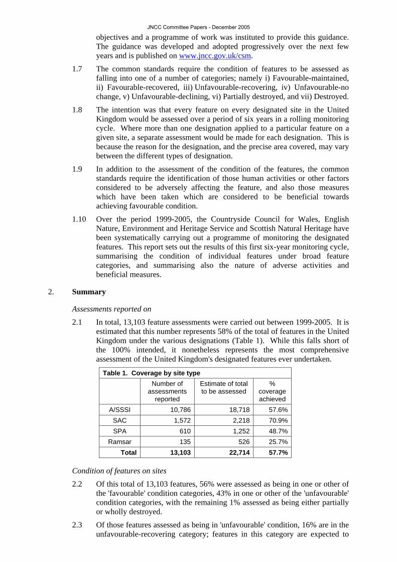
2.1 In total, 13,103 feature assessments were carried out between 1999-2005. It is estimated that this number represents 58% of the total of features in the United Kingdom under the various designations (Table 1). While this falls short of the 100% intended, it nonetheless represents the most comprehensive assessment of the United Kingdom's designated features ever undertaken.
Table 1. Coverage by site type Number of
assessments reported
Estimate of total to be assessed
% coverage achieved
A/SSSI 10,786 18,718 57.6% SAC 1,572 2,218 70.9% SPA 610 1,252 48.7%
Ramsar 135 526 25.7% Total 13,103 22,714 57.7%
Condition of features on sites
2.2 Of this total of 13,103 features, 56% were assessed as being in one or other of the 'favourable' condition categories, 43% in one or other of the 'unfavourable' condition categories, with the remaining 1% assessed as being either partially or wholly destroyed.
2.3 Of those features assessed as being in 'unfavourable' condition, 16% are in the unfavourable-recovering category; features in this category are expected to
JNCC Committee Papers - December 2005

achieve favourable condition if present management is maintained. Features in the other 'unfavourable' categories will require additional measures to be taken if they are to achieve future favourable condition status. Where a feature has been wholly destroyed the loss of the feature is considered irrecoverable; this is the case also for that part of a partially destroyed feature which is destroyed.
Figure 1. Condition of A/SSSI features
1%
26%
16%
57%
Destroyed (whole orpart)
Unfavourable
Unfavourablerecovering
Favourable
n = 10,786 coverage = 58%
Figure 1. Condition of A/SSSI features
1%
26%
16%
57%
Destroyed (whole orpart)
Unfavourable
Unfavourablerecovering
Favourable
n = 10,786 coverage = 58%
2.4 If the favourable percentages of the different designation types are compared across all features they vary substantially. Ramsar and SPA features are 86% and 81% favourable respectively. ASSI/SSSI features (Figure 1) are 57% favourable as opposed to SAC features (Figure 2) which are only 37% favourable. The favourable status of Ramsar and SPA features is a reflection of the favourable condition of bird features in general (circa 76%).
Figure 2. Condition of SAC features
1%
38%
24%
37%
Destroyed(whole or part)
Unfavourable
Unfavourablerecovering
Favourable
n = 1,572 coverage = 71%
Figure 2. Condition of SAC features
1%
38%
24%
37%
Destroyed(whole or part)
Unfavourable
Unfavourablerecovering
Favourable
n = 1,572 coverage = 71%
2.5 Across designated sites as a whole, geological features are the most favourable (86%), followed by species (68%). Terrestrial habitats seem to faring poorly with only 39% of assessments favourable. Marine and coastal habitats (61%) and freshwater habitats (49%) have fared somewhat better.
2.6 There are a large number of features which are recovering from unfavourable condition. If these are combined with those which are favourable, terrestrial habitats are more on a par with marine habitats and species, as indicated in Table 2.
Table 2. Condition of broad groups of features reported
JNCC Committee Papers - December 2005

no of
assessments reported
% destroyed
or part destroyed
% unfavourable
(except recovering)
% recovering
% favourable
% favourable
+ recovering
Species 2840 0.2% 25.2% 6.7% 67.9% 74.6% Marine and coastal
habitats 918 0.9% 29.2% 9.6% 60.3% 69.9% Terrestrial habitats 6200 1.2% 33.3% 26.9% 38.6% 65.5%
Freshwater habitats 602 0.7% 39.7% 11.1% 48.5% 59.6% All habitats 7720 1.1% 33.3% 23.6% 42.0% 65.6% Geological 2242 1.3% 10.6% 1.7% 86.4% 88.1%
All features combined 12774 0.9% 27.2% 15.9% 55.9% 71.8%
2.7 It is also possible to split some of the terrestrial habitat reporting categories into upland and lowland features. This indicates that upland features are more favourable (44%) than lowland (35%). However, more assessments fell in the unfavourable-recovering category in the lowlands (32%) than in the uplands (19%). The picture becomes quite complex if individual habitats are considered. If the unfavourable-recovering and favourable assessments are combined, the situation reverses, with the uplands (63%) in a slightly worse condition than the lowlands (66%).
2.8 The results of the condition assessment are given in Table 3, which is ordered, under broad feature category headings, according to the percentage achieving favourable condition. Shaded rows indicate those categories which are above the average percentage in favourable condition for all features combined.
JNCC Committee Papers - December 2005
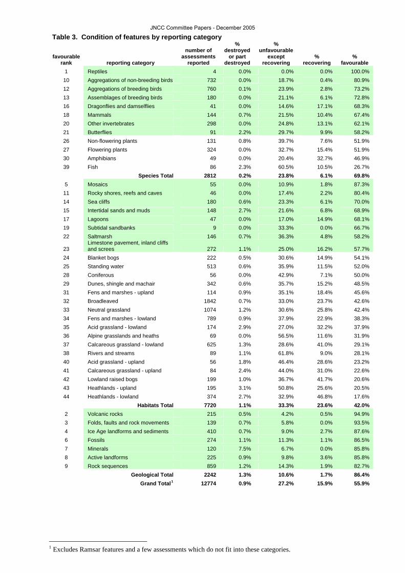
Table 3. Condition of features by reporting category
favourable rank reporting category
number of assessments
reported
% destroyed
or part destroyed
% unfavourable
except recovering
% recovering
% favourable
1 Reptiles 4 0.0% 0.0% 0.0% 100.0% 10 Aggregations of non-breeding birds 732 0.0% 18.7% 0.4% 80.9% 12 Aggregations of breeding birds 760 0.1% 23.9% 2.8% 73.2% 13 Assemblages of breeding birds 180 0.0% 21.1% 6.1% 72.8% 16 Dragonflies and damselflies 41 0.0% 14.6% 17.1% 68.3% 18 Mammals 144 0.7% 21.5% 10.4% 67.4% 20 Other invertebrates 298 0.0% 24.8% 13.1% 62.1% 21 Butterflies 91 2.2% 29.7% 9.9% 58.2% 26 Non-flowering plants 131 0.8% 39.7% 7.6% 51.9% 27 Flowering plants 324 0.0% 32.7% 15.4% 51.9% 30 Amphibians 49 0.0% 20.4% 32.7% 46.9% 39 Fish 86 2.3% 60.5% 10.5% 26.7%
Species Total 2812 0.2% 23.8% 6.1% 69.8% 5 Mosaics 55 0.0% 10.9% 1.8% 87.3%
11 Rocky shores, reefs and caves 46 0.0% 17.4% 2.2% 80.4% 14 Sea cliffs 180 0.6% 23.3% 6.1% 70.0% 15 Intertidal sands and muds 148 2.7% 21.6% 6.8% 68.9% 17 Lagoons 47 0.0% 17.0% 14.9% 68.1% 19 Subtidal sandbanks 9 0.0% 33.3% 0.0% 66.7% 22 Saltmarsh 146 0.7% 36.3% 4.8% 58.2%
23 Limestone pavement, inland cliffs and screes 272 1.1% 25.0% 16.2% 57.7%
24 Blanket bogs 222 0.5% 30.6% 14.9% 54.1% 25 Standing water 513 0.6% 35.9% 11.5% 52.0% 28 Coniferous 56 0.0% 42.9% 7.1% 50.0% 29 Dunes, shingle and machair 342 0.6% 35.7% 15.2% 48.5% 31 Fens and marshes - upland 114 0.9% 35.1% 18.4% 45.6% 32 Broadleaved 1842 0.7% 33.0% 23.7% 42.6% 33 Neutral grassland 1074 1.2% 30.6% 25.8% 42.4% 34 Fens and marshes - lowland 789 0.9% 37.9% 22.9% 38.3% 35 Acid grassland - lowland 174 2.9% 27.0% 32.2% 37.9% 36 Alpine grasslands and heaths 69 0.0% 56.5% 11.6% 31.9% 37 Calcareous grassland - lowland 625 1.3% 28.6% 41.0% 29.1% 38 Rivers and streams 89 1.1% 61.8% 9.0% 28.1% 40 Acid grassland - upland 56 1.8% 46.4% 28.6% 23.2% 41 Calcareous grassland - upland 84 2.4% 44.0% 31.0% 22.6% 42 Lowland raised bogs 199 1.0% 36.7% 41.7% 20.6% 43 Heathlands - upland 195 3.1% 50.8% 25.6% 20.5% 44 Heathlands - lowland 374 2.7% 32.9% 46.8% 17.6%
Habitats Total 7720 1.1% 33.3% 23.6% 42.0% 2 Volcanic rocks 215 0.5% 4.2% 0.5% 94.9% 3 Folds, faults and rock movements 139 0.7% 5.8% 0.0% 93.5% 4 Ice Age landforms and sediments 410 0.7% 9.0% 2.7% 87.6% 6 Fossils 274 1.1% 11.3% 1.1% 86.5% 7 Minerals 120 7.5% 6.7% 0.0% 85.8% 8 Active landforms 225 0.9% 9.8% 3.6% 85.8% 9 Rock sequences 859 1.2% 14.3% 1.9% 82.7% Geological Total 2242 1.3% 10.6% 1.7% 86.4% Grand Total1 12774 0.9% 27.2% 15.9% 55.9%
1 Excludes Ramsar features and a few assessments which do not fit into these categories.
JNCC Committee Papers - December 2005
2.9 The species assessments show considerable variabilities. Only four reptile
assessments have been made and it would not be sensible to place too much reliance on the high rank of this category. However, birds features are faring well with up to 81% in favourable condition At the other end of the scale, fish (27%) have a worryingly low proportion of favourable assessments. Habitats are also very variable, ranging from less than a fifth of lowland heathland features in favourable condition, to mosaics at 87% favourable. No assessments are available yet for estuaries and for large shallow inlets and bays.
2.10 Many of the features which are in best condition are ones which are less easily damaged by human activities; this may be because they are relatively robust (e.g. geological features), or because they are relatively difficult to access (e.g. cliffs). The features which are least favourable are probably being impacted by factors which operate outside the sites on which they are designated (e.g. drainage conditions for bogs, fires on heaths adjacent to housing developments), or which require concerted effort by many agencies (e.g. water quality affecting fish).
2.11 A small number of features have been reported as partially or completely destroyed. The minerals category stands out as more susceptible to destruction, and this is partly a consequence of the localised nature of the features. In each of the cases where this is reported, it is the result of removal of the mineral specimens or mineral-bearing rock, such that the feature is no longer present at the site.
Adverse Activities
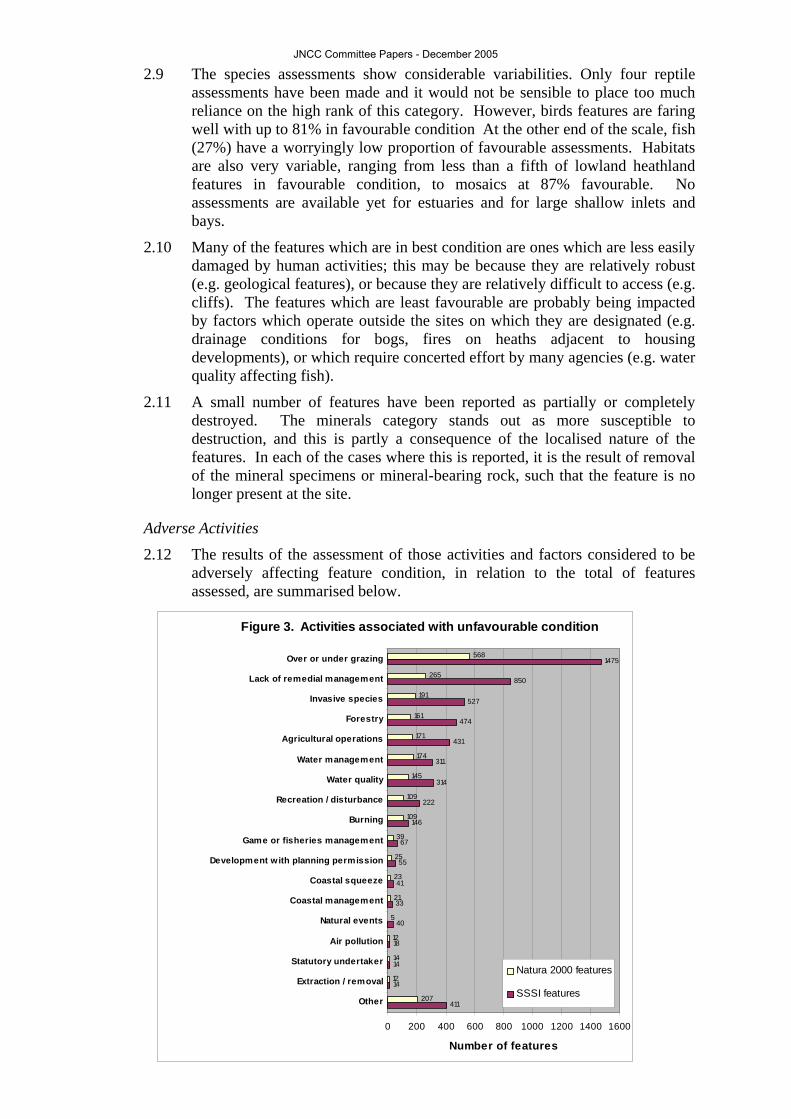
2.12 The results of the assessment of those activities and factors considered to be adversely affecting feature condition, in relation to the total of features assessed, are summarised below.
Figure 3. Activities associated with unfavourable condition
411
14
14
18
40
33
41
55
67
146
222
314
311
431
474
527
850
1475
207
12
14
12
5
21
23
25
39
109
109
145
174
171
161
191
265
568
0 200 400 600 800 1000 1200 1400 1600
Other
Extraction / removal
Statutory undertaker
Air pollution
Natural events
Coastal management
Coastal squeeze
Development with planning permission
Game or fisheries management
Burning
Recreation / disturbance
Water quality
Water management
Agricultural operations
Forestry
Invasive species
Lack of remedial management
Over or under grazing
Number of features
Natura 2000 features
SSSI features
JNCC Committee Papers - December 2005

2.13 Grazing (either under-grazing or over-grazing) is mentioned most commonly
as the activity causing unfavourable status for many feature types and is perhaps the largest single cause for concern. It is, for example, the main factor suggested for the unfavourable status of lowland dwarf shrub heath; the habitat in worst condition. Whilst the picture is quite complex and the key adverse activities vary between features, the clear message from this analysis is that more needs to be done to ensure that management of designated sites is appropriate to the features for which they are important.
2.14 It is often very difficult to determine the effects of air pollution on SSSIs, given the complex interactions between pollution impacts, management and abiotic influences. As a result, the impacts of air pollution, and the identification of air pollution as an adverse activity affecting condition, are substantially under-reported in this assessment.
Management Measures
2.15 The results of the assessment of the measures which have been taken which are considered to be beneficial to achieving or maintaining favourable feature condition are summarised below. These measures relate to land and water predominantly in private ownership. Land managed for conservation purposes, for example as nature reserves by the statutory agencies or by voluntary bodies, makes a substantial contribution to favourable condition but is not included in these data.
Figure 4. Management measures reported
1018
23
17
60
79
60
266
1011
3122
388
17
18
44
49
71
111
257
834
0 500 1000 1500 2000 2500 3000 3500
Other
Planning condition /agreement
Site managementenforcement
Conservation agencygrant
Management regimenegotiation
Other grant
Scottish forestrygrant scheme
Agri-environmentscheme
Managementagreement / scheme
Number of features
Natura 2000 featuresSSSI features
2.16 Management agreements with owners or occupiers are the most common way
of trying to bring sites into management and favourable condition. This situation may change from now on, with agri-environment schemes having a larger role to play. However, some agri-environment schemes have not proven to be very successful at funding the restoration phase where capital costs are very high. Experience to date shows that restoration is best achieved through targeted projects.
2.17 Table 4 shows the effect of combining favourable assessments with those which are unfavourable-recovering. It is ordered, under broad feature category headings, according to the percentage achieving favourable and
JNCC Committee Papers - December 2005

unfavourable-recovering conditions. Shaded rows are the same as those in Table 3 to facilitate comparison.
JNCC Committee Papers - December 2005

Table 4. Effect of ranking assessments when favourable and recovering condition are combined
favourable rank
favourable + recovering
rank reporting category
number of assessments
reported % favourable + recovering
1 1 Reptiles 4 100.0% 16 9 Dragonflies and damselflies 41 85.4% 10 13 Aggregations of non-breeding birds 732 81.3% 30 14 Amphibians 49 79.6% 13 15 Assemblages of breeding birds 180 78.9% 18 16 Mammals 144 77.8% 12 18 Aggregations of breeding birds 760 75.9% 20 20 Other invertebrates 298 75.2% 21 26 Butterflies 91 68.1% 27 27 Flowering plants 324 67.3% 26 37 Non-flowering plants 131 59.5% 39 43 Fish 86 37.2%
Species Total 2812 76.0% 5 6 Mosaics 55 89.1%
17 11 Lagoons 47 83.0% 11 12 Rocky shores, reefs and caves 46 82.6% 14 17 Sea cliffs 180 76.1% 15 19 Intertidal sands and muds 148 75.7% 23 21 Limestone pavement, inland cliffs and screes 272 73.9% 35 22 Acid grassland - lowland 174 70.1% 37 23 Calcareous grassland - lowland 625 70.1% 24 24 Blanket bogs 222 68.9% 33 25 Neutral grassland 1074 68.2% 19 28 Subtidal sandbanks 9 66.7% 32 29 Broadleaved 1842 66.3% 44 30 Heathlands - lowland 374 64.4% 31 31 Fens and marshes - upland 114 64.0% 29 32 Dunes, shingle and machair 342 63.7% 25 33 Standing water 513 63.5% 22 34 Saltmarsh 146 63.0% 42 35 Lowland raised bogs 199 62.3% 34 36 Fens and marshes - lowland 789 61.2% 28 38 Coniferous 56 57.1% 41 39 Calcareous grassland - upland 84 53.6% 40 40 Acid grassland - upland 56 51.8% 43 41 Heathlands - upland 195 46.2% 36 42 Alpine grasslands and heaths 69 43.5% 38 44 Rivers and streams 89 37.1%
Habitats Total 7720 65.6% 2 2 Volcanic rocks 215 95.3% 3 3 Folds, faults and rock movements 139 93.5% 4 4 Ice Age landforms and sediments 410 90.2% 8 5 Active landforms 225 89.3% 6 7 Fossils 274 87.6% 7 8 Minerals 120 85.8% 9 10 Rock sequences 859 84.5% Geological Total 2242 88.1% Grand Total2 12774 71.8%
2 Excludes Ramsar features and a few assessments which do not fit into these categories.
JNCC Committee Papers - December 2005

2.18 This is the status that we should expect to see assuming the management that
has been put in place is successful (i.e. recovering condition is converted to favourable condition). However, time will be needed for actions taken to realise their benefit on the ground. The higher ranking of some features in Table 4 compared to Table 3, including lowland heaths and grasslands, demonstrates the considerable efforts made by the conservation agencies to improve the condition of features in these vulnerable groups over recent years, and the potential value of continuing, and enhancing, this effort.
2.19 At the broad scale, tackling many of the problems of unfavourable condition of terrestrial features undoubtedly lies in the area of major policy changes to further encourage environmentally-friendly farming systems. The prevalence of grazing problems needs to be tackled urgently. Frequent site visits and regular contact between conservation staff and farmers are required to build relationships and ensure that the conservation vision for the site is understood.
2.20 Management agreements and agri-environment schemes are both important tools. Agri-environment schemes will increasingly become the main response mechanism to management problems. In England, where SSSIs are already being targeted, this will be supplemented by Wildlife Enhancement Schemes. The equivalent approach in Scotland and Northern Ireland are the Natural Care and Management of Sensitive Sites schemes. In Wales, management agreements are regarded as an essential means of topping-up what it isn’t possible to deliver through agri-environment agreements. Influencing livestock policy will be essential. Schemes such as the Grazing Animals Project in England, and Pori, Natur a Treftadaeth in Wales, are producing promising results, but need more secure financial backing.
Resources
2.21 The total cost of Common Standards Monitoring to date is estimated at just under £14 million. This includes staff costs and the start-up costs of training, guidance and standard development but has not been scaled up to cover the assessments that have yet to be made to complete the 6 year cycle. This contrasts with a site management cost of nearly £200 million over the same period. Monitoring costs, therefore, are currently running at about 7% of management costs.
3. Provisos 3.1 While these data represent the most comprehensive account of the condition
of sites designated for nature conservation in the United Kingdom, a number of provisos need to be made.
3.2 Because the guidance on feature objectives was made available progressively during the six-year monitoring period, not all assessments were made against objectives formulated in accordance with this guidance. This issue will reduce in significance as the monitoring programme is rolled forward.
3.3 The four statutory nature conservation agencies carrying out the monitoring undertook this work in a manner determined by priorities in their various countries. For example, the Countryside Council for Wales concentrated their effort on SACs, making relatively few assessments on SSSIs or SPAs. However, the Council did undertake a rapid assessment exercise of the condition of SSSIs. While this did not follow the common standards methodology (and the results are, therefore, not included here), it did allow for some cross-check to be made between the condition of SSSI features in Wales from those recorded elsewhere. The reports from English Nature are concentrating on habitat SSSIs and SACs and there are fewer reports relating
JNCC Committee Papers - December 2005

to features on species SSSIs and few reports on SPA or Ramsar features. Such discrepancies between countries can be expected to reduce as the monitoring programme is rolled forward.
3.4 Quality assurance of procedures was undertaken by the individual nature conservation agencies in accordance with processes determined by the agency concerned. Further quality assurance to ensure compatibility of assessments within and between agencies will be introduced shortly.
3.5 It is possible that the method treats SAC features more severely than SSSI features. SACs tend to be larger than SSSIs and are often an aggregation of SSSIs. Aggregation rules for data mean that parts of a feature assessed as unfavourable can cause the whole feature to be assessed as unfavourable. This is more likely to happen on aggregated or large sites. Another factor maybe that SAC features are selected because they are particularly in need of conservation across Europe. It is consequently to be expected that their condition is less favourable than the broader suite of SSSI features. In addition, SAC features tend to be defined more tightly than A/SSSI features and therefore need to be maintained more strictly.
JNCC Committee Papers - December 2005
Dunes, Shingle and Machair
Dunes, Shingle and Machair (Coastal)
Context These habitats occur above the high water mark, but in areas influenced by wave splash and sea-spray. Salt-tolerant species are the characteristic colonisers of this habitat and the biotopes present are strongly influenced by sediment size as well as the degree of wave exposure of the shore. Strandline communities are often present on moderately exposed sandy shores, particularly on flat, slightly mobile beaches with little or no human disturbance. Under these conditions annual vegetation can develop on the accumulations of drift material rich in nitrogenous organic matter at or near the high water mark. Characteristic vascular plants include the sea sandwort Honckenya peploides, saltwort Salsola kali, and sea beet Beta maritima. On the upper margins shore, three major supralittoral sediment habitat types occur: coastal vegetated shingle, sand dunes, and machair. Shingle beaches are widely distributed around the UK coastline and tend to form in high energy environments where the sea can pile up pebbles above the tide line. There are five recognised types distributed around the UK: fringing beaches, spits, barriers, cuspate forelands and barrier islands. Herb-rich open pioneer stages colonise the seaward edge with species such as sea-kale Crambe maritima, sea pea Lathyrus japonicus, thrift Armeria maritima, yellow horned poppy Glaucium flavum and sea holly Eryngium maritimum. Grassland, heath, scrub, and moss and lichen-dominated vegetation of old, stable, shingle occur further inland. Distinct features within sand dune systems include fore dunes, yellow dunes, dune grassland, dune slacks, dune heath and dune scrub. Factors such as stability and moisture retention in these different systems determine what species are present. In mobile fore dunes, for example, typical species are marram grass Ammophila arenaria and, in northern areas of Britain, the lyme-grass Leymus arenarius. Dune slacks, which are areas of wetland within the dune system, may have scarce plants such as the fen orchid Liparis loeselii and the petalwort Petalophyllum ralfsii. Machair is a distinctive sand dune formation that is only found in the north and west coast of Scotland and in western Ireland. The soils are made up of wind deposited shell-sand blown inland from coastal beaches and mobile dunes, which lie over impermeable rock. The main habitats of machair are dry grassland, damp grassland, marsh and standing water and the vegetation broadly described as a herb-rich sward. Machair also supports a rich invertebrate fauna and the large wader populations of the Usits, Tiree and Coll are considered the most important in the north-west Palaearctic.
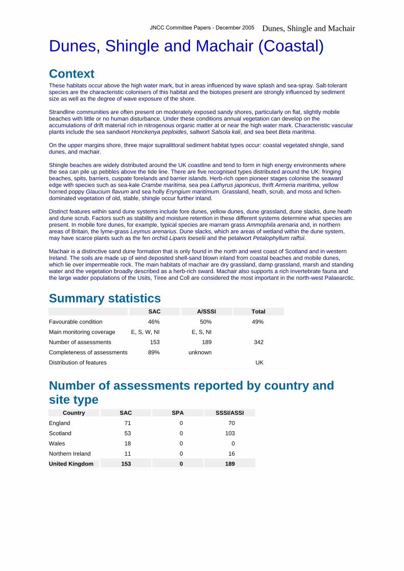
Summary statistics SAC A/SSSI Total
Favourable condition 46% 50% 49%
Main monitoring coverage E, S, W, NI E, S, NI
Number of assessments 153 189 342
Completeness of assessments 89% unknown
Distribution of features UK
Number of assessments reported by country and site type
Country SAC SPA SSSI/ASSI
England 71 0 70
Scotland 53 0 103
Wales 18 0 0
Northern Ireland 11 0 16
United Kingdom 153 0 189
JNCC Committee Papers - December 2005

Dunes, Shingle and Machair Natura features List of Natura 2000 interest features within this reporting category
Interest feature name
Formal name Informal name No. of
features assessed
Total no. of features % assessed
Annual vegetation of drift lines Annual vegetation of drift lines
10 12 83%
Atlantic decalcified fixed dunes (Calluno-Ulicetea)
Coastal dune heathland 9 10 90%
Coastal dunes with Juniperus spp. Dunes with juniper thickets 1 2 50%
Decalcified fixed dunes with Empetrum nigrum
Lime-deficient dune heathland with crowberry
2 2 100%
Dunes with Hippophae rhamnoides Dunes with sea-buckthorn 1 1 100%
Dunes with Salix repens ssp. argentea (Salicion arenariae)
Dunes with creeping willow 13 14 93%
Embryonic shifting dunes Shifting dunes 20 22 91%
Fixed dunes with herbaceous vegetation ("grey dunes")
Dune grassland 26 31 84%
Humid dune slacks Humid dune slacks 22 25 88%
Machairs Machair 8 8 100%
Perennial vegetation of stony banks Coastal shingle vegetation outside the reach of waves
12 13 92%
Shifting dunes along the shoreline with Ammophila arenaria ("white dunes")
Shifting dunes with marram 29 32 91%
Natura 2000 comprises Special Protection Areas (under the Birds Directive) and Special Areas for Conservation (under the Habitats and Species Directive). The list presented here includes all of the qualifying species and habitats under these Directives, and shows the proportion of these features for which a condition assessment has been made.
JNCC Committee Papers - December 2005

Dunes, Shingle and Machair SSSI features List of interest feature types in this reporting category for which assessments have been made on SSSI/ASSI
Interest feature name
Formal name Informal name No. of features assessed
Coastal sand dunes Fixed dunes with herbaceous vegetation 1
Coastal sand dunes Coastal sand dunes 1
Coastal sand dunes Embryonic shifting dunes 2
Coastal sand dunes Humid dune slacks 1
Coastal sand dunes Shifting dunes along the shoreline with Ammophila arenaria (“white dunes”)
1
Coastal sand dunes Shifting dunes along the shoreline with Ammophila arenaria (white dunes)
2
Coastal sand dunes Dunes with Salix repens ssp argentea (Salicion arenariae)
1
Coastal vegetated shingle Annual vegetation of drift lines 1
Coastal vegetated shingle Coastal vegetated shingle 1
Coastal vegetated shingle Perennial vegetation of stoney banks 1
Fixed dunes with herbaceous vegetation (“grey dunes”)
Fixed dunes with herbaceous vegetation (“grey dunes”) 1
Machairs Machair 32
Maritime cliff and slope Maritime cliff and slope 2
Perennial vegetation of stony banks Perennial vegetation of stony banks 1
Sand dune Sand dune 55
Shingle Shingle 16
Supralittoral Sediment Supralittoral Sediment 70 This list has not been fully standardised at a UK level yet. It is intended to show the principal constituent "feature types" for this reporting category.
JNCC Committee Papers - December 2005

Dunes, Shingle and Machair Maps - distribution
Distribution of assessed interest features. Map showing the locations of the 10km squares on which at least one condition assessment has been made, either for a feature on a Natura 2000 site or on an SSSI/ASSI. It does not show features that have not yet been assessed.
JNCC Committee Papers - December 2005

Dunes, Shingle and Machair Maps - Natura
Current condition of SAC features Distribution of SAC features showing assessments of favourability (where "unfavourable recovering" is counted as unfavourable).
Future condition of SAC features Distribution of SAC features showing predicted assessments of favourability based on the assumption that currently " nfavourable recovering" features will become "favourable"). u IMPORTANT NOTE: we do not have information on the timescale of this predicted recovery; it assumes that a sympathetic management regime will be sustained and eventually result in "favourable" condition being attained.
Key: Proportion of assessed features on 10km squares that are favourable:
JNCC Committee Papers - December 2005

Dunes, Shingle and Machair Maps - SSSI
Current condition of SSSI/ASSI features Distribution of SSSI/ASSI features showing assessments of favourability (where "unfavourable recovering" is counted as unfavourable).
Future condition of SSSI/ASSI features Distribution of SSSI/ASSI features showing predicted assessments of favourability based on the assumption that currently "unfavourable recovering" features will become " avourable"). f IMPORTANT NOTE: we do not have information on the timescale of this predicted recovery; it assumes that a sympathetic management regime will be sustained and eventually result in "favourable" condition being attained.
Key: Proportion of assessed features on 10km squares that are favourable:
JNCC Committee Papers - December 2005

Dunes, Shingle and Machair Condition summary
This presents a bar chart for each of the condition categories. This lists the 10 different condition assessments and presents a bar chart showing the number of features within the SSSI series and the Natura 2000 series (either SPA - bird features only or SAC for all features other than birds). Note that the Natura 2000 totals include all qualifying interest features that have been submitted to the EU on official Natura 2000 data forms. For Natura 2000 we are able to estimate the number of features that have not been assessed during the 6 year reporting period - we are unable to do this for SSSI/ASSI because we do not have an overall list of notified interest features for these designations. NB favourable unclassified and unfavourable unclassified have been used in this first six year cycle to get around difficulties in identifying trends in condition as common standards monitoring is implemented. It is expected that these categories will not be used for second or subsequent assessments of a feature.
JNCC Committee Papers - December 2005

Dunes, Shingle and Machair Condition assessment - Natura 2000 features
The number and proportion of assessments for Natura 2000 (SAC and SPA) interest features falling into each of the condition categories. Note that the unfavourable category includes all reports of unfavourable condition except unfavourable recovering which is shown as a separate segment.
Condition assessment - SSSI features
The number and proportion of assessments for SSSI/ASSI interest features falling into each of the condition categories. Note that the unfavourable category includes all reports of unfavourable condition except unfavourable recovering which is shown as a separate segment.
JNCC Committee Papers - December 2005

Dunes, Shingle and Machair Adverse activities
The number of interest features where an activity has been reported as being implicated in the "unfavourable" condition of a feature. More than one adverse activity may be reported for each feature.
JNCC Committee Papers - December 2005

Dunes, Shingle and Machair Management measures
The measures summary bar chart lists the management measures relevant to the reporting category. For each "measure" the chart shows the number of interest features where that measure has been taken on a site to improve or maintain the condition of an interest feature. More than one measure may be reported for each feature assessed.
Interpretation Overall, 49% of dune, shingle and machair features reported are in favourable condition. This is below average for marine and coastal features, and just below the average condition for all features taken together, but above the average for habitat features. 50% of A/SSSI and 46% of SAC features reported are in favourable condition. A further 13% of A/SSSI and 18% of SAC features reported are in unfavourable-recovering condition. Dune heaths in SACs are generally in poor condition. Dunes with Salix repens, although mostly unfavourable, are better catered for in the provision of management agreements. Habitat management issues are the greatest cause of unfavourable condition for sand dune, shingle and machair sites. Most significant of the habitat management issues is under-grazing and lack of remedial management. Invasion by scrub or lack of grazing lead to invasion by coarser grasses and scrub and decline in quality of the habitat. Securing grazing is complicated by intrinsic difficulties of stock management on many coastal sites and issues such as the quality of grazing. Overgrazing can also be an issue. Scrub and invasive species management plans may have long lead in times and need long time periods to deliver results. Management plans with the owners of sites help address these issues. Agricultural grant schemes such as Countryside Stewardship and Tir Gofal have an important role to play in this, but the figures indicate a disappointing level of application for these feature types. More work needs to be done with partners and owners to improve take up of agri-environment schemes. Inappropriate coastal management will affect shingle and sand dune habitats. This can include disrupted shingle movements or sand supply, which interrupts longshore drift, or moving or reprofiling shingle ridges for flood management, which disturbs the habitat developing on the surface. In these cases it will be non-conservation public bodies responsible for managing the habitat. Many of these problems can only be addressed through strategic shoreline management plans and strategies.
JNCC Committee Papers - December 2005

Mammals
Mammals
Context SSSI features can be notified if they qualify under criteria outlined in sections 3.1 - 3.4 of Chapter 13 'Mammals' of the Guidelines for Selection of Biological SSSIs. Sites are currently notified mostly for seals, otter and bats. Sites for seals may be notified both for moulting haul-out or for breeding locations. The basis of site selection for otter is mainly breeding holts or holt complexes, together with the immediate surroundings and cover. For bats, both hibernating and breeding sites can be selected, in some cases for individual species, in others for an assemblage of breeding and hibernating species. Sites are not notified directly for other mammals such as pine marten Martes martes, wildcat Felis sylvestris, polecat Mustela putorius, red squirrel Sciurus vulgaris, common dormouse Muscardinus avellanarius, yellow-necked mouse Apodemus flavicollis, Orkney vole Microtus arvalis orcadensis and lesser white-toothed shrew Crocidura suaveolus, but such species can be taken into account as attributes that enhance the value of mainly woodland and upland sites that are notified predominantly for habitat or botanical features. Mammals listed on Annex II of the EC Habitats Directive , and thereby qualifying as features for the selection of Special Areas of Conservation (SACs) are: lesser horseshoe bat Rhinolophus hipposideros, greater horseshoe bat Rhinolophus ferrumequinum, barbastelle Barbastella barbastellus, Bechstein's bat Myotis bechsteinii, bottlenose dolphin Tursiops truncatus, harbour porpoise Phocoena phocoena, otter Lutra lutra, grey seal Halichoerus grypus and harbour seal Phoca vitulina.
Summary statistics SAC A/SSSI Total
Favourable condition 65% 72% 67%
Main monitoring coverage E, S E, S
Number of assessments 97 47 144
Completeness of assessments 66% unknown
Distribution of features UK
Number of assessments reported by country and site type
Country SAC SPA SSSI/ASSI
England 48 0 32
Scotland 42 0 15
Wales 7 0 0
Northern Ireland 0 0 0
United Kingdom 97 0 47
JNCC Committee Papers - December 2005

Mammals Natura features List of Natura 2000 interest features within this reporting category
Interest feature name
Formal name Informal name No. of features assessed
Total no. of features % assessed
Barbastella barbastellus Barbastelle 7 9 78%
Halichoerus grypus Grey seal 5 12 42%
Lutra lutra Otter 57 76 75%
Myotis bechsteini Bechstein's bat 8 9 89%
Phoca vitulina Common seal 2 11 18%
Rhinolophus ferrumequinum Greater horseshoe bat 10 12 83%
Rhinolophus hipposideros Lesser horseshoe bat 7 15 47%
Tursiops truncatus Bottlenose dolphin 1 3 33% Natura 2000 comprises Special Protection Areas (under the Birds Directive) and Special Areas for Conservation (under the Habitats and Species Directive). The list presented here includes all of the qualifying species and habitats under these Directives, and shows the proportion of these features for which a condition assessment has been made.
SSSI features List of interest feature types in this reporting category for which assessments have been made on SSSI/ASSI
Interest feature name
Formal name Informal name No. of features assessed
Barbastella barbastellus and Myotis bechsteini
Maternity colonies of Barbastelle and Bechstein`s bats
2
Halichoerus grypus Grey seal 8
Hibernating populations of bats Hibernating populations of bats 12
Lutra lutra Otter 8
Muscardinus avellanarius Dormouse 3
Phoca vitulina Common seal 3
Rhinolophus ferrumequinum Greater horseshoe bat 7
Rhinolophus hipposideros Lesser horseshoe bat 4 This list has not been fully standardised at a UK level yet. It is intended to show the principal constituent "feature types" for this reporting category.
JNCC Committee Papers - December 2005

Mammals Maps - distribution
Distribution of interest features assessed. Map showing the locations of the 10km squares on which at least one condition assessment has been made, either for a feature on a Natura 2000 site or on an SSSI/ASSI. It does not show features that have not yet been assessed.
Maps - Natura
Current condition of SAC features Distribution of SAC features showing assessments of favourability (where "unfavourable recovering" is counted as unfavourable).
Future condition of SAC features Distribution of SAC features showing predicted assessments of favourability based on the assumption that currently " nfavourable recovering" features will become "favourable"). u IMPORTANT NOTE: we do not have information on the timescale of this predicted recovery; it assumes that a sympathetic management regime will be sustained and eventually result in "favourable" condition being attained.
Key: Proportion of assessed features on 10km squares that are favourable:
JNCC Committee Papers - December 2005

Mammals
JNCC Committee Papers - December 2005

Mammals Maps - SSSI
Current condition of SSSI/ASSI features Distribution of SSSI/ASSI features showing assessments of favourability (where "unfavourable recovering" is counted as unfavourable).
Future condition of SSSI/ASSI features Distribution of SSSI/ASSI features showing predicted assessments of favourability based on the assumption that currently "unfavourable recovering" features will become " avourable"). f IMPORTANT NOTE: we do not have information on the timescale of this predicted recovery; it assumes that a sympathetic management regime will be sustained and eventually result in "favourable" condition being attained.
Key: Proportion of assessed features on 10km squares that are favourable:
JNCC Committee Papers - December 2005

Mammals Condition summary
This presents a bar chart for each of the condition categories. This lists the 10 different condition assessments and presents a bar chart showing the number of features within the SSSI series and the Natura 2000 series (either SPA - bird features only or SAC for all features other than birds). Note that the Natura 2000 totals include all qualifying interest features that have been submitted to the EU on official Natura 2000 data forms. For Natura 2000 we are able to estimate the number of features that have not been assessed during the 6 year reporting period - we are unable to do this for SSSI/ASSI because we do not have an overall list of qualifying interest features for these designations. NB favourable unclassified and unfavourable unclassified have been used in this first six year cycle to get around difficulties in identifying trends in condition as common standards monitoring is implemented. It is expected that these categories will not be used for second or subsequent assessments of a feature.
JNCC Committee Papers - December 2005

Mammals Condition assessment - Natura 2000 features
The number and proportion of assessments for Natura 2000 (SAC and SPA) interest features falling into each of the condition categories. Note that the unfavourable category includes all reports of unfavourable condition except unfavourable recovering which is shown as a separate segment.
Condition assessment - SSSI features
The number and proportion of assessments for SSSI/ASSI interest features falling into each of the condition categories. Note that the unfavourable category includes all reports of unfavourable condition except unfavourable recovering which is shown as a separate segment.
JNCC Committee Papers - December 2005
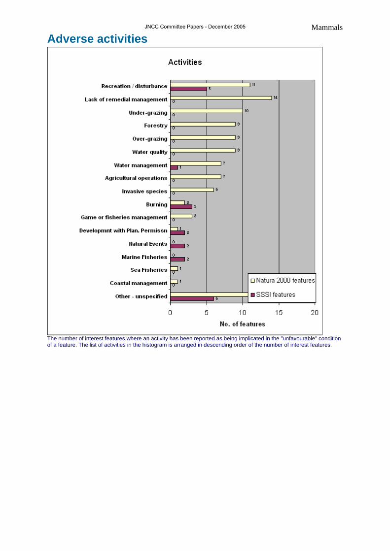
Mammals Adverse activities
The number of interest features where an activity has been reported as being implicated in the "unfavourable" condition of a feature. The list of activities in the histogram is arranged in descending order of the number of interest features.
JNCC Committee Papers - December 2005

Mammals Management measures
The measures summary bar chart lists the management measures relevant to the reporting category. For each "measure" the chart shows the number of interest features where that measure has been taken on a site to improve or maintain the condition of an interest feature. The list of measures in the histogram is arranged in descending order of the number of interest features - ie the most commonly used measure is shown at the top of the bar chart.
JNCC Committee Papers - December 2005

Mammals Interpretation Overall 67% of the mammal features reported are in favourable condition. This is the average for species features but above the average for all features. 72% of the A/SSSI and 65% of the SAC features reported are in favourable condition. A further 11% of A/SSSI and 10% of SAC features reported are in unfavourable-recovering condition.
Bats 53% of bat features reported are in favourable condition. Two thirds of the sites notified for hibernating bat populations are reported as favourable. For greater (Rhinolophus ferrumequinum) and lesser horseshoe (Rhinolophus hipposideros) bats the corresponding figures are 47% and 53% respectively. Through the national bat monitoring programme, we know lesser horseshoe bat to be increasing - further investigation is therefore needed to ascertain why half of the features are unfavourable. Bechstein's and Barbastelle bats are restricted to England. Two thirds of the barbastelle (Barbastella barbastellus) assessments reported are in favourable condition, which is encouraging for barbastelle conservation, a species poorly covered by other monitoring schemes. Conversely, only one of eight Bechstein's bat (Myotis bechsteini) sites is favourable. As one of the UK's rarest mammals the distribution and habitat preferences of this species are not well understood, however forestry practices and lack of remedial management measures, amongst others, appear to be the key threats. As all sites have management agreements it is hoped this trend will soon be reversed.
Otter 82% of the otter (Lutra lutra) sites reported are in favourable condition. All of the otter SACs and SSSIs reported from Scotland are reported to be favourable, a recent national survey also found Scottish otter populations to be in good condition. In England only 4 of the 15 otter sites are favourable; however this does not match with other recent surveys which suggests their populations are recovering throughout large areas of their former range. Further information is therefore needed before any judgements can be made about how the site series is aiding otter conservation in England. In Wales, 5 sites are reported, all assessed as favourable.
Seals 77% of seal assessments reported are favourable. It is encouraging that many of the harbour seal (Phoca vitulina) and grey seal (Halichoerus grypus) sites are in a favourable condition in Scotland. In England all three grey seal sites reported were favourable but the one site for harbour seal (The Wash) is unfavourable-declining. Here the unfavourable status was attributable to natural causes rather than human activities. Harbour seal numbers have declined in the Wash in recent years as a result of the 2002 phocine distemper virus epidemic that reduced numbers by 22%.
JNCC Committee Papers - December 2005

Rock Sequences
Rock sequences
Context Geological Conservation Review (GCR) sites are selected for, and grouped according to, GCR blocks, which are site-selection categories for nationally important Earth science sites. There are around 100 'blocks' in Britain. Each 'block'; represents a particular geological age or Earth science theme, such as Marine Permian Stratigraphy, Jurassic-Cretaceous Reptilia, Caledonian Igneous Rocks and Quaternary of Scotland. For the most part, these GCR sites are classified according either to their stratigraphical age (Stage, Period) or to a range of stratigraphical ages (e.g. Caradoc--Ashgill block). Blocks for some stratigraphical ages, however, were defined not purely by age, but also by geographical area or environmental setting where there were significant variations in rocks across Britain formed at the same time. This is why there are two blocks for the Devonian Period, one for marine rocks and one for non-marine rocks. It is not possible in every case to define blocks by stratigraphical age. For example, where fossils are rare or absent it is difficult to locate the boundary between different geological ages. Such stratigraphical units are named after the geographical localities where they were defined, for example, the Wealden Group, which consists of mudstone, shale and sandstone which only occur in south-east England. Most invertebrate fossils (e.g. trilobites, echinoderms, ammonites and other molluscs) are also addressed within the stratigraphical blocks, because these fossils are widely used in correlating rock strata. Because of the relative rarity of fossils such as reptiles, fish, mammals, birds, terrestrial plants, insects and other arthropods (excluding trilobites) these are covered in separate palaeontological blocks.
Summary statistics SAC A/SSSI Total
Favourable condition 83% 83%
Main monitoring coverage N/A E, S, NI
Number of assessments N/A 859 859
Completeness of assessments Approx. 80%
Distribution of features UK
Number of assessments reported by country and site type
Country SAC SPA SSSI/ASSI
England N/A N/A 725
Scotland N/A N/A 112
Wales N/A N/A 0
Northern Ireland N/A N/A 22
United Kingdom N/A N/A 859
JNCC Committee Papers - December 2005

Rock Sequences SSSI features List of interest feature types in this reporting category for which assessments have been made on SSSI/ASSI
Interest feature name
Formal name Informal name No. of features assessed
Aalenian - Bajocian Aalenian - Bajocian 51
Aptian - Albian Aptian - Albian 29
Arenig - Llanvirn Arenig - Llanvirn 10
Arenig - Tremadoc Arenig - Tremadoc 3
Bathonian Bathonian 46
Berriasian, Valanginian, Hauterivian, Barremian Berriasian, Valanginian, Hauterivian, Barremian 11
Callovian Callovian 14
Cambrian Cambrian 9
Cambrian - Tremadoc Cambrian - Tremadoc 2
Caradoc - Ashgill Caradoc - Ashgill 23
Carboniferous stratigraphy Carboniferous stratigraphy 9
Cenomanian, Turonian, Senonian, Maastrichtian Cenomanian - Maastrichtian 2
Cenomanian, Turonian, Senonian, Maastrichtian Cenomanian, Turonian, Senonian, Maastrichtian 36
Cretaceous stratigraphy Dunnaglea - Larrybane 1
Cretaceous stratigraphy Cretaceous stratigraphy 2
Dinantian of Devon & Cornwall Dinantian of Devon & Cornwall 9
Dinantian of northern England & north Wales Dinantian of northern England & north Wales 55
Dinantian of Scotland Dinantian of Scotland 1
Dinantian of southern England & south Wales Dinantian of southern England & south Wales 11
Hettangian, Sinemurian and Pliensbachian Hettangian, Sinemurian and Pliensbachian 26
Jurassic stratigraphy Jurassic stratigraphy 2
Kimmeridgian Kimmeridgian 13
Llandeilo Llandeilo 3
Llandovery Llandovery 19
Lower Carboniferous [Dinantian - Namurian (part)]
Lower Carboniferous [Dinantian - Namurian (part)]
24
Ludlow Ludlow 21
Marine Devonian Marine Devonian 44
Marine Permian Marine Permian 24
Namurian of England & Wales Namurian of England & Wales 37
Neogene (Pliocene) Neogene (Pliocene) 16
Non-marine Devonian Non-marine Devonian 24
Ordovician stratigraphy Ordovician stratigraphy 3
Oxfordian Oxfordian 31
Palaeogene Palaeogene 26
Permian - Triassic Permian - Triassic 32
Permian - Triassic (red beds) Permian - Triassic (red beds) 10
Permian stratigraphy Permian stratigraphy 1
Portlandian - Berriasian Portlandian - Berriasian 17
Precambrian of England & Wales Precambrian of England & Wales 11
Rhaetian Rhaetian 9
Silurian stratigraphy Silurian stratigraphy 2
Toarcian Toarcian 15
Tremadoc Tremadoc 3
Triassic stratigraphy Triassic stratigraphy 2
JNCC Committee Papers - December 2005

Rock Sequences Interest feature name
Formal name Informal name No. of features assessed
Upper Carboniferous [Namurian (part) - Westphalian]
Upper Carboniferous [Namurian (part) - Westphalian]
7
Wealden Wealden 36
Wenlock Wenlock 29
Westphalian Westphalian 48 This list has not been fully standardised at a UK level yet. It is intended to show the principal constituent "feature types" for this reporting category.
Maps - distribution
Distribution of assessed interest features. Map showing the locations of the 10km squares on which at least one condition assessment has been made, either for a feature on a Natura 2000 site or on an SSSI/ASSI. It does not show features that have not yet been assessed.
JNCC Committee Papers - December 2005

Rock Sequences Maps - SSSI
Current condition of SSSI/ASSI features Distribution of SSSI/ASSI features showing assessments of favourability (where "unfavourable recovering" is counted as unfavourable).
Future condition of SSSI/ASSI features Distribution of SSSI/ASSI features showing predicted assessments of favourability based on the assumption that currently "unfavourable recovering" features will become " avourable"). f IMPORTANT NOTE: we do not have information on the timescale of this predicted recovery; it assumes that a sympathetic management regime will be sustained and eventually result in "favourable" condition being attained.
Key: Proportion of assessed features on 10km squares that are favourable:
JNCC Committee Papers - December 2005

Rock Sequences Condition summary
This presents a bar chart for each of the condition categories. This lists the 10 different condition assessments and presents a bar chart showing the number of features within the SSSI series and the Natura 2000 series (either SPA - bird features only or SAC for all features other than birds). Note that the Natura 2000 totals include all qualifying interest features that have been submitted to the EU on official Natura 2000 data forms. For Natura 2000 we are able to estimate the number of features that have not been assessed during the 6 year reporting period - we are unable to do this for SSSI/ASSI because we do not have an overall list of notified interest features for these designations. NB favourable unclassified and unfavourable unclassified have been used in this first six year cycle to get around difficulties in identifying trends in condition as common standards monitoring is implemented. It is expected that these categories will not be used for second or subsequent assessments of a feature.
JNCC Committee Papers - December 2005

Rock Sequences Condition assessment - SSSI features
The number and proportion of assessments for SSSI/ASSI interest features falling into each of the condition categories. Note that the unfavourable category includes all reports of unfavourable condition except unfavourable recovering which is shown as a separate segment.
JNCC Committee Papers - December 2005

Rock Sequences Adverse activities
The number of interest features where an activity has been reported as being implicated in the "unfavourable" condition of a feature. More than one adverse activity may be reported for each feature.
JNCC Committee Papers - December 2005
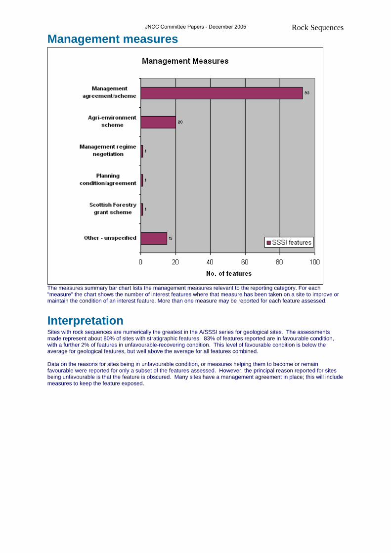
Rock Sequences Management measures
The measures summary bar chart lists the management measures relevant to the reporting category. For each "measure" the chart shows the number of interest features where that measure has been taken on a site to improve or maintain the condition of an interest feature. More than one measure may be reported for each feature assessed.
Interpretation Sites with rock sequences are numerically the greatest in the A/SSSI series for geological sites. The assessments made represent about 80% of sites with stratigraphic features. 83% of features reported are in favourable condition, with a further 2% of features in unfavourable-recovering condition. This level of favourable condition is below the average for geological features, but well above the average for all features combined. Data on the reasons for sites being in unfavourable condition, or measures helping them to become or remain favourable were reported for only a subset of the features assessed. However, the principal reason reported for sites being unfavourable is that the feature is obscured. Many sites have a management agreement in place; this will include measures to keep the feature exposed.
JNCC Committee Papers - December 2005