the archaeological investigation of a hexagonal … archaeological investigation of a hexagonal...
TRANSCRIPT

The archaeological investigation of a hexagonal feature at Star Hill, Bridge,
near Canterbury, Kent. 2003-6
The Kent Archaeological Field SchoolDirector, Paul Wilkinson, PhD., FRSA., MSIA., MIFA.
School Farm Oast, Graveney Road, Faversham, Kent, ME13 8UPTelephone 01795 532548
Website www.kafs.co.uk E-mail [email protected]
Bridge Report/final 9/12/08 8:42 AM Page 1

Contents
1. Summary........................................................................................................................................page 3.
2. Introduction....................................................................................................................................page 5.2.1 Project Background
3. Aims & Objectives.........................................................................................................................page 6.
4. Methodology..................................................................................................................................page 7.4.1 Archaeological Excavation
5. The Archaeological & Historical Background...............................................................................page 9.5.1. Archaeological Evaluation5.2. Previous Archaeological Assessments within the Area5.3. Archaeological Sites & Monuments Records5.4. Documentary Evidence5.5. Geology and Topography
6. Review of the Archaeological Fieldwork.....................................................................................page 14.6.1. Stratigraphical Deposit Model (SDM)6.2. Area 1, 6.3. Area 2, 6.4. Area 3, 6.5. Area 4.6.6. The 2003 investigation6.7. The 2004 investigation6.8. The 2005 investigation6.9. The Roman road investigation
7. Archaeological Narrative..............................................................................................................page 20.7.1. Phase I- Late Neolithic/Early Bronze Age. 7.2. Phase 2-Late Bronze/Early Iron Age. 7.3. Phase 3-Late Iron Age/Early Roman. 7.4. Phase 4-Mid Roman. 7.5. Phase 5-Early/Mid Anglo-Saxon. 7.6. Phase 6 Late Post-Medieval.
8. The hexagonal feature..................................................................................................................page 24.
9. Archaeological Finds....................................................................................................................page 27.9.1. Treasure finds. 9.2. Coins. 9.3. Disc-pendant. 9.4. Lithic assemblage. 9.5. Ceramic assemblage.9.6. Environmental evidence. 9.7. Grave goods,. 9.8. Human and animal bones. 9.9. The Site Archive.
10. Recommendations for further archaeological assessment.........................................................page 29.10.1. Statement of potential10.2. Preparation of full report & publication10.3. Conclusions
11. References..................................................................................................................................page 30.Appendix 1. Graves & Grave Goods, Small Finds Recording Forms.Appendix II. Aerial photographs/ Map.Appendix III. Ceramic Assessment, Nigel MacPherson-GrantAppendix IV. Lithic Assessment, Chris Butler.Appendix V. Research & Project Design, Paul WilkinsonAppendix VI. Figures.Appendix VII. Project constraints/letters.
Bridge Report/final 9/12/08 8:42 AM Page 2

Fig. 1. Aerial photograph of the hexagonal feature.Fig. 2. Aerial photograph of the hexagonal feature.Fig. 3. Student’s in Graves 3 & 4.Fig. 4. Student in Grave 7.Fig. 5. Map produced in 1887 by the Rev. F. Vine.Fig. 6. 20th century OS map of Bridge.Fig. 7. Vertical Aerial photograph of BridgeFig. 8. 2005 view of the exposed hexagonal feature ditch.Fig. 9. 2005 view of the exposed hexagonal feature ditch.Fig. 10. SMR map of Star Hill.Fig. 11. Photograph showing graves cutting into the fill.Fig. 12. Photograph showing graves cutting into the fill.Fig. 13. View of stripped Area 1.Fig. 14. Stripping reveals graves in Area 1.Fig. 15. Excavation of the hexagonal feature.Fig. 16. Anglo-Saxon cremation urn revealed.Fig. 17. 2005 view of excavated Anglo-Saxon graves.Fig. 18. Gold scutiform disc pendant in situ.Fig. 19. Split-post palisade fence/ditch.Fig. 20. Late Bronze Age/Early Iron Age post hole.Fig. 21. Student’s recording features.Fig. 22. Student’s drawing of 7th century pot.Fig. 23. Grave 7 with inhumation in situ.Fig. 24. Vertical aerial photograph of Star Hill, Bridge.Fig. 25. Euclid’s diagram of the regular hexagon.Fig. 26. Sacred polygonal features.Fig. 27. Grave 1.Fig. 28. Grave 2.Fig. 29. Grave 3.Fig. 30. Grave 4.Fig. 31. Grave 5.Fig. 32. Grave 6.Fig. 33. Grave 7.Fig. 34. Grave 8.Fig. 35. Grave 9.Fig. 36. Grave 10.Fig. 37. Grave 11.
Fig. 38. Ortho-rectified aerial photograph of Star Hill.Fig. 39. Ortho-rectified aerial photograph of Star Hill.Fig. 40. Map of Bridge 1887.Fig. 41. Trench location plan.Fig. 42. Plan of the site showing plough damage.Fig. 43. Plan and Area index.Fig. 44. Phases 1-4.Fig. 45. Area 1. Phases 1-4.Fig. 46. Area 2. Phases 1-4.Fig. 47. Area 3. Phases 1-4.Fig. 48. Area 4. Phases 1-4.Fig. 49. Area 1. Phases 5A-C.Fig. 50. Area 2. Phases 5A-C.Fig. 51. Area 3. Phases 5A-C.Fig. 52. Area 4. Phases 5A-C.Fig. 53. A3 plan. Phases 1-4.Fig. 54. A3 plan. Phases 5A-C.Fig, 55. Areas of 2003-2005 investigation.Fig. 56. Area of 2005 investigation.Fig. 57. Sections from 2005 investigationFig. 58. Overall site plan of 2006 investigation (A3).Fig. 59-78. Plans and Sections. 1:10, 1:20.Fig. 79. Artefacts from Grave 1. SF161, SF144, SF160.
List of Figures
Bridge Report/final 9/12/08 8:42 AM Page 3

3
1. Summary
In 2003 the Kent Archaeological Field School (KAFS) was invited by the Bridge and District HistorySociety to investigate a crop-mark on top of Star Hill in the shape of a hexagon (Fig. 1). The NMRMonument Report (2003) summarises the feature as an: ‘Hexagonal feature with dark centre seen on airphotographs, possibly a World War II installation’. Other archaeologists are emphatic that it is a garden feature associated with 18th century landscaping of Bourne Park in which the site is located (Paul Bennettpers. comm.). However, excavation of the fill of the hexagonal ditch in 2003 retrieved 14 sherds (72gms) offlint and grog-tempered ware with a spread of dates from 150BC to AD50. Subsequently each Easter from2004 to 2006 (Fig. 55) the KAFS carried out a Programme of Assessment and Archaeological Excavationon this area of densely crop-marked land at Star Hill, Bridge, near Canterbury, Kent. The site centre istaken as NGR 618800 153600.
The land is currently in the ownership of Vanessa Mcdonald of Hardres Court Farm and is under pasture.Aerial photographs (Figs. 1, 7, 38, 39) show that the Scheduled Monument burial mounds (KE 71) to theeast of the area of investigation by the KAFS had been destroyed by ploughing (Fig. 42). With a possiblefuture change of ownership there could be plans to change the farming regime back from pasture to ploughwith the consequential further loss of buried archaeology.
Research by the KAFS prior to field work had found a 19th century map drawn by the Rev. F. T. Vine, Vicarof Patrixbourne and published by him in the 2nd edition of his book, ‘Caesar in Kent’. Vine thought thehexagonal feature was a Roman fort (Fig. 5, 40), one of two in the grounds of Bourne Park (Vine 1887).
Figs. 1, 2. Aerial photographs of the hexagonal feature on Star Hill, Bridge. The photograph above looks towards Canterburyand shows the village of Bridge with theRoman Watling Street running through it.The photograph (left) shows the area ofinvestigation (study area) by the KAFS in2005 (blue box) and 2006 (red box). Bothareas are to the east of the hexagon. To theleft (green arrow) can be seen many morering ditches of Anglo-Saxon inhumations. Anestimate of the number of burials in this partof Star Hill is well over 1000.
Bridge Report/final 9/12/08 8:42 AM Page 4

An ideal opportunity had therefore arisen to carry out an archaeological training excavation on a crop-mark considered to be either a feature of the Park or built as a military installation during World War II.The initial investigation carried out during May Bank Holiday in 2003 by the KAFS of two points of thehexagonal ditched enclosure enabled the students to find the centre of the hexagon where stripping of theturf revealed a circular pit, about three metres in diameter cut into the chalk. The pit had been pillagedsome time in the past but sherds of Late Iron Age pottery with burnt bone, and Medieval pottery suggesta cremation deposit of Late Iron Age/ Early Roman period plundered during the Medieval orAntiquarian period. Further stripping of the topsoil in 2004 within the perimeter of the hexagon failed tofind any tree-planting pits, indeed the only features revealed were a number of prehistoric post-holes andrubbish pits dug into the chalk during the First and Second World Wars (Fig. 55).
In 2005 further work was undertaken on the south side of the hexagon where almost immediately aneast-west orientated grave cut into the chalk was revealed with a number of 7th century Anglo-Saxoncoins exposed in the disturbed fill. Investigation revealed a possible family group of 12 graves orientatedto the hexagon feature with Graves 3, 4, 4a, and 7 cutting the fill of the hexagon feature ditch (Fig. 56).The graves were an obvious target for treasure hunters and full excavation proceeded with the appropriate Burial Licence obtained. Most of the graves contained artefacts that were Treasure Troveand include a gold pendant, glass palm cup, Frankish pottery vessels, beads, buckles, spears, knives,cowrie shells, loom weights and over 60 silver Anglo-Saxon coins dating to AD680-690 (Appendix I).Worked flint and Iron Age pottery sherds were also retrieved by sieving the topsoil within the excavatedarea. The worked flint is the subject of a specialist report which dates the assemblage to the Neolithicand suggests that stone tool manufacture was taking place on site (Hardaker 2005 pers comm).The constant retrieval of scattered fresh Iron-age pottery sherds throughout the site did suggest thatIron-Age occupation was a possible feature of the site and investigation of this aspect should form partof the revised 2006 Research Design (Appendix V).
As a result in 2006 further investigation comprising an area excavation of a 50 metre strip was undertaken to the east of the hexagon (Fig. 58). The results were spectacular. Over 90 Anglo-Saxoninhumation graves cut into the chalk were revealed overlaying 5th century Anglo-Saxon cremationdeposits which in turn overlay Iron-Age cremations, post-holes, rubbish pits, stake holes, ditches, andhut platforms which in turn overlay Bronze Age and earlier features (Fig. 13, 14, 53, 54). The date ofthe hexagonal ditched enclosure has now been firmly established as pre-Anglo-Saxon as no fewer thanseven Anglo-Saxon inhumations cut into the fill of the ditch (Fig. 23, 56). Pottery sherds were retrievedfrom the fill of the ditch which give a tentative date from 150BC to AD50. It can only be assumed thatthe hexagonal feature was short-lived, and is of an early Roman date.
Figs. 3, 4. The picture to the left shows studentsin Graves 3 & 4. The double ditch hexagonal feature can clearly be seen as can Grave 4 cutting into the fill of the earlier feature. Abovecan be seen Grave 7 which on excavation revealeda complete skeleton with grave goods. The gravehad been cut into the fill of the hexagonal featuredouble ditch (Fig. 23, 56). 4
Bridge Report/final 9/12/08 8:42 AM Page 5
2. Introduction
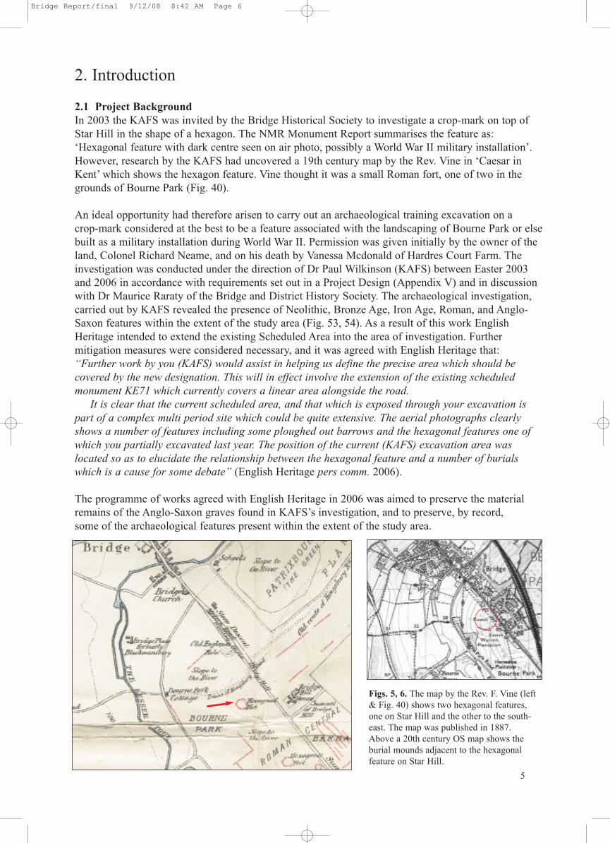
2.1 Project BackgroundIn 2003 the KAFS was invited by the Bridge Historical Society to investigate a crop-mark on top ofStar Hill in the shape of a hexagon. The NMR Monument Report summarises the feature as:‘Hexagonal feature with dark centre seen on air photo, possibly a World War II military installation’.However, research by the KAFS had uncovered a 19th century map by the Rev. Vine in ‘Caesar inKent’ which shows the hexagon feature. Vine thought it was a small Roman fort, one of two in thegrounds of Bourne Park (Fig. 40).
An ideal opportunity had therefore arisen to carry out an archaeological training excavation on a crop-mark considered at the best to be a feature associated with the landscaping of Bourne Park or elsebuilt as a military installation during World War II. Permission was given initially by the owner of theland, Colonel Richard Neame, and on his death by Vanessa Mcdonald of Hardres Court Farm. The investigation was conducted under the direction of Dr Paul Wilkinson (KAFS) between Easter 2003and 2006 in accordance with requirements set out in a Project Design (Appendix V) and in discussionwith Dr Maurice Raraty of the Bridge and District History Society. The archaeological investigation,carried out by KAFS revealed the presence of Neolithic, Bronze Age, Iron Age, Roman, and Anglo-Saxon features within the extent of the study area (Fig. 53, 54). As a result of this work EnglishHeritage intended to extend the existing Scheduled Area into the area of investigation. Further mitigation measures were considered necessary, and it was agreed with English Heritage that: “Further work by you (KAFS) would assist in helping us define the precise area which should be covered by the new designation. This will in effect involve the extension of the existing scheduled monument KE71 which currently covers a linear area alongside the road.
It is clear that the current scheduled area, and that which is exposed through your excavation ispart of a complex multi period site which could be quite extensive. The aerial photographs clearlyshows a number of features including some ploughed out barrows and the hexagonal features one ofwhich you partially excavated last year. The position of the current (KAFS) excavation area was located so as to elucidate the relationship between the hexagonal feature and a number of burialswhich is a cause for some debate” (English Heritage pers comm. 2006).
The programme of works agreed with English Heritage in 2006 was aimed to preserve the materialremains of the Anglo-Saxon graves found in KAFS’s investigation, and to preserve, by record, some of the archaeological features present within the extent of the study area.
5
Figs. 5, 6. The map by the Rev. F. Vine (left& Fig. 40) shows two hexagonal features,one on Star Hill and the other to the south-east. The map was published in 1887. Above a 20th century OS map shows the burial mounds adjacent to the hexagonalfeature on Star Hill.
Bridge Report/final 9/12/08 8:42 AM Page 6

3. Aims and Objectives
Following on from the initial stages of evaluation work in 2003-5, suitable mitigation measures wereproposed by the KAFS for the 2006 campaign and agreed with English Heritage. The preferableoption for English Heritage of the important archaeological remains at Star Hill was preservation insitu as set out in PPG 16:
‘Archaeological remains should be seen as a finite, and non-renewable resource, in many cases highlyfragile and vulnerable to damage and destruction. Appropriate management is therefore essential toensure they survive in good condition. In particular, care must be taken to ensure that archaeologicalremains are not needlessly or thoughtlessly destroyed.’ (Para A6)
However, the KAFS agreed in principal that the Anglo-Saxon graves should only be recorded and notexcavated but sample excavation should take place on other features already exposed in the initial stripand map exercise (Fig.13). In undertaking this archaeological work the principles set out by theInstitute of Field Archaeologists (IFA) were adhered to. The IFA defines an excavation as being:
‘...a programme of controlled, intrusive fieldwork with defined research objectives which examines,records and interprets archaeological deposits, features and structures and, as appropriate, retrievesartefacts, ecofacts and other remains within a specified area or site on land, inter-tidal zone or under-water. The records made and objects gathered during fieldwork are studied and that results of thatstudy published in detail appropriate to that design’ (IFA 1999b:2).
The aims of this archaeological investigation and excavation were therefore (not exclusively):
1. To understand the character, form, function and date of any archaeological remains apart fromAnglo-Saxon graves in the study area. The work should include analysis of the spatial organisation ofactivities on the site during the prehistoric, Iron Age, Roman, and Anglo-Saxon periods through examination of the distribution of features, artefactual and environmental assemblages.
2. To assist in the understanding of the archaeological occupation of Star Hill through examination ofthe date, form and character of the study area in the context of its topographical position and that ofother similarly dated findings within the area and beyond.
3. To elucidate the relationship between the hexagonal feature and the Anglo-Saxon burials and otherfeatures so that the relationship could be clearly resolved.
4. To undertake a Level 3 topographical survey of Star Hill including that which is currently scheduledwhich would provide a positive contribution to the proposed scheduling process.
Fig. 7. A vertical aerialphotograph taken on 12thJanuary 1946 by the RAF(Film No. 40851069/UK/1112). It showsthe surviving round barrows (blue arrow). Thehexagonal feature (greenarrow), and a large formalprobably18th century garden (red arrow). Alsoshown are relict field systems, droveways andthe dry river bed of thestream called theNailbourne. 6
Bridge Report/final 9/12/08 8:42 AM Page 7

4. Methodology
4.1 Archaeological ExcavationExcavation in 2006 was carried out using a 360° mechanical excavator fitted with a toothless ditchingbucket, removing the overburden to the top of the first recognisable archaeological horizon, under theconstant supervision of an experienced archaeologist. Exposed surfaces were subsequently hand-cleaned to reveal features in plan and carefully selected cross-sections through the features were excavated to enable sufficient information about form, development date and stratigraphic relation-ships to be recorded without prejudice to more extensive investigations, should these prove to be necessary. All archaeological work was carried out in accordance with the updated Method Statement(Appendix V).
The KAFS single context recording system was used to record the deposits. A full list will be providedin the final report. Layers and fills are recorded (100). The cut of the feature is shown [100]. Context numbers were assigned to all deposits for recording purposes and detailed on pro-forma KAFS contextsheets. Plans of all features were made using a scale of 1:20, with sections recorded at 1:10. A fullphotographic record of all stages of the excavation was kept, which included working shots showingworking constraints and conditions.
Upon completion of mechanical excavation, a 10m grid was established and a pre-excavation plangenerated using global positioning satellite (GPS) technology recording three dimensional points every0.10m. For ease of reference the site was subsequently divided into 4 distinct areas.
Table 1 provides an area by area summary of the site at Star Hill, as well as detailing the frequency ofarchaeological features encountered and investigated.
Table 1. Location and frequency of archaeological features encountered (Note: Linear features have been included, wherepresent, within individual areas)
7
Area
Archaeological features
Location (Fig. 43)
Area 1
Central area/2006
Western area/2006
Investigated(No.)
In situ(No.)
Excavated(Approx %)
15
87 27
19
19
18
60
32
8
0
30%
74%
100%
30%
18
51
27
58 12%73
Total
Hexagonal feature areas/2003-5
Eastern area/2006
South-west area/2006Area 4
Area 3
Area 2
Previouswork
Bridge Report/final 9/12/08 8:42 AM Page 8
5. Archaeological & Historical Background
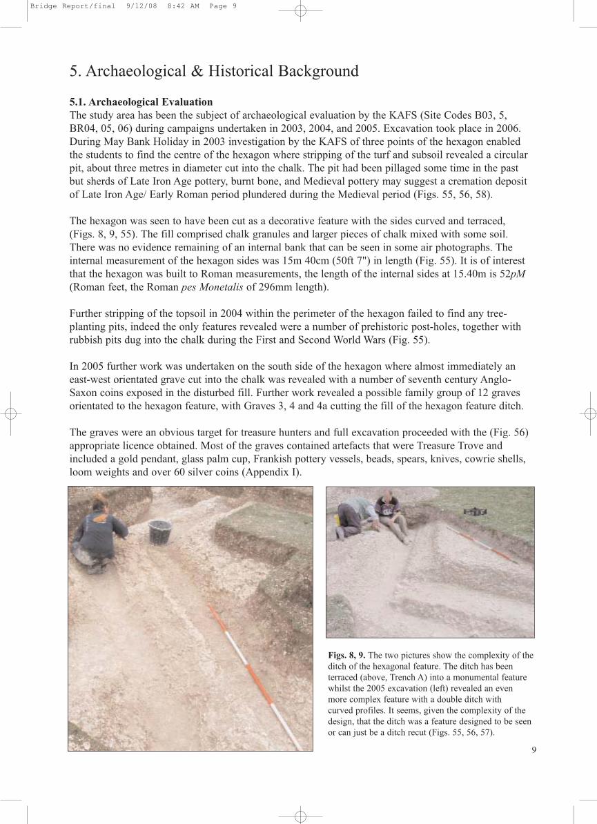
5.1. Archaeological EvaluationThe study area has been the subject of archaeological evaluation by the KAFS (Site Codes B03, 5,BR04, 05, 06) during campaigns undertaken in 2003, 2004, and 2005. Excavation took place in 2006.During May Bank Holiday in 2003 investigation by the KAFS of three points of the hexagon enabledthe students to find the centre of the hexagon where stripping of the turf and subsoil revealed a circularpit, about three metres in diameter cut into the chalk. The pit had been pillaged some time in the pastbut sherds of Late Iron Age pottery, burnt bone, and Medieval pottery may suggest a cremation depositof Late Iron Age/ Early Roman period plundered during the Medieval period (Figs. 55, 56, 58).
The hexagon was seen to have been cut as a decorative feature with the sides curved and terraced,(Figs. 8, 9, 55). The fill comprised chalk granules and larger pieces of chalk mixed with some soil.There was no evidence remaining of an internal bank that can be seen in some air photographs. Theinternal measurement of the hexagon sides was 15m 40cm (50ft 7") in length (Fig. 55). It is of interestthat the hexagon was built to Roman measurements, the length of the internal sides at 15.40m is 52pM(Roman feet, the Roman pes Monetalis of 296mm length).
Further stripping of the topsoil in 2004 within the perimeter of the hexagon failed to find any tree-planting pits, indeed the only features revealed were a number of prehistoric post-holes, together with rubbish pits dug into the chalk during the First and Second World Wars (Fig. 55).
In 2005 further work was undertaken on the south side of the hexagon where almost immediately aneast-west orientated grave cut into the chalk was revealed with a number of seventh century Anglo-Saxon coins exposed in the disturbed fill. Further work revealed a possible family group of 12 gravesorientated to the hexagon feature, with Graves 3, 4 and 4a cutting the fill of the hexagon feature ditch.
The graves were an obvious target for treasure hunters and full excavation proceeded with the (Fig. 56)appropriate licence obtained. Most of the graves contained artefacts that were Treasure Trove andincluded a gold pendant, glass palm cup, Frankish pottery vessels, beads, spears, knives, cowrie shells,loom weights and over 60 silver coins (Appendix I).
Figs. 8, 9. The two pictures show the complexity of theditch of the hexagonal feature. The ditch has been terraced (above, Trench A) into a monumental featurewhilst the 2005 excavation (left) revealed an evenmore complex feature with a double ditch with curved profiles. It seems, given the complexity of thedesign, that the ditch was a feature designed to be seenor can just be a ditch recut (Figs. 55, 56, 57).
9
Bridge Report/final 9/12/08 8:42 AM Page 9

Worked flint and Iron Age pottery sherds were also retrieved by sieving the topsoil and subsoil withinthe excavated area. The worked flint is the subject of a specialist report (see Appendix IV) which datesthe assemblage to the Neolithic and suggests that stone tool manufacture was taking place on site.
The constant retrieval of scattered fresh Iron-age pottery sherds throughout the site did suggest thatIron-Age occupation was a possible feature of the site and investigation of this aspect would form partof the 2006 Research Design (Appendix V).
The land at Star Hill has a complex mass of crop-marks revealed by air photographs (Figs. 38, 39).They cover an area of approximately 5 hectares to the west of the A2 (Watling Street). The crop-marksare reported in the RCHME Mapping Project No. 1077099 dated 01 October to 1986-01 October 1987.The crop-marks show a large number of ploughed-out round barrows sitting astride the course of theRoman Watling Street within the Scheduled Monument area (Fig. 7) whilst to the north-west are a largenumber of smaller ditched barrows. To the south-west there are a number of possible rectangular enclosures and droveways.
The field in question is adjacent to the Scheduled Monument KE71 which currently covers a linear areaalongside the A2 road but will be extended to cover most of the study area (Figs. 2, 41).
The Star Hill crop-mark site has been provisionally identified as a probable Early Roman hexagonal sacred feature which seems to be unique and is of a type of site not identified elsewhere in Britain.
However, there is at least one example of an Early Bronze Age barrow that, though essentially round,did appear as though it had been originally dug in a series of short straight sections (Lord-of-the-Manor1977, Site 2B, Thanet). However, the hexagonality of the present ditch is markedly different, with a formal precision that would indicate a later, Roman date.
Further excavation of the study area was necessary to elucidate the relationship between the hexagonalfeature and the 7th century burials and prove beyond reasonable doubt that at the very least the 7th century graves post-date the hexagonal feature.
As a result of the 2006 excavations it is clear that the hexagon feature cuts the Late Bronze Age (LBA)or Early Iron Age (EIA) ditch 014/018 and is in turn cut by at least seven Anglo-Saxon graves. ARoman date is therefore realistic. The burnt bone and ‘Belgic’ sherds found in the central pit is probably contemporary with its construction and the Medieval and later elements intrusive.
The recorded stratigraphic evidence means that the ditch of the hexagonal feature definitely post-datesthe LBA/EIA enclosure ditch 014/018 (together with any associated Early Iron Age activity) and definitely pre-dates the Anglo-Saxon cemetery.
The sherd evidence from both the hexagon’s ditch, and its central pit, is not sufficient to be conclusive –no absolute firm date can be applied on the basis of the pottery data recovered to date. Most man-madeactivities produce some artefactual by-products of that activity. Here, and using the inter-period ceramicevidence, this technically means the hexagon was constructed during either the Late Iron Age or Romanperiods.
As a putatively indigenous pre-Roman enterprise the hexagon could have been constructed during theincreased phase of ‘Belgic’-period activity, ie.sometime after c.50/25 BC. Its neatly straight sides andRoman measurement, though, imply a Roman level of planning or design logic. It could therefore be aCaesarian or Claudian, possibly sacred, imposition into native farmland.
10
Bridge Report/final 9/12/08 8:42 AM Page 10
5.2 Previous Archaeological Assessments within the AreaThe site lies on a hill within a rich archaeological landscape overlooking the southern edge of Bridgevillage. A number of sites have been investigated in the vicinity, mainly archaeological works on theBridge By-pass by the Canterbury Archaeological Society in 1966-1974.
Although the work was funded by grants from the Department of the Environment and an interimreport published by Nigel Macpherson-Grant with an emphasis on the prehistoric pottery inArchaeologia Cantiana Vol. XCVI, 1980, no full report has been published.
It is understood that the report was to be published in two parts. Part 1, Prehistoric, and Part 2 whichwould have covered the later Roman and Anglo-Saxon cemeteries. It would also have included a sec-tion on settlement and land-use at Bridge including synthesising the evidence presented in both parts ofthe reports.
In 1961 Dr Mary Watson undertook field work just to the east of the current study area. The area ofWatson’s interest was being developed as a housing estate and the site lay in the path of a road whichwas being prepared. Two rubbish pits which were excavated yielded pre-Roman pottery, including aSwarling type pedestal base and a handle from a Mediterranean type imported in Belgic times, a pre-Roman bronze fibula and other bronze fragments, a broken speculum coin, Allen Class I, and domesticanimal bones. The area has now been completely developed, but the excavator, Dr. Mary Watson, whoretains the finds has not, as yet, published a report.
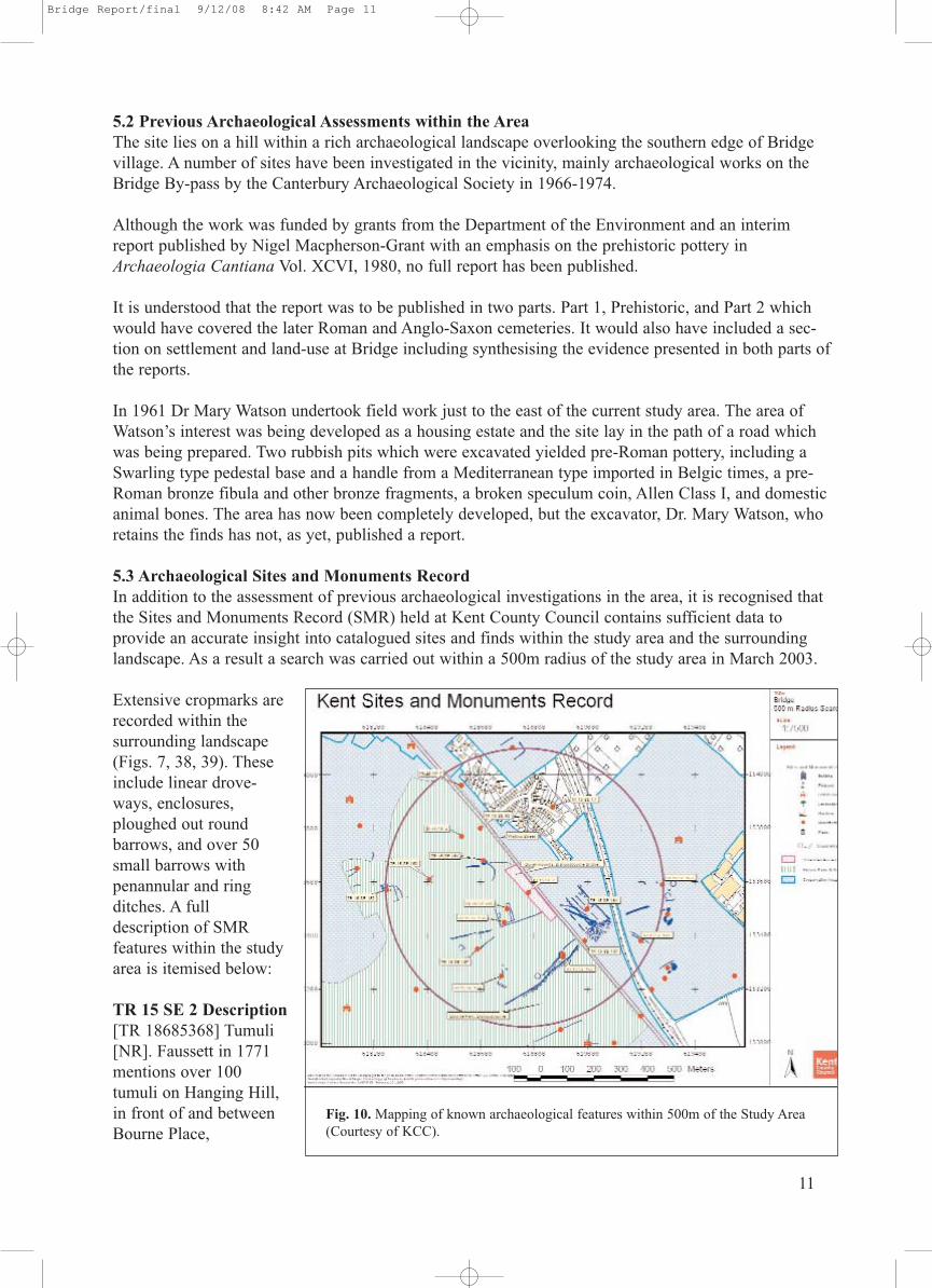
5.3 Archaeological Sites and Monuments RecordIn addition to the assessment of previous archaeological investigations in the area, it is recognised thatthe Sites and Monuments Record (SMR) held at Kent County Council contains sufficient data to provide an accurate insight into catalogued sites and finds within the study area and the surroundinglandscape. As a result a search was carried out within a 500m radius of the study area in March 2003.
Extensive cropmarks arerecorded within the surrounding landscape(Figs. 7, 38, 39). Theseinclude linear drove-ways, enclosures,ploughed out round barrows, and over 50small barrows withpenannular and ringditches. A full description of SMR features within the studyarea is itemised below:
TR 15 SE 2 Description[TR 18685368] Tumuli[NR]. Faussett in 1771mentions over 100tumuli on Hanging Hill,in front of and betweenBourne Place,
11
Fig. 10. Mapping of known archaeological features within 500m of the Study Area(Courtesy of KCC).
Bridge Report/final 9/12/08 8:42 AM Page 11

12
Bishopsbourne, and the Roman road (some parallel to the road); others had been ploughed down.Wright opened three and found them to be Saxon. This grave mound cluster is partly in woodland andpartly under the plough; only eleven mounds survive and these, in general, are in a poor condition (Noreport).
TR 15 SE 7 Description[TR 18595388] Romano-British urns and other vessels, (some in Liverpool Museum) with skeletonsand fragments of weapons, were found c.1833 about half-way up Bridge Hill during alterations to theCanterbury - Dover road. Three more burials under the pavement on the north side of the road werefound with 4th c. pottery in 1956. The 1956 burials were found when a G.P.O. cable was laid at thejunction of Beech Hill and Bridge Hill at TR 18535396: the pottery, which included two 4th c. jugs, hasbeen retained by Mr. Jenkins (No report).
TR 15 SE 17 Description[TR 18938] An Late Iron Age site was found in May 1961 on Bridge Hill above the 200 ft. contournear the summit of the hill (and adjacent to the Study Area) where it slopes to the north-west. The areawas being developed as a housing estate and the site lay in the path of a road which was being pre-pared. Two rubbish pits which were excavated yielded pre-Roman pottery, including a Swarling typepedestal base and a handle from a Mediterranean type imported in Belgic times, a pre-Roman bronzefibula and other bronze fragments, a broken speculum coin, Allen Class I, and domestic animal bones.The area has been completely developed, but the excavator, Dr. Mary Watson, who retains the finds,indicated the approximate find spot at TR 18875388 (No report).
TR 15 SE 154 DescriptionHexagonal feature with dark centre, probable WW2 military installation.
TR 15 SE 155 DescriptionRectilinear enclosure with probable building foundation against its west side.
TR 15 SE 164 DescriptionComplex of linear features parallel to Roman Road, with "castellated" WW2 slit trenches, possibletrackways etc.
5.4 Documentary EvidenceThe most important historical information has come from the Rev. F. Vine who was aware of thehexagonal feature on Star Hill and in 1887 wrote in his book ‘Caesar in Kent’:
“On the brow of the hill, in Bourne Park, there are what appear to be the remains of two [Roman] out-posts, 400 yards apart, surrounded each by a ditch. They are of the same dimensions, and form almostperfect hexagons, each side being about 50 feet in length. They are situated in commanding positionson a hill, called locally ‘Star Hill,’ and would afford excellent stations for the guards placed before thegates of the camp, whence they could view the position and movement of the enemy. They are knowntraditionally as ‘the Forts.’ They are now bare of trees but have the appearance of having been plantedat some comparatively recent period “(Vine 1887: 197).
In Vine’s book ‘Caesar in Kent’ there are also some excellent maps which show the location of not onebut two similar hexagonal features (Figs. 5, 40). A critique of Vine’s work by Matthew Bell has been located. Bell, a local landowner, bought BourneHouse in 1845 and wrote in the Bourne Book: “The two hexagonal enclosures, p191, surrounded by a bank, there is no ‘ditch’, and supposed to be‘outposts’, are easily recognised: he says ‘they are known traditionally as the Forts’: this is anotherinstance of a tradition known to hardly anyone. I have never heard it mentioned. But, whatever else
Bridge Report/final 9/12/08 8:42 AM Page 12
13
they may have been, they were certainly once plantations, as the trees (Scotch firs) still existed fortyyears ago in one of them, and a few stumps were visible in the other: the bank of the N. W. hexagon isstill perfect, but after making ample allowance for the levelling effects of time and weather, it seems tome far too insignificant in its dimensions to have ever been the embankment of a Roman ‘outpost’ whileit is exactly what one might expect to find as a bank thrown up to assist in protecting a plantation madeperhaps less than 100 years ago” (Raraty M. M. pers comm 2008).
5.5 Geology and TopographyThe British Geological Society shows that the North Downs consists of Upper Chalk, although geologi-cally the Downs consist of the Lower, Middle and Upper Chalks. Most of the Downland in the Bridgearea is underlain by the Upper Chalk, with the lower strata (Lower Chalk) outcropping on the scarp andvalley slopes. The Lower Chalk has a high clay content, qualifying almost as Marl. The Middle Chalk ismore pure and whiter, and being harder resists erosion better. Upper Chalk is purer still, and containslarge quantities of flint which on erosion turns into Clay-with-Flints.
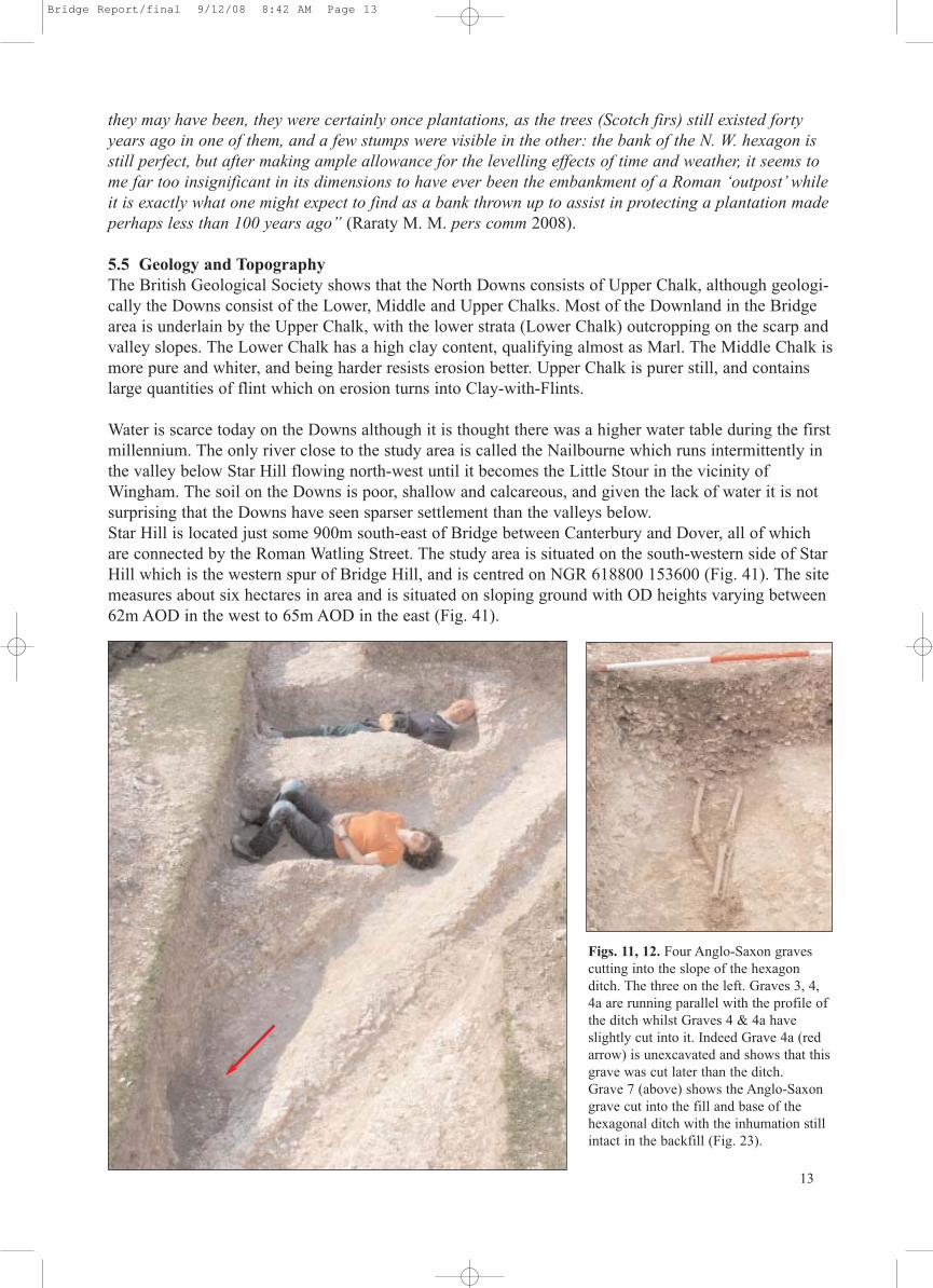
Water is scarce today on the Downs although it is thought there was a higher water table during the firstmillennium. The only river close to the study area is called the Nailbourne which runs intermittently inthe valley below Star Hill flowing north-west until it becomes the Little Stour in the vicinity ofWingham. The soil on the Downs is poor, shallow and calcareous, and given the lack of water it is notsurprising that the Downs have seen sparser settlement than the valleys below.Star Hill is located just some 900m south-east of Bridge between Canterbury and Dover, all of whichare connected by the Roman Watling Street. The study area is situated on the south-western side of StarHill which is the western spur of Bridge Hill, and is centred on NGR 618800 153600 (Fig. 41). The sitemeasures about six hectares in area and is situated on sloping ground with OD heights varying between62m AOD in the west to 65m AOD in the east (Fig. 41).
Figs. 11, 12. Four Anglo-Saxon gravescutting into the slope of the hexagonditch. The three on the left. Graves 3, 4,4a are running parallel with the profile ofthe ditch whilst Graves 4 & 4a haveslightly cut into it. Indeed Grave 4a (redarrow) is unexcavated and shows that thisgrave was cut later than the ditch. Grave 7 (above) shows the Anglo-Saxongrave cut into the fill and base of thehexagonal ditch with the inhumation stillintact in the backfill (Fig. 23).
Bridge Report/final 9/12/08 8:42 AM Page 13
14
6. Review of the Archaeological Fieldwork
6.1 Stratigraphical Deposit Model (SDM)A common stratigraphic sequence was recognised across the site comprising topsoil/overburden(001) overlying a thin subsoil (002) and the natural Upper Chalk. The topsoil/overburden consistedof relatively loose dark brown sandy loam with frequent to moderate inclusions of sub-rounded –angular flints and fragments of chalk. The subsoil comprised moderately dense mid-brown sandyloam that not only sealed all archaeological deposits recorded on site, but also contained fragmentsof friable abraded pottery and charcoal. A clear line of horizon gave way to regular natural depositsof Upper Chalk where mechanical excavation ceased immediately above the chalk leaving a 15mmzone of subsoil to be removed by hand. This zone was carefully trowelled off and a careful examination and investigation for truncated features was carried out. The depth of the overlying layervaried, with the average depth of the natural geology being located between 0.40m (east) 0.60m(west) below the existing ground level. Archaeological deposits were recorded between 64.44m and65.03m AOD. Each group of features will be looked at separately, in conjunction with the full context list set out in the final report. The Areas about to be described were investigated duringEaster 2006. Earlier work is itemised in 6.6 to 6.9.
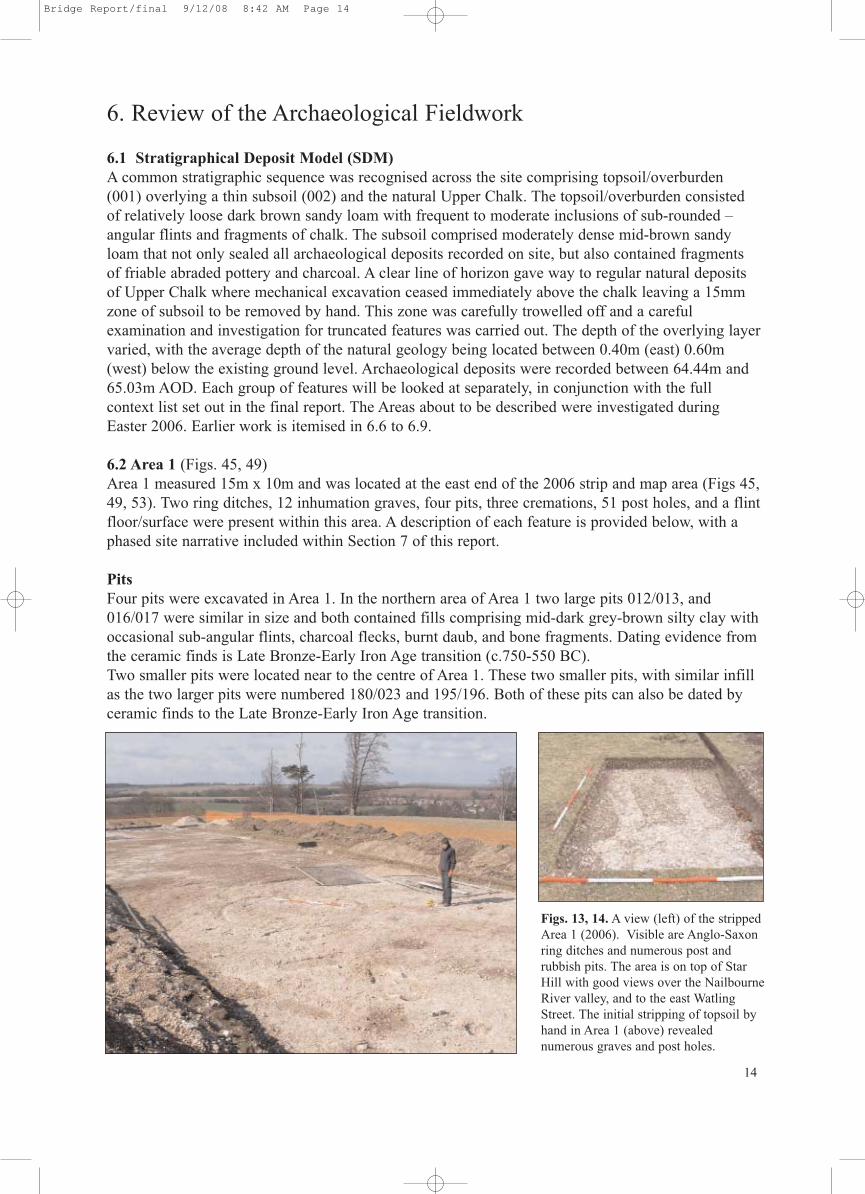
6.2 Area 1 (Figs. 45, 49)Area 1 measured 15m x 10m and was located at the east end of the 2006 strip and map area (Figs 45,49, 53). Two ring ditches, 12 inhumation graves, four pits, three cremations, 51 post holes, and a flintfloor/surface were present within this area. A description of each feature is provided below, with aphased site narrative included within Section 7 of this report.
PitsFour pits were excavated in Area 1. In the northern area of Area 1 two large pits 012/013, and016/017 were similar in size and both contained fills comprising mid-dark grey-brown silty clay withoccasional sub-angular flints, charcoal flecks, burnt daub, and bone fragments. Dating evidence fromthe ceramic finds is Late Bronze-Early Iron Age transition (c.750-550 BC).Two smaller pits were located near to the centre of Area 1. These two smaller pits, with similar infillas the two larger pits were numbered 180/023 and 195/196. Both of these pits can also be dated byceramic finds to the Late Bronze-Early Iron Age transition.
Figs. 13, 14. A view (left) of the strippedArea 1 (2006). Visible are Anglo-Saxonring ditches and numerous post and rubbish pits. The area is on top of StarHill with good views over the NailbourneRiver valley, and to the east WatlingStreet. The initial stripping of topsoil byhand in Area 1 (above) revealed numerous graves and post holes.
Bridge Report/final 9/12/08 8:42 AM Page 14

Post-pits and post holesThe post holes and post-pits within Area 1 formed two main clusters. Located within the northernextent of this area and to the north-east of a flint cobbled floor which is on its south-west side were aseries of post-holes of a post-built structure dated by pottery typical of the Early Iron Age. The fourlarge storage pits (page 14) were clustered close to this building as are post holes 203/204, 201/202,195/196, 035, 200/199. The pottery types retrieved from these features which are obviously groupedtogether suggest a farmstead dated to the Late Bronze-Early Iron Age transition. For further hypothesis of this phase of activity on the site see the Archaeological Narrative (pages 20-5).
GravesThere are 13 grave cuts located within Area 1, G.36, G.37, G.38, G.39, G.40, G.41, G.42, G.43, G.44,G.45, G.46, G.47, G.58. None were excavated. Two of the graves (G.40, G.58) cut into the earlierstorage pits (012/013, 016/017) dated by pottery evidence to the Late Bronze-Early Iron Age transition. Two south-west to north-east aligned barrow ring ditches 205/206 and 188/189 were foundin Area 1. Ring ditch 188/189 can be dated by pottery to c.375-450AD. Inside ring ditch 188/189were two cremations 207/208 and 020/021, again dated to the same period. For the orientation of thegraves see Appendix I. The ring ditch to the north (205/206) seems not to have a grave cut. The ring-ditch 205/206 was not excavated.
Cremation pitsThree Anglo-Saxon cremation pits were identified in Area 1. The Anglo-Saxon cremation pits020/021, 181/182, 185/186 can be dated by ceramic finds to the fifth-sixth century. All were similar insize (Fig. 16) but unfortunately all had been badly damaged by ploughing. The remains of the largeceramic bowls found in all three cremations had been set slightly into the chalk surface enabling thebase and part of the pot to survive. The burnt, calcified bone that did remain was retrieved as a 100%sample for future analysis. The possible cremation pits 211/212, 209/210, cannot be precisely datedbut were similar in size and configuration but the ceramic evidence had been totally destroyed byploughing. Adjacent to one of the ring-ditches was a cremation containing the remains of a smallangle-shouldered bowl with horizontal grooved above shoulder decoration. Its decoration and formsuggest it may be a devolved version of the early faceted carinated bowls found in East Anglia andrelated to similar types from the Elbe river area of northern Germany, and dated there to betweenc.375-450AD. Within the ring-ditch was another cremation, this time in a large globular urn decoratedwith ‘Stehende Bogen’ or ‘standing arches’. The date of this cremation, which may be verified byCarbon 14 dating, is unlikely to be later than c.450-475AD.
6.3 Area 2 (Figs. 46, 50)Area 2 measured 15m x 20m and was located at the east end of the 2006 strip and map area (Figs. 46,50, 53). One ring ditch, 38 inhumation graves, three pits, two cremations, 42 post pits and holes, anda split-post palisade trench with an associated concentration of Late Neolithic-Early Bronze Age typeflints were present within this area. A description of each feature is provided below, with a phased sitenarrative included within Section 7 of this report.
PitsThree pits were excavated in Area 2. In the northern area of Area 2 two large pits 022/021 & 224/225,were similar in size and both contained fills comprising mid-dark grey-brown silty clay with occasional sub-angular flints, charcoal flecks, burnt daub, and bone fragments. Dating evidence fromthe ceramic finds is Late Bronze-Early Iron Age transition (c.750-550BC).One pit was located near to the centre of Area 2. The smaller pit, with similar infill as the two largerpits was numbered 066/065. These pits can also be dated by ceramic finds to the Late Bronze-EarlyIron Age transition.
15
Bridge Report/final 9/12/08 8:42 AM Page 15

16
Post-pits and post holesA total of 42 postholes and pits were recognised within Area 2. Seven on excavation provided no dating evidence, but of the remainder, nine can be dated by ceramic evidence to the Late Bronze Age-Early Iron Age transition. A further five can be dated, again by ceramic evidence, to the Late IronAge to Early Roman transition; 21 were not excavated.
Linear featuresA north-south thin curving split-post palisade trench, 107/108, 105/220, 106/221, 109/110, can bedated by the associated concentration of flint flakes to the Late Neolithic-Early Bronze Age. The construction of the palisade is worthy of note. A curving slot about 180mm wide and 110mm deephad been cut into the chalk and slots cut through the base of this trench about 60mm wide and240mm long. These slots were where the split timber was slotted in vertically to build the solid palisade fence. To keep the timbers upright the slots were packed with clay.
GravesThere are 38 grave cuts located within Area 2, G.55, G.65, G.48, G.85, G.79, G.75, G.78, G.77,G.86, G.87, G.88, G.69, G.53, G.54, G.52, G.12, G.82, G.83, G.73, G.76, G.50, G.51, G.68, G.17,G.18, G.66, G.71, G.80, G.67, G.49, G.19, G.84, G.89, G.64, G.32, G.33, G.35, G.34. Five of thegraves (G.54, G.50, G.66, G.67, G.89) cut the palisade trench, and three (G.12, G.82, G.49) cut LateIron Age pits (125/126, 121/187, 149/150). For the orientation of the graves see Appendix I. Nonewere excavated. The ring ditch (217) and grave (G.84) to the south were also not excavated.
Cremation pitsTwo Anglo-Saxon cremation pits were identified in Area 2. The Anglo-Saxon cremation pits 083/084,045/046 can be dated by ceramic finds to the fifth century. Both were similar in size (Fig. 16) butunfortunately had been badly damaged by ploughing. The remains of the large ceramic bowls foundin both cremations had been set slightly into the chalk surface enabling the base and part of the pot tosurvive. The burnt, calcified bone that did remain was retrieved as a 100% sample for future analysis.The cremation 083/084 provided 11 sherds of sand and marl-tempered ware weighing 71gms. Thisfabric is broadly similar to the Canterbury Saxon EMS 2 with a date range from c.450AD, but morelikely c.475AD and lasting to c.625/650AD.
Figs. 15, 16. Excavation of the hexagonal feature andassociated Anglo-Saxon graves during 2005 (left).Above an Anglo-Saxon cremation urn (046) wasretrieved in Area 2 in 2006. Dating by ceramic specialists suggest from the mid 5th century.
Bridge Report/final 9/12/08 8:42 AM Page 16

17
6.4 Area 3 (Figs. 47, 51)Area 3 measured 15m x 15m and was located at the west end of the 2006 strip and map area (Figs.47, 51, 53). Features include 27 inhumation graves, two pits, no cremations, 21 post pits and holes,and a ditch dated to the Late Bronze Age-Early Iron Age. A description of each feature is providedbelow, with a phased site narrative included within Section 7 of this report.
PitsTwo pits were excavated in Area 3. In the northern area of Area 3 one small pit (024/025), containeda fill comprising mid-dark grey-brown silty clay with occasional sub-angular and worked flint, charcoal flecks, and burnt daub with carbonised grain. Dating evidence from the lithic finds indicatesLate Neolithic-Early Bronze Age. The other pit (223/019) was located near to the centre of Area 3, and adjacent to the ditch and was cutby Grave 25. The fill of the pit comprising mid-dark grey-brown silty clay with occasional sub-angular flint, bone and charcoal pieces contained 22 sherds of Late Bronze Age-Early Iron Age flint-tempered ware dating from c.900-600BC.
Post-pits and post holesA total of 21 postholes and pits were recognised within Area 3. 16 were clustered in the vicinity ofGrave 63. Nine on excavation provided no dating evidence, but of the remainder, four can be datedby ceramic evidence to the Late Bronze Age-Early Iron Age transition. A further three can be dated,again by ceramic evidence to the Late Iron Age to Early Roman transition, five were not excavated.
GravesThere are 27 grave cuts located within Area 3, G.29. G28, G.26, G.25, G.13, G.16, G.30, G.27, G.24,G.23, G.22, G.21, G.14, G.15, G.31, G.90, G.66, G.61, G.62, G.63, G.81, G.74, G.59, G.60, G.72,G.56, and G.57. One of the graves (G.25) cuts the prehistoric ditch, and also cuts a Late Bronze Age-Early Iron Age pit (019/223). For the orientation of the graves see Appendix I. Four graves (G.16,G.15, G.14, G.62) were excavated. The prehistoric ditch (015, 018, 014, 015) was also completelyexcavated.
Linear featuresA northwest-southeast orientated shallow pre-Roman ditch was completely excavated. The fill (015,120) comprised mid orange-brown silty clay, with dark brown clay mottling. Occasional roundedstones and charcoal flecks were present throughout the fill, which also produced flint-tempered pottery dating to the Late Bronze Age-Early Iron Age (c.900-600BC) It probably represents the LateBronze Age-Early Iron Age farmstead’s enclosure ditch which is located at the eastern end of the site.
Cremation pitsNo Anglo-Saxon cremation pits were identified in Area 3.
6.5 Area 4 (Figs. 48, 52)Area 4 measured 15m x 10m and was located at the west end of the 2006 strip and map area (Figs.48, 52, 53). The area included 15 inhumation graves, three pits, one cremation, six post pits andholes, and two linear features were present within this area, which are detailed below. A descriptionof each feature is provided, with a phased site narrative included within Section 7 of this report.
Linear FeaturesTwo linear features were recorded within Area 4. Both are of some importance. The prehistoric linearditch had a maximum width of 1.08m, whilst the hexagonal feature was slightly larger at 1.97m at itsmaximum extent. The prehistoric ditch is dated by pottery retrieved from the sieved infill to the LateBronze-Early Iron Age transition, and is likely to be the farmstead’s enclosure ditch.
Bridge Report/final 9/12/08 8:42 AM Page 17
The building which is associated with the ditch is the rectangular post-built structure, probably a LateBronze-Early Iron Age farmstead and is located at the eastern end of the strip and map area. The ditchof the hexagonal feature cuts the prehistoric ditch and in turn seven Anglo-Saxon graves cut the hexagon’s ditch. An unusual cremation burial (174/173), enclosed within a substantial four-post structure is likely to have been positioned deliberately in the area where the two ditches cross. Thehexagonal feature is unique, and for that reason is a dilemma. Further discussion on this feature is tobe found on page 25.
Post pits and postholesSix post pits and postholes were recognised with Area 4, two were not excavated whilst the four thatwere are part of a four-post structure enclosing a cremation dating to about c.475/500-625AD. Thefour-post structure was about 1.60m square with a central cremation urn partly cut into the chalk andreduced by ploughing to 26 sherds weighing 220gms. At the Anglo-Saxon cemetery at Apple Down inSussex the excavators (Down & Welch 1990: 25-32) reconstructed the structure over cremation 146as having corner posts supporting a pitched thatched roof with perhaps side walls of planking or wattle and daub to protect the inside and to brace the structure. Comparable structures are also knownfrom earlier and contemporary sites on the continent (Lucy, S.J. 2000).
GravesThere are 15 grave cuts located within Area 4, they are G.1, G.2, G.3, G.4, G.5, G.6, G.7, G.8, G.9,G.10, G.11, G.70, G.96, G.95, G.4a. Twelve were excavated and the results of the excavation andtheir impact on the hexagonal feature can be found on page 22. Two graves G.96 and G.95 cut thefill of the ditch of the hexagon but were not excavated (Fig. 55).
Cremation pitsSee ‘Post pits and postholes’ (above) for discussion of the one cremation burial found in this area.
6.6 The 2003 investigation (Fig. 55)An area 10m x 6m (Trench A) was excavated in the north-east corner of the hexagonal feature. Depth of topsoil above the natural chalk was about 0.25m. The topsoil (001) was a darkbrown humic soil progressively getting grey/white with numerous chalk nodules, flint pieces andchalk fleck inclusions. Two probable Anglo-Saxon graves were found in the north-west corner, butnot excavated. A single post-hole (03/2008) was sectioned and dated by flint fragments to theNeolithic/Bronze Age. The surface of the chalk was scarred with a number of plough-marks. Workedflint was retrieved on the surface of the chalk and again dated to the Neolithic/Bronze Age. The specialist report suggests that the manufacture of working blanks to make axes- termed a “FactorySite” could have been taking place at this location (Hardaker & MacRae pers. comm). Trench B (4x3m) was excavated and found to be overlaying the western corner of the hexagonal feature exposing- as in Trench A the ditch of the hexagonal feature. The ditch in this trench is a double ditch whereas the ditch in Trench A is a single ditch. However, the fill of the ditches is comparable with white/grey chalk earth mix (102), some flint, and chalk granules leading to the lowerinfill of the ditch (104) of a chalk/soil mix with inclusions of chalk pieces and granules. No organic material or soil was found in or at the bottom of the ditch. Six sherds of pottery (45gms) wereretrieved from the chalk surfaces adjacent to the ditch in Trench B and are flint-tempered and can bedated to 150-50BC. One sherd of Early Medieval pot was retrieved from the topsoil and can be datedto c.1075-1100AD. In the ditch 14 sherds (72gms) of flint and grog-tempered ware were retrievedwith a spread of dates from 150BC to AD50. One sherd of Medieval pot was found in the lower levels of the turf above the ditch and can be dated to c.1200-1250/75 AD.With two points of the hexagon located it was a simple matter to locate the centre of the hexagonal
18
Bridge Report/final 9/12/08 8:42 AM Page 18

feature and where stripping of the turf revealed a circular pit about three metres in diameter cut intothe chalk. Five sherds (40gms) of pottery dating from 150BC to AD1525 were recovered from the feature.
6.7 The 2004 investigation (Fig. 55)An area 7m x 7.5m (Trench D) was excavated in the north area of the hexagonal feature. The reasonfor investigating this area was to see if any archaeological activity had taken place within the perimeter of the hexagonal ditch. Depth of topsoil above the natural chalk was about 0.26m. The topsoil (001) was a dark brown humic soil progressively getting grey/white with numerous chalk nodules, flint pieces and chalk fleck inclusions. Five post-holes or pits were revealed. All were excavated, one post-hole (04/010) contained prehistoric datable material. The 37 sherds (470gms)were flint-tempered ware from the Late Bronze/Early Iron Age and dating from c.900-600BC. Most ofthe sherds were conjoining shoulder sherds from a fairly large-diameter coarseware storage-jar orcooking pot. Three other pits had dateable material from both World Wars.
6.8 The 2005 investigation (Fig. 56)Further work was undertaken in 2005 on the south side of the hexagonal feature where almost immediately an east-west orientated grave cut into the chalk was revealed with a number of silverAnglo-Saxon 7th century coins exposed in the grave fill. Further work revealed a possible familygroup of twelve graves orientated to the hexagonal feature with the fill of graves G.3, G.4, G.4a, andG.7 cutting the fill of the ditch of the hexagonal feature (Fig. 23). Just to the east a further row of sixgraves were found. The graves were an obvious target for treasure hunters and full excavation pro-ceeded with the appropriate licence obtained. For a catalogue of finds see Appendix I.
6.9 The Roman road investigationThe Roman road from Canterbury to Dover was investigated in the summer of 2004-2005. The roadruns parallel to the main road from Canterbury to Dover and forms the eastern limit of the study area.A full report is forthcoming on the Roman roads in Kent of which this road will be part.
19
Figs. 17, 18. The 2005 investigationrevealed a number of Anglo-Saxongraves (left). Some contained gravegoods including a gold scutiform discpendant (above) and over 60 silver pennies. The coins have beendated by the British Museum to thelate 7th century and the gold pendantis of the same period.
Bridge Report/final 9/12/08 8:42 AM Page 19
7. Archaeological Narrative
The purpose of this archaeological narrative is to draw the various strands of evidence together intoa coherent picture. The presence of archaeological features, their characteristics and contents enableus to propose a provisional chronological matrix for the site, although it should be mentioned at thispoint that this may be subject to revision following the preparation of additional specialist assess-ments. Section 7 was written from data provided by Nigel MacPherson-Grant and Gareth Williams.
The original intention of the research excavation was to examine the nature, and determine the dateof, a previously un-examined hexagonal ditched enclosure recorded via aerial photography. In addition to the hexagon, the site produced evidence of multi-period activity, earlier prehistoric andup to post-Roman activity. Overall, 11 phases were recorded – 5 implied (represented by residual orintrusive material only) and 6 site-phases (represented by archaeological features). The latter are :Late Neolithic-Early Bronze Age, Late Bronze-Early Iron Age, Late Iron Age-Early Roman, MidRoman (the hexagon), Early-Mid Anglo-Saxon and Late Post-Medieval.
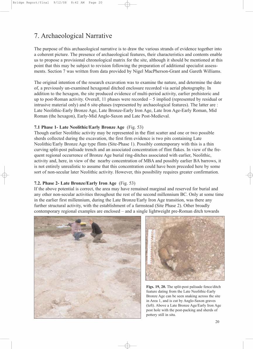
7.1 Phase 1- Late Neolithic/Early Bronze Age (Fig. 53)Though earlier Neolithic activity may be represented in the flint scatter and one or two possiblesherds collected during the excavation, the first firm evidence is two pits containing LateNeolithic/Early Bronze Age type flints (Site-Phase 1). Possibly contemporary with this is a thincurving split-post palisade trench and an associated concentration of flint flakes. In view of the fre-quent regional occurrence of Bronze Age burial ring-ditches associated with earlier, Neolithic, activity and, here, in view of the nearby concentration of MBA and possibly earlier BA barrows, itis not entirely unrealistic to assume that this concentration could have been preceded here by somesort of non-secular later Neolithic activity. However, this possibility requires greater confirmation.
7.2. Phase 2- Late Bronze/Early Iron Age (Fig. 53)If the above potential is correct, the area may have remained marginal and reserved for burial andany other non-secular activities throughout the rest of the second millennium BC. Only at some timein the earlier first millennium, during the Late Bronze/Early Iron Age transition, was there any further structural activity, with the establishment of a farmstead (Site Phase 2). Other broadly contemporary regional examples are enclosed – and a single lightweight pre-Roman ditch towards
20
Figs. 19, 20. The split-post palisade fence/ditchfeature dating from the Late Neolithic-EarlyBronze Age can be seen snaking across the sitein Area 1, and is cut by Anglo-Saxon graves(left). Above a Late Bronze Age/Early Iron Agepost hole with the post-packing and sherds ofpottery still in situ.
Bridge Report/final 9/12/08 8:42 AM Page 20

the western end of the site may represent the farmstead’s enclosure ditch. Irrespective, within thearea selected for occupation, at least one rectangular post-built structure was built and providedwith an area of flint cobble paving on its south-west side. Whether this paving was in front of alived-in building or formed part of a yard surface associated with animal byres, is uncertain.Sherds from well-paralleled fineware bowl types were found in some of the building’s post-pits.Four large storage-type pits were clustered close to this building – and at least some of the post-holes and smaller pits scattered across the site are contemporary. Interestingly, one or two of thesepits, and a small quantity of features and residual material, also produced pottery typical of theEarly Iron Age. The conjunction of both pottery types, from among a series of pits that are obviously grouped together, in the same part of the site, sharing the same size and therefore likelyfunction, and with broadly similar wear patterns, implies contemporary usage. The quantities ofdefinite EIA-type pottery are comparatively low and there are no indicators implying laterlongterm EIA activity - at least from the excavated area. It is not possible, with the available rangeof evidence, to determine how long the LBA/EIA settlement had been in existence prior to thearrival of IA-type pottery – but the above does imply that, towards the end of the LBA/EIAoccupation, continental-style EIA ceramic types were adopted and used for a short time before thesite was abandoned. It is not present in the material from the LBA/EIA settlement sited on theKingston Downs further south along the chalk trackway (Bridge By-pass Site 5; Macpherson-Grant 1980, Fig.1). It is not obviously present, but may be implied, at the dual- or multi-phase settlement at Coldharbour Lane (op.cit, Site 8) – on slightly higher ground only three-quarters of amile north-east of Star Hill. Elements from Coldharbour suggest it was partly contemporary withStar Hill. It may have either replaced it or been concurrent – and a chronology-and land-use basedassessment of these three sites is now required. In the interim, a reliable settlement start-date forStar Hill is difficult to determine, but cessation around c.550 BC or shortly after is likely, and a tentative date between c.750-550 BC is suggested for this site-phase.
7.3 Phase 3- Late Iron Age/Early Roman (Fig. 54)There is no further activity until the Late Iron Age. A few small pits and some tentative residualmaterial may be of indigenous (pre-‘Belgic’) LIA date (Site-Phase 3). This likelihood is strength-ened by the recovery of an early-style grog-tempered ’Belgic’-style storage jar rim - formallyrelated to similar types made in the indigenous flint-tempered tradition. By comparison with material from Bigbury, near Canterbury, this indicates a date within the first half of the first century BC. The nearby Bridge Hill LIA settlement (a relatively short distance east around thespur of Bridge Hill) produced both indigenous LIA and ‘Belgic’-style LIA pottery, together withan early Dr1A amphora and a potin coin. The currency of that settlement appears to be fromc.150/100 BC through until the Early Roman period. Star Hill also produced a small number of‘Belgic’-style sherds and 2 Gallo-Belgic imported sherds – but insufficient to suggest occupationin the immediate locale. Though most of these sherds represent small intrusive or residual ele-ments, a few are relatively large and fresh enough to still suggest discard not too far from a settle-ment, or at least within its periphery. The Star Hill evidence suggests no obvious activity beforec.75 BC - and possibly later than Bridge Hill. With Bridge Hill so close, it is a little unlikely thatanother farmstead would be established just round the corner. It is more realistic to see the BridgeHill settlement establishing itself, growing in relative wealth, and taking in more adjacent land –in this case the Star Hill area. The recovered ceramic from Bridge Hill indicates cessation (or settlement shift) by the earlier second century AD. The same trend appears to apply at Star Hill –strengthening the possibility that both sites could be part of the same settlement and sharing thesame basic history. At Star Hill, to date, there is little or no Roman pottery dated later thanc.125/150 AD – despite its proximity to the Roman road between Dover and Canterbury.
7.4. Phase 4- Mid Roman (Fig. 55)The creation and use of the hexagon-shaped enclosure is represented by Site-Phase 4.
21
Bridge Report/final 9/12/08 8:42 AM Page 21

It post-dates the potentially LBA/EIA ditch at the western end of the site. In addition, its neatrational form suggests it is unlikely to be of pre-Roman Iron Age date. It could be Caesarian, butthat would mean imposition into land possibly farmed by the Bridge Hill LIA settlement. Notimpossible - but its form does not automatically suggest a military function – the only realisticexplanation for its presence during that phase of Roman activity. Since it clearly pre-dates theAnglo-Saxon graves that cut into its ditch, its construction has to be of Roman date. Although thestripped area was only sampled, not completely excavated, there are very few features that can bereasonably (not absolutely) allocated to this phase. Of the pottery, the few sherds that suggest on-site activity, are exclusively of first century BC date. The remaining Conquest-period and EarlyRoman sherds are all small and abraded. Their low quantities and condition suggests derivationfrom manure spreads and implying that the immediate locale was maintained solely as arable landthroughout most of the first century AD. With only a few sherds of specifically Early Roman orMid Roman pottery, and none apparently later than c.125/150 AD – a change in land-use is indicated, a change that appears to have remained virtually constant until the Early-Anglo Saxonuse of the locale as a cemetery. It is strongly suggested that it is within this temporal space thatthe hexagon was constructed sometime after c.150 AD. It was not entirely excavated so it is notcertain whether it contained any internal structures, but its shape does not suggest a utilitarianfunction – more certainly a non-secular, perhaps memorial or cremation-type use on reserved ormarginal land.
7.5. Phase 5- Early/Mid Anglo-Saxon (Fig. 54)The topographic conjunction of the hexagon and the Anglo-Saxon cemetery (Site-Phase 5) isunlikely to be coincidental – though the fact that Saxon graves cut the hexagon’s ditch confirmsthat by the mid or later fifth century AD any visible traces of the ditch were probably slight.Several of the graves are almost exactly aligned with its south-eastern side, reinforcing the likeli-hood that their positioning was influenced by a still visible bank. An unusual cremation burial,enclosed within a substantial 4-post structure, were almost certainly similarly influenced – as maybe a thin scatter of other graves from the main cemetery area. Overall, and including the lattergraves, there are at least 4 main alignment trends. Of these, three can only be placed broadlywithin the fifth-earlier seventh centuries (Site-Phase 5A). A fourth, represented by a closely-clus-tered group partially cutting the hexagon and neatly aligned east-west, is of late seventh centurydate (Site-Phase 5B). For 5A – there are obvious family or necessity grave groups that includemixed-age and child clusters and, towards the east end of the stripped area a string of three south-
Figs. 21, 22. Students of the KAFS record-ing features as part of their course work. Astudent’s drawing (above) of one of the 7thcentury pots (Grave 11. Fig. 79)).
22
Bridge Report/final 9/12/08 8:42 AM Page 22

west to north-east aligned barrow ring-ditches. Interspersed amongst all these are a scatter ofheavily plough-damaged urned cremation burials. Without further excavation it is not possible tosay which are the earliest graves – but there are indications. Adjacent to one ring-ditch was acremation contained in a small angle-shouldered bowl with horizontal grooved above-shoulderdecoration. Its decoration and form suggest it may be a devolved version of the early faceted carinated bowls found in East Anglia and related to similar types from the Elbe river area ofnorthern Germany – and dated there to between c.375-450AD.
The implication is that some East Anglian Saxon villages pre-date c.450AD. Such a claim is notmade for Star Hill, but the basic similarity of type does suggest an early date – around AD450 orshortly after. Within the same ring-ditch, and probably pre-dating it, was another cremation, thistime in a large globular urn decorated with ‘Stehende Bogen’ or ‘standing arches’. The type ofdecoration is not unusual but the fabric is profusely coarsely sanded, more so than most Star Hillcremation pots and very similar to the fabrics of some of the earliest Saxon pottery from theCanterbury sequence which, if not close to c.450AD, are unlikely to be later than c.450-475 AD.The likelihood that the Star Hill cemetery began around c.450AD, or shortly after, is quitestrong. Site Phase 5B is at the other end of the cemetery’s currency. Four female graves all produced Anglo-Saxon silver pennies datable to AD675-690. One of these contained a Frankish-style wheel-thrown roulette-decorated bottle, possibly from a Kent workshop. In addition, atleast two of the graves were dug at the same time. Both contained deliberately placed deposits of prehistoric sherds, with a conjoin linking both graves – presumably derived from disturbing anearlier feature and re-buried as an act of ancestor honoration or pacification.
7.6. Phase 6 Late Post-Medieval (Fig. 55) Site-Phase 6 is antiquarian, represented by a Roman phase central pit excavated within the hexagon, and containing a mixture of residual and contemporary finds, pottery, tile, coal – andpresumably a by-product of antiquarian inquisitiveness during the late 18th/19th centuries.
Fig. 23. Conclusive evidence that the hexagonal feature pre-dates the Anglo-Saxon graves. Here Grave 7 has beencut into the fill of the earlier hexagonal feature ditch. The grave cut is just below the base of the ditch (Fig. 57), butthe skeleton and grave goods are above the base of the ditch and in the fill of the ditch. They have survived intact.
23
Bridge Report/final 9/12/08 8:42 AM Page 23

8. The hexagonal feature
The NMR Monument Report (TR 15 SE 154) states that at OSGB Grid Reference TR 18615368 (centre point) a “Hexagonal feature with dark centre seen on air photograph. Possibly aWorld War II military installation”. (File Number AF1077575 RCHME: Kent Mapping Project,TR 15 SE).
However, the Rev. F. Vine was aware of the hexagonal feature in 1887, and wrote in his book‘Caesar in Kent’:On the brow of the hill, in Bourne Park, there are what appear to be the remains of two[Roman] outposts, 400 yards apart, surrounded each by a ditch. They are of the samedimensions, and form almost perfect hexagons, each side being about 50 feet in length. (Vine 1887: 197).
Excavation of the adjacent Anglo-Saxon graves in 2005 showed that at least seven graves arecut into the ditch fill of the hexagonal feature (Figs. 23, 55, 56) and that the feature pre-dates the cutting of these graves in the 7th century AD.
Vine measured the sides of the hexagonal feature and found they were “about 50 [Imperial]feet”. On measuring the hexagonal feature in 2004-5 with an Electromagnetic DistanceMeasurer (EDM) it was found that the outer sides of the ditch were 18.10m long which is about60 pM (Roman feet, the pes Monetalis of 296mm length). There are six sides and six angles of60 degrees making 360 degrees. The width of the ditch is 1.97m which is 6.66 pM, and the
Fig. 24. A vertical aerial photograph of Star Hill taken on 5th Feb 1982 (NMR 2101/179: TR 1853/8). The hexagonal feature can easily be seen. It is thought that it may have had an internal bank but excavation failed toreveal any evidence. To the left (north) can be seen numerous Anglo-Saxon ring-ditches with internal burials whilstat the top of the photograph (east) are the remains of at least 12 ploughed-out round barrows.
24
Bridge Report/final 9/12/08 8:42 AM Page 24
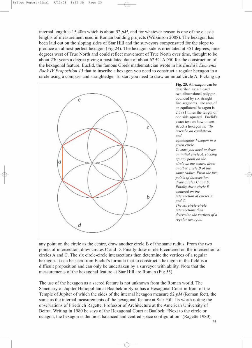
internal length is 15.40m which is about 52 pM, and for whatever reason is one of the classiclengths of measurement used in Roman building projects (Wilkinson 2008). The hexagon hasbeen laid out on the sloping sides of Star Hill and the surveyors compensated for the slope toproduce an almost perfect hexagon (Fig.24). The hexagon side is orientated at 351 degrees, ninedegrees west of True North and could reflect movement of True North over time, thought to beabout 230 years a degree giving a postulated date of about 62BC-AD50 for the construction ofthe hexagonal feature. Euclid, the famous Greek mathematician wrote in his Euclid’s ElementsBook IV Proposition 15 that to inscribe a hexagon you need to construct a regular hexagon in acircle using a compass and straightedge. To start you need to draw an initial circle A. Picking up
any point on the circle as the centre, draw another circle B of the same radius. From the twopoints of intersection, draw circles C and D. Finally draw circle E centered on the intersection ofcircles A and C. The six circle-circle intersections then determine the vertices of a regular hexagon. It can be seen from Euclid’s formula that to construct a hexagon in the field is a difficult proposition and can only be undertaken by a surveyor with ability. Note that the measurements of the hexagonal feature at Star Hill are Roman (Fig.55).
The use of the hexagon as a sacred feature is not unknown from the Roman world. TheSanctuary of Jupiter Heliopolitan at Baalbek in Syria has a Hexagonal Court in front of theTemple of Jupiter of which the sides of the internal hexagon measure 52 pM (Roman feet), thesame as the internal measurements of the hexagonal feature at Star Hill. Its worth noting theobservations of Friedrich Ragette, Professor of Architecture at the American University ofBeirut. Writing in 1980 he says of the Hexagonal Court at Baalbek: “Next to the circle or octagon, the hexagon is the most balanced and centred space configuration” (Ragette 1980).
Fig. 25. A hexagon can bedescribed as: a closedtwo-dimensional polygonbounded by six straightline segments. The area ofan equilateral hexagon is2.5981 times the length ofone side squared. Euclid’sexact text on how to con-struct a hexagon is: “Toinscribe an equilateraland equiangular hexagon in agiven circle.To start you need to drawan initial circle A. Pickingup any point on the circle as the centre, drawanother circle B of thesame radius. From the twopoints of intersection,draw circles C and D.Finally draw circle E centered on the intersection of circles Aand C. The six circle-circleintersections then determine the vertices of aregular hexagon.
25
Bridge Report/final 9/12/08 8:42 AM Page 25
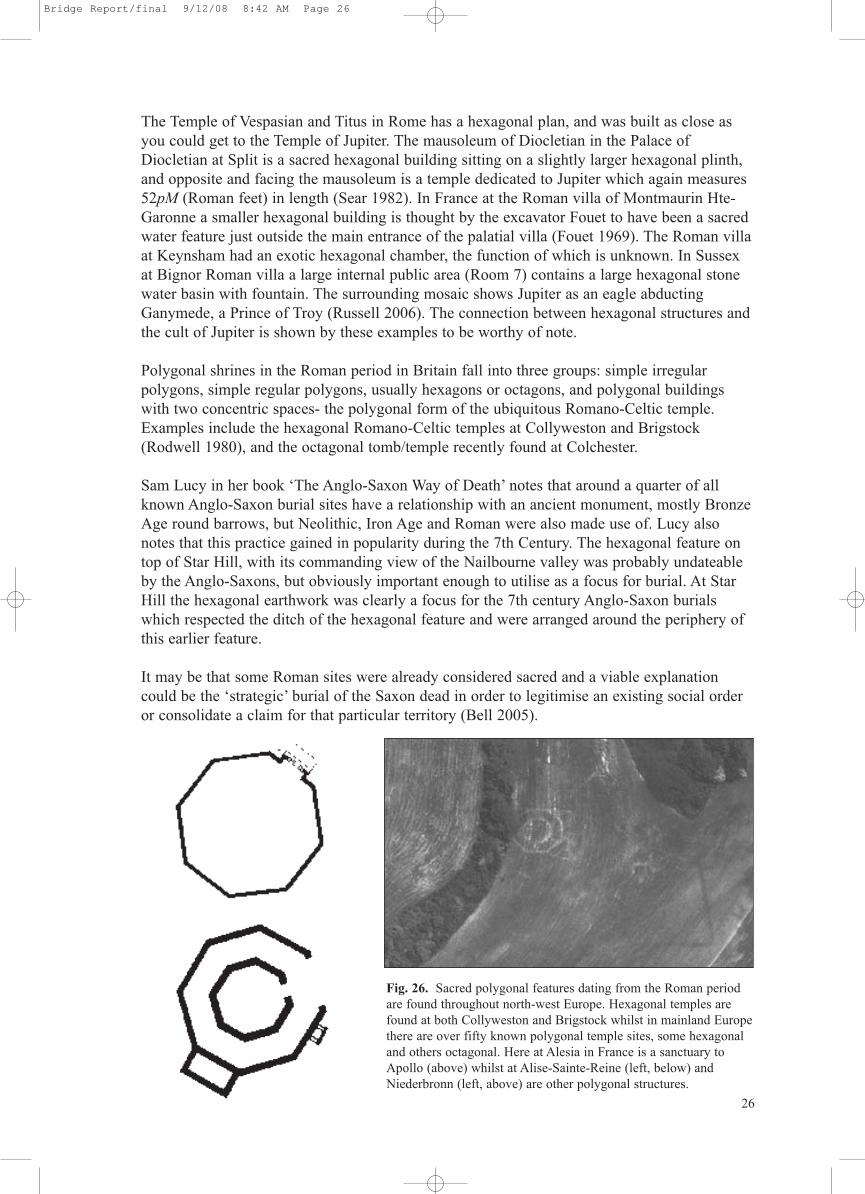
The Temple of Vespasian and Titus in Rome has a hexagonal plan, and was built as close asyou could get to the Temple of Jupiter. The mausoleum of Diocletian in the Palace ofDiocletian at Split is a sacred hexagonal building sitting on a slightly larger hexagonal plinth,and opposite and facing the mausoleum is a temple dedicated to Jupiter which again measures52pM (Roman feet) in length (Sear 1982). In France at the Roman villa of Montmaurin Hte-Garonne a smaller hexagonal building is thought by the excavator Fouet to have been a sacredwater feature just outside the main entrance of the palatial villa (Fouet 1969). The Roman villaat Keynsham had an exotic hexagonal chamber, the function of which is unknown. In Sussexat Bignor Roman villa a large internal public area (Room 7) contains a large hexagonal stonewater basin with fountain. The surrounding mosaic shows Jupiter as an eagle abductingGanymede, a Prince of Troy (Russell 2006). The connection between hexagonal structures andthe cult of Jupiter is shown by these examples to be worthy of note.
Polygonal shrines in the Roman period in Britain fall into three groups: simple irregular polygons, simple regular polygons, usually hexagons or octagons, and polygonal buildingswith two concentric spaces- the polygonal form of the ubiquitous Romano-Celtic temple.Examples include the hexagonal Romano-Celtic temples at Collyweston and Brigstock(Rodwell 1980), and the octagonal tomb/temple recently found at Colchester.
Sam Lucy in her book ‘The Anglo-Saxon Way of Death’ notes that around a quarter of allknown Anglo-Saxon burial sites have a relationship with an ancient monument, mostly BronzeAge round barrows, but Neolithic, Iron Age and Roman were also made use of. Lucy alsonotes that this practice gained in popularity during the 7th Century. The hexagonal feature ontop of Star Hill, with its commanding view of the Nailbourne valley was probably undateableby the Anglo-Saxons, but obviously important enough to utilise as a focus for burial. At StarHill the hexagonal earthwork was clearly a focus for the 7th century Anglo-Saxon burialswhich respected the ditch of the hexagonal feature and were arranged around the periphery ofthis earlier feature.
It may be that some Roman sites were already considered sacred and a viable explanationcould be the ‘strategic’ burial of the Saxon dead in order to legitimise an existing social orderor consolidate a claim for that particular territory (Bell 2005).
Fig. 26. Sacred polygonal features dating from the Roman periodare found throughout north-west Europe. Hexagonal temples arefound at both Collyweston and Brigstock whilst in mainland Europethere are over fifty known polygonal temple sites, some hexagonaland others octagonal. Here at Alesia in France is a sanctuary toApollo (above) whilst at Alise-Sainte-Reine (left, below) andNiederbronn (left, above) are other polygonal structures.
26
Bridge Report/final 9/12/08 8:42 AM Page 26

27
9. Archaeological Finds
9.1 Artefact finds This report on the artefacts was compiled by Gareth Williams from the British Museum. It isunderstood that a full report on the small finds from Star Hill will be undertaken by the staff ofthe British Museum for the final report.
A total of eleven Anglo-Saxon graves were discovered in the fill of the ditch of a hexagonal feature believed to be of Roman date. All of the burials were oriented east-west with the head atthe west end, and most had grave goods. Four of these graves (graves, 1, 5, 6 and 9) containedcoins. In each case the coins came from female burials, in which the grouping of the coins suggested that they had been contained in a bag, which had been placed at the woman’s feetalong with other grave goods. One of the graves (Grave 5) which contained coins also containeda scutiform disc pendant. A variety of other material was found in these four graves, as well as inthose graves which contained no precious metal objects. In the opinion of the excavators, thisgroup of graves represent a distinct group within the cemetery.
Each of the four graves containing coins, each a separate Treasure case, has been assigned a separate sub-number within the overall administrative number 2005 T115, as T115 a-d.
All of the coins were early Anglo-Saxon pennies (sometimes misleadingly known as sceattas),and each grave contained a mixture of coins of Series A and B. These represent the primaryphase of the Anglo-Saxon penny coinage, from c. AD680-690. The metal content of these particular coins has not been tested, since a large enough sample of similar material has previously been tested that we can be certain that the coins will have a very high silver content,well in excess of the 10% threshold required by the Treasure Act. In each case, there are morethan 2 coins, as required by the terms of the Act. In the case of Grave 5 (T2005 115b), the scutiform pendant would constitute a case of potential Treasure in its own right, since it has aprecious metal content of around 95% (see attached report). This type of pendant can also bedated to the 7th century, consistent with the date of the coins, and in each case the remainingobjects are of the same date, leaving no doubt that they should be associated.
There is no surviving evidence through which the original ownership of the objects can be traced,and since the coins in all four cases, and the brooch in case T2005 115b, exceed the threshold of10% precious metal and are more than 300 years old, it is therefore my opinion that each of thesecases represents a prima facie case of Treasure under the terms of the Treasure Act (1996). Theother non-precious material listed in each case should also be considered as Treasure by association under the terms of the Act.
9.2 CoinsAll of the coins were early Anglo-Saxon pennies (sometimes misleadingly known as sceattas),and each grave contained a mixture of coins of Series A and B. These represent the primaryphase of the Anglo-Saxon penny coinage, from c. AD675-690. Series A is attributed to the king-dom of Kent, and Metcalf (1993, 85-6) suggests that it most plausibly dates from the reign ofKing Hlothere (673-85). Series B is also well-known from Kentish graves, and is sometimesfound alongside Series A, but the distribution of single finds suggests that this series is more like-ly to have been issued north of the Thames, either in Essex or East Anglia. The series subdividesinto four main groups, which again subdivide, but all of the coins from Bridge which can be cer-tainly identified fall into group BI, which appears to be broadly contemporary with Series A,although it may extend a little later (Metcalf 1993, 94-102). The established classification withinSeries B (Rigold 1960-61) is overly complicated. Metcalf (1993, 94) notes the existence of over
Bridge Report/final 9/12/08 8:42 AM Page 27
150 recorded examples across the whole of Series B, from an estimated total of 150 obverse and300 reverse dies. The 33 (actually 64 were delivered to the British Museum-PW) examples fromBridge, all apparently within group BI, represent a substantial addition to the corpus (especiallyas other single finds have emerged since Metcalf’s study), and prompt a re-examination of theseries and its internal classification, and this work is currently ongoing, and will be presented infull at a later date. For now it is sufficient to note that there are few if any die links within eachof the grave assemblages, or between the different graves. This reinforces the impression givenby Metcalf’s figures that this is a very substantial coinage, and implies fairly extensive use andcirculation of coinage in the region at the time that the coins were deposited. The similarity ofthe composition of the groups of coins from all four graves suggest that the burials took placewithin a fairly short space of time.9.3 Disc-pendantIn addition to coins, grave finds also contained a base-gold scutiform pendant, weighing 3.68g.Non-destructive X-ray fluorescence analysis of the surface carried out at the British Museum bySusan La Niece and Antony Simpson, indicated a gold content of 46-48%, a silver content of 47-49%, with a little copper.Scutiform disc-pendants are known from Anglo-Saxon graves from the sixth and seventh cen-turies. Hines (1984, 221-35) has suggested that there may have been a gap in production and usefrom c. AD560-650, but Geake (1997, 38) has questioned this. However, a pendant of this type iscertainly consistent with the late seventh-century date suggested by the coins, and the use ofbase-gold also has parallels with the general reduction in the gold content of the coinage in thecourse of the century although pendants which can be firmly dated as late as this are rare.Scutiform pendants are typically associated with female burials, and may have had an amuleticfunction as ‘symbolic shields’ (Meaney 1981, 159-62; Geake 1997, 38-9).
9.4 Lithic assemblageQuantification and analysis of flint artefacts has been completed by Chris Butler, Terry Hardaker,and R J MacRae. An interim assessment can be found in the Appendix IV.
9.5 Ceramic assemblageA full assessment of the ceramic assemblage by Nigel MacPherson-Grant is with the SiteArchive. Synthesis of this material is provided in Appendix III. Pottery drawings are nearingcompletion- see Fig. 79.
9.6 Environmental evidenceQuantification and analysis of the environmental evidence has been disappointing due to the alkaline nature of the deposits, but good results may be forthcoming from the prehistoric pits.
9.7 Grave goods, discussion of typesGrave goods are in the care of the British Museum and a full assessment of all findings will formpart of the final report. A full list of grave goods and small finds is provided in Appendix I.
9.8 Human and animal bonesFew bones were retrieved from the chalk matrix of the graves, but information on the sex andage, including isotope studies, based on the surviving bones will form part of the final report.
9.9 Summary of the Site ArchiveIn addition to the artefact assemblages mentioned above, the Site Archive includes:Correspondence, 546 digital photographs, 128 35mm colour slides, 79 A3 permatrace site drawings of plans, and sections. Context register. A full archive catalogue will be prepared for publication pending receipt of final specialist reports. 28
Bridge Report/final 9/12/08 8:42 AM Page 28
10. Recommendations for further archaeological assessment
10.1 Statement of potentialThe archaeological excavations at Star Hill, Bridge have confirmed the presence of numerous5th-7th century Anglo-Saxon graves impacting on an earlier Roman hexagonal feature. Alsorevealed was an extensive multiphase site of some magnitude. If an opportunity offers itself itwould be productive to carry out ( with the permission of English Heritage and the landowner)a Level 3 survey including a full geophysical survey on Star Hill and its environs.
It was not unusual for the Anglo-Saxons of the 5th to 7th centuries to seek the proximity of earlier monuments when burying their dead. But the 5th century cremation burials retrievedfrom Star Hill are unusual in East Kent and need further study. The form and decoration of thesurviving cremation urns, grave goods and stray finds can be dated to the 5th-7th centuries andare of importance given how scarce such material is in Kent. Furthermore the un-excavatedareas of Star Hill have enormous potential to shed more light on the as yet poorly understoodtransition from Late Roman Britain to Early Anglo-Saxon England.
It has been noted from work undertaken for the Research Design (Appendix V) that theNailbourne valley has the potential to reveal other areas of archaeological activity includingAnglo-Saxon settlements, some of which have been discovered in recent KAFS field-walkingexercises. However, before further work is undertaken in the Nailbourne environs it is essentialthat all of the various local archaeological factions agree to a regional Research Design monitored by Canterbury City Council, and English Heritage.
10.2 Preparation of Full Report & PublicationA full report will be produced within five years of this post-excavation assessment. Within thistime the Kent Archaeological Field School and English Heritage will discuss and agree with theCanterbury City Archaeologist the scope of the final report, the format and destination of subsequent publications arising from excavation and post-excavation work on the study site.
10.3 ConclusionsThe archaeological excavations at Star Hill, Bridge have been carried out in accordance with awritten Project & Research Design (Appendix V). Archaeological remains present within thestudy site have been assessed and reported, enabling preservation by Scheduling (Fig. 41) andby record. A wealth of important data on the formation of human activity in the landscape hasbeen retrieved, and an opportunity realised to teach a future generation of archaeologists theimportance of landscape interpretation and Anglo-Saxon cemetery studies.
10.4 AcknowledgmentsThe Kent Archaeological Field School would like to thank Vanessa McDonald and her familyfor unstinting support, for Maurice Raraty of the Bridge and District History Society, and toPeter Kendall and Judith Roebuck of English Heritage. Thanks are also extended to Ges Moodyand Emma Boast for site survey and illustrations, to Chris Fern, Fern Archaeology, and JamesMadden for illustrations, and to the staff and students of the KAFS and various universities,both here and abroad, who carried out the archaeological fieldwork. The fieldwork was directed by Paul Wilkinson aided by Ronnie Jenkins, Louise Cooke, Andy Stephney, CatherineWilkinson, Mick Butler and Mike Robson.
Dr Paul WilkinsonJune 2008 29
Bridge Report/final 9/12/08 8:42 AM Page 29
11. References
Bell T. 2005 The Religious Reuse of Roman Structures in Early Medieval England.
Down A. & Welch M. 1990 Chichester Excavations VII: Apple Down and the Mardens.
Fouet G. 1969 La villa gallo-romaine de Montmaurin.
Lucy S. 2000 The Anglo-Saxon way of Death.
Macpherson-Grant N. 1980 Archaeologia Cantiana Vol. XCVI.
Percival J. 1976 The Roman Villa.
Ragette F. 1980 Baalbek.
Rodwell W. 1980 Temples, Churches and Religion: Recent Research in Roman Britain.
Russell M. 2006 Roman Sussex.
Sear F. 1982 Roman Architecture.
Vine F. (Rev) 1887 Caesar in Kent.
Wilkinson P. 2006-8 Kent Archaeological Field School Newsletters.
Wilkinson P. 2008 Investigation of the Roman Barn at Hog Brook, Teynham, Kent.
30
Bridge Report/final 9/12/08 8:42 AM Page 30