terms - weeblymcs4thgrade.weebly.com/uploads/3/7/4/0/37403421/al_history_chapte… · 36 alabama:...
TRANSCRIPT

36 Alabama: Our Beautiful Home
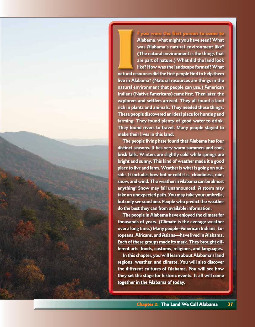
Above: This view of the Talladega Mountains, in the Piedmont region, was taken from Mount Cheaha, the highest point in Alabama.
T E R M Snatural environment,
natural resource, weather, climate, pioneer, geology, mineral, swamp, fertile, surface water, aquifer, groundwater, wetland, waterway, salt marsh,
delta, estuary, subtropical, temperature, precipitation, natural hazard, drought,
fl ash fl ood, lightning, tornado, hurricane, evacuate, natural
vegetation, evergreen tree, deciduous tree,
ecosystem, technology
Chapter 2: The Land We Call Alabama 37
f you were the first person to come toAlabama, what might you have seen? What was Alabama’s natural environment like? (The natural environment is the things that are part of nature.) What did the land look like? How was the landscape formed? What
natural resources did the fi rst people fi nd to help them live in Alabama? (Natural resources are things in the natural environment that people can use.) American Indians (Native Americans) came fi rst. Then later, the explorers and settlers arrived. They all found a land rich in plants and animals. They needed these things. These people discovered an ideal place for hunting and farming. They found plenty of good water to drink. They found rivers to travel. Many people stayed to make their lives in this land.
The people living here found that Alabama has four distinct seasons. It has very warm summers and cool, brisk falls. Winters are slightly cold while springs are bright and sunny. This kind of weather made it a good place to live and farm. Weather is what is going on out-side. It includes how hot or cold it is, cloudiness, rain, snow, and wind. The weather in Alabama can be almost anything! Snow may fall unannounced. A storm may take an unexpected path. You may take your umbrella, but only see sunshine. People who predict the weather do the best they can from available information.
The people in Alabama have enjoyed the climate for thousands of years. (Climate is the average weather over a long time.) Many people–American Indians, Eu-ropeans, Africans, and Asians—have lived in Alabama. Each of these groups made its mark. They brought dif-ferent arts, foods, customs, religions, and languages.
In this chapter, you will learn about Alabama’s land regions, weather, and climate. You will also discover the different cultures of Alabama. You will see how they set the stage for historic events. It all will come together in the Alabama of today.

Maps are very important in our study of manysubjects. A map is a picture or drawing of a larger place. Maps show landforms such as lakes, rivers, and mountains. Maps can show where people live. They can show the kinds of crops grown. They can even show where events took place.
If you can read a map’s parts, you can read a map. A map might show the height of the land. Such a map is called a relief map. Different col-ors can be used to show different land heights. Land height above sea level is its elevation. The colors might show other things like where crops are grown.
The compass rose shows which way is north, south, east, or west. It usually points to the top for north, but not always. If you cannot fi nd a compass rose on the map, the top of the map should be north.
Now we will read a map. Find the relief map of the United States of America in the Atlas of Alabama. The leader will read the instructions. Everyone will perform the task. You may play on teams or individually. 1. Point to the compass rose. 2. Determine and point to which direction
is north on the map. Which direction is south? Which direction is east? Which direction is west?
3. Point to Alabama. 4. What large lakes are north of Alabama?
38 Chapter 2: The Land We Call Alabama
5. What large body of water is directly south of Alabama?
6. If you were going to drive to California, in which direction would you go? To Indiana? To South Carolina?
7. Study the difference in colors on the map. Can you tell that the tan, brown, and orange show land at higher elevations? Which part of the United States appears to have more mountains? The eastern part? The western part?
8. Study the difference in colors in Alabama. Which area of Alabama appears to have lower altitude? The southern part? The northern part?
9. Now close your eyes. Point to the north without opening your eyes. Keep your hands pointing and open your eyes. Is everyone pointing in the same direction?
10. With your teacher, determine which way is north. You may use a compass.
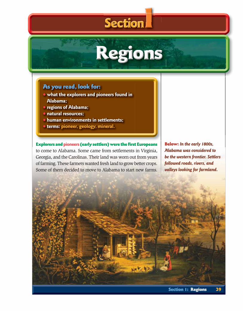
Explorers and pioneers (early settlers) were the fi rst Europeansto come to Alabama. Some came from settlements in Virginia, Georgia, and the Carolinas. Their land was worn out from years of farming. These farmers wanted fresh land to grow better crops. Some of them decided to move to Alabama to start new farms.
Below: In the early 1800s, Alabama was considered to be the western frontier. Settlers followed roads, rivers, and valleys looking for farmland.
Section 1: Regions 39
As you read, look for:• what the explorers and pioneers found in
Alabama;• regions of Alabama; • natural resources;• human environments in settlements;• terms: pioneer, geology, mineral.

Choosing Where to SettleThese people had to decide where in the new territory to settle.
They found fi ve different kinds of land in Alabama. They also had to decide the best way to get there. As time passed, travelers told one another about roads to Alabama. People who came back told others the easiest routes for travel. Word was also passed on about where the best farmland was located.
Farmers were not the only people coming to Alabama. Some of the settlers brought their black slaves. There were also a few free blacks among the settlers. Later, other people came as storekeepers, miners, builders, and laborers. They also had to know how to get here and where they could work. The settlers had to decide where to move in the new territory. The regions of Alabama were an important part of their decision. It was harder to travel to some of the regions than to others. And the land was better for farming in certain regions.
told others the easiest routes for travel. Word was also passedon about where the best farmland was located.
Farmers were not the only people coming to Alabama. Someof the settlers brought their black slaves. There were also afew free blacks among the settlers. Later, other people came asstorekeepers, miners, builders, and laborers. They also had toknow how to get here and where they could work. The settlershad to decide where to move in the new territory. The regions ofAlabama were an important part of their decision. It was harderto travel to some of the regions than to others. And the land wasbetter for farming in certain regions.
40 Chapter 2: The Land We Call Alabama
Map Skill: Which of the states that borderAlabama have just onetype of land region?

Land Regions of AlabamaAlabama’s land is divided into regions based on the geology
of the rocks. Geology deals with the history of Earth, especially the history recorded in rocks. The land regions in Alabama do not stop at the state line. They are also in neighboring states. The fi ve regions are the Coastal Plain, the Piedmont, the Ridge and Valley, the Appalachian Plateau, and the Interior Plateau.
Map Skill: Which land region appears to be the largest?
Map Skill: Looking at maps Map 3 and 4:1. Which region is mostlikely for travel throughthe valleys? 2. Whatstates did most peopleusing the Huntsville Road travel through?
Section 1: Regions 41

The Coastal PlainThe southern part of Alabama seems almost
fl at. But part of this area is made of gently roll-ing hills. It lies in a region called the Coastal Plain. Notice that the Coastal Plain stretches all the way from Texas to New Jersey. Rivers that fl ow across the Coastal Plain run toward
the ocean. Elevations in Alabama’s Coastal Plain range from about 500 feet inland to sea level (0 feet) at the Gulf of Mexico. Oil and natural gas are found in this region. More than half of Alabama’s land lies in the Coastal Plain.
Remember these settlers did not have cars or trucks to take them to Alabama. There were no paved roads to make travel easier. They came in wagons and carts or riding horses or mules. Some even came on foot. Because the Coastal Plain is fl atter, it is easier to travel through than mountains. Many settlers moved into this area because they could travel by river or over fl at land. They came to the Coastal Plain mostly from South Carolina and Georgia. They traveled on or near the Federal Road. Some came by ship into Mobile Bay and then up the Alabama and Tombigbee rivers.
Below: Salt marshes along the coast of Alabama are an important breeding place for many kinds of aquatic life.
The state has 50 miles of coastline.
42 Chapter 2: The Land We Call Alabama
The Fall Line is at the northern edge of the Coastal Plain. This imaginary line separates the Coastal Plain from the other regions. Elevations in the northern part of the state are higher than on the Coastal Plain. Where rivers fl ow from the higher land onto the Coastal Plain, you usually fi nd waterfalls or rapids.
Why would people later build cities like We-tumpka on the Fall Line? At that time, there was no electricity. People had to use other ways to make machinery work. Settlers who had facto-ries needed waterpower to run their machines. Those who planned gristmills for grinding grains into fl our and meal also needed power. So these people moved along the Fall Line to harness the power of the swift-fl owing water.
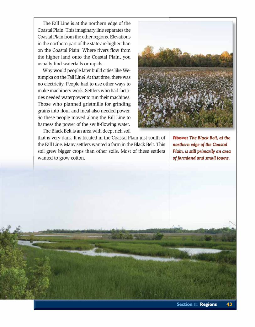
The Black Belt is an area with deep, rich soil that is very dark. It is located in the Coastal Plain just south of the Fall Line. Many settlers wanted a farm in the Black Belt. This soil grew bigger crops than other soils. Most of these settlers wanted to grow cotton.
Section 1: Regions 43
Above: The Black Belt, at the northern edge of the Coastal Plain, is still primarily an area of farmland and small towns.

The PiedmontAnother region begins in east-central Ala-
bama. The Piedmont extends through Georgia and the Carolinas all the way to New Jersey. It is a rolling landscape with low hills and broad valleys. The hills of the Piedmont are all that are left of an old mountain range. Over time,
wind and rain have worn away most of the mountains. Mount Cheaha, the highest point in the state, lies in the Talladega Forest in the Piedmont region.
Settlers moved into the Piedmont where there was good land. The river valleys were ideal for growing cotton and other crops. The success of farming there made the Piedmont attract more settlers. These new people needed supplies. Villages and towns were built to meet the settlers’ needs. These settlements pro-vided ways for others to make a good living. The towns might have a general store and a blacksmith shop. Some villages had a gristmill. There were even some sawmills that made lumber from the area’s many trees. With all of these changes, the settlers created human environments.
The oldest known rock in the state is in Lee County at Chewacla State Park. It is over one billion years old.
crcrcreaeaeatetetedd d huhuhumamamann n enenenvivivirororonmnmnmenenentststs...
Below: The valleys of the Piedmont are good for farming.This small Piedmont farm is in Randolph County.
44 Chapter 2: The Land We Call Alabama

Above: At 2,413 feet, Mount Cheaha in Cleburne County is the highest point in Alabama.
Some of the rocks in this area changed long ago to marble. These natural resources attracted new settlers to work in the Piedmont’s stone quarries. the highgg est popp int in Alabama.PiPiededmomom ntntnt sss ssstotonene qqqqquauarrrrieiees.s.
Section 1: Regions 45
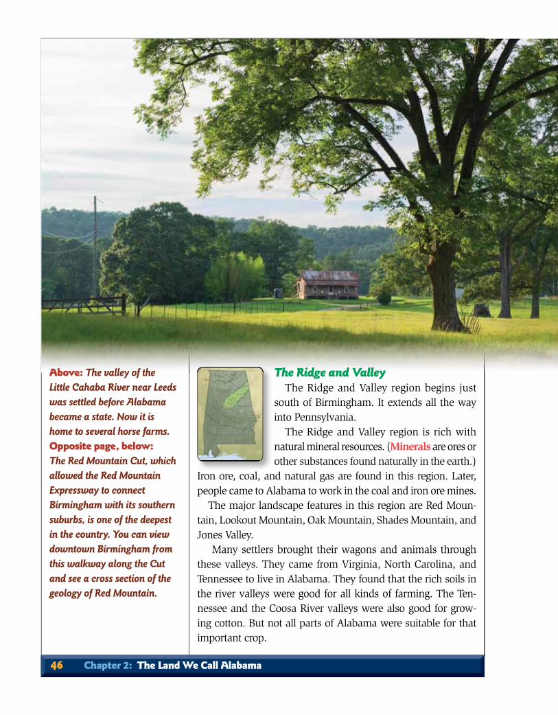
The Ridge and ValleyThe Ridge and Valley region begins just
south of Birmingham. It extends all the way into Pennsylvania.
The Ridge and Valley region is rich with natural mineral resources. (Minerals are ores or other substances found naturally in the earth.)
Iron ore, coal, and natural gas are found in this region. Later, people came to Alabama to work in the coal and iron ore mines.
The major landscape features in this region are Red Moun-tain, Lookout Mountain, Oak Mountain, Shades Mountain, and Jones Valley.
Many settlers brought their wagons and animals through these valleys. They came from Virginia, North Carolina, and Tennessee to live in Alabama. They found that the rich soils in the river valleys were good for all kinds of farming. The Ten-nessee and the Coosa River valleys were also good for grow-ing cotton. But not all parts of Alabama were suitable for that important crop.
Above: The valley of the Little Cahaba River near Leeds was settled before Alabama became a state. Now it is home to several horse farms. Opposite page, below: The Red Mountain Cut, which allowed the Red Mountain Expressway to connect Birmingham with its southern suburbs, is one of the deepest in the country. You can view downtown Birmingham from this walkway along the Cut and see a cross section of the geology of Red Mountain.
46 Chapter 2: The Land We Call Alabama
Section 1: Regions 47

The Appalachian Plateau and the Interior Plateau
North and west of the Ridge and Valley are two plateau regions. A plateau is a higher area made of layers of rock that are nearly fl at.
The Appalachian Plateau region begins in Alabama around Jasper. It extends north
through Tennessee and Kentucky into western New York. Coal is found in this region. The Interior Plateau begins in northern Alabama and extends north to the Ohio River and into southern Indiana. The Tennessee River has made a wide valley that runs through the Interior Plateau region. People sometimes call this part of Alabama the Highland Rim.
Settlers moved into these regions mostly through the valleys of the Ridge and Valley region and the Huntsville Road. Many of these people came from North Carolina, Virginia, Tennessee, and Kentucky to seek new land.
Many farmers moved to the river valleys of the region to grow cotton. Some moved to other land to grow other crops. Later, miners and quarrymen came to work in the coal mines and stone quarries.
48 Chapter 2: The Land We Call Alabama
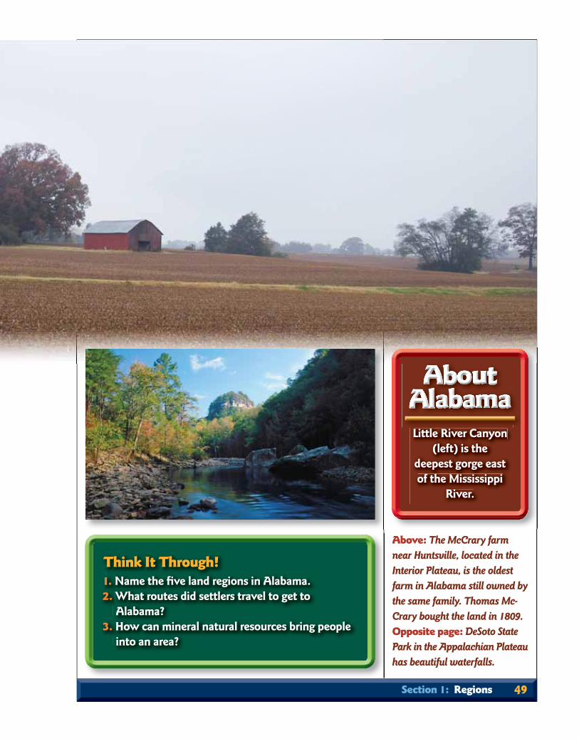
Little River Canyon (left) is the
deepest gorge east of the Mississippi
River.
Think It Through!1. Name the fi ve land regions in Alabama.2. What routes did settlers travel to get to
Alabama?3. How can mineral natural resources bring people
into an area?
Above: The McCrary farm near Huntsville, located in the Interior Plateau, is the oldest farm in Alabama still owned by the same family. Thomas Mc-Crary bought the land in 1809. Opposite page: DeSoto State Park in the Appalachian Plateauhas beautiful waterfalls.
Section 1: Regions 49
Why did large numbers of settlers come to Alabama? Thearea’s natural resources made it a great place to live. The weather and rich soil were good for farming. Because of Alabama’s cli-mate, most of the state had a growing season of over 200 days. The area also had a good supply of water and many kinds of minerals. These were all important reasons for choosing Ala-bama as home.
The layers of rock in Alabama contain many minerals that people use. Sand and clay are used to make pottery and glass. Rocks are used to make everything from arrowheads to skyscrap-ers. Some of the more important rocks are limestone, sandstone, and marble. You will learn later how iron ore helped Birmingham grow “magically.”
Some of these rocks give us clues about Alabama’s prehistoric (before written history) environment. Limestone formed at the bottom of a saltwater sea. Wherever you fi nd limestone, you know that the land was once under an ocean. Coal is made of plants and animals that once lived in a swampy environment. So where you fi nd coal, you know that there once was a swamp (fl ooded forest) in that area.
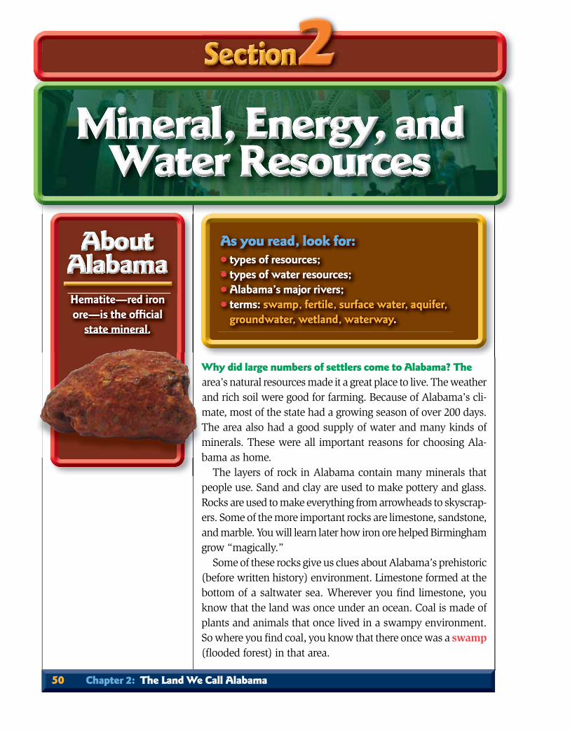
Hematite—red iron ore—is the offi cial
state mineral.
As you read, look for:• types of resources; • types of water resources;• Alabama’s major rivers;• terms: swamp, fertile, surface water, aquifer,
groundwater, wetland, waterway.
50 Chapter 2: The Land We Call Alabama
WaamTmb

SoilRocks break down very slowly, forming soil. The minerals
that were in the rocks become part of the soil. Decayed material from plants also becomes part of the soil.
In Alabama, there are many kinds of rocks and minerals. There are also many kinds of plants. So Alabama has many kinds of soil. Some soils are very fertile; that is, they are good for growing things. Other soils are very poor for growing things.
Section 2: Mineral, Energy, and Water Resources 51
Map Skill: What mineral or energy resources are found in or near your county?
Above: The fertility of soil can have a dramatic impact on theeconomic prosperity of an area.

Water ResourcesFreshwater is an important part of the natural environment.
Plants, animals, and people could not survive without water. Alabama’s water resources are found on the surface of the land and underground.
Surface WaterSurface water is found in rivers, streams, lakes, and wetlands.
(Wetlands are places that are wet all or part of the year.) Alabama has more than 77,000 miles of rivers and streams. The state
Map Skill: From your home, which river(s) would you travel to get to the Gulf of Mexico?
52 Chapter 2: The Land We Call Alabama

River Source Location Direction of Flow
Alabama Formed by Coosa and Southwest Southwest Tallapoosa Rivers; fl ows Alabama into Mobile River
Black Warrior Northeast Alabama; fl ows Central and Southwest into Tombigbee River western Alabama
Cahaba Origin is north of Central South Birmingham; fl ows into Alabama Alabama River
Chattahoochee Flows into state from Southeast South Georgia, then borders Alabama Georgia and Alabama; fl ows into Florida
Choctawhatchee Forms south of Eufaula; Southeast Southwest fl ows into Florida Alabama
Conecuh Forms east of Montgomery; South-central Southwest fl ows into Florida Alabama
Coosa Flows into state from East-central Southwest Georgia; fl ows into Alabama Alabama River
Mobile Formed by Alabama and Southwest South Tombigbee Rivers; fl ows Alabama into Mobile Bay
Pea Formed north of Eufaula; Southeast South fl ows into Choctawhatchee Alabama River
Tallapoosa Flows into state from East-central South west Georgia; fl ows into Alabama Alabama River
Tennessee Flows into state in northeast Northern West and exits northwest Alabama
Tombigbee Flows into state from Western South Mississippi; fl ows into Alabama Mobile River
Section 2: Mineral, Energy, and Water Resources 53

has 6 rivers that are deep and wide enough for large boats. Rivers used for transportation are called waterways. Indi-ans, settlers, traders, farmers, miners, and others used the waterways to travel and carry supplies.
Surface water could also be a problem. Settlers in wagons had no bridges to cross rivers, creeks, or swamps. They had to fi nd other ways to cross the water. Sometimes they could use rafts to cross the river. Oth-ers used extra horses to pull wagons across creeks. Many just carried their belongings across on foot.
Study the chart on page 53 to fi nd how settlers could use these rivers for travel. It is im-portant to fi nd where the river begins (source). You should also notice the direction of the fl ow. Keep in mind that these early settlers had no motors on their boats and canoes. Most of the river travel was with the river’s fl ow. It was hard to
push with poles or paddles against the fl ow. Three of Alabama’s rivers form parts of the state’s borders.
The Tennessee River, the state’s largest river, is part of our border with Mississippi. The Chattahoochee River is part of our divid-ing line with Georgia. The Perdido River is part of the border between Alabama and Florida.
Aquifers Did you wonder where the water in a spring or well came
from? A great amount of water is stored beneath the surface of the earth. When it rains, some of the water soaks into the
puppupupupupupupupu hhshhshhshshshshsh wwwwwwititititititititititithhhhhhhh poppopopopopopopop lllellelelelelelelelessssssss orororororororr pppppppp ddadddadadadadadadaaddldldldlddldldldldldldleseseseseseseseseses aaaaaaaaggggggggAbove: Rivers below the Fall Line are usually broad and slow-moving. The Tombigbee River near Demopolis in the Black Belt is famous for its white chalk bluffs.
54 Chapter 2: The Land We Call Alabama

ground. It fi lls up tiny spaces in layers of gravel and rock. These layers act like sponges and are called aquifers. Water stored in the aquifers is called groundwater. Groundwater seeps out of aquifers and forms springs.
Early settlers needed water close to the surface for drinking and watering their livestock. They got their water from wells, springs, creeks, and rivers. One of the reasons they chose a place to stay was a good supply of water. Notice that many cities and towns are on creeks and rivers.
There are 20 large aquifers in Alabama. They are located under the Coastal Plain, the Ridge and Valley, and the Interior Plateau regions of the state.
Think It Through!1. What is coal made of?2. Why was a good supply of water important to
settlers?3. Which river is part of the border between
Alabama and Florida?
Half of the state’s population depends on groundwater for their drinking water.
Above: The broad rivers of the Coastal Plain begin as fast-moving rivers like the Little River on Lookout Mountain in the Appalachian Plateau.
Section 2: Mineral, Energy, and Water Resources 55
56 Chapter 2: The Land We Call Alabama
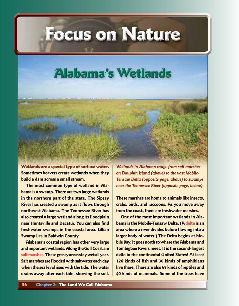
Wetlands are a special type of surface water.Sometimes beavers create wetlands when they build a dam across a small stream.
The most common type of wetland in Ala-bama is a swamp. There are two large wetlands in the northern part of the state. The Sipsey River has created a swamp as it fl ows through northwest Alabama. The Tennessee River has also created a large wetland along its fl oodplain near Huntsville and Decatur. You can also fi nd freshwater swamps in the coastal area. Lillian Swamp lies in Baldwin County.
Alabama’s coastal region has other very large and important wetlands. Along the Gulf Coast are salt marshes. These grassy areas stay wet all year. Salt marshes are fl ooded with saltwater each day when the sea level rises with the tide. The water drains away after each tide, showing the soil.
These marshes are home to animals like insects, crabs, birds, and raccoons. As you move away from the coast, there are freshwater marshes.
One of the most important wetlands in Ala-bama is the Mobile-Tensaw Delta. (A delta is an area where a river divides before fl owing into a larger body of water.) The Delta begins at Mo-bile Bay. It goes north to where the Alabama and Tombigbee Rivers meet. It is the second-largest delta in the continental United States! At least 126 kinds of fi sh and 30 kinds of amphibians live there. There are also 69 kinds of reptiles and 40 kinds of mammals. Some of the trees have
Wetlands in Alabama range from salt marshes on Dauphin Island (above) to the vast Mobile-Tensaw Delta (opposite page, above) to swamps near the Tennessee River (opposite page, below).

Section 2: Mineral, Energy, and Water Resources 57
adapted to life in wet soil by growing “knees.” These knees give the tree extra support to stand up straight in water.
Mobile Bay and the Delta form an area called an estuary. An estuary is a place where fresh-water from rivers mixes with saltwater from the ocean. This special mix of water is an ideal place for many water animals to live. Shrimp, blue crabs, and oysters need this kind of water when they are young. As they get older, they can live in saltier water. Many people along the Alabama coast depend on fi shing to make a liv-ing. We would not have as many fi sh if we did not have coastal wetlands.
A deepwater oil-drilling rig exploded in April 2010. This accident in the Gulf of Mexico killed 11 people. It took BP, the company that drilled the well, 3 months to stop the oil from gushing.
The oil rose to the top of the water. It fl oated to the shore of the Gulf. The oil polluted the sand and wetlands of Louisiana, Mississippi, Alabama, Florida, and Texas. Many animals were killed by the oil.
People along the coast lost money because of the oil spill. The people who fi sh for a liv-ing could not fi sh. Restaurants could not serve fresh seafood. Vacationers did not come to the beach to play. The oil spill was a terrible event for Alabama and its neighboring states.
Human activity can destroy wetlands. Scien-tists believe that one-half of Alabama’s wetlands have been destroyed over the last 200 years. What caused this destruction? Trees were cut down. Ditches were dug to drain away the wa-ter. The water became polluted. Pollution in a river is carried to the coast where it can harm wetlands. It will take the help of people all over Alabama to protect the water.
Every television and radio station has people who talk aboutthe weather each day. They discuss how hot or cold it is and what the chances are that it will rain. They tell you what it is going to be like tomorrow and the next day. This information helps you plan what to wear.
Understanding your area’s climate can be very useful too. It helps your school principal plan for how many snow days you may need this year. Knowing average amounts of rainfall helps farmers decide which crops to plant.
Temperature and PrecipitationAlabama is located just north of the Tropic of Cancer. The
state’s climate is subtropical or temperate. The winter months are colder than the summer months. Alabama summers are long and very warm. Average monthly summer temperatures (how hot or cold it is) are in the low-80s°F (Fahrenheit). Winters here are short and mild with average temperatures in the mid-40s°F.
The mountainous areas of the state are at higher altitudes. These parts of Alabama are usually cooler year round. They have more winter days with temperatures near freezing, which is 32°F.
As you read, look for:• the climate zone for Alabama; • types of precipitation;• terms: subtropical, temperature, precipitation,
natural hazard, drought, fl ash fl ood, lightning, tornado, hurricane, evacuate.
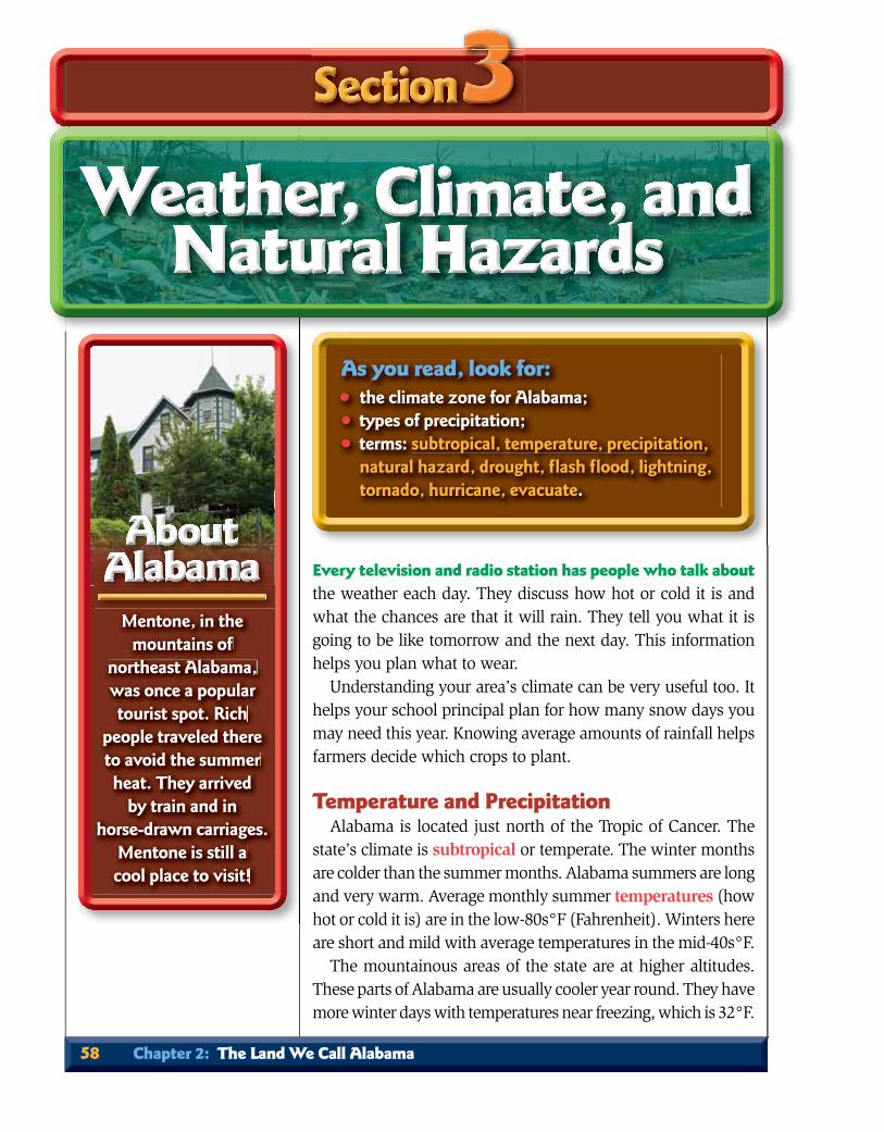
Mentone, in the mountains of
northeast Alabama, was once a popular tourist spot. Rich
people traveled there to avoid the summer heat. They arrived
by train and in horse-drawn carriages.
Mentone is still a cool place to visit!
58 Chapter 2: The Land We Call Alabama
Temperatures in Alabama can be very high or low at times. Temperatures have sometimes fallen below 0°F. Summer tem-peratures have risen above 103°F. Those extreme temperatures can sicken or even kill people.
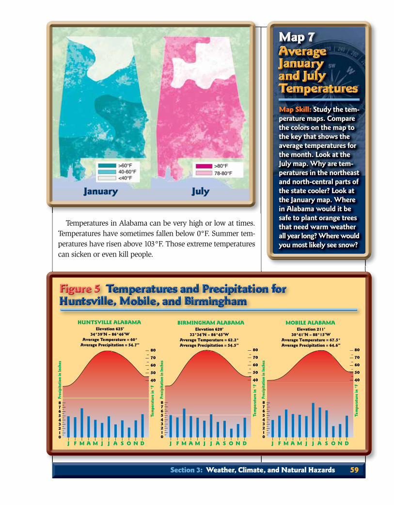
Map Skill: Study the tem-perature maps. Compare the colors on the map to the key that shows the average temperatures for the month. Look at the July map. Why are tem-peratures in the northeast and north-central parts of the state cooler? Look at the January map. Where in Alabama would it be safe to plant orange trees that need warm weather all year long? Where would you most likely see snow?
BIRMINGHAM ALABAMAElevation 620’
33°34’N – 86°45’WAverage Temperature = 62.2°Average Precipitation = 54.5”
876543210
Prec
ipita
tion
in In
ches
80
70
60
50
40
Te m
pera
ture
in °
F
J F M A M J J A S O N D
HUNTSVILLE ALABAMAElevation 625’
34°39’N – 86°46’WAverage Te mperature = 60°
Average Precipitation = 54.7”
876543210
80
70
60
50
40
Prec
ipita
tion
in In
ches
Te m
pera
ture
in °
F
J F M A M J J A S O N D J F M A M J J A S O N D
876543210
Prec
ipita
tion
in In
ches
80
70
60
50
40
Te m
pera
ture
in °
F
MOBILE ALABAMAElevation 211’
30°41’N – 88°15’WAverage Temperature = 67.5°Average Precipitation = 64.6”
January July
Section 3: Weather, Climate, and Natural Hazards 59

Precipitation is water in the form of rain, snow, sleet, or hail. It falls from clouds to the earth’s surface. Because Alabama’s temperatures are usually warm, most of its precipitation falls as rain. Some places in Alabama receive 50 to 60 inches of pre-cipitation a year. That puts it in the top 10 among the states for precipitation amounts.
Natural Hazards Certain kinds of weather can cause harm and are called natu-
ral hazards. Natural hazards that occur in Alabama include ice storms, heavy snows, droughts, fl ash fl oods, thunderstorms, tornadoes, and hurricanes.
Frozen HazardsIce storms occur when drops of rain fall on frozen surfaces.
They spread out and freeze into layers of ice. The ice can become thick and heavy. Ice on roads or on bridges can cause accidents.
Snow is another frozen hazard. When just a few snowfl akes fall from clouds, we call them fl urries. When a large amount of snow falls, we call it a snowstorm. Most of the snow that falls on Alabama melts when it hits the ground. Both snow and ice have weight and can knock down trees and power lines.
Below: The weight of ice on branches and power lines can cause them to break. Bottom: A winter scene on the Little Cahaba River. Snow is uncommon in Alabama and usually does not last very long.
60 Chapter 2: The Land We Call Alabama
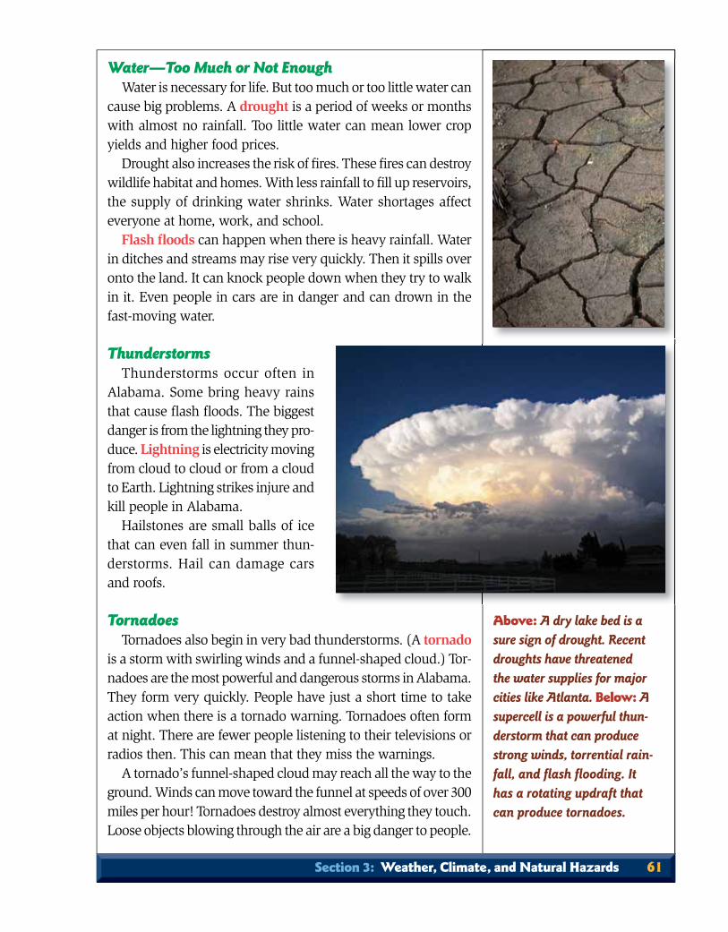
Water—Too Much or Not EnoughWater is necessary for life. But too much or too little water can
cause big problems. A drought is a period of weeks or months with almost no rainfall. Too little water can mean lower crop yields and higher food prices.
Drought also increases the risk of fi res. These fi res can destroy wildlife habitat and homes. With less rainfall to fi ll up reservoirs, the supply of drinking water shrinks. Water shortages affect everyone at home, work, and school.
Flash fl oods can happen when there is heavy rainfall. Water in ditches and streams may rise very quickly. Then it spills over onto the land. It can knock people down when they try to walk in it. Even people in cars are in danger and can drown in the fast-moving water.
ThunderstormsThunderstorms occur often in
Alabama. Some bring heavy rains that cause fl ash fl oods. The biggest danger is from the lightning they pro-duce. Lightning is electricity moving from cloud to cloud or from a cloud to Earth. Lightning strikes injure and kill people in Alabama.
Hailstones are small balls of ice that can even fall in summer thun-derstorms. Hail can damage cars and roofs.
TornadoesTornadoes also begin in very bad thunderstorms. (A tornado
is a storm with swirling winds and a funnel-shaped cloud.) Tor-nadoes are the most powerful and dangerous storms in Alabama. They form very quickly. People have just a short time to take action when there is a tornado warning. Tornadoes often form at night. There are fewer people listening to their televisions or radios then. This can mean that they miss the warnings.
A tornado’s funnel-shaped cloud may reach all the way to the ground. Winds can move toward the funnel at speeds of over 300 miles per hour! Tornadoes destroy almost everything they touch. Loose objects blowing through the air are a big danger to people.
Above: A dry lake bed is a sure sign of drought. Recent droughts have threatened the water supplies for major cities like Atlanta. Below: A supercell is a powerful thun-derstorm that can produce strong winds, torrential rain-fall, and fl ash fl ooding. It has a rotating updraft that can produce tornadoes.
Section 3: Weather, Climate, and Natural Hazards 61
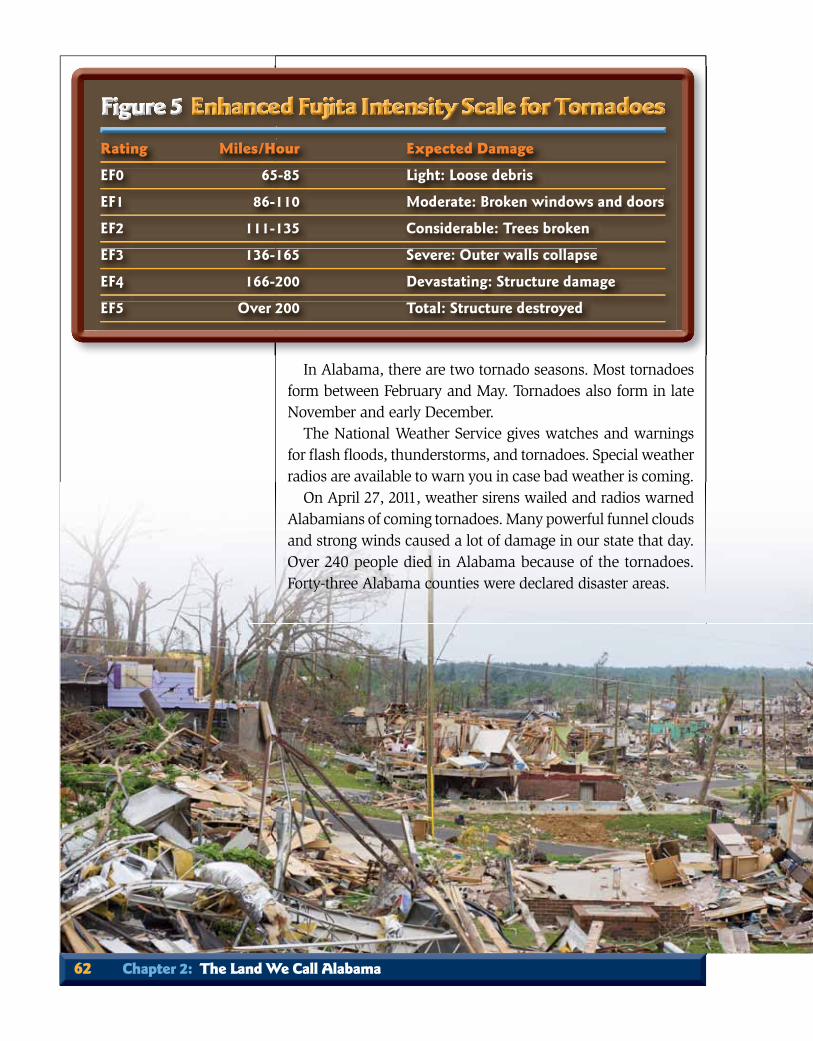
In Alabama, there are two tornado seasons. Most tornadoes form between February and May. Tornadoes also form in late November and early December.
The National Weather Service gives watches and warnings for fl ash fl oods, thunderstorms, and tornadoes. Special weather radios are available to warn you in case bad weather is coming.
On April 27, 2011, weather sirens wailed and radios warned Alabamians of coming tornadoes. Many powerful funnel clouds and strong winds caused a lot of damage in our state that day. Over 240 people died in Alabama because of the tornadoes. Forty-three Alabama counties were declared disaster areas.
Rating Miles/Hour Expected Damage
EF0 65-85 Light: Loose debris
EF1 86-110 Moderate: Broken windows and doors
EF2 111-135 Considerable: Trees broken
EF3 136-165 Severe: Outer walls collapse
EF4 166-200 Devastating: Structure damage
EF5 Over 200 Total: Structure destroyed
62 Chapter 2: The Land We Call Alabama

The tornado that hit Hackleburg was an EF-5. An EF-4 tornado hit the Tuscaloosa-Birmingham area. Those two storms ranked sixth and seventh in the deadliest tornadoes in United States history. The four counties with the highest death tolls were Tuscaloosa, Dekalb, Franklin, and Marion.
After the terrible storms, Alabamians came together to help each other clean up and rebuild. People from other states and the Federal Emergency Management Agency (FEMA) came to help too.
HurricanesHurricanes are powerful storms that form over warm seas.
These circle-shaped storms can be 300 miles wide. Hurricane wind speeds can be over 200 miles per hour. But water causes most of the damage in a hurricane. Buildings and highways near the coast are often fl ooded or even destroyed.
Hurricane season lasts from June through November. The National Hurricane Center puts out watches and warnings about hurricanes. Because these storms move so slowly, people have time to evacuate low coastal areas. (Evacuate means to leave the area because of danger.)
The weather and climate of a place can change its history. Without enough rain, crops would not grow. Some crops, such as cotton, need a long growing season. Some plants, such as orange trees, need very warm temperatures.
Above: Tuscaloosa was devastated by a huge EF-4 tornado on April 27, 2011. The storm was so powerful that it travelled more than 60 miles north to Birmingham where it destroyed, among many other neighborhoods, the Smithdale Estates in Pratt City (below)
Section 3: Weather, Climate, and Natural Hazards 63

Early settlers chose land that was good for farming. They grew crops that would do well on their land. But Alabama’s weather sometimes made American Indians, explorers, and set-tlers change their plans. Droughts made crops die. Dry trees and grasses brought forest fi res. Floods caused Alabama to move its center of government. Hurricanes made settlers in Mobile change their minds. The weather could be extreme: very cold or very hot. This made travel hard for explorers and settlers.
Think It Through!1. What is the difference between weather and climate?2. Describe Alabama’s subtropical or temperate
climate.3. Name three natural hazards.4. In thunderstorms, what is the greatest danger?
In 1997, Hurricane Danny (above) struck Alabama. It produced heavy rains that set the state’s record
rainfall for one day—32.52 inches.
Katrina
Map Skill: Study the Paths of Hurricanes. The number of hurricanes and their paths are different every year. On this map, how many hurricanes were a danger to Alabama?
64 Chapter 2: The Land We Call Alabama
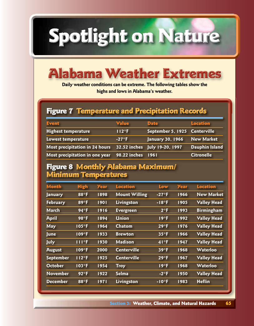
Daily weather conditions can be extreme. The following tables show the highs and lows in Alabama’s weather.
Event Value Date Location
Highest temperature 112°F September 5, 1925 Centerville
Lowest temperature -27°F January 30, 1966 New Market
Most precipitation in 24 hours 32.52 inches July 19-20, 1997 Dauphin Island
Most precipitation in one year 98.22 inches 1961 Citronelle
Month High Year Location Low Year Location
January 88°F 1898 Mount Willing -27°F 1966 New Market
February 89°F 1901 Livingston -18°F 1905 Valley Head
March 94°F 1916 Evergreen 2°F 1993 Birmingham
April 98°F 1894 Union 19°F 1992 Valley Head
May 105°F 1964 Chatom 29°F 1976 Valley Head
June 109°F 1933 Brewton 35°F 1966 Valley Head
July 111°F 1930 Madison 41°F 1947 Valley Head
August 109°F 2000 Centerville 39°F 1968 Waterloo
September 112°F 1925 Centerville 29°F 1967 Valley Head
October 103°F 1954 Troy 19°F 1968 Waterloo
November 92°F 1922 Selma -2°F 1950 Valley Head
December 88°F 1971 Livingston -10°F 1983 Hefl in
MoMMMMoMo tntntnthhhhhh HiHiHiHiHi hhhghghgh YYYYYeaeaearrr LLLoLoLocacaca ititititiononon LLLLLowowow YYYYYeaeaearrr LLLoLoLocacaca ititititiononon
Section 3: Weather, Climate, and Natural Hazards 65

Alabama’s warm, wet climate creates a good environment forplants. Before the fi rst people ever arrived, the land was covered with a blanket of vegetation. Plants growing naturally in an area are called the natural vegetation.
As you read, look for:• types of vegetation in Alabama;• types of animals in Alabama; • terms: natural vegetation, evergreen tree,
deciduous tree, ecosystem.
Above: DeSoto State Park is famous for its rhododendrons. Below: Deciduous trees provide beautiful colors in the fall.
66 Chapter 2: The Land We Call Alabama
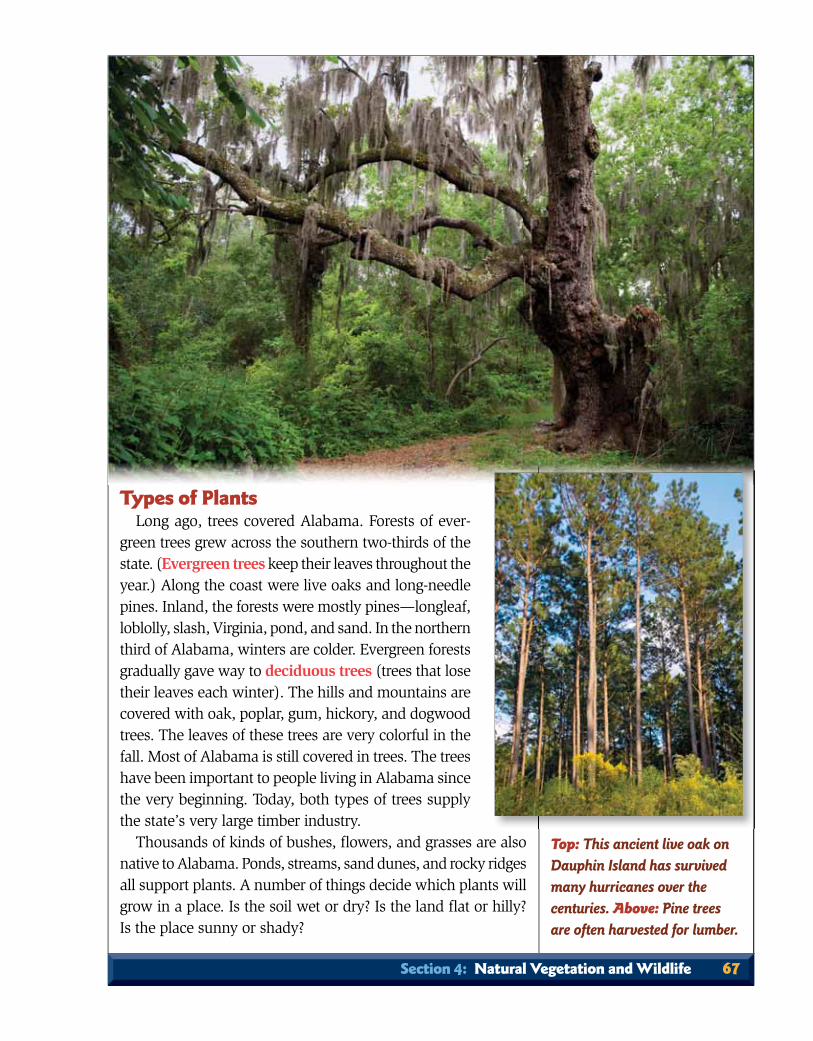
Types of PlantsLong ago, trees covered Alabama. Forests of ever-
green trees grew across the southern two-thirds of the state. (Evergreen trees keep their leaves throughout the year.) Along the coast were live oaks and long-needle pines. Inland, the forests were mostly pines—longleaf, loblolly, slash, Virginia, pond, and sand. In the northern third of Alabama, winters are colder. Evergreen forests gradually gave way to deciduous trees (trees that lose their leaves each winter). The hills and mountains are covered with oak, poplar, gum, hickory, and dogwood trees. The leaves of these trees are very colorful in the fall. Most of Alabama is still covered in trees. The trees have been important to people living in Alabama since the very beginning. Today, both types of trees supply the state’s very large timber industry.
Thousands of kinds of bushes, fl owers, and grasses are also native to Alabama. Ponds, streams, sand dunes, and rocky ridges all support plants. A number of things decide which plants will grow in a place. Is the soil wet or dry? Is the land fl at or hilly? Is the place sunny or shady?
Top: This ancient live oak on Dauphin Island has survived many hurricanes over the centuries. Above: Pine trees are often harvested for lumber.
Section 4: Natural Vegetation and Wildlife 67
Think It Through!1. What is the difference between evergreen and deciduous trees?2. How can Alabama have so many different types
of animals?
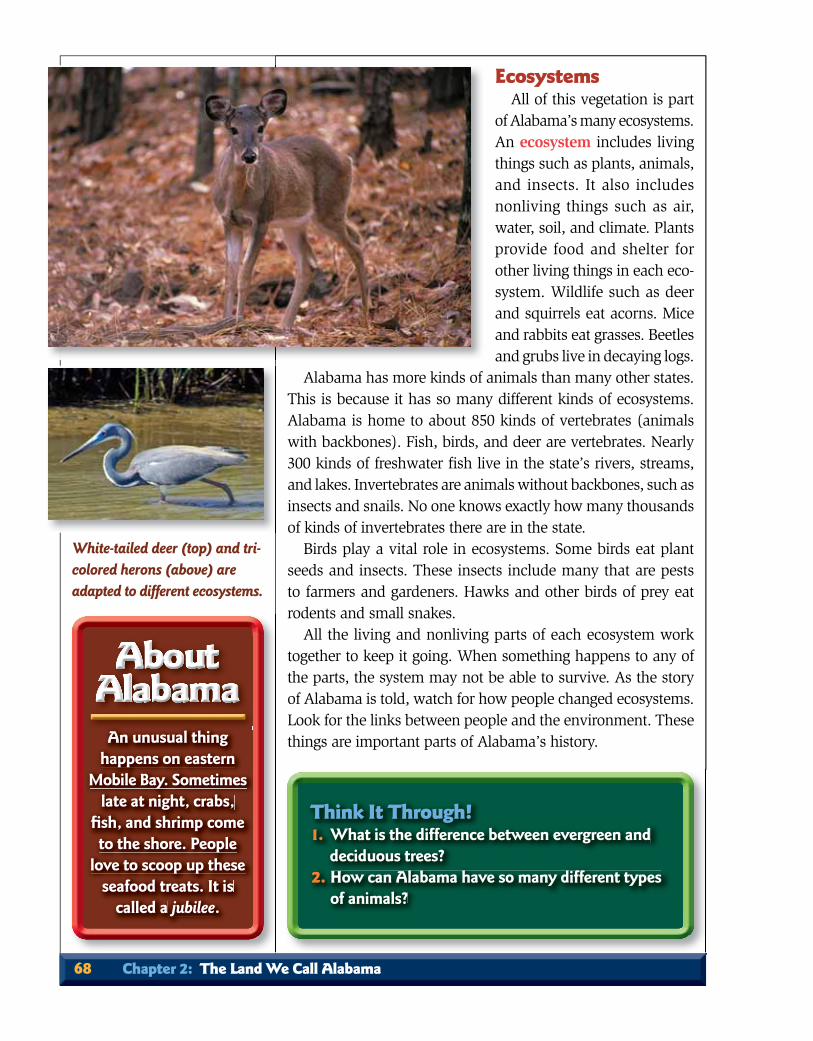
EcosystemsAll of this vegetation is part
of Alabama’s many ecosystems. An ecosystem includes living things such as plants, animals, and insects. It also includes nonliving things such as air, water, soil, and climate. Plants provide food and shelter for other living things in each eco-system. Wildlife such as deer and squirrels eat acorns. Mice and rabbits eat grasses. Beetles and grubs live in decaying logs.
Alabama has more kinds of animals than many other states. This is because it has so many different kinds of ecosystems. Alabama is home to about 850 kinds of vertebrates (animals with backbones). Fish, birds, and deer are vertebrates. Nearly 300 kinds of freshwater fi sh live in the state’s rivers, streams, and lakes. Invertebrates are animals without backbones, such as insects and snails. No one knows exactly how many thousands of kinds of invertebrates there are in the state.
Birds play a vital role in ecosystems. Some birds eat plant seeds and insects. These insects include many that are pests to farmers and gardeners. Hawks and other birds of prey eat rodents and small snakes.
All the living and nonliving parts of each ecosystem work together to keep it going. When something happens to any of the parts, the system may not be able to survive. As the story of Alabama is told, watch for how people changed ecosystems. Look for the links between people and the environment. These things are important parts of Alabama’s history.An unusual thing
happens on eastern Mobile Bay. Sometimes
late at night, crabs, fi sh, and shrimp come to the shore. People
love to scoop up these seafood treats. It is
called a jubilee.
White-tailed deer (top) and tri-colored herons (above) are adapted to different ecosystems.
68 Chapter 2: The Land We Call Alabama

You now know about Alabama’sphysical geography. Before you read about the people who fi rst came to Alabama, it would be good to learn more about some-thing called culture. In Chapter 1, we learned that it is the beliefs and customs of a group of people. Culture is that and much more.
Some things you were born with—such as the color of your eyes, hair, and skin. Some things you were taught—like what to eat, what to wear, and how to behave. You have also learned how to use things. You probably know how to ride a bicycle. You might have already learned to use a hammer, screwdriver, or computer. You have been taught things at home, at school, and in your place of worship. All of these things are now a part of your culture.
Every group or person you meet as you read the story of Alabama had a culture. Each culture had different ideas about how to dress and what foods were good to eat. They had ideas about how to make a living. They had tools and knew how to use them to do various jobs. These tools and skills are known
As you read, look for:• what a culture is;• how culture changes;• term: technology.
Above: Many people, like these native Americans, go to great lengths to preserve the traditions of their culture.
Section 5: Culture 69

as technology. The story of the state is the story of people from many different places. They came to Alabama at different times. They brought their cultures with them.
How Cultures ChangeWhen people from different cultures meet, they often share
parts of their cultures. Most people in Alabama are not part of the Asian or Hispanic cultures, but they enjoy eating Chinese and Mexican food. Some of the ideas you have may be from another culture.
Sometimes your culture changes from one year to the next. Do you like the same songs this year that you did last year? What about the clothes you wear or the food you like to eat? Have your favorites changed? Think of all the new things you learned in the last year. You probably know how to do things now that you did not know how to do then. Watch for changes in the culture of Alabama’s people through time.
Every person has a basic need for food, shelter, and clothing. Quite a few people are able to grow their own food. Some can even build a house and make clothing. Others get jobs so they can earn the money to buy food and clothes and pay for a place to live. Over time, ideas change as to how people make a liv-ing. Some of the earliest Alabamians hunted and fi shed. Later, many were farmers. Many people then left their farms to work in factories. Today, many Alabamians work in offi ces, stores, or restaurants.<DYK>About Alabama
Technology Changes CultureTechnology changes too. In the past, people used simple tools.
Now they may use power tools and machinery. People traveled by horse and wagon. Now they drive cars and SUVs (Sport Utility Vehicles) and ride in airplanes. Computers are used in homes, schools, and businesses today. But few people had even seen one 30 years ago.
Each way of making a living needs different resources. As the people of Alabama change jobs, they need different resources. Technology must have resources. The farmer needs good soil. Machinery usually uses electricity. Electricity is often made from coal or waterpower.
Alabama’s many resources made it possible for people from different cultures to live well. People who wanted to farm found
Arab has a festival for a wild plant called poke salad or salat.
The plant has purple stems and berries. Can you identify
this plant?
70 Chapter 2: The Land We Call Alabama
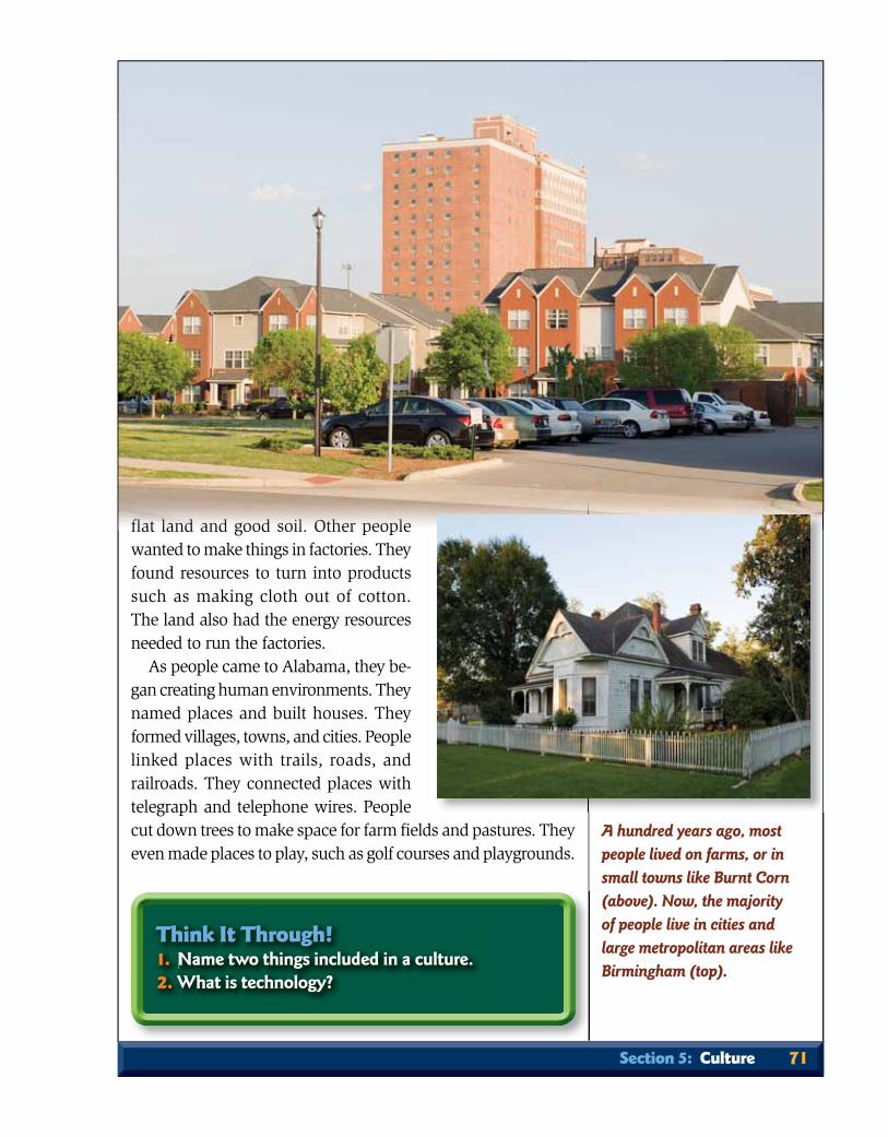
fl at land and good soil. Other people wanted to make things in factories. They found resources to turn into products such as making cloth out of cotton. The land also had the energy resources needed to run the factories.
As people came to Alabama, they be-gan creating human environments. They named places and built houses. They formed villages, towns, and cities. People linked places with trails, roads, and railroads. They connected places with telegraph and telephone wires. People cut down trees to make space for farm fi elds and pastures. They even made places to play, such as golf courses and playgrounds.
flflflflflflflflfl tttatatatata llllllllananananddddddddddd ananananandddddddd gogogogo dddddododod ssss iiioioioilllllll. OOOOOOOO hhththtthththththerererer ppppeoeoeoeo llllplplpleeee
Think It Through!1. Name two things included in a culture.2. What is technology?
A hundred years ago, most people lived on farms, or in small towns like Burnt Corn (above). Now, the majority of people live in cities and large metropolitan areas like Birmingham (top).
Section 5: Culture 71

climate, plants, animals, and landscapes form different kinds of ecosystems.
Everyone has a culture. Culture is all the things in your life. It is your clothes, language, religion, food, games, work, home, and so on. Cultures change one another, and they change over time. Alabama is the home of different cultures that make our state even more special.
RememberOn a separate piece of paper,
write the title for each group. Place each word or term from the Word Bank with like meanings in the group where it belongs. Add extra words or terms if you know them.
Group Titles:Extreme weather Water termsLand regions Wetland terms
Word Bank:Appalachian Plateau Interior PlateauAquifer PiedmontCoastal Plain Ridge and ValleyDelta Salt marshDrought Surface waterGroundwater TornadoHurricane Waterway
Reviewing the Facts1. When people fi nd a use for some-thing natural, what is it called?
2. What is the difference between weather and climate?
RRRR
weach word or
T
RR11th
2 What is
A
SummaryAlabama lies at the meeting point of five
different land regions. The Coastal Plain covers the southern half of the state. The Piedmont is in east-central Alabama. Northwest of that is the mountainous Ridge and Valley region. The Appalachian Plateau lies northwest of the Ridge and Valley. The Interior Plateau (Highland Rim) is in northern Alabama.
The fi rst settlers moved into Alabama to farm. They traveled to the Black Belt and the val-leys of the Tennessee, Coosa, Tombigbee, and Alabama Rivers for the rich soils. The settlers moved into Alabama from the southeast on the Federal Road. Those from settlements farther north came through the valleys of the Ridge and Valley region. They traveled from Tennessee and Kentucky on the Huntsville Road.
Alabama has many mineral and energy re-sources. The energy resources are coal, oil, and natural gas. Mineral resources include iron ore, limestone, sandstone, and marble. The different types of soil determined the richness of the land. Settlers fi rst moved to land where it was easy to grow crops. Later, miners, quarrymen, and others came to Alabama for its natural resources.
Alabama has a subtropical climate with four distinct seasons. The state gets a lot of pre-cipitation. Natural hazards include ice storms, droughts, tornadoes, and hurricanes. The state has a long growing season and a good water supply. These qualities make it ideal for many types of plants. All of these plants give food and shelter to many different kinds of animals. The
72 Chapter 2: The Land We Call Alabama

Chapter Review 73
WritingWrite a letter to someone who does not live in our state. In the letter,
describe Alabama’s natural environment. Tell the person about the state’s regions, resources, and water. Explain how the landscape can be changed.
Preparing for TestsMultiple Choice—These ques-
tions are like those you may see on a test. Write your answers on a separate sheet of paper.
1. The northern part of Alabama is sometimes called the Highland Rim. What natural region is that?A. Interior Plateau B. Appalachian PlateauC. Ridge and ValleyD. Coastal Plain
2. Why does Alabama have many more animals than many other states?A. It is in the South.B. It has evergreen trees.C. It has many different ecosystems.D. It has different cultures.
Using TechnologyYou are going to find out how
much rainfall your area received re-cently. Using the Internet, go to the website of the Alabama Offi ce of State Climatology (AOSC) nsstc.uah.edu/aosc.
Look under Moisture Indices and find the Lawn and Garden Index—Alabama. This map shows how much precipitation the state re-ceived in the last week. Find the district where you live and look at the map key. How much rain did your area receive in the week shown?
3. How did the settlers choose which region to go to?
4. How are land regions divided?5. What is the highest point in the state?6. Why does Alabama have more kinds of
animals than many other states?7. What is natural vegetation?
Using Critical Thinking Skills1. Why was it an advantage for
farmers to live near a river?2. Why is a long growing season important?3. What happens when something in an
ecosystem changes? For example, what would happen if all the acorns that deer feed on disappeared?
Making Decisions1. The Little River Canyon is a love-ly natural area. If someone wanted
to build an amusement park in or near it, would you be for or against the plan?
2. What animal would you introduce into Alabama? Why? Can you think of any bad things that could happen if that animal lived wild in Alabama?
3. Cultures have differences in foods, languages, entertainment, clothes, art, and so on. If you could adopt parts of other cultures, what would they be?
Projects1. Make a relief map of Alabama’s natural land regions.
2. Design a PowerPoint presentation about early settlers. Explain one of the following: (a) how they came to Alabama, or (b) how they chose which area to settle in.
UTTT1
farmers
e
MMMM1111ly
to build
v
PP11na
2 Design a
X
PPP
tioa test Write
c
WWWWWn
describe Alab
C
U
mcently Using
o
Chapter Review 73


Chapter Review 75
o
times called the Highland Rim. What natu-ral region is that?A. Interior Plateau B. Appalachian PlateauC. Ridge and ValleyD. Coastal Plain
2.There are two tornado seasons in Ala-bama, but most tornadoes form between which two months?A. June and AugustB. January and MarchC. November and DecemberD. February and May
3. Why does Alabama have many more animals than many other states?A. It is in the South.B. It has evergreen trees.C. It has many different ecosystems.D. It has different cultures.
Using TechnologyYou are going to find out how
much rainfall your area received re-cently. Using the Internet, go to the website of the Alabama Offi ce of State Climatology (AOSC) nsstc.uah.edu/aosc.
Look under Moisture Indices and find the Lawn and Garden Index—Alabama. This map shows how much precipitation the state re-ceived in the last week. Find the district where you live and look at the map key. How much rain did your area receive in the week shown?

494 Alabama: Our Beautiful Home
This glossary contains those terms that are in bold color in the textbook. The chapter in which the term appears is shown in parenthe-ses at the end of the defi nition.
Aagricultural economy an economy that is
farm-related (9) Allies the group of countries that fought
the Axis powers in World War II (largest were England, France, the Soviet Union, and the United States); See “ally” (11)
ally a friend or partner (4)al Qaeda the group of terrorists who
carried out the 9/11 attacks (13) amendment an addition or change, such
as to a constitution or other document (3)
American Revolution the war American colonists fought to gain freedom from Great Britain’s rule (3)
ammunition bullets and gunpowder, materials to load into a weapon (4)
amphibious living on land and in water (11)
ancestor a person from long ago who is a direct relative (3)
antique something made long ago (1)Appalachian Plateau geographic region
that begins in Alabama around Jasper and extends north through Tennessee and Kentucky into western New York (2)
aquifer an area with layers of gravel and rock that act like sponges; it is where
water is stored beneath the surface of the earth (2)
architecture the style of a building such as Colonial or Victorian (1)
armistice agreement to stop the war (10)artesian well a well that produces fl owing
water (without pumping) (6)arthritis a joint disorder (16)Articles of Confederation the plan for
a national government adopted by the Continental Congress in 1781 (3)
assassinate to kill someone; usually a murder for political reasons (8)
assembly line a manufacturing method where products are made on a moving belt (10)
assessment the amount property is valued at for taxation (15)
Axis powers the group of countries that fought the Allies in World War II (largest were Germany, Italy, and Japan) (11)
Bbill a suggested law (15)black codes laws passed to limit the
freedom of African Americans (8)blast furnace a furnace that uses a blast
of hot air to melt pure iron to remove it from iron ore (6)
blockade the use of naval forces to stop shipping (7)
bombardier an airplane crew member who drops the bombs (11)
Glossary 495
boundary border or line, such as between states or countries (3)
boycott a refusal to use goods or services(12)
braille a way of writing with raised characters for the use of people who are blind or visually impaired (10)
Ccabinet the president’s highest level of
advisors (16)cadet young military student (7)Cajun a person of French heritage living
in Louisiana, Mississippi, or Alabama (1)capital a city that is the seat of
government (1)capitol the building in which the
legislature meets (6)carpetbagger a person who came to the
South from the North after the Civil War; some came to help Southerners, but others came seeking profi t or political power (8)
ceasefi re a truce that means all fi ghting stops (13)
cede to give up something, such as land or rights (5)
census an offi cial count of people (6)civil court the court system that rules on
disputes between people (15)civilian a person who is not military (11)civil rights the basic rights that belong to
all citizens (9)climate the average weather over a long
time (2)Coastal Plain geographic region that
includes the southern part of Alabama and stretches from Texas to New Jersey (2)
coke a fuel to heat blast furnaces; made by baking coal in a very hot furnace
without setting it on fi re (9)Cold War a time after World War II when
tension existed between the United States and the Soviet Union; called “cold” because there was no actual fi ghting (11)
colony a settlement of people in a new land who are ruled by their homeland (3)
combat fi ghting, as in a war (11)command to be in charge; commander is
a military title (3)communist a form of government where
the state owns all property and the government makes all economic plans (11)
commute to travel to work regularly (10)conquistador a Spanish conqueror (3)constitution a written statement of basic
laws (3)convict-leasing the practice of selling the
labor of prisoners (16)cotton gin a machine invented by Eli
Whitney that takes cotton seeds out of the white fi bers (bolls); short for “cotton engine” (5)
council a group of people chosen to make decisions for a larger group, such as a tribe (4)
county seat the town or city where the courthouse is located (15)
credit getting an item now and paying for it over time (9)
criminal court the court that handles cases when a person is charged with a crime (15)
culture the beliefs and customs of a group of people (1)
Ddeciduous tree a tree that loses its leaves
each winter (2)

496 Alabama: Our Beautiful Home
Declaration of Independence a document in which the 13 original colonies stated their intention to separate from Great Britain; signed on July 4, 1776 (3)
deed a legal document that proves who owns the land (6)
delegate representative, a person who represents a group of people (3)
deliberate something carefully thought out (12)
delta an area where a river divides before fl owing into a larger body of water (2)
democratic a form of government in which people elect their leaders and have protected rights; people can own property and businesses (11)
depletion using up something such as nutrients in the soil (13)
depression a time of severe economic problems (11)
desegregation ending the practice of segregation of the races (12)
destination the end of a trip (1)disarm to lay down weapons or arms;
in the war in Iraq, it meant the Iraqis had to destroy their weapons of mass destruction (13)
discriminate to treat differently and unfairly (12)
distinguished showed a special talent or achieved something special (11)
diversify to have many different kinds of something, such as several industries in an area (13)
dome a roof that is round, like half of a hollow ball (6)
draft a process where the government requires people to serve in the military (10)
drought a period of weeks or months with almost no rainfall (2)
Eeconomic relating to activities that try to
make money (5)economy includes all the things people do
to make and sell goods and services (5)ecosystem the living things (plants and
animals) and nonliving things (air, water, soil, and climate) in a certain area (2)
elect to choose by vote (4)entrada journey, in Spanish (3)entrepreneur a person who operates and
assumes the risk of a business (16)estuary a place where freshwater from
rivers mixes with saltwater from the ocean (2)
evacuate to leave the area because of danger (2)
evergreen tree a tree that keeps its leaves throughout the year (2)
executive branch the branch of government that carries out the laws—for the United States, the president heads this branch; for the state, the governor is the head (3)
exhibit a display to show something (1)expand to enlarge or increase (9)expedition a trip made by a group for
a special purpose such as exploring unknown lands (3)
Ffacility a place with areas for use such as
a restroom or school (12)Fall Line a geological boundary that
separates the Coastal Plain from other regions (2)
fertile good for growing things (2)fi rst-responder one of the people who
rush to help in case of emergency, such as police offi cers and fi refi ghters (13)
fl ash fl ood fl ooding caused by heavy

Glossary 497
rainfall that can make water in ditches and streams rise very quickly (2)
fl atboat a wide, fl at-bottom boat made of split logs and sealed with tar (6)
fl eet a group of ships (7)foundry a place for casting metal (6)4-H a club for students where they learn
about farming, good health, citizenship, and cooking; stands for Heart, Hands, Health, and Head (1)
freedman a black person who was not a slave (5)
frontier land beyond settled areas (5)Future Farmers of America (FFA) a club
for students where they learn about farming, citizenship, and other life skills(1)
Ggenerate to make or produce power (10)geology study of the history of Earth,
especially the history recorded in rocks(2)
governor the head of the executive level of a state or territorial government (3)
groundwater water stored naturally in aquifers; may seep out and form springs (2)
Hhabitat the place where animals or plants
live (1)heritage ways of life passed on from one
generation to the next (1)historic Indians American Indians who
were living in the New World when the Europeans arrived (4)
historic place a place where something important in history happened (1)
Holocaust the murder of millions of Jewish people during the 1930s and 1940s (11)
hurricane a large and powerful circle-shaped storm that forms over warm seas (2)
hydroelectric the use of waterpower to generate electricity (10)
Iimmigrant a person who settles in a new
country (1)immunity resistance, such as to
disease(s) (3)impurity unwanted part, such as a
pollutant (9)inaugurate to swear in to offi ce in a
ceremony (7)industry a factory or place to work that
makes products or services (1) integration ending segregation and being
combined into one group (12) Interior Plateau geographic region
that begins in northern Alabama and extends north to the Ohio River and into southern Indiana; this part of Alabama is sometimes called the Highland Rim (2)
interpreter a person who translates one language to another (3)
JJim Crow laws laws that kept blacks from
using the same public facilities as whites(9)
journal daily writings like a diary (3)judicial branch the branch of government
that rules on the meaning of laws; the court system (3)
jury a group of citizens chosen to attend a trial and make a decision on the case (15)
Kkeelboat a riverboat that could go
upstream as well as downstream (6)

498 Alabama: Our Beautiful Home
Llabor force the group of available workers
(14)legislative branch the branch of
government that makes the laws; the U.S. Congress and the state legislature (3)
lightning electricity moving from cloud to cloud or from a cloud to Earth (2)
livestock animals such as cattle, pigs, sheep, and horses (1)
Mmaintenance working on equipment to
make it run like new (11)maritime close to or about the sea (15)mass communication communicating
to large numbers of people; newspapers and the Internet are means of mass communication (14)
migration when a group of people or animals move from one area to another (4)
militia citizens trained as soldiers (4)mill a factory built near a river with swift-
fl owing water (5)mineral ore or other substance found
naturally in the earth (2)missionary a person who goes to another
area to do religious work (4)motto a statement of what a group
believes in or stands for (15)multimodal a kind of rail shipment in
which goods are sent in containers and transferred to ships, planes, or trucks (14)
municipal referring to cities and towns (15)
munitions military supplies such as bullets, bombs, and explosives (10)
Muslim a person who follows the teachings of the Islam religion (13)
NNAACP National Association for the
Advancement of Colored People; an organization that works for the rights of black Americans (12)
natural environment the things that are part of nature (2)
natural hazard a weather event that can be dangerous or cause problems for people, such as an ice storm, fl ash fl ood, thunderstorm, tornado, or hurricane (2)
natural resource something in the natural environment that people can use (2)
natural vegetation plants that grow naturally and are not planted by people (2)
navigable passable by ships (if a waterway is deep and wide enough for ships) (5)
navigator an airplane crew member who fi nds routes for the fl ight and locates the targets (11)
Nazi a follower of Adolf Hitler (11)New Deal government programs to help
people and the economy during the Great Depression (11)
9/11 the date, September 11, 2001, when several terrorist attacks occurred in the United States (13)
nonviolent without violence; peaceful (12)
normal school a school for training teachers (9)
Ooath pledge or promise that a person
takes when being sworn in to offi ce (6)orphan a child whose parents have died
(4)overcropping planting the same crop over
and over (10)
Glossary 499
Ppandemic widespread disease such as
the Spanish fl u (10)paraplegic a person who is paralyzed in
both legs (16)patent a document registering an
invention with the government patent offi ce; gives the inventor sole rights to sell the invention (10)
Patriot missile an American antimissile missile (13)
permanent lasting, or staying the same (3)
persuade to get someone to do something; to convince (4)
Piedmont geographic region extending from Alabama through Georgia and the Carolinas all the way to New Jersey (2)
pioneer an early settler in a new place (2)
planetarium a building with a special ceiling that shows images of the night sky and stars (1)
plantation large area of land with a big farm (5)
planter a person who owned a plantation (5)
political party a group of people who agree on how to run the state or country (8)
poll tax a tax that a person had to pay in order to vote (10)
posthumous after death; refers to an occurrence after death, such as a military award (11)
poultry birds (chickens, turkeys, and quail) raised for food or to lay eggs (14)
precipitation water in the form of rain, snow, sleet, or hail (2)
prejudice an opinion that is not based on looking at the facts fairly (12)
prisoner of war (POW) member of the military who has been captured by the enemy (11)
procession a parade; a group moving forward in a ceremonial type of parade (7)
profession a job that requires special training and education (16)
prosecutor a person who presents a legal case against an accused person (16)
prosperity good economic times (11)provost the chief offi cer of a college (16)
Rradical having extreme or very strong
views (8) ratify to approve formally, such as
an amendment to the United States Constitution (3)
ration to limit, such as the amount of something like food during a time of war (11)
rebel a person fi ghting a war against the government in power (13)
Reconstruction the time after the U.S. Civil War (8)
record a way of hearing music such as a CD or digital tunes (16)
recruit to sign up or hire people (10)repeal to cancel something such as a law
(8)retail the sale of products to the fi nal
consumer (14)revenue money; for governments, comes
mostly from taxes (15)Ridge and Valley geographic region that
begins just south of Birmingham and extends into Pennsylvania (2)
rotunda round, domed section of a building (6)
rural areas where most people live on

500 Alabama: Our Beautiful Home
farms, not in towns; the population is more spread out than in urban areas (7)
Ssalt marsh a grassy, wet area that fl oods
with saltwater each day when the sea level rises with the tide (2)
scalawag a white Southerner who cooperated with the military government during Reconstruction (8)
secede to withdraw from something as some states did from the Union in the Civil War era (7)
sectionalism sectional differences; the belief by people of a certain region that their ideas and ways of life are better and more important than other regions (7)
segregation separation of the races (10)service industry the type of industry
that provides work without producing goods; workers include waiters, doctors, attorneys, and teachers (14)
settler a person who goes to live in a new area (1)
sharecropper a farmer who worked someone else’s land and gave the landowner a share of the harvest; the landowner provided seeds, tools, and a place to live (9)
site a place where something is or was located or happened (1)
sit-in a form of protest in which people just sit in an area (12)
skirmish a brief fi ght as in a war (7)slave a person forced to work for
someone regarded as the slave’s owner (3)
Social Security Act (SSA) provides retirement and disability benefi ts; one of the New Deal programs (11)
sociobiology the study of biology through
social systems like those of ants and bees (16)
speculator a person who buys something planning to sell it later for a profi t (5)
squatter a person who cleared and settled land without ownership of the land (5)
state-of–the-art modern; latest method of doing something (14)
stock a share of ownership in a business (11)
strip mining surface mining; when a huge machine digs away the rock and soil that covers a layer of coal (14)
suborbital less than a full orbit of Earth (13)
subtropical a part of the world that borders the tropical zones; describes Alabama’s temperate climate (2)
suburb an area outside of a city (more densely populated than rural areas) (9)
successor one who follows, such as the next person in a political offi ce (8)
suffrage the right to vote (11)supply and demand an economic term
describing the difference between what industries and/or farms produce (supply) and what they can sell (demand) (11)
surface water the water in rivers, streams, lakes, and wetlands (2)
surrender to give up or to “lay down arms” in war (7)
survey to measure and map out an area(3)
swamp a wetland, usually a fl ooded forest (2)
symbol one thing that stands for another(12)
synagogue a house of worship for a Jewish congregation (6)
synthetic a man-made material (14)

Glossary 501
Ttax money charged to people and
businesses for services provided by the government (3)
technology use of knowledge, tools, and skills (2)
temperature a measurement of how hot or cold something is; expressed in degrees (2)
tenant farmer a farmer who had seeds and tools but farmed someone else’s land; the farmer paid the landowner a share of the harvest (9)
terminal a place with a waiting room and a place to buy tickets (12)
terrorist a person who uses violence to cause fear, usually in an attempt to change the ruler or government (13)
textile cloth or fabric (1)theme a subject (1)therapy a treatment to help or cure
someone (14)tornado a powerful storm with swirling
winds and a funnel-shaped cloud (2)trial a legal process where the facts are
studied by a court (15)tributary a stream that feeds into a river (14)truce agreement to stop fi ghting (11)tuition school charges (9)
Uunemployment being without a job (11)unionist a person who wanted to stay in
the United States and not secede (7)United States Constitution the document
that set up the framework and basic laws of our government; signed on September 17, 1787, and ratifi ed in 1788 (3)
urban an area of cities or towns; more densely populated than rural areas or the suburbs (7)
Vvehicle a way of transportation (10)veto to say no to something, such as the
governor or president can do to a bill (15)
WWar on Terrorism any action taken to
stop terrorists; announced by the United States soon after 9/11 (13)
waterway a navigable river that can be used for transportation and carrying goods (2)
weapons of mass destruction (WMD) weapons that can kill many people at once, such as chemical and biological weapons (13)
weather the conditions outside relating to temperature, precipitation, cloudiness, and wind (2)
wetland a place that is wet all or part of the year (2)
whitewater fast-moving water; rapids (1)wholesale the sale of products to stores
that will then resell the products to the fi nal consumer (14)
Wiregrass an area that includes southeast Alabama and parts of Florida and Georgia; known for the type of grass that once covered the region (1)
Yyeoman a person who owns and works a
small farm (5)