dorchester - boston · northern dorchester’s only emergency shelter, and as soon as the 2050s, it...
TRANSCRIPT
Focus Areas 195194 City of Boston: Climate Ready Boston
Dorchester
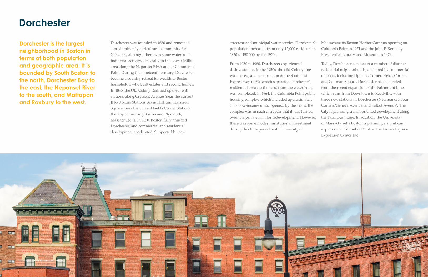
Dorchester is the largest neighborhood in Boston in terms of both population and geographic area. It is bounded by South Boston to the north, Dorchester Bay to the east, the Neponset River to the south, and Mattapan and Roxbury to the west.
Dorchester was founded in 1630 and remained a predominately agricultural community for 200 years, although there was some waterfront industrial activity, especially in the Lower Mills area along the Neponset River and at Commercial Point. During the nineteenth century, Dorchester became a country retreat for wealthier Boston households, who built estates and second homes. In 1845, the Old Colony Railroad opened, with stations along Crescent Avenue (near the current JFK/U Mass Station), Savin Hill, and Harrison Square (near the current Fields Corner Station), thereby connecting Boston and Plymouth, Massachusett s. In 1870, Boston fully annexed Dorchester, and commercial and residential development accelerated. Supported by new
CC Image courtesy of dalecruse on Flickr
streetcar and municipal water service, Dorchester’s population increased from only 12,000 residents in 1870 to 150,000 by the 1920s.
From 1950 to 1980, Dorchester experienced disinvestment. In the 1950s, the Old Colony line was closed, and construction of the Southeast Expressway (I-93), which separated Dorchester’s residential areas to the west from the waterfront, was completed. In 1964, the Columbia Point public housing complex, which included approximately 1,500 low-income units, opened. By the 1980s, the complex was in such disrepair that it was turned over to a private fi rm for redevelopment. However, there was some modest institutional investment during this time period, with University of
Massachusett s Boston Harbor Campus opening on Columbia Point in 1974 and the John F. Kennedy Presidential Library and Museum in 1979.
Today, Dorchester consists of a number of distinct residential neighborhoods, anchored by commercial districts, including Uphams Corner, Fields Corner, and Codman Square. Dorchester has benefi tt ed from the recent expansion of the Fairmount Line, which runs from Downtown to Readville, with three new stations in Dorchester (Newmarket, Four Corners/Geneva Avenue, and Talbot Avenue). The City is planning transit-oriented development along the Fairmount Line. In addition, the University of Massachusett s Boston is planning a signifi cant expansion at Columbia Point on the former Bayside Exposition Center site.

Focus Areas 197196 City of Boston: Climate Ready Boston
FLOOD PROGRESSION
9 INCHES SEA LEVEL RISE
In the second half of the century, large areas of Dorchester will be exposedto high-probability fl ooding (10 percent annual chance). During this time frame, coastal fl ooding in Dorchester will be most prominent from Dorchester Bay near Joseph Moakley Park and along the Neponset River.
DEFINITIONS
Near term: Beginning 2030s, assumes 9 inches of sea level rise
Midterm: Beginning 2050s, assumes 21 inches of sea level rise
Long term: Beginning 2070s or later, assumes 36 inches of sea level rise Exposure: Can refer to people, buildings, infrastructure, and other resources within areas likely to experience hazard impacts. Does not consider conditions that may prevent or limit impacts.
Vulnerability: Refers to how and why people or assets can be affected by a hazard. Requires site-specific information.
Consequence: Illustrates to what extent people or assets can be expected to be affected by a hazard, as a result of vulnerability and exposure. Consequences can often be communicated in terms of economic losses.
Annualized losses: The sum of the probability-weighted losses for all four flood frequencies analyzed for each sea level rise scenario. Probability-weighted losses are the losses for a single event times the probability of that event occurring in a given year.
*For a full list of definitions, refer to the Glossary in the Appendix.
Dorchester is exposed to climate change impacts including heat, increased precipitation and stormwater fl ooding, and sea level rise and coastal and riverine fl ooding. Exposure to heat and stormwater fl ooding are addressed in the Citywide Vulnerability Assessment (see p.12), while exposure and consequences to coastal and riverine fl ood risk are further discussed in this section
In the near term and in the second half of the century, exposure to coastal fl ooding is primarily due to the low waterfront edge along Dorchester
9 INCHES SEA LEVEL RISE 21 INCHES SEA LEVEL RISE 36 INCHES SEA LEVEL RISE
LEGEND

Focus Areas 199198 City of Boston: Climate Ready Boston
Bay and the Neponset River. Though exposure is largely limited in the near term, approximately 10 percent of the land areas in Dorchester have a high probability of fl ooding as soon as the 2050s (10 percent annual chance). Areas around Joseph Moakley Park are additionally exposed to low-probability fl ood events (1 percent annual chance) as soon as the 2050s.
In the late century, Dorchester exposure will change signifi cantly, with large areas exposed to high-probability fl ood events (10 percent annual chance). More critically, in the late century, Northern Dorchester is expected to become a fl ood pathway to South Boston, the South End, and Roxbury. Areas around Joseph Moakley Park, created using fi ll in the late 1800s, tend to be low lying, leading to the exposure in Dorchester and surrounding areas.
The topography around Joseph Moakley Park and I-93 is low lying, potentially allowing fl oodwaters to propagate inland. Flood protection solutions targeted toward this area in northern Dorchester may provide benefi ts in South Boston, the South End, and Roxbury.
The greatest concentration of land area exposed is on the northern end of Dorchester, due to coastal fl ooding from Dorchester Bay through Joseph Moakley Park.
In the late century, fl ooding from Dorchester Bay will extend from Dorchester into South Boston, the South End, and Roxbury.

Focus Areas 201200 City of Boston: Climate Ready Boston
EXPOSUREPOPULATION & INFRASTRUCTURE
POPULATION AND SOCIAL VULNERABILITIES
There are about 87,000 residents in Dorchester, about 14 percent of Boston’s overall population. In total, 24 percent of Dorchester households have children, compared to 17 percent citywide. Dorchester also has a diverse population that is 72 percent people of color, compared to 52 percent citywide.
Approximately 6,820 people live in housing that is projected to be at risk in a low-probability fl ood scenario (1 percent annual chance) as soon as the 2070s, generating need for shelter beds for an estimated 750 individuals. Seven public emergency
DORCHESTER POPULATION EXPOSURE
shelters are located within Dorchester and have the capacity for 1,000 individuals. McCormick Middle School, located on Columbia Point, is northern Dorchester’s only emergency shelter, and as soon as the 2050s, it will be exposed to low-probability fl ood events (1 percent annual chance). If this shelter is impacted by fl ooding, all roads leading out of Columbia Point are also expected to be fl ooded, potentially isolating residents in the northern portion of Dorchester without shelter. As soon as the 2070s, the Leahy Holloran Community Center will also be exposed to high-probability fl ood events (10 percent annual chance), which would reduce the shelter capacity by an additional 140 individuals.
INFRASTRUCTURE
Damage to exposed roads and the MBTA Red Line could isolate Columbia Point from the rest of Dorchester and impact transportation connections to North Quincy.Within this century, all of Dorchester’s evacuation routes, including I-93 South, Morrissey Boulevard, Neponset Avenue, and Gallivan Boulevard, will be exposed to coastal fl ooding and sea level rise. In the near term, portions of Morrissey Boulevard near the Dorchester Bay Basin and the Neponset Avenue/I-93 South junction are exposed to high-probability fl ood events (1 percent annual chance). As soon as the 2050s, all of Morrissey Boulevard, as well as sections of I-93 South in the same area, will be exposed to high-probability fl ood events (10 percent annual chance). Road closures due to fl ood damage could isolate Columbia Point from the rest of Dorchester, impacting a major university (University of Massachusett s Boston) and three
K–12 schools, aff ecting delivery of resources into the area, and aff ecting major transportation links between Downtown Boston, Dorchester, and the South Shore.
In the second half of the century, the MBTA Red Line JFK/UMass Station will be exposed to high-probability fl ood events, meaning that approximately 8,000 riders may need alternative transportation options. In addition, portions of the Fairmount commuter rail line in South Boston are exposed to high-probability storms, potentially limiting the transportation options of those who commute from Dorchester to South Boston or Downtown using this line. As soon as the 2070s, sections of the Fairmount line in northern Dorchester and the Newmarket Station will be exposed to fl ooding. Low- to no-income populations that might depend disproportionally on public transportation may also be disproportionally aff ected by the impacts for coastal fl ooding and sea level rise in the mid- to late century.
Dorchester’s emergency response facilities are exposed to sea level rise and coastal fl ood impacts throughout the century. Private ambulance service providers have two facilities located in the Dorchester neighborhood. In the near term, one facility is exposed to fl ood impacts due to high-probability storms (10 percent annual chance). As soon as the 2050s, it will be exposed to monthly tides. If the station is damaged or has reduced response capacity, then the remaining station may be expected to cover the service area. As soon as the 2070s, the remaining station will become exposed to fl ooding from low-probability events (1 percent annual chance).
In the near term, the Boston State Police Station H-6 will be exposed to low-probability storm events, while the Engine 20 Fire Station will be exposed to high-probability storm events (10 percent annual chance) as soon as the 2070s and may require support from other stations in the neighborhood.
Commercial Point is exposed to low-probability storms in the near term. This is not expected to disrupt distribution of liquid natural gas to and from National Grid’s storage tank. Commercial Point, nested between Dorchester Bay and the Neponset River, is home to a liquid natural gas (LNG) storage tank, solar panels, and a commercial marina. National Grid’s LNG storage tank on Commercial Point is elevated to provide protection against storm surge and is not expected to be exposed to fl ood impacts this century. Though other portions of Commercial Point and surface roads that connect the plant inland are exposed to fl ooding in the near term, National Grid has operational contingencies and plans in place to keep the natural gas plant operational. The solar power–generating facility on Commercial Point is not expected to be exposed to coastal fl ooding during this century but may be at risk of wind damage during storm events.
Focus Areas 203202 City of Boston: Climate Ready Boston
EXPOSURE AND CONSEQUENCESBUILDINGS AND ECONOMY
RISK TO BUILDINGS
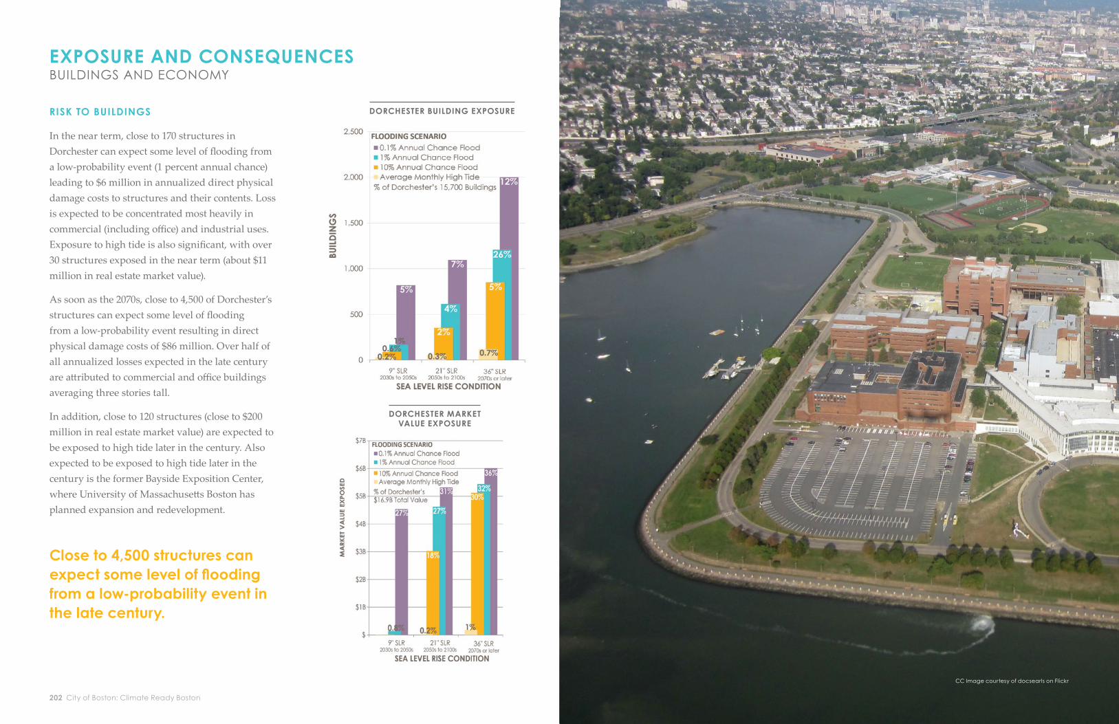
In the near term, close to 170 structures in Dorchester can expect some level of fl ooding from a low-probability event (1 percent annual chance) leading to $6 million in annualized direct physical damage costs to structures and their contents. Loss is expected to be concentrated most heavily in commercial (including offi ce) and industrial uses. Exposure to high tide is also signifi cant, with over 30 structures exposed in the near term (about $11 million in real estate market value).
As soon as the 2070s, close to 4,500 of Dorchester’s structures can expect some level of fl ooding from a low-probability event resulting in direct physical damage costs of $86 million. Over half of all annualized losses expected in the late century are att ributed to commercial and offi ce buildings averaging three stories tall.
In addition, close to 120 structures (close to $200 million in real estate market value) are expected to be exposed to high tide later in the century. Also expected to be exposed to high tide later in the century is the former Bayside Exposition Center, where University of Massachusett s Boston has planned expansion and redevelopment.
DORCHESTER BUILDING EXPOSURE
DORCHESTER MARKET VALUE EXPOSURE
Close to 4,500 structures can expect some level of fl ooding from a low-probability event in the late century.
CC Image courtesy of dalecruse on FlickrCC Image courtesy of dalecruse on Flickr
CC Image courtesy of docsearls on Flickr

Focus Areas 205204 City of Boston: Climate Ready Boston
Over $200 million in current real estate market value is expected to be exposed to high tides in the late century.
RISK TO THE ECONOMY1
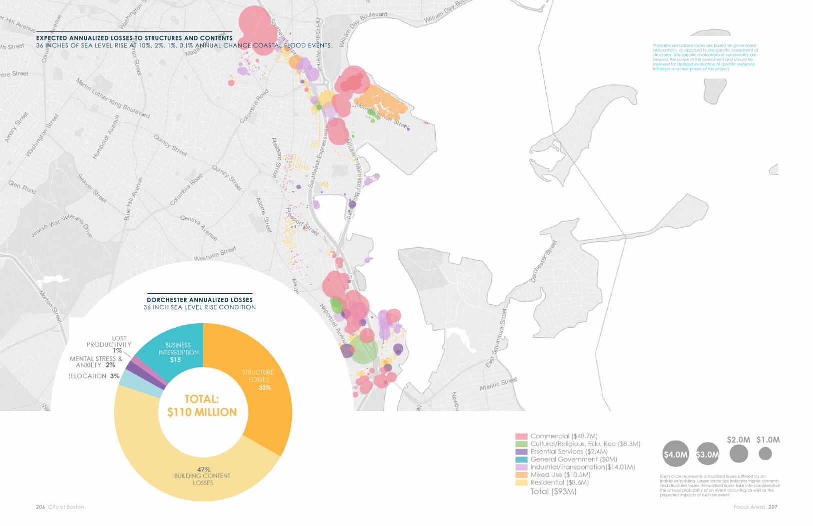
Dorchester provides Boston with close to 35,000 jobs and over $7 billion in annual output. Top employers in the community include public education, hospitals, and grocers, though no one industry seems to dominate. The economy is heavily service oriented. As with other service-oriented neighborhood economies, restaurants are expected to be most heavily impacted in a fl ood event, particularly considering expected loss of employment. This is expected to be the case throughout the century. As soon as the 2070s, coastal fl ood impacts to Dorchester are expected to result in 110 annualized jobs lost and about $15 million in annualized output loss to the current Boston economy. Restaurants are expected to comprise roughly 40 percent of job loss and 20 percent of output loss. Restaurants tend to employ low- to moderate-income personnel, and business interruption to such assets can exacerbate impacts to already vulnerable populations.
ECONOMIC RISK ASSUMPTIONS
Job and output loss includes direct, indirect, and induced consequences of flood impacts. Direct results are impacts felt within a neighborhood, while indirect and induced results are those expected to be felt throughout Suffolk County as a result of changes in spending patterns. Results for both job and output losses are the sum of annualized values for the four flood frequencies analyzed for each sea level rise scenario. This represents a lower-bound estimate for several reasons. First, not all probabilistic events are considered. Second, the analysis assumes that all impacted businesses eventually reopen, though FEMA estimates that almost 40 percent of small businesses—and up to 25 percent of all businesses—never reopen after experiencing flood impacts. Third, only building areas directly impacted by floodwater are assumed to experience business interruption. This does not consider interruptions of businesses due to loss of power or utility functions. Finally, the analysis only considers existing populations, businesses, and buildings and does not include projections for future growth. Refer to the Appendix for a more detailed explanation of the exposure and consequence analysis.
INDUSTRY ANNUALIZED LOSS OF ECONOMIC OUTPUT
Restaurants $3,200,000
Real Estate $1,400,00
Recreation facilities, including bowling centers, sports centers, and parks
$790,000
Wholesale trade and retail
$1,700,000
All other industries $7,900,000
Total $14,900,000
1 Economic data is provided at the zip code level. One of the South Dorchester zip codes overlaps with Mattapan. As such, the base economic data, and thus annual jobs and output production, for South Dorchester includes some of Mattapan. This is expected to have minimal impact on calculated results, which are based on average output and employment by industry per square foot within neighborhood zip codes.
Direct physical damages to structures are expected to be heavily concentrated in commercial and offi ce use buildings.
DORCHESTER ECONOMIC LOSSES
DORCHESTER ANNUALIZED LOSSES
Focus Areas 207206 City of Boston: Climate Ready Boston
DORCHESTER ANNUALIZED LOSSES36 INCH SEA LEVEL RISE CONDITION
EXPECTED ANNUALIZED LOSSES TO STRUCTURES AND CONTENTS36 INCHES OF SEA LEVEL RISE AT 10%, 2%, 1%, 0.1% ANNUAL CHANCE COASTAL FLOOD EVENTS.
Each circle represents annualized losses suffered by an individual building. Larger circle size indicates higher contents and structures losses. Annualized losses take into consideration the annual probability of an event occurring, as well as the projected impacts of such an event.
Probable annualized losses are based on generalized assumptions, as opposed to site-specifi c assessment of structures. Site-specifi c evaluations of vulnerability are beyond the scope of this assessment and should be reserved for detailed evaluation of specifi c resilience initiatives or a next phase of this project.

Focus Areas 209208 City of Boston: Climate Ready Boston
PROTECTED SHORES
DEVELOP LOCAL CLIMATE RESILIENCE PLANS TO SUPPORT DISTRICT-SCALE CLIMATE ADAPTATION
The City should develop a local climate resilience plan for Dorchester to support district-scale climate adaptation. The plan should include the following:
◦ Community engagement through a local climate resilience committ ee, leveraging existing local organizations and eff orts.
◦ Land-use planning for future fl ood protection systems, including Flood Protection Overlay Districts in strategically important “fl ood breach points” identifi ed below (see Potential Flood Protection Locations).
◦ Flood protection feasibility studies, evaluating district-scale fl ood protection, including at locations identifi ed below (see Potential Flood Protection Locations).
◦ Infrastructure adaptation planning through the Infrastructure Coordination Committ ee. For Dorchester, key partners include the Department of Conservation and Recreation, which controls Morrissey Boulevard, and the Boston Parks and Recreation Department, which controls Joseph Moakley Park.
◦ Coordination with other plans, including Imagine Boston 2030, GoBoston 2030, Special Planning Areas, the Morrissey Boulevard redesign, the Joseph Moakley Park master plan, and any potential Municipal Harbor Plan process.
◦ Development of fi nancing strategies and governance structures to support district-scale adaptation.
DORCHESTERAPPLICATION OF RESILIENCE INITIATIVES
ESTABLISH FLOOD PROTECTION OVERLAY DISTRICTS AND REQUIRE POTENTIAL INTEGRATION WITH FLOOD PROTECTION
PRIORITIZE AND STUDY THE FEASIBILITY OF DISTRICT-SCALE FLOOD PROTECTION
The Boston Planning and Development Agency (BPDA) should petition the Boston Zoning Commission to create new Flood Protection Overlay Districts in areas that are strategically important for potential future fl ood protection infrastructure (see Potential Flood Protection Locations below). Within a Flood Protection Overlay District, a developer would be required to submit a study of how a proposed project could be integrated into a future fl ood protection system; options may include raising and reinforcing the development site or providing room for a future easement across the site.
To reduce the risk of coastal fl ooding at major inundation points, the City should study the feasibility of constructing district-scale fl ood protection at the primary fl ood entry points in Dorchester (see Potential Flood Protection Locations below for a preliminary identifi cation of locations and potential benefi ts).
These feasibility studies should take place in the context of local climate resilience plans, featuring engagement with local community stakeholders, coordination with infrastructure adaptation, and considerations of how fl ood protection would impact or be impacted by neighborhood character and growth. Examples of prioritization criteria include the timing of fl ood risk, consequences for people and economy, social equity, fi nancial feasibility, and potential for additional benefi ts beyond fl ood risk reduction.

Focus Areas 211210 City of Boston: Climate Ready Boston
2These preliminary coastal fl ood protection concepts are based on a high-level analysis of existing topography, rights-of-way, and urban and environmental conditions. Important additional factors, including existing drainage systems, underground transportation and utility structures, soil conditions, and zoning as well as any potential external impacts as a result of the project have not been studied in detail. As described in Initiatives 5-2 and 5-3 (see pp. 106,110), detailed feasibility studies, including appropriate public and stakeholder engagement, are required in order to better understand the costs and benefi ts of fl ood protection in each location.
3 Additional fl ood protection may be required for fl ood events more severe than the 1% annual chance fl ood. See Appendix for more detailed information on expected effectiveness of fl ood protection systems, including analysis of additional fl ood protection locations and fl ood frequencies.
4Benefi ts of district-scale fl ood protection would be modest.
SLR SCENARIO DISTRICT SCALE FLOOD PROTECTIONFOR 1% ANNUAL CHANCE FLOOD3
9” SLR (2030s–2050s)
None4
21” SLR (2050s–2100s)
The South Boston Waterfront and Dorchester Bay locations combined
36” SLR(2070s or later)
The New Charles River Dam, South Boston Waterfront, and Dorchester Bay locations combined
POTENTIAL DISTRICT-SCALEFLOOD PROTECTION LOCATIONS2
See District-Scale Flood Protection Systems section for a citywide perspective on district-scale fl ood protection. District-scale fl ood protection is only one piece of a multi-layered solution that includes prepared and connected communities, resilient infrastructure, and adapted buildings.
In the near term, coastal fl ood risk Dorchester is limited to very low-probability, severe events and likely does not require district-scale fl ood protection.
As soon as the 2050s, combined fl ood protection at multiple locations will be critical:
◦ At Dorchester Bay, addressing inland fl ood pathways originating from the Old Harbor and Savin Hill Cove
◦ At the South Boston Waterfront, addressing inland fl ood pathways originating from Fort Point Channel, Boston Harbor, and the Reserve Channel
◦ At the New Charles River Dam, addressing potential overtoppingor fl anking of the dam
LOCATIONS ◦ The Dorchester Bay location focuses on fl ood
pathways along the Old Harbor and Savin Hill Cove. Potential fl ood protection solutions could include a landscaped berm or full elevation of Joseph Moakley Park, a waterside alignment along William Day Boulevard, an alignment along Harbor Point, a landscaped berm or alignment running along the waterfront through Old Harbor Park, and an alignment along Old Colony Avenue.
◦ The New Charles River Dam location, described in the Charles River and Downtown focus areas (see pp. 174, 216), addresses potential overtopping or fl anking of the dam.
◦ The South Boston Waterfront location, described in the South Boston focus area (see p.282), addresses fl ood entry points along the edge of the district.
DETAILED CONSIDERATIONS ◦ Independently eff ective in the near term:
Dorchester Bay fl ood protection is expected to be independently eff ective in protecting portions of Dorchester in the near term until the 0.1 percent annual chance event. Nevertheless, impacts to Dorchester residents are modest in the near term, as the 1 percent annual chance event and higher probability events are not expected to aff ect residential buildings.
◦ Multiple protection locations required in the second half of the century: Dorchester and areas in South Boston surrounding Joseph Moakley Park may be exposed to fl ooding from Fort Point Channel as soon as the 2050s. At this point, fl ood protection at the South Boston Waterfront may be required to supplement fl ood protection at Dorchester Bay. The combination of fl ood protection at these two locations will benefi t Dorchester, South Boston, Downtown, the South End, and even northern Roxbury. Later in the century, interventions at the New Charles River Dam will be required to protect the aforementioned neighborhoods against the 1 percent annual chance event.
DorchesterBay
South Boston
WaterfrontNew Charles
River Dam

Focus Areas 213212 City of Boston: Climate Ready Boston
PREPARED & CONNECTED COMMUNITIES
CONDUCT AN OUTREACH CAMPAIGN TO PRIVATE FACILITIES THAT SERVE VULNERABLE POPULATIONS TO ENSURE THAT THEY ENGAGE IN EMERGENCY PREPAREDNESS AND ADAPTATION PLANNING.
EXPAND BOSTON’S SMALL BUSINESS PREPAREDNESS PROGRAM
The City should conduct outreach to managers of facilities in Dorchester that serve signifi cant concentrations of vulnerable populations and are not required to have operational preparedness and evacuation plans under current regulations. Targeted facilities should include aff ordable housing complexes, substance abuse treatment centers, daycare facilities, food pantries, small nonprofi t offi ces, and others. Illustrative examples of the types of facilities to which the City should conduct outreach are the Harbor Point mixed-income development and Columbia Point Infant Toddler Daycare. These facilities will be exposed to damage from mid-century sea level rise and coastal fl ooding, in addition to access issues related to stormwater fl ooding in the near term.5
The City should reach out to small businesses in Dorchester exposed to stormwater fl ooding risk in the near term or coastal fl ooding risk at 9 inches of SLR to help them develop business continuity plans, evaluate additional insurance coverage needs, and identify low-cost physical adaptations. In Dorchester, there are 34 commercial or mixed-use buildings that could host small businesses exposed to fl ooding under 1 percent annual chance fl ood event with 9 inches of SLR. Furthermore, three Main Street districts, Upham’s Corner, Bowdoin/Geneva, and Field’s Corner, are expected to have isolated portions exposed to stormwater fl ooding in the near term and throughout the century.
5 The City did not review the extent of existing preparedness planning as part of this study.
RESILIENT INFRASTRUCTURE
ESTABLISH INFRASTRUCTURE COORDINATION COMMITTEE ADAPTATION PLANNING.
PROVIDE GUIDANCE ON PRIORITY EVACUATION AND SERVICE ROAD INFRASTRUCTURE TO THE ICC
CONDUCT FEASIBILITY STUDIES FOR COMMUNITY ENERGY SOLUTIONS
The Infrastructure Coordination Committ ee (ICC) should support coordinated adaptation planning for Dorchester’s key infrastructure systems, including transportation, water and sewer, energy, telecommunications, and environmental assets. In the near term, the City will support the MBTA in conducting a full asset-level vulnerability assessment of its system, including the Red Line. The JFK/UMass Red Line Station will be exposed under a 10 percent annual chance fl ood event with 21 inches of SLR.
The Offi ce of Emergency Management should work with Boston Transportation Department, Department of Public Works, and private utilities to provide guidance on critical roads to prioritize for adaptation planning, including evacuation routes and roads required to restore or maintain critical services. Under 9 inches of SLR, four evacuation routes are exposed under a 1 percent annual chance fl ood event. These evacuation routes include I-93 South, Morrissey Boulevard, Neponset Avenue, and Gallivan Boulevard.
The 2016 Boston Community Energy Study identifi ed fi ve sites in Dorchester as feasible locations for emergency microgrids due to their concentration of critical facilities. These sites are the intersection of Gallivan Boulevard and Neponset Avenue, Fields Corner, Codman Square, Four Corners/Geneva, and along Blue Hill Avenue. The Environment Department should work with local stakeholders and utility providers to explore this location. The proposed Gallivan Boulevard and Fields Corner sites are exposed to extensive stormwater fl ooding in the near term. The Gallivan Boulevard site also may be exposed to the 1 percent annual chance event as soon as the 2050s.

Focus Areas 215214 City of Boston: Climate Ready Boston
ADAPTEDBUILDINGS
PROMOTE CLIMATE READINESS FOR PROJECTS IN THE DEVELOPMENT PIPELINE
PREPARE MUNICIPAL FACILITIES FOR CLIMATE CHANGE
Upon amending the zoning code to support climate readiness (see Initiative 9-2, p.135), the Boston Planning and Development Agency (BPDA) should immediately notify all developers with projects in the development pipeline in the future fl oodplain that they may alter their plans in a manner consistent with the zoning amendments (e.g., elevating their fi rst-fl oor ceilings without violating building height limits), without needing to restart the BPDA permitt ing process. Currently, 39 residential and 18 commercial buildings are under construction or permitt ed in Dorchester, representing 3,067 additional housing units and six million square feet of new commercial space.
The Offi ce of Budget Management should work with City departments to prioritize upgrades to municipal facilities in Dorchester that demonstrate high levels of vulnerability (in terms of the timing and extent of exposure), consequences of partial or full failure, and criticality (with highest priority for impacts on life and safety) from coastal fl ooding. Exposure to municipal facilities located in Dorchester is minimal in the near term. Later in the century, the McCormack Middle School, Paul A. Dever School, Boston Collegiate Middle School, and Engine 20 Fire Station will be exposed to fl ood impacts during the 1 percent annual chance event. To address extreme heat risks, the City should prioritize backup power installation at municipal facilities that demonstrate high levels of criticality, including specifi c Boston Centers for Youth and Family and Boston Public School facilities that serve as emergency shelters.
ESTABLISH A CLIMATE READY BUILDINGS EDUCATION PROGRAM FOR PROPERTY OWNERS, SUPPORTED BY A RESILIENCE AUDIT PROGRAM
INCORPORATE FUTURE CLIMATE CONDITIONS INTO AREA PLANS AND ZONING AMENDMENTS
The City should develop and run a Climate Ready Buildings Education Program and a resilience audit program to inform property owners about their current and future climate risk and actions they can undertake to address these risks. To prepare for the most immediate risks, the City should prioritize audits for buildings with at least a 1 percent annual chance of exposure to coastal and riverine fl ooding in the near term, under 9 inches of sea level rise. In Dorchester, this includes almost 170 structures, 35 percent of which are exclusively residential and 24 percent of which are industrial. A resilience audit should help property owners identify cost-eff ective, building-specifi c improvements to reduce fl ood risk, such as backfl ow preventers, elevation of critical equipment, and deployable fl ood barriers; promote interventions that address stormwater runoff or the urban heat island eff ect, such as green roofs or “cool roofs” that refl ect heat; and encourage owners to develop operational preparedness plans and secure appropriate insurance coverage. The resilience audit program should include a combination of mandatory and voluntary, market-based and subsidized elements.
The City should incorporate future climate considerations (long-term projections for extreme heat, stormwater fl ooding, and coastal and riverine fl ooding) into major planning eff orts in Dorchester. The City is conducting a planning process for Glover’s Corner and plans to update the Joseph Moakley Park master plan. The Department of Conservation and Recreation is planning redesign and reconstruction of Morrissey Boulevard.