temperature, salinity, and chlorophyll in biscayne bay and ......project that was underway at the...
TRANSCRIPT
Temperature, salinity, and chlorophyll variability in Biscayne Bay and the southern estuaries, 2002 ‐ 2012
Libby Johns and Chris Kelble
Atlantic Oceanographic and Meteorological LaboratoryNational Oceanic and Atmospheric Administration
4301 Rickenbacker Causeway, Miami, FL
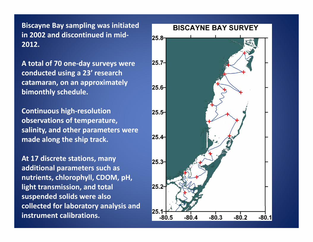
Biscayne Bay sampling was initiated in 2002 and discontinued in mid‐2012.
A total of 70 one‐day surveys were conducted using a 23’ research catamaran, on an approximately bimonthly schedule.
Continuous high‐resolution observations of temperature, salinity, and other parameters were made along the ship track.
At 17 discrete stations, many additional parameters such as nutrients, chlorophyll, CDOM, pH, light transmission, and total suspended solids were also collected for laboratory analysis and instrument calibrations.

Surface temperature, salinity, and chlorophyll data from stations #1 through 16 will be used for most of the statistical analyses to follow in this presentation.
Station #17, located offshore of the Deering Estate, was started later (in 2005) and will be discussed separately.
There are a total of 1166 station occupations.

Sea Surface Temperature
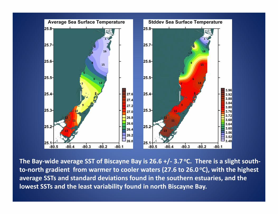
The Bay‐wide average SST of Biscayne Bay is 26.6 +/‐ 3.7 oC. There is a slight south‐to‐north gradient from warmer to cooler waters (27.6 to 26.0 oC), with the highest average SSTs and standard deviations found in the southern estuaries, and the lowest SSTs and the least variability found in north Biscayne Bay.

The cruise‐averaged SST time series shows an annual cycle, with a low of 18.3 oC on 1/19/2005, and a high of 32.2oC on 8/1/2012. A small (1.5 oC) warming trend over the 2002 – 2012 time period is probably not significant due to the sparse temporal resolution.

The SST distribution is non‐Gaussian. The average SST (26.6 oC) is about .6 oC lower than the median SST value of 27.2 oC. Temperatures deviate farther from the mean in the winter months.

The SST shows a pronounced annual cycle, with climatological values over 30oC during the summer months (JAS) and below 22oC during the winter months (DJF). Individual cruises can vary from this pattern, for example March 2003 (circled in red) was anomalously warm as compared to climatology.

Station‐station time series correlations were calculated for all station pairs. The results for correlations with station #15 (offshore) are shown above. The correlations are all in the .9 to 1.0 range, indicating that the SST for the Bay as a whole increases and decreases seasonally without much spatial variability.
In the finer contour interval shown in the right panel, a tendency for stations #5 and #12 to be slightly less correlated with the other stations can be seen.

SST VARIABILITY SUMMARY
Biscayne Bay responds as a whole to SST changes imposed by air temperature variability on an annual cycle, and also to extreme warm and cold events with spatial scales larger than the Bay.
Station‐station time series correlations for SST showed that each station is correlated with each of the other stations at the .9 to 1.0 level.
Stations #5 and #12 (located near canal mouths) are slightly less correlated with the other stations.

Salinity

The overall Bay‐wide average SSS is 31.6 +/‐ 6.6 psu, with a range of 21.7 (at station #5) to 36.4 (at station #14). There is an onshore‐offshore gradient from fresher to saltier waters, with the most variability found at the onshore stations, including Manatee Bay (#12), and the least variability found at the offshore stations.

The Bay‐wide average SSS time series shows a low of 21.7 in August 2005 following Hurricane Katrina, and a high of 39.9 in July 2004 during an extended drought. There is no particular trend over the 2002 – 2012 time period, but there is much annual and interannual variability.
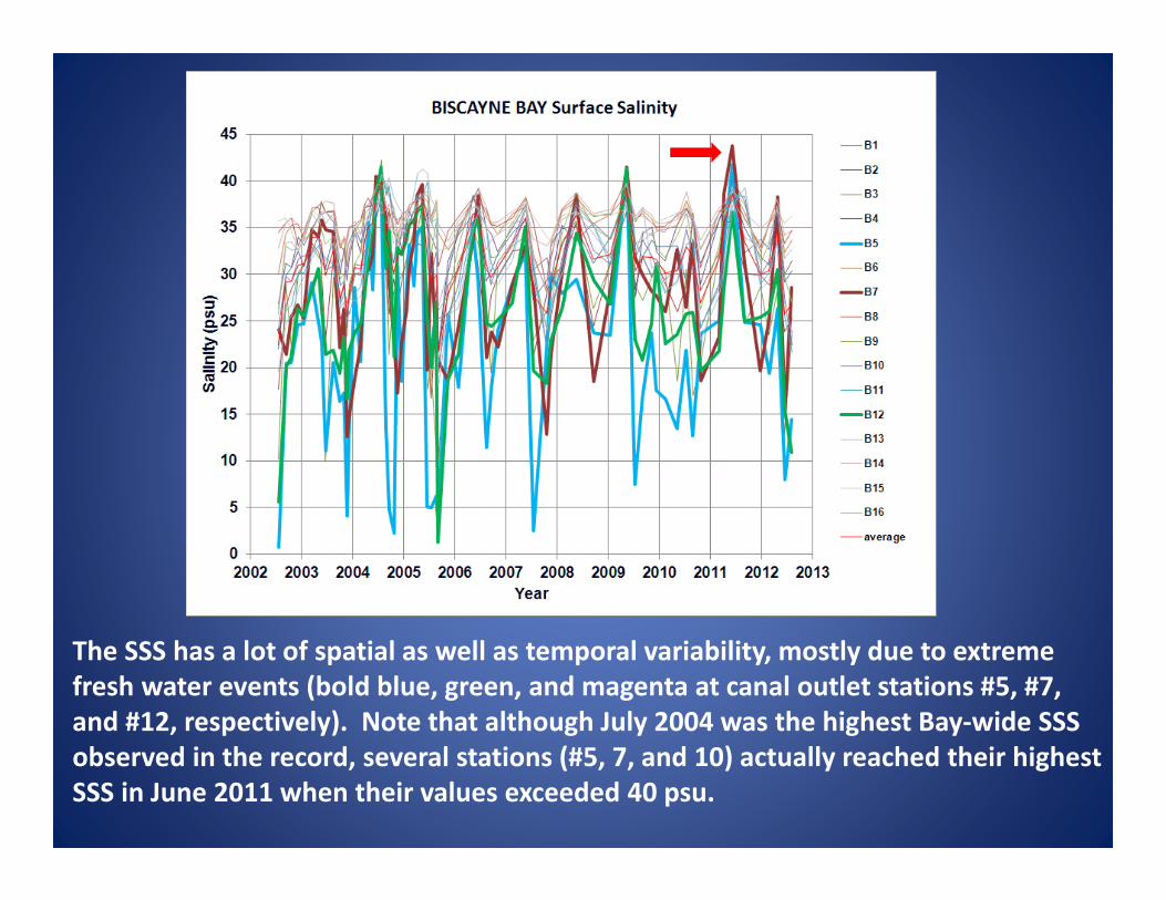
The SSS has a lot of spatial as well as temporal variability, mostly due to extreme fresh water events (bold blue, green, and magenta at canal outlet stations #5, #7, and #12, respectively). Note that although July 2004 was the highest Bay‐wide SSS observed in the record, several stations (#5, 7, and 10) actually reached their highest SSS in June 2011 when their values exceeded 40 psu.
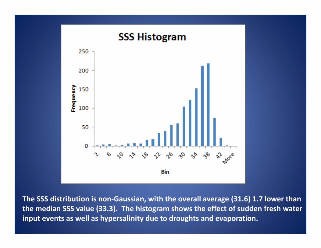
The SSS distribution is non‐Gaussian, with the overall average (31.6) 1.7 lower than the median SSS value (33.3). The histogram shows the effect of sudden fresh water input events as well as hypersalinity due to droughts and evaporation.

The SSS has an annual cycle with climatological values approaching 35 during the dry season (MAM) and below 30 during the wet season (SON). Individual cruises vary widely, and sudden fresh events occur in all months except March and April.

Station‐station time series correlations are shown above, with a contour scale of 0.2 (blue) to 1.0 (dark red). Correlations with station #13 (left panel) show a southern estuaries group. The correlations with station #5 (center panel) show a coastal group that receives fresh water canal inputs. Station #12, in Manatee Bay, is also correlated with this group. The correlations with station #15 (right panel) show an offshore station group.

SSS VARIABILITY SUMMARY
Salinity variability in Biscayne Bay is mostly driven by fresh water input from canals and local precipitation over the Bay during the wet season, and droughts and evaporation during the dry season.
There are three primary station groups. The inshore group responds most to the fresh water inputs from the adjacent local canals, with the lowest SSS and high variability.
The offshore stations have higher oceanic SSS and low variability due to tidal exchanges with the Atlantic offshore waters.
The southern estuaries, which tend to become relatively fresher or saltier than the rest of Biscayne Bay because they are the most isolated from the circulation and as a result have longer residence times, on the order of months, compared to the central and northern Bay.

Chlorophyll

The Bay‐wide average CHL is 1.0 +/‐ 1.5 mg/m3, with a range of .3 (at station #15) to 1.9 (at station #12). Highest values are found in the southern estuaries and at stations #2 and #5 in the central and northern coastal Bay. The standard deviation map looks nearly identical to the average CHL map, with highest variability found in the southern estuaries and very low variability found in the central offshore Bay.

The Bay‐wide average CHL shows low background levels between blooms of .2 to .5 mg/m3, and a highest value of > 3.7 mg/m3 (on 8/9/2006) during an extreme algal bloom. There is much annual and interannual variability, with a tendency for an annual wet season/dry season bloom cycle. There may be a small positive trend, especially over the last 4 years.

Time series from each of the stations are shown above, with their average shown in red. The highest average values measured were clearly dominated by the southern estuaries, stations #9, 10, 11, 12, and 13 (shown in a bold font). This bloom started suddenly near the end of 2005, peaked in 2006, and lessened during 2007 to near background CHL levels. Other, smaller blooms occur at different stations and times, but the southern estuaries event was the most notable feature for this time period.

The CHL distribution is extremely non‐Gaussian. The average Bay‐wide CHL (0.1 mg/m3) is .5 mg/m3 higher than the median CHL value (0.5 mg/m3). The histogram shows that typical CHL values tend to be very low (.1 to .5 mg/m3), while extremes occur with isolated values as high as 16 mg/m3.

There is a small wet/dry season cycle in the record, with high CHL events occurring in most months except during the peak of the dry season (March and April).

Station‐station correlations are shown above for stations #13, #15, #5, and #1 (left to right). The southern estuaries stand out as a highly correlated group, uncorrelated with the offshore central and northern Biscayne Bay stations (first panel).
A second group is comprised of the offshore central Bay stations (second panel), and a third group seems to form around station #5 (third panel).
A fourth group, which had not been identified by SSS, is apparent in the northern Bay (fourth panel), where blooms can form which are only weakly correlated with the rest of the Bay.

CHL VARIABILITY SUMMARY
The extreme algal blooms that occurred in the southern estuaries during 2005 to 2007 dramatically dominated the CHL time series records. These blooms were caused by a combination of hurricane effects and the road construction project that was underway at the time (Rudnick et al., 2006 report).
The relatively isolated southern estuaries, the offshore stations, and the coastal stations of the central Bay, most particularly station #5, show high within‐group correlations very similar to the salinity results.
However, there is a fourth group with high correlation comprised of the northernmost Biscayne Bay stations (primarily station #1, but also stations #2 and #16, off Key Biscayne). These stations tend to have algal blooms independent of the rest of the Bay.

Station #17, located just offshore of the Deering Estate between stations #3 and #5 and highly correlated in SSS with both of them, was added in 2005 when there was discussion of restoring this area to a more natural wetland or slough as part of CERP’s Biscayne Bay Coastal Wetlands (BBCW) Phase 1. Measurements continued through August 2012, providing a baseline for comparison with future salinity changes.

Summary
Sea surface temperature, salinity, and chlorophyll observations from 2002 to 2012 were used to look at spatial and temporal patterns of variability and to divide the stations into correlated groupings.
Temperature responds primarily to atmospheric forcing on spatial scales larger then the Bay. Slight temperature differences were seen in the coastal, central‐Bay stations located adjacent to canals.
Salinity responds primarily to hydrological wet/dry season forcing. There are three highly correlated groups: (1) an inshore zone with low salinity and high variability dominated by the canal outflows; (2) an offshore zone with salinities typical of the adjacent Atlantic waters due to tidal mixing; and (3) a southern estuaries zone characterized by very high and low salinity events.

Summary, cont.
Chlorophyll responds primarily in the form of algal blooms to enhanced nutrient concentrations delivered by fresh water canal flow and run‐off. There is a tendency for higher chlorophyll concentrations to occur in the wet season and lower in the dry season, but blooms were observed in every month of the year except for March and April.
Based on the CHL analysis, three highly correlated station groups are the same as those derived from salinity: inshore (higher chlorophyll), offshore (lower chlorophyll), and the southern estuaries (extreme algal blooms in 2005 – 2007).
However, there was also a fourth group in the northern Bay that was characterized by moderate algal blooms not well correlated with the rest of Biscayne Bay and the southern estuaries.

Bottom Line:
Bimonthly sampling is obviously not ideal, but the results from this simple analysis “make sense” on their own and agree qualitatively with those of other programs. Future work will incorporate the rest of the sampled parameters such as nutrients, NH4, CDOM, pH, light transmission, and total suspended solids.
Thank you!