tectonic history of the palo duro basin, texas panhandle
TRANSCRIPT
TECTONIC HISTORY OF THE PALO DURO BASIN,
TEXAS PANHANDLE
by
Roy T. Budn; k
Prepared for the U. S. Department of Energy
Office of Nuclear Waste Isolation under contract no. DE-AC-97-83WM46615
Bureau of Economic Geology W. L. Fisher, Director
The University of Texas at Austin Un i ve rs i t Y S tat ion, P.O. Box X
Austin, Texas 78712
OF-WTWI-1983-1
, /
)
~'
3.3.2 TECTONIC HISTORY
INTRODUCTION
The Palo Duro Basin is one of a dozen or more intracratonic basins formed as a result of
large-scale plate motions in the Late Paleozoic (Goldstein, 1981; Kluth and.Coney, 1981). The
margins of the basin are defined by a series of uplifts that developed during the Pennsylvanian
(fig. 1). The Palo Duro Basin is bounded on the northeast by the Amarillo-WiChita Uplift, on the
northwest by the Bravo Dome, and on the west by the Sierra Grande and other smaller uplifts,
all of which were imporant sources of sediment. To the south, the Matador Arch served as a
sediment barrier and loci of carbonate buildups, as did a number of smaller, generally unnamed,
uplifts to the east.
The Palo Duro Basin includes sediments deposited in two temporally separate but spatially
overlapping basins (Budnik and Smith, 1982). The initial basin, a northwest extension of the
Hardeman Basin (fig. 2), formed as a result of the foundering of a Mississippian shelf during the
latest Mississippian or early Pennsylvanian (Budnik and Smith, 1982; Dutton and others, 1982).
Up to 2,500 ft (750 m) of Pennsylvanian and a similar thickness of Wolfcampian (Lower
Permian), primarily marine, sediments were deposited during this phase (Dutton and others,
1982). A second basin (effectively the northern shelf of the Midland Basin; fig. 3) formed in
response to regional subsidence of the much larger Permian Basin. In excess of 4,000 ft
(1,200 m) of restricted marine to non-marine sediments were deposited nearly continuously
throughout the mid- and late Permian (Leonardian, Guadalupian, and Ochoan; Presley, 1980).
REGIONAL TECTONIC HISTORY
The distribution of Late Paleozoic sediments, as well as older and younger deposits within
the Palo Duro Basin were influenced by movement along preexisting faults (Budnik and Smith,
1982; Dutton and others, 1982; McGookey and Goldstein, 1982; Budnik, 1983). These
1

intrabasinal faults are related to a regional zone of crustal weakness that extends from
Oklahoma and New Mexico into Colorado and Utah. Occupying this zone are the Amarillo
Wichita Uplift, the Cenozoic Rio Grande Rift and its precursors, and the central Colorado
uplifts (fig. 4). The Amarillo. Uplift is continuous with the Apishapa-Wet Mountain Uplift of
southeastern Colorado (King, 1977) via the Freezeout Creek fault zone an~ other, previously
unrecognized faults in northestern New Mexico and adjacent states. Recurrent movement along
this three-pronged system of faults appears to have been the dominant contrOlling influence on
the tectonic history of the Palo Duro Basin.
Precambrian
The origin of the regional system of faults can be traced back to the late Precambrian,
when it may have formed as a result of deep mantle processes. The three-pronged
configuration is very similar to plume-generated triple junctions recognized elsewhere (Burke
and Dewey, 1973). Isotopic data from mafic volcanics near the apex of the system also suggest
the presence of a mantle plume in that area approximately 1,800 to 1,900 my a (Condie and
Budding, 1979). All three segments mark boundaries between contrasting basement terranes
and/or include faults that exhibit evidence of Precambrian movement along them.
The southeast (Wet Mountain-Wichita Mountain) segment appears to delineate the
northern edge of a Proterozoic (1,200 to 1,400 mya) basin (Brewer and others, 1983; Tweto,
1983). In the Hardeman Basin, south of the Wichita Uplift, COCORP seismic reflection surveys
(Oliver and others, 1976; Brewer and others, 1981) revealed the presence of a thick (23,000 to
33,000 ft; 7 to 10 km) sequence of well-layered strata interpreted to be interbedded volcanic
and sedimentary rocks of the Tillman Group (Flawn, 1956; Brewer and others, 1981; fig. 5).
North of the Amarillo-Wichita Uplift, layering is absent within the crust. Brewer and others
(1983) suggest on the basis of this contrast that the uplift formed as a result of Paleozoic
reactivation of a fault zone that was in existence at the time of formation of the Proterozoic
basin.
2

A similar relationship exists in southeastern Colorado. The Las Animas Formation, a low
grade metasedimentary and bimodal metavolcanic sequence (Tweto, 1983) occurs south of the
Apishapa fault and west of the Freezeout Creek fault zone (fig. 6). The unit appears to have
been preserved in a graben within approximately 1,4-00 my a granites, which is truncated by
basal Cambrian sandstones. Tweto (1983) correlated the Las Animas Formation with the
Tillman Group on the basis of lithology, age, and structural setting. He believes the Apishapa
fault originated in the Precambrian and formed the northern edge of the basin into which the
Las Animas Formation was deposited (Tweto, 1980a).
The Proterozoic basin or basins inferred from the Las Animas and Tillman units may have
covered a much larger area including parts of Oklahoma, Texas, Colorado, and New Mexico.
These units, together with volcanics of the Panhandle (rhyolite) and Swisher (diabase) terranes,
and the metaarkoses and metagraywackes of the De Baca and possibly Fisher terranes (Flawn,
1956) may define a Proterozoic basin that covered over 50,000 square miles (130,000 sq. km;
fig. 7). Proprietary and nonproprietary seismic reflection surveys (fig. 8) and gravity data
(Goldstein, 1982) confirm the presence of thick, well-stratified sequences beneath the Paleozoic
of the Palo Duro and Tucumcari Basins. This large Precambrian basin was bounded on the north
by the southeast segment of the regional fault system.
The Precambrian history of New -Mexico is less well understood, as the area has been
subjected to multiple major Phanerozoic deformations. Nonetheless, it appears that the
southern segment of the regional fault zone also odginated in the Precambrian. The zone
parallels the western margin of the above-described Proterozoic basin, and appears to separate
rocks greater than 1,4-00 my a on the west from younger rocks to the east (fig. 7).
Individual faults within this segment appear to have originated in the Precambrian. East
of Albuquerque, the Tijeras fault separates Precambrian greenstones from gneisses. Aplite and
pegmatite dikes associated with 1,400 to 1,800 my a plutonism are arranged en echelon to the
fault in the greenstone indicating movement on the fault at that time (Lisenbee and others,
1979). To the north, in the southern Sangre de Cristo Mountains, the Picuris-Pecos fault zone
3

may have also formed in the Precambrian (Miller and others, 1963). Schists, 1700 to 1800 my a
(Robertson and Moench, 1979) are complexly deformed adjacent to the fault and are intruded by
undeformed mafic dikes that parallel the fault.
There is a great deal of evidence to suggest that the northwest (Colorado) segment of the
regional fault system originated in the Precambrian. Baars (1976) and Tweto (1980a) have
summarized the evidence for individual faults within the segment (fig. 9). For example, the
Use-Gore system, a major north-northwest trending fault zone, predated the -emplacement of a
1,700 my a granite in the Wet Mountains (Tweto, 1980a). Also, in southwestern Colorado, the
Coalbank Pass fault offsets 1,780 my a granite and is intruded by 1,4-00 my a granite (Baars,
1976). Tweto (1980b) defines at least two periods of faulting during the Precambrian: one at
about 1,700 my a and another at about 1,400 my a based on these and other data.
Late Precambrian-Early Paleozoic
Deciphering the late Proterozoic and early Paleozoic tectonic history of the region is
difficult because much of the section is missing due to erosion or nondeposition. Even so, there
is evidence that the Precambrian faults along each segment of the system were reactivated
during this period.
A major rifting event along the southeastern segment produced the southern Oklahoma
aulacogen during the latest Precambrian and Early Cambrian (Hoffman and others, 1974). The
resulting basin was filled with up to 20,000 ft (6,100 m) of bimodal volcanics and volcanoc1astic
sediments (Ham and others, 1964). The Precambrian faults were again reactivated during the
Late Cambrian to Early Ordovician as indicated by anomalously high sedimentation rates and
the distribution of lithofacies within the Arbuckle Group in the Ardmore Basin (Feinstein, 1981).
The uppermost Devonian Woodford Formation overlies Devonian through Cambrian units on the
flanks of the Wichita Uplift, indicating fault movement during the mid-Devonian (Tarr and
others, 1965). Renewed uplift of the Amarillo Mountains, possibly accompanied by faulting, is
suggested by rapid facies changes in the Kinderhook Series (Lower Mississippian) of the western
Anadarko BaSin (Mapel and others, 1979).

The early Paleozoic history of the southern (New Mexico) segment is largely unknown; in
many areas Pennsylvanian or younger strata lie directly on basement. In south central New
Mexico, an angular unconformity between Cambrian through Lower Devonian units and Upper
Devonian strata (Kottlowski and others, 1956) suggests regional uplift, perhaps accompanied by
localized faulting during mid-Devonian. There is good evidence for early Paleozoic faulting in
the Sangre de Cristo Range to the north. The Del Padre Formation thickens and becomes
conglomeratic against the Picuris-Pecos fault, which, as discussed above, also has evidence of
Precambrian movement. The Del Padre is unfossiliferous and its age is unknown. Baltz and
Read (1960) consider it and the overlying Espiritu Santo Formation to be Devonian (?) on the
basis of lithologic correlation with Devonian units in Colorado. Armstrong (1979) indicates that
both formations are middle Mississippian (Osagean) based on fossils found in the Espiritu Santo.
In either case, the Picuris-Pecos fault was reactivated during the early P~eozoic.
A vailable data for the northwest (Colorado) segment indicate that the Precambrian faults
were periodically reactivated during the early Paleozoic. In southwest Colorado, the Upper
Cambrian Ignacio Formation, Upper Devonian Elbert Formation, and Lower Mississippian
(Osagean) Leadville Formation all coarsen toward the margins of northwest-trending grabens
(Baars and See, 1968). A similar pattern is seen in central Colorado in the Upper Cambrian
Sawatch, Upper Devonian Parting and Leadville Formations (Baars, 1976; Tweto, 1980a).
Pennsyl vanian
The most intense Paleozoic deformation along the regional system took place during the
formation of the Ancestral Rockies in the Pennsylvanian and early Permian (Ham and Wilson,
1967; DeVoto, 1980; Dutton and others, 1982). During this time, preexisting faults were
reactivated to produce a series of fault-bounded uplifts and rapidly subsiding basins along aU
segments. The following discussion applies to all segments and is based primarily on the work
of Kluth and Coney (1981) and the above-cited authors.
5

The initial movement was one of minor uplift and erosion during the latest Mississippian
or earliest Pennsylvanian. Mississippian and older strata were stripped off broad areas that
were then broken into horsts and grabens during the Pennsylvanian. These epeirogenic
movements were followed by three pulses of deformation: one in the early Pennsylvanian
(Morrowan-A tokan; Wichita Orogeny), one in the middle Pennsylvanian (Desmoinesian; Ouachita
Orogeny), and one in the late Pennsylvanian to early Permian .(Virgilian to Wolfcampian;
Arbuckle or Marathon Orogeny). Thousands of feet of arkosic sediment accumulated in basins
adjacent to basement-cored source terranes. Each succeeding pulse deformed sediments
deposited during the previous episode. While the Whole region was undergoing deformation at
this time, the areas of greatest structural relief were confined to the regional fault system
(fig. 10).
Permian
Tectonic activity decreased during the middle and late Permian, although preexisting
structures continued to influence depositional patterns (McGookey, 1981; McGookey and
Goldstein, 1982; fig. 11). The uplifts along the southeast segment subsided along with the
adjoining basins to form the northern part of the Permian Basin (fig. 12). The Amarillo Uplift
was completely covered by Wolfcampian shelf carbonate (Dutton and others, 1982). The
Wichita Uplift continued to be a source of coarse arkosic sediment (the Pontatoc Formation) as
late as mid-Permian. Younger Permian strata in the Anadarko Basin become clastic-rich in the
vicinity of the uplift as well (Fay, R. 0., 1964).
Deformation over the Apishapa Uplift was apparently intermittent during the mid
Permian. East of the Freezeout Creek fault zone, there is a complete section of Pennsylvanian
and Lower Permian strata. West of the fault, the Pennsylvanian, upper Wolfcamp and lower
Leonard are absent (fig. 13; Rascoe and Baars, 1972). Coarse arkosic sediments were deposited
along the eastern side of the Front Range of Colorado and the Sangre de Cristo Mountains of
New Mexico through the mid-Permian. Widespread unconformities within upper Permian strata
are present throughout the region, indicating continued epeirogenic movement (Rascoe and
Baars, 1972). 6
Mesozoic
Early and Middle Mesozoic deformation is difficult to document because of a general lack
of Triassic and Jurassic strata within the regional fault system. In the Uncompaghre Mountains,
Precambrian faults were reactivated during the Late Permian or early Triassic. The Cutler
Formation (Permian) was folded and faulted prior to deposition of the Dolor~s Formation (Upper
TriassiC; Weimer, 1980). Along the southern extension of the Freezeout Creek fault zone, there
appear to have been at least two episodes of deformation during the .mid-Mesozoic. In
northeastern New Mexico, Upper Triassic strata (Dockum Group) were folded prior to deposition
of the Jurassic Exeter Formation (Baldwin and Muehlberger, 1959, fig. 1lf.a). A few miles to the
east, in northwestern Oklahoma, the Jurassic is folded beneath the Cretaceous (Stovall, 19lf.3;
fig. llf.b).
Early Tertiary
The western parts of North and South America underwent major deformation during the
Laramide Orogeny (latest Cretaceous and early Tertiary). Many Precambrian faults within the
southern and northwestern segments of the regional system were again reactivated to form
major uplifts and basins (Miller and others, 1963; Tweto, 1980b). The effects of this orogeny
were much less pronounced along the southeastern segment. The Dakota Sandstone (lower
Cretaceous) and older rocks were folded and faulted over the Apishapa and Freezeout Creek
fault zones (Scott, 1968). The Dockum Group may have been downfaulted against the Permian
along the south side of the Amarillo Uplift during this time (Barnes, 1969). Upper Permian
strata are faulted at the surface along the north side of the Wichita Uplift (Carr and Bergman,
1976). The age of faulting is unknown, but may be related to the Laramide Orogeny.
Late Tertiary
A second major tectonic event occurred during the Tertiary in the western United States.
The Basin and Range province formed as a result of extension during the Neogene (King, 1977).
The eastern edge of this province, delineated by the Rio Grande Rift, lies along the southern
7

and northwestern segments of the regional system. Many of the faults that bound the Neogene
grabens within the Rio Grande Rift originated in the Precambrian, including the Tijeras and
Picuris-Pecos faults in New Mexico (Kelley, 1979; Lisenbee and others, 1979) and the Use and
Gore faults in Colorado (fig. 15; Taylor, 1975; Tweto, 1979, 1980b). Rift basins bounded by
these and other reactivated faults are filled with up to 13,000 ft (4,00-0 m) of syntectonic
deposits of the Sante Fe Formation (Kelley, 1977).
The southeast segment of the regional system was generally unaffected by Basin and
Range deformation. The Ogallala Formation, coeval with the Sante Fe Formation, was
deposited as a vast, relatively thin sheet east of the rift (fig. 15). In the Texas Panhandle, the
Ogallala Formation averages about 300 ft (loa m) in thickness (Seni, 1980, fig. 16). Locally,
however, there are areas of anomalous thickening. Along the south side of the Amarillo Uplift,
the Ogallala is in excess of 800 ft (250 m) thick. This thick Ogallala s~ction is in the Carson
County Basin, part of the Whittenburg Trough (Soderstrom, 1968) (fig. 17).
The Carson County basin lies within the zone of Quaternary dissolution of Permian
evaporites (Gustavson and others, 1980; fig. 18) and may be related to Neogene dissolution.
However, the similarity of post-salt (Ogallala) and pre-salt (Tubb, Wolfcampian, and basement)
structures in the basin (fig. 19) suggests that it is of tectonic origin. A proprietary seismic line
across the eastern end of the basin confirms the presence of a pre-salt graben in this area. The
Carson County basin is interpreted to be a rhomb graben formed as the result of local strike
slip faulting during Basin and Range deformation in the Neogene.
TECTONIC HISTORY OF THE PALO DURO BASIN
The history of deformation within the Palo Duro Basin is closely related to that of the
surrounding region. The effects of each deforming event were more subtle, however, in the
basin than along the regional fault system.
8

The dominant structural grain of the Palo Duro Basin is northwest (Nicholson, 1960;
Budnik and Smith, 1982; Dutton and others, 1982), as defined by the orientation of numerous
fault-bounded blocks within and adjacent to the basin (fig. 20). This trend is parallel to that of
individual faults within the Amarillo Uplift and Matador Arch, but oblique to the overall strike
of these two features.
Precambrian
Timing of the initiation of faulting within the basin is difficult to document. As discussed
above, the Palo Duro Basin was part of a larger Proterozoic basin or series of basins (fig. 7).
Proterozoic basin fill within the Palo Duro Basin consists of rhyolite (Panhandle terrane),
diabase and intercalated calcareous and siliceous metasediments (SwiSher Terrane) and coeval
granite (Amarillo terrane) onto which the volcanics were extruded (Flawn, 1956; Muehlberger
and others, 1967; Goldstein, 1982). The volcanics were originally believed to be approximately
1,100 myoId (Muelhberger and others, 1966); however, recent age determinations place them at
about 1,300 my a (W. Muehlberger, personal communication). The bimodal basalt-rhyolite
association, indicative of a rift environment (Hoffman and others, 1974; Condie and Budding,
1979), implies contemporaneity of faulting and volcanism. Where contacts between terranes
are relatively well-defined, they coincide with faults. Tweto (1980b) and Brewer and others
(1983) observed similar relationships between basement terranes and faults along the southeast
segment of the regional system and postulated a Precambrian origin for those faults. Faults
within the Palo Duro Basin may also have formed 1,300 mya.
Late Precambrian-Early Paleozoic
Evidence for Late Precambrian-Early Cambrian deformation within the Palo Duro Basin is
tenuous. An arkosic sandstone occurs beneath basal Cambrian(?) quartzose sandstone in a few
wells within the basin. This arkose is generally considered on sample logs to be weathered
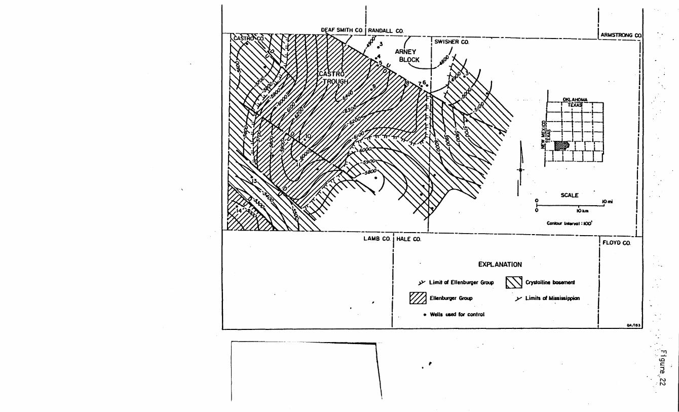
basement. However, in the Sun Oil Company III Herring well in Castro County (BEG IICastro
11, fig. 21), Roth (1960) described the unit as consisting of slightly metamorphosed arkosic
9

sandstone and interbedded pyroclastics. This unit, which lies on diabase of the Swisher terrane
in the Sun Oil well appears to be preserved in the deepest part of the Castro Trough (named by
Birsa, 1977; figs. 22, 23, and 24-). The age of the arkose is unknown. Other sandstone units in
the Proterozoic basin are primarily graywackes (Tillman) or quartzites (DeBaca; Muehlberger
and others, 1967). The Las Animas Formation (Tweto, 1983) consists of ~wo distinct phases
(1) gray quartzite and graywacke similar to the Tillman Group and (2) arkose, graywacke, and
phyllite, all maroon in color, some limestone, and thin interbeds of volcanics. The two phases
are found in wells 4-0 miles (65 km) apart. Tweto (1983) interprets the arkosic phase to be the
upper part of the formation. However, the arkose may be a younger unit and it and the Castro
County arkose may reflect faulting during the opening of the southern Oklahoma aulacogen.
A stable shelf occupied the area of the Palo Duro Basin during the Late Cambrian to Early
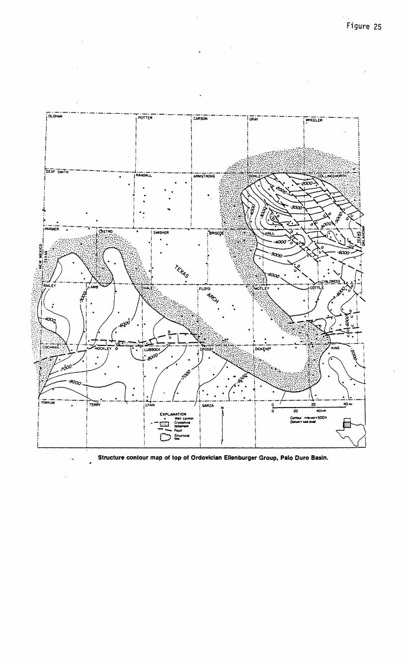
Ordovician (Dutton and others, 1982). Sometime between mid-Ordovician .and early Missisippian
time, a northwest trending area in the central Panhandle was uplifted to form the Texas Arch
(fig. 25; Adams, 1954). Ellenburger (Ordovician) carbonates and Cambrian(?) clastics were
eroded from the crest of the arch, except where preserved in downfaulted blocks, such as the
Castro Trough (fig. 22). Silurian and Devonian sediments present on the flanks of the arch are
absent over the crest due to erosion or non-deposition. Precise timing of uplift and
accompanying faulting is unknown; however, on the eastern flank of the arch, in the Hollis
Basin, units as young as Devonian (Hunton Group) are truncated below Upper Devonian and
Lower Mississippian strata (Tarr and others, 1965), suggesting a mid-Devonian age of deforma
tion (Ham and Wilson, 1967).
Pennsyl vanian ,
The formation and major deformation of the Palo Duro Basin coincided with the
development of the Ancestral Rockies (Goldstein, 1982). During this time, the Palo Duro Basin
underwent three pulses of deformation (Ham and Wilson, 1967). Initially, the basin formed in
the latest Mississippian to earliest Pennsylvanian as a result of the breakup of the Mississippian
10

shelf along preexisting faults. Mississippian and older strata were eroded off fault blocks within
the basin and surrounding uplifts (Dutton and others, 1982). Lower Pennsylvanian sediments
were deposited primarily in the southeastern part of the basin, which was an extension of the
Hardeman Basin (fig. 26; Budnik and Smith, 1982). The main period of deformation occurred
during the mid-Pennsylvanian (Dutton and others, 1982). The basin axis shifted westward and
became oriented parallel to the northwest trending structural grain (fig. 26). A series of deep
grabens (the Whittenburg Trough; Soderstrom, 1968) developed along the' south flank of the
Amarillo Uplift and separated the uplift from the Palo Duro Basin (fig. 20). The trough trapped
most of the arkosic sediment shed off the south side of the uplift (fig. 27). Intrabasinal fault
blocks were important sources of sediment. Lower Pennsylvanian deposits thin by up to 50
percent across upfaulted blocks, and in some cases are absent on the higher structures (fig. 28).
By the end of the Desmoinesian (middle Pennsylvanian), many of the structural highs had been
eroded down and most of the area was covered by a carbonate shelf (Dutton, 1980; Handford
and others, 1981).
Renewed movement during the Late Pennsylvanian differentiated the region into a well
defined basin and Shelf-margin complex (Dutton and others, 1982). Carbonate buildups were
localized on structurally high blocks (figs. 29 and 30; Handford and others, 1981; Budnik and
Smith, 1982). Episodic movement throughout the Late Pennsylvanian and Early Permian
(Wolfcampian) maintained the high standing areas. T.his phase culminated in the Wolfcampian
with erosion of Upper Pennsylvanian (Cisco) strata from fault blocks in the southwestern part of
the basin (Budnik and Smith, 1982) and a westerly shift of the basin axis (figs. 26 and 31). The
remainder of the Wolfcampian was marked by a filling of the basin and development of a
carbonate shelf over the entire region (Handford, 1980).
Permian
A second basin formed in the mid-Permian (Leonardian) under the influence of regional
subsidence associated with the larger Permian Basin (fig. 12; Budnik and Smith, 1982). The Palo
11

Duro Basin subsided nearly continuously during the remainder of the Paleozoic, eventually being
filled with over 4,000 ft (1,200 m) of evaporites and related strata, which were deposited at or
near sea level (fig. 32; Presley, 1980) •.
Basement structures continued to subtly influence depositional patterns during this phase.
The entire evaporitic interval thins over basement highs. In the Castro Trough, for example,
which apparently existed during the pre-Paleozoic, the pre-Mississippian, and the Pennsylvan
ian, Permian deposits were also affected by basement structure (fig. 33). Mid-Permian
(Leonardian) strata (Wichita Group and Glorieta Formation) are more clastic-rich in the trough
than on the flanking highs (figs. 34 and 35; Presley and McGillis, 1982; Handford, unpubliShed
data). Upper Permian (Guadalupian) units exhibit similar trends. Salt in the San Andres Cycle 4
thickens into the trough (fig. 36) as does the clastic portion of the Salado-Tansill Formation
(fig. 37; McGillis and Presley, 1981). The uppermost Permian evaporitic unit (the Alibates
Formation) thins over the basement high northeast of the Castro Trough (McGillis and Presley,
1981). In central Randall County, the Permian thins over a basement high and units as young as
the Alibates are deformed over a basement fault (fig. 8). In Palo Duro Canyon, intraforma
tional angular unconformities in the Quartermaster Formation (fig. 38) indicate that deforma
tion continued into the latest Permian.
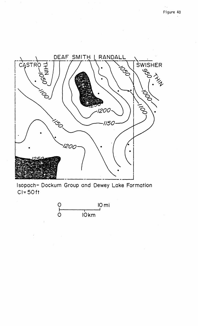
Mesozoic
Minor deformation continued into the Mesozoic. Locally, there is an angular unconform
ity at the base of the Dockum Group (fig. 39). Depositional patterns in the Dockum Group
(Upper Triassic) fluvial-lacustrine deposits (McGowen and others, 1979) were influenced by
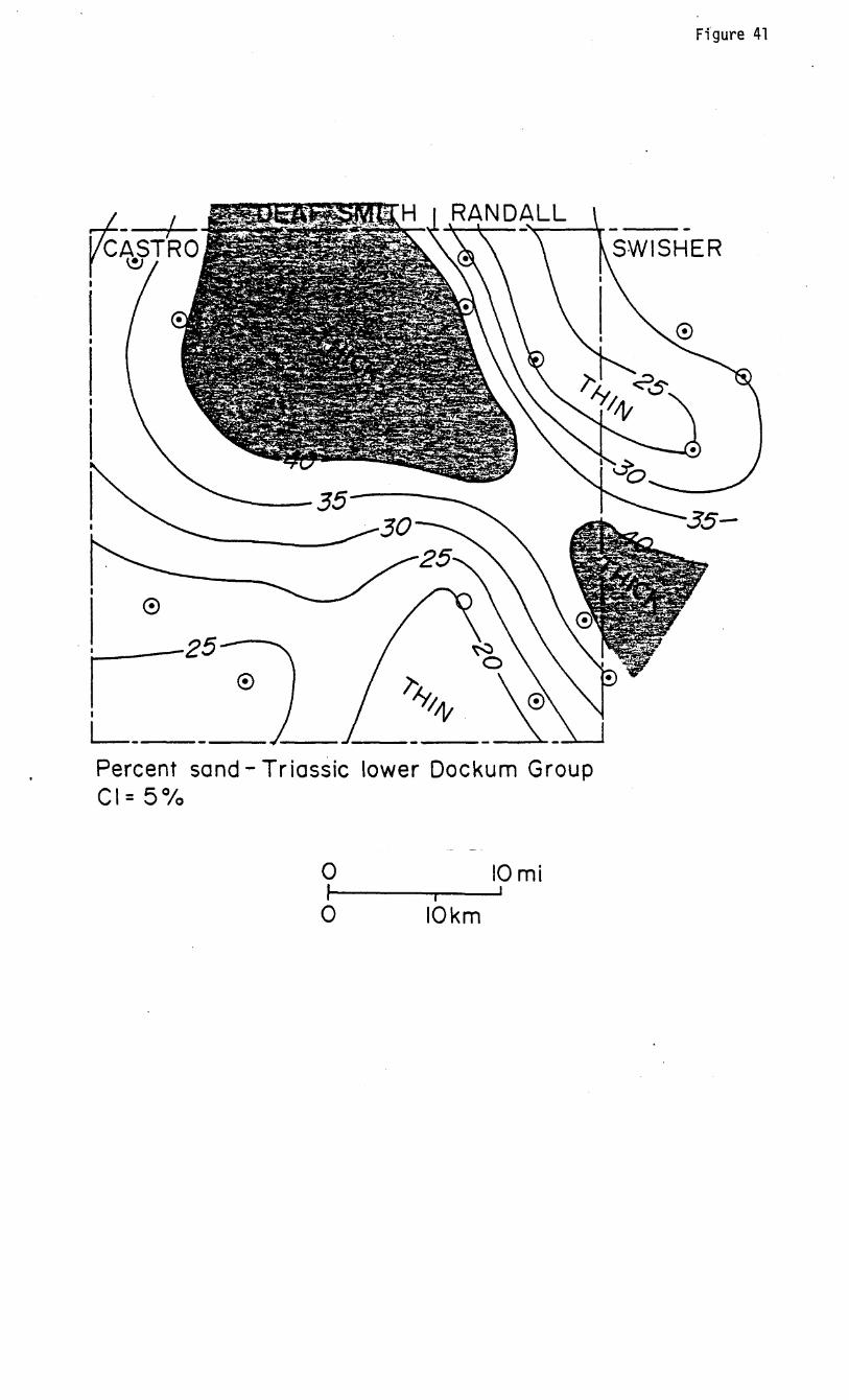
basement structures. In the Castro Trough, for example, the Dockum is thicker and more sand
rich than in adjacent areas (figs. 40 and 41).
Cenozoic
Evidence for Laramide deformation is lacking within the Palo Duro Basin, primarily
because of. the absence of deposits of the appropriate age. The Ogallala Formation (Neogene)
12

rests unconformably upon pre-Tertiary strata (fig. 42; Seni, 1980; Barnes, 1968). In the
Neogene, the basement structures again subtly influenced depositional patterns. Major channel
systems in the Ogallala tend to overlie basement lows, whereas interchannel areas correspond
to structural highs (fig. 43). The Ogallala Formation is thicker and has a higher percentage of
sand in the Castro Trough than it does over the basement high to the northeast (fig. 44). In the
southwestern parts of Deaf Smith and Randall Counties, Dockum strata crop out from beneath a
thin veneer of Ogallala on top of basement highs (fig. 43).
SUMMARY
The tectonic history of the Palo Duro Basin and surrounding region has been dominated by
recurrent motion on a regional fault system. This three-pronged system, extending from
Oklahoma and New Mexico into Colorado may have originated as a result of deep mantle
processes 1,800 to 1,900 mya. Faults along this system were reactivated several times during
the Precambrian and formed the boundaries of a large Proterozoic basin in eastern New Mexico,
West Texas, and southwestern Oklahoma. The southern Oklahoma aulacogen opened along the
southeast segment of the system during the Late Precambrian to early Cambrian.
Where evidence exists, it appears that the system underwent renewed movement during
the Late Cambrian, Middle Devonian, and mid-Mississippian. The Ancestral Rockies formed in
the Pennsylvanian as a series of uplifted blocks within the regional fault zone, flanked by
rapidly subsiding basins. Three pulses of deformation during the Pennyslvanian and Early
Permian maintained the relative relief between uplifts and basins.
Regionally, relief was subdued during the Permian and Mesozoic, although individual
faults were reactivated periodically. The southern and northwestern segments of the regional
system underwent major deformation in the Laramide Orogeny. Evidence of deformation along
the southeastern segment at this time consists primarily of local faults and unconformities
within the Mesozoic and upper Permian section. The Neogene Basin and Range event affected
13

the same segment of the regional system as the Laramide. A rhomb graben developed along the
southeastern segment during deposition of the Ogallala Formation.
The tectonic history of the Palo Duro Basin closely followed that of the regional system.
The dominant northwest-trending fault set in the basin parallels the regional fault pattern. The
intrabasinal faults probably originated at the time of formation of the' Proterozoic basin.
Although the evidence is sketchy, it appears that the faults may have been reactivated during
the Late Precambrian to Early Cambrian and in the mid-Devonian.
Deformation during the remainder of the Phanerozoic is best documented by facies
changes within the stratigraphic section. The initial Palo Duro Basin formed in the Early
Pennsylvanian as a result of the reactivation of basement faults during uplift of the Ancestral
Rockies. The basin axis shifted westward and became better defined with each succeeding
pulse of deformation. Intrabasinal fault blocks localized carbonate buildups and deposition of
clastic sediments.
Filling of the basin at the end of the Wolfcampian was followed by the formation of a
second basin in the Leonardian. Depositional patterns within the predominantly evaporite
section of this basin were subtly influenced by basement structures. Within a given unit,
structural lows tend to contain thicker salt beds and a greater percentage of clastics than
adjoining highs.
Mesozoic and Cenozoic terrestrial deposits demonstrate the same subtle basement control
on facies distribution. The Dockum Group and the Ogallala Formation are thicker and more
sand-riCh in structural lows.
The Palo Duro Basin exhibits the effects of recurrent deformation beginning in the
Precambrian and continuing through to at least the Neogene.
14
REFERENCES
Adams, J. E., 1954-, Mid-Paleozoic paleogeography of Central Texas: Shale Shaker, v. 4, no. 6,
p. 4--9.
Armstrong, A. K., 1979, North-central New Mexico, an alternative interpretation of the
Mississippian: U.S. Geological Survey, Professional Paper 1010-K, p. 189-197.
Baars, D. L., 1976, The Colorado Plateau aulacogen-key to continental scal,e basement rifting:
Proceedings of Second International Conference on Basement Tectonics, p. 157-164-.
Baars, D. L., and See, K. D., 1968, Pre-Pennsylvanian stratigraphy and paleotectonics of the San
Juan Mountains, southwestern Colorado: Geological Society of America Bulletin, v.79,
no. 3, p. 333-350.
Baldwin, B., and Muehlberger, W. R., 1959, Geologic studies of Union County, New Mexico:
New Mexico Bureau of Mines and Mineral Resources Bulletin 63, 171 p.
Baltz, E. H., and Read, C. B., 1960, Rocks of Mississippian and probable Devonian in the Sangre
de Cristo Mountains, New Mexico: American Association of Petroleum Geologists
Bulletin, v. 4-4-, no. 11, p. 174-9-1774-.
Barnes, V. E., 1968, Plainview sheet: The University of Texas at Austin, Bureau of Economic
Geology Geologic Atlas of Texas, 1:250,000.
______ 1969, Amarillo Sheet. Geologic Atlas of Texas, scale 1:250,000: The University
of Texas at Austin, Bureau of Economic Geology.
in press, Dalhart Sheet. Geologic Atlas of Texas, scale 1:250,000: The
University of Texas at Austin, Bureau of Economic Geology.
1977, Clovis sheet: The University of Texas at Austin, Bureau of Economic
Geology, Geologic Atlas of Texas, 1:250,000.
Birsa, D. S., 1977, Subsurface geology of the Palo Duro Basin, Texas Panhandle: The University
of Texas at Austin, Ph.D. dissertation, 379 p.
15
Brewer, J. A., Brown, L. D., Steiner, D., Ollver, J. E., Kaufman, S., and Denison, R. E., 1981,
Proterozoic basin in the southern Midcontinent of the United States revealed by COCORP
deep seismic reflection profiling: Geology, v. 9, no. 12, p. 569-575.
Brewer, J. A., Good, R., Oliver, J. G., Brown, L. D., and Kaufman, S., 1983, COCORP profiling
across the southern Oklahoma aulacogen: overthrusting of the Wichita Mountains and
compression within the Anadarko Basin: Geology, v. 11, no. 2, p. 109-114.
Budnik, R. T., and Smith, D., 1982, Regional stratigraphic framework of the Texas Panhandle, in
Gustavson, T. C. and others, Geology and GeOhydrology of the Palo Duro Basin, Texas
Panhandle: The University of Texas at Austin, Bureau of Economic Geology Geological
Circular 82-7, p. 38-86.
Budnik, R. T., 1983, Recurrent motion on Precambrian-age basement faults, Palo Duro Basin,
Texas Panhandle: Abstract, American Association of Petroleum Geologists Bulletin,
v. 67, no. 3, p. 433.
Burke, K., and Dewey, J. F., 1973, Plume-generated triple junctions: key indicators in applying
plate tectonics to old rocks: Journal of Geology, v. 81, p. 406-433.
Carr, J. E., and Bergman, D. L., 1976, Reconnaissance of water resources of the Clinton
Quadrangle, west-central Oklahoma: Oklahoma Geological Survey Map HA-5, 1:250,000.
Condie, K. C., 1982, Plate-tectonics model for Proterozoic continental accretion in the
southwestern United States: Geology, v. 10, no. 1, p. 37-42.
Condie, K. C., and Budding, A. J., 1979, Geology and geOChemistry of Precambrian rocks,
central and south-central New Mexico: New Mexico Bureau of Mines and Mineral
Resources Memoir 35, 58 p.
Denison, R. E., and Hetherington, E. A., Jr., 1969, Basement rocks in far west Texas and south
central New Mexico, in Kottlowski, F. E., and Lemone, D. Y., eds., Border stratigraphy
symposium: New Mexico Bureau of Mines and Mineral Resources Circular no. 104,
p. 1-16.
16

DeVoto, R. H., 1980, Mississippian stratigraphy and history of Colorado, in Kent, H. C., and
Porter, K. W., eds., Colorado Geology: Rocky Mountain Association of Geologists,
symposium, p. 57-70.
Dutton, S. P., 1980, Depositional systems and hydrocarbon resource potential of the Pennsylvan
ian System, Palo Duro and Dalhart Basins, Texas Panhandle: The University of Texas at
Austin, Bureau of Economic Geology Geological Circular 80-8, 4-9 p.
Dutton, S. P., Goldstein, A. G., and Ruppel, S. C., 1982, Petroleum potential of the Palo Duro
Basin: The University of Texas at Austin, Bureau of Economic Geology Report of
Investigations No. 123, 87 p.
Edwards, J., Jr., 1966, The petrology and structure of the buried Precambrian basement of
Colorado: Colorado School of Mines Quarterly, v. 61, no. 4-, 4-36 p.
Fay, R. 0., 1964-, The Blaine and related formations of northwestern 9klahoma and southern
Kansas: Oklahoma Geological Survey Bulletin 98, 238 p.
Feinstein, S., 1981, Subsidence and thermal history of southern Oklahoma aulacogen: implica
tions for petroleum exploration: American Association of Petroleum Geologists, v.65,
no. 12, p. 2521-2523.
Flawn, P. T., 1956, Basement rocks of Texas and southeast New Mexico: University of Texas,
Austin, Bureau of Economic Geology, Publication 5605, 261 p.
Goldstein, A. G., 1981, Basement structure and tectonic development of tne Palo Duro Basin, in
Gustavson, T. C. and others, Geology and geohydrology of the Palo Duro Basin, Texas
Panhandle: The University of Texas at Austin, Bureau of Economic Geology, Geological
Circular 81-3, p. 5-9.
Goldstein, A. G., 1982, Quantitative analysis of regional Bouguer gravity data, in Gustavson,
T. C. and others, Geology and geohydrology of the Palo Duro Basin, Texas Panhandle: The
University of Texas at Austin, Bureau of Economic Geology, Geological Circular 82-7,
p. 11-17.
17

Gustavson T. C., Finley, R. J., and McGillis, K. A., 1980, Regional dissolution of Permian salt in
the Anadarko, Dalhart, and Palo Duro Basins of the Texas Panhandle: The University of
Texas at Austin, Bureau of Economic Geology, Report of Investigations 106, 40 p.
Ham, W. E., Denison, R. E., and Merritt, C. A., 1964, Basement rocks and structural evolution
of southern Oklahoma: Oklahoma Geological Survey Bulletin 95, 305 p.
Ham, W. E., and Wilson, J. L., 1967, Paleozoic epeirogeny and orogeny in the central United
States: American Journal of Science, v. 265, no. 5, p. 332-407.
Handford, C. R., 1980, Lower Permian facies of the Palo Duro Basin, Texas: depositional
systems, shelf margin evolution, paleogeography and petroleum potential: The University
of Texas at Austin, Bureau of Economic Geology, Report of Investigations 102, 31 p.
Handford, C. R., and Dutton, S. P., 1980, Pennyslvanian - Early Permian depositional systems
and shelf-margin evolution, Palo Duro Basin, Texas: American Association of Petroleum
Geologists Bulletin, v. 64, no. 1, p. 88-106.
Handford, C. R., Dutton, S. P., and Fredericks, P. F., 1981, Regional cross sections of the Texas
Panhandle: Precambrian to mid-Permian: The University of Texas at Austin, Bureau of
Economic Geology.
Hoffman, P., Dewey, J. F., and Burke, K., 1974, Aulacogens and their genetic relation to
geosyncline with a Proterozoic example from Great Slave Lake, Canada, in Dott, R. H.,
Jr., and Shaver, R. H., Modern and ancient geosynclinal sedimentation: Society of
Economic Paleontologists and Mineralogists, Special Publication 19, p. 38-55 •.
Kelley, V. C., 1977, Geology of the Albuquerque Basin, New Mexico: New Mexico Bureau of
Mines and Mineral Resources, Memoir 33, 60 p.
Kelley, V. C., 1979, Tectonics, middle Rio Grande Rift, New Mexico, in Riecken, R. E., ed., Rio
Grande Rift: Tectonics and magmatism: American Geophysical Union, p. 57-70.
King, P. B. (compiler), 1969, Tectonic map of North America: U.S. Geological Survey, scale
1:500,000,000.
King, P. B • ., 1977, The evolution of North America: Princeton University Press, 197 p.
18

Kluth, P. B, 1977, and Coney, P. J., 1981, Plate tectonics of the Ancestral Rocky Mountains:
Geology, v. 9, no. 1, p. 10-15.
Knowles, T., Nordstrom, P., and Klemt, W. B., 1982, Evaluating the ground-water resources of
the High Plains of Texas: Texas Department of Water Resources Report LP-173, 1557 p.
Kottlowski, F. E., Flower, R. H., Thompson, M. L., and Fosters, R. W' f 1956, Statigraphic
studies of the San Andres Mountains, New Mexico: New Mexico Bureau of Mines and
Mineral Resources, Memoir 1, 132 p.
Lisenbee, A. L., Woodward, L. A., and Connolly, J. R., 1979, Tijeras-Canoncito fault system - a
major zone of recurrent movement in north-central New Mexico, in Ingersoll, R. V., ed.,
Santa Fe Country: New Mexico Geological Society, Guidebook 30th field conference,
p.89-99.
Mapel, W. J., Johnson, R. B., Bachman, G. 0., and Varnes, K. L., .1979, Southern Rocky
Mountains region: U.S. Geological Survey Professional Paper 1010-J, p. 161-187.
McGillis, K. A., and Presley, M. W., 1981, Tansill, Salado, and Alibates Formations: Upper
Permian evaporite/carbonate strata of the Texas Panhandle: The University of Texas at
Austin, Bureau of Economic Geology Geological Circular 81-8, 31 p.
McGookey, D. A., 1981, Application of Glorieta-Flowerpot facies analyses to map and
distinguish between salt dissolution and facies transitions, western Amarillo Uplift and
adjacent areas, in Gustavson, T. C., and others, Geology and geohydrology of the Palo
Duro Basin, Texas Panhandle: The University of Texas at Austin, Bureau of Economic
Geology Geological Circular 81-3, p. 156-165.
McGookey, D. A., and Goldstein, A. G., 1982, Structural influence on deposition and
deformation at the northwest margin of the Palo Duro Basin, in Gustavson, T. C., and
others, Geology and geohydrology of the Palo Duro Basin, Texas Panhandle: The
University of Texas at Austin, Bureau of Economic Geology Geological Circular 82-7,
p. 28-37.
19

McGowen, J. H., Granata, G. E., and Seni, S. J., 1979, Depositional framework of the lower
Dockum Group (Triassic), Texas Panhandle: The University of Texas at Austin, Bureau of
Economic Geology, Report of Investigations No. 97, 60 p.
McKee, E. D., Crosby, E. J., et al., 197.5, Paleotectonic investigations of the Pennsylvanian
system in the United States: U.S. Geological Survey, Professional Paper 8.53, pt. 1, 34-9 p.,
pt. 2, 192 p.
McKee, E. D., and Oriel, S. S., 1967, Paleotectonic maps of the Permian system: U.s.
Geological Survey, Misc. Inv. Map 1-4-.50, 164- p.
Miller, J. P., Montgomery, A., and Sutherland, P. K., 1963, Geology of part of the southern
Sangre de Cristo Mountains, New Mexico: New Mexico Bureau of Mines and Mineral
Resources Memoir 11, 106 p.
Muehlberger, William R., Denison, R. E., and Lidiak, E. G., 1967, Basement rocks in continental
interior of United States: American Association of Petroleum ~eologists Bulletin, v • .51,
no. 12, p. 23.51-2380.
Muehlberger, W. R., Hedge, C. F., Denison, R. E., and Marvin, R. F., 1966, Geochronology of
the Midcontinent Region, United States, 3., Southern Area: Journal of Geophysical
Research, v. 71, no. 22, p • .54-09-.54-26.
Nicholson, J. H., 1960, Geology of the Texas Panhandle, in Aspects of the geology of Texas, a
symposium: University of Texas, Austin, Bureau of Economic Geology, Publication 6017,
p • .51-64-.
Oliver, J., Dobrin, M., Kaufman, S., Meyer, R., and Phinney, R., 1976, Continuous seismic
reflection profiling of the deep basement, Hardeman County, Texas: Geological Society
of America, v. 87, no. 11, p. 1.537-1.54-6.
Olson, J. C., Marvin, R. F., Parker, R. Lo, and Mehnert, H. N., 1977, Age and tectonic setting of
lower Paleozoic alkalic and mafic rocks, carbonatites, and thorium veins in south-central
Colorado: U.S. Geological Survey, Journal of Research, v • .5, no. 6, p. 673-687.
20

Presley, M. W., 1980, Upper Permian salt-bearing stratigraphic units, in Gustavson, T. C., and
others, Geology and geohydrology of the Palo Duro Basin, Texas Panhandle: The
University of Texas at Austin, Bureau of Economic Geology Geological Circular 80-7,
p. 12-23.
Presley, M. W., 1981, Permeable Sheet Sandstones of the Glorieta Formatton intertongue with
salt-bearing rocks in the northwestern Texas Panhandle, in Gustavson, T. C. and others,
Geology and geOhydrology of the Palo Duro Basin, Texas Panhandle:' The University of
Texas at Austin, Bureau of Economic Geology Geological Circular 81-3.
Presley, M. W., and McGillis, K. A., 1982, Coastal evaporite and tidal-flat sediments of the
upper Clear Fork and Glorieta Formations, Texas Panhandle: The University of Texas at
Austin, Bureau of Economic Geology Report of Investigations No. 115, 50 p.
Ramondetta, P. J., 1982, Facies and stratigraphy of the San Andres formation, northern and
northwestern Shelves of Midland Basin, Texas and New Mexico: The University of Texas
at Austin, Bureau of Economic Geology Report of Investigations no. 128, 56 p.
Rascoe, B., Jr., and Baars, D. L., 1972, Permian System, in Mallory, W. W., ed., Geologic Atlas
of the Rocky Mountain Region: Rocky Mountain Association of Geologists, p. 143-165.
Robertson, J. M., and Moench, R. H., 1979, The Pecos Greenstone Belt: A Proterozoic volcano
sedimentary sequence in southern Sangre de Cristo Mountains, New Mexico, in Ingersoll,
R. V., ed., Sante Fe Country: New Mexico Geological Society, Guidebook 30th field
conference, p. 165-173.
Robinson, P., 1972, Tertiary History, in Mallory, W. W., Geologic Atlas of Rocky Mountains:
Rocky Mountains Association of Geologists, p. 233-242.
Roth, Robert, 1960, Swisher gabbroic terrane of Texas Panhandle: Bulletin of the American
Association of Petroleum Geologists, v. 44, no. 11, p. 1775-1784.
Scott, G. R., 1968, Geologic and structure contour map of the La Junta Quadrangle, Colorado
and Kansas: U.S. Geological Survey, Miscellaneous Geologic Investigations Map 1-560,
1:250,000.
21

Scott, G. R., 1975, Cenozoic surfaces and deposits in the southwestern Rocky Mountains, in
Curtis, B. F., 1975, ed., Cenozoic history of the southern Rocky Mountains: Geological
Society of America, memoir 14-4-, p. 227-24-8.
Seager, W. R., and Morgan, P., 1979, Rio Grande Rift in southern New Mexico, West Texas, and
Northern Chihuahua, in Riecker, R. E., ed., Rio Grande Rift: Tectonics and Magmatism,
AGU p. 87-106.
Seni, Steven, J., 1980, Sand-body geometry and depositional systems, Ogallala Formation,
Texas: The University of Texas at Austin, Bureau of Economic Geology Report of
Investigations No. 105, 36 p.
Soderstrom, G. S., 1968, Stratigraphic relationships in the Palo Duro - Hardeman Basin area, in
Basins of the Southwest, v. 1: West Texas Geological Society, p. 4-1-4-9.
Stovall, J. 'II., 194-3, Stratigraphy of the Cimarron Valley (Mesozoic Rocks), in Schoff, S. L.,
Geology and groundwater resources of Cimarron County, Oklahoma: Oklahoma Geological
Survey, Bulletin 62, p. 4-3-100.
Tarr, R. S., Jordan, lo, an9 Rowland, T. C., 1965, Geologic map and sections of pre-Woodford
rocks in Oklahoma: Oklahoma Geological Survey, Map GM-9, 1:750,000.
Taylor, R. B., 1975, Neogene tectonism in south-central Colorado, in Curtis, B. F., Cenozoic
history of the southern Rocky Mountains: Geological Society of America, Memoir 4-4-,
p. 211-226.
Tweto, 0., 1979, The Rio Grande Rift System in Colorado, in Riecker, R. E., ed., Rio Grande
Rift: tectonics and magmatism: American Geophysical Union, p. 33-56.
Tweto, 0., 1980a, Precambrian geology of Colorado, in Kent, H. C., and Porter, K. 'II., eds.,
Colorado Geology: Rocky Mountain Association of Geologists-symposium, p. 37-4-6 • .J
Tweto, 0., 1980b, Tectonic history of Colorado, in Kent, H. C., and Porter, K. W., eds.,
Colorado Geology: Rocky Mountain Association of Geologists-symposium, p. 5-9.
Tweto, 0., 1983, Las Animas Formation (Upper Precambrian) in the subsurface of Southern
Colorado: U. S. Geological Survey, bulletin, 1529-G, 14- p.
22

,.
Weeks, J. B., and Gutentag, E. D., 1981, Bedrock geology, altitude of base, and 1980 saturated
thickness of the high plains aquifer in parts of Colorado, Kansas, Nebraska, New Mexico,
Oklahoma, South Dakota, Texas, and Wyoming: U.S. Geological Survey Hydrologic
Investigations Atlas HA-648.
Weimer, R. J., 1980, Recurrent movement on basement faults, a tectonic style for Colorado and
adjacent areas, in Kent, H. C., and Porter, K. W., eds. Colorado Geology: Rocky Mountain
Association of Geologists, symposium, p. 23-35.
23

Figure Captions
Figure 1. Structural elements of the Texas Panhandle. After Nicholson (1960).
Figure 2. Isopach of the Pennsylvanian system. After Dutton and others (1982).
i _
Figure 3. Position of shelf margins during Pennsylvanian, and Early and Middle Permian. After
Ramondetta (1982).
Figure 4-. Tectonic map of Texas Panhandle and surrounding region modified from King (1969)
and Budnik and Smith (1982).
Figure 5. COCORP seismic reflection profile, Hardeman Basin, Oklahoma. p€ : top of
basement, A, B, and C are reflectors within basement. Note truncation of Precambrian
layering at east end of line. Precambrian fault probably caused truncation, and was reactivated
by Pennsylvanian movements as Burch Fault. (Brewer and others, 1981). See figure 7 for
location.
Figure '6. Distribution of Las Animas Formation, southeastern Colorado. (Tweto, 1983).
Figure 7. Distribution of basement terranes. Vertical ruling-Proterozoic basin fill, LA-Las
Animas Formation, PV-Panhandle volcanics, SD-Swisher diabase, DB-DeBaca terrane, TG-
Tillman Group, FT -Fisher terrane; blank-granitic rocks less than 14-00 mya; diagonal ruling
rocks older than 14-00 mya. Stippled rocks younger than 600 my. From Edwards (1966);
Muehlberger and others (1966, 1967); Denison and Hetherington (1969); Olson and others (1977);
Condie and Budding (1979); Condie (1982); Tweto (1983). H-Iocation of figure 5, S-location of
figure 8.
1

Figure 8. Seismic reflection profile, Palo Duro Basin. IP -top of Pennsylvanian,p€-top of
basement; A and B are reflectors within basement. Termination of reflectors at C and 0
probably due to Precambrian faults that were reactivated in the Pennsylvanian. See figure 7
for location.
Figure 9. Precambrian-aged faults in Colorado. From Tweto (1980a) and Baars (1976).
Figure 10. Distribution of arkosic sandstone and basement uplifts of the Ancestral Rocky
Mountains. (McKee and others, 1975).
Figure 11. Isopach map of lower Glorieta (Leonardian). Sandstone bed pinches out against flank
of Amarillo Uplift. (McGookey, 1981).
Figure 12. Outline of Permian Basin. (McKee and Oriel, 1967, plate 19).
Figure 13. East-west cross section across Freezeout Creek fault. (Rascoe and Baars, 1972).
Figure .Ill-a. East-west cross section, Union County, New Mexico, showing angular unconformity
below Jurassic. (Baldwin and Muehlberger, 1959).
Figure Ill-b. Northwest-southeast cross section, Cimarron County, Oklahoma, showing angular
unconformity between Jurassic (Morrison Formation) and Cretaceous (Purgatoire Formation)
. (Stovall, 19l1-3).
Figure 15. Distribution of syntectonic Neogene sediments, High Plains and Rio Grande Rift.
(Robinson, 1972; Scott, 1975; Weeks and Gutentag, 1981). Faults from Tweto (1979) and Kelley
(1979).
2

Figure 16. Isopach map, Ogallala Formation (Seni, 1980).
Figure 17. Structure contour map on top of basement, Whittenburg Trough and flanking uplifts.
Contour intervals: 1,000 ft and 500 ft contours in OD's of feet.
Figure 18. Structure contour map, base of Ogallala and active salt dissolution zone (Gustavson
and others, 1980).
Figure 19. Structure contour maps, Carson County basin,
a) top of basement contour interval 200 ft.
b) top of Wolfcamp contour interval 100 ft.
c) top of Tubb Formation contour interval 100 ft.
d) top of Alibates Formation contour interval 100 ft.
e) base of Ogallala Formation, CI:50 ft. Modified from Knowles and others, (1982).
Figure 20. Structure contour map on top of basement, Palo Duro Basin.
Figure 21. Electric log and sample description Roth (1960) from Sun Oil Company III Herring in
Castro County. Well no. 11 in figures 22 and 23.
Figure 22. Mississippian subcrop and basement structure contour map, Castro Trough, Castro
County. Contours on top of crystalline basement, CI: 100 ft.
Figure 23. Southwest-northeast section across southwest part of Palo Duro Basin. Well names
listed in table 1.
Figure 24. postulated distribution of a Precambrian(?) arkose in central Castro County.
3

Figure 25. Structure contour map on top of Ordovician Ellenburger Group, Palo Duro Basin
(Dutton and others, 1982).
Figure 26. Block diagrams of paleogeographic evolution of Palo Duro Basin during Pennsylvan
ian and Wolfcamp time (Handford and Dutton, 1980).
Figure 27. Distribution of Pennsylvanian and Wolfcampian arkosic sediments in the Texas
Panhandle. Dutton and others (1982).
Figure 28. Isopach of Lower Pennsylvanian clastics, Castro Trough contour interval 100 ft.
Figure 29. Distribution of Upper Pennsylvanian carbonate in Palo Duro. Basin. Modified from
Dutton (1980).
Figure 30. Seismic section J-J', central Randall County. Line of section in figure 29.
Figure 31. Isopach of Wolfcampian Series, Palo Duro Basin (Dutton and others, 1982).
Figure 32. Regional north-south facies cross section of salt-bearing rocks in Texas Panhandle
(Presley, 1981).
Figure 33. Isopach of Permian System, Castro County.
Figure 34. Facies distribution maps for Wichita Group, Palo Duro Basin (Handford, unpublished
data). Contour-percent dolomite. Contour interval: 10 percent.
Figure 35. Facies distribution maps for Glorieta clastic units (Presley and McGillls, 1982).
Figure 36. Net salt map, Cycle LJ, lower San Andres Formation, Castro County (Presley,
unpublished data).
Figure 37. Net-clastic map, Salado-Tansill Formation. Mudstone-siltstone beds and mudstone
are intercalated with salt. Northwest-trending depositional axes define strike-oriented mud
flats. Values determined from gamma ray logs (McGillis and Presley, 1981).
Figure 38. Photograph of intraformational angular unconformity within Quartermaster Forma
tion, Palo Duro Canyon State Park. Photo by E. Collins.
Figure 39. Photograph of angular unconformity between Quartermaster Formation and Dockum
Group at Capital Peak, Palo Duro Canyon State Park. Photo by E. Collins.
Figure LJO. Isopach map of Dockum Group (Triassic) and Dewey Lake Formation (uppermost
Permian), Castro County, contour interval: 50 ft.
Figure LJI. Percent sand, lower Dockum Group (McGowen, unpubliShed data). Contour interval:
5 percent.
Figure LJ2. Photograph of angular unconformity between Dockum Group and Ogallala Forma
tion. South side of Palo Duro Canyon, looking east from State Highway 207, Armstrong County.
Figure LJ3. Schematic illustration of Ogallala depositional facies and sediment dispersal
systems. Width and length of arrows indicate relative intensity of fluvial processes. Facies not
time-equivalent (Seni, 1980). Vertical ruling = Dockum outcrops (Barnes, 1977).
Figure LJLJ. -Net sand, Ogallala Formation, Castro County (Knowles and others, 1982). Contour
interval: 20 ft.
5

county
B.E.G. #
Bailey
8
17
Castro
6
8
9
11
13
14
Parmer
10
Swisher
3
TABLE 1
Lion Oil Company, Birdwell #1
Phillips Petroleum Company, Stephens A #1
.' Ashmum and Hilliard, Formwalt #1
I. A. Stephens, I. C. Little #1
Ashmum and Hilliard, Willis #1
Sun Oil Company, L. C. Boothe, #1
Amarillo Oil Company, L. C. Boothe #1
Sun Oil Company, A. L. Habenen #1
Sunray, Kimbrough #1
Frankfort Oil Company, Cul ton #1

L_ I I • Lubbock
t---'I---r-JI-r---t--I I Q~ I I I ~q) I ,
I- __ l __ -L- _ -'_~ .. --L_ o I o
"" .. 20 ,
\
4,0 .. , &0 80 mU ••
~ I I&) ,,/tom.t.,.
Figure 1
N
\
t:';:-;":J Precambrian basoment exposed throuc;ahout Pennsylvanian
==Faultl
• Well control
EXPLANATION
Contour interval' 400 "
... Axil of balin
Area northeast of hachured line sflaws thickness from top of M''"''',ppian to top of Miuauroon Series.
Isopach map of Pennsylvanian System. After Dutton and others (l982).
Figure 2

TATUM BASIN
DELAWARE
BASIN \
-----L-WARD \
Figure 3
I BRISCOE
3,>, •• : i ~. ;u---~--n~----l--~
II Indea mop
II I
! II I' EASTERN
I I I
I ~--...--- MITCHELL ,
I , SOUTHERN MIDLAND
BASIN
MIDLAND
_jp::::: ___ L __ ~> UPTON I ~,':': ,
_J..J-I-'I-...:= ..... "="-~-------
" Lineament
San Andres ail field
o 20mi , II--....... -'-or--___ , .... ' \ I 0 30km
~ REAGAN - \ !
" Map of study area in Texas showing San Andres oil production, shelf margins, and surface lineaments. Surface lineaments are from
tinley and Gustavson (1981), and shelf-margin positions are from J. H. Nicholson (personal communication, 1980).

.. ~
'. '\ ~ t : . . ~ J I
. , \~\~ k I
\
" .\
),.,jY"<".. .' t.....-~" :-..... . ~/! " ]\) ......,~ /9~.rNI?)I!: ~",\¢-'
- __ ~_.__ If",· I ~ __. fI
o /L L AI.JDI\II(.J
- ( ~t/ "-. '. ,". ~~~ "-I f
<1 y, ~, ,,'~Q-~ "'-- I
j J ~I N6W /,,-,' / // \'\. ~ ~~~;~:\ ~ /'-.6 ><"/ i:.cJ ~" ~Ah " . '" I r~ ~
I '" O(AIl-O ~ .. ,J'~'" ~/;~'"
I / ~ '" I . ". ~ ,,-. '''-t \. l \ /j i -rC-X;qJ "-
\ \ I )\ ~
en o z
5
o 10 u w en
· Figure 5
BURCH HARDEMAN BASI N FAULT WICHITA MTNS.
600 400 \ 200. : E o
10
15
20 km

~I
37"
R66W 65 64 63
1Q5" 103'
Area of figure S
,r ... ........,
i COLORADO i
~ '.:z~/;J
Lamar
I I
\.
L~-----l I , I I
SPANISH PEAKy I \ f' -- lAS ANIMAS COUNTY I I
62
I I L ________ L. _____ ---Ll-------J
0 I I
I I
0
61 60 511
0 20
I I I I I I I I
I 0 10
I I I
25
50 I
I
100 KILOMETERS I
50 MILES
40 KILOMETERS
I I
20 MILES
T 25 S
, "
26
T , 33 " S
R48W
Figure 6
EXPlANA TlON
~ '~.'.' Las Animas Formation
0 , __ .. 1 .... 1 Granite. -1,400 m.y. age
0 Felsic and hornblendic
- gneisses
Inferred fault at lOp of Precambrian basement
11 Borehole in Precambrian •
basement

, Figure 7
_...--.'t',

wEn ~~~ l
~"
~ .~"
:::
•
D ':::';";'---
-:::. ~"~~" ::c:=: ~~~ ~: ~~~;;."
-
, .
.~
()
I , . 1
Figure 8
~ t :~= ~~ =- =~:: "~
··~~S ;;;" . : ;!:-:i~ ... - ::: ~;; ;:~
'i~ iii' .~

I I
40'r.
39'
I I
I
3B°\I
I I I
I· I I
107'
Colorado
Figure 9
106' 105' 104' 103'
-~--]--'----T~~~~~~;E-;---1 ~ 1. Fish Cr. - Soda Cr. shear zone ,
"1 ® ./ 2. Skin Gulch shear zone 1\ i<' ,...:;.-'t\ 0 3. Iron Dike
(;\ r\ 4. Dikes of _1.400 m.y. age g B' S. Breccia reef loults ® 6. Idaho Springs - Ralston shear zon~
• DENVER
7. Homestake shear zone J B. Gore fault 9. Blue River fault
10. South Park - Currant Cr faults
11. lise fault 12. Red Rocks fault 13. Cimarron loult 14. Ute Pass lault 1 S. Rampart Range fault 16. Apishapa fault 17. Freezeout Cr. fault zone Ii .t:.-16-it. 'pArr f..,...;f.t
100
Site of late Paleozoic
\ , \ I I Apishapa highland
___ --J 370 LL-______ L-_____ .L ______ .L ___ _

'Figure '10
TIDAL FLATS
InId - salt
eo.itour interval .. 5 ft
o 10 20 30km ~I ==~~'==~=='==~==I~ o ~ to e 2'omi
Sand >10'
1(·;\,,·1 Sand < 10'
Figure 11
---------------, R08ERTS CQ I
I .. Intercalated with red beds
· Fi gure 12
o t
"",'I-r-~- .. ,"0 It "'" ,!.. I

Ii·!. ·,W::·:·::
----'(1-----
ro, ,~ ... ' , ., I.
'I It I, I lID ~ II
I I it lIun 0
.1 i1II IilfJ
J I I( ~IHI
. Fi gure 13

~ 01..0 !lAD /)
A/'~ 1"\'l'Ie Q I A
~A'
I t
rJ·
A
" ~ I.A ,(,Jo ""!If
II
~4' • flit ,7e. , 0 j<".
S i
S
Fi'gure 14a&b
0"-
~ 0 ••••• , ...
C2] P""90hwe 'm. ~ Mot,.," 'fill. Q!J tnt., 'L
E!J Cla'IiC ptv4
[i;ej 5~.... P.~ n.
~ 5 ..... Canyon 'ro.
[!!J T«I'I"'.' 'm,
• , •
; , k"" 1'0
I l
·Fi gure 15
,--l---------'--'-----.. ------ --- -- ----\t----------.- --- .. -.. -
\
\--------r
K/4WJ 'A f ~ __ t-__ -

..
II ••• r .. ..... :- .. 31-14': ',:, ,". '\:> .. '
.... . . '.
r~11~
10'-
16
".
I
t I
J-I·' ,. :------r
. I f I i ~ , . ~
.L-----L---i EXp\.ANATION I _0QaI1aIa -'-"..... ,
I -3.-
---1--' I I
o-1Od
COIIIta., ....... 1 100 't ~l"..-0IJ0I""_1 --.. _-
.. L~ t ,
~ .-
r -~ -~
, tsopach map, Ogallala Formation. Ogallala thickness is defined as net thickness of all deposits above base of the Ogallala Formation. Undifferentiated Pleistocene deposits (normally less than 7 m (20 ttJ thick) may be included in this total.

Fi gure 17
0 10 ,..,·'u
I I 10 10
i ,
I I '10 .,0
k""

~ Bose of Ogallala outcrop
'< 7> Soil dissolution zone
Fi gure 18
N
·~HM-+ -:-..:......:::..,.~~-.:-""'-:-'L .. ~ __ ._.-! ----- f
, 0 25 50 mi
)1=~~~~ ________ I_o~---------4~O--------~eOkm
Contour Interval - 50 feel
- - Amarillo Uplift axis
.• --'--:.::..' Structure-contour map on the base of the Ogallala Formation (in part from Cronin, 1961). Map also indicates the active salt dissolution zone for the Salado, Seven Rivers, San Andres, and Glorieta Formations.

·Fi gure 19a

o I o
Ii> •
Figure 19b
,[" LV {

Fi gure 19c
eli fl so,J Co.
0 ~o
• . ( IOQ~J
0 ~ .. iM Ji> I I I 0 Jt "" /0
'X f~ff . LVJJ G4V' -t~11

Fi gure 19d
Q
J o

· Fi gure 1ge
E XPLANA T ION
-z/ Conlour on top 01 / bosement (xlOOOItI
ImfJ >Olt
r::::::} 0 to-5000 It .........
k:::>1 <-5000fl
o ~~ I f o amm
'-" Structure-contour map on the top of Precambrian basement.
N
,
-r'J" ..... ~ 1.0 C ""'S CD
N o

· .Figure 21
SUN OIL COMPANY #/ Herring I Castro Co Spontaneous potential
millivolts 20 -11+ Sp
9400
9600
~
0 0
9800 ~
0\ C
~
"'C
~ 0 (1)
.0
.c. -a. 10,000 (1)
0
10,200
Resistivity 2 o 500hms m-m
I I
Res
)
Mississippian limestone
Ordovician Ellenburger dolomite
£(1) Quartzose sandstone ,,~------
Arkose
< Diabase
<
Serpentinite
Olivine diabase
EOKLAHOMA : -r-£m-T , I
~-t-t--. 8· --t-4-t-, ~1~·-1--t-I-1
~~.+~~. ~-1_J_..L_L_..J_]
SCALE o IOmi I i I
o IOknI
CGnIour InWwaI : tOO'
-------~~o.1 ~~~.------------------------! fLO;O CO.-
EXPLANATION
Y' Limit rl Ellenb..-ger Group ~ CryitoUine bo&emenI
, ~ Ellenburger Group y Limits rl Mississippian
• Wdls used fOt control
~
I i I
I I
I i
QI./IU
"T1
CD s::
i6 N
'N

.;)
I
\
/
.. .. ... ,
I
< '0
)
~ -....)
. ~
.~.
~
.. .. ... ... I
<I a ... I
'" • .. r& I
-~
I .. .
~ ~ .. - ...... .
/
Figure 23
~ i . ~ ............. . . .. I-"---~"" ~---....................... .
~

.;.
Deaf Smith
! Castro •
•
• t;>-C:JY." • • ,ry.<O •
\) • 0Y.,,~
~\S I •
• S
Distribution of pre-Ellenburger Group arkose In Castro Trough
• Well control
o Wells penetrating pre-Ellenburger arkose
o I o
I
IOkm
IOmi ,
Figure 24
•
N
EXPI.ANATION
I Wen contfOl ~-CB Ct~lOlilne --- Foult
D Slrue""" lOw
o
Structure contour map of top of Ordovician Ellenburger Group, Palo Duro Basin.
Figure 25
oj.. \J I
•. oW. ~+-
\J •. , _._.-, %' .~

Figure 26
o 40mi I---T---' o 40km
_ -., . Block diagrams of paleogeographic evolution of Palo Duro Basin during Pennsylvanian and Wolfcampian time (from Handford and Dutton, 1980).

o u x '" =< ~
'" z
• • • • . ..
~ I·
I .\" /00· .1
..Figure 27
jUILEY - - - LAMBd ~ ---~t--·--
i : i·· i. ,~ · ·i ::' li~;~hc .~:. · · I· ~O\. ~,'o:~~ r">~'2:':":"~'~:::;;' • -- I J-~_.J. - • 0 ____ - ., COCHRAN',.,;.',.'" HOCKLEY- 'UbijOCK---- -T""CiIoSiIy-------- OICKENS------- KING I
, ..
IF~' :\ o!\ \ ~ \ 0 ,~ ~_! i I I MAP I! io 40 km I
~-----~------1------1------L-----l-----J k5@] 300-1000 It net granite wosh
D > 1000 It net granile wash
EXPLANATION
[:;.-;ti;H Precambrian bosement exposed '" '.' Ihrougnout Pennsylvanian
_=-=Faults
• Well control
Contour Intarval variable: 0-40011 Col."IOOft
400 -1200 ft Col. "200 ft >1200 " Col. • 400 "

Figure 28
-.,..- -----, -----I SWISHER
Lower Pennsylvanian isopach, CI = 100 ft
Q
I f'I',J.." 10 , i 10
N

.. Figure 29 OKLAHOMA
DAU.AM I'HANsRiRO----rExASiOOiiiTREE--- [UPSCOM""B-----:lN " , , I EXPLANATION '\
I, ',~Faults , ' tsSSJ Areas with no Upper Pennsylvanian \1
1 I~Areo with no Cisco
, " ~ Carbonate isolith (%) 'I'
1 . / Granite wash isolith I
I I R08£RiS-- ! HEMPHILL I 'I 1 : , I i . I : . I I
~"tt-~~~~~~~~~~ .. -~.-- -J GRAY I WHEELER :
, I~ I ~:~
~I~ W...J I-,~
'0 , I
\' CHILO?:/ /l II
'- ,./ I -
--~I
i
I
l
i I i I ~
.:=~~~~===t, CROS~-;;BY;-=-::--~---l-"",", 1""'- I , i \0 ~ .~ ~ ~ ~~ll '\ 6 I iO I k $0 I Jakm
I "
i AFTER nUTION (1980) ~

w .. -3100-... -5 c: o -3600- .
surface Topography :' •••• 1· •••••• • ' ..... ,. .......... _ ............ . .':: ,
o > ..
w
OJ
E
• -3!lOO_
0.0-
0.1-
O.z-
0.3-
O~-
0.6-
07-
0.8-
09-
1.0- ~,~~
11-
12-
1.3-
14-
1.5-
1.6-
1.7 -
~ . \I;::. t _a. t ••••
t •••••
.' .-. .... . " .t·
...... ,. "'.l/ ....... _ ... ~~!~.·> ... ~)'· .... "~,;~I·.· . .,.'itit, '~ .... r~-·· Lower Pennsylvanian w.-0e,... ....... :;;:, : :~.f '-" .-~ .. ':.:. "; ',' ·t·.~ " .... ,.,-:a:r ..... • •••
o I o
, Ikm
i-.... :.~ .... :. : .. ,,1- ....
Imi I
!' '1 ... -1 ...... I
'Figure 30
E
... _f .,

I i __ _
D r::;::! L:J
EJ········· .......... ..........
Figure 31
EXPLANATION
<600 feet N
600 -1400 feet
J >1400 feet
Well control
Contour interval: 200 feet
o 40mi I~--~~--~i~----~i o 40km
... Isopach map of Wolfcampian Series, Palo Duro Basin (Handford, unpublished data).

A AMARILLO DALHART BASIN UPLIFT PALO DURO BASIN
NORTH
<il~ I , DEAF SMITH I TEXAS ~I~ SHERMAN HARTLEY I OLDHAM 10 II- 31 39 33 I 5 45 I 2 I
. or'" 20n to 20 3OfII, _
_ 00
100
.00
Datum = Top of San Andres Formation. ALiBATES OUTER BRINE PAN fACIES
LOCATION MAP
I CASTRO I
13 I I
MATADOR AI ARCH SOUTH
LAMB , HOCKLEY 921 8
' .....
~ i~ iu ~ ... C)
~ ~ I:! ~
~
~ 2 " .....
to s:::: -S (l)
W N

.----
o
Permian isopach, CI = 100 ft
o ~ o Ii>
Ii) I
'Figure 33
SWISHER

? ~ C 03 (0 c~..:) C .),A../ ,:--;; v /:' ;:. ,) C.Z. - 10%
I i > bJ% COJ
!====t r=:::::::l '---' i _
---,.. ;1
,.1 .'. 'II ~
Figure 34
O~I --~--~i----~~~ o l40km

:...·_·1
i j j
! i N
l
0 0
. ___ . __ ._'"""1'_. __ . ____ ._._ . i
.j I i
'MEElEA1
i \
.... __ ._ .. _._.:...;:!..:...;."'. - - - _._._._.1_._._._.-._.-
Figure 35
". Facies distribution maps for Q!Q.tic:,ta clastic units. Values for net mudstone calculated from gamma-ray data. . - ... ~----

Figure 36
- ---r SWISHER THIN ! .
o THIN
I
-- --..,;
San Andres Formation - net salt Cycle 4, CI = 10ft
o I o
i
M-... 10
1° r

,._._._-
"
Figure 37
N
) 0 10 ZO 30'"' 1 , , , 0 10 ZO 30'"
. ___ ._._._,_. _____ ._. _____ r ___ • _________ J ;;;~;----_CARSON 1 GRAY i WHEELER i
Iii 1 .
i i i
.----~ <;DU.'''''''''''''" I
00~i(t.:~,;,-,;,-+OONi..EY -- -. -- --! ...
~i~ x:J: "'I~ t-:::.:
1° i : , I
&~~:=':::~"""~'!.';'·~~~rE~;7:fs;~t;-~~'7(1~~;;~~·:';t·---·I~U:---·-·-j --;c;.;;:-~;-----!
EXPLANATION
I
~~~~~~~IQ~:-·-i-·- _._ .. '. _ .. -i KING
i i
0 40 - 6011 ~6O-8011 ~80-IOOII 0 >10011
ContO\M' inter-«ll • 20 ft •• Core

· Figure 38
photograph

, Figure 39
photograph
\ \ DEA F S M I T~H--"T-_ T'~~ -'T--T\--
r-CASTRO 1.- SWISHER \- ~
I c Z ~ > (.J\ o~
• c • ~
•
Isopach- Dockum Group and Dewey Lake Formation CI-: 50ft
o I o
i
IOkm
IOmi I
Figure 40
~-35 I
1"-----------I I 0
r-------25 I 0 1'. I ,y/1t L _____ __ J ___ _ _
Percent sand - Triassic lower Dockum Group CI = 5%
o IOmi t-I -----.,..-----11
o IOkm
Fi'gure 41

, Fi gure 42
photograph

I •
I I
1 I I INTER-CHANNEL
I I
i~ 1---
------4----- . - ~ -,
\~ (' -:;~~ •
INTER-CHANNEL \~
.0
•
I ~ -_/ -I
Figure 43
N
J
o 50 Mi ~I---------+--------~I o 80 Km

Fi gure 4 ~
-j-ISWISHER 7"1-(/ tv L
/20~ ". /40
/60
I
I I L---- ---=--~- __ -- LAM8lHA LE'
~ o
\
Net sand- Tertiary Ogallala Formation, C 1 = 20 ft Source: Texas Department of Water Resources (1982)
o
I o
/0 J