technical cooperation with the philippines department of
TRANSCRIPT
National REDD+ System Philippines Project
Deutsche Forstservice GmbH
Component 4 implemented
on behalf of Deutsche Gesellschaft für Internationale Zusammenarbeit (GIZ) GmbH
Technical Cooperation with the Philippines
Department of Environment and Natural Resources (DENR)
National REDD+ System Philippines
Component 4:
Forest Land Use Planning and REDD+ Implementation in Selected Areas
PN 12.9022.0-001.00 / VN 81162755
Field Manual for the Forest Resources Assessments
in Eastern Samar and Davao Oriental
December 2014
Ralph LENNERTZ, Ransom FIEL, Cyrus Peter MEGRASO
National REDD+ System Philippines Project
Deutsche Forstservice GmbH
Component 4 implemented
on behalf of Deutsche Gesellschaft für Internationale Zusammenarbeit (GIZ) GmbH

FRA Field Manual i
National REDD+ System Philippines Project
TABLE OF CONTENT
TABLE OF CONTENT ............................................................................................................. i
APPENDICES ........................................................................................................................ ii
TABLES ................................................................................................................................ iii
FIGURES .............................................................................................................................. iii
ACRONYMS ......................................................................................................................... iv
SYMBOLS .............................................................................................................................. v
EXECUTIVE SUMMARY ........................................................................................................ 1
1. INTRODUCTION AND BACKGROUND .......................................................................... 2
1.1 National REDD+ System Philippines Project .......................................................... 2
1.2 Methodological Framework ..................................................................................... 2
1.3 Project Sites ........................................................................................................... 3
1.4 Objectives .............................................................................................................. 4
2. INVENTORY DESIGN ..................................................................................................... 6
2.1 Inventory Method .................................................................................................... 6
2.2 Number and Distribution of Sampling Units ............................................................ 6
2.3 Configuration of Sampling Units ............................................................................. 7
2.4 Observations and Measurements at and around the Sample Points ....................... 8
2.5 Observations and Measurements at and around the Satellite Centers.................... 8
2.6 Implementation ....................................................................................................... 9
2.6.1 Inventory teams .......................................................................................... 9
2.6.2 Inventory equipment .................................................................................. 10
2.6.3 Inventory camps ........................................................................................ 10
2.6.4 Data recording, processing and analysis ................................................... 11
2.7 Quality Assurance / Quality Control ...................................................................... 11
2.7.1 Quality Assurance (QA) ............................................................................ 11
2.7.2 Quality Control (QC) .................................................................................. 11
3. RETRIEVAL AND PERMANENT MARKING OF SAMPLE POINTS AND SATELLITE CENTERS.................................................................................................. 13
3.1 Approach of Sample Points using GPS Receivers ................................................ 13
3.2 Location of Sample Points and Satellite Centers using Compass and Distance Tape ...................................................................................................... 14
3.3 Permanent marking of Sample Points and Satellite Centers ................................. 16
3.4 Inaccessible Sample Points and Satellite Centers ................................................ 16
4. OBSERVATIONS AND MEASUREMENTS ................................................................... 18

FRA Field Manual ii
National REDD+ System Philippines Project
4.1 Administrative Location ........................................................................................ 18
4.2 Target Coordinates ............................................................................................... 18
4.3 Actual Coordinates ............................................................................................... 18
4.4 Elevation .............................................................................................................. 18
4.5 Slope .................................................................................................................... 18
4.6 Slope Orientation .................................................................................................. 19
4.7 Terrain .................................................................................................................. 20
4.8 Land Classification ............................................................................................... 20
4.9 Land Cover ........................................................................................................... 20
4.10 Forest Type .......................................................................................................... 21
4.11 Tree Crown Cover ................................................................................................ 21
4.12 Plant Diversity ...................................................................................................... 22
4.13 Ground Coverage Classes by Vegetation Layers ................................................. 22
4.14 Ground Coverage and Average Depth of Litter ..................................................... 22
4.15 Mid-Diameter and Length of Lying Dead Wood Sections ...................................... 23
4.16 Observations / measurements on Live Trees and Standing Dead Wood .............. 24
4.16.1 Species ..................................................................................................... 24
4.16.2 Azimuth ..................................................................................................... 24
4.16.3 Horizontal distance.................................................................................... 24
4.16.4 Reference diameter ................................................................................... 26
4.16.5 Merchantable height .................................................................................. 28
5. SEQUENCING OF OBSERVATIONS, MEASUREMENTS AND DATA RECORDING ................................................................................................................ 32
5.1 Sequencing of Observations, Measurements and Data Recording at the Sample Points ...................................................................................................... 32
5.2 Sequencing of Observations, Measurements and Data Recording on the Satellites ............................................................................................................... 32
6. REFERENCES .............................................................................................................. 34
APPENDICES
Appendix 1: List of Sampling Units to be Inventoried in Eastern Samar
Appendix 2: List of Sampling Units to be Inventoried in Davao Oriental
Appendix 3: Inventory Data Forms
Appendix 4: Species List (sorted by common name)
Appendix 5: Species List (sorted by scientific name)

FRA Field Manual iii
National REDD+ System Philippines Project
TABLES
Table 1: Overview of plot sizes and data requirements for live trees and dead wood ........................................................................................................... 9
FIGURES
Figure 1: Configuration of the sampling unit (cluster) ................................................. 7
Figure 2: GARMIN GPSmap 64 and 78 series GPS receivers ................................. 13
Figure 3: SUUNTO KB-14/360 handheld precision compass ................................... 15
Figure 4: Horizontal distance measurement with offset ............................................ 16
Figure 5: Re-location of inaccessible Satellites ........................................................ 17
Figure 6: SUUNTO PM-5/360 handheld precision clinometer / dendrometer ............ 19
Figure 7: Measurements on lying dead wood sections ............................................. 23
Figure 8: LTI TruePulse Laser 200 rangefinder ........................................................ 25
Figure 9: LTI TruePulse Laser 200 rangefinder (tilt sensor alignment) ..................... 25
Figure 10: LTI TruePulse Laser 200 rangefinder (horizontal distance measurements) ......................................................................................... 26
Figure 11: Reference diameter measurements .......................................................... 27
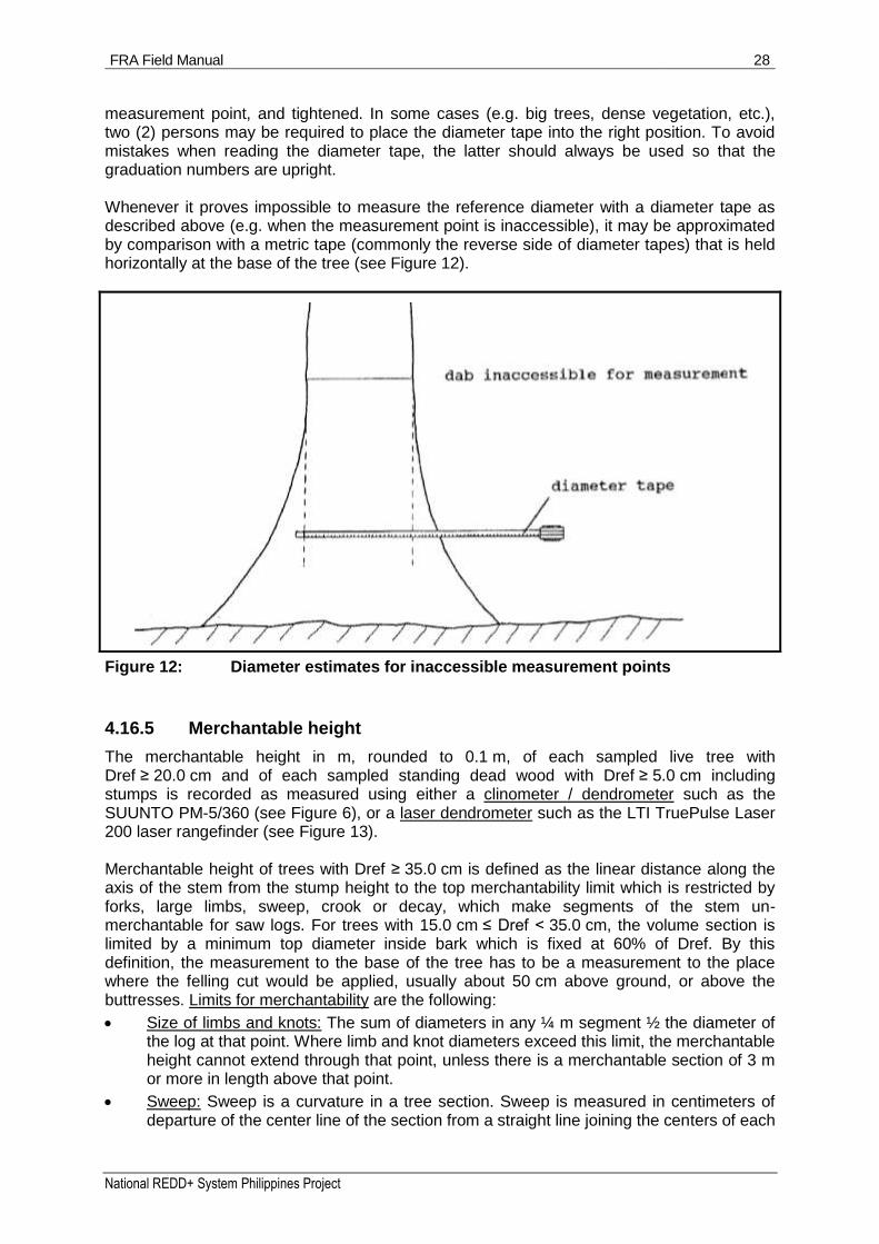
Figure 12: Diameter estimates for inaccessible measurement points ......................... 28
Figure 13: LTI TruePulse Laser 200 rangefinder (height measurements) ................... 31

FRA Field Manual iv
National REDD+ System Philippines Project
ACRONYMS
AD Ancestral Domain
AFOLU Agriculture, Forest and Other Land Use
AGB Above-Ground Biomass
BGB Below-Ground Biomass
BMUB Bundesministerium für Umwelt, Naturschutz, Bau und Reaktorsicherheit (Federal Ministry for the Environment, Nature Conservation, Building and Nuclear Safety)
CADT Certificate of Ancestral Domain Title
CBFM Community-Based Forest Management
CLUP Comprehensive Land Use Plan
CMA Co-Management Agreement
DENR Department of Environment and Natural Resources
DFS Deutsche Forstservice GmbH
DOM Dead Organic Matter
FLUP Forest Land Use Planning
FMB Forest Management Bureau
FREL Forest Reference Emissions Level
FRL Forest Reference Level
GHG Greenhouse Gas
GIZ Deutsche Gesellschaft für Internationale Zusammenarbeit GmbH
GPS Global Positioning System
ICC Indigenous Cultural Communities
IP Indigenous People
IPCC Intergovernmental Panel on Climate Change
LGU Local Government Unit
MRV Measurement, Reporting and Verification
NAMRIA National Mapping and Resource Information Authority
NCIP National Commission on Indigenous People
NGP National Greening Program
PNRPS The Philippine National REDD-Plus Strategy
POI Point of Interest
PSC Project Steering Committee
QA Quality Assurance
QC Quality Control
REDD+ Reducing Emissions from Deforestation and forest Degradation, and conservation, sustainable management of forests and enhancement of carbon stocks
SINP Samar Island Natural Park
SOM Soil Organic Matter
SOP Standard Operating Procedure
UNFCCC United Nations Framework Convention on Climate Change
FRA Field Manual v
National REDD+ System Philippines Project
SYMBOLS
= equal
> greater
≥ greater or equal
< smaller
≤ smaller or equal

FRA Field Manual 1
National REDD+ System Philippines Project
EXECUTIVE SUMMARY
The present manual constitutes the technical reference for the field teams carrying out the Forest Resources Assessments to be conducted from 2014 until 2015 in the sites of the National REDD+ System Philippines Project in the Visayas and Mindanao selected for Forest Land Use Planning (FLUP) and the implementation of REDD+ eligible activities (Borongan City and Maydolong in Eastern Samar, Caraga, Manay and Tarragona in Davao Oriental), in support of the elaboration and pilot testing of Forest Reference (Emissions) Levels FR(E)Ls and a Measurement, Reporting and Verification (MRV) system. The underlying methodology has been developed and described by LENNERTZ R. and SCHADE J. (2014) in a separate document. It is a refinement of the forest carbon baseline study carried out from 2011 until 2012 in Leyte in the framework of the Climate relevant Modernization of Forest Policy and Piloting of Reducing Emissions from Deforestation and Forest Degradation (REDD) Project, taking into account evolving international standards and good practices with regards to forest carbon stock assessment for the estimation of Greenhouse Gas (GHG) emissions and removals in compliance with the latest (2006) Intergovernmental Panel on Climate Change (IPCC) guidelines for national GHG inventories in the Agriculture, Forestry and Other Land Use (AFOLU) sector following the "Stock Difference Method". The Forest Resources Assessments pursue the objectives of providing estimates of carbon stocks with quantified precisions for key carbon pools:
Above-Ground Biomass (AGB) at Tier 2 level (in due time Tier 3 after the first re-measurement);
Below-Ground tree Biomass (BGB) at Tier 1 level;
Dead Organic Matter (DOM) at Tier 2 level (in due time Tier 3 after the first re-measurement);
Soil Organic Matter (SOM) at Tier 1 level;
of key forest strata according to the 2010 forest cover map prepared by the National Mapping and Resource Information Authority (NAMRIA), based on the establishment, observation and measurement of 200 Sampling Units per Project site (600 Sampling Units in total). After a short introduction to the Project, as well as a brief summary of the methodological background, the scope and the objectives of the Forest Resources Assessments, the manual successively provides details about:
the inventory design, notably regarding (i) the inventory method, (ii) the number, distribution and configuration of Sampling Units, (iii) the parameters to be assessed / measured, (iv) the manpower, equipment and logistics for the implementation, (v) data recording, processing and analysis, and (vi) Quality Assurance (QA) and Quality Control (QC) (Chapter 2);
the retrieval and permanent marking of Sample Points and Satellite Centers (Chapter 3);
the observations and measurements to be carried out (Chapter 4);
the sequencing of observations, measurements and data recording (Chapter 5).
Not all particular situations that may be encountered during the implementation of the inventories can be anticipated beforehand. If situations arise for which the instructions are not clear or complete, the solution(s) temporarily adopted by the inventory teams shall be documented and brought to the attention of the authors. The latter shall study the issue and amend / augment the inventory instructions so as to lift ambiguities and ensure proper and standardized implementation of the inventory procedures.
FRA Field Manual 2
National REDD+ System Philippines Project
1. INTRODUCTION AND BACKGROUND
1.1 National REDD+ System Philippines Project
The German Federal Ministry for the Environment, Nature Conservation, Housing and Nuclear Safety (BMUB) funded National REDD+ System Philippines Project contributes to the overall goal that Department of Environment and Natural Resources (DENR), relevant government agencies, local government units and local communities / indigenous people in the Philippines use a national framework, based on internationally recognized ecological and social safeguards, to reduce Greenhouse Gas (GHG) emissions from deforestation and forest degradation and to achieve co-benefits (biodiversity conservation and livelihoods improvement). The Project supports the implementation of the Philippine National REDD-Plus Strategy (PNRPS) by assisting the process towards REDD+ Readiness. The Project works in 3 sites in various regions of the Philippines for REDD+ demonstration activities: Region 5 Luzon / Bicol Region, Region 8 Eastern Samar, and Region 11 Davao Oriental. Project Component 4 shall achieve the following indicators:
Forest Land Use Plans (FLUPs) and co-management agreements with clear land tenure arrangements for local communities and Indigenous People (IP) groups and biodiversity conservation agreements with local actors are in place for at least three pilot areas covering a total forest area of at least 150.000 ha.
REDD+ eligible activities (avoided deforestation and degradation, reforestation, assisted natural regeneration, sustainable forest management) in at least three pilot areas for emissions reduction and CO2 removals have been implemented.
Moreover, substantial contributions shall be furnished to:
Forest Reference (Emissions) Levels (FR[E]Ls) for the three sites;
Concept for a REDD+ Measurement, Reporting and Verification (MRV) system;
Forest policy and regulatory frameworks related to Community-Based Forest Management (CBFM), tenure arrangements, Co-Management Agreements (CMAs), IP/ICC concerns, and biodiversity conservation;
Knowledge management and Project monitoring and reporting.
It is in support of the elaboration and pilot testing of FR(E)Ls and the MRV system that Forest Resources Assessments shall be carried out in Eastern Samar and Davao Oriental.
1.2 Methodological Framework
The 2006 Intergovernmental Panel on Climate Change (IPCC) guidelines for national GHG inventories propose two methods of calculating carbon stock changes in a given carbon pool for a given land-use category in the Agriculture, Forestry and Other Land Use (AFOLU) sector:
the "Gain - Loss Method", estimating the difference between increases (transfer from another carbon pool or increase of biomass [removal]) and decreases (transfer to another carbon pool or emissions) of the amount of carbon;
the "Stock Difference Method", estimating the change of carbon stocks through measurements at two (or more) points in time (which reflects the emissions and removals).
The "Stock Difference Method" is robust and transparent, particularly to monitor carbon stock changes from forest degradation, which, in the Philippines, is a GHG emission source key

FRA Field Manual 3
National REDD+ System Philippines Project
category (category "3 B 1 a Forest Land Remaining Forest Land") with a presumably higher emission level than deforestation (sub-category "3 B 2 b i Forest Land Converted to Cropland"). The "Stock Difference Method" requires two estimations: (i) forest area (preferably by strata that are correlated to carbon stocks) and (ii) carbon stock per unit area of forest. For both estimations, it is essential to refer to DENR Memorandum Circular 2005-005 of 26 May 2005 with regards to the forest definition: "Land with an area of more than 0.5 hectare and tree crown (or equivalent stocking level) of more than 10 percent. The trees should be able to reach a minimum height of 5 meters at maturity in situ. It consists either of closed forest formations where trees of various storeys and undergrowth cover a high portion of the ground or open forest formations with a continuous vegetation cover in which tree crown cover exceeds 10 percent. Young natural stands and all plantations established for forestry purposes, which have yet to reach a crown density of more than 10 percent or tree height of 5 meters are included under forest. These are normally forming part of the forest area which are temporarily unstocked as a result of human intervention or natural causes but which are expected to revert to forest. It includes forest nurseries and seed orchards that constitute an integral part of the forest; forest roads, cleared tracts, firebreaks and other small open areas; forest within protected areas; windbreaks and shelter belts of trees with an area of more than 0.5 hectare and width of more than 20 meters; plantation primarily used for forestry purposes, including rubber wood plantations. It also includes bamboo, palm and fern formations (except coconut and oil palm)." The forest area by strata has recently been mapped nationwide by the National Mapping and Resource Information Authority (NAMRIA), through visual classification of medium- to high- resolution multi spectral satellite data, acquired mainly 2010. Carbon stock per unit area of forest for the different strata must be determined using appropriate probabilistic (statistical) field sampling inventory methods. The adopted inventory methodology, developed and described by LENNERTZ R. and SCHADE J. (2014), is a refinement of the forest carbon baseline study carried out from mid-2011 until end 2012 in Leyte in the framework of the BMUB funded, GIZ-assisted Climate relevant Modernization of Forest Policy and Piloting of Reducing Emissions from Deforestation and Forest Degradation (REDD) Project (SCHADE J. and R. LUDWIG, 2013), building on the experience gained during this inventory, and taking into account evolving international standards and good practices.
1.3 Project Sites
Considering the variability of the prevailing natural, cultural and institutional conditions throughout the Philippines, 3 replications were deemed necessary to validate lessons learned in the field from activities contributing to the up-scaling of the implementation of the PNRPS. Following the geographical division into major island groups, one replication each should be implemented in Luzon, the Visayas and Mindanao, respectively. In the 3 sites, Municipalities as territorial units for FLUPs and Comprehensive Land Use Plans (CLUPs), have been scrutinized in February 2014 with the concurrence of an international short-term expert (SEIFERT-GRANZIN J., 2014) for their potential, applying criteria regarding (i) forests and threats, (ii) priority watersheds, (iii) biodiversity conservation, (iv) poverty, (v) logistics, (vi) replicability, (vii) preparedness and commitment of the LGUs, and (viii) for one site at least priority areas of the National Commission on Indigenous People (NCIP). The recommended sites and proposed activities:

FRA Field Manual 4
National REDD+ System Philippines Project
in Albay (Luzon) the Municipalities of
o Malinao, Tabaco City and Tiwi, to serve as a test case for developing a prototype financing mechanism for conservation of forest carbon stocks, and
o Ligao City and Oas for FLUP and sustainable forest management, as well as developing the link between the National Greening Program (NGP) and a REDD+ registry;
in Eastern Samar (Visayas) the Municipalities of Borongan City and Maydolong, covering the Suribao river watershed offering opportunities for creating synergies between a ridge-to-reef or integrated watershed ecosystems management approach, protected areas management (as part of the Samar Island Natural Park [SINP]) and REDD+; and
in Davao Oriental (Mindanao) the Municipalities of Caraga, Manay and Tarragona, featuring considerable areas of Closed Forests being part of Ancestral Domains (ADs) with Certificate of Ancestral Domain Titles (CADTs) either approved or in the process of delineation;
were approved in May 2014 by the Project Steering Committee (PSC). The Forest Resources Assessments shall be limited to Eastern Samar and Davao Oriental.
1.4 Objectives
The Forest Resources Assessments shall provide estimates of carbon stocks (expressed in t C / ha) with quantified precisions
for the key carbon pools (with definitions according to the 2006 IPCC guidelines for national GHG inventories)
o Living Biomass (LB), composed of
- Above-Ground Biomass (AGB), defined as follows: "All biomass of living vegetation, both woody and herbaceous, above the soil including stems, stumps, branches, bark, seeds, and foliage. In cases where forest understory is a relatively small component of the above-ground biomass carbon pool, it is acceptable for the methodologies and associated data used in some tiers to exclude it, provided the tiers are used in a consistent manner throughout the inventory time series."
- Below-Ground tree Biomass (BGB), defined as follows: "All biomass of live roots. Fine roots of less than (suggested) 2 mm diameter are often excluded because these often cannot be distinguished empirically from soil organic matter or litter."; and
o Dead Organic Matter (DOM), composed of
- Dead Wood (DW), defined as follows: "Includes all non-living woody biomass not contained in the litter, either standing, lying on the ground, or in the soil. Dead wood includes wood lying on the surface, dead roots, and stumps, larger than or equal to 10 cm in diameter (or the diameter specified by the country)." (for the Forest Resources Assessments in the National REDD+ System Philippines Project sites, the inventory threshold / minimum diameter for dead wood is set to 5.0 cm), and
- Litter (LI), defined as follows: "Includes all non-living biomass with a size greater than the limit for soil organic matter (suggested 2 mm) and less than the minimum diameter chosen for dead wood (e.g. 10 cm), lying dead, in various states of decomposition above or within the mineral or organic soil. This includes the litter layer as usually defined in soil typologies. Live fine roots above the mineral or organic soil (of less than the minimum diameter limit chosen for below-ground biomass) are included in litter where they cannot be distinguished from it empirically." (for the Forest

FRA Field Manual 5
National REDD+ System Philippines Project
Resources Assessments in the National REDD+ System Philippines Project sites, the inventory threshold / minimum diameter for dead wood is set to 5.0 cm);
of key forest strata according to the 2010 forest cover map prepared by the National Mapping and Resource Information Authority (NAMRIA), distinguishing:
o Closed Forests (forests with a tree crown cover of more than 40%) and
o Open Forests (forests with a tree crown cover of more than 10% up to 40%);
within and (for comparison purposes) adjacent to the Project sites;
at T0 (prior to the implementation of REDD+ eligible activities);
using permanent sampling units in view of the implementation of the "Stock Difference Method" for determining GHG emissions and removals.
Considering that more than 96% of the AGB biomass of tropical forest is found in trees with a diameter at breast height (Dref) ≥ 10.0 cm (GILLESPIE A. et al., 1992; in the Philippines, LASCO et al., 2006, report from Surigao del Sur 98% of the AGB in trees with a Dref ≥ 19.5 cm), the biomass of trees with a Dref < 5.0 cm and the non-tree biomass (except for bamboos and palms, which are also included in the Philippine forest definition, see Chapter 1.2) is not key and will not be accounted for in the inventories. BGB of live trees, bamboos and palms shall not be estimated directly, but calculated using the BGB to AGB ratio (R) of the IPCC guidelines. The carbon stocks of mangroves (a non-key forest stratum, since of the total 2010 forest area, mangroves represent only 4.07% in Eastern Samar and 1.00% in Davao Oriental) shall be accounted for using IPCC Tier 1 data (IPCC, 2013: Supplement to the 2006 IPCC guidelines for national GHG - Coastal wetlands: Tables 4.3, 4.5, 4.7 and 4.11). IPCC Tier 1 data shall also be used to account for Soil Organic Matter (SOM) (IPCC, 2006: IPCC guidelines for national GHG inventories - AFOLU: Table 2.3), defined as follows: "Includes organic carbon in mineral soils to a specified depth chosen by the country and applied consistently through the time series. Live and dead fine roots and DOM within the soil, that are less than the minimum diameter limit (suggested 2 mm) for roots and DOM, are included with soil organic matter where they cannot be distinguished from it empirically. The default for soil depth is 30 cm."

FRA Field Manual 6
National REDD+ System Philippines Project
2. INVENTORY DESIGN
2.1 Inventory Method
The inventory adopts a stratified probabilistic (statistical) sampling using permanent Sampling Units (SUs), referring to the Closed Forests and Open Forests strata of the 2010 NAMRIA national forest cover map. The population sampled to estimate the forest biomass and carbon stock consists of the following elements:
live trees (including bamboos, palms, rattan and tree ferns) with a diameter at breast height or above buttress (Dref) ≥ 5.0 cm (in tropical forests, the smaller trees represent less than 4% of the AGB, are not key and hence excluded from the inventory);
dead wood, both standing and lying, down to a small end diameter of 5.0 cm (the smaller fractions are part of the litter);
litter.
For live trees and dead wood, the inventory threshold consistently amounts to 5.0 cm (in diameter). The population elements are sampled with a probability proportional to their frequency, using fixed circular area plots.
2.2 Number and Distribution of Sampling Units
200 Sampling Units per Province shall be inventoried, 150 thereof within the municipal territories of the LGUs with Project field activities (Borongan City and Maydolong in Eastern Samar, Caraga, Manay and Tarragona in Davao Oriental). The other 50 Sampling Units are spread throughout the remaining provincial territory. The Sample Points (centers of the Sampling Units) are randomly drawn from those nodes of a quadratic grid with a side length of 1 km located in Closed Forests or Open Forests according to the 2010 NAMRIA national forest cover map. In the absence of official / authoritative administrative boundaries, the municipal boundaries downloadable from the GADM database of Global Administrative Areas Version 2 (see http://www.gadm.org/) have been used as reference. Appendix 1 lists the coordinates of the Sampling Units to be inventoried in Eastern Samar, Appendix 2 those to be inventoried in Davao Oriental. The numbering of the Sampling Units reveals whether the Sample Point is located within the selected municipal territories (001 to 150), or within the remaining territory of the Province (501 to 550). The numbering follows the sequence of the random drawing of the Sample Points.

FRA Field Manual 7
National REDD+ System Philippines Project
2.3 Configuration of Sampling Units
Each Sampling Unit consists of the following elements (see Figure 1 below):
1 circular plot with 25 m radius for the ocular assessment of the land cover.
4 "satellites" with their centers at 40 m horizontal distance from the sample point in the 4 cardinal directions (North, East, South and West), each consisting of 2 concentric circular plots:
o 5 m radius plot for:
- the sampling of "small-sized" live trees (all species, plus bamboos, palms, rattan and tree ferns) with 5 cm ≤ Dref < 20 cm;
- the sampling of standing dead wood with Dref ≥ 5.0 cm;
- the sampling of lying dead wood down to a diameter of 5.0 cm;
- the sampling of litter.
o 10 m radius plot for:
- the sampling of "big-sized" live trees (all species, plus bamboos, palms, rattan and tree ferns) with Dref ≥ 20 cm;
Figure 1: Configuration of the sampling unit (cluster)
FRA Field Manual 8
National REDD+ System Philippines Project
2.4 Observations and Measurements at and around the Sample Points
The following parameters are observed / measured at the Sample Points:
Administrative location: Province, City / Municipality and Barangay.
Actual coordinates.
Elevation.
Slope.
Slope orientation.
Terrain: 11 classes (plateau; summit / crest; upper slope; middle slope; lower slope; bench /terrace; valley; plain; narrow depression; water course; dunes).
Land classification: Legal status (forest land or alienable and disposable).
The following parameters are assessed within a radius of approximately 25 m horizontal distance around the Sample Points:
Land cover: 12 classes (forest; marshland / swamp; fallow; shrubs; wooded grassland; grassland; annual crop; perennial crop; open / barren land; built-up area; fishpond; inland water).
Forest type: 10 types (dipterocarp old growth forest; dipterocarp residual forest; mossy forest; submarginal forest; closed pine forest; open pine forest; mangrove of growth forest; mangrove reproduction forest; native tree plantation forest; other plantation forest).
Tree crown cover: 3 classes (tree crown cover ≤ 10%; 10% < tree crown cover ≤ 40%); tree crown cover > 40%).
2.5 Observations and Measurements at and around the Satellite Centers
The following parameters are observed / measured at the Satellite Centers (similar to the observations / measurements at the Sample Points):
Administrative location: Province, City / Municipality and Barangay.
Actual coordinates.
Elevation.
Slope.
Slope orientation.
Terrain: 11 classes (plateau; summit / crest; upper slope; middle slope; lower slope; bench /terrace; valley; plain; narrow depression; water course; dunes).
Land classification: Legal status (forest land or alienable and disposable).
The following parameters are observed / measured within a radius of exactly 5 m horizontal distance around the Satellite Centers:
Plant diversity.
Ground coverage classes for six (6) vegetation layers according to height (< 50 cm; 50 cm ≤ height < 130 cm; 130 cm ≤ height < 200 cm; 2.0 m ≤ height < 4.0 m; 4.0 m ≤ height < 10.0 m; height > 10.0 m): 4 classes (none; coverage ≤ 10%; 10% < coverage ≤ 50%; coverage > 50%).
For each of the sampled "small-sized" live trees (including bamboos, palms, rattan and tree ferns) with 5 cm ≤ Dref < 20 cm: species, azimuth and horizontal distance (from the Satellite Center), and Dref.
For each of the sampled standing dead wood (including stumps) with Dref ≥ 5.0 cm: species, azimuth and horizontal distance (from the Satellite Center), Dref and merchantable height.

FRA Field Manual 9
National REDD+ System Philippines Project
For each of the sampled lying dead wood sections (those portions that are within the 5 m horizontal distance radius plot) down to a diameter of 5.0 cm: mid-diameter and length.
Litter: ground coverage percentage plus average depth.
The following parameters are observed / measured within a radius of exactly 10 m horizontal distance around the Satellite Centers:
Land cover: 12 classes (forest; marshland / swamp; fallow; shrubs; wooded grassland; grassland; annual crop; perennial crop; open / barren land; built-up area; fishpond; inland water).
Forest type: 10 types (dipterocarp old growth forest; dipterocarp residual forest; mossy forest; submarginal forest; closed pine forest; open pine forest; mangrove of growth forest; mangrove reproduction forest; native tree plantation forest; other plantation forest).
Tree crown cover: 3 classes (tree crown cover ≤ 10%; 10% < tree crown cover ≤ 40%); tree crown cover > 40%).
For each of the sampled "big-sized" live trees (including bamboos, palms, rattan and tree ferns) with Dref ≥ 20.0 cm: species, azimuth and horizontal distance (from the Satellite Center), Dref and merchantable height.
Table 1 summarizes the circular plot sizes and the required observations / measurements for live trees (including bamboos, palms, rattan and tree ferns) and dead wood.
Table 1: Overview of plot sizes and data requirements for live trees and dead wood
Live Trees Dead Wood
"Small-Sized" "Big-Sized" Standing Lying
5 cm ≤ Dref < 20 cm Dref ≥ 20 cm Dref ≥ 5 cm Dref ≥ 5 cm
Plot radius 5.0 m 10.0 m 5.0 m 5.0 m
Species Species Species Species -
Azimuth Azimuth Azimuth Azimuth -
Hor. Distance Hor. Distance Hor. Distance Hor. Distance -
Diameter DBH / DAB DBH / DAB DBH / DAB Mid-Diameter
Height / Length - Merch. Height Merch. Height Section Length
2.6 Implementation
2.6.1 Inventory teams
The inventories are carried out by two Inventory Teams, each composed as follows:
One Team Leader, with a B.Sc. in Forestry, and at least 2 years working experience in forest resources assessment / monitoring;
One Assistant, with a B.Sc. in Forestry, and at least 2 years working experience in forest resources assessment / monitoring;
Two to four Helpers (according to the accessibility of the SUs being measured), recruited locally, familiar with the area and if possible knowledgeable about tree species / forest products.

FRA Field Manual 10
National REDD+ System Philippines Project
The Team Leaders are responsible for the security of the team, for the equipment entrusted to them, and for the work of their members. They direct the members, validate the data observed or measured by their Assistants, and complete the field data forms. The Assistants manipulate the equipment and carry out the observations and measurements. The Helpers advise on the retrieval of the Sample Points, carry the equipment, open / brush trails, access and sighting lines, mark the Sample Points and centers of the Satellite Centers, help the Assistants in carrying out the measurements, and mark the trees. Based on the experience gained in the implementation of the forest carbon baseline study from mid-2011 until end 2012 in Leyte in the framework of the BMUB funded, GIZ-assisted Climate relevant Modernization of Forest Policy and Piloting of Reducing Emissions from Deforestation and Forest Degradation (REDD) Project, one Inventory Team working 2 x 12 days without break per month (to reduce the proportion of time spend in mobilization / de-mobilization) should be able to establish and measure an average of 16 Sampling Units per month. Hence, with two Inventory Teams, it is expected that 200 Sampling Units will be accomplished within 6.5 months (incl. an initial 6-days plus 1-week training).
2.6.2 Inventory equipment
Each Inventory Team is equipped with the following:
One (1) handheld GPS receiver with proven sensitivity / ability to operate under difficult signal reception conditions (under tree cover), such as GARMIN GPSmap 62 and 64 series, or GARMIN GPSmap 76 and 78 series, to retrieve the sample points and measure coordinates.
One (1) handheld "dendrometer" for the measurement of tree heights using the trigonometric principle, hence capable of measuring distances and inclination angles, such as the LASER TECHNOLOGY Inc. (LTI) TruePulse Laser 200 laser rangefinder.
One (1) handheld precision compass graduated in degrees for the measurement of bearings / azimuth, such as the SUUNTO KB-14/360.
One (1) handheld precision clinometer such as the SUUNTO PM-5/360 as alternative to and backup for the dendrometer.
One (1) fiberglass distance tape, 30 m, to measure distances.
One (1) steel diameter tape, 5 m, to measure tree diameters.
Per Sampling Unit five (5) iron rods (of at least 1 cm diameter and 50 cm length) and five (5) bright-colored 1/2 " PVC pipes (of 50 cm length) for the marking of the Sample Point and Satellite Centers.
One (1) hatchet.
One (1) first aid kit.
One (1) backpack to carry the equipment.
Personal field work gear for the Team Leaders and Assistants (boots, rain coats, head lamps, sleeping bags, etc.)
Camping equipment (tents, mobile stoves, etc.).
2.6.3 Inventory camps
Considering the location of the Sampling Units to be inventoried and their accessibility, studied on the basis of available geographic data such as topographic, infrastructure and road network maps, GOOGLE Earth images, etc., the Sampling Units are grouped into batches assigned to inventory camps strategically located, preferably in Barangays or Sitios.

FRA Field Manual 11
National REDD+ System Philippines Project
A reasonable compromise must be found between (i) the number of Sampling Units assigned to a specific inventory camp (ideally not less than the number of Sampling Units that can be observed / measured by the two (2) Inventory Teams in one (1) field mission, to minimize the "unproductive" time spend travelling from the Project office to and from the inventory camp), and (ii) the distance from the inventory camp to the furthest Sampling Unit.
2.6.4 Data recording, processing and analysis
In the field, the inventory data are recorded using the set of specifically designed data forms shown in Appendix 3. The data forms shall progressively be submitted to the field office for encoding into a specifically developed MySQL-powered database, whose architecture has been developed and described by BARROIS V. (2014).
2.7 Quality Assurance / Quality Control
2.7.1 Quality Assurance (QA)
During the establishment, assessment and measurement of the Sampling Units in the field, the inventory instructions contained in the present manual must strictly be complied with. If situations arise for which the instructions are not clear or complete, the solution temporarily adopted shall be documented and brought to the attention of the authors of the present manual. The latter shall study the issue and amend / augment the inventory instructions so as to lift ambiguities and ensure proper and standardized implementation of the inventory procedures. During data acquisition, the Team Leader shall repeat aloud all information / data he receives from his team members prior to their recording on the field data forms. Before leaving the Sample Point and each of the four Satellites, he shall verify whether all needed data haven been properly recorded, and that no equipment will be left behind. At the end of each day, the Team Leader shall re-check the completeness of the field data forms, and store them properly collated in a dry and safe place until handing them over to the Junior Advisor in charge of the coordination and supervision of the field work. The Junior Advisor shall regularly, more frequently at the start of the inventory, accompany the inventory teams to closely watch whether the inventory procedures, assessments and measurements are carried out correctly. Errors must be corrected swiftly. The Assistants should not permanently work with the same Team Leader, but regularly be rotated, so as to improve the consistent and homogenous implementation of the inventory protocol. Data encoding shall closely follow the data acquisition in the field, so that eventual gaps and errors observed can be ironed out with minimal effort, and the inventory teams be cautioned on typical and critical issues.
2.7.2 Quality Control (QC)
Ten percent (10%) of the Sampling Units chosen at random and without prior knowledge of the Inventory Teams will be subject to an independent re-measurement. The Team proceeding to the re-measurement shall be led by the Junior Advisor, and assisted by the Team Leader responsible for the original establishment, assessment and measurement of the Sampling Unit. All data of the Sampling Unit shall anew be acquired, recorded and processed. The field measurement error (in % of the difference of the total forest carbon

FRA Field Manual 12
National REDD+ System Philippines Project
stock per ha between the measured and the re-measured Sampling Unit, with reference to the re-measured Sampling Unit) will be computed and documented. Data encoding will likewise be checked, in a first round through the limitation of data entry ranges, the sorting of data to spot oddly small and large numbers, and using programmed plausibility checks revealing implausible data constellations. Once the data are seemingly purged of gross mistakes, ten percent (10%) of the encoded data chosen at random will be compared with the field data forms.

FRA Field Manual 13
National REDD+ System Philippines Project
3. RETRIEVAL AND PERMANENT MARKING OF SAMPLE POINTS AND SATELLITE CENTERS
3.1 Approach of Sample Points using GPS Receivers
The Sample Points are accessed / retrieved on the basis of their coordinates using orientation maps and handheld Global Positioning System (GPS) stand-alone receivers such as the GARMIN GPSmap 62, 64, 76 and 78 series GPS receivers (see Figure 2). As with all GARMIN GPS receivers, the Sample Points can be uploaded from a computer as "Points of Interest (POIs)" rather than as "waypoints", using the "GARMIN POI loader" software (freeware downloadable from http://www8.garmin.com/support/mappingsw.jsp). "POIs" offer the advantage that unlike "waypoints", they cannot be edited nor erased from the GPS receivers (unless connected to a computer and with the use of the aforementioned software).
Figure 2: GARMIN GPSmap 64 and 78 series GPS receivers
Prior to navigating to a "waypoint" or "POI", the GPS receiver must be properly configured. With GARMIN GPSmap 62, 64, 76 and 78 receivers, press the MENU button twice to open the < Main Menu >, and verify respectively set the following configuration options:
< Setup > \ < System > \ < GPS > \ < Normal >;
< Units > \ < Distance and Speed > \ < Metric >;
< Position Format > \ < UTM UPS >;
< Map Datum > \ < WGS 84 >;
< Heading > \ < Display > \ < Numeric Degrees >;
< Heading > \ < North Reference > \ < True >;
< Heading > \ < Compass > \ < Auto >;
< Altimeter > \ < Auto Calibration > \ < On >;
< Altimeter > \ < Barometer Mode > \ < Variable Elevation >;
< Routing > \ < Activity > \ < Direct Routing >.
The built-in compass must regularly be calibrated, notably after moving long distances, experiencing temperature changes, or changing batteries: press the MENU button twice to open the < Main Menu >, select < Heading > \ < Compass > \ < Calibrate Compass > and follow the instructions displayed.

FRA Field Manual 14
National REDD+ System Philippines Project
To navigate to a
"waypoint", press the FIND button, and select the destination from < Waypoints > among the stored "waypoints"
"POI", press the FIND button, and select the destination from < Extras > \ < Custom POIs > among the stored "POIs"
(shown in the order of their proximity). Then select < GO >, and cycle to the < Compass > window pressing repeatedly the PAGE button. The most informative selection of data fields for the < Compass > window, which can be customized by pressing the MENU button and selecting < Change Data Fields > while viewing the < Compass > window, is as follows:
up left: < Waypoint at Dest. > (displays the name of the "Waypoint" or "POI" selected as destination);
up right: < Off Course > (displays the distance between the actual position and the straight line connecting the position where the navigation was initiated to the destination);
down left: < Bearing > (displays the azimuth / bearing in ° to the destination);
down right: < Distance to Dest. > (displays the distance in km or m to the destination).
The approach of a targeted Sample Point is best studied together with the local Helpers / Guides, who are well versed with the terrain, existing trails, unsurmountable barriers and/or obstacles such as steep hills or waterlogged areas to be avoided. As long as the destination is still several hundred meters away, it is faster to proceed towards it following trails or easy to moderate terrain conditions, heading into the right direction, rather than following a straight line.
3.2 Location of Sample Points and Satellite Centers using Compass and Distance Tape
Considering the limited positional precision of stand-alone GPS measurements / navigation (in practice ± 10 m, as evidenced by the virtual movement of an immobilized GPS receiver, which is a remarkable precision to come close to any point on the globe from whatever origin over considerable distances, but insufficient to measure distances of less than 100 m to 200 m, since the relative precision deteriorates to 10% to 5%), the location of Sample Points must be determined covering the last 10 m to 15 m by compass and horizontal distance measurement (referring to the azimuth / bearing and distance to the Sample Point displayed by the GPS receiver on the < Compass > window once the distance to the destination is less than 15 m) using a distance tape, in order to prevent bias (preference for easily accessible areas) when closing in on the Sample Point. The same applies to the location of the four (4) Satellite Centers of each Sampling Unit, located at 40 m in the four (4) cardinal directions (North = 0°; East = 90°, South = 180°; West = 270°) from the Sample Point. Two persons (Helpers) are needed for accurate horizontal distance measurements using distance tapes ("chain"), a head chainman also acting as brusher, and a rear chainman. On level terrain, the distance tape is stretched straight and horizontally above the ground. On slopes or uneven ground, measurements are made by steps ("horizontal chaining" or "brake chain"), in such a way that differences in elevation between the ends or intermediate points of the distance tape (for easy monitoring of the cumulated horizontal distance covered using multiples of 5 m) are balanced by raising the lower end. The azimuth / bearing is measured with the help of a handheld precision compass such as the SUUNTO KB-14/360 (see Figure 3). The compass man (Assistant) sends the head

FRA Field Manual 15
National REDD+ System Philippines Project
chainman in the desired direction. Whenever the end either of the distance tape or of the range of vision is reached, the compass man directs the head chainman to place a pole. On steep terrains as well as over short sighting distances (less than 5 m), however, the compass does not permit reliable measurements / readings. In these cases, it is necessary to prolong the already covered straight line with the help of poles that are aligned with at least two poles placed along the established portion ("tree pole method").
To adjust focus, close one eye and look through the optics. Turn the cranted black optics knob until numbers are clear.
To measure / read azimuth / bearing, hold the compass horizontally, so that the scale can move freely. Keep both eyes open, and aim through the optics to the target. An optical illusion makes the sighting line and the scale appear over the target. Read the value from the sighting line once the scale is stable.
Figure 3: SUUNTO KB-14/360 handheld precision compass
Whenever unsurmountable obstacles, such as cliffs, thick clusters of pandan (Pandanus spp.) or buho and alike (Schizostachyum spp.), etc. are encountered when measuring horizontal distances, it is necessary to offset the straight line. The offset (see Figure 4) is done perpendicularly to the straight line. As soon as the obstacle has been circumvented, the original straight line must be returned to.

FRA Field Manual 16
National REDD+ System Philippines Project
Figure 4: Horizontal distance measurement with offset
3.3 Permanent marking of Sample Points and Satellite Centers
The Sample Points and the 4 Satellite Centers of each Sampling Unit are permanently marked with an iron rod (of at least 1 cm diameter and 50 cm length), forced at least 4/5 of its length into the ground, topped with a 50 cm bright-colored 1/2 " PVC pipe to facilitate the retrieval for Quality Control (QC) purposes.
3.4 Inaccessible Sample Points and Satellite Centers
Should one of the Satellite Centers turn out to be inaccessible, it may exceptionally be re-located at 80 m horizontal distance from the Sample Point in the next cardinal direction, turning clockwise (see Figure 5, page 17: if the Western Satellite Center is inaccessible, its center may be re-located at 80 m horizontal distance to the West + 90° = North from the Sample Point). Should a Sample Point turn out to be inaccessible, the Sampling Unit will be abandoned. In due time, a replacement Sample Point will be drawn at random from those nodes of the quadratic grid with a side length of 1 km located (i) in the same forest stratum and (ii) at a similar elevation as the inaccessible Sample Point.

FRA Field Manual 17
National REDD+ System Philippines Project
Figure 5: Re-location of inaccessible Satellites

FRA Field Manual 18
National REDD+ System Philippines Project
4. OBSERVATIONS AND MEASUREMENTS
4.1 Administrative Location
The administrative location, comprising at least the Region, Province and Municipality, and as much as possible the Barangay, is observed at and recorded for the Sample Points and all Satellite Centers. Hence, five (5) such observations are recorded per Sampling Unit (in some cases, a Sampling Unit may be crossed by an administrative boundary).
4.2 Target Coordinates
The target UTM coordinates, comprising the Zone (in the Philippines 50 in Palawan, 52 in the eastern-most portions of Mindanao, 51 elsewhere), the Northing in m and the Easting in m, are recorded for the Sample Points. The coordinates are taken from the lists in Appendix 1 (Sampling Units for Eastern Samar) or Appendix 2 (Sampling Units for Davao Oriental).
4.3 Actual Coordinates
The actual UTM coordinates, comprising the Zone (in the Philippines 50 in Palawan, 52 in the eastern-most portions of Mindanao, 51 elsewhere), the Northing in m and the Easting in m, are measured at and recorded for the Sample Points and all Satellite Centers. Hence, five coordinate measurements are performed per Sampling Unit. The coordinates are read from the GPS receiver, immobilized at the Sample Point or Satellite Center, using "averaging". With GARMIN GPSmap 62, 64, 76 and 78 receivers, press the MENU button twice to open the < Main Menu >, select < Waypoint Avg. >, followed by < Create Waypoint >, and wait until the sample confidence has reached 100%. This may take up to 5 minutes, under poor satellite signal reception conditions more. There is no harm letting the GPS receiver continue the averaging after the sampling confidence has reached 100%. Hence, the GPS receiver can be left at measurement point, while performing other observations / measurements.
4.4 Elevation
The elevation in m above sea level is measured at and recorded for the Sample Points and all Satellite Centers. Hence, five (5) elevation measurements are performed per Sampling Unit. The elevation is read from the GPS receiver. With GARMIN GPSmap 62, 64, 76 and 78 receivers, cycle to the < Elevation Plot > window pressing repeatedly the PAGE button, and read the elevation from the < Elevation > data field. If the latter is not shown, press the MENU button, select < Change Data Fields >, and choose < Elevation >.
4.5 Slope
The slope is measured at and recorded for the Sample Points and all Satellite Centers. Hence, five slope measurements are performed per Sampling Unit. The slope corresponds to the average inclination in % measured with a clinometer such as the SUUNTO PM-5/360 (see Figure 6) in two opposite directions along 10 m segments (oblique distance) of an imaginary straight line passing through the Sample Point / Satellite Center and following the steepest slope gradient (where water would run off).

FRA Field Manual 19
National REDD+ System Philippines Project
To adjust focus, close one eye and look through the optics. Turn the cranted black optics knob until numbers are clear.
To measure / read vertical angle, hold the clinometer vertically, so that the scale can move freely. Keep both eyes open, and aim through the optics to the target. An optical illusion makes the sighting line and the scale appear over the target. Read the value from the sighting line once the scale is stable.
Figure 6: SUUNTO PM-5/360 handheld precision clinometer / dendrometer
4.6 Slope Orientation
The slope orientation is measured at and recorded for the Sample Points and all Satellite Centers. Hence, five slope orientation measurements are performed per Sampling Unit. The slope orientation corresponds to the azimuth / bearing in ° of the downhill direction of the imaginary straight line used for the measurement of the slope gradient, read from a compass such as the SUUNTO KB-14/360 (see Figure 3).
FRA Field Manual 20
National REDD+ System Philippines Project
4.7 Terrain
The terrain / topography class is observed at and recorded for the Sample Points and all Satellite Centers. Hence, five terrain / topography classes assessments are performed per Sampling Unit. The assessment through ocular inspection distinguishes the 11 classes defined by FAO (FAO, 2012: National Forest Monitoring and Assessment - Manual for integrated field data collection. Version 3.0):
Plateau: Relatively flat (slope ≤ 5%); terrain of great extent and high elevation, above adjacent lowlands limited by an abrupt descent scarp on at least one side; may be dissected by deep valleys and deeply incised rivers.
Summit / crest: Crest of any kind or hilltop; can be sharp or rounded.
Upper slope: Upper slope of hillside (located on the upper 1/3 of the slope) (shoulder).
Middle slope: Middle slope of hillside (slope > 5%) (back slope).
Lower slope: Lower slope of hillside (foot slope).
Bench / terrace: Horizontal zone of average width over 30 m interposed in the valley side (slope < 15%) or a terrace over 6 m width.
Valley: Very wide, gently sloping depression with predominant extent in one direction commonly situated between two mountains or ranges of hills; the profile may be U- or V-shaped; includes river valley (formed by flowing water) or glacier valleys.
Plain: A large flat to very gently undulating area at a low elevation with reference to surroundings
Narrow depression: Enclosed depression or small, narrow valley or distinct crater (including ravine, gorges, gullies, canyons, etc.).
Water course: Permanent or temporary water course (river, etc.).
Dunes: Sandy hills developed through sand deposits from wind erosion / storms, often unstable and moving.
4.8 Land Classification
The land classification (legal status) is observed at and recorded for the Sample Points and all Satellite Centers. Hence, five land classification assessments are performed per Sampling Unit. The assessment through ocular inspection distinguishes 2 classes according to the latest available land classification map from DENR:
Forest land.
Alienable and disposable.
4.9 Land Cover
The land cover is observed at and recorded for the Sample Points within a radius of 25 m horizontal distance and all Satellites within a radius of 10 m horizontal distance from the centers. Hence, five land cover assessments are performed per Sampling Unit. The assessment through ocular inspection distinguishes forests (further classified according to their type, see Chapter 4.10) and the 11 non-forest land cover classes used in the 2010 NAMRIA national forest cover map:
Forest: Land with an area of more than 0.5 ha and trees able to reach a minimum height of 5 m in situ with a crown cover of more than 10% (see Chapter 1.2 for the detailed definition).
Marshland / swamp.
Fallow.
Shrubs.
FRA Field Manual 21
National REDD+ System Philippines Project
Wooded grassland.
Grassland.
Annual crop.
Perennial crop.
Open / barren land.
Built-up area.
Fishpond.
Inland water.
4.10 Forest Type
The forest type is observed at and recorded for the Sample Points within a radius of 25 m horizontal distance and all Satellites within a radius of 10 m horizontal distance from the centers. Hence, five forest type assessments are performed per Sampling Unit. The assessment through ocular inspection distinguishes the 8 natural forest types used in the conduct of the second National Forest Resources Inventory (1979 - 1988), plus 2 additional types for planted (man-made) forests:
Dipterocarp old growth forest: Tropical rain forest dominated by Dipterocarpaceae with traces of commercial logging.
Dipterocarp residual forest: Tropical rainforest dominated by Dipterocarpaceae after commercial logging.
Mossy forest: Tropical rainforests of the high elevations dominated by Podocarpaceae, Myrtaceae and Fagaceae with trees of medium height and short boled, covered with epiphytes.
Submarginal forest: Tropical rainforest dominated by Leguminosae and lesser utilized species, mainly restricted to shallow and excessively drained lime stone soils.
Closed Pine forest: Pure stands of Benguet or Minodoro Pine with crown cover > 30%.
Open Pine forest: Pure stands of Benguet or Minodoro Pine with 10% < crown cover ≤ 30%.
Mangrove old growth forest: Tidal forests dominated by Rhizophoraceae located on mud flats at the mouths of streams along the shore of protective bays, without traces of exploitation.
Mangrove reproduction forest: Tidal forests dominated by Rhizophoraceae and Verbenaceae dominated by Api-api (Avicennia officinalis) located on mud flats at the mouths of streams along the shore of protective bays, where utilization had been intensive and big trees had been removed.
Native tree plantation forest: Planted forest dominated by native rainforest species.
Other plantation forest: Planted forest dominated by non-native, often fast growing tree species.
4.11 Tree Crown Cover
The tree crown cover is observed at and recorded for the Sample Points within a radius of 25 m horizontal distance and all Satellites within a radius of 10 m horizontal distance from the centers. Hence, five tree crown cover assessments are performed per Sampling Unit.

FRA Field Manual 22
National REDD+ System Philippines Project
The assessment through ocular inspection distinguishes the 3 classes currently used by NAMRIA for forest cover mapping:
Non-forest: tree crown cover ≤ 10%).
Open forest: 10% < tree crown cover ≤ 40%.
Closed forest: Tree crown cover > 40%.
4.12 Plant Diversity
The plant diversity is counted at and recorded for all Satellites within a radius of 5 m horizontal distance from the centers. Hence, four plant diversity counts are performed per Sampling Unit. The inventory consist of the counting of distinct higher plant species observed, even if not known by their local, official common or scientific names. To avoid repeated counting of the same species, the count should be done by only one person, systematically collecting specimen of leaves from plants that can be reached from the ground.
4.13 Ground Coverage Classes by Vegetation Layers
Ground coverage classes for six vegetation layers are observed and recorded for all Satellites within a radius of 5 m horizontal distance from the centers. Hence, four times six ground coverage classes assessments are performed per Sampling Unit. For each of the following 6 vegetation layers:
Grass, herbs and mosses.
Tree regeneration, shrubs and plants with 50 cm ≤ height < 130 cm.
Tree regeneration, bushes and plants with 130 cm ≤ height < 200 cm.
Undergrowth of any kind with 2.0 m ≤ height < 4.0 m.
Lower trees and other plants with 4.0 m ≤ height < 10.0 m.
High trees with height > 10.0 m.
the following 4 ground coverage classes are assessed through ocular inspection:
None.
Coverage ≤ 10%.
10% < coverage ≤ 50%.
Coverage > 50%.
4.14 Ground Coverage and Average Depth of Litter
Litter, defined as all non-living biomass with a size > 2 mm and < 5.0 cm (i.e. the minimum diameter / inventory threshold for dead wood), lying dead, in various states of decomposition above or within the mineral or organic soil, is inventoried and recorded for all Satellites within a radius of 5 m horizontal distance from the centers through ocular estimates of
the ground coverage in %, and
the average depth in cm.

FRA Field Manual 23
National REDD+ System Philippines Project
4.15 Mid-Diameter and Length of Lying Dead Wood Sections
Lying dead wood, defined as all non-living woody biomass lying on the ground with a diameter ≥ 5.0 cm (i.e. the inventory threshold for dead wood and live trees) not contained in the litter, is inventoried and recorded for all Satellites within a radius of 5 m horizontal distance from the centers. For each lying dead wood section within the 5 m radius plot (without considering those portions extending beyond the plot, see Figure 7, the following measurements are performed:
Mid-diameter: Mid-diameter outside bark in cm, rounded to 0.1 cm, of the dead wood section within the 5 m radius plot, without considering those portions (i) extending beyond the plot, or (ii) with a diameter < 5 cm. The mid-diameter is measured using a caliper or a diameter tape.
Length: Length in m, rounded to 0.1 m, of the dead wood section within the 5 m radius plot, without considering those portions (i) extending beyond the plot, or (ii) with a diameter < 5 cm. The length is measured using a distance tape.
If a lying dead wood section features branches, these are measured separately.
Figure 7: Measurements on lying dead wood sections
FRA Field Manual 24
National REDD+ System Philippines Project
4.16 Observations / measurements on Live Trees and Standing Dead Wood
Live trees and standing dead wood with a reference diameter ≥ 5.0 cm are inventoried and recorded for all Satellites within a radius of
5 m horizontal distance from the centers for
o "small-sized" live trees (all species, plus bamboos, palms, rattan and tree ferns) with 5.0 cm ≤ Dref < 20.0 cm;
o standing dead wood with Dref ≥ 5.0 cm;
10 m horizontal distance from the centers for "big-sized" live trees (all species, plus bamboos, palms rattan and tree ferns) with Dref ≥ 20.0 cm.
For each of the sampled live trees and standing dead wood, (i) the species, (ii) azimuth and (iii) horizontal distance from the Satellite Center, (iv) Dref and for standing dead wood with Dref ≥ 5.0 cm as well live trees with Dref ≥ 20.0 cm (v) the merchantable height are observed / measured and recorded as described hereafter.
4.16.1 Species
Local common names of trees, bamboos, palms, rattan and tree ferns are not suited to unequivocally identify a species, because they vary from dialect to dialect, and even from place to place. They should only be recorded if the species cannot be identified using an official common name or a scientific name. A comprehensive, though not exhaustive species list is provided in Appendix 4 (alphabetically sorted on the common names) respectively Appendix 5 (alphabetically sorted on the scientific names).
4.16.2 Azimuth
The azimuth / bearing in ° of the center of each sampled live tree and standing dead wood at its basis / ground level is recorded as measured from the Satellite Center using a compass such as the SUUNTO KB-14/360 (see Figure 3).
4.16.3 Horizontal distance
The horizontal distance in m, rounded to 0.1 m, of the center of each sampled live tree and standing dead wood at its basis / ground level is recorded as measured from the Satellite Center using a distance tape or a laser rangefinder such as the LTI TruePulse Laser 200 (see Figure 8, Figure 9 and Figure 10).

FRA Field Manual 25
National REDD+ System Philippines Project
Press the FIRE button on top of the unit to turn power on.
Press and hold simultaneously the ▲ or ▼ buttons on the side of the unit for 4 seconds to turn power off.
The eyepiece can be adjusted by turning it.
The diopter of the viewfinder can be adjusted by turning the cranted ring at the basis of the eyepiece.
To change units, press and hold the ▼ button for 4 seconds until < UnitS > is displayed in the viewfinder. Press the FIRE button to confirm the < UnitS > option, then press the ▲ or ▼ buttons to select the unit (feet, meters or yards), and press the FIRE button to select the unit and return to the measurement mode.
Figure 8: LTI TruePulse Laser 200 rangefinder
The tilt sensor is aligned during assembly. Should the unit suffer a severe shock, the tilt sensor may have to be re-aligned as follows: (1) Press and hold the ▼ button for 4 seconds until < UnitS > is displayed. (2) Press the ▼ button to display the < inc > option. (3) Press the FIRE button to confirm the < inc > option, then press the ▲ or ▼ buttons to select the < CAL_Y > option, and press the FIRE button to start the calibration of the tilt sensor. < CAL_1 > is displayed. (4) Position the unit on a flat level surface. Use one finger to hold the front of the unit flat on the surface, and keep the finger in place until step (7) is completed. (5) press the FIRE button; < CAL_2 > is displayed. (6) Rotate the unit 180 °. (7) Press the FIRE button; < donE > is displayed. (8) Press the FIRE button to return to the measurement mode.
Figure 9: LTI TruePulse Laser 200 rangefinder (tilt sensor alignment)

FRA Field Manual 26
National REDD+ System Philippines Project
To measure horizontal distance, select the < HD > mode by pressing the ▲ or ▼ button until < HD > is displayed at the bottom of the viewfinder.
Look through the eyepiece and use the crosshair to aim to the target along a clear line of sight, then press and hold the FIRE button.
Release the FIRE button once the horizontal distance is displayed.
Figure 10: LTI TruePulse Laser 200 rangefinder (horizontal distance measurements)
4.16.4 Reference diameter
The reference diameter (Dref) outside bark in cm, rounded to 0.1 cm, of each sampled live tree and standing dead wood is recorded as measured using a diameter tape at the following measurement points (see also Figure 11):
in general at "breast height", i.e. 1.3 m above ground ("Diameter at Breast Height [DBH]") as measured from the uphill side of the stem;
for trees with prominent buttresses / basal flanges at breast height, the diameter is measured 30 cm above the end of the buttresses / flanges ("Diameter Above Buttress [DAB]");
for trees with bulges, swellings, depressions, branches or other abnormalities at breast height, the diameter is measured just below and above the abnormality at a point where it ceases to affect normal stem form, and computed as the average of the two measurements;
for stumps with a total height < 1.3 m at the section.
If a live tree / standing dead wood forks immediately above breast height, the diameter is measured below the swell resulting from the fork. If a live tree / standing dead wood forks below breast height, the stems are considered as separate trees / standing dead woods. On

FRA Field Manual 27
National REDD+ System Philippines Project
leaning live trees / standing dead woods, the "breast height" must be determined along the axis of the stem.
Source: ZÖHRER F., 1980: Forstinventur: Ein Leitfaden für Studium und Praxis
Figure 11: Reference diameter measurements
Prior to the measurement, all vines and climbers, as well as other hindrances that may impede the proper use of the diameter tape at the measurement point on the stem must be removed. The diameter tape is wrapped around the stem, carefully levelled at the
FRA Field Manual 28
National REDD+ System Philippines Project
measurement point, and tightened. In some cases (e.g. big trees, dense vegetation, etc.), two (2) persons may be required to place the diameter tape into the right position. To avoid mistakes when reading the diameter tape, the latter should always be used so that the graduation numbers are upright. Whenever it proves impossible to measure the reference diameter with a diameter tape as described above (e.g. when the measurement point is inaccessible), it may be approximated by comparison with a metric tape (commonly the reverse side of diameter tapes) that is held horizontally at the base of the tree (see Figure 12).
Figure 12: Diameter estimates for inaccessible measurement points
4.16.5 Merchantable height
The merchantable height in m, rounded to 0.1 m, of each sampled live tree with Dref ≥ 20.0 cm and of each sampled standing dead wood with Dref ≥ 5.0 cm including stumps is recorded as measured using either a clinometer / dendrometer such as the SUUNTO PM-5/360 (see Figure 6), or a laser dendrometer such as the LTI TruePulse Laser 200 laser rangefinder (see Figure 13). Merchantable height of trees with Dref ≥ 35.0 cm is defined as the linear distance along the axis of the stem from the stump height to the top merchantability limit which is restricted by forks, large limbs, sweep, crook or decay, which make segments of the stem un-merchantable for saw logs. For trees with 15.0 cm ≤ Dref < 35.0 cm, the volume section is limited by a minimum top diameter inside bark which is fixed at 60% of Dref. By this definition, the measurement to the base of the tree has to be a measurement to the place where the felling cut would be applied, usually about 50 cm above ground, or above the buttresses. Limits for merchantability are the following:
Size of limbs and knots: The sum of diameters in any ¼ m segment ½ the diameter of the log at that point. Where limb and knot diameters exceed this limit, the merchantable height cannot extend through that point, unless there is a merchantable section of 3 m or more in length above that point.
Sweep: Sweep is a curvature in a tree section. Sweep is measured in centimeters of departure of the center line of the section from a straight line joining the centers of each

FRA Field Manual 29
National REDD+ System Philippines Project
end of the section. The departure is measured at the midpoint of the section containing the sweep. A simple rule for maximum sweep is that departure minus allowance for long taper cannot exceed ½ the small end diameter of the section. Merchantable length is terminated below a section with excessive sweep unless there is a merchantable section of 3 m or more in length above that section.
Crook: Crook is a more or less abrupt bending or angle in a tree section. Crook is measured in cm of maximum departure of the section center line from an extension of the center line of the straight portion of the log. The maximum departure cannot exceed ½ the small end diameter of the log. Excessive crook should terminate the merchantable length unless there is a merchantable section of 3 m or more in length above that section.
Height measurements using the SUUNTO PM-5/360 clinometer / dendrometer:
Height (H) can be estimated from any known horizontal distance through two (2) readings of the % scale, aiming to the upper point (merchantable or total height of the tree) respectively to the lower point (base of the tree). For best results, the horizontal distance used for the sightings should be approximately equal to the height to be measured. Taking into consideration the sign of the lower reading (+ for readings > 0%, - for readings < 0%), the height is computed using the following formula:
𝐻 = (𝑈 − 𝐿) × 𝐷
100
with
H height, in m
U reading, aiming to the upper point, in %
L reading, aiming to the lower point, in %
D horizontal distance
Example:
For readings aiming to the upper point of + 62% respectively to the lower point of - 23% from a horizontal distance of 18.0 m, the formula yields:
𝐻 = ((+62) − (−23)) × 18.0
100= 15.3 m
For horizontal distances of 15.0 m and 20.0 m, scales graduated in m are provided to do direct readings using the following formula:
𝐻 = (𝑈 − 𝐿)
with
H height, in m
U reading, aiming to the upper point, in m
L reading, aiming to the lower point, in m

FRA Field Manual 30
National REDD+ System Philippines Project
Example:
For readings aiming to the upper point of + 7 m respectively to the lower point of - 5 m from a horizontal distance of 20.0 m as illustrated to the right, the formula yields:
𝐻 = ((+7) − (−5)) = 12.0 m
Source: FAO, 2012: National forest monitoring and assessment. Manual for integrated field data collection, V. 3.0
Example:
For readings aiming to the upper point of + 15.5 m respectively to the lower point of + 3.5 m from a horizontal distance of 20.0 m as illustrated to the right, the formula yields:
𝐻 = ((+15.5) − (+3.5)) = 12.0 m
Source: FAO, 2012: National forest monitoring and assessment. Manual for integrated field data collection, V. 3.0
For leaning trees, the height can be estimated making use of the Pythagorean theorem. Example:
For readings aiming to the upper point of + 11.7 m respectively to the lower point of - 1.6 m from a horizontal distance of 20.0 m, and considering the lean of the tree, projecting the tip at 5.0 m horizontal distance from its base as illustrated to the right, the Pythagorean theorem yields:
𝐻 = √11.72 + 522= 12.7 m
Source: FAO, 2012: National forest monitoring and assessment. Manual for integrated field data collection, V. 3.0

FRA Field Manual 31
National REDD+ System Philippines Project
Height measurements using the LTI TruePulse Laser 200 rangefinder:
Height can be estimated from through three (3) measurements (horizontal distance, followed by the inclination aiming to the upper point [merchantable or total height] respectively to the lower point [base] of the tree) using the LTI TruePulse Laser 200 rangefinder. For best results, the horizontal distance should be approximately equal to the height to be measured.
To measure height,, select the < HT > mode by pressing the ▲ or ▼ button until < HT > is displayed at the bottom of the viewfinder.
The < HD > indicator flashes, prompting to measure the horizontal distance to the tree. Look through the eyepiece and use the crosshair to aim to the tree along a clear line of sight, then press and hold the FIRE button. Release the FIRE button once the measured horizontal distance appears briefly.
The < Ang_1 > and the < Inc > indicators flash, prompting to measure the inclination to the upper point (merchantable or total height of the tree). Look through the eyepiece and use the crosshair to aim to the upper point, then press and hold the FIRE button. The measured inclination appears and is updated as long as the FIRE button is held. The measured inclination is locked once the FIRE button is released.
The < Ang_2 > and the < Inc > indicators flash, prompting to measure the inclination to lower point (base of the tree). Look through the eyepiece and use the crosshair to aim to the lower point, then press and hold the FIRE button. The measured inclination appears and is updated as long as the FIRE button is held. The measured inclination is locked once the FIRE button is released.
The measured height is displayed after the three measurements (horizontal distance, upper point, lower point).
Figure 13: LTI TruePulse Laser 200 rangefinder (height measurements)

FRA Field Manual 32
National REDD+ System Philippines Project
5. SEQUENCING OF OBSERVATIONS, MEASUREMENTS AND DATA RECORDING
5.1 Sequencing of Observations, Measurements and Data Recording at the Sample Points
Upon arrival at the Sample Point, the following sequence of observations, measurements and data recording (on the data form for the Sample Points) should be observed:
1) Sample Point No.
2) Date
3) Names of Team Leader, Assistant and Helpers
4) Sketch map of the approach to the Sample Point (with support of the GPS receiver showing the track of the approach to the Sample Point)
5) Region, Province, City / Municipality, Barangay
6) Target coordinates
7) Actual coordinates (once the GPS receiver has completed the averaging)
8) Elevation
9) Slope
10) Slope orientation
11) Terrain
12) Land classification
13) Land cover
14) Forest type
15) Tree crown cover
5.2 Sequencing of Observations, Measurements and Data Recording on the Satellites
Upon arrival at each of the Satellite Centers, the following sequence of observations, measurements and data recording (on the two data form for the Satellites) should be observed:
1) Sample Point No.
2) Satellite identification (and eventual re-location)
3) Date
4) Names of Team Leader, Assistant and Helpers
5) Region, Province, City / Municipality, Barangay
6) Actual coordinates (once the GPS receiver has completed the averaging)
7) Elevation
8) Slope
9) Slope orientation
10) Terrain
11) Land classification
12) Land cover
13) Forest type
14) Tree crown cover
15) Plant diversity
16) Ground coverage classes by vegetation layers
17) Ground coverage and average depth of litter
18) For each sampled lying dead wood section, starting from the North and turning clock-wise: (i) number, (ii) mid-diameter and (iii) length. If more than 23 lying dead wood

FRA Field Manual 33
National REDD+ System Philippines Project
sections are sampled, a continuation page must be used; on the latter, the following data need to be repeated from the first page:
a) Sample Point No.
b) Satellite identification (and eventual re-location)
c) Date
d) Names of Team Leader, Assistant and Helpers
19) For each sampled live tree, bamboo, palm, rattan, tree fern and standing dead wood, starting from the North and turning clock-wise: (i) number, (ii) species name, (iii) azimuth, (iv) horizontal distance, (v) DBH / DAB, (vi) merchantable height (if required), (vii) and a check mark to indicate whether the tree / bamboo / palm / rattan / tree fern is alive or dead. If more than 30 live trees, bamboos, palms, rattan, tree ferns or standing dead wood are sampled, a continuation page must be used; on the latter, the following data need to be repeated from the first page:
a) Sample Point No.
b) Satellite identification (and eventual re-location)
c) Date
d) Names of Team Leader, Assistant and Helpers

FRA Field Manual 34
National REDD+ System Philippines Project
6. REFERENCES
ABED T. et al., 2003: Tree measurement manual for farm foresters
ANSAB et al., 2010: Forest carbon stock measurement - Guidelines for measuring carbon stocks in community-managed forests
AUSTRALIAN GREENHOUSE OFFICE, 2002: Field measurement procedures for carbon accounting - Field measurement procedures
AUSTRALIAN GREENHOUSE OFFICE, 2002: Field measurement procedures for carbon accounting - Field sheets and appendices
AUSTRALIAN GREENHOUSE OFFICE, 2002: Field measurement procedures for carbon accounting - Reference document
BARROIS V., 2014: Database architecture for the management and analysis of forest carbon stock inventory data of the National REDD+ System Philippines Project
BFD, 1963: Regional volume equations and tables for Philippine timber species
CARBONFIX E.V., 2011: Forest inventory guideline
CHAVE J. et al., 2014: Improved allometric models to estimate the aboveground biomass of tropical trees
CHOJNACKY D. et al., 2009: Separating duff and litter for improved mass and carbon estimates
DENR, 1988: Natural forest resources of the Philippines
DENR, 2012: FMB Technical Bulletin No. 3 - Measurement standards in the conduct of timber inventory
DHARWAMAN I. et al., 2010: Standard operating procedures for field measurement
FAO, 1997: Estimating biomass and biomass change of tropical forests
FAO - IUFRO, 2004: Knowledge reference for national forest assessments - Sample designs.
FAO, 2008: Technical review of FAO's approach and methods for national forest monitoring and assessment
FAO, 2012: National Forest Monitoring and Assessment - Manual for integrated field data collection. Version 3.0.
FERNANDO E., 2012: Forest stratification on ecological terms and forest categories in the Philippines
FORESTRY AND FOREST PRODUCTS RESEARCH INSTITUTE, 2012: REDD-plus cookbook
FRANGI J. and A. LUGO, 1985: Ecosystem dynamics of a subtropical floodplain forest
GARMIN, 2013: GPSMAP 78 series owner's manual
GILLESPIE, A. et al. 1992: Tropical forest biomass estimation from truncated stand tables
GOFC-GOLD, 2013: A sourcebook of methods and procedures for monitoring and reporting anthropogenic greenhouse gas emissions and removals associated with deforestation, gains and losses of carbon stocks in forests remaining forests, and forestation - COP 19 Version 1
GREGOIRE T., 1998: Design-based and model-based inference in survey sampling: Appreciating the difference
HAIRIAH K. et al., 2001: Methods for sampling carbon stocks above and below ground.
HAIRIAH K. et al., 2011: Measuring carbon stocks across land use systems - A manual
HEWSON J. et al., 2013: REDD+ Measurement, Reporting and Verification (MRV) manual
IPCC, 1996: Revised guidelines for national greenhouse gas inventories - Reference manual
IPCC, 2003: Good practice guidance for land use, land-use change and forestry
IPCC, 2006: IPCC guidelines for national greenhouse gas inventories, Volume 4 - Agriculture, forestry and other land use

FRA Field Manual 35
National REDD+ System Philippines Project
IPCC, 2013: 2013 revised supplementary methods and good practice guidance arising from the Kyoto Protocol
IPCC, 2013: Supplement to the 2006 IPCC guidelines for national greenhouse gas inventories - Coastal wetlands
JOHNSON E., 2000: Forest sampling desk reference
KAUFFMAN J. et al., 2012: Protocols for the measurement, monitoring and reporting of structure, biomass and carbon stocks in mangrove forests
LASCO R. et al., 2006: Carbon stocks assessment of a selectively logged Dipterocarp forest and wood processing mill in the Philippines
LENNERTZ R. and J. SCHADE, 2014: Methodology of the Forest Resources Assessments in the selected sites of the National REDD+ System Philippines Project
MACDICKEN K., 1997: A guide to monitoring carbon storage in forestry and agroforestry projects
MANDALLAZ D., 2008: Sampling techniques for forest inventories
MANIATIS D., 2010: Methodologies to measure aboveground biomass in the Congo Basin forest in a UNFCCC REDD+ context
PEARSON T. et al., 2005: Sourcebook for land use, land-use change and forestry projects
PHUONG V. et al., 2012: Tree allometric equation development for estimation of forest above-ground biomass in Viet Nam - Evergreen broadleaf, deciduous, and bamboo forests in the Central Highland region
POLANSKY C., 2003: Guide to low-cost practical forest resources inventory in the context of participatory management
SCHADE J. and R. LUDWIG, 2013: Forest carbon baseline study in Leyte
SEIFERT-GRANZIN J., 2014: Design of REDD+ interventions in Project sites and further development of baseline and MRV system for REDD+ in the Philippines
SCHREUDER H. et al., 2004: Statistical techniques for sampling and monitoring natural resources
SKOLE D. et al., 2012: Field data collection for landscape carbon inventories
SKOLE D. et al., 2012: Guidelines for measuring carbon in biomass of agro-forestry systems
SKOLE D. et al., 2012: Guidelines for measuring carbon in forest change
TCG, 2009; Measuring and monitoring terrestrial carbon
THIELE T. et al., 2010: Monitoring, assessment and reporting for sustainable forest management in Pacific Island Countries - Manual
TOMPPO E. et al, 2008: Technical review of FAO's approach and methods to National Forest Monitoring and Assessment
VCS, 2010: REDD methodological module - Estimation of carbon stocks in the above- and belowground biomass in live tree and non-tree pools
VCS, 2010: REDD methodological module - Estimation of carbon stocks in the dead wood pool
VCS, 2010: REDD methodological module - Estimation of carbon stocks in the litter pool
WALKER S. et al., 2012: Standard operating procedures for terrestrial carbon measurement
WALKER W. et al., 2011, Field guide for forest biomass and carbon estimation V. 1.0
WONG J., 2000: The biometrics of NTFP resource assessment
ZEMEK O., 2009: Biomass and carbon stocks inventory of perennial vegetation in the Chieng Khoi watershed, NW Vietnam
ZÖHRER F., 1980: Forstinventur: Ein Leitfaden für Studium und Praxis

FRA Field Manual Appendix 1
List of Sampling Units to be Inventoried in Eastern Samar Page 1
National REDD+ System Philippines Project
Appendix 1:
List of Sampling Units to be Inventoried in Eastern Samar
Sampling UTM Coordinates WGS 84 Geographic Coordinates Unit No. Zone East North Longitude Latitude
[m] [m] [°] [°]
001 51N 742000 1279000 125.2190204 11.5614505
002 51N 747000 1269000 125.2641198 11.4707301
003 51N 755000 1292000 125.3391366 11.6779824
004 51N 748000 1286000 125.2745195 11.6242796
005 51N 753000 1290000 125.3206506 11.6600589
006 51N 744000 1288000 125.2379979 11.6426399
007 51N 755000 1276000 125.3379318 11.5334054
008 51N 765000 1275000 125.4294813 11.5236179
009 51N 747000 1281000 125.2649885 11.5791691
010 51N 763000 1273000 125.4110029 11.5056992
011 51N 761000 1295000 125.3943749 11.7046358
012 51N 765000 1273000 125.4293261 11.5055469
013 51N 755000 1285000 125.3386075 11.6147302
014 51N 750000 1289000 125.2930744 11.6512433
015 51N 753000 1284000 125.3202013 11.6058420
016 51N 760000 1265000 125.3829112 11.4336388
017 51N 747000 1289000 125.2655726 11.6514613
018 51N 751000 1282000 125.3017220 11.5879161
019 51N 743000 1270000 125.2275442 11.4800489
020 51N 755000 1279000 125.3381564 11.5605137
021 51N 749000 1286000 125.2836859 11.6242071
022 51N 755000 1286000 125.3386829 11.6237662
023 51N 744000 1272000 125.2368488 11.4980523
024 51N 752000 1279000 125.3106644 11.5607343
025 51N 749000 1265000 125.2821527 11.4344414
026 51N 747000 1279000 125.2648431 11.5610960
027 51N 754000 1289000 125.3297425 11.6509487
028 51N 744000 1280000 125.2374214 11.5703463
029 51N 758000 1273000 125.3651939 11.5060750
030 51N 749000 1267000 125.2822975 11.4525144
031 51N 753000 1276000 125.3196056 11.5335524
032 51N 763000 1282000 125.4116980 11.5870198
033 51N 767000 1272000 125.4475709 11.4963580
034 51N 750000 1291000 125.2932228 11.6693160
035 51N 758000 1264000 125.3645170 11.4247513
036 51N 764000 1274000 125.4202418 11.5146588
037 51N 749000 1283000 125.2834652 11.5970979
038 51N 761000 1272000 125.3926032 11.4968146
039 51N 757000 1269000 125.3557316 11.4700053
040 51N 754000 1281000 125.3291420 11.5786598
041 51N 751000 1273000 125.3010585 11.5065891
042 51N 755000 1262000 125.3368907 11.4068993
043 51N 746000 1276000 125.2554619 11.5340576
044 51N 751000 1292000 125.3024651 11.6782789
045 51N 751000 1272000 125.3009851 11.4975528
046 51N 765000 1276000 125.4295590 11.5326534
047 51N 745000 1276000 125.2462983 11.5341286
048 51N 745000 1280000 125.2465863 11.5702753
049 51N 744000 1279000 125.2373496 11.5613096

FRA Field Manual Appendix 1
List of Sampling Units to be Inventoried in Eastern Samar Page 2
National REDD+ System Philippines Project
Sampling UTM Coordinates WGS 84 Geographic Coordinates Unit No. Zone East North Longitude Latitude
[m] [m] [°] [°]
050 51N 746000 1284000 125.2560412 11.6063505
051 51N 748000 1287000 125.2745929 11.6333160
052 51N 745000 1275000 125.2462265 11.5250919
053 51N 759000 1275000 125.3745075 11.5240722
054 51N 758000 1262000 125.3643673 11.4066793
055 51N 754000 1291000 125.3298933 11.6690209
056 51N 743000 1280000 125.2282565 11.5704170
057 51N 748000 1267000 125.2731367 11.4525858
058 51N 756000 1263000 125.3461239 11.4158624
059 51N 764000 1281000 125.4207845 11.5779076
060 51N 752000 1280000 125.3107386 11.5697705
061 51N 755000 1287000 125.3387583 11.6328022
062 51N 760000 1273000 125.3835177 11.5059256
063 51N 760000 1293000 125.3850518 11.6866409
064 51N 755000 1277000 125.3380066 11.5424415
065 51N 754000 1283000 125.3292918 11.5967321
066 51N 763000 1271000 125.4108492 11.4876279
067 51N 758000 1293000 125.3667162 11.6867928
068 51N 762000 1274000 125.4019179 11.5148106
069 51N 745000 1268000 125.2457253 11.4618349
070 51N 762000 1290000 125.4031536 11.6593810
071 51N 743000 1281000 125.2283281 11.5794537
072 51N 756000 1270000 125.3466454 11.4791151
073 51N 751000 1266000 125.3005459 11.4433344
074 51N 753000 1286000 125.3203508 11.6239143
075 51N 749000 1268000 125.2823700 11.4615509
076 51N 754000 1288000 125.3296673 11.6419126
077 51N 745000 1288000 125.2471651 11.6425685
078 51N 744000 1271000 125.2367775 11.4890156
079 51N 747000 1267000 125.2639758 11.4526569
080 51N 765000 1272000 125.4292486 11.4965113
081 51N 747000 1283000 125.2651342 11.5972422
082 51N 744000 1283000 125.2376372 11.5974564
083 51N 742000 1282000 125.2192341 11.5885610
084 51N 748000 1290000 125.2748135 11.6604253
085 51N 744000 1282000 125.2375652 11.5884197
086 51N 750000 1285000 125.2927783 11.6150980
087 51N 743000 1278000 125.2281136 11.5523434
088 51N 766000 1271000 125.4383321 11.4873993
089 51N 757000 1270000 125.3558066 11.4790413
090 51N 763000 1296000 125.4127897 11.7135174
091 51N 746000 1288000 125.2563323 11.6424968
092 51N 753000 1289000 125.3205756 11.6510228
093 51N 762000 1275000 125.4019947 11.5238463
094 51N 763000 1291000 125.4123984 11.6683398
095 51N 760000 1278000 125.3838988 11.5511046
096 51N 744000 1270000 125.2367062 11.4799788
097 51N 751000 1268000 125.3006921 11.4614072
098 51N 751000 1291000 125.3023905 11.6692426
099 51N 746000 1286000 125.2561866 11.6244236
100 51N 745000 1289000 125.2472378 11.6516051
101 51N 759000 1266000 125.3738269 11.4427491
102 51N 756000 1280000 125.3473956 11.5694757
103 51N 745000 1286000 125.2470201 11.6244952

FRA Field Manual Appendix 1
List of Sampling Units to be Inventoried in Eastern Samar Page 3
National REDD+ System Philippines Project
Sampling UTM Coordinates WGS 84 Geographic Coordinates Unit No. Zone East North Longitude Latitude
[m] [m] [°] [°]
104 51N 747000 1265000 125.2638321 11.4345836
105 51N 744000 1277000 125.2372062 11.5432361
106 51N 743000 1269000 125.2274733 11.4710120
107 51N 758000 1265000 125.3645920 11.4337873
108 51N 745000 1284000 125.2468752 11.6064220
109 51N 760000 1272000 125.3834416 11.4968897
110 51N 748000 1276000 125.2737890 11.5339147
111 51N 752000 1285000 125.3111102 11.6149517
112 51N 747000 1285000 125.2652801 11.6153152
113 51N 750000 1269000 125.2916040 11.4705157
114 51N 741000 1283000 125.2101396 11.5976681
115 51N 754000 1276000 125.3287687 11.5334791
116 51N 744000 1287000 125.2379256 11.6336032
117 51N 767000 1274000 125.4477271 11.5144288
118 51N 765000 1271000 125.4291712 11.4874758
119 51N 758000 1270000 125.3649677 11.4789672
120 51N 757000 1274000 125.3561071 11.5151853
121 51N 751000 1290000 125.3023160 11.6602064
122 51N 754000 1282000 125.3292169 11.5876959
123 51N 750000 1273000 125.2918961 11.5066614
124 51N 756000 1292000 125.3483043 11.6779075
125 51N 751000 1286000 125.3020185 11.6240613
126 51N 753000 1283000 125.3201266 11.5968058
127 51N 746000 1265000 125.2546718 11.4346543
128 51N 759000 1267000 125.3739023 11.4517850
129 51N 761000 1275000 125.3928323 11.5239219
130 51N 757000 1275000 125.3561824 11.5242213
131 51N 763000 1283000 125.4117756 11.5960553
132 51N 766000 1277000 125.4387994 11.5416120
133 51N 749000 1281000 125.2833184 11.5790250
134 51N 743000 1286000 125.2286868 11.6246375
135 51N 765000 1279000 125.4297924 11.5597599
136 51N 758000 1276000 125.3654206 11.5331829
137 51N 751000 1263000 125.3003272 11.4162252
138 51N 743000 1287000 125.2287587 11.6336743
139 51N 751000 1262000 125.3002544 11.4071888
140 51N 766000 1279000 125.4389557 11.5596829
141 51N 759000 1276000 125.3745834 11.5331081
142 51N 756000 1262000 125.3460497 11.4068263
143 51N 763000 1289000 125.4122423 11.6502687
144 51N 744000 1284000 125.2377092 11.6064931
145 51N 754000 1275000 125.3286942 11.5244429
146 51N 748000 1265000 125.2729924 11.4345127
147 51N 754000 1292000 125.3299688 11.6780569
148 51N 754000 1286000 125.3295169 11.6238404
149 51N 763000 1292000 125.4124765 11.6773753
150 51N 751000 1287000 125.3020928 11.6330976
501 51N 738000 1354000 125.1877761 12.2394914
502 51N 733000 1337000 125.1406071 12.0862258
503 51N 753000 1298000 125.3212533 11.7323479
504 51N 750000 1323000 125.2956305 11.9584747
505 51N 747000 1242000 125.2621969 11.2267393
506 51N 752000 1255000 125.3089037 11.3438621
507 51N 758000 1251000 125.3635485 11.3072827
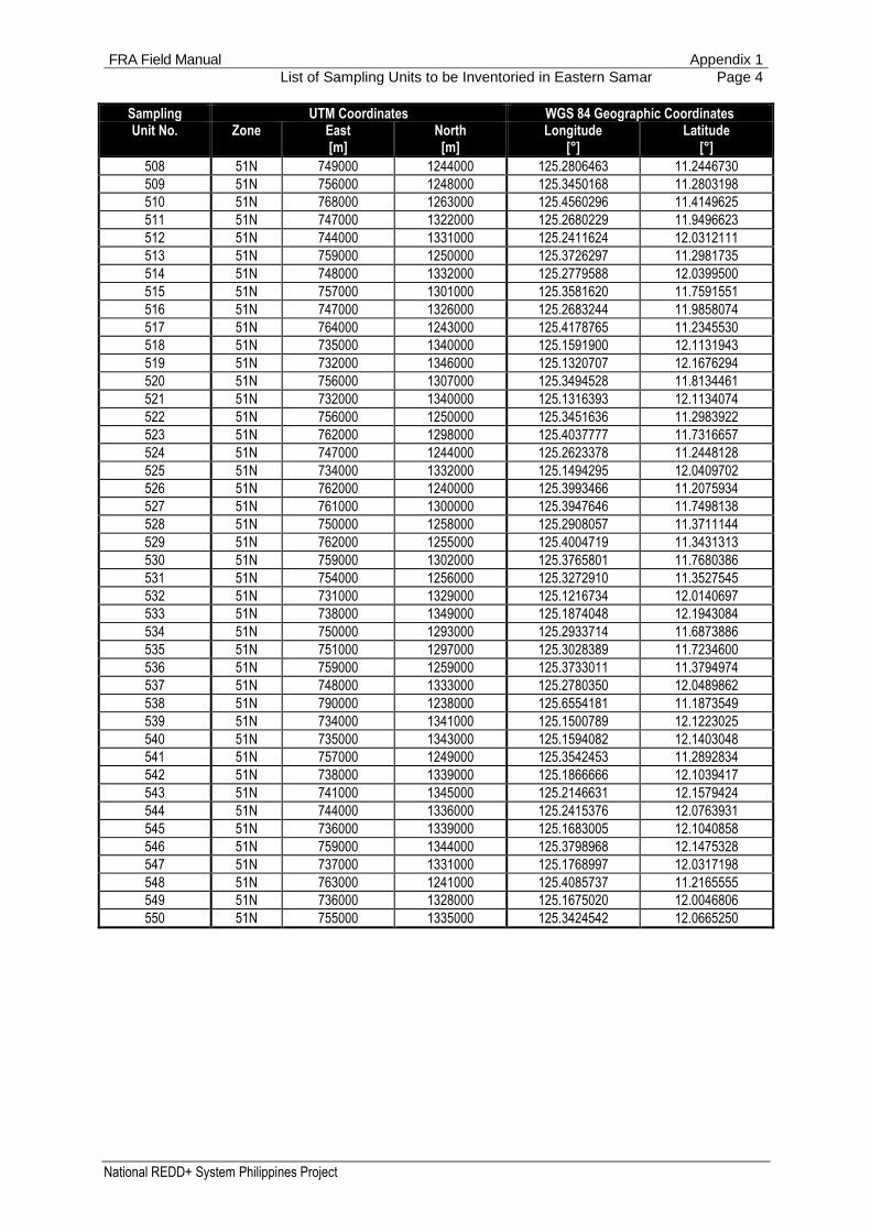
FRA Field Manual Appendix 1
List of Sampling Units to be Inventoried in Eastern Samar Page 4
National REDD+ System Philippines Project
Sampling UTM Coordinates WGS 84 Geographic Coordinates Unit No. Zone East North Longitude Latitude
[m] [m] [°] [°]
508 51N 749000 1244000 125.2806463 11.2446730
509 51N 756000 1248000 125.3450168 11.2803198
510 51N 768000 1263000 125.4560296 11.4149625
511 51N 747000 1322000 125.2680229 11.9496623
512 51N 744000 1331000 125.2411624 12.0312111
513 51N 759000 1250000 125.3726297 11.2981735
514 51N 748000 1332000 125.2779588 12.0399500
515 51N 757000 1301000 125.3581620 11.7591551
516 51N 747000 1326000 125.2683244 11.9858074
517 51N 764000 1243000 125.4178765 11.2345530
518 51N 735000 1340000 125.1591900 12.1131943
519 51N 732000 1346000 125.1320707 12.1676294
520 51N 756000 1307000 125.3494528 11.8134461
521 51N 732000 1340000 125.1316393 12.1134074
522 51N 756000 1250000 125.3451636 11.2983922
523 51N 762000 1298000 125.4037777 11.7316657
524 51N 747000 1244000 125.2623378 11.2448128
525 51N 734000 1332000 125.1494295 12.0409702
526 51N 762000 1240000 125.3993466 11.2075934
527 51N 761000 1300000 125.3947646 11.7498138
528 51N 750000 1258000 125.2908057 11.3711144
529 51N 762000 1255000 125.4004719 11.3431313
530 51N 759000 1302000 125.3765801 11.7680386
531 51N 754000 1256000 125.3272910 11.3527545
532 51N 731000 1329000 125.1216734 12.0140697
533 51N 738000 1349000 125.1874048 12.1943084
534 51N 750000 1293000 125.2933714 11.6873886
535 51N 751000 1297000 125.3028389 11.7234600
536 51N 759000 1259000 125.3733011 11.3794974
537 51N 748000 1333000 125.2780350 12.0489862
538 51N 790000 1238000 125.6554181 11.1873549
539 51N 734000 1341000 125.1500789 12.1223025
540 51N 735000 1343000 125.1594082 12.1403048
541 51N 757000 1249000 125.3542453 11.2892834
542 51N 738000 1339000 125.1866666 12.1039417
543 51N 741000 1345000 125.2146631 12.1579424
544 51N 744000 1336000 125.2415376 12.0763931
545 51N 736000 1339000 125.1683005 12.1040858
546 51N 759000 1344000 125.3798968 12.1475328
547 51N 737000 1331000 125.1768997 12.0317198
548 51N 763000 1241000 125.4085737 11.2165555
549 51N 736000 1328000 125.1675020 12.0046806
550 51N 755000 1335000 125.3424542 12.0665250

FRA Field Manual Appendix 2
List of Sampling Units to be Inventoried in Davao Oriental Page 1
National REDD+ System Philippines Project
Appendix 2:
List of Sampling Units to be Inventoried in Davao Oriental
Sampling UTM Coordinates WGS 84 Geographic Coordinates Unit No. Zone East North Longitude Latitude
[m] [m] [°] [°]
001 51N 869000 788000 126.3398382 7.1168515
002 51N 867000 814000 126.3234758 7.3517765
003 51N 874000 812000 126.3866547 7.3332424
004 51N 875000 813000 126.3957677 7.3422040
005 51N 869000 791000 126.3400346 7.1439428
006 51N 867000 790000 126.3218870 7.1350429
007 51N 864000 818000 126.2966066 7.3881000
008 51N 866000 804000 126.3137643 7.2615373
009 51N 865000 822000 126.3059223 7.4241556
010 51N 875000 811000 126.3956307 7.3241443
011 51N 867000 784000 126.3214975 7.0808592
012 51N 868000 785000 126.3306024 7.0898250
013 51N 869000 813000 126.3414989 7.3426115
014 51N 870000 790000 126.3490099 7.1348468
015 51N 868000 822000 126.3330631 7.4239526
016 51N 865000 808000 126.3049852 7.2977262
017 51N 871000 792000 126.3581827 7.1528416
018 51N 865000 812000 126.3052513 7.3338489
019 51N 877000 811000 126.4137188 7.3240073
020 51N 866000 794000 126.3131066 7.1712307
021 51N 878000 824000 126.4236666 7.4413229
022 51N 871000 800000 126.3587139 7.2250837
023 51N 868000 796000 126.3313218 7.1891608
024 51N 879000 807000 126.4315308 7.2877515
025 51N 867000 799000 126.3224771 7.2163183
026 51N 870000 812000 126.3504763 7.3335138
027 51N 868000 809000 126.3321852 7.3065571
028 51N 869000 790000 126.3399691 7.1349124
029 51N 868000 795000 126.3312559 7.1801303
030 51N 883000 808000 126.4677721 7.2965045
031 51N 868000 802000 126.3317185 7.2433438
032 51N 866000 793000 126.3130413 7.1622000
033 51N 865000 798000 126.3043260 7.2074189
034 51N 871000 813000 126.3595888 7.3424764
035 51N 876000 808000 126.4044694 7.2969866
036 51N 875000 824000 126.3965274 7.4415320
037 51N 882000 810000 126.4588681 7.3146324
038 51N 871000 811000 126.3594533 7.3244160
039 51N 867000 822000 126.3240162 7.4240204
040 51N 872000 786000 126.3668279 7.0985944
041 51N 870000 808000 126.3502066 7.2973927
042 51N 871000 808000 126.3592506 7.2973254
043 51N 876000 806000 126.4043329 7.2789270
044 51N 867000 811000 126.3232745 7.3246849
045 51N 872000 792000 126.3672238 7.1527756
046 51N 868000 815000 126.3325886 7.3607397
047 51N 870000 801000 126.3497379 7.2341806
048 51N 878000 814000 126.4229701 7.3510273
049 51N 868000 789000 126.3308628 7.1259472

FRA Field Manual Appendix 2
List of Sampling Units to be Inventoried in Davao Oriental Page 2
National REDD+ System Philippines Project
Sampling UTM Coordinates WGS 84 Geographic Coordinates Unit No. Zone East North Longitude Latitude
[m] [m] [°] [°]
050 51N 865000 816000 126.3055187 7.3699717
051 51N 865000 792000 126.3039345 7.1532344
052 51N 872000 814000 126.3687018 7.3514387
053 51N 880000 815000 126.4411284 7.3599181
054 51N 867000 809000 126.3231408 7.3066238
055 51N 872000 793000 126.3672900 7.1618058
056 51N 875000 814000 126.3958363 7.3512338
057 51N 872000 811000 126.3684978 7.3243484
058 51N 869000 810000 126.3412968 7.3155205
059 51N 864000 808000 126.2959407 7.2977923
060 51N 869000 795000 126.3402978 7.1800646
061 51N 882000 809000 126.4587985 7.3056032
062 51N 865000 790000 126.3038047 7.1351728
063 51N 874000 815000 126.3868601 7.3603322
064 51N 864000 805000 126.2957426 7.2706999
065 51N 870000 803000 126.3498714 7.2522412
066 51N 873000 821000 126.3782270 7.4145805
067 51N 874000 821000 126.3872731 7.4145116
068 51N 864000 813000 126.2962726 7.3429462
069 51N 873000 813000 126.3776784 7.3423405
070 51N 864000 803000 126.2956109 7.2526383
071 51N 868000 799000 126.3315198 7.2162523
072 51N 875000 812000 126.3956991 7.3331741
073 51N 869000 798000 126.3404961 7.2071558
074 51N 874000 818000 126.3870662 7.3874219
075 51N 869000 824000 126.3422465 7.4419451
076 51N 866000 809000 126.3140962 7.3066904
077 51N 876000 811000 126.4046748 7.3240759
078 51N 874000 811000 126.3865865 7.3242125
079 51N 872000 809000 126.3683622 7.3062881
080 51N 871000 802000 126.3588476 7.2431441
081 51N 865000 803000 126.3046546 7.2525726
082 51N 867000 783000 126.3214328 7.0718285
083 51N 866000 812000 126.3142965 7.3337823
084 51N 865000 811000 126.3051847 7.3248183
085 51N 868000 807000 126.3320515 7.2884962
086 51N 870000 787000 126.3488132 7.1077557
087 51N 867000 802000 126.3226753 7.2434100
088 51N 873000 814000 126.3777467 7.3513706
089 51N 866000 798000 126.3133686 7.2073534
090 51N 866000 816000 126.3145646 7.3699047
091 51N 874000 809000 126.3864502 7.3061526
092 51N 868000 823000 126.3331312 7.4329830
093 51N 869000 786000 126.3397076 7.0987906
094 51N 867000 785000 126.3215622 7.0898898
095 51N 876000 807000 126.4044011 7.2879568
096 51N 871000 787000 126.3578535 7.1076902
097 51N 872000 808000 126.3682945 7.2972580
098 51N 868000 813000 126.3324538 7.3426788
099 51N 866000 799000 126.3134344 7.2163841
100 51N 867000 813000 126.3234086 7.3427459
101 51N 865000 820000 126.3057875 7.4060943
102 51N 869000 803000 126.3408282 7.2523078
103 51N 869000 796000 126.3403638 7.1890950

FRA Field Manual Appendix 2
List of Sampling Units to be Inventoried in Davao Oriental Page 3
National REDD+ System Philippines Project
Sampling UTM Coordinates WGS 84 Geographic Coordinates Unit No. Zone East North Longitude Latitude
[m] [m] [°] [°]
104 51N 869000 782000 126.3394475 7.0626687
105 51N 879000 806000 126.4314621 7.2787220
106 51N 869000 815000 126.3416341 7.3606722
107 51N 867000 798000 126.3224112 7.2072877
108 51N 867000 796000 126.3222797 7.1892265
109 51N 866000 820000 126.3148341 7.4060270
110 51N 867000 808000 126.3230740 7.2975933
111 51N 865000 821000 126.3058549 7.4151250
112 51N 866000 801000 126.3135661 7.2344454
113 51N 874000 823000 126.3874115 7.4325714
114 51N 873000 793000 126.3763312 7.1617394
115 51N 864000 823000 126.2969426 7.4332536
116 51N 880000 810000 126.4407812 7.3147711
117 51N 871000 805000 126.3590487 7.2702348
118 51N 868000 793000 126.3311245 7.1620693
119 51N 871000 789000 126.3579849 7.1257508
120 51N 864000 806000 126.2958086 7.2797307
121 51N 871000 794000 126.3583150 7.1709022
122 51N 875000 809000 126.3954940 7.3060846
123 51N 866000 817000 126.3146318 7.3789352
124 51N 868000 782000 126.3304079 7.0627334
125 51N 875000 807000 126.3953577 7.2880248
126 51N 870000 809000 126.3502739 7.3064230
127 51N 865000 794000 126.3040647 7.1712959
128 51N 869000 783000 126.3395124 7.0716991
129 51N 877000 815000 126.4139946 7.3601260
130 51N 866000 784000 126.3124574 7.0809237
131 51N 868000 801000 126.3316522 7.2343133
132 51N 869000 812000 126.3414315 7.3335812
133 51N 874000 810000 126.3865183 7.3151825
134 51N 872000 810000 126.3684299 7.3153183
135 51N 884000 808000 126.4768149 7.2964349
136 51N 869000 814000 126.3415664 7.3516419
137 51N 868000 794000 126.3311902 7.1710998
138 51N 869000 793000 126.3401661 7.1620037
139 51N 874000 813000 126.3867231 7.3422723
140 51N 866000 813000 126.3143634 7.3428129
141 51N 869000 811000 126.3413641 7.3245508
142 51N 864000 824000 126.2970101 7.4422844
143 51N 870000 813000 126.3505439 7.3425441
144 51N 868000 824000 126.3331994 7.4420134
145 51N 866000 815000 126.3144974 7.3608741
146 51N 878000 810000 126.4226939 7.3149089
147 51N 865000 806000 126.3048527 7.2796647
148 51N 881000 823000 126.4507345 7.4320829
149 51N 864000 811000 126.2961396 7.3248847
150 51N 872000 818000 126.3689749 7.3875590
501 51N 843000 787000 126.1046944 7.1094570
502 51N 852000 715000 126.1817990 6.4586009
503 51N 860000 849000 126.2625149 7.6683273
504 51N 871000 866000 126.3633060 7.8210700
505 51N 841000 791000 126.0868512 7.1457088
506 51N 854000 881000 126.2104074 7.9577394
507 51N 884000 829000 126.4782999 7.4860449
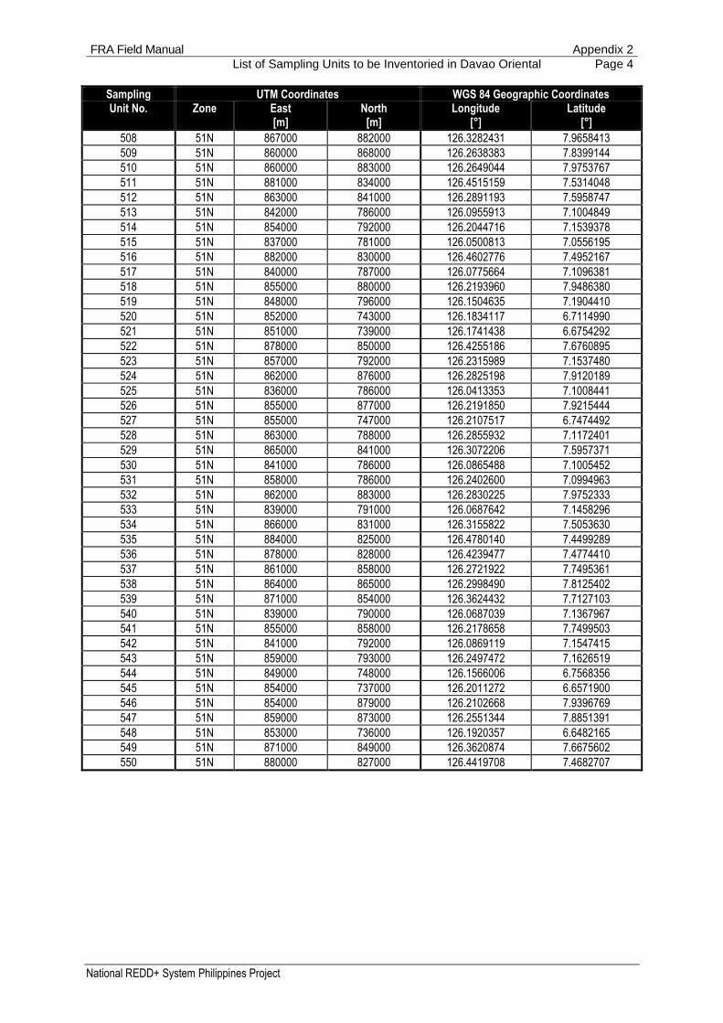
FRA Field Manual Appendix 2
List of Sampling Units to be Inventoried in Davao Oriental Page 4
National REDD+ System Philippines Project
Sampling UTM Coordinates WGS 84 Geographic Coordinates Unit No. Zone East North Longitude Latitude
[m] [m] [°] [°]
508 51N 867000 882000 126.3282431 7.9658413
509 51N 860000 868000 126.2638383 7.8399144
510 51N 860000 883000 126.2649044 7.9753767
511 51N 881000 834000 126.4515159 7.5314048
512 51N 863000 841000 126.2891193 7.5958747
513 51N 842000 786000 126.0955913 7.1004849
514 51N 854000 792000 126.2044716 7.1539378
515 51N 837000 781000 126.0500813 7.0556195
516 51N 882000 830000 126.4602776 7.4952167
517 51N 840000 787000 126.0775664 7.1096381
518 51N 855000 880000 126.2193960 7.9486380
519 51N 848000 796000 126.1504635 7.1904410
520 51N 852000 743000 126.1834117 6.7114990
521 51N 851000 739000 126.1741438 6.6754292
522 51N 878000 850000 126.4255186 7.6760895
523 51N 857000 792000 126.2315989 7.1537480
524 51N 862000 876000 126.2825198 7.9120189
525 51N 836000 786000 126.0413353 7.1008441
526 51N 855000 877000 126.2191850 7.9215444
527 51N 855000 747000 126.2107517 6.7474492
528 51N 863000 788000 126.2855932 7.1172401
529 51N 865000 841000 126.3072206 7.5957371
530 51N 841000 786000 126.0865488 7.1005452
531 51N 858000 786000 126.2402600 7.0994963
532 51N 862000 883000 126.2830225 7.9752333
533 51N 839000 791000 126.0687642 7.1458296
534 51N 866000 831000 126.3155822 7.5053630
535 51N 884000 825000 126.4780140 7.4499289
536 51N 878000 828000 126.4239477 7.4774410
537 51N 861000 858000 126.2721922 7.7495361
538 51N 864000 865000 126.2998490 7.8125402
539 51N 871000 854000 126.3624432 7.7127103
540 51N 839000 790000 126.0687039 7.1367967
541 51N 855000 858000 126.2178658 7.7499503
542 51N 841000 792000 126.0869119 7.1547415
543 51N 859000 793000 126.2497472 7.1626519
544 51N 849000 748000 126.1566006 6.7568356
545 51N 854000 737000 126.2011272 6.6571900
546 51N 854000 879000 126.2102668 7.9396769
547 51N 859000 873000 126.2551344 7.8851391
548 51N 853000 736000 126.1920357 6.6482165
549 51N 871000 849000 126.3620874 7.6675602
550 51N 880000 827000 126.4419708 7.4682707

FRA Field Manual Appendix 3
Field Data Forms Page 1
National REDD+ System Philippines Project
Appendix 3:
Inventory Data Forms
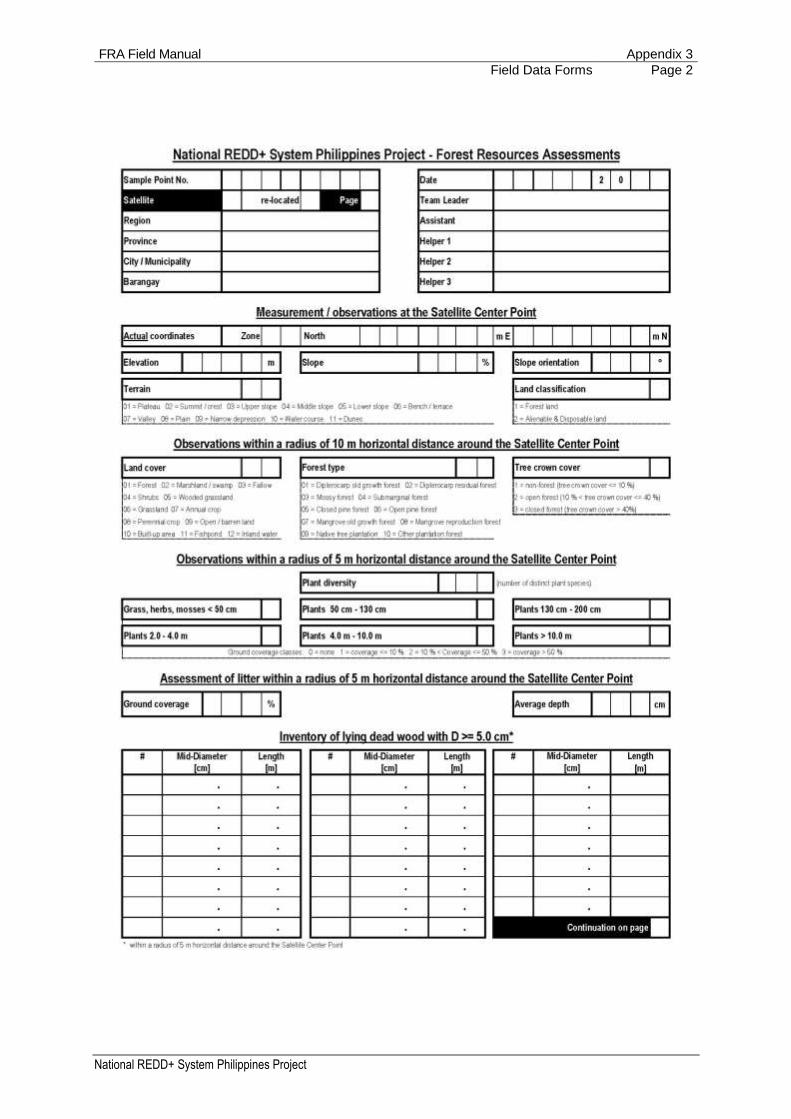
FRA Field Manual Appendix 3
Field Data Forms Page 2
National REDD+ System Philippines Project

FRA Field Manual Appendix 3
Field Data Forms Page 3
National REDD+ System Philippines Project

FRA Field Manual Appendix 4
Species List (sorted by common name) Page 1
National REDD+ System Philippines Project
Appendix 4:
Species List (sorted by common name)
Common Name Scientific Name Family
Trees
Abuab Lophopetalum javanum Turcz. Celastraceae
Adina Pertusadina multifolia (Havil.) Ridsdale Rubiaceae
African Tulip Spathodea campanulata P. Beauv. Bignoniaceae
Afu Anisoptera thurifera (Blanco) Blume Dipterocarpaceae
Agoho Casuarina equisetifolia L. Casuarinaceae
Agoho del Monte Gymnostoma rumphianum (Miq.) L.A.S. Johnson Casuarinaceae
Agosip Symplocos cochinchinensis (Lour.) S. Moore Symplocaceae
Akle Albizia acle (Blanco) Merr. Leguminosae
Akleng-parang Albizia procera (Roxb.) Benth. Leguminosae
Alahan Guioa koelreuteria (Blanco) Merr. Sapindaceae
Alim Melanolepis multiglandulosa (Reinw. ex Blume) Rchb. & Zoll. Euphorbiaceae
Almaciga Agathis philippinensis Warb. Araucariaceae
Almon Shorea almon Foxw. Dipterocarpaceae
Alupag Dimocarpus longan subsp. malesianus Leenh. Sapindaceae
Alupag-amo Litchi chinensis Sonn. Sapindaceae
Amayan Licania splendens (Korth.) Prance Chrysobalanaceae
Amugis Koordersiodendron pinnatum Merr. Anacardiaceae
Anabiong Trema orientalis (L.) Blume Ulmaceae
Anagap Archidendron scutiferum (Blanco) I.C. Nielsen Leguminosae
Anang Diospyros pyrrhocarpa Miq. Ebenaceae
Anilao Colona serratifolia Cav. Tiliaceae
Anislag Flueggea flexuosa Müll. Arg. Euphorbiaceae
Antipolo Artocarpus blancoi (Elmer) Merr. Moraceae
Anubing Artocarpus ovatus Blanco Moraceae
Anuling Pisonia umbellifera (J.R. Forst. & G. Forst.) Seem. Nyctaginaceae
Apanit Mastixia pentandra subsp. philippinensis (Wangerin) K.M. Matthew Cornaceae
Apauang Mallotus cumingii Müll. Arg. Euphorbiaceae
Api-api Avicennia officinalis L. Avicenniaceae
Apias Ficus ampelas Burm.f. Moraceae
Apitong Dipterocarpus grandiflorus (Blanco) Blanco Dipterocarpaceae
Arangga Homalium foetidum Benth. Flacourtiaceae
Ata-ata Diospyros mindanaensis Merr. Ebenaceae
Aunasin Ardisia paniculata Roxb. Myrsinaceae
Bagalunga Melia azedarach L. Meliaceae
Bagarilao Cryptocarya ampla Merr. Lauraceae
Bagna Glochidion triandrum (Blanco) C.B. Rob. Euphorbiaceae
Bagras Eucalyptus deglupta Blume Myrtaceae
Bagtikan Shorea malaanonan Blume Dipterocarpaceae
Baguilumbang Reutealis trisperma (Blanco) Airy Shaw Euphorbiaceae
Bahai Ormosia calavensis Blanco Leguminosae
Bakan Litsea philippinensis Merr. Lauraceae
Bakauan Rhizophora apiculata Blume Rizophoraceae
Bakauan-gubat Carallia brachiata (Lour.) Merr. Rhizophoraceae
Balakat Ziziphus talanae Merr. Rhamnaceae
Balakat-gubat Balakata luzonica (Vidal) Esser Euphorbiaceae
Balangua Cryptocarya edanoii Merr. Lauraceae
Balanti Homalanthus populneus (Geiseler) Pax Euphorbiaceae
Balat-buaya Fagraea racemosa Jack Gentianaceae

FRA Field Manual Appendix 4
Species List (sorted by common name) Page 2
National REDD+ System Philippines Project
Common Name Scientific Name Family
Balete Ficus balete Merr. Moraceae
Balik Hydnocarpus heterophylla Blume Flacourtiaceae
Balikbikan Drypetes longifolia (Blume) Pax & K. Hoffm. Euphorbiaceae
Balinghasai Buchanania arborescens (Blume) Blume Anacardiaceae
Balitbitan Cynometra ramiflora L. Leguminosae
Balobo Diplodiscus paniculatus Turcz. Tiliaceae
Balu Cordia subcordata Lam. Boraginaceae
Balukang Chisocheton cumingianus (C.DC.) Harms Meliaceae
Banaba Lagerstroemia speciosa (L.) Pers. Lythraceae
Banai-banai Radermachera pinnata (Blanco) Seem. Bignoniaceae
Banato Mallotus philippensis (Lam.) Müll. Arg. Euphorbiaceae
Bangkal Nauclea orientalis (L.) L. Rubiaceae
Bangkal, Kaatoan Breonia chinensis (Lam.) Capuron Rubiaceae
Bangkal, Southern / Hambabalud
Neonauclea formicaria (Elmer) Merr. Rubiaceae
Bansalangin Mimusops elengi L. Sapotaceae
Banuyo Wallaceodendron celebicum Koord. Leguminosae
Basikong Ficus botryocarpa Miq. Moraceae
Basilan Apitong Dipterocarpus eurhynchus Miq. Dipterocarpaceae
Basilan-Yakal Hopea basilanica Foxw. Dipterocarpaceae
Batete Kingiodendron alternifolium (Elmer) Merr. & Rolfe Leguminosae
Batikuling Litsea leytensis Merr. Lauraceae
Batino Alstonia macrophylla Wall. ex G.Don Apocynaceae
Batitinan Lagerstroemia piriformis Koehne Lythraceae
Bayanti Aglaia rimosa (Blanco) Merr. Meliaceae
Bayok Pterospermum diversifolium Blume Sterculiaceae
Benguet Pine Pinus kesiya Royle ex. Gordon Pinaceae
Betis Madhuca betis (Blanco) J.F. Macbr. Sapotaceae
Binggas Terminalia citrina Roxb. ex Fleming Combretaceae
Binoloan Syzygium acuminatissimum (Blume) DC. Myrtaceae
Binuang Octomeles sumatrana Miq. Datiscaceae
Bitanghol Calophyllum blancoi Planch. & Triana Guttiferae
Bitaog-Palomaria Calophyllum inophyllum L. Guttiferae
Blanco Narig Vatica umbonata Burck Dipterocarpaceae
Boga Alseodaphne philippinensis (Elmer) Kosterm. Lauraceae
Bogo Garuga floribunda Decne. Burseraceae
Bokbok Xanthophyllum flavescens Roxb. Xanthophyllaceae
Bolon Platymitra arborea (Blanco) P.J.A. Kessler Annonaceae
Bolong-eta Diospyros pilosanthera Blanco Ebenaceae
Brazilian fire Tree Schizolobium parahyba (Vell.) S.F. Blake Leguminosae
Broad-winged Apitong Dipterocarpus kunstleri King Dipterocarpaceae
Bugawak Melicope confusa (Merr.) P.S. Liu Rutaceae
Bulala (Wild Rambutan) Dimocarpus fumatus (Blume) Leenh. Sapindaceae
Bulalog Parishia maingayi Hook.f. Anacardiaceae
Buntan Engelhardtia rigida Blume Juglandaceae
Busain Bruguiera gymnorhiza (L.) Lam. Rhizophoraceae
Cana-Fistula Cassia fistula L. Leguminosae
Caribbean Pine Pinus caribaea Morelet Pinaceae
Dagang Anisoptera aurea Foxw. Dipterocarpaceae
Daha Macaranga caudatifolia Elmer Euphorbiaceae
Dalingdingan Hopea foxworthyi Elmer Dipterocarpaceae
Dalinsi Terminalia pellucida C. Presl Combretaceae
Dangula (Sasalit) Teijsmanniodendron ahernianum (Merr.) Bakh. Labiatae
Dao Dracontomelon dao (Blanco) Merr. & Rolfe Anacardiaceae
Dapdap Erythrina variegata L. Leguminosae

FRA Field Manual Appendix 4
Species List (sorted by common name) Page 3
National REDD+ System Philippines Project
Common Name Scientific Name Family
Dita Alstonia scholaris (L.).R. Br. var. scholaris Apocynaceae
Duguan Myristica philippinensis Gand. Myristicaceae
Duklitan Planchonella duclitan (Blanco) Bakh.f. Sapotaceae
Dulit Canarium hirsutum Willd. Burseraceae
Dungon-late Heritiera littoralis Aiton Sterculiaceae
Durian Durio zibethinus L. Bombacaceae
Duyok-duyok Manilkara fasciculata (Warb.) H.J. Lam & Maas Geest. Sapotaceae
Earpod Enterolobium cyclocarpum (Jacq.) Griseb. Leguminosae
Ebony Diospyros vera (Lour.) A.Chev. Ebenaceae
Gatasan Garcinia venulosa (Blanco) Choisy Guttiferae
Gisihan Aglaia leptantha Miq. Meliaceae
Gisok-Gisok Hopea philippinensis Dyer Dipterocarpaceae
Gubas Endospermum peltatum Merr. Euphorbiaceae
Guijo Shorea guiso Blume Dipterocarpaceae
Hagakhak Dipterocarpus validus Blume Dipterocarpaceae
Hagimit Ficus minahassae (Teijsm. & Vriese) Miq. Moraceae
Hairy-Leafed Apitong Dipterocarpus alatus Roxb. ex G. Don Dipterocarpaceae
Hamindang Macaranga bicolor Muell. Arg. Euphorbiaceae
Haras / Ituman Garcinia ituman Merr. Guttiferae
Hasselt Panau Dipterocarpus hasseltii Blume Dipterocarpaceae
Hawili Ficus septica Burm.f. Moraceae
Highland Panau Dipterocarpus hasseltii Blume Dipterocarpaceae
Himbabao Broussonetia luzonica (Blanco) Bureau Moraceae
Hogs Plum Spondias mombin L. Anacardiaceae
Igem Dacrycarpus imbricatus (Blume) de Laub. Podocarpaceae
Ilang-ilang Cananga odorata (Lam.) Hook.f. & Thomson Annonaceae
Ilo-ilo Aglaia iloilo (Blanco) Merr. Meliaceae
Ipil Intsia bijuga (Colebr.) Kuntze Leguminosae
Ipil-ipil Leucaena leucocephala (Lam.) de Wit Leguminosae
Is-is Ficus ulmifolia Lam. Moraceae
Jatoba Hymenaea courbaril L. Leguminosae
Kaburo Phoebe sterculioides (Elmer) Merr. Lauraceae
Kakawete Gliricidia sepium (Jacq.) Walp. Leguminosae
Kalamansanai Neonauclea calycina (Bartl. ex DC.) Merr. Rubiaceae
Kalantas Toona calantas Merr. & Rolfe Meliaceae
Kaliantan Leea guineensis G. Don Leeaceae
Kalingag / Cinamomon Cinnamomum mercadoi S. Vidal Lauraceae
Kalios Streblus asper Lour. Moraceae
Kalulot Artocarpus rubrovenius Warb. Moraceae
Kalumala Rosenbergiodendron longiflorum (Ruiz & Pav.) Fagerl. Rubiaceae
Kalumpang Sterculia foetida L. Sterculiaceae
Kalumpit Terminalia microcarpa Decne. Combretaceae
Kalunti Shorea hopeifolia (F. Heim) Symington Dipterocarpaceae
Kamagong Diospyros discolor Willd. Ebenaceae
Kamandiis Garcinia rubra Merr. Guttiferae
Kamatog Sympetalandra densiflora (Elmer) Steenis Leguminosae
Kamiring Semecarpus cuneiformis Blanco Anacardiaceae
Kamuning Murraya paniculata (L.) Jack Rutaceae
Kanapai Ficus magnoliifolia Blume Moraceae
Kangko Aphanamixis polystachya (Wall.) R. Parker Meliaceae
Kansulud Aglaia argentea Blume Meliaceae
Karaksan Chionanthus ramiflorus Roxb. Oleaceae
Katagpo Psychotria luzoniensis (Cham. & Schltdl.) Fern.-Vill. Rubiaceae
Katap Trigonostemon longipes (Merr.) Merr. Euphorbiaceae
Katmon Dillenia philippinensis Rolfe Dilleniaceae
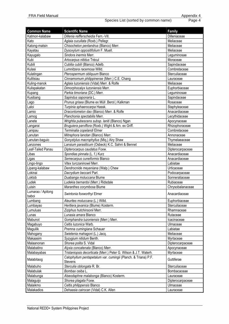
FRA Field Manual Appendix 4
Species List (sorted by common name) Page 4
National REDD+ System Philippines Project
Common Name Scientific Name Family
Katmon-kalabaw Dillenia reifferscheidia Fern.-Vill. Dilleniaceae
Kato Aglaia cucullata (Roxb.) Pellegr. Meliaceae
Katong-matsin Chisocheton pentandrus (Blanco) Merr. Meliaceae
Kayatau Dysoxylum oppositifolium F. Muell. Meliaceae
Kayugalo Sindora inermis Merr. Leguminosae
Kubi Artocarpus nitidus Trécul Moraceae
Kubili Cubilia cubili (Blanco) Adelb. Sapindaceae
Kulasi Lumnitzera racemosa Willd. Combretaceae
Kulatingan Pterospermum obliquum Blanco Sterculiaceae
Kulilisiau Cinnamomum philippinense (Merr.) C.E. Chang Lauraceae
Kuling-manok Aglaia luzoniensis (Vidal) Merr. & Rolfe Meliaceae
Kulispakatan Dimorphocalyx luzoniensis Merr. Euphorbiaceae
Kupang Parkia timoriana (DC.) Merr. Leguminosae
Kusibang Sapindus saponaria L. Sapindaceae
Lago Prunus grisea (Blume ex Müll .Berol.) Kalkman Rosaceae
Laloi Turpinia sphaerocarpa Hassk. Staphyleaceae
Lamio Dracontomelon dao (Blanco) Merr. & Rolfe Anacardiaceae
Lamog Planchonia spectabilis Merr. Lecythidaceae
Lanete Wrightia pubescens subsp. laniti (Blanco) Ngan Apocynaceae
Langarai Bruguiera parviflora (Roxb.) Wight & Arn. ex Griff. Rhizophoraceae
Lanipau Terminalia copelandi Elmer Combretaceae
Lanutan Mitrephora lanotan (Blanco) Merr. Annonaceae
Lanutan-baguio Gonystylus macrophyllus (Miq.) Airy Shaw Thymelaeaceae
Lanzones Lansium parasiticum (Osbeck) K.C. Sahni & Bennet Meliaceae
Leaf-Tailed Panau Dipterocarpus caudatus Foxw. Dipterocarpaceae
Libas Spondias pinnata (L. f.) Kurz Anacardiaceae
Ligas Semecarpus cuneiformis Blanco Anacardiaceae
Lingo-lingo Vitex turczaninowii Merr. Labiatae
Lipang-kalabaw Dendrocnide meyeniana (Walp.) Chew Urticaceae
Lokinai Dacrydium beccarii Parl. Podocarpaceae
Loktob Duabanga moluccana Blume Sonneratiaceae
Ludek Ludekia bernardoi (Merr.) Ridsdale Rubiaceae
Luisin Maranthes corymbosa Blume Chrysobalanaceae
Lumarao / Apitong baboi
Swintonia foxworthyi Elmer Anacardiaceae
Lumbang Aleurites moluccana (L.) Willd. Euphorbiaceae
Lumbayao Heritiera javanica (Blume) Kosterm. Sterculiaceae
Lumuluas Ziziphus hutchinsonii Merr. Rhamnaceae
Lunas Lunasia amara Blanco Rutaceae
Mabunot Gomphandra luzoniensis (Merr.) Merr. Icacinaceae
Magabuyo Celtis luzonica Warb. Ulmaceae
Maguilik Premna cumingiana Schauer Labiatae
Mahogany Swietenia mahagoni (L.) Jacq. Meliaceae
Makaasim Syzygium nitidum Benth. Myrtaceae
Malaanonan Shorea polita S. Vidal Dipterocarpaceae
Malabatino Alyxia concatenata (Blanco) Merr. Apocynaceae
Malabayabas Tristaniopsis decorticata (Merr.) Peter G. Wilson & J.T. Waterh. Myrtaceae
Malabitaog Calophyllum pentapetalum var. cumingii (Planch. & Triana) P.F. Stevens
Guttiferae
Malabuho Sterculia oblongata R. Br. Sterculiaceae
Malabulak Bombax ceiba L. Bombacaceae
Malabunga Alseodaphne malabonga (Blanco) Kosterm. Lauraceae
Malaguijo Shorea plagata Foxw. Dipterocarpaceae
Malaikmo Celtis philippensis Blanco Ulmaceae
Malakadios Dehaasia cairocan (Vidal) C.K. Allen Lauraceae
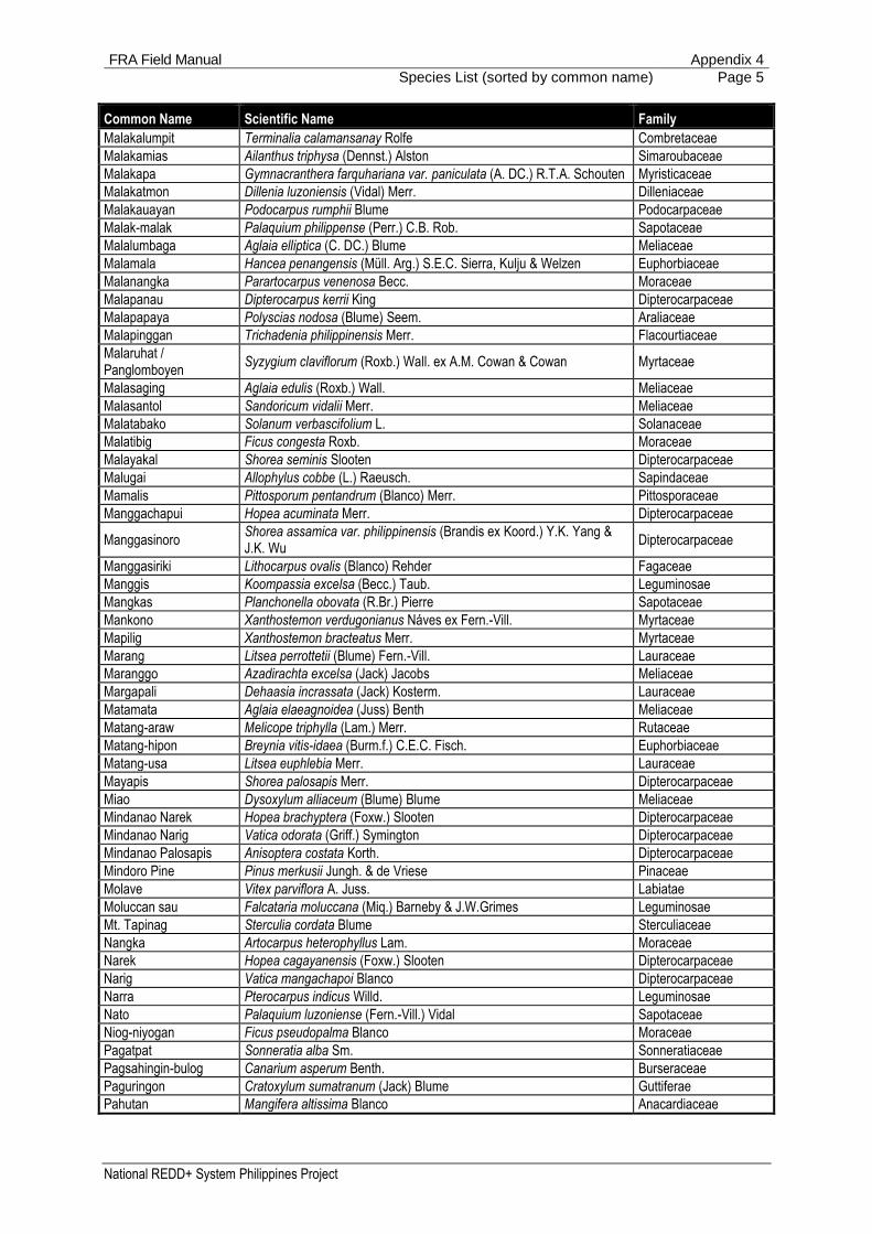
FRA Field Manual Appendix 4
Species List (sorted by common name) Page 5
National REDD+ System Philippines Project
Common Name Scientific Name Family
Malakalumpit Terminalia calamansanay Rolfe Combretaceae
Malakamias Ailanthus triphysa (Dennst.) Alston Simaroubaceae
Malakapa Gymnacranthera farquhariana var. paniculata (A. DC.) R.T.A. Schouten Myristicaceae
Malakatmon Dillenia luzoniensis (Vidal) Merr. Dilleniaceae
Malakauayan Podocarpus rumphii Blume Podocarpaceae
Malak-malak Palaquium philippense (Perr.) C.B. Rob. Sapotaceae
Malalumbaga Aglaia elliptica (C. DC.) Blume Meliaceae
Malamala Hancea penangensis (Müll. Arg.) S.E.C. Sierra, Kulju & Welzen Euphorbiaceae
Malanangka Parartocarpus venenosa Becc. Moraceae
Malapanau Dipterocarpus kerrii King Dipterocarpaceae
Malapapaya Polyscias nodosa (Blume) Seem. Araliaceae
Malapinggan Trichadenia philippinensis Merr. Flacourtiaceae
Malaruhat / Panglomboyen
Syzygium claviflorum (Roxb.) Wall. ex A.M. Cowan & Cowan Myrtaceae
Malasaging Aglaia edulis (Roxb.) Wall. Meliaceae
Malasantol Sandoricum vidalii Merr. Meliaceae
Malatabako Solanum verbascifolium L. Solanaceae
Malatibig Ficus congesta Roxb. Moraceae
Malayakal Shorea seminis Slooten Dipterocarpaceae
Malugai Allophylus cobbe (L.) Raeusch. Sapindaceae
Mamalis Pittosporum pentandrum (Blanco) Merr. Pittosporaceae
Manggachapui Hopea acuminata Merr. Dipterocarpaceae
Manggasinoro Shorea assamica var. philippinensis (Brandis ex Koord.) Y.K. Yang & J.K. Wu
Dipterocarpaceae
Manggasiriki Lithocarpus ovalis (Blanco) Rehder Fagaceae
Manggis Koompassia excelsa (Becc.) Taub. Leguminosae
Mangkas Planchonella obovata (R.Br.) Pierre Sapotaceae
Mankono Xanthostemon verdugonianus Náves ex Fern.-Vill. Myrtaceae
Mapilig Xanthostemon bracteatus Merr. Myrtaceae
Marang Litsea perrottetii (Blume) Fern.-Vill. Lauraceae
Maranggo Azadirachta excelsa (Jack) Jacobs Meliaceae
Margapali Dehaasia incrassata (Jack) Kosterm. Lauraceae
Matamata Aglaia elaeagnoidea (Juss) Benth Meliaceae
Matang-araw Melicope triphylla (Lam.) Merr. Rutaceae
Matang-hipon Breynia vitis-idaea (Burm.f.) C.E.C. Fisch. Euphorbiaceae
Matang-usa Litsea euphlebia Merr. Lauraceae
Mayapis Shorea palosapis Merr. Dipterocarpaceae
Miao Dysoxylum alliaceum (Blume) Blume Meliaceae
Mindanao Narek Hopea brachyptera (Foxw.) Slooten Dipterocarpaceae
Mindanao Narig Vatica odorata (Griff.) Symington Dipterocarpaceae
Mindanao Palosapis Anisoptera costata Korth. Dipterocarpaceae
Mindoro Pine Pinus merkusii Jungh. & de Vriese Pinaceae
Molave Vitex parviflora A. Juss. Labiatae
Moluccan sau Falcataria moluccana (Miq.) Barneby & J.W.Grimes Leguminosae
Mt. Tapinag Sterculia cordata Blume Sterculiaceae
Nangka Artocarpus heterophyllus Lam. Moraceae
Narek Hopea cagayanensis (Foxw.) Slooten Dipterocarpaceae
Narig Vatica mangachapoi Blanco Dipterocarpaceae
Narra Pterocarpus indicus Willd. Leguminosae
Nato Palaquium luzoniense (Fern.-Vill.) Vidal Sapotaceae
Niog-niyogan Ficus pseudopalma Blanco Moraceae
Pagatpat Sonneratia alba Sm. Sonneratiaceae
Pagsahingin-bulog Canarium asperum Benth. Burseraceae
Paguringon Cratoxylum sumatranum (Jack) Blume Guttiferae
Pahutan Mangifera altissima Blanco Anacardiaceae

FRA Field Manual Appendix 4
Species List (sorted by common name) Page 6
National REDD+ System Philippines Project
Common Name Scientific Name Family
Pahutan / Malipajo Mangifera monandra Merr. Anacardiaceae
Paitan Syzygium costulatum (C.B.Rob.) Merr. Myrtaceae
Palosapis Anisoptera thurifera (Blanco) Blume Dipterocarpaceae
Pamitaogen Calophyllum whitfordii Merr. Guttiferae
Panau Dipterocarpus gracilis Blume Dipterocarpaceae
Pandakaking-gubat Tabernaemontana pandacaqui Lam. Apocynaceae
Pangi Pangium edule Reinw. Flacourtiaceae
Para Rubber Hevea brasiliensis (Willd. ex A. Juss.) Müll. Arg. Euphorbiaceae
Philippine Ash Fraxinus griffithii C.B. Clarke Oleaceae
Piagau Xylocarpus moluccensis (Lam.) M. Roem. Meliaceae
Pili Canarium ovatum Engl. Burseraceae
Piling-liitan Canarium luzonicum (Blume) A. Gray Burseraceae
Pototan Bruguiera sexangula (Lour.) Poir. Rhizophoraceae
Pulahan Lansium parasiticum (Osbeck) K.C. Sahni & Bennet Meliaceae
Puso-puso Neolitsea vidalii Merr. Lauraceae
Putian Alangium javanicum (Blume) Wang. var. jaheri Bloem. Alangiaceae
Rain Tree (Acacia) Albizia saman (Jacq.) Merr. Leguminosae
Rarang Erythrina subumbrans (Hassk.) Merr. Leguminosae
Red Lauan Shorea negrosensis Foxw. Dipterocarpaceae
Red Nato Palaquium obovatum (Griff.) Engl. Sapotaceae
Round-Leafed Apitong Dipterocarpus orbicularis Foxw. Dipterocarpaceae
Saguimsim Syzygium brevistylum (C.B. Rob.) Merr Myrtaceae
Sakat Terminalia nitens C. Presl Combretaceae
Salakin Aphanamixis polystachya (Wall.) R. Parker Meliaceae
Salinggogon Cratoxylum formosum (Jacq.) Benth. & Hook.f. ex Dyer Guttiferae
Salingkugi Albizia saponaria (Lour.) Miq. Leguminosae
Sandit Magnolia philippinensis P. Parm. Magnoliaceae
Sangilo Pistacia chinensis Bunge Anacardiaceae
Santol Sandoricum koetjape (Burm.f.) Merr. Meliaceae
Sinaligan Sterculia rubiginosa Vent. Sterculiaceae
Spanish Cedar Cedrela odorata L. Meliaceae
Sudiang Ctenolophon parvifolius Oliv. Linaceae
Supa Sindora supa Merr. Leguminosae
Taba Tristaniopsis littoralis (Merr.) Peter G. Wilson & J.T. Waterh. Myrtaceae
Tabau Lumnitzera littorea (Jack) Voigt Combretaceae
Tabigi Xylocarpus granatum J. Koenig Meliaceae
Tabon-tabon Atuna racemosa Raf. Chrysobalanaceae
Tagatoi Palaquium foxworthyi Merr. Sapotaceae
Tagpo Ardisia elliptica Thunb. Myrsinaceae
Taingang-baboi Gonocaryum calleryanum (Baill.) Becc. Icacinaceae
Takip-asin Macaranga grandifolia (Blanco) Merr. Euphorbiaceae
Taklang-anak Garcinia dulcis (Roxb.) Kurz Guttiferae
Talisay Terminalia catappa L. Combretaceae
Talisay-gubat Terminalia foetidissima Griff. Combretaceae
Taluto Pterocymbium tinctorium Merr. Sterculiaceae
Tamayuan Strombosia philippinensis S. Vidal Olacaceae
Tambalau Myristica glomerata (Blanco) Kudô & Masam. Myristicaceae
Tambis / Malatambis Syzygium aqueum (Burm. f.) Alston Myrtaceae
Tan-ag Kleinhovia hospita L. Sterculiaceae
Tangal Ceriops tagal (Perr.) C.B. Rob. Rhizophoraceae
Tanghas Myristica elliptica Wall. Myristicaceae
Tangile Shorea polysperma Merr. Dipterocarpaceae
Tanglin Adenanthera intermedia Merr. Fabaceae
Tanguisang-bayawak Ficus variegata Blume Moraceae
Tara-tara Dysoxylum cumingianum C.DC Meliaceae

FRA Field Manual Appendix 4
Species List (sorted by common name) Page 7
National REDD+ System Philippines Project
Common Name Scientific Name Family
Tawi-tawi Narig Vatica rassak Blume Dipterocarpaceae
Teak Tectona grandis L.f. Labiatae
Thick-leafed Narig Vatica pachyphylla Merr. Dipterocarpaceae
Tiagkot Archidendron clypearia subsp. clypearia (Jack) I.C. Nielsen Leguminosae
Tiaong Shorea ovata Dyer ex Brandis Dipterocarpaceae
Tibig Ficus nota (Blanco) Merr. Moraceae
Tiga Tristaniopsis micrantha (Merr.) Peter G. Wilson & J.T. Waterh. Myrtaceae
Tikas-pula Canna indica L. Cannaceae
Tinaang-pantai Drypetes maquilingensis (Merr.) Pax & K. Hoffm. Euphorbiaceae
Tindalo Afzelia rhomboidea (Blanco) S.Vidal Fabaceae
Tiri Gleditsia fera (Lour.) Merr. Leguminosae
Toog Petersianthus quadrialatus (Merr.) Merr. Lecythidaceae
Tuai Bischofia javanica Blume Euphorbiaceae
Tubling-kahoi Pterocarpus cumingii (Benth.) Kuntze Leguminosae
Tukang-kalau Aglaia pachyphylla Miq. Meliaceae
Tulo Alphitonia philippinensis Braid Rhamnaceae
Tungkao Glebionis coronaria (L.) Cass. ex Spach Compositae
Ulayan (Oak) Lithocarpus caudatifolius (Merr.) Rehder Fagaceae
Unik Albizia philippinensis Nielsen Leguminosae
Urung Fagraea fragrans Roxb. Gentianaceae
Usak Neonauclea media (Havil.) Merr. Rubiaceae
Vidal's Lanutan Thespesia campylosiphon (Turcz.) Rolfe Malvaceae
White Lauan Shorea contorta S. Vidal Dipterocarpaceae
White Nato Pouteria macrantha (Merr.) Baehni Sapotaceae
Whitford Narig Vatica whitfordii Foxw. Dipterocarpaceae
Yabnob Horsfieldia costulata Warb. Myristicaceae
Yakal Shorea astylosa Foxw. Dipterocarpaceae
Yakal-Gisok Shorea gisok Foxw. Dipterocarpaceae
Yakal-Kaliot Hopea malibato Foxw. Dipterocarpaceae
Yakal-Mabolo Shorea ciliata King Dipterocarpaceae
Yakal-Magasusu Hopea mindanensis Foxw. Dipterocarpaceae
Yakal-Malibato Shorea malibato Foxw. Dipterocarpaceae
Yakal-Saplungan Hopea plagata S. Vidal Dipterocarpaceae
Yakal-Yamban Shorea falciferoides Foxw. Dipterocarpaceae
Yemane Gmelina arborea Roxb. Labiatae
Bamboos
Anos Schizostachyum lima (Blanco) Merr. Poaceae
Bayog Dendrocalamus merrillianus (Elmer) Elmer Poaceae
Bikal Schizostachyum diffusum (Blanco) Merr. Poaceae
Bikal-baboi Dinochloa dielsiana Pilg. Poaceae
Bocaue Dinochloa luconiae (Munro) Merr. Poaceae
Bolo Gigantochloa levis (Blanco) Merr. Poaceae
Buho Schizostachyum lumampao (Blanco) Merr. Poaceae
Giant Bamboo Dendrocalamus asper (Schult.) Backer Poaceae
Kawayan Kiling Bambusa vulgaris Schrad. Poaceae
Kawayan Tinik Bambusa blumeana Schult.f. Poaceae
Palms
Anahaw Saribus rotundifolius (Lam.) Blume Arecaceae
Anibong / Anibong-gubat
Oncosperma tigillarium (Jack) Ridl. Arecaceae
Buri Corypha utan Lam. Arecaceae
Kaong Arenga pinnata (Wurmb) Merr. Arecaceae
Nipa Nypa fruticans Wurmb Arecaceae
Pandan Pandanus spp. Pandanaceae
Pandan (Mottled) Pandanus tectorius Parkinson ex Du Roi Pandanaceae

FRA Field Manual Appendix 4
Species List (sorted by common name) Page 8
National REDD+ System Philippines Project
Common Name Scientific Name Family
Pandan-layugan Pandanus exaltatus Blanco Pandanaceae
Pugahan Caryota cumingii Lodd. ex Mart. Arecaceae
Sarawag Pinanga insignis Becc. Arecaceae
Takipan Caryota urens L. Arecaceae
Tarau Livistona saribus (Lour.) Merr. ex A. Chev. Arecaceae

FRA Field Manual Appendix 5
Species List (sorted by scientific name) Page 1
National REDD+ System Philippines Project
Appendix 5:
Species List (sorted by scientific name)
Scientific Name Family Common Name
Trees
Adenanthera intermedia Merr. Fabaceae Tanglin
Afzelia rhomboidea (Blanco) S.Vidal Fabaceae Tindalo
Agathis philippinensis Warb. Araucariaceae Almaciga
Aglaia argentea Blume Meliaceae Kansulud
Aglaia cucullata (Roxb.) Pellegr. Meliaceae Kato
Aglaia edulis (Roxb.) Wall. Meliaceae Malasaging
Aglaia elaeagnoidea (Juss) Benth Meliaceae Matamata
Aglaia elliptica (C. DC.) Blume Meliaceae Malalumbaga
Aglaia iloilo (Blanco) Merr. Meliaceae Ilo-ilo
Aglaia leptantha Miq. Meliaceae Gisihan
Aglaia luzoniensis (Vidal) Merr. & Rolfe Meliaceae Kuling-manok
Aglaia pachyphylla Miq. Meliaceae Tukang-kalau
Aglaia rimosa (Blanco) Merr. Meliaceae Bayanti
Ailanthus triphysa (Dennst.) Alston Simaroubaceae Malakamias
Alangium javanicum (Blume) Wang. var. jaheri Bloem. Alangiaceae Putian
Albizia acle (Blanco) Merr. Leguminosae Akle
Albizia philippinensis Nielsen Leguminosae Unik
Albizia procera (Roxb.) Benth. Leguminosae Akleng-parang
Albizia saman (Jacq.) Merr. Leguminosae Rain Tree (Acacia)
Albizia saponaria (Lour.) Miq. Leguminosae Salingkugi
Aleurites moluccana (L.) Willd. Euphorbiaceae Lumbang
Allophylus cobbe (L.) Raeusch. Sapindaceae Malugai
Alphitonia philippinensis Braid Rhamnaceae Tulo
Alseodaphne malabonga (Blanco) Kosterm. Lauraceae Malabunga
Alseodaphne philippinensis (Elmer) Kosterm. Lauraceae Boga
Alstonia macrophylla Wall. ex G.Don Apocynaceae Batino
Alstonia scholaris (L.).R. Br. var. scholaris Apocynaceae Dita
Alyxia concatenata (Blanco) Merr. Apocynaceae Malabatino
Anisoptera aurea Foxw. Dipterocarpaceae Dagang
Anisoptera costata Korth. Dipterocarpaceae Mindanao Palosapis
Anisoptera thurifera (Blanco) Blume Dipterocarpaceae Afu
Anisoptera thurifera (Blanco) Blume Dipterocarpaceae Palosapis
Aphanamixis polystachya (Wall.) R. Parker Meliaceae Kangko
Aphanamixis polystachya (Wall.) R. Parker Meliaceae Salakin
Archidendron clypearia subsp. clypearia (Jack) I.C. Nielsen Leguminosae Tiagkot
Archidendron scutiferum (Blanco) I.C. Nielsen Leguminosae Anagap
Ardisia elliptica Thunb. Myrsinaceae Tagpo
Ardisia paniculata Roxb. Myrsinaceae Aunasin
Artocarpus blancoi (Elmer) Merr. Moraceae Antipolo
Artocarpus heterophyllus Lam. Moraceae Nangka
Artocarpus nitidus Trécul Moraceae Kubi
Artocarpus ovatus Blanco Moraceae Anubing
Artocarpus rubrovenius Warb. Moraceae Kalulot
Atuna racemosa Raf. Chrysobalanaceae Tabon-tabon
Avicennia officinalis L. Avicenniaceae Api-api
Azadirachta excelsa (Jack) Jacobs Meliaceae Maranggo
Balakata luzonica (Vidal) Esser Euphorbiaceae Balakat-gubat
Bischofia javanica Blume Euphorbiaceae Tuai

FRA Field Manual Appendix 5
Species List (sorted by scientific name) Page 2
National REDD+ System Philippines Project
Scientific Name Family Common Name
Bombax ceiba L. Bombacaceae Malabulak
Breonia chinensis (Lam.) Capuron Rubiaceae Bangkal, Kaatoan
Breynia vitis-idaea (Burm.f.) C.E.C. Fisch. Euphorbiaceae Matang-hipon
Broussonetia luzonica (Blanco) Bureau Moraceae Himbabao
Bruguiera gymnorhiza (L.) Lam. Rhizophoraceae Busain
Bruguiera parviflora (Roxb.) Wight & Arn. ex Griff. Rhizophoraceae Langarai
Bruguiera sexangula (Lour.) Poir. Rhizophoraceae Pototan
Buchanania arborescens (Blume) Blume Anacardiaceae Balinghasai
Calophyllum blancoi Planch. & Triana Guttiferae Bitanghol
Calophyllum inophyllum L. Guttiferae Bitaog-Palomaria
Calophyllum pentapetalum var. cumingii (Planch. & Triana) P.F. Stevens
Guttiferae Malabitaog
Calophyllum whitfordii Merr. Guttiferae Pamitaogen
Cananga odorata (Lam.) Hook.f. & Thomson Annonaceae Ilang-ilang
Canarium asperum Benth. Burseraceae Pagsahingin-bulog
Canarium hirsutum Willd. Burseraceae Dulit
Canarium luzonicum (Blume) A. Gray Burseraceae Piling-liitan
Canarium ovatum Engl. Burseraceae Pili
Canna indica L. Cannaceae Tikas-pula
Carallia brachiata (Lour.) Merr. Rhizophoraceae Bakauan-gubat
Cassia fistula L. Leguminosae Cana-Fistula
Casuarina equisetifolia L. Casuarinaceae Agoho
Cedrela odorata L. Meliaceae Spanish Cedar
Celtis luzonica Warb. Ulmaceae Magabuyo
Celtis philippensis Blanco Ulmaceae Malaikmo
Ceriops tagal (Perr.) C.B. Rob. Rhizophoraceae Tangal
Chionanthus ramiflorus Roxb. Oleaceae Karaksan
Chisocheton cumingianus (C.DC.) Harms Meliaceae Balukang
Chisocheton pentandrus (Blanco) Merr. Meliaceae Katong-matsin
Cinnamomum mercadoi S. Vidal Lauraceae Kalingag / Cinamomon
Cinnamomum philippinense (Merr.) C.E. Chang Lauraceae Kulilisiau
Colona serratifolia Cav. Tiliaceae Anilao
Cordia subcordata Lam. Boraginaceae Balu
Cratoxylum formosum (Jacq.) Benth. & Hook.f. ex Dyer Guttiferae Salinggogon
Cratoxylum sumatranum (Jack) Blume Guttiferae Paguringon
Cryptocarya ampla Merr. Lauraceae Bagarilao
Cryptocarya edanoii Merr. Lauraceae Balangua
Ctenolophon parvifolius Oliv. Linaceae Sudiang
Cubilia cubili (Blanco) Adelb. Sapindaceae Kubili
Cynometra ramiflora L. Leguminosae Balitbitan
Dacrycarpus imbricatus (Blume) de Laub. Podocarpaceae Igem
Dacrydium beccarii Parl. Podocarpaceae Lokinai
Dehaasia cairocan (Vidal) C.K. Allen Lauraceae Malakadios
Dehaasia incrassata (Jack) Kosterm. Lauraceae Margapali
Dendrocnide meyeniana (Walp.) Chew Urticaceae Lipang-kalabaw
Dillenia luzoniensis (Vidal) Merr. Dilleniaceae Malakatmon
Dillenia philippinensis Rolfe Dilleniaceae Katmon
Dillenia reifferscheidia Fern.-Vill. Dilleniaceae Katmon-kalabaw
Dimocarpus fumatus (Blume) Leenh. Sapindaceae Bulala (Wild Rambutan)
Dimocarpus longan subsp. malesianus Leenh. Sapindaceae Alupag
Dimorphocalyx luzoniensis Merr. Euphorbiaceae Kulispakatan
Diospyros discolor Willd. Ebenaceae Kamagong
Diospyros mindanaensis Merr. Ebenaceae Ata-ata
Diospyros pilosanthera Blanco Ebenaceae Bolong-eta
Diospyros pyrrhocarpa Miq. Ebenaceae Anang

FRA Field Manual Appendix 5
Species List (sorted by scientific name) Page 3
National REDD+ System Philippines Project
Scientific Name Family Common Name
Diospyros vera (Lour.) A.Chev. Ebenaceae Ebony
Diplodiscus paniculatus Turcz. Tiliaceae Balobo
Dipterocarpus alatus Roxb. ex G. Don Dipterocarpaceae Hairy-Leafed Apitong
Dipterocarpus caudatus Foxw. Dipterocarpaceae Leaf-Tailed Panau
Dipterocarpus eurhynchus Miq. Dipterocarpaceae Basilan Apitong
Dipterocarpus gracilis Blume Dipterocarpaceae Panau
Dipterocarpus grandiflorus (Blanco) Blanco Dipterocarpaceae Apitong
Dipterocarpus hasseltii Blume Dipterocarpaceae Hasselt Panau
Dipterocarpus hasseltii Blume Dipterocarpaceae Highland Panau
Dipterocarpus kerrii King Dipterocarpaceae Malapanau
Dipterocarpus kunstleri King Dipterocarpaceae Broad-winged Apitong
Dipterocarpus orbicularis Foxw. Dipterocarpaceae Round-Leafed Apitong
Dipterocarpus validus Blume Dipterocarpaceae Hagakhak
Dracontomelon dao (Blanco) Merr. & Rolfe Anacardiaceae Dao
Dracontomelon dao (Blanco) Merr. & Rolfe Anacardiaceae Lamio
Drypetes longifolia (Blume) Pax & K. Hoffm. Euphorbiaceae Balikbikan
Drypetes maquilingensis (Merr.) Pax & K. Hoffm. Euphorbiaceae Tinaang-pantai
Duabanga moluccana Blume Sonneratiaceae Loktob
Durio zibethinus L. Bombacaceae Durian
Dysoxylum alliaceum (Blume) Blume Meliaceae Miao
Dysoxylum cumingianum C.DC. Meliaceae Tara-tara
Dysoxylum oppositifolium F. Muell. Meliaceae Kayatau
Endospermum peltatum Merr. Euphorbiaceae Gubas
Engelhardtia rigida Blume Juglandaceae Buntan
Enterolobium cyclocarpum (Jacq.) Griseb. Leguminosae Earpod
Erythrina subumbrans (Hassk.) Merr. Leguminosae Rarang
Erythrina variegata L. Leguminosae Dapdap
Eucalyptus deglupta Blume Myrtaceae Bagras
Fagraea fragrans Roxb. Gentianaceae Urung
Fagraea racemosa Jack Gentianaceae Balat-buaya
Falcataria moluccana (Miq.) Barneby & J.W.Grimes Leguminosae Moluccan sau
Ficus ampelas Burm.f. Moraceae Apias
Ficus balete Merr. Moraceae Balete
Ficus botryocarpa Miq. Moraceae Basikong
Ficus congesta Roxb. Moraceae Malatibig
Ficus magnoliifolia Blume Moraceae Kanapai
Ficus minahassae (Teijsm. & Vriese) Miq. Moraceae Hagimit
Ficus nota (Blanco) Merr. Moraceae Tibig
Ficus pseudopalma Blanco Moraceae Niog-niyogan
Ficus septica Burm.f. Moraceae Hawili
Ficus ulmifolia Lam. Moraceae Is-is
Ficus variegata Blume Moraceae Tanguisang-bayawak
Flueggea flexuosa Müll. Arg. Euphorbiaceae Anislag
Fraxinus griffithii C.B. Clarke Oleaceae Philippine Ash
Garcinia dulcis (Roxb.) Kurz Guttiferae Taklang-anak
Garcinia ituman Merr. Guttiferae Haras / Ituman
Garcinia rubra Merr. Guttiferae Kamandiis
Garcinia venulosa (Blanco) Choisy Guttiferae Gatasan
Garuga floribunda Decne. Burseraceae Bogo
Glebionis coronaria (L.) Cass. ex Spach Compositae Tungkao
Gleditsia fera (Lour.) Merr. Leguminosae Tiri
Gliricidia sepium (Jacq.) Walp. Leguminosae Kakawete
Glochidion triandrum (Blanco) C.B. Rob. Euphorbiaceae Bagna
Gmelina arborea Roxb. Labiatae Yemane
Gomphandra luzoniensis (Merr.) Merr. Icacinaceae Mabunot

FRA Field Manual Appendix 5
Species List (sorted by scientific name) Page 4
National REDD+ System Philippines Project
Scientific Name Family Common Name
Gonocaryum calleryanum (Baill.) Becc. Icacinaceae Taingang-baboi
Gonystylus macrophyllus (Miq.) Airy Shaw Thymelaeaceae Lanutan-baguio
Guioa koelreuteria (Blanco) Merr. Sapindaceae Alahan
Gymnacranthera farquhariana var. paniculata (A. DC.) R.T.A. Schouten Myristicaceae Malakapa
Gymnostoma rumphianum (Miq.) L.A.S. Johnson Casuarinaceae Agoho del Monte
Hancea penangensis (Müll. Arg.) S.E.C. Sierra, Kulju & Welzen Euphorbiaceae Malamala
Heritiera javanica (Blume) Kosterm. Sterculiaceae Lumbayao
Heritiera littoralis Aiton Sterculiaceae Dungon-late
Hevea brasiliensis (Willd. ex A. Juss.) Müll. Arg. Euphorbiaceae Para Rubber
Homalanthus populneus (Geiseler) Pax Euphorbiaceae Balanti
Homalium foetidum Benth. Flacourtiaceae Arangga
Hopea acuminata Merr. Dipterocarpaceae Manggachapui
Hopea basilanica Foxw. Dipterocarpaceae Basilan-Yakal
Hopea brachyptera (Foxw.) Slooten Dipterocarpaceae Mindanao Narek
Hopea cagayanensis (Foxw.) Slooten Dipterocarpaceae Narek
Hopea foxworthyi Elmer Dipterocarpaceae Dalingdingan
Hopea malibato Foxw. Dipterocarpaceae Yakal-Kaliot
Hopea mindanensis Foxw. Dipterocarpaceae Yakal-Magasusu
Hopea philippinensis Dyer Dipterocarpaceae Gisok-Gisok
Hopea plagata S. Vidal Dipterocarpaceae Yakal-Saplungan
Horsfieldia costulata Warb. Myristicaceae Yabnob
Hydnocarpus heterophylla Blume Flacourtiaceae Balik
Hymenaea courbaril L. Leguminosae Jatoba
Intsia bijuga (Colebr.) Kuntze Leguminosae Ipil
Kingiodendron alternifolium (Elmer) Merr. & Rolfe Leguminosae Batete
Kleinhovia hospita L. Sterculiaceae Tan-ag
Koompassia excelsa (Becc.) Taub. Leguminosae Manggis
Koordersiodendron pinnatum Merr. Anacardiaceae Amugis
Lagerstroemia piriformis Koehne Lythraceae Batitinan
Lagerstroemia speciosa (L.) Pers. Lythraceae Banaba
Lansium parasiticum (Osbeck) K.C. Sahni & Bennet Meliaceae Lanzones
Lansium parasiticum (Osbeck) K.C. Sahni & Bennet Meliaceae Pulahan
Leea guineensis G. Don Leeaceae Kaliantan
Leucaena leucocephala (Lam.) de Wit Leguminosae Ipil-ipil
Licania splendens (Korth.) Prance Chrysobalanaceae Amayan
Litchi chinensis Sonn. Sapindaceae Alupag-amo
Lithocarpus caudatifolius (Merr.) Rehder Fagaceae Ulayan (Oak)
Lithocarpus ovalis (Blanco) Rehder Fagaceae Manggasiriki
Litsea euphlebia Merr. Lauraceae Matang-usa
Litsea leytensis Merr. Lauraceae Batikuling
Litsea perrottetii (Blume) Fern.-Vill. Lauraceae Marang
Litsea philippinensis Merr. Lauraceae Bakan
Lophopetalum javanum Turcz. Celastraceae Abuab
Ludekia bernardoi (Merr.) Ridsdale Rubiaceae Ludek
Lumnitzera littorea (Jack) Voigt Combretaceae Tabau
Lumnitzera racemosa Willd. Combretaceae Kulasi
Lunasia amara Blanco Rutaceae Lunas
Macaranga bicolor Muell. Arg. Euphorbiaceae Hamindang
Macaranga caudatifolia Elmer Euphorbiaceae Daha
Macaranga grandifolia (Blanco) Merr. Euphorbiaceae Takip-asin
Madhuca betis (Blanco) J.F. Macbr. Sapotaceae Betis
Magnolia philippinensis P. Parm. Magnoliaceae Sandit
Mallotus cumingii Müll. Arg. Euphorbiaceae Apauang
Mallotus philippensis (Lam.) Müll. Arg. Euphorbiaceae Banato
Mangifera altissima Blanco Anacardiaceae Pahutan

FRA Field Manual Appendix 5
Species List (sorted by scientific name) Page 5
National REDD+ System Philippines Project
Scientific Name Family Common Name
Mangifera monandra Merr. Anacardiaceae Pahutan / Malipajo
Manilkara fasciculata (Warb.) H.J. Lam & Maas Geest. Sapotaceae Duyok-duyok
Maranthes corymbosa Blume Chrysobalanaceae Luisin
Mastixia pentandra subsp. philippinensis (Wangerin) K.M. Matthew Cornaceae Apanit
Melanolepis multiglandulosa (Reinw. ex Blume) Rchb. & Zoll. Euphorbiaceae Alim
Melia azedarach L. Meliaceae Bagalunga
Melicope confusa (Merr.) P.S. Liu Rutaceae Bugawak
Melicope triphylla (Lam.) Merr. Rutaceae Matang-araw
Mimusops elengi L. Sapotaceae Bansalangin
Mitrephora lanotan (Blanco) Merr. Annonaceae Lanutan
Murraya paniculata (L.) Jack Rutaceae Kamuning
Myristica elliptica Wall. Myristicaceae Tanghas
Myristica glomerata (Blanco) Kudô & Masam. Myristicaceae Tambalau
Myristica philippinensis Gand. Myristicaceae Duguan
Nauclea orientalis (L.) L. Rubiaceae Bangkal
Neolitsea vidalii Merr. Lauraceae Puso-puso
Neonauclea calycina (Bartl. ex DC.) Merr. Rubiaceae Kalamansanai
Neonauclea formicaria (Elmer) Merr. Rubiaceae Bangkal, Southern / Hambabalud
Neonauclea media (Havil.) Merr. Rubiaceae Usak
Octomeles sumatrana Miq. Datiscaceae Binuang
Ormosia calavensis Blanco Leguminosae Bahai
Palaquium foxworthyi Merr. Sapotaceae Tagatoi
Palaquium luzoniense (Fern.-Vill.) Vidal Sapotaceae Nato
Palaquium obovatum (Griff.) Engl. Sapotaceae Red Nato
Palaquium philippense (Perr.) C.B. Rob. Sapotaceae Malak-malak
Pangium edule Reinw. Flacourtiaceae Pangi
Parartocarpus venenosa Becc. Moraceae Malanangka
Parishia maingayi Hook.f. Anacardiaceae Bulalog
Parkia timoriana (DC.) Merr. Leguminosae Kupang
Pertusadina multifolia (Havil.) Ridsdale Rubiaceae Adina
Petersianthus quadrialatus (Merr.) Merr. Lecythidaceae Toog
Phoebe sterculioides (Elmer) Merr. Lauraceae Kaburo
Pinus caribaea Morelet Pinaceae Caribbean Pine
Pinus kesiya Royle ex. Gordon Pinaceae Benguet Pine
Pinus merkusii Jungh. & de Vriese Pinaceae Mindoro Pine
Pisonia umbellifera (J.R. Forst. & G. Forst.) Seem. Nyctaginaceae Anuling
Pistacia chinensis Bunge Anacardiaceae Sangilo
Pittosporum pentandrum (Blanco) Merr. Pittosporaceae Mamalis
Planchonella duclitan (Blanco) Bakh.f. Sapotaceae Duklitan
Planchonella obovata (R.Br.) Pierre Sapotaceae Mangkas
Planchonia spectabilis Merr. Lecythidaceae Lamog
Platymitra arborea (Blanco) P.J.A. Kessler Annonaceae Bolon
Podocarpus rumphii Blume Podocarpaceae Malakauayan
Polyscias nodosa (Blume) Seem. Araliaceae Malapapaya
Pouteria macrantha (Merr.) Baehni Sapotaceae White Nato
Premna cumingiana Schauer Labiatae Maguilik
Prunus grisea (Blume ex Müll .Berol.) Kalkman Rosaceae Lago
Psychotria luzoniensis (Cham. & Schltdl.) Fern.-Vill. Rubiaceae Katagpo
Pterocarpus cumingii (Benth.) Kuntze Leguminosae Tubling-kahoi
Pterocarpus indicus Willd. Leguminosae Narra
Pterocymbium tinctorium Merr. Sterculiaceae Taluto
Pterospermum diversifolium Blume Sterculiaceae Bayok
Pterospermum obliquum Blanco Sterculiaceae Kulatingan
Radermachera pinnata (Blanco) Seem. Bignoniaceae Banai-banai

FRA Field Manual Appendix 5
Species List (sorted by scientific name) Page 6
National REDD+ System Philippines Project
Scientific Name Family Common Name
Reutealis trisperma (Blanco) Airy Shaw Euphorbiaceae Baguilumbang
Rhizophora apiculata Blume Rizophoraceae Bakauan
Rosenbergiodendron longiflorum (Ruiz & Pav.) Fagerl. Rubiaceae Kalumala
Sandoricum koetjape (Burm.f.) Merr. Meliaceae Santol
Sandoricum vidalii Merr. Meliaceae Malasantol
Sapindus saponaria L. Sapindaceae Kusibang
Schizolobium parahyba (Vell.) S.F. Blake Leguminosae Brazilian fire Tree
Semecarpus cuneiformis Blanco Anacardiaceae Kamiring
Semecarpus cuneiformis Blanco Anacardiaceae Ligas
Shorea almon Foxw. Dipterocarpaceae Almon
Shorea assamica var. philippinensis (Brandis ex Koord.) Y.K. Yang & J.K. Wu
Dipterocarpaceae Manggasinoro
Shorea astylosa Foxw. Dipterocarpaceae Yakal
Shorea ciliata King Dipterocarpaceae Yakal-Mabolo
Shorea contorta S. Vidal Dipterocarpaceae White Lauan
Shorea falciferoides Foxw. Dipterocarpaceae Yakal-Yamban
Shorea gisok Foxw. Dipterocarpaceae Yakal-Gisok
Shorea guiso Blume Dipterocarpaceae Guijo
Shorea hopeifolia (F. Heim) Symington Dipterocarpaceae Kalunti
Shorea malaanonan Blume Dipterocarpaceae Bagtikan
Shorea malibato Foxw. Dipterocarpaceae Yakal-Malibato
Shorea negrosensis Foxw. Dipterocarpaceae Red Lauan
Shorea ovata Dyer ex Brandis Dipterocarpaceae Tiaong
Shorea palosapis Merr. Dipterocarpaceae Mayapis
Shorea plagata Foxw. Dipterocarpaceae Malaguijo
Shorea polita S. Vidal Dipterocarpaceae Malaanonan
Shorea polysperma Merr. Dipterocarpaceae Tangile
Shorea seminis Slooten Dipterocarpaceae Malayakal
Sindora inermis Merr. Leguminosae Kayugalo
Sindora supa Merr. Leguminosae Supa
Solanum verbascifolium L. Solanaceae Malatabako
Sonneratia alba Sm. Sonneratiaceae Pagatpat
Spathodea campanulata P. Beauv. Bignoniaceae African Tulip
Spondias mombin L. Anacardiaceae Hogs Plum
Spondias pinnata (L. f.) Kurz Anacardiaceae Libas
Sterculia cordata Blume Sterculiaceae Mt. Tapinag
Sterculia foetida L. Sterculiaceae Kalumpang
Sterculia oblongata R. Br. Sterculiaceae Malabuho
Sterculia rubiginosa Vent. Sterculiaceae Sinaligan
Streblus asper Lour. Moraceae Kalios
Strombosia philippinensis S. Vidal Olacaceae Tamayuan
Swietenia mahagoni (L.) Jacq. Meliaceae Mahogany
Swintonia foxworthyi Elmer Anacardiaceae Lumarao / Apitong baboi
Sympetalandra densiflora (Elmer) Steenis Leguminosae Kamatog
Symplocos cochinchinensis (Lour.) S. Moore Symplocaceae Agosip
Syzygium acuminatissimum (Blume) DC. Myrtaceae Binoloan
Syzygium aqueum (Burm. f.) Alston Myrtaceae Tambis / Malatambis
Syzygium brevistylum (C.B. Rob.) Merr Myrtaceae Saguimsim
Syzygium claviflorum (Roxb.) Wall. ex A.M. Cowan & Cowan Myrtaceae Malaruhat / Panglomboyen
Syzygium costulatum (C.B.Rob.) Merr. Myrtaceae Paitan
Syzygium nitidum Benth. Myrtaceae Makaasim
Tabernaemontana pandacaqui Lam. Apocynaceae Pandakaking-gubat
Tectona grandis L.f. Labiatae Teak

FRA Field Manual Appendix 5
Species List (sorted by scientific name) Page 7
National REDD+ System Philippines Project
Scientific Name Family Common Name
Teijsmanniodendron ahernianum (Merr.) Bakh. Labiatae Dangula (Sasalit)
Terminalia calamansanay Rolfe Combretaceae Malakalumpit
Terminalia catappa L. Combretaceae Talisay
Terminalia citrina Roxb. ex Fleming Combretaceae Binggas
Terminalia copelandi Elmer Combretaceae Lanipau
Terminalia foetidissima Griff. Combretaceae Talisay-gubat
Terminalia microcarpa Decne. Combretaceae Kalumpit
Terminalia nitens C. Presl Combretaceae Sakat
Terminalia pellucida C. Presl Combretaceae Dalinsi
Thespesia campylosiphon (Turcz.) Rolfe Malvaceae Vidal's Lanutan
Toona calantas Merr. & Rolfe Meliaceae Kalantas
Trema orientalis (L.) Blume Ulmaceae Anabiong
Trichadenia philippinensis Merr. Flacourtiaceae Malapinggan
Trigonostemon longipes (Merr.) Merr. Euphorbiaceae Katap
Tristaniopsis decorticata (Merr.) Peter G. Wilson & J.T. Waterh. Myrtaceae Malabayabas
Tristaniopsis littoralis (Merr.) Peter G. Wilson & J.T. Waterh. Myrtaceae Taba
Tristaniopsis micrantha (Merr.) Peter G. Wilson & J.T. Waterh. Myrtaceae Tiga
Turpinia sphaerocarpa Hassk. Staphyleaceae Laloi
Vatica mangachapoi Blanco Dipterocarpaceae Narig
Vatica odorata (Griff.) Symington Dipterocarpaceae Mindanao Narig
Vatica pachyphylla Merr. Dipterocarpaceae Thick-leafed Narig
Vatica rassak Blume Dipterocarpaceae Tawi-tawi Narig
Vatica umbonata Burck Dipterocarpaceae Blanco Narig
Vatica whitfordii Foxw. Dipterocarpaceae Whitford Narig
Vitex parviflora A. Juss. Labiatae Molave
Vitex turczaninowii Merr. Labiatae Lingo-lingo
Wallaceodendron celebicum Koord. Leguminosae Banuyo
Wrightia pubescens subsp. laniti (Blanco) Ngan Apocynaceae Lanete
Xanthophyllum flavescens Roxb. Xanthophyllaceae Bokbok
Xanthostemon bracteatus Merr. Myrtaceae Mapilig
Xanthostemon verdugonianus Náves ex Fern.-Vill. Myrtaceae Mankono
Xylocarpus granatum J. Koenig Meliaceae Tabigi
Xylocarpus moluccensis (Lam.) M. Roem. Meliaceae Piagau
Ziziphus hutchinsonii Merr. Rhamnaceae Lumuluas
Ziziphus talanae Merr. Rhamnaceae Balakat
Bamboos
Bambusa blumeana Schult.f. Poaceae Kawayan Tinik
Bambusa vulgaris Schrad. Poaceae Kawayan Kiling
Dendrocalamus asper (Schult.) Backer Poaceae Giant Bamboo
Dendrocalamus merrillianus (Elmer) Elmer Poaceae Bayog
Dinochloa dielsiana Pilg. Poaceae Bikal-baboi
Dinochloa luconiae (Munro) Merr. Poaceae Bocaue
Gigantochloa levis (Blanco) Merr. Poaceae Bolo
Schizostachyum diffusum (Blanco) Merr. Poaceae Bikal
Schizostachyum lima (Blanco) Merr. Poaceae Anos
Schizostachyum lumampao (Blanco) Merr. Poaceae Buho
Palms
Arenga pinnata (Wurmb) Merr. Arecaceae Kaong
Caryota cumingii Lodd. ex Mart. Arecaceae Pugahan
Caryota urens L. Arecaceae Takipan
Corypha utan Lam. Arecaceae Buri
Livistona saribus (Lour.) Merr. ex A. Chev. Arecaceae Tarau
Nypa fruticans Wurmb Arecaceae Nipa
Oncosperma tigillarium (Jack) Ridl. Arecaceae Anibong / Anibong-gubat

FRA Field Manual Appendix 5
Species List (sorted by scientific name) Page 8
National REDD+ System Philippines Project
Scientific Name Family Common Name
Pandanus exaltatus Blanco Pandanaceae Pandan-layugan
Pandanus spp. Pandanaceae Pandan
Pandanus tectorius Parkinson ex Du Roi Pandanaceae Pandan (Mottled)
Pinanga insignis Becc. Arecaceae Sarawag
Saribus rotundifolius (Lam.) Blume Arecaceae Anahaw