technical advisory committee meeting (tac)
TRANSCRIPT

If you have a disability requiring accommodations, please contact the Capital Region Transportation Planning
Agency at (850) 891-8630. The telephone number of the Florida Relay TDD Service is # 711.
TECHNICAL ADVISORY COMMITTEE MEETING (TAC) TUESDAY, SEPTEMBER 7, 2021 AT 9:00 AM
CITY COMMISSION CHAMBERS, 2ND FLOOR CITY HALL
300 SOUTH ADAMS STREET TALLAHASSEE, FL 32301
NOTE: This meeting will be broadcast live on http://www.talgov.com/TLHLive2
AGENDA
Citizens wishing to provide input at the TAC meeting may:
(1) Provide comments in person at the meeting. Speakers are requested to limit their comments to three (3) minutes; or
(2) Submit written comments prior to the meeting at http://crtpa.org/contact-us/ by providing comments in the “Email Us” portion of the page before 5:00 p.m. on September 6. This will allow time for comments to be provided to TAC members in advance of the meeting. Comments submitted after this time (up to the time of the meeting) will be accepted and included in the official record of the meeting; or
(3) Provide live comments during the meeting virtually by registering before 5:00 p.m. on September 6 at http://crtpa.org/contact-us/ and noting your desire to provide comments via video in the “Email Us” portion of the page along with the agenda item or issue your wish to discuss. You will be contacted by CRTPA staff and provided with a link to virtually access the meeting and provide your comment during the meeting. Speakers are requested to limit their comments to three (3) minutes.
1. AGENDA MODIFICATIONS 2. PUBLIC COMMENT ON ITEMS NOT APPEARING ON THE AGENDA
This portion of the agenda is provided to allow for public input on general CRTPA issues that are not included on the meeting’s agenda. Citizens who have registered to comment virtually and have received a Webex link will have their microphones unmuted. Those interested in addressing the Committee are requested to limit their comments to three (3) minutes.

September 7, 2021 TAC Meeting Agenda Page 2
www.crtpa.org
3. CONSENT AGENDA
A. Minutes of the June 1, 2021 meeting B. Unified Planning Work Program (UPWP) Amendment
4. CONSENT ITEMS PULLED FOR DISCUSSION 5. PRESENTATION/DISCUSSION/ACTION
The public is welcome to comment on any discussion item in this section. Citizens who have registered to comment virtually and have received a Webex link will have their microphones unmuted. Each member of the public is provided three (3) minutes to address the committee.
A. Fiscal Year (FY) 2023 – FY 2027 Roadway Project Priority List Update
This item seeks a recommendation to the Board to split the limits of the current #3 ranked project (Crawfordville Road from Lost Creek Bridge to E. Ivan Road) into two (2) segments. RECOMMENDED ACTION: For Committee Action.
B. Thomasville Road Multi-Use Path Feasibility Study A project update will be provided including upcoming public involvement opportunities. RECOMMENDED ACTION: For Committee Information.
6. INFORMATION
A. Future Meeting Dates B. TIP Amendments/Modifications
7. ITEMS FROM COMMITTEE MEMBERS OR STAFF
This portion of the agenda is provided to allow members an opportunity to discuss and request action on items and issues relevant to the Committee, as appropriate.
8. ADJOURNMENT

September 7, 2021
COMMITTEE AGENDA ITEM 3A
MINUTES
TYPE OF ITEM: Consent The minutes from the June 1, 2021 Committee meeting are provided as Attachment 1.
RECOMMENDED ACTION
Option 1: Approve the minutes of the June 1, 2021 Committee meeting.
TECHNICAL ADVISORY COMMITTEE MEETING (TAC) TUESDAY, JUNE 1, 2021 AT 9:00 AM
CITY COMMISSION CHAMBERS, 2ND FLOOR CITY HALL 300 SOUTH ADAMS STREET
TALLAHASSEE, FL 32301
Meeting Minutes
Members Present: Diane Quigley, Chair, Gadsden Planning; Eric Houge, Tallahassee International Airport; Allen Secreast, Traffic Management; Wayne Bryan, UUPI; Charles Wu, Leon County Public Works; Artie White; PLACE; Andrea Rosser, StarMetro; Pat Maurer, Ride On; Ben Chandler, ARPC; Steve Shafer, City Engineering; Mike Alfano, Blueprint Intergovernmental Agency
Staff Present: Greg Slay, Executive Director, CRTPA; Jack Kostrzewa, CRTPA; Greg Burke, CRTPA; Suzanne Lex, CRTPA; Yulonda Mitchell, CRTPA; Chris Muehlemann, Leon County Public Works; Bryant Paulk, FDOT
The meeting was called to order at 9:00 AM with a roll call.
1. AGENDA MODIFICATIONS
2. PUBLIC COMMENT ON ITEMS NOT APPEARING ON THE AGENDA
3. CONSENT AGENDA
A. Minutes of the May 4, 2021 meetingB. Unified Planning Work Program (UPWP) Amendment
Committee Action: Ms. Rosser made a motion to approve the consent agenda. Mr. White seconded the motion and the motion was unanimously passed.
4. CONSENT ITEMS PULLED FOR DISCUSSION
ATTACHMENT 1

June 1, 2021 TAC Meeting Minutes Page 2
www.crtpa.org
5. PRESENTATION/DISCUSSION/ACTION
A. Connections 2045 Regional Mobility Plan (RMP) Amendment
The CRTPA is seeking to amend the Connections 2045 RMP to include transit projects. The RMP is scheduled to be formally amended at the June 15 CRTPA meeting. RECOMMENDED ACTION: Recommend the CRTPA approve an amendment to the Connections 2045 RMP.
Mr. Kostrzewa introduced the Connections 2045 Regional Mobility Plan (RMP) Amendment. He stated the CRTPA was seeking to amend the plan to include transit projects. The transit projects were not previously included in the adopted Connections Mobility Plan that were adopted in November, due to StarMetro updating their Transit Development Plan (TDP) and developing the Comprehensive Operation Analysis (COA). The projects from those two plans will be added to the Connections 2045 Regional Mobility Plan at a later date. Committee Action: Mr. White made a motion to recommend approval of the Connections 2045 Regional Mobility Plan (RMP) Amendment. Ms. Rosser seconded the motion and the motion was unanimously passed.
B. Fiscal Year (FY) 2023 – FY 2027 Project Priority Lists (PPLs) The Draft FY 2023 – 2027 Priority Project Lists has been developed. The lists to be discussed consist of the following: 1. Regional Mobility Plan (RMP) Roadways Project Priority List 2. Regional Mobility Plan (RMP) Bicycle and Pedestrian Project Priority List 3. Regional Trails Project Priority List 4. Transportation Systems Management (TSM) and Safety Project Priority List 5. Intelligent Transportation Systems (ITS) Project Priority List 6. StarMetro Project Priority List 7. Tallahassee International Airport Project Priority List RECOMMENDED ACTION: Recommend the CRTPA adopt the FY 2023 – FY 2027 Project Priority Lists.
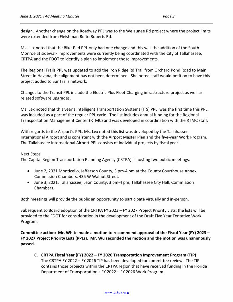
Ms. Lex summarized the Project Priority Lists (PPLs) by noting the PPLs are adopted annually and the projects are for the next fiscal year’s cycle (FY 2023-FY 2027). She noted the projects identified on all the PPLs are consistent with the Regional Mobility Plan, Congestion Management Plan, Transit Development Plan and the Airport Master Plan. These establish the priorities for the region and identify projects or phases of projects that need funding. Once funding is identified, the projects are programmed in the Transportation Improvement Program and listed in the document by project category. She briefly highlighted the changes within each of the Project Priority Lists and noted that the first change was to the Roadway PPL where the limits for the Orange Avenue project from Springhill Rd to Monroe St, have been extended to North Lake Bradford in the west. Because of this extension, FDOT has made staff aware this project will need to increase the funding for the project’s
June 1, 2021 TAC Meeting Minutes Page 3
www.crtpa.org
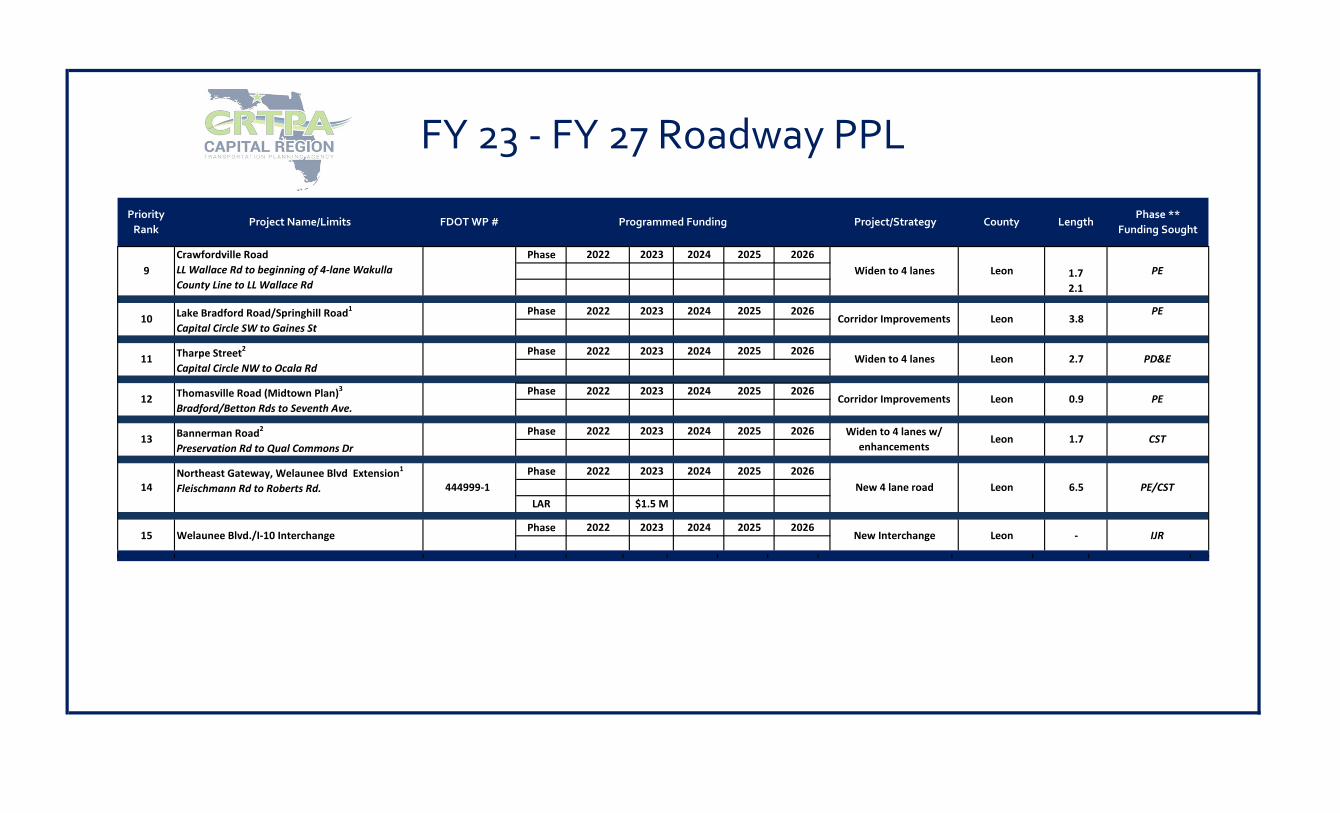
design. Another change on the Roadway PPL was to the Welaunee Rd project where the project limits were extended from Fleishman Rd to Roberts Rd.
Ms. Lex noted that the Bike-Ped PPL only had one change and this was the addition of the South Monroe St sidewalk improvements were currently being coordinated with the City of Tallahassee, CRTPA and the FDOT to identify a plan to implement those improvements. The Regional Trails PPL was updated to add the Iron Ridge Rd Trail from Orchard Pond Road to Main Street in Havana, the alignment has not been determined. She noted staff would petition to have this project added to SunTrails network. Changes to the Transit PPL include the Electric Plus Fleet Charging infrastructure project as well as related software upgrades. Ms. Lex noted that this year’s Intelligent Transportation Systems (ITS) PPL, was the first time this PPL was included as a part of the regular PPL cycle. The list includes annual funding for the Regional Transportation Management Center (RTMC) and was developed in coordination with the RTMC staff. With regards to the Airport’s PPL, Ms. Lex noted this list was developed by the Tallahassee International Airport and is consistent with the Airport Master Plan and the five-year Work Program. The Tallahassee International Airport PPL consists of individual projects by fiscal year. Next Steps The Capital Region Transportation Planning Agency (CRTPA) is hosting two public meetings.
• June 2, 2021 Monticello, Jefferson County, 3 pm-4 pm at the County Courthouse Annex, Commission Chambers, 435 W Walnut Street.
• June 3, 2021, Tallahassee, Leon County, 3 pm-4 pm, Tallahassee City Hall, Commission Chambers.
Both meetings will provide the public an opportunity to participate virtually and in-person. Subsequent to Board adoption of the CRTPA FY 2023 – FY 2027 Project Priority Lists, the lists will be provided to the FDOT for consideration in the development of the Draft Five Year Tentative Work Program.
Committee action: Mr. White made a motion to recommend approval of the Fiscal Year (FY) 2023 – FY 2027 Project Priority Lists (PPLs). Mr. Wu seconded the motion and the motion was unanimously passed.
C. CRTPA Fiscal Year (FY) 2022 – FY 2026 Transportation Improvement Program (TIP)
The CRTPA FY 2022 – FY 2026 TIP has been developed for committee review. The TIP contains those projects within the CRTPA region that have received funding in the Florida Department of Transportation’s FY 2022 – FY 2026 Work Program.

June 1, 2021 TAC Meeting Minutes Page 4
www.crtpa.org
RECOMMENDED ACTION: Recommend the CRTPA adopt the FY 2022 – FY 2026 TIP. Ms. Lex summarized the item, stating the Transportation Improvement Plan was a five-year Work Program and was updated annually. Mrs. Lex explained the purpose of the TIP is to inform the public and governmental agencies of transportation projects (planning through construction) that have received funding during the next five-year period (FY 2022 – FY 2026) within our region (Gadsden, Jefferson, Leon and Wakulla counties). She highlighted each of the new projects by county. Resurfacings Gadsden
• Hardaway Highway • US 90 Washington Street • Ben Bostic Road
Jefferson • US 319/N. Jefferson Street • Ashville Highway • Boston Highway
Leon • US 90/W. Tennessee Street • US 319/Capital Circle SE • US 90/Mahan Dr. • US 319/Capital Circle SE • Woodville Highway
Wakulla • Coastal Highway • Tiger Hammock Road • Whidden Lake Road • Lonnie Raker Lane • Bloxham Cutoff Road
Bridge Repair/Rehabilitation Gadsden
• Salem Road Jefferson
• CR 257 over Aucilla River • CR 259/Waukeenah Highway
Leon • Miccosukee Road
Wakulla • Surf Road
Sidewalk Projects Gadsden

June 1, 2021 TAC Meeting Minutes Page 5
www.crtpa.org
• US 90/Jefferson St sidewalk in Quincy (Chalk St to Strong Road) to be constructed on the south side of the road.
Jefferson • None
Leon • None
Wakulla • None
Safety projects
• Bloxham Cutoff Road (CR 61/Wakulla Springs Road-Intersection Improvement) Intelligent Transportation Systems
• CCTV Camera Upgrades at various locations Next Steps The Capital Region Transportation Planning Agency (CRTPA) is hosting two public meetings (in coordination with the PPL and RMP Amendment meeting).
• June 2, 2021 Monticello, Jefferson County, 3 pm-4 pm at the County Courthouse Annex,
Commission Chambers, 435 W Walnut Street. • June 3, 2021, Tallahassee, Leon County, 3 pm-4 pm, Tallahassee City Hall, Commission
Chambers.
Both meetings will provide the public an opportunity to participate virtually and in-person. Subsequent to CRTPA Board adoption of the TIP, staff will transmit the document to state and federal review agencies. Committee action: Mr. Wu made a motion to recommend approval of the CRTPA Fiscal Year (FY) 2022 – FY 2026 Transportation Improvement Program (TIP). Ms. Rosser seconded the motion and the motion was unanimously passed.
June 1, 2021 TAC Meeting Minutes Page 6
www.crtpa.org
D. CRTPA Safety Discussion
This item presents an analysis of bicycle and pedestrian data trends in the CRTPA region related to safety and builds upon the discussion held at the February 2 Committee meetings associated with the CRTPA’s annual adoption of safety targets.
RECOMMENDED ACTION: For Committee Information.
Mr. Kostrzewa provided a presentation on the Bicycle and Pedestrian Safety relating to the FDOT Performance measures and summarized the CRTPA Safety Discussion. Committee Action: This item was an informational item, therefore no action was taken.
6. INFORMATION
A. Future Meeting Dates
7. ITEMS FROM COMMITTEE MEMBERS OR STAFF
This portion of the agenda is provided to allow members an opportunity to discuss and request action on items and issues relevant to the CRTPA, as appropriate.
8. ADJOURNMENT Meeting was adjourned at 9:55 am.

STATEMENT OF ISSUE
The purpose of this item is to amend the CRTPA FY 2021 – FY 2022 Unified Planning Work Program (UPWP) to include the State FY 22 FTA contract award and to authorize the Executive Director to sign the associated Federal Transit Authority 5305(d) Joint Planning Agreement with the Florida Department of Transportation (FDOT).
RECOMMENDED ACTION
Option 1: Recommend the CRTPA Board approve the CRTPA FY 2021 – FY 2022 Unified Planning Work Program (UPWP) Amendment to include State FY 2022 FTA funds and State Match Toll Credit Soft Match, and to authorize the Executive Director to sign the associated Federal Transit Authority 5305(d) Joint Planning Agreement.
HISTORY AND ANALYSIS
The FTA and the State match funds are allocated annually. The proposed amendment revises the UPWP FY 2022 FTA budget to include the available State FY 2022 contract award. These funds will be authorized in the 5305(d) Joint Planning Agreement with the FDOT. The total award is $180,615, of which 80% is FTA funds and the remaining 20% State Toll Credit Soft Match (non-cash match).
State FY 2022 FTA 5303(d) Award FTA 80% (DU) State 20% Total Award $144,492 $36,123 $180,615
In the FY 2021 – FY 2022 UPWP, the FTA funds and the State Match funds are allocated to personnel and operating costs. Attachment 1 provides the total FTA budget for FY 2022 by task in the UPWP.
TYPE OF ITEM: Presentation/Discussion/Action
COMMITTEE AGENDA ITEM 3B
CRTPA FISCAL YEAR (FY) 2021 – FY 2022UNIFIED PLANNING WORK PROGRAM AMENDMENT
September 7, 2021

Agenda Item 3B – Unified Planning Work Program Amendment September 7, 2021 PAGE 2
NEXT STEPS
Subsequent to Board approval the Joint Planning Agreements will be executed and the UPWP will be updated to incorporate the approved changes.
ATTACHMENT
Attachment 1: Amended FTA Funding by UPWP Task in FY 2022

Task 1.0 Task 2.0 Task 3.0 Task 4.0 Task 5.0 Task 6.0 Task 7.0 TOTAL ROUNDED 80,697$ 10,250$ 9,750$ 23,750$ 18,250$ 11,250$ 26,275$ 180,222$ DPTO - 80% 64,558$ 8,200$ 7,800$ 19,000$ 14,600$ 9,000$ 21,020$ 144,178$ SM - 20% 16,139$ 2,050$ 1,950$ 4,750$ 3,650$ 2,250$ 5,255$ 36,044$
80,698$ 10,250$ 9,750$ 23,750$ 18,250$ 11,250$ 26,275$ 180,222$
Task 1.0 Task 2.0 Task 3.0 Task 4.0 Task 5.0 Task 6.0 Task 7.0 TOTAL ROUNDED 80,697$ 10,250$ 9,750$ 23,750$ 18,250$ 11,250$ 26,275$ 180,223$ DPTO - 80% 64,872$ 8,200$ 7,800$ 19,000$ 14,600$ 9,000$ 21,020$ 144,178$ SM - 20% 16,218$ 2,050$ 1,950$ 4,750$ 3,650$ 2,250$ 5,255$ 36,045$
81,091$ 10,250$ 9,750$ 23,750$ 18,250$ 11,250$ 26,275$ 180,616$
Task 1.0 Task 2.0 Task 3.0 Task 4.0 Task 5.0 Task 6.0 Task 7.0 TOTAL ROUNDED 161,395$ 20,500$ 19,500$ 47,500$ 36,500$ 22,500$ 52,550$ 180,223$ DPTO - 80% 129,430$ 16,400$ 15,600$ 38,000$ 29,200$ 18,000$ 42,040$ 144,178$
SM - 20% 32,358$ 4,100$ 3,900$ 9,500$ 7,300$ 4,500$ 10,510$ 36,045$ 161,788$ 20,500$ 19,500$ 47,500$ 36,500$ 22,500$ 52,550$ 360,838$
ORIGINAL FTA G1X08
State FY 22 (Federal FY 21) 80% FTA and 20% Soft Match
Revised FTA Task Totals for FY22
ATTACHMENT 1

STATEMENT OF ISSUE
Staff is seeking a recommendation to the Board to adopt the CRTPA FY 2023 – FY 2027 Amended Regional Mobility Plan Roadways Project Priority List (PPL) and to request the Florida Department of Transportation (FDOT) revise the project in the development of the upcoming Work Program.
RECOMMENDED ACTION
Option 1: Recommend the Board adopt the CRTPA FY 2023 – FY 2027 Amended Regional Mobility Plan Roadways Project Priority List (PPL); and request the FDOT revise Work Program Project No. 220495-3 consistent with the CRTPA FY 2023 – FY 2027 Amended Roadway PPL.
BACKGROUND AND ANALYSIS
Annually the CRTPA adopts project priority lists for which the agency is seeking transportation funding. The lists provide the FDOT guidance as that agency proceeds with development of the Annual State Work Program. At the June 15, 2021 CRTPA Meeting, the Board approved the Regional Mobility Plan Roadways PPL. (Attachment No. 1) In addition, at that meeting, the Board directed staff to revise Roadways Project Priority No. Three to be consistent with the project limits in the adopted 2045 Regional Mobility Plan.
Currently, roadway capacity Project Priority No. Three seeks right-of-way acquisition and construction funding for the Crawfordville Road segment from Lost Creek Bridge to East Ivan Road (Work Program Project No. 220495-3). As amended, the segment is divided into two projects. (Attachment 2) The limits for the southern project are from Lost Creek Bridge to Wakulla Arran Road. The northern project extends from Wakulla Arran Road to the East Ivan Road termini. This modification divides the 4.4 mile segment roughly into two equal sections with the northern piece proposed as Roadway Project Priority No. Three and the southern piece as Project Priority No. Four. The intent of this change is to facilitate funding the higher priority northern segment, including improvements at the Crawfordville Road and Wakulla Arran Road intersection.
TYPE OF ITEM: Presentation/Discussion/Action
COMMITTEE AGENDA ITEM 5A
AMENDED REGIONAL MOBILITY PLAN ROADWAYS PROJECT PRIORITY LIST
September 7, 2021

Committee Agenda Item 5A – CRTPA Amended FY 2023 – FY 2027 Regional Mobility Plan Roadways Project Priority List SEPTEMBER 7, 2021 PAGE 2
NEXT STEPS
Upon Board adoption of the CRTPA FY 2023 – FY 2027 Amended Roadway PPL, the list will be provided to the FDOT for consideration in the development of the Draft Five-Year Tentative Work Program. In addition, the CRTPA will formally request the FDOT revise Work Program Project No. 220495-3 consistent with the CRTPA FY 2023 – FY 2027 Amended Roadway PPL.
ATTACHMENTS
Attachment 1: Adopted FY 2023 – FY 2027 Regional Mobility Plan Regional Roadways PPL (June 2021) Attachment 2: Amended FY 2023 – FY 2027 Regional Mobility Plan Regional Roadways PPL (Sep 2021)

Widen to 4 lanes Leon 0.8 PD&E ($1.6)8Pensacola Street(West Side Student Corridor Gateway 1 )
Phase 2022 2023 2024 2025 2026
7Mahan Drive and Capital Circle, NE(Intersection Improvements)
Phase 2022 2023 2024 2025 2026 IntersectionImprovements
Leon 0 FS
2026Corridor Improvements Leon 0.5 PE6 Thomasville Road (Midtown Plan)3
(Seventh Ave. to Monroe St.)Phase 2022 2023 2024 2025
5 437902-4Phase 2022 2023 2024 2025 2026
Widen to 4 lanes Leon 4.3PE $1.9 M
4Crawfordville Road(N. of Alaska Way to Lost Creek Bridge)
220495-6Phase 2022 2023 2024 2025 2026
Widen to 4 lanes Wakulla 3.6ROW($31.09M) CST
($50.5M)ROW $2.6 M
2
3Crawfordville Road(Lost Creek Bridge to East Ivan Rd.)
220495-3Phase 2022 2023 2024 2025 2026
Widen to 4 lanes Wakulla 4.4ROW($33.99M) CST
($43.8M)
CST
FY 23 - FY 27 Roadway PPL
1Woodville Highway1
(Capital Circle, SE to Gaile Ave.) (Gaile Ave. to Paul Russell Rd.)
424009-4424009-5
Phase 2022 2023 2024 2025 2026Widen to 4 lanes Leon 2.1
County LengthPhase ** Funding
Sought
Capital Circle, Southwest2
(Crawfordville Rd. to Springhill Rd.)219749-2
Phase 2022 2023 2024 2025 2026Widen to 6 lanes Leon 2.34 CST ($32.1M)
Orange Avenue2
(N Lake Bradford Road to Monroe St) (Capital Circle, SW to N. Lake Bradford Rd)
Priority Rank
Programmed Funding Project Name/Limits
CST ($19.5M) CST ($8.7M)
FDOT WP # Project/Strategy
ROW (19.1M) PE ($3.2 M)
ATTACHMENT 1
Adopted June 2021
20252024
FY 23 - FY 27 Roadway PPL
9Crawfordville RoadLL Wallace Rd to beginning of 4-lane Wakulla County Line to LL Wallace Rd
Phase 2022 2023 2024 2025 2026Widen to 4 lanes Leon 1.7
2.1PE
Priority Rank
Project Name/Limits FDOT WP # Programmed Funding Project/Strategy County LengthPhase **
Funding Sought
10 Lake Bradford Road/Springhill Road1
Capital Circle SW to Gaines StPhase 2022 2023 2024 2025 2026
Corridor Improvements Leon 3.8PE
11 Tharpe Street2
Capital Circle NW to Ocala RdPhase 2022 2023 2024 2025 2026
Widen to 4 lanes Leon 2.7 PD&E
12 Thomasville Road (Midtown Plan)3
Bradford/Betton Rds to Seventh Ave.Phase 2022 2023 2026
Corridor Improvements Leon 0.9 PE
13 Bannerman Road2
Preservation Rd to Qual Commons DrPhase 2022 2023 2024 2025 2026 Widen to 4 lanes w/
enhancementsLeon 1.7 CST
14Northeast Gateway, Welaunee Blvd Extension1
Fleischmann Rd to Roberts Rd. 444999-1Phase 2022 2023 2024 2025 2026
New 4 lane road Leon 6.5 PE/CSTLAR $1.5 M
New Interchange Leon - IJR15 Welaunee Blvd./I-10 InterchangePhase 2022 2023 2024 2025 2026

Priority Rank
Project Name/Limits FDOT WP No. Programmed Funding
PE ($3.2 M) ROW (19.1M)**
ROW ($33.99M) CST 43.8M
2026Widen to 6 lanes Leon 2.3
FY 23 - FY 27 Roadway PPL
1Woodville Highway1
(Capital Circle, SE to Gaile Ave.)(Gaile Ave. to Paul Russell Rd.)
424009-4424009-5
Phase 2022 2023 2024 2025 2026Widen to 4 lanes Leon 2.1
CST ($19.5M) CST ($8.7M)
2 Capital Circle, Southwest2
(Crawfordville Rd. to Springhill Rd.)219749-2
Phase 2022 2023 2024 2025CST ($32.1M)
4Crawfordville Road(Lost Creek Bridge to Wakulla Arran Road )
220495-3Phase 2022 2023 2024 2025 2026
Widen to 4 lanes Wakulla 2.3
Crawfordville Road(N. of Alaska Way to Lost Creek Bridge)
220495-6Phase 2022 2023 2024 2025 2026
Widen to 4 lanes Wakulla 3.6ROW ($31.09M)
CST ($50.5M)ROW $2.6 M5
6Orange Avenue2
(N Lake Bradford Road to Monroe St) 437902-4Phase 2022 2023 2024 2025 2026
Widen to 4 lanes Leon 4.3PE $1.9 M(Capital Circle, SW to N. Lake Bradford Rd)
7 Thomasville Road (Midtown Plan)3
(Seventh Ave. to Monroe St.)0.5
Phase 2022 2023 2024 2025 2026Corridor Improvements Leon 0.5 PE
8Mahan Drive and Capital Circle, NE(Intersection Improvements)
0Phase 2022 2023 2024 2025 2026 Intersection
ImprovementsLeon 0 FS
9Pensacola Street(West Side Student Corridor Gateway 1 )
0.8Phase 2022 2023 2024 2025 2026
Widen to 4 lanes Leon 0.8 PD&E ($1.6)
Widen to 4 lanes Wakulla 2.1Phase 2022 2023 2024 2025 2026
Project Strategy County LengthPhase & Funding
Sought
3Crawfordville Road(Wakulla Arran Road to East Ivan Road)
220495-3
ATTACHMENT 2
Amended Sept 2021
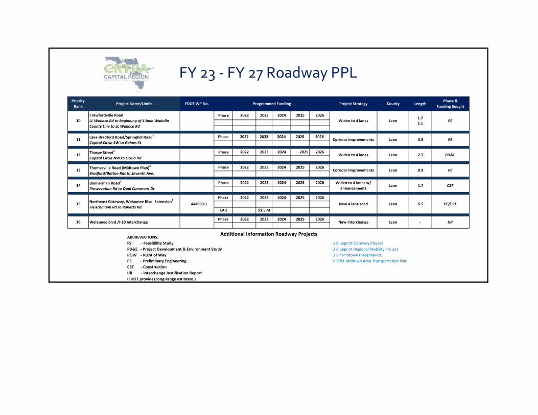
ABBREVIATIONS: FS - Feasibility Study 1 Blueprint Gateway ProjectPD&E - Project Development & Environment Study 2 Blueprint Regional Mobility ProjectROW - Right of Way 3 BP Midtown Placemaking,PE - Preliminary Engineering CRTPA Midtown Area Transportation PlanCST - Construction IJR - Interchange Justification Report (FDOT provides long-range estimate.)
Additional Information Roadway Projects
- IJRPhase 2022 2023 2024 2025 2026
New Interchange Leon
LAR $1.5 MNew 4 lane road Leon 6.5 PE/CST
16 Welaunee Blvd./I-10 Interchange
15 Northeast Gateway, Welaunee Blvd Extension1
Fleischmann Rd to Roberts Rd.444999-1
Phase 2022 2023 2024 2025 2026
14 Bannerman Road2
Preservation Rd to Qual Commons DrPhase 2022 2023 2024 2025 2026 Widen to 4 lanes w/
enhancementsLeon 1.7 CST
13 Thomasville Road (Midtown Plan)3
Bradford/Betton Rds to Seventh Ave.Phase 2022 2023 2026
Corridor Improvements Leon 0.9 PE
12 Tharpe Street2
Capital Circle NW to Ocala RdPhase 2022 2023 2024 2025 2026
Widen to 4 lanes Leon 2.7 PD&E
11 Lake Bradford Road/Springhill Road1
Capital Circle SW to Gaines StPhase 2022 2023 2024 2025 2026
Corridor Improvements Leon 3.8 PE
FY 23 - FY 27 Roadway PPL
10Crawfordville RoadLL Wallace Rd to beginning of 4-lane Wakulla County Line to LL Wallace Rd
Phase 2022 2023 2024 2025 2026Widen to 4 lanes Leon
1.72.1
PE
2024 2025
Phase & Funding Sought
LengthCountyProject StrategyProgrammed FundingFDOT WP No.Project Name/LimitsPriority
Rank

September 7, 2021
Committee AGENDA ITEM 5B
THOMASVILLE ROAD MULTI-USE PATH FEASIBILITY STUDY
STATEMENT OF ISSUE Capital Region Transportation Planning Agency (CRTPA) staff and Kimley-Horn and Associates (the Project Team) will be making a presentation regarding the Thomasville Road Multi-Use Path.
INTRODUCTION In 2019, the CRTPA was engaged in the development of the Connections 2045 Regional Mobility Plan (RMP) and the Tallahassee-Leon County Bike and Pedestrian Master Plan (BPMP). In both of these projects the Thomasville Road Multi-Use Path (Thomasville Road MUP) was incorporated due to its regional and local connections, as well as the corridor being highly ranked project by the Blueprint Intergovernmental Agency through the Greenways Master Plan. From a regional perspective, the Thomasville Road MUP is critical to linking several regional trail networks together. Such connections include projects evaluating shared-use paths along Maclay Road to Meridian Road and along Meridian Road to the Town of Havana via the Orchard Pond Greenway in Leon County and Iron Bridge Road in Gadsden County. To the south, the Cascades Park Trail leads to smaller Neighborhood Network (identified in the BPMP) projects and links to Midtown including a proposed multi-use trail on Thomasville Road south of Betton Road as identified in the Midtown Area Transportation Plan. From a local perspective, the Thomasville Road MUP provides a linkage from the Market District to Midtown as Thomasville Road serves as a commuter and recreational route for many pedestrians and bicyclists. These linkages also lead into subdivisions, schools, parks, businesses, and other trails such as the Goose Pond Trail. The intent of the Feasibility Study is to evaluate the multimodal connectivity of the Thomasville Road corridor from the Market District to Midtown and to what extent, considering costs and impacts, can a multi-use path be accommodated along the corridor from Betton Road to Maclay Road. This agenda item is being presented to provide an update to the CRTPA Board, including the alternatives, prior to the second round of Public Engagement which is scheduled to begin in mid-September and ending in mid-November.

Agenda Item 5B - Thomasville Road Multi-Use Path SEPTEMBER 7, 2021 PAGE 2
Project Goals The following seven (7) goals were developed for the Thomasville Road MUP:
• Safety – provide safe connections between destinations along Thomasville Road, and beyond.
• Accessibility – create a facility that is accessible to a variety of user types and is appropriate for at least three of the four bicycle comfort levels.
• Network Connectivity -grow network connectivity by providing opportunities to access destinations along and beyond Thomasville Road.
• Positive Network Experience – ensure positive network experience by incorporating natural features, creative design, and ADA compliance.
• Equitable – make the facility available to people with disabilities, low-income areas, aging populations and areas of low vehicle ownership.
• Multimodal – accommodate a variety of modes on the facility.
• Health and Recreation provide opportunities for extended trips to recreate and exercise. Feasibility Plan The Feasibility Plan contains the following three (3) elements described below:
• Existing Conditions - To determine the feasibility of this multi-use path, existing right-of-way was documented (using the Leon County Property Appraiser maps) along with environmental or physical opportunities and barriers. The Feasibility Study included field visits for data collection to develop an inventory of corridor constraints which formed the basis for developing solutions for consideration by the project team.
• Public Engagement - In addition to data collection, a Public Engagement phase was incorporated after the collection of existing data was underway. Efforts in this phase included meetings with neighborhood associations and homeowner associations (coordinated with City of Tallahassee Neighborhood Services), businesses, and citizens in a variety of formats to both gather and disseminate information. This phase also included meetings with local government departments and agencies such as City of Tallahassee Underground Utilities, Real Estate, Parks and Recreation, Leon County School Board, Leon County Public Works, Tallahassee-Leon County Planning Department, Florida Department of Transportation (Central Office and District 3), and the Blueprint Intergovernmental Agency.
• Alternative Alignments - The third component of the project focuses on alternative alignments of the multi-use path within the corridor. This is accomplished using the existing conditions, opportunities and barriers that were noted during the collection of the existing data and the input provided by citizens, businesses, and neighborhood associations/homeowner
Agenda Item 5B - Thomasville Road Multi-Use Path SEPTEMBER 7, 2021 PAGE 3
associations. These alternative alignments will be presented to the CRTPA Board on September 13, 2021.
After the CRTPA Board meeting on September 13, 2021, the Project Team will initiate the second round of Public Engagement that will end in mid-November. With this input, the alignment will be refined and presented to the CRTPA Board for final approval at their January 2022 meeting. Alternatives Summary To assist in providing a direct connection to the alternatives for the Thomasville Road MUP please refer to bullets below to find the specific page for each alternative. Betton Road to Armistead Road (2 options) – page 9
1. Thomasville Road (west side) – page 10 2. Thomasville Road (east side) – page 12 3. Trescott Ditch McCord Park – page 14 4. Trescott Drive – Page 16
Armistead Road to Metropolitan Boulevard – page 18
• Removing bike lanes (both sides) – page 18
• Armistead Road to Woodgate Way – east side of the road – page 20
• Crossover east side to west side at Woodgate Way – page 21
• Woodgate Way to Metropolitan Boulevard – west side of the road – page 22 Market District Connection South of Interstate 10 (3 options) – page 23
1. Live Oak Plantation Road – page 24 2. Metropolitan Corporate Center – page 25 3. FDOT right of way – page 26
North of Interstate 10 – page 28
• Timberlane School Road to Timberlane Road – page 28 • Timberlane Road (Timberlane School Road to Maclay Road – page 30
COVID-19 The Thomasville Road MUP Feasibility Study began in January 2020 and was impacted by the COVID-19 virus. This was noticeable in the Public Engagement component as public safety protocols did not allow for in-person meetings. However, the Project Team took a pro-active approach by employing various methods of engaging the public that relied on technology to conduct meetings, project rooms and Q&A sessions in a virtual environment. The project team is hopeful that the second round of Public Engagement can be held in-person. Our experience from the use of various virtual opportunities during the past year has shown that we can engage the public through both methods and have greater participation.
Agenda Item 5B - Thomasville Road Multi-Use Path SEPTEMBER 7, 2021 PAGE 4
PROJECT PHASES The remainder of this agenda provides further details regarding Existing Conditions, Public Engagement and Alternatives development. Existing Conditions The first task of the Thomasville Road MUP was to collect data including locations and information regarding the existing conditions of the corridor. This is done to identify unique corridor opportunities and barriers and to ensure that project development can be accomplished. This step also identifies information to feed into the Public Engagement phase as citizens become involved in the process. This data collection effort began in December of 2019 and continues throughout the existing conditions phase as various opportunities and barriers are investigated. The Existing Conditions Report details various data sets including the following:
• Roadway - pages 7 – 11
• Crash Data - pages 12 and 13
• Right of Way - pages 14 – 17
• Driveways - page 18 – 21
• Trees – pages 22 – 28
• Easements – pages 29 - 31
• Environmental Characteristics - pages 32 - 35
• Historic and Cultural Resources, Grade & Elevation and Network Connectivity – pages 36 and 37
• Existing Projects - pages 38 and 39.
Public Engagement The contract for this project was executed prior to COVID-19 and included in-person meetings and larger events to gather input from citizens and businesses along the Thomasville Road corridor and beyond, as necessary. Unfortunately, protocols that were put in placed eliminated the in-person format from occurring for the first round of the Public Engagement phase. Based on this limitation the Project Team used a multi-faceted approach that used social media, virtual meetings with the citizens, businesses and other city and county organizations. The following pages outline this approach.
• CRTPA Website and Facebook Prior to the initiation of the Public Engagement phase the Project Team established a presence on Facebook (Thomasville Road Multi-Use Path | Facebook) and a webpage on the CRTPA.org website (Thomasville Road Multi-Use Path | CRTPA) to provide information regarding meetings, updates, etc.. The links to these two platforms have been incorporated into the materials distributed for reaching out the public.
• Neighborhood Association/Homeowner Association Meetings
Agenda Item 5B - Thomasville Road Multi-Use Path SEPTEMBER 7, 2021 PAGE 5
The Project Team met with staff from the City of Tallahassee Neighborhood Services to provide information about the Neighborhood Associations (NA’s)/Homeowner Associations (HOA’s) along the corridor for contact purposes. This is list of HOAs and NAs that were contacted along with others that were contacted after the original request for meetings was made in November and December 2020. The initial request for HOA/NA meetings was distributed on November 17, 2020 (including an informational flyer) with the first HOA/NA meeting was held on January 7, 2021 (Waverly Hills) and continuing into the summer of 2021 with the last meeting on August 12, 2021 (Charleston Place).
• Stakeholder Meetings In addition to residential meetings the Project Team met with businesses, schools, government agencies/departments relating to either the Thomasville Road MUP or the connections to Betton Hills and/or the Market District. The Stakeholder list provides the date (s) that the meetings occurred. These contacts helped shapes many areas of the Thomasville Road MUP particularly North of Live Oak Plantation and south of Winthrop Way.
• Virtual Project Page An extensive Virtual Project page was developed for the project since there could be no public meetings during the initial phase of Public Engagement. The list of HOAs and NAs were used to send out links to the Virtual room along with any individual contacts that had submitted emails for project contact. The Virtual Room materials included:
• The significance of the corridor as a pedestrian and bike facility
• The “Types of Users” from the Tallahassee-Leon County Bike and Pedestrian Master Plan
• Project Limits
• Connecting to Midtown and the Market District (Project Coordination)
• Project Goals
• Additional Design Considerations
• Frequently Asked Questions
• Existing Conditions Assessment
• Completed Activities
• The 9 C’s of Bicycling
• Stakeholder Feedback and Information
• Project Timeline
Visitors could visit the virtual “room” materials in any order that they wanted or were interested in pursuing additional information for. Overall, there were 211 unique individuals that visited the site while it was open from April 27, 2020 to May 25, 2020. The “unique” visitor could have revisited the room several times but that would only count as a single unique visitor the first time. Originally, the room was intended to be open for a two week period, but that was extended to May 25, 2021 for additional input.

Agenda Item 5B - Thomasville Road Multi-Use Path SEPTEMBER 7, 2021 PAGE 6
• Question and Answer Sessions While the Virtual Room was open, the Project Team held three Question and Answer sessions that allowed for live feedback on comments or questions that were asked regarding the project. These sessions were held on Thursday, April 29, 2021, Monday, May 3, 2021, and Monday, May 24, 2021, with 5, 9 and 28 participants, respectively. The extension of the Virtual Room time period (to May 24, 2021) also included an additional Question and Answer Session on May 24, 2021. These sessions were recorded and posted to the CRTPA.org website along with the transcripts for review and can be found using the following links:
• Q&A Session #1 Transcripts
• Q&A Session #1 Video
• Q&A Session #2 Transcripts
• Q&A Session #2 Video
• Q&A Session #3 Transcript
• Q&A Session #3 Video
• Emails Announcing Virtual Project Room In advance of the opening of the Virtual Project Room the Project Team sent out an email announcing the times and dates of the Virtual Project Room. The email included a link to the first Thomasville Road Multi-Use Newsletter to provide some basic information regarding the project.
• Leon County Link The Leon County Link provide the citizens of Leon County a preview of upcoming events from month to month. The April 2021 edition included an announcement for the Thomasville Road Multi-Use Path as well as the US 90 trail project.
• USPS Mailouts In addition to the emails that were sent out to known HOAs and NAs, regarding the Virtual Project Room, there were other neighborhoods and property owners requiring contact about the how to access the information. Therefore, those properties related to the extension to the Market District (Live Oak Plantation Road, Timberlane School Road and Timberlane Road) were sent notices through USPS.
The extension of the time period for the Virtual Room and an additional Question and Answer Session also included a mailout announcing the inclusion of the session. These mailouts (236 in total) were sent out along Thomasville Road from Betton Road to Metropolitan Boulevard to all properties within a 300 foot buffer.

Agenda Item 5B - Thomasville Road Multi-Use Path SEPTEMBER 7, 2021 PAGE 7
• Comments from the Public From the very beginning of the project the Project Team created a spreadsheet to note the comments that were provide via email directly through staff, through the CRTPA website “Contact Us” tab, or by Facebook. The Comment Log is updated as comments are made so the linked provided reflects those comments received as of August 16, 2021. In general, the OPPOSED comments revolved around both traffic on Thomasville Road and the path, proper. The Thomasville Road comments were related to the drivers’ speed, traffic noise and air pollution. The comments associated to the path referred to conflicts with bike and pedestrians using the same space and at different speeds, and safety for those such as the elderly, children and pets. Others spoke to difficulty accessing and exiting driveways with traffic on Thomasville Road being heavy and fast combined with a higher number of bikes and pedestrians on the path. Lastly, any tree removal was a concern.
A sampling of comments OPPOSED to the project include:
• Because of very high traffic volume on Thomasville Rd., many intersections without traffic lights and an ignorance of/failure to comply with right of way rules by drivers, user safety is a serious concern (Comment Log, comment 31).
• Noise and fumes produced by said traffic make user experience and health concerns poor (Comment Log, comment 31 and comment 42).
• Having foot and bike traffic sharing the same path is a safety concern (Comment Log, comment 31).
• Major tree removal (Comment Log, comment 47 and 64).
• Accessing and exiting properties along the corridor, both residential and commercial, will become more difficult than it already is (comments from virtual meeting with several HOAs).
The SUPPORTING comments bike and pedestrian safety, connectivity and multimodal options. In terms of connections, remarks involved connections to improving connections to neighborhoods and activity centers. From a safety perspective, others saw the traffic issues on Thomasville Road as being a barrier to the use of the current facility (and current condition of sidewalk) and a path being a better multimodal option for commuting and recreation. A sampling of comments IN SUPPORT of the project include:
• Would love to be involved in making a Thomasville corridor happen as it would be nice to ride and buy groceries... rather than car (Comment Log, comment 3).
• Provide better connections to neighborhoods along the corridor (Comment Log, comment 4).
• The Thomasville Road multi-use path will be an essential multi-modal connector for two Blueprint place making projects that have multi-modal transportation featured, Midtown and Market Square. The current infrastructure along Thomasville Road for cyclists and walkers is unsafe, (Comment Log, comment 13).

Agenda Item 5B - Thomasville Road Multi-Use Path SEPTEMBER 7, 2021 PAGE 8
• Want a trail for bikes and pedestrians joining the north area of town to midtown. Preferably not on the road (Comment Log, comment 16).
• I am a frequent cycler, but I never cycle on this stretch of road because it is far too dangerous. However, my family would be able to commute by bike to work, school and activities if this project happens (Comment Log, comment 17).
Collectively, the Project Team received substantial feedback regarding the Thomasville Road MUP both for and against the project. More importantly, the integration of these comments with the Existing Conditions Report assists in providing guidance to the CRTPA on potential improvements that can be made in the corridor and others that will require phases beyond the Feasibility Study to address should the project move forward.

Agenda Item 5B - Thomasville Road Multi-Use Path SEPTEMBER 7, 2021 PAGE 9
Thomasville Road MUP Alternatives The alternatives for the Thomasville Road MUP are contained in the following three (3) distinct segments:
1. Betton Road to Armistead Road 2. Armistead Road to Live Oak Plantation Road 3. Live Oak Plantation Road to Maclay Commerce Boulevard
Segment 1 - Betton Road to Armistead Road In this section of the project there are four (4) feasible options for the path, shown as Figure 1. Two of the options include the use of the path in McCord Park and the other two options are located on Thomasville Road.
Figure 1 – Thomasville Road Multi-Use Path (Armistead Road to Betton Road)

Agenda Item 5B - Thomasville Road Multi-Use Path SEPTEMBER 7, 2021 PAGE 10
Thomasville Road West Side The Thomasville Road West side section, shown as Figure 2, from Betton Road to Armistead Road is not feasible as a feasible option given the limited right of way. In some instances, the available right of way is less than 8’, as shown in Figure 3.
Figure 2 – Thomasville Road Multi-Use Path (Thomasville Road West Side)
Disadvantages to this option:
• Right of way is very limited with the back to the existing sidewalk being the edge of the right of way to approximately North Ride.
• To accommodate a 10’ path, construction would take the path the “back of the curb” and considering the target users (identified in the Tallahassee-Leon County Bike and Pedestrian Master Plan) being more of beginning to intermediate bike riders and walkers being young children to the elderly this would not be an ideal situation.
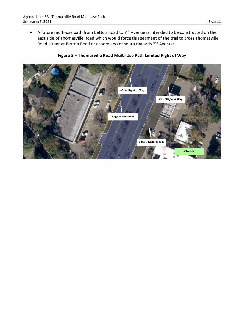
Agenda Item 5B - Thomasville Road Multi-Use Path SEPTEMBER 7, 2021 PAGE 11
• A future multi-use path from Betton Road to 7th Avenue is intended to be constructed on the east side of Thomasville Road which would force this segment of the trail to cross Thomasville Road either at Betton Road or at some point south towards 7th Avenue.
Figure 3 – Thomasville Road Multi-Use Path Limited Right of Way
Agenda Item 5B - Thomasville Road Multi-Use Path SEPTEMBER 7, 2021 PAGE 12
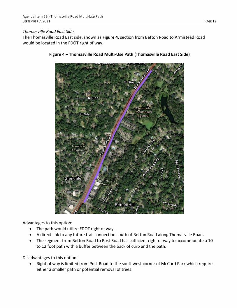
Thomasville Road East Side The Thomasville Road East side, shown as Figure 4, section from Betton Road to Armistead Road would be located in the FDOT right of way.
Figure 4 – Thomasville Road Multi-Use Path (Thomasville Road East Side)
Advantages to this option:
• The path would utilize FDOT right of way.
• A direct link to any future trail connection south of Betton Road along Thomasville Road.
• The segment from Betton Road to Post Road has sufficient right of way to accommodate a 10 to 12 foot path with a buffer between the back of curb and the path.
Disadvantages to this option:
• Right of way is limited from Post Road to the southwest corner of McCord Park which require either a smaller path or potential removal of trees.

Agenda Item 5B - Thomasville Road Multi-Use Path SEPTEMBER 7, 2021 PAGE 13
• The Post Road to southwest McCord Park is not an ideal situation for safety considering the target users (identified in the Tallahassee-Leon County Bike and Pedestrian Master Plan) being more of beginning to intermediate bike riders and walkers being young children to the elderly.
Gore Areas There are several gore areas that channel traffic along the outside lanes in the section from Betton Road to Armistead Road that could be used for adding width to the path as shown in Figure 5. Removing these areas would create 12’ travel lanes and add space for the multi-use path.
Figure 5 – Thomasville Road Gore Areas (Betton Road to Armistead Road)
Agenda Item 5B - Thomasville Road Multi-Use Path SEPTEMBER 7, 2021 PAGE 14
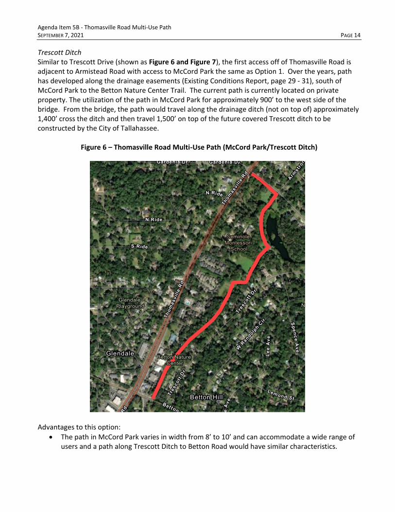
Trescott Ditch Similar to Trescott Drive (shown as Figure 6 and Figure 7), the first access off of Thomasville Road is adjacent to Armistead Road with access to McCord Park the same as Option 1. Over the years, path has developed along the drainage easements (Existing Conditions Report, page 29 - 31), south of McCord Park to the Betton Nature Center Trail. The current path is currently located on private property. The utilization of the path in McCord Park for approximately 900’ to the west side of the bridge. From the bridge, the path would travel along the drainage ditch (not on top of) approximately 1,400’ cross the ditch and then travel 1,500’ on top of the future covered Trescott ditch to be constructed by the City of Tallahassee.
Figure 6 – Thomasville Road Multi-Use Path (McCord Park/Trescott Ditch)
Advantages to this option:
• The path in McCord Park varies in width from 8’ to 10’ and can accommodate a wide range of users and a path along Trescott Ditch to Betton Road would have similar characteristics.

Agenda Item 5B - Thomasville Road Multi-Use Path SEPTEMBER 7, 2021 PAGE 15
• This route is much safer than placing the path along Thomasville Road when considering the target users (identified in the Tallahassee-Leon County Bike and Pedestrian Master Plan) being more of beginning to intermediate bike riders and walkers being young children to the elderly.
• Provides a traffic free and tree covered experience for a short distance.
• There would be minimum to no tree impacts.
• The sidewalk adjacent to Armistead Drive would be reconstructed to become ADA compliant. Disadvantages to this option:
• Residents in Betton Hills do not want a path due to concerns regarding safety and crime (access to the back of the property).
• Residents feel that there will be impacts to McCord Park mostly associated with speeding bicyclists mixed with elderly residents, children and pets utilizing the path that may not be able to react fast enough to avoid conflicts.
• The sidewalk adjacent to Armistead Drive would be require property from McCord Park.
Figure 7 – Thomasville Road Multi-Use Path (Trescott Ditch Looking South)
Agenda Item 5B - Thomasville Road Multi-Use Path SEPTEMBER 7, 2021 PAGE 16
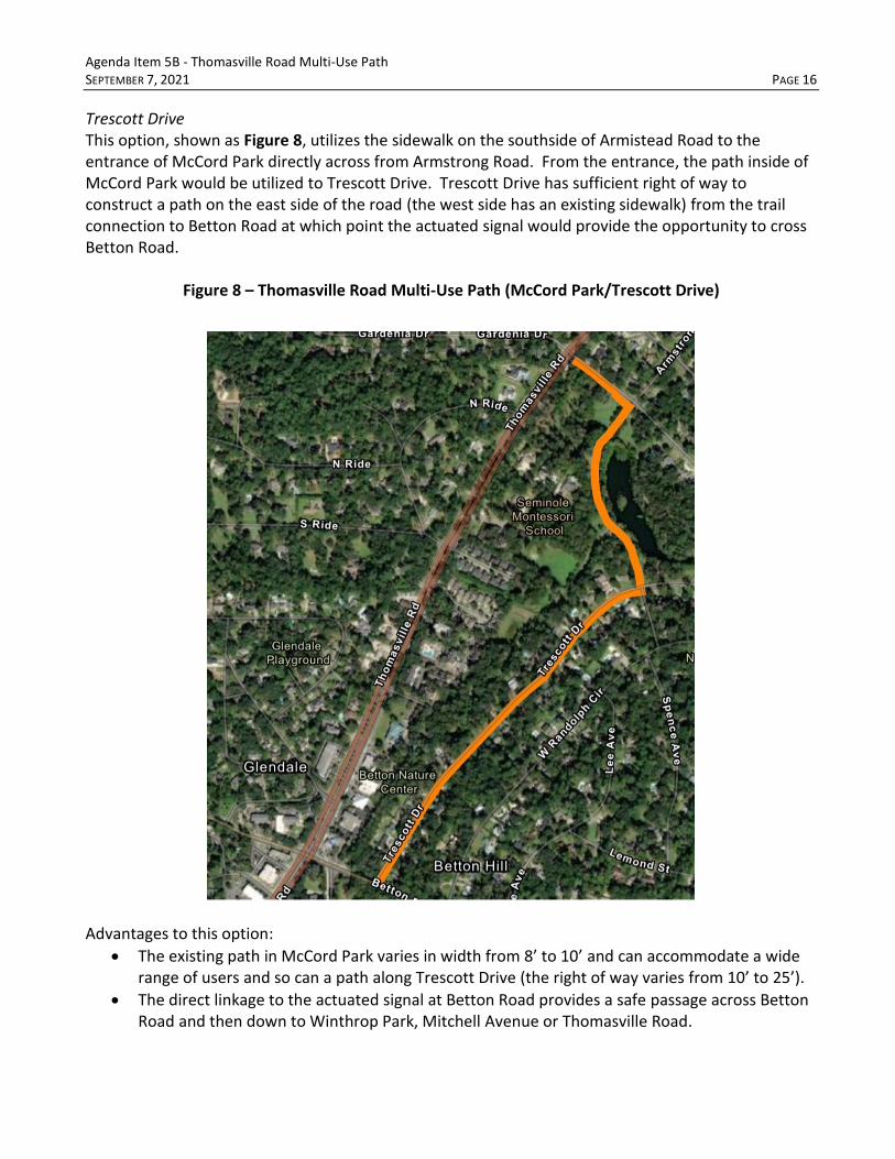
Trescott Drive This option, shown as Figure 8, utilizes the sidewalk on the southside of Armistead Road to the entrance of McCord Park directly across from Armstrong Road. From the entrance, the path inside of McCord Park would be utilized to Trescott Drive. Trescott Drive has sufficient right of way to construct a path on the east side of the road (the west side has an existing sidewalk) from the trail connection to Betton Road at which point the actuated signal would provide the opportunity to cross Betton Road.
Figure 8 – Thomasville Road Multi-Use Path (McCord Park/Trescott Drive)
Advantages to this option:
• The existing path in McCord Park varies in width from 8’ to 10’ and can accommodate a wide range of users and so can a path along Trescott Drive (the right of way varies from 10’ to 25’).
• The direct linkage to the actuated signal at Betton Road provides a safe passage across Betton Road and then down to Winthrop Park, Mitchell Avenue or Thomasville Road.

Agenda Item 5B - Thomasville Road Multi-Use Path SEPTEMBER 7, 2021 PAGE 17
• This route is much safer than placing the path along Thomasville Road when considering the target users being more of beginning to intermediate bike riders and walkers being young children to the elderly.
• The sidewalk adjacent to Armistead Drive would be reconstructed to become ADA compliant. Disadvantages to this option:
• Residents in Betton Hills, in particular, along Trescott Drive, do not want a path due to concerns regarding safety, difficulties entering and leaving their property, crime, and an increase in bike and pedestrian traffic in their neighborhood.
• Residents feel that there will be impacts to McCord Park mostly associated with speeding bicyclists mixed with elderly residents, children and pets utilizing the path that may not be able to react fast enough to avoid conflicts.
• Would require removal of some small trees to accommodate the path.
• The are 23 properties that will require driveway cuts along the path.
• The sidewalk adjacent to Armistead Drive would require property from McCord Park. While this option is feasible, the number of driveways cuts will make the installation of the path difficult and has the potential to create safety issues on Trescott Drive. Therefore, the Project Team has removed this option from consideration.

Agenda Item 5B - Thomasville Road Multi-Use Path SEPTEMBER 7, 2021 PAGE 18
Armistead Road to Metropolitan Boulevard This segment of the path would be in the FDOT right of way. Beginning at Armistead Road the path would be located on the east side of the road to Woodgate Way. At Woodgate Way the path would cross at the signalized intersection from the east side to the west side of Thomasville Road at the signalized crossing. From Woodgate Way the path would continue north, on the west side of the road, to Live Oak Plantation Road. Further discussion of this alignment is provided below. Thomasville Road Bike Lanes The bike lanes on Thomasville Road (Figure 9) end just north of Waverly Road (west side of Thomasville Road) and begin north of Freedom Church (on the east side of Thomasville Road) and continue beyond Interstate 10. During the Public Engagement phase several citizens (experienced bicyclists) commented on how they won’t travel in the bike lane on this section of Thomasville Road due to the speed and volume of traffic. Additionally, there were consistent questions from citizens asking if the study would look at reducing the speed on Thomasville Road. Based on these questions and the need to provide safety along the corridor, on the path and with bicyclists, the Project Team is recommending the removal of the bike lanes (both sides of the road) on Thomasville Road from just north of Waverly Road and the Freedom Church to Metropolitan Boulevard.
Figure 9 – Bike Lanes at Waverly Road (West Side) and Freedom Church (East Side)
The removal of these lanes would:
• Reduce the outside lane of Thomasville Road to 12’ on both the east and west side of the road,
• Increase the right of way for the multi-use trail by 4’.
• Potentially reduce the speed of vehicles on Thomasville Road.
• Eliminate any need for additional right of way in this portion of the path.
• Provides an additional space to subdivisions and businesses that have limited sight distance.

Agenda Item 5B - Thomasville Road Multi-Use Path SEPTEMBER 7, 2021 PAGE 19
• Provide consistency for the multi-use trail from Metropolitan Boulevard to Betton Road.
• Increase the safety of pedestrian and bicyclists by having a wider buffer between Thomasville Road and the multi-use path.
Examples of these changes are shown Figure 10 and Figure 11.
Figure 10 – Bike Lane Removal around Asbury Hills and Thomasville Road
Figure 11 – Bike Lane Removal around Braemore Way and Thomasville Road

Agenda Item 5B - Thomasville Road Multi-Use Path SEPTEMBER 7, 2021 PAGE 20
Armistead Road to Woodgate Way (East Side) The Project Team reviewed the opportunities along the east side and west side of Thomasville Road for the multi-use path between Armistead Road to Woodgate Way, shown as Figure 12.
Figure 12 – Thomasville Road Multi-Use Path (Armistead Road to Woodgate Way)
The Project Team opted for the east side as opposed to the west side for the following reasons:
• There is more right of way on the east side and coupled with an additional 4’ from the bike lane, the path would have more separation from the traffic on Thomasville Road providing a safer environment for pedestrians and bikes.
• This would maximize the width of the path allowing space for users traveling in different directions.
• The additional 4’ from the bike lane would provide additional space to improve sight distances for adjacent subdivisions and businesses while exiting or accessing their respective driveways or roads.

Agenda Item 5B - Thomasville Road Multi-Use Path SEPTEMBER 7, 2021 PAGE 21
• The east side is ADA compliant which wouldn’t require as much earthwork and rebuilding as the west side of Thomasville Road.
• The east side has better connectivity for the segment south of Armistead Road and south of Betton Road.
• There are significantly less tree impacts on the east side in this section versus the west side. Woodgate Way Crossing There were several crossings that were reviewed for making the east to west movement. The purpose for moving to the west is to provide a better linkage to the Market District as well as avoid situations with limited right of way on the east side such as around Dorothy B. Oven Park. The Woodgate Way at Thomasville Road intersection, shown as Figure 13, has less conflicts than the Hermitage Boulevard at Thomasville Road intersection, does not have free flow right-hand turn lanes, and has three legs instead of four which makes the crossing of Thomasville Road safer. Additionally, by installing the crossing on the south side of the intersection, there are no conflicts with right hand turns heading north on Thomasville Road from Woodgate Way.
Figure 13 – Thomasville Road at Woodgate Way Intersection

Agenda Item 5B - Thomasville Road Multi-Use Path SEPTEMBER 7, 2021 PAGE 22
Woodgate Way to Metropolitan Boulevard (West Side) The path is better suited for the west side of Thomasville Road in this section, shown as Figure 14, as opposed to the east side for several reasons:
• Avoids the crossing of the path at the Hermitage Boulevard at Thomasville Road intersection which has multiple conflict points.
• The additional 4’ from the bike lane provides sufficient right of way for separation from the traffic on Thomasville Road allowing for a safer environment for pedestrians and bikes.
• Due to minimal right of way, this option avoids impact to several large trees in Dorothy B. Oven Park that are located on the back of the existing sidewalk.
• The west side provide a more direct connections to the Market District options.
Figure 14 – Thomasville Road Multi-Use Path (Woodgate Way to Metropolitan Boulevard)

Agenda Item 5B - Thomasville Road Multi-Use Path SEPTEMBER 7, 2021 PAGE 23
Market District Connection (South of Interstate 10) There are three (3) options relating to the Thomasville Road MUP (South of Interstate 10) from Live Oak Plantation Road to south of Interstate 10 that are shown in Figure 15 and detailed below. The Market District Connection (north and south) would be beyond the CRTPA’s jurisdiction since these are local roads, and would require coordination with the City of Tallahassee, Leon County and Blueprint as part of the Market District Placemaking project.
Figure 15 – Market District Connections (South of Interstate 10)

Agenda Item 5B - Thomasville Road Multi-Use Path SEPTEMBER 7, 2021 PAGE 24
Live Oak Plantation Road (Thomasville Road to Timberlane School Road to Interstate 10) The first option investigated by the Project Team begins at the southwest corner of the Thomasville Road at Live Oak Plantation Road intersection, shown as Figure 16. From Thomasville Road the path would move west to the intersection of Live Oak Plantation Road at Timberlane School Road and then north under Interstate 10.
Figure 16 – Market District Connections (South of Interstate 10) Live Oak Plantation Road/Timberlane School Road
Advantages to using Live Oak Plantation Road and Timberlane School Road include:
• Avoids the intersection of Live Oak Plantation Road at Thomasville Road since the path would begin south of the intersection (meeting the needs of the users for safety purposes).
• Available right of way along Live Oak Plantation Road and Timberlane School Road.
• The most direct route staying on the existing road system.
• Tree shade and less traffic.
• Avoids any impact to the conservation area associated with the Metropolitan Corporate Center Conservation Easements and Gas Transmission Easement.

Agenda Item 5B - Thomasville Road Multi-Use Path SEPTEMBER 7, 2021 PAGE 25
• Recently installed speed humps and raised intersections have slowed traffic down along Live Oak Plantation Road.
Disadvantages to using Live Oak Plantation Road include:
• Residents have historically been opposed to any bike and pedestrian improvement along the road (whether a smaller portion the corridor being used for the path would be viewed differently has yet to be determined).
Metropolitan Corporate Center (Thomasville Road to Timberlane School Road) The last option begins at Thomasville Road and utilizes Metropolitan Boulevard (west) into the Metropolitan Corporate Center, then heads west behind a stormwater facility and parking lot tying into the FDOT right of way and down to Timberlane School Road. This route is shown as Figure 17.
Figure 17 – Metropolitan Corporate Center (South of Interstate 10)
Advantages to using Metropolitan Corporate Center include:
• Avoids the Interstate 10 interchange (meeting the needs of the users for safety purposes).
Westernmost
Stormwater
Pond
Agenda Item 5B - Thomasville Road Multi-Use Path SEPTEMBER 7, 2021 PAGE 26
• Tree shaded with very little traffic.
• Avoids any impact to the Metropolitan Corporate Center Conservation Easements. Disadvantages to using the Metropolitan Corporate Center include:
• There are crash issues that have been identified by FDOT at the intersection of Live Oak Plantation Road and Thomasville Road. These issues are related to the left-hand turn movement from Live Oak Plantation to northbound Thomasville Road that makes crossing this intersection particularly dangerous.
• Further discussions must occur with TMH, CHP, FDOT and Florida Gas Transmission.
• Elevation challenges as the path moves from the westernmost stormwater pond to Timberlane School Road.
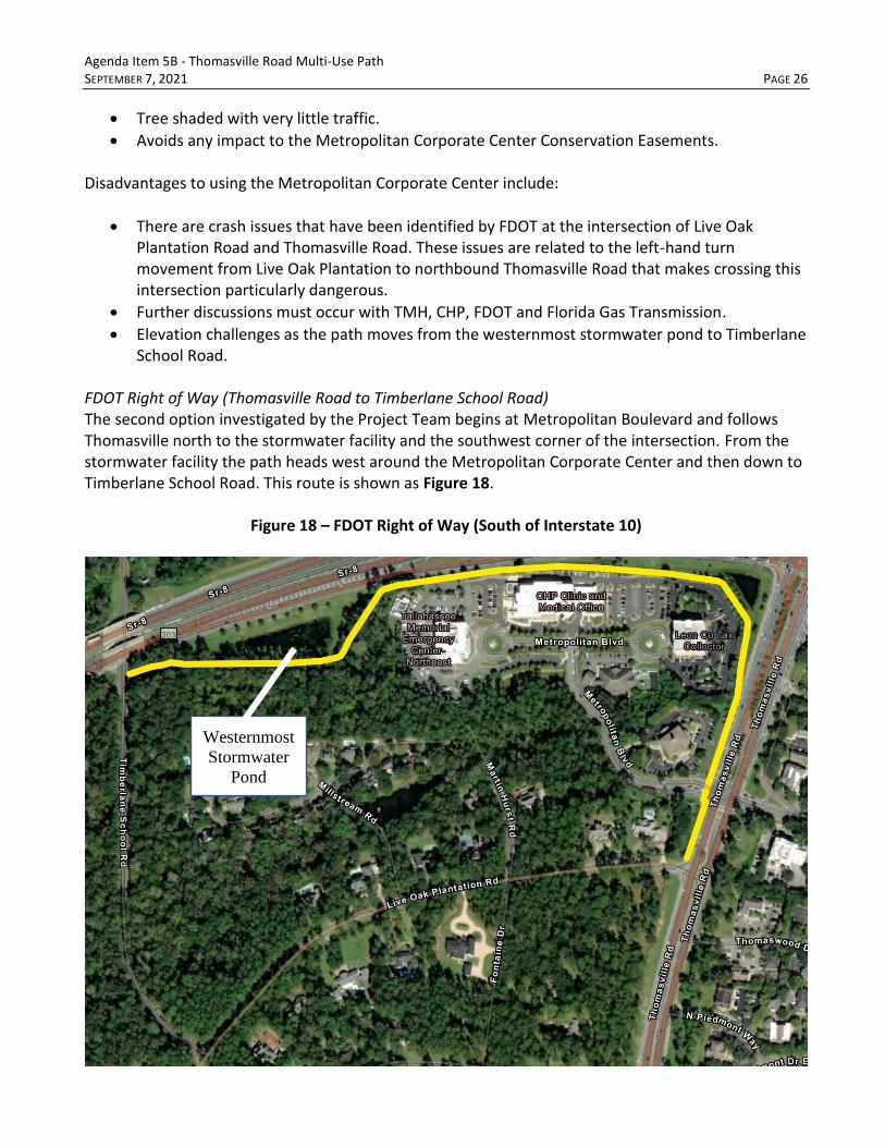
FDOT Right of Way (Thomasville Road to Timberlane School Road) The second option investigated by the Project Team begins at Metropolitan Boulevard and follows Thomasville north to the stormwater facility and the southwest corner of the intersection. From the stormwater facility the path heads west around the Metropolitan Corporate Center and then down to Timberlane School Road. This route is shown as Figure 18.
Figure 18 – FDOT Right of Way (South of Interstate 10)
Westernmost
Stormwater
Pond

Agenda Item 5B - Thomasville Road Multi-Use Path SEPTEMBER 7, 2021 PAGE 27
Advantages to using FDOT ROW include:
• Avoids the Interstate 10 interchange (meeting the needs of the users for safety purposes).
• Available right of way along Interstate 10.
• Avoids trees.
• Avoids any environmental issues associated with the Metropolitan Corporate Center Conservation Easements and Gas Transmission Easement.
Disadvantages to using the FDOT right of way include:
• There are crash issues that have been identified by FDOT at the intersection of Live Oak Plantation Road and Thomasville Road. These issues are related to the left-hand turn movement from Live Oak Plantation to northbound Thomasville Road that makes crossing this intersection particularly dangerous.
• It is the most circuitous of the three options.
• There will be elevation challenges as the path moves from the westernmost stormwater pond to Timberlane School Road.
Agenda Item 5B - Thomasville Road Multi-Use Path SEPTEMBER 7, 2021 PAGE 28
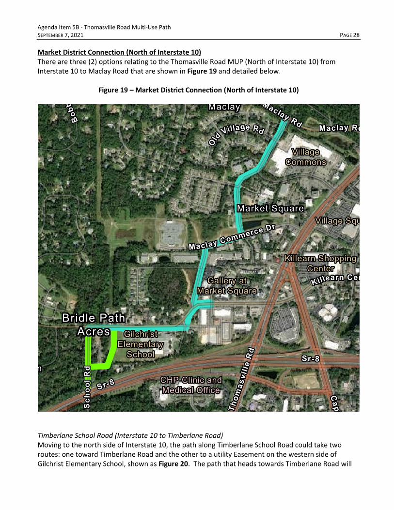
Market District Connection (North of Interstate 10) There are three (2) options relating to the Thomasville Road MUP (North of Interstate 10) from Interstate 10 to Maclay Road that are shown in Figure 19 and detailed below.
Figure 19 – Market District Connection (North of Interstate 10)
Timberlane School Road (Interstate 10 to Timberlane Road) Moving to the north side of Interstate 10, the path along Timberlane School Road could take two routes: one toward Timberlane Road and the other to a utility Easement on the western side of Gilchrist Elementary School, shown as Figure 20. The path that heads towards Timberlane Road will

Agenda Item 5B - Thomasville Road Multi-Use Path SEPTEMBER 7, 2021 PAGE 29
put users at the bottom of a very steep climb towards Gilchrist Elementary School that many will find extremely challenging. The use of the utility easement puts the path at the sidewalk along Timberlane Road with a slight climb up the hill. Given the two options, the Project Team would recommend the path that utilizes the utility easement.
Figure 20 – Timberlane School Road (Interstate 10 to Timberlane Road)
Advantages to using Timberlane School Road and utility easement include:
• Avoids the Interstate 10 interchange (meeting the needs of the users for safety purposes).
• Tree shaded with very little traffic.
• Easements with utilities can be attained (as discussed with City of Tallahassee Real Estate).
• Eliminates the ascent up Timberlane Road.
Recommended
Route

Agenda Item 5B - Thomasville Road Multi-Use Path SEPTEMBER 7, 2021 PAGE 30
Timberlane Road (Timberlane School Road to Maclay Road) This section, shown as Figure 21, relies on existing infrastructure that would potentially be rebuilt to accommodate the path including the sidewalk in front of Gilchrist Elementary School (south side of Timberlane Road), as well as the sidewalk that parallels Timberlane Road to the intersection of Market Street.
Figure 21 – Timberlane Road (Timberlane School Road to Maclay Road)
Advantages to using Timberlane Road and utility easement include:
• Avoids the Interstate 10 interchange (meeting the needs of the users for safety purposes).
• Builds upon existing system that is already established.
• Provides connection to Blueprint’s Market District Park.
• Provides connection to Maclay Road which in turn will connect to the Meridian Road trail.

Agenda Item 5B - Thomasville Road Multi-Use Path SEPTEMBER 7, 2021 PAGE 31
Disadvantages to using Timberlane Road include:
• Potential limitations of width of the facility on Martin Hurst Road and Timberlane Road in front of Gilchrist Elementary school.
Alternatives Summary In summary, there are several alternatives for the various segments of the Thomasville MUP. Below summarizes the alternatives that will be presented to citizens in the second round of Public Engagement. The two alternatives that won’t be presented include the following:
1. Betton Road to Armistead Road - Thomasville Road (west side) and Trescott Drive Path. 2. Betton Road to Armistead Road – Trescott Drive Path.
Other segments still being evaluated include the following. Betton Road to Armistead Road (2 options)
1. Thomasville Road (east side) 2. Trescott Ditch McCord Park
Armistead Road to Metropolitan Boulevard
• Removing bike lanes (both sides)
• Crossover east side to west side at Woodgate Way
• Armistead Road to Woodgate Way – east side of the road
• Woodgate Way to Metropolitan Boulevard – west side of the road Market District Connection South of Interstate 10 (3 options)
1. Live Oak Plantation Road 2. Metropolitan Corporate Center 3. FDOT right of way
North of Interstate 10
• Timberlane School Road to Timberlane Road • Timberlane Road (Timberlane School Road to Maclay Road
NEXT STEPS After the CRTPA Board meeting, the second round of Public Engagement will be initiated. This will include virtual meetings, virtual project materials (similar to the virtual project room for the first round of Public Engagement) and planned in-person meetings. From mid-September to the end of October meetings with NA’s and HOA’s, businesses, individuals will be held as well as three (3) virtual Question and Answer (Q & A) meetings that are tentatively scheduled for October 14, 21, and 25. In

Agenda Item 5B - Thomasville Road Multi-Use Path SEPTEMBER 7, 2021 PAGE 32
November, in-person meetings will be held barring any issues related COVID-19 (locations still to be determined). After the second round of Public Engagement is completed (approximately November 15), the Project Team will focus on identifying a preferred route for the Thomasville Road MUP. This final route is anticipated to be presented at the January 2022 CRTPA Board meeting.
September 7, 2021
COMMITTEE AGENDA 6 A
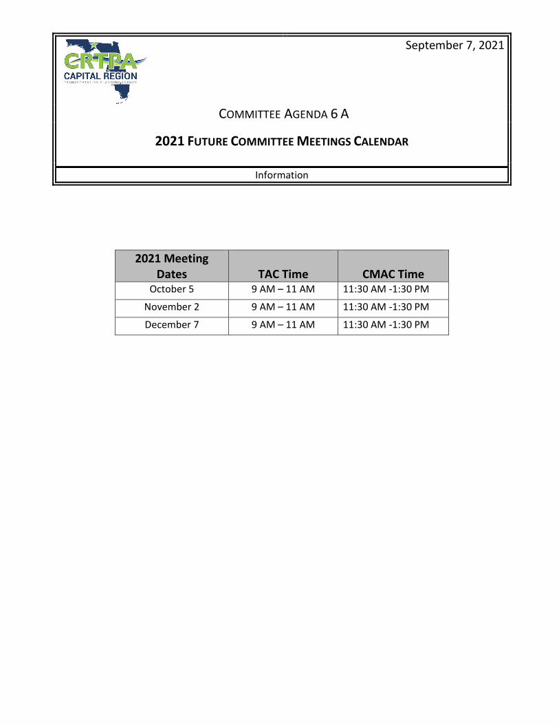
2021 FUTURE COMMITTEE MEETINGS CALENDAR Information
2021 Meeting Dates
TAC Time
CMAC Time
October 5 9 AM – 11 AM 11:30 AM -1:30 PM
November 2 9 AM – 11 AM 11:30 AM -1:30 PM
December 7 9 AM – 11 AM 11:30 AM -1:30 PM

The purpose of this item is to update the Committee on recent changes to the CRTPA’s FY 2021 – FY 2025 and FY 2022 – FY 2026 Transportation Improvement Programs
The following projects in the CRTPA’s FYs 2021 – 2025 and FYs 2022 – 2026 TIPs are revised as follows:
• FY 2021 – FY 2025 TIP Amendment Project No. 439374-1: Provide funding for the Environmental
Phase in FY 22 for the replacement of the CR 159 Salem Road Bridge over Swamp Creek, Bridge No. 500032. (Gadsden County) Administratively Amended, June 2021 (Attachment 1) Subsequently, the Executive Committee approved a second amendment to the Salem Road Bridge project, increasing funding to 6.6. million for the construction phase. This amendment was approved by the CRTPA Executive Committee on August 24 as a time-sensitive item, allowing for the immediate authorization of funds. Amended, August 2021 (Attachment 2)
• FY 2021 – FY 2025 TIP Amendment Project No. 439366-1: Provide increased funding in FY 22 for the Rail and Utilities Phase of the CR 259 over SCL Railroad Bridge Project, Bridge No. 540027. Administratively Amended, June 2021 (Attachment 3)
• FY 2022 – FY 2026 TIP Modification Project No. 439374-1: Provide increased funding for the
Construction Phase in FY 2022 for the replacement of the CR 159 Salem Road Bridge over Swamp Creek. The TIP modification ensures that the project costs are consistent in both the FY 2021 – FY 2025 and the FY 2022 – FY 2026 TIPs. Administratively Modified, August 2021 (Attachment 4)
TYPE OF ITEM: Informational Item
COMMITTEE AGENDA ITEM 6 B
CRTPA TRANSPORTATION IMPROVEMENT PROGRAM (TIP) FISCAL YEAR (FY) 2021 – FY 2025 TIP AMENDMENTS
FY 2022 – FY 2026 TIP MODIFICATION
September 7, 2021

CRTPA Transportation Improvement Program - FY 2020/21 - FY 2024/2025
C-5
CR 159 SALEM ROAD OVER SWAMP CREEK BRIDGE NO. 5000324393741 SIS
Project Description: BRIDGE REPLACEMENTNotes: The Environmental Phase (ENV) of this project was Administratively Amended into the TIP in July 2021.Lead Agency: MANAGED BY FDOTCounty: GADSDENLength: .674
From:To:
Phase Group: PRELIMINARY ENGINEERING, RIGHT OF WAY, CONSTRUCTION
Phase Fund Code PRIOR YEAR 2021 2022 2023 2024 2025 2026 Total
PE ACBZ 116,125 0 0 0 0 0 0 116,125
PE BRTZ 747,428 0 0 0 0 0 0 747,428
ROW ACBZ 90,000 0 0 0 0 0 0 90,000
CST ACBR 0 0 519,024 0 0 0 0 519,024
CST ACBZ 0 0 3,512,722 0 0 0 0 3,512,722
ENV ACBZ 127,533 127,533
953,553 4,159,279 5,112,832Prior Year Cost: 955,553Future Year Cost: 0Total Project Cost: 5,112,832LRTP: 2045 RMP Appendix B, Table 10 – Page 9
ATTACHMENT 1

CRTPA Transportation Improvement Program - FY 2020/21 - FY 2024/2025
C-5
CR 159 SALEM ROAD OVER SWAMP CREEK BRIDGE NO. 5000324393741 SIS Project Description: BRIDGE REPLACEMENT
Notes: The Environmental Phase of this project was Administratively Amended into the TIP in July 2021. The Construction Phase was amended by the Executive Committee in August 2021 to reflect increased project costs.
Lead Agency: MANAGED BY FDOTCounty: GADSDENLength: .674
From:To:
Phase Group: PRELIMINARY ENGINEERING, RIGHT OF WAY, CONSTRUCTION
Phase Fund Code PRIOR YEAR 2021 2022 2023 2024 2025 2026 Total
PE ACBZ 116,125 0 0 0 0 0 0 116,125
PE BRTZ 747,428 0 0 0 0 0 0 747,428
ROW ACBZ 90,000 0 0 0 0 0 0 90,000
CST ACBZ 0 0 5,719,780 0 0 0 0 5,719,780
CST ACBZ 0 0 85,636 0 0 0 0 85,636
ENV ACBZ 127,533
856,362
127,533Prior Year Cost: 955,553Future Year Cost: 0Total Project Cost: 7,742,864LRTP: 2045 RMP Appendix B, Table 10 – Page 9
Page 67 of 289
953,553 6,789,311 7,742,864
CST ACBZ 856,36200
0 0
ATTACHMENT 2

CRTPA Transportation Improvement Program - FY 2020/21 - FY 2024/2025
C-8
CR 259 OVER SCL RAILROAD BRIDGE NO. 5400274393661 SIS
Project Description: BRIDGE REPLACEMENTNotes: The Railroad and Utilities Phase was administratively amended into the TIP in July 2021.Lead Agency: MANAGED BY FDOTCounty: JEFFERSONLength: .028
From:To:
Phase Group: CONSTRUCTION, PRELIMINARY ENGINEERING, RIGHT OF WAY, RAILROAD &UTILITIES
Phase Fund Code PRIOR YEAR 2021 2022 2023 2024 2025 2026 Total
CST ACBR 0 0 3,428,910 0 0 0 0 3,428,910
PE ACBR 150,187 0 0 0 0 0 0 150,187
PE NHBR 705,751 0 0 0 0 0 0 705,751
ROW ACBR 105,000 0 0 0 0 0 0 105,000
RRU ACBR 83,255 83,255
960,938 3,512,165 4,473,103
Prior Year Cost: 960,938Future Year Cost: 0Total Project Cost: 4,473,103LRTP: 2045 RMP Appendix B, Table 10 – Page 9
ATTACHMENT 3

CRTPA Transportation Improvement Program - FY 2021/22 - FY 2025/2026
C-5
CR 159 SALEM ROAD OVER SWAMP CREEK BRIDGE NO. 5000324393741 Non-SIS
Project Description: BRIDGE REPLACEMENTLead Agency: MANAGED BY FDOTCounty: GADSDENLength: 0.674
From:To:
Phase Group: PRELIMINARY ENGINEERING, RIGHT OF WAY, CONSTRUCTION, ENVIRONMENTAL
Phase Fund Code 2022 2023 2024 2025 2026 Total
CST ACBZ 6,661,778 0 0 0 0 6,661,778
ENV ACBZ 127,533 0 0 0 0 127,533
6,789,311 6,789,311
Prior Year Cost: 955,553Future Year Cost: 0Total Project Cost: 7,742,864LRTP: 2045 RMP Appendix B, Table 10 -Page 9
Page 69 of 289
Notes: Funding was added to the Construction Phase and approved as an Administrative Modification to the TIP in August 2021. The modification ensures project construction costs are consistent with costs in CRTPA's FY 2021 - FY 2025 TIP.
ATTACHMENT 4