teaching resource kit for dryland countries
TRANSCRIPT

UN
ESCO
A Creative Approach to Environmental Education
Teaching Resource Kit for Dryland Countries

Entire table of contents as anticipated
for the teacher’s manual
(subject to changes)
Introduction
Chapter 1Discovering the Ecosystem and its Biodiversity
Activities:1. Collecting Treasures2. Forms and Compositions on the Ground 3. Land, Rock and Erosion4. Nature’s Palette5. The Vitality of Fauna6. The Dance of the Species 7. The Biotope Puzzle8. At Biodiversity School
Chapter 2The Water Cycle
Activities:1. Water and Poetry2. Playing with Watercolour Painting 3. The Water Cycle4. The Light and Colour of Water 5. The Water Map 6. A Scrapbook of Wells and Ponds 7. Clear Water Stories and Cartoons 8. Wall Chart of a Village Water System
Chapter 3The Importance of Plant Life
Activities:1. Inventing the Herbarium 2. Tree, plant, are you on form?3. Flowers in Colour 4. Root Sculptures 5. The Tree Ecosystem (or Who Lives in the Tree?)6. An Inventory of Useful Plants7. The Plant as Mascot8. Role Playing put to Good Use
Officer-in-charge:
Thomas Schaaf, UNESCO
Editor and project designer:
Hélène Gille
Scientific advisers:
Michel Le Berre, Thomas Schaaf
Graphic designer:
Mecano, Laurent Batard
Coordination and iconography:
Hélène Gille
With the collaboration of:
Cathy Lee
Translation:
Suzi Morris
Photoengraving:
Num Créative
Printing:
LM Graphie
Printed on white semi-matt coated paper
Teaching Resource Kit for DrylandCountries
A Creative Approach to Environmental Education
Cover photograph:View of El Ateuf, M’Zab Valley, Algeria, 2002© Olivier Brestin

Introduction
UNESCO’s Man and the Biosphere (MAB) Programme iscurrently developing two teaching resource kits for envi-ronmental education.These kits are intended for primaryand secondary schoolteachers worldwide and are basedon an innovative approach appealing to the creativityand artistic sensibilities of pupils aged 6-15 approxi-mately.The first kit is designed for use in dryland coun-tries, and the second in mountainous countries.The purpose of this document is to present an extract
of the Teaching Resource Kit for Drylands,and its contentechoes the United Nations General Assembly declara-tion proclaiming 2006 as the International Year of Desertsand Desertification.
The objectives of the kit
In dryland ecosystems,populations are affected by deser-tification and erosion problems that result in environ-mental degradation and affect their ability to live decentlives in a challenging natural environment.The purpose of the kit is to help teachers transmit scien-tific information and environmental knowledge to theirpupils in an entertaining and appealing way.The longer-term objective is to develop the ability tocombat land degradation and desertification amongpupils and their communities while endeavouring toconserve biodiversity. As such, the kit is consistent withthe activities developed as part of the Decade of Educationfor Sustainable Development (2005-2014), the promo-tion of which falls within UNESCO’s fields of competence.
The creative approach
The kit includes a teacher’s manual containing activitiesappropriate to the dryland ecosystem,developed in accor-dance with a creative approach to environmental educa-tion.Initially,the activities harness the environment’s aestheticand inspiring qualities in order to arouse pupils’ curio-sity and keep their attention, encouraging them tobecome more aware of the aspects of the natural envi-ronment in which they live.Building upon their newly-acquired knowledge, pupilsthen explore, in real-life situations and through specificexercises, the relationship between the ecosystem andlocal culture. In this way, they develop their capacity tothink critically about the impact of human activities onthe environment.In short, the creative approach works in two stages:•Awakening environmental knowledge through crea-tive and thought-stimulating activities that encourage
rediscovery and appreciation of the natural environmentand biodiversity;• Developing awareness of sustainable developmentthrough more advanced and equally creative activitiesrequiring the sustained participation of the pupil andthe class as a whole.
Who is the kit intended for?
The kit is designed chiefly for primary and secondaryschoolteachers who, in the frequently poor rural regionsthat make up drylands, work for the most part in diffi-cult conditions. It is designed for teachers of various disci-plines,such as geography,biology,physics and plastic arts.It is broadly aimed at all teachers wanting to carry out anenvironmental education project,either alone or as partof a team,in a formal or non-formal educational setting.The structure of the project will depend on individualteachers’motivation for embarking on it,and their abilityto organize themselves and combine their efforts.Teachersmay,for instance,develop a thematic project (along thelines of a themed class or one based around an artisticor cultural project) or even conduct the activities in thekit as part of broader educational or pedagogical inno-vation projects.
Structure and content of the kit
Once completed,the kit will comprise a teacher’s manualdivided into three thematic chapters:Chapter 1: Discovering the Ecosystem and its BiodiversityChapter 2: The Water CycleChapter 3: The Importance of Plant Life
Each thematic chapter will contain around eight activi-ties ranked according to content and complexity. Eachchapter begins with two “easy” activities, followed bythree “intermediate” and three “advanced” activities.The kit will also contain classroom materials designedto be used with the teacher’s manual, namely pedago-gical items (maps, posters) for collective use.
Presentation of an extract of the Teaching Resource Kit
for Dryland Countries
The selected extract is from the first chapter of the teacher’smanual: Discovering the Ecosystem and its Biodiversity.Here, teachers will find three progressively graded acti-vities: one “easy”, one “intermediate”and one “advanced”.In Collecting Treasures (Activity 1), the teacher encou-rages pupils to take a fresh look at the environmentthrough the collection of natural objects, an exercise

that inspires pleasure and wonder while teaching pupilsto identify the physical qualities of species in their naturalhabitat. By organizing the items they have gathered,pupils develop a better understanding of the relation-ships between species and their habitat and among thespecies themselves, and soon gain a basic grasp of thenotion of “the ecosystem” as a working whole.In Land, Rock and Erosion (Activity 2), the teacher helpspupils to understand the local landscape by exploringits geological structure and features.This activity deve-lops an understanding of certain physical mechanismslinked to the mobilization and transport of movableelements in the soil and substrate. Kindling knowledgeof desertification through the use of one’s eyes andimagination to explore the landscape also helps to iden-tify tangible ways of addressing and establishing foun-dations for combating desertification.An Inventory of Useful Plants (Activity 3) is an advancedactivity requiring pupils’ longer-term participation.Theteacher helps them to question the local population’suse of the environment from a sustainable developmentperspective. The exercise serves to position humans inthe ecosystem by exploring the extent to which theyplay a vital role therein,the importance of the ecosystemto the well-being of all, and how biological diversitymeets each of the diverse needs of human beings.Regarded as a source of crops and bounty,the ecosystemis likened to a garden whose fruits are consumed by thecommunity: a nourishing garden (edible plants),a healinggarden (medicinal plants and oils) and a protectinggarden (the use of plants in house building and clothesmanufacturing).The pupils consider how,in return, the community looksafter nature.The activity encourages exchanges with livingholders of indigenous knowledge, such as shepherds,farmers,trackers,foresters and healers. Their deep know-ledge of the environment constitutes the living memoryof the relationship between ecosystems and local cultures.The pupils learn to place this knowledge in a scientificcontext, exploring, for instance, how such knowledgecan lead to a better understanding of species conser-vation and to the sustainable use of environmentalresources.
How to use the teacher’s manual?
This presentation document also provides a brief over-view of how the activities in one particular chapter ofthe manual are organized.Graphic symbols next to the description of each activity
allow teachers to better identify and grasp the peda-gogical material. In particular, they will be able to assess:•The level of the activity (its level of difficulty in termsof content and implementation);•Whether the activity is to be conducted outside or inthe classroom;•How many sessions are required in order to completethe activity (session length is entirely determined by theteacher, but it is two to three hours on average depen-ding on the time available).
The description of each activity starts by setting out itsobjectives.For “easy” and “intermediate” activities, objectives are“environmental discovery”,“knowledge”to be transmittedor “comprehension”.The “advanced” activities aim to create “aptitudes” anddevelop “skills”, in addition to transmitting knowledge.The objectives are clearly set out in each case.
The required methodology is illustrated by the divisionof the activity into sequential stages, each summarizedby a verb indicating a specific action (“collect”, or “orga-nize”, for example). This provides both a sense of dyna-mism and a clear order of progression.Scientific and technical terms relating to ecology andthe environment are clearly identifiable: they are high-lighted in pink and direct the reader to a glossary atthe end of the document. In this way,the teacher’s know-ledge base is strengthened and the requisite knowledgespecified.

Chapter 1
Discovering the Ecosystem and its Biodiversity

01 Collecting Treasures
Objectives
1. Discovery of the environmentBy collecting natural objects in their own familiar landscape, pupils become aware of the biologi-cal diversity of their environment. This exercise usually generates a sense of wonder.
2. Knowledge and comprehensionThe process of classifying the objects and assembling them into collections gives pupils a first,visual notion of the terms “biotope”,“biocenosis” and “ecosystem”.
Methodology
1. GuideIn drylands, the landscape can appear monotonous and austere. Consequently, the teacher encou-rages pupils to explore the environment “with a fine tooth-comb” and identify microhabitatswhere biodiversity exists to a greater or lesser degree.The teacher introduces the notion of biodiversity1,a general term used to designate the variabilityof the plants, animals and micro-organisms that exist on earth, their variability within a singlespecies and the variability of the ecosystems to which they belong. By and large, biodiversitycovers genetic diversity, species diversity and habitat diversity.
2. IdentifyIn the desert landscape, usually characterized by uniformity, the teacher identifies at least twozones that are different from a geographical or plant cover perspective.Given the usually vast scale of arid regions, the teacher may allow the class to explore the land-scape by vehicle.The class learns to observe changes in vegetation cover ranging from an area dominated byrocks to an environment with one vegetation stratum, usually covered with bush formations,shrubs and plants that are characteristic of arid and semi-arid zones (such as cereus or saguarocactus bush in Latin America).Other potential examples of identifiable zones:
A dry savannah zone;
A more humid zone, such as a pond, a wadi (even when dry), the periphery of a watering hole or a riverside;
An oasis zone containing cultivated plots or fields.
3. CollectThe pupil explores the various identifiable zones in turn, collecting as many different naturalobjects as possible within each zone: fragments from rocky strata, unusual stones, soil and mudsamples,small containers of sand,bush and shrub branches, leaves,stalks and tufts of grass, leaves
04 Chapter 1 – Discovering the Ecosystem and its Biodiversity
Leveleasy
Placeclassroomand outdoors
Duration2 sessions
★
1.Terms highlighted in pink are defined in the glossary on the inside back cover.

05
and flowers of herbaceous plants (except the most fragile), fruit and grains of all kinds, cones,unearthed tubers and bulbs (irises, tulips, wild onions), root fragments, pieces of bark, fungi andlichens, fossils, dead insects (beetles, grasshoppers), detritivores, empty cocoons, small mammalbones and teeth (fennec foxes, rodents), bird feathers, shells, eggs fallen from nests, the shedskin and scales of reptiles and so on.Surprise! These objects are like hidden treasures revealed in the palm of your hand.
4. CleanWhere necessary, the pupils clean the objects carefully so as not to damage them.
5. Observe>During class,pupils work in groups to study each individual object. It is interesting to learn aboutthem by examining them from different angles, observing them in minute detail and comparingthem with other objects of the same type (such as two fruits).> The teacher asks the class to identify any similarities among the objects in terms of shape,texture and colour.
6. IdentifyOnly then will the pupils proceed to identify the objects:What do they belong to? Do they belong to the plant or the animal kingdom? Do they belong tothe same species? Are they earth resources (such as soil, for instance)?
1. Acacia senegalensis
in a semi-arid zone, North Kenya©UNESCO-MAB
2. Palm trees at Oued Guir,
Tazzouguert region, Tamlelt Plain,
Morocco, 2005 ©Peter Dogsé
3. Palm grove, Timimoun Oasis,
Algeria, 2002©Olivier Brestin
2
3
1

06 Chapter 1 – Discovering the Ecosystem and its Biodiversity
7. ClassifyThe pupils classify their finds according to a set of distinctions:Does it belong to the plant kingdom?Does it belong to the animal kingdom?Is it living matter?Is it dead matter?Has it always been dead (a rock, for example)?
8. Integrate concepts> The teacher takes the children outside again in order to consider each object individually andappraise it in its natural context. The teacher may also select the objects one by one from thepupils’ collections.> The idea is to start with the individual object (the smallest unit) and increase in scale throughspecies and habitats to considering the ecosystem as a whole.Example:
A particular object can provide clues about the species and its natural habitat.
What is the lifestyle of the species in its habitat?
What are its feeding habits?
> This is how the teacher introduces the concept of biocenosis – a community of living organisms(animals, plants and micro-organisms) that coexist in the same natural habitat (see glossary).> The teacher then introduces the concept of biotope – a defined natural area characterized byspecific conditions, that supports animal and plant species adapted to these conditions (see glos-sary).Examples:
In nebkha zones (sand dunes formed around plants by the wind, typical of some North African regions),
bushes (salsola), insects, rodents (gerbils) and herbivorous mammals (gazelles and goats) cohabit and, conse-
quently, share the same biotope.
By extension, the acacia and the giraffe, both of which live in one particular area of dry, wooded savannah,
also share the same biotope.
9. Create “collections”Using this knowledge, the pupils will each create a collection based on their own finds and disco-veries, with the aim of presenting the objects they have collected in a visual form thatillustrates the recently acquired notions of biotope and biocenosis.> A flat box or simple cardboard surface could be used to present the collection.How might one illustrate the unity that exists within a community of living organisms in oneplace?> The teacher explains at this point that an ecosystem can be regarded as the dynamic combi-nation of a biocenosis and a biotope, and, more broadly, as a set of interacting units, biotopesand biocenoses (see glossary).> The pupil recalls the place where each object was found.What are the key characteristics of thislandscape unit in the ecosystem?> The pupil then places each group of objects on a cardboard base representing a particularbiotope:- To this end, the pupil first creates a coloured background representing the soil of the biotope byrubbing or sticking appropriate mineral samples on to the tray. Sand could be sprinkled on to alayer of glue, for example, creating an effect that closely resembles the real thing in terms oftexture and substance;- Additional elements can be drawn and pasted on;- Alternatively, the display could remain more abstract, the objects grouped and presented on thebase in a specific order (starting with a rubbed-on soil sample representing the soil of the biotope,

followed by objects from the actual species, grouped so as to represent either the food chain,species families or kingdoms).> The pupils themselves propose how first to represent the ecosystem on the basis of their findsand the information initially provided to them, in order to illustrate the unity and diversity of agiven living place in the landscape.> The teacher’s role is to shape the collection according to the reality of the environment.Dependingon the diversity of locally available habitats, the teacher might suggest focusing not only on thediversity of the collected objects, but also on their numbers and relative proportions.Consequently, the collection might emphasize the comparing of objects of the same kind (severaltypes of leaf or several bird feathers, for example).> This allows the teacher to bring in quantitative elements (numeric information) and introducemore precise concepts,such as species richness and abundance,or,conversely, the rarity or declineof species that mark the difference between one biotope and another.With regard to species decline, the teacher introduces the notion of the impact of human activi-ties on conservation and the environment.> And so pupils may create as many mini-collections as there are identifiable habitats,each collec-tion corresponding to a specific biotope.These genuine “collections of places”help pupils to compre-hend the ecosystem by picturing it as an ensemble of separate units, just as it can be studied byecologists.
Teaching Resource Kit – Dryland Countries 07
4. Mixed formation of woody and
herbaceous plants in the dry season,
Sahel©UNESCO-MAB
5. Giraffe grazing on a bush, Sahel©UNESCO-MAB
6. Young shepherd with herd of goats,
Sahel©UNESCO-MAB
4
6
5
02 Land, Rock and Erosion
Objectives
1. Discovery of the environmentThrough learning about relief formations and the constitution of the geological landscape withtheir teacher, the pupils establish a relationship between rock and soil quality, and betweenrocks and sediments.
2. Knowledge and comprehensionAfter several brief interventions in the mineral landscape (tracing shapes and making sculptures),the pupils visualize the phenomenon of erosion through a series of drawings (in particular windaction in drylands) and understand the importance of soil nutrients in the ecosystem.
Methodology
1. Identify the mineralIn drylands, it is often the rock rather than the vegetation that characterizes the landscape.The pupils and teacher select one or more points in the landscape where mineral elements predo-minate.
2. Observe the geological formation of the landscapeThe class visits the site with the teacher and learns about relief formations and the constitutionof the geological landscape;> The teacher describes the type of rock that comprises the landscape:This could be sedimentary rock, formed by the deposition and cementation of the weatheredremains of other rocks (shale, siltstone and sandstone), the deposition of the results of biogenicactivity (limestone), or by precipitation from solution (halite and gypsum).> The pupils probe the soil in several places within the landscape:They discover that it consists of sediments produced by the degradation of the rock that composesthe relief – fragments of disintegrated or eroded rock, such as stones, pebbles, sand, silt and clay.The soil may have formed a thick deposit or a thinner one, such as a fine veneer on block fields orlarge rocks. The pupils identify this phenomenon by moving about the landscape.> The pupils are encouraged to make the connection between stones scattered here and thereand the rock that comprises the relief:The teacher explains geological formation as it occurs (for sedimentary rocks) through sedimentaccumulation; in other words, by strata or superimposed layers that are visible for example insandstone, in the horizontal stratification of the plateaux and tables that are characteristic of therelief of drylands, and in stones scattered over the ground.
For a better perspective, the pupils can split or break fragments or slabs of rock, the easiest beingcleavable rocks such as shale, slate, some sandstone and limestone, and calcshale.
08 Chapter 1 – Discovering the Ecosystem and its Biodiversity
Levelintermediate
Placeoutdoors
Duration2 sessions
★ ★
09
3.Make the connection between soil and relief and place oneself in the landscapeNext,the pupils make the connection between the soil under their feet and the relief in the distancethrough a number of brief interventions in the landscape:To this end, they will handle mineral matter by creating sculptures from collections of stones andsediments (tumuli, cairns, circles), tracing figures with their footprints and creating chromaticcompositions using minerals.The teacher encourages them to establish a proportional scale (human scale,natural scale) betweentheir interventions and the landscape:•A propped-up stone or artificial tumulus a few score centimetres high could represent a majorlandscape relief. These creations, arranged in the foreground for the benefit of the viewer, withthe relief as backdrop, appear as large as the background relief and reflect its appearance andtexture. The similarity is striking! •A straight line traced with the foot on flat ground and symmetrically aligned with the relief may,owing to the effects of perspective, create a link between the person on the ground and therelief in the distance,between the human scale and the landscape scale,and between the groundand the vertical form of the relief.These sculptures or artificial drawings introduced to the landscape also represent evidence ofhuman endeavour in vast natural expanses: a way for pupils to capture two kinds of action andcreation –the human and the natural– and become part of the landscape!
4. Identify wind action and erosion marks> With their ground drawings, the pupils observe the visibility of the marks made by their feet.By breaking or lifting the top layer of the ground’s surface, the marks appear darker or lighter thanthe original ground.> The teacher points out the desert varnish (or eolian polish) coating the ground and rocks.This allows the teacher to change themes and introduce the role of the wind in shaping the contoursof the landscape.The teacher first reminds the class that erosion is the process by which the earth’s surface is wornaway and transformed by agents such as water, wind, ice and heat.
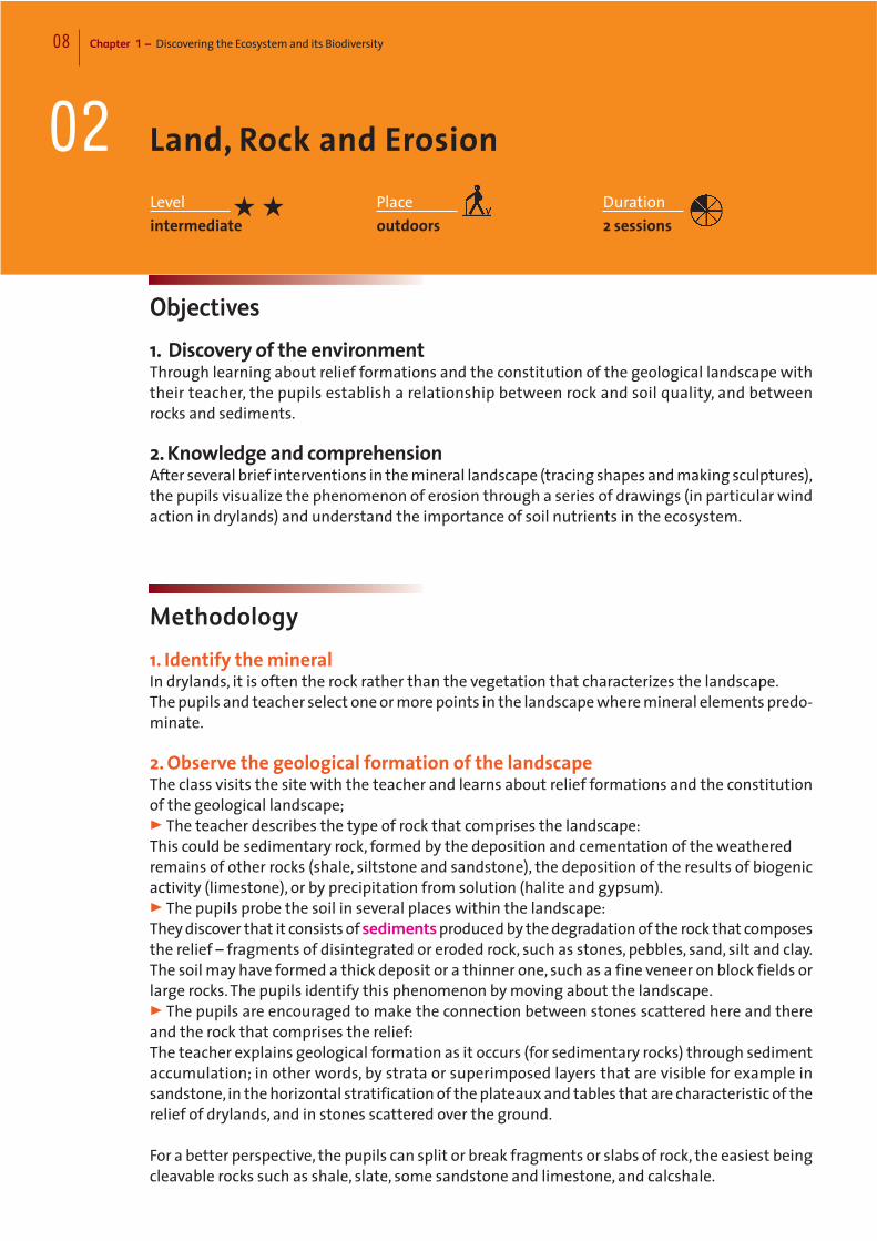
7. Dunes of the Namib Desert,
Swakopmund region, Namibia ©Yann Arthus-Bertrand La Terre vue du Ciel, UNESCO
8. Mountains at Brandberg West
(2,573m), Damaraland region,
Namibia©Yann Arthus-Bertrand La Terre vue du Ciel, UNESCO
7
8
10 Chapter 1 – Discovering the Ecosystem and its Biodiversity
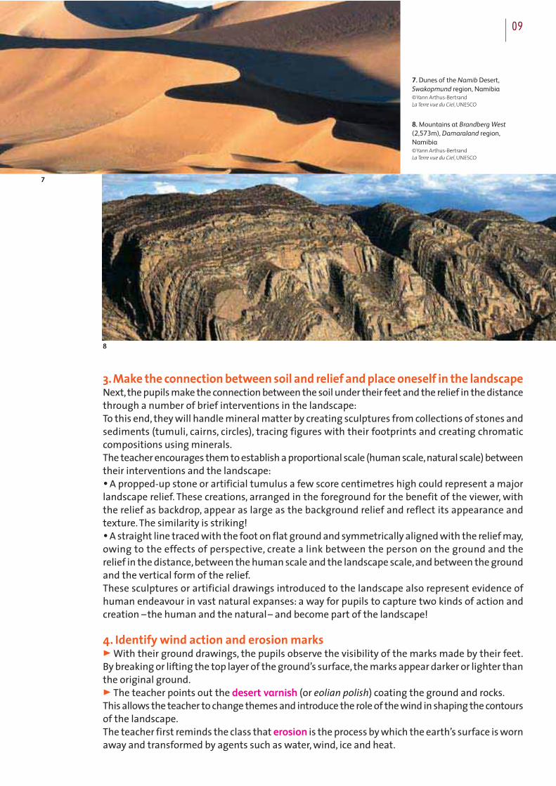
9. Eroded rock, Tamrit region,
Tassili N’Ajjer, Algeria, 2002©Olivier Brestin
10. Abandoned Tuareg camp,
Erg Admer, Tassili N’Ajjer, Algeria,
2002©Olivier Brestin
11. Ischigualasto geological
formation, Moon Valley, San Juan,
Argentina©UNESCO/Liliana Madrid de Zito Fontan
The teacher then explains that eolian erosion is the process by which winds erode the earth’scrust by wearing away rocks, thereby changing the contours of the relief.The teacher may use examples to illustrate corrasion – the abrasive effect of wind containinggrains of sand or quartz on landscape reliefs and ground surfaces.The teacher also explains defla-tion, the process by which winds lift and transport small particles from the ground, depositingthem to accumulate elsewhere (dune displacement).The teacher concludes by pointing out that, contrary to what one might expect in drylands,water erosion (fluvial erosion, seepage into the water table) is often more influencial on thelandscape than eolian erosion. None-the-less, eolian erosion is a form of surface erosion that isharmful to soil productivity. Finally, the teacher mentions the important role of thermal erosionin the fragmentation of rock blocks in drylands.
5. DrawThe pupils go on to identify one or more instances of eolian erosion and comprehend, throughdrawing, the “plastic” effect of winds on the landscape.Equipped with sketch pads, they may (depending on the location and context):> Capture the crumbling of the rock into worn rocks, or landscape reliefs made uneven by accu-mulated forms;> Portray the formation of dune masses by “sketching” the dunes according to the direction inwhich the crest is moving, one side in sunshine and the other in shadow,and highlight the whorlsand light contrast;> Draw “close-ups”(where the phenomenon exists) of jagged ridges emerging from soft groundor unusual (sometimes hollowed-out) rock contours;> Depict furrows made in the sand or in fossilized sandstone by the wind, by drawing parallelserpentine lines and using contrasting tones (light/dark).The bareness of the landscape is reflected throughout.
9
10
11

Teaching Resource Kit – Dryland Countries 11
1312
12. Cypress, Tamrit region,
Tassili N’Ajjer, Algeria, 2002©Olivier Brestin
13. Sand dunes, Hassi Khalifa region,
Algeria, 2002©Olivier Brestin
6. Interpret the drawings and understand the effect of eolian erosion on the environment> The teacher facilitates the interpretation of the drawings and explains how wind action is thecause of degradation in soil that is impoverished by drought or over-use by humankind.The (fertile) topsoil is blown away by deflation; the rock is scoured and exposed; living organismsbecome scarce.> The teacher establishes a causal relationship between absence of vegetation and intensity ofeolian erosion:wherever the earth is unprotected by vegetation, the wind easily carries sedimentsaway in the form of sand and dust clouds. And the more intense the deflation, the more it laysbare vast expanses of terrain, to the detriment of flora since plants cannot grow without soil(except lichens).
7. Identify an area of land that is protected from erosionThe pupils identify an area that is less bare or exposed to the wind than the areas they have justsurveyed.>What is it that protects the area from the wind? Its orientation? A relief? Human developments,such as green barriers of tree and bush plantations? Windbreaks or hedges made of branches orpalms? Is it a more humid area? A fertile area? A farming area, or an area of wild vegetation? >What are the constituents of non-sterile soil? In addition to sediments:humus,nutrients,water,air, identifiable living elements or organisms such as roots, worms, detritivorous organisms andother, invisible organisms such as mushroom filaments, bacteria and other micro-organisms.
8. Take earth samples from several locations and appraise its physical qualitiesThe pupils proceed to take soil samples from the various sites visited in the course of the exer-cise.These samples are conserved in transparent receptacles which serve to display their compo-sition, texture and colour.Examples:
Where soil is exhausted or has been swept away, the pupils can take a little sand, white if from gypsum terrain,
yellow or orange if the quartz in the sand is heavy in metal oxides. From other points in the landscape, they
can take thicker samples of silty or clayey earth (and show the various different qualities of clay). They may
also take a bit of mud from a riverbank or riverbed or from a watering hole.
The pupils conclude the sampling exercise by wetting their samples and rubbing them on to paperor material in order to show the different colours of the soils.

0312 Chapter 1 – Discovering the Ecosystem and its Biodiversity
An Inventory of Useful Plants
Objectives
1. Knowledge and comprehension By using drawings to create a picture inventory, pupils will gain a full understanding of the directuses of plants in many areas of community life.The pupils are encouraged to ask questions about harvesting methods, plant use and, by exten-sion, the consumption of natural resources.
2. AptitudesThe teacher encourages pupils to engage in real dialogue with holders of local knowledge in thecommunity.
Notes and suggestions:
For this laboratory workshop on the role of plants throughout their lifecycle, the pupils and teacher will use
either a separate room or the back of the classroom.
They mount three large panels of paper or cardboard onto the walls, thereby creating an area for an inven-
tory and plant display, a reception area and an area for tasting and small experiments (plant pots, dyeing).
The teacher leading the activity takes a holistic view of the relationship between human beings and their
environment (regarding the local population as playing an integral part in its ecosystem): as humans, we
receive a multitude of benefits and products from ecosystems which enhance our well-being and quality of
life. In this way, the ecosystem can be regarded as a source of crops and bounty for humankind, a garden in
the broadest sense from which the community picks its fruit.
The teacher may consider classifying the plants according to three themes illustrated by three wall panels:
A. The Nourishing Garden;
B. The Healing Garden;
C. The Protecting Garden.
Leveladvanced
Placeclassroomand outdoors
Duration6 sessions
★ ★ ★

Teaching Resource Kit – Dryland Countries 13
Methodology
The teacher divides the class into three groups of pupils, each responsible for one of the threepanels in the inventory of “plants useful to the community”.Each group considers how their wall panel will be arranged.The ceiling height provides room forthe pupils to hang specimens upside-down above each panel if necessary.The pupils begin classifying the plants according to their use:•Food;•Treatment, medicine and rituals (bodily health and spiritual well-being);•Raw materials for building homes (protective cover for the family) and making clothes (indivi-dual protection).Some plants have a number of uses and will therefore feature on several panels.In their groups, the pupils agree on how their wall panel will be arranged. With guidance from theteacher, they devise the sub-categories within each panel.
A. The Nourishing Garden
1. ClassifyThe pupils conduct an initial classification of edible plants of the region according to the followingcategories:•Edible bulbs, e.g. garlic, onion;•Edible stalks, e.g. overground, fleshy stalks such as Barbary fig (Opuntia) and fennel, and under-ground stalks (tubers) such as potatoes;•Edible roots, e.g. carrots and turnips;•Edible leaves, e.g. common garden cress;•Fleshy fruits:
- Berries or seeded fruits, e.g. jasmine berries, toothbrush tree berries (Salvadora persica), water-melon, courgette, African cucumber (belonging to the gourd family);- Drupes or single-seeded fruits, e.g. dates, olives, jojoba and karite fruit;•Dry fruits:
- Pods, e.g. all peas and beans (belonging to the legume family), including pigeon peas (Cajanuscajan), tamarind (Tamarindus indica), cow peas (Vigna unguiculata);- Grains, e.g. wheat, sorghum, millet, corn (belonging to the grass family);- Single-seeded dry fruits, e.g. the kermes oak acorn.In this way the pupils form an initial view of the natural resources available, whether cultivatedor non-cultivated plants.
2. Select one edible species> Each pupil chooses a plant and is asked to identify it in its natural environment and sketch ordraw it.> If it is a common species, the pupil may bring a specimen into class. The pupil takes a carefulcutting and hangs it to dry (in the case of a grass, for example). The pupil may also try to replanta young shoot (a Barbary fig cutting, for instance).
3. Draw on the wall panelEach pupil then classifies the plant according to the above-mentioned categories and producesa full-colour drawing straight onto the wall panel.The wall panel is divided into several sections corresponding to the various categories. The pupiltakes care to produce the drawing in the correct category.

14. Woman sorting wheat for cooking,
high-plateaux region, Bolivia©UNESCO/Pierre A. Pittet
15. Farm worker and labourer,
potato cultivation, Senegal, 1982©UNESCO/Pierre A. Pittet
16. Traditional production
of sun-dried tomatoes, Senegal, 1982©UNESCO/Pierre A. Pittet
17. Foggara irrigation,
Timimoun Oasis, Algeria, 2002©Olivier Brestin
18. Traditional production
of tomato concentrate, Senegal, 1982©UNESCO/Dominique Roger
19. Women carrying water
on their heads, India©UNESCO/Bernard Henry
20. Women crushing millet, Djenné,
Mali©UNESCO/Alexis N.Vorontzoff
14
15
16
18
19
20
17
4. TasteWhile one pupil draws on the panel, another tastes or asks other pupils to taste the plant inquestion. For the purposes of this exercise, it is recommended that only well-known edible speciesare selected.Blindfolding the pupils tasked with identifying the plant allows the teacher to test their ability torecognize flavours.Pupils may also bring food from home such as soup, fruit juice or samples of home-made recipes,which, owing to simple variants (such as cooking times or the inclusion of a particular herb), willallow them to rediscover the taste of a commonly used plant or one that, although well-known,has become increasingly neglected or under-used as it has become more rare.Note:
The teacher’s objective in this tasting exercise is to maximise opportunities to taste and identify the diffe-
rent flavours of well-known local plants (both commonly available and less so); In the case of non-cultivated
plants, this could mean seeking increasingly rare plant specimens.
5. Seek and integrate informationBack to the wall panel, the pupils add notes and information on the use of plants to their drawings:> Is it a cultivated/non-cultivated plant?> If cultivated, is it sown or planted?> Is it eaten raw or cooked?> Which adjectives can be used to describe the ‘taste’ of the plant?> Is it a common or rare species? > If it is a naturally growing plant,has it become more rare over time? Is it possible to gather infor-mation on the population growth of a particular species? (See glossary at the end of the activityor guidelines for more advanced work.)> Is it an endangered and/or protected species?> Does the plant contribute to nutritional diversification and development (by meeting specificnutritional requirements)? Note :
It is important that these written notes be graphically incorporated into the wall panel, be positioned around
the drawings, follow imaginary lines, vary in style depending on the sense and meaning and include symbols
indicating whether a plant is rare or endangered.
6. Discuss local plants and food production with resource peopleAt this point in the exercise the teacher encourages contact and interaction with at least twoholders of local ecological knowledge from among the population:•An elder (a respected member of the community) who has a good knowledge of local biodiver-sity as a source of complementary or replacement foodstuffs (and a source of income) in times ofadversity:• A farmer/breeder who understands the importance of cultivated plants in food productionand the role of indigenous plants in conserving the local ecosystem.The teacher encourages the class to engage in dialogue with these local actors. Discussionsfocus on the impact of the use and consumption of natural resources (particularly plants) on biodi-versity and food security:> Are non-cultivated plants becoming more rare in certain drylands? > What are the consequences of this decline in (and sometimes extinction of) species for thenutritional health of the local population and their means of survival?> How do land exhaustion (monoculture) and the alteration of natural habitats for agriculturalor rearing purposes pose a threat to plant conservation and, in fragile ecosystems in particular,a region’s food security?
Kit pédagogique – Zones arides 15

16 Chapter 1 – Discovering the Ecosystem and its Biodiversity
> How are local biodiversity and plants in particular essential to food production as a result ofthe functions they fulfil in the ecosystem?
B. The Healing Garden
1. Meet with an expert on plants and their propertiesThe pupils pay a visit to the traditional healer or herbalist, the community specialist in essentialoils and medicinal plants.The pupils ask the healer to take part in creating the second wall panel.The pupils ask the healer to present plant samples to the class and may also, if allowed, go withthe healer to pick samples.
2. Draw and record medicinal plants on the wall panel> Based on the specialist’s valuable input, the pupils classify the plants according to their thera-peutic or healing properties, draw them in full colour onto the wall panel and dry and hangspecimens from the ceiling.> For the division of the panel into sections, the plants are classified according to their proper-ties: tonic,antipyretic,purgative,diuretic… Teachers may simplify this vocabulary and describe theconditions cured by the plants instead.Examples:
In Africa, aniseed and fennel have multiple properties. Giant fennel is a painkiller and a purgative (helps
with waste elimination).
The bark of the baobab is antipyretic (reduces fever) and its leaves have a number of therapeutic uses,
specifically diuretic (increases urinary secretion), tonic, and as a cure for dysentery and lumbago. They are
also used as a foodstuff as an ingredient in sauces.
21
22
21. Desert oaks, Kata Tjuta region,
Northern Territory, Australia, 2001©Olivier Brestin
22. Termite nest, Kata Tjuta region,
Northern Territory, Australia, 2001©Olivier Brestin
23. Eucalyptus caesia,
New South Wales, Australia, 2001©Olivier Brestin
24. Aloe vera in bloom, La Gomera,
Canary Islands, Spain, 2003©Thomas Schaaf
25. Eucalyptus annulata flower,
Western Australia,
Australia 2001©Olivier Brestin

Teaching Resource Kit – Dryland Countries 17
The red flowered hibiscus (also known as carcadet or bissap) is a cultivated plant that produces a tea rich in
vitamin C (tonic).
3. Identify how healing and rituals are connected by plantsThe teacher introduces the sacred aspect of plants and encourages discussion.Are some plants used in rituals? Are they used in initiation rites, healing rituals and the protec-tion of spaces?The ritual use of each plant (for religious purposes or spiritual well-being) is described on the wallpanel in the above-mentioned therapeutic categories:Examples :
In some drylands, myrrh and incense are used in funeral ceremonies and purification and sacrificial rites.
Other species, planted at the entrance of houses or surrounding them in order to afford protection, are used
to mark territorial boundaries.
Sea squill bulbs (Urginea maritima) are used in the high Algerian plains as borders for agricultural plots.
The pupils can enhance the information on the wall panel by drawing the rituals as they imaginethem based on the anecdotes of the healer or herbalist. Here, as before, text and images work invisual harmony on the panel.
4. Explore the relationship between plants, cultural traditions and conservationFinally, the class explores the consumption of essential oils and medicinal plants and the impactof this consumption on the cultural traditions of healing and rituals.> Which non-destructive techniques can be used to pick precious non-cultivated plants?> How can we ensure their conservation?> Have there been cases of species extinction?> What are the consequences for cultural traditions?> To what extent does the herbalist or traditional healer’s vast knowledge constitute the livingmemory of links between local plant diversity and local customs and culture? > Can restoring local and indigenous knowledge in this particular respect contribute to the conser-vation of the ecosystem?
23 24
25

18 Chapter 1 – Discovering the Ecosystem and its Biodiversity
> Can the herbalist or healer transmit their knowledge across the generations via the classroom? > Does the value accorded to certain plants naturally lead to the protection of specific areas? > Are any of these areas recognized as sacred natural sites? Can these sites serve to inspire envi-ronmental conservation?
C. The Protecting Garden
As well as food, medicine and ritual ingredients, plants also provide shelter that affords “protec-tion and security”.The use of plants as a building material for dwellings is the subject of the thirdwall panel. Locally, however, fibres and bark can also be used to make clothing, another form ofprotection, and may therefore also be displayed on the wall panel.
1. Make a sketch of one’s own houseThe teacher asks the pupils to take a close look at their own homes and make a series of draw-ings and sketches on separate pieces of paper.Do different types of dwellings exist within villages in drylands?Is there any evidence of a shift from a nomadic lifestyle to a more settled one, or of an alterna-tion between the two lifestyles among the population?
2. Draw a typical local dwelling on the wall panelThe class compares the various drawings and chooses one that is representative of each type oflocal dwelling.The chosen drawing is then re-drawn in large on the wall panel.Other pupils use words and arrows to identify and clearly label the plants that the houses aremade of (for each dwelling type drawn on the wall panel).For nomadic dwellings:> What is a tent made of? Is it made entirely of animal materials, such as goats’ hair or cow, goator camel hide? What are “yurts” or “gers” made of, common in central Asia and still widely usedby nomads in Mongolia?> Is the nomadic dwelling easy to dismantle, such as a matted straw or latticed panel hut?Which plants are used?For sedentary dwellings:> Even if the hut is made of wood or clay (often called banco), are plants also used in its construc-tion? What is the roof covering made of?Example:
Thatched roofs, sometimes made of date palms but more often with grasses such as typhas (Typha australis
as found in Senegal, Algeria, Mauritania).
What kind of wood are the main beams made of?Which types of tree are most commonly used for this purpose?Example:
The date palm is commonly used, but if it is not available, which tree species are used instead? Acacia tortilis?
Acacia radiana?
If these tree species are rare, are any other tree species used?
> Are there any sedentary dwellings made entirely from plant materials?Examples:
Circular structures made from grasses are typical of some African regions.
A zeriba is a lightweight construction that can be made with different plants - straw, for example, or braided
or fenced foliage.

Teaching Resource Kit – Dryland Countries 19
3. Depict the dwelling in detailStill focusing on the depiction of the dwellings, another group of pupils produces detail sketchesof the main picture, highlighting the detail of the construction by drawing “close-ups” of braidsand fixation points or producing a series of sketches showing the stages of construction.They write down the names of plants turned into rope or thread in order to tie or fix items together.Examples:
Sisal (Agave sisalana) is a fibre extracted from the leaves of the agave, found in South America;
Needle grass (Stipa tenacissima) is common in the Mediterranean basin and in North Africa.
Gamba grass (Andropogon gayanus) is found in Sahelian Africa.
4.Make the connection between environmentally-adapted dwellings and naturalresourcesThe pupils describe the characteristics that show how the plants have adapted over time to theenvironment and climatic conditions.The population has learnt over time how to make use of these characteristics,by developing specificand accurate uses for the plants, for instance in the construction of dwellings.Which plants are best at providing shelter from the wind?Which plants are insect-resistant?Which plants protect from extreme heat and dryness?Examples:
Palm leaf spines arranged side by side allow air to circulate freely and keep the inside of the dwelling cool.
The information is either written or drawn directly onto the wall panel.
5. Conduct an overview of how plants are used in the construction of dwellingsFinally, the entire class discusses the important role of plants in improving the living standardsof dryland inhabitants.Wood is collected for house shells, for general construction and for producing mortar (such asAcacia albida or Gao in Africa). It is also collected for handicraft and furniture making. But thesevarious uses, along with the collection of firewood, also represent one of the principle causes ofthe deforestation that is largely responsible for the rarefaction and disappearance of the plant cover.Despite ever-increasing need, could it be possible to promote action and encourage behaviour tocurb or limit this trend? Which non-destructive methods can be used to cut down trees while maintaining the forests?> Using traditional wood-cutting techniques?
26 27
26. et 27. House and village,
Dogon Country, Mali, 1995©UNESCO/ Alfred Wolf

20 Chapter 1 – Discovering the Ecosystem and its Biodiversity
Example:
Selective pruning and trimming.
> Encouraging the conservation of natural resources through the selection and rational consump-tion of species according to need?The teacher demonstrates how,by its very nature and the many different functions it fulfils,speciesdiversity meets the specific needs of the population.> Promoting natural regeneration?Re-sowing,creating plantations and maintaining forests;avoiding cutting down young trees andshoots;controlling pasture zones by delimiting the perimeters of protected areas;providing alter-native, renewable energy sources such as solar power.> Finally, the teacher may consider the advantages and drawbacks of modern, urban buildingmaterials.Examples :
Cement and steel are industrially produced and sturdy. However, they are costly and consume both water
and energy.
Guidelines for more advanced work:
At various stages in the activity, or once it has been completed, it would be a worthwhile exercise to combine
this primarily visual and pictorial inventory with more scientific ones, compiled as part of national or regional
action programmes of countries that have ratified the United Nations Convention to Combat Desertification
(UNCCD).
With regard to the monitoring and evaluation of biodiversity, teachers are encouraged to consult scientific
databases such as the GTOS TEMS database, which provides an analysis of environmental quality indica-
tors in places around the world, the BRIM (Biosphere Reserves Integrated Monitoring) programme which is
managed by UNESCO’s Man and the Biosphere (MAB) Programme and the IUCN Red List of Threatened
Species, the world’s most comprehensive inventory of the global conservation status of plant and animal
species.
28. Holm oak
plantation,
Sidi-bel-Abbès
region, Algeria,
2002©Olivier Brestin

Activity n°1
Collecting Treasures
BiocenosisFrom the Greek “bios” (life) and “koïnos”(common, community). A community ofliving organisms (animal, vegetable andmicro-organisms) that coexist in a definedspace (biotope).
BiodiversityThe variability among living organismsfrom all sources (plants,animals and micro-organisms) on the earth, the variabilitywithin species and the variability amongthe ecological complexes of which theyare part. This includes diversity withinspecies, between species and of ecosys-tems.
BiotopeFrom the Greek “bios” (life) and “topos”(place).A defined natural area characterized byspecific geological,soil and climate condi-tions, of variable size, usually small, thatsupports animal and plant species thatare adapted to these conditions.Examples:ponds, humid grassland, pine forests.
Plant coverCollective vegetation covering the ground.
EcosystemAn interacting complex of a communityof living organisms and its physical,chemi-cal and geographical environment. Thus,air, land,water and living organisms,inclu-ding human beings, interact to form anecosystem.
HabitatA place that is home to a particular plantor animal species, and which provides allthat the species requires in order to live.
Activity n°2
Land, Rock and Erosion
Desert varnish (or eolian polish)Dark brown or orange patina coating thesurface of sand or rocks in the desert.Thepresence of metal oxides (iron, manga-nese) combined with wind action and solarradiation gives mineral particles and rocksthis colouring.
ErosionThe wearing away and transformation ofthe earth’s surface by water (rain, river,sea),ice or atmospheric agents (wind,heat,precipitations). Thus one refers to watererosion,eolian (wind) erosion and thermal(heat) erosion. This phenomenon is oftenaggravated by humankind (deforestation,agriculture, road-building) and results inthe transformation of the relief and thecarrying away of soils.
Eolian erosionThe wearing away and transformation ofthe earth’s surface through wind action.A form of surface erosion. It includes:Deflation, which denotes the lifting andtransporting of fine soil particles (smalland medium-sized grains of sand, dust);Corrasion,which denotes the mechanicaland abrasive effect of particle-laden wind(containing grains of sand and quartz,andice particles in polar regions) on reliefs andsoils.
HumusA complex mixture of organic substancesgenerated by the breakdown of plant(dead leaves) and animal debris by micro-organisms (invertebrates,bacteria,fungi)living in the soil.Humus is a dark, earthy substance that ispresent in topsoil and contributes to soilfertility by releasing nitrogen and othernutritive elements vital for plant growth.
NutrientsA nutritive substance (chemical elementsor compounds),either mineral or organic,that is vital to the functioning of all livingorganisms.The nutrients that are absorbed by plantsfor growth are phosphates, nitrates,mineral salts and potassium.
SedimentsMaterial resulting primarily from rockerosion (soil,sand,clay,gravel,blocks), thatis transported by various agents, such aswater, wind, ice and gravity, and which,once set down,becomes compressed andforms a rock. It may also originate fromorganic matter (shell or coral debris accu-mulation).
Activity n°3
An Inventory of Useful Plants
FirewoodWood that is used by the population asthe main source of domestic energy: forcooking and light.
ConservationThe protection of ecosystems,species andnatural resources against degradation anddestruction so that future generationsmight benefit from them. The conserva-tion of ecosystems, species and naturalresources can result in the planned mana-gement of their use by humankind.
United Nations Convention to CombatDesertification (UNCCD)International agreement adopted in 1994in Paris. 191 countries have ratified theConvention to date (2005).It aims to combatdesertification and mitigate the effects ofdrought in countries experiencing serious drought and/or desertification.The actionprogrammes of the Convention are desi-
gned to improve land productivity,restore(or conserve) soils, define the best use ofwater and achieve sustainable develop-ment in affected regions.
Single species population growthAn increase in the number of individualsbelonging to the same species measuredover time.The assessment is often conduc-ted in a single biotope.
DeforestationAll the processes by which humankind istransforming forest ecosystems and causingthem to disappear:overuse of wood,forestfires, farming of wooded areas.
ExtinctionThe entire disappearance of a species fromEarth.
MonocultureA form of agriculture consisting of plantinga single species over vast areas. Mono-culture is a cause of serious ecologicalimbalances, since it can result in soilerosion and encourages the proliferationof pests and diseases.
Indigenous plant (or local plant)A plant that grows naturally in a givengeographical area (a portion of the totalspecies range) and whose genetic mate-rial has adapted to that location.Where aplant exists only in a single location orregion in the world, it is known as anendemic plant (more restrictive).
Medicinal plantA plant used by humankind for therapeuticpurposes.
Natural resourcesMineral or biological elements for whichhumankind has found a use. The veryconcept of a resource implies use. Theseresources fall into two categories:•Non-renewable resources, consisting ofmineral raw materials, such as metals;•Renewable resources, that can be usedwithout being exhausted,in that their rateof removal is slower than their rate ofrenewal, such as forests.Today, there is a persistent and growingtrend towards exhaustion of the world’snatural resources.
Glossary

This document presents an extract of the teaching resource kit for environmentaleducation that is currently being developed by UNESCO’s Man and the Biosphere(MAB) Programme.Designed to be used in dryland countries, the kit is aimed at primary and secondaryschoolteachers and is based on an innovative approach appealing to the creativityand artistic sensibilities of pupils aged 6-15 approximately.Conceived with the aim of developing among younger generations the ability to combat desertification while endeavouring to conserve biodiversity, the content ofthe kit echoes the United Nations General Assembly declaration proclaiming 2006as the International Year of Deserts and Desertification. It is also consistent with theactivities developed as part of the Decade of Education for Sustainable Development(2005-2014), the promotion of which falls within UNESCO’s fields of competence.
UN
ESCO
A Creative Approach to Environmental Education