sydney metro, city & southwest aboriginal archaeological
TRANSCRIPT
AMBS Ecology & Heritage
www.ambs.com.au [email protected] 02 9518 4489
Sydney Metro, City & Southwest Aboriginal Archaeological Method Statement: Barangaroo, Martin Place, Pitt Street & Waterloo
Prepared by AMBS Ecology & Heritage for John Holland CPB Ghella JV
February 2018 AMBS Reference: 16315
Sydney Metro, City & Southwest Aboriginal Archaeological Method Statement
AMBS Ecology & Heritage II
Document Information
Citation:
AMBS Ecology & Heritage (2017) Sydney Metro, City & Southwest Aboriginal Archaeological Method Statement: Barangaroo, Martin Place, Pitt Street & Waterloo. Consultancy report to John Holland CPB Ghella JV.
AMBS Ref: 16315
Document Ref: 16315 AMS BAR.MAR.PIT.WAT-180202
Versions: Version 1: Draft Report issued 29 January 2018 Version 2: Final Report issued 2 February 2018
Recipient:
Robert Muir Senior Environment Coordinator
Tunnel and Station Excavation Works Sydney Metro City & Southwest
Approved by: Christopher Langeluddecke, Director Aboriginal Heritage, AMBS Ecology & Heritage
Sydney Metro, City & Southwest Aboriginal Archaeological Method Statement
AMBS Ecology & Heritage III
Contents 1 Introduction ....................................................................................................... 1
1.1 Aboriginal Community Consultation ...................................................................................... 2 1.2 Methodology & Authorship ................................................................................................... 3
2 Study Areas ....................................................................................................... 4 2.1 Barangaroo Station ................................................................................................................ 4 2.2 Martin Place Station .............................................................................................................. 4 2.3 Pitt Street Station North & South .......................................................................................... 4 2.4 Waterloo Station .................................................................................................................... 5
3 Archaeological Context ..................................................................................... 11 3.1 Barangaroo Station .............................................................................................................. 11
3.1.1 Additional Information ................................................................................................. 12 3.1.2 Contamination Investigations ...................................................................................... 13
3.2 Martin Place Station ............................................................................................................ 16 3.2.1 Additional Information ................................................................................................. 16
3.3 Pitt Street Station................................................................................................................. 17 3.4 Waterloo Station .................................................................................................................. 17
3.4.1 Additional Information ................................................................................................. 18 3.4.2 Contamination Investigations ...................................................................................... 19
4 Research Design ................................................................................................ 21 4.1 Research Questions ............................................................................................................. 21
5 Archaeological Methodology ............................................................................. 22 5.1 Archaeological Inspection & Liaison with Historical Archaeological Investigations ............ 22 5.2 Stage 1 Test Excavation ....................................................................................................... 22 5.3 Stage 2 Salvage Excavation .................................................................................................. 24 5.4 Post Excavation Analysis & Reporting .................................................................................. 25 5.5 Storage of Aboriginal Objects .............................................................................................. 25 5.6 Human Remains ................................................................................................................... 26
Bibliography ............................................................................................................ 27
Tables Table 3.1 Summary of archaeological potential and significance for Barangaroo Station study area
(Artefact 2016a:101). .................................................................................................................. 12 Table 3.2 Contamination borehole information at Barangaroo Station study area. .......................... 14 Table 3.3 Summary of archaeological potential and archaeological significance at Martin Place Station
study area (Artefact 2016a:101). ................................................................................................ 16 Table 3.4 Summary of archaeological potential and archaeological significance at the Pitt Street
Station study areas (Artefact 2016a:101-102). ........................................................................... 17 Table 3.5 Summary of archaeological potential and archaeological significance at Waterloo Station
study area (Artefact 2016a:102). ................................................................................................ 18 Table 3.6 Contamination borehole and test pit information at Waterloo Station study area. .......... 19
Figures Figure 1.1 Sydney Metro Chatswood to Sydenham tunnel and station excavation locations (Sydney
Metro Transport for NSW [TfNSW]). ............................................................................................. 2 Figure 2.1 Barangaroo Station study area. ........................................................................................... 6 Figure 2.2 Martin Place Station study area, including extent of basements. ....................................... 7 Figure 2.3 Pitt Street North Station study area, including extent of basements. ................................. 8 Figure 2.4 Pitt Street South Station study area, including extent of basements. ................................. 9 Figure 2.5 Waterloo Station study area, including extent of basements. .......................................... 10
Sydney Metro, City & Southwest Aboriginal Archaeological Method Statement
AMBS Ecology & Heritage IV
Figure 3.1: The approximate location of the Barangaroo Station study area in relation to the eastern foreshore of Cockle Bay, as presented in James Meehan’s 1807 plan of Sydney (Plan of the Town of Sydney in New South Wales, National Library of Australia [NLA] http://nla.gov.au/nla.obj-229911438/view in Casey and Lowe 2017:30) ............................................................................ 13
Figure 3.2 Barangaroo Station geotechnical and contamination testing locations. ........................... 15 Figure 3.3 Waterloo Station geotechnical and contamination testing locations. .............................. 20
Sydney Metro, City & Southwest Aboriginal Archaeological Method Statement
AMBS Ecology & Heritage 1
1 Introduction
The Sydney Metro & City Southwest project is 30km of a new rail system from Chatswood to Bankstown and includes a new crossing beneath Sydney Harbour, and new railway stations. The scope includes Tunnels and Station Excavation (TSE) construction works associated with the following stations, dives and shafts:
• Chatswood
• Artarmon
• Crows Nest
• Victoria Cross (North Sydney)
• Blues Point
• Barangaroo
• Martin Place
• Pitt Street
• Waterloo
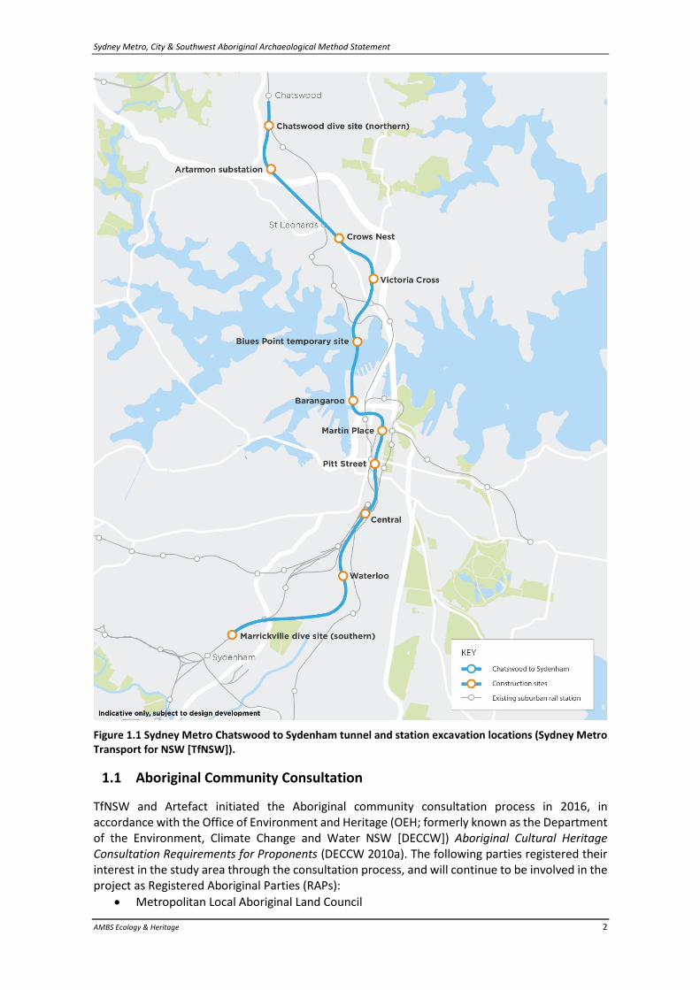
• Marrickville (see Figure 1.1) The Project was approved by the Minster for Planning on 9 January 2017, subject to a number of Conditions set out in Critical State Significant Infrastructure [CSSI] Sydney Metro & Southwest Chatswood to Sydenham Infrastructure Approval (Application no. SSI 15_7400) (Project Planning Approval). Tunnelling works will remove any Aboriginal heritage objects that may be present at each of the sites. Documentation for the project includes Sydney Metro Chatswood to Sydenham Aboriginal Heritage – Archaeological Assessment (EIS Technical Paper 5) and Sydney Metro Chatswood to Sydenham Aboriginal Cultural Heritage Assessment (ACHA) prepared by Artefact Heritage (Artefact). Minister’s Condition of Approval (CoA) E17 refers to the following requirements addressing Aboriginal heritage:
Aboriginal Heritage
E23 The Proponent must take all reasonable steps so as not to harm, modify or otherwise impact any Aboriginal object associated with the CSSI except as authorised by this approval.
E24 Before excavation, the Proponent must implement the Aboriginal Cultural Heritage Assessment prepared for the CSSI and included in the PIR. Excavation and/or salvage must be undertaken by a qualified archaeologist in consultation with the Registered Aboriginal Parties for the CSSI.
E25 Where previously unidentified Aboriginal objects are discovered during construction of the CSSI, construction must stop in the vicinity of the affected area and a suitably qualified and experienced Aboriginal heritage expert must be contacted to provide specialist heritage advice, before works recommence. The measures to consider and manage this process must be specified in the Heritage Management sub-plan required by Condition C3 and, where relevant, include registration in the OEH’s Aboriginal Heritage Information Management System (AHIMS).
John Holland CPB Ghella Joint Venture (JHCPBG) is undertaking the TSE works and has commissioned AMBS Ecology & Heritage (AMBS) to manage the Aboriginal heritage provisions for the project. This Aboriginal Archaeological Method Statement (AMS) has been prepared in accordance with Condition E24 and the requirements of the ACHA, and addresses the Barangaroo Station, Martin Place Station, Pitt Street Station, and Waterloo Station project areas.
Sydney Metro, City & Southwest Aboriginal Archaeological Method Statement
AMBS Ecology & Heritage 2
Figure 1.1 Sydney Metro Chatswood to Sydenham tunnel and station excavation locations (Sydney Metro Transport for NSW [TfNSW]).
1.1 Aboriginal Community Consultation
TfNSW and Artefact initiated the Aboriginal community consultation process in 2016, in accordance with the Office of Environment and Heritage (OEH; formerly known as the Department of the Environment, Climate Change and Water NSW [DECCW]) Aboriginal Cultural Heritage Consultation Requirements for Proponents (DECCW 2010a). The following parties registered their interest in the study area through the consultation process, and will continue to be involved in the project as Registered Aboriginal Parties (RAPs):
• Metropolitan Local Aboriginal Land Council
Sydney Metro, City & Southwest Aboriginal Archaeological Method Statement
AMBS Ecology & Heritage 3
• Darug Land Observations
• Tocomwall Pty Ltd
• Darug Aboriginal Cultural Heritage Assessments
• Kamilaroi-Yankuntjatjara Working Group
• Woronora Plateau Gungangara Elders Council
• Murra Bidgee Mullangari Aboriginal Corporation
• Aboriginal Archaeology Service Inc
• Gundungurra Tribal Technical Services
• Tony Williams
• Bilinga Cultural Heritage Technical Services
• Gunyuu Cultural Heritage Technical Services
• Mynyunga Cultural Heritage Technical Services
• Murrumbul Cultural Heritage Technical Services
• Wingikara Cultural Heritage Technical Services Consultation and engagement will continue with the established RAPs, and draft reporting, including reports produced following any archaeological excavations undertaken will be provided to all RAPs following client approval, for their review and input. Aboriginal community representatives participating in fieldwork will be drawn from these RAP organisations, based on experience, availability, and the advice of the TfNSW Metro Aboriginal Focus Group.
1.2 Methodology & Authorship
This report is consistent with the principles and guidelines of the Burra Charter: The Australia ICOMOS Charter for Places of Cultural Significance 2013. It has been prepared in accordance with current heritage best practice and OEH guidelines as specified in the Guide to Investigating, Assessing and Reporting on Aboriginal Cultural Heritage in NSW (OEH 2011), the Code of Practice for Archaeological Investigation of Aboriginal Objects in NSW and the Aboriginal Cultural Heritage Consultation Requirements for Proponents 2010 (DECCW 2010a; 2010b). The report has been prepared by Christopher Langeluddecke, AMBS Director Aboriginal Heritage. AMBS Archaeologist Jenna Weston reviewed this report for consistency and quality.
Sydney Metro, City & Southwest Aboriginal Archaeological Method Statement
AMBS Ecology & Heritage 4
2 Study Areas
2.1 Barangaroo Station
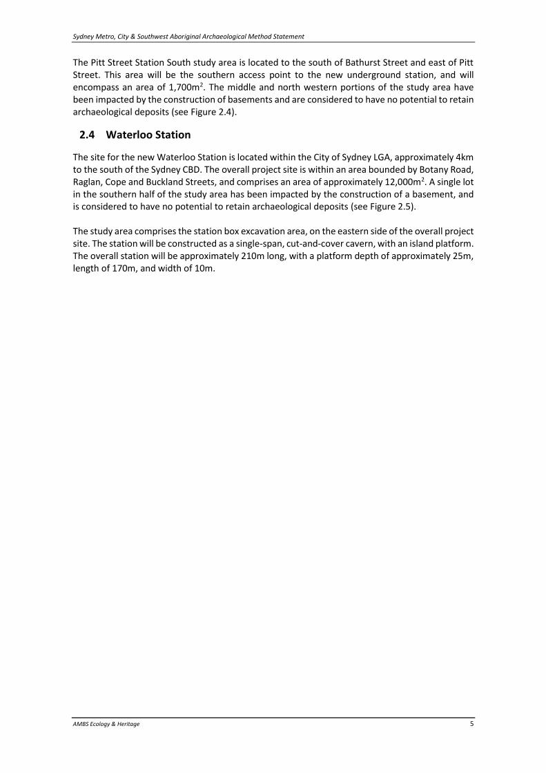
The site of the new Barangaroo Station comprises areas to be excavated for the construction of the new underground station within the road reserve of Hickson Road Barangaroo and the adjacent Barangaroo development area, within the City of Sydney Local Government Area (LGA). The site covers approximately 13,800m2, and the station platform will be located beneath Hickson Road, with access points and associated ancillary areas west of the road, in the Barangaroo development area (Figure 2.1). The Barangaroo Station site will be used during tunnelling for the project for launching and support of the tunnel-boring machine (TBM) for the Sydney Harbour crossing to Blues Point, and for retrieval of the cutter heads and shields of the TBMs from the Marrickville Dive site. The station will be constructed as a single-span, cut-and-cover cavern, with an island platform. The overall station will be approximately 210m long, with a platform depth of approximately 25m, length of 170m, and width of 10m. Station entries will be located to the west of Hickson Road.
2.2 Martin Place Station
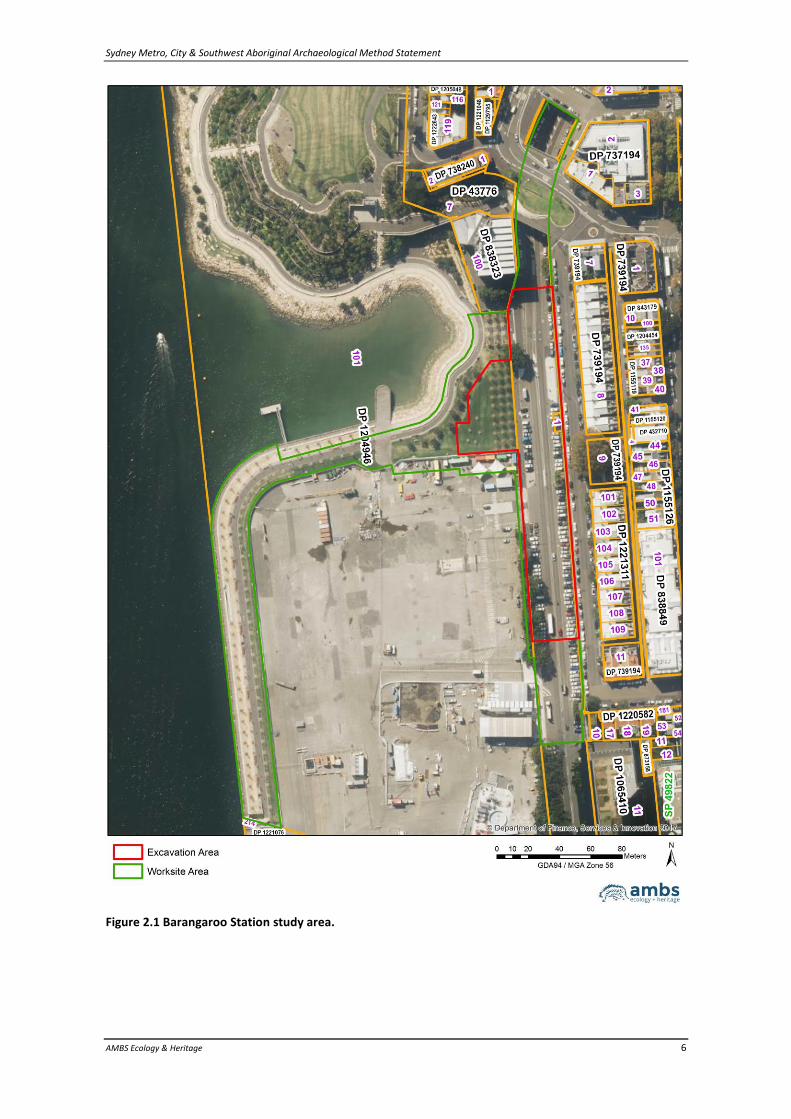
The site for the new Martin Place Station is located within the City of Sydney LGA, in the Sydney CBD. The project area comprises two construction areas at Martin Place: one approximately 2,800m2 in size located to the north of Martin Place, bounded by Castlereagh, Hunter and Elizabeth Streets; and one approximately 2,000m2 in size located to the south of Martin Place, bounded by Castlereagh and Elizabeth Streets. The entirety of the study area has been impacted by the construction of basements, including the extent of the existing suburban and intercity Martin Place Station, and is considered to have no potential to retain archaeological deposits (Figure 2.2). The station will be constructed as a mined binocular cavern, with two single side platforms. The overall station will be approximately 200m long, with a platform depth of approximately 25m at the northern end and 27m at the southern end, a length of 170m, and width of 6m on each platform. An underground pedestrian link to the existing suburban and intercity Martin Place Station Platform will be included, and an underground connection to 33 Bligh Street is also proposed.
2.3 Pitt Street Station North & South
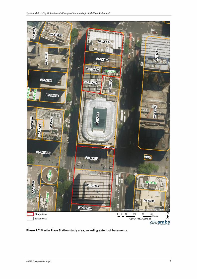
The site for the new Pitt Street Station is located within the City of Sydney LGA, in the Sydney CBD. Pitt Street Station comprises two separate study areas to be excavated as surface access points to a new underground station. At both the north and south study areas, the required shaft excavation will comprise the majority of the footprint of each site. The underground station will be constructed as a mined binocular cavern, with two single side platforms. The overall station will be approximately 200m long, with a platform depth of approximately 17m at the northern end and 20m at the southern end, a length of 170m, and width of 5m on each platform. The Pitt Street Station North study area is located on the north side of Park Street, between Pitt Street and Castlereagh Street Sydney. It comprises an area to be excavated as a northern access point to the new underground station, and will encompass an area of approximately 3,100m2. The eastern portion of the study area has been impacted by the construction of basements, including an underground car park, and is considered to have no potential to retain archaeological deposits (see Figure 2.3).
Sydney Metro, City & Southwest Aboriginal Archaeological Method Statement
AMBS Ecology & Heritage 5
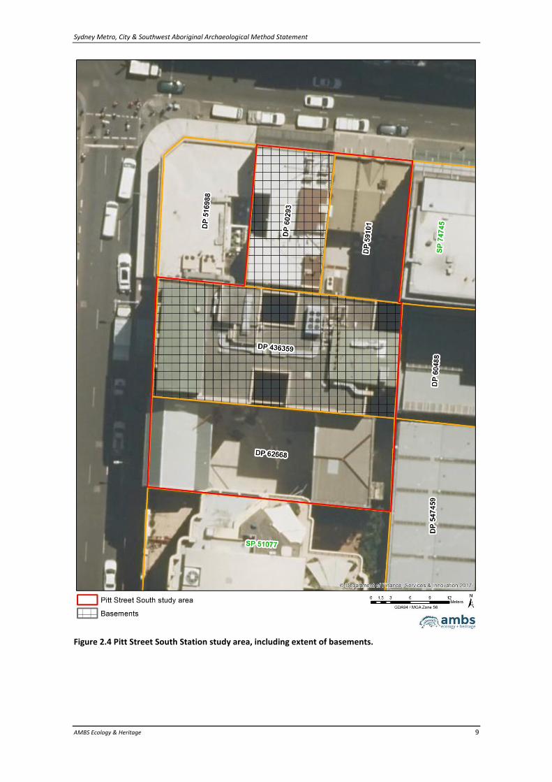
The Pitt Street Station South study area is located to the south of Bathurst Street and east of Pitt Street. This area will be the southern access point to the new underground station, and will encompass an area of 1,700m2. The middle and north western portions of the study area have been impacted by the construction of basements and are considered to have no potential to retain archaeological deposits (see Figure 2.4).
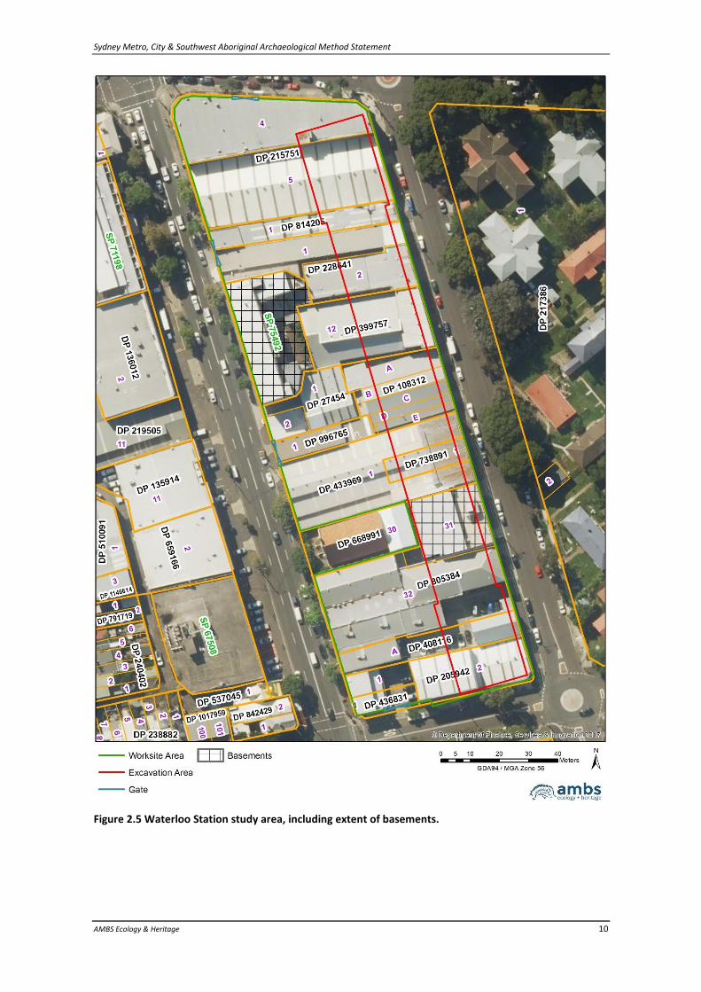
2.4 Waterloo Station
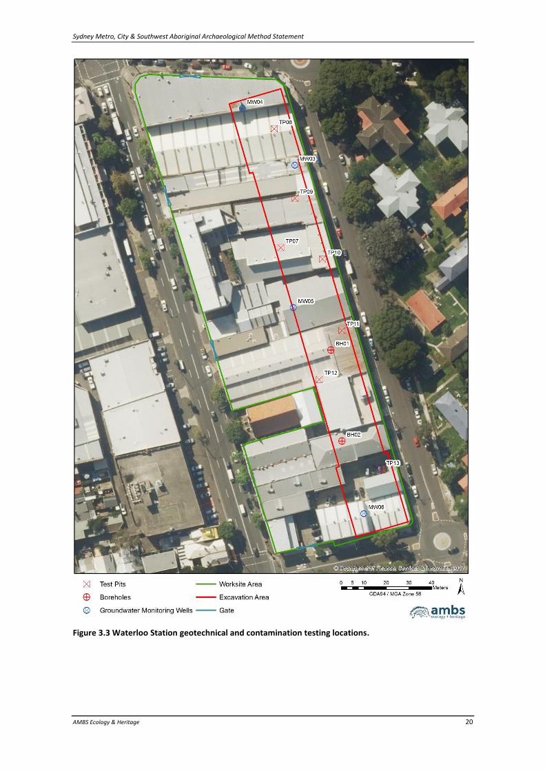
The site for the new Waterloo Station is located within the City of Sydney LGA, approximately 4km to the south of the Sydney CBD. The overall project site is within an area bounded by Botany Road, Raglan, Cope and Buckland Streets, and comprises an area of approximately 12,000m2. A single lot in the southern half of the study area has been impacted by the construction of a basement, and is considered to have no potential to retain archaeological deposits (see Figure 2.5). The study area comprises the station box excavation area, on the eastern side of the overall project site. The station will be constructed as a single-span, cut-and-cover cavern, with an island platform. The overall station will be approximately 210m long, with a platform depth of approximately 25m, length of 170m, and width of 10m.
Sydney Metro, City & Southwest Aboriginal Archaeological Method Statement
AMBS Ecology & Heritage 6
Figure 2.1 Barangaroo Station study area.
Sydney Metro, City & Southwest Aboriginal Archaeological Method Statement
AMBS Ecology & Heritage 7
Figure 2.2 Martin Place Station study area, including extent of basements.
Sydney Metro, City & Southwest Aboriginal Archaeological Method Statement
AMBS Ecology & Heritage 8
Figure 2.3 Pitt Street North Station study area, including extent of basements.
Sydney Metro, City & Southwest Aboriginal Archaeological Method Statement
AMBS Ecology & Heritage 9
Figure 2.4 Pitt Street South Station study area, including extent of basements.
Sydney Metro, City & Southwest Aboriginal Archaeological Method Statement
AMBS Ecology & Heritage 10
Figure 2.5 Waterloo Station study area, including extent of basements.
Sydney Metro, City & Southwest Aboriginal Archaeological Method Statement
AMBS Ecology & Heritage 11
3 Archaeological Context
The archaeological context of the project areas has been researched and addressed in the EIS Technical Paper and ACHA, which should be referred to for detailed information on the heritage context and archaeological background which underpins this AMS. Summaries of those investigations are presented below, along with additional information gathered through research carried out for the historic archaeological investigations, and geotechnical and contamination investigations for the project areas.
3.1 Barangaroo Station
The original landscape of the Barangaroo study area is likely to have consisted of a rocky shoreline, which would have represented an important resource zone for Aboriginal people. The study area has been significantly altered since European contact, with progressive land reclamation and wharf construction along the shoreline leading to the current extent of the Darling Harbour shoreline throughout the 19th and 20th centuries. In addition, much of the current alignment of Hickson Road on the eastern extent of the study area is located along a cutting into the natural Hawkesbury Sandstone slope. Geotechnical boreholes investigating an area to the west of Hickson Road, within the original harbour extent, identified that the underlying material in that area comprises up to 0.5m of fill material overlying up to 6.5m of reclamation material. No previously identified Aboriginal heritage sites have been recorded within 100m of the study area on the OEH Aboriginal Heritage Information Management System (AHIMS) database. The nearest identified Aboriginal heritage sites recorded on AHIMS are an open camp site approximately 300m north (AHIMS #45-6-0519), and a rock engraving approximately 180m north (AHIMS #45-6-1939. Excavation of AHIMS #45-6-0519 undertaken in 1984 identified shell midden material overlying approximately 30cm of grey sand with stone artefacts. Shell species recovered by the excavations included Rock and Mud Oyster (Saccostrea sp. and Ostrea sp.), cockle (Anadara trapezia), whelk (Pyrazus ebininus) and mussel (Trichomya sp.). Approximately 392 silcrete, quartz, quartzite and chert stone artefacts were recovered, including cores, used flakes and fabricators. In addition, the presence of ceramic fragments in association with the grey sand suggested continued Aboriginal use of the site following European contact. A preliminary summary of archaeological potential and archaeological significance of the study area as assessed by Artefact in the EIS Technical Paper is presented in Table 3.1. The assessment of potential and significance assumes that archaeological deposits are present within the study area.
Sydney Metro, City & Southwest Aboriginal Archaeological Method Statement
AMBS Ecology & Heritage 12
Table 3.1 Summary of archaeological potential and significance for Barangaroo Station study area (Artefact 2016a:101).
Location Archaeological potential Archaeological significance
Barangaroo Station
Moderate to high – Archaeological potential has been identified within the western portion of the Barangaroo Station footprint. This archaeological potential relates to the possible survivability of buried shell midden deposits associated with the original shoreline of Darling Harbour. The eastern portion of the Barangaroo Station footprint does not demonstrate archaeological potential due to the large-scale removal of the original sandstone context.
Potentially high – Intact Aboriginal archaeological deposits within the Sydney CBD are extremely rare and would be of high research significance. It is also possible that out-of-context Aboriginal artefacts may be present in the layers of fill used in the area. Any such artefacts would not likely demonstrate high archaeological significance as they would not have potential to provide accurate information or answers to relevant research questions.
3.1.1 Additional Information
Additional historic research into the Barangaroo Station study area undertaken by Casey and Lowe for the historic Archaeological Management Statement has clarified the historic context of the site, and confirmed an extensive history of development and land reclamation within the project footprint (Casey and Lowe 2017). The majority of the study area was below the low-water mark prior to European development in the area. The approximate location of the original shoreline in relation to the study area is presented in Figure 3.1. Reclamation and development began to encroach into the harbour from the 1830s, with wharves, jetties, warehouses and stores being established along the foreshore. A quarry was active in the south of the study area from the 1840s until at least the 1850s. During the 1950s, finger wharves were infilled, significantly expanding the land reclamation in the study area (Casey and Lowe 2017:27,32,45). In 1909 Hickson Road was constructed, which required cutting back of the natural sandstone cliff face, creating the High Street Cutting adjacent to (east of) the study area. In areas without solid natural stone foundations, Hickson Road was constructed through pouring of a six-inch (15cm) thick concrete foundation over a four-inch (10cm) thick foundation of blue metal (Casey and Lowe 2017:42).

Sydney Metro, City & Southwest Aboriginal Archaeological Method Statement
AMBS Ecology & Heritage 13
Figure 3.1: The approximate location of the Barangaroo Station study area in relation to the eastern foreshore of Cockle Bay, as presented in James Meehan’s 1807 plan of Sydney (Plan of the Town of Sydney in New South Wales, National Library of Australia [NLA] http://nla.gov.au/nla.obj-229911438/view in Casey and Lowe 2017:30)
3.1.2 Contamination Investigations
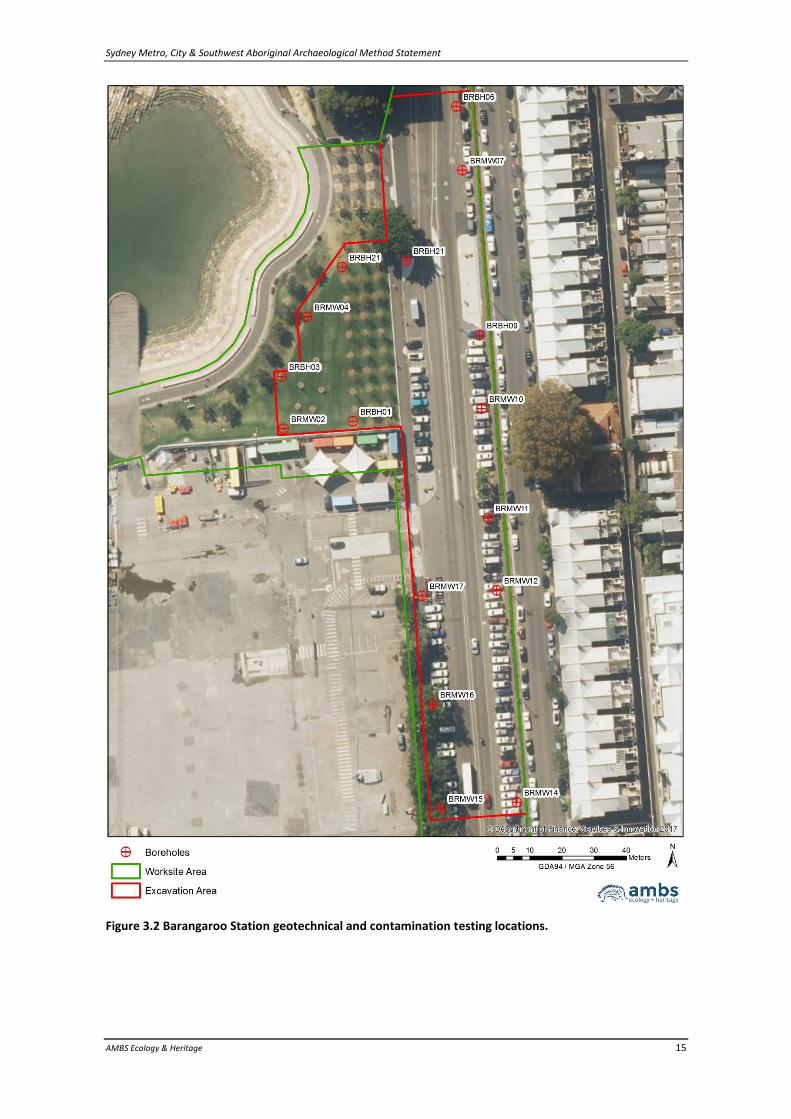
A series of boreholes was excavated along the eastern side of Hickson Road by Douglas Partners Pty Ltd in November 2017, to allow pre-construction testing and classification of contamination at the site. Profiles excavated within the boreholes showed that soils in the areas tested are limited to concrete and gravel road base materials over gravel and sand fill materials, placed directly onto sandstone. No evidence of natural soils was identified (see Table 3.2 and Figure 3.2). The results from the contamination testing indicate that the eastern portion of Hickson Road has been extensively disturbed by the construction of the road, which required cutting into the sandstone to level the area for construction. Archaeological deposits in the eastern portion of Hickson Road are likely to have been removed where this has occurred, however where the level of the shoreline was such that it required infilling prior to road construction, Aboriginal
Sydney Metro, City & Southwest Aboriginal Archaeological Method Statement
AMBS Ecology & Heritage 14
archaeological deposits or natural sandstone surfaces with potential to retain engravings or rock art may remain relatively undisturbed beneath fill materials.
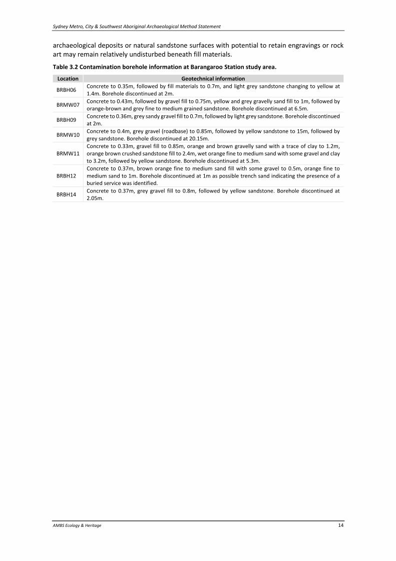
Table 3.2 Contamination borehole information at Barangaroo Station study area.
Location Geotechnical information
BRBH06 Concrete to 0.35m, followed by fill materials to 0.7m, and light grey sandstone changing to yellow at 1.4m. Borehole discontinued at 2m.
BRMW07 Concrete to 0.43m, followed by gravel fill to 0.75m, yellow and grey gravelly sand fill to 1m, followed by orange-brown and grey fine to medium grained sandstone. Borehole discontinued at 6.5m.
BRBH09 Concrete to 0.36m, grey sandy gravel fill to 0.7m, followed by light grey sandstone. Borehole discontinued at 2m.
BRMW10 Concrete to 0.4m, grey gravel (roadbase) to 0.85m, followed by yellow sandstone to 15m, followed by grey sandstone. Borehole discontinued at 20.15m.
BRMW11 Concrete to 0.33m, gravel fill to 0.85m, orange and brown gravelly sand with a trace of clay to 1.2m, orange brown crushed sandstone fill to 2.4m, wet orange fine to medium sand with some gravel and clay to 3.2m, followed by yellow sandstone. Borehole discontinued at 5.3m.
BRBH12 Concrete to 0.37m, brown orange fine to medium sand fill with some gravel to 0.5m, orange fine to medium sand to 1m. Borehole discontinued at 1m as possible trench sand indicating the presence of a buried service was identified.
BRBH14 Concrete to 0.37m, grey gravel fill to 0.8m, followed by yellow sandstone. Borehole discontinued at 2.05m.
Sydney Metro, City & Southwest Aboriginal Archaeological Method Statement
AMBS Ecology & Heritage 15
Figure 3.2 Barangaroo Station geotechnical and contamination testing locations.
Sydney Metro, City & Southwest Aboriginal Archaeological Method Statement
AMBS Ecology & Heritage 16
3.2 Martin Place Station
The Martin Place Station study area is located in an extensively disturbed built urban environment, and the footprint includes the current entrance to Martin Place Station. The original landscape of the study area is likely to have consisted of a gentle slope landform, within the Tank Stream catchment area. Previous geotechnical boreholes excavated on Pitt Street and Castlereagh Street near the study area have shown up to 2.3m of fill overlying residual clayey sand, suggesting that remnant A horizon with potential to retain in situ archaeological deposits has been removed from those locations. No previously identified Aboriginal heritage sites have been recorded within 100m of the study area on the OEH AHIMS database. The nearest identified Aboriginal heritage site recorded on AHIMS is site #45-6-2581, a sub-surface archaeological deposit approximately 200m west of the Martin Place study area at Angel Place. Archaeological excavations undertaken at Angel Place and at William Street, approximately 750m southeast of the study area, have indicated that it is possible for Aboriginal archaeological deposits to survive in sub-surface contexts within the Sydney CBD. However, both of those sites had been preserved by the significant deposition of fill prior to building construction, and neither building had deep excavations for a basement. The study area’s location within the Tank Stream catchment, and within 250m of the stream itself, suggests that the site had potential to retain Aboriginal archaeological deposits where it had not experienced significant impacts and excavations. However, the area has been significantly impacted through the development of the current extent of Martin Place Station, construction of large numbers of buildings with underground basements and car parks to the north and south of Martin Place, and installation of underground services throughout the study area. A preliminary summary of archaeological potential and archaeological significance of the study area as assessed by Artefact in the EIS Technical Paper is presented in Table 3.3. The assessment of potential and significance assumes that archaeological deposits are present within the study area.
Table 3.3 Summary of archaeological potential and archaeological significance at Martin Place Station study area (Artefact 2016a:101).
Location Archaeological potential Archaeological significance
Martin Place Station
Moderate to high – Discrete portions of surviving archaeological deposit containing Aboriginal objects may occur in very small areas. The location of Martin Place Station within the Tank Stream catchment and within 250 metres of that watercourse suggests potential for Aboriginal objects below the ground surface in areas that have not been significantly impacted or excavated (for example, during the construction of building basements and / or underground car parks).
Potentially high – Intact Aboriginal archaeological deposits within the Sydney CBD are extremely rare and would be of high research significance. It is also possible that out-of-context Aboriginal artefacts may be present in the layers of fill used in the area. Any such artefacts would not likely demonstrate high archaeological significance as they would not have potential to provide accurate information or answers to relevant research questions.
3.2.1 Additional Information
Review of the current buildings and development within the Martin Place Station study area has identified that it is likely that the entirety of the area has been impacted by basements and similar underground disturbances, including the construction of the current Martin Place Railway Station. All of the buildings presently within the footprint of the study area have basements, which will have removed any potential for archaeological deposits to remain intact and present. In addition,
Sydney Metro, City & Southwest Aboriginal Archaeological Method Statement
AMBS Ecology & Heritage 17
the construction of Martin Place Station in 1979 included an extensive below-ground concourse, which was constructed using cut-and-cover excavation, and is also likely to have completely removed any archaeological deposits which may have been present.
3.3 Pitt Street Station
The Pitt Street Station North and South study areas are located in an extensively disturbed built environment. The original landscape of the study areas is likely to have consisted of low-lying gently sloping areas, associated with swampy lands at the headwaters of the Tank Stream. Previous geotechnical boreholes excavated on Pitt Street and Castlereagh Street demonstrated that those areas contain approximately 2m of fill overlying residual clays. The results were interpreted to suggest that the deep fill layers beneath the streets are associated with underground service installation, and that A horizon soil contexts with potential to retain Aboriginal archaeological deposits have been removed at the two borehole locations. No Aboriginal sites have previously been recorded within 100m of the Pitt Street Station study areas. The closest previously recorded Aboriginal sites are AHIMS site #45-6-2838, a sub-surface archaeological deposit approximately 380m to the northwest, and AHIMS site #45-6-2637, a PAD site approximately 380m to the southwest. The study area’s location in a low-lying and gently sloping area within the Tank Stream catchment, and within 250m of the stream itself, suggests that the site had potential to retain Aboriginal archaeological deposits where it had not experienced significant impacts and excavations. The heavily built environment suggests that natural deposits and archaeological deposits within sections of the study area may have been impacted or removed through construction of buildings and basements, and installation of underground services. However, impacts to soils across the site not subject to significant excavations will vary, and discrete areas of surviving Aboriginal archaeological deposits may occur. A preliminary summary of archaeological potential and archaeological significance of the study area as assessed by Artefact in the EIS Technical Paper is presented in Table 3.4. The assessment of potential and significance assumes that archaeological deposits are present within the study area.
Table 3.4 Summary of archaeological potential and archaeological significance at the Pitt Street Station study areas (Artefact 2016a:101-102).
Location Archaeological potential Archaeological significance
Pitt Street Station
Moderate to high – The location of Pit Street Station in a low-lying and gently sloping area around the headwaters of the Tank Stream suggests potential for Aboriginal objects below the ground surface in areas that have not been significantly impacted or excavated (for example, during the construction of building basements and / or underground car parks).
Potentially high – Intact Aboriginal archaeological deposits within the Sydney CBD are extremely rare and would be of high research significance. It is also possible that out-of-context Aboriginal artefacts may be present in the layers of fill used in the area. Any such artefacts would not likely demonstrate high Archaeological significance as they would not have potential to provide accurate information or answers to relevant research questions.
3.4 Waterloo Station
The Waterloo Station study area is located in an urban environment, occupied prior to demolition for the Metro project primarily by commercial warehouse/office and storage buildings. The study area is situated in the northwestern portion of a large Quaternary sand sheet, which covered the local area.
Sydney Metro, City & Southwest Aboriginal Archaeological Method Statement
AMBS Ecology & Heritage 18
Prior to land clearing and development, large sand dunes were present from Waterloo east to the coast, and south to Botany Bay. Historic records indicated that the sand sheet at Moore Park, east of the study area, was subject to extensive erosion and deflation following vegetation clearance, and such impacts may have also occurred in the study area following land clearing. Previous geotechnical information obtained from boreholes at four locations in the vicinity of the Waterloo Station study area confirmed that a deep layer of Quaternary sand is present in the vicinity, beneath layers of fill. Although the nearest extant water source to the Waterloo Station study area is Shea Creek, approximately 900m to the south, it is likely that the other drainage channels or swampy areas were located in closer proximity to the study area prior to development and modification of the sand sheet landform. No previously identified Aboriginal heritage sites have been recorded within 100m of the study area on the OEH AHIMS database. The nearest identified Aboriginal heritage site recorded on AHIMS is site #45-6-2597, an artefact and shell midden site approximately 275m north. Recent archaeological excavations of the Botany Sand Sheet undertaken by Artefact in Moore Park recovered Aboriginal artefacts underneath up to 1m of fill material and modern rubbish. The investigations identified that the greyish sand A1 horizon was absent or very fine, and that it was followed by bleached A2 sands, and then B horizon silicified sands (coffee rock). The excavation suggested that the A1 horizon had been extensively disturbed and removed following vegetation clearance and development of the landscape. The built environment suggests that natural deposits and archaeological potential within the study area are likely to have been impacted by construction of buildings and some basements, and installation of underground services. However, geotechnical information indicates that the sand sheet is relatively deep in the vicinity of the study area, and there is potential for relatively undisturbed soil layers which may retain Aboriginal archaeological deposits to be present beneath areas of limited ground disturbance. A preliminary summary of archaeological potential and archaeological significance of the study area as assessed by Artefact in the EIS Technical Paper is presented in Table 3.5. The assessment of potential and significance assumes that archaeological deposits are present within the study area.
Table 3.5 Summary of archaeological potential and archaeological significance at Waterloo Station study area (Artefact 2016a:102).
Location Archaeological potential Archaeological significance
Waterloo Station
Moderate to high – There are likely to have been significant, although not necessarily comprehensive, sub-surface impacts across the site from 19th and 20th century construction and installation of services. Notwithstanding, discrete portions of surviving archaeological deposit containing Aboriginal objects may occur beneath buildings and deep layers of introduced fill. There is moderate to high potential for Aboriginal objects to be present in sub-surface contexts where there
have not been extensive sub‑surface impacts.
Potentially high – Intact Aboriginal archaeological deposits within the area are extremely rare and would be of high research significance. It is also possible that out-of-context Aboriginal artefacts may be present in the layers of fill used in the area. However, any such artefacts would not likely demonstrate high archaeological significance as they would not have potential to provide accurate information or answers to relevant research questions.
3.4.1 Additional Information
Additional historic research into the Waterloo Station study area undertaken by AMBS for the historic Archaeological Management Statement has indicated that, while there is limited documentary evidence about the residential and commercial development of the study area, it is
Sydney Metro, City & Southwest Aboriginal Archaeological Method Statement
AMBS Ecology & Heritage 19
possible that historic archaeological remains of residences dating to the 1860s and 1870s, and perhaps earlier, may remain present within the project footprint. Physical evidence of residences may include outbuildings, as well as cesspits and rubbish pits, which are likely to intrude deeper into the sediments and any underlying Aboriginal heritage deposits (AMBS 2017:40).
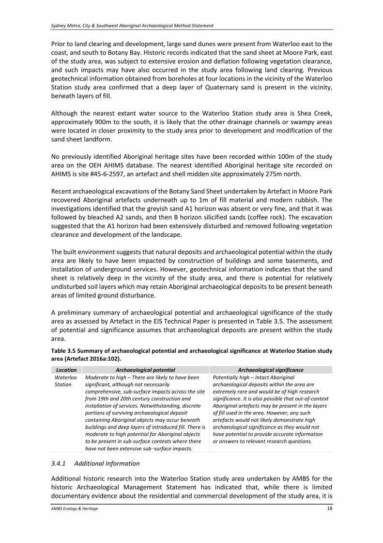
3.4.2 Contamination Investigations
In November and December 2017 Douglas Partners Pty Ltd undertook testing for contaminants at the Waterloo Station site. The testing process comprised excavation of a series of boreholes and test pits to allow pre-construction testing and classification of contamination at the site (see Table 3.6 and Figure 3.3). The test pits excavated were all stopped at a relatively shallow depth due to either the presence of historic archaeological materials requiring further investigation, or hazardous asbestos. Soil profiles identified through borehole investigations generally showed a layer of fill materials across the site to varying depths, followed by grey or yellow natural sands, with an increasing clay content at depth. Where recorded, the sands were noted as becoming wet after 2m depth, and saturated between 3m and 7m. The results from the contamination testing indicate that, while the study area has experienced disturbance from historic development, the Quaternary sand sheet is present, and Aboriginal archaeological deposits may remain relatively undisturbed in the sands beneath introduced fill materials.
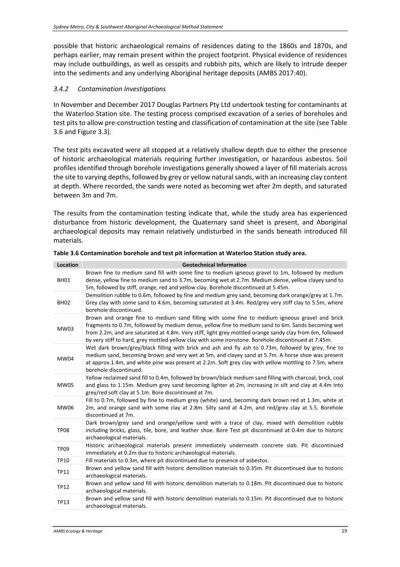
Table 3.6 Contamination borehole and test pit information at Waterloo Station study area.
Location Geotechnical Information
BH01 Brown fine to medium sand fill with some fine to medium igneous gravel to 1m, followed by medium dense, yellow fine to medium sand to 3.7m, becoming wet at 2.7m. Medium dense, yellow clayey sand to 5m, followed by stiff, orange, red and yellow clay. Borehole discontinued at 5.45m.
BH02 Demolition rubble to 0.6m, followed by fine and medium grey sand, becoming dark orange/grey at 1.7m. Grey clay with some sand to 4.6m, becoming saturated at 3.4m. Red/grey very stiff clay to 5.5m, where borehole discontinued.
MW03
Brown and orange fine to medium sand filling with some fine to medium igneous gravel and brick fragments to 0.7m, followed by medium dense, yellow fine to medium sand to 6m. Sands becoming wet from 2.2m, and are saturated at 4.8m. Very stiff, light grey mottled orange sandy clay from 6m, followed by very stiff to hard, grey mottled yellow clay with some ironstone. Borehole discontinued at 7.45m.
MW04
Wet dark brown/grey/black filling with brick and ash and fly ash to 0.73m, followed by grey, fine to medium sand, becoming brown and very wet at 5m, and clayey sand at 5.7m. A horse shoe was present at approx.1.4m, and white pine was present at 2.2m. Soft grey clay with yellow mottling to 7.5m, where borehole discontinued.
MW05 Yellow reclaimed sand fill to 0.4m, followed by brown/black medium sand filling with charcoal, brick, coal and glass to 1.15m. Medium grey sand becoming lighter at 2m, increasing in silt and clay at 4.4m into grey/red soft clay at 5.1m. Bore discontinued at 7m.
MW06 Fill to 0.7m, followed by fine to medium grey (white) sand, becoming dark brown red at 1.3m, white at 2m, and orange sand with some clay at 2.8m. Silty sand at 4.2m, and red/grey clay at 5.5. Borehole discontinued at 7m.
TP08 Dark brown/grey sand and orange/yellow sand with a trace of clay, mixed with demolition rubble including bricks, glass, tile, bore, and leather shoe. Bore Test pit discontinued at 0.4m due to historic archaeological materials.
TP09 Historic archaeological materials present immediately underneath concrete slab. Pit discontinued immediately at 0.2m due to historic archaeological materials.
TP10 Fill materials to 0.3m, where pit discontinued due to presence of asbestos.
TP11 Brown and yellow sand fill with historic demolition materials to 0.35m. Pit discontinued due to historic archaeological materials.
TP12 Brown and yellow sand fill with historic demolition materials to 0.18m. Pit discontinued due to historic archaeological materials.
TP13 Brown and yellow sand fill with historic demolition materials to 0.15m. Pit discontinued due to historic archaeological materials.
Sydney Metro, City & Southwest Aboriginal Archaeological Method Statement
AMBS Ecology & Heritage 20
Figure 3.3 Waterloo Station geotechnical and contamination testing locations.
Sydney Metro, City & Southwest Aboriginal Archaeological Method Statement
AMBS Ecology & Heritage 21
4 Research Design
The excavations and associated works required for the Metro project will impact on any Aboriginal heritage objects which may remain present within the study areas. The archaeological research design establishes research questions to guide the archaeological process, and provide the basis for the analysis of archaeological information gathered through the investigations.
4.1 Research Questions
Where archaeological excavations are undertaken, their primary aim will be to recover an appropriate sample of any archaeological deposit present. Archaeological excavations will ensure the existence of an archaeological record of the study areas, and will allow an appropriate level of archaeological analysis to be carried out on the excavated cultural material that would otherwise have been lost due to the works. Excavations aimed at increasing the current scientific knowledge of the region provide an appropriate offset to the cumulative impacts on Aboriginal heritage arising from the development, ensuring that sites will not be destroyed without retaining the information they may hold for archaeological knowledge of the area and future research. To ensure that the research potential and significance of an archaeological resource is realised, archaeological investigations should aim to address substantive research themes. The following research questions form the foundation of the archaeological investigations within the TSE project study areas, and are based on key research questions identified in the ACHA (Artefact 2017b:41).
• Intactness: Do the study areas contain spatially intact, stratified Aboriginal archaeological deposits? Investigation of the intactness of archaeological deposits has potential to contribute to the understanding of the impacts of urban development on Aboriginal heritage sites.
• Nature and Extent: What is the nature and extent of any Aboriginal archaeological deposits in the study areas? Is it possible to identify distinct activity areas such as knapping floors, or is there evidence of the nature of the occupation of the sites, such as longer-term occupation which might be associated with larger water supplies, to which Aboriginal people transported larger quantities of stone and practiced varying flaking techniques?
• Significance: What is the archaeological and cultural significance of Aboriginal sites which are identified in the study areas? Where archaeological investigation identifies Aboriginal archaeological deposits in the study areas, the heritage significance of the TSE work sites should be reassessed in line with the OEH Code of Practice for Archaeological Investigation of Aboriginal Objects in NSW (DECCW 2010b), which states that archaeological values should be identified and their significance assessed using criteria reflecting best practice assessment processes as set out in the Burra Charter. Assessments of cultural significance can only be made by the relevant Aboriginal communities, and will be established through consultation with the RAPs.
• Comparative: How do the results of the archaeological investigations and reassessments of significance compare with Aboriginal archaeological sites in the vicinity of the study areas, and what are the implications for the understanding of Aboriginal archaeology in the Sydney Basin? In addition, how do the results from each of the TSE study areas compare; what conclusions can be drawn regarding the distribution of Aboriginal archaeological material across the project sites; and is it possible to determine if factors such as historic disturbance, elevation and landforms, or the presence of sand bodies affect the distribution and relative survivability of sites?
Sydney Metro, City & Southwest Aboriginal Archaeological Method Statement
AMBS Ecology & Heritage 22
5 Archaeological Methodology
The overall scope and nature of the archaeological methodology has been defined in the EIS and ACHA, and will be applied to the Barangaroo, Martin Place, Pitt Street North, Pitt Street South, and Waterloo Station study areas.
5.1 Archaeological Inspection & Liaison with Historical Archaeological Investigations
Archaeological inspections will be carried out by the Aboriginal archaeological Excavation Director (ED) at each of the study areas, following completion of historic archaeological investigations and clearing of historic materials, to identify if intact remnant soil profiles are present, and to determine if there is potential for Aboriginal archaeological deposits to be present. The Aboriginal archaeological ED will liaise with the historic archaeological team for each study area during their works, to ensure that potential Aboriginal objects recovered during historic investigations are appropriately identified and taken into account when determining the requirement for Stage 1 test excavations. Where historic archaeological excavation has been undertaken, but has not cleared large enough areas to allow adequate inspection of the study area to determine the potential for intact remnant soil profiles to be present, the mechanical removal of the extant surface, base gravels and overburden will be undertaken, directed by an archaeologist. If soil profiles with potential to retain Aboriginal archaeological deposits are identified during inspection, or located during the historic archaeological investigations, the Aboriginal archaeological ED will assess the need for Stage 1 test excavations to be undertaken in the relevant study area. If no evidence of intact remnant soils with potential to retain Aboriginal archaeological deposits is identified during inspection or historic archaeological investigations, or if no Aboriginal objects are identified during historic archaeological investigations, the Aboriginal archaeological ED will issue a Clearance Certificate to inform the project team and proponent in writing.
5.2 Stage 1 Test Excavation
Stage 1 test excavations will primarily comprise manual or mechanical excavation of test pits in controlled units within each study area confirmed as having potential to retain Aboriginal archaeological deposits, in order to confirm if Aboriginal objects are present, and to allow determination of the need for expanded Stage 2 salvage excavations. Manual test pits will be 1m2, and dependent on the cultural material present and the nature of the deposit, excavation will proceed as 10cm arbitrary units, or stratigraphic units where identifiable stratigraphic layers are present. Archaeological test pits will initially be positioned in a grid approximately 10m apart, dependent upon the area available for investigations, and the observable levels of disturbance. As none of the study areas have been cleared at the time this AMS is being prepared, it is not possible to identify the areas that could potentially require and be available for excavation, and as such it is not possible to determine specifically where test pits would be placed during excavations. Where there are constraints preventing pits being positioned on the grid layout, pits will be offset by up to 5m within the study area. Where limited areas of remnant soils are present, pit sizes may be reduced to allow excavation to proceed. In study areas where the area of potential archaeological deposit is very limited, it is possible that Stage 1 excavations may be sufficient to
Sydney Metro, City & Southwest Aboriginal Archaeological Method Statement
AMBS Ecology & Heritage 23
archaeologically excavate the entirety of the archaeological resource, without Stage 2 excavations being undertaken. If historic materials or introduced fill materials overlie the area to be excavated following completion of historic archaeological investigations, they may be removed by machine to expose soils requiring manual excavation, under the direction of an archaeologist. Excavation pits will be set out by hand, and their location recorded using handheld GPS units. Excavated pits will be surveyed by a qualified surveyor prior to completion of excavation works in any portion of the study areas and the issuing of Clearance Certificates. Test pits would be manually excavated to a depth assessed as being culturally sterile, or to a point where it is no longer physically possible to archaeologically excavate, such as when the water table is reached, the walls of the pits are no longer stable, or the pits are inundated. Due to health and safety considerations, pits will be manually excavated to 1.5m in depth, at which point additional pits will be excavated adjacent, to allow the area to be stepped; or the pits will be shored. Where excavation is required beyond 1.5m, and previously excavated units have identified limited numbers of archaeological materials in upper units, machine excavation may be undertaken to recover or expose soils at depths shown to be likely to retain archaeological materials, or adjacent to manually excavated test pits in order to create a stepped working surface to allow manual excavation at depth. Machine excavation will require a mechanical excavator equipped with a small, flat edged bucket, excavating in shallow scrapes to remove soils, under the direction of an archaeologist. Mechanical excavation should take place in 20cm units, and the directing archaeologist should record the excavated soils as per the manual excavation methodology. A sample of up to 50% of units excavated by machine should be sieved. Should it be determined that there is potential for additional cultural material to be present at depths deeper than that able to be manually excavated, deeper sediments may be investigated through the use of a hand auger. Where hand auger results suggest that archaeological deposits have potential to continue beyond the point where test pits are inundated, the Aboriginal archaeological ED may consider bulk recovery of units beyond that depth using machine excavation and sieving. Where appropriate, sections will be drawn detailing the stratigraphy and features within the excavated deposit, and all units will be photographed, prior to and during excavation. Soil and carbon samples will be collected where appropriate, and measurements of the pH of soils will be made. All manually excavated material will be sieved on-site through 3mm and 5mm sieves, to ensure recovery of small archaeological materials, and material will be wet or dry sieved as appropriate to soil conditions. If suitable features or deposits are identified during excavations, samples will be taken for dating by radiocarbon or OSL analysis, depending on the nature of the sample. If shell midden material, hearths or suspected hearths are identified, samples of each layer or deposit material will be subject to C14 radiocarbon dating determinations by the University of Waikato Radiocarbon Dating Lab, or similar facility. To allow comparison with other archaeological studies in the local region, where appropriate a suitably qualified geomorphologist will be engaged to analyse the soils in the study areas, and examine soil profiles revealed during excavation. Geomorphological information will be appended to and summarised within final reporting, and will contribute to the overall interpretation of the results of the archaeological excavation.
Sydney Metro, City & Southwest Aboriginal Archaeological Method Statement
AMBS Ecology & Heritage 24
If Stage 1 excavations recover insufficient Aboriginal cultural material to trigger Stage 2 savage excavations, the Aboriginal archaeological ED will issue a Clearance Certificate to inform the project team and proponent in writing following completion of the Stage 1 works. Clearance Certificates may apply to an entire study area, or discrete portions of the study areas, as works are completed.
5.3 Stage 2 Salvage Excavation
Where the Stage 1 test excavations identify archaeologically significant or intact Aboriginal heritage deposits, Stage 2 archaeological salvage excavations will be undertaken. Triggers for Stage 2 excavations at the Barangaroo, Martin Place and Pitt Street Station study areas are as follows:
• Identification of any artefacts during Stage 1 excavations. A minimum number of artefacts has not been set due to the potential heritage significance of sites in these areas
• Identification of rare or significant artefacts, features or site types
• Identification of artefacts in contexts which may provide significant information on site formation, including potential for samples to be extracted suitable for dating
Triggers for Stage 2 excavations at the Waterloo Station study area are as follows:
• Identification of more than 5 artefacts per excavation unit during Stage 1 excavations
• Identification of rare or significant artefacts, features or site types
• Identification of artefacts in contexts which may provide significant information on site formation, including potential for samples to be extracted suitable for dating
The extent of the Stage 2 salvage excavations will be determined by the Stage 1 test excavation results, and will utilise the same methods of manual or mechanical excavation. Manually excavated salvage pits shall initially be undertaken by expanding out in four 1m2 pits adjacent to the sides of the original pit, where the study area to be investigated is large enough to allow such expansion. Excavations will cease once an adequate sample of the archaeological resource has been recovered to allow an appropriate level of analysis, and to allow adequate description of the intactness, nature, extent and significance of the site. Machine excavation will be utilised as per Stage 1, where it is necessary to remove historic materials, introduced fill, or culturally sterile soils prior to manual excavation, or to investigate areas over 1.5m in depth. Where Aboriginal heritage objects are identified during historic archaeological excavations, the Stage 1 test excavation will form part of the historic excavation program, and will be guided in line with the relevant historic Archaeological Method Statement for that work site. RAP representatives would be involved in the excavation of Aboriginal objects from historic archaeological contexts. Where historic materials are identified during the Stage 1 or 2 test excavations, the historic ED will be consulted with to determine any necessary modifications to the Aboriginal AMS. Should Aboriginal heritage objects be identified in introduced fill material that is not considered a historic archaeological context and will not be excavated under the historic AMS for the relevant study area, the Aboriginal archaeological ED will establish if additional investigation of the fill material is required. Additional investigation may include, but not be limited to, excavation of manual test pits to sample the fill as per the Stage 1 methodology, or mechanical excavation and sieving of a larger area of fill. Following completion of Stage 2 excavations, the Aboriginal archaeological ED will issue a Clearance Certificate to inform the project team and proponent in writing. Clearance Certificates may apply to an entire study area, or discrete portions of the study areas, as works are completed.
Sydney Metro, City & Southwest Aboriginal Archaeological Method Statement
AMBS Ecology & Heritage 25
5.4 Post Excavation Analysis & Reporting
Following excavation, attributes will be recorded for each excavated artefact in accordance with the OEH AHIMS Feature Recording Form – Artefact, which requires identification and recording of material, artefact type, dimensions, and platform and termination type. Excavated archaeological material will be analysed on a similar level to that of previous assemblages from the Sydney Basin, and information from this analysis will be used to make interpretations about the Aboriginal site use, antiquity and settlement patterns of the study area, and to assess regional cultural heritage values. A full description of the recording methods will be included in the final archaeological reporting, and analysis of the excavation results will allow a reassessment of the archaeological and cultural significance of the study areas and their context in the surrounding lands. Preliminary analysis of materials will be carried out during Stage 1 test excavations to determine the appropriate scale of the Stage 2 salvage excavation phase. Detailed analysis will be undertaken after all excavation works are completed. Separate Aboriginal archaeological excavation reports will be prepared for each study area subject to archaeological excavations, and will address:
• The Aboriginal cultural heritage and environmental context of the project areas
• The Aboriginal community consultation process, and identified cultural values of the project areas to the local Aboriginal community
• The Aboriginal archaeological methodology used for inspections and archaeological excavations
• The results of the archaeological investigations, including any artefactual or geomorphological analysis
• An assessment of the heritage significance of any Aboriginal heritage sites, objects or places identified by the investigations, and conclusions addressing the implications of the results of the investigations for the understanding of Aboriginal archaeology in the local area and wider region
• Recommendations for final storage and appropriate use for interpretation. Following completion of the Aboriginal heritage excavations, the location, nature and extent of any sites identified by the works will be recorded on an Aboriginal Heritage Information Management System recording form, and provided to OEH in line with their requirements. All draft reports will be sent to the RAPs for comment, and any feedback received in a timely manner will be incorporated into the final report as part of the consultation process, in accordance with OEH requirements.
5.5 Storage of Aboriginal Objects
Aboriginal objects that are recovered during the archaeological investigations will be cleaned, bagged, labelled and appropriately analysed and stored so that information that can contribute to the understanding of the sites is not lost. Prior to analysis, Aboriginal objects will be stored in a locked container on site during excavations. TfNSW will provide long term storage of both historic and Aboriginal relics salvaged and uncovered during archaeological investigations. TfNSW’s storage facility will be secure to protect all relics and salvaged elements from damage or vandalism, and the transportation and storage instructions of the historic and Aboriginal archaeological Excavation Directors will be followed. The facility will also be appropriate for on-site artefact analysis to be undertaken by a number of specialists.
Sydney Metro, City & Southwest Aboriginal Archaeological Method Statement
AMBS Ecology & Heritage 26
5.6 Human Remains
In the event that potential human remains are identified during the Aboriginal archaeological investigations, works must immediately cease in the vicinity of the find, and the find should be managed in accordance with the Aboriginal and Historic Heritage Unexpected Finds Protocol.
Sydney Metro, City & Southwest Aboriginal Archaeological Method Statement
AMBS Ecology & Heritage 27
Bibliography
AMBS Ecology & Heritage [AMBS] (2017) Sydney Metro, City & Southwest Archaeological Method Statement for Waterloo Station. Report to John Holland CPB Ghella Joint Venture. Artefact Heritage (2016a) Sydney Metro City Chatswood to Sydenham: Aboriginal Heritage – Archaeological Assessment. Technical Paper 5 of the EIS, prepared for Arcadis / RPS / Jacobs. Artefact Heritage (2016b) Sydney Metro City & Southwest Chatswood to Sydenham: Aboriginal Cultural Heritage Assessment. Report to Arcadis / RPS / Jacobs. Casey and Lowe (2017) Barangaroo Station Hickson Road Barangaroo, Sydney Metro Project, Archaeological Method Statement. Report to John Holland CPB Ghella Joint Venture Department of the Environment, Climate Change and Water NSW [DECCW] (2010a) Aboriginal Cultural Heritage Consultation Requirements for Proponents 2010. DECCW, Sydney. DECCW (2010b) Code of Practice for Archaeological Investigation of Aboriginal Objects in New South Wales. DECCW, Sydney. Office of Environment and Heritage [OEH] (2011) Guide to Investigating, Assessing and Reporting on Aboriginal Cultural Heritage in NSW. OEH, Sydney.