surveying (practice) amendment regulation 2003 · clause 1 surveying (practice) amendment...
TRANSCRIPT
New South Wales
2003 No 363
Surveying (Practice) AmendmentRegulation 2003under the
Surveying Act 2002
Published in Gazette No 103 of 25 June 2003, page 5904 Page 1
Her Excellency the Governor, with the advice of the Executive Council, hasmade the following Regulation under the Surveying Act 2002.
ANTHONY KELLY, M.L.C.,
Minister Assisting the Minister for Natural Resources (Lands)
Explanatory noteThe object of this Regulation is to amend the Surveyors (Practice) Regulation 2001, soas to insert new provisions, omit obsolete provisions and amend other provisions inconnection with the commencement of the Surveying Act 2002 and the consequentrepeal of the Surveyors Act 1929, the Survey Co-ordination Act 1949, the Survey MarksAct 1902 and the Survey (Geocentric Datum of Australia) Act 1999.
This Regulation also renames the Surveyors (Practice) Regulation 2001 as theSurveying Regulation 2001, repeals the Survey Co-ordination Regulation 1998 andreplicates its provisions in the renamed Regulation.
This Regulation is made under the Surveying Act 2002, including section 36 (the generalpower to make regulations) and sections 3, 4, 5, 10, 15, 19, 26, 27 and 30.
Page 2
Surveying (Practice) Amendment Regulation 2003Clause 1
Surveying (Practice) Amendment Regulation 2003under the
Surveying Act 2002
2003 No 363
1 Name of Regulation
This Regulation is the Surveying (Practice) Amendment Regulation2003.
2 Commencement
This Regulation commences on 25 June 2003.
3 Amendment of Surveyors (Practice) Regulation 2001
The Surveyors (Practice) Regulation 2001 is amended as set out inSchedule 1.
4 Repeal of Survey Co-ordination Regulation 1998
The Survey Co-ordination Regulation 1998 is repealed.

Surveying (Practice) Amendment Regulation 2003
Amendments Schedule 1
2003 No 363
Schedule 1 Amendments(Clause 3)
[1] Clause 1
Omit the clause. Insert instead:
1 Name of Regulation
This Regulation is the Surveying Regulation 2001.
[2] Clauses 3 and 3A
Omit clause 3. Insert instead:
3 Application of Regulation
(1) This Regulation applies to all land surveys, and to all surveysreferred to in section 4 or 5 of the Act, but does not apply toany mining surveys except to the extent to which the otherprovisions of this Regulation expressly provide and to theextent provided by an order in force under clause 3A.
(2) This Regulation applies to the registration of both landsurveyors and mining surveyors.
3A Mining surveys
(1) The Surveyor-General may, by order published in theGazette, give directions with respect to the conduct of miningsurveys.
(2) Such an order may only be made on the recommendation ofthe Board.
(3) The document entitled Survey and Drafting Directions forMine Surveyors, published in March 2000 by the Departmentof Mineral Resources, is taken to be an order under this clausewith respect to mining surveys carried out for the purposes ofthe Coal Mines Regulation Act 1982, and may be amendedand repealed accordingly.
(4) The document entitled Survey and Drafting Directions forMining Surveyors, published in December 2001 by theDepartment of Mineral Resources, is taken to be an orderunder this clause with respect to mining surveys carried outfor the purposes of the Mines Inspection Act 1901, and may beamended and repealed accordingly.
Page 3

Surveying (Practice) Amendment Regulation 2003
Schedule 1 Amendments
2003 No 363
[3] Clause 4 Interpretation
Omit the definitions of AHD, established permanent mark, referencemark, rural survey and the Act from clause 4 (1). Insert instead:
AHD means Australian Height Datum, as defined in section 3(1) of the Act.
established permanent survey mark means a survey mark thehorizontal position of which is determined to be Class C orbetter as specified in Standards & Practices for ControlSurveys and that is identified in the register of public surveys,in such manner as the Surveyor-General may determine, asbeing an established permanent survey mark.
reference mark means permanent survey mark or a mark ofthe kind referred to in Schedule 3.
rural survey means a land survey that is not an urban survey.
the Act means the Surveying Act 2002.
[4] Clause 4 (1)
Insert in alphabetical order:
Board examination means an examination (whether oral orwritten, or both oral and written) approved by the Board forthe purposes of this definition, as set out in a formal Boarddetermination.
boundary mark means a mark of the kind referred to inSchedule 2.
continuing professional development requirements meansprofessional development requirements approved by theBoard for the purposes of this definition, as set out in a formalBoard determination.
formal Board determination means a determination that hasbeen made and published by the Board under clause 4C.
lockspit means a mark described as a lockspit in Schedule 2.
recognised practical experience, in relation to an applicantfor registration as a surveyor, means experience in which:(a) the applicant has been employed as a full-time
surveyor’s assistant, whether in New South Wales orelsewhere, for one or more periods totalling at least 2
Page 4
Surveying (Practice) Amendment Regulation 2003
Amendments Schedule 1
2003 No 363
years (in the case of an application for registration as aland surveyor), or at least 3 years (in the case ofregistration as a mining surveyor), during the 5 yearperiod immediately preceding the application, and
(b) while so employed, the applicant has obtained practicalexperience for a continuous period of one year or morein:(i) all aspects of the conduct of land surveys, or
(ii) all aspects of the conduct of mining surveys,
as the case requires.
recognised professional training agreement means a trainingagreement approved by the Board for the purposes of thisdefinition, as set out in a formal Board determination.
recognised qualification means any qualification that theBoard recognises to be an appropriate qualification for thepurposes of this definition, as set out in a formal Boarddetermination.
Standards & Practices for Control Surveys means thepublication entitled Standards & Practices for ControlSurveys (SP1) published by the Inter-GovernmentalCommittee on Surveying and Mapping, as that publication isamended from time to time.
student of surveying means a person who is enrolled in acourse of studies that leads to a recognised qualification.
survey drafter means a person who has such abilities andexperience as the Board considers appropriate to qualify theperson to be a survey drafter, as set out in a formal Boarddetermination.
surveyor’s assistant means a person who has such abilitiesand experience as the Board considers appropriate to qualifythe person to be a surveyor’s assistant, as set out in a formalBoard determination.
[5] Clause 4 (1), definition of “MGA”
Omit “(within the meaning of the Survey (Geocentric Datum of Australia)Act 1999)”.
Page 5

Surveying (Practice) Amendment Regulation 2003
Schedule 1 Amendments
2003 No 363
[6] Clause 4 (1), definition of “urban survey”
Omit “means a survey”. Insert instead “means a land survey”.
[7] Clause 4 (1), definitions of “chisel mark”, “permanent mark”,“plan of survey”, “State Control Survey” and “survey mark”
Omit the definitions.
[8] Part 1A
Insert after Part 1:
Part 1A Administration
Division 1 Constitution of Board
4A Constitution of Board: section 27
(1) The Institution of Surveyors NSW Incorporated is prescribedas the professional association of land surveyors to nominatepersons for appointment to the Board under section 27 (2) (c)of the Act.
(2) AIMS—Australian Institute of Mine Surveyors Limited isprescribed as the professional association of mining surveyorsto nominate persons for appointment to the Board undersection 27 (2) (d) of the Act.
(3) The Australasian Urban and Regional Information SystemsAssociation is prescribed as the professional association ofpersons involved in the spatial information industry tonominate persons for appointment to the Board under section27 (2) (e) of the Act.
4B Committees
(1) This clause applies to any committee established undersection 30 of the Act.
(2) A committee must have at least 3 members.
(3) The chairperson and deputy chairperson of a committee are tobe nominated by the Board, and may (but need not) bemembers of the Board.
Page 6

Surveying (Practice) Amendment Regulation 2003
Amendments Schedule 1
2003 No 363
(4) Committee meetings are to be held at the times and placesdetermined by the chairperson of the committee.
(5) The procedures for convening committee meetings and for theconduct of business at committee meetings are to bedetermined by the chairperson of the committee.
(6) At a committee meeting, a majority of the committeemembers constitutes a quorum.
(7) The chairperson of a committee (or, in the absence of thechairperson, the deputy chairperson of the committee) is topreside at committee meetings.
(8) A decision supported by a majority of the votes cast at acommittee meeting at which a quorum is present constitutes adecision of the committee.
(9) In the event of an equality of votes, the chairperson of thecommittee has a second, or casting, vote.
(10) The chairperson of a committee is to report all decisions of thecommittee to the next Board meeting.
Division 2 Formal Board determinations
4C Formal Board determinations
(1) The Board may, by resolution, make the following kinds ofdetermination:(a) a determination approving an examination for the
purposes of the definition of Board examination inclause 4 (1),
(b) a determination approving requirements for thepurposes of the definition of continuing professionaldevelopment requirements in clause 4 (1),
(c) a determination approving a training agreement for thepurposes of the definition of recognised professionaltraining agreement in clause 4 (1),
(d) a determination recognising a qualification for thepurposes of the definition of recognised qualificationin clause 4 (1),
Page 7

Surveying (Practice) Amendment Regulation 2003
Schedule 1 Amendments
2003 No 363
(e) a determination recognising abilities and experience(whether for a person or a class of persons) for thepurposes of the definition of survey drafter in clause 4(1),
(f) a determination recognising abilities and experience(whether for a person or a class of persons) for thepurposes of the definition of surveyor’s assistant inclause 4 (1).
(2) The Board is to ensure that copies of each determination madeunder this clause are published on its internet site and madeavailable for inspection at each of its offices.
Division 3 Registration of surveyors
4D Qualifications for registration
A person is eligible to be registered as a surveyor if theperson:(a) holds a recognised qualification, and(b) has recognised practical experience, and(c) has either passed the Board’s examination or fulfilled
the requirements of a recognised professional trainingagreement, and
(d) is of good character.
4E Board examinations
Board examinations are to be conducted at such times andplaces as the Board may determine.
4F Provision of further information and supporting evidence
Without limiting section 43 (1) of the Licensing andRegistration (Uniform Procedures) Act 2002, the Board mayrequire an applicant for registration as a surveyor to furnishthe following documents:(a) documentary evidence that the applicant holds a
recognised qualification,(b) documentary evidence that the applicant has recognised
practical experience,
Page 8
Surveying (Practice) Amendment Regulation 2003
Amendments Schedule 1
2003 No 363
(c) documentary evidence that the applicant has passed therelevant Board examination or fulfilled therequirements of a recognised professional trainingagreement,
(d) one or more character references given in relation to theapplicant within the previous 2 years.
4G Continuing professional development
(1) A registered surveyor must comply with the continuingprofessional development requirements.
(2) Compliance with the requirements of this clause is a conditionof registration as a surveyor.
4H Conditions of registration
Registration as a mining surveyor may be granted subject to acondition restricting the mining surveyor to the conduct ofmining surveys in relation to open cut mines.
4I Surveyor to report position etc of permanent survey marks
(1) As soon as practicable after a registered surveyor carrying outa survey:(a) places a new permanent survey mark, or(b) becomes aware that an existing permanent survey mark
has been removed, damaged, destroyed, displaced,obliterated or defaced, or is in a state of disrepair,
the registered surveyor must notify the Surveyor-General ofthat fact and of the number and location of the permanentsurvey mark.
(2) Compliance with the requirements of this clause is a conditionof registration as a surveyor.
4J Register of surveyors
(1) The following particulars are to be recorded in the register ofsurveyors, in relation to each registered surveyor, in additionto those required by section 49 (1) of the Licensing andRegistration (Uniform Procedures) Act 2002:(a) the qualifications pursuant to which the surveyor was
registered,
Page 9

Surveying (Practice) Amendment Regulation 2003
Schedule 1 Amendments
2003 No 363
(b) in the case of a registered mining surveyor whoseregistration is subject to a condition restricting themining surveyor to the conduct of mining surveys inrelation to open cut mines, a statement to that effect,
(c) in the case of a mining surveyor who was originallyregistered or licensed interstate, the State or Territory inwhich the surveyor was originally registered orlicensed,
(d) the surveyor’s address for service of notices,(e) particulars of any action that the Board has taken in
relation to the surveyor under section 12 or 13 of theAct, together with the date on which the action wastaken.
(2) The register of surveyors may be maintained in written orelectronic form.
4K Certificates of meritorious service
The Board may issue a certificate of meritorious service toany person who surrenders his or her certificate ofregistration, as referred to in section 50 (7) of the Licensingand Registration (Uniform Procedures) Act 2002, if satisfiedthat it is appropriate to do so in recognition of the person’scontribution to surveying in New South Wales.
Division 4 Fees
4L Fees
The fees set out in Schedule 6 are payable in relation to thevarious matters referred to in that Schedule.
[9] Clause 6
Omit the clause.
Page 10
Surveying (Practice) Amendment Regulation 2003
Amendments Schedule 1
2003 No 363
[10] Clauses 7 (e), 8, 9, 10 (1), 16 (2), 18 (2) and (6), 19 (2), 20 (4), 21 (2),24 (2), 30 (4) and (5), 32, 33 (7), 34 (2) and (3), 36 (3) and (5), 37 (6),38, 40 (1) and (2), 41 (1)–(4), 46 (1) and (4), 47 (2), 48 (3) (a), 49, 54,55 (2), (3) and (5), 56 (5), 57 (2) (b), 59 (2) and (3), 60 (3) (b) and 61 (2)
Omit “plan of survey” wherever occurring.
Insert instead “survey plan”.
[11] Section 9 Surveyor to record nature of boundaries
Insert “or fence” after “substantial structure” in clause 9 (1) (c).
[12] Clauses 11 and 11A
Omit clause 11. Insert instead:
11 Notice of proposed entry to land: section 19
The notice referred to in section 19 (1) of the Act (for theconduct of both land surveys and mining surveys) must begiven, in the form set out in Form 2:(a) by delivering it to any person who is apparently over the
age of 16 years and is apparently residing on, or inoccupation of, the land to be entered, or
(b) if there is no person available to give the notice to asreferred to in paragraph (a), by affixing it in aconspicuous place at the main point of entry to the land,at the main point of entry to a building situated on theland or to some other conspicuous object situated on theland.
11A Certificate of authority: section 26
(1) A certificate of authority referred to in section 26 of the Act,whether for a land surveyor or a mining surveyor, must beissued by the Surveyor-General in the form of Form 2A.
(2) Despite subclause (1), an identity card issued to a surveyor bythe former Board of Surveyors under the Surveyors Act 1929is taken to be such a certificate.
[13] Clause 13 Surveyor to obtain information
Insert “and to connect the survey to the State control survey in accordancewith Parts 4 and 5” after “land to be surveyed”.
Page 11
Surveying (Practice) Amendment Regulation 2003
Schedule 1 Amendments
2003 No 363
[14] Clause 18 Surveys for easements and restrictions on use
Omit clause 18 (1). Insert instead:
(1) If a survey is carried out for the purpose of defining aneasement or restriction on use (referred to in this clause as arestriction), the surveyor must connect the site of theeasement or restriction by measurement to relevantmonuments.
[15] Clause 18 (2) and (4) (a)
Insert “or restriction” and “or restrictions” after “easement” and“easements” respectively, wherever occurring.
[16] Clause 18 (3)
Omit the subclause.
[17] Clause 18 (4) (b)
Omit the paragraph. Insert instead:(b) show on the survey plan by bearing and distance the
essential dimensions of the site and note the site on theplan as “easement” or “restriction on use of land”, or“proposed easement” or “proposed restriction on use ofland”, as appropriate, and
[18] Clause 23 Surveys using global positioning system (GPS)
Omit “an accuracy of Class ‘B’ or better as specified in the Standards &Practices for Control Surveys (SP1)—Version 1.4 published in November2000 by the Inter-Governmental Advisory Committee on Surveying andMapping” from clause 23 (1).
Insert instead “the level of accuracy appropriate to the type of surveybeing undertaken, as specified in Standards & Practices for ControlSurveys”.
[19] Clauses 25 (2) (c), 30 (2)–(4), 32 (2), 33 (2)–(10), 41 (1) (c), 43 (1) (a)and 47 (3) and (4)
Omit “permanent mark” and “permanent marks” wherever occurring.
Insert instead “permanent survey mark” and “permanent survey marks”,respectively.
Page 12
Surveying (Practice) Amendment Regulation 2003
Amendments Schedule 1
2003 No 363
[20] Clause 28 Identification or re-marking surveys
Omit clause 28 (3). Insert instead:
(3) This clause and clauses 3, 4, 5, 7 (a), (b) and (d), 11, 13, 14,19, 23, 27, 30 (1), 31, 39 and 48–53 apply to a survey referredto in subclause (1) or (2).
[21] Clause 29 Surveys not requiring strict accuracy
Omit clause 29 (4). Insert instead:
(4) This clause and clauses 3, 4, 5, 7 (d), 11, 13, 30 (1), 31, 39 and48–53 apply to a survey referred to in subclause (1).
[22] Clause 30 Procedure for adopting datum line
Insert after clause 30 (2):
(2A) The MGA co-ordinates used to determine the orientation ofthe survey must be obtained from the register of publicsurveys within 6 months before the date of completion of thesurvey as recorded in the survey certificate.
[23] Clause 32 Method of recording datum line on survey plan
Omit “accuracy” from clause 32 (2).
[24] Clause 33 Connection of surveys and marks
Omit clause 33 (1). Insert instead:
(1) This clause applies to any survey that is carried out for thepurpose of lodging a survey plan with a public authority.
(1A) An urban survey must be connected by measurement to atleast 2 permanent survey marks and, for land having an areaof more than 10 hectares, to at least 2 more permanent surveymarks for each 10 hectares (or part thereof) by which the areaof land being surveyed exceeds 10 hectares.
(1B) A rural survey must be connected by measurement to at least2 permanent survey marks and, for land having an area ofmore than 10 hectares, to at least 2 more permanent surveymarks for each 100 hectares (or part thereof) by which thearea of land being surveyed exceeds 10 hectares.
(1C) The distance between a survey mark and a permanent surveymark referred to in subclause (1A) or (1B) must not exceed:
Page 13

Surveying (Practice) Amendment Regulation 2003
Schedule 1 Amendments
2003 No 363
(a) 300 metres, in the case of an urban survey, or(b) 1,000 metres, in the case of a rural survey.
[25] Clause 33 (2)
Omit “subclause (1) (a) or (b)”. Insert instead “subclause (1C)”.
[26] Clause 33 (4)
Omit “subclause (1) (a) or (b)”. Insert instead “subclause (1A) or (1B)”.
[27] Clause 33 (8)
Omit “subclause (1) (a)”. Insert instead “subclause (1A)”.
[28] Clause 33 (8) (a)
Omit “(SP1)—Version 1.4 published in November 2000 by the Inter-Governmental Advisory Committee on Surveying and Mapping”.
[29] Clause 34 Placement of pegs or marks
Omit clause 34 (1). Insert instead:
(1) Except in the case of a survey referred to in clause 18, 28 (1)or 29, each corner of the land being surveyed (including thecorners of each parcel of land in a subdivision) must bemarked with a boundary mark.
[30] Clause 34 (2)
Omit “such a peg or mark”. Insert instead “a boundary mark”.
[31] Clause 35 Urban surveys
Insert at the end of the section:
(2) Subclause (1) (a) does not require the placement of areference mark at any extremity of the land if some otherreference mark is already placed within 10 metres of thatextremity and that reference mark is referenced to thatextremity on the survey plan.
[32] Clause 36 Rural surveys
Omit “a peg or mark of the type prescribed by clause 42” from clause 36(1).
Page 14
Surveying (Practice) Amendment Regulation 2003
Amendments Schedule 1
2003 No 363
Insert instead “a boundary mark”.
[33] Clause 37 Placement of reference marks for roads
Omit “is of the type prescribed by clause 43 (1) (e) (ie a drill hole andwing)” from clause 37 (4).
Insert instead “consists of a drill hole and wing”.
[34] Clause 41 Surveyor to note nature and position of survey marksetc
Insert after clause 41 (2):
(2A) Except as allowed under clause 35 (2), a reference mark maybe connected to only one point on a survey plan, and may notbe connected to that point if it is more than 30 metres fromthat point.
[35] Clause 42
Omit clause 42. Insert instead:
42 Marking of survey boundaries
(1) The marking of surveyed boundaries of land must be donewith boundary marks so that the boundaries are readily andunambiguously discernible on the ground.
(2) If drill holes, chisel marks or similar marks are to be placed inan ornamental wall, ornamental path or similar structure, thesize of the mark placed may be reduced at the discretion of thesurveyor to avoid undue damage to the wall, path or otherstructure being marked, but only if the marking is durable andreadily and unambiguously discernible.
Page 15

Surveying (Practice) Amendment Regulation 2003
Schedule 1 Amendments
2003 No 363
[36] Clause 43
Omit the clause. Insert instead:
43 Survey marks and permanent survey marks
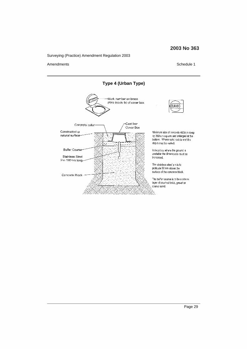
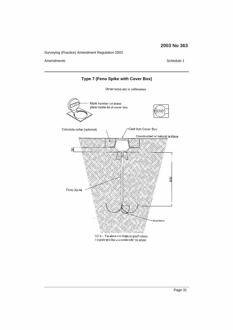
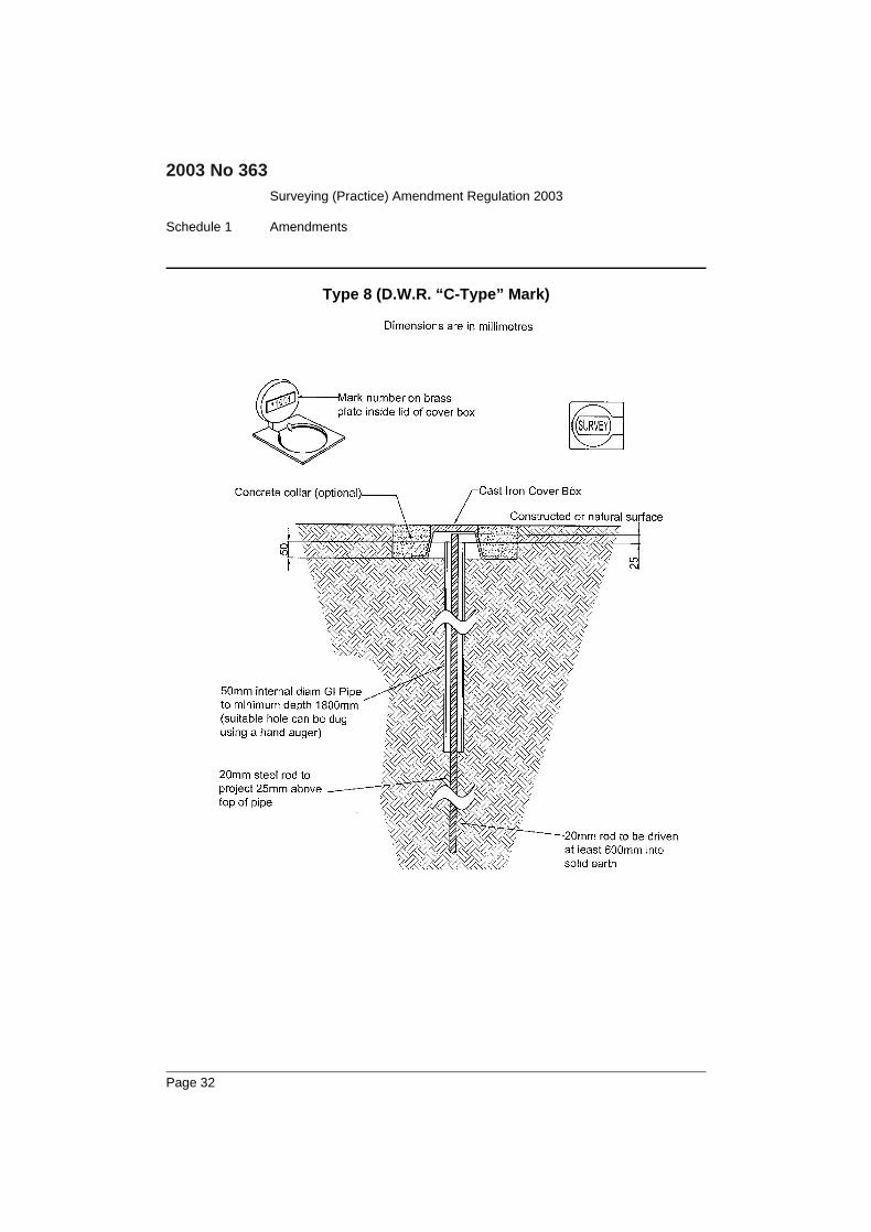
(1) The forms and styles of marks described in Schedule 4 aredeclared to be the forms and styles for permanent surveymarks under the Act.Note. Schedule 4 lists permanent survey marks by Type number, usingthe same Type numbers as have been allocated by previous regulations.Type numbers 3 and 5 are now obsolete, and so do not appear in theSchedule.
(2) The forms and styles of marks described in Schedules 2, 3 and4 (boundary marks, reference marks and permanent surveymarks) are declared to be the forms and styles for surveymarks under the Act.
(3) Survey marks must be placed and used in accordance with anyrequirements specified in Schedules 2, 3 and 4.
(4) When a reference mark is required to be placed for thepurposes of a survey, the form and style of reference mark tobe used is to be chosen according to an order of preferencethat is the order in which they are listed in Schedule 3.
[37] Clause 45
Omit the clause. Insert instead:
45 Use of broad arrows
A broad arrow may be used on a survey mark only in relationto a survey referred to in section 4 or 5 of the Act.
[38] Clause 46 Datum used for levelling
Omit “(SP1)—Version 1.4 published in November 2000 by the Inter-Governmental Advisory Committee on Surveying and Mapping” fromclause 46 (3).
Page 16

Surveying (Practice) Amendment Regulation 2003
Amendments Schedule 1
2003 No 363
[39] Clause 47A
Insert after clause 47:
47A Placement of permanent survey marks by non-surveyors:section 25
For the purposes of section 25 of the Act, a person isauthorised to place a permanent survey mark at any locationif, and only if:(a) the mark is placed in accordance with any requirements
specified in Schedule 4, and(b) the location of the permanent survey mark is indicated
on a locality sketch plan that is in a form acceptable tothe Surveyor-General, and
(c) that locality sketch map is given to the Surveyor-General within 2 months after the permanent surveymark is placed.
[40] Clause 55 Location and relocation of mean high-water markboundary
Insert at the end of the section:Note. In certain locations, the operation of this clause may be affectedby Part 4B (Modification of doctrine of erosion and accretion) of theCoastal Protection Act 1979.
[41] Clause 56 Location and relocation of banks of non-tidal streamsor lakes
Insert after clause 56 (6):
(6A) If the middle line of a stream is the boundary of land and hasnot previously been defined by survey, or if the middle line ofa stream is otherwise required to be determined, then bothbanks of the stream must be surveyed and shown on thesurvey plan together with the determination of the middleline.
[42] Clause 59 Calculation of areas of land abutting a natural feature
Omit clause 59 (3). Insert instead:
(3) The bearings and distances between the end points of theradiations or offsets used to determine the location of thenatural feature, and the area of the land being surveyed, are tobe shown on the survey plan for that land.
Page 17
Surveying (Practice) Amendment Regulation 2003
Schedule 1 Amendments
2003 No 363
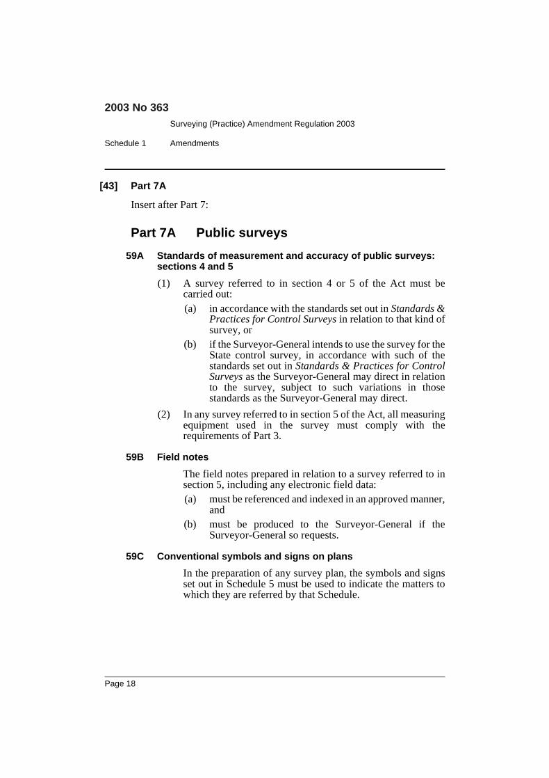
[43] Part 7A
Insert after Part 7:
Part 7A Public surveys
59A Standards of measurement and accuracy of public surveys:sections 4 and 5
(1) A survey referred to in section 4 or 5 of the Act must becarried out:(a) in accordance with the standards set out in Standards &
Practices for Control Surveys in relation to that kind ofsurvey, or
(b) if the Surveyor-General intends to use the survey for theState control survey, in accordance with such of thestandards set out in Standards & Practices for ControlSurveys as the Surveyor-General may direct in relationto the survey, subject to such variations in thosestandards as the Surveyor-General may direct.
(2) In any survey referred to in section 5 of the Act, all measuringequipment used in the survey must comply with therequirements of Part 3.
59B Field notes
The field notes prepared in relation to a survey referred to insection 5, including any electronic field data:(a) must be referenced and indexed in an approved manner,
and(b) must be produced to the Surveyor-General if the
Surveyor-General so requests.
59C Conventional symbols and signs on plans
In the preparation of any survey plan, the symbols and signsset out in Schedule 5 must be used to indicate the matters towhich they are referred by that Schedule.
Page 18
Surveying (Practice) Amendment Regulation 2003
Amendments Schedule 1
2003 No 363
[44] Clause 60 Deferment of placement of survey marks
Omit clause 60 (2) (b). Insert instead:(b) deposit with the Surveyor-General the amount
specified in Schedule 6 in that regard, and
[45] Clause 62 Effect of contravention
Omit “section 14 of the Act (Power of board to deal with offences)”.
Insert instead “section 13 of the Act (Professional misconduct)”.
[46] Clause 62A
Insert after clause 62:
62A Removal etc of survey marks
(1) An application for an authorisation referred to in section 24(1) of the Act must be made to the Surveyor-General at least14 days before the date on which the applicant intends toremove, damage, destroy, obliterate or deface the surveymark in respect of which the authorisation is sought.
(2) Subclause (1) applies only to permanent survey marks andreference marks.
[47] Schedules 1–6
Omit Schedule 1. Insert instead:
Schedule 1 Forms(Clause 4 (2))
Form 1 Survey certificate(Surveying Regulation 2001—Clause 10)
I, [Insert Name] of [Insert Address], a surveyor registered under the Surveying Act2002, certify that the survey represented in this plan is accurate, has been made inaccordance with the Surveying Regulation 2001 and was completed on: [Insert dateof completion of survey].
Page 19

Surveying (Practice) Amendment Regulation 2003
Schedule 1 Amendments
2003 No 363
Dated:
(Signature)
Form 2 Notice of entry(Surveying Regulation 2001—Clause 11)
To the occupier of: [Insert reference to land proposed to be entered]
I, [Insert Name] of [Insert Address], in my capacity as [Insert capacity of personconcerned, such as “a surveyor” or “an authorised person”], give notice undersection 19 of the Surveying Act 2002 that I intend to enter the land referred to aboveon: [Insert dates of proposed entry] together with my assistants for purposes relatingto the making of a survey.
Dated:
(Signature)
Form 2A Certificate of authority(Surveying Regulation 2001—Clause 11A)
The surveyrelates to:
[Specify the land actually surveyed, or specify any land shown inthe plan that is not the subject of the survey]
Board of Surveying and Spatial Information
[photo]
I certify that:[Name of person]Identification number:is [Insert capacity of cardholder, such as “a surveyor”or “an authorised person”] and is authorised toexercise the powers of entry conferred by Part 4 of theSurveying Act 2002
Date of issueDD/MM/YY Surveyor-General
Page 20
Surveying (Practice) Amendment Regulation 2003
Amendments Schedule 1
2003 No 363
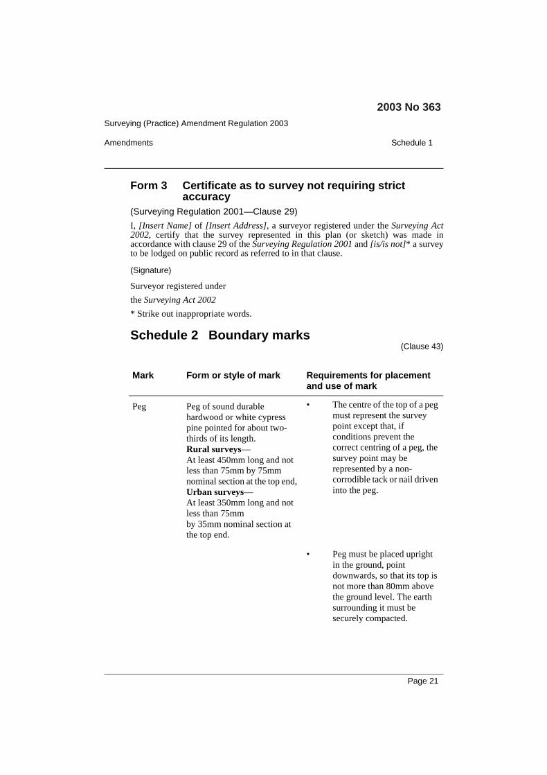
Form 3 Certificate as to survey not requiring strictaccuracy
(Surveying Regulation 2001—Clause 29)
I, [Insert Name] of [Insert Address], a surveyor registered under the Surveying Act2002, certify that the survey represented in this plan (or sketch) was made inaccordance with clause 29 of the Surveying Regulation 2001 and [is/is not]* a surveyto be lodged on public record as referred to in that clause.
(Signature)
Surveyor registered under
the Surveying Act 2002
* Strike out inappropriate words.
Schedule 2 Boundary marks(Clause 43)
Mark Form or style of mark Requirements for placementand use of mark
Peg Peg of sound durablehardwood or white cypresspine pointed for about two-thirds of its length.Rural surveys—At least 450mm long and notless than 75mm by 75mmnominal section at the top end,Urban surveys—At least 350mm long and notless than 75mmby 35mm nominal section atthe top end.
• The centre of the top of a pegmust represent the surveypoint except that, ifconditions prevent thecorrect centring of a peg, thesurvey point may berepresented by a non-corrodible tack or nail driveninto the peg.
• Peg must be placed uprightin the ground, pointdownwards, so that its top isnot more than 80mm abovethe ground level. The earthsurrounding it must besecurely compacted.
Page 21

Surveying (Practice) Amendment Regulation 2003
Schedule 1 Amendments
2003 No 363
• If a peg projecting above thesurface of the ground couldbe hazardous orinconvenient to the publicthe peg may, at the discretionof the surveyor, be placedflush with the surface of theground. If that is done, thefact must be noted on theplan of survey.
• When the depth of soil isinsufficient to permit theconventional placement of apeg, then:(a) if there is sound rock,
a drill hole and wingor chiselled wingsmust be placed in therock, or
(b) if there is no soundrock, a cairn of rocksmust be built aroundthe peg above thesurface of the soil.
Drill hole Drill hole of not less than6mm in diameter and not lessthan 10mm deep.
• Drilled into rock, concrete orsubstantial structure.
• If practicable, a chiselledwing must be cut anddirected to the mark.
Non-corrodiblenail
Non-corrodible nail at least80mm long.
• Driven completely into fixedtimber.
• If practicable, a chiselledwing must be cut anddirected to the mark.
Mark Form or style of mark Requirements for placementand use of mark
Page 22
Surveying (Practice) Amendment Regulation 2003
Amendments Schedule 1
2003 No 363
Non-corrodiblerod or spike
Non-corrodible rod or spike atleast 150mm long.
• Only to be used if theplacement of a peg is notpracticable.
• Driven flush to the surface.
Broad arrow Broad arrow at least 80mmlong, 20mm wide and 10 mmdeep at the base, pointed atone end.
• Cut in rock, concrete,substantial structure or fixedtimber.
Lockspit A trench, or line of packedstones, not less then one metrelong, 200mm wide, 150mmdeep and commencing 300mmfrom each boundary mark.
• Dug or placed in thedirection of the boundarylines.
• If the type of soil renderstrenches ineffective,direction stakes not less than50mm by 30mm by 450mmmay be placed in thedirection of the boundarylines 4 metres distant fromthe corner.
Chiselledwing
Chiselled wing at least 80mmlong, 20mm wide and 10 mmdeep at the base, pointed atone end.
• Cut in rock, concrete,substantial structure or fixedtimber.
• Not to be used by itself as aboundary mark.
Approvedmark
A mark of a durable characterapproved for specific terrain.
• As approved by the SurveyorGeneral.
Mark Form or style of mark Requirements for placementand use of mark
Page 23

Surveying (Practice) Amendment Regulation 2003
Schedule 1 Amendments
2003 No 363
Schedule 3 Reference marks(Clause 43)
Mark Form or style of markRequirements for placementand use of mark
PermanentSurvey Mark
As for the PermanentSurvey Marks described inSchedule 4.
• As specified in Schedule 4.
Drill hole Drill hole not less than 6mmin diameter and not less than10mm deep.
• Drilled into rock, concrete orsubstantial structure.
• A chiselled wing must be cutand directed to the mark.
Chiselled wing Chiselled wing at least80mm long, 20mm wideand 10 mm deep at the base,pointed at one end.
• Cut in a substantial structure,fixed timber or the soundwood of a suitable tree.
• The point of the chiselledwing being the referencepoint, the chiselled wing toface towards the relevantcorner.
• Placed at a convenient heightabove ground level.
Broad arrow Broad arrow comprising ofthree chiselled wings atleast 80mm long, 20mmwide and 10 mm deep at thebase, pointed at one end.
• Cut in rock, concrete,substantial structure, fixedtimber or the sound wood ofa suitable tree.
• The point of the chiselledwing being the referencepoint.
• Faced towards the relevantcorner.
Page 24

Surveying (Practice) Amendment Regulation 2003
Amendments Schedule 1
2003 No 363
• Placed at a convenient heightabove ground level.
Metal spike orgalvanisediron pipe
Metal spike at least 300mmlong. If a solid metal spike,an external diameter of atleast 20 mm. If a pipe, aninternal diameter of at least20mm and a rim wallthickness of at least 3mm.
• Placed vertically and at least80mm below the surface ofthe ground, or deeper ifplaced below where fencingis likely to be erected.
Specific point A specific point, on apermanent or substantialstructure.
• The specific point must beadequately described.
• If practicable, a chiselledwing must be cut anddirected to the mark.
Galvanisedstar picket
Galvanised star picket atleast 450mm in length.
• Placed vertically and at least80mm below the surface ofthe ground, or deeper ifplaced below where fencingis likely to be erected.
Non-corrodible nail
Non-corrodible nail at least80mm long.
• Driven completely into fixedtimber.
• If practicable, a chiselledwing must be cut anddirected to the mark.
PVC pipe PVC pipe at least one metrein length and 20mm ininternal diameter, made ofmaterial with a thickness ofat least 3mm.
• For use in swampy or marshareas.
• Placed vertically.
Mark Form or style of markRequirements for placementand use of mark
Page 25

Surveying (Practice) Amendment Regulation 2003
Schedule 1 Amendments
2003 No 363
Glass bottle Glass bottle filled with sand,soil, cement or other similarmaterial and at least 200mmin length and 30mm in neckdiameter.
• Placed vertically and at least80mm below the surface ofthe ground, or deeper ifplaced below where fencingis likely to be erected.
Reinforcedconcrete block
Reinforced concrete blockin the form of a truncatedpyramid 400mm long,150mm square (at the lowerend) and 100mm square (atthe upper end) into the topof which a non-corrodiblenail or plug not less than80mm long has beeninserted at least 75mm deep.
• Placed vertically and at least80mm below the surface ofthe ground, or deeper ifplaced below where fencingis likely to be erected.
Approvedmark
A mark of a durablecharacter approved forspecific terrain.
• As approved by the SurveyorGeneral.
Mark Form or style of markRequirements for placementand use of mark
Page 26

Surveying (Practice) Amendment Regulation 2003
Amendments Schedule 1
2003 No 363
Schedule 4 Permanent survey marks(Clause 43)
Type 1 (State Survey Mark)
Page 27

Surveying (Practice) Amendment Regulation 2003
Schedule 1 Amendments
2003 No 363
Type 2 (State Survey Mark)
Page 28
Surveying (Practice) Amendment Regulation 2003
Amendments Schedule 1
2003 No 363
Type 4 (Urban Type)
Page 29

Surveying (Practice) Amendment Regulation 2003
Schedule 1 Amendments
2003 No 363
Type 6 (Non Urban Type)
Page 30
Surveying (Practice) Amendment Regulation 2003
Amendments Schedule 1
2003 No 363
Type 7 (Feno Spike with Cover Box)
Page 31
Surveying (Practice) Amendment Regulation 2003
Schedule 1 Amendments
2003 No 363
Type 8 (D.W.R. “C-Type” Mark)
Page 32

Surveying (Practice) Amendment Regulation 2003
Amendments Schedule 1
2003 No 363
Type 9 (Trigonmetrical Station)
Page 33

Surveying (Practice) Amendment Regulation 2003
Schedule 1 Amendments
2003 No 363
Type 10 (Rooftop Pillar)
Page 34

Surveying (Practice) Amendment Regulation 2003
Amendments Schedule 1
2003 No 363
Schedule 5 Conventional symbols and signs(Clause 59C)
Conventional Signs and Symbols to be used on Plans
Page 35

Surveying (Practice) Amendment Regulation 2003
Schedule 1 Amendments
2003 No 363
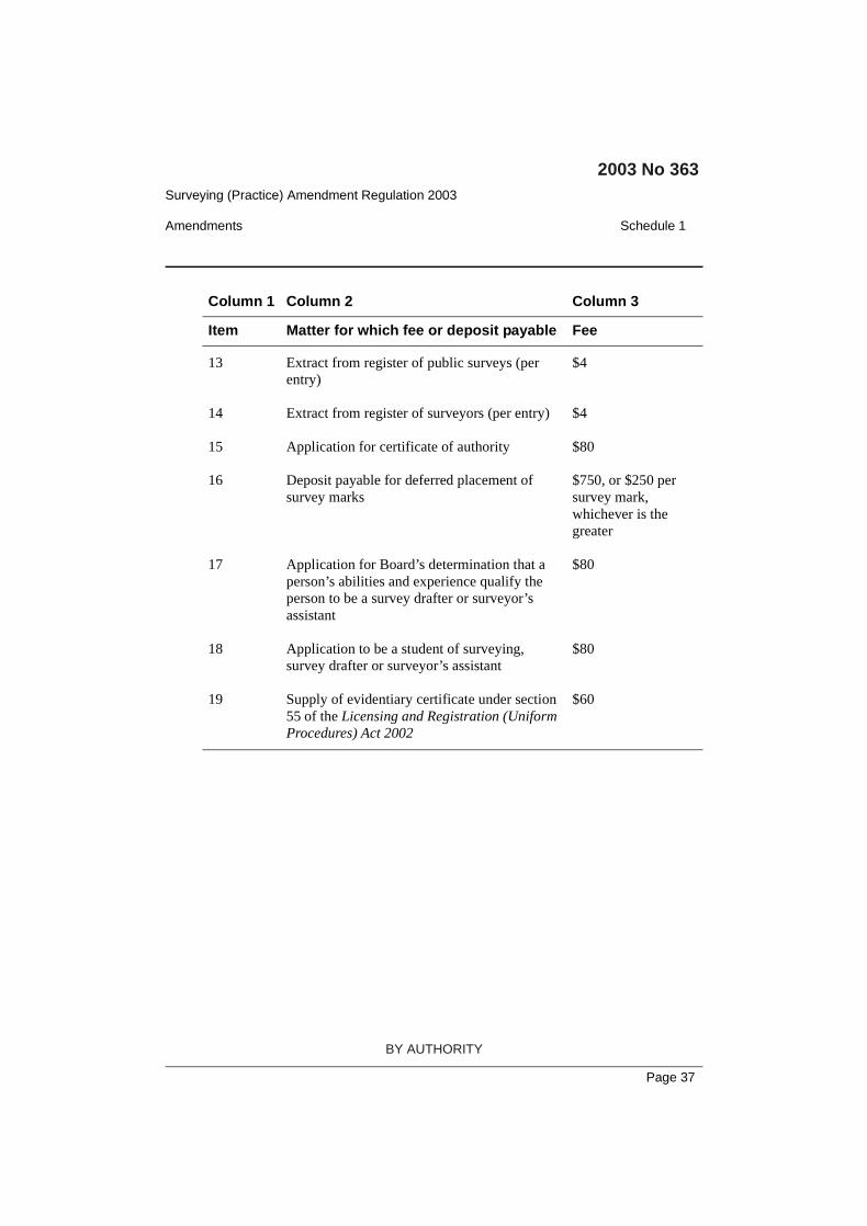
Schedule 6 Fees and deposits(Clause 4K)
Column 1 Column 2 Column 3
Item Matter for which fee or deposit payable Fee
1 Application to sit for Board examination $250 per subject
2 Application to enrol in recognised professionaltraining agreement
$60
3 Relodgment of application to enrol inrecognised professional training agreement
$30
4 Variation of application to enrol in recognisedprofessional training agreement
$30
5 Submission of recognised professional trainingagreement report
$200 per report
6 Resubmission of recognised professionaltraining agreement report
$100
7 Final interview (recognised professionaltraining agreement report)
$200
8 Application for granting of registration $60
9 Application for restoration of registration $150
10 Application for replacement of certificate ofregistration
$60
11 Annual administration fee $360 or, in the caseof registration asboth a land surveyorand mining surveyor,$240 in respect ofeach registration
12 Application to inspect register of publicsurveys
$25
Page 36
Surveying (Practice) Amendment Regulation 2003
Amendments Schedule 1
2003 No 363
13 Extract from register of public surveys (perentry)
$4
14 Extract from register of surveyors (per entry) $4
15 Application for certificate of authority $80
16 Deposit payable for deferred placement ofsurvey marks
$750, or $250 persurvey mark,whichever is thegreater
17 Application for Board’s determination that aperson’s abilities and experience qualify theperson to be a survey drafter or surveyor’sassistant
$80
18 Application to be a student of surveying,survey drafter or surveyor’s assistant
$80
19 Supply of evidentiary certificate under section55 of the Licensing and Registration (UniformProcedures) Act 2002
$60
Column 1 Column 2 Column 3
Item Matter for which fee or deposit payable Fee
Page 37
BY AUTHORITY