survey of coastal alabama marinas: an inventory … · survey of coastal alabama marinas : an...
TRANSCRIPT
SURVEY OF COASTAL ALABAMA MARINAS:
AN INVENTORY OF CURRENT BEST MANAGEMENT PRACTICES
July 2007
Randy C. Shaneyfelt Heather D. Krantz Environmental Scientist/Program Coordinator Environmental Scientist AL Department of Environmental Management AL Department of Environmental Management
Alabama Department of Environmental Management Mobile Branch
2204 Perimeter Road, Mobile, Alabama 36615

Funding for this project was provided in part by award #NA04NOS4190029
through the Coastal Zone Management Act of 1972, as amended, administered by the Office of Ocean and Coastal Resource Management,
National Oceanic and Atmospheric Administration in support of the Alabama Coastal Nonpoint Pollution Control Program, which is jointly administered by the Alabama Department of Conservation and Natural Resources, State Lands Division and the
Alabama Department of Environmental Management.
Acknowledgements We would like to acknowledge the wonderful cooperation of the local Marina owners and staff
members of coastal Alabama that enabled the completion of this project. Also we would like to make our appreciation known to the members of ADEM’s Coastal Section and Mobile Branch, along with staff members of the Army Corps of Engineers-Mobile District, U. S. Fish and Wildlife, U. S. Coast Guard, Alabama Department of Conservation and Natural Resources, for their help in developing
and reviewing the assessment criteria for this project.
Disclaimers The mention or depiction of trade names or facility names in this document is for illustrative purposes only
and does not constitute an endorsement by the Alabama Department of Environmental Management, the Alabama Department of Conservation and Natural Resources, or
the National Atmospheric and Oceanic Administration.
ii
Survey of Coastal Alabama Marinas : An Inventory of Current Best Management Practices
iii
Table of Contents PageFunding, Acknowledgement, and Disclaimer----------------------------------------ii Maps------------------------------------------------------------------------------------------iv Acronyms & Abbreviations--------------------------------------------------------------v I Introduction------------------------------------------------------------------------1 II Project Objectives-----------------------------------------------------------------2 III Project Methodology--------------------------------------------------------------3 IV Management Measures for Marinas and Recreational Boating--------------------------------------------------------4 V Targeted Marina BMP Survey Areas-----------------------------------------6 VI Marina BMP Survey Results----------------------------------------------------11
Section I Site Location and Contact Information---------------------12 Section II Marina Flushing--------------------------------------------------12 Section III Marina Dredge and Fill-----------------------------------------12 Section IV Erosion Prevention----------------------------------------------13 Section V Habitat Assessment----------------------------------------------15 Section VI Water Quality Assessment-------------------------------------19 Section VII Stormwater Run-Off--------------------------------------------20 Section VIII Fuel Station Design----------------------------------------------21 Section IX Sewage Facility---------------------------------------------------22 Section X Solid Waste--------------------------------------------------------23 Section XI Fish Waste---------------------------------------------------------24 Section XII Liquid Materials-------------------------------------------------25 Section XIII Comments---------------------------------------------------------25
VII Summary of Survey Results------------------------------------------------------26 A Overall Conclusions------------------------------------------------------26 B Comparisons of 8-Digit Hydrological Unit Codes (HUCs)-------27 1 Perdido Bay HUC------------------------------------------------27 2 Mobile Bay-Escatawpa HUCs---------------------------------27 3 Mobile Tensaw Delta HUC-------------------------------------28 4 Mississippi Coastal HUC---------------------------------------28 VIII Survey Recommendations--------------------------------------------------------28 Appendix A-----------------------------------------------------------------------------------30 Appendix B-----------------------------------------------------------------------------------35 Appendix C-----------------------------------------------------------------------------------36 Appendix D-----------------------------------------------------------------------------------42

Survey of Coastal Alabama Marinas : An Inventory of Current Best Management Practices
iv
Maps
Page Map I. Coastal Alabama Marina BMP Survey Areas---------------5 Map II. Perdido Bay Marina BMP Survey Sites----------------------7 Map III. Mobile Bay and Escatawpa Marina BMP Survey Sites----8 Map IV. Mobile- Tensaw Delta Marina BMP Survey Sites----------9 Map V. Mississippi Coastal Marina BMP Survey Sites---------------10
Survey of Coastal Alabama Marinas : An Inventory of Current Best Management Practices
v
Acronyms & Abbreviations
ACAMP Alabama’s Coastal Area Management Program ACNPCP Alabama Coastal Nonpoint Pollution Control Program ADCNR Alabama Department of Conservation and Natural Resources ADEM Alabama Department of Environmental Management ADPH Alabama Department of Public Health AWW Alabama Water Watch B.E.A.C.H. Beaches Environmental Assessment and Coastal Health Act BMP Best Management Practices GIS geographic information system GPS Global Positioning System HUCs Hydrological Unit Codes MA management Area MB Marina Basin MMs Management Measures NOAA-OCRM National Oceanic and Atmospheric Administration Office of
Ocean and Coastal Resource Management NPS nonpoint source NPDES National Pollutant Elimination Discharge System NRCS Natural Resources Conservation Service SAV Submerged Aquatic Vegetation SPCC Spill Prevention Control and Countermeasure TSS total suspended solids USEPA United States Environmental Protection Agency WQ Water Quality
1
SURVEY OF COASTAL ALABAMA MARINAS:
AN INVENTORY OF CURRENT BEST MANAGEMENT PRACTICES
I. Introduction The Survey of Coastal Marinas: An Inventory of Current Best Management Practices (Marina BMP Survey) seeks to identify baseline existing Best Management Practices (BMPs) data in coastal Marina facilities, within the Mobile and Baldwin County area, during the 2004-2006 summer/ fall boating seasons. The Alabama Coastal Nonpoint Pollution Control Program (ACNPCP) developed this project to identify, survey, and map marina and residential facilities that provide mooring for 10 or more vessels and/or provide water access, as a boat launch facility (also referred to as Marina Site). The types of Marina & Recreational Boating facilities identified include, marinas, residential docking facilities and boat ramps. All of these three facility-types were evaluated in each of the Marina BMP Survey’s designated subwatershed areas for the purposes of this Marina BMP Study. Alabama’s Coastal Area Management Program (ACAMP) provided funding from NOAA that allows the Alabama Department of Environmental Management (ADEM) to coordinate the implementation of projects such as this, which have been designed by the ADEM’s ACNPCP staff to address Alabama’s CZARA-§6217 Conditional Approval items and provide the foundational 5-Step Projects Template below, for the Alabama Coastal Nonpoint Pollution Control Program:
ACNPCP Projects Development Template
• Step 1-Develop baseline information through interagency data coordination and BMP Surveys. Also to develop technical assistance training workshops that will enhance regulatory and public awareness.
• Step 2-Develop Targeted Water Quality (WQ) or Monitoring Studies applicable to each Category.
• Step 3-Compile available Projects and permit information, developing databases and Geographic Information System (GIS) components that allow the analysis of Program-related data for specific land-use categories, each five years.
• Step 4-Use this info to develop “on the ground” implementation projects and/or engage in related Program education and outreach projects.
• Step 5-Develop post-implementation monitoring and WQ Studies to gauge or measure effectiveness of ACNPCP Projects and develop current Program needs.
This Marina BMP Survey project implements Step 1 of the Template for this category and satisfies the 1998 Conditional Approval issues sited in the Alabama Coastal Findings and Conditions document under the Marinas & Recreational Boating section. It states that “Alabama will develop a strategy to implement and demonstrate credible survey tools” within the ACNPCP Management Area, which may track and document implementation of all Management Measures (MMs).

Survey of Coastal Alabama Marinas : An Inventory of Current Best Management Practices
II. Project Objectives The objectives of the Survey of Coastal Marinas: An Inventory of Current Best Management Practices project were two-fold: 1. Develop a Marina Best Management Practices Survey (BMP Survey) inspection form that reflects the multi-agency informational needs relating to Marinas and Recreational Boating management measures as outlined by the Guidance Specifying Management Measures for Sources of Nonpoint Pollution in Coastal Waters, EPA 840-B-92-002 January 1993, and other issues of interest to Alabama’s Coastal Area Management Program, the Alabama-Mississippi Clean Marina Program, U.S. Coast Guard, and the Alabama Marine Police. 2. That through the implementation of this Marina BMP Survey the ACNPCP would collect a complete suite of current and accurate baseline Marina BMP implementation data within the available marina/recreational boating facilities or Marina Sites located within Alabama’s CNPCP Management Area, in order to ascertain or field-truth which existing BMPs were in place and functioning within those Marina Sites during potentially high boating activity periods. Overall this Marina BMP Survey project provides proof and documentation of Alabama’s appropriate implementation of credible survey tools throughout the ACNPCP Management Area, relating to documenting the inventory of coastal Alabama Marinas and the tracking of current baseline Marina and Recreational Boating Management Measures in coastal Alabama.
2
Survey of Coastal Alabama Marinas : An Inventory of Current Best Management Practices
III. Project Methodology The Marina BMP Survey evaluation form (see Appendix A) was developed as a coordinated interagency effort over a ten-month period. ADEM’s ACNPCP staff spearheaded the design of the Marina BMP Survey form, including review and design input from ADEM-Coastal Section and Mobile Branch staff, ADCNR-Marine Police and Coastal Section staff, and local U.S. Coast Guard representatives. The Survey was primarily designed to evaluate the presence and/or absence of USEPA recommended management measures, as best management practices for Marinas and Recreational Boating Activities, within the Alabama CNPCP Management Area. This Survey also sought to evaluate these land-use activities to correlate their positional relationship to the surrounding area, as well as, assess incidental items of interest for the partner agencies relating to Marinas usage. To complement this effort ADEM developed a Marinas Survey Letter (see Appendix B) for this project, which was designed to communicate and introduce the concept of the project to the local Marina owner/managers. This was distributed to all known Marina owners and presented onsite by project staff, at the time of the Survey evaluation. If a facility operator was not present, then the staff conducted the Survey and if possible, conversed with the boat-owner tenants to ascertain key information. Preliminary duties to prepare for the actual initiation of the Marina Survey involved many activities; first there was acquisition of any available data concerning coastal Alabama Marinas. This included tabletop setup, computer information queries and site specific information assessment (e.g. County Revenue Commissions tax plats and owner information with aerial photography and topographic maps and some field reconnaissance). The major amount of Marina Site locations and contact information was acquired by this means, with the balance being documented onsite, along with the onsite request to Survey the Marina Site facilities. The ADEM staff began to collect accurate baseline data for the identified Marina Sites, which included those known sites within each of the designated 8 digit subwatersheds. Many Marina Sites were added as the staff conducted the Survey and spoke with Marina owners, tenants, and recreational users. The ADEM staff conducted an inspection of the Marina BMP Survey for each Marina Site which comprised an assessment of the Marina's adjacent constructed area, parking areas, stormwater conveyances, and waters wherein the marina/recreational boating facility is located; including boat ramps, docking piers, boat slips, break waters, and bulkheading, etc. Also, it is interesting to note that Section V., the Habitat Assessment section, of the Marina BMP Survey was developed to provide important additional information relating to evaluation of the Marina Site’s landscape positioning and adjacency of other development/land-use areas. Each Marina Site was photographed and its location determined with Global Positioning System (GPS) instrumentation. These GPS coordinates were used to place each Marina Site within the appropriate subwatershed drainage area. These subwatersheds are listed for this report (see Appendix C ) and mapped in terms of the Natural Resources Conservation Service (NRCS) Hydrologic Unit Codes (HUCs), primarily with 8-digit descriptors and cross-referenced secondarily to the new NRCS 12-digit numeric HUC designations.
3
Survey of Coastal Alabama Marinas : An Inventory of Current Best Management Practices
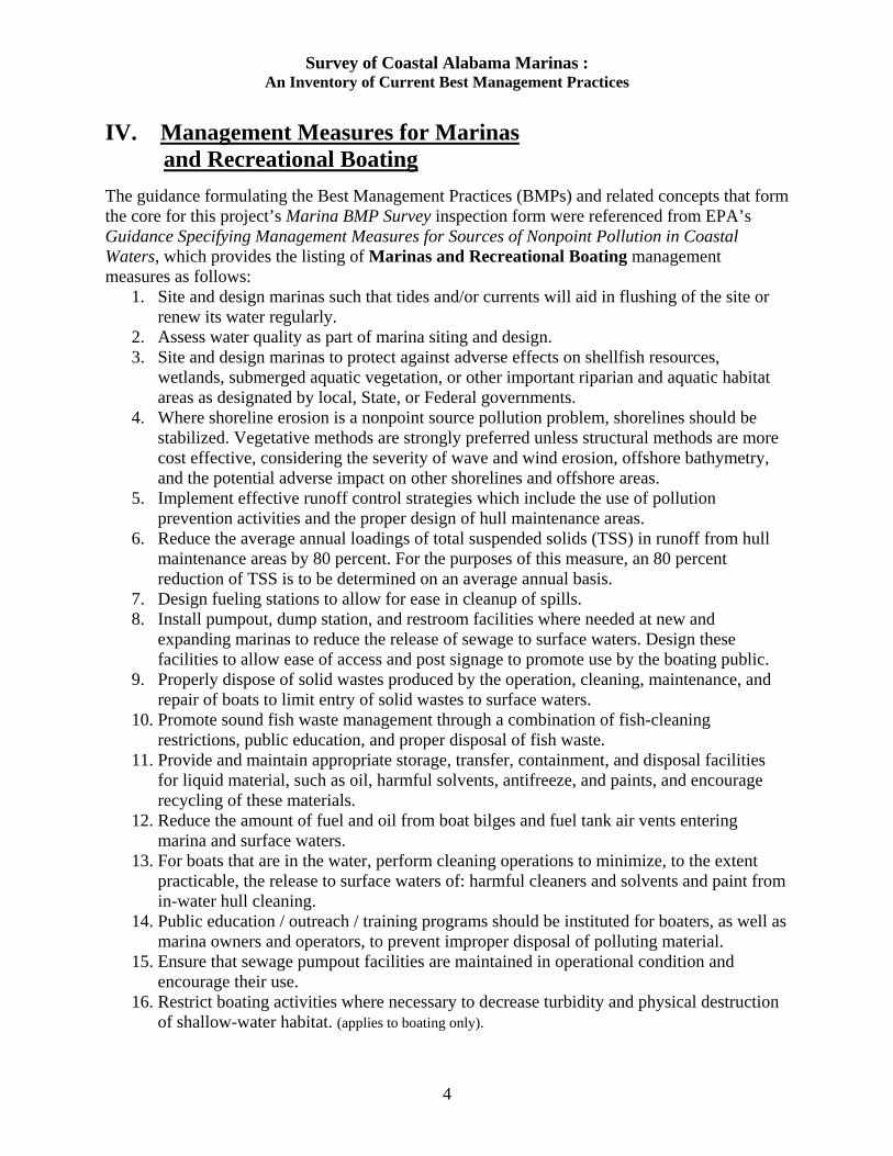
IV. Management Measures for Marinas and Recreational Boating The guidance formulating the Best Management Practices (BMPs) and related concepts that form the core for this project’s Marina BMP Survey inspection form were referenced from EPA’s Guidance Specifying Management Measures for Sources of Nonpoint Pollution in Coastal Waters, which provides the listing of Marinas and Recreational Boating management measures as follows:
1. Site and design marinas such that tides and/or currents will aid in flushing of the site or renew its water regularly.
2. Assess water quality as part of marina siting and design. 3. Site and design marinas to protect against adverse effects on shellfish resources,
wetlands, submerged aquatic vegetation, or other important riparian and aquatic habitat areas as designated by local, State, or Federal governments.
4. Where shoreline erosion is a nonpoint source pollution problem, shorelines should be stabilized. Vegetative methods are strongly preferred unless structural methods are more cost effective, considering the severity of wave and wind erosion, offshore bathymetry, and the potential adverse impact on other shorelines and offshore areas.
5. Implement effective runoff control strategies which include the use of pollution prevention activities and the proper design of hull maintenance areas.
6. Reduce the average annual loadings of total suspended solids (TSS) in runoff from hull maintenance areas by 80 percent. For the purposes of this measure, an 80 percent reduction of TSS is to be determined on an average annual basis.
7. Design fueling stations to allow for ease in cleanup of spills. 8. Install pumpout, dump station, and restroom facilities where needed at new and
expanding marinas to reduce the release of sewage to surface waters. Design these facilities to allow ease of access and post signage to promote use by the boating public.
9. Properly dispose of solid wastes produced by the operation, cleaning, maintenance, and repair of boats to limit entry of solid wastes to surface waters.
10. Promote sound fish waste management through a combination of fish-cleaning restrictions, public education, and proper disposal of fish waste.
11. Provide and maintain appropriate storage, transfer, containment, and disposal facilities for liquid material, such as oil, harmful solvents, antifreeze, and paints, and encourage recycling of these materials.
12. Reduce the amount of fuel and oil from boat bilges and fuel tank air vents entering marina and surface waters.
13. For boats that are in the water, perform cleaning operations to minimize, to the extent practicable, the release to surface waters of: harmful cleaners and solvents and paint from in-water hull cleaning.
14. Public education / outreach / training programs should be instituted for boaters, as well as marina owners and operators, to prevent improper disposal of polluting material.
15. Ensure that sewage pumpout facilities are maintained in operational condition and encourage their use.
16. Restrict boating activities where necessary to decrease turbidity and physical destruction of shallow-water habitat. (applies to boating only).
4
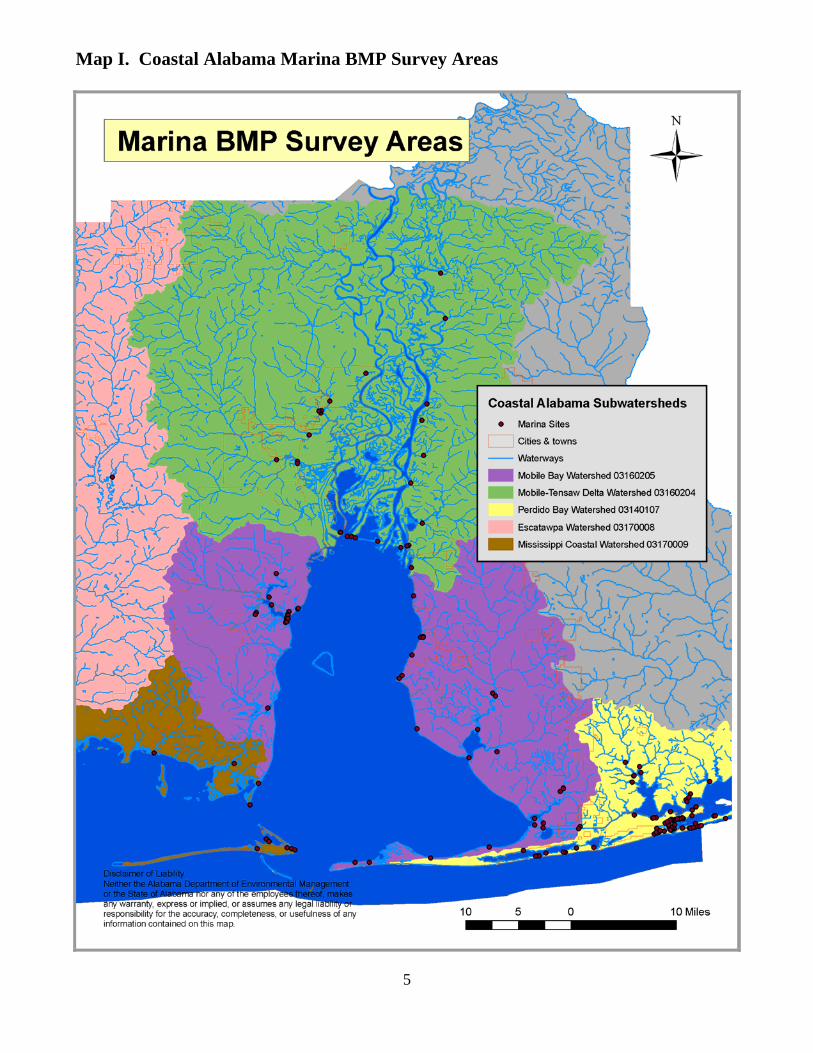
Map I. Coastal Alabama Marina BMP Survey Areas
5
Survey of Coastal Alabama Marinas : An Inventory of Current Best Management Practices
6
V. Targeted Marina BMP Survey Areas (refer to Map I above) The following Subwatersheds (see Appendix D) were targeted based upon the known presence of Marinas and boat ramp facilities within the ACNPCP Management Area: Perdido Bay –HUC 03140107 @ 313 sq. miles - refer to Map II This subwatershed is located in the southeastern Baldwin County and encompasses subwatershed HUCs 031401070104 (Palmetto Creek), 031401070201 (Sandy Creek), 031401070202 (Milfin Creek), 031401070203 (Graham Bayou), 031401070204 (Hammock Creek), and 031401070205 (Little Lagoon). Waterbodies include Cotton Bayou, Ole River, Perdido Bay, Terry Cove, Wolf Bay, Wolf Creek, Milfin Creek, Owens Bayou, Graham Bayou, Bay La Launch, Bayou St. John, Stone Quarry Bayou, Palmetto Creek, Lake Shelby, and Ono Cove. Mobile Bay -HUC 03160205 @ 883 sq. miles - refer to Map III Mobile Bay Watershed encompasses subwatersheds with the following Hydrological Unit Codes (HUCs): 031602050104 (Bon Secour Bay), 031602050201 (Garrow's Bend- Mobile Bay), 031602050202 (Upper Dog River), 031602050204 (Lower Dog River), 031602050207 (Delchamp's Bayou), 031602050301 (Yancey Branch), 031602050302 (Fly Creek), 031602050303 (Gum Swamp), 031602050307 (Lower Fish River), 031602050308 (Magnolia River), 031602050310 (Bon Secour River), and 031602050311 (Oyster Bay). Waterbodies include Dog River, Rabbit Creek, Perch Creek, Weeks Bay, Fly Creek, Fish River, Noltie Creek, Intercoastal Waterway, Bon Secour River, Little Lagoon, Navy Cove, and Mobile Bay. Escatawpa –HUC 03170008-90 @ 105 sq. miles - refer to Map III This subwatershed is located in west Mobile County on Big Creek Lake and encompasses subwatershed HUC 031700080402 (Big Creek Hamilton Creek). Mobile Tensaw Delta -HUC 03160204 @ 972 sq. miles - refer to Map IV Sites located in the northeastern portions of Mobile County and the northwestern portions of Baldwin County, the Mobile-Tensaw Delta Watershed, encompasses subwatersheds with the following Hydrological Unit Codes (HUCs): 031602040105 (Big Chippewa Lake), 031602040201 (Miffin Lake), 031602040203 (The Basin), 031602040301 (Gunnison Creek), 031602040302 (Bayou Sara), 031602040303 (Grand Bay), 031602040404 (Lower Chasaw Creek), 031602040503 (Lower Bay Minette Creek), and 031602040505 (Tensaw River-Apalachee River). Waterbodies include Chickasaw Creek, Dead Lake, Gunnison Creek, Mobile River, Steele Creek, Bayou Sara, Tensaw River, Chacaloochee Bay, Bay Minette Creek, Blakely River, D'Olive Bay, Hurricane Creek, Shellbank River, and . Mississippi Coastal -HUC 03170009 @ 231 sq. miles -refer to Map V This subwatershed is located in southernmost Mobile County and encompasses 12 digit sub-watershed HUCs 031700090103 (Grand Bay Swamp), 03170009020 2 (Dauphin Island), and 03160205010 (Mobile Bay). Waterbodies include Bayou Heron Canal, Bayou Aloe, Colony Cove, Dauphin Island Bay, Fort Gaines Pass, Mississippi Sound, Heron Bay, West Fowl River, Portersville Bay, and Mobile Bay.
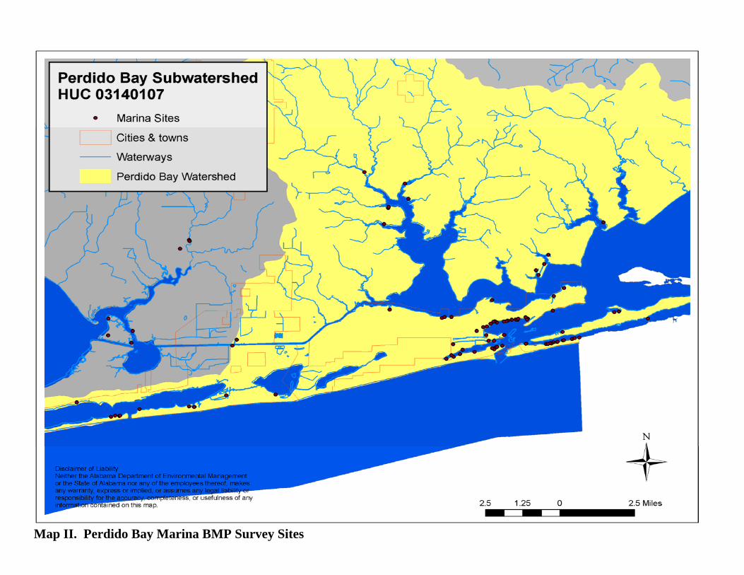
Map II. Perdido Bay Marina BMP Survey Sites
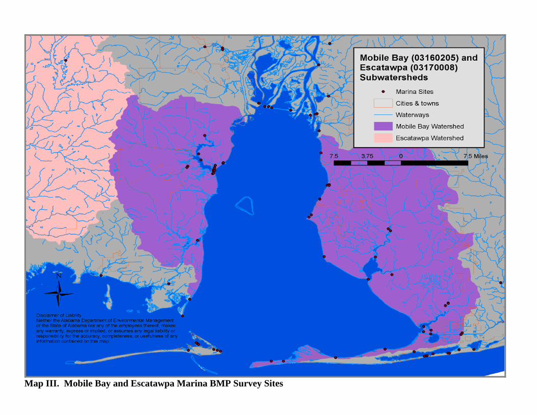
Map III. Mobile Bay and Escatawpa Marina BMP Survey Sites
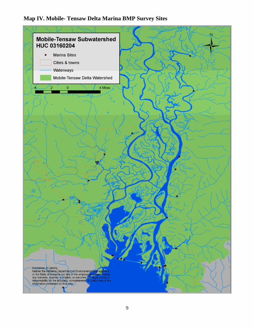
Map IV. Mobile- Tensaw Delta Marina BMP Survey Sites
9
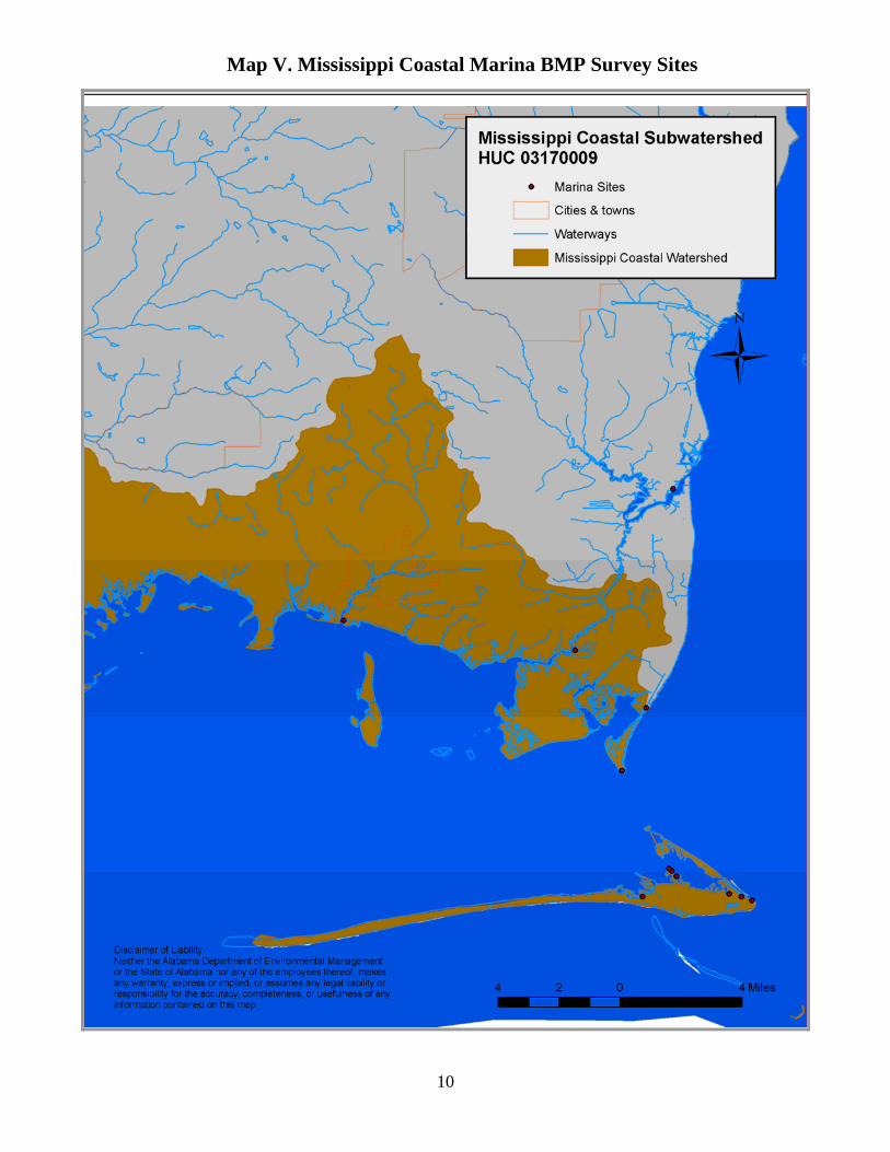
Map V. Mississippi Coastal Marina BMP Survey Sites
10
Survey of Coastal Alabama Marinas : An Inventory of Current Best Management Practices
11
VI. Marina BMP Survey Results Each Survey Section in the Marina BMP Survey was developed to quantify and address the management measures put forth in the EPA’s 1993 Guidance Specifying Management Measures for Sources of Nonpoint Pollution in Coastal Waters, as well as other pertinent Marina information for coastal Alabama. These Marina BMP Surveys were developed, recorded, and documented at 163 inspected Marina Sites through the efforts of ADEM’s Mobile Branch, including both the Environmental Assessment Section and Coastal Section staff members. These Marina BMP Survey Results and Summary scores were derived by calculating the mean of the Section percentile rankings with a score of 50 or greater, as adjusted for applicability to each site. This was calculated using the following process: These data observations were recorded at each Marina Site using the Marina BMP Survey Form (see Appendix A). The manner in which the Marina Sites were evaluated differed based upon the type of facility (e.g. Recreational Marina vs. Boat Ramp). In order to compute scores in an equivalent manner, specific BMPs or Sections that were non-applicable were documented as “NA” on the Marina Survey form. The points for each section were then calculated against the total possible score of applicable BMPs for each Marina Site. This yielded a percentile based score from 0 to 100 for each BMP Section, creating a probability distribution. The mean of those percentile scores ranked at 50% or greater were calculated to provide the Overall score for each Marina Site, including each Section and Subwatershed. Scoring Example for Section XI. Fish Waste: [Overall Point Range of -6 to +6] T11 Score for Marina A: (Marina with Fish Cleaning Station, with O&M Plan)
Section Score= (3-Yes @ +3 points & 3-No @ -3 points, with 0 NAs) = 0 points, within the a range of -6 to +6 = 50% = 50
T11 Score for Marina B: (Marina with Fish Cleaning Station, without O&M Plan)
Section Score = ( 2-Yes @ +2 points & 3-No @ -3 points, with 1 NA) = -1 point, within a range of -5 to +5= 40%=40
T11 Score for Marina C: (Marina without Fish Cleaning Station, without O&M Plan, with signage)
Section Score = (1-Yes @ +1 point & 4-No @ -4 points, with 1 NA) = -3 points within a range of -5 to +5 = 20%=20.
Since Marina A has the only passing score, which for the purposes of this Marina BMP Study has been determined to be a percentile score of 50 or greater per Section, the Section T11% Score = 1/3 = .33 =33%. This means that 33% of the marinas in this sample were documented to have suitable Fish Waste BMPs at a level of 50 percent or greater. This method of data ranking and calculation was utilized for each Section and Subwatershed tabulated in this Marina BMP Survey in order to identify those Marina Sites that exhibited the presence of a majority of the surveyed BMPs. Overall percentage scores were also tabulated for all Marina Sites that achieved a compliance standard at or above 50 percent for the observed presence of these BMPs.

Survey of Coastal Alabama Marinas : An Inventory of Current Best Management Practices
12
Section I. Site Location and Contact Information For purposes of this Report, the pertinent information collected for this Survey section has been displayed in the following Subwatershed Maps:
Map I Marina BMP Survey Area, Map II Perdido Bay Marina BMP Sites -HUC 03140107 Map III Mobile Bay Marina BMP Sites -HUC 03160205,
including Escatawpa Site -HUC 03170008-90 Map IV Mobile-Tensaw Marina BMP Sites -HUC 03160204, Map V Mississippi Coastal Marina BMP Sites -HUC 03170009.
All other information from this section has not been included, in order to provide non-disclosure as assured to the Survey participants of this project.
Section II. Marina Flushing The second section of the Marina BMP Survey pertains to EPA Management Measures that address the marina flushing and design parameters. The Marina Sites surveyed in this Study were ranked and 82% of these sites exhibited the presence of a majority of the surveyed BMPs related to Marina Flushing at a level of 50 percent or higher. The photographs below depict a few of the local facilities that incorporated some of the practices to ensure proper flushing (e.g. alternative designs to protect interior basin Submerged Aquatic Vegetation (SAV) areas and Marina entrance attenuators that allow more marina basin flow.)
Slotted wave attenuator as protection for SAVs Slotted wave attenuator at entrance of marina
Section III. Marina Dredge and Fill For purposes of this Report, activities relating to this Survey section were not observed during this Study period, therefore scores for this section were not included.
Survey of Coastal Alabama Marinas : An Inventory of Current Best Management Practices
13
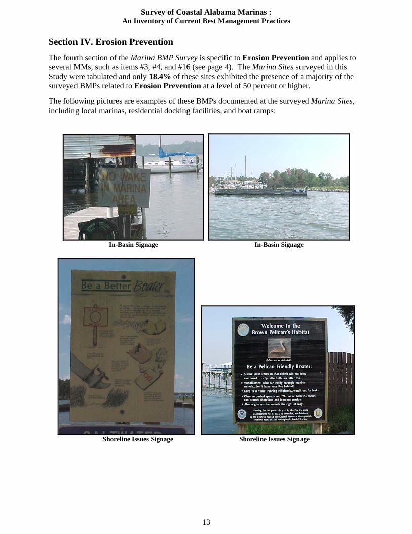
Section IV. Erosion Prevention The fourth section of the Marina BMP Survey is specific to Erosion Prevention and applies to several MMs, such as items #3, #4, and #16 (see page 4). The Marina Sites surveyed in this Study were tabulated and only 18.4% of these sites exhibited the presence of a majority of the surveyed BMPs related to Erosion Prevention at a level of 50 percent or higher. The following pictures are examples of these BMPs documented at the surveyed Marina Sites, including local marinas, residential docking facilities, and boat ramps:
In-Basin Signage In-Basin Signage
Shoreline Issues Signage Shoreline Issues Signage

Survey of Coastal Alabama Marinas : An Inventory of Current Best Management Practices
14
In-Basin Signage-‘Idle Speed / No Wake’ Shoreline Issues Signage- ‘Danger / Slow’
Example of Erosion Due to Undermined Bulkheading Example of Erosion Due to Wave Energy
Restricted Boating Activities in Emergent Areas Restricted Boating Activities in Emergent Areas
Boating activities need to be restricted in SAV and emergent areas adjacent to Marina Site

Survey of Coastal Alabama Marinas : An Inventory of Current Best Management Practices
15
Section V. Habitat Assessment This section in the Marina BMP Survey applies to Habitat Assessment concepts found in MMs #3, #4, and #16. In this Marina BMP Survey, 54.6% of these sites exhibited the presence of a majority of the surveyed BMPs related to Habitat Assessment at a score of 50 percent or higher. The Habitat Assessment section was developed to provide important additional information that describes and evaluates the Marina Site’s landscape positioning and adjacency to other development and /or land-use areas surrounding these marinas/recreational boating facilities. This Section also includes BMPs that relate to shoreline stabilization and vegetation. The following pictures are examples of some of the BMPs that were documented at the surveyed Marina Sites.
Shoreline partially stabilized by vegetation Minimal disturbance to riparian zone
Minimal disturbance to riparian zone Emergent vegetation versus bulkheading and
bordering with impervious surfaces.
Other shoreline stabilization techniques… Interesting shoreline stabilization techniques with
the use of roof shingles.

Survey of Coastal Alabama Marinas : An Inventory of Current Best Management Practices
16
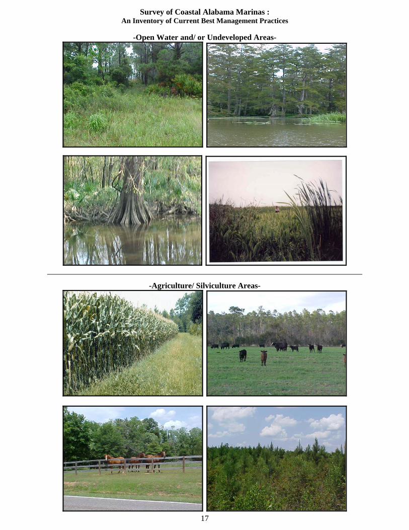
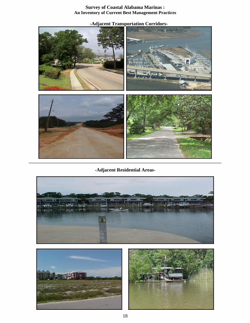
This section of the Marina Survey also seeks to evaluate the adjacency of the predominant land uses that surround the Marina Sites, in order to provide a basic assessment of the Marina’s position on the landscape. It may also serve to provide relative scores that express development pressures within each of the designated subwatersheds.
This aerial photograph illustrates the general position of this Marina complex, as it relates to Open Waters, Transportation Corridors, Undeveloped Marsh Areas and some Residential Areas at the top of this picture.
These Habitat Areas are evaluated by the type of Adjacent Marina Land Use that is in proximity to the Marina Site within a 500 foot radius. The photographs below provide some typical examples of these Habitat Area designations:
-Open Water and/ or Undeveloped Areas-
Survey of Coastal Alabama Marinas : An Inventory of Current Best Management Practices
17
-Open Water and/ or Undeveloped Areas-
-Agriculture/ Silviculture Areas-
Survey of Coastal Alabama Marinas : An Inventory of Current Best Management Practices
18
-Adjacent Transportation Corridors-
-Adjacent Residential Areas-
Survey of Coastal Alabama Marinas : An Inventory of Current Best Management Practices
19
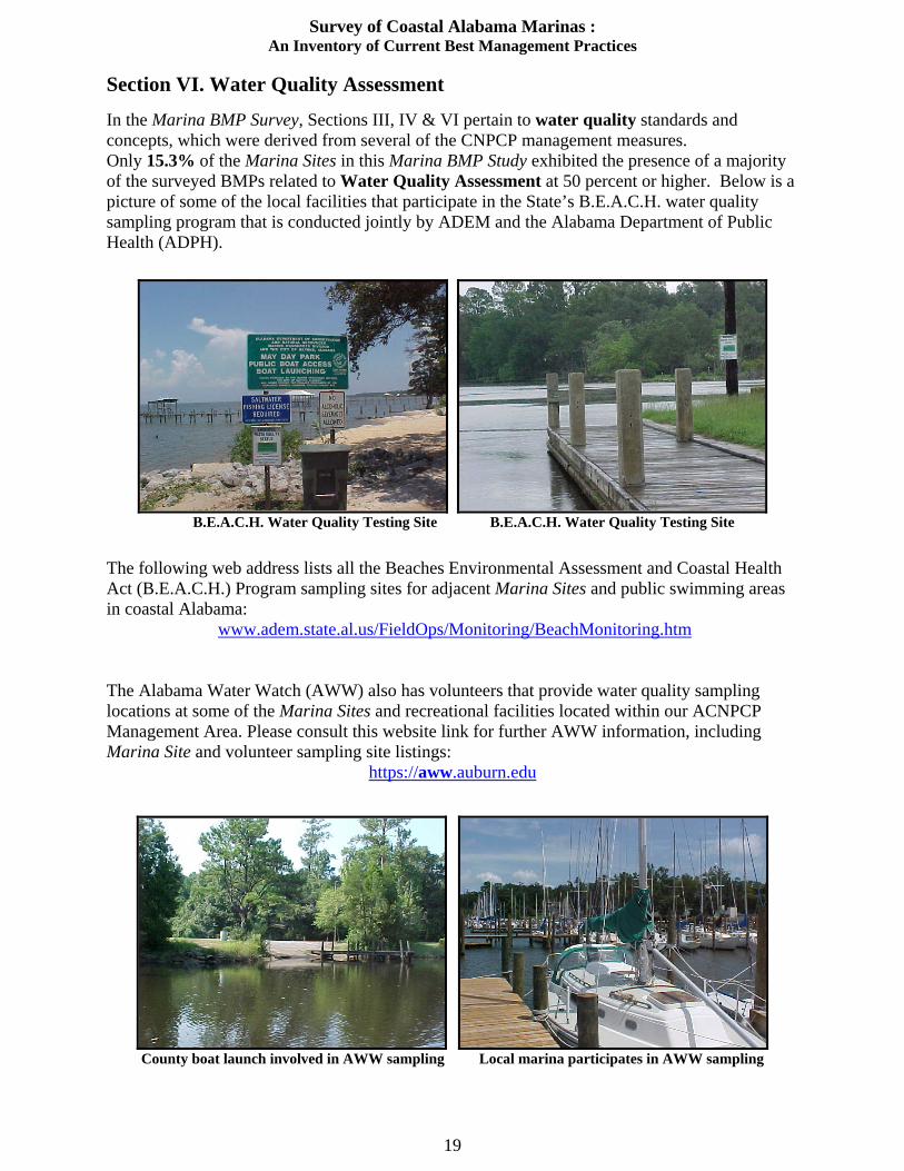
Section VI. Water Quality Assessment In the Marina BMP Survey, Sections III, IV & VI pertain to water quality standards and concepts, which were derived from several of the CNPCP management measures. Only 15.3% of the Marina Sites in this Marina BMP Study exhibited the presence of a majority of the surveyed BMPs related to Water Quality Assessment at 50 percent or higher. Below is a picture of some of the local facilities that participate in the State’s B.E.A.C.H. water quality sampling program that is conducted jointly by ADEM and the Alabama Department of Public Health (ADPH).
B.E.A.C.H. Water Quality Testing Site B.E.A.C.H. Water Quality Testing Site
The following web address lists all the Beaches Environmental Assessment and Coastal Health Act (B.E.A.C.H.) Program sampling sites for adjacent Marina Sites and public swimming areas in coastal Alabama:
www.adem.state.al.us/FieldOps/Monitoring/BeachMonitoring.htm The Alabama Water Watch (AWW) also has volunteers that provide water quality sampling locations at some of the Marina Sites and recreational facilities located within our ACNPCP Management Area. Please consult this website link for further AWW information, including Marina Site and volunteer sampling site listings:
https://aww.auburn.edu
County boat launch involved in AWW sampling Local marina participates in AWW sampling

Survey of Coastal Alabama Marinas : An Inventory of Current Best Management Practices
20
Section VII. Stormwater Run-Off This portion of the Marina BMP Survey pertains to stormwater run-off and what stormwater run-off control strategies are being implemented at the surveyed Marina Sites. Management Measures associated with this section are MMs #4, #5, #6, #9, and #11 (see Page 4). The Marina BMP Survey documented that 50.3% of the Marina Sites exhibited the presence of a majority of the surveyed BMPs related to Stormwater Run-Off at a level of 50 percent or higher. It should be noted that ADEM Administrative Code Rule 335-8-x-.xx) makes various provisions concerning some of this Section’s Management Measures, which were evaluated as baseline Marina BMPs (which may be attributable to Marina construction permitting processes). A few of the BMPs that relate to these Stormwater Run-Off concepts are depicted below:
Constructed wetland Porous parking and grassed buffer
Vegetated Infiltration basin Catch basin
Onsite Infiltration Trench Typical Designated Boat Hull Maintenance Area
Survey of Coastal Alabama Marinas : An Inventory of Current Best Management Practices
21
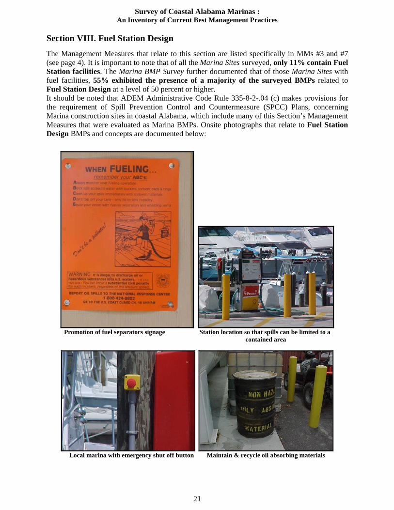
Section VIII. Fuel Station Design The Management Measures that relate to this section are listed specifically in MMs #3 and #7 (see page 4). It is important to note that of all the Marina Sites surveyed, only 11% contain Fuel Station facilities. The Marina BMP Survey further documented that of those Marina Sites with fuel facilities, 55% exhibited the presence of a majority of the surveyed BMPs related to Fuel Station Design at a level of 50 percent or higher. It should be noted that ADEM Administrative Code Rule 335-8-2-.04 (c) makes provisions for the requirement of Spill Prevention Control and Countermeasure (SPCC) Plans, concerning Marina construction sites in coastal Alabama, which include many of this Section’s Management Measures that were evaluated as Marina BMPs. Onsite photographs that relate to Fuel Station Design BMPs and concepts are documented below:
Promotion of fuel separators signage Station location so that spills can be limited to a
contained area
Local marina with emergency shut off button Maintain & recycle oil absorbing materials
Survey of Coastal Alabama Marinas : An Inventory of Current Best Management Practices
22
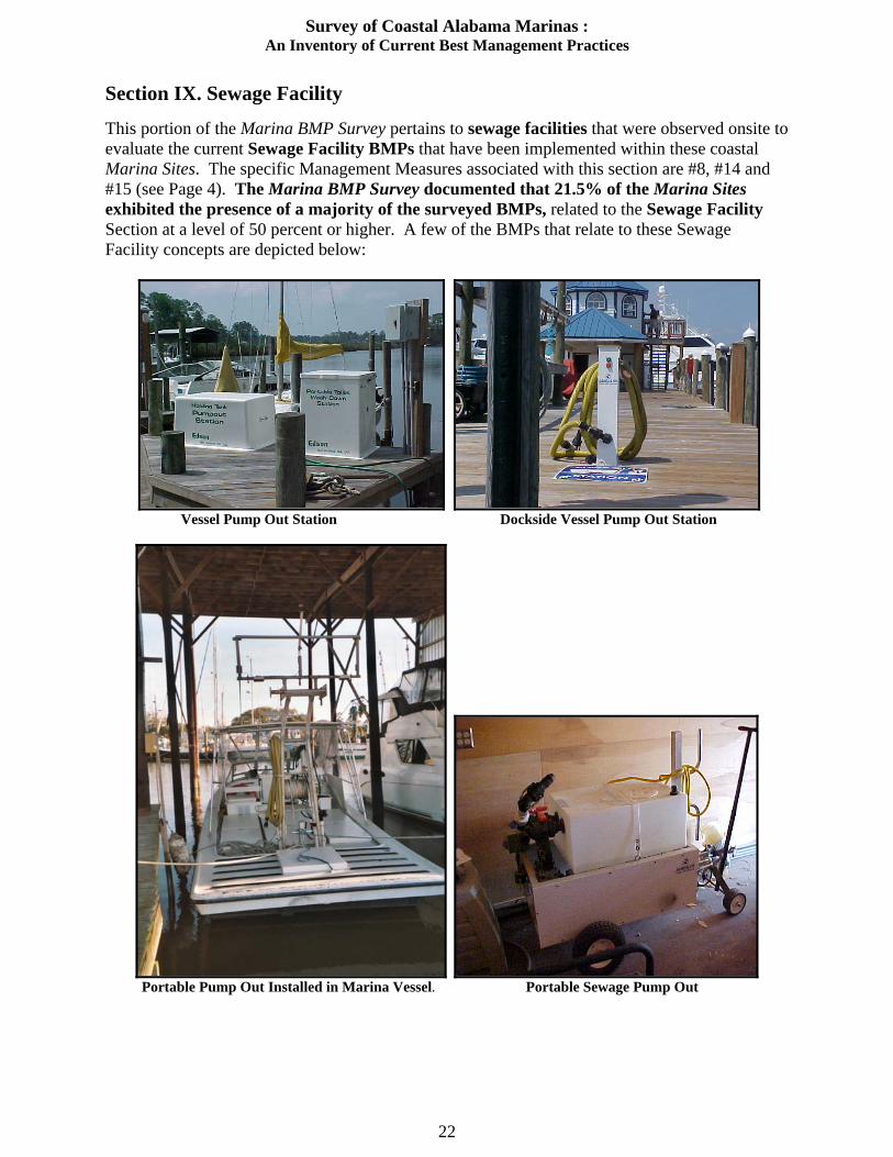
Section IX. Sewage Facility This portion of the Marina BMP Survey pertains to sewage facilities that were observed onsite to evaluate the current Sewage Facility BMPs that have been implemented within these coastal Marina Sites. The specific Management Measures associated with this section are #8, #14 and #15 (see Page 4). The Marina BMP Survey documented that 21.5% of the Marina Sites exhibited the presence of a majority of the surveyed BMPs, related to the Sewage Facility Section at a level of 50 percent or higher. A few of the BMPs that relate to these Sewage Facility concepts are depicted below:
Vessel Pump Out Station Dockside Vessel Pump Out Station
Portable Pump Out Installed in Marina Vessel. Portable Sewage Pump Out
Survey of Coastal Alabama Marinas : An Inventory of Current Best Management Practices
23
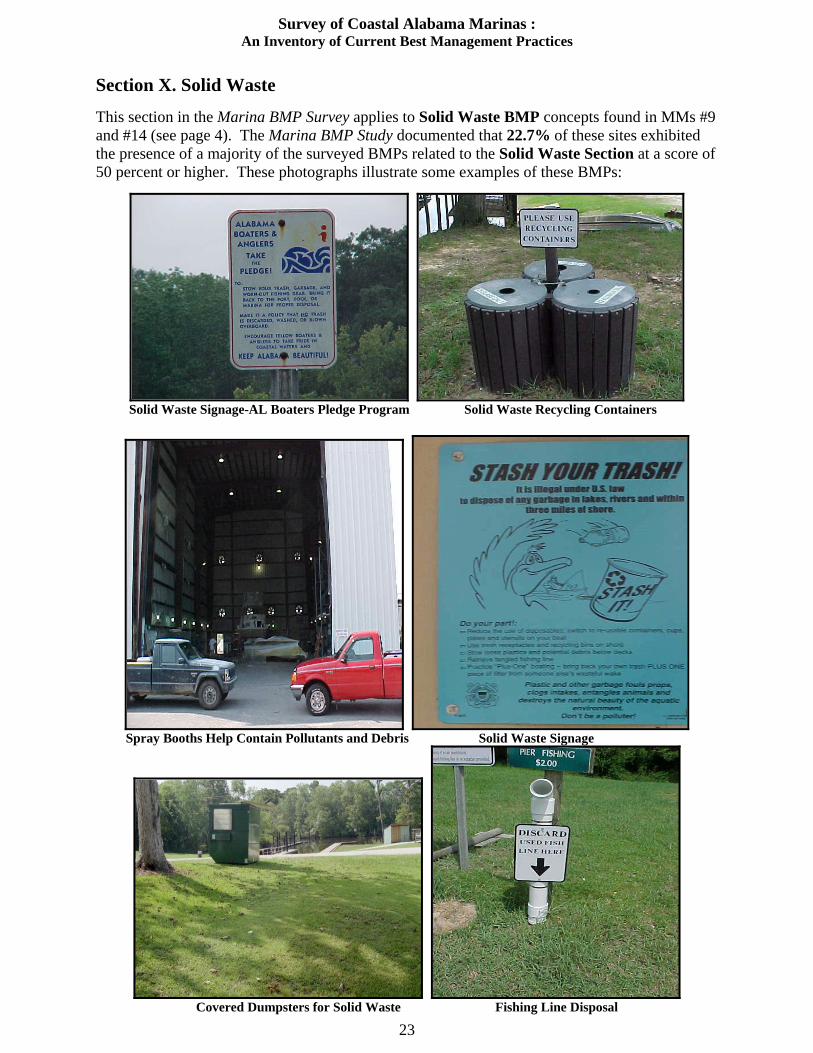
Section X. Solid Waste This section in the Marina BMP Survey applies to Solid Waste BMP concepts found in MMs #9 and #14 (see page 4). The Marina BMP Study documented that 22.7% of these sites exhibited the presence of a majority of the surveyed BMPs related to the Solid Waste Section at a score of 50 percent or higher. These photographs illustrate some examples of these BMPs:
Solid Waste Signage-AL Boaters Pledge Program Solid Waste Recycling Containers
Spray Booths Help Contain Pollutants and Debris Solid Waste Signage
Covered Dumpsters for Solid Waste Fishing Line Disposal

Survey of Coastal Alabama Marinas : An Inventory of Current Best Management Practices
24
Section XI. Fish Waste The Management Measures that relate to this Fish Waste section are listed specifically in MMs #10 and #14 (see page 4). The Marina BMP Survey documented that of those Marina Sites with Fish Waste facilities; only 11.65% exhibited the presence of a majority of the surveyed BMPs related to Fish Waste facilities at a level of 50 percent or higher. A few of the BMPs that relate to these Fish Waste concepts are depicted below:
Signage for designated cleaning station Rules governing fish cleaning operations
General Rules, including fish cleaning operations. Proper fish cleaning station, but lacks signage.
Rules governing fish cleaning operations. Needs signage and proper disposal of fish waste.
Survey of Coastal Alabama Marinas : An Inventory of Current Best Management Practices
25
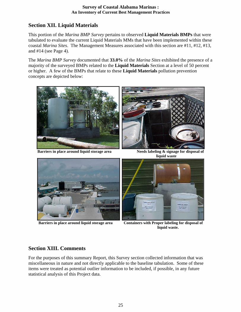
Section XII. Liquid Materials This portion of the Marina BMP Survey pertains to observed Liquid Materials BMPs that were tabulated to evaluate the current Liquid Materials MMs that have been implemented within these coastal Marina Sites. The Management Measures associated with this section are #11, #12, #13, and #14 (see Page 4). The Marina BMP Survey documented that 33.0% of the Marina Sites exhibited the presence of a majority of the surveyed BMPs related to the Liquid Materials Section at a level of 50 percent or higher. A few of the BMPs that relate to these Liquid Materials pollution prevention concepts are depicted below:
Barriers in place around liquid storage area Needs labeling & signage for disposal of
liquid waste
Barriers in place around liquid storage area Containers with Proper labeling for disposal of
liquid waste.
Section XIII. Comments For the purposes of this summary Report, this Survey section collected information that was miscellaneous in nature and not directly applicable to the baseline tabulation. Some of these items were treated as potential outlier information to be included, if possible, in any future statistical analysis of this Project data.

Survey of Coastal Alabama Marinas : An Inventory of Current Best Management Practices
26
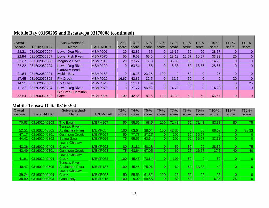
VII. Summary of Survey Results
A. Overall Conclusions The Overall BMP data gathered for this Marina Survey is presented in Table 1 below. The data is presented as ranked by percentage per Survey Section and also grouped by designated 8-digit HUC subwatersheds.
Table 1. Overall Ranking of Marina Sites (Based Upon the Presence of Survey BMPs at 50% or More).
BMP Section
Overall Ranked
Total %
Perdido Bay HUC
[83]
Mobile Tensaw Delta HUC [27]
Mobile Bay-
EscatawpaHUC [45]
Mississippi Coastal HUC
[8]
Total Of
50%+Sites [163]
Marina Flushing 82.0 73 26 27 8 134
*Fuel Station 55.0 7/7 0/3 2/7 1/1 10/18
Habitat Assessment 54.6 31 23 31 4 89
Stormwater
Run-Off 50.3 40 18 19 5 82
Liquid
Materials 33.0 33 3 14 4 54
Solid Waste 22.7 14 8 13 2 37
Sewage Facilities 21.5 16 5 12 2 35
Erosion Prevention 18.4 17 7 5 1
30
Water Quality
Assessment15.3 11 3 10 1 25
Fish Waste BMPs 11.6 9 2 6 2 19
* Fuel stations are present in only 11 % of the surveyed Marina Sites, therefore only those sites were graded for BMP compliance. [ ] indicate the number of Marina Sites surveyed in each HUC.
Survey of Coastal Alabama Marinas : An Inventory of Current Best Management Practices
27
The overall data tabulated from this Marina BMP Survey indicates that those management measures, which have already been encompassed within the regulatory process, as an artifact of established Marina construction and the National Pollutant Discharge Elimination System (NPDES) permitting activities, have resulted in their general implementation. As a result, the following BMP Sections in the Marina BMP Survey had the highest rankings (all at 50% or greater), which are listed in the following order:
1. Marina Flushing 2. Fuel Station Design 3. Habitat Assessment 4. Stormwater Run-Off
These four BMP Sections yielded survey scores indicating that 50 percent or more of these BMPs were present in situ for each Section. However, it should be noted that these Sections comprise only 4 out of 10 of the tabulated Marina BMP Survey Sections for this assessment. In fact, the ranked total score percentiles for this Marina BMP Survey yielded only eighteen (18) of the 163 Marina Sites having overall totaled score rankings at 50% or higher. This group comprises only 11% of the Marina Sites surveyed for this project (See Appendix E). B. Comparisons of 8-digit Hydrologic Unit Codes (HUCs) In an effort to properly address the results of the Marina BMP Survey in terms of subwatersheds (see Appendix D) the following 8-digit HUCs were designated for the purpose of this project: 1. Perdido Bay HUC A general description of this subwatershed is found on page 6, with a map of the surveyed Marina Sites presented on Map II. 83 Marina Sites were surveyed in this subwatershed, which yields the highest marina density for Coastal Alabama at 26.5 marinas per 100 square miles. The four lowest ranked Sections in this subwatershed for the Marina Survey were the following:
1) Fish Waste BMPs at ~11% 2) Water Quality Assessment at 13.2% 3) Solid Waste at 16.8% 4) Sewage Facilities at ~19%
This subwatershed yielded the lowest Habitat Assessment ranking at 37% Two of the best Survey Sections, Fuel Station Design and Marina Flushing and Habitat Assessment were surveyed at 100% and ~88% respectively. 2. Mobile Bay-Escatawpa HUCs These subwatersheds are described on page 6, with a map of the surveyed Marina Sites presented on Map III. 45 Marina Sites were surveyed in these subwatersheds. The Mobile Bay subwatershed yields the second highest marina density for Coastal Alabama at 4.9 marinas per 100 square miles. The three lowest ranked Sections in these subwatersheds for the Marina Survey were the following:
1) Erosion Prevention at 4.4% 2) Fish Waste BMPs at ~13% 3) Sewage Facilities at ~26%
Two of the best Survey Sections, Habitat Assessment and Marina Flushing were surveyed at 69% and 60% respectively.
Survey of Coastal Alabama Marinas : An Inventory of Current Best Management Practices
28
3.Mobile Tensaw Delta HUC This subwatershed is described on page 6, with a map of the surveyed Marina Sites presented on Map IV. 27 Marina Sites were surveyed in this subwatershed, which yields the lowest marina density for Coastal Alabama at 2.8 marinas per 100 square miles. The five lowest ranked Sections in this subwatershed for the Marina Survey were the following:
1) Fuel Station Design at 0% 2) Fish Waste BMPs at 7.4% 3) Water Quality and Liquid Materials at ~11% 4) Sewage Facilities at 18.5%
Two of the best Survey Sections, Marina Flushing and Habitat Assessment were surveyed at 96% and 85% respectively. 4.Mississippi Coastal HUC This subwatershed is described on page 6, with a map of the surveyed Marina Sites presented on Map V. 8 Marina Sites were surveyed in this subwatershed, which yields the second lowest marina density for Coastal Alabama at 3.4 marinas per 100 square miles. The five lowest ranked Sections in this subwatershed for the Marina Survey were the following:
1. Erosion Prevention and Water Quality Assessment, both at ~12% 2. Sewage Facilities, Solid Waste, and Fish Waste; all at ~25%
Two of the best Survey Sections, Marina Flushing and Fuel Station Design were both surveyed at 100%.
C. Survey Recommendations One of the implied objectives within any resource survey is to develop recommendations based upon the project data gathered, in order to provide research-based program and project guidance for future targeting and development. The overall results of this Marina BMP Survey yielded observations concerning Water Quality Monitoring and Enforcement issues. Based upon the positive rankings tabulated for the four items that yielded overall percentiles at or above 50% (i.e. Marina Flushing, Fuel Station Design, Habitat Assessment, Stormwater Run-Off ); the balance of the results from the Marina BMP Survey seem to indicate that if the State, County, Municipal or local regulatory entities were to promulgate more specific resource-management guidelines relative to the BMPs surveyed in this project, then the potential for associated land-use water quality impacts might be substantially reduced through the further implementation of many of these basic Marinas and Recreational Boating Best Management Practices. The key area for recommendations concerning this Marina BMP Survey focus directly toward to potential Education and Outreach project development and implementation issues, the Marina BMP Survey seems to highlight some important BMP sections and subwatersheds that could benefit from targeted efforts to address the items in following order of suggested prioritization:
Survey of Coastal Alabama Marinas : An Inventory of Current Best Management Practices
29
1. Fish Waste BMPS 2. Water Quality Assessment 3. Erosion Prevention 4. Sewage Facilities and BMPs 5. Solid Waste BMPs 6. Liquid Materials BMPs
Future ADEM ACNPCP Projects and Studies should incorporate better statistical analysis that consider the appropriate weighting of these identified priorities, as calibrated across the distribution of in situ conditions. In conclusion, the funding and implementation of these recommendations as tangible future projects should serve to build upon the projects and goals set forth by the coastal resource management agencies, while working with local entities to build consensus, in order to effectively manage and conserve coastal resources that will provide for the continued improvement of Alabama’s coastal waters.

Appendix A
Alabama Coastal Non-Point Pollution Control Program Coastal Marina Survey Report
I. Marina Information Owner Name Marina Name Date
Address
City State ZipCode
Phone County
15 Digit HUC
Sub Watershed Name
GPS Decimal Latitude (decimal degrees)
GPS Decimal Longitude (decimal degrees)
Marina site land acreage: Survey Date/Time Evaluation Complete Date
Marina Manager Name: Samples Taken Photos Taken
Years in Operation: Permit Information: Quantity of Boat Slips: Wet ______ Dry Storage Count ______ Does Marina Possess a Marina Operation & Maintenance Plan Yes No Site Contact : Phone: Marina in use? Yes No
If No Proposed Defunct
if Defunct only answer sections II., IV., and V, & VII.
Survey Type: Baseline Complaint Follow-up Previous Date: _____________ II. Marina Flushing (*) Yes No NA Yes No NA
Marina Flushes Properly Open Marina Basin Design
Artificial Water Circulating Device Design Promotes Basin Permeable or Slotted Wave Attenuator Circulation Bulkhead/Breakwater
Multiple Entrances to Promote Marina Type:_________________ Flushing (ie; open, slotted, key hole/river, bay)
30
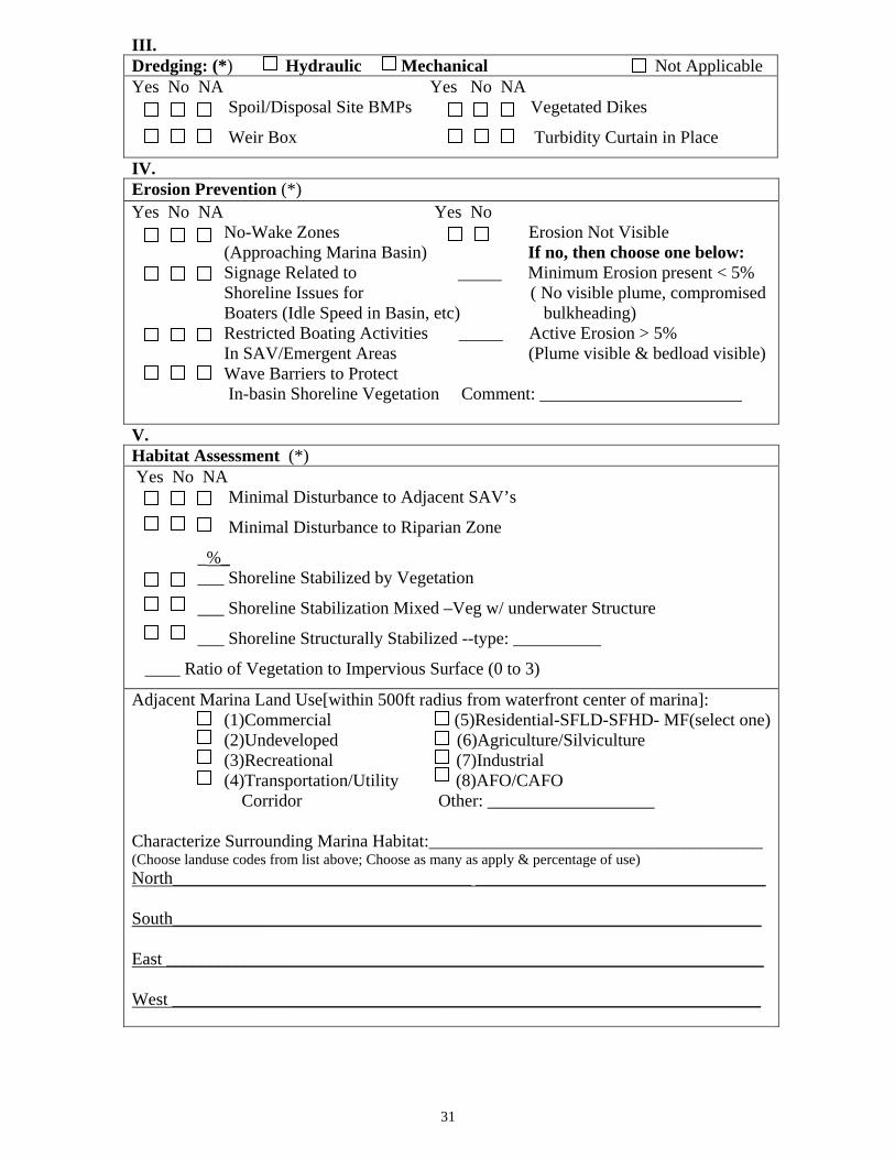
III. Dredging: (*) Hydraulic Mechanical Not Applicable Yes No NA Yes No NA Spoil/Disposal Site BMPs Vegetated Dikes
Weir Box Turbidity Curtain in Place
IV. Erosion Prevention (*) Yes No NA Yes No No-Wake Zones Erosion Not Visible
(Approaching Marina Basin) If no, then choose one below: Signage Related to Minimum Erosion present < 5% Shoreline Issues for ( No visible plume, compromised Boaters (Idle Speed in Basin, etc) bulkheading) Restricted Boating Activities _____ Active Erosion > 5%
In SAV/Emergent Areas (Plume visible & bedload visible) Wave Barriers to Protect In-basin Shoreline Vegetation Comment: _______________________ V. Habitat Assessment (*) Yes No NA Minimal Disturbance to Adjacent SAV’s
Minimal Disturbance to Riparian Zone
_%_ ___ Shoreline Stabilized by Vegetation
___ Shoreline Stabilization Mixed –Veg w/ underwater Structure
___ Shoreline Structurally Stabilized --type: __________
____ Ratio of Vegetation to Impervious Surface (0 to 3)
Adjacent Marina Land Use[within 500ft radius from waterfront center of marina]: (1)Commercial (5)Residential-SFLD-SFHD- MF(select one) (2)Undeveloped (6)Agriculture/Silviculture (3)Recreational (7)Industrial (4)Transportation/Utility (8)AFO/CAFO Corridor Other: ___________________ Characterize Surrounding Marina Habitat:______________________________________ (Choose landuse codes from list above; Choose as many as apply & percentage of use) North__________________________________ _________________________________ South___________________________________________________________________ East ____________________________________________________________________ West ___________________________________________________________________
31
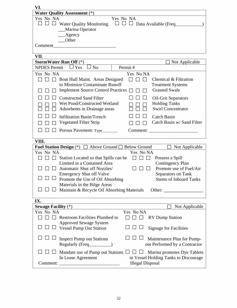
VI. Water Quality Assessment (*) Yes No NA Yes No NA
Water Quality Monitoring Data Available (Freq.___________) ___Marina Operator ___Agency ___Other Comment___________________________
VII. StormWater Run Off (*) Not Applicable NPDES Permit Yes No Permit # Yes No NA Yes No NA Boat Hull Maint. Areas Designed Chemical & Filtration
to Minimize Contaminate Runoff Treatment Systems Implement Source Control Practices Grassed Swale
Constructed Sand Filter Oil-Grit Separators Wet Pond/Constructed Wetland Holding Tanks Adsorbents in Drainage areas Swirl Concentrator
Infiltration Basin/Trench Catch Basin Vegetated Filter Strip Catch Basin w/ Sand Filter
Porous Pavement: Type________ Comment: _____________________ VIII. Fuel Station Design (*) Above Ground Below Ground Not Applicable Yes No NA Yes No NA Station Located so that Spills can be Possess a Spill
Limited in a Contained Area Contingency Plan Automatic Shut off Nozzles/ Promote use of Fuel/Air Emergency Shut off Valve Separators on Tank
Promote the Use of Oil Absorbing Stems of Inboard Tanks Materials in the Bilge Areas Maintain & Recycle Oil Absorbing Materials Other: _________________
IX. Sewage Facility (*) Not Applicable Yes No NA Yes No NA Restroom Facilities Plumbed to RV Dump Station Approved Sewage System Vessel Pump Out Station Signage for Facilities Inspect Pump out Stations Maintenance Plan for Pump- Regularly (Freq._________) out Performed by a Contractor
Mandate use of Pump out Stations Marina promotes Dye Tablets In Lease Agreement in Vessel Holding Tanks to Discourage Comment: __________________________ Illegal Disposal
32
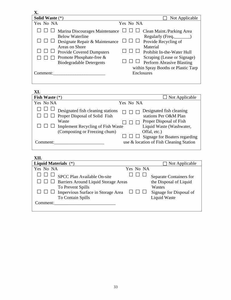
X. Solid Waste (*) Not Applicable Yes No NA Yes No NA
Marina Discourages Maintenance Clean Maint./Parking Area Below Waterline Regularly (Freq._______) Designate Repair & Maintenance Provide Recycling of Areas on Shore Material Provide Covered Dumpsters Prohibit In-the-Water Hull Promote Phosphate-free & Scraping (Lease or Signage) Biodegradable Detergents Perform Abrasive Blasting within Spray Booths or Plastic Tarp Comment:_______________________ Enclosures
XI. Fish Waste (*) Not Applicable Yes No NA Yes No NA
Designated fish cleaning stations Designated fish cleaning Proper Disposal of Solid Fish stations Per O&M Plan Waste Proper Disposal of Fish Implement Recycling of Fish Waste Liquid Waste (Washwater, (Composting or Freezing chum) Offal, etc.) Signage for Boaters regarding Comment:______________________ use & location of Fish Cleaning Station XII. Liquid Materials (*) Not Applicable Yes No NA Yes No NA
SPCC Plan Available On-site Separate Containers for Barriers Around Liquid Storage Areas the Disposal of Liquid To Prevent Spills Wastes Impervious Surface in Storage Area Signage for Disposal of To Contain Spills Liquid Waste Comment:___________________________
33

XIII.
Preparer Signature Printed Name ADEM
Review Signature Printed Name Date
34
Observations/Comments: _________________________________________________________________________ _________________________________________________________________________ _________________________________________________________________________ _________________________________________________________________________ _________________________________________________________________________ _________________________________________________________________________ _________________________________________________________________________ _________________________________________________________________________ _________________________________________________________________________ _________________________________________________________________________ _________________________________________________________________________ _________________________________________________________________________
ADEM-MOB 2004rcs
Appendix B
Alabama Coastal Non-Point Pollution Control Program
Marina Survey Request
To Coastal Alabama Marina Owners: We are conducting a base-line survey to assess local marina needs. This information will be useful in managing resources, requesting financial assistance and acquiring federal grants in the future for the Coastal Alabama Area. We thank you for providing the requested information in order that we may promote a voluntary Clean Marina Program and reflect the status of Marinas for Coastal Alabama. We appreciate your participation in the Coastal Alabama Marina Survey. If you have any questions concerning the survey, please call: Heather Krantz ADEM Mobile Branch 2204 Perimeter Road Mobile, AL 36615 251-450-3409
35
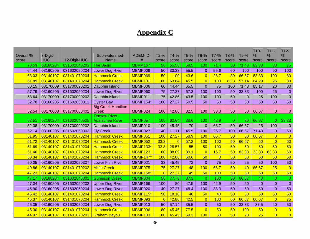
Appendix C
Overall % score
8-Digit-HUC 12-Digit-HUC
Sub-watershed-Name
ADEM-ID-#
T2-% score
T4-% score
T5-% score
T6-% score
T7-% score
T8-% score
T9-% score
T10-% score
T11-% score
T12-% score
70.53 03160204 031602040203 The Basin MBPM167 50 55.56 68.5 100 71.4 50 71.43 83.33 80 75 64.44 03160205 031602050204 Lower Dog River MBMP009 50 33.33 55.5 0 55.6 60 100 100 90 100 63.03 03140107 031401070204 Hammock Creek MBMP069 50 100 43.6 0 26.7 80 66.67 83.33 100 80 61.89 03140107 031401070204 Hammock Creek MBMP131 100 63.64 45.5 0 100 83.3 57.14 64.29 25 80 60.15 03170009 031700090202 Dauphin Island MBMP006 60 44.44 65.5 0 75 100 71.43 85.17 20 80 57.79 03160205 031602050204 Lower Dog River MBMP060 75 27.27 67.3 100 100 50 33.33 100 25 0 53.64 03170009 031700090202 Dauphin Island MBMP011 75 42.86 43.5 100 100 50 0 25 100 0 52.78 03160205 031602050311 Oyster Bay MBMP154* 100 27.27 50.5 50 50 50 50 50 50 50
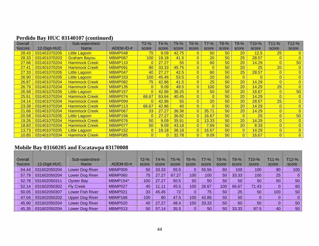
52.54 03170008 031700080402 Big Creek Hamilton Creek MBMP024 100 42.86 82.5 100 33.3 50 50 66.67 0 0
52.51 03160204 031602040505 Tensaw River-Apalachee River MBMP057 100 63.64 38.6 100 42.9 0 80 66.67 0 33.33
52.38 03170009 031700090202 Dauphin Island MBMP010 100 45.45 70 0 66.7 50 66.67 25 100 0 52.14 03160205 031602050302 Fly Creek MBMP027 40 11.11 45.5 100 26.7 100 66.67 71.43 0 60 51.95 03140107 031401070204 Hammock Creek MBMP051 100 27.27 58.9 100 66.7 50 50 66.67 0 0 51.72 03140107 031401070204 Hammock Creek MBMP052 33.3 0 57.2 100 100 50 66.67 50 0 60 51.69 03140107 031401070204 Hammock Creek MBMP133* 33.3 28.57 55 50 100 50 50 50 50 50 51.46 03140107 031401070204 Hammock Creek MBMP123 60 88.89 39.1 0 16.7 50 83.33 33.33 83.33 60 50.34 03140107 031401070204 Hammock Creek MBMP147* 100 42.86 60.6 50 0 50 50 50 50 50 50.05 03160205 031602050307 Lower Fish River MBMP021 33 45.45 72 0 75 50 25 50 100 50 49.86 03140107 031401070202 Milfin Creek MBMP075 75 27.27 48 100 66.7 50 40 66.67 25 0 47.23 03140107 031401070204 Hammock Creek MBMP158* 0 27.27 45 50 100 50 50 50 50 50 47.17 03160204 031602040301 Gunnison Creek MBMP004 50 77.78 87.3 0 100 50 66.67 40 0 0 47.04 03160205 031602050202 Upper Dog River MBMP166 100 80 47.5 100 42.9 50 50 0 0 0 45.90 03160205 031602050204 Lower Dog River MBMP020 40 27.27 48.4 100 33.3 50 60 50 0 50 45.42 03140107 031401070204 Hammock Creek MBMP115* 50 18.18 46 50 40 50 50 50 50 50 45.37 03140107 031401070204 Hammock Creek MBMP093 0 42.86 42.5 0 100 60 66.67 66.67 0 75 45.35 03160205 031602050204 Lower Dog River MBMP013 50 57.14 35.5 0 50 50 33.33 87.5 40 50 45.30 03140107 031401070204 Hammock Creek MBMP096 80 45.45 77.5 0 50 50 100 50 0 0 44.97 03140107 031401070203 Graham Bayou MBMP103 100 45.45 59.3 100 50 50 20 25 0 0
36

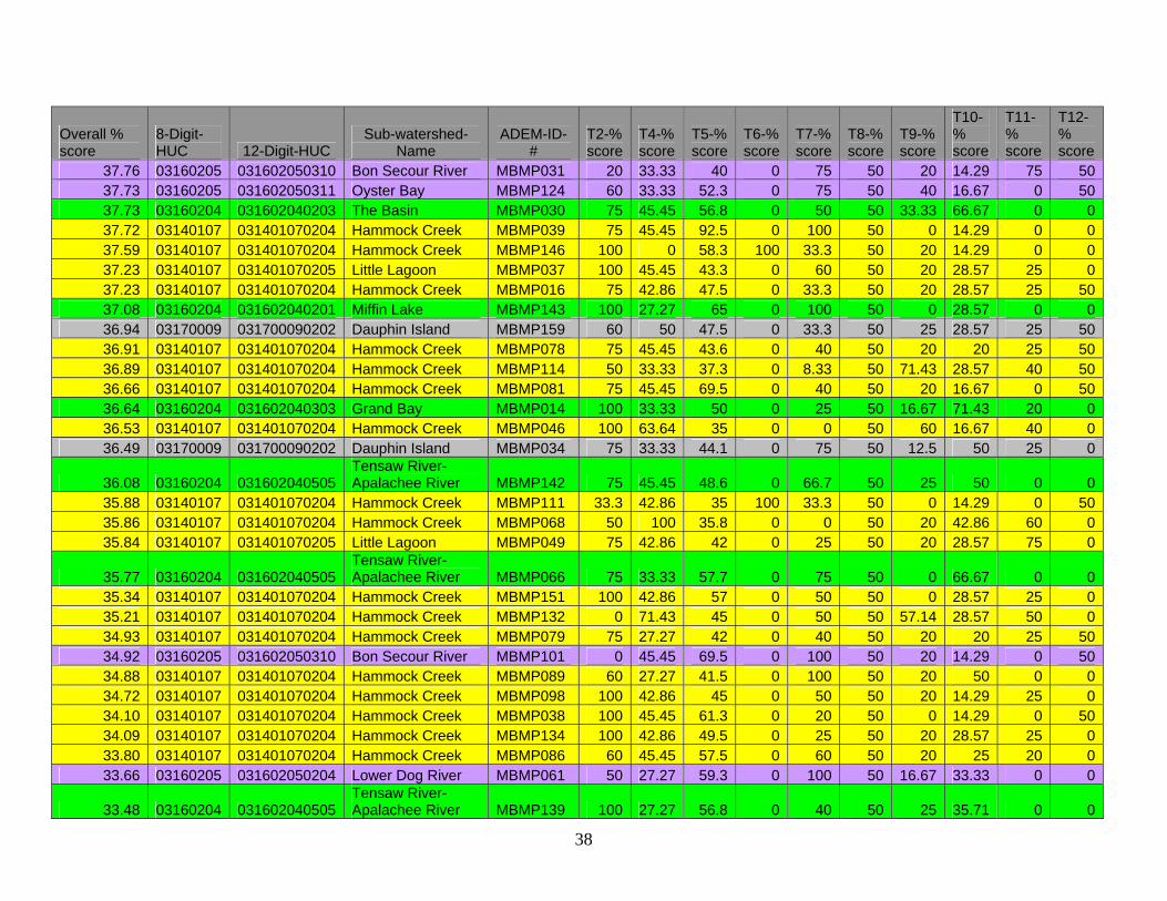
Overall % score
8-Digit-HUC 12-Digit-HUC
Sub-watershed-Name
ADEM-ID-#
T2-% score
T4-% score
T5-% score
T6-% score
T7-% score
T8-% score
T9-% score
T10-% score
T11-% score
T12-% score
44.42 03160204 031602040302 Bayou Sara MBMP065 75 55.56 63.6 0 100 50 66.67 33.33 0 0 43.99 03160205 031602050310 Bon Secour River MBMP032 80 27.27 74.3 0 100 50 25 33.33 0 50 43.66 03160205 031602050311 Oyster Bay MBMP094 100 22.22 31 0 50 50 50 33.33 100 0 43.51 03140107 031401070204 Hammock Creek MBMP149 100 77.78 59 0 66.7 50 40 16.67 25 0
43.36 03160204 031602040404 Lower Chasaw Creek MBMP002 80 81.81 48.2 0 50 50 20 28.57 0 75
43.22 03140107 031401070204 Hammock Creek MBMP109 100 45.45 86.8 0 100 50 25 25 0 0 42.49 03160204 031602040301 Gunnison Creek MBMP003 75 63.64 67.1 0 60 25 16.67 37.5 40 40
41.91 03160204 031602040404 Lower Chasaw Creek MBMP063 100 45.45 73.6 0 100 50 0 50 0 0
41.74 03160205 031602050301 Yancey Branch MBMP028 75 0 53.5 100 22.2 50 50 66.67 0 0 41.33 03140107 031401070204 Hammock Creek MBMP059 75 100 80 0 25 50 33.33 50 0 0 41.27 03160205 031602050311 Oyster Bay MBMP106 75 42.86 61.3 0 60 50 20 28.57 25 50 41.12 03140107 031401070204 Hammock Creek MBMP043 75 42.86 40 100 20 50 0 33.33 0 50 40.80 03160205 031602050307 Lower Fish River MBMP056 100 45.45 54.3 100 25 50 25 8.33 0 0 40.57 03140107 031401070204 Hammock Creek MBMP042 75 63.64 62.5 0 20 50 42.86 16.67 25 50
40.47 03160204 031602040505 Tensaw River-Apalachee River MBMP137 100 45.45 75.9 0 60 50 33.33 40 0 0
40.31 03140107 031401070204 Hammock Creek MBMP080 100 42.86 40 0 66.7 50 50 28.57 25 0 40.23 03140107 031401070204 Hammock Creek MBMP116 50 42.86 47.5 0 66.7 50 66.67 28.57 0 50 40.19 03140107 031401070204 Hammock Creek MBMP092 60 77.78 45.5 0 50 50 20 28.57 20 50 40.12 03140107 031401070204 Hammock Creek MBMP107 75 63.64 48.3 0 75 50 0 14.29 25 50 40.05 03160205 031602050302 Fly Creek MBMP128 75 14.29 44.5 0 66.7 25 75 50 0 50 39.80 03140107 031401070204 Hammock Creek MBMP097 100 45.45 77.5 0 50 50 0 25 0 50 39.58 03140107 031401070204 Hammock Creek MBMP041 75 81.82 47.5 0 20 50 42.86 28.57 0 50
39.24 03160204 031602040404 Lower Chasaw Creek MBMP062 50 55.56 61.8 100 25 50 25 25 0 0
39.03 03140107 031401070203 Graham Bayou MBMP104 100 27.27 68 0 50 50 20 25 0 50 38.99 03160204 031602040303 Grand Bay MBMP015 100 9.09 69.6 0 80 50 0 6.25 75 0 38.93 03140107 031401070203 Graham Bayou MBMP105 100 33.33 64.3 0 66.7 50 0 25 0 50 38.92 03140107 031401070204 Hammock Creek MBMP125 75 71.43 42.8 0 50 50 0 25 25 50 38.67 03160205 031602050204 Lower Dog River MBMP118 50 63.64 58.8 0 100 50 50 14.29 0 0 38.34 03160205 031602050302 Fly Creek MBMP126 100 42.86 40.5 0 25 50 0 25 100 0 37.96 03140107 031401070204 Hammock Creek MBMP040 75 45.45 92.5 0 100 50 0 16.67 0 0
37
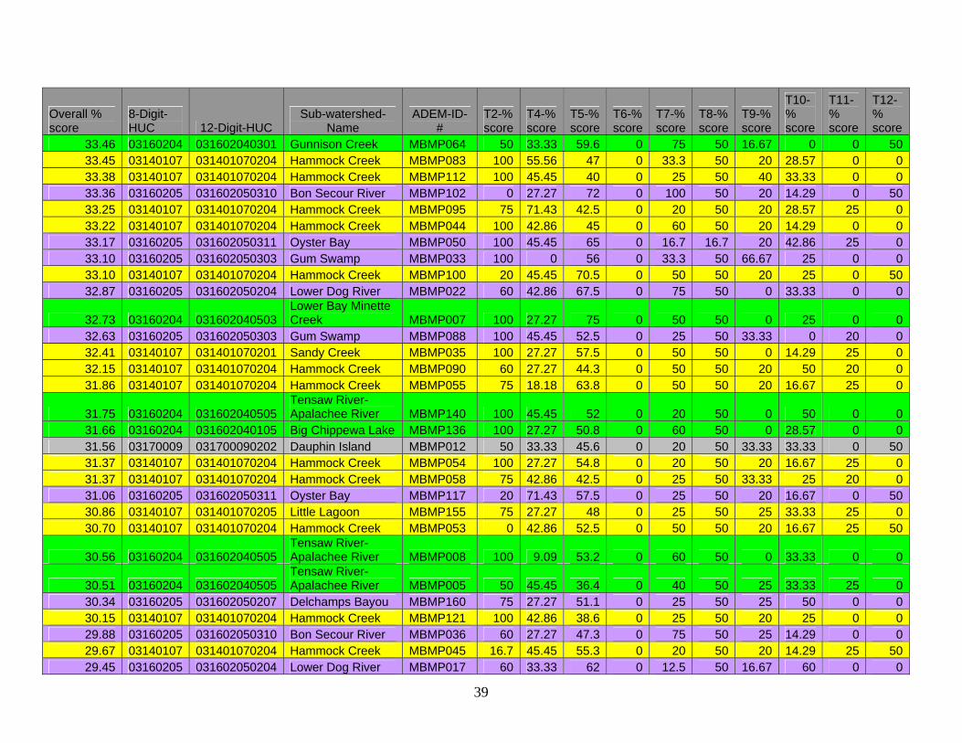
Overall % score
8-Digit-HUC 12-Digit-HUC
Sub-watershed-Name
ADEM-ID-#
T2-% score
T4-% score
T5-% score
T6-% score
T7-% score
T8-% score
T9-% score
T10-% score
T11-% score
T12-% score
37.76 03160205 031602050310 Bon Secour River MBMP031 20 33.33 40 0 75 50 20 14.29 75 50 37.73 03160205 031602050311 Oyster Bay MBMP124 60 33.33 52.3 0 75 50 40 16.67 0 50 37.73 03160204 031602040203 The Basin MBMP030 75 45.45 56.8 0 50 50 33.33 66.67 0 0 37.72 03140107 031401070204 Hammock Creek MBMP039 75 45.45 92.5 0 100 50 0 14.29 0 0 37.59 03140107 031401070204 Hammock Creek MBMP146 100 0 58.3 100 33.3 50 20 14.29 0 0 37.23 03140107 031401070205 Little Lagoon MBMP037 100 45.45 43.3 0 60 50 20 28.57 25 0 37.23 03140107 031401070204 Hammock Creek MBMP016 75 42.86 47.5 0 33.3 50 20 28.57 25 50 37.08 03160204 031602040201 Miffin Lake MBMP143 100 27.27 65 0 100 50 0 28.57 0 0 36.94 03170009 031700090202 Dauphin Island MBMP159 60 50 47.5 0 33.3 50 25 28.57 25 50 36.91 03140107 031401070204 Hammock Creek MBMP078 75 45.45 43.6 0 40 50 20 20 25 50 36.89 03140107 031401070204 Hammock Creek MBMP114 50 33.33 37.3 0 8.33 50 71.43 28.57 40 50 36.66 03140107 031401070204 Hammock Creek MBMP081 75 45.45 69.5 0 40 50 20 16.67 0 50 36.64 03160204 031602040303 Grand Bay MBMP014 100 33.33 50 0 25 50 16.67 71.43 20 0 36.53 03140107 031401070204 Hammock Creek MBMP046 100 63.64 35 0 0 50 60 16.67 40 0 36.49 03170009 031700090202 Dauphin Island MBMP034 75 33.33 44.1 0 75 50 12.5 50 25 0
36.08 03160204 031602040505 Tensaw River-Apalachee River MBMP142 75 45.45 48.6 0 66.7 50 25 50 0 0
35.88 03140107 031401070204 Hammock Creek MBMP111 33.3 42.86 35 100 33.3 50 0 14.29 0 50 35.86 03140107 031401070204 Hammock Creek MBMP068 50 100 35.8 0 0 50 20 42.86 60 0 35.84 03140107 031401070205 Little Lagoon MBMP049 75 42.86 42 0 25 50 20 28.57 75 0
35.77 03160204 031602040505 Tensaw River-Apalachee River MBMP066 75 33.33 57.7 0 75 50 0 66.67 0 0
35.34 03140107 031401070204 Hammock Creek MBMP151 100 42.86 57 0 50 50 0 28.57 25 0 35.21 03140107 031401070204 Hammock Creek MBMP132 0 71.43 45 0 50 50 57.14 28.57 50 0 34.93 03140107 031401070204 Hammock Creek MBMP079 75 27.27 42 0 40 50 20 20 25 50 34.92 03160205 031602050310 Bon Secour River MBMP101 0 45.45 69.5 0 100 50 20 14.29 0 50 34.88 03140107 031401070204 Hammock Creek MBMP089 60 27.27 41.5 0 100 50 20 50 0 0 34.72 03140107 031401070204 Hammock Creek MBMP098 100 42.86 45 0 50 50 20 14.29 25 0 34.10 03140107 031401070204 Hammock Creek MBMP038 100 45.45 61.3 0 20 50 0 14.29 0 50 34.09 03140107 031401070204 Hammock Creek MBMP134 100 42.86 49.5 0 25 50 20 28.57 25 0 33.80 03140107 031401070204 Hammock Creek MBMP086 60 45.45 57.5 0 60 50 20 25 20 0 33.66 03160205 031602050204 Lower Dog River MBMP061 50 27.27 59.3 0 100 50 16.67 33.33 0 0
33.48 03160204 031602040505 Tensaw River-Apalachee River MBMP139 100 27.27 56.8 0 40 50 25 35.71 0 0
38
Overall % score
8-Digit-HUC 12-Digit-HUC
Sub-watershed-Name
ADEM-ID-#
T2-% score
T4-% score
T5-% score
T6-% score
T7-% score
T8-% score
T9-% score
T10-% score
T11-% score
T12-% score
33.46 03160204 031602040301 Gunnison Creek MBMP064 50 33.33 59.6 0 75 50 16.67 0 0 50 33.45 03140107 031401070204 Hammock Creek MBMP083 100 55.56 47 0 33.3 50 20 28.57 0 0 33.38 03140107 031401070204 Hammock Creek MBMP112 100 45.45 40 0 25 50 40 33.33 0 0 33.36 03160205 031602050310 Bon Secour River MBMP102 0 27.27 72 0 100 50 20 14.29 0 50 33.25 03140107 031401070204 Hammock Creek MBMP095 75 71.43 42.5 0 20 50 20 28.57 25 0 33.22 03140107 031401070204 Hammock Creek MBMP044 100 42.86 45 0 60 50 20 14.29 0 0 33.17 03160205 031602050311 Oyster Bay MBMP050 100 45.45 65 0 16.7 16.7 20 42.86 25 0 33.10 03160205 031602050303 Gum Swamp MBMP033 100 0 56 0 33.3 50 66.67 25 0 0 33.10 03140107 031401070204 Hammock Creek MBMP100 20 45.45 70.5 0 50 50 20 25 0 50 32.87 03160205 031602050204 Lower Dog River MBMP022 60 42.86 67.5 0 75 50 0 33.33 0 0
32.73 03160204 031602040503 Lower Bay Minette Creek MBMP007 100 27.27 75 0 50 50 0 25 0 0
32.63 03160205 031602050303 Gum Swamp MBMP088 100 45.45 52.5 0 25 50 33.33 0 20 0 32.41 03140107 031401070201 Sandy Creek MBMP035 100 27.27 57.5 0 50 50 0 14.29 25 0 32.15 03140107 031401070204 Hammock Creek MBMP090 60 27.27 44.3 0 50 50 20 50 20 0 31.86 03140107 031401070204 Hammock Creek MBMP055 75 18.18 63.8 0 50 50 20 16.67 25 0
31.75 03160204 031602040505 Tensaw River-Apalachee River MBMP140 100 45.45 52 0 20 50 0 50 0 0
31.66 03160204 031602040105 Big Chippewa Lake MBMP136 100 27.27 50.8 0 60 50 0 28.57 0 0 31.56 03170009 031700090202 Dauphin Island MBMP012 50 33.33 45.6 0 20 50 33.33 33.33 0 50 31.37 03140107 031401070204 Hammock Creek MBMP054 100 27.27 54.8 0 20 50 20 16.67 25 0 31.37 03140107 031401070204 Hammock Creek MBMP058 75 42.86 42.5 0 25 50 33.33 25 20 0 31.06 03160205 031602050311 Oyster Bay MBMP117 20 71.43 57.5 0 25 50 20 16.67 0 50 30.86 03140107 031401070205 Little Lagoon MBMP155 75 27.27 48 0 25 50 25 33.33 25 0 30.70 03140107 031401070204 Hammock Creek MBMP053 0 42.86 52.5 0 50 50 20 16.67 25 50
30.56 03160204 031602040505 Tensaw River-Apalachee River MBMP008 100 9.09 53.2 0 60 50 0 33.33 0 0
30.51 03160204 031602040505 Tensaw River-Apalachee River MBMP005 50 45.45 36.4 0 40 50 25 33.33 25 0
30.34 03160205 031602050207 Delchamps Bayou MBMP160 75 27.27 51.1 0 25 50 25 50 0 0 30.15 03140107 031401070204 Hammock Creek MBMP121 100 42.86 38.6 0 25 50 20 25 0 0 29.88 03160205 031602050310 Bon Secour River MBMP036 60 27.27 47.3 0 75 50 25 14.29 0 0 29.67 03140107 031401070204 Hammock Creek MBMP045 16.7 45.45 55.3 0 20 50 20 14.29 25 50 29.45 03160205 031602050204 Lower Dog River MBMP017 60 33.33 62 0 12.5 50 16.67 60 0 0
39

Overall % score
8-Digit-HUC 12-Digit-HUC
Sub-watershed-Name
ADEM-ID-#
T2-% score
T4-% score
T5-% score
T6-% score
T7-% score
T8-% score
T9-% score
T10-% score
T11-% score
T12-% score
29.26 03140107 031401070204 Hammock Creek MBMP084 60 27.27 51 0 60 50 30 14.29 0 0 29.22 03140107 031401070204 Hammock Creek MBMP150 0 45.45 51.5 0 50 50 33.33 28.57 33.33 0 28.95 03160204 031602040303 Grand Bay MBMP144 100 18.18 71.4 0 50 50 0 0 0 0 28.93 03140107 031401070104 Palmetto Creek MBMP108 75 27.27 42 0 20 50 0 25 0 50 28.67 03140107 031401070204 Hammock Creek MBMP122 16.7 77.78 43 0 40 50 20 14.29 25 0
28.58 03160204 031602040505 Tensaw River-Apalachee River MBMP145 100 27.27 66.8 0 25 50 0 16.67 0 0
28.43 03140107 031401070205 Little Lagoon MBMP048 75 9.09 42.8 0 50 50 20 12.5 25 0 28.33 03140107 031401070203 Graham Bayou MBMP087 100 18.18 41.5 0 20 50 25 28.57 0 0 27.94 03160205 031602050302 Fly Creek MBMP127 75 9.09 37.7 0 60 50 33.33 14.29 0 0
27.87 03160204 031602040505 Tensaw River-Apalachee River MBMP138 0 33.33 56.8 0 60 50 50 28.57 0 0
27.66 03140107 031401070204 Hammock Creek MBMP110 0 27.27 55 0 60 50 20 14.29 0 50 27.45 03170009 031700090202 Dauphin Island MBMP148 50 0 54.5 0 25 50 20 0 25 50 27.41 03140107 031401070204 Hammock Creek MBMP091 80 33.33 45.8 0 0 50 20 25 20 0 27.33 03140107 031401070205 Little Lagoon MBMP047 40 27.27 42.5 0 60 50 25 28.57 0 0 27.17 03160205 031602050302 Fly Creek MBMP130 66.7 0 42.5 0 37.5 50 0 75 0 0 26.90 03140107 031401070205 Little Lagoon MBMP153 100 45.45 53.5 0 20 50 0 0 0 0 26.87 03140107 031401070204 Hammock Creek MBMP082 75 42.86 41.5 0 25 50 20 14.29 0 0 26.79 03140107 031401070204 Hammock Creek MBMP135 0 9.09 49.5 0 100 50 20 14.29 25 0
26.60 03160204 031602040505 Tensaw River-Apalachee River MBMP141 75 45.45 55.5 0 40 50 0 0 0 0
26.58 03140107 031401070205 Little Lagoon MBMP157 0 42.86 36.3 0 50 50 20 16.67 0 50 26.28 03170009 031700090103 Grand Bay Swamp MBMP025 50 0 67.8 0 75 50 20 0 0 0 26.25 03160205 031602050104 Bon Secour Bay MBMP119 16.7 9.09 56 0 57.1 50 20 28.57 25 0 25.87 03160205 031602050204 Lower Dog River MBMP071 0 33.33 57.5 0 25 50 50 42.86 0 0 25.66 03160205 031602050204 Lower Dog River MBMP018 33.3 33.33 57.8 0 14.3 50 25 42.86 0 0 25.51 03140107 031401070204 Hammock Creek MBMP074 66.7 63.64 40.5 0 0 50 20 14.29 0 0 24.53 03160204 031602040301 Gunnison Creek MBMP023 100 27.27 61.4 0 0 0 16.67 0 0 40 24.14 03140107 031401070204 Hammock Creek MBMP099 0 42.86 55 0 20 50 20 28.57 25 0 23.72 03160205 031602050302 Fly Creek MBMP072 33.3 22.22 44.5 100 10 0 20 7.14 0 0 23.55 03160205 031602050104 Bon Secour Bay MBMP161 100 0 53 0 20 50 0 12.5 0 0 23.38 03140107 031401070204 Hammock Creek MBMP113 66.7 42.86 40 0 0 50 20 14.29 0 0
40
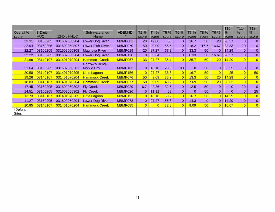
Overall % score
8-Digit-HUC 12-Digit-HUC
Sub-watershed-Name
ADEM-ID-#
T2-% score
T4-% score
T5-% score
T6-% score
T7-% score
T8-% score
T9-% score
T10-% score
T11-% score
T12-% score
23.31 03160205 031602050204 Lower Dog River MBMP001 20 42.86 55 0 16.7 50 20 28.57 0 0 22.94 03160205 031602050307 Lower Fish River MBMP070 50 9.09 65.5 0 18.2 16.7 16.67 33.33 20 0 22.27 03160205 031602050308 Magnolia River MBMP019 20 27.27 77.8 0 33.3 50 0 14.29 0 0 22.22 03160205 031602050204 Lower Dog River MBMP120 0 63.64 55 0 8.33 50 16.67 28.57 0 0 21.66 03140107 031401070204 Hammock Creek MBMP067 33 27.27 36.4 0 35.7 50 20 14.29 0 0
21.64 03160205 031602050201 Garrow's Bend- Mobile Bay MBMP163 0 18.18 23.3 100 0 50 0 25 0 0
20.58 03140107 031401070205 Little Lagoon MBMP156 0 27.27 36.8 0 16.7 50 0 25 0 50 19.26 03140107 031401070204 Hammock Creek MBMP076 50 9.09 35.9 0 13.3 50 20 14.29 0 0 18.83 03140107 031401070204 Hammock Creek MBMP077 50 9.09 43.2 0 7.69 50 20 8.33 0 0 17.45 03160205 031602050302 Fly Creek MBMP029 16.7 42.86 32.5 0 12.5 50 0 0 20 0 14.51 03160205 031602050302 Fly Creek MBMP026 0 11.11 59 0 0 50 0 0 0 25 13.73 03140107 031401070205 Little Lagoon MBMP152 0 18.18 38.2 0 16.7 50 0 14.29 0 0 11.27 03160205 031602050204 Lower Dog River MBMP073 0 27.27 56.8 0 14.3 0 0 14.29 0 0 10.85 03140107 031401070204 Hammock Creek MBMP085 0 0 32.8 0 9.09 50 0 16.67 0 0
*Defunct Sites
41

Appendix D Perdido Bay HUC 03140107 Overall %score 12-Digit-HUC
Sub-watershed-Name ADEM-ID-#
T2-% score
T4-% score
T5-% score
T6-% score
T7-% score
T8-% score
T9-% score
T10-% score
T11-% score
T12-% score
63.03 031401070204 Hammock Creek MBMP069 50 100 43.64 0 26.67 80 66.67 83.33 100 80 61.89 031401070204 Hammock Creek MBMP131 100 63.64 45.45 0 100 83.3 57.14 64.29 25 80 51.95 031401070204 Hammock Creek MBMP051 100 27.27 58.86 100 66.67 50 50 66.67 0 0 51.72 031401070204 Hammock Creek MBMP052 33.33 0 57.15 100 100 50 66.67 50 0 60 51.69 031401070204 Hammock Creek MBMP133* 33.33 28.57 55 50 100 50 50 50 50 50 51.46 031401070204 Hammock Creek MBMP123 60 88.89 39.09 0 16.67 50 83.33 33.33 83.33 60 50.34 031401070204 Hammock Creek MBMP147* 100 42.86 60.56 50 0 50 50 50 50 50 49.86 031401070202 Milfin Creek MBMP075 75 27.27 48 100 66.67 50 40 66.67 25 0 47.23 031401070204 Hammock Creek MBMP158* 0 27.27 45 50 100 50 50 50 50 50 45.42 031401070204 Hammock Creek MBMP115* 50 18.18 46 50 40 50 50 50 50 50 45.37 031401070204 Hammock Creek MBMP093 0 42.86 42.5 0 100 60 66.67 66.67 0 75 45.30 031401070204 Hammock Creek MBMP096 80 45.45 77.5 0 50 50 100 50 0 0 44.97 031401070203 Graham Bayou MBMP103 100 45.45 59.25 100 50 50 20 25 0 0 43.51 031401070204 Hammock Creek MBMP149 100 77.78 59 0 66.67 50 40 16.67 25 0 43.22 031401070204 Hammock Creek MBMP109 100 45.45 86.75 0 100 50 25 25 0 0 41.33 031401070204 Hammock Creek MBMP059 75 100 80 0 25 50 33.33 50 0 0 41.12 031401070204 Hammock Creek MBMP043 75 42.86 40 100 20 50 0 33.33 0 50 40.57 031401070204 Hammock Creek MBMP042 75 63.64 62.5 0 20 50 42.86 16.67 25 50 40.31 031401070204 Hammock Creek MBMP080 100 42.86 40 0 66.67 50 50 28.57 25 0 40.23 031401070204 Hammock Creek MBMP116 50 42.86 47.5 0 66.67 50 66.67 28.57 0 50 40.19 031401070204 Hammock Creek MBMP092 60 77.78 45.5 0 50 50 20 28.57 20 50 40.12 031401070204 Hammock Creek MBMP107 75 63.64 48.25 0 75 50 0 14.29 25 50 39.80 031401070204 Hammock Creek MBMP097 100 45.45 77.5 0 50 50 0 25 0 50 39.58 031401070204 Hammock Creek MBMP041 75 81.82 47.5 0 20 50 42.86 28.57 0 50 39.03 031401070203 Graham Bayou MBMP104 100 27.27 68 0 50 50 20 25 0 50 38.93 031401070203 Graham Bayou MBMP105 100 33.33 64.25 0 66.67 50 0 25 0 50 38.92 031401070204 Hammock Creek MBMP125 75 71.43 42.75 0 50 50 0 25 25 50 37.96 031401070204 Hammock Creek MBMP040 75 45.45 92.5 0 100 50 0 16.67 0 0 37.72 031401070204 Hammock Creek MBMP039 75 45.45 92.5 0 100 50 0 14.29 0 0 37.59 031401070204 Hammock Creek MBMP146 100 0 58.25 100 33.33 50 20 14.29 0 0 37.23 031401070205 Little Lagoon MBMP037 100 45.45 43.25 0 60 50 20 28.57 25 0
42
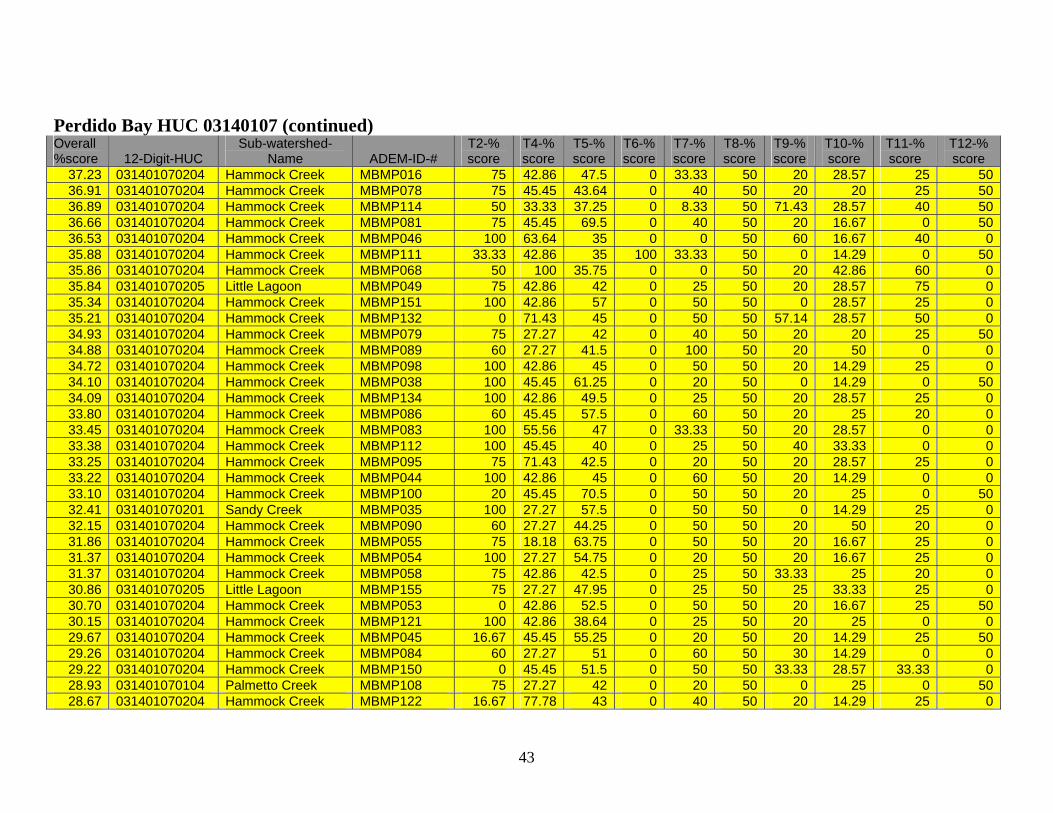
Perdido Bay HUC 03140107 (continued) Overall %score 12-Digit-HUC
Sub-watershed-Name ADEM-ID-#
T2-% score
T4-% score
T5-% score
T6-% score
T7-% score
T8-% score
T9-% score
T10-% score
T11-% score
T12-% score
37.23 031401070204 Hammock Creek MBMP016 75 42.86 47.5 0 33.33 50 20 28.57 25 50 36.91 031401070204 Hammock Creek MBMP078 75 45.45 43.64 0 40 50 20 20 25 50 36.89 031401070204 Hammock Creek MBMP114 50 33.33 37.25 0 8.33 50 71.43 28.57 40 50 36.66 031401070204 Hammock Creek MBMP081 75 45.45 69.5 0 40 50 20 16.67 0 50 36.53 031401070204 Hammock Creek MBMP046 100 63.64 35 0 0 50 60 16.67 40 0 35.88 031401070204 Hammock Creek MBMP111 33.33 42.86 35 100 33.33 50 0 14.29 0 50 35.86 031401070204 Hammock Creek MBMP068 50 100 35.75 0 0 50 20 42.86 60 0 35.84 031401070205 Little Lagoon MBMP049 75 42.86 42 0 25 50 20 28.57 75 0 35.34 031401070204 Hammock Creek MBMP151 100 42.86 57 0 50 50 0 28.57 25 0 35.21 031401070204 Hammock Creek MBMP132 0 71.43 45 0 50 50 57.14 28.57 50 0 34.93 031401070204 Hammock Creek MBMP079 75 27.27 42 0 40 50 20 20 25 50 34.88 031401070204 Hammock Creek MBMP089 60 27.27 41.5 0 100 50 20 50 0 0 34.72 031401070204 Hammock Creek MBMP098 100 42.86 45 0 50 50 20 14.29 25 0 34.10 031401070204 Hammock Creek MBMP038 100 45.45 61.25 0 20 50 0 14.29 0 50 34.09 031401070204 Hammock Creek MBMP134 100 42.86 49.5 0 25 50 20 28.57 25 0 33.80 031401070204 Hammock Creek MBMP086 60 45.45 57.5 0 60 50 20 25 20 0 33.45 031401070204 Hammock Creek MBMP083 100 55.56 47 0 33.33 50 20 28.57 0 0 33.38 031401070204 Hammock Creek MBMP112 100 45.45 40 0 25 50 40 33.33 0 0 33.25 031401070204 Hammock Creek MBMP095 75 71.43 42.5 0 20 50 20 28.57 25 0 33.22 031401070204 Hammock Creek MBMP044 100 42.86 45 0 60 50 20 14.29 0 0 33.10 031401070204 Hammock Creek MBMP100 20 45.45 70.5 0 50 50 20 25 0 50 32.41 031401070201 Sandy Creek MBMP035 100 27.27 57.5 0 50 50 0 14.29 25 0 32.15 031401070204 Hammock Creek MBMP090 60 27.27 44.25 0 50 50 20 50 20 0 31.86 031401070204 Hammock Creek MBMP055 75 18.18 63.75 0 50 50 20 16.67 25 0 31.37 031401070204 Hammock Creek MBMP054 100 27.27 54.75 0 20 50 20 16.67 25 0 31.37 031401070204 Hammock Creek MBMP058 75 42.86 42.5 0 25 50 33.33 25 20 0 30.86 031401070205 Little Lagoon MBMP155 75 27.27 47.95 0 25 50 25 33.33 25 0 30.70 031401070204 Hammock Creek MBMP053 0 42.86 52.5 0 50 50 20 16.67 25 50 30.15 031401070204 Hammock Creek MBMP121 100 42.86 38.64 0 25 50 20 25 0 0 29.67 031401070204 Hammock Creek MBMP045 16.67 45.45 55.25 0 20 50 20 14.29 25 50 29.26 031401070204 Hammock Creek MBMP084 60 27.27 51 0 60 50 30 14.29 0 0 29.22 031401070204 Hammock Creek MBMP150 0 45.45 51.5 0 50 50 33.33 28.57 33.33 0 28.93 031401070104 Palmetto Creek MBMP108 75 27.27 42 0 20 50 0 25 0 50 28.67 031401070204 Hammock Creek MBMP122 16.67 77.78 43 0 40 50 20 14.29 25 0
43
Perdido Bay HUC 03140107 (continued) Overall %score 12-Digit-HUC
Sub-watershed-Name ADEM-ID-#
T2-% score
T4-% score
T5-% score
T6-% score
T7-% score
T8-% score
T9-% score
T10-% score
T11-% score
T12-% score
28.43 031401070205 Little Lagoon MBMP048 75 9.09 42.75 0 50 50 20 12.5 25 0 28.33 031401070203 Graham Bayou MBMP087 100 18.18 41.5 0 20 50 25 28.57 0 0 27.66 031401070204 Hammock Creek MBMP110 0 27.27 55 0 60 50 20 14.29 0 50 27.41 031401070204 Hammock Creek MBMP091 80 33.33 45.75 0 0 50 20 25 20 0 27.33 031401070205 Little Lagoon MBMP047 40 27.27 42.5 0 60 50 25 28.57 0 0 26.90 031401070205 Little Lagoon MBMP153 100 45.45 53.5 0 20 50 0 0 0 0 26.87 031401070204 Hammock Creek MBMP082 75 42.86 41.5 0 25 50 20 14.29 0 0 26.79 031401070204 Hammock Creek MBMP135 0 9.09 49.5 0 100 50 20 14.29 25 0 26.58 031401070205 Little Lagoon MBMP157 0 42.86 36.25 0 50 50 20 16.67 0 50 25.51 031401070204 Hammock Creek MBMP074 66.67 63.64 40.45 0 0 50 20 14.29 0 0 24.14 031401070204 Hammock Creek MBMP099 0 42.86 55 0 20 50 20 28.57 25 0 23.38 031401070204 Hammock Creek MBMP113 66.67 42.86 40 0 0 50 20 14.29 0 0 21.66 031401070204 Hammock Creek MBMP067 33 27.27 36.36 0 35.71 50 20 14.29 0 0 20.58 031401070205 Little Lagoon MBMP156 0 27.27 36.82 0 16.67 50 0 25 0 50 19.26 031401070204 Hammock Creek MBMP076 50 9.09 35.91 0 13.33 50 20 14.29 0 0 18.83 031401070204 Hammock Creek MBMP077 50 9.09 43.18 0 7.69 50 20 8.33 0 0 13.73 031401070205 Little Lagoon MBMP152 0 18.18 38.18 0 16.67 50 0 14.29 0 0 10.85 031401070204 Hammock Creek MBMP085 0 0 32.78 0 9.09 50 0 16.67 0 0
Mobile Bay 03160205 and Escatawpa 03170008
Overall %score 12-Digit-HUC
Sub-watershed-Name ADEM-ID-#
T2-% score
T4-% score
T5-% score
T6-% score
T7-% score
T8-% score
T9-% score
T10-% score
T11-% score
T12-% score
64.44 031602050204 Lower Dog River MBMP009 50 33.33 55.5 0 55.56 60 100 100 90 100 57.79 031602050204 Lower Dog River MBMP060 75 27.27 67.27 100 100 50 33.33 100 25 0 52.78 031602050311 Oyster Bay MBMP154* 100 27.27 50.5 50 50 50 50 50 50 50 52.14 031602050302 Fly Creek MBMP027 40 11.11 45.5 100 26.67 100 66.67 71.43 0 60 50.05 031602050307 Lower Fish River MBMP021 33 45.45 72 0 75 50 25 50 100 50 47.04 031602050202 Upper Dog River MBMP166 100 80 47.5 100 42.86 50 50 0 0 0 45.90 031602050204 Lower Dog River MBMP020 40 27.27 48.4 100 33.33 50 60 50 0 50 45.35 031602050204 Lower Dog River MBMP013 50 57.14 35.5 0 50 50 33.33 87.5 40 50
44
Mobile Bay 03160205 and Escatawpa 03170008 (continued)
Overall %score 12-Digit-HUC
Sub-watershed-Name ADEM-ID-#
T2-% score
T4-% score
T5-% score
T6-% score
T7-% score
T8-% score
T9-% score
T10-% score
T11-% score
T12-% score
43.99 031602050310 Bon Secour River MBMP032 80 27.27 74.25 0 100 50 25 33.33 0 50 43.66 031602050311 Oyster Bay MBMP094 100 22.22 31 0 50 50 50 33.33 100 0 41.74 031602050301 Yancey Branch MBMP028 75 0 53.5 100 22.22 50 50 66.67 0 0 41.27 031602050311 Oyster Bay MBMP106 75 42.86 61.25 0 60 50 20 28.57 25 50 40.80 031602050307 Lower Fish River MBMP056 100 45.45 54.25 100 25 50 25 8.33 0 0 40.05 031602050302 Fly Creek MBMP128 75 14.29 44.5 0 66.67 25 75 50 0 50 38.67 031602050204 Lower Dog River MBMP118 50 63.64 58.75 0 100 50 50 14.29 0 0 38.34 031602050302 Fly Creek MBMP126 100 42.86 40.5 0 25 50 0 25 100 0 37.76 031602050310 Bon Secour River MBMP031 20 33.33 40 0 75 50 20 14.29 75 50 37.73 031602050311 Oyster Bay MBMP124 60 33.33 52.27 0 75 50 40 16.67 0 50 34.92 031602050310 Bon Secour River MBMP101 0 45.45 69.5 0 100 50 20 14.29 0 50 33.66 031602050204 Lower Dog River MBMP061 50 27.27 59.32 0 100 50 16.67 33.33 0 0 33.36 031602050310 Bon Secour River MBMP102 0 27.27 72 0 100 50 20 14.29 0 50 33.17 031602050311 Oyster Bay MBMP050 100 45.45 65 0 16.67 16.67 20 42.86 25 0 33.10 031602050303 Gum Swamp MBMP033 100 0 56 0 33.33 50 66.67 25 0 0 32.87 031602050204 Lower Dog River MBMP022 60 42.86 67.5 0 75 50 0 33.33 0 0 32.63 031602050303 Gum Swamp MBMP088 100 45.45 52.5 0 25 50 33.33 0 20 0 31.06 031602050311 Oyster Bay MBMP117 20 71.43 57.45 0 25 50 20 16.67 0 50 30.34 031602050207 Delchamps Bayou MBMP160 75 27.27 51.14 0 25 50 25 50 0 0 29.88 031602050310 Bon Secour River MBMP036 60 27.27 47.25 0 75 50 25 14.29 0 0 29.45 031602050204 Lower Dog River MBMP017 60 33.33 62 0 12.5 50 16.67 60 0 0 27.94 031602050302 Fly Creek MBMP127 75 9.09 37.73 0 60 50 33.33 14.29 0 0 27.17 031602050302 Fly Creek MBMP130 66.67 0 42.5 0 37.5 50 0 75 0 0 26.25 031602050104 Bon Secour Bay MBMP119 16.67 9.09 56 0 57.14 50 20 28.57 25 0 25.87 031602050204 Lower Dog River MBMP071 0 33.33 57.5 0 25 50 50 42.86 0 0 25.66 031602050204 Lower Dog River MBMP018 33.33 33.33 57.8 0 14.29 50 25 42.86 0 0 23.72 031602050302 Fly Creek MBMP072 33.33 22.22 44.5 100 10 0 20 7.14 0 0 23.55 031602050104 Bon Secour Bay MBMP161 100 0 53 0 20 50 0 12.5 0 0
45
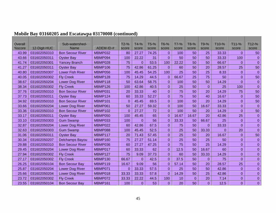
Mobile Bay 03160205 and Escatawpa 03170008 (continued)
Overall %score 12-Digit-HUC
Sub-watershed-Name ADEM-ID-#
T2-% score
T4-% score
T5-% score
T6-% score
T7-% score
T8-% score
T9-% score
T10-% score
T11-% score
T12-% score
23.31 031602050204 Lower Dog River MBMP001 20 42.86 55 0 16.67 50 20 28.57 0 0 22.94 031602050307 Lower Fish River MBMP070 50 9.09 65.5 0 18.18 16.67 16.67 33.33 20 0 22.27 031602050308 Magnolia River MBMP019 20 27.27 77.8 0 33.33 50 0 14.29 0 0 22.22 031602050204 Lower Dog River MBMP120 0 63.64 55 0 8.33 50 16.67 28.57 0 0
21.64 031602050201 Garrow's Bend- Mobile Bay MBMP163 0 18.18 23.25 100 0 50 0 25 0 0
17.45 031602050302 Fly Creek MBMP029 16.67 42.86 32.5 0 12.5 50 0 0 20 0 14.51 031602050302 Fly Creek MBMP026 0 11.11 59 0 0 50 0 0 0 25 11.27 031602050204 Lower Dog River MBMP073 0 27.27 56.82 0 14.29 0 0 14.29 0 0
52.54 031700080402 Big Creek Hamilton Creek MBMP024 100 42.86 82.5 100 33.33 50 50 66.67 0 0
Mobile-Tensaw Delta 03160204 Overall %score 12-Digit-HUC
Sub-watershed-Name ADEM-ID-#
T2-% score
T4-% score
T5-% score
T6-% score
T7-% score
T8-% score
T9-% score
T10-% score
T11-% score
T12-% score
70.53 031602040203 The Basin MBPM167 50 55.56 68.5 100 71.43 50 71.43 83.33 80 75
52.51 031602040505 Tensaw River-Apalachee River MBMP057 100 63.64 38.64 100 42.86 0 80 66.67 0 33.33
47.17 031602040301 Gunnison Creek MBMP004 50 77.78 87.27 0 100 50 66.67 40 0 0 44.42 031602040302 Bayou Sara MBMP065 75 55.56 63.64 0 100 50 66.67 33.33 0 0
43.36 031602040404 Lower Chasaw Creek MBMP002 80 81.81 48.18 0 50 50 20 28.57 0 75
42.49 031602040301 Gunnison Creek MBMP003 75 63.64 67.05 0 60 25 16.67 37.5 40 40
41.91 031602040404 Lower Chasaw Creek MBMP063 100 45.45 73.64 0 100 50 0 50 0 0
40.47 031602040505 Tensaw River-Apalachee River MBMP137 100 45.45 75.91 0 60 50 33.33 40 0 0
39.24 031602040404 Lower Chasaw Creek MBMP062 50 55.56 61.82 100 25 50 25 25 0 0
38.99 031602040303 Grand Bay MBMP015 100 9.09 69.55 0 80 50 0 6.25 75 0
46

Mobile-Tensaw Delta 03160204 (continued) Overall %score 12-Digit-HUC
Sub-watershed-Name ADEM-ID-#
T2-% score
T4-% score
T5-% score
T6-% score
T7-% score
T8-% score
T9-% score
T10-% score
T11-% score
T12-% score
37.73 031602040203 The Basin MBMP030 75 45.45 56.82 0 50 50 33.33 66.67 0 0 37.08 031602040201 Miffin Lake MBMP143 100 27.27 65 0 100 50 0 28.57 0 0 36.64 031602040303 Grand Bay MBMP014 100 33.33 50 0 25 50 16.67 71.43 20 0
36.08 031602040505 Tensaw River-Apalachee River MBMP142 75 45.45 48.63 0 66.67 50 25 50 0 0
35.77 031602040505 Tensaw River-Apalachee River MBMP066 75 33.33 57.73 0 75 50 0 66.67 0 0
33.48 031602040505 Tensaw River-Apalachee River MBMP139 100 27.27 56.82 0 40 50 25 35.71 0 0
33.46 031602040301 Gunnison Creek MBMP064 50 33.33 59.55 0 75 50 16.67 0 0 50
32.73 031602040503 Lower Bay Minette Creek MBMP007 100 27.27 75 0 50 50 0 25 0 0
31.75 031602040505 Tensaw River-Apalachee River MBMP140 100 45.45 52 0 20 50 0 50 0 0
31.66 031602040105 Big Chippewa Lake MBMP136 100 27.27 50.75 0 60 50 0 28.57 0 0
30.56 031602040505 Tensaw River-Apalachee River MBMP008 100 9.09 53.18 0 60 50 0 33.33 0 0
30.51 031602040505 Tensaw River-Apalachee River MBMP005 50 45.45 36.36 0 40 50 25 33.33 25 0
28.95 031602040303 Grand Bay MBMP144 100 18.18 71.36 0 50 50 0 0 0 0
28.58 031602040505 Tensaw River-Apalachee River MBMP145 100 27.27 66.82 0 25 50 0 16.67 0 0
27.87 031602040505 Tensaw River-Apalachee River MBMP138 0 33.33 56.82 0 60 50 50 28.57 0 0
26.60 031602040505 Tensaw River-Apalachee River MBMP141 75 45.45 55.5 0 40 50 0 0 0 0
24.53 031602040301 Gunnison Creek MBMP023 100 27.27 61.36 0 0 0 16.67 0 0 40
47

Mississippi Coastal 03170009
Overall %score 12-Digit-HUC
Sub-watershed-Name ADEM-ID-#
T2-% score
T4-% score
T5-% score
T6-% score
T7-% score
T8-% score
T9-% score
T10-% score
T11-% score
T12-% score
60.15 031700090202 Dauphin Island MBMP006 60 44.44 65.5 0 75 100 71.43 85.17 20 80 53.64 031700090202 Dauphin Island MBMP011 75 42.86 43.5 100 100 50 0 25 100 0 52.38 031700090202 Dauphin Island MBMP010 100 45.45 70 0 66.67 50 66.67 25 100 0 36.94 031700090202 Dauphin Island MBMP159 60 50 47.5 0 33.33 50 25 28.57 25 50 36.49 031700090202 Dauphin Island MBMP034 75 33.33 44.09 0 75 50 12.5 50 25 0 31.56 031700090202 Dauphin Island MBMP012 50 33.33 45.64 0 20 50 33.33 33.33 0 50 27.45 031700090202 Dauphin Island MBMP148 50 0 54.5 0 25 50 20 0 25 50 26.28 031700090103 Grand Bay Swamp MBMP025 50 0 67.75 0 75 50 20 0 0 0
*Defunct Sites
48