supplemental site investigation report ammunition storage …
TRANSCRIPT

SUPPLEMENTAL SITEINVESTIGATION REPORT
AMMUNITION STORAGEMAGAZINES AND PESTICIDESTORAGE AREA
Camp BonnevilleWashington
Prepared for
U.S. Army Corps of EngineersSeattle District4735 East Marginal Way SouthSeattle, Washington 98134
December 2000
1501 Fourth Avenue, Suite 1500Seattle, Washington 98101(206) 343-793353F0072207

CONSENSUS STATEMENT
The enclosed report is entitled “Supplemental Site Investigation Report, AmmunitionStorage Magazines and Pesticide Storage Area, Camp Bonneville, Washington.” Theundersigned agree with the information presented in this report, including the results andconclusions.
____________________________________ _______________________Eric Waehling DateBRAC Environmental Coordinator
______________________________________ _______________________Christopher Maurer DateWashington State Department of Ecology
_______________________________________ _______________________Harry Craig DateU.S. EPA Region 10

Table of Contents
S:\GAYTER\CBONNEVILLE\BONNEVILLE AMMO RPT (3).DOC\14-DEC-00\\ i
Executive Summary ...............................................................................................................................ES-1
Section 1 ONE Introduction .................................................................................................................... 1-1
Section 2 TWO Scope of Work and Objectives...................................................................................... 2-1
Section 3 THREE Site Background............................................................................................................. 3-1
3.1 Site Location ............................................................................................ 3-13.2 Site History .............................................................................................. 3-13.3 Physical Setting........................................................................................ 3-23.4 Geology and Hydrogeology..................................................................... 3-2
3.4.1 Regional Geology and Physiography........................................... 3-23.4.2 Surface Hydrology....................................................................... 3-33.4.3 Geology and Soils ........................................................................ 3-33.4.4 Hydrogeology .............................................................................. 3-4
3.5 Previous Investigations ............................................................................ 3-53.5.1 Environmental Baseline Survey................................................... 3-53.5.2 Brac ’95 Cleanup Plan ................................................................. 3-63.5.3 Soil and Groundwater .................................................................. 3-63.5.4 Surface Water............................................................................... 3-7
Section 4 FOUR Field Investigation Methods.......................................................................................... 4-1
4.1 Pesticide Storage Area ............................................................................. 4-14.1.1 Chemical of Potential Concern .................................................... 4-14.1.2 UXO Avoidance........................................................................... 4-14.1.3 Surface Soil Sampling Procedures............................................... 4-14.1.4 Flooring Material Sampling Procedures ...................................... 4-24.1.5 Sample Laboratory Analyses ....................................................... 4-3
4.2 Ammunition Storage Magazine ............................................................... 4-34.2.1 Chemicals of Potential Concern................................................... 4-34.2.2 UXO Avoidance........................................................................... 4-34.2.3 Surface Soil Sampling Methods................................................... 4-44.2.4 Drilling and Subsurface Soil Sampling Methods......................... 4-44.2.5 Sample Analyses.......................................................................... 4-6
4.3 Deviations From the Work Plan .............................................................. 4-6
Section 5 FIVE Site Investigation Results ............................................................................................. 5-1
5.1 Pesticide Storage Area ............................................................................. 5-15.1.1 Field Observations ....................................................................... 5-15.1.2 Laboratory Analytical Results ..................................................... 5-1
5.2 Ammunition Storage Magazines.............................................................. 5-35.2.1 Field Observations ....................................................................... 5-3

Table of Contents
ii S:\GAYTER\CBONNEVILLE\BONNEVILLE AMMO RPT (3).DOC\14-DEC-00\\
5.2.2 Laboratory Analytical Results ..................................................... 5-45.3 Comparison to Regulatory Criteria.......................................................... 5-5
5.3.1 Petroleum Hydrocarbons ............................................................. 5-65.3.2 Pesticides, Herbicides, and Pcbs.................................................. 5-65.3.3 Metals........................................................................................... 5-65.3.4 Ordnance ...................................................................................... 5-75.3.5 Semivolatile Organics.................................................................. 5-7
5.4 Soil Results Exceeding Regulatory Screening Criteria ........................... 5-75.4.1 Pesticide Storage Area ................................................................. 5-75.4.2 Ammunition Storage Magazine ................................................... 5-8
Section 6 SIX Discussion of Conceptural Site Model......................................................................... 6-1
6.1.1 Potential Release and Transport Mechanisms ............................. 6-16.2 Potential Human Receptors...................................................................... 6-26.3 Potential Ecological Receptors ................................................................ 6-2
Section 7 SEVEN Conclusions and Recommendations ........................................................................... 7-1
7.1 Pesticide Storage Area ............................................................................. 7-17.1.1 Rationale for Recommendations.................................................. 7-1
7.2 Ammunition Storage Magazine ............................................................... 7-27.2.1 Rationale for Recommendations.................................................. 7-3
Section 8 EIGHT References...................................................................................................................... 8-1
List of Tables, Figures, and Appendices
S:\GAYTER\CBONNEVILLE\BONNEVILLE AMMO RPT (3).DOC\14-DEC-00\\ iii
Tables
Table 4-1 Soil Sample Identification and Requested Analyses Ammunition StorageMagazines and Pesticide Storage Area
Table 4-2 Chemicals of Potential Concern in Soil and Groundwater
Table 5-1 Summary of Pesticides, Herbicides and PCBs in SoilPesticide Storage Area
Table 5-2 Summary of TPH in Soil, Pesticide Storage Area and Ammunition StorageMagazines
Table 5-3 Summary of Metals and Conventionals in Soil, Pesticide Storage Area andAmmunition Storage Magazines
Table 5-4 Summary of Semivolatile Organic Compounds in Soil,Ammunition Storage Magazines
Table 5-5 Summary of Ordnance and Explosives, Ammunition Storage Magazines
Table 5-6 TPH Screening Levels for Soil (mg/kg), Pesticide Storage Area andAmmunition Storage Magazines
Table 5-7 Pesticides, Herbicides and PCBs Screening Levels for Soil (µg/kg),Pesticide Storage Area and Ammunition Storage Magazines
Table 5-8 Metals Screening Levels for Soil (mg/kg), Pesticide Storage Area andAmmunition Storage Magazines
Table 5-9 Ordnance Screening Levels for Soil (µg/kg), Pesticide Storage Area andAmmunition Storage Magazines
Table 5-10 Semivolatile Organic Compounds Screening Levels for Soil (µg/kg),Pesticide Storage Area and Ammunition Storage Magazines
Figures
Figure 3-1 Location of Camp Bonneville Military Installation
Figure 3-2 Location of Pesticide Storage Area and Ammunition Storage MagazineCamp Bonneville
Figure 4-1 Pesticide Storage Area
Figure 4-2 Ammunition Storage Magazine
Figure 6-1 Conceptual Site Model Potential Human Exposure Pathway
Figure 6-2 Pesticide Storage Area and Ammunition Storage Magazines CampBonneville

List of Tables, Figures, and Appendices
iv S:\GAYTER\CBONNEVILLE\BONNEVILLE AMMO RPT (3).DOC\14-DEC-00\\
Appendices
Appendix A Soil Boring Log
Appendix B Laboratory Data Sheets (Forms 1s)
Appendix C Laboratory Quality Review Report
Appendix D Chain of Custody Forms and Field Notebook
Appendix E Response to Comments on Draft Supplemental Site Investigation Report
Acronyms
S:\GAYTER\CBONNEVILLE\BONNEVILLE AMMO RPT (3).DOC\14-DEC-00\\ v
2,4,5-T trichlorophenoxy acetic acid2,4-D dichlorophenoxy acetic acidACM asbestos-containing materialAFP artillery firing pointAPP accident prevention planARI Analytical Resources, Inc.BCT BRAC Cleanup TeamBCP BRAC Cleanup Planbgs below ground surfaceBRAC Base Realignment and Closureca carcinogenCERCLA Comprehensive Environmental Response, Compensation and Liability ActCERFA Community Environmental Response Facilitation ActCLP contract laboratory programCOPC chemical of potential concernCSM Conceptual Site ModelDDT dichloro diphenyl trichloroethaneDNR Washington State Department of Natural ResourcesDOD Department of DefenseDQO data quality objectiveEBS environmental baseline surveyEcology Washington State Department of EcologyEDF electronic data formatEO exploded ordnanceEPA U.S. Environmental Protection AgencyFBI Federal Bureau of InvestigationFORSCOM U.S. Army Forces CommandFSP field sampling planGIS graphic information systemHE high explosiveHFA Human Factors AnalysisHMX octhydro-1,3,5,7-tetranitro-1,3,5,7 tetrazocineHQ hazard quotientLBP lead-base paintMDL method detection limitmg/kg milligrams per kilogram

Acronyms
vi S:\GAYTER\CBONNEVILLE\BONNEVILLE AMMO RPT (3).DOC\14-DEC-00\\
mm millimeterMRL method reporting limitmsl mean sea levelMS/MSD matrix spike and matrix spike duplicateMTCA Model Toxics Control ActNC nitrocellulosenc noncarcinogenNCEA National Center for Environmental AssessmentNG nitroguanadineNQ nitroglycerineNTU nephelometric turbidity unitPCBS polychlorinated biphenylsPETN pentaerythritol tetranitratePID Photoionization DetectorsPRG preliminary remediation goalPt Troutdale FormationQa Quaternary alluviumQA/QC quality assurance/quality controlQls Quaternary landslide depositRBCs Risk-Based ConcentrationsRDX hexahydro-1,3,5-trinitro-1,3,5-triazineSAP sampling and analysis planSOW scope of workSPT Standard Penetration TestSSI Supplemental Site InvestigationSVOCs Semi-volatile organic compoundsTNT 2,4,6-trinitrotolueneTPH total petroleum hydrocarbonsTv volcanic bedrock
µg/L micrograms per literUSACE U.S. Army Corps of EngineersUSAMC U.S. Army Material CommandUST underground storage tankUXO unexploded ordnance
Executive Summary
S:\GAYTER\CBONNEVILLE\BONNEVILLE AMMO RPT (3).DOC\14-DEC-00\\ ES-1
Camp Bonneville is a 3,840-acre military installation, located 12 miles east of the City ofVancouver, in Clark County, Washington. The installation covers a large portion of the LacamasCreek Valley and consists mostly of forested areas. The majority of structures on the propertyare located in the Bonneville and Killpack cantonment areas near the installation’s mainentrance. Camp Bonneville was established as a drill field and rifle range in 1909 and hashistorically been used for military training. In recent years, the Federal Bureau of Investigation(FBI) has used some of the post firing ranges. In 1995 the camp was selected for closure underthe Base Realignment and Closure (BRAC) process.
The U. S. Army Corps of Engineers (USACE), Seattle District is managing environmentalinvestigation and cleanup activities at Camp Bonneville in accordance with the BRACenvironmental restoration program, which includes investigation and potential remediation ofsites with contaminated soil and/or groundwater. As part of the investigation effort at CampBonneville, the USACE retained URS to perform a Supplemental Site Investigation (SSI) at theAmmunition Storage Magazines and former Pesticide Storage Area.
The primary objectives of the SSI were to:
• Evaluate chemicals of potential concern (COPCs) in surface soil and in flooring material ofBuilding 4126 at the Pesticide Storage Area.
• Evaluate COPCs in surface and subsurface soil and groundwater at the largest AmmunitionStorage Magazine (Building 2953).
• Evaluate potential exposure to human and ecological receptors based on a conceptual sitemodel.
The SSI included the collection of two surface soil samples adjacent to the Pesticide StorageArea (Building 4126) and a floor material sample from inside Building 4126. The samples weresubmitted for analysis of petroleum hydrocarbons, organochlorine pesticides, polychlorinatedbiphenyls (PCBs), metals, and herbicides. Unexploded ordnance (UXO) avoidance activitieswere conducted to provide safe access to sampling locations.
The SSI also included the collection of three surface soil samples near the doorway of the largestAmmunition Storage Magazine (Building 2953). In addition, one boring was drilleddowngradient of the Building 2953, and one subsurface soil sample was collected from the soilboring. Two soil borings were originally planned (including installation of groundwatermonitoring wells); however, groundwater was not encountered in the downgradient boring.Therefore, the planned upgradient boring was not drilled.
Based on data gathered for the Pesticide Storage area, COPCs are present in the flooring materialin Building 4126 and in surface soil adjacent to the building in concentrations exceeding one ormore regulatory screening criteria.
The following conclusions for the Ammunition Storage Magazines are based on data gatheredduring the SSI and on data gathered by Shannon and Wilson (1999) during a previousinvestigation:
• Soil and residues inside the storage magazines contain explosives compounds and metals(Shannon and Wilson, 1999).

Executive Summary
ES-2 S:\GAYTER\CBONNEVILLE\BONNEVILLE AMMO RPT (3).DOC\14-DEC-00\\
• Surface soils up to 2 feet below ground surface contain metals at concentrations exceedingregulatory screening criteria (Shannon and Wilson, 1999) at all three Ammunition StorageMagazines (Buildings 2950, 2951, and 2953).
• Concentrations of metals decrease significantly with increasing depth.
• Surface soil along the footpath leading to the largest magazine (Building 2953) contains 2,4-dinitrotoluene at concentrations exceeding the cleanup level.
The most likely exposure pathway for these COPCs is direct contact with contaminated surfacesoil and surface water. The most likely human receptors include current and future on-siteworkers, and future on-site recreational users. The most likely ecological receptors includeterrestrial animals, benthic invertebrates, fish, and waterfowl.

SECTIONONE Introduction
S:\GAYTER\CBONNEVILLE\BONNEVILLE AMMO RPT (3).DOC\14-DEC-00\\ 1-1
1. Section 1 ONE Introduction
Camp Bonneville is a 3,840-acre military installation, located 12 miles east of the city ofVancouver, in Clark County, Washington. The installation covers a large portion of the LacamasCreek Valley and consists mostly of forested areas. The majority of structures on the propertyare located in the Bonneville and Killpack cantonment areas within a few thousand feet of theinstallation’s main entrance. Camp Bonneville was established as a drill field and rifle range in1909 and has historically been used for military training. In recent years, the Federal Bureau ofInvestigation (FBI) has used some of the post firing ranges. In 1995, the camp was selected forclosure under the Base Realignment and Closure (BRAC) process.
The U. S. Army Corps of Engineers (USACE), Seattle District is managing environmentalinvestigation and cleanup activities at Camp Bonneville in accordance with the BRACenvironmental restoration program, which includes investigation and potential remediation ofsites with contaminated soil and/or groundwater. As part of the investigation effort at CampBonneville, the USACE retained URS Corporation (URS) to perform a Supplemental SiteInvestigation (SSI) at the Ammunition Storage Magazine area and former Pesticide StorageArea.
The scope of work (SOW) for Delivery Order number 0035 of Contract Number DACA67-98-1005 (dated July 23, 1999), originally included an investigation of Demolition Areas 2 and 3 aswell as the Ammunition Storage Magazines. However, discussions between Fort Lewis,USACE, URS, the U.S. Environmental Protection Agency (EPA), and the Washington StateDepartment of Ecology (Ecology) resulted in removal of Demolition Areas 2 and 3 from the SSI.In addition, Modification number 1 to Delivery Order number 0035 (dated November 23, 1999)included investigation of the Pesticide Storage Area.
As specified in the original SOW and Modification Number 1, the objectives of the SSI were toevaluate the floor of and surface soil around the Pesticide Storage Building (4126), and evaluatethe surface and subsurface soil in the vicinity of the Ammunition Storage Magazines forpotential contaminants related to historic activities. These results were compared to regulatoryscreening criteria to evaluate the potential exposure to human and ecological receptors. Inaddition, potential groundwater impacts were also included in the SSI at the Ammunition StorageMagazines. However, groundwater was not encountered in the soil boring drilled there. Thesedata will aid the BRAC Cleanup Team (BCT) to determine follow-up action for the site, ifnecessary.
SECTIONTWO Scope of Work and Objectives
S:\GAYTER\CBONNEVILLE\BONNEVILLE AMMO RPT (3).DOC\14-DEC-00\\ 2-1
2. Section 2 TWO Scope of Work and Objectives
The Scope of Work for the SSI included the following tasks:
Prepare Management Plan – URS prepared a draft and final Management Plan to describe theprocedures and methods employed to complete the SSI at the Pesticide Storage Area andAmmunition Storage Magazines. The Management Plan included a detailed Work Plan,Sampling and Analysis Plan (including a Field Sampling Plan and Quality Assurance ProjectPlan), Accident Prevention Plan, and Investigation-Derived Waste Plan (URS 2000). URS andthe USACE conducted a project kickoff meeting and a meeting to discuss the draft ManagementPlan to discuss the project objectives, schedule, and comments on the draft Management Plan.
Conduct Site Survey and Reconnaissance – Prior to field activities, URS and the USACEperformed a site survey and reconnaissance to review site conditions, locate soil boring andsurface soil sample locations, and refine the field program to reflect site conditions.
Conduct UXO Avoidance Activities – Unexploded ordnance (UXO) may exist near the studyareas because Camp Bonneville had been used for nearly 80 years as a military firing range.Therefore, because the most important safety precaution when dealing with potential UXO is tominimize exposure of personnel, UXO avoidance measures were conducted before workers wereallowed to begin site activities. This was accomplished by employing a team of UXO specialiststo perform the following UXO avoidance activities in areas where the investigation wasperformed:
• Visual inspection of all investigation areas except those that are used on a regular basis forroutine operations (i.e., roadways)
• Magnetometer surface surveys of foot or vehicular traverses off of established roadways andwalkways
• Borehole magnetometry measurements during drilling
Conduct Surface Soil Sampling and Analysis – URS collected surface soil samples at thePesticide Storage Area and Ammunition Storage Magazines to evaluate potential surface soilcontamination. Samples collected from the Pesticide Storage Area (including the floor sample)were analyzed for the following constituents:
• Chlorinated pesticides
• Chlorinated herbicides
• Polychlorinated biphenyls (PCBs)
• Priority pollutant metals (plus barium)
• Petroleum hydrocarbons (NWTPH HCID with follow-up analysis of gasoline and diesel, asrequired)
Samples collected at the Ammunition Storage Magazines were analyzed for the followingconstituents:
• Nitroaromatic and nitramine explosives, nitroglycerine, nitroguanidine, and ammoniumperchlorate
• Semi-volatile organic compounds (SVOCs)
• Priority pollutant metals (plus barium)

Scope of Work and Objectives SECTIONTWO
2-2 S:\GAYTER\CBONNEVILLE\BONNEVILLE AMMO RPT (3).DOC\14-DEC-00\\
• Grain size
• Total organic carbon
• Petroleum hydrocarbons (NWTPH HCID with follow-up analysis of gasoline and diesel, asrequired)
Soil Boring – URS drilled one soil boring at the Ammunition Storage Magazine to evaluatepotential soil contamination in the estimated downgradient direction. The boring was drilled to adepth of approximately 22 feet below ground surface (bgs), where the drilling rig met refusal.Groundwater was not encountered during drilling. Therefore a monitoring well was notinstalled. Since no groundwater was encountered in the downgradient boring, the USACE fieldrepresentative determined that the planned upgradient boring would not be drilled.
Supplemental Site Investigation Report – This draft SSI Report describes fieldwork andincludes an interpretation of the data gathered during the SSI. Data are compared to existingregulatory cleanup levels and conclusions are presented summarizing the results of thiscomparison.

SECTIONTHREE Site Background
S:\GAYTER\CBONNEVILLE\BONNEVILLE AMMO RPT (3).DOC\14-DEC-00\\ 3-1
3. Section 3 THREE Site Background
3.1 SITE LOCATIONCamp Bonneville is located in Clark County, Washington, near the town of Proebstel,approximately 12 miles east of the city of Vancouver (Figure 3-1). It consists of 3,840 acres,840 acres of which are leased from Washington State (Woodward-Clyde 1997). CampBonneville occupies the following location:
• Section 35, and a portion of Sections 34 and 36 (Section 36 is leased) of Township 3 North,Range 3 East
• Sections 1 and 2, and portions of Section 3, 10, and 11 (Sections 10 and 11 are leased) ofTownship 2 North and Range 3 East
The areas of interest for this investigation include the former Ammunition Storage Magazinesand Pesticide Storage Area. These locations are identified in Figure 3-2. The Pesticide StorageArea (Building 4126) is located just west of the Camp Bonneville cantonment. Building 4126was constructed in approximately 1958 and is a wood structure with a wooden floor. Other thandoors and windows, the building has no ventilation system. This building was used to store 55-gallon drums of 2,4,5-trichlorophenoxy acetic acid (2,4,5-T); 2,4-dichlorophenoxy acetic acid(2,4-D); and an unknown amount of dichloro diphenyl trichloroethane (DDT) until 1977 whenthese materials were moved to Building 1864. The Ammunition Storage Magazines are locatedeast of the Camp Bonneville cantonment and southwest of the existing sewage treatment lagoon.The three magazines are designated as Buildings 2950, 2951, and 2953. The magazines wereconstructed in 1976 and used to store munitions of various types that were brought to CampBonneville for training purposes. The three structures are sub-surface concrete buildings withconcrete floors.
3.2 SITE HISTORYCamp Bonneville is a sub-installation of Fort Lewis. In 1909, Camp Bonneville was establishedwith 309 leased acres as a drill field and rifle range for Vancouver Barracks. The creation of thisdrill field and target range was due in part to the near-level range floor, which is protected fromwind by the foothills of the Cascade Mountains. The plateau and valley, which is 350 yardswide and 2,000 yards long, contained the Army’s 14 short-range and seven long-range targets.
In 1912, an appropriation was made to expand the facilities at Camp Bonneville to include atarget range and a road leading to the post. However, after the option expired in 1915, the Armybegan to conduct its target practice at an Oregon National Guard range near Clackamas, Oregon.When the Army resumed activities at Camp Bonneville in 1918, the valley contained 24 targets.A machine-gun range was also added to the training facilities at some point prior to 1929.
In 1919, 2,711 acres were purchased upon which Camp Bonneville was established. The CampBonneville and Camp Killpack Cantonments were established during the late 1920s and the early1930s, and contain a total of 46 buildings. The U.S. Army leased 840 acres, in two separateparcels, from Washington in State 1955. In 1957, the lease on 20 acres was terminated and theland was returned to the Washington State Department of Natural Resources (DNR). Thistransaction marks the last significant real estate action at Camp Bonneville. The U.S. Army’slease on the remaining 820 acres was in effect until September 30, 1996 (Woodward-Clyde

Site Background SECTIONTHREE
3-2 S:\GAYTER\CBONNEVILLE\BONNEVILLE AMMO RPT (3).DOC\14-DEC-00\\
1997). The USACE, under the direction of the U.S. Army Forces Command (FORSCOM), iscurrently pursuing a lease extension with the DNR.
The mission at Camp Bonneville was to provide a training camp for active U.S. Army, U.S.Army Reserve, U.S. National Guard, U.S. Marine Corps Reserve, U.S. Navy Reserve, U.S.Coast Guard Reserve units, and other Department of Defense (DOD) Reserve personnel. Thepast use of Camp Bonneville has varied and has been mostly dependent on the type and level ofdemand for trained personnel. It was also used as an internment camp during World War II. Thetype of use of this training camp varied depending upon the unit using the facility but generallyincluded the use of the firing ranges and training areas. When not required for military trainingactivities, Camp Bonneville was used until the late 1980s by local civic and nonprofitorganizations for religious retreats and picnics, as a camp for Boy Scouts, as a location for highschool environmental studies, and for State Highway Patrol pistol training. The one tenant atCamp Bonneville is the FBI, who owns and manages small arms training facilities theyconstructed at Camp Bonneville in 1995.
The U.S. Army has been managing forestland at Camp Bonneville since 1957. Managementactivities have consisted of scarification and replacement of lands burned during the fires of1902, 1938, and 1951, and timber sales.
3.3 PHYSICAL SETTINGCamp Bonneville is located on the western slope of the Cascade Mountains in the LacamasCreek valley. The terrain is generally rolling, typical of foothills in the Cascade Mountains,covered with undergrowth and large stands of coniferous timber. The west quarter of theinstallation consists generally of low hills and the low plain of the Lacamas Creek valley, whilethe remainder of the post is comprised of the well-dissected hills of the westernmost CascadeMountains foothills. Elevations range from 289 feet in Lacamas Creek at the southwest cornerof the installation to 1,000 feet at the northwest, 1,350 feet at the southeast, and 1,450 feet at thesouth-central boundary of the installation. The topography is erosional except for shallowdeposition in the Lacamas Creek valley.
3.4 GEOLOGY AND HYDROGEOLOGY
3.4.1 Regional Geology and Physiography
Camp Bonneville is situated on the margin of the western foothills of the southern Cascades inthe transition zone between the Puget Trough and the Willamette Trough Provinces. Thegeology of this area generally consists of Eocene and Miocene volcanic and sedimentary rocktypes overlain by unconsolidated clays, silts, sands, and gravels of the Troutdale Formation(Phillips 1987).
The area surrounding the camp is sparsely populated with scattered residences and is usedprimarily for agriculture and livestock grazing. The nearest town is Proebstel, an unincorporatedcommunity southwest of the western entrance to the camp. The two cantonments, CampKillpack and Camp Bonneville, are located on the valley floor. The remainder of the propertyconsists of moderately steep, heavily vegetated slopes that have been used primarily as firing
SECTIONTHREE Site Background
S:\GAYTER\CBONNEVILLE\BONNEVILLE AMMO RPT (3).DOC\14-DEC-00\\ 3-3
ranges. The valley floor is a relatively narrow floodplain, which ranges from an elevation ofabout 290 feet above mean sea level (msl) on the western end of the property to about 360 feetabove msl on the east. The adjoining slopes rise moderately steeply to elevations of between1,000 and 1,500 feet along ridge tops within the property boundaries.
3.4.2 Surface Hydrology
The principal surface water feature in this area is Lacamas Creek, which flows southward fromthe coalescence of two branch streams in the north-central part of Camp Bonneville, exiting theinstallation at its southwest corner. From the southwestern property boundary, Lacamas Creekflows southwestward to Proebstel, where it turns toward the southeast and continues to itsconfluence with the Columbia River at the town of Camas.
Numerous minor tributaries draining adjacent uplands flow into Lacamas Creek. Buck Creekand David Creek, the largest of these streams, drain the southeastern hills of the property. Twoartificial impoundments of Lacamas Creek, with a total surface area of less than 4,600 squarefeet, have been created to support a trout sports fishery (USACE 1987).
3.4.3 Geology and Soils
Camp Bonneville is situated along the structural and physiographic boundary between thewestern flank of the southern Cascade Mountains and the Portland-Vancouver Basin. Thegeology of the Camp Bonneville vicinity is known primarily from geologic mapping byMundorff (1964) and Phillips (1987), a limited number of well logs available from the generalarea, and an investigation conducted by Shannon & Wilson (1999).
The geology at Camp Bonneville can be divided into three general areas that correspondapproximately to topographic divisions. The area west of Lacamas Creek is composed of aseries of predominately gravel and semi-consolidated conglomerate layers with scattered lensesand stringers of sand (Upper Troutdale Formation). Underlying the Troutdale Formation andcomprising the area to the north and east of Lacamas Creek are predominantly basalt flows andflow breccia, with some pyroclastic and andesitic rocks, which are folded and faulted. Thebottomland along Lacamas Creek is comprised of unconsolidated silt, sand, and gravel valleyfill, with some clay. Because of the thick soil and dense vegetation, no faults have beenidentified within Camp Bonneville (Environmental Science and Engineering, Inc. [ESE] 1983).A Quaternary landslide has been identified in the uplands near David Creek (Phillips 1987).
Soils of Camp Bonneville are mainly low-permeability clays, so there is considerable runoff aftereach storm and occasional minor flooding of Lacamas Creek. Upland soils have mainlydeveloped from basalt and are generally gravelly or stony and fairly shallow. Bottomland soilsalong Lacamas Creek tend to be clayey (Geo Recon International 1981).
Shannon & Wilson (1999) described the four distinctive stratigraphic units that underlie thecamp area:
• Quaternary floodplain and stream channel alluvium and lacustrine deposits, whichmantle the Lacamas Creek valley floor (Qa)
• A Quaternary landslide deposit (Qls) of surface soils and bedrock displaced from thesteep slope along David Creek

Site Background SECTIONTHREE
3-4 S:\GAYTER\CBONNEVILLE\BONNEVILLE AMMO RPT (3).DOC\14-DEC-00\\
• A thick sequence of Quaternary to Pliocene-age gravel, fine-grained sand, and cobblyand bouldery sand known as the Troutdale Formation (Pt), which underlies areas tothe west of the Bonneville cantonment
• Oligocene-age volcanic bedrock (Tv), which is exposed at the surface in the easternpart of the camp
The Quaternary alluvium deposits that make up the shallow surface soils of the Lacamas Creekvalley floor are composed of stream channel, floodplain, and alluvial fan sediments. Thesedeposits consist of a thin layer of clay and silt, underlain by silty sand and some gravel. Duringdrilling and excavation activities associated with the removal of an underground storage tank(UST) in Camp Killpack (Hart Crowser 1996), at least 25 feet of silty clay was encountered andinterpreted to be older alluvium. Borings for a recent study (Shannon & Wilson 1999) alsoencountered alluvial clays and silts overlying a relatively thick silty clay deposit in the CampBonneville cantonment. These clayey soils probably originated as water deposits that weredeposited on the valley floor in Quaternary time as a result of catastrophic flooding along theColumbia River (Shannon & Wilson 1999).
Phillips (1987) mapped a large landslide deposit on the steep northwest-facing slope of LacamasCreek above the Camp Bonneville cantonment. The age of the landslide is unknown; however,the topographic expression suggests that it is not recent. The slide displaced surface soils andbedrock over about 100 acres of land adjacent to David Creek to the northeast. The landslidedeposits extended from an elevation of about 1,000 feet at the headwall of the slide to anelevation of about 500 feet at its toe along David Creek.
The Troutdale Formation, which reportedly underlies a portion of the western part of the camp,ranges from a poorly consolidated sand and gravel to a well-indurated conglomerate in its upperpart. Based on regional logs, the Upper Troutdale Formation is locally about 150 feet thick andconsists of cemented sand, gravel, sandy clay, and boulders. It is underlain by up to 150 feet ofthe Lower Troutdale Formation, which contains considerably more clay interspersed with sandyand gravelly layers. There is considerable variation in the lithology and thickness of theTroutdale Formation. In general, the formation thins eastward against the underlying bedrock.The lower part of the formation reportedly is typically coarser grained toward the east (Mundorff1964).
The bedrock that underlies the alluvial deposits and Troutdale Formation is exposed at thesurface in the eastern part of Camp Bonneville. The bedrock consists of Oligocene-age andesiteand basaltic andesite flows, minor flow breccias, tuffs, and volcaniclastic sandstones. Theuppermost bedrock has been reported to be severely weathered (Shannon & Wilson 1999). Thisweathered bedrock tends to form surface soils that contain gravel of basalt lithology. Duringdrilling for the 1999 investigation (Shannon & Wilson 1999), bedrock was encountered in 10 soilborings, at depths ranging from approximately 6 to 37 feet below ground surface (bgs).
3.4.4 Hydrogeology
Little information is available about the hydrogeology of Camp Bonneville, despite Mundorff’s(1964) extensive study of groundwater resources in Clark County. There are two drinking waterwells at Camp Bonneville: a 385-foot-deep well at the Bonneville cantonment, and a 193-foot-deep well at the Killpack cantonment (ESE 1993). The latter well is apparently different from

SECTIONTHREE Site Background
S:\GAYTER\CBONNEVILLE\BONNEVILLE AMMO RPT (3).DOC\14-DEC-00\\ 3-5
the 516-foot-deep well at the Killpack cantonment described by Mundorff (1964). In addition, awell was drilled at the FBI range during 1998, which extends to a depth of 105 feet bgs (Shannon& Wilson 1999). Several groundwater monitoring wells associated with the sewage lagoon arelocated east of the Camp Bonneville Cantonment. Based on regional information from Mundorff(1964) and the reported depths of the wells at the camp, water supply wells in the area generallyextend into the Troutdale Formation or underlying bedrock. Most of the nearby wells apparentlyobtain groundwater from depths of 150 to as much as 500 feet bgs.
The water table is typically within a few feet of the surface in areas underlain by alluvium andappears to fluctuate seasonally several feet. A rising water table occurs in the early fall throughspring during the rainy season, and a falling water table occurs throughout the summer months.The localized groundwater flow generally follows local topography toward tributaries andcreeks. Generally, groundwater flows from the uplands west toward Lacamas Creek, and easttoward the creek from the cantonments. The elevation of the water table at upland areas of thesite has not been established. However, it may be fairly shallow (less than 50 feet bgs) on theeastern valley walls, which are marked by shallow bedrock, multiple creeks, and tributaries.
3.5 PREVIOUS INVESTIGATIONS
3.5.1 Environmental Baseline Survey
Camp Bonneville Military Reservation was selected for closure under the 1995 BRAC process.The purpose of the environmental baseline survey (EBS) was to classify discrete areas of realproperty associated with Camp Bonneville subject to transfer or lease into one of the sevenstandard environmental condition of property area types. The categories are defined by theCommunity Environmental Response Facilitation Act (CERFA) guidance and the DOD BRACCleanup Plan (BCP) Guidebook (DOD 1993). Property classification was achieved byidentifying, characterizing, and documenting the presence or likely presence of a release orthreatened release of hazardous substances or petroleum products associated with the historicaland current use of Camp Bonneville. Releases at Camp Bonneville that could affect theenvironmental condition of the installation property were also identified, characterized, anddocumented. Additionally, areas containing or suspected of containing non-ComprehensiveEnvironmental Response, Compensation and Liability Act (CERCLA) contamination substances(i.e., asbestos, lead-based paint), that may limit or preclude the transfer or lease of the propertyfor unrestricted use were delineated separately as being qualified.
The survey and parcel evaluation of Camp Bonneville identified 25 BRAC parcels based onenvironmental condition of the property. Of the total 3,840 acres at Camp Bonneville,3,826.26 acres were designated as Categories 1 and 2. The remaining 13.74 acres of BRACproperty were designated as Categories 5 and 7. Additionally, 1.31 acres were designated asqualified for asbestos-containing material (ACM) and lead-based paint (LBP), and the entireinstallation (3,840 acres) was qualified for UXO and/or ordnance fragments.
The Pesticide Storage Area (Building 4126) was designated as a category 7 parcel (areas that arenot evaluated or need additional evaluation) and given parcel number 16(7)HR(P). The buildingwas historically used to store 55-gallon drums of 2,4,5-T; 2,4-D; and an unknown amount ofDDT until 1977. The year storage began is unknown. The Ammunition Storage Magazines

Site Background SECTIONTHREE
3-6 S:\GAYTER\CBONNEVILLE\BONNEVILLE AMMO RPT (3).DOC\14-DEC-00\\
(Building 2950, 2951, and 2953) together comprise Parcel 7Q-X(P), and were qualified forpotential UXO.
3.5.2 BRAC ’95 Cleanup Plan
The BCP for Camp Bonneville was prepared under the BRAC ’95 program. The BRAC processincludes preparing an EBS, CERFA reports, Sampling and Analysis Recommendations, and aBCP. The goal of the BCP process under the BRAC ’95 program is to expedite and improveenvironmental response actions in order to facilitate the disposal and reuse of Camp Bonnevillewhile protecting human health and the environment.
The BCP provided the status, management, and response strategy, and action items related to theongoing environmental restoration and associated programs at Camp Bonneville. Theseprograms support full restoration of the base property, where feasible, which is necessary to meetthe requirements for property disposal and reuse activities associated with closure of theinstallation.
3.5.3 Soil and Groundwater
Hazardous Waste Investigations
Soil and groundwater investigations have been conducted to support restoration activities atCamp Bonneville. Past investigations have addressed petroleum storage (Hart Crowser 1996),asbestos (Hart Crowser 1996), and gas training facilities (Hart Crowser 1998).
Site Investigations were conducted (Shannon & Wilson 1999) between October 1997 and August1998. The objectives were to identify areas that are contaminated and to determine theappropriate step(s) toward site restoration. The 1999 multi-sites report documents the results ofenvironmental investigations of 17 known or suspected contaminated areas at Camp Bonneville.
Investigated sites included three former landfills, two suspected disposal areas, a former burnarea, two burned buildings, two grease pit locations, a former maintenance pit, two former washracks, a pesticide mixing/storage building, a former sewage pond, a former training building,three ammunition storage magazines, a hazardous materials accumulation point, and 26aboveground storage tanks.
When compared to appropriate regulatory criteria, the analytical results obtained from soil andgroundwater samples indicated the following (Shannon & Wilson 1999):
No Further Action:
• No evidence of soil or groundwater contamination was detected in environmental samplesfrom Landfills No. 2 and 3, former Buildings 1962 and 1983, the Paint and Solvent DisposalArea, 18 of the aboveground storage tanks, the Hazardous Material Accumulation Point, orWash Rack No. 2.
• No evidence of the existence of Landfill No. 1 was found.
• At the former Burn Area, the grease pits at the Camp Bonneville and Camp Killpackcantonments, and the former sewage pond, contamination was detected at levels slightly

SECTIONTHREE Site Background
S:\GAYTER\CBONNEVILLE\BONNEVILLE AMMO RPT (3).DOC\14-DEC-00\\ 3-7
above background and in subsurface soils, but was concluded to pose no exposure hazardunder normal use scenarios.
Limited Potential Risk:
• The areas of limited potential risk included the Drum Disposal Area (metals), Wash RackNo. 1 (total petroleum hydrocarbon [TPH] and metals), the Pesticide Mixing/StorageBuilding (TPH, hexachlorobenzene, pesticides, and metals), eight aboveground storage tanks(diesel-range TPH), the Former CS Training Building (lead, polyaromatic hydrocarbons), theMaintenance Pit (TPH, metals, volatiles), and the outside of the ammunition storagemagazines (metals). The interiors of the ammunition storage magazines also contain soilwith explosives; hexahydro-1,3,5-trinitro-1,3,5-triazine (RDX) in one magazine and metalsin both the smaller magazines above risk-based cleanup criteria.
The Shannon & Wilson report (1999) concluded that the extent of contamination at most of thesesites is limited in lateral extent, and appears to be confined to surface and near-surface soils.Groundwater conditions were investigated on a local, site-specific basis. Evaluation ofinstallation-wide groundwater conditions was beyond the scope of the investigations.Investigation activities have not been conducted at the Pesticide Storage Area (Building 4126).
3.5.4 Surface Water
Surface water sampling of the Lacamas Creek watershed was conducted in 1998 (Hart Crowser1998). Chemical analysis of water samples included testing for munitions and metals. The onlysignificant results were slight exceedances of arsenic, which may be attributable to backgroundconcentrations.

Military InstallationLocation of Camp Bonneville
SEATTLE DISTRICTCORPS OF ENGINEERS
SEATTLE,WASHINGTON
U.S. ARMY
CAMP BONNEVILLE
FIGURE 3-1
PN 53F0072207 WASHINGTON


SECTIONFOUR Field Investigation Methods
S:\GAYTER\CBONNEVILLE\BONNEVILLE AMMO RPT (3).DOC\14-DEC-00\\ 4-1
4. Section 4 FOUR Field Investigation Methods
This section describes the field activities conducted on July 26 and 27, 2000. The chemicals ofpotential concern (COPCs), UXO avoidance techniques, and field sampling techniques aredescribed for each area.
4.1 PESTICIDE STORAGE AREA
4.1.1 Chemical of Potential Concern
The Pesticide Storage Area may contain herbicides, pesticides, hydrocarbons, PCBs, and metals.As stated above the objective of the SSI was to evaluate the potential presence of thesecontaminants in Building 4126 flooring materials and in surface soil (0 to 6 inches bgs) aroundthe building. A summary of these chemicals is included in Table 4-1.
4.1.2 UXO Avoidance
Human Factors Analysis (HFA), of Gaithersburg Maryland, conducted UXO avoidance activitiesand marked safe access and sampling areas before URS collected surface soil samples near thepesticide storage building (Building 4126). UXO avoidance was conducted in accordance withthe USACE Safety and Health Requirements Manual (EM385-12-1), Safety Concepts and BasicConsiderations for Unexploded Ordnance Operations (ETL-385-1-1), and the U.S. ArmyMaterial Command (USAMC) Safety Manual (AMC-R 385-100).
HFA searched sample locations and personnel access routes with a hand-held magnetometer.The type of magnetometer used is capable of detecting metallic objects, with high resolution, upto a depth of approximately 6 feet bgs. Based on search results, HFA inserted red pin-flagsalong safe area perimeters. All locations where magnetic anomalies were encountered wereidentified with orange markers and sampling personnel did not approach the anomaly locations.Only one magnetic anomaly, most likely due to a piece of cable on the ground surface, wasevident near the pesticide storage building. A Schonstedt Model GA-72CV magnetometer wasused for UXO avoidance on the ground surface and a Mk26 Mod 0 Ordnance Locator (ForsterFerex 4.021) magnetometer was used for down-hole UXO avoidance.
4.1.3 Surface Soil Sampling Procedures
URS collected surface soil samples from two areas adjacent to Building 4126. These included a4-square-foot area just outside the building entrance and a 4-square-foot area adjacent to thebuilding’s south wall. Just outside the building entrance, only a 4-foot wide strip of exposed soilwas available for sampling due to the presence of an 8-foot by 8-foot concrete pad, locatedapproximately 4 feet west of the building. The exposed strip of soil below the building entrancewas selected for obtaining sample SS04 (Figure 4-1) because it was considered to be the mostlikely location where spills may have occurred when the building was used. The south side ofthe building was selected for sample SS05 because thick vegetation on all other sides of thebuilding prevented access for UXO clearance and sampling.
In each location, as much vegetation as possible was removed and a grid was placed on theground to ensure collection of an unbiased composite sample. The grid consisted of two clothmeasuring tapes laid perpendicular to each other to form four, 1-foot squares. Subsamples of

Field Investigation Methods SECTIONFOUR
4-2 S:\GAYTER\CBONNEVILLE\BONNEVILLE AMMO RPT (3).DOC\14-DEC-00\\
approximately equal volume were then collected from each grid square and homogenized toform one composite sample.
The subsamples were collected from each grid section by removing soil with a clean, stainlesssteel spoon and transferring it to a clean, stainless steel bowl. Approximately equal volumes ofsoil were removed from each grid square by scraping the soil surface and digging to 6 inchesbgs. The loosened soil was then placed in the bowl; gravel, vegetation, and other debris werecarefully removed; and the finer grained soil was thoroughly mixed and broken apart. The soilwas then transferred from the bowl to laboratory-provided, certified clean, glass jars withTeflonTM-lined lids. The jars were individually sealed in ziploc bags and placed into a coolertogether with chipped ice.
Sample SS04 included a quality assurance/quality control (QA/QC) blind duplicate, a matrixspike and matrix spike duplicate (MS/MSD), and a duplicate sample for the USACE laboratory.The primary, USACE duplicate, and MS/MSD samples were identified as SS04 and marked withthe correct sampling time. The blind duplicate sample for the contract laboratory was labeledwith the fictitious identification SS504 and a fictitious sampling time. The samples were loggedon chain of custody forms designated for each laboratory. Blind duplicate samples were notidentified as such on the chain of custody forms.
4.1.4 Flooring Material Sampling Procedures
Because Building 4126 was historically used as a pesticide storage and mixing facility, pesticidesmay have spilled on the floor. The approximately 80-square-foot floor is constructed of 2-inchby 12-inch, clear, Douglas Fir planks spaced less than 1/16 of an inch apart. Dry rot or othersigns of degradation of the floor were not present. Because the floor was in good condition, it islikely that material spilled on the floor would not easily go through the floor and onto underlyingsoil. Some spilled material may have penetrated the wood and/or remained on the wood surface;therefore, one sample of floor material was collected inside the building.
A wipe sample was originally planned for the floor; however, wipe samples are not appropriatefor porous materials, such as wood. Therefore, it was concluded that a chip sample of the floorwould be a more representative type of sample. Prior to collecting the sample, the analyticallaboratory provided information regarding the volume of material needed and the proper methodto collect and submit the sample. Sample collection was first attempted by chipping the floorsurface with a stainless steel chisel and mallet. However, because the fir planks were old andhard, this method proved impractical considering the volume of sample needed for analysis. Inaddition, the variously sized chips were not easily placed into jars for transport to the laboratory.Because of this situation an alternate method was necessary.
The alternate method included augering holes in the wood using a new, clean, stainless steelauger bit attached to a brace. Several holes were dilled using the brace and bit, to depths ofapproximately 0.5 to 1 inch below the floor surface. As the auger penetrated the wood, itproduced thin shavings between 10 and 15 millimeters (mm) long by approximately 1 mm thick.The shavings from approximately 20 holes were placed into a stainless steel bowl and thoroughlyhomogenized to create a composite sample designated as FS01. Each sample jar wood shavingswas immediately labeled, placed into a ziploc bag, and packaged in a cooler along with sufficient

SECTIONFOUR Field Investigation Methods
S:\GAYTER\CBONNEVILLE\BONNEVILLE AMMO RPT (3).DOC\14-DEC-00\\ 4-3
ice to maintain the sample at approximately 4o Celsius. The sample was identified as FS01 andthis identification was recorded together with the sampling time on a chain of custody form.
4.1.5 Sample Laboratory Analyses
All of the surface soil and flooring material samples were submitted for analysis of the followingCOPCs:
• Chlorinated herbicides – EPA Method 8151
• Chlorinated pesticides – EPA Method 8081
• PCBs – EPA Method 8082
• Priority pollutant metals, plus barium – EPA Method 6000/7000 Series
• Petroleum hydrocarbons – NWTPH HCID with appropriate follow-up for Gx and/or Dx
The primary and QA/QC samples were hand-delivered to Analytical Resources, Inc. (ARI) onJune 28, 2000. Duplicate samples were shipped to the USACE laboratory via priority-overnightFederal Express on June 27, 2000. Table 4-1 summarizes the soil sample identifiers, requestedanalyses, analytical methods, and laboratory quantitation limits used by ARI.
4.2 AMMUNITION STORAGE MAGAZINE
4.2.1 Chemicals of Potential Concern
The Ammunition Storage Magazines may contain exploded ordnance (EO) and UXO. AlthoughEO and UXO are not expected to have leached into the subsurface soil, it is possible thatexplosives constituents, petroleum hydrocarbons, and metals may have leached into subsurfacesoil. A summary of COPCs is provided in Table 4-2.
4.2.2 UXO Avoidance
UXO avoidance activities at the Ammunition Storage Magazine included delineating safe accessroutes to the sample locations, searching surface soil sampling areas, and conducting a downholesearch at the boring location. The access routes that were cleared included the drivewayextending from the main road to the front door of the Ammunition Storage Magazine bunker,and the area around the boring location, next to the main road (Figure 4-2). All of the surfacesoil sample locations and the one boring location were on or next to the road in front of thebunker. A second boring was to be located along the main road, uphill from the bunker; but dueto the absence of groundwater encountered in the first boring, the second boring was not drilled.However, the second boring location was evaluated for the presence of UXO as described below(prior to drilling the first boring).
HFA evaluated the access road with a magnetometer to search for magnetic anomalies. The roadand approximately 5-foot wide strips of land adjacent to the road were searched and deemed safefor access. HFA placed red pin flags along the perimeter of the cleared route and instructed allpersonnel to enter and leave only by the approved access route. Two magnetic anomaliesencountered in the roadway were concluded to be due to large nails on the ground surface. The
Field Investigation Methods SECTIONFOUR
4-4 S:\GAYTER\CBONNEVILLE\BONNEVILLE AMMO RPT (3).DOC\14-DEC-00\\
5-foot-wide strips adjacent to the road included the surface soil sample locations in front of thebunker door and provided safe work areas for the drilling crew.
In addition to evaluating the boring location with a magnetometer, HFA conducted downholeclearance at the boring location prior to mobilization of the drilling rig. Downhole clearanceconsisted of advancing hand auger borings to 4 feet bgs and searching for subsurface magneticanomalies using a Schoenstadt Mark 26 downhole magnetometer. Native soil consisting of stiffred clay was encountered in both boring locations at less than 1 foot bgs. Although it is unlikelythat UXO would be present in native soil, HFA advanced each boring to 4 feet bgs for addedsafety. When the hand auger boring was complete, HFA inserted the Mark 26 probe and slowlylowered it to the bottom. As the probe descended, an analog meter was observed to detect thepresence of any metallic objects. No anomalies were noted in either boring location.
The small area encompassing the surface soil sample locations was checked twice for qualityassurance of the UXO evaluating process. The one boring location (Figure 4-2) was alsoevaluated twice for additional QA/QC. During QA/QC activities, HFA noted that several falsepositive magnetometer measurements were attributable to the presence of imported road covergravel. The gravel was composed of basalt from unknown sources and was described by HFA as“hot rock” in that the gravel contained a large enough mass of ferrous minerals to activate themagnetometer. To ensure that gravel, and not UXO, was causing the false positive detections,several pieces of gravel were placed on bare soil and measured with the magnetometer. With thegravel present, an anomaly was detected. When the gravel was removed, no anomaly wasdetected. HFA observed the signal that was characteristic of the gravel, adjusted the sensitivityof the magnetometer, and repeated the access route evaluation.
4.2.3 Surface Soil Sampling Methods
Three discrete grab soil samples were collected from a small area in front of the AmmunitionStorage Magazine door (Building 2953). The purpose of sampling in this area was to evaluatepotential surface soil contamination associated with black powder that was recently removedfrom the building. The sample locations were located along the short footpath leading awayfrom the door (Figure 4-2). The samples were designated as SS01, SS02, and SS03 and wereapproximately 1 foot, 3 feet, and 6 feet away from the threshold of the magazine, respectively.
In each discrete sample location, vegetation including grasses and blackberry vine tendrils werecut away or removed to reveal the soil surface. A clean stainless steel spoon was then used toscrape and loosen the heavily compacted, gravelly soil. The loosened soil was placed into aclean stainless steel bowl and gravel, vegetation, and other debris were removed. The resultantfine-grained soil component was homogenized. The soil was then transferred to laboratory-provided, certified clean, glass sample jars. Each jar was labeled with the sample identificationand other pertinent information, sealed the jar in a ziploc bag and placed it in a cooler withsufficient ice to maintain the sample at 4o Celsius.
4.2.4 Drilling and Subsurface Soil Sampling Methods
Drilling and subsurface soil sampling at the Ammunition Storage Magazine were performed byTacoma Pump and Drill of Graham, Washington under direct supervision of a URS geologist.Tacoma Pump and Drill used a Mobile B-61, hollow-stem auger, drilling rig to drill and sample

SECTIONFOUR Field Investigation Methods
S:\GAYTER\CBONNEVILLE\BONNEVILLE AMMO RPT (3).DOC\14-DEC-00\\ 4-5
one soil boring (SB-01). The URS geologist observed and logged soil samples collectedcontinuously from the surface to approximately 22 feet bgs, where the drilling rig met refusal.One sample was collected and submitted for laboratory analysis.
Tacoma Pump and Drill used the hollow-stem auger method to advance soil boring SB-01. Thehollow-stem auger method consists of rotating and pushing a leading auger fitted with teeth,which is attached to helical auger flights that lift soil to the ground surface. In this case, a 9-inch-diameter finger bit and 5-foot-long, 8.5-inch outer diameter, 4-inch inner diametercontinuous auger flights were used. The finger bit is a steel collar fitted with four, 2-inch-longcarbide teeth, that loosens and pushes through soil and gravel as it is rotated. Soil loosened bythe bit was captured on the auger flights and lifted toward the ground surface where it wasshoveled into drums. Additional auger flights were attached to the leading bit in a “string” as theboring deepened.
Sampling tools were lowered to the bottom of the boring through the 4-inch-diameter opening inthe center of the auger flight string. The sampler, attached to a threaded steel rod, was drivenwith a hammer so that it penetrated soil below the drill bit and retrieved a relatively undisturbedsample. At the Ammunition Storage Magazine, the augers were advanced 18 inches at a timeand an 18-inch-long, 1.5-inch-diameter, standard penetration test (SPT) split spoon was used toretrieve the soil sample. The sampler was driven with an automated hydraulic hammer designedto mimic a 140-pound cat-head hammer with a 30-inch drop. Each sampling event includeddriving the SPT 18 inches and recording the number of hammer blows for each 6 inches ofpenetration.
Lubricants were neither necessary nor used during the drilling and sampling process. TacomaPump and Drill connected the auger flights with bolts and used clean, threaded drill rod forlowering and retrieving sampling tools. All equipment was steam-cleaned prior to mobilizationof the drilling rig.
URS collected samples continuously from 4 feet bgs (bottom of UXO avoidance boring) to thebottom of the hollow-stem auger boring at approximately 22 feet bgs. Each split spoon wasopened, photographed, and observed for visual and olfactory evidence of contamination. TheURS geologist recorded all sample observations including drilling rates and sample blow countson a soil boring log (Appendix A). One sample (SB01-4.5), consisting of soil collected between4 and 7 feet bgs, was retained for laboratory analysis.
The sample collected for laboratory analysis was composited from two SPTs driven between 4and 7 feet bgs. Soil from each split spoon was observed and logged as described above and thentransferred to a clean stainless steel bowl. The URS geologist used a clean stainless steel spoonto thoroughly mix the soil and transfer it into certified clean, laboratory provided, glass jars.Sample jars were labeled, placed into ziploc bags and then packaged in a cooler along withenough ice to maintain them at or below 4o Celsius. Soil from two split spoons was necessary tocollect a sufficient volume of soil for both primary and QA/QC samples. The primary samplewas identified as SB01-4.5.
After the boring was completed and analytical samples were securely packaged, Tacoma Pumpand Drill abandoned the soil boring in accordance with Ecology Minimum Standards forConstruction and Maintenance of Wells (WAC 173-160). Abandonment procedures includedslowly withdrawing the auger string while pouring 3/8-inch bentonite chips through the hollowstem opening. Approximately 2 gallons of potable water were poured into the boring to hydrate

Field Investigation Methods SECTIONFOUR
4-6 S:\GAYTER\CBONNEVILLE\BONNEVILLE AMMO RPT (3).DOC\14-DEC-00\\
the bentonite hole plug each time an auger flight was withdrawn from the boring. This processwas continued until all of the auger flights were removed and the bentonite seal was flush withthe ground surface.
4.2.5 Sample Analyses
Surface and subsurface soil samples from the Ammunition Storage Magazine were submitted toARI Laboratories, GPL Laboratories, and the USACE QC laboratory for analysis of thefollowing compounds:
• Priority pollutant metals, plus barium
• SVOCs
• Ordnance compounds
• Ammonium Perchlorate
In addition to the above analyses, subsurface soil sample SB01-4.5 was analyzed for grain size,total organic carbon, and petroleum hydrocarbons. Soil sample identifiers, QA/QC samples, andthe requested analyses are described in Table 4-1.
4.3 DEVIATIONS FROM THE WORK PLANThe number of borings and the drilling methods used were different than described in thesampling and analysis plan because of changes in the scope of work and conditions encounteredin the field. The original sampling and analysis plan included drilling and sampling two boringsand installing two monitoring wells using the air-rotary drilling method. After completion of theoriginal plan, URS and the USACE concluded that the hollow-stem auger method would besufficient for drilling because bedrock was not anticipated to be encountered at the time themanagement plan was written. Monitoring wells were not installed and only one boring wascompleted because groundwater was not encountered between the ground surface andapproximately 22 feet bgs while drilling soil boring SB-01 (Figure 4-2). The USACE fieldrepresentative decided that if shallow groundwater was not encountered and a monitoring wellwas not installed in the presumed downgradient direction from the Ammunition StorageMagazine, then an upgradient boring and well would not provide useful data. Based on thisdecision, only SB-01 was drilled and only one subsurface soil sample was collected.
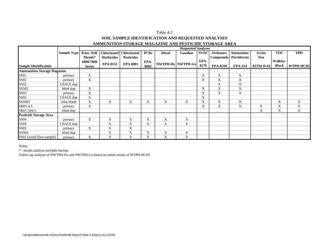
Prior. Poll. Chlorinated Chlorinated PCBs Diesel Gasoline SVOC Ordnance Ammonium Grain TOC TPHMetals* Herbicides Pesticides Compounds Perchlorate Size
Sample Identification6000/7000
SeriesEPA 8151 EPA 8081
EPA-8082
NWTPH-Dx NWTPH-GxEPA-8270 EPA-8330 EPA-314 ASTM D-63
Walkley-Black WTPH-HCID
Ammunition Storage MagazineSS01 primary X X X XSS02 primary X X X XSS02 USACE dup X XSS502 blind dup X X X XSS03 primary X X X XSS03 USACE dup X XSS1003 rinse blank X X X X X X X X X X XSB01-4.5 primary X X X X X X XSB01-504.5 blind dup X X XPesticide Storage AreaSS04 primary X X X X X XSS04 USACE dup X X X X XSS05 primary X X XSS504 blind dup X X X X XFS01 (wood floor sample) primary X X X X X X
Notes:* - metals analysis includes bariumFollow-up analysis of NWTPH-Dx and NWTPH-Gx based on initial results of WTPH-HCID
Table 4-1SOIL SAMPLE IDENTIFICATION AND REQUESTED ANALYSES
AMMUNITION STORAGE MAGAZINE AND PESTICIDE STORAGE AREARequested Analyses
Sample Type
i:\projects\Bonneville Ammo-Pest\Draft Report\Table 4-2report.xls 11/5/01

TABLE 4-2CHEMICALS OF POTENTIAL CONCERN
IN SOIL AND GROUNDWATER
SAMPLINGAREAS
MUNITIONCOMPOUND
CLASSES CONTAMINANTS OF POTENTIAL CONCERN
High Explosivesand OrganicCompounds
Artillery Propellants Other
AmmunitionStorage
Magazines
ArtilleryPropellants, HE
TNT, RDX, PETN,Picric Acid
Black Powder (nitrate), NC,NG, NQ, Plasticizers,
Stabilizers
Priority PollutantMetals plus Barium,
TPH, SVOCs
PesticideStorage Area
N/A N/A N/A Priority PollutantMetals plus Barium,
Pesticides,Herbicides, PCBs,
TPH
Notes:Black powder is a mixture of potassium or sodium nitrate, charcoal, and sulfur.Plasticizers = dibutylphthalate, diethylphthalateStabilizers = diphenylamine, N-nitrosodiphenylamineHE = high explosiveN/A = Not applicableNC = nitrocelluloseNG = nitroguanidineNQ = nitroglycerinePCB = polychlorinated biphenylPETN = pentaerythritol tetranitrateRDX = hexahydro-1,3,5-trinitro-1,3,5-triazineSVOC = semivolatile organic compoundTNT = 2,4,6-trinitrotolueneTPH = Total Petroleum HydrocarbonsPriority pollutant metals include antimony, arsenic, beryllium, cadmium, chromium, copper, lead, mercury, nickel, selenium, silver,thallium, and zinc.

Building 4126
ConcretePad
CoveredStorage
U.S. ARMYCORPS OF ENGINEERS
SEATTLE,WASHINGTONSEATTLE DISTRICT
CAMP BONNEVILLE WASHINGTONPN 53F0072207
APPROX 1"=5'SCALE
0
FEET
5
FS01
SS05
SS04
FIGURE 4-1
PESTICIDE STORAGE AREA
Legend
Flooring MaterialSubsample Location (for Composite Sample)
Subsample Location (for Composite Sample)Surface Soil
UXO Avoidance Perimeter
SS04
FS01

SS02
SS01
SS03
SB-01
AmmunitionStorageBunker
Gravel Driveway
Locked Gate
Gravel Road
FIGURE 4-2
AMMUNITION STORAGE MAGAZINE
CAMP BONNEVILLE WASHINGTONSCALE
5
APPROX 1"=5'
0
FEET
UXO Avoidance Perimeter
SS01
SB-01
Surface Soil Sample Location
Soil Boring Location
Legend
Chainlink Fence
SEATTLE DISTRICTCORPS OF ENGINEERS
SEATTLE,WASHINGTON
U.S. ARMY
PN 53F0072207
SECTIONFIVE Site Investigation Results
S:\GAYTER\CBONNEVILLE\BONNEVILLE AMMO RPT (3).DOC\14-DEC-00\\ 5-1
5. Section 5 FIVE Site Investigation Results
The following summarizes field observations made by URS during sampling activities and theresults of laboratory analysis for soil samples.
5.1 PESTICIDE STORAGE AREA
5.1.1 Field Observations
The Pesticide Storage Area is located on the edge of a small, flat, grassy field approximately75 feet south of the gravel road in front of the Camp Killpack cantonment. Overall, the groundsurface in this area slopes very gently to the south, away from the road. Building 4126 restsdirectly on the ground surface, without foundational support. It contains a doorway, with thedoor removed, and two large windows without panes. The walls and roof are moderatelyweathered but the 2- inch by 12-inch fir boards that comprise the floor are sound and show nosigns of rot. A light-duty workbench and some paper debris (fast-food packaging) were the onlyitems observed inside the building on June 26, 2000. A small amount of gray, coarse powderand a few milliliters of dried tar were present on the floor at the time of sampling.
The building is approximately 4 feet west of an approximately 8-foot by 8-foot concrete pad.There is a small grassy area 20 feet to the east and a covered storage area approximately 30 feetto the northeast. A few pieces of wood and sheet metal are scattered on the ground surface.Several evergreen trees are located immediately west and southwest of the building.
According to USACE and Camp Bonneville personnel, previous uses of the pesticide buildingincluded towing it to various locations throughout the cantonment. Wooden skids attached to theunderside of the floor further suggest this type of use. Vines and bushes growing up against thebuilding walls suggest that it has not been moved and has been in its current location for aconsiderable amount of time.
Topsoil in the pesticide storage area consists of brown, sandy silt and some fine gravel. Asubstantial amount of organic matter in the soil includes mostly live roots from grass, Oregongrape, and blackberry vines. Based on observations made while collecting the soil samples, thetopsoil is well compacted and fairly dense. URS did not observe visual or olfactory evidence ofsoil contamination such as stains and/or dead vegetation.
5.1.2 Laboratory Analytical Results
As described in Section 4, surface soil samples were collected from just outside the doorway andadjacent to the south side of the building. A flooring material sample was collected inside thebuilding. The surface soil sample from the doorway was identified as SS04, the sample from thesouth side of the building was identified as SS05, and the flooring material sample was labeledFS01. A blind duplicate sample (SS504) was also collected from the surface soil samplinglocation outside the doorway. The primary and blind duplicate samples were analyzed by ARI.All of the samples were analyzed for organochlorine pesticides, PCBs, herbicides, petroleumhydrocarbons, and priority pollutant metals plus barium. Analytical results for detected analytesare summarized in Tables 5-1 through 5-3. The complete laboratory analytical data sheets(Form 1s) are provided in Appendix B.

Site Investigation Results SECTIONFIVE
5-2 S:\GAYTER\CBONNEVILLE\BONNEVILLE AMMO RPT (3).DOC\14-DEC-00\\
Organochlorine Pesticides and PCBs
DDT and its analogues 4,4-DDD and 4,4-DDE, beta-BHC, lindane, and endrin aldehyde weredetected in the pesticide storage area (Table 5-1). 4,4-DDD (estimated concentration of76 µg/kg in primary soil sample), 4,4-DDE (estimated concentration of 230 µg/kg in primary soilsample), 4,4-DDT (estimated concentration of 2,700 µg/kg in primary soil sample), lindane(estimated concentration of 2 µg/kg in primary soil sample), and endrin aldehyde (estimatedconcentration of 9.5 µg/kg in duplicate soil sample) were detected in soil collected from thedoorway (SS04). 4,4-DDE (concentration of 7.7 µg/kg), 4,4-DDT (concentration of 42 µg/kg),and beta-BHC (concentration of 4.2 µg/kg) were detected next to the south side of the building.The flooring material sample (FS01) contained only 4,4,-DDT (2,600 µg/kg).
Overall, analyte concentrations were highest in the soil sample collected from the doorway(SS04). Concentrations of DDE and DDT from the south side of the building wereapproximately 30 times lower than the doorway sample. The DDT concentration in the flooringmaterial was similar to the doorway surface soil sample. However, it was the only analytedetected inside the building.
PCBs were not detected at concentrations exceeding laboratory reporting limits in any of thesamples.
Herbicides
The only herbicide detected in the soil samples from the Pesticide Storage Area was 2,4,5-T(Table 5-1). Sample SS504 had an estimated concentration of 230 µg/kg and sample SS05 hadan estimated concentration of 160 µg/kg. The herbicides detected in the floor sample (FS01)included 2,4-D (estimated concentration of 500 µg/kg); 2,4-DB (estimated concentration of3,000 µg/kg); 2,4,5-T (estimated concentration of 92,000 µg/kg); and MCPP (estimatedconcentration of 42,000 mg/kg).
Petroleum Hydrocarbons
Diesel and motor oil-range hydrocarbons were detected in all three samples collected from thePesticide Storage Area (plus the duplicate sample) (Table 5-2). The concentrations in the soilsamples were similar. The diesel-range hydrocarbon concentrations were 42 mg/kg (primarysample SS04) and 43 mg/kg (SS05). Concentrations of motor oil-range hydrocarbons were200 mg/kg (SS05) and 230 mg/kg (primary sample SS04 and duplicate). The concentrationsdetected in flooring material were significantly higher (diesel – 3,900 mg/kg and motor oil –1,800 mg/kg).
Gasoline range hydrocarbons were only detected in the flooring material sample at an estimatedconcentration of 460 mg/kg. Gasoline was not detected in the soil samples.
Metals
Analyses for 13 priority pollutant metals plus barium were conducted for all three samplescollected from the Pesticide Storage Area (Table 5-3). All of the metals analyzed exceptantimony, thallium, and selenium were detected in the soil samples. Only eight metals weredetected in the flooring material as beryllium, nickel, selenium, silver, and thallium were notdetected above the laboratory reporting limit. Unlike most other analytes, the lead concentrationin the soil from the south side of the building (SS05 – 970 mg/kg) was significantly higher than

SECTIONFIVE Site Investigation Results
S:\GAYTER\CBONNEVILLE\BONNEVILLE AMMO RPT (3).DOC\14-DEC-00\\ 5-3
the concentration in the doorway sample (SS04 – 270 mg/kg). Overall, metal concentrations inthe floor sample were lower than concentrations in the soil.
5.2 AMMUNITION STORAGE MAGAZINES
5.2.1 Field Observations
URS recorded field observations at the Ammunition Storage Magazines (Building 2953) whilecollecting surface soil samples and drilling a soil boring. Surface soil samples were collected inthree locations in front of the bunker door. Subsurface soil samples were collected from soilboring SB-01 approximately 15 feet south of the bunker.
The Ammunition Storage Magazines are located approximately 2,000 feet northeast of thePesticide Storage Area on the south side of the road leading into the facility from the CampKillpack cantonment. They are positioned on a flat, graded terrace approximately 10 feet belowthe elevation of the road. An approximately 10-foot-wide by 50-foot-long access road descendsfrom the main gravel road on the west side of the largest magazine (Building 2953) and ends infront of the magazine entrance on the south side. Overall, the ground surface in this area slopesaway from the road and continues to descend toward the south away from the terrace.
Building 2953 is a small concrete bunker that is covered with several feet of soil on all sidesexcept the south side. A locked steel door and a secondary, protective steel grate protect a three-foot-wide doorway on the south side of the bunker. The concrete building covers approximately100 square feet. The protective soil cover that slopes away from the north, west, and east sidesof the building covers most of the remaining graded area. A chain-link and barbed wire fenceextends around the entire perimeter of the storage area. A locked gate is positioned at theintersection of the main gravel road and the magazine access road.
The access road and portions of the area around the bunker are covered with coarse, basalticgravel. Most of the area, including the access road, is overgrown with Himalayan blackberryvines, Scotch Broom, small red alder trees, and grass.
Surface soil adjacent to the bunker consists of an approximately 6-inch to 1-foot-thick layer offill composed of silty, gravelly sand. Along a narrow foot path extending from the door of thebunker to the access road, the soil is very compact and contains a high percentage of basaltgravel derived from the nearby road cover. In one surface soil sample location, URSencountered approximately 6-inch-diameter cobbles. A dense network of roots was encounteredin all surface soil sample locations from the surface to approximately 1-foot bgs.
Soil, as encountered in the boring location, consists of fill (as described above) to approximately1 foot bgs, silty clay and clayey silt to approximately 7 feet bgs, and a heterogeneous mixture ofsilt, clay, and weathered bedrock from 7 feet bgs to the bottom of the boring (22 feet bgs). Theupper 6 feet of native soil, from approximately 1 foot to 7 feet bgs, is fairly uniform, red-brown,silty clay with a small percentage of fine to medium sand. Beginning at 7 feet bgs, the soilconsists of multiple thin layers of black, red, and/or gray silty clay or clayey silt. Withincreasing depth, the soil is increasingly heterogeneous with fewer visible layers and anincreasing amount of what appears to be extremely weathered bedrock material from an andesiticparent rock. During drilling, refusal was met at 21 feet bgs. Based on the material observed

Site Investigation Results SECTIONFIVE
5-4 S:\GAYTER\CBONNEVILLE\BONNEVILLE AMMO RPT (3).DOC\14-DEC-00\\
immediately above this depth, it is likely that refusal was due to the upper surface of intact oronly slightly weathered bedrock. A log of the soil boring is presented in Appendix A.
Groundwater was not encountered during drilling. Soil collected in the split spoon sampler wasdry to moist. When the boring was complete, URS verified the absence of groundwater betweenthe surface and 22 feet bgs by raising the drill stem 5 feet and allowing the boring to remain openfor approximately 15 minutes as directed by the USACE site representative. No groundwaterentered the boring.
The on-site URS geologist did not observe visual or olfactory evidence of contamination in anyof the soil samples collected. Results of photoionization detector (PID) screening also indicatedan absence of volatile organic compounds.
5.2.2 Laboratory Analytical Results
As described in Section 4, surface soil samples were collected from the front of the largestAmmunition Storage Magazine (Building 2953) along the footpath leading away from the door.The samples were designated as SS01, SS02, and SS03 and were approximately 1 foot, 3 feet,and 6 feet away from the threshold of the magazine, respectively. A blind duplicate sample(SS502) was also collected from at Building 2953. The primary and blind duplicate sampleswere analyzed by ARI, except for analysis of explosives and propellants, which was performedby GPL Laboratories. All of the samples were analyzed for priority pollutant metals plusbarium, SVOCs, and explosives and propellants. Analytical results for detected analytes aresummarized in Tables 5-2 through 5-5. The complete laboratory analytical data sheets (Form 1s)are provided in Appendix B. In addition to surface soil samples, one subsurface sampledesignated as SB01-4.5 was also collected from the soil boring drilled at the AmmunitionStorage Magazine. This sample was analyzed for the same parameters as the surface sample,plus TPH identification, grain size, and total organic carbon.
Petroleum Hydrocarbons
One primary subsurface soil sample (SB01-4.5) and one duplicate sample (SB01-504.5) fromboring SB-01 were collected and analyzed for petroleum hydrocarbons. Neither samplecontained detectable concentrations of gasoline-range, diesel-range, or motor-oil rangepetroleum hydrocarbons (Table 5-2).
Semivolatile Organic Compounds
The only surface or subsurface sample collected from the Ammunition Storage Magazines withdetectable concentrations of SVOCs was primary sample SS02 and duplicate sample SS502(Table 5-4). 2,4-dinitrotoluene was detected at a concentration of 750 µg/kg, although thiscompound was not detected in the duplicate sample. In addition, bis(2-ethylhexyl) phthalate wasdetected in the primary sample at a concentration of 220 µg/kg and in the duplicate sample at aconcentration of 380 µg/kg. No other SVOCs were detected above the laboratory reportinglimit.
Ordnance and Explosives
The only ordnance compound detected in the surface soil samples collected from theAmmunition Storage Magazines was 2,4-dinitrotoluene, which was detected in all three surfacesoil samples and the duplicate sample (Table 5-5). The concentrations ranged from an estimated
SECTIONFIVE Site Investigation Results
S:\GAYTER\CBONNEVILLE\BONNEVILLE AMMO RPT (3).DOC\14-DEC-00\\ 5-5
value of 53.7 µg/kg in SS03 to 17,200 µg/kg in primary sample SS02. However, duplicatesample SS502 was reported by the laboratory to contain an estimated concentration of92.5 µg/kg. No ordnance compounds were detected in subsurface soil sample SB01-4.5.
Primary surface soil sample SS02 was the only sample collected from the Ammunition StorageMagazines that contained detectable concentrations of propellants (Table 5-5). PETN wasdetected at a concentration of 2,280 µg/kg and picric acid was detected at a concentration of1,100 µg/kg. Duplicate sample SS502 did not contain detected concentrations of these twopropellant compounds. No propellant compounds were detected in subsurface soil sampleSB01-4.5.
Apparent discrepancies in the concentrations of propellant compounds and the semivolatile,ordnance compound 2,4-dinitrotoluene are likely due to sample heterogeneity and not tolaboratory error. Preferential adsorption of these compounds, in small discrete intervals in thesoil, makes it difficult to adequately homogenize the compound within each sample. Duringextraction and analysis, several aliquots from any one sample may indicate several differentresults. This condition precludes obtaining reproducible analytical results that represent anaverage concentration in each sample.
Metals
Analyses for 13 priority pollutant metals plus barium were conducted for all three surfacesamples (and duplicate sample) collected from the Ammunition Storage Magazines (Table 5-3).These same metals were also analyzed for the subsurface sample collected from the soil boring.All of the metals analyzed except thallium and selenium were detected in one or more of thesurface soil samples. Only eight metals were detected in the subsurface soil sample as arsenic,cadmium, mercury, selenium, silver, and thallium were not detected above the laboratoryreporting limit. Unlike most other analytes, the lead concentrations in the soil from primarysample SS02 (280 mg/kg) and duplicate sample SS502 (210 mg/kg) were significantly higherthan the concentration in the surface sample SS03 (72 mg/kg) and subsurface sample SB01-4.5(7 mg/kg).
5.3 COMPARISON TO REGULATORY CRITERIAA screening level assessment of concentrations of chemicals detected in surface soil samples,soil boring samples, and floor material samples was performed to identify compounds that maypose a threat to human health and the environment. A screening level assessment comparesconcentrations of detected compounds to applicable regulatory (screening) criteria. Thescreening criteria considered for this investigation include:
• MTCA Methods A and B cleanup levels for soil (Chapter 173-340 WAC, 1997)
• MTCA Proposed Amendments to Methods A and B cleanup levels for soil (Chapter 173-340WAC, 1999)
• Natural Background Soil Metals Concentrations in Washington State – 90th Percentile Values(Ecology Publication #94-115, October 1994).
• Background Soil Metal Concentrations for Camp Bonneville (Shannon & Wilson 1999)

Site Investigation Results SECTIONFIVE
5-6 S:\GAYTER\CBONNEVILLE\BONNEVILLE AMMO RPT (3).DOC\14-DEC-00\\
• EPA Region 9 Preliminary Remediation Goals (PRGs). Values based on a default residentialsoil use scenario and a 10-6 cancer risk or a hazard quotient of 1 (EPA Region 9, 2000).However, Risk-Based Concentrations (RBCs) were calculated for five compounds(2-amino-4,6-dinitrotoluene, 4-amino-2,6-dinitrotoluene, PETN, picric acid, and2,4-dinitrotoluene/2,6-dinitrotoluene mixture) using EPA Region 9 PRGs and toxity criteriafrom the National Center for Environmental Assessment (NCEA).
• EPA Region 10 RBCs. Adopted from the table prepared by Region 9 with a hazard quotientof 0.1 and a 10-6 cancer risk (EPA Region 10, 2000).
If the site concentration exceeded the selected screening level, then the chemical was consideredto be of potential concern. If the site concentration is less than the selected screening level, thechemical was excluded as a COPC. Selection and application of specific screening levels arediscussed in the following sections. A comparison of screening criteria and the criterion selectedfor comparison for the COPCs are presented in Tables 5-6 through 5-10.
5.3.1 Petroleum Hydrocarbons
Based on agreement with Ecology, petroleum hydrocarbon results for soil were screened forCOPCs using the proposed MTCA Method A cleanup values, which are based on the type ofhydrocarbon detected (Table 5-6).
5.3.2 Pesticides, Herbicides, and PCBs
Organo-chlorinated pesticides, herbicides, and PCBs were screened against MTCA Method Bcleanup levels and EPA Region 9 and 10 preliminary remediation goals (PRGs) (Table 5-7).
5.3.3 Metals
Metals results for soil were screened against a combination of MTCA Methods A and B cleanuplevels, EPA Region 9 PRGs, EPA Region 10 RBCs, natural background concentrations for ClarkCounty (Ecology 1994), and background values specifically obtained for Camp Bonneville(Shannon and Wilson 1999). In general, the lowest concentration of established values (i.e.,MTCA Methods A and B, EPA Region 9 PRGs, and Region 10 RBCs) was selected as theappropriate screening level (Table 5-8). However, arsenic concentrations were compared tonatural background values for Clark County since this background value is higher than theMethod B cleanup level of 2 mg/kg. Although higher than the MTCA Method B carcinogeniccriteria, the background value of 6 mg/kg (Ecology 1994) is still more conservative than all ofthe other criteria. In accordance with WAC Chapter 173-340-7407(e), if background values areused as cleanup levels, no single sample concentration may be greater than two times the 90thpercentile value, and less than 10 percent of the sample concentrations may exceed the 90thpercentile value.
As part of the Multi-Sites Investigation (Shannon & Wilson 1999), background soil sampleswere collected to statistically evaluate and establish background metal concentrationsrepresentative for Camp Bonneville. These background values were considered when selectingan appropriate screening level for metals detected during this investigation. However, based onreview of potential screening values, the Camp Bonneville-specific background concentrations

SECTIONFIVE Site Investigation Results
S:\GAYTER\CBONNEVILLE\BONNEVILLE AMMO RPT (3).DOC\14-DEC-00\\ 5-7
were not selected as screening criteria for any of the metals since the other potential screeninglevels were lower than the specific Camp Bonneville background metal concentrations.
5.3.4 Ordnance
Ordnance, explosives, and propellants results were screened against MTCA Method B cleanuplevels, Region 9 and 10 PRGs, and RBCs (Table 5-9).
5.3.5 Semivolatile Organics
Semivolatile organic compounds were screened against MTCA Method B cleanup levels andRegion 9 and 10 PRGs (Table 5-10).
5.4 SOIL RESULTS EXCEEDING REGULATORY SCREENING CRITERIASoil results are summarized in Tables 5-1 Through 5-10. Results exceeding screening levels areshown in bold and underlined.
5.4.1 Pesticide Storage Area
Petroleum Hydrocarbons
The diesel result of the Pesticide Storage Area floor sample (FS01 – 3,900 mg/kg) was greaterthan the proposed MTCA cleanup level of 2,000 mg/kg for diesel-range hydrocarbons. Inaddition, gasoline was detected in sample FS01 at a concentration of 460 mg/kg, which exceedsthe MTCA Method A cleanup level of 100 mg/kg.
Metals
Lead was detected in two surface soil samples from the Pesticide Storage Area (SS04 –270 mg/kg and SS05 – 970 mg/kg) at concentrations that exceed the MTCA Method A value of250 mg/kg. Other metals detected in the surface soil and floor samples were below theirrespective cleanup levels.
Pesticides/Herbicides/PCBs
4,4-DDT was detected in two soil samples collected from the Pesticide Storage Area (SS04 –2,700 µg/kg [1,400 µg/kg duplicate] and SS05 – 42 µg/kg) at concentrations greater than theMTCA Method B protection of groundwater value of 25.7 µg/kg, and EPA Region 9 and10 carcinogenic PRG of 1,700 µg/kg. Sample SS04 also had detections of 4,4-DDD (76 µg/kg –48 µg/kg duplicate) and 4,4-DDE (230 µg/kg – 190 µg/kg duplicate) greater than the MTCAMethod B Protection of Groundwater values of 36.5 µg/kg and 25.7 µg/kg, respectively. Otherorgano-chlorinated pesticides detected in the surface soil and floor samples were below theirrespective cleanup levels. The herbicide 2,4,5-T was detected in the floor sample (FS01 –92,000 µg/kg) at a concentration exceeding the EPA Region 10 PRG HQ value of 61,000 µg/kg.In additions, MCPP in FS01 (estimated value of 42,000 µg/kg) exceeded the EPA region 10 PRGHQ value of 6,100 mg/kg. Other herbicides detected in the surface soil and floor samples werebelow their respective cleanup levels.

Site Investigation Results SECTIONFIVE
5-8 S:\GAYTER\CBONNEVILLE\BONNEVILLE AMMO RPT (3).DOC\14-DEC-00\\
5.4.2 Ammunition Storage Magazine
Petroleum Hydrocarbons
Only the subsurface soil sample (and a duplicate) from soil boring SB01 was submitted forhydrocarbon identification analysis. The sample did not contain detectable concentrations ofgasoline-range, diesel-range, or motor-oil range hydrocarbons.
Metals
Antimony was detected in two locations in the Ammunition Storage Area. The surface soilsample [SS502 (duplicate of SS02) – 8 mg/kg] was detected at a concentration just greater thanthe Clark County background concentration for antimony of 6 mg/kg (Table 5-3). The boringsample (SB01-4.5 – 20 mg/kg) was also detected at a concentration greater than the backgroundconcentration, and also greater than the MTCA B non-carcinogenic value range of 0.64-1.44 mg/kg. Cadmium was detected at two locations in the Ammunition Storage Area (SS02 –5.6 mg/kg [5.5 mg/kg duplicate] and SS03 - 1.4 mg/kg) at concentrations greater than the EPARegion 10 HQ screening level of 3.7 mg/kg. Lead was detected at one location in theAmmunition Storage Area, SS02 at a concentration of 280 mg/kg, which is greater the MTCAMethod A value of 250 mg/kg. Other metals detected were below their respective cleanuplevels.
Semivolatile Organic Compounds
Although SVOCs were detected in two samples, the results were below the applicable screeningcriteria.
Ordnance
The 2,4-Dinitrotoluene result for one sample collected from the Ammunition Storage Area(SS02 - 17,200 µg/kg [92.5 µg/kg duplicate]) was greater than the Region 10 PRG HQ value of12000 µg/kg. Other ordnance compounds detected were below their respective cleanup level.
As described above, the tendency of these compounds to preferentially adsorb to soil makes itdifficult obtain repeatable analytical results for some ordnance compounds. The data do suggest,however, that there are a few localized points where the concentration of 2,4-dinitrotolueneexceeds the cleanup level.

Table 5-1 SUMMARY OF PESTICIDES, HERBICIDES AND PCBs IN SOIL
PESTICIDE STORAGE AREACAMP BONNEVILLE, WASHINGTON
Sample ID FS01 SS04 SS504 SS05Sample location FS01 SS04 SS05
QAQC Type duplicate Screening
Date Sampled 6/26/00 6/27/00 6/27/00 6/27/00 Levela
Pesticides (µg/kg dry) 4,4´-DDD 150 U 76 48 4.7 U 2,400 4,4´-DDE 80 U 230 190 7.7 1700 4,4´-DDT 2600 2700J 1400J 42 1700 Aldrin 40 U 2 U 2.1 U 2.4 U 29 alpha-BHC 40 U 4.8 U 2.7 U 2.4 U 90 beta-BHC 40 U 2 U 2.1 U 4.2 320 delta-BHC 40 UJ R R R NA gamma-BHC (Lindane) 40 U 2 2.1 U 2.4 U 440 alpha-Chlordane 40 U 2 U 2.1 U 2.4 U 769 gamma-Chlordane 40 U 2 U 2.1 U 2.4 U 769 Dieldrin 80 U 4 U 4.3 U 4.7 U 30 Endosulfan I 40 U 2 U 2.1 U 2.4 U 37000 Endosulfan II 80 U 4 U 4.3 U 4.7 U 37000 Endosulfan sulfate 80 U 4 U 4.3 U 4.7 U NA Endrin 290 U 39 U 35 U 4.7 U 1800 Endrin aldehyde 80 U R R R NA Endrin ketone 80 U 4 U 4.3 U 4.7 U NA Heptachlor 40 U 2 U 2.1 U 2.4 U 110 Heptachlor epoxide 40 U 2 U 2.1 U 2.4 U 53 Methoxychlor 400 U 20 U 21 U 24 U 31000 Toxaphene 11000 U 200 U 210 U 240 U 440PCBs (µg/kg dry) Aroclor 1016 800 U 40 U 42 U 47 U 390 Aroclor 1221 1600 U 80 U 85 U 94 U 130 Aroclor 1232 800 U 40 U 42 U 110 U 130 Aroclor 1242 800 U 40 U 42 U 47 U 130 Aroclor 1248 800 U 40 U 42 U 47 U 130 Aroclor 1254 800 U 40 U 42 U 80 U 220 Aroclor 1260 800 U 40 U 42 U 96 U 130Herbicides (µg/kg dry) 2,4-D 500 J 40 UJ 42 UJ 47 UJ 69000 2,4-DB 3000 J 200 UJ 220 UJ 240 UJ 49000 2,4,5-TP (Silvex) 23 UJ 10 UJ 11 UJ 12 UJ 640000 2,4,5-T 92000 J 170 J 230 J 160 J 61000 Dalapon 90 UJ 110 UJ 120 UJ 130 UJ 180000 Dicamba 20 UJ 24 UJ 26 UJ 28 UJ 180000 Dinoseb 73 UJ 20 UJ 22 UJ 24 UJ 610 Dichloroprop 37 UJ 40 UJ 42 UJ 47 UJ NA MCPA 42000 UJ 51000 UJ 54000 UJ 59000 UJ 31000 MCPP 42000 J 50000 UJ 53000 UJ 59000 UJ 6100Notes:aSee Table 5-1 For complete list of screening levels
ug/kg - micrograms per killogram
NA - not applicable
U - not detected above stated detection limit
J - Value is estimated
R - Rejected dataBold values indicate detections
Bold and underlined values indicate an exceedance of the screening levels.
Q\WCFS\53F0072207\Soil-Tables\Table 5-1
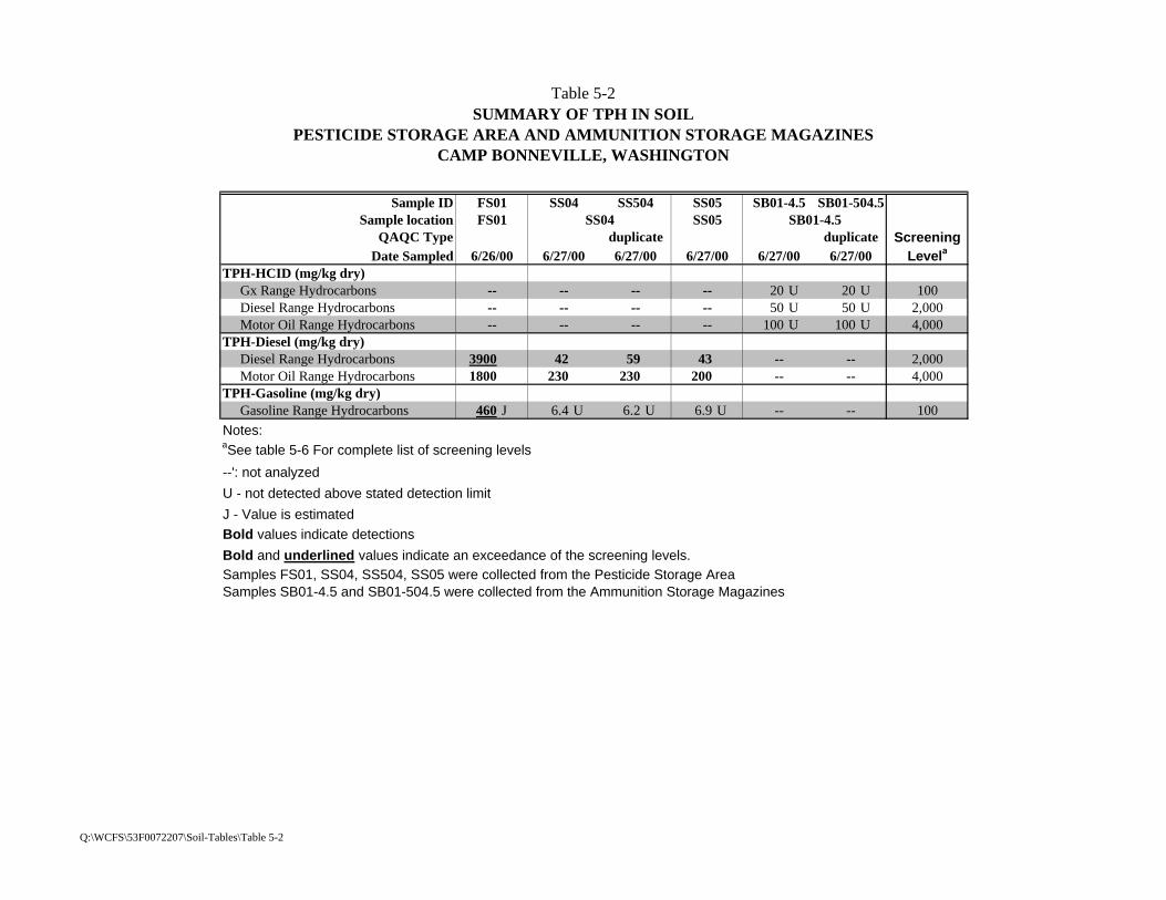
Table 5-2 SUMMARY OF TPH IN SOIL
PESTICIDE STORAGE AREA AND AMMUNITION STORAGE MAGAZINESCAMP BONNEVILLE, WASHINGTON
Sample ID FS01 SS04 SS504 SS05 SB01-4.5 SB01-504.5Sample location FS01 SS04 SS05 SB01-4.5
QAQC Type duplicate duplicate ScreeningDate Sampled 6/26/00 6/27/00 6/27/00 6/27/00 6/27/00 6/27/00 Levela
TPH-HCID (mg/kg dry) Gx Range Hydrocarbons -- -- -- -- 20 U 20 U 100 Diesel Range Hydrocarbons -- -- -- -- 50 U 50 U 2,000 Motor Oil Range Hydrocarbons -- -- -- -- 100 U 100 U 4,000TPH-Diesel (mg/kg dry) Diesel Range Hydrocarbons 3900 42 59 43 -- -- 2,000 Motor Oil Range Hydrocarbons 1800 230 230 200 -- -- 4,000TPH-Gasoline (mg/kg dry) Gasoline Range Hydrocarbons 460 J 6.4 U 6.2 U 6.9 U -- -- 100Notes:aSee table 5-6 For complete list of screening levels
--': not analyzed
U - not detected above stated detection limit
J - Value is estimatedBold values indicate detections
Bold and underlined values indicate an exceedance of the screening levels.Samples FS01, SS04, SS504, SS05 were collected from the Pesticide Storage AreaSamples SB01-4.5 and SB01-504.5 were collected from the Ammunition Storage Magazines
Q:\WCFS\53F0072207\Soil-Tables\Table 5-2

Table 5-3SUMMARY OF METALS AND CONVENTIONALS IN SOIL
PESTICIDE STORAGE AREA AND AMMUNITION STORAGE MAGAZINESCAMP BONNEVILLE, WASHINGTON
PESTICIDE STORAGE AREA AMMUNITION STORAGE MAGAZINESample ID FS01 SS04 SS05 SS01 SS02 SS502 SS03 SB01-4.5 SB01-504.5
Sample location FS01 SS04 SS05 SS01 SS02 SS03 SB01-4.5QAQC Type duplicate duplicate Screening
Date Sampled 6/26/00 6/27/00 6/27/00 6/27/00 6/27/00 6/27/00 6/27/00 6/27/00 6/27/00 Levela
Metals (mg/kg dry) Antimony 5 U 6 U 7 6 U 6 U 8 5 U 20 -- 3 Arsenic 0.11 1.7 1.8 2 3.1 2.9 3 0.6 U -- 6 Barium 7.2 197 250 119 181 174 149 151 -- 257 Beryllium 0.1 U 1 0.9 0.5 0.5 0.5 0.5 0.6 -- 15 Cadmium 1 0.8 0.9 1 5.6 5.5 1.4 0.6 U -- 2 Chromium 0.8 30.2 28.2 28.1 25.1 33.6 20.4 36 -- 100 Copper 1.2 85.8 83.2 77.2 102 89.6 65 123 -- 290 Lead 29 270 970 43 280 210 72 7 -- 250 Mercury 0.46 0.09 0.12 0.05 U 0.05 U 0.05 0.05 U 0.05 U -- 1 Nickel 1 U 15 18 18 16 19 14 21 -- 160 Selenium 0.2 U 0.3 U 0.6 U 0.6 U 0.6 U 0.5 U 0.2 U 0.6 U -- 39 Silver 0.3 U 0.7 0.6 0.9 0.6 0.6 0.6 0.9 U -- 39 Thallium 0.1 U 0.1 U 0.3 U 0.1 U 0.3 U 0.3 U 0.3 U 0.1 U -- 6 Zinc 255 214 330 78.3 141 165 86.5 76 -- 2,300Conventionals (mg/kg dry) Total Organic Carbon -- -- -- -- -- -- -- 0.13 J 0.28 J NA Total Solids -- -- -- -- -- -- -- 73.4 75.8 NANotes:aSee Table 5-8 For complete list of screening levels
mg/kg - milligrams per killogram
--': not analyzed
NA - not applicable
U - not detected above stated detection limit
J - Value is estimated
Bold values indicate detections
Bold and underlined values indicate an exceedance of the screening levels.
Q:\WCFS\53F0072207\Soil-Tables\Table 5-3
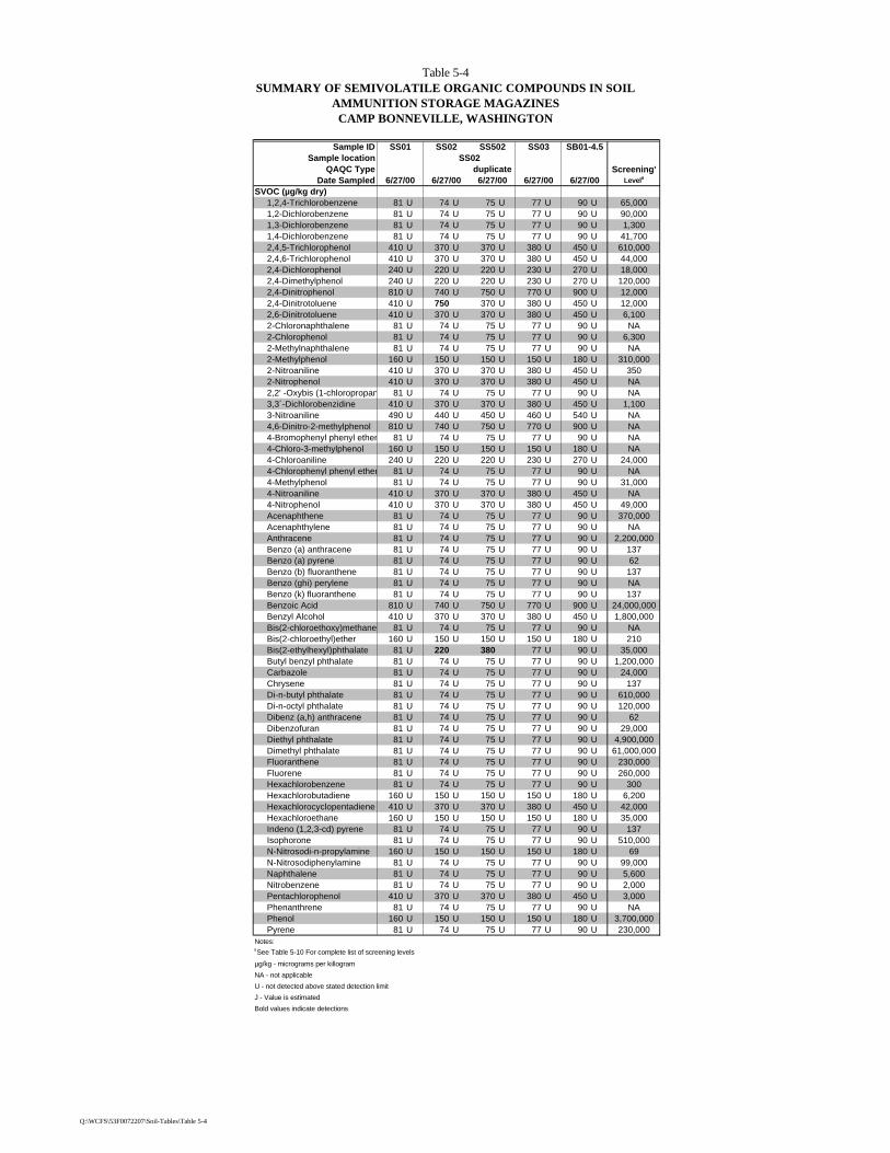
Table 5-4 SUMMARY OF SEMIVOLATILE ORGANIC COMPOUNDS IN SOIL
AMMUNITION STORAGE MAGAZINESCAMP BONNEVILLE, WASHINGTON
Sample ID SS01 SS02 SS502 SS03 SB01-4.5Sample location SS02
QAQC Type duplicate Screening'Date Sampled 6/27/00 6/27/00 6/27/00 6/27/00 6/27/00 Levela
SVOC (µg/kg dry) 1,2,4-Trichlorobenzene 81 U 74 U 75 U 77 U 90 U 65,000 1,2-Dichlorobenzene 81 U 74 U 75 U 77 U 90 U 90,000 1,3-Dichlorobenzene 81 U 74 U 75 U 77 U 90 U 1,300 1,4-Dichlorobenzene 81 U 74 U 75 U 77 U 90 U 41,700 2,4,5-Trichlorophenol 410 U 370 U 370 U 380 U 450 U 610,000 2,4,6-Trichlorophenol 410 U 370 U 370 U 380 U 450 U 44,000 2,4-Dichlorophenol 240 U 220 U 220 U 230 U 270 U 18,000 2,4-Dimethylphenol 240 U 220 U 220 U 230 U 270 U 120,000 2,4-Dinitrophenol 810 U 740 U 750 U 770 U 900 U 12,000 2,4-Dinitrotoluene 410 U 750 370 U 380 U 450 U 12,000 2,6-Dinitrotoluene 410 U 370 U 370 U 380 U 450 U 6,100 2-Chloronaphthalene 81 U 74 U 75 U 77 U 90 U NA 2-Chlorophenol 81 U 74 U 75 U 77 U 90 U 6,300 2-Methylnaphthalene 81 U 74 U 75 U 77 U 90 U NA 2-Methylphenol 160 U 150 U 150 U 150 U 180 U 310,000 2-Nitroaniline 410 U 370 U 370 U 380 U 450 U 350 2-Nitrophenol 410 U 370 U 370 U 380 U 450 U NA 2,2' -Oxybis (1-chloropropane) 81 U 74 U 75 U 77 U 90 U NA 3,3´-Dichlorobenzidine 410 U 370 U 370 U 380 U 450 U 1,100 3-Nitroaniline 490 U 440 U 450 U 460 U 540 U NA 4,6-Dinitro-2-methylphenol 810 U 740 U 750 U 770 U 900 U NA 4-Bromophenyl phenyl ether 81 U 74 U 75 U 77 U 90 U NA 4-Chloro-3-methylphenol 160 U 150 U 150 U 150 U 180 U NA 4-Chloroaniline 240 U 220 U 220 U 230 U 270 U 24,000 4-Chlorophenyl phenyl ether 81 U 74 U 75 U 77 U 90 U NA 4-Methylphenol 81 U 74 U 75 U 77 U 90 U 31,000 4-Nitroaniline 410 U 370 U 370 U 380 U 450 U NA 4-Nitrophenol 410 U 370 U 370 U 380 U 450 U 49,000 Acenaphthene 81 U 74 U 75 U 77 U 90 U 370,000 Acenaphthylene 81 U 74 U 75 U 77 U 90 U NA Anthracene 81 U 74 U 75 U 77 U 90 U 2,200,000 Benzo (a) anthracene 81 U 74 U 75 U 77 U 90 U 137 Benzo (a) pyrene 81 U 74 U 75 U 77 U 90 U 62 Benzo (b) fluoranthene 81 U 74 U 75 U 77 U 90 U 137 Benzo (ghi) perylene 81 U 74 U 75 U 77 U 90 U NA Benzo (k) fluoranthene 81 U 74 U 75 U 77 U 90 U 137 Benzoic Acid 810 U 740 U 750 U 770 U 900 U 24,000,000 Benzyl Alcohol 410 U 370 U 370 U 380 U 450 U 1,800,000 Bis(2-chloroethoxy)methane 81 U 74 U 75 U 77 U 90 U NA Bis(2-chloroethyl)ether 160 U 150 U 150 U 150 U 180 U 210 Bis(2-ethylhexyl)phthalate 81 U 220 380 77 U 90 U 35,000 Butyl benzyl phthalate 81 U 74 U 75 U 77 U 90 U 1,200,000 Carbazole 81 U 74 U 75 U 77 U 90 U 24,000 Chrysene 81 U 74 U 75 U 77 U 90 U 137 Di-n-butyl phthalate 81 U 74 U 75 U 77 U 90 U 610,000 Di-n-octyl phthalate 81 U 74 U 75 U 77 U 90 U 120,000 Dibenz (a,h) anthracene 81 U 74 U 75 U 77 U 90 U 62 Dibenzofuran 81 U 74 U 75 U 77 U 90 U 29,000 Diethyl phthalate 81 U 74 U 75 U 77 U 90 U 4,900,000 Dimethyl phthalate 81 U 74 U 75 U 77 U 90 U 61,000,000 Fluoranthene 81 U 74 U 75 U 77 U 90 U 230,000 Fluorene 81 U 74 U 75 U 77 U 90 U 260,000 Hexachlorobenzene 81 U 74 U 75 U 77 U 90 U 300 Hexachlorobutadiene 160 U 150 U 150 U 150 U 180 U 6,200 Hexachlorocyclopentadiene 410 U 370 U 370 U 380 U 450 U 42,000 Hexachloroethane 160 U 150 U 150 U 150 U 180 U 35,000 Indeno (1,2,3-cd) pyrene 81 U 74 U 75 U 77 U 90 U 137 Isophorone 81 U 74 U 75 U 77 U 90 U 510,000 N-Nitrosodi-n-propylamine 160 U 150 U 150 U 150 U 180 U 69 N-Nitrosodiphenylamine 81 U 74 U 75 U 77 U 90 U 99,000 Naphthalene 81 U 74 U 75 U 77 U 90 U 5,600 Nitrobenzene 81 U 74 U 75 U 77 U 90 U 2,000 Pentachlorophenol 410 U 370 U 370 U 380 U 450 U 3,000 Phenanthrene 81 U 74 U 75 U 77 U 90 U NA Phenol 160 U 150 U 150 U 150 U 180 U 3,700,000 Pyrene 81 U 74 U 75 U 77 U 90 U 230,000Notes:aSee Table 5-10 For complete list of screening levels
µg/kg - micrograms per killogram
NA - not applicable
U - not detected above stated detection limit
J - Value is estimated
Bold values indicate detections
Q:\WCFS\53F0072207\Soil-Tables\Table 5-4

Table 5-5SUMMARY OF ORDNANCE AND EXPLOSIVES
AMMUNITION STORAGE AREACAMP BONNEVILLE, WASHINGTON
Sample ID SS01 SS02 SS502 SS03 SB01-4.5Sample location SS01 SS02 SS03 SB01-4.5
QAQC Type duplicate ScreeningDate Sampled 6/27/00 6/27/00 6/27/00 6/27/00 6/27/00 Levela
Ordnance (µg/kg dry) 1,3,5-Trinitrobenzene 120 U 120 U 114 U 120 U 120 U 4,000 1,3-DNB 120 U 120 U 114 U 120 U 120 U 610 2,4,6-Trinitrotoluene 120 U 120 U 114 U 120 U 120 U 16,000 2,4-Dinitrotoluene 8,420 93 J 54 J 120 U 12,000 2,6-Dinitrotoluene 120 U 120 U 114 U 120 U 120 U 16,200 2-Amino-4,6-Dinitrotoluene 120 U 120 U 114 U 120 U 120 U 16,200 4-Amino-2,6-Dinitrotoluene 120 U 120 U 114 U 120 U 120 U NA HMX 250 U 250 U 238 U 250 U 250 U NA Nitrobenzene 120 U 120 U 114 U 120 U 120 U 2,000 RDX 250 U 250 U 238 U 250 U 250 U 4,400 Tetryl 250 UJ 250 UJ 238 UJ 250 UJ 250 UJ 61,000 m-Nitrotoluene 250 U 250 U 238 U 250 U 250 U 37,000 o-Nitrotoluene 250 U 250 U 238 U 250 U 250 U 37,000 p-Nitrotoluene 120 U 120 U 114 U 120 U 120 U 37,000Propellants (µg/kg dry) Ammonium Perchlorate 48 U 50 U 51 U 51 U 45 U 39 Nitroglycerin 5,780 U 5,510 U 5,450 U 5,520 U 6,010 U 35 Nitroguanidine 125 U 125 U 125 U 123 U 123 U 610,000 PETN 500 U 2,280 476 U 500 U 500 U 208 x 106
Picric Acid 1,000 U 1,100 952 U 1,000 U 1,000 U 624,000Notes:aSee Table 5-9 for complete list of screening levels.
NA - not applicable
U - not detected above stated detection limit
J - Value is estimatedBold values indicate detections
Bold and Underlined values indicateand exceedance of the screening level.
17,200
Q:\WCFS\53F0072207\Soil-Tables\Table 5-5
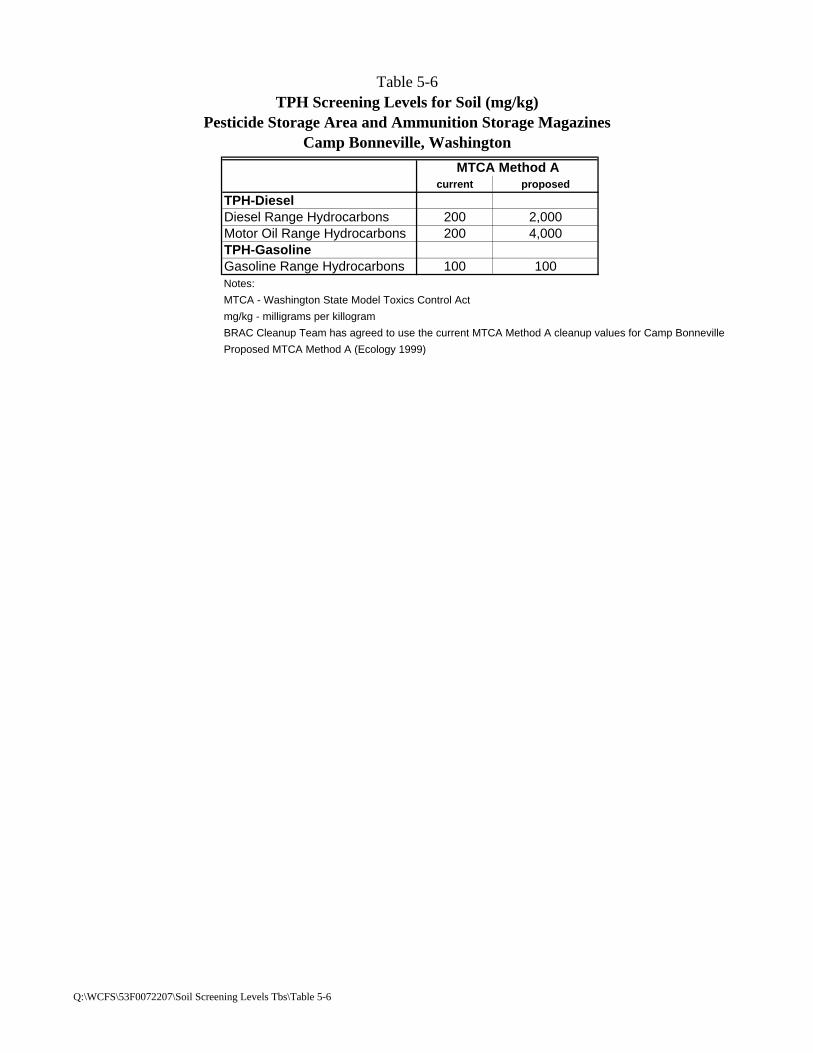
Table 5-6TPH Screening Levels for Soil (mg/kg)
Pesticide Storage Area and Ammunition Storage MagazinesCamp Bonneville, Washington
MTCA Method Acurrent proposed
TPH-DieselDiesel Range Hydrocarbons 200 2,000Motor Oil Range Hydrocarbons 200 4,000TPH-GasolineGasoline Range Hydrocarbons 100 100Notes:
MTCA - Washington State Model Toxics Control Act
mg/kg - milligrams per killogram
BRAC Cleanup Team has agreed to use the current MTCA Method A cleanup values for Camp Bonneville
Proposed MTCA Method A (Ecology 1999)
Q:\WCFS\53F0072207\Soil Screening Levels Tbs\Table 5-6

Table 5-7Pesticides, Herbicides and PCBs Screening Levels for Soil (ug/kg)
Pesticide Storage Area and Ammunition Storage MagazinesCamp Bonneville, Washington
MTCA Method B
EPA Region 9 Residential Soil
EPA Region 10 Risk-Based
Concentration
Selected Screening
Levelc
carninogen non-carcinogen PRG HQ = 0.1 10-6
Pesticides 4,4´-DDD 4,170 NA 2,400 ca NA 2,400 2,4004,4´-DDE 2,940 NA 1,700 ca NA 1,700 1,7004,4´-DDT 2,940 40,000 1,700 ca NA 1,700 1,700Aldrin 59 2,400 29 ca 180 29 29alpha-BHC 159 NA 90 ca NA 90 90beta-BHC 556 NA 320 NA NA 320delta-BHC NA NA NA NA NA NAgamma-BHC (Lindane) 769 24,000 440 ca 2,100 440 440alpha-Chlordanea 769 4,800 1,600 ca 3,500 1,600 769gamma-Chlordanea 769 4,800 1,600 ca 3,500 1,600 769Dieldrin 63 4,000 30 ca 310 30 30Endosulfan Ib NA 480,000 370,000 nc 37,000 NA 37,000Endosulfan IIb NA 480,000 370,000 nc 37,000 NA 37,000Endosulfan sulfate NA NA NA NA NA NAEndrin NA 24,000 18,000 nc 1,800 NA 1,800Endrin Aldehyde NA NA NA NA NA NAEndrin ketone NA NA NA NA NA NAHeptachlor 222 40,000 110 ca 3,100 110 110Heptachlor epoxide 110 1,040 53 ca 79 53 53Methoxychlor NA 40,000 310,000 nc 31,000 NA 31,000Toxaphene NA 909 440 NA 440 440PCBs Aroclor 1016 NA 5,600 3,900 nc 390 6,300 390Aroclor 1221 130 NA 220 ca NA 220 130Aroclor 1232 130 NA 220 ca NA 220 130Aroclor 1242 130 NA 220 ca NA 220 130Aroclor 1248 130 NA 220 ca NA 220 130Aroclor 1254 NA 1,600 220 ca 110 220 220Aroclor 1260 130 NA 220 ca NA 220 130Herbicides 2,4-D NA 800,000 690,000 nc 69,000 NA 69,0002,4-DB NA 640,000 490,000 nc 49,000 NA 49,0002,4,5-TP (Silvex) NA 640,000 NA NA NA 64,0002,4,5-T NA 800,000 610,000 nc 61,000 NA 61,000Dalapon NA 2,400,000 1,800,000 nc 180,000 NA 180,000Dicamba NA 2,400,000 1,800,000 nc 180,000 NA 180,000Dinoseb NA 80,000 6,100 nc 610 NA 610Dichloroprop NA NA NA NA NA NAMCPA NA NA 131,000 nc 31,000 NA 31,000MCPP NA NA 61,000 nc 6,100 NA 6,100Notes:atotal chlordanebendosulfancSelected screening level is the most conservative (i.e. the lowest value) of all screening levels presented.
MTCA - Washington State Model Toxics Control Act
EPA - U.S. Environmental Protection Agency
HQ - hazard quotient
µg/kg - micrograms per killogram
PRG - preliminary remediation goalEPA Region 10 risk-based concentration derived from EPA Region 9 PRG. HQ = 0.1X noncarcinogenic value. 10-6 = carcinogenic value.
ca - carcinogen; nc - noncarcinogen
NA - not applicable
Q:\WCFS\53F0072207\Soil Screening Levels Tbs\Table 5-7

Table 5-8Metals Screening Levels for Soil (mg/kg)
Pesticide Storage Area and Ammunition Storage MagazinesCamp Bonneville, Washington
Metal MTCA Method A MTCA Method B
Clark County Background 90th
Percentilea
Camp Bonneville Backgroundh EPA Region 9
Residential soil
Selected Screening
Levelcarcinogen non-carcinogen PRG HQ=0.1 10-6
Antimony NA NA 32-72b NA 0.12 31 nc 3 NA 3Arsenic 20 2 60 6 NC 0.39 ca 22 0 6i
Barium NA NA 5,600 NA 257 5,400 nc 540 NA 540Beryllium NA 0 400 2 NC 150 nc 15 1,100 15Cadmium 2c NA 80 1 NC 37 nc 4 1,400 2Chromium 100d NA 80,000 27 NC 210 ca NA 210 100Copper NA NA 2,960 34 114 2,900 nc 290 NA 290Lead 250 NA NA 17 NC 400f NA NA 250Mercury 1e NA 24 0 NC 23 nc 2 NA 1Nickel NA NA 1,600 21 NC 1,600 nc 160 NA 160Selenium NA NA 400 NA NC 390 nc 39 NA 39Silver NA NA 400 NA NC 390 nc 39 NA 39Thallium NA NA 6 NA 0.27 6.3-7g NA NA 6Zinc NA NA 24,000 96 NC 23,000 nc 2,300 NA 2,300Notes:
NA = Not Available, NC = Not CalculatedaNatural background soil metals concentrations in Clark County, Washington State, per Ecology Publication #94-115.bVaries with the form of antimonycThe MTCA Method A cleanup level for cadmium is for plant protection.dThe MTCA Method A cleanup level for chromium is for protection from inhalation of suspended dusts.eCleanup level base on protection of groundwaterfRBC for residential soilgVaries with the form of thalliumhBackground values developed by Shannon & Wilson (1999)iIf screening levels are less then the background level, the background level is used (i.e. arsenic)
MTCA - Washington State Model Toxics Control Act
EPA - U.S. Environmental Protection Agency
HQ - hazard quotient
mg/kg - milligrams per killogram
PRG - preliminary remediation goalEPA Region 10 risk-based concentration derived from EPA Region 9 PRG. HQ = 0.1X noncarcinogenic value. 10-6 = carcinogenic value.
ca - carcinogen; nc - noncarcinogen
EPA Region 10 Risk-Based
Concentration
Q:\WCFS\53F0072207\Soil Screening Levels Tbs\Table 5-8

Table 5-9Ordnance Screening Levels for Soil (µg/kg)
Pesticide Storage Area and Ammunition Storage MagazinesCamp Bonneville, Washington
MTCA Method B
EPA Region 9 Residential Soil
EPA Region 10 Risk-Based
Concentration
Selected Screening
Levela
carninogen non-carcinogen PRG HQ = 0.1 10-6
Ordnance1,3,5-Trinitrobenzene NA 4,000 1,800,000 nc 180,000 NA 4,0001,3-DNB NA 8,000 6,100 nc 610 NA 6102,4,6-Trinitrotoluene 33,300 40,000 16,000 ca 16,000 16,0002,4-Dinitrotoluene NA 160,000 120,000 nc 12,000 NA 12,0002,6-Dinitrotoluene NA 80,000 61,000 nc 6,110 NA 6,110Explosives2-Amino-4,6-Dinitrotoluene* NA NA 16,200 ca NA NA 16,2004-Amino-2,6-Dinitrotoluene* NA NA 16,200 ca NA NA 16,2002,4-DNT/2,6-DNT* NA NA 710 ca NA NA 710HMX NA NA NA NA NA NANitrobenzene NA 40,000 20,000 nc 2,000 NA 2,000RDX 9,090 240,000 4,400 ca NA 4,400 4,400Tetryl NA 800,000 610,000 nc 61,000 NA 61,000m-Nitrotoluene NA 800,000 370,000 nc 37,000 NA 37,000o-Nitrotoluene NA 800,000 370,000 nc 37,000 NA 37,000p-Nitrotoluene NA 800,000 370,000 nc 37,000 NA 37,000PropellantsAmmonium Perchlorate NA NA 39b NA NA 39Nitroglycerin NA NA 35,000 nc NA 35 35Nitroguanidine NA 8,000,000 6,100,000 nc 610,000 NA 610,000ExplosivesPETN* NA NA 208 x 106 nc NA NA 208 x 106
Picric Acid* NA NA 624,000 nc NA NA 624,000Notes:aSelected screening level is the most conservative (I.e. the lowest value) of all screening levels presentedbas perchlordane
MTCA = Washington State Model Toxics Control Act
EPA = U.S. Environmental Protection Agency
NCEA = National Center for Environmental Assessment
HQ = hazard quotient
µg/kg = micrograms per killogram
PRG = preliminary remediation goalEPA Region 10 risk-based concentration derived from EPA Region 9 PRG. HQ = 0.1X noncarcinogenic value. 10-6 = carcinogenic value
ca = carcinogen; nc = noncarcinogen
NA = not applicable
RDX = hexahydro-1,3,5-trinitro-1,3,5-triazine
HMX = octahydro-1,3,5,7-tetrnitro-1,3,5,7-tetraocine
PETN = pentaerythritol tetranitrate*Screening levels for these compounds were calculated using EPA Region 9 PRGs and toxicity criteria from the NCEA
Q:\WCFS\53F0072207\Soil Screening Levels Tbs\Table 5-9

Table 5-10Semivolatile Organic Compounds Screening Levels for Soil (µg/kg)
Pesticide Storage Area and Ammunition Storage MagazinesCamp Bonneville, Washington
MTCA Method B
EPA Region 9 Residential Soil
EPA Region 10 Risk-Based
Concentration
Selected Screening
Levela
carninogen non-carcinogen PRG HQ = 0.1 10-6
SVOCs1,2,4-Trichlorobenzene NA 800,000 650,000 nc 65,000 NA 65,0001,2-Dichlorobenzene NA 7,200,000 900,000 nc 90,000 NA 90,0001,3-Dichlorobenzene NA NA 13,000 nc 1,300 NA 1,3001,4-Dichlorobenzene 41,700 NA 480,000 nc 48,000 NA 41,7002,4,5-Trichlorophenol NA 8,000,000 6,100,000 nc 610,000 NA 610,0002,4,6-Trichlorophenol 90,900 NA 44,000 ca NA 44,000 44,0002,4-Dichlorophenol NA 240,000 180,000 nc 18,000 NA 18,0002,4-Dimethylphenol NA 1,600,000 1,200,000 nc 120,000 NA 120,0002,4-Dinitrophenol NA 160,000 120,000 nc 12,000 NA 12,0002,4-Dinitrotoluene NA 160,000 120,000 nc 12,000 NA 12,0002,6-Dinitrotoluene NA 80,000 61,000 nc 6,100 NA 6,1002-Chloronaphthalene NA NA NA NA NA NA2-Chlorophenol NA 400,000 63,000 nc 6,300 NA 6,3002-Methylnaphthalene NA NA NA NA NA NA2-Methylphenol NA NA 3,100,000 nc 310,000 NA 310,0002-Nitroaniline NA NA 3,500 nc 350 NA 3502-Nitrophenol NA NA NA NA NA NA2,2' -Oxybis (1-chloropropane) NA NA NA NA NA NA3,3´-Dichlorobenzidine 2,220 NA 1,100 ca NA 1,100 1,1003-Nitroaniline NA NA NA NA NA NA4,6-Dinitro-2-methylphenol NA NA NA NA NA NA4-Bromophenyl phenyl ether NA NA NA NA NA NA4-Chloro-3-methylphenol NA NA NA NA NA NA4-Chloroaniline NA 320,000 240,000 nc 24,000 NA 24,0004-Chlorophenyl phenyl ether NA NA NA NA NA NA4-Methylphenol NA NA 310,000 nc 31,000 NA 31,0004-Nitroaniline NA NA NA NA NA NA4-Nitrophenol NA NA 490,000 nc 49,000 NA 49,000Acenaphthene NA 4,800,000 3,700,000 nc 370,000 NA 370,000Acenaphthylene NA NA NA NA NA NAAnthracene NA 24,000,000 22,000,000 nc 2,200,000 NA 2,200,000Benzo (a) anthracene 137 NA 620 ca NA 620 137Benzo (a) pyrene 137 NA 62 ca NA 62 62Benzo (b) fluoranthene 137 NA 620 ca NA 620 137Benzo (ghi) perylene NA NA NA NA NA NABenzo (k) fluoranthene 137 NA 6,200 ca NA 6,200 137Benzoic Acid NA 320,000,000 240,000,000 nc 24,000,000 NA 24,000,000Benzyl Alcohol NA 24,000,000 18,000,000 nc 1,800,000 NA 1,800,000Bis(2-chloroethoxy)methane NA NA NA NA NA NABis(2-chloroethyl)ether 909 NA 210 ca NA 210 210Bis(2-ethylhexyl)phthalate 71,400 1,600,000 35,000 ca NA 35,000 35,000Butyl benzyl phthalate NA 16,000,000 12,000,000 nc 1,200,000 NA 1,200,000Carbazole 50,000 NA 24,000ca NA 24,000 24,000Chrysene 137 NA 62,000 ca NA 62,000 137Di-n-butyl phthalate NA 8,000,000 6,100,000 nc 610,000 NA 610,000Di-n-octyl phthalate NA 1,600,000 1,200,000 nc 120,000 NA 120,000Dibenz (a,h) anthracene 137 NA 62 ca NA 62 62Dibenzofuran NA NA 290,000 nc 29,000 NA 29,000Diethyl phthalate NA 64,000,000 49,000,000 nc 4,900,000 NA 4,900,000Dimethyl phthalate NA 80,000,000 610,000,000 nc 61,000,000 NA 61,000,000Fluoranthene NA 3,200,000 2,300,000 nc 230,000 NA 230,000Fluorene NA 3,200,000 2,600,000 nc 260,000 NA 260,000Hexachlorobenzene 625 64,000 300 ca NA 300 300Hexachlorobutadiene 12,800 16,000 6,200 ca NA 6,200 6,200Hexachlorocyclopentadiene NA 560,000 420,000 nc 42,000 NA 42,000Hexachloroethane 71,400 80,000 35,000 ca NA 35,000 35,000Indeno (1,2,3-cd) pyrene 137 NA 620 ca NA 620 137Isophorone 1,050,000 16,000,000 510,000 ca NA 510,000 510,000N-Nitrosodi-n-propylamine 143 NA 69 ca NA 69 69N-Nitrosodiphenylamine 204,000 NA 99,000 ca NA 99,000 99,000Naphthalene NA 3,200,000 56,000 nc 5,600 NA 5,600Nitrobenzene NA 40,000 20,000 nc 2,000 NA 2,000Pentachlorophenol 8,330 2,400,000 3,000 ca NA 3,000 3,000Phenanthrene NA NA NA NA NA NAPhenol NA 48,000,000 37,000,000 nc 3,700,000 NA 3,700,000Pyrene NA 2,400,000 2,300,000 nc 230,000 NA 230,000Notes:aSelected screening level is the most conservative (I.e. the lowest value) of all screening levels presented.
MTCA - Washington State Model Toxics Control Act
EPA - U.S. Environmental Protection Agency
HQ - Hazard Quotient
µg/kg - micrograms per kilogram
PRG - preliminary remediation goal
EPA Region 10 risk-based concentration derived from Epa Region 9 PRG. HQ = 0.1 X noncarcinogenic value.
ca - carcinogen; nc - noncarcinogen
Q:\WCFS\53F0072207\Soil Screening Levels Tbs\Table 5-10

SECTIONSIX Discussion of Conceptural Site Model
S:\GAYTER\CBONNEVILLE\BONNEVILLE AMMO RPT (3).DOC\14-DEC-00\\ 6-1
6. Section 6 SIX Discussion of Conceptural Site Model
A conceptual site model (CSM) is a schematic representation of potential pathways by whichreceptors (humans or other ecological endpoint species) may be exposed to chemicals at orreleased from a source. The purposes of the CSM for the investigation at the Pesticide StorageArea and Ammunition Storage Magazine were to provide a framework for problem definition, toidentify exposure pathways that may result in adverse effects to human health or other ecologicalreceptors, and to aid in identifying effective cleanup measures targeted at significant contaminantsources and exposure pathways, if necessary.
An exposure pathway describes a specific environmental pathway by which chemicals may betransported to human or other ecological receptors. A complete exposure pathway requires eachof the following six elements:
• Source of chemicals
• Mechanism of chemical release
• Environmental transport medium
• Exposure point
• Intake route
• Human or other ecological endpoints
If one of these elements is absent, the pathway is incomplete and exposure cannot occur.Incomplete pathways, as well as negligible pathways that would not contribute to overall riskestimates, are not expected to result in adverse effects to human health or the environment.
6.1 Potential Release and Transport Mechanisms
The likely sources of COPCs at the Pesticide Storage Area is the storage of pesticides andherbicides in Building Number 4126, as well as application to the surrounding soil and potentialspills. Materials such as 2,4,5-T; 2,4-D; and DDT were stored there until approximately 1977after which they were moved to Building 1864. The source of COPCs at the AmmunitionStorage Magazines is the ammunition historically stored inside the magazines. In addition,smokeless powder and/or black powder residue was reportedly present outside the magazine atBuilding Number 2953 (Shannon & Wilson 1999).
The principal chemical release mechanisms for COPCs from undisturbed soil to the environmentinclude:
• Historic releases of contaminants to surface soil
• Leaching to subsurface soils
Mobile contaminants leaching from the surface may enter and contaminate subsurface soil.Exposure pathways would most likely be related to direct contact with contaminated surface andsubsurface soil. The groundwater pathway is considered negligible or incomplete because of theabsence of contaminants found in the subsurface soils, their relatively low mobility, and theabsence of groundwater (at the Ammunition Storage Magazines). As a result of the negligible orincomplete groundwater pathway, the contamination of surface water from groundwater seeps isalso considered negligible or incomplete. The distance to Lacamas Creek from the centers of the

Discussion of Conceptural Site Model SECTIONSIX
6-2 S:\GAYTER\CBONNEVILLE\BONNEVILLE AMMO RPT (3).DOC\14-DEC-00\\
Pesticide Storage Area and Ammunition Storage Magazines is estimated to be approximately750 feet to the south and 100 feet to the south, respectively.
6.2 POTENTIAL HUMAN RECEPTORSAs discussed in Section 5, the floor sample from the Pesticide Storage Area containedconcentrations of diesel-range and gasoline-range petroleum hydrocarbons greater than thescreening criteria. Other COPCs detected above their respective screening criteria at thePesticide Storage Area include lead, 4,4-DDT, 4,4-DDD, and 4,4-DDE from surface soilsamples. In addition, the floor sample from the Pesticide Storage Area also containedconcentrations of 2,4,5-T above the screening criteria.
The only COPCs detected at concentrations exceeding the screening criteria at the AmmunitionStorage Magazines included cadmium in two surface soil sample locations, lead in one surfacesoil sample location, and 2,4-dinitrotoluene in one surface soil sample location. The subsurfacesample collected from soil boring SB01 did not contain COPCs above their respective screeningcriteria.
Potential human exposure pathways are presented on Figure 6-1. Based on stormwater runofffrom soil containing COPCs above the screening criteria into Lacamas Creek, potentiallycomplete ingestion and dermal exposure pathway receptors include current on-site workers,future on-site recreational users, and future on-site workers. Incomplete exposure pathways forhuman receptors include current off-site recreational site users, current off-site residents andworkers, due their unlikely contact with stormwater runoff into Lacamas Creek. Trespasserexposure is considered negligible due to the limited amount of time (and therefore exposure) thatthey may be on-site.
Potentially complete inhalation exposure pathway to COPCs is considered to be restricted tocurrent on-site workers, future on-site recreational users, and future on-site workers. Exposure tocurrent and future off-site residents, workers, recreational users, and trespassers is considered tobe negligible due to their unlikely exposure to air containing COPCs. Similarly, direct contactthough ingestion or dermal contact with soil containing COPCs is likely limited to current on-siteworkers, future on-site recreational users, and future on-site workers.
6.3 POTENTIAL ECOLOGICAL RECEPTORS Camp Bonneville is a heavily wooded area and the dominant tree species are Douglas fir,western red cedar, western hemlock, and red alder. Depending primarily on moisture gradients,the understory is composed of salal, Oregon grape, vine maple, and sword fern (Larson 1980).Several species of small mammals and birds reside on the site including rock doves, cottontailrabbits, ground squirrels, mice, and shrews. There are also several Special Status Species presentat or near Camp Bonneville (USACE 1999). Species confirmed at or near Camp Bonnevilleinclude:
Plants
• Hairy-stemmed checker-mallow: state-endangered species
• Small-flowered trillium: state-sensitive species

SECTIONSIX Discussion of Conceptural Site Model
S:\GAYTER\CBONNEVILLE\BONNEVILLE AMMO RPT (3).DOC\14-DEC-00\\ 6-3
Amphibians
• Northern red-legged frog: federal species of concern
Birds
• Vaux’s swift: state candidate species
• Pileated woodpecker: state candidate species
Mammals
• Brush Prairie (Northern) pocket gopher: state candidate species
Fish
• Coastal Cutthroat Trout: federal species of concern
Potential ecological receptors on-site include terrestrial animals, benthic invertebrates, fish, andwaterfowl that may be exposed to COPCs in undisturbed surface soil or surface water(Figure 6-2). Terrestrial and aquatic plants could also be exposed to COPCs in surface soil orsurface water. A hypothetical future excavation scenario in which subsurface soil is exposed andbrought to the surface was also included in the exposure pathway model to account for possiblefuture use of the site. In this scenario, terrestrial animals, plants, and possibly waterfowl areassumed to have direct exposure to subsurface soil on-site, and terrestrial animals and waterfowlare assumed to have inhalation exposure to airborne particulates from subsurface soil.
Potential exposure of ecological receptors to groundwater is considered negligible or incompletebecause of the concentration of contaminants found in the subsurface soils, their relatively lowmobility, and the absence of groundwater encountered during drilling activities to a depth of 23feet bgs (at the Ammunition Storage Magazines). As a result of the negligible or incompletegroundwater pathway, the contamination of surface water from groundwater seeps is alsoconsidered negligible or incomplete.


SECTIONSEVEN Conclusions and Recommendations
S:\GAYTER\CBONNEVILLE\BONNEVILLE AMMO RPT (3).DOC\14-DEC-00\\ 7-1
7. Section 7 SEVEN Conclusions and Recommendations
The primary objectives of this investigation included the following:
• Evaluation of COPCs in surface soil and in flooring material of Building 4126 at thePesticide Storage Area
• Evaluation of COPCs in surface and subsurface soil and groundwater at the AmmunitionStorage Magazine
• Evaluation of potential exposure to human and ecological receptors based on a conceptualsite model
The following two sections present summaries of the conclusions and recommendations for eachinvestigation area followed by more detailed discussions regarding the rationale for therecommendations.
7.1 PESTICIDE STORAGE AREA
Conclusions
The following conclusions are based on data gathered during the SSI at the Pesticide StorageArea:
• COPCs are present in the flooring material in Building 4126 and in surface soil adjacent tothe building.
• Based on the CSM, there are potentially complete exposure pathways for current and futureon-site human and ecological receptors.
Recommendations
Based on these conclusions URS recommends the following remedial actions are recommendedfor the Pesticide Storage Area:
• Conduct a TCLP analysis for Building 4126 construction materials.
• Demolish Building 4126. Dispose of demolition debris based on TCLP analysis.
• Excavate and dispose of surface soil to approximately 1 foot bgs beneath the footprint of thebuilding and to a distance of approximately 4 feet outside the footprint of the building.
• Collect and analyze confirmation soil samples.
• Based on results of confirmation soil sample analysis, continue excavation or backfillexcavation with clean soil.
• Conduct UXO avoidance activities prior to remedial work.
7.1.1 Rationale for Recommendations
Analytical results suggest that pesticides and petroleum hydrocarbons are localized in andimmediately adjacent to Building 4126. COPC concentrations were highest inside the building,moderate in soil in front of the building door, and lowest along the south side of the building.

Conclusions and Recommendations SECTIONSEVEN
7-2 S:\GAYTER\CBONNEVILLE\BONNEVILLE AMMO RPT (3).DOC\14-DEC-00\\
This suggests that COPCs are concentrated in the areas where they may have been mixed ortransported out of the building.
The chlorinated herbicides 2,4,5-T, 2,4-D, and 2,4-DB were detected in the flooring materialsample. Of these three, only 2,4,5-T was detected in soil. In the flooring material sample the2,4,5-T concentration exceeded the EPA Region 10 Risk-based screening level. In the soilsamples 2,4,5-T concentrations were significantly lower than inside the building and were belowregulatory screening criteria.
The organochlorine pesticide DDT was detected at concentrations greater than the MTCAMethod B cleanup level in the flooring material sample and in both soil samples. Theconcentrations detected inside the building and in soil next to the building door were higher thanthe concentration detected in the soil sample next to the south side of the building. The doorwaysoil sample (SS04) also contained DDD and DDE at concentrations exceeding MTCA Method Bcriteria, while the south wall soil sample contained only DDE at a concentration lower than thecleanup level. These data support the hypothesis that COPCs are concentrated in a small areaaround the building.
Gasoline and diesel-range hydrocarbons were detected inside the building at concentrationsexceeding proposed MTCA Method A cleanup levels. In the soil samples, only diesel and motoroil were detected. The diesel concentrations detected in soil were below regulatory criteria. Themotor oil concentrations in soil were below the proposed MTCA A cleanup level of 2,000mg/kg.
Metals concentrations were generally higher in soil samples than in the flooring material sample.None of the metals in the flooring material sample exceeded the regulatory criteria. In soil, onlylead exceeded the MTCA Method A screening level of 250 mg/kg. Unlike the pesticides, thelead concentration in the sample collected next to the south wall of the building was much higherthan the concentration detected next to the doorway. These data suggest that lead detected in thesoil may be unrelated to former pesticide storage activities in this area.
COPCs at the Pesticide Storage Area, including petroleum hydrocarbons, organochlorinepesticides, and the herbicide 2,4,5-T, are likely due to limited historic releases immediatelyaround Building 4126. Exposure pathways would most likely be related to direct contact withcontaminated surface soil. Potential human receptors include on-site workers. Similarly,ecological receptors are likely limited to on-site species that contact surface soil in the PesticideStorage Area.
7.2 AMMUNITION STORAGE MAGAZINE
Conclusions
The following conclusions are based on data gathered during the SSI and on data gathered byShannon & Wilson (1999) during the multi-sites investigation at the Ammunition StorageMagazine:
• Soil and residues inside the storage magazines contain explosives compounds and metals(Shannon & Wilson, 1999).

SECTIONSEVEN Conclusions and Recommendations
S:\GAYTER\CBONNEVILLE\BONNEVILLE AMMO RPT (3).DOC\14-DEC-00\\ 7-3
• Surface soils up to 2 feet bgs, contain metals at concentrations exceeding regulatoryscreening criteria (Shannon & Wilson, 1999).
• Concentrations of metals decrease significantly with increasing depth (Shannon & Wilson,1999).
• Surface soil along the footpath leading to the largest magazine contains 2,4-dinitrotoluene atconcentrations exceeding the cleanup level.
Recommendations
The following recommendations for the Ammunition Storage Magazines are based on the aboveconclusions and on the data presented in the CSM:
• Remove and dispose soil and residues that are present inside the storage magazines.
• Clean the interiors of the storage magazines and collect and dispose all cleaning solutions.
• Excavate and dispose soil (0-inches to 1-foot bgs) along the short foot path leading to thedoor of building 2953 (the magazine investigated during the SSI). This includes anapproximately 4-foot-wide area along the approximately 6 foot-long path. In addition,excavate and dispose soil (0 inches to 1-foot bgs) in areas at Buildings 2950 and 2951 wheremetals concentrations exceeded screening values (Shannon & Wilson 1999).
• Conduct additional UXO avoidance activities prior to remedial activity.
• Collect confirmation soil samples at the excavated areas.
• Analyze confirmation samples for metals, explosives, and propellants.
7.2.1 Rationale for Recommendations
COPCs exceeding regulatory criteria in samples collected at Building 2953 (as part of this SSI)included 2,4-dinitrotoluene, cadmium, and lead. Based on the apparent distribution of thedetected COPCs, it appears that surface soil in a small area in front of the Building 2953 doorcontains COPCs at concentrations greater than cleanup levels. Based on the soil types observedin the soil boring and on the analytical results for the subsurface sample, is not likely that 2,4-dinitrotoluene, lead, or cadmium have migrated beyond the footpath or to a depth greater than afew inches bgs.
Based on data gathered by Shannon & Wilson in 1999, metals are also present above cleanuplevels in soil at the two smaller magazines (Building 2950 and 2951). The highestconcentrations are present in the surface soil with significant reduction in concentrations withdepth. The metals most commonly found in concentrations exceeding screening criteria werearsenic, beryllium, cadmium, chromium, copper, and nickels which exceeded background valuesand/or regulatory or risk-based criteria. However, only arsenic and beryllium exceeded humanhealth, risk-based screening criteria.
Potential exposure rates includes dermal contact with contaminated soil and surface water.Potential human receptors current and future on-site workers and future on-site recreationalusers. Potential ecological receptors include terrestrial animals, benthic invertebrates, fish, andwaterfowl that may be exposed to COPCs in undisturbed surface soil or surface water.

SECTIONEIGHT References
S:\GAYTER\CBONNEVILLE\BONNEVILLE AMMO RPT (3).DOC\14-DEC-00\\ 8-1
8. Section 8 EIGHT References
Department of Defense. 1993. BRAC Cleanup Plan (BCP) Handbook.
Environmental Science and Engineering, Inc. 1983. Installation Assessment of the HQ, I Corpsand Ft. Lewis, Washington and the Subinstallations Yakima Firing Center, Camp Bonneville,and Vancouver Barracks.
Geo Recon International. 1981. Cultural Resources Survey, Forest Management Project, Ft.Lewis and Camp Bonneville, Washington, for U.S. Army, Ft. Lewis.
Hart Crowser. 1996. Petroleum Contaminated Soil Investigation, Former Tank No. 7-CMBPN,Building No. 4475, Camp Bonneville Washington. Contract No. DACA67-93-D-1004.September 1996.
———. 1998. Draft Project Evaluation Report Surface Water Investigation of Lacamas Creekand Tributaries Camp Bonneville Vancouver, Washington. Contract No. DACA67-98-D-1008.December 1998.
Larson, Lynn L. 1980. Cultural Resource Reconnaissance of Forest Management Tracts onFort Lewis and Camp Bonneville. Office of Public Archaeology, Institute for EnvironmentalStudies, University of Washington, Reconnaissance Report No. 34.
Mundorff, M.J. 1964. Geology and groundwater conditions of Clark County, Washington, witha description of major alluvial aquifer supply along the Columbia River: U.S. Geological SurveyWater Supply Paper 1600, 268 p.
Phillips, W.M.. 1987. Geologic map of the Vancouver quadrangle, Washington and Oregon:Washington Division of Geology and Earth Resources Open File Report 87-10, scale 1:100,000.
Shannon & Wilson. 1999. Final Report Volume 1 Multi-Sites Investigations, Camp Bonneville,Washington. Contract No. DACA 67-94-D-1014. July 1999.
U.S. Army Corps of Engineers (USACE). 1987. Environmental Assessment, Modifications toTraining Facilities, Camp Bonneville, Clark County, Washington.
_________. 1999. Draft Environmental Assessment for Disposal and Reuse of CampBonneville, Washington. Prepared for U.S. Army Forces Command. September 1999.
URS Greiner Woodward Clyde. 2000. Management Plan for Ammunition Storage Magazinesand Pesticide Storage Area, Site Investigation, Camp Bonneville, Washington. June 2000.
Washington State Department of Ecology. 1994. Natural Background Soil MetalsConcentrations in Washington State. Publication No. 94-115. October.
_________. 1997. Interim Interpretive and Policy Statement – Cleanup of Total PetroleumHydrocarbons. Publication No. ECY 97-600. January.
________. 1999. Proposed Amendments Model Toxics Control Act, Cleanup Regulation.WAC 173-340. Publication No. ECT 99-060. November.
Woodward-Clyde Federal Services. 1996. Final Environmental Baseline Survey, CampBonneville Washington. March 1997.

Appendix A
Soil Boring Log


Appendix B
Laboratory Data Sheets [Forms 1s]


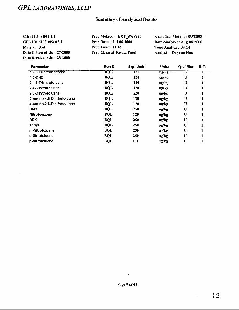


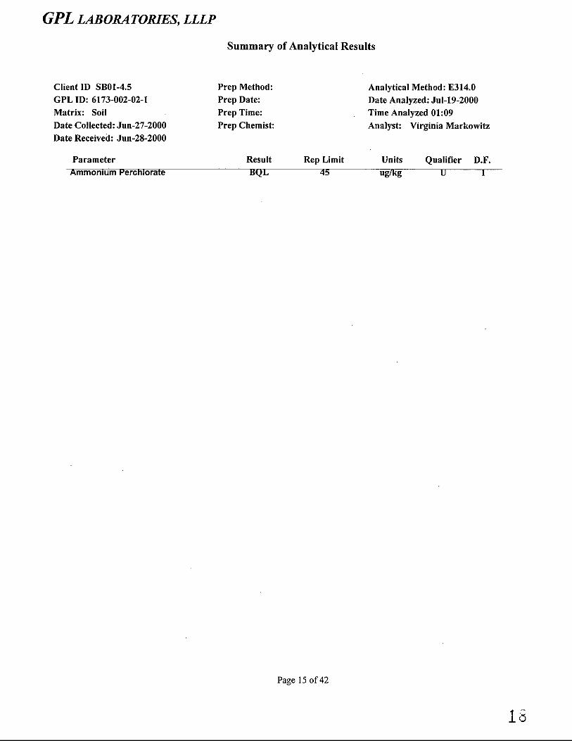


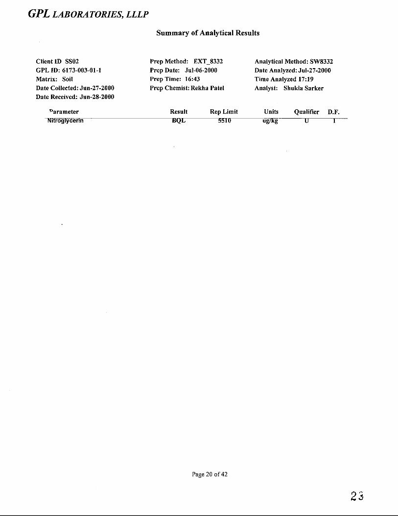


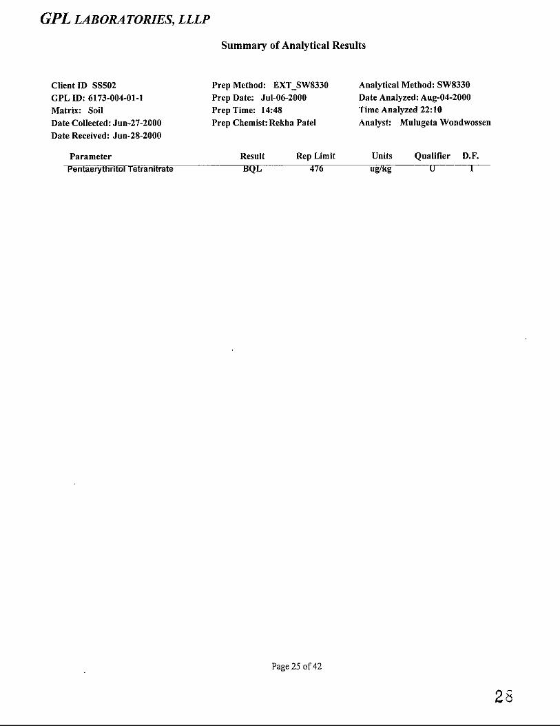


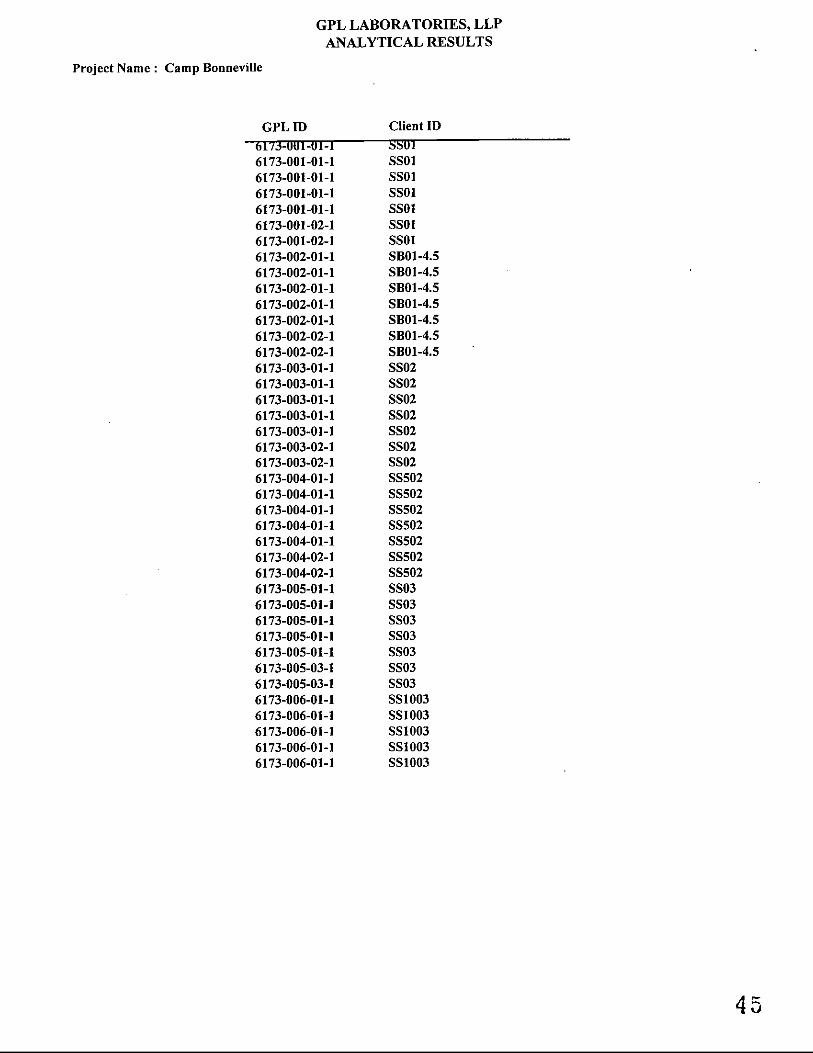


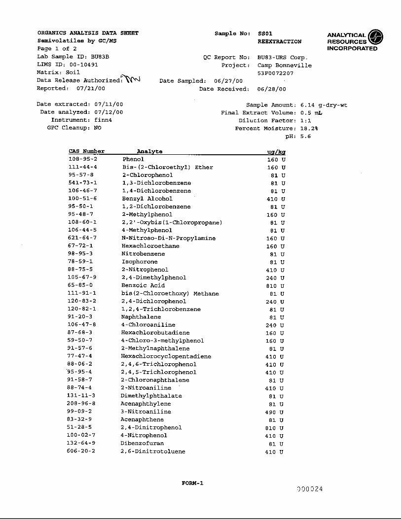
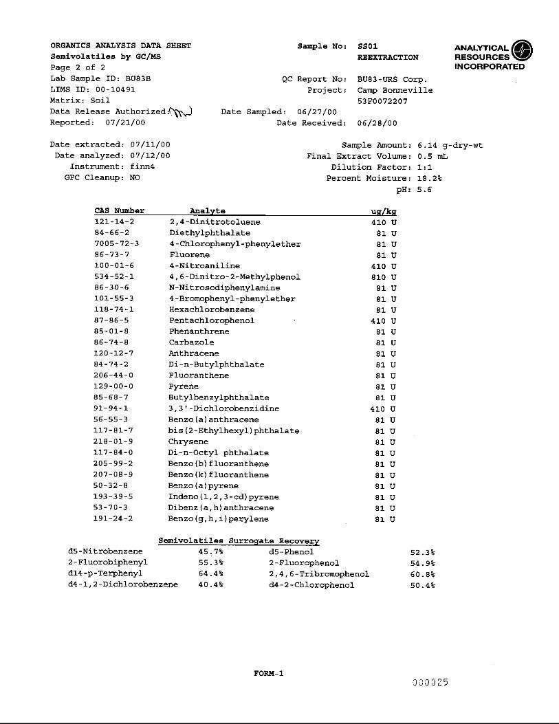


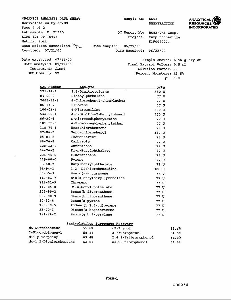


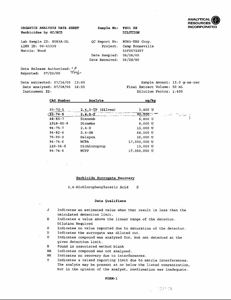

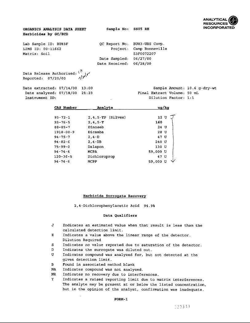


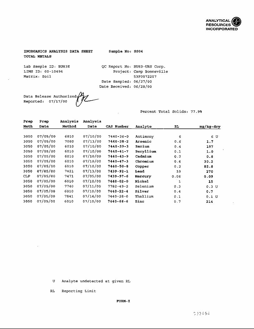
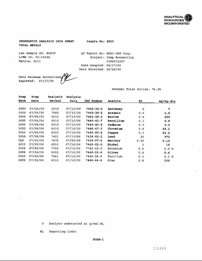


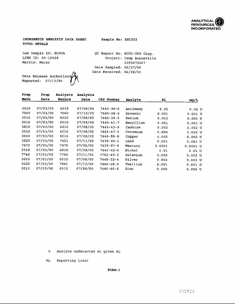

Appendix C
Laboratory Quality Review Report

Appendix CLaboratory Quality Review Report
S:\GAYTER\CBONNEVILLE\BONNEVILLE AMMO RPT (3).DOC\14-DEC-00\\ C-1
The analytical results for six primary soil samples, one primary wood sample, and threeduplicates collected at Camp Bonneville in June 2000, were subject to a quality assurance/qualitycontrol (QA/QC) review. This QA/QC review includes evaluation of analytical precision,accuracy, representativeness, comparability, and completeness. Precision is evaluated bycomparison of results for primary and sample duplicate analyses and laboratory duplicateanalyses; accuracy is evaluated using the analytical results for blanks, surrogates, matrix spikesand blank spikes; representativeness is evaluated by examining chain of custody paperwork andverifying analysis was performed within allowable holding times; comparability is evaluated byexamining laboratory reporting limits; and completeness is evaluated by calculating thepercentage of acceptable data. Raw data were not reviewed and results were not recalculated.
Samples were collected by URS and analyzed by Analytical Resources, Inc. of Seattle,Washington and GPL Laboratories of Gaithersburg, Maryland. Samples were collected andanalyzed according to the Management Plan prepared by URS. Where applicable, this datareview follows the criteria established in the United States Environmental Protection Agency(EPA) Functional Guidelines for Organic Data Review (February 1994), the EPA FunctionalGuidelines for Inorganic Data Review (February 1994), and the United Stated Army Corps ofEngineers (USACE) Shell (Shell) guidelines (November 1998). Samples were analyzed for oneor more of the following analytical methods: ordnance, picric acid, nitroguanidine, PETN, andnitroglycerine by EPA Method 8330; ammonium perchlorate by EPA method 314.0; semi-volatile organic compounds (SVOCs) by EPA Method SW-846 8270; chlorinated herbicides byEPA Method 8151; chlorinated pesticides by EPA Method 8081; polychlorinated biphenyls(PCBs) by EPA Method 8082; petroleum hydrocarbons by NWTPH-Dx, NWTPH-Gx, andNWTPH-HCID; metals by EPA Method 6000/7000; total organic carbon by Walkley Black; andgrain size analysis by ASTM 063.
All analytical data are acceptable for use. Three samples and one field duplicate were qualifiedas estimated (J) due to missed holding times. No data were qualified due to non-compliantsurrogate percent recoveries. Some samples were qualified as estimated (J) due to non-compliant LCS percent recoveries. Two samples had analytes rejected due to non-compliantLCS recoveries. Two samples were qualified as estimated (J) due to non-compliant fieldduplicate precision. The reporting limits met the project goals.
REPRESENTATIVENESS
Chain of Custody and Holding Times
The chain of custody (COC) forms indicate that samples were maintained under chain of custodyand forms were signed upon release and receipt.
All soil samples were analyzed within the holding times with the following exceptions:
• Samples FS01, SS04, SS05, and SS504 were re-extracted and re-analyzed for chlorinatedherbicides 3 days past the holding time due to non-compliant quality control samples in thefirst extract and analysis. The samples were qualified as estimated (J) due to missed holdingtimes.

Appendix CLaboratory Quality Review Report
C-2 S:\GAYTER\CBONNEVILLE\BONNEVILLE AMMO RPT (3).DOC\14-DEC-00\\
ACCURACY
Review of Blanks
The laboratory analyzed at least one method blank for each analysis batch. One rinse blank,sample ID SS1003, was collected and analyzed for each method (except TPH-HCID and grainsize). Frequency requirements for method and rinse blanks were met. Target analytes in methodand equipment rinse blanks were below detection, with the exception listed in the table below.Associated samples did not have detections of bis (2-ethylhexyl) phthalate; therefore, no datawere qualified.
SAMPLE ID METHOD BATCH ANALYTE RESULT(µG/L)
Rinse BlankSS1003
8270 BU90 bis (2-ethylhexyl)phthalate 2.9
Surrogate Recovery Review
The laboratories spike all samples (except for metals, TOC, and grain size analyses) withappropriate surrogates (system monitoring compounds). Surrogate compounds are compoundsnot expected to be found in environmental samples; however, they are chemically similar toseveral compounds analyzed in the method and behave similarly in extracting solvents.Surrogates are used to evaluate sample preparation and analysis. Surrogate recoveries are withinShell or laboratory-established control limits (whichever were applicable), with the followingexceptions:
• One of four SVOC neutral/base (N/B) surrogate percent recoveries was below the controllimits for sample SS01. Associated quality control data were within the control limits;therefore, no data were qualified.
• Two of two pesticide surrogate percent recoveries were not calculated for the third dilution ofsamples SS04 and SS504. The laboratory conducted a fluorisil/sulfur cleanup on the samplesprior to dilution. The surrogates were not recovered due to the high dilution of the samples;therefore, no data were qualified.
• One of two PCB surrogate percent recoveries was above the control limits for sample SS504.Associated quality control data were within the control limits; therefore, no data werequalified.
• The diesel surrogate percent recovery was above the control limit for sample SS05.Associated quality control data were within the control limits; therefore, no data werequalified.
• One of two gasoline surrogate percent recoveries was above the control limit for LCSduplicate BU90LCD. The associated LCS percent recovery was within the control limits;therefore, no data were qualified.
• The HCID surrogate percent recoveries were below the control limits for sample SB01-504.5and for matrix spike duplicate SB01-504.5MSD. Associated quality control data were withinthe control limits; therefore, no data were qualified.

Appendix CLaboratory Quality Review Report
S:\GAYTER\CBONNEVILLE\BONNEVILLE AMMO RPT (3).DOC\14-DEC-00\\ C-3
• The herbicide surrogate percent recovery was not recovered for sample FS01RE. Thesurrogate was not recovered due to the necessary high dilution of the sample. Associatedquality control data were within the control limits; therefore, no data were qualified.
• The nitroglycerine surrogate percent recovery was above the Shell control limits for sampleSS01 due to matrix interference. Associated quality control data were within the controllimits; therefore, no data were qualified.
Matrix Spike/Matrix Spike Duplicate Review
Matrix spike/matrix spike duplicate (MS/MSD) data presented and reviewed for these sampledelivery groups are within laboratory control limits with the exceptions listed below. Data arequalified based on non-compliant MS/MSD percent recoveries only when the associatedlaboratory control sample is also non-compliant. Insufficient sample was submitted forMS/MSD analysis on the water matrix; therefore, either and LCS/LCSD was substituted or theMS/MSD analyses were reported from other GPL samples batched with Camp Bonnevillesamples.
• SVOC MSD SS02: the n-nitrosodiphenylamine percent recovery was below the Shell controllimit at 44.1%. The associated MS percent recovery was within the control limits; therefore,no data were qualified. The MS/MSD relative percent difference (RPD) was above the Shellcontrol limits for 2,4-dinititrotoluene at 70%. No data were qualified.
• Pesticide MS FS01: the delta-BHC percent recovery was below the Shell control limit at4.7%. The associated LCS percent recoveries were also below the control limits; therefore,associated data were qualified as estimated (J). The 4,4-DDD and 4,4-DDT percentrecoveries were above the Shell control limit as 147% and 144%. Associated quality controldata were within the control limits; therefore, no data were qualified.
• Pesticide MS/MSD SS04: the percent recoveries were below the Shell control limits for 17 of20 spiked compounds due to matrix interference. The associated compounds were within thecontrol limits in the LCS, with the exception of delta-BHC and endrin aldehyde; therefore,delta-BHC and endrin aldehyde were qualified as rejected (R) for associated samples.
• PCB MS/MSD SS04: the percent recoveries were below the Shell control limits for two oftwo spiked compounds due to matrix interference. The associated LCS was within thecontrol limits; therefore, no data were qualified.
• Diesel MS FS01: the matrix spike was not recovered. The spiked sample diesel was at least5 times greater than the spike added; therefore, no data were qualified.
• Metals MS SS02: the percent recoveries were below the Shell control limits for antimony,arsenic, copper, and selenium. The associated LCS was within the control limits; therefore,no data were qualified.
• Explosives MS/MSD SS01: the 2,4-dinitrotoluene was not recovered in the MS/MSD due tothe high level of the compound in the spiked sample. The associated LCS was within thecontrol limits; therefore, no data were qualified. The MSD tetryl percent recovery was belowthe Shell control limit and the MS/MSD RPD for tetryl was above the Shell control limit.The associated MS was within the Shell control limits; therefore, no data were qualified.
Appendix CLaboratory Quality Review Report
C-4 S:\GAYTER\CBONNEVILLE\BONNEVILLE AMMO RPT (3).DOC\14-DEC-00\\
• Picric acid MS/MSD SS03: the picric acid MS/MSD percent recovery was below thelaboratory control limits. The associated LCS was within the control limits; therefore, nodata were qualified.
Two matrix spike samples were analyzed for each analysis. The frequency requirement of fivepercent was met for each matrix included with the project samples
Laboratory Control Sample Review
Laboratory control sample (LCS) data presented and reviewed for these sample delivery groupsare within laboratory control limits with the following exceptions.
• Pesticide LCS BU83SB: the percent recoveries for delta-BHC and endrin aldehyde werebelow the Shell control limits in the LCS. Associated samples were qualified as rejected (R).
• Gasoline LCS BU83SB: the LCS percent recovery was below the laboratory control limits at70.4%. According to the laboratory the control limit is advisory since there was insufficientdata to calculate a valid control limit. The percent recovery was only slightly below theadvisory limit; therefore, the sample may be biased low. Considering the high detection ofgasoline in the sample affected (FS01), the sample was qualified as estimated (J).
• Explosives LCS NLCSA: the tetryl LCS percent recovery was below the Shell control limits;however, it was within the laboratory control limits that were reported in the Work Plan.Associated data were qualified as estimated (J).
At least one laboratory control sample was analyzed per batch, meeting the project frequencyrequirements.
PRECISION
Field Duplicate Review
Three field duplicates were collected during the sampling event covered by this review. Thefield duplicate sample ID’s are SS02/SS502, SS04/SS504, and SB01-4.5/SB01-504.5. The RPDis calculated for this review only when sample results are greater than 5 times the reporting limit.Control limits for field duplicate precision are 50 percent RPD for solid samples. The fieldduplicate results show good agreement for all sample pairs except for 4,4’-DDT in SS04/SS504and TOC in SB01-4.5/SB01-504.5. The samples and the associated duplicate were qualified asestimated for the analytes with RPDs greater than 50 percent.
SAMPLE ID &DUPLICATE ID ANALYTE
PRIMARYRESULT
(µg/L)
DUPLICATERESULT
(µg/L)
RELATIVEPERCENT
DIFFERENCESS02/SS502 arsenic 3.1 2.9 7
barium 181 174 4beryllium 0.5 0.5 0cadmium 5.6 5.5 2chromium 25.1 33.6 30
copper 102 89.6 13lead 280 210 29
nickel 16 19 17zinc 141 165 16
Appendix CLaboratory Quality Review Report
S:\GAYTER\CBONNEVILLE\BONNEVILLE AMMO RPT (3).DOC\14-DEC-00\\ C-5
SAMPLE ID &DUPLICATE ID ANALYTE
PRIMARYRESULT
(µg/L)
DUPLICATERESULT
(µg/L)
RELATIVEPERCENT
DIFFERENCESS04/SS504 endrin aldehyde 7 9.5 30
4,4’-DDE 230 190 194,4’-DDD 76 48 454,4’-DDT 2700 1400 632,4,5-T 170 230 30diesel 42 59 34
SB01-4.5/SB01-504.5 TOC 0.13 0.28 73
The frequency of field duplicate collection meets the project duplicate frequency requirement ofat least 10 percent of the field samples for every analytical method.
COMPARABILITY
Reporting Limits
The requested reporting limits (RLs) and the actual reporting limits for compounds of concernare shown below. Compounds detected below the reporting limit but above the method detectionlimit are considered estimates by the laboratory, and are qualified with a “J”. Some samplesrequired dilutions due to matrix interference, which resulted in elevated reporting limits. Thelaboratory conducted the appropriate cleanup procedures during the pesticide and PCB analysesto keep the reporting limits low. The reporting limits for toxaphene, MCPP, and MCPA are afactor of 100 (or more) higher than the other compounds in the method due to the intrinsicdifficulty of analyzing these compounds. Even though the laboratory performed the necessaryclean-ups on the samples, the matrices of the Camp Bonneville samples caused the laboratory toincrease the reporting limits for all pesticides and herbicides resulting in even more elevatedreporting limits for toxaphene, MCPP, and MCPA. No data were qualified based on reportinglimits.
MATRIX ANALYTEREQUESTEDREPORTING
LIMIT(µg/Kg)
REPORTINGLIMIT
(µg/Kg)soil/wood metals 5 0.1 to 6 mg/Kgsoil/wood herbicides 10000 10 to 59000soil/wood pesticides 170 2 to 4000soil/wood PCBs 330 40 to 800soil/wood diesel 5 mg/Kg results > RLsoil/wood gasoline 200 mg/Kg 6.2 to 6.9 mg/Kgsoil/wood SVOCs 67 74 to 900 mg/Kgsoil/wood ordnance 500 120 to 250soil/wood ammonium
perchlorate50 45 to 59.5
soil/wood nitroglycerin 10 5450 to 6010soil/wood nitroguanidine 125 120soil/wood PETN 2000 480 to 500soil/wood picric acid NA 952 to 1000
Appendix CLaboratory Quality Review Report
C-6 S:\GAYTER\CBONNEVILLE\BONNEVILLE AMMO RPT (3).DOC\14-DEC-00\\
COMPLETENESSThe laboratory reported all requested analyses and the laboratory report is complete. The projectcompleteness goal is 98 percent. No data were judged to be invalid; therefore, completeness forthese sampling events is 100 percent.
Based on the QA/QC review, data can be qualified as estimated (J) or rejected (R). Thefollowing table summarizes the qualified results:
SAMPLE IDSAMPLE
TYPE LAB ID ANALYTE QUALIFIERFS01 wood BU83A delta-BHC
all herbicidesgasoline
40 UJJ or UJ460 J
SS01 soil BU83B tetryl 250 UJSS02 soil BU83C tetryl 250 UJSS03 soil BU83D tetryl 250 UJSS04 soil BU83E delta-BHC
endrin aldehydeall herbicides
4,4’-DDT
2 R7 R
J or UJ2700 J
SS05 soil BU83F delta-BHCendrin aldehyde
all herbicides
2.4 R4.7 R
J or UJSS504 duplicate of
SS04BU83G delta-BHC
endrin aldehydeall herbicides
4,4’-DDT
2.1 R9.5 R
J or UJ1400 J
SS502 duplicate ofSS02
BU83H tetryl 238 UJ
SB01-4.5 soil BU83I tetrylTOC
250 UJ0.13 J
SB01-504.5 duplicate ofSB01-4.5
BU83J TOC 0.28 J
SS1003 rinse blank BU90A noneTrip Blank trip blank BU90B none

Appendix D
Chain of Custody Forms and Field Notebook


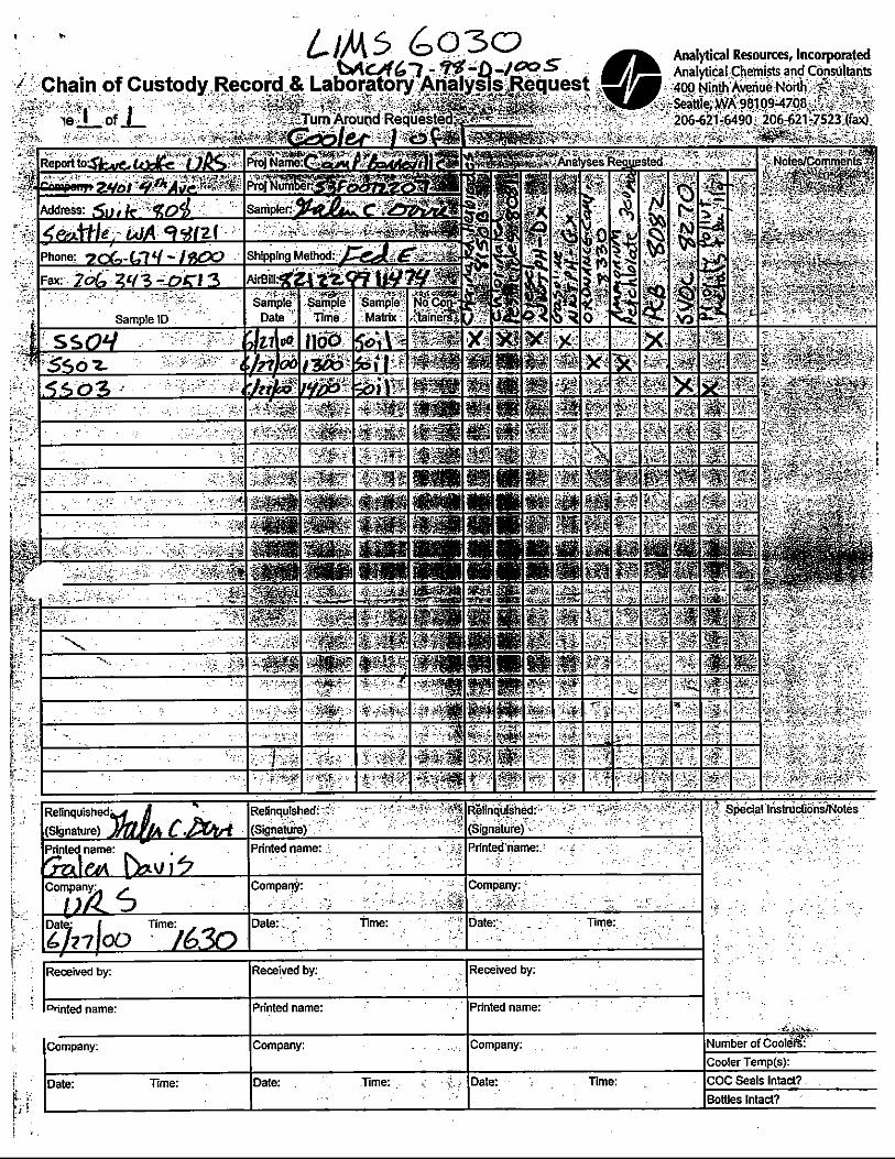

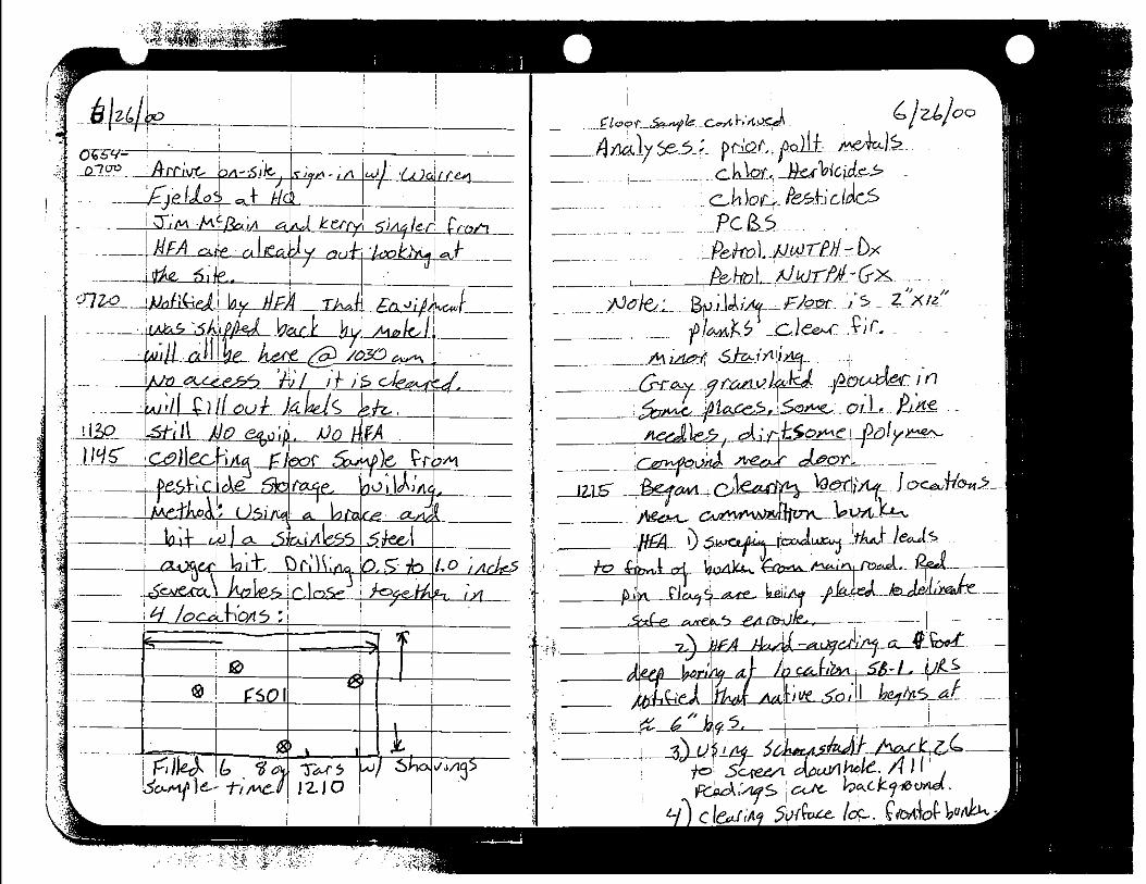

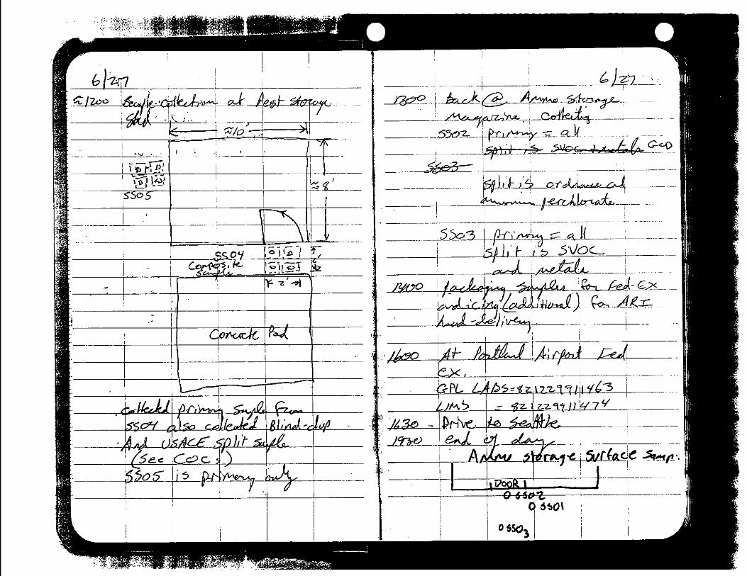
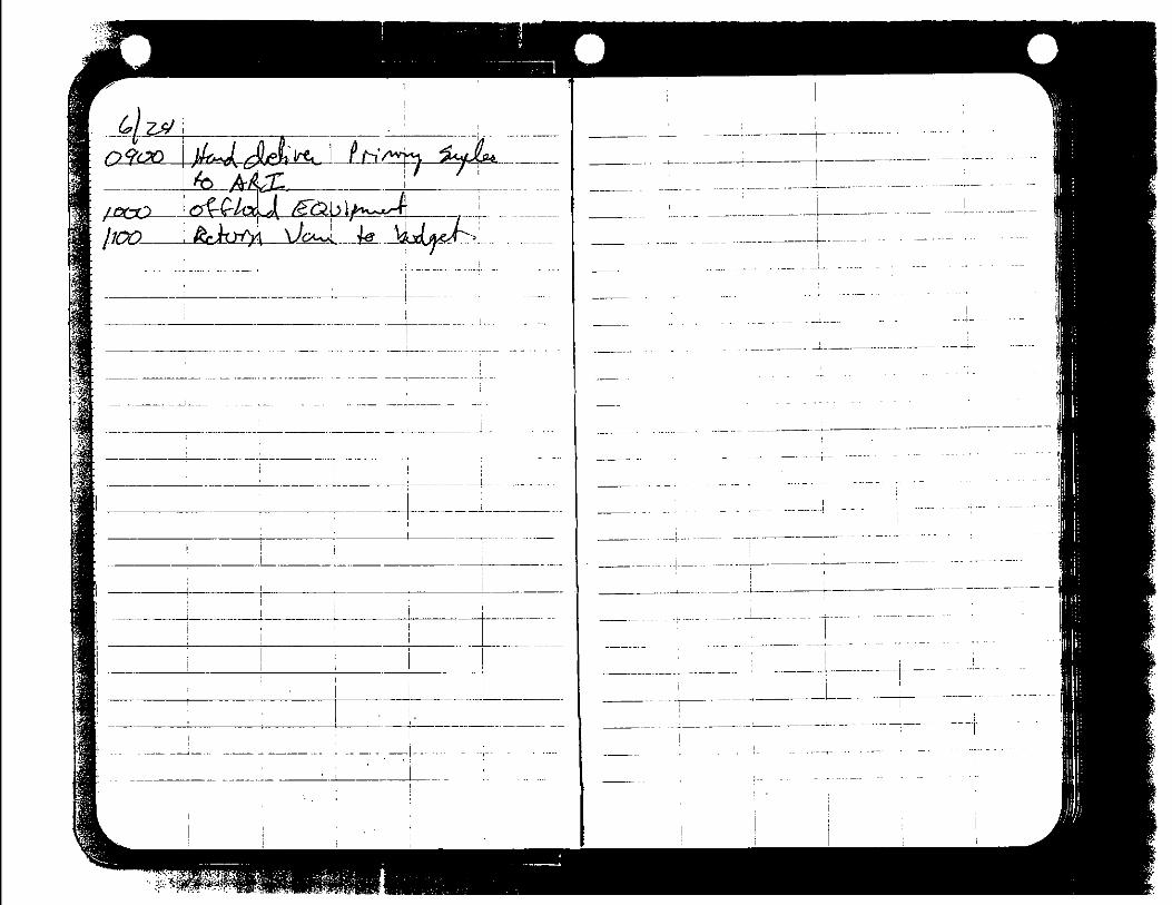

Appendix E
Response to Comments on Draft Supplemental SiteInvestigation Report

S:\gayter\CBonneville\Bonneville Ammo Rpt (3).doc
December 14, 200053-F0072207
Mr. Rodney TaieU.S. Army Corps of Engineers, Seattle DistrictCENWS-PM-HW4735 E. Marginal Way SouthSeattle, WA 98134-2385
Re: Draft Supplemental Site Investigation ReportAmmunition Storage Magazines and Pesticide Storage AreaCamp Bonneville, WashingtonResponse to CommentsContract No. DACA67-98-D-1005 (D.O. No. 0035)
Dear Mr. Taie:
This letter presents URS’ response to comments on our “Draft Supplemental SiteInvestigation Report, Ammunition Storage Magazines and Pesticide Storage Area, CampBonneville, Washington,” dated September 2000. Comments were received from the U.S.Army Corps of Engineers (USACE) on November 16, 2000. Responses are included belowfor each comment.
USACE COMMENTS
Rodney Taie
1. Section One, Introduction, Page 1-1, 4th Paragraph, 3rd sentence. Delete extra period atthe end of the sentence.
URS Response:
The extra period will be removed from the end of the sentence.
2. Section Three, Site Background. Site History, page 3-2, Paragraph 3, 2nd sentence.Change sentence to read, “The USACE under direction of the US Army ForcesCommand (FORSCOM), is currently pursing a lease extension with the DNR.”
URS Response:
The sentence will be revised as suggested.
3. Site History, page 3-2, Paragraph 4, 1st sentence. Change “is” to was.
URS Response:
The sentence will be revised as suggested.
4. Site History, page 3-2, Paragraph 4, 3rd sentence. The reviewer takes exception to thesentence that “Camp Bonneville is currently used for weekday training of company unitsfrom Fort Lewis and weekend used by Oregon and Washington Reserve Units.” CampBonneville is no longer an active base. Delete entire sentence from the paragraph.

Mr. Rodney TaieUSACE Seattle DistrictDecember 14, 2000Page 2
S:\gayter\CBonneville\Bonneville Ammo Rpt (3).doc
URS Response:
The indicated sentence will be deleted from the paragraph.
5. Site History, page 3-2, Paragraph 4, 4th sentence. Change the work “includes” toincluded.
URS Response:
The sentence will be revised as indicated.
6. Section Four, Field Investigation Methods. UXO Avoidance, Paragraph 2. Please clarifywhat brand of handheld magnetometer was used.
URS Response:
A Schonstedt Model GA-72CV magnetometer was used for UXO avoidance on the groundsurface and a Mk26 Mod 0 Ordnance Locator (Forster Ferex 4.021) magnetometer was usedfor down-hole UXO avoidance. These instruments will be added to the text for clarification.
7. Section Six, Discussion of Conceptual Site Model. Figure 6-1. Change text inside boxfrom Ammunition Storage Magazines and DA-2 and DA-2 to Ammunition StorageMagazines and Pesticide Storage Area.
URS Response:
The text box will be corrected.
8. Figure 6-2 – same comment as comment number 6.
URS Response:
The text box will be corrected.
Sandy Lemlich
1. Page 4-3, Section 4.1.5, 1st Bullet. Please change the method to 8151.
URS Response:
The text will be corrected as indicated.
2. Page 4-5, 1st Full Paragraph, 2nd Line. Please clarify whether or not the “lead auger”is referring to a metal (Pb) auger or not. If it is referring to an auger composed of lead,how does this affect the metals data.
URS Response:
The auger referred to is the first auger inserted into the borehole. It is not composed of lead.The text will be revised to read “leading” auger to eliminate potential confusion.
3. Table 4-2. Please add PETN and picric acid to this table.
URS Response:
The table will be corrected as indicated.

Mr. Rodney TaieUSACE Seattle DistrictDecember 14, 2000Page 3
S:\gayter\CBonneville\Bonneville Ammo Rpt (3).doc
4. Page 5-2, 1st Paragraph, Last Line. MCPP should be moved to the herbicides sectionand all parts of the document referring to MCPP should be modified.
URS Response:
The text will be corrected as indicated.
5. Table 5-1. Please explain in the text why reporting limits for toxaphene and PCB’s wereelevated in the wood sample and MCPA and MCPP were elevated in both the wood andfloor samples. Did the laboratory conduct appropriate cleanup procedures beforediluting samples?
URS Response:
Appropriate cleanup procedures were performed before diluting the pesticide samples.Herbicide samples were not cleaned up. The text will be revised with an explanation as towhy the reporting limits were high for toxaphene, MCPP, and MCPA.
6. Table 5-2. The title is misleading since the boring samples are from the ammunitionstorage bunker.
URS Response:
The title of the table will be reworded to read “Summary of TPH in Soil, Pesticide StorageArea and Ammunition Storage Magazines.” In addition, clarification notes will be added atthe bottom of the table to indicate which samples were collected from each area.
7. Table 5-2. Please change the screening level to 2,000 mg/kg for diesel and 4000 mg/kgfor motor oil range. This is based on an agreement with Christopher Maurer ofWashington Department of Ecology that we could used the proposed values. Based onthis change, text concerning exceedances of screening values may have to be modified.
URS Response:
The text will be corrected as indicated.
8. Table 5-3. The screening value for antimony is incorrect. The background value of 0.12mg/kg should not be used as the screening value. Please change the value to 3 mg/kg.
URS Response:
The table and text will be corrected as indicated.
9. Table 5-3. The screening value for lead is incorrect. The Region 9 PRG of 130 mg/kg isthe California modification which is not appropriate for Camp Bonneville. The correctRegion 9 PRG is 400 mg/kg for residential soils. The correct screening value for thisproject is the MTCA method A value of 250 mg/kg.
URS Response:
The table and text will be corrected as indicated.
Mr. Rodney TaieUSACE Seattle DistrictDecember 14, 2000Page 4
S:\gayter\CBonneville\Bonneville Ammo Rpt (3).doc
10. Table 5-3. The screening value for cadmium is incorrect since MTCA A values areappropriate only for petroleum and lead. The appropriate value is 2 mg/kg. Please checkall other screening values and make sure that they are appropriate.
URS Response:
The screening value listed for cadmium in Table 5-3 is 2 mg/kg.
11. Page 6-2, Section 6.3. Please add the Federally proposed species – coastal cutthroattrout. It is supposed to be listed sometime this month.
URS Response:
The text will be corrected as indicated.
12. Figures 6-1 and 6-2. Change DA-2 and DA-3 to pesticide storage building.
URS Response:
The Figures will be corrected as indicated.
13. Page C-2, Bullet 2. Please discuss whether the samples were cleaned up prior to dilutionas required in the shell.
URS Response:
The laboratory conducted a fluorisil/sulfur cleanup on the samples prior to dilution. Thesurrogate recoveries in question were for the third dilution of the samples from which only4,4’-DDT was reported. The surrogate recoveries did not have a bias on the samples due tothe high dilution in addition to the high concentration of 4,4’-DDT in the sample.
14. Page C-3, 1st Bullet. Same as comment 13.
URS Response:
The laboratory did not conduct a GPC cleanup on this sample; however, the sample was notdiluted.
15. Page C-4, Laboratory Control Sample Review, Bullets 1-3. Usually if LCS percentrecoveries are low, all non-detects are rejected. Please review the data and determine ifany of it should be rejected.
URS Response:
The data were reviewed. Some data were rejected; however, the other data remain estimatedand the text has been revised to indicated more clearly why the data were not rejected.
16. Page C-5, Reporting Limits. Please discuss procedures taken by the lab to reducereporting limits.
URS Response:
The text will be revised as indicated.

Mr. Rodney TaieUSACE Seattle DistrictDecember 14, 2000Page 5
S:\gayter\CBonneville\Bonneville Ammo Rpt (3).doc
DEPARTMENT OF ECOLOGY COMMENTS
Christopher Maurer
1. Page 6-2, Section 6.3: The source cited for the presence of California quail, chukhars,and rock doves a the site is in error. Suggest that URS consult the final version of thesource rather than the draft version.
URS Response:
The references to California quail, chukars, and western meadowlarks will be deleted.According the Draft Environmental Assessment referred to in the text, rock doves are presentat Camp Bonneville. Because the final version of the Environmental Assessment has not yetbeen completed, the most current information is available in the draft version.
2. Appendix C, page C-3, sixth bullet (MS SS02): The bullet should state whether any datawere qualified as a result of the percent recoveries being too low.
URS Response:
The bullet will be revised to state that the data were not qualified.
3. Eric – in your e-mail of 13 September, you stated that you had had the contaminated soilat these two sites excavated. What action did you take regarding the contaminationfound inside both the Ammunition Storage Magazine and the Pesticide Mixing Area(Building 4126)?
URS Response:
Discussions with the USACE have indicated that excavation of contaminated soil andcleanup of the interior of the Ammunition Storage Magazines and Pesticide Storage Area(Building 4126) has not yet been conducted. The remediation activities are tentativelyplanned for January 2001.
ENVIRONMENTAL PROTECTION AGENCY (REGION 10) COMMENTS
Harry Craig
1. Table 5-9, Ordnance Screening Levels for Soils
a) Based on EPA’s National Center for Environmental Assessment (NCEA) toxicologyreview, the following toxicity values should be used for generating risk basedscreening levels:

Mr. Rodney TaieUSACE Seattle DistrictDecember 14, 2000Page 6
S:\gayter\CBonneville\Bonneville Ammo Rpt (3).doc
ChemicalCancer Slope Factor
1/(mg/kg/day) Cancer WOENon-Cancer RfD
(mg/kg/day) Source2-Am-4,6-DNT 3E-02 C 5E-04 3/12/98 NCEA e-mail, IRIS*4-Am-2,6-DNT 3E-02 C 5E-04 3/12/98 NCEA e-mail, IRIS*PETN --- --- 1 3/12/98 NCEA e-mailPicric Acid --- --- 3E-03 6/15/92 NCEA2,4-DNT/2,6-DNT 6.8E-01 B2 --- IRISNote:Technical grade DNT is a mixture of the 2,4-DNT (67%) and 2,6-DNT (19%) isomers, carcinogenic risk for the individualisomers should be based on the mixture.*= based on the toxicity of 2,4,6-trinitotoluene (TNT)
URS Response:
The values listed in the table above will be used for generating the appropriate screeningvalues and the text will be modified as necessary. A mixture of 2,4-DNT and 2,6-DNT wasnot reported by the analytical laboratory.
b) PETN and picric acid are explosives rather that propellant compounds.
URS Response:
The text will be corrected in accordance with the comment.
2. Appendix B – Please provide EPA for review a copy of the PETN and picric acid HPLCmethod(s) and QA criteria used by GPL Labs, these are likely modifications to thestandard EPA Method 8330.
URS Response:
A copy of modified EPA Method 8330 will be provided to EPA under separate cover by theanalytical laboratory (GPL Labs). However, modified EPA Method 8330 will not becomepart of the Administrative Record for Camp Bonneville.
Please call me if you have any questions concerning this letter.
Sincerely,
URS
Steven P. Wolfe, R.GProject Manager