sumner county project
TRANSCRIPT

NASHVILLE AREA MPO FY 2014-2017 TIP - ADOPTED DECEMBER 11, 2013
SUMNER

NASHVILLE AREA METROPOLITAN PLANNING ORGANIZATION
Transportation Improvement Program for FYs 2014-2017
Project Description Widen Rockland Rd from 2 lanes to 3 lanes along the existing alignment from W. Main St to Imperial Blvd.This project will include drainage, curb and gutter, a multi-use path and landscaping.
West Main St. to Imperial Blvd.Location
Route Rockland Road
$12,624,690.00Air Quality Status 043162.00TDOT PINNon-Exempt Project Cost
Sumner County 1.50 1052-177Regional Plan IDLengthCounty
TIP # 2002-028
HendersonvilleLead AgencyRoad WideningImprovement Type
Rockland Road WideningProject Name
Local fundsState FundsFederal FundsTotal FundsFunding TypeType of WorkFiscal Year
$40,000.00$0.00$160,000.00$200,000.00U-STPPE-D2015
$500,000.00$0.00$2,000,000.00$2,500,000.00U-STPROW, UTILITIES2016
$750,000.00$0.00$3,000,000.00$3,750,000.00U-RSVCONSTRUCTION2017
REVISION HISTORY
PROJECT NOTES
12/17/12 - Schedule: Oct 2014 - New/amended contract withTDOT.Nov 2014 - Receive Notice To Proceed from TDOT forPE.Dec 2014-Sept 2015 - PE NEPA and Design.Oct 2015 -Notice To Proceed from TDOT for ROW and Utilities.Nov 2015-Sept 2016 - Acquire ROW; adjust utilities.Oct 2016-Sept 2017- Construction and closeout.The project will be managed bythe City’s Public Works Department and EngineeringConsultant. All contracts (engineering, ROW acquisition andconstruction) will include schedules with milestones and dates.One of the main criteria in choosing the engineering consultantwill be performance and proven knowledge of TDOTrequirements and track record in working with TDOT
Printed on
Nashville Area Metropolitan Planning Organization
Wednesday, December 11, 2013
Transportation Improvement Program for FYs 2014-2017
127/191Page
NASHVILLE AREA METROPOLITAN PLANNING ORGANIZATION
Transportation Improvement Program for FYs 2014-2017
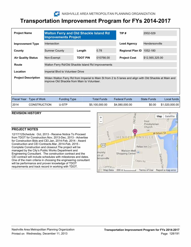
Project Description Widen Walton Ferry Rd from Imperial to Main St from 2 to 5 lanes and align with Old Shackle at Main andimprove Old Shackle from Main to Volunteer.
Imperial Blvd to Volunteer DriveLocation
Route Walton Ferry Rd/Old Shackle Island Rd Improvements
$12,565,325.00Air Quality Status 010766.00TDOT PINNon-Exempt Project Cost
Sumner County 0.78 1052-180Regional Plan IDLengthCounty
TIP # 2002-029
HendersonvilleLead AgencyIntersectionImprovement Type
Walton Ferry and Old Shackle Island RdImprovements Project
Project Name
Local fundsState FundsFederal FundsTotal FundsFunding TypeType of WorkFiscal Year
$1,020,000.00$0.00$4,080,000.00$5,100,000.00U-STPCONSTRUCTION2014
REVISION HISTORY
PROJECT NOTES
12/17/12Schedule: Oct, 2013 - Receive Notice To Proceedfrom TDOT for Construction.Nov, 2013-Dec, 2013 - Advertisefor Construction Bids and CEI.Jan, 2014-Feb, 2014 - AwardConstruction and CEI Contracts.Mar, 2014-Feb, 2015 -Complete Construction and closeout.The project will bemanaged by the City’s Public Works Department andEngineering Consultant. The construction contract and theCEI contract will include schedules with milestones and dates.One of the main criteria in choosing the engineering consultantwill be performance and proven knowledge of TDOTrequirements and track record in working with TDOT.
Printed on
Nashville Area Metropolitan Planning Organization
Wednesday, December 11, 2013
Transportation Improvement Program for FYs 2014-2017
128/191Page

NASHVILLE AREA METROPOLITAN PLANNING ORGANIZATION
Transportation Improvement Program for FYs 2014-2017
Project Description Widen New Shackle Island Road from SR-386 to Iris Drive from 3 lanes to 5. Bike/ped facilities included.
New Shackle Island Road from SR-386 to Iris DrivLocation
Route New Shackle Island Road (SR-258)
$4,964,644.00Air Quality Status 108885.01TDOT PINNon-Exempt Project Cost
Sumner County 0.80 1052-176Regional Plan IDLengthCounty
TIP # 2006-014
HendersonvilleLead AgencyRoad WideningImprovement Type
New Shackle Island Road (SR-258) - Phase1
Project Name
Local fundsState FundsFederal FundsTotal FundsFunding TypeType of WorkFiscal Year
$35,000.00$0.00$140,000.00$175,000.00U-STPROW, UTILITIES2014
$648,900.00$0.00$2,595,600.00$3,244,500.00U-STPCONSTRUCTION2014
REVISION HISTORY
PROJECT NOTES
Printed on
Nashville Area Metropolitan Planning Organization
Wednesday, December 11, 2013
Transportation Improvement Program for FYs 2014-2017
129/191Page

1/4/13 - Major Tasks: Major tasks include the completion ofPE/construction documents, acquisition of ROW and theconstruction of the project. *** Project Schedule• NEPA ‐Completed. • Preliminary Engineering – Almost complete. •ROW Phase – Begin in 2013, estimated 18‐24 to complete •Begin Construction – begin upon completion of ROWacquisition. • Complete Construction in 2 years. *** ProjectManagement: The project will follow TDOT constructionprocedures and will include ConstructionEngineeringInspections (CEI) as part of project contract. TDOT isresponsible for the management of the ROW acquisition andconstruction phases. The City of Gallatin will continue to workclosely with TDOT throughout the remainder of the project tohelp ensure that it will be completed efficiently and in a timelymanner.The City of Gallatin has an excellent track record ofworking closely with TDOT and successfully completingprojects on time and within budget. Examples of Gallatin’srecent successful project management efforts include theDowntown Streetscape Project and the four (4) American,Recovery and Reinvestment Act Projects ‐ TownCreekGreenway – Phase 1, Downtown Streetscape – Phase 2, BigStation Camp Boulevard, S Water Avenue Resurfacing.
NASHVILLE AREA METROPOLITAN PLANNING ORGANIZATION
Transportation Improvement Program for FYs 2014-2017
Project Description Widen existing roadway to five lanes with curb and gutter between Blythe Avenue and North WaterAvenue. Construct new (2-lane, divided median with turn lanes or 3-lane cross section) roadwayconnection between Blythe Avenue and SR-109. Acquire right of way for a 5-lane minor arterial (includingsidewalks) along the entire route between US-31E and SR-109. Acquire right of way at the intersection ofSR-109 and Hatten Track Road to allow for a future interchange at this location.
From SR-174/N. Water Avenue intersection to new interchange onto SR-109.Location
Route East-West Corridor (Albert Gallatin Avenue (SR-174) / Hatten Track Road Extension)
$29,315,000.00Air Quality Status 111041.00TDOT PINNon-Exempt Project Cost
Sumner County 0.80 1052-120Regional Plan IDLengthCounty
TIP # 2008-51-032
GallatinLead AgencyNew RoadImprovement Type
East-West Corridor (Albert Gallatin Avenue(SR-174) / Hatten Track Road Extension)
Project Name
Local fundsState FundsFederal FundsTotal FundsFunding TypeType of WorkFiscal Year
$48,000.00$0.00$192,000.00$240,000.00U-STPPE-D2014
$700,000.00$0.00$2,800,000.00$3,500,000.00U-STPROW2014
$2,325,000.00$0.00$9,300,000.00$11,625,000.00U-RSVCONSTRUCTION2015
$465,000.00$0.00$1,860,000.00$2,325,000.00U-STPPE-D2015
$2,325,000.00$0.00$9,300,000.00$11,625,000.00U-RSVCONSTRUCTION2016
REVISION HISTORY
PROJECT NOTES
Printed on
Nashville Area Metropolitan Planning Organization
Wednesday, December 11, 2013
Transportation Improvement Program for FYs 2014-2017
130/191Page

1/4/13 - Major Tasks: Major tasks include the completion ofPE/construction documents, acquisition of ROW and theconstruction of the project. *** Project Schedule• NEPA ‐Completed. • Preliminary Engineering – Almost complete. •ROW Phase – Begin in 2013, estimated 18‐24 to complete •Begin Construction – begin upon completion of ROWacquisition. • Complete Construction in 2 years. *** ProjectManagement: The project will follow TDOT constructionprocedures and will include ConstructionEngineeringInspections (CEI) as part of project contract. TDOT isresponsible for the management of the ROW acquisition andconstruction phases. The City of Gallatin will continue to workclosely with TDOT throughout the remainder of the project tohelp ensure that it will be completed efficiently and in a timelymanner.The City of Gallatin has an excellent track record ofworking closely with TDOT and successfully completingprojects on time and within budget. Examples of Gallatin’srecent successful project management efforts include theDowntown Streetscape Project and the four (4) American,Recovery and Reinvestment Act Projects ‐ TownCreekGreenway – Phase 1, Downtown Streetscape – Phase 2, BigStation Camp Boulevard, S Water Avenue Resurfacing.
Printed on
Nashville Area Metropolitan Planning Organization
Wednesday, December 11, 2013
Transportation Improvement Program for FYs 2014-2017
131/191Page

NASHVILLE AREA METROPOLITAN PLANNING ORGANIZATION
Transportation Improvement Program for FYs 2014-2017
Project Description Improve/upgrade existing signalization infrastructure and construct a right turn lane on SR-25.
SR-6/SR-25 and SR-6/Locust StreetLocation
Route Various intersection improvements
$467,000.00Air Quality Status 110421.00TDOT PINExempt Project Cost
Sumner County 0.00 1054-275Regional Plan IDLengthCounty
TIP # 2008-54-033
GallatinLead AgencyIntersectionImprovement Type
Gallatin Various Intersection ImprovementsProject Name
Local fundsState FundsFederal FundsTotal FundsFunding TypeType of WorkFiscal Year
$0.00$0.00$30,000.00$30,000.00STATE (SAFETYH-STP)
ROW2014
$0.00$41,650.00$166,600.00$208,250.00STATE (SAFETYH-STP)
CONSTRUCTION2014
$0.00$45,750.00$183,000.00$228,750.00U-STPCONSTRUCTION2014
REVISION HISTORY
PROJECT NOTES
Printed on
Nashville Area Metropolitan Planning Organization
Wednesday, December 11, 2013
Transportation Improvement Program for FYs 2014-2017
132/191Page
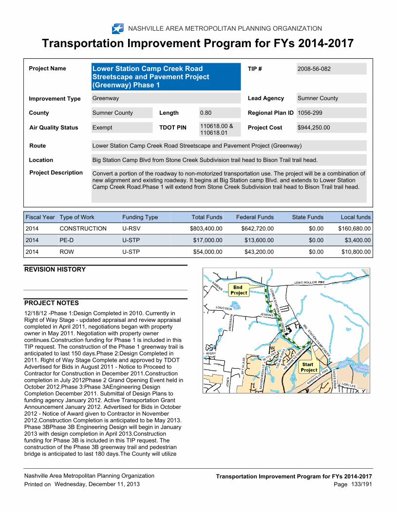
12/18/12 -Phase 1:Design Completed in 2010. Currently inRight of Way Stage - updated appraisal and review appraisalcompleted in April 2011, negotiations began with propertyowner in May 2011. Negotiation with property ownercontinues.Construction funding for Phase 1 is included in thisTIP request. The construction of the Phase 1 greenway trail isanticipated to last 150 days.Phase 2:Design Completed in2011. Right of Way Stage Complete and approved by TDOTAdvertised for Bids in August 2011 - Notice to Proceed toContractor for Construction in December 2011.Constructioncompletion in July 2012Phase 2 Grand Opening Event held inOctober 2012.Phase 3:Phase 3AEngineering DesignCompletion December 2011. Submittal of Design Plans tofunding agency January 2012. Active Transportation GrantAnnouncement January 2012. Advertised for Bids in October2012 - Notice of Award given to Contractor in November2012.Construction Completion is anticipated to be May 2013.Phase 3BPhase 3B Engineering Design will begin in January2013 with design completion in April 2013.Constructionfunding for Phase 3B is included in this TIP request. Theconstruction of the Phase 3B greenway trail and pedestrianbridge is anticipated to last 180 days.The County will utilizeWiser Company for the Phase 3B design. Wiser Company hascompleted all of the design for the Lower Station CampGreenway phases. Phase 3B design should be completed inApril 2013. The TIP funding will be utilized for construction andconstruction engineering inspection fees.Once design iscomplete in April and construction funds are obtained, Phase3B will be ready to proceed to construction. Phase 1 designhas been completed; Phase 1 will be ready to proceed toconstruction once the right of way is obtained. The LowerStation Camp Greenway is a priority project for SumnerCounty.
NASHVILLE AREA METROPOLITAN PLANNING ORGANIZATION
Transportation Improvement Program for FYs 2014-2017
Project Description Convert a portion of the roadway to non-motorized transportation use. The project will be a combination ofnew alignment and existing roadway. It begins at Big Station camp Blvd. and extends to Lower StationCamp Creek Road.Phase 1 will extend from Stone Creek Subdivision trail head to Bison Trail trail head.
Big Station Camp Blvd from Stone Creek Subdivision trail head to Bison Trail trail head.Location
Route Lower Station Camp Creek Road Streetscape and Pavement Project (Greenway)
$944,250.00Air Quality Status 110618.00 &110618.01
TDOT PINExempt Project Cost
Sumner County 0.80 1056-299Regional Plan IDLengthCounty
TIP # 2008-56-082
Sumner CountyLead AgencyGreenwayImprovement Type
Lower Station Camp Creek RoadStreetscape and Pavement Project(Greenway) Phase 1
Project Name
Local fundsState FundsFederal FundsTotal FundsFunding TypeType of WorkFiscal Year
$160,680.00$0.00$642,720.00$803,400.00U-RSVCONSTRUCTION2014
$3,400.00$0.00$13,600.00$17,000.00U-STPPE-D2014
$10,800.00$0.00$43,200.00$54,000.00U-STPROW2014
REVISION HISTORY
PROJECT NOTES
Printed on
Nashville Area Metropolitan Planning Organization
Wednesday, December 11, 2013
Transportation Improvement Program for FYs 2014-2017
133/191Page

12/18/12 -Phase 1:Design Completed in 2010. Currently inRight of Way Stage - updated appraisal and review appraisalcompleted in April 2011, negotiations began with propertyowner in May 2011. Negotiation with property ownercontinues.Construction funding for Phase 1 is included in thisTIP request. The construction of the Phase 1 greenway trail isanticipated to last 150 days.Phase 2:Design Completed in2011. Right of Way Stage Complete and approved by TDOTAdvertised for Bids in August 2011 - Notice to Proceed toContractor for Construction in December 2011.Constructioncompletion in July 2012Phase 2 Grand Opening Event held inOctober 2012.Phase 3:Phase 3AEngineering DesignCompletion December 2011. Submittal of Design Plans tofunding agency January 2012. Active Transportation GrantAnnouncement January 2012. Advertised for Bids in October2012 - Notice of Award given to Contractor in November2012.Construction Completion is anticipated to be May 2013.Phase 3BPhase 3B Engineering Design will begin in January2013 with design completion in April 2013.Constructionfunding for Phase 3B is included in this TIP request. Theconstruction of the Phase 3B greenway trail and pedestrianbridge is anticipated to last 180 days.The County will utilizeWiser Company for the Phase 3B design. Wiser Company hascompleted all of the design for the Lower Station CampGreenway phases. Phase 3B design should be completed inApril 2013. The TIP funding will be utilized for construction andconstruction engineering inspection fees.Once design iscomplete in April and construction funds are obtained, Phase3B will be ready to proceed to construction. Phase 1 designhas been completed; Phase 1 will be ready to proceed toconstruction once the right of way is obtained. The LowerStation Camp Greenway is a priority project for SumnerCounty.
Printed on
Nashville Area Metropolitan Planning Organization
Wednesday, December 11, 2013
Transportation Improvement Program for FYs 2014-2017
134/191Page

NASHVILLE AREA METROPOLITAN PLANNING ORGANIZATION
Transportation Improvement Program for FYs 2014-2017
Project Description Convert a portion of the roadway to non-motorized transportation use. The project will be a combination ofnew alignment and existing roadway. Phase 3 begins at the southeast quadrant of Bison Trail parallel toLower Station Camp Creek Road. The trail then turns east along the southern boundary of the schoolproperty and ends at Big Station Camp Boulevard. There is also a trail to the backside of the elementaryschool. The trail will connect to the elementary and middle schools and end at Bid Station Camp Blvd.
From SE quadrant of Bison Trail parallel to Lower Station Camp Creek Road. The trail then turns eastalong the southern boundary of the school property and ends at Big Station Camp Boulevard.
Location
Route Lower Station Camp Creek Road Streetscape and Pavement Project (Greenway)
$701,000.00Air Quality Status 110618.01TDOT PINExempt Project Cost
Sumner County 1.10 1056-299Regional Plan IDLengthCounty
TIP # 2008-56-082-B
Sumner CountyLead AgencyGreenwayImprovement Type
Lower Station Camp Creek RoadStreetscape and Pavement Project(Greenway) Phase 3
Project Name
Local fundsState FundsFederal FundsTotal FundsFunding TypeType of WorkFiscal Year
$31,151.00$0.00$124,602.00$155,753.00U-STPCONSTRUCTION2014
REVISION HISTORY
PROJECT NOTES
Printed on
Nashville Area Metropolitan Planning Organization
Wednesday, December 11, 2013
Transportation Improvement Program for FYs 2014-2017
135/191Page
NASHVILLE AREA METROPOLITAN PLANNING ORGANIZATION
Transportation Improvement Program for FYs 2014-2017
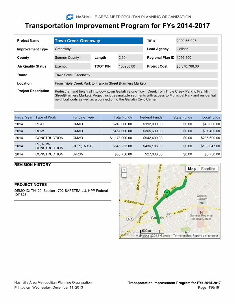
Project Description Pedestrian and bike trail into downtown Gallatin along Town Creek from Triple Creek Park to FranklinStreet(Farmers Market). Project includes multiple segments with access to Municipal Park and residentialneighborhoods as well as a connection to the Gallatin Civic Center.
From Triple Creek Park to Franklin Street (Farmers Market)Location
Route Town Creek Greenway
$5,370,766.00Air Quality Status 106988.00TDOT PINExempt Project Cost
Sumner County 2.60 1056-300Regional Plan IDLengthCounty
TIP # 2009-56-027
GallatinLead AgencyGreenwayImprovement Type
Town Creek GreenwayProject Name
Local fundsState FundsFederal FundsTotal FundsFunding TypeType of WorkFiscal Year
$48,000.00$0.00$192,000.00$240,000.00CMAQPE-D2014
$91,400.00$0.00$365,600.00$457,000.00CMAQROW2014
$235,600.00$0.00$942,400.00$1,178,000.00CMAQCONSTRUCTION2014
$109,047.00$0.00$436,186.00$545,233.00HPP (TN120)PE, ROW,CONSTRUCTION
2014
$6,750.00$0.00$27,000.00$33,750.00U-RSVCONSTRUCTION2014
REVISION HISTORY
PROJECT NOTES
DEMO ID: TN120. Section 1702-SAFETEA-LU, HPP FederalID# 828
Printed on
Nashville Area Metropolitan Planning Organization
Wednesday, December 11, 2013
Transportation Improvement Program for FYs 2014-2017
136/191Page

NASHVILLE AREA METROPOLITAN PLANNING ORGANIZATION
Transportation Improvement Program for FYs 2014-2017
Project Description Relocate and widen to 3 lanes of a portion of Airport Road and all associated costs to allow for runwayand hangar expansion at the Sumner County Regional Airport.
From Airport Road to Gregory DriveLocation
Route Airport Road Relocation
$4,198,527.00Air Quality Status 112818.00TDOT PINNon-Exempt Project Cost
Sumner County 1.34 1052-273Regional Plan IDLengthCounty
TIP # 2011-510-017
GallatinLead AgencyRoad UpgradesImprovement Type
Airport Road RelocationProject Name
Local fundsState FundsFederal FundsTotal FundsFunding TypeType of WorkFiscal Year
$0.00$0.00$1,500,000.00$1,500,000.00HPP (TN281)CONSTRUCTION2014
$0.00$202,000.00$0.00$202,000.00STATE (SIA)PE-D2014
$0.00$2,496,527.00$0.00$2,496,527.00STATE (SIA)CONSTRUCTION2014
REVISION HISTORY
PROJECT NOTES
DEMO ID: TN281. (Division A of FY '10 Appropriations Act).Code 56C0. 100% Federal
12/17/12 - Major tasks include the completion ofPE/construction documents, acquisition of ROW and theconstruction of the project.Project Schedule• PreliminaryEngineering – Almost complete• Begin Construction –anticipated to begin in late summer 2013• CompleteConstruction in 1 yearProject ManagementThe project willfollow TDOT construction procedures and will includeConstruction Engineering Inspections (CEI) as part of projectcontract. TDOT is responsible for themanagement of project.The City of Gallatin will continue to work closely with TDOTthroughout the remainder of the project to help ensure that itwill be completed efficiently and in a timely manner.
Printed on
Nashville Area Metropolitan Planning Organization
Wednesday, December 11, 2013
Transportation Improvement Program for FYs 2014-2017
137/191Page

NASHVILLE AREA METROPOLITAN PLANNING ORGANIZATION
Transportation Improvement Program for FYs 2014-2017
Project Description Construct new 4 lane roadway
Proposed SR-109 - Portland BypassLocation
Route SR-109
$46,000,000.00Air Quality Status 106634.01TDOT PINNon-Exempt Project Cost
Sumner County 6.80 1051-222Regional Plan IDLengthCounty
TIP # 2011-51-108
TDOTLead AgencyNew RoadImprovement Type
SR-109 Portland BypassProject Name
Local fundsState FundsFederal FundsTotal FundsFunding TypeType of WorkFiscal Year
$0.00$400,000.00$1,600,000.00$2,000,000.00NHPPPE-D2014
REVISION HISTORY
PROJECT NOTES
Printed on
Nashville Area Metropolitan Planning Organization
Wednesday, December 11, 2013
Transportation Improvement Program for FYs 2014-2017
138/191Page

NASHVILLE AREA METROPOLITAN PLANNING ORGANIZATION
Transportation Improvement Program for FYs 2014-2017
Project Description Intersection Improvements including the construction of a dedicated left turn lane on Tyree Springs Road(SR 258) and a dedicated right turn lane on South Palmers Chapel Road.
Tyree Springs Rd @ South Palmers Chapel RoadLocation
Route Tyree Springs (SR-258) / S Palmers Chapel Intersection Improvements
$350,000.00Air Quality Status TDOT PINNon-Exempt Project Cost
Sumner County 0.21 1054-255Regional Plan IDLengthCounty
TIP # 2011-54-156
White HouseLead AgencyIntersectionImprovement Type
Tyree Springs (SR-258) / S Palmers ChapelIntersection Improvements
Project Name
Local fundsState FundsFederal FundsTotal FundsFunding TypeType of WorkFiscal Year
$0.00$90,000.00$0.00$90,000.00STATE (SAFETY)CONSTRUCTION2014
REVISION HISTORY
PROJECT NOTES
12/18/12-design completed and then moved into construction.Depending on the outcome of current funding coordination, theplanned design phase will occur during the fall of 2013. Withall design and permitting phases to be completed during thewinter of 2013-2014, constructioncurrently is likely to be bid inthe early portion of 2014, with a spring 2014 constructionestimate.The project will be managed locally by city staff incooperation with the City's Engineering Consultant. The Citywill track the progress of the project and submit monthlychecklists to TDOT and the MPO determined representatives.During the project construction phase, staff will visit the sitedaily and complete project notes.
Printed on
Nashville Area Metropolitan Planning Organization
Wednesday, December 11, 2013
Transportation Improvement Program for FYs 2014-2017
139/191Page
NASHVILLE AREA METROPOLITAN PLANNING ORGANIZATION
Transportation Improvement Program for FYs 2014-2017
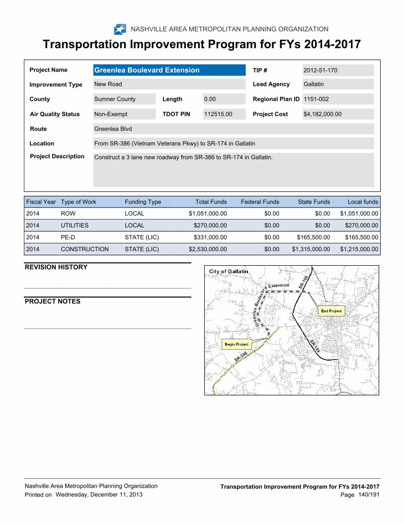
Project Description Construct a 3 lane new roadway from SR-386 to SR-174 in Gallatin.
From SR-386 (Vietnam Veterans Pkwy) to SR-174 in GallatinLocation
Route Greenlea Blvd
$4,182,000.00Air Quality Status 112515.00TDOT PINNon-Exempt Project Cost
Sumner County 0.00 1151-002Regional Plan IDLengthCounty
TIP # 2012-51-170
GallatinLead AgencyNew RoadImprovement Type
Greenlea Boulevard ExtensionProject Name
Local fundsState FundsFederal FundsTotal FundsFunding TypeType of WorkFiscal Year
$1,051,000.00$0.00$0.00$1,051,000.00LOCALROW2014
$270,000.00$0.00$0.00$270,000.00LOCALUTILITIES2014
$165,500.00$165,500.00$0.00$331,000.00STATE (LIC)PE-D2014
$1,215,000.00$1,315,000.00$0.00$2,530,000.00STATE (LIC)CONSTRUCTION2014
REVISION HISTORY
PROJECT NOTES
Printed on
Nashville Area Metropolitan Planning Organization
Wednesday, December 11, 2013
Transportation Improvement Program for FYs 2014-2017
140/191Page

NASHVILLE AREA METROPOLITAN PLANNING ORGANIZATION
Transportation Improvement Program for FYs 2014-2017
Project Description Development of a Park n' Ride lot in the Greensboro North Transit Ready Development (TDR) in Gallatinfor RTA Route 92X Gallatin/Hendersonville Express.
Intersection Harris Lane/Greenlea Blvd & Enterprise DriveLocation
Route Greensboro North Park-n-Ride in Gallatin
$695,500.00Air Quality Status TDOT PINExempt Project Cost
Sumner County 0.00 1085-501Regional Plan IDLengthCounty
TIP # 2012-55-199
RTALead AgencyTransit CapitalImprovement Type
Greensboro North Park-n-Ride in GallatinProject Name
Local fundsState FundsFederal FundsTotal FundsFunding TypeType of WorkFiscal Year
$10,000.00$0.00$40,000.00$50,000.00U-STP (Flexed toFTA)
PE-N2014
$28,000.00$0.00$112,000.00$140,000.00U-STP (Flexed toFTA)
ROW2014
$101,100.00$0.00$404,400.00$505,500.00U-STP (Flexed toFTA)
CONSTRUCTION2014
REVISION HISTORY
PROJECT NOTES
Printed on
Nashville Area Metropolitan Planning Organization
Wednesday, December 11, 2013
Transportation Improvement Program for FYs 2014-2017
141/191Page

NASHVILLE AREA METROPOLITAN PLANNING ORGANIZATION
Transportation Improvement Program for FYs 2014-2017
Project Description Construct 8-ft wide bike/ped trail and boardwalk along Sanders Ferry Rd along the water’s edge of DrakesCreek/Old Hickory Lake.
From Main Street along Sanders Ferry Rd and Drakes Creek/Old Hickory Lake to Sanders Ferry ParkLocation
Route Sanders Ferry/ Drakes Creek
$1,488,000.00Air Quality Status 117016.00TDOT PINExempt Project Cost
Sumner County 1.52 ConsistentRegional Plan IDLengthCounty
TIP # 2012-56-171
HendersonvilleLead AgencyGreenwayImprovement Type
Sanders Ferry/ Drakes Creek Bike TrailProject Name
Local fundsState FundsFederal FundsTotal FundsFunding TypeType of WorkFiscal Year
$10,000.00$0.00$40,000.00$50,000.00CMAQROW2014
$257,600.00$0.00$1,030,400.00$1,288,000.00CMAQCONSTRUCTION2014
$6,000.00$0.00$24,000.00$30,000.00CMAQPE-D2014
REVISION HISTORY
PROJECT NOTES
12/17/12 - Schedule: Oct, 2013 - Receive Notice To Proceedfrom TDOT to acquire ROW.Nov, 2013-Mar, 2014 - AcquireROW and easements; adjust utilities if needed.Apr, 2014 -Receive Notice To Proceed from TDOT to advertise forconstruction.May, 2014 - Award contract for construction.May,2014-Dec 2014 - Complete construction and closeout.Theproject will be managed by the City’s Public Works Departmentand Engineering Consultant. All contracts (engineering, ROWacquisition and construction) will include schedules withmilestones and dates. One of the main criteria in choosing theengineering consultant will be performance and provenknowledge of TDOT requirements and track record in workingwith TDOT.The City has successfully managed the followingprojects:1. Indian Lake Boulevard at 386 Bridge widening,ramps, signals.2. New Shackle Island Road3. Traffic SignalUpgrade4. ARRA ProjectsWhile the City experienced somedifficulty in getting through the TDOT process, once a NoticeTo Proceed with construction was received, the projects werecompleted on time and within budget.
Printed on
Nashville Area Metropolitan Planning Organization
Wednesday, December 11, 2013
Transportation Improvement Program for FYs 2014-2017
142/191Page

NASHVILLE AREA METROPOLITAN PLANNING ORGANIZATION
Transportation Improvement Program for FYs 2014-2017
Project Description Streetscaping on South Water Ave. Replace existing sidewalks, install pedestrian amenities, landscaping,decorative pedestrian/street lighting & stamped asphalt crosswalks and pedestrian signalization at theSouth Water Ave/Smith Street intersection.
South Water Avenue from Main St. to Smith St.Location
Route South Water Avenue
$377,000.00Air Quality Status TDOT PINExempt Project Cost
Sumner County 0.70 1086-601Regional Plan IDLengthCounty
TIP # 2012-56-183
GallatinLead AgencyStreetscapingImprovement Type
Downtown Gallatin Streetscape - Phase 3Project Name
Local fundsState FundsFederal FundsTotal FundsFunding TypeType of WorkFiscal Year
$25,000.00$0.00$100,000.00$125,000.00U-STPCONSTRUCTION2014
REVISION HISTORY
PROJECT NOTES
Printed on
Nashville Area Metropolitan Planning Organization
Wednesday, December 11, 2013
Transportation Improvement Program for FYs 2014-2017
143/191Page

NASHVILLE AREA METROPOLITAN PLANNING ORGANIZATION
Transportation Improvement Program for FYs 2014-2017
Project Description Restriping of HWY 31W to allow extension of greenway access for bike and pedestrian traffic along theroute.
White House Greenway South Trail Head south of Cliff Garrett Dr to White House North Greenway trailhead north of Garland Ct.
Location
Route Highway 31W/ SR-41
$450,000.00Air Quality Status 118375.00TDOT PINExempt Project Cost
Sumner County 0.75 1086-601Regional Plan IDLengthCounty
TIP # 2012-56-195
White HouseLead AgencyMulti-Modal UpgradesImprovement Type
Highway 31W/ SR-41 Bike/PedestrianProject
Project Name
Local fundsState FundsFederal FundsTotal FundsFunding TypeType of WorkFiscal Year
$74,000.00$0.00$296,000.00$370,000.00U-STPCONSTRUCTION2014
$3,380.00$0.00$13,520.00$16,900.00U-STP(Deobligated fromNEPA)
CONSTRUCTION2014
REVISION HISTORY
PROJECT NOTES
12/18/12-The City will follow the TDOT-LPDO determinedprocess for selecting a design firm to get the project designcompleted. The first phase of the project is proposed for year2013 year. The next step will be for the City to follow the TDOT-LPDO determined approval process and obtain contractorbids and select a contractor meeting State requirements forthe construction phase which is proposed to be completedduring the year 2014 budget. The project will be managedlocally by city staff in cooperation with the City's EngineeringConsultant. The City will track the progress of the project andsubmit monthly checklists to the MPO determinedrepresentatives.During the project construction phase, staff willvisit the site daily and complete project notes.
Printed on
Nashville Area Metropolitan Planning Organization
Wednesday, December 11, 2013
Transportation Improvement Program for FYs 2014-2017
144/191Page

NASHVILLE AREA METROPOLITAN PLANNING ORGANIZATION
Transportation Improvement Program for FYs 2014-2017
Project Description Develop historic preservation transportation enhancement project in Sumner and surrounding counties.
Douglass-Clark HouseLocation
Route
$121,485.00Air Quality Status 117101.00TDOT PINExempt Project Cost
Sumner County 0.00 ConsistentRegional Plan IDLengthCounty
TIP # 2012-59-191
Sumner CountyLead AgencyHistoric PreservationImprovement Type
Civil War Historic PreservationProject Name
Local fundsState FundsFederal FundsTotal FundsFunding TypeType of WorkFiscal Year
$24,297.00$0.00$97,188.00$121,485.00HPP (TN169)PE, ROW,CONSTRUCTION
2014
REVISION HISTORY
PROJECT NOTES
DEMO ID: TN169. Section 1702-SAFETEA-LU, HPP FederalID# 2411
The project will involve the design, construction andinstallation of a main display located at the Douglass‐ClarkHouse in Sumner County with smaller exhibits located in theother five counties at courthouses, archives building, orwelcome center.
Printed on
Nashville Area Metropolitan Planning Organization
Wednesday, December 11, 2013
Transportation Improvement Program for FYs 2014-2017
145/191Page

NASHVILLE AREA METROPOLITAN PLANNING ORGANIZATION
Transportation Improvement Program for FYs 2014-2017
Project Description Resurfacing, restoration and rehabilitation improvements of various roads in the City of Portland.
Various locations within the City of Portland.Location
Route Portland 3R Improvements Program (Grouping)
$170,448.00Air Quality Status TDOT PINExempt Project Cost
Sumner County 0.00 ConsistentRegional Plan IDLengthCounty
TIP # 2014-510-040
PortlandLead AgencyResurfacingImprovement Type
Portland 3R Improvements Program(Grouping)
Project Name
Local fundsState FundsFederal FundsTotal FundsFunding TypeType of WorkFiscal Year
$34,090.00$0.00$136,358.00$170,448.00L-STPPE, ROW,CONSTRUCTION
2014
REVISION HISTORY
PROJECT NOTES
Printed on
Nashville Area Metropolitan Planning Organization
Wednesday, December 11, 2013
Transportation Improvement Program for FYs 2014-2017
146/191Page

NASHVILLE AREA METROPOLITAN PLANNING ORGANIZATION
Transportation Improvement Program for FYs 2014-2017
Project Description Construction of sidewalk , pedestrian bridge, ADA ramps, 1 crosswalk and signage.
Walton Ferry Elementary and Hawkins Middle Schools - Walton Ferry RoadLocation
Route Walton Ferry Road
$177,475.00Air Quality Status 117002.00TDOT PINExempt Project Cost
Sumner County 0.27 ConsistentRegional Plan IDLengthCounty
TIP # 2014-511-032
HendersonvilleLead AgencyMulti-Modal UpgradesImprovement Type
Walton Ferry Elementary and HawkinsMiddle Schools
Project Name
Local fundsState FundsFederal FundsTotal FundsFunding TypeType of WorkFiscal Year
$0.00$0.00$177,475.00$177,475.00SRTSPE, ROW,CONSTRUCTION
2014
REVISION HISTORY
PROJECT NOTES
Printed on
Nashville Area Metropolitan Planning Organization
Wednesday, December 11, 2013
Transportation Improvement Program for FYs 2014-2017
147/191Page
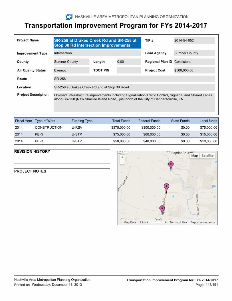
NASHVILLE AREA METROPOLITAN PLANNING ORGANIZATION
Transportation Improvement Program for FYs 2014-2017
Project Description On-road, infrastructure improvements including Signalization/Traffic Control, Signage, and Shared Lanesalong SR-258 (New Shackle Island Road), just north of the City of Hendersonville, TN.
SR-258 at Drakes Creek Rd and at Stop 30 Road.Location
Route SR-258
$500,000.00Air Quality Status TDOT PINExempt Project Cost
Sumner County 0.00 ConsistentRegional Plan IDLengthCounty
TIP # 2014-54-052
Sumner CountyLead AgencyIntersectionImprovement Type
SR-258 at Drakes Creek Rd and SR-258 atStop 30 Rd Intersection Improvements
Project Name
Local fundsState FundsFederal FundsTotal FundsFunding TypeType of WorkFiscal Year
$75,000.00$0.00$300,000.00$375,000.00U-RSVCONSTRUCTION2014
$15,000.00$0.00$60,000.00$75,000.00U-STPPE-N2014
$10,000.00$0.00$40,000.00$50,000.00U-STPPE-D2014
REVISION HISTORY
PROJECT NOTES
Printed on
Nashville Area Metropolitan Planning Organization
Wednesday, December 11, 2013
Transportation Improvement Program for FYs 2014-2017
148/191Page

NASHVILLE AREA METROPOLITAN PLANNING ORGANIZATION
Transportation Improvement Program for FYs 2014-2017
Project Description Construct sidewalks from SR-109 to South Russell Street; College Street from Searcy Lane toMorningside Drive; and Searcy Lane from College Street to SR-52
SR52 from SR-109 to South Russell Street; College Street from Searcy Lane to Morningside Drive; andSearcy Lane from College Street to SR-52
Location
Route SR-52
$131,250.00Air Quality Status 040641.00TDOT PINExempt Project Cost
Sumner County 1.00 ConsistentRegional Plan IDLengthCounty
TIP # 314
PortlandLead AgencySidewalksImprovement Type
SR-52 SidewalksProject Name
Local fundsState FundsFederal FundsTotal FundsFunding TypeType of WorkFiscal Year
$26,250.00$0.00$105,000.00$131,250.00CMAQCONSTRUCTION2014
REVISION HISTORY
PROJECT NOTES
Printed on
Nashville Area Metropolitan Planning Organization
Wednesday, December 11, 2013
Transportation Improvement Program for FYs 2014-2017
149/191Page

NASHVILLE AREA METROPOLITAN PLANNING ORGANIZATION
Transportation Improvement Program for FYs 2014-2017
Project Description Widen Drakes Creek Rd from SR 386/Vietnam Veterans Blvd from 2 lanes to 5 lanes, including left turnlanes in all 4 directions at the intersection of Drakes Creek Rd and Stop 30 Rd and signalization. Theproject also involves raising this intersection above the flood elevation and replacing a condemned bridge.
From SR-386 to Stop 30 RoadLocation
Route Drakes Creek Widening
$2,700,000.00Air Quality Status TDOT PINNon-Exempt Project Cost
Sumner County 0.25 1052-174Regional Plan IDLengthCounty
TIP # 99-New-28
HendersonvilleLead AgencyRoad WideningImprovement Type
Drakes Creek Road WideningProject Name
Local fundsState FundsFederal FundsTotal FundsFunding TypeType of WorkFiscal Year
$48,000.00$0.00$192,000.00$240,000.00U-STPPE2014
$80,000.00$0.00$320,000.00$400,000.00U-STPROW, UTILITIES2015
$412,000.00$0.00$1,648,000.00$2,060,000.00U-RSVCONSTRUCTION2016
REVISION HISTORY
PROJECT NOTES
12/17/12 - Schedule: Oct, 2013-Nov, 2013 - Enter a contractwith TDOT to allow the City to manage this project.Dec, 2013-Jan, 2014 - Receive Notice To Proceed from TDOT forPE.Feb, 2014-Mar, 2014 - Advertise for Proposals forEngineering Consultant.Apr, 2014 - Hire EngineeringConsultant.May, 2014-Apr, 2015 - PE.May, 2015 - ReceiveNotice To Proceed from TDOT for ROW and Utilities. Jan,2015-Dec, 2015 - ROW and Utilities.Jan, 2016 - ReceiveNotice to Proceed for Construction.Feb, 2016-Mar, 2016 -Advertise for bids.Apr, 2016-Je, 2016 - Award contract forconstruction and CEI.Jul, 2016-Je, 2017 - Completeconstruction and closeout.The project will be managed by theCity’s Public Works Department and Engineering Consultant.All contracts (engineering, ROW acquisition and construction)will include schedules with milestones and dates. One of themain criteria in choosing the engineering consultant will beperformance and proven knowledge of TDOT requirementsand track record in working with TDOT.
Printed on
Nashville Area Metropolitan Planning Organization
Wednesday, December 11, 2013
Transportation Improvement Program for FYs 2014-2017
150/191Page

NASHVILLE AREA METROPOLITAN PLANNING ORGANIZATION
Transportation Improvement Program for FYs 2014-2017
Project Description Widen from 2 lanes to 4/5 lanes
North of Cumberland River Bridge to SR-109 BypassLocation
Route SR-109
$19,200,000.00Air Quality Status 100286.00TDOT PINNon-Exempt Project Cost
Sumner County 1.30 1052-223Regional Plan IDLengthCounty
TIP # AM-018
TDOTLead AgencyRoad WideningImprovement Type
SR-109Project Name
Local fundsState FundsFederal FundsTotal FundsFunding TypeType of WorkFiscal Year
$0.00$1,980,000.00$7,920,000.00$9,900,000.00NHPPROW2014
REVISION HISTORY
PROJECT NOTES
HPP ID# 1180 (Section 1602-TEA-21) -http://www.fhwa.dot.gov/tea21/tea21.pdf
Printed on
Nashville Area Metropolitan Planning Organization
Wednesday, December 11, 2013
Transportation Improvement Program for FYs 2014-2017
151/191Page