structural-tectonic architecture of limestone quarry ... · acta montanistica slovaca ročník 11...
TRANSCRIPT
Acta Montanistica Slovaca Ročník 11 (2006), číslo 1, 70-85
Structural-tectonic architecture of limestone quarry Gombasek
on Plešivec Plateau of Silica Nappe
Tibor Sasvári1, Stanislav Jacko jun.2 and Julián Kondela1
Abstract Investigation of bends, fold deformations, sigmoidal foliation trend as well as displacement of Silica Nappe surfaces revealed
gradual evolution of Late Cretaceous tectonic movements in the limestone quarry Gombasek located on Plešivec Plateau of Silica Nappe. Tertiary and recent tectonic changes resulted in extension, fault polishes of semiductile deformation, reactivation of tectonic structures, formation of horst and graben structures and extensional structures of karstification.
Key words: Silica Nappe, Gombasek, Late Cretaceous, Paleogene and recent tectonic deformations.
Introduction
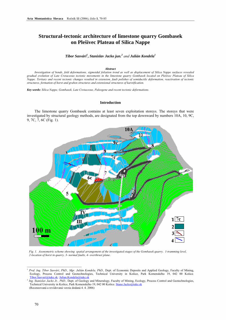
The limestone quarry Gombasek contains at least seven exploitation storeys. The storeys that were investigated by structural geology methods, are designated from the top downward by numbers 10A, 10, 9C, 9, 7C, 7, 6C (Fig. 1).
Fig. 1. Axonometric scheme showing spatial arrangement of the investigated etages of the Gombasek quarry. 1-tramming level, 2-location of horst in quarry, 3- normal faults, 4- overthrust plane.
1 Prof. Ing. Tibor Sasvári, PhD., Mgr. Julián Kondela, PhD., Dept. of Economic Deposits and Applied Geology, Faculty of Mining,
Ecology, Process Control and Geotechnologies, Technical University in Košice, Park Komenského 19, 042 00 Košice. [email protected]; [email protected]
2 Ing. Stanislav Jacko Jr., PhD., Dept. of Geology and Mineralogy, Faculty of Mining, Ecology, Process Control and Geotechnologies, Technical University in Košice, Park Komenského 19, 042 00 Košice. [email protected]
(Recenzovaná a revidovaná verzia dodaná 4. 4. 2006)
70

Acta Montanistica Slovaca Ročník 11 (2006), číslo 1, 70-85
Geologic structure in the Gombasek quarry
The studied deposit Slavec - Gombasek is located in the Inner Western Carpathians, which
are subdivided into five palaeoalpine tectonic units: Gemericum, Bôrka Nappe, Meliaticum, Turnaicum and Silicicum (Mello et al., 1997).
Silicicum overlies the above-mentioned units. The area of the Slovak karst consists of several rock types starting with Lower Triassic rocks and terminating with Upper Cretaceous rocks. The Plešivec Plateau, which is a part of the Slovak Karst, is typical by weakly inclined north-vergent monoclinal structure. In the southern part Middle Triassic sediments predominate while gradually northward older sediments of the Lower Triassic are exposed.
The Gombasek quarry occurs at the southern margin of the Plešivec Plateau. As it already was mentioned, the southern part consists of mainly massive Wetterstein limestones (Ladinian - Cordevolian) represented by foraminifera, bryozoan and stromatopora tests, which includes irregular layers and lenses of younger sediments defined as Gombased Member (Santonian – Campanian).
Wettersten limestones are medium- to thick bedded with beds thick from 0,3 up to 1,5-2 m. The bedding has generally NE-SW direction and slight monoclinal 10 – 20° dip toward NW. The bedding planes were tectonically deformed and karstified at many places. The deposits of karst caverns (Quaternary of age) are composed of weathered material represented by red and ocherous claystones containing fallen irregular clasts of wetterstein limestone.
Gombasek Member (Santonian - Conacian) consists of dark shales and sandstones. The sediments are known only from the Gombasek quarry, where they are exposed in the form of lenses or irregular layers. The sandstones are dark gray and yellowish-brown colour. They are fine- to medium-grained, thin-bedded with several cm thick beds. On the bedding planes of sandstones it is possible to find relic mineralization as pyrite and coatings and also veins (thick up to 0.5 cm) of manganese mineralization. The claystones and mudstones are dark with fine friableness. The relics of macrofauna occurring in the sediments of Gombasek Member were analysed by Mello and Snopková (1973). The position of the Gombasek Member in relation to the Wetterstein limestones is clearly tectonic. The member occurs most frequently in the basal part of the quarry, where it is also the thickest. The altitude difference between individual occurrences is from 10 to 30 m, however, higher upward, between 10th and 7th storeys the difference is up to 150 m.
Tectonic evolution of the wider part of the studied area
Deposition area of the Silicicum, which also comprises Plešivec Plateau, occurred in the southernmost
part of the Slovakian-Carpathian Mesozoic basins system (Plašienka, 1999). After a longer sedimentary hiatus in the Silicicum area, deposition started by deep-water sediments of Gosau Group (Samuel, 1977; Mišík 1978; Mello ed. 1997 in Plašienka, 1999). This implies later thrusting of the Silicicum Nappe comparing to the Fatricum and Hronicum, probably in the Middle Senonian (Campanian). After formation of Silicicum Nappe structure the unit was tectonically deformed by fault structures.
The fault tectonics in the studied area resulted from several deformation stages related to displacements along the three most important fault lines, which cross the studied area. The most important is NE-SW Rapovec fault system trending in direction Rapovce - Rašice - Sograď creek (Vass et al., 1989). The system represents a continuation of the Plešivec fault system (Plančár et al., 1977) on the surface, bifurcating from the Hurbanovo - Diósjenő line near Balassagyarmat. Another NNW-SSE fault system is represented by Štítnik fault system, while the third fault system is represented by E-W Rožňava fault system.
The interpretation of the tectonic evolution during the Paleogene is mostly based on the data from Lučenec Depression, where also stratigraphic records are available. During the Late Eocene NW-SE and WNW-ESE compressional stress field was active, which generated E-W strike slips and NW-SE normal faults. Striking change of the palaeostress field occurred at the end of the Eocene, when huge E-W extension prevailed. The extension resulted in initiation of N-S fault structures intersecting NW-SE structures. At the end of the Oligocene or at the beginning of the Miocene palaeostress field again changed. NE-SW and ENE-WSW faults were again reactivated in the NE-SW and ENE-WSW compressional stress field. At the Karpatian - Badenian boundary stress fields with N-S compression and NW-SE extension started to prevail. The stress field was controlled by WNW-ESE and NNE-SSW shear faults. In the Early Badenian predominated NE-SW extension and NW-SE and E-W compression. This resulted in activation of NE-SW fault structures. In the Middle and Late Badenian NE-SW extension continued.
71

Tibor Sasvári, Stanislav Jacko jun. and Julián Kondela: Structural-tectonic architecture of limestone quarry Gombasek on Plešivec Plateau of Silica Nappe
Geomorphologic evolution of the area
Uplift of the area at the end of Eggerian resulted in sea regression southward in the Rimava Depression.
The oldest surface forms are probably represented by hills of Koniar and Plešivec plateaus, which are elevated up to the altitude 70 - 100 m above the even surface. However, a striking and very fast uplift of the area occurred after the Pannonian (Poltár Formation), which is defined as a result of Attic movements. At that time morphological structures were formed along the NW-SE faults as for example Štítnik gorge or Muráň valley. Conspicuous depression forms also originated along the E-W thrust lines as for example Rožňava Depression. At this time recent sinks originated. After uplift of the central part of the Slovak Karst in the Pontian slight subsidence of the area was related to the subsidence of several depressions in the Inner Western Carpathians. In narrow valleys, generated by this subsidence, gravel, sand and clay were deposited (Rožňava Depression, depression of Štítnik and Slaná rivers). In the Pliocene during the period of relative tectonic standstill intensive weathering of Triassic carbonates, mostly Wetterstein limestones, occurred, which resulted in 400 m thick vadose zone with subaeric karstification. On the plateau surface another depressions, skarp fields and mounds originated. A part of infiltrating karst waters circulated in piesometric level to the foot of plateaus and formed caves (Gombasek cave). At the end of the Pliocene it came to the repeated uplift of some parts of the Slovak Karst.
Succession of tectonic structures of Silica Nappe
Among the oldest structures belong the structures originated during the displacement of Silica Nappe.
Some important relics found during the fieldwork confirmed complicated geological - structural evolution of the pre-displacement and post-displacement period. Occasional open and closed folds were preserved, which occur either in the tectonic slice of the Gombasek Member or in the overlying and underlying successions of carbonate rocks. The mutual subhorizontal displacement of partial slices of the tectonic sequences of the Silica Nappe resulted in deformation by pure shear and generation of sigmoid foliation course. The displacement of the Silica Nappe also affected slicing of lithologically different sequences, which are separated from each other by striking overlying and underlying displacement planes.
Late Cretaceous deformation of Silica Nappe
Flexures and fold structures
The slice of the Gombasek Member contains several pale sandstone beds with open folds of meter order on the 7th storey (Fig. 2). The flexures are caused by deformation of tectonic slices of the Gombasek Member. The tectonogram (Fig. 3) contains mean b-axis and further two b-axes of the flexure of sandstone beds belonging to the Gombasek Member on the 7th storey. The constructional axis plane =26/31° crosses b-axes of flexures.
Fig. 2. Flexured sandstone beds of the Gombasek Member on the 7th storey.
Fig. 3. Mean b-axis and axis plane of flexured folds of sandstone beds belonging to the Gombasek Member.
We found relics of the fold structures in limestone layers at three places in the quarry. The folds could
originate in the pre-displacement period or during the displacement of the Silica Nappe in semiductile conditions. The axis planes do not coincide, what theoretically excludes the unified stress field. The spatial
72
Acta Montanistica Slovaca Ročník 11 (2006), číslo 1, 70-85
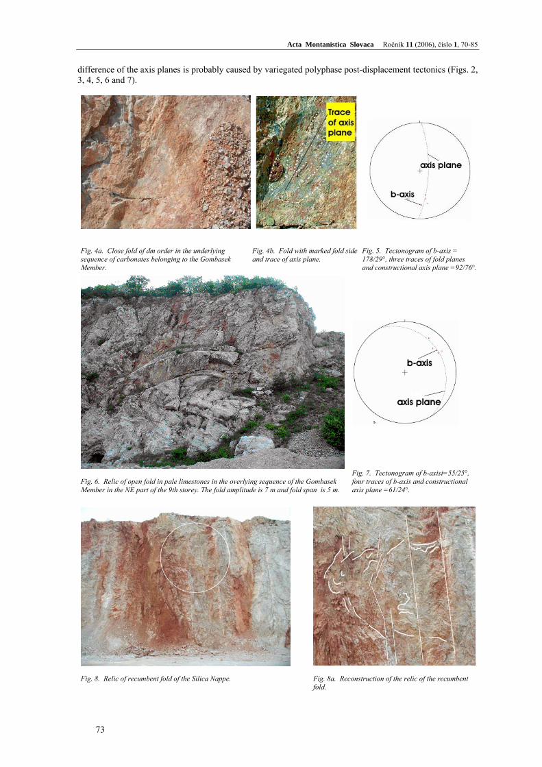
difference of the axis planes is probably caused by variegated polyphase post-displacement tectonics (Figs. 2, 3, 4, 5, 6 and 7).
Fig. 4a. Close fold of dm order in the underlying sequence of carbonates belonging to the Gombasek Member.
Fig. 4b. Fold with marked fold side and trace of axis plane.
Fig. 5. Tectonogram of b-axis = 178/29°, three traces of fold planes and constructional axis plane =92/76°.
Fig. 6. Relic of open fold in pale limestones in the overlying sequence of the Gombasek Member in the NE part of the 9th storey. The fold amplitude is 7 m and fold span is 5 m.
Fig. 7. Tectonogram of b-axisi=55/25°, four traces of b-axis and constructional axis plane =61/24°.
Fig. 8. Relic of recumbent fold of the Silica Nappe.
Fig. 8a. Reconstruction of the relic of the recumbent fold.
73

Tibor Sasvári, Stanislav Jacko jun. and Julián Kondela: Structural-tectonic architecture of limestone quarry Gombasek on Plešivec Plateau of Silica Nappe
In the upper third of the quarry wall in the 10Ath storey we found a relic of closed fold with probable subhorizontal axis plane without the possibility of a direct measurement. The half of the fold span is 6 - 7 m and amplitude is up to 5 m (Fig. 8). The subhorizontal position of the fold may be related to the displacement of the Silica Nappe.
Sigmoid course of foliation
Deformation of simple shear mechanism results in generation of asymmetric shift and rotation tendency
of inner structure of deformed body - rock in the direction of shear zone. The arrangement of sigmoid foliation course therefore shows the stronger progressive deformation and rotation of terminal deformation ellipsoid. The subhorizontal translation of the Silica Nappe enabled generation of sigmoid asymmetric bodies in semiductile conditions because calcite in carbonate rocks starts to behave plastically yet from 150°C. The structures of such type are preserved in the quarry wall (Figs. 9, 10, 11) having SE-NW direction on the 7C storey.
Fig. 9. Sigmoid course of foliation resulted from increased progressive deformation on the 7C storey.
Sas62P.plnSas62L.lin
Fig. 10. Preserved thrust structures beneath the Gombasek Member near the documentary point 7C-3. Small square marks trace of dip strike of the thrust lineation.
Fig. 11. Formation of asymmetric boudins after Goldšteina (1988 in Nemčok et al, 1995). Increasing subhorizontal shear stress enables rotation of generated tectonic deformation into direction parallel to the boundaries of the shear zone and the extension is adapted to displacement on earlier formed extensional cracks. Boudins originate at high values of shear stress, which during the increasing stress start completely separate and their edges get ductile shape.
74

Acta Montanistica Slovaca Ročník 11 (2006), číslo 1, 70-85
Displacement planes of the Silica Nappe Tectonic slices, containing sediments of Gombasek Member with sandstones and dark shales, occur
in several parts of the Gombasek quarry. They are exclusively tectonically restricted in spite of nicely preserved subhorizontal beds near the 6C quarry storey (Fig. 12, 13).
Fig. 12. Bedding of pale and pinky sandstones and dark shales belonging to the Gombasek Member east of the quarry wall 6C.
Fig. 13. Great circles of bedding with mean N-S strike and 28° dip toward west.
Sas160 nadlozie.pln Datasets: 3
In the SW part of the quarry wall on the 7th storey there is preserved a part of about 30 m thick tectonic
slice of Gombasek Member (Fig. 14). The basal part consists of 3-5 m thick interval of tectonic breccias overlain by irregular layers of sandstones and minor dark shales.
Fig. 14. Tectonic slice of Gombasek Member on the 7th storey. The underlying tectonic breccias are dotted and thin lines mark the contact zone of the overlying beds with dark, redish and yellowish-green clay. In the middle part sandstone layers are marked, which are deformed by pure shear.
G o m b a s e k M e m b e r
75

Tibor Sasvári, Stanislav Jacko jun. and Julián Kondela: Structural-tectonic architecture of limestone quarry Gombasek on Plešivec Plateau of Silica Nappe
Sas77 podlozie.plnSas80 nadlozie.pln
Fig. 15. Contact of the overlying part of the tectonic slice of the Gombasek Member in the SW part of the 7th storey. The contact plane 250/18°.
Fig. 16 . Great circles of underlying (252/60°) and overlying (259/15°) sediments of the tectonic slice of the Gombasek Member from the Fig. 14.
The upper part of the tectonic slice passes into 50 - 120 cm thick interval of dark manganese clayey
shales. 30 cm thick layer of red clay in turn, overlies them. 40 cm thick yellowish layer of clayey shales caps the entire succession. Such bed succession is preserved on several tectonized relics of the 7th storey (Figs. 15 and 17). The absence of interslice mechanical deformation between overlaying clayey interval of Gombasek Member and the slice of limestones overthrusted above it suggests post-displacement chemical redistribution of these irregular clayey layers (Jacko et.al., 2005).
Comparison of azimuthes and dips of overlying and underlying thrust planes of the tectonic slice of Gombasek Member belonging to the Silica Nappe in the SW and SE part of the Gombasek quarry shows their general consistency. Their small dipping differences are caused by post-displacement fault deformation.
Fig. 17. General view on thrust plane at the level of the 10A storey.
Fig. 18. Tectonic breccias underlying thrust plane of the tectonic slice of Gombasek Member at level of the 10A storey.
The third important outcrop of the overlying part of the tectonic slice appears some 250 m south
of the quarry wall of 10A storey near a big turn of internal quarry road (Fig. 17). Also here it is possible to find overlying breccias originating from the period of a direct dynamic displacement of the Silica Nappe (Fig. 18). The lower layers of the tectonic breccias, thick 2 - 3 m, are fine-grained and the upper layers, thick 1-2 m, are coarse-grained with tectonic breccias containing clasts 5 - 40 cm in diameter. Also here is the space between the overlying breccias of the Gombasek Member tectonic slice and overlying limestones filled by layers of Mn-shales, which are capped by 8 - 15 cm thick greenish-yellow claystones (Fig. 19).
76

Acta Montanistica Slovaca Ročník 11 (2006), číslo 1, 70-85
The layers suggest post-displacement chemical redistribution of clayey minerals. The tectonogram of the overlying thrust layer (Fig. 20) has E-W direction, it means, rotated in 90° against the southern part of the quarry (Figs. 15 and 16). The contrast in the azimuths is probably caused by rotation of the blocks containing tectonic slices of Gombasek Member sediments in the area of 6C and 7 storeys near the margin of Plešivec Plateau.
Sas93 nadlozie.plnDatasets: 1
Fig. 19. Upper part of the tectonic slice of Gombasek Member at level of the 10A storey. There is 15 cm thick layer of green-yellow clay overlying dark Mn shales.
Fig. 20. Tectonogram with velky obluk of overlying plane of the tectonic slice of Gombasek Member at the level of the 10A storey. Azimuth is E-W with subhorizontal dip toward S.
Tertiary and recent deformations of the Silica Nappe
After deposition of the Gombasek Member in Senonian of the Late Cretaceous and after tectonic
displacement of the Silica Nappe, several regional palaeostress stages developed gradually evolving in the Paleogene, Neogene and Quaternary. Paleogene extension
In the area of Gombasek quarry sporadic structures of NNE-SSW dip-slip character were found. They are related to the regional evolution of the Inner-Carpathian Paleogene Basin. The evolution is characteristic by SEE-NWW extension. Tectonic polishes of semiductil deformation
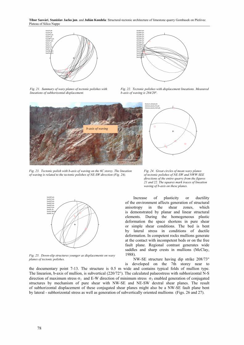
Two striking shear conjugated dextral fault systems of regionally distributed tectonic polishes with bends on these planes show brittle-ductile conditions of shear-zone deformations (Figs. 21 and 22). The oldest lineations suggest subhorizontal displacements at least of two generations. The structures were reactivated in younger deformation extensional stages in the form of oblique normal faults (Fig. 25),
Flexures or waving on conjugated tectonic polishes of NE-SW and NWW-SEE directions originated due to shear stress of simple shear as secondary structures in semiductile conditions (Figs. 23 and 24).
The tectonic polish planes are important particularly from the viewpoint of stability of blocks comprising the quarry walls. The blocks with moderate dips often slip down along these planes during reactivation resulting in young regional extension. The most common are planes of NE-SW direction dipping SE and less NW (Fig. 25).
77
Tibor Sasvári, Stanislav Jacko jun. and Julián Kondela: Structural-tectonic architecture of limestone quarry Gombasek on Plešivec Plateau of Silica Nappe
Fig. 21. Summary of wavy planes of tectonic polishes with lineations of subhorizontal displacement.
Fig. 22. Tectonic polishes with displacement lineations. Measured b-axis of waving is 284/20°.
Sas1P.plnSas3P.plnSas4PS.plnSas5P.plnSas38PS.plnSas51P.plnSas1L.linSas3L.linSas4LS.linSas5L.linSas38LS.linSas51LS.lin
Sas81P.plnSas83P.plnSas49P.plnSas32P.plnSas33P.plnSas34P.plnSas36P.plnSas38PM.plnSas20P.plnSas108P.plnSas114P.plnSas32L.linSas108.linSas115L.lin
Suma b zvlnenia.linZvlnene plochy SV.plnZvlnene plochy SZZ.pln
Fig. 23. Tectonic polish with b-axis of waving on the 6C storey. The lineation of waving is related to the tectonic polishes of NE-SW direction (Fig. 24).
Fig. 24. Great circles of mean wavy planes of tectonic polishes of NE-SW and NWW-SEE directions of the entire quarry from the figures 21 and 22. The squares mark traces of lineation waving of b-axis on these planes.
b-axis of waving
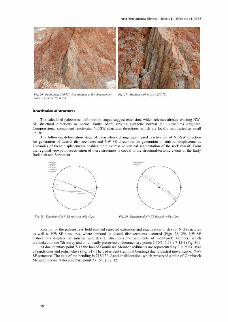
Increase of plasticity or ductility of the environment affects generation of structural anisotropy in the shear zones, which is demonstrated by planar and linear structural elements. During the homogeneous plastic deformation the space shortens in pure shear or simple shear conditions. The bed is bent by lateral stress in conditions of ductile deformation. In competent rocks mullions generate at the contact with incompetent beds or on the free fault plane. Regional contrast generates wide saddles and sharp crests in mullions (McClay, 1988).
NW-SE structure having dip strike 208/73° is developed on the 7th storey near to
the documentary point 7-13. The structure is 0.5 m wide and contains typical folds of mullion type. The linearion, b-axis of mullion, is subvertical (220/72°). The calculated palaeostress with subhorizontal N-S direction of maximum stress σ1 and E-W direction of minimum stress σ3 enabled generation of conjugated structures by mechanism of pure shear with NW-SE and NE-SW dextral shear planes. The result of subhorizontal displacement of these conjugated shear planes might also be a NW-SE fault plane bent by lateral - subhorizontal stress as well as generation of subvertically oriented mullioms (Figs. 26 and 27).
Fig. 25. Down-slip structures younger as displacements on wavy planes of tectonic polishes.
Sas35P.plnSas51P.plnSas64P.plnSas65P.plnSas66P.plnSas67P.plnSas35L.linSas51LNM.linSas65L.lin
78
Acta Montanistica Slovaca Ročník 11 (2006), číslo 1, 70-85
Fig. 26. Fault plane 209/73° with mullions at the documentary point 7-3 on the 7th storey.
Fig. 27. Mullions with b-axis=220/72°.
Reactivation of structures
The calculated paleostress deformation stages suggest extension, which releases already existing NW-SE structural directions as normal faults. More striking synthetic normal fault structures originate. Compressional component reactivates NE-SW structural directions, which are locally manifested as small uplifts.
The following deformation stage of palaeostress change again used reactivation of NE-SW direction for generation of dextral displacements and NW-SE directions for generation of sinistral displacements. Dynamics of these displacements enables more expressive vertical segmentation of the rock massif. From the regional viewpoint reactivation of these structures is coeval to the structural-tectonic events of the Early Badenian and Sarmatian.
Fig. 28. Reactivated NW-SE sinistral stike-slips. Fig. 29. Reactivated NW-SE dextral strike-slips.
Sas139P.plnSas140P.plnSas57P.plnSas140L.linSas57LNM.linSas57LS.lin
F zatahovacie.plnDatasets: 3
Rotation of the palaeostress field enabled repeated extension and reactivation of dextral N-S structures
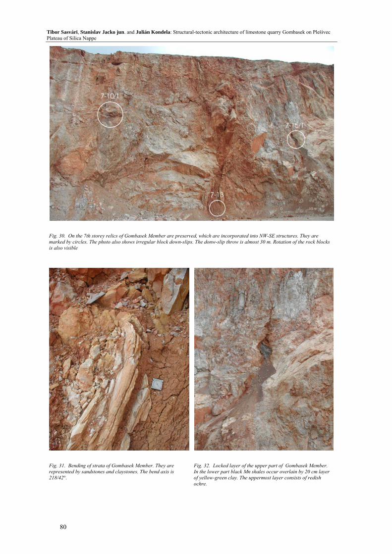
as well as NW-SE structures, where sinistral or dextral displacements occurred (Figs. 28, 29). NW-SE dislocations displace in sinistral and dextral directions the sediments of Gombasek Member, which are locked on the 7th storey and only locally preserved at documentary points 7-10/1, 7-13 a 7-15/1 (Fig. 30).
At documentary point 7-13 the locked Gombasek Member sediments are represented by 2 m thick layer of sandstones and redish clays (Fig. 31). The bed is bent (terminal bending) due to dextral movement of NW-SE structure. The axis of the bending is 218/42°. Another dislocation, which preserved a relic of Gombasek Member, occurs at documentary point 7 - 15/1 (Fig. 32).
79
Tibor Sasvári, Stanislav Jacko jun. and Julián Kondela: Structural-tectonic architecture of limestone quarry Gombasek on Plešivec Plateau of Silica Nappe
Fig. 30. On the 7th storey relics of Gombasek Member are preserved, which are incorporated into NW-SE structures. They are marked by circles. The photo also shows irregular block down-slips. The donw-slip throw is almost 30 m. Rotation of the rock blocks is also visible
Fig. 31. Bending of strata of Gombasek Member. They are represented by sandstones and claystones. The bend axis is 218/42°.
Fig. 32. Locked layer of the upper part of Gombasek Member. In the lower part black Mn shales occur overlain by 20 cm layer of yellow-green clay. The uppermost layer consists of redish ochre.
80
Acta Montanistica Slovaca Ročník 11 (2006), číslo 1, 70-85
Horst and graben structures
Regional uplift of the Plešivec Plateau at the end of Miocene may be also observed by structures of deformation stage with multiple displacements. It is mostly represented by reactivated structures, which generated a striking horst and graben structure in Gombasek quarry.
The palaeostress analysis shows NE-SW compression, which at the beginning of the deformation stage enabled thrusts generation affecting uplift of the area in NW-SE direction and origin of a young subvertical segmentation of Plešivec Plateau including the area of Gombasek quarry.
At the same time the palaeostress analysis shows NW-SE extension and following generation and reactivation of N-S (Fig. 33) and NE-SW (Fig. 34) normal fault structures. The location of Gombasek quarry preferably enabled graben-type subsidence along the NW and SE margin, while the middle part of the quarry left relatively stable forming natural NW-SE horst. Some NW-SE structures confirm initial relative uplift in relation to the successively younger subsiding graben structures. Relative stability of the NW-SE horst in the Gombasek quarry determines the least deformation of limestone blocks and related relatively low intensity of the karstification.
Fig. 33. Down-slip structures of N-S direction. Squares show down-slip lineations
Fig. 34. Down-slip structures of NE-SW direction. Squares show down-slip lineations
Sas27P.plnSas28P.plnSas29P.plnSas40P.plnSas58P.plnSas59P.plnSas71P.plnSas72P.plnSas73P.plnSas88P.plnSas135P.plnSas137P.plnSas138P.plnSas29LM.linSas40L.linSas58L.linSas59L.lin
Sas9PM.plnSas25P.plnSas26P.plnSas103P.plnSas111P.plnSas122P.plnSas9LM.linSas103L.lin
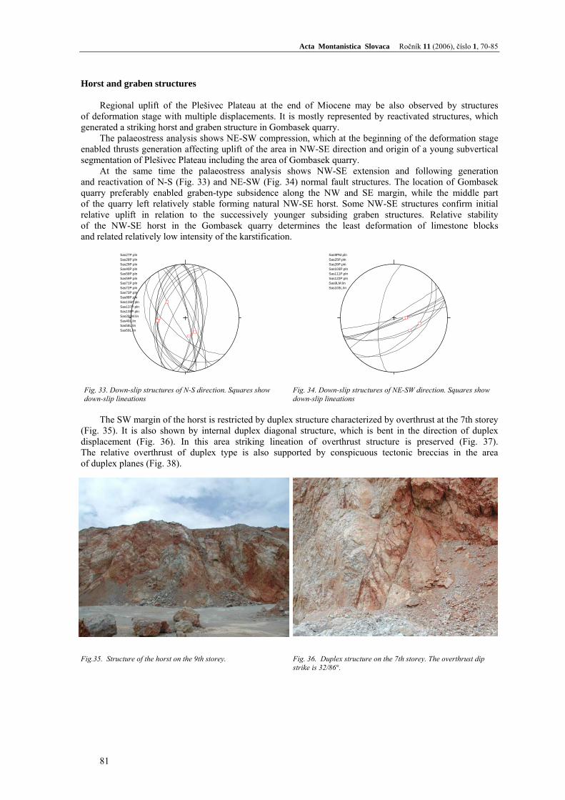
The SW margin of the horst is restricted by duplex structure characterized by overthrust at the 7th storey
(Fig. 35). It is also shown by internal duplex diagonal structure, which is bent in the direction of duplex displacement (Fig. 36). In this area striking lineation of overthrust structure is preserved (Fig. 37). The relative overthrust of duplex type is also supported by conspicuous tectonic breccias in the area of duplex planes (Fig. 38).
Fig.35. Structure of the horst on the 9th storey.
Fig. 36. Duplex structure on the 7th storey. The overthrust dip strike is 32/86°.
81
Tibor Sasvári, Stanislav Jacko jun. and Julián Kondela: Structural-tectonic architecture of limestone quarry Gombasek on Plešivec Plateau of Silica Nappe
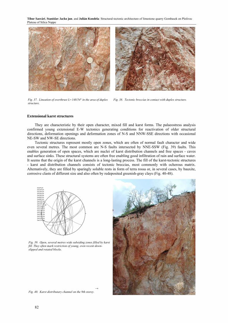
Fig. 37. Lineation of overthrust L=148/54° in the area of duplex structure.
Fig. 38. Tectonic breccias in contact with duplex structure.
Extensional karst structures
They are characteristic by their open character, mixed fill and karst forms. The palaeostress analysis confirmed young extensional E-W tectonics generating conditions for reactivation of older structural directions, deformation openings and deformation zones of N-S and NNW-SSE directions with occasional NE-SW and NW-SE directions.
Tectonic structures represent mostly open zones, which are often of normal fault character and wide even several metres. The most common are N-S faults intersected by NNE-SSW (Fig. 39) faults. This enables generation of open spaces, which are nuclei of karst distribution channels and free spaces - caves and surface sinks. These structural systems are often free enabling good infiltration of rain and surface water. It seems that the origin of the karst channels is a long-lasting process. The fill of the karst-tectonic structures - karst and distribution channels consists of tectonic breccias, most commonly with ocherous matrix. Alternatively, they are filled by sparingly soluble rests in form of terra rossa or, in several cases, by bauxite, corrosive clasts of different size and also often by redeposited greenish-gray clays (Fig. 40-48).
Sas2P.plnSas13P.plnSas14P.plnSas15P.plnSas19P.plnSas60P.plnSas98P.plnSas103P.plnSas108P.plnSas115 A P.plnSas116P.plnSas117P.plnSas119P.plnSas120P.plnSas128P.plnSas131P.plnSas133P.plnSas141P.pln
Fig. 39. Open, several metres wide subsiding zones filled by karst fill. They often mark restriction of young, even recent down-slipped and rotated blocks. → Fig. 40. Karst distributary channel on the 9th storey.
82

Acta Montanistica Slovaca Ročník 11 (2006), číslo 1, 70-85
Fig. 41. Crossing of structures enables generation of open spaces - caves.
Fig. 42. Dropstone decoration of the cave.
Fig. 43. Dislocation structures used for subvertical abysses on the 9C storey.
Fig. 44. Down-slip tectonic cave structure on the 10A storey.
Fig.45. Suvertical dislocation zone filled by tectonic breccias and bauxite on the 9C storey.
Fig. 46. Subvertical dislocation zone filled by tectonic breccias and bauxite on 10A storey.
83
Tibor Sasvári, Stanislav Jacko jun. and Julián Kondela: Structural-tectonic architecture of limestone quarry Gombasek on Plešivec Plateau of Silica Nappe
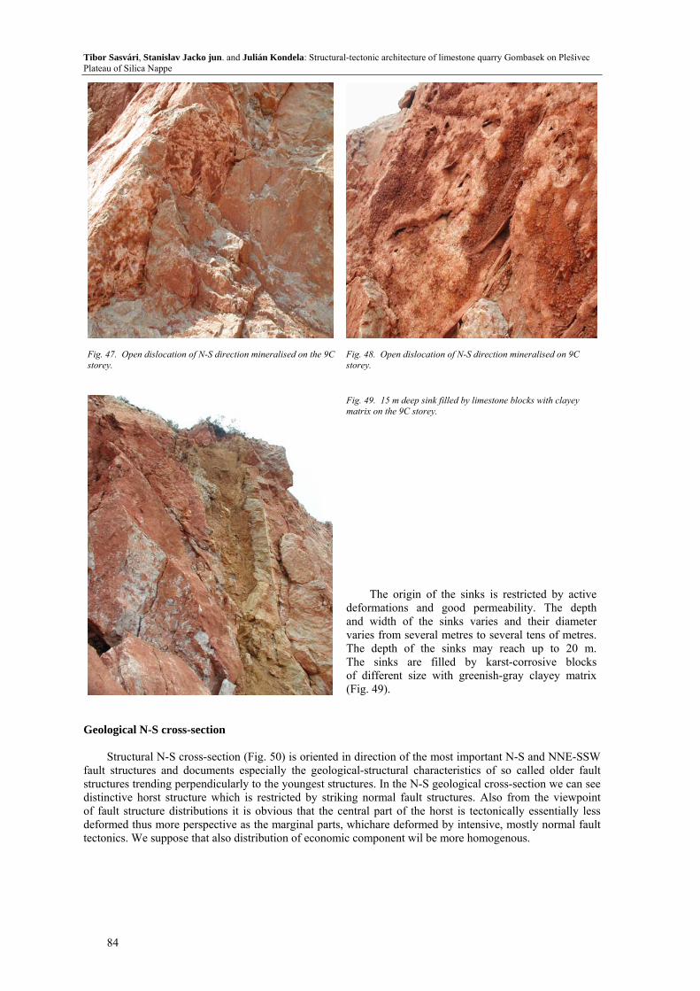
Fig. 47. Open dislocation of N-S direction mineralised on the 9C storey.
Fig. 48. Open dislocation of N-S direction mineralised on 9C storey.
Fig. 49. 15 m deep sink filled by limestone blocks with clayey matrix on the 9C storey.
The origin of the sinks is restricted by active
deformations and good permeability. The depth and width of the sinks varies and their diameter varies from several metres to several tens of metres. The depth of the sinks may reach up to 20 m. The sinks are filled by karst-corrosive blocks of different size with greenish-gray clayey matrix (Fig. 49).
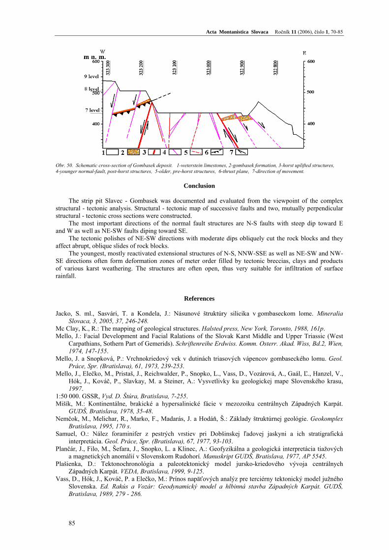
Geological N-S cross-section
Structural N-S cross-section (Fig. 50) is oriented in direction of the most important N-S and NNE-SSW fault structures and documents especially the geological-structural characteristics of so called older fault structures trending perpendicularly to the youngest structures. In the N-S geological cross-section we can see distinctive horst structure which is restricted by striking normal fault structures. Also from the viewpoint of fault structure distributions it is obvious that the central part of the horst is tectonically essentially less deformed thus more perspective as the marginal parts, whichare deformed by intensive, mostly normal fault tectonics. We suppose that also distribution of economic component wil be more homogenous.
84
Acta Montanistica Slovaca Ročník 11 (2006), číslo 1, 70-85
Obr. 50. Schematic cross-section of Gombasek deposit. 1-weterstein limestones, 2-gombasek formation, 3-horst uplifted structures, 4-younger normal-fault, post-horst structures, 5-older, pre-horst structures, 6-thrust plane, 7-direction of movement.
Conclusion
The strip pit Slavec - Gombasek was documented and evaluated from the viewpoint of the complex
structural - tectonic analysis. Structural - tectonic map of successive faults and two, mutually perpendicular structural - tectonic cross sections were constructed.
The most important directions of the normal fault structures are N-S faults with steep dip toward E and W as well as NE-SW faults diping toward SE.
The tectonic polishes of NE-SW directions with moderate dips obliquely cut the rock blocks and they affect abrupt, oblique slides of rock blocks.
The youngest, mostly reactivated extensional structures of N-S, NNW-SSE as well as NE-SW and NW-SE directions often form deformation zones of meter order filled by tectonic breccias, clays and products of various karst weathering. The structures are often open, thus very suitable for infiltration of surface rainfall.
References
Jacko, S. ml., Sasvári, T. a Kondela, J.: Násunové štruktúry silicika v gombaseckom lome. Mineralia Slovaca, 3, 2005, 37, 246-248.
Mc Clay, K., R.: The mapping of geological structures. Halsted press, New York, Toronto, 1988, 161p. Mello, J.: Facial Development and Facial Ralations of the Slovak Karst Middle and Upper Triassic (West
Carpathians, Sothern Part of Gemerids). Schriftenreihe Erdwiss. Komm. Osterr. Akad. Wiss, Bd.2, Wien, 1974, 147-155.
Mello, J. a Snopková, P.: Vrchnokriedový vek v dutinách triasových vápencov gombaseckého lomu. Geol. Práce, Spr. (Bratislava), 61, 1973, 239-253.
Mello, J., Elečko, M., Pristaš, J., Reichwalder, P., Snopko, L., Vass, D., Vozárová, A., Gaál, Ľ., Hanzel, V., Hók, J., Kováč, P., Slavkay, M. a Steiner, A.: Vysvetlivky ku geologickej mape Slovenského krasu, 1997.
1:50 000. GSSR, Vyd. D. Štúra, Bratislava, 7-255. Mišík, M.: Kontinentálne, brakické a hypersalinické fácie v mezozoiku centrálnych Západných Karpát.
GUDŠ, Bratislava, 1978, 35-48. Nemčok, M., Melichar, R., Marko, F., Madarás, J. a Hodáň, Š.: Základy štruktúrnej geológie. Geokomplex
Bratislava, 1995, 170 s. Samuel, O.: Nález foraminifer z pestrých vrstiev pri Dobšinskej ľadovej jaskyni a ich stratigrafická
interpretácia. Geol. Práce, Spr. (Bratislava), 67, 1977, 93-103. Plančár, J., Filo, M., Šefara, J., Snopko, L. a Klinec, A.: Geofyzikálna a geologická interpretácia tiažových
a magnetických anomálií v Slovenskom Rudohorí. Manuskript GUDŠ, Bratislava, 1977, AP 5545. Plašienka, D.: Tektonochronológia a paleotektonický model jursko-kriedového vývoja centrálnych
Západných Karpát. VEDA, Bratislava, 1999, 9-125. Vass, D., Hók, J., Kováč, P. a Elečko, M.: Prínos napäťových analýz pre terciérny tektonický model južného
Slovenska. Ed. Rakús a Vozár: Geodynamický model a hlbinná stavba Západných Karpát. GUDŠ, Bratislava, 1989, 279 - 286.
85