“strong winds, big seas and wild scenery” - sapper...
TRANSCRIPT
1
“Strong winds, big seas and wild scenery”
Solo cruising on the SW coast of Ireland – Bob Hendicott on Rosinis – April/May 2013
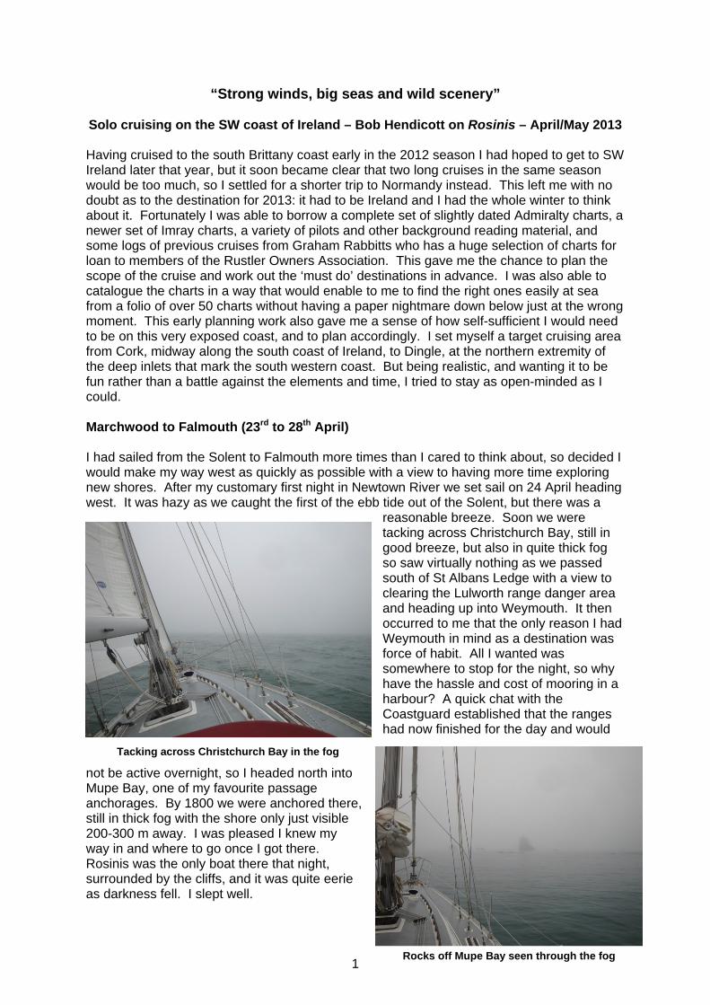
Having cruised to the south Brittany coast early in the 2012 season I had hoped to get to SW Ireland later that year, but it soon became clear that two long cruises in the same season would be too much, so I settled for a shorter trip to Normandy instead. This left me with no doubt as to the destination for 2013: it had to be Ireland and I had the whole winter to think about it. Fortunately I was able to borrow a complete set of slightly dated Admiralty charts, a newer set of Imray charts, a variety of pilots and other background reading material, and some logs of previous cruises from Graham Rabbitts who has a huge selection of charts for loan to members of the Rustler Owners Association. This gave me the chance to plan the scope of the cruise and work out the ‘must do’ destinations in advance. I was also able to catalogue the charts in a way that would enable to me to find the right ones easily at sea from a folio of over 50 charts without having a paper nightmare down below just at the wrong moment. This early planning work also gave me a sense of how self-sufficient I would need to be on this very exposed coast, and to plan accordingly. I set myself a target cruising area from Cork, midway along the south coast of Ireland, to Dingle, at the northern extremity of the deep inlets that mark the south western coast. But being realistic, and wanting it to be fun rather than a battle against the elements and time, I tried to stay as open-minded as I could. Marchwood to Falmouth (23rd to 28th April) I had sailed from the Solent to Falmouth more times than I cared to think about, so decided I would make my way west as quickly as possible with a view to having more time exploring new shores. After my customary first night in Newtown River we set sail on 24 April heading west. It was hazy as we caught the first of the ebb tide out of the Solent, but there was a
reasonable breeze. Soon we were tacking across Christchurch Bay, still in good breeze, but also in quite thick fog so saw virtually nothing as we passed south of St Albans Ledge with a view to clearing the Lulworth range danger area and heading up into Weymouth. It then occurred to me that the only reason I had Weymouth in mind as a destination was force of habit. All I wanted was somewhere to stop for the night, so why have the hassle and cost of mooring in a harbour? A quick chat with the Coastguard established that the ranges had now finished for the day and would
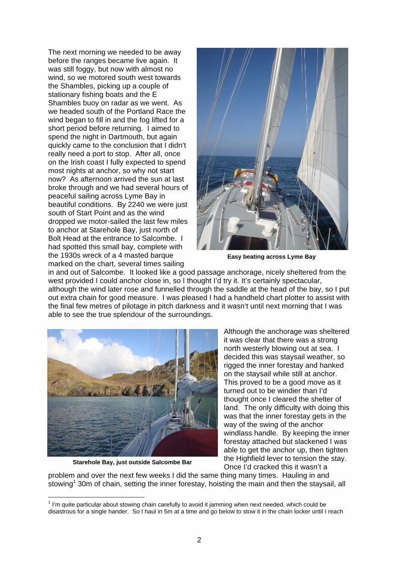
not be active overnight, so I headed north into Mupe Bay, one of my favourite passage anchorages. By 1800 we were anchored there, still in thick fog with the shore only just visible 200-300 m away. I was pleased I knew my way in and where to go once I got there. Rosinis was the only boat there that night, surrounded by the cliffs, and it was quite eerie as darkness fell. I slept well.
Tacking across Christchurch Bay in the fog
Rocks off Mupe Bay seen through the fog
2
The next morning we needed to be away before the ranges became live again. It was still foggy, but now with almost no wind, so we motored south west towards the Shambles, picking up a couple of stationary fishing boats and the E Shambles buoy on radar as we went. As we headed south of the Portland Race the wind began to fill in and the fog lifted for a short period before returning. I aimed to spend the night in Dartmouth, but again quickly came to the conclusion that I didn’t really need a port to stop. After all, once on the Irish coast I fully expected to spend most nights at anchor, so why not start now? As afternoon arrived the sun at last broke through and we had several hours of peaceful sailing across Lyme Bay in beautiful conditions. By 2240 we were just south of Start Point and as the wind dropped we motor-sailed the last few miles to anchor at Starehole Bay, just north of Bolt Head at the entrance to Salcombe. I had spotted this small bay, complete with the 1930s wreck of a 4 masted barque marked on the chart, several times sailing in and out of Salcombe. It looked like a good passage anchorage, nicely sheltered from the west provided I could anchor close in, so I thought I’d try it. It’s certainly spectacular, although the wind later rose and funnelled through the saddle at the head of the bay, so I put out extra chain for good measure. I was pleased I had a handheld chart plotter to assist with the final few metres of pilotage in pitch darkness and it wasn’t until next morning that I was able to see the true splendour of the surroundings.
Although the anchorage was sheltered it was clear that there was a strong north westerly blowing out at sea. I decided this was staysail weather, so rigged the inner forestay and hanked on the staysail while still at anchor. This proved to be a good move as it turned out to be windier than I’d thought once I cleared the shelter of land. The only difficulty with doing this was that the inner forestay gets in the way of the swing of the anchor windlass handle. By keeping the inner forestay attached but slackened I was able to get the anchor up, then tighten the Highfield lever to tension the stay. Once I’d cracked this it wasn’t a
problem and over the next few weeks I did the same thing many times. Hauling in and stowing1 30m of chain, setting the inner forestay, hoisting the main and then the staysail, all
1 I’m quite particular about stowing chain carefully to avoid it jamming when next needed, which could be disastrous for a single hander. So I haul in 5m at a time and go below to stow it in the chain locker until I reach
The rocks off Mupe Bay – still in the fog
Easy beating across Lyme Bay
Starehole Bay, just outside Salcombe Bar

3
whilst also piloting out of a confined area is hard work, so rushing is not an option and I was ready for a breather as we cleared Bolt Head and set course for Falmouth. The reward was exhilarating sailing with 2 reefs in the main, a tight luff on the staysail and Millie (the Monitor windvane) steering us accurately as we beat at 5-6 knots into a steady F5. With the spring tide under us we soon had Eddystone Lighthouse in sight and by 1350 we were just south, with clear views into Plymouth Sound, of the coast east and west and north onto the familiar territory of Dartmoor.
Rosinis sailed herself through the afternoon and I had a couple of catnaps as we picked up Dodman Point fine on the starboard bow and the Lizard on the port bow. It became clear that we would be arriving in Falmouth at last light so I decided to cook supper before we got too close. As we approached a timely wind shift lifted us towards St Anthony’s Head and a single tack took us past Black Rock and into Carrick Roads. By 2130 we were at anchor, just off Falmouth Visitors Yacht Haven (by now I was into the swing of anchoring) ready to move onto the pontoon the next morning. It had been a great sail from the Solent to Falmouth in just 3 days with no shore stops and Rosinis had gone really well under staysail in a blow – much better than struggling on with a baggy, heavily furled genoa. The next morning I felt quite lethargic and it wasn’t until 1130 that we moved the short distance onto the pontoons so I could get provisions and water. I was keen to keep moving, first to Newlyn, then on to the Scillies, so didn’t want to stay here long. However it was blowing hard and I spent 2 full days in Falmouth waiting for good wind to get around the Lizard, combined with a reasonable forecast for the Scillies. I enjoy the bustle and comings and goings of Falmouth and almost always manage to find another Rustler 36 there (no surprise as the Rustler yard is just up river). This occasion was no different and I soon
the point where it may break out and then just wind fast. This takes time but it’s worth it and I’ve never had a chain jam when anchoring.
Beating at 5-6 knots towards Eddystone in a F5 Eddystone, with Plymouth Sound to the right
Rosinis in Falmouth Visitors Yacht Haven
Beating at 5-6 knots towards Eddystone in F5
4
spotted John Pinchbeck on Reiver. It turned out that we have a number of friends and acquaintances in common and we spent several hours chatting, drinking coffee and red wine, and comparing notes on our boats. Onwards to the Scilly Isles (29th April to 3rd May) I have met many crews in the past waiting for days in Falmouth for a break in the weather that would allow them to head west to the Scillies, so I considered myself lucky to be able to set off for Newlyn on 29 April. Why didn’t I head straight for the islands? Well, whilst I had sailed west of Falmouth several times in the past it had always been in races (normally
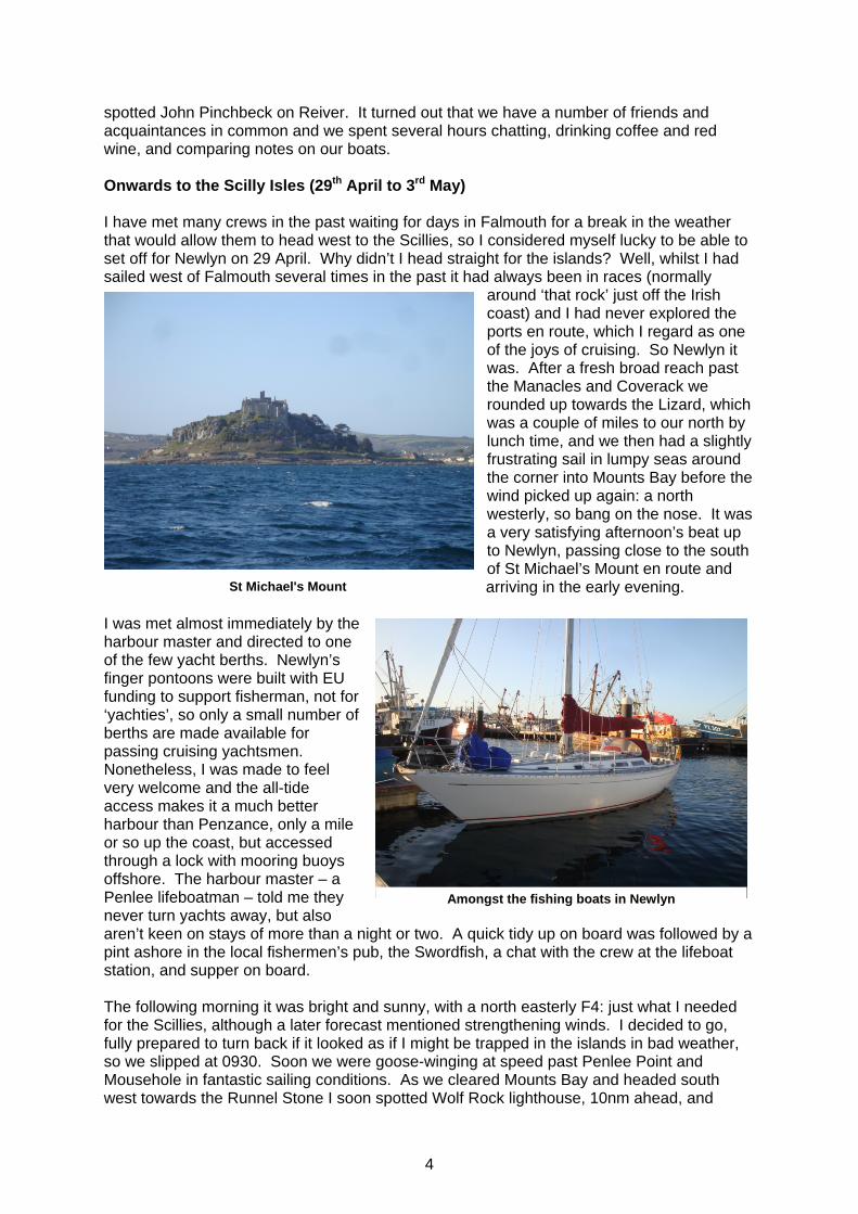
around ‘that rock’ just off the Irish coast) and I had never explored the ports en route, which I regard as one of the joys of cruising. So Newlyn it was. After a fresh broad reach past the Manacles and Coverack we rounded up towards the Lizard, which was a couple of miles to our north by lunch time, and we then had a slightly frustrating sail in lumpy seas around the corner into Mounts Bay before the wind picked up again: a north westerly, so bang on the nose. It was a very satisfying afternoon’s beat up to Newlyn, passing close to the south of St Michael’s Mount en route and arriving in the early evening.
I was met almost immediately by the harbour master and directed to one of the few yacht berths. Newlyn’s finger pontoons were built with EU funding to support fisherman, not for ‘yachties’, so only a small number of berths are made available for passing cruising yachtsmen. Nonetheless, I was made to feel very welcome and the all-tide access makes it a much better harbour than Penzance, only a mile or so up the coast, but accessed through a lock with mooring buoys offshore. The harbour master – a Penlee lifeboatman – told me they never turn yachts away, but also aren’t keen on stays of more than a night or two. A quick tidy up on board was followed by a pint ashore in the local fishermen’s pub, the Swordfish, a chat with the crew at the lifeboat station, and supper on board. The following morning it was bright and sunny, with a north easterly F4: just what I needed for the Scillies, although a later forecast mentioned strengthening winds. I decided to go, fully prepared to turn back if it looked as if I might be trapped in the islands in bad weather, so we slipped at 0930. Soon we were goose-winging at speed past Penlee Point and Mousehole in fantastic sailing conditions. As we cleared Mounts Bay and headed south west towards the Runnel Stone I soon spotted Wolf Rock lighthouse, 10nm ahead, and
St Michael's Mount
Amongst the fishing boats in Newlyn

5
shortly after sighted Longships lighthouse, off to the north west past Gwennap Head. Through binoculars I managed to pick out the Minack cliff theatre to the north. As we cleared land the wind backed to the north and freshened to F5, so by the time we reached
Wolf Rock I had a reef in the main and 2 reefs in the genoa and we were still fast reaching at 6.5+ knots. By 1350, just as we passed to the south of the south western corner of the Traffic Separation Scheme I sighted land ahead at 12nm range. We then had a fast reach to the south of St Mary’s, spotting many of the pilotage marks as we closed the islands: St Martin’s Day Mark, Round Island lighthouse, St Agnes’ Day Mark and Bishop Rock lighthouse were all visible. By 1600 we were anchored in 4 meters of crystal clear water in The Cove between St Agnes and Gugh. What a spectacular setting! These two islands are
joined at low water by a causeway that submerges at high water springs and in the bright sunshine it was as if we were anchored, all alone, in a tropical paradise – although it was still blowing hard and I put out 30m of chain, then more as the tide rose. My big CQR doesn’t like sand and I was to learn from the few other cruisers I met on this trip that most are now using Rocna anchors. My solution was to put chain where it’s needed; on the sea bed rather than in the locker. For the rest of my trip I had good swinging room almost everywhere I went and normally put out at least 40m. Once settled I had a well earned cuppa in the cockpit, mesmerised by the wonderful
surroundings. As I settled down for the night I was slightly taken aback by the late forecast on Navtex which was for F5-7. Together with the creaking of the rope on the chain hook it meant I had a fitful night’s sleep.
Wolf Rock lighthouse End of the Lands End TSS
A smudge of land on the horizon
Anchored in The Cove between St Agnes and Gugh

6
As with many things taken for granted with a fit and able crew, some operations need some adaptation to be managed singlehandedly, so the next morning I worked out how to inflate, launch and recover the dinghy on my own, and how to get the outboard on it without it visiting the seabed (my previous long cruises had not really needed the dinghy, but it was to prove essential in Ireland). It turned out to be much easier than I expected. Even with my heavy Lodestar dinghy I could get it on deck, inflate it and put it over the side on my own, and recover it with a halliard and cradle of ropes to spread the load. Thank goodness for 2-
stroke outboards: I managed to lower it into the dinghy by hand on a single rope, then climb down and attach it to the transom. By the end of my cruise I could do this happily in quite bumpy water in no more than about 20 minutes. Having sorted my travel arrangements I headed off to explore the picturesque islands of St Agnes and Gugh, resplendent with wild flowers and criss-crossed with sleepy lanes.
That afternoon, having returned on board for lunch, I decided to head across to St Mary’s, the next island to the north. I motored the mile or so across the sound and was surprised to find moorings in the bay at Porth Cressa where I had expected to anchor. Although I’d towed the dinghy it seemed a long way to the head of the beach, so I called it a day and decided to move round to St Mary’s Pool the next morning where I knew there would be
Sunset over St Agnes
Looking SW towards Bishop Rock
Looking NW from St Agnes
Rosinis in paradise

7
moorings. It would provide a much better base from which to explore the islands’ capital, Hugh Town. By 1045 I was there, having made good use of the essentials for Scillies pilotage (see photo). It was also a good opportunity to identify a few more Scillies landmarks. I was soon back in the dinghy and heading ashore to stock up the galley and do some laundry. It was with some surprise that I found the World Pilot Gig championships about to take place over the early May Bank Holiday weekend. It was with rather less surprise that I then found Hugh Town bursting at the seams with gig crews and their followers from
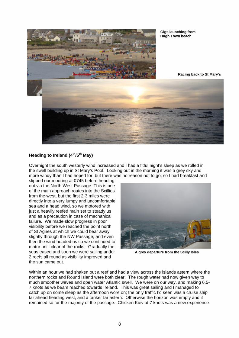
almost every West Country rowing club and many more from across the globe. Gigs were originally used to put pilots onto inbound vessels, thereby securing valuable pilotage fees; hence the need for speed, to beat competing pilots. They were also used as rescue craft prior to the formation of RNLI, and doubtless provided a seaworthy means of salvaging cargo from the many wrecks around the Scillies coast. Today gig racing is almost a religion in the Islands. My afternoon was spent soaking up the atmosphere and the sun, watching the supply vessel, Scillonian, coming and going from the pier and exploring Hugh Town, particularly the Garrison and the Star Castle Hotel, another pilotage landmark. The next day I had hoped to leave for Ireland, but a forecast of ‘F7 occasional F8’ off the Irish coast put me off and I stayed put in Hugh Town for a further 24 hours. Although the wind did rise slightly where I was, I really wished I’d gone. Later I found Rosinis’ stern bumping against the empty mooring behind me so decided to move (St Mary’s Pool moorings are close together and exposed to the west and north west). After listening to the forecast that evening I made a dash ashore to watch the first of the pilot gig races together with the crews of a couple of other yachts moored close by. It was quite a spectacle watching almost 100 boats all racing back to Hugh Town from a start line off St Agnes and it just about made up for the fact that I hadn’t been able to sail. As night fell I dashed back on board to get the dinghy packed away before it got dark. I was determined to head off the next morning and kept my fingers crossed for good weather.
Sun cream, sun glasses, hand bearing compass and binoculars: essentials for Scillies pilotage
St Mary's Pool and Hugh Town from the Star Castle Hotel. MV Scillonian moored at the pier
8
Heading to Ireland (4th/5th May) Overnight the south westerly wind increased and I had a fitful night’s sleep as we rolled in the swell building up in St Mary’s Pool. Looking out in the morning it was a grey sky and more windy than I had hoped for, but there was no reason not to go, so I had breakfast and slipped our mooring at 0745 before heading out via the North West Passage. This is one of the main approach routes into the Scillies from the west, but the first 2-3 miles were directly into a very lumpy and uncomfortable sea and a head wind, so we motored with just a heavily reefed main set to steady us and as a precaution in case of mechanical failure. We made slow progress in poor visibility before we reached the point north of St Agnes at which we could bear away slightly through the NW Passage, and even then the wind headed us so we continued to motor until clear of the rocks. Gradually the seas eased and soon we were sailing under 2 reefs all round as visibility improved and the sun came out. Within an hour we had shaken out a reef and had a view across the islands astern where the northern rocks and Round Island were both clear. The rough water had now given way to much smoother waves and open water Atlantic swell. We were on our way, and making 6.5-7 knots as we beam reached towards Ireland. This was great sailing and I managed to catch up on some sleep as the afternoon wore on; the only traffic I’d seen was a cruise ship far ahead heading west, and a tanker far astern. Otherwise the horizon was empty and it remained so for the majority of the passage. Chicken Kiev at 7 knots was a new experience
Racing back to St Mary’s
Gigs launching from Hugh Town beach
A grey departure from the Scilly Isles

9
that evening and then it was back to catnaps all through the night interrupted only by the need to stay awake as we passed close to the Kinsale Gas Field at about 0400, where seismic surveys were under way (according to Navtex) and there were many small vessels moving apparently randomly. Then it was on to the coast which we sighted at 0620 before making our way past Roches Point and into Cork Harbour. There we turned hard left into the Owenboys River and Crosshaven, where we finally moored at 0930 at the Royal Cork Yacht Club. The team at the Royal Cork made me very welcome: I think I was one of their first UK-based cruisers of
the season. Remarkably I had had enough sleep overnight to feel reasonably fresh so had no difficulty enjoying their hospitality. The only minor glitch on the crossing was that the chart plotter hadn’t switched from the UK cartridge to the Irish one, despite having been tested before we departed. Oh well – it was only 11 days since we had left the Solent and here we were in Ireland, having had a great few days en route in the Scillies – not bad!
The southern coast of Ireland (6th to 15th May) Although it would have been great to spend a little more time in Crosshaven I couldn’t ignore the south easterly breeze that had set in overnight, so the next day I had an early start, cleaned ship, fuelled and watered and was away before 1000 having suffered the second minor mishap of the trip: the bow thruster jammed2 as I was leaving the fuelling berth amidst the Irish National Optimist team selection (think of almost a hundred 8-9 year olds vying to be first to the starting area and you’ll get the picture).
2 This was to be the last use I had of the bow thruster this season, but I became much better at manoeuvring Rosinis as a result.
Roches Point lighthouse and the entrance to Cork Harbour
Crosshaven village: the Royal Cork Yacht Club is up river on the left
Heading west towards Kinsale
In Irish waters
10
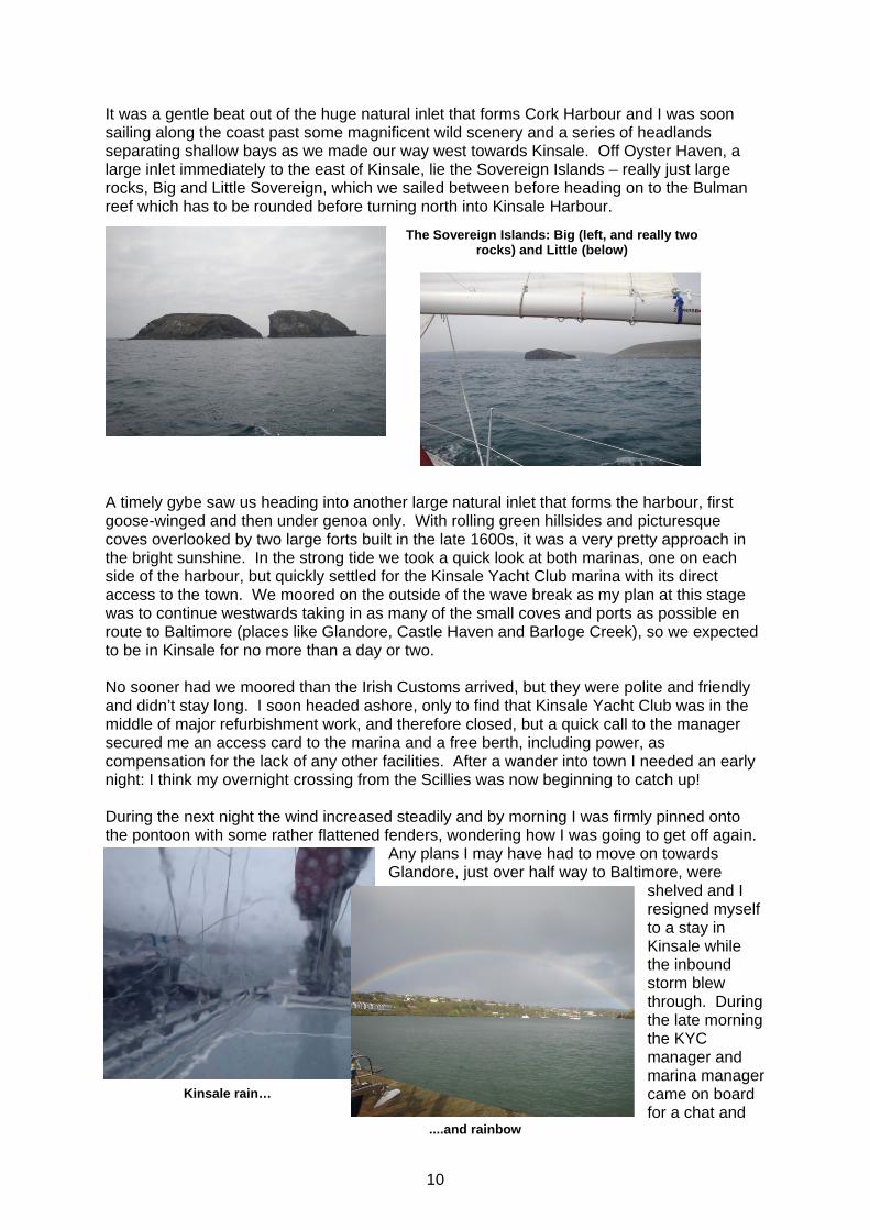
It was a gentle beat out of the huge natural inlet that forms Cork Harbour and I was soon sailing along the coast past some magnificent wild scenery and a series of headlands separating shallow bays as we made our way west towards Kinsale. Off Oyster Haven, a large inlet immediately to the east of Kinsale, lie the Sovereign Islands – really just large rocks, Big and Little Sovereign, which we sailed between before heading on to the Bulman reef which has to be rounded before turning north into Kinsale Harbour.
A timely gybe saw us heading into another large natural inlet that forms the harbour, first goose-winged and then under genoa only. With rolling green hillsides and picturesque coves overlooked by two large forts built in the late 1600s, it was a very pretty approach in the bright sunshine. In the strong tide we took a quick look at both marinas, one on each side of the harbour, but quickly settled for the Kinsale Yacht Club marina with its direct access to the town. We moored on the outside of the wave break as my plan at this stage was to continue westwards taking in as many of the small coves and ports as possible en route to Baltimore (places like Glandore, Castle Haven and Barloge Creek), so we expected to be in Kinsale for no more than a day or two. No sooner had we moored than the Irish Customs arrived, but they were polite and friendly and didn’t stay long. I soon headed ashore, only to find that Kinsale Yacht Club was in the middle of major refurbishment work, and therefore closed, but a quick call to the manager secured me an access card to the marina and a free berth, including power, as compensation for the lack of any other facilities. After a wander into town I needed an early night: I think my overnight crossing from the Scillies was now beginning to catch up! During the next night the wind increased steadily and by morning I was firmly pinned onto the pontoon with some rather flattened fenders, wondering how I was going to get off again.
Any plans I may have had to move on towards Glandore, just over half way to Baltimore, were
shelved and I resigned myself to a stay in Kinsale while the inbound storm blew through. During the late morning the KYC manager and marina manager came on board for a chat and
Kinsale rain…
The Sovereign Islands: Big (left, and really two rocks) and Little (below)
....and rainbow

11
also welcomed a newly arrived French yacht before offering us both berths inside the marina, counselling us that the outer pontoons would be particularly uncomfortable in the south easterly severe gale that was forecast. After a broadside tow off the pontoon by the KYC rib, and the challenge of mooring a long-keeled yacht in a marina in heavy weather, albeit with some help, it was a relief to be storm bound somewhere with power, water and provisions all easily at hand, rather than at anchor somewhere remote. It could have been much worse and Kinsale is not a bad place to be stuck for a few days…….and it was three more extremely windy, and often rainy, days before I was able to move again. Whilst in Kinsale I took the chance to explore the town, visit the markets, bars and restaurants, and walk amidst the wonderful scenery each side of the harbour, including the forts and coves I’d seen on the way in. The KYC team were very helpful with weather forecasts and in support of my quest to fix the electronic chart cartridge, which entailed a (successful) day out and a bus ride to Cork.
Kinsale
Overall it was a busy time in a great location, but by the time I was able to move again I was desperate to get going. Finally, after several early starts that turned out to be false alarms I decided it was ‘a goer’ even though it would be a beat into strong westerlies. I rigged the staysail (again) and we were away by 0815 accompanied by the French yacht that had been making similar decisions to me for the past few days. It was bright, occasionally sunny, and still very blustery as we headed south to round the Old Head of Kinsale. As we turned west the French headed straight on towards the Scillies. From here on it was a beat into a steady F5 and solid seas as the swell rolled in from the south west. Rosinis handled it brilliantly and we made good progress past the many names I’d been studying in the pilot throughout the winter: Courtmacsherry Bay, Seven Heads, Clonakilty Bay and Galley Head. It then seemed

12
to take forever to beat into Glandore Bay in winds that were now reaching 36 knots apparent, bringing regular green water across the deck and into the cockpit3. I managed to get some great video coverage from under the shelter of the sprayhood and continued to be amazed at how comfortable the Rustler is in these conditions. Life continued as normal down below. I had decided as I left Kinsale that, in view of lost time, I would head as far west as I could in the conditions, foregoing the opportunity to call into some of the places I’d hoped to. Eventually we made it into Glandore Bay, sighting Rabbit Island, just off the entrance to Glandore harbour, High and Low Islands, and the Stags, a large rocky outcrop that had probably claimed a few vessels over the years. As evening fell we were between The Stags and the southern entrance to Baltimore harbour and, with the wind finally easing, we motor- sailed the last 5 miles, dropping anchor off Sherkin Island at 2230. It was another hour before I’d tidied up and had a drink. This was the heaviest beat of any distance I’d attempted in such conditions and I felt Rosinis and I were continuing to break new boundaries all the time. It had been really rewarding sailing, although not without a few slightly anxious moments. Although we had maintained good boat speed through the water, averaging almost 5 knots over 64nm, our tacking angle in the heavy seas was well over 110˚. Despite continuous water over the deck there had been little to pump out and we
seemed to have taken in no more than 3-4” of water in the bilge throughout the passage. As I headed for my bunk, very satisfied, I couldn’t help notice how dark it was outside – no light pollution here!
3 Several times the port cockpit seat filled completely when we were on a starboard tack, and I was delighted to be able to test one of my winter adaptations – a tube from seat level to cockpit sole that allows trapped water to drain quickly. It worked well.
Old Head of Kinsale, with Coutmacsherry Bay beyond
Lot's Wife seen from Sherkin Island across the ruins of the Abbey

13
The next morning was grey and dull, but I could still make out the large Baltimore daymark known as Lot’s Wife high on the cliffs to the east side of the entrance. After launching the dinghy I set off for the jetty from which the passenger ferry to Baltimore runs on a regular basis. There I met the crew of a 46 footer that had also come from Kinsale the previous day, but they’d motored the whole way and had an extremely uncomfortable trip. They seemed impressed that I’d sailed it. I felt even more impressed!
On arrival in Baltimore – I’d expected a sizeable town, but it’s really no more than a village – I found it was the weekend of an Irish fiddle festival, so all the bars were alive with folk music – how very Irish! Later I made my way back so I could walk across to look at Gascanane Sound which runs between Sherkin Island and Cape Clear Island to the west, and through which I planned to sail the next day. On my return I was asked for help by a local farmer and oyster fisherman to herd his cows into another field. This earned me a lift back to the Islanders Rest, just above my anchorage, where I stopped for a welcomed shower. The next morning the early forecast and a cursory look on deck suggested it was still blowing hard, so I returned to bed. Then through the morning I prevaricated and eventually left just after lunch, reasoning that the local Glenans sailing school yachts were still out, albeit heavily reefed, therefore so should I be. It was blowing 23-25 knots in the shelter of
Rosinis at anchor (centre) in Baltimore harbour with Baltimore in the background
Looking across Gascanane Sound to Cape Clear Island
Beating past Cape Clear Island
Fastnet Rock

14
Sherkin Island, so I weighed anchor slowly, stowing chain as I went and set the staysail with double reefed main whilst still in the harbour. Once ready we went for it, aiming to sail around Cape Clear Island rather than through Gascanane Sound, sheltering under the lee of the island for as long as we could, before blasting across Long Island Bay and into Schull, another picturesque natural harbour. It was actually blowing harder than expected, but the sail plan was just right and a couple of tacks saw us at the south west extremity of Cape Clear Island in big swell and large waves, but moving fast with the Fastnet Rock just visible about 4nm to our west. Once around the corner it became a fetch across Long Island Bay, leaving West Calf Island just to our lee, and then a fast reach across to the eastern end of Long Island and into Schull Harbour. We raced in at 7 knots in clouds of spray and very
slickly dropped sail just in time to dip our ensign to an Irish warship anchored there, but this brought no response whatsoever, so we anchored just off the pier, had a celebratory beer and tidied up. What a sail! During this passage we clocked our 500th mile since leaving the Solent and learned that, if in doubt, go and have a look. It will probably be tremendous sailing, and if not don’t be too proud to turn back. The other thing that struck me was the wonderful names on the chart – Long Island Bay, Cape Clear, Roaring Water Bay, Schull etc etc.
The following day it was cold and drizzly.
I had planned to go ashore in Schull which has a reputation for brilliant seafood, but the forecast talked of another fast moving depression bringing gale force winds by the end of the day. So we left promptly and motored in calm conditions through Long Island Sound with the weather clearing and brightening as we headed for Crookhaven, only 10nm away. Crookhaven is a real gem: a perfectly sheltered elongated harbour open only to the east. Despite the abundant moorings I decided to anchor, trusting my own ground tackle in preference to the unknown condition of local buoys that probably hadn’t been serviced, although I later discovered that these moorings are well maintained and the only other yacht there had just moved from anchor to one of the moorings in anticipation of the inbound storm. I decided to stay put, anchored just a stone’s throw from the village waterfront, and quickly discovered that the other yacht, a US registered boat called Exodus, had been in Baltimore harbour the night I arrived and left early the following morning. I went ashore to get provisions and stepped back in time into a village store straight from the 1930s, complete with power cut which meant I couldn’t pay for (or even know the cost of) the limited supplies I was able to buy. Mid way through my purchases Dermot, the publican of O’Sullivan’s Bar
Schull
Crookhaven from Rosinis Rosinis from O'Sullivan's

15
next door, stuck his head around the door and invited me in for a beer. There I also met Kevin and Lauren from Exodus and we later had drinks on board Rosinis and supper ashore together. The late forecast for Shannon and Fastnet was westerly F10 and that night we were buffeted by some very strong gusts from all directions: north, west and, just occasionally, east. The next morning’s forecast was for slightly less wind – just F8 – so after coffee on Exodus and a quick trip ashore in the morning I set off to walk along the cliffs to Brow Head, the headland immediately to the east of Mizen Head (the SW extremity of Ireland). The cliff top views were incredible: west to Mizen Head, south to Cape Clear and the Fastnet Rock, and east to Crookhaven and into Long Island Bay. Staying upright in the wind was quite a feat at times.
Back on board with a better forecast for the next day, I prepared to move in the morning and stowed the dinghy on deck. Exodus was planning to leave very early, bound for Valentia. I was heading for Bantry Bay so didn’t need quite such an early start. The Irish west coast (16th to 22nd May) It was still dark when I woke and Exodus had already left, so I decided to weigh anchor just as it was getting light. I was slightly concerned that I may have snagged the ground chain of one of the moorings as we’d been blasted back and forth by strong gusts over the previous few days, but the anchor came up cleanly and by 0530 we were motoring with the main up and almost no wind. With a clean hull and prop we made good progress – over 5.8 knots, which is unusual for Rosinis with her relatively small 27hp engine. Soon we were past Brow Head, looking up at the cliffs we’d been looking down from the previous day, with the Fastnet light flashing reassuringly away to the south. It was a very uneventful passage around Mizen Head and onto the west coast as we made our way past Three Castle Head, then
Mizen Head on a calm day
Panorama from the track up to Brow Head
Cape Clear Fastnet Rock Long Island BayRosinis at anchor

16
across Dunmanus Bay to Sheep’s Head. This part of the coast comprises a number of very long, elongated bays (typically 30nm long) with wide entrances flanked by headlands with high sea cliffs which look like islands when seen head on. It stayed cloudy and a number of rainy squalls passed, fortunately missing us. Several fishing boats could be seen trawling in the distance; a reminder of the fishing fleet working out of Castletown Berehaven ahead of us. As we crossed the entrance to Bantry Bay, Ardnakinna Point lighthouse was visible ahead marking Piper Sound at the western end of Bear Island, and we motored in to
anchor in Dunboy Bay at 0945, just below Dunboy House. Once this must have been a magnificent country home, but it seemed to have been renovated and extended with some ghastly apartments alongside, all of which seemed to be empty; a sign of the recent boom and bust nature of the Irish economy. After a lazy morning reading I weighed anchor and had a fast reach along the Bearhaven channel under main and genoa. This was the first time the genoa had had an airing since the passage from Crosshaven to Kinsale 10 days previously (I’d been beginning to wonder whether it was worth carrying it!) Soon we were approaching Lawrence Cove, a small inlet on the sheltered north side of Bear Island
which I’d chosen because of the laundry there, which I badly needed, not because there were pontoons. It was clear the season had not yet begun here as the ‘marina’ office opened especially for me and the quaint local shop in nearby Perrin Village made the store in Crookhaven look positively modern and over-stocked. I did manage to get some milk, but bread wasn’t available until the next re-supply arrived from the mainland. The only phone signal was from the top of the highest local hill. The following morning I took the chance to fill the water tank whilst alongside – much
easier than lugging jerricans in the dinghy – and we set off out into the Bearhaven channel again where we had a brilliant beat under full main and genoa past Roancarrigmore lighthouse and into Bantry Bay, heading for Glengarriff 25nm away at the head of the bay. I’d rather expected a run on this easterly leg, but as I later found, I had to be content with beating both in and out of Bantry Bay.
Looks like an island, but actually Sheep's Head, with Bantry Bay to the left and Dunmanus Bay to the right
Dunboy House
Moored in Lawrence Cove, Bear Island

17
Earlier in the morning I’d had a brief chat with the crew of a local boat that had over-wintered at Lawrence Cove and was about to sail back to its summer mooring at Glengarriff. They left slightly after us, but it was still pleasing to draw away steadily as we beat up the bay, passing an anchored tanker waiting to discharge oil through the single point mooring into the oil terminal at Whiddy Island, just visible in the distance ahead. Our exhilarating beat continued all the way to the entrance to Glengarriff where I dropped sails and motored gently in through the picturesque islands to anchor
in 4m just north of Bark Island. Next to me, also at anchor, was a British ketch about 10m in length, but with no sign of anyone aboard. It was a beautiful spot, and already Glengarriff was matching the expectations that had been set in my mind by the pilots I’d read and many people I’d spoken to. Just as I’d tidied sails and ropes a very intense thunder storm passed through dumping huge hail stones into the cockpit and flattening the water completely. It was good to watch it from the companionway, in the dry. It brightened as quickly as the storm had arrived so I inflated the dinghy and paddled over to
the ketch next door, Anna Maria, where John the skipper had just returned, drenched. He was also sailing solo and seemed adept at living from the sea, catching crabs and lobster in a small creel, collecting mussels from the rocks around the islands, and with a well-stocked freezer on board full of pollack fillets (not sure where the power for that came from). I came away with a couple of fillets for supper and made a mental note to get myself sorted out to fish from Rosinis, something I’d never really done. The day was rounded off by a quiet paddle around the islands in the dinghy, accompanied by a pair of seals. John said that the day he’d arrived he’d seen a pair of otters playing on one of the islands, and also that there was a pair of sea eagles on Garinish Island, the largest island in the bay. I didn’t see either that evening.
Beating into Bantry Bay
Glengarriff reflections My welcoming thunder storm

18
The following day I’d planned to stay in Glengarriff so James, our eldest son, could drive down from Dublin to visit. He was due to arrive around midday so I invited John for a coffee on board Rosinis and then spent the morning ashore finding somewhere for our evening meal, catching up on emails and provisions, and exploring. James and I spent the afternoon exploring the islands in the dinghy, enjoying the wildlife at close quarters, and
visiting the ornamental gardens on Garinish island before a good meal ashore at the Eccles Hotel, still recognisable from photos on display taken 100 years previously. We’d almost resigned ourselves to a morning of hill walking the following day due to lack of wind (fine with me having had days of sailing, but not really what James had come for), but eventually decided to head out anyway even if we had to motor, which we did as far as Bantry, hidden behind Whiddy Island and guarded by acres of mussel and oyster beds. Then the breeze filled in and we had a gentle sail back into the anchorage from where James left to return to Dublin, all too soon, and I followed shortly after, heading for Adrigole on the north shore of Bantry Bay a few miles to
White Tailed Eagles (aka Sea Eagles)
The smaller bird in the photo to the right is a crow providing a sense of
scale
Glengarriff views
Dinner with James at the Eccles Hotel
An inquisitive seal
19
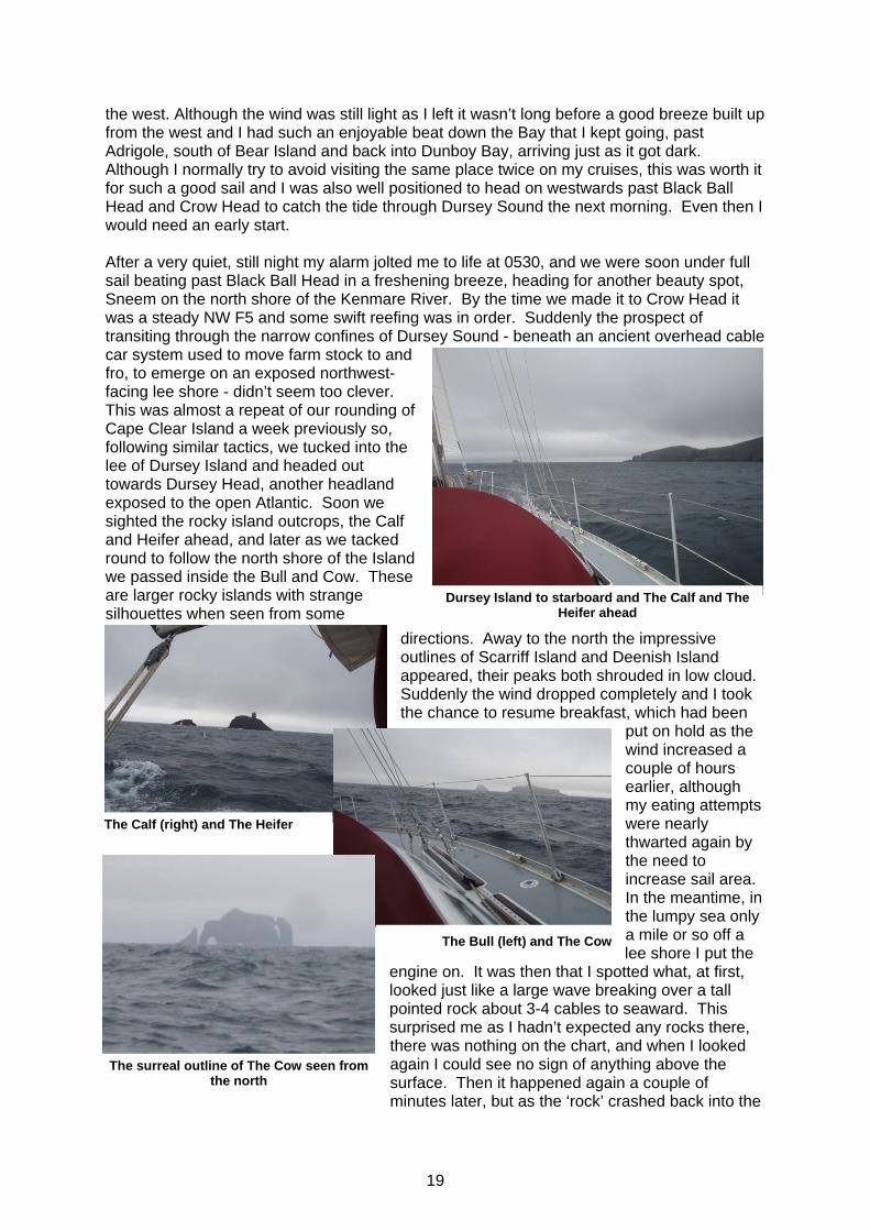
the west. Although the wind was still light as I left it wasn’t long before a good breeze built up from the west and I had such an enjoyable beat down the Bay that I kept going, past Adrigole, south of Bear Island and back into Dunboy Bay, arriving just as it got dark. Although I normally try to avoid visiting the same place twice on my cruises, this was worth it for such a good sail and I was also well positioned to head on westwards past Black Ball Head and Crow Head to catch the tide through Dursey Sound the next morning. Even then I would need an early start. After a very quiet, still night my alarm jolted me to life at 0530, and we were soon under full sail beating past Black Ball Head in a freshening breeze, heading for another beauty spot, Sneem on the north shore of the Kenmare River. By the time we made it to Crow Head it was a steady NW F5 and some swift reefing was in order. Suddenly the prospect of transiting through the narrow confines of Dursey Sound - beneath an ancient overhead cable car system used to move farm stock to and fro, to emerge on an exposed northwest- facing lee shore - didn’t seem too clever. This was almost a repeat of our rounding of Cape Clear Island a week previously so, following similar tactics, we tucked into the lee of Dursey Island and headed out towards Dursey Head, another headland exposed to the open Atlantic. Soon we sighted the rocky island outcrops, the Calf and Heifer ahead, and later as we tacked round to follow the north shore of the Island we passed inside the Bull and Cow. These are larger rocky islands with strange silhouettes when seen from some
directions. Away to the north the impressive outlines of Scarriff Island and Deenish Island appeared, their peaks both shrouded in low cloud. Suddenly the wind dropped completely and I took the chance to resume breakfast, which had been
put on hold as the wind increased a couple of hours earlier, although my eating attempts were nearly thwarted again by the need to increase sail area. In the meantime, in the lumpy sea only a mile or so off a lee shore I put the
engine on. It was then that I spotted what, at first, looked just like a large wave breaking over a tall pointed rock about 3-4 cables to seaward. This surprised me as I hadn’t expected any rocks there, there was nothing on the chart, and when I looked again I could see no sign of anything above the surface. Then it happened again a couple of minutes later, but as the ‘rock’ crashed back into the
Dursey Island to starboard and The Calf and The Heifer ahead
The Calf (right) and The Heifer
The Bull (left) and The Cow
The surreal outline of The Cow seen from the north

20
sea in a cloud of spray I realised I was watching a whale breaching – truly amazing!4 I turned the engine off and searched again but saw no further signs. No sooner had I put up more sail than the wind increased again, and this pattern continued all the way to Sneem. As we passed the north western entrance to Dursey Sound, where we would have emerged if we’d gone inside the island, waves were breaking heavily on the cliffs each side and it was just possible with binoculars to see the cable car plying back and forth. Despite the disappointment of missing a classic passage through a narrow Sound it had been the right decision to sail outside Dursey Island, and my rewards had been the views of the offshore islands and the whale, which was unforgettable.
By the time I could identify the approach to Sneem the wind had veered to the north east and we were beating into a F6 before motoring in past the outlying islands with the main still up. Only when we moved right to the northern extremity of the harbour did the wind drop below 20 knots. The perfectly sheltered bay on Garinish Island (a second island of the same name as the one in Glengarriff) recommended in the pilot was a lee shore and full of mooring buoys and a couple of bathing platforms, all deserted, so we anchored just to the south of Oysterbed House. Suddenly it was very peaceful in the sun, although
the wind continued to howl not far away. Later that evening I had supper in the cockpit, almost a first for this cruise.
4 Comparing what I saw with photos on the internet, I decided it was probably a Minke whale.
Anchored off Oysterbed House, Sneem
Kenmare River scenery (looking north, above, and south, below)
21
Despite my initial aim to get as far north as Dingle I was beginning to realise that this was too ambitious in view of the weather and the amount of time I’d spent enjoying the Irish coast so far. If I were to attempt to reach Dingle it would mean a long sail past Valentia Island and across Dingle Bay, only to turn round and head back shortly after. Even my shorter term plan to head west along the north coast of the Kenmare River to Derrynane looked in jeopardy in view of the forecast, which was for another gale from the west within the next 24 hours. I didn’t particularly want to be storm bound here for an unknown time, so decided, reluctantly, to turn south again. The Kenmare River would be the northern limit of this year’s cruise.
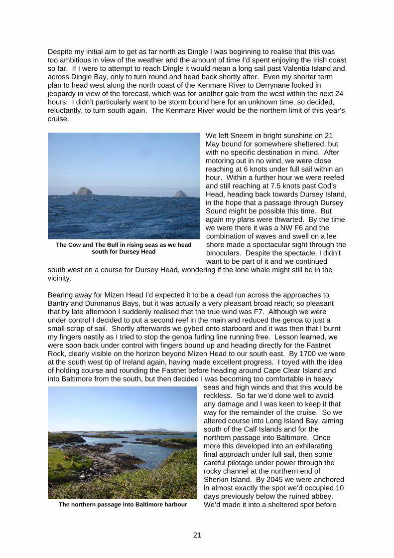
We left Sneem in bright sunshine on 21 May bound for somewhere sheltered, but with no specific destination in mind. After motoring out in no wind, we were close reaching at 6 knots under full sail within an hour. Within a further hour we were reefed and still reaching at 7.5 knots past Cod’s Head, heading back towards Dursey Island, in the hope that a passage through Dursey Sound might be possible this time. But again my plans were thwarted. By the time we were there it was a NW F6 and the combination of waves and swell on a lee shore made a spectacular sight through the binoculars. Despite the spectacle, I didn’t want to be part of it and we continued
south west on a course for Dursey Head, wondering if the lone whale might still be in the vicinity. Bearing away for Mizen Head I’d expected it to be a dead run across the approaches to Bantry and Dunmanus Bays, but it was actually a very pleasant broad reach; so pleasant that by late afternoon I suddenly realised that the true wind was F7. Although we were under control I decided to put a second reef in the main and reduced the genoa to just a small scrap of sail. Shortly afterwards we gybed onto starboard and it was then that I burnt my fingers nastily as I tried to stop the genoa furling line running free. Lesson learned, we were soon back under control with fingers bound up and heading directly for the Fastnet Rock, clearly visible on the horizon beyond Mizen Head to our south east. By 1700 we were at the south west tip of Ireland again, having made excellent progress. I toyed with the idea of holding course and rounding the Fastnet before heading around Cape Clear Island and into Baltimore from the south, but then decided I was becoming too comfortable in heavy
seas and high winds and that this would be reckless. So far we’d done well to avoid any damage and I was keen to keep it that way for the remainder of the cruise. So we altered course into Long Island Bay, aiming south of the Calf Islands and for the northern passage into Baltimore. Once more this developed into an exhilarating final approach under full sail, then some careful pilotage under power through the rocky channel at the northern end of Sherkin Island. By 2045 we were anchored in almost exactly the spot we’d occupied 10 days previously below the ruined abbey. We’d made it into a sheltered spot before
The Cow and The Bull in rising seas as we head south for Dursey Head
The northern passage into Baltimore harbour

22
the forecast gale reached us and I felt relieved as I kept anchor watch for a couple of hours during the night, clutching a mug of hot chocolate and listening to music as the wind gusted strongly all around. After breakfast the next morning I decided to re-anchor. The boat that had been ahead of me had now gone so I had more swinging room and the chance to put out more chain. I then took the dinghy to fetch water, topping the tanks up ready for the trip back across to UK, hopefully via the Scillies again. Having done so I went to say hello to the crew on the only other occupied yacht and was immediately invited on board for lunch with Dermot and Deidre who were heading from Rosslare, where Dermot runs a sailing school, to Schull. Lunch in the sun in the cockpit was very relaxing and, as I left, their terrier seemed to want to join me in the dinghy as I departed. I then made a quick trip ashore to discreetly deposit my rubbish in a bin, have a shower and catch up on emails at the Islanders Rest. As I lashed the deflated dinghy on deck I reflected on a rare day of shorts weather – very pleasant. Ireland back to the Solent (23rd May to 1st June) We weighed anchor at 0840 and ghosted out of Baltimore harbour under genoa in the expectation that this would be a downwind passage all the way across to New Grimsby Sound in the Scillies. Lot’s Wife gleamed in the sunshine on the cliff top above us, as if to bid farewell. I’d enjoyed Ireland, but was now looking forward to getting home.
By mid morning the wind had increased to the forecast 24 knots, but as soon as I rolled the genoa it dropped again. By lunchtime we were back in international waters, so lowered the Irish courtesy flag, and by 1500 only the highest mountains could still be seen astern. An hour later the horizon was empty and we were powering south east, still under only the full genoa. By 1800 we had 100nm to go to the Scillies and we passed a lone fishing vessel a couple of miles to port. Then the wind began to increase: to 27 knots by 1855, so 2 reefs in
The night after the gale - re-anchored off Sherkin Island, Baltimore
Lot's Wife: our departure from Baltimore

23
the genoa; to 34 knots by 2035, so a third reef in the genoa; and by 2115 it was 38 knots, and I wound quite a few more rolls into what was now a very small sail, still drawing strongly as we surged downwind. At 2140 the shipping forecast received from Niton by Navtex
mentioned NW 5-7, occasionally F8 in the Irish Sea. I was now about a third of the way across the Celtic Sea already in a F8 and had clearly missed the weather window I thought I’d identified prior to departure. As the night progressed, with the wind consistently over 30 knots, I managed to get the UK Radio 4 forecast at 0048, which gave F5-7 from N-NW, becoming F4 later. It was a cold, clear night and bright, with almost a full moon. Perhaps I would still be able to get into New Grimsby if the wind dropped before the morning, but right now it didn’t look good.
I cat-napped through the night and by 0500, as it was getting light, we were 38nm NW of the Scillies, but still running in over 30 knots of wind. The only change in the early morning forecast was that Scilly was reporting a rather sedate northerly F5. I clearly needed to re-plan: do I slow down and still try to get into the Scillies once the wind drops; do I sail on past into the western approaches to the Channel; or do I head to the north of the Scillies, avoiding Seven Stones and the Traffic Separation Scheme and head for a Cornish port? As I was doing some rough time/tide/speed calculations at the chart table there was a distinct bang and we rounded up into wind, ending up broadside to some huge waves. I knew exactly what had happened. As I’d ghosted out of Baltimore harbour the day before I’d noticed that one of the stopper knots at the end of the Monitor steering lines had frayed where it joined the paddle. Rather than fix it then, as I should have done, I’d prayed that it would last the night.....and it had, just, but I hadn’t anticipated the morning being quite how it was. I shortened sail still further and tied myself firmly onto the afterdeck and, right at the limit of my reach, was just able to jury-rig a new line. It was wet work with waves occasionally breaking right over the boat, but within about 20 minutes it was temporarily fixed. It was with some relief and a degree of quiet satisfaction that we were soon sailing on the wind vane again: I hadn’t relished the prospect of hand-steering for what turned out to be a further 15 hours before we made port. Throughout the morning we continued to close on the Scillies, having decided to pass to the north of the islands and into Newlyn. By 1300 I could see Round Island and the northern shores of Bryer, Tresco and St Martin’s quite clearly about 3 nm to our south. Now I had a phone signal I decided to call home to say I was OK – probably more comfort to me to talk to someone than it was for Claire at home who had no reason to be aware of the weather where I was. At 1430 we were had passed between the Scillies and the Seven Stones reef and altered course to due East to cross the Traffic Separation Scheme at right angles. I was surprised there was no shipping until I’d crossed, when a container ship passed close by our stern as it turned north. Shortly afterwards I spotted dolphins around Rosinis, but they didn’t stay long. By now the Cornish coast was clearly visible and we needed to head north east to counter the tide and make our way into Mounts Bay. It continued to blow at 25-30 knots, but by getting into the lee of land and hoisting the mainsail with 3 reefs we managed to get out of the colossal seas into calmer water as we plugged our way slowly past Mousehole and into Newlyn, arriving at 2030. It was still blowing at 25 knots in the harbour entrance. In the previous 36 hours we’d covered 180nm in winds up to F8 and rarely below F6: it was both my longest and roughest solo passage to date.
Sunset - running before a gale in the Celtic Sea

24
I spent the following day in Newlyn and was humbled to find a mini-Transat yacht moored close to me when I woke. It had retired from a 1000nm singlehanded qualifying passage whilst just off the southern Irish coast because of a faulty fuel cell, leaving the boat with no power. My exploits were put into perspective when the young lady skipper explained that she hadn’t quite worked out yet how to sleep when doing 18 knots downwind with a spinnaker up! Impressive!
After a quiet day in Newlyn I was up at 0400 to catch the tide around Lizard Point. In contrast to our arrival there was almost no wind as we motored across Mounts Bay watching the sun rise and it was a very sedate passage around the Lizard and into Helford River, where we arrived at 1000. It seemed packed – a real contrast to Ireland – so we made our way upstream to the anchorage above all the moorings and eventually found some space to drop the hook. Not relishing the late May Bank Holiday crowds or the effort of inflating the dinghy, I didn’t bother to head ashore. As I headed out of Helford River the next morning yachts were scurrying to get home
before the Bank Holiday weekend finished, mostly making the short hop across to Falmouth. I was aiming for Dartmouth and in the rising south westerly was soon reaching at 6.5-7 knots towards Eddystone, sighted fine on the port bow at about 1230. As seemed to be the pattern for this cruise, the wind rose steadily and was soon over 30 knots and more reefs were required. Reducing the genoa further was easy, but without rounding into wind it was more of a problem with the main, so I stayed with 2 reefs making Rosinis slightly unbalanced but still manageable for Millie (the Monitor) to steer. By 1400 we were a couple of miles due south of Eddystone when I spotted a large yacht beating fast to the west.........then another ......and then more. It took me a while but I eventually worked out that this was the start of the OSTAR and I didn’t envy the participants starting a solo race across the Atlantic with a beat into the conditions I was in. As we approached Prawle Point I decided I had to put the third reef in the main to remove weather helm and provide more control for the gybe necessary to head up to Dartmouth. Running fast into Dartmouth under 3 reefs and a tiny genoa I decided to lower the main completely to try and lose some speed and we ran in under headsail alone. As we entered the river, still sailing, a pod of large dolphins appeared alongside, matching their speed perfectly to ours: a wonderful welcome at the end of another very fast passage. We’d covered 73nm in just less than 12 hours from weighing anchor to being moored alongside the Town Quay. From Dartmouth we had a frustrating sail in very little wind to Weymouth, then over the next couple of days via Mupe Bay (again, but in good visibility this time) and Studland Bay before heading back into the Solent, now in a fresher breeze. Our final stop, as always, was Newtown where we arrived on a bright sunny afternoon and anchored amongst a number of other Marchwood yachts. The following morning I woke early to watch the Round the Island Race pass, but not early enough to see Ben Ainslie’s record breaking run: he had gone by the time I appeared on deck. After a ‘welcome home’ visit from my friend John Foster who came over from Lymington, we set sail on our final leg back to Marchwood in a brisk northerly which made a great beat home.
St Michael's Mount at dawn

25
It seemed slightly strange to be back, but hugely satisfying to have completed another challenging cruise. Overall we’d been away for 40 days. We’d covered 1105nm, run the engine for 75 hours (which included a small amount of battery charging at anchor) and spent:
• 21 nights at anchor • 3 nights on moorings • 13 nights alongside • 2 nights at sea.
More importantly, we’d managed it with no damage apart from a broken Monitor line and a disabled bow thruster........although I had discovered a few more leaks to fix and that regular dousing in salt water cleans teak beautifully!
Back in Newtown River

26

27