strengthening data management and information sharing … · strengthening data management and...
TRANSCRIPT

Strengthening data management and information sharing on water ecology in the 3S Basins Report on the proceedings of the BRIDGE Technical Forum: Data Sharing and Developing a Common Framework for Water Ecology Assessment in the 3S (Sekong, Sesan and Sre Pok) Basins (4 - 5 February 2015)
May 2015

The designation of geographical entities in this report, and the presentation of the material, do not imply the expression of any opinion whatsoever on the part of IUCN (International Union for Conservation of Nature) or the Swiss Agency for Development and Cooperation concerning the legal status of any country, territory, or area, or of its authorities, or concerning the delimitation of its frontiers or boundaries. The views expressed in this publication do not necessarily reflect those of IUCN or the Swiss Agency for Development and Cooperation. The BRIDGE project is funded by the Swiss Agency for Development and Cooperation.
Published by: IUCN Asia Regional Office Copyright: ©2015 International Union for Conservation of Nature and Natural Resources Reproduction of this publication for educational or other non-commercial purposes is authorized without prior written permission from the copyright holder provided the source is fully acknowledged. Reproduction of this publication for resale or other commercial purposes is prohibited without prior written permission of the copyright holder.
Cover photo: IUCN Produced by: IUCN Asia Regional Office Available from: IUCN (International Union for Conservation of Nature) Asia Regional Office 63 Sukhumvit Soi 39 Sukhumvit Road Wattana, Bangkok 10110 Thailand Tel: +662 662 4029 http://www.iucn.org/about/union/secretariat/offices/asia/regional_activities/bridge_3s/

CONTENTS
1 Forum Background and objectives ................................................................................... 5
1.1 The BRIDGE project .................................................................................................. 5
1.2 Integrated Water Resources Management (IWRM) ................................................... 5
1.3 BRIDGE Technical Forum objectives ......................................................................... 6
2 Organisation of the forum ................................................................................................. 7
3 Profile of the participants .................................................................................................. 8
4 Opening and welcome remarks ........................................................................................ 9
5 Proceedings of Day 1: Scientific information sharing in the 3S Basins ............................ 10
5.1 BRIDGE project presentation and implementation status......................................... 10
5.1.1 The BRIDGE project in the 3S Basins ............................................................... 10
5.1.2 Comments from participants ............................................................................. 11
5.2 Review and basin profiles ........................................................................................ 11
5.2.1 Presentation abstracts ...................................................................................... 11
5.2.2 Movie screening ................................................................................................ 12
5.2.3 Discussion highlights ........................................................................................ 12
5.3 Review of available data and need for information sharing and dissemination in the 3S Basins ................................................................................................................ 15
5.3.1 Viet Nam: Water monitoring in the Sesan and Sre Pok River basins ................... 15
5.3.2 Lao PDR: Water ecology monitoring in Lao PDR, ............................................... 15
5.3.3 Development and conservation in the 3S Basins in Cambodia: Issues of data availability, use and challenges ........................................................................... 16
5.3.4 Linked open data for understanding trans-boundarydevelopment trends and issues.................................................................................................................. 17
5.3.5 Comparative review of Hydrolancang’s mitigation work in China and the Lower Sesan 2 Dam in Cambodia ................................................................................. 17
5.3.6 Comments and suggestions from participants: .................................................... 18
5.4 Outcomes of the discussion on data sharing in 3S Basins and the way forward ...... 18
5.5 Highlights from the wrap-up: .................................................................................... 21
6 Proceedings of Day 2: Developing a common framework for water ecology assessment in the 3S Basins ................................................................................................................. 22
6.1 Existing methods and tools available or officially adopted to monitor river ecology in the 3S Basins .......................................................................................................... 22
6.1.1 The MRC hydro-meteorological network and data management ....................... 22
6.1.2 Improved environmental baseline information for hydropower planning and operation ........................................................................................................... 22

4
6.1.3 Cambodia: Data on the Mekong Basin including in the 3SBasin ....................... 23
6.1.4 Data and information on the 3S Basins: 3S Basins hydropower development and Tonle Sap food security .................................................................................... 23
6.1.5 MRC’s water quality and ecological health monitoring ...................................... 24
6.1.6 IWMI-SEA: some research highlights and data ................................................. 24
6.1.7 Discussion highlights ........................................................................................ 25
6.2 Developing common framework for water ecology assessment in the 3S Basins: concept and group discussions ................................................................................ 26
6.2.1 Introduction ....................................................................................................... 26
6.2.2 Group discussions: Next steps in the development of a common framework for water ecology assessment in the 3S Basins (including time frame, definition of a working group and framework structure). .......................................................... 28
7 Highlights from the BRIDGE Technical Forum: Wrap–up and the way forward ............... 31
List of Appendices
Appendix 1: Workshop agenda Appendix 2: List of participants

5
1 FORUM BACKGROUND AND OBJECTIVES
1.1 The BRIDGE project
The BRIDGE (Building River Dialogue and Governance) project is facilitated by IUCN (International Union for Conservation of Nature), and financed by the Water Diplomacy Programme of the Swiss Agency for Development and Cooperation (SDC). The project aims to build water governance capacities through learning, demonstration, leadership, and consensus-building in trans-boundary hotspot river basins. It is a multi-regional project, implemented in a dozen river basins in South and Meso-America, Africa and Asia.
At the basin level, strategic priorities for BRIDGE are guided by currently available mechanisms for trans-boundary cooperation on water issues. Where cooperation strategies or agreements are in place, the objective is to support implementation and help make the associated local, national and trans-boundary institutions operationally effective. Where no specific agreements are in place, the project focuses on building channels for dialogue, action and learning, in order to create spaces for cooperation.
In Asia, the BRIDGE project is working on the 3S Basins (Sekong, Sesan and Sre Pok rivers) shared by Cambodia, Viet Nam and Lao PDR. The project has been operational since 2011, and has provided opportunities for dialogue and training on hydro-diplomacy for key stakeholders, facilitated the sharing of information on Integrated Water Resources Management (IWRM), and produced data and studies to support technical discussions across basins.
1.2 Integrated Water Resources Management (IWRM)
The sustainable management of river basins depends on the availability and quality of data, as well as stakeholder cooperation at all levels. The 1995 Mekong River Agreement on cooperation for the sustainable development of the Mekong River Basin recognizes that the activities in the basin must aim for a balance among the economic, social and environmental dimensions of development.
IWRM is a well-recognized process that can contribute to the sustainable and balanced development of any river basin. IWRM approaches promote coordinated development and management of water, land and related resources, and thus help maximize the resultant economic and social benefits in an equitable manner, without compromising the sustainability of ecosystems.
Spatial and ecological data are tools for achieving IWRM. The basic requirements for the introduction of IWRM processes are twofold. On the one hand, there is a need to integrate information about the natural systems, for example, water resources, agricultural systems and ecological systems. On the other hand, there is also a need for an integrated institutional response, as the management responsibility for different components of the various natural systems lie with different national agencies.
However, the full development of the IWRM concept in the 3S River Basins may be challenging. Understanding of the functioning of the natural systems of the basins remains incomplete, and data at the local level, in particular, requires higher resolution. There are also likely to be challenges related to the integration of institutional management within and

6
between countries. Challenges may also emanate from the lack of “vertical” (eg. among national, provincial and local government levels) and “horizontal” integration and coordination at country level. These are some of the issues that this BRIDGE Technical Forum sought to discuss and explore.
1.3 BRIDGE Technical Forum objectives
The 3S Basins form a contiguous ecological unit. The 3S Rivers are recognized as an important part of the Lower Mekong fish migration system. Most migratory fish species move from the Tonle Sap and Mekong mainstream up the 3S Rivers to breed. However, in recent years, the 3S Basins have come under variety of threats, including hydropower development, expansion and corporatization of agriculture and mining development. Over 50 gold mining units are reported to be working in the Sekong Basin alone. As a result of these threats, both the long-term ecological security and the sustainability of livelihoods in the 3S Basin have been compromised. Against this background, the BRIDGE Technical Forum aimed at providing a platform for dialogue among key organizations and stakeholders in the 3S Basins. The forum was an opportunity for government departments working on water resource management issues in the 3S Basins, as well as representatives from the Mekong River Commission, NGOs and the academic sector, to discuss existing data and tools in the 3S Basins. More specifically, the forum intended to:
• identify available data for IWRM planning in the 3S Basins; • carry out a stakeholder mapping of organisations and individuals involved with data
generation and knowledge management in the 3S Basins; and • discuss technical and institutional mechanisms to enhance data collection and
sharing in the 3S Basins.
This meeting also initiated the development of a common framework for water ecology assessment for countries in the 3S Basins. This framework, once fully developed, could be used as a tool that supports and informs decision making on IWRM.
7
2 ORGANISATION OF THE FORUM
The BRIDGE Technical Forum was structured as a two day event with four sessions. The sessions included technical presentations and group discussions (See Annex 1).
The first session introduced participants to the BRIDGE project objectives, its activities and outputs. Presentations were made on the profiles of the 3S River Basins and the online GIS platform. Session 2 reviewed available data on river ecology in the 3S Basins and also permitted discussion of gaps related to information sharing and dissemination. The presentations were followed by group discussions which analysed existing data sharing mechanisms and current gaps in knowledge, and identified opportunities for collaboration. Day 1 concluded with the reporting back on group discussion.
Day 2 initiated the development of the common framework for water ecology assessment in the 3S Basins. Session 3 included presentations on the tools currently available and officially adopted to monitor river ecology in the 3S Basins. The last session of the forum, Session 4, involved technical presentations on how to develop a common framework for water ecology in the 3S Basins, followed by facilitated group discussions aimed at identifying next steps and follow up actions.
At the end of the forum, participants were asked to fill out evaluation forms. The evaluation forms were designed to record participants’ feedback on the organization and facilitation of the forum and also suggestions on how to improve future forums.
The following materials were provided to the forum participants:
1. All presentations made at the BRIDGE Technical Forum (PDF files).
2. BRIDGE Knowledge Products:
a. Basin Profiles (brief fact sheets on each of the 3S River Basins);
b. A report entitled “The Sekong River in Viet Nam, Lao PDR and Cambodia”; and
c. The Sekong Movie.
*the above knowledge products are available at: http://www.3sbasin.org/

8
3 PROFILE OF THE PARTICIPANTS
The BRIDGE Technical Forum was attended by 46 participants from 28 different organizations working in the 3S Basins. The participants were selected to facilitate sharing of firsthand knowledge and information on river ecology. Most participants selected have technical backgrounds, and are directly involved with data generation and management on river ecology as well as integrated water resource management and planning. (See Annex 2 for the full participants list and contact details).
Forum participants included representatives from government authorities, regional and national Mekong committees, international and national NGOs, and the academic sector. More than half of the representatives at the forum came from the Mekong committees and governmental authorities represented at the forum including the Information and Knowledge Management Programme (IKMP) and Environmental Programme (EP) of Mekong River Commission (MRC); the National Mekong Committees; and Ministries and Divisions responsible for water resources, natural resources, the environment, agriculture and fisheries from the participating countries. Non-governmental organizations represented at the forum included Fisheries Action Coalition Team (FACT), Conservation International (CI), International Water Resource Management Institute (IWMI) and Open Development Mekong (ODM). Freelance consultants working in the 3S Basins for organisations such as the Asian Development Bank (ADB) and the World Bank (WB) also attended.
At least 40% of the participants had prior working relationship with the BRIDGE project, mostly through their participation in training workshops on hydro-diplomacy as members of the BRIDGE Champions’ Network.

9
4 OPENING AND WELCOME
Dr Scott Perkin (Head, Natural Resources Group, IUCN ARO) opened the forum and formally welcomed participants. Below is a transcript of his speech.
BRIDGE project seeks to build linkages and strengthen cooperation for sustainable river basin management. The project uses sound science and technical data to support policy changes. In this regard, BRIDGE is very much in line with IUCN's overall approach and core identity as an organization convening people and providing a neutral platform. The BRIDGE project is being implemented in river basins and trans-boundary water bodies all over the world. In Asia, the focus has been on the Sekong, Sesan and Sre Pok Basin, known as the 3S Basins. The 3S Basins is important in itself, since it provides a substantial proportion of the annual flow of the Mekong, supports numerous key species (including many species of migratory fish), and sustains the livelihoods of local communities. The 3S Basins are also in many ways representative of the challenges and opportunities existing in the wider Mekong region, and can thus provide lessons that are relevant far beyond their boundaries. Therefore, the BRIDGE project in the 3S Basins can generate lessons and develop tools which can be disseminated and replicated in many of the river basins of Southeast Asia.
In addition to supporting hydro-diplomacy by providing training and capacity building on international treaties and formal trans-boundary cooperation mechanisms, BRIDGE supports what could perhaps be called “technical hydro-diplomacy.” By creating the space in which diverse stakeholders can work together to prepare research reports, documents and maps, it provides opportunities for discussion and cooperation among "technical" stakeholders. This is critical, since only a comprehensive understanding of the 3S Basins, coupled with strengthened technical cooperation across the Basins, will ensure that high level hydro-diplomacy efforts are based on a solid foundation. The BRIDGE team designed a forum that will provide an opportunity for key stakeholders to highlight their work, put it into context with other initiatives, energise partnerships and, generate new ideas on how to improve the management of the 3S Basins through enhanced cooperation. The two days of the forum will be an opportunity for all to learn, to share information about ongoing activities in the 3S Basins and the data produced, and to think collectively about the way forward. It is hoped that forum will be a landmark event towards the goal of strengthening cooperation in the management of the 3S Basins.

10
5 PROCEEDINGS OF DAY 1: SCIENTIFIC INFORMATION SHARING IN THE 3S BASINS
5.1 BRIDGE project presentation and implementation status
5.1.1 The BRIDGE project in the 3S Basins
Presented by Mr Raphaël Glémet, BRIDGE Project Manager, IUCN Asia Regional Office, Bangkok BRIDGE is a multiregional project, with a focus on knowledge management and trans-boundary cooperation in 14 hotspot river basins. The project is implemented across three continents around the world. The Mekong component of the project has a focus on the so-called 3S Rivers: the Sekong (principally in Lao PDR and Cambodia), Sesan and Sre Pok (both straddling Viet Nam and Cambodia)..
Financed by Water Diplomacy Programme of the Swiss Agency for Development and Cooperation (SDC), the project aims to build water governance capacities (individual and institutional) through learning, demonstration, leadership development and building consensus for better management of water resources. Currently in the project is in its second phase. Phase I of the project, which ran from April 2011 to March 2013, assessed the context and possibilities of cooperation in the 3S Basins.
The BRIDGE project uses demonstration of water diplomacy with multi-stakeholder participation to build trans-boundary water cooperation. At the basin level the strategic priorities of action are determined by existing frameworks for trans-boundary water management. In river basins where cooperation strategies or agreements are in place, priority is given to supporting implementation and making the associated local, national and trans-boundary institutions operationally effective. Where no mechanisms for trans-boundary cooperation are in place, the priority is to build channels for dialogue, action and learning from which the new spaces needed for cooperation can emerge.
Why focus on the 3S Basins
The 3S Basins are the most significant trans-boundary tributaries of the Mekong, contributing almost 20% of the total Mekong flow.
The Mekong component of BRIDGE has been working on leadership development processes in the 3S region. As a part of the project activity, a series of workshops has been conducted on capacity building and training on hydro-diplomacy for the government officials dealing with natural resource management in the 3S countries.
The BRIDGE project focuses on two key mechanisms to promote cooperation in the 3S Basins:
• Technical dialogue: with the aim to support trans-boundary cooperation through science-based decision making; and
• Hydrodiplomacy: enhancing leadership and governance capacities.
11
The project priority for 2015 is the development of the enabling environment for trans-boundary cooperation in Lao PDR, Cambodia and Viet Nam, by facilitating cooperation, building capacities of key stakeholders and using water resource information to inform wider, cross-sectoral dialogues at the regional level.
The BRIDGE project developed strong linkages with national and local governments of the 3S region in particular with the various departments related to water resources, environment or international cooperation within the various ministries, as well as with the three National Mekong Committees. The project also developed effective cooperation with two programmes of the MRC, namely the Environment programme and the Information and Knowledge Management Programme (IKMP). In the near future, BRIDGE will work on developing and strengthening the link with grassroots level organizations in the 3S Basins. It will also aim to develop stronger links with Cambodia, Lao PDR and Viet Nam (CLV), the Association of Southeast Asian Nations (ASEAN), academic institutions and the private sector in the 3S Basins.
5.1.2 Comments from participants:
Participants acknowledged that the BRIDGE project is working very closely with national and regional MRC and also the national ministries with responsibilities for natural resource management in the 3S countries. However, it was felt that more work is required to strengthen ties with the regional platforms like ASEAN and CLV, and also to establish ties with the private sector, as they are responsible for most of the externalities in the 3S Basins. The representative from the Cambodian National Mekong Committee (CNMC) recommended that the BRIDGE project should identify and assign focal persons in key national and regional organisations, such as the MRC, the National Mekong Committees, ADB and ASEAN. The focal person would provide a regular channel of communication between IUCN and these organisations. It was clarified that under the Mekong Agreement, any development on the Mekong or its tributaries needs to be notified under the Procedures for Notification, Prior Consultation and Agreement (PNPCA). Therefore the PNPCA does apply to the 3S Basins even if the full PNPCA process does not need to be applied.
5.2 Review of 3S Basins profile and Online GIS Platform
5.2.1 Presentation abstracts
3S (Sekong, Sre Pok and Sesan) Basins profiles Mr Daniel Constable GIS/Environmental Specialist (IUCN Viet Nam office) This presentation gave a comparative overview of each of the 3S Basins. By compiling and analyzing data at a basin level it is possible to gain a better understanding of the issues affecting each basin. A preliminary profile of the basins noted that the area is roughly divided, with 36% of the area covered by the Sekong, 24% by the Sesan, and 40% by the Sre Pok. There are significant differences in the characteristics of each river basin such as topography, precipitation, and population. The Sekong was noted for its low population density, rugged topography, and high forest cover. The Sesan, the smallest of the three, was found to have more intermediate geophysical characteristics between the Sekong and

12
Sre Pok. The Sre Pok, the largest basin, has the highest population and covers the largest elevation range. As of 2012, the total human population residing within the 3S was around 4.7 million, the majority of which resided in Viet Nam. Hydropower is a relevant issue, with 17 hydropower dams (>10MW) currently in the basins, and another 19 planned or under construction. Most proposed dams would be constructed in Lao PDR.
Online GIS platform and maps Mr Daniel Constable GIS/Environmental Specialist (IUCN Viet Nam office) Although significant data exists for the 3S Basins, some strategic gaps remain. The most recent official land cover data set is from 2003. Given the rapid changes in the region, this is a significant data gap. Additional gaps to address include groundwater, the location of areas zoned for mining or other concessions, hydrologically correct river and basin networks for analyses, and populations vulnerable to natural disasters, among others. In addition to gaps, data access and data sharing were noted as areas for improvement. Although the original project focus was on data sharing, much of the collected data remains the intellectual property of the respective data authors and cannot currently be shared by third parties. Could this be overcome by developing web applications using the restricted data, such as interactive maps and tables, to overcome the limitation in raw data dissemination?
5.2.2 Movie screening
Sekong movie The thirteen minute movie is the story of the River Sekong (BRIDGE I). The movie briefly introduces viewer to the socio-ecological context of Sekong basin, and how it has been changing in the recent years due to variety of developmental pressures and land-use changes. It includes interviews from different stakeholders, capturing their views on the current developmental scenario and future directions in the Sekong River Basin. The Sekong River originates in Viet Nam and flows through Lao PDR and Cambodia before merging with Mekong. The river is a source of water, transport, food and livelihoods for many living in the basin. However, sustainable use of this common property resource has been threatened in recent years due changing land-use mainly driven by commercialization of agriculture and hydropower development. Stakeholders interviewed in the movie expressed that need to work on a trans-boundary level on joint research and data generation and to strengthen cooperation between countries. The movie suggests that some decisions should be taken at community level. All this will contribute to sustainable development of this trans-boundary river basin. Web link to the movie: http://www.3sbasin.org/publication/pnvm.html
5.2.3 Discussion highlights
Following the presentations and screening of the Sekong movie, participants discussed the constraints associated with data availability and data sharing in the 3S Basins; the linkages between the quality of data and its implications; the utility of GIS mapping in scoping of new dam sites; and the role that MRC is playing as a data compiler and dissemination platform. Participants also provided their feedback on the BRIDGE knowledge products provided, including the Sekong movie.

13
Data availability and sharing in the 3S Basins:
Participants agreed that extensive data on a variety of river ecology parameters is already available. Each country in the region has its own data set that is dispersed across various government ministries and departments. However, there was a concern that data owners were unwilling to share many of these datasets, either on account of data sensitivity or for other reasons. The discussions highlighted difficulty faced by IUCN in obtaining data from government departments and national institutions within 3S Basins countries. IUCN has to depend heavily on the open access data available from MRC and civil society organisations for profiling of the 3S Basins. Further constraints in data sharing relate to differences in the way data is collected and compiled, leading to problems in data comparisons. Participants agreed that time-series data on flow characteristics, including the seasonality of flow, is available for the 3S Rivers. The data is old, however, with the latest data collected in 2008. Still, this time series data can be used to develop a better understanding of the impacts of current and proposed hydropower development on flow regimes in the 3S Basins. Representative from the MRC (Mekong River Commission) Information and Knowledge Management Programme (IKMP) informed the forum that IKMP is currently compiling data sets from 2008-2012 and that the new flow data sets will be available for open access on the MRC data portal by the second half of 2015. Most of the data sets, including those relating to precipitation and flow characteristics are already available. IKMP is working with other stakeholders, both government and civil society to fill the data gaps. In order to address current data gaps, countries need to discuss issues of data availability, data quality and sharing. They also need to identify what kind of data sets and indicators are required to support sustainable development in the 3S Basins. This may include parameters related to river hydrology, sedimentation and fish biology. Discussions highlighted the challenges around hydropower development in the 3S region. In reference to the proposed Lower Sesan 2 Dam in Cambodia, the participant from the 3S River Protection Network (3SPN) argued there is not much water available for damming and water supply. This is a fast changing landscape as a result of rampant deforestation and corporatisation of agriculture. The demand for water has increased in recent years as a result of rapid agricultural expansion and increasing demand for portable water supply. Furthermore, the damming will also impact the flow reversal and the migration of fish, impacting local livelihoods. The CNMC participant agreed that the concerns regarding hydropower development in the region must be addressed. The region needs socio-economic development and dams provide opportunities to develop. But to make this development holistic and sustainable, it is required that different stakeholders, the government, civil society and private sector work together. Cambodia is working with US-based organisations to study sediment flow in the Sesan Basin, and also exploring how new technologies can be applied to study the impacts of all future hydropower developments in the region.

14
The discussion also noted the critical role that IUCN can play in finding resources, both financial and technical, to help fill the existing data gaps and strengthen cooperation on data sharing, and its management in the 3S region.
Comments and suggestions to improve BRIDGE Knowledge Products:
Sekong Movie: Participants found the movie interesting and informative. More footage from stakeholders from Lao PDR would be beneficial. It was felt that this movie should also highlight ongoing cooperation among the 3S countries, their government departments and civil society organisations working in the Sekong River Basin and how it is contributing to the sustainable development of the 3S Basins in general. IUCN should incorporate feedback from policy makers on how to solve problems concerning the Sekong River Basin into the movie.
Figure 1. Screening of the Sekong movie at the BRIDGE technical forum.
Fact sheets - 3S Basins profiles: Participants acknowledged that these Knowledge Products are very relevant. It was felt that international boundaries as indicated in the current maps, in the basin fact sheets, may need some realignment and fine-tuning. Also, IUCN should share these documents more widely; especially with relevant national organizations, and get their feedback on the material. This will help establish government ownership and might also facilitate official recognition of these documents and the information and data therein.
All BRIDGE project outputs (from the Mekong 3S component) are available at 3sbasin.org, a web-platform managed by IUCN and BRIDGE dedicated to the 3S Basins: http://www.3sbasin.org/publication/download-documents.html

15
5.3 Review of available data and need for information sharing and dissemination in the 3S Basins
Afternoon session on day one introduced participants to the tools and mechanisms that are currently being utilised by 3S countries for collecting data on river ecology and water quality. The session also introduced participants to the main organisations involved in data generation and compilation in the region; the types of data available and the different ways in which this data can be accessed. The presentations during this session also highlighted the research that is being undertaken by civil society organisations in the 3S Basins.
5.3.1 Viet Nam: Water monitoring in the Sesan and Sre Pok River basins
Abstract: Ms Truong Tung Hoa Officer, Department of Water Resources Management, Ministry of Natural Resources and Environment, Viet Nam This presentation introduces some key regulations on water monitoring in Viet Nam and describes the water monitoring network working in the Sesan and Sre Pok River Basins. Circular No. 29/2011/TT-BTNMT published on 1st of August, 2011 provides for the technical process for environmental inspection of surface water. QCVN 38:2011/BTNMT, the national technical regulation on surface water quality for protection of aquatic life specifies maximum limits for various parameters of surface water quality. Pleiku station on the Sesan River and Ban Don on the Sre Pok River are sampled 12 times per year to collect water quality data, usually on 15th of each month. Water level and discharge is regularly monitored in several stations, in which Kon Tum on the Sesan River, and Duc Xuyen, Giang Son and Ban Don on the Sre Pok River are real time water level monitoring stations. MRC provides this real time data on their data portal. The National Centre of Hydro-Meteorological Forecasting (NCHMF) in Viet Nam manages the hydrology monitoring network, and frequently monitor, collect data and inform concerned authorities at various levels. The Institute of Meteorology, Hydrology and Environment (IMHEN) manages experimental stations including environment observation stations, marine meteorology stations, and agricultural meteorology stations. The presentation concluded that the number of stations on these basins is limited, monitoring frequency is low and there is lack of data for assessing reservoir operations on water quantity and quality.
5.3.2 Lao PDR: Water ecology monitoring in Lao PDR,
Ms Phaylin Bouakeo Officer, Ministry of Natural Resources and Environment (MoNRE), Lao PDR The Sekong River Basin is one of the 62 river basins in Lao PDR for which data is collected on five different river ecology parameters: water quality (Ph, temperature etc), GIS (geographical information system), water use (agriculture, domestic and hydropower development), surface water (discharge, rainfall etc) and changes in the ground water level across the basin. Lao PDR has developed tools and guidelines on data collection and management. These include guidelines on River Basin Management; Water Quality Monitoring Guidelines; National Water Resources Inventory, etc. The Lao PDR government has also developed the 2020 National Water Resource Strategy, which aims to achieve sustainable utilization and integrated development of water resources for the benefit of local people, while ensuring environmental protection, effective climate change adaptation and livelihood improvement. The strategy identifies 11 programmes of work, each focusing on
16
specific issues linked to sustainable river basin management, including management of water resources for impact mitigation and adaptation to climate change, protection of water quality for aquatic life; collection, analysis and management of water resource data and information. In Lao PDR, the coordination of data collection and management involves cooperation among different levels of government. The river ecology data is generated at the district level (there are 42 line agencies working on this) and shared with provincial organizations and the Ministry of Environment (MoNRE). All the data managed by MoNRE is available for access at http://monre.gov.la. The main issues impeding constant monitoring of water quality in Lao PDR include: unclear regulations; limited knowledge, skills and experience of staff; and non-availability of the correct equipment. 5.3.3 Development and conservation in the 3S Basins in Cambodia: Issues of data
availability, use and challenges
Dr Seak Sophat Head of Natural Resources Management and Development, Faculty of Development Study, Royal University of Phnom Penh The presentation describes developmental scenario on the Cambodian side of the 3S Basins. In Cambodia, at least eight hydropower dam projects are either functional or planned. Economic Land Concessions (ELCs), mining concessions and timber laundering in the name of reservoir clearance are some of the major concerns in Cambodia. Hydrological modelling in Cambodia is being conducted using the Soil and Water Assessment Tool (SWAT) and stream hydrology modelling tools like MIKE (integrated hydrological modelling system). Since 2011, Royal University of Phnom Penh (RUPP) has also collated data on waterbirds. The existing and planned methodologies for data collections includes the following: 1. Water quality monitoring: water sampling, secki disk, hydrological stations. 2. Planned instalment of equipment in sub-catchments of the Sre Pok River. 3. Hydropower impacts: hydrological modelling as well as remote sensing and geospatial information systems to identify affected areas. The data generated at various levels is stored by individual agencies. This data is used for research and study, planning, practices, policy and regulation formulation. RUPP data on waterbirds is being used for conservation, awareness raising, teaching and research. Data is typically stored by individual agencies, e.g. hydrology with the Department of Rivers under the Ministry of Water Resources and Meteorology (MoWRAM), Fisheries Administration (FiA) and some other NGOs (like WorldFish); and socio-economic impacts with 3S River Protection Network (3SPN), RUPP research projects, NGO Forum, etc. Information on forest cover and economic land concessions is stored with the Forest Administration (FA), but is not accessible. There are major knowledge, cooperation and resourcing gaps, and support is needed to supplement the available information. Some of the major issues include: lack of mechanisms to share data among the concerned agencies working in the 3S Basins; lack of cooperation to share the work and joint actions potentially due to conflict of interests; dearth of financial support to install equipment to collect data; and lack of human resources who are interested in conservation and protection.

17
5.3.4 Linked open data for understanding trans-boundarydevelopment trends and issues
Dr. Terry Parnell Project Manager, Open Development Mekong, Cambodia The Open Development Initiative (ODI) of the East-West Management Institute (EWMI) offers an innovative online platform for aggregating, organising and objectively presenting a wide range of information, across landscapes and sectors to illuminate development trends. The platform increases public awareness, enables individual analysis, and informs planning and public dialogue to contribute to sustainable development and good governance. Economic development and its social and environmental implications are prioritized. Historical and current information is presented with context, through briefings and compelling data visualizations, without editorial comment. Initiated in 2011, the pilot site, Open Development Cambodia (www.opendevcam.net), is a go-to site for private sector, civil society, academia and technocrats, and is frequently cited as a source for news, research, and planning. The site attracts 35,000 visitors monthly, 40% return users. Now expanding across the Mekong, a new unified database will support five country websites, in both native and English language, and the regional Open Development Mekong. The shared back architecture enables a regional, trans-border view. ODI natively supports good open data standards and crowd-sourced data-sharing. Registered data contributors may directly contribute to the database and participate in a discussion forum to clarify and query data in a private space. Publication follows vetting to standards.
5.3.5 Comparative review of Hydrolancang’s mitigation work in China and the Lower Sesan 2 Dam in Cambodia
Ms Amy Trandem Southeast Asia Program Director, International Rivers This presentation provides an overview of two research projects International Rivers has carried out on the Lower Sesan 2 Hydropower Dam (LS2). One is based on a study called Starving the Mekong River, which provides a detailed look into the project’s costs and benefits and decision-making process and argues that LS2 should not proceed as it is currently planned since the potential human and environmental costs are unacceptably high. Studies on LS2, currently under construction in north-eastern Cambodia, have indicated significant impact on fisheries, food security, and local livelihoods. Therefore the project is widely considered as one of the most controversial projects within the Mekong River Basin. The second study is a comparative review of Hydrolancang’s (LS2’s main dam developer) track record of mitigating some of the environmental and social impacts of two of its dams, the Manwan and Nuozhado, located on the Upper Mekong mainstream, compared with LS2. The research has found significant shortcomings in the LS2’s environmental and social management plan and its budget for fisheries and biodiversity mitigation and resettlement practices. The full report is available for open access on http://www.internationalrivers.org/node/3962.

18
5.3.6 Comments and suggestions from participants:
Frequency of data collection in 3S Basins: Discussions highlighted the need to increase both the number of stations currently collecting water ecology data and also the frequency of real time data collection. At present the data on most of the water ecology parameters is collected once every month; this may not be enough and might affect the data analysis at a later stage. Data access: Nationally, in every country there are procedures and guidelines that need to be followed to get access to available data. In some countries MoNRE has most of the water ecology data sets, and thus works as a centralized agency for data compilation at national level and could be one point information source for variety of data. Furthermore, it was highlighted that MRC has projects to build databases and make data and information available online for open access. Good quality water ecology and socio-economic data on 3S Basins is also available with national universities and civil society organizations. Therefore, it was recommended that government departments need to have a good working relationship with civil society organisations and they need to work more closely on data management. Financial constraints were cited as a major hindrance to achieving improved coordination and data management, as well as the use of this data in IWRM planning. The representative form MoNRE Lao PDR stated that Lao PDR recently received funding from the World Bank, but only for operating current hydrology stations. The Lao PDR government wants to develop IWRM approaches for the Sekong River and would like to work with donors on capacity building aimed at improving the understanding of the IWRM approaches within the agencies of Lao PDR.
5.4 Outcomes of the group discussion on data sharing in 3S Basins and the way forward
The participants were divided into four mixed groups, each with representatives from both government and civil society. Five guiding questions were provided for discussions. Each group was given one hour for discussion, and subsequently reported back on the outcomes of group discussion.
The Guiding Questions: 1) Gaps and challenges: What are the main gaps and critical data to be collected/improved to support IWRM in the 3S Basins? What are the main barriers in collecting those data? What are the ways to overcome these barriers? 2) Tools and mechanisms: What trans-boundary data sharing platforms or mechanisms are the most relevant for the 3S Basins (e.g. MRC, SERVIR Mekong, Open Development Mekong, BRIDGE) and how could they be improved and supported? 3) Cooperation: How can linkages be strengthened and created between the various projects producing relevant data in the 3S Basins? How can these be integrated into a common platform while ensuring data quality and regular updates? 4) Upscaling to policy level: How can participants, organizations and stakeholders support the linkage between scientific data production and policy and strategy decision making? How can data production be translated into actual change?

19
5) BRIDGE and scientific dialogue: What role should the BRIDGE project play in coordinating data sharing and scientific dialogue among various projects and initiatives? Give examples and suggestions.
General problems and future directions identified in the group discussions are summarised below.
Figure 2. Participants at the BRIDGE technical forum engaging in group discussions.
What are the data gaps and challenges?
• Significant data is already available. The main issue is more about how to organize this data, provide access, and communicate it to larger and relevant audiences. This is challenging because different countries follow different formats and standards.
• Missing data in the 3S Basins include information on the dynamics and functioning of aquatic ecosystems, the biology of economically and ecologically important species, groundwater distribution and use and sedimentation load. There is also a need for increasing frequency of water quality data collection and better monitoring in the lower Mekong basin. Participants felt a need for reinforcing metrological data collection.
• Funding challenges, particularly the availability of financial resources were identified as a constraint in achieving quality data generation and management.
Tools and mechanisms
• There is a need to strengthen trans-boundary cooperation and establish mechanisms which facilitate joint data generation and monitoring among countries of the 3S Basins. Also, economic development and land use planning among different countries in the region need to be aligned with each other.
• There are real benefits in getting countries to work together; it was suggested that priority should be given to bilateral cooperation in resolving trans-boundary issues.
• Trans-boundary agreements (MOA/MOU) promoting cooperation among key organizations were highlighted as an important tool that can help establish better cooperation. These agreements will allow these organizations to undertake joint

20
research and monitoring activities, which is aligned with government policy, strategy and plan.
Strengthening cooperation and linkages
• There is need for collective action from all stakeholders, including voices from the ground, by facilitating more community involvement and consultations.
• There is a need to strengthen monitoring before and after dam construction, and to share monitoring data, for example by developing mechanisms to alert the public about release of water from dams.
• MRC is the natural platform for data sharing and management in the Mekong region. However, concerns were raised regarding the shrinking of available resources for MRC as a result of many donors pulling out. National governments need to fill this resource gap.
Considerations for up-scaling to policy level
• In countries of the 3S Basins, decision-making processes are not meaningfully shared with the public. There is a need to prioritize strengthening communication between governments, civil society organisations and local communities.
• Decisions regarding developmental projects in the 3S Basins must be based on hard facts and data and not on assumptions and biases. We have to balance river development with national aspirations and requirements.
• There is a need to create more spaces for community participation and dialogue. This is important in order to promote transparency, accountability, and public involvement in decision-making.
• Voices from the ground should also be included and the good work happening at community level should be recorded. This is important as the community has important knowledge and local understanding, which in many cases goes undocumented.
BRIDGE and scientific dialogue
• BRIDGE can be a supplementary and a neutral platform for discussing issues and concerns pertaining to the 3S Basins.
• The project should continue working towards institutional capacity building in the 3S Basins. The role of BRIDGE should be to organize regional basin forums and dialogue on more specific topics, such as species biology, social concerns etc, and to support study tours and training.
• BRIDGE can encourage national and regional engagements by providing financial support and acting as a convener of people for dialogue.
• BRIDGE can also build capacity by demonstrating the use of water ecology data for various purposes, such as in IWRM planning and impact assessment.

21
5.5 Highlights from the wrap-up:
The first day of the forum identified current gaps and constraints related to data generation and management in the 3S Basins. The forum also noted that most of the challenges are linked to vertical and horizontal sharing of data among different government agencies, as well with civil society organisations and the local communities. The forum discussed the role of MRC as a natural platform that governments, NGOs and civil societies are using as a mechanism for data sharing and management in the 3S region. Data gaps and coordination issues remain, and it was clearly highlighted that the 3S region needs to build on the currently available platforms for data collection and dissemination. The group discussions highlighted that NGOs and civil societies are generating data through independent research which might be very useful to government and other organisations. The way forward is to develop partnerships for technical cooperation and develop projects on the ground that build on this technical cooperation.
Figure 4. Ms Truong Tung Hoa (MoNRE, Viet Nam) presenting on Day 1 of the BRIDGE technical forum

22
6
6.1 Existing methods and tools available or officially adopted to monitor river ecology in the 3S Basins
PROCEEDINGS OF DAY 2: DEVELOPING A COMMON FRAMEWORK FOR WATER ECOLOGY ASSESSMENT IN THE 3S BASINS
6.1.1 The MRC hydro-meteorological network and data management
Dr. Sothea Khem Senior Hydrologist, Information and Knowledge Management Programme (IKMP), Mekong River Commission Secretariat (MRCS) MRC established a near-real time hydro-meteorological network, based on the World Meteorological Organization (WMO) standard. The network was funded by the French Government through the French Development Agency (AFD) and the Fonds Français pour l'Environnement Mondial (FFEM). The main objective of the MRC hydro-meteorological network is to establish an efficient, reliable and timely hydro-meteorological data collection and transmission system. The system is integrated into the existing MRCS (Mekong River Commission Secretariat) monitoring system, and will also improve the national hydrological networks and river monitoring/forecasting capacities. The 47 network stations provide near-real time water level and rainfall in 15 minute time-steps over the mainstream and main tributaries of the Mekong River. Online charts from the stations are available at: http://monitoring.mrcmekong.org/. The MRC’s Data and Information strategy is based on the requirements set out in the IKMP programme and Programme Implementation Plan documents. Flood-control works and hydropower were the main targets of interest. The collected data were used for designing and implementing many hydropower, irrigation, navigation and environmental assessment projects, mainly in Mekong tributaries. Cambodia, Lao PDR, Thailand and Viet Nam have collected and provided data to the MRC Secretariat for final processing, analysis and archiving for common use and sharing.
6.1.2 Improved environmental baseline information for hydropower planning and operation
Mr. Piseth Chea Information Management Programme Officer, Initiative on Sustainable Hydropower (ISH), Mekong River Commission Secretariat (MRCS) & Dr. Paradis Someth Water Utilisation Specialist, Basin Development Plan Programme (BDP), Mekong River Commission Secretariat (MRCS) This presentation covers criteria for selecting water parameters for detecting changes in water resources systems (possibly caused by human activities and climate change) and illustrates location, duration, frequency and method of data collection and types of parameters, which the MRC has been monitoring specifically for the 3S Basins. It reviewed existing monitoring activities by the MRC and its Member Countries to see how well the parameters collected support indicators that highlight hydropower changes, or verify an absence of hydropower-induced change, or assist in distinguishing hydropower-induced versus other causes of change. Baseline information, in this context, provides an understanding of the environmental, social and economic conditions in the receiving environment at a point in time and place in the
23
Lower Mekong Basin as well as in the 3S Basins. The information will provide a scientifically robust understanding to assist discussions about the changes that will occur and their implications and management. Parameters (the types of data that will be collected in the monitoring programme) provide the basis for developing or selecting indicators that are sensitive to change in condition or which show a response to a stressor. Indicators meaningful to hydropower planning and evaluation, and the parameters that inform them, can be grouped under the disciplines of hydrology, water quality, sediments and geomorphology, aquatic ecology, and fisheries. Existing monitoring programmes cover many of the parameters and indicators considered in this presentation. Of importance to the project team’s work are to build consistency in data collection and analysis methods, to integrate sampling locations between disciplines, to centralise and enhance data access/retrieval and reporting systems, and to ensure that good quality, reliable and meaningful data can be available across the LMB and the 3S Basins over the long-term. Recommendations for improvement have been made in the form of a baseline monitoring programme for hydropower planning that builds on and complements existing activities. This will test the feasibility and practicability of its recommended programme, with the findings used to develop recommendations regarding long-term basin-wide monitoring.
6.1.3 Cambodia: Mekong Basin existing data and information including 3S
HE Mr Watt Botkosal, Deputy Secretary General, Cambodia National Mekong Committee (CNMC) Eighty six percent of Cambodian territory lies in the Mekong Basin, and are divided into five sub-areas by the Basin Development Plan (BDP). The BDP promotes and enhances the national planning process by integrating the regional perspectives into national planning. Data and information produced by BDP relates to current water dependent sectors and water demands (including ecological demands), development opportunities, potential social, environmental and economic impacts (positive and negative) of development and trans-boundary issues and impacts. A new socio-economic database was established in relation to flooding, climate change vulnerability, fisheries, water resource access and use. CNMC is responsible for Mekong Basin data management in cooperation with the Ministry of Planning (MOP) which oversees all data storage as designed by National Statistical Institute. Future analysis and discussion of current situation and trends within 3S Basins in the broader context of the LMB is required to address the main trans-boundary issues: (1) information sharing, (2) participation and dialogue, and (3) application of tools for assessment and decision-making with proposed strategic priorities for Trans-boundary Water Cooperation (IUCN, Watt Botkosal, 2015).
6.1.4 Data and information on the 3S Basins: 3S Basins hydropower development and Tonle Sap food security
Ms Tracy A. Farrell Senior Technical Director-Greater Mekong Program, Conservation International, Cambodia The Tonle Sap (TS) ecosystem is characterized by dynamic flood pulse systems and is functionally connected to the 3S Rivers. Most migratory fish species move from the Tonle Sap and Mekong mainstream up to the 3S Rivers to spawn and grow. People living in the region mainly depend on fisheries and rice farming for their livelihoods. Any impact on the flood pulse system, such as flow flattening due to hydropower development or disruption of

24
annual flow reversal has the potential to disrupt the functioning of TS lake ecosystem and consequently, the local livelihoods. The presentation noted that many of the proposed hydropower projects on 3S Rivers are large and of comparable scale to the Lancang cascade in the upper Mekong in China with a similar level of active storage. Studies have also indicated that the mainstream dams, once developed, would lead to changes in the long-term flow pattern of the Mekong River, with a 63% increase in dry season flows and 22% increase in wet season flows. Furthermore, Lower Sesan II and Sambor may effectively block most fish migration and sediment flow. This has implications on the food security of those depending on the TS Lake. Integrating available information (on species biology, flow changes, etc.) and modelling the results to inform policy decisions on fisheries management actions is the way forward to better manage food security in the TS.
6.1.5 MRC’s water quality and ecological health monitoring
Mr Kongmeng Ly Water Quality Programme Officer, MRCS In response to the provisions set out in the 1995 Mekong Agreement, the MRC Environment Programme (EP) was established to support the cooperation among the MRC Member Countries to secure a balance between economic development and ecological protection in the Lower Mekong Basin. Along with the establishment of the EP, the MRC Member Countries also recognized that sustainable development of water resources of the Lower Mekong River Basin will not be possible without effective management of water quality. Therefore, the MRC Member Countries agreed to establish Water Quality Monitoring Network (WQMN) and Ecological Health Monitoring (EHM) programs to detect changes in the Mekong River water quality and to take preventive and remedial action if any change in the Mekong River water quality is detected. Since their establishment, the WQMN and EHM have provided a continuous record of water quality and ecological monitoring data that have been used by various organizations to support decision making on development projects. The WQMN and EHM cover stations in the Mekong mainstream and the Mekong tributaries, including the 3S Basins.
6.1.6 IWMI-SEA: some research highlights and data
Mr Matthew McCartney Director, International Water Management Institute, Vientiane, Lao PDR The International Water Management Institute (IWMI) conducts research to improve the management of land and water resources for food, livelihoods and the environment. In serving this mission, IWMI focuses on the integration of policies, technologies and management systems to achieve pragmatic solutions to real problems—practical, relevant results in the field of irrigation and water and land resources. This presentation provided an overview of some of IWMI’s and partners’ projects conducted in Southeast Asia. It included research on: 1) models to predict flow characteristics in ungauged Mekong tributaries, 2) opportunities for synergies between hydropower and irrigation in the Nam Ngum Basin in Lao PDR, 3) opportunities for livelihood enhancement in the face of dam-driven change, specifically in the 3S Basins, 4) sustainable expansion of groundwater use for irrigation in Lao PDR, 5) evidence of climate change impacts on rainfall, and 6) development of climate smart villages. In addition, relevant research conducted at IWMI headquarters in Colombo was also presented. This included flood mapping and flood evaluation, as well as irrigated area mapping. In all cases the data utilized were explained and key results presented.

25
6.1.7 Discussion highlights
Following the technical presentations, participants discussed about the MRC hydro-meteorological data collection and transmission systems and its applicability and usefulness in improving national capacities for river monitoring and flood forecasting in the 3S Basins.
On flood forecasting, there are mechanisms to re-interact with users. In case of abrupt water level changes, the relevant national government in 3S countries are alerted and reasons investigated. The MRC hydro-meteorological network has been functional since 2007. It provides data on the near real time basis. This network was recently updated to reduce the lag time from one hour to 15 minutes before the data is made available online.
Concerns were raised regarding data accessibility and information dissemination at the local level. Local communities generally do not have access to internet, and thus it is difficult to deliver data on a real-time basis.
Discussions highlighted the role of the MRC as a technical arm mainly concerned with data management and its dissemination. To improving the delivery of data in real-time basis to the local community, MRC needs to work more closely with national organisations.
On the presentation on environmental baseline information for hydropower planning and operations ,it was commented that there are data gaps and more research is required on fish biology, river bank erosion and sand mining. These are important issues in the 3S Basins and availability of these data will improve current modelling exercises.
Figure 5. Dr. Sothea Khem (MRCS) presenting on Day 2 of the BRIDGE technical forum.

26
6.2 Developing common framework for water ecology assessment in the 3S Basins: concept and group discussions
6.2.1 Introduction
Mr Jim Webb Deputy Managing Director and Senior Environmental Manager, Hatfield Consultants Mekong, Vientiane, Lao PDR The presentation described available concepts and tools that could be utilised for the developing a common framework for the assessment of river ecology in trans-boundary river basin. The specific issue and concepts discussed are as below:
• River ecosystems and river health • River ecology assessments • Holistic approach • Trans-boundary assessment methodology
Presentation highlighted that river health is an inclusive concept and river ecology assessment an evolving science. It was pointed that management of shared waters should include all components of the basin and involve all the stakeholders in decision making process. Historically, there hasn’t been much appreciation of the need for maintaining natural river flow regimes and its implication for basin ecology. According to current understanding, the full natural range of flow conditions is important for the maintenance of the health of river ecosystems. Therefore, it is important to combine hydrological and ecological information to classify rivers and to set flow regimes, called environmental flows (e-flows).Furthermore, any assessment of environmental flows requires:
• Water audits: a summary of the water resource availability in the river basin, including trends and anomalies based on available data;
• Classification of major stretches of the river basins that includes river sources, pristine areas, and highly developed areas;
• An interdisciplinary team; and • Conducting the assessment of the current health of the river at different times of
the year (i.e. wet and dry seasons). The presentation highlighted the following six steps, important in any e-flows assessment:
1. Defining the ecological assets; 2. Agreeing on the desired condition of the assets; 3. Setting ecological objectives (targets); 4. Establishing the scientific work to determine the flows needed to meet the
objectives; 5. Determining the impacts on other users; and 6. Undertaking trade-offs and negotiations.
South Africa has been a pioneer of e-flows and has developed holistic e-flows methodologies for the management of many of their river basins. The holistic methodology currently in use considers complete ecosystems and can be used in combination with other approaches including hydrological, hydraulic and habitat methods. The method comprises

27
the systematic development of an e-flow regime to maintain specific objectives. The method requires in-depth technical knowledge and a multidisciplinary team. The method is suitable where emphasis may be on the protection of a broader set of values upon which livelihoods are dependent.
For trans-boundary assessments, the method needs to track changes in the status of stresses on trans-boundary water systems. It should use existing data scattered across multiple sources and take into consideration that data on a national level may need to be re-aggregated on a trans-boundary river basin scale. The Global Environment Facility - Trans-boundary Waters Assessment Programme (GEF-TWAP) has developed an indicator-based approach for designing methodology for trans-boundary river ecology assessment. The approach includes:
1. Determining the vision for the trans-boundary water system; and 2. Developing a framework:
a. Determining indicators; b. Developing a scoring system; c. Identifying interlinkages and cross-cutting issues among water systems; d. Developing partnerships and institutional arrangements; and e. Establishing data sharing and information management.
The GEF-TWAP recommends two groups of indicators for the Mekong and 3S Basins: the current state indicators and the projected status in future time periods. Within each of these two groups five indicator clusters should be used, as follows:
1. Water quantity; 2. Water quality; 3. Ecosystem attributes/assets; 4. Water governance; and 5. Socio-economic features.
One of the important considerations in the selection of indicators is that the number of indicators should be kept to a minimum to keep the framework simple and easy to implement. The indicators should be relevant to a particular issue and easy to understand and to communicate. The indicators need to be acceptable to stakeholders. If data is not available on a river basin/regional scale, it may need to be re-aggregated from different scales. Also, one should look for linkages between human well-being, livelihoods and ecosystems.
The success of any trans-boundary assessment method thus will depend on:
• Clearly defined indicators; • A manageable number of indicators; • In-country knowledge of practices and long-term monitoring data availability; • Clear policy and legislation; • Implementation regulations, guidance and professional practice; • Broad stakeholder support; • Consistent application of indicators; and • In-country capacity.

28
6.2.2 Group discussions: Next steps in the development of a common framework for the assessment of the 3S Basins ecology (including time frame, definition of a working group and framework structure).
Following the above presentation on a trans-boundary water assessment methodologies, participants debated and discussed a variety of issues related to the development of a common trans-boundary method for water ecology assessment. Following guiding question was shared with participants to reflect and discuss. Guiding Questions: • What is the vision for the future in the 3S Basins and will this tool contribute to the
vision? • What indicators (ecological, social, economic, governance, etc.) should be included in
a river ecology assessment and what should be the structure of the framework? • How can BRIDGE support this process and implementation of the framework? • What types of training/capacity building activities are needed? Discuss strategies and
activities. • Who should lead and how can BRIDGE support that agency?
Highlights from the group discussions are as below:
What should be the vision of the 3S Basins framework?
The discussion groups suggested that the 3S Basins framework should be dedicated to the wellbeing of all the people living around and influenced by the 3S Basins. In this sense wellbeing was identified as sustainable development of the 3S Basins to support economic growth and social development while protecting the environment. Economic growth includes the cooperative relationship between the countries so that benefits of the rivers are shared with “reasonable and equitable use of [the] waters.” Social development is a precursor to economic growth and the 3S countries and communities that depend on the rivers must live in harmony, foster mutual understanding and be open to dialogue regarding the future use of the rivers. The framework must also maintain the environmental benefits of the 3S Basins by ensuring that e-flows are maintained (the 3S Basins influences Tonle Sap, Cambodia) and healthy ecosystem services.
What are the tools/indicators the 3S Basins framework would contribute to the vision?
The discussion groups assessed tools and indicators that would be important to include in the 3S Basins Framework. Support indicators, such as those utilized by the MRC were suggested as a possible guiding precursor. These indicators were separated into three categories: 1) strategic indicators (simplified index for decision makers), 2) assessment indicators, and 3) monitoring indicators. Specific tools/indicators were listed by the discussion groups and separated into the following sectors (cross category assessments are also listed):

29
Table 1. Tools and indicators potentially important to include in the 3S Basins framework identified by sector as discussed at the BRIDGE technical forum.
Sector Tools/Indicators Agricultural a) sediment quality and quality assessments;
b) land use assessments; and c) runoff quantity and quality (pH, contaminants, etc.).
Fisheries/habitat a) river/aquatic ecology assessment; b) habitat assessments; c) riparian vegetation cover; d) wetland conservation; e) water quality assessments (D.O., nutrients), both analytical and in
situ; f) population migratory routes; and g) species diversity and population.
Hydrological assessments
a) water flow discharge assessments; b) sedimentation; and c) water quality.
Ecosystem assessments
a) habitat assessments, land use surveys; b) e-flows assessments; and c) biodiversity assessments.
Socio-economic assessments
a) livelihood assessments including measuring income; and b) demographic and migration studies.
Good governance
a) governance structure and institutional assessment; b) existence of relevant government bodies that have power
cooperation/interaction both within governments and between governments at all levels;
c) legislation; d) existence and integration of NGO/CSOs into political process; and e) taking action, including water consumption taxes, water
management and river bank management strategies.
How can BRIDGE support this process and implementation of the framework?
1. What type of training/capacity building activities is needed? The discussion groups identified the following training and capacity building activities through which BRIDGE can support the implementation of the 3S Basins framework: • Develop a management strategy for the 3S Basins framework; • Facilitate the development of MoU/MoA with governments; • Assist all three governments in establishing River Basin Committees (RBCs) for
the 3S Basins; • Offer capacity development for government staff, specifically in technical matters
pertaining to modelling, hydrology, e-flows, monitoring and evaluation, and data collection;
• Offer capacity development at the community level, specifically on environmental indicators, environmental management, river-ecology, and community-based adaptation strategies;
• Create a forum for developing understanding and dialogue about trans-boundary issues with involvement of all stakeholders;
• Engage with private sector developers (hydropower, etc.); • Implement awareness raising campaigns on issues facing the 3S Basins;

30
• Set up visit and exchange study tours; and • Assist the 3S Basins framework in finding funding options.
2. Who should the lead agency be for a 3S Basins framework?
The Discussion Groups identified possible lead agencies for the 3S Basins framework, including: • Central governments of the three 3S Basins countries; • National Coordinating Bodies (e.g. MONRE, national committees, CLV); • River Basin Organizations (RBO) at the provincial levels; • Local authorities/communities; • Inter-ministerial joint committees including local communities; • CSOs and other groups currently working in the 3S Basins; • Mekong River Commission; and • IUCN or BRIDGE members.
How can BRIDGE work as facilitator for an agency or working group?
The discussion groups suggested that BRIDGE can assist the 3S Basins framework as a facilitator and as a neutral convener in the face of political differences (given the varied political contexts of the countries of the 3S Basins). Furthermore it was suggested that BRIDGE can assist in the development of a strategy for the 3S Basins framework. Finally, BRIDGE can help bolster the 3S Basins framework implementing agencies by providing technical, financial and material support.

31
7 HIGHLIGHTS FROM THE BRIDGE TECHNICAL FORUM: WRAP–UP AND THE WAY FORWARD
Mr. Raphaël Glémet BRIDGE Project Manager, IUCN Asia Regional Office
The BRIDGE Technical Forum addressed a very challenging and complex topic: data production, data sharing and the use of existing data, all this in the context of trans-boundary cooperation. All the presentations at the forum were of high quality and targeted, they were also in line with the core topic and objectives of the forum. They provided clear information and highlighted lessons learned in the 3S Basins. The forum also facilitated the exchange of learning and ideas among participants despite the fact that participants came from such diverse backgrounds. Furthermore, the BRIDGE Technical Forum was in line with the IUCN identity and role as a neutral facilitator and allowed the participants to initiate and energize science based dialogue focused on the 3S Basins. It was highlighted that a two day forum cannot solve the problems or challenges facing data generation and sharing in 3S Basins on river ecology. However it is hoped that through the discussions both formal and informal we have managed to identify or remind ourselves which way we should take to solve these problems. One way could be to work together in building a tool, a method to assess river health in the 3S Basins. “Cooperation” was the key word that echoed throughout the forum and this value can really go a long way in solving the problems identified at the forum. Although the forum has ended, it marks the beginning of work on the development of common methodology for river ecology assessment for the 3S Basins. IUCN will work on the recommendations of forum and on strengthening linkages with the key stakeholders in the 3S Basins.

32
APPENDICES

33
Appendix 1 Agenda

34
BRIDGE technical forum on “Data Sharing and Common Framework for Water Ecology Assessment
in the 3S (Sekong, Sesan and Sre Pok) Basins”
Four Wings Hotel, 40 Sukhumvit Road 26, Klongtoey, Bangkok 10110 Thailand
(04-05 February 2015) Agenda
Time Day 1 (Wednesday, 4th February 2015): Scientific Information Sharing in the 3S River Basins
08:30 - 09:00 Registration
Session 1: Inauguration and Review of Basins Profiles (3S)
09:00 - 09:15 Opening and Welcome Dr Scott Perkin, Head, Natural Resources Group (IUCN Asia Regional Office)
09:15 - 09:30 Round of introductions and opening remarks from each participant (facilitated by BRIDGE team)
09:30 - 10:00 BRIDGE Project Presentation and Implementation Status Mr Raphaël Glémet, BRIDGE Project Manager (IUCN Asia Regional Office)
10:00-10:15 Screening of Sekong Movie
10:15-10:30 Q&A session on BRIDGE project objectives and workplan
10:30 - 10:45 Coffee Break and Group Picture
10:45 - 11:30 Presentation on 3S (Sekong, Sre Pok and Sesan) Basins Profiles and Q&A Session Mr Daniel Constable, GIS/Environmental Specialist (IUCN Viet Nam office)
11:30 - 12:00 Presentation on Online GIS Platforms and Maps and Q&A Session Mr Daniel Constable, GIS/Environmental Specialist (IUCN Viet Nam office)
12:00 – 13:00 Lunch
Session 2: Review of Available Data and Need for Information Sharing and Dissemination
13:00 - 14:45 Presentation on data generation and availability: 3S Basins (15 minutes each)
Viet Nam: Water Monitoring in the Sesan –Sre Pok River Basins Ms Truong Tung Hoa (Department of Water Resources Management, Ministry of Natural Resources and Environment, Viet Nam) Lao PDR: Water Ecology Monitoring in Lao PDR Ms Phaylin Bouakeo, Department of Water Resources, Lao PDR

35
Development and Conservation in the 3S River Basins in Cambodia: Issues of Data Availability, Use and Challenges Dr Seak Sophat, Head, Natural Resources Management and Development (Faculty of development studies, Royal University of Phnom Penh, Cambodia) Open Development Mekong: Linked Open Data for Understanding Trans Border Development Trends and Issues Ms Terry Parnell Project Manager, Open Development Mekong Phnom Penh, Cambodia Comparative Review of Hydrolancang's Domestic Work and the Lower Sesan 2 Dam Ms Amy Trandem International Rivers, Bangkok, Thailand
14:45 - 15:00 Coffee Break
15:00 - 16:00 Group Discussion on data Sharing in 3S Basins and the way forward - Analysis of existing data sharing mechanism - Identification of gaps in knowledge - Identification of opportunities for collaboration
16:00 - 17:00 Reporting back on the outcomes of Group Discussion (Power Point Presentation by
each group)
17:00 - 17:15 Wrap up of Day 1
18:30 (Evening)
Reception Dinner for all participants 18:30 – 20:30 * Delegates are requested to meet in the lobby of the Four Wings Hotel (venue of the meeting) from where a vehicle will take you to the dinner venue (20 minutes away from the hotel). Vehicle leaves 18:30 sharp!
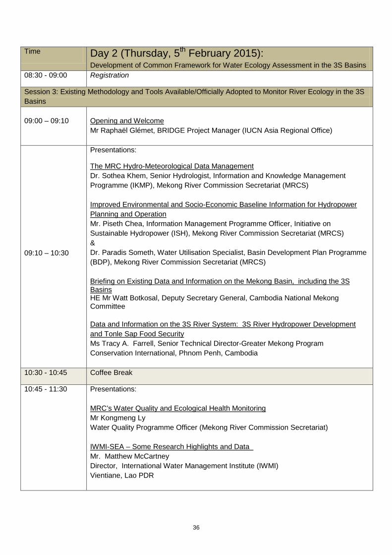
36
Time Day 2 (Thursday, 5th February 2015): Development of Common Framework for Water Ecology Assessment in the 3S Basins
08:30 - 09:00 Registration
Session 3: Existing Methodology and Tools Available/Officially Adopted to Monitor River Ecology in the 3S Basins
09:00 – 09:10
Opening and Welcome Mr Raphaël Glémet, BRIDGE Project Manager (IUCN Asia Regional Office)
09:10 – 10:30
Presentations:
The MRC Hydro-Meteorological Data Management Dr. Sothea Khem, Senior Hydrologist, Information and Knowledge Management Programme (IKMP), Mekong River Commission Secretariat (MRCS) Improved Environmental and Socio-Economic Baseline Information for Hydropower Planning and Operation Mr. Piseth Chea, Information Management Programme Officer, Initiative on Sustainable Hydropower (ISH), Mekong River Commission Secretariat (MRCS) & Dr. Paradis Someth, Water Utilisation Specialist, Basin Development Plan Programme (BDP), Mekong River Commission Secretariat (MRCS) Briefing on Existing Data and Information on the Mekong Basin, including the 3S Basins HE Mr Watt Botkosal, Deputy Secretary General, Cambodia National Mekong Committee Data and Information on the 3S River System: 3S River Hydropower Development and Tonle Sap Food Security Ms Tracy A. Farrell, Senior Technical Director-Greater Mekong Program Conservation International, Phnom Penh, Cambodia
10:30 - 10:45 Coffee Break
10:45 - 11:30 Presentations: MRC’s Water Quality and Ecological Health Monitoring Mr Kongmeng Ly Water Quality Programme Officer (Mekong River Commission Secretariat) IWMI-SEA – Some Research Highlights and Data Mr. Matthew McCartney Director, International Water Management Institute (IWMI) Vientiane, Lao PDR

37
11:30- 12:00 Facilitated discussion on thematic activities
12:00 - 13:00 Lunch break
Session 4: Developing a Common Framework for River Ecology Assessment in the 3S Basins--Concept and Group Discussions
13:00 - 14:00 Developing a common framework for river ecology assessment in the 3S Basins Mr Jim Webb, Deputy Managing Director and Senior Environmental Manager (Hatfield Consultants Mekong, Vientiane, Lao PDR)
14:00-15:30 Group Discussions: Next steps in developing a common framework for river ecology assessment in the 3S Basins (including time frame, definition of a working group and framework structure). (facilitator: Mr Jim Webb, Deputy Managing Director, Hatfield Consultants Mekong)
15:30 - 15:45 Coffee Break
15:45 - 16:45 Reporting back on the outcomes of the group discussion (Powerpoint presentation by each group)
16:45 - 17:30 Workshop Wrap-up and way forward Presentation of tentative agenda for upcoming events in 2015
17:30-17:45 Feedback for evaluation

38
Appendix 2 List of participants

39
Participants list, BRIDGE Technical Forum on “Data Sharing and Common Framework for Water Ecology Assessment in the 3S (Sekong, Sesan and Sre Pok) Basins” 4-5 February 2015, Bangkok
S/N
Title Name Position Organization Country Email
Government
1 Mr. Watt Botkosal Deputy Secretary General
Cambodia National Mekong Committee (CNMC)
Cambodia [email protected]
2 Ms. Le Thi Huong Deputy Head of Division
Viet Nam National Mekong Committee
Viet Nam [email protected]
3 Mr. Kongmeng Ly Water Quality Programme Officer
Mekong River Comission Secretariat (MRCS)
Cambodia [email protected]
4 Dr. Sothea Khem Senior Hydrologist
Mekong River Commission Secretariat (MRCS)
Cambodia [email protected]
5 Mr. Paradis Someth
Water Utilisation Specialist
Mekong River Commission Secretariat (MRCS)
Lao PDR [email protected]
6 Dr. Luu Thi Thanh Nhan
Lecturer MRC Viet Nam [email protected]
7 Dr. Lam Hung Son Coordinator MRC, M-IWRMP Viet Nam [email protected]
8 Ms. Truong Tung Hoa
Officer Department of Water Resources, Ministry of Natural Resources and Environment
Viet Nam [email protected]
9 Mr. Chanlakhone Homkingkeo
Officer Water Quality Monitoring and Management Division, Department of Water Resources, MoNRE
Lao PDR [email protected]
10 Mr. Say Tom Chief of Human Resource Development Office, Department of Agriculture Extension (DAE)
The Ministry of Agriculture, Forestry and Fisheries (MAFF)
Cambodia [email protected]
11 Mr. Vannaphar Tammajedy
Deputy Director of Namxouang Aquaculture Development Center
Department of Livestock and Fisheries, MAF
Lao PDR [email protected]
12 Mr. Chheng Phen Acting Director, Inland Fishereis Research and Development Institute, Fisheries Administration
Fisheries Administration (FiA) of The Ministry of Agriculture, Forestry and Fishereies (MAFF)
Cambodia [email protected]

40
13 Mr. Chhunn Chhim Senior officer Department of New and Renewable Energy (NandRE)
Ministry of Industry, Mines, and Energy
Cambodia [email protected]
14 Mr. Bui Tuan Hai Officer Institute of Water Resource Planning
Viet Nam [email protected]
15 Mr. Sengsoulivanh Inthachak
Head of Water Resources Section
Department of Natural Resources and Environment of Champasak Province
Lao PDR [email protected]
16 Mr. Chanthaphone Panyathong
Civil Engineer, Electrocty Generation Planning Division
Department of Energy Policy and Planning, Ministry of Energy and Mines
Lao PDR [email protected]
17 Ms. Phaylin Bouakeo
Department of Water Resources
Ministry of Natural Resources and Environment
Lao PDR [email protected]
18 Mr. Phousavanh Fongkhamdeng
Deputy Director, Administration-Planning Division
Department of Water Resources, MoNRE
Lao PDR [email protected]
19 Mr. Pich Sereywath
Deputy Director of Department of Community Fisheries Development
Ministry of Agriculture, Forestry and Fisheries. (MAFF)
Cambodia [email protected]
University and Research based Organizations
20 Assoc. Prof.
Le Anh Tuan Vice Director Research Institute for Climate Change (DRAGON institute - Mekong), Can Tho University
Viet Nam [email protected]
21 Assoc. Prof.
Hoang Duc Huy
Lecturer Department of Ecology and Evolutionary Biology, Ho Chi Minh City University of Science
Viet Nam [email protected]
22 Ms. Vu Thi Thanh Tu
Researcher Institute of Foreign policy and Strategic Studies, Diplomatic Academy of Viet Nam
Viet Nam [email protected]
23 Mr. Seak Sophat Head of Natural Resources Management and Development, Faculty of Development Study
Royal University of Phnom Penh
Cambodia [email protected] [email protected]
Regional/ National NGOs
24 Mr. Meach Mean Coordinator 3S River Protection Network (3SPN)
Cambodia [email protected] or [email protected]
25 Mr. Tek Vannara Executive Director
NGO Forum Cambodia Cambodia [email protected]

41
26 Mr. Kong Am Program Coordinator
My Village (Mvi) at Stung Treng
Cambodia [email protected]
27 Ms. Nguyen Hanh Quyen
GIS associate, GMS Environmental Operation Center
Advance Development Bank
Thailand [email protected]
28 Mr. Yourk Senglong
Program Manager
Fisheries Action Coalition Team (FACT)
Cambodia [email protected]
29 Mr. Jim Webb Deputy Managing Director and Senior Environmental Manager
Hatfield Consultants Mekong, Vientiane, Lao PDR
Lao PDR [email protected]
International NGOs
30 Dr. Tracy Farrell Senior Technical Director, Conservation International – Great Mekong Program
Conservation International (CI)
Cambodia [email protected]
31 Mr. Matthew McCartney
Principal Researcher and Theme Leader Ecosystem Services
International Water Modelling Institute (IWMI)
Lao PDR [email protected]
32 Mr. Terry Parnell Project Manager
Open Development Mekong (OPD)
Cambodia [email protected]
33 Ms. Amy Trandem SE Asia Program Director
International Rivers (IR) Thailand [email protected]
Freelance Consultant Working in 3S Countries
34 Mr. Nguyen Huu Thien
Wetland specialist
Freelance (ADB Consultant)
Viet Nam [email protected]
35 Mr. Pham Tan Ha GIS and Water Resources expert
Freelance Viet Nam [email protected]
IUCN
36 Dr. Scott Perkin Head, Natural Resource Group
IUCN Thailand [email protected]
37 Mr. Jake Brunner Deputy, South East Asia
IUCN Viet Nam [email protected]
38 Mr. Raphael Glemet
Senior Programme Officer, Water and Wetlands
IUCN Thailand [email protected]
39 Mr. Daniel Constable
GIS Specialist IUCN Viet Nam [email protected]
40 Mr. Vilavong Vannalath
Field Coordinator, Champasak
IUCN Lao PDR [email protected]
41 Ms. Wendy Atieno Programme and Communications Officer
IUCN Lao PDR [email protected]

42
42 Mr. Sorn Pheakdey
Water and Wetlands Coordinator
IUCN Cambodia [email protected]
43 Ms. Ria Sen Programme Assistant
IUCN Thailand [email protected]
44 Mr. Vishwa Sinha Programme officer, NRG
IUCN Thailand [email protected]
45 Mr. Nguyen Duc Tu
Water and Wetland Program Coordinator
IUCN Viet Nam [email protected]