strand - bilton primary school
TRANSCRIPT


Strand
Key Stage 1
Progression Statement Relevant Flic Objective
What to look for
(working towards)
What to look for (expected)
What to look for (exceeding expectations)
1. The UK and local area
Name, locate and identify characteristics of the four countries and capital cities of the United Kingdom and its surrounding seas.
Year 1 –Name, locate and identify characteristics of the four countries and capital cities of the United Kingdom and its surrounding areas (3: Link Location and Place Knowledge) Year 2 – N/A
The child can use an atlas to name and locate on a map the four countries and capital cities of the United Kingdom. (E.g. Using information about food from different countries of the UK, locate them on a UK map. Prepare a ‘Great British Picnic’ using these foods.)
The child can name, locate and identify characteristics of the four countries and capital cities of the United Kingdom and its surrounding seas on a map. (E.g. Using information about food from different parts of the UK, create a map showing where regional foods come from. Prepare a ‘Great British Picnic’ using these foods.)
The child can name, locate and identify characteristics of the four countries and capital cities of the United Kingdom and its surrounding seas on a range of maps. (E.g. Research food that originates from different parts of the UK and create a map showing where regional foods come from. Design a menu for a ‘Great British Picnic’ using these foods.)
Develop knowledge of the human and physical geography of a small area of the United Kingdom.
Year 1 - Understand geographical similarities and differences of a small area of the United Kingdom (3: Link Location and Place Knowledge) Year 2 - Understand geographical similarities and differences of a small area of the United Kingdom (3: Link Location and Place
The child can know about the local area and name key landmarks, e.g. the nearest local green space. (E.g. From a vocabulary list of features of the local area, identify which are human or physical. Describe these features.)
The child can know about the local area, and name and locate key landmarks. (E.g. Create a vocabulary list of the human and physical features of the local area. Describe these features and locate them on a map using images or drawings.)
The child can know the local area and its physical and human geography. (E.g. Investigate how other people view the local area, e.g. tourism websites. Create a vocabulary list of the human and physical features of the local area and how people can use and change these. Describe these features
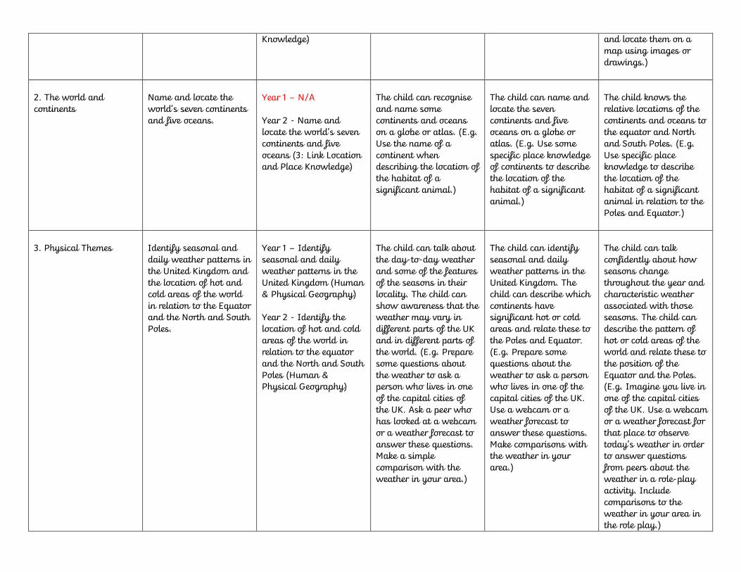
Knowledge)
and locate them on a map using images or drawings.)
2. The world and continents
Name and locate the world's seven continents and five oceans.
Year 1 – N/A Year 2 - Name and locate the world’s seven continents and five oceans (3: Link Location and Place Knowledge)
The child can recognise and name some continents and oceans on a globe or atlas. (E.g. Use the name of a continent when describing the location of the habitat of a significant animal.)
The child can name and locate the seven continents and five oceans on a globe or atlas. (E.g. Use some specific place knowledge of continents to describe the location of the habitat of a significant animal.)
The child knows the relative locations of the continents and oceans to the equator and North and South Poles. (E.g. Use specific place knowledge to describe the location of the habitat of a significant animal in relation to the Poles and Equator.)
3. Physical Themes
Identify seasonal and daily weather patterns in the United Kingdom and the location of hot and cold areas of the world in relation to the Equator and the North and South Poles.
Year 1 – Identify seasonal and daily weather patterns in the United Kingdom (Human & Physical Geography) Year 2 - Identify the location of hot and cold areas of the world in relation to the equator and the North and South Poles (Human & Physical Geography)
The child can talk about the day-to-day weather and some of the features of the seasons in their locality. The child can show awareness that the weather may vary in different parts of the UK and in different parts of the world. (E.g. Prepare some questions about the weather to ask a person who lives in one of the capital cities of the UK. Ask a peer who has looked at a webcam or a weather forecast to answer these questions. Make a simple comparison with the weather in your area.)
The child can identify seasonal and daily weather patterns in the United Kingdom. The child can describe which continents have significant hot or cold areas and relate these to the Poles and Equator. (E.g. Prepare some questions about the weather to ask a person who lives in one of the capital cities of the UK. Use a webcam or a weather forecast to answer these questions. Make comparisons with the weather in your area.)
The child can talk confidently about how seasons change throughout the year and characteristic weather associated with those seasons. The child can describe the pattern of hot or cold areas of the world and relate these to the position of the Equator and the Poles. (E.g. Imagine you live in one of the capital cities of the UK. Use a webcam or a weather forecast for that place to observe today’s weather in order to answer questions from peers about the weather in a role-play activity. Include comparisons to the weather in your area in the role play.)
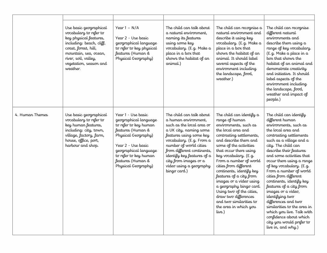
Use basic geographical vocabulary to refer to key physical features, including: beach, cliff, coast, forest, hill, mountain, sea, ocean, river, soil, valley, vegetation, season and weather.
Year 1 – N/A Year 2 - Use basic geographical language to refer to key physical features (Human & Physical Geography)
The child can talk about a natural environment, naming its features using some key vocabulary. (E.g. Make a place in a box that shows the habitat of an animal.)
The child can recognise a natural environment and describe it using key vocabulary. (E.g. Make a place in a box that shows the habitat of an animal. It should label several aspects of the environment including the landscape, food, weather.)
The child can recognise different natural environments and describe them using a range of key vocabulary. (E.g. Make a place in a box that shows the habitat of an animal and demonstrate creativity and initiative. It should label aspects of the environment including the landscape, food, weather and impact of people.)
4. Human Themes
Use basic geographical vocabulary to refer to key human features, including: city, town, village, factory, farm, house, office, port, harbour and shop.
Year 1 - Use basic geographical language to refer to key human features (Human & Physical Geography) Year 2 - Use basic geographical language to refer to key human features (Human & Physical Geography)
The child can talk about a human environment, such as the local area or a UK city, naming some features using some key vocabulary. (E.g. From a number of world cities from different continents, identify key features of a city from images or a video using a geography bingo card.)
The child can identify a range of human environments, such as the local area and contrasting settlements, and describe them and some of the activities that occur there using key vocabulary. (E.g. From a number of world cities from different continents, identify key features of a city from images or a video using a geography bingo card. Using two of the cities, draw two differences and two similarities to the area in which you live.)
The child can identify different human environments, such as the local area and contrasting settlements such as a village and a city. The child can describe their features and some activities that occur there using a range of key vocabulary. (E.g. From a number of world cities from different continents, identify key features of a city from images or a video, identifying two differences and two similarities to the area in which you live. Talk with confidence about which city you would prefer to live in, and why.)

5. Understanding Places and Connections
Understand geographical similarities and differences through studying the human and physical geography of a small area of the United Kingdom.
Year 1 – Understand geographical similarities and differences of a small area of the United Kingdom (Link Location and Place Knowledge) Year 2 - Understand geographical similarities and differences of a small area of the UK and a contrasting non-European country (Link Location and Place Knowledge)
The child can make observations about, and describe, the local area and the nearest local green space. (E.g. Make the first page of a ‘World Wonders’ book with some reasons why their local area is wonderful, drawing on ideas from the rest of the class. Use different colours to identify its physical and human characteristics.)
The child can make observations about, and describe, the local area and its physical and human geography. (E.g. Make the first page of a ‘World Wonders’ book with reasons why their local area is wonderful. Use different colours to identify its physical and human characteristics.)
The child can make observations about, and describe, the local area and its physical and human geography, and suggest how they are connected. (E.g. Make the first page of a ‘World Wonders’ book with reasons why their local area is wonderful. Use different colours to identify its physical and human characteristics. Draw this together by annotating an image or map of the local area.)
Understand geographical similarities and differences through studying the human and physical geography of a small area of a contrasting non-European country.
Year 1 – N/A Year 2 - Understand geographical similarities and differences of a small area of the UK and a contrasting non-European country (Link Location and Place Knowledge)
The child can describe an aspect of the physical and human geography of a distant place. The child can show awareness of their locality and identify one or two ways it is different and similar to the distant place. (E.g. Complete a travel document to visit a place they have studied; be supported in a role-play to explain why they wish to visit this place.)
The child can describe the physical and human geography of a distant place. The child can describe their locality and how it is different and similar to the distant place. (E.g. Complete a travel document to visit a place they have studied; work with a peer in a role-play to explain why they wish to visit this place, mentioning its physical and human characteristics.)
The child can confidently describe the physical and human geography of a distant place. The child can confidently describe their locality and how it is different and similar to the distant place, and suggest why this may be so. (E.g. Complete a travel document. Act as a travel agent in a role-play, explaining confidently why people may wish to visit a range of places, including an understanding of the physical and human characteristics of the places.)

6. Map and Atlas Work Use world maps, atlases and globes to identify the United Kingdom and its countries, as well as the countries, continents and oceans studied at this key stage.
Year 1 - Use world maps, atlases and globes (Geographical Skills & Fieldwork) Year 2 - Use world maps, atlases and globes (Geographical Skills & Fieldwork)
The child can use a world map, atlas or globe to recognise and name some continents and oceans. The child can use a UK wall map or atlas to locate and identify the four countries and capital cities of the United Kingdom. (E.g. Locate the continents where different animals live on a world map, in an atlas or on the wall.)
The child can use a world map, atlas or globe to name and locate the seven continents and five oceans. The child can use a UK wall map or atlas to locate and identify the four countries and capital cities of the United Kingdom and its surrounding seas. (E.g. Locate the continents where different animals live on a blank base map of the world using an atlas.)
The child can use a world map, atlas or globe to locate the continents and oceans relative to the Equator and North and South Poles. The child can use a range of maps and satellite images to locate and identify the four countries and capital cities of the United Kingdom and its surrounding seas. (E.g. Locate with confidence the continents where different animals live on a base map of the world using an atlas and describe their location.)
Use simple compass directions (North, South, East and West) and locational and directional language (e.g. near and far; left and right), to describe the location of features and routes on a map.
Year 1 – Use simple compass directions &Use simple directional language in relation to mapwork (Geographical Skills & Fieldwork) Year 2 - Use simple compass directions & Use simple directional language in relation to mapwork (Geographical Skills & Fieldwork)
The child can locate places on a map of the local area using locational and directional language. (E.g. After a walk to a nearby green space, describe the route taken on a simple base map using everyday directions and locational language prompted by their journey stick.)
The child can describe a journey on a map of the local area using simple compass directions and locational and directional language. (E.g. After a walk to a nearby green space, describe the route taken on a large-scale map using compass directions and locational language prompted by their journey stick.)
The child can describe a journey on a map of the local area locating features and landmarks seen on the journey. (E.g. After a walk to a nearby green space, describe with confidence the route taken on a large-scale OS map using compass directions and locational language prompted by their journey stick.)
7. Fieldwork and Investigation
Use aerial photographs and plan perspectives to recognise landmarks and basic human and physical features; devise
Year 1 – Recognise some features from aerial photographs and plan perspectives (Geographical Skills &
The child can use aerial photos to identify features of a locality. The child can draw a simple map. (E.g. Create
The child can use aerial photos to identify physical and human features of a locality. The child can draw a
The child can use aerial photos to identify a range of physical and human features of a locality. The child can

a simple map; and use and construct basic symbols in a key.
Fieldwork) Year 2 - Recognise features from aerial photographs and plan perspectives (Geographical Skills & Fieldwork)
models of landmarks seen on a local walk. Order the landmarks as they were seen on the journey.)
simple map with a basic key of places showing landmarks. (E.g. Create models of landmarks seen on a local walk, order the landmarks and correctly locate them on a large-scale map on the classroom or hall floor.)
draw a map with a key of places showing landmarks. (E.g. Create symbols for landmarks seen on a local walk, correctly locate them on a map and construct a key.)
Use simple fieldwork and observational skills to study the geography of their school and its grounds and the key human and physical features of its surrounding environment.
Year 1 – Relate to the geography of the school and its surroundings through observations (Geographical Skills & Fieldwork) Year 2 – N/A
The child can assist in keeping a weekly weather chart based on first-hand observations using picture symbols. The child can locate some features of the school grounds on a base map. (E.g. Go into the playground to observe the weather and record this with drawings.)
The child can keep a weekly weather chart based on first-hand observations using picture symbols, and present this data. The child can locate features of the school grounds on a base map. (E.g. Go into the playground to observe the weather and record this, building up a table of information to be discussed and described.)
The child can keep a weekly weather chart based on first-hand observations using picture symbols. Talk about this data and identify patterns. The child can accurately locate features of the school grounds on a base map. (E.g. Independently take a set of weather measurements using equipment such as a thermometer and homemade rain gauge, and record them.)
Strand
Lower Key Stage 2
Progression Statement Relevant Flic Objective
What to look for
(working towards)
What to look for (expected)
What to look for (exceeding expectations)
1. The UK and Local Area
Name and locate counties, cities and geographical regions of the United Kingdom and recognise their
Year 3 – Name and locate countries and cities of the UK, geographical regions and identify human and
The child can describe where the UK is located, and name and locate its four countries and some counties; locate where
The child can describe where the UK is located, and name and locate some major urban areas; locate where they live in
The child can describe where the UK is located, and name and locate a range of cities and counties; locate where

identifying human and physical characteristics.
physical characteristics (Location Knowledge) Year 4 - Name and locate countries and cities of the UK, geographical regions and identify human and physical characteristics (Location Knowledge)
they live in the UK. The child can relate continent, country, county, city/where you live. The child can locate the UK's major urban areas; locate some physical environments in the UK. (E.g. Use a copy of a map of the British Isles and locate and label the main British rivers.)
the UK using locational terminology (north, south, east, west) and the names of nearby counties. The child can locate and describe some human and physical characteristics of the UK. (E.g. Use a copy of a map of the British Isles and locate and label the main British rivers. Add the names of settlements at the mouth of the rivers.)
they live in the UK using locational terminology (north, south, east, west). The child can locate and describe several contrasting physical environments. (E.g. Use a copy of a map of the British Isles and locate and label the main British rivers. Add the names of settlements at the mouth of the rivers. Locate and label the mountains/hills where the source of these rivers is found.)
2. The World and Continents
Locate the world's countries, focusing on Europe and North and South America
Year 3 - Locate the worlds countries, using maps to focus on their environmental regions, key physical and human characteristics, countries and major cities (Location Knowledge) Year 4 - Locate the worlds countries, using maps to focus on their environmental regions, key physical and human characteristics, countries and major cities (Location Knowledge)
The child can locate countries in Europe and North and South America on a map or atlas. The child can describe some European and North and South American cities using an atlas. (E.g. Using the words of the song ‘Route 66’, locate the places mentioned on a map of the USA to show a route across the USA.)
The child can locate some countries in Europe and North and South America on a map or atlas. The child can relate continent, country, state, city. Identify states in North America using a map. (E.g. Using the words of the song ‘Route 66’, locate the places mentioned on a map of the USA to show a route across the USA. Describe the route.)
The child can locate most countries in Europe and North and South America using an atlas. The child can identify states in the USA using a map. Explain and illustrate, with examples, continent, country, state, city. (E.g. Using the words of the song ‘Route 66’, locate the places mentioned on a map of the USA to show a route across the USA. Describe the route and what you would expect to see on the way.)
Identify the position and significance of latitude, longitude, Equator, Northern Hemisphere,
Year 3 – N/A Year 4 – N/A
The child can use a globe and map to identify the position of the Poles, the Equator,
The child can identify the position of the Prime/Greenwich Meridian and understand
The child can identify the position of the Equator, Northern Hemisphere and

Southern Hemisphere, the Tropics of Cancer and Capricorn, Arctic and Antarctic Circles, the Prime/Greenwich Meridian and time zones (including day and night).
Northern Hemisphere and Southern Hemisphere. Locate the Tropics of Cancer and Capricorn, Arctic and Antarctic Circles. (E.g. In a group, make a locational map quiz or puzzle for their class to test knowledge of key points and lines on the globe.)
the significance of latitude and longitude. (E.g. In a group or individually, make a locational map game, quiz or puzzle for other children in their class to test knowledge and understanding of latitude and longitude.)
Southern Hemisphere and understand the significance of the Tropics of Cancer and Capricorn, Arctic and Antarctic Circles, the Prime/Greenwich Meridian (including day and night). (E.g. Individually or leading a group, create a locational map game, quiz or puzzle for other children in their class or school to test knowledge and understanding of the significance of latitude and longitude.)
3. Physical Themes
Describe and understand key aspects of physical geography including: climate zones, biomes and vegetation belts.
Year 3 – Describe and understand the key aspects of physical geography (Human & Physical Geography) Year 4 - Describe and understand the key aspects of physical geography (Human & Physical Geography)
The child can describe the pattern of hot or cold areas of the world and relate this to the position of the Equator and the Poles. (E.g. Prepare a report, using a map and photographs, about an animal they have chosen. This should contain details of the animal, where it lives in terms of climate and what it eats.)
The child can indicate tropical, temperate and polar climate zones on a globe or map and describe the characteristics of these zones using appropriate vocabulary. (E.g. Prepare a report, using maps and photographs, about an animal they have chosen. This should contain details of the animal, where it lives in terms of climate and biome, and what it eats.)
The child can indicate tropical, temperate and polar climate zones on a globe or map and describe the characteristics of these zones using appropriate vocabulary. The child can understand the relationship between climate and vegetation. (E.g. Independently prepare a report, using maps and photographs, about an animal they have chosen. This should contain details of the animal, where it lives in relation to climate and biome, and how it is suited to the environment.)
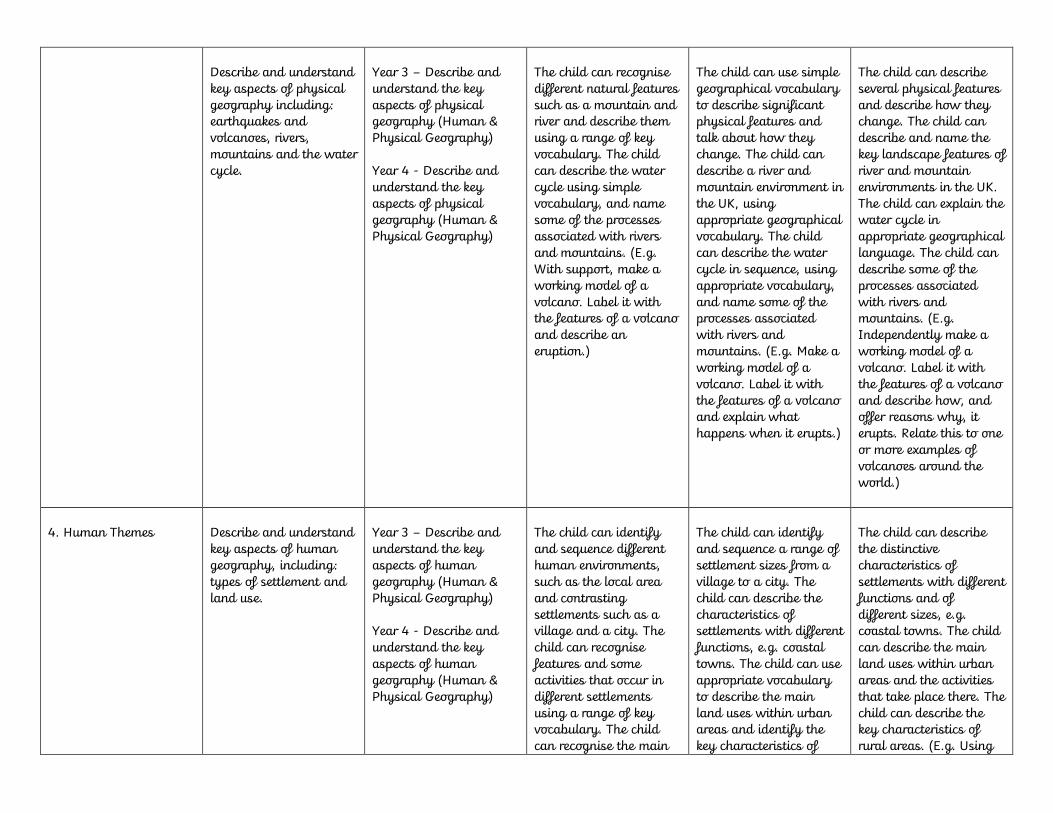
Describe and understand key aspects of physical geography including: earthquakes and volcanoes, rivers, mountains and the water cycle.
Year 3 – Describe and understand the key aspects of physical geography (Human & Physical Geography) Year 4 - Describe and understand the key aspects of physical geography (Human & Physical Geography)
The child can recognise different natural features such as a mountain and river and describe them using a range of key vocabulary. The child can describe the water cycle using simple vocabulary, and name some of the processes associated with rivers and mountains. (E.g. With support, make a working model of a volcano. Label it with the features of a volcano and describe an eruption.)
The child can use simple geographical vocabulary to describe significant physical features and talk about how they change. The child can describe a river and mountain environment in the UK, using appropriate geographical vocabulary. The child can describe the water cycle in sequence, using appropriate vocabulary, and name some of the processes associated with rivers and mountains. (E.g. Make a working model of a volcano. Label it with the features of a volcano and explain what happens when it erupts.)
The child can describe several physical features and describe how they change. The child can describe and name the key landscape features of river and mountain environments in the UK. The child can explain the water cycle in appropriate geographical language. The child can describe some of the processes associated with rivers and mountains. (E.g. Independently make a working model of a volcano. Label it with the features of a volcano and describe how, and offer reasons why, it erupts. Relate this to one or more examples of volcanoes around the world.)
4. Human Themes
Describe and understand key aspects of human geography, including: types of settlement and land use.
Year 3 – Describe and understand the key aspects of human geography (Human & Physical Geography) Year 4 - Describe and understand the key aspects of human geography (Human & Physical Geography)
The child can identify and sequence different human environments, such as the local area and contrasting settlements such as a village and a city. The child can recognise features and some activities that occur in different settlements using a range of key vocabulary. The child can recognise the main
The child can identify and sequence a range of settlement sizes from a village to a city. The child can describe the characteristics of settlements with different functions, e.g. coastal towns. The child can use appropriate vocabulary to describe the main land uses within urban areas and identify the key characteristics of
The child can describe the distinctive characteristics of settlements with different functions and of different sizes, e.g. coastal towns. The child can describe the main land uses within urban areas and the activities that take place there. The child can describe the key characteristics of rural areas. (E.g. Using

land uses within urban areas and the key characteristics of rural areas. (E.g. Using Google Earth, atlases and images with support, research some major cities in North and South America and identify how they are different.)
rural areas. (E.g. Using Google Earth, atlases and images, research several major cities in North and South America and identify how they are different and similar.)
Google Earth, atlases and images, independently research several major cities in North and South America and suggest reasons why they are different and similar.)
Understanding Place and Connections
Understand geographical similarities and differences through the study of human and physical geography of a region of the United Kingdom.
Year 3 – Understand the geographical similarities and differences through the study of human and physical geography of a region of the UK, a region in a European country and a region within North or South America (Location Knowledge) Year 4 - Understand the geographical similarities and differences through the study of human and physical geography of a region of the UK, a region in a European country and a region within North or South America (Location Knowledge)
The child can understand the basic physical and human geography of the UK and its contrasting human and physical environments. The child can recognise that some regions are different from others. (E.g. Research a coastal locality and make a travel agent style presentation to a group of people to promote the human and physical characteristics of the area.)
The child can understand the physical and human geography of the UK and its contrasting human and physical environments. The child can explain why some regions are different from others. (E.g. Research a coastal locality and make a travel agent style presentation to a group of people to promote the human and physical characteristics of the area and how they combine to form a unique environment.)
The child can have a good understanding of the physical and human geography of the UK and its contrasting human and physical environments. The child can explain why some regions are different from others and give reasons why some are similar. (E.g. Research a coastal locality and make a travel agent style presentation to a group of people to promote the human and physical characteristics of the area and how they combine to form a unique environment compared to other areas.)
Understand geographical similarities and differences through the study of human and physical geography of a region in a European
Year 3 – Understand the geographical similarities and differences through the study of human and physical geography of a region of the UK, a
The child can recognise that there are physical and human differences within countries and continents. The child can show awareness of the
The child can describe and compare similarities and differences between some regions in Europe and North or South America. The child can
The child can offer explanations for the similarities and differences between some regions in Europe and North or South America.

country and a region within North or South America.
region in a European country and a region within North or South America (Location Knowledge) Year 4 - Understand the geographical similarities and differences through the study of human and physical geography of a region of the UK, a region in a European country and a region within North or South America (Location Knowledge)
physical and human characteristics of a European region and a region in North or South America. (E.g. Using photos, information sheets and Google Earth, record information about one city in North America and one in South America. Compare these cities, identifying one difference and one similarity.)
understand how the human and physical characteristics of one region in Europe and North or South America are connected and make it special. (E.g. Using photos, information sheets and Google Earth, record information about one city in North America and one in South America and their surrounding areas. Compare these cities, drawing out human and physical characteristics. Identify differences and similarities.)
The child can describe and compare the physical and human characteristics of some regions in North or South America. The child can understand how the human and physical characteristics are connected for more than one region in Europe and North or South America. (E.g. Using photos, information sheets and Google Earth, record information about several cities in North America and South America and their surrounding areas. Select two cities and their surrounding areas to compare, drawing out human and physical characteristics, differences and similarities.)
Establish an understanding of the interaction between physical and human processes
Year 3 – Within Human & Physical Geography Year 4 – Within Human & Physical Geography
The child can describe how some physical processes can cause hazards to people. The child can recognise that there are advantages and disadvantages of living in certain environments. (E.g. Investigate the impacts of the 2011 Japanese earthquake using images and internet research.)
The child can understand how physical processes can cause hazards to people. The child can describe some advantages and disadvantages of living in hazard-prone areas. (E.g. Investigate the causes and impacts of the 2011 Japanese earthquake using images and internet research.)
The child can offer reasons why physical processes can cause hazards to people. The child can offer explanations for the advantages and disadvantages of living in hazard-prone areas. (E.g. Investigate the causes and impacts of the 2011 Japanese earthquake using images and internet research,

and investigate how people are attempting to minimise the impacts of future earthquakes.)
6. Map and Atlas Work
Use maps, atlases, globes and digital/computer mapping to locate countries and describe features studied.
Year 3 – Use maps, atlases, globes to locate countries (Geographical Skills and Fieldwork) Year 4 – Use maps, atlases, globes to locate countries (Geographical Skills and Fieldwork)
The child can use a map to identify countries in Europe and/or North and South America. The child can use an atlas to describe where the UK is located, and name and locate its four countries and some counties; locate where they live in the UK. The child can use an atlas to locate where they live in the UK and the UK's major urban areas. (E.g. Use an atlas to locate places in an atlas using the contents page.)
The child can use a map or atlas to locate some countries and cities in Europe or North and South America. The child can use a map to locate some states of the USA. The child can use an atlas to locate the UK and locate some major urban areas; locate where they live in the UK. (E.g. Use an atlas to locate places using latitude and longitude and be able to describe the location of the place using a nested hierarchy.)
The child can use an atlas to locate many countries, cities and key features in Europe or North and South America. The child can use a map to locate the states of the USA. The child can use an atlas to name and locate a range of cities and counties in the UK. (E.g. Use an atlas with confidence to locate places using latitude and longitude, be able to describe the location of the place using a nested hierarchy and describe where the place is in relation to others.)
Use symbols and key (including the use of Ordnance Survey maps) to build their knowledge of the United Kingdom and the wider world.
Year 3 – Use the eight points of a compass, four-figure grid references, symbols and key to build their knowledge of the UK and the wider world (Geographical Skills and Fieldwork) Year 4 - Use the eight points of a compass, four-figure grid references, symbols and
The child can use a simple letter and number grid. The child can give direction instructions up to four compass points. The child can use large-scale maps outside. (E.g. Follow a local river downstream on an OS map. Identify some features of the river.)
G.2.6.4.b. The child can use four-figure grid references. The child can give direction instructions up to eight compass points. The child can adeptly use large-scale maps outside. (E.g. Follow a local river downstream on an OS map. Identify human and physical features along the river’s course and record these
G.2.6.5.b. The child can know that six-figure grid references can help you find a place more accurately than four-figure grid references. The child can use the scale bar or 1 km grid to estimate distance. The child can recognise patterns on maps and begin to explain what they show. (E.g. Independently follow a
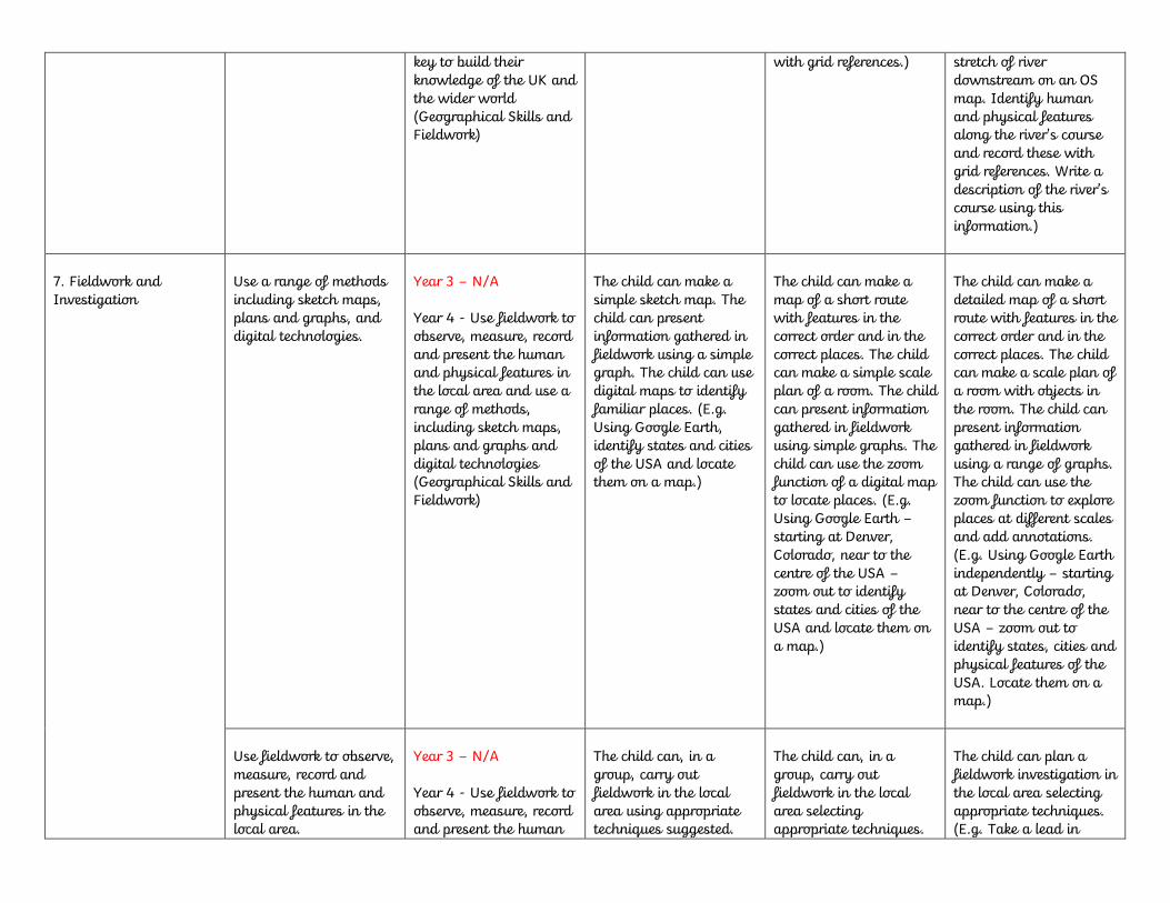
key to build their knowledge of the UK and the wider world (Geographical Skills and Fieldwork)
with grid references.)
stretch of river downstream on an OS map. Identify human and physical features along the river’s course and record these with grid references. Write a description of the river’s course using this information.)
7. Fieldwork and Investigation
Use a range of methods including sketch maps, plans and graphs, and digital technologies.
Year 3 – N/A Year 4 - Use fieldwork to observe, measure, record and present the human and physical features in the local area and use a range of methods, including sketch maps, plans and graphs and digital technologies (Geographical Skills and Fieldwork)
The child can make a simple sketch map. The child can present information gathered in fieldwork using a simple graph. The child can use digital maps to identify familiar places. (E.g. Using Google Earth, identify states and cities of the USA and locate them on a map.)
The child can make a map of a short route with features in the correct order and in the correct places. The child can make a simple scale plan of a room. The child can present information gathered in fieldwork using simple graphs. The child can use the zoom function of a digital map to locate places. (E.g. Using Google Earth – starting at Denver, Colorado, near to the centre of the USA – zoom out to identify states and cities of the USA and locate them on a map.)
The child can make a detailed map of a short route with features in the correct order and in the correct places. The child can make a scale plan of a room with objects in the room. The child can present information gathered in fieldwork using a range of graphs. The child can use the zoom function to explore places at different scales and add annotations. (E.g. Using Google Earth independently – starting at Denver, Colorado, near to the centre of the USA – zoom out to identify states, cities and physical features of the USA. Locate them on a map.)
Use fieldwork to observe, measure, record and present the human and physical features in the local area.
Year 3 – N/A Year 4 - Use fieldwork to observe, measure, record and present the human
The child can, in a group, carry out fieldwork in the local area using appropriate techniques suggested.
The child can, in a group, carry out fieldwork in the local area selecting appropriate techniques.
The child can plan a fieldwork investigation in the local area selecting appropriate techniques. (E.g. Take a lead in

and physical features in the local area and use a range of methods, including sketch maps, plans and graphs and digital technologies (Geographical Skills and Fieldwork)
(E.g. Participate with a group to create a river in the playground using natural materials. Use a watering can to form the river. Observe and record what happens to the water over different materials. Take photographs and label with key river features.)
(E.g. Create a river in the playground using natural materials. Use a watering can to form the river. Observe and record what happens to the water over different materials. Take photographs and label with key river features and processes.)
planning and creating a river in the playground and select a range of natural materials to use. Use a watering can to form the river. Observe and record what happens to the water over different materials. Take photographs and annotate with key river features and processes.)
Strand
Upper Key Stage 2
Progression Statement Relevant Flic Objective
What to look for
(working towards)
What to look for (expected)
What to look for (exceeding expectations)
1. The UK and Local Area
Identify the geographical regions and key topographical features of the United Kingdom (including hills, mountains, coasts and rivers), and land-use patterns; and understand how some of these aspects have changed over time.
Year 5 – N/A Year 6 – N/A
The child can locate and describe some physical environments in the UK, e.g. coastal environments, the UK's significant rivers and mountains. The child can locate the UK's regions and major cities. (E.g. Use a blank map to create a 'Highest, longest, biggest' challenge – locate the longest river and highest point of each country of the UK.)
The child can locate and describe several physical environments in the UK, e.g. coastal and mountain environments, and how they change. The child can locate the UK's major urban areas, knowing some of their distinct characteristics and how some of these have changed over time. The child can recognise broad land-use patterns of the UK. (E.g. Use a blank map to create a 'Highest, longest, biggest' challenge – locate the longest river and highest point of each country of the UK, as well as other
The child can locate and describe a range of contrasting physical environments in the UK, e.g. coastal, river, hill and mountain environments, and how they change. Locate, with accuracy, the UK's major urban areas, knowing their distinct characteristics and how they have changed over time. The child can identify broad land-use patterns of the UK. (E.g. Create a ‘Top Trumps’ game for other groups in the class for rivers, mountains in the UK, as well as other categories the children develop on

categories the children develop on their own, e.g. waterfall, lake, city population.)
their own, e.g. waterfall, lake, city population.)
2. The World and Continents
Locate the world's countries, using maps to focus on Europe (including the location of Russia) and North and South America, concentrating on their environmental regions, key physical and human characteristics, countries and major cities.
Year 5 – Locate the worlds countries, using maps to focus on their environmental regions, key physical and human characteristics, countries and major cities (Location Knowledge) Year 6 – Locate the worlds countries, using maps to focus on their environmental regions, key physical and human characteristics, countries and major cities (Location Knowledge)
The child can locate some major cities and countries of Europe and North and South America on physical and political maps. The child can describe some key physical and human characteristics of Europe and North and South America. (E.g. Use physical and political maps of Europe to create a junk model of the Alps. Label the key countries, cities and mountains.)
The child can locate cities, countries and regions of Europe and North and South America on physical and political maps. The child can describe key physical and human characteristics and environmental regions of Europe and North and South America. (E.g. Use physical and political maps of Europe to create a junk model of the Alps. Draw the borders of the countries, and label main cities and mountains.)
The child can locate places and regions of Europe and North and South America, and can identify the distinct characteristics of some regions. The child can describe, compare and contrast key physical and human characteristics, and environmental regions of Europe and North and South America. (E.g. Independently use physical and political maps of Europe to create a junk model of the Alps. Draw the borders of the countries, and label main cities and mountains. Add annotations to identify the main physical, human and cultural characteristics of the region of the Alps.)
Identify the position and significance of latitude, longitude, Equator, Northern Hemisphere, Southern Hemisphere, the Tropics of Cancer and Capricorn, Arctic and Antarctic Circles, the
Year 5 – Identify the position and significance of latitude, longitude, Equator, Northern Hemisphere, Southern Hemisphere, Artic and Antarctic Circle, the Prime/Greenwich
The child can locate places studied in relation to the Equator, Tropics of Cancer and Capricorn, and their latitude and longitude. (E.g. Produce a world fruit map based around a world map
The child can locate places studied in relation to the Equator, the Tropics of Cancer and Capricorn, latitude and longitude, and relate this to their time zone, climate, seasons and
The child can locate places studied in relation to the Equator, latitude and longitude, and relate this to their time zone, climate, seasons and vegetation. (E.g. Produce a world fruit map based
Prime/Greenwich Meridian and time zones (including day and night).
Meridian (Location Knowledge) Year 6 - Identify the position and significance of latitude, longitude, Equator, Northern Hemisphere, Southern Hemisphere, the Tropics of Cancer and Capricorn, Artic and Antarctic Circle, the Prime/Greenwich Meridian and time zones (Location Knowledge)
locating the origin of some fruits and relate this to latitude, longitude, the Equator, the Tropics of Cancer and Capricorn, and climate.)
vegetation. (E.g. Produce a world fruit map based around a world map locating the origin of several fruits and relate this to latitude, longitude, the Equator, the Tropics of Cancer and Capricorn, the Arctic and Antarctic Circles and climate zone.)
around a world map locating the origin of several fruits and relate this to latitude, longitude, the Equator, the Tropics of Cancer and Capricorn, the Arctic and Antarctic Circles and climate zone. Consider how these fruits could be grown nearer to home.)
3. Physical Themes
Describe and understand key aspects of physical geography, including: climate zones, biomes and vegetation belts.
Year 5 – Describe and understand the key aspects of physical geography (Human & Physical Geography) Year 6 - Describe and understand the key aspects of physical geography (Human & Physical Geography)
The child can understand that climate and vegetation are connected in an example of a biome, e.g. the tropical rainforest. The child can understand that animals and plants are adapted to the climate. The child can understand our food is grown in many different countries because of their climate. (E.g. Create a fruit map poster based around a world map using several fruits and labelling their countries of origin.)
The child can understand how climate and vegetation are connected in biomes, e.g. the tropical rainforest and the desert. The child can describe what the climate of a region is like and how plants and animals are adapted to it. The child can understand how food production is influenced by climate. (E.g. Produce a world fruit map showing where the fruit we eat is grown and the key aspects of the climate in these locations.)
The child can understand how climate and vegetation are connected in a range of biomes, e.g. the tropical rainforest, a hot desert, the Arctic.) The child can explain climate patterns of a region, describe the characteristics of a biome, what its climate is like and how plants and animals are adapted to it. The child can relate climate to food production. (E.g. Produce a world fruit map based around a world map using several fruits and identifying the climate zones where they grow.)
Describe and understand key aspects of physical geography, including:
Year 5 – Describe and understand the key aspects of physical
The child can describe some key physical processes and the
The child can describe and understand a range of key physical processes
The child can describe and understand some key physical processes
rivers, mountains, volcanoes and earthquakes, and the water cycle.
geography (Human & Physical Geography) Year 6 - Describe and understand the key aspects of physical geography (Human & Physical Geography)
resulting landscape features, e.g. understand the characteristics of a mountain region and how it was formed. (E.g. Make a playdough model to show the formation of fold mountains of the Alps in Europe and talk about what it shows.)
and the resulting landscape features. The child can understand how a mountain region was formed. (E.g. Make a playdough model to show the formation of fold mountains of the Alps in Europe and annotate it with simple explanations of what it shows.)
and the resulting landscape features. The child can understand how fold mountain regions are formed. (E.g. Make playdough models at stages in the formation of fold mountains of the Alps in Europe and write a commentary to show how the mountains are formed.)
4. Human Themes
Describe and understand key aspects of human geography including: economic activity including trade links, and the distribution of natural resources including energy, food, minerals and water.
Year 5 – Describe and understand the key aspects of human geography (Human & Physical Geography) Year 6 - Describe and understand the key aspects of human geography (Human & Physical Geography)
The child can know and understand what life is like in cities and in villages. The child can know the journey of how one product gets into their home in detail. The child can describe some renewable and non-renewable energy sources. The child can describe different types of industry currently in the local area. The child can know where some of our main natural resources come from. (E.g. Take part in a decision-making exercise selecting an energy source to generate power for nearby houses.)
The child can know and understand what life is like in cities and in villages and in a range of settlement sizes. The child can understand that products we use are imported as well as locally produced. The child can explain how the types of industry in the area have changed over time. The child can understand where our energy and natural resources come from. (E.g. Prepare a presentation for a decision-making exercise selecting an energy source to generate power for nearby houses.)
The child can know and understand what life is like in cities and in villages and in a range of settlement sizes in different parts of the world. The child can understand that our shopping choices have an effect on the lives of others. The child can explain how, and offer reasons why, the types of industry in the area have changed over time. The child can understand where our energy and natural resources come from, and the impacts of their use. (E.g. Take a lead in a presentation in a decision-making exercise selecting an energy source to generate power for nearby houses.)

5. Understanding Places and Connections
Understand geographical similarities and differences and change through the study of human and physical geography of the United Kingdom.
Year 5 – Understand the geographical similarities and differences through the study of human and physical geography of a region of the UK, a region in a European country and a region within North or South America (Location Knowledge) Year 6 - Understand the geographical similarities and differences through the study of human and physical geography of a region of the UK, a region in a European country and a region within North or South America (Location Knowledge)
The child can understand how a region has changed. (E.g. Produce a presentation showing how the site of the 2012 London Olympic and Paralympic Games has changed.)
The child can understand how a region has changed and how it is different from another region of the UK. (E.g. Produce a presentation showing how the site of the 2012 London Olympic and Paralympic Games has changed, including the views of local people.)
The child can understand how and why their region and other regions have changed, and how the regions of the UK are distinctive. (E.g. Produce a presentation showing how the site of the 2012 London Olympic and Paralympic Games has changed, including the views of local people and the future impact of the development of the Queen Elizabeth Park.)
Understand geographical similarities and differences through the study of human and physical geography of the United Kingdom, a region in a European country and a region within North or South America.
Year 5 – Understand the geographical similarities and differences through the study of human and physical geography of a region of the UK, a region in a European country and a region within North or South America (Location Knowledge) Year 6 - Understand the geographical similarities and differences through the study of human and physical geography of a region of the UK, a
The child can know and share information about a European region and a region in North or South America, and understand that a region such as the Alps is unique. (E.g. Design an app/webpage/leaflet for tourists to the Alps selecting some information.)
The child can know information about a region of Europe and North or South America, its physical environment and climate, and economic activity. (E.g. Design an app/webpage/leaflet for tourists to the Alps, selecting a range of information about the physical and human environment.)
The child can understand the importance of a region in Europe and in North or South America, its human and physical environment, and how they are connected. (E.g. Design an app/webpage/leaflet for tourists to the Alps, selecting a range of information about the physical and human environment. Refine the item based on feedback)

region in a European country and a region within North or South America (Location Knowledge)
Deepen an understanding of the interaction between physical and human processes.
Year 5 – Within Human & Physical Geography Year 6 - Within Human & Physical Geography
The child can explain some ways a biome (including the oceans) is valuable and under threat from human activity. The child can understand how human activity is influenced by climate and weather. The child can understand hazards from physical environments such as avalanches in mountain regions. The child can identify an important environmental issue. (E.g. Make an animation to show why the Amazon rainforest is valuable and why it should be protected.)
The child can explain some ways biomes (including the oceans) are valuable, why they are under threat and how they can be protected. The child can understand how human activity is influenced by climate and weather. The child can understand hazards from physical environments and their management, such as avalanches in mountain regions. The child can explain several threats to wildlife/habitats. (E.g. Make an animation to show why the Amazon rainforest is valuable and under threat, and why it should be protected.)
The child can explain some ways biomes (including the oceans) are valuable, why they are under threat and a range of ways they could be protected for the future. The child can understand how human activity is influenced by climate and weather. The child can understand the causes of hazards from physical environments and their management, such as avalanches in mountain regions. The child can understand that no one type of energy production will provide all our energy needs. (E.g. Make an animation to show why the Amazon rainforest is valuable and how it should be protected.)
6. Map and Atlas Work
Use maps, atlases, globes and digital/computer mapping to locate countries and describe features studied
Year 5 – Use maps, atlases, globes and digital/computer mapping to locate countries and describes features studied (Geographical Skills & Fieldwork)
The child can use physical and political maps, atlases, and computer mapping to describe some key physical and human characteristics of Europe or North and South
The child can use physical and political maps to describe key physical and human characteristics of regions of Europe or North and South America. The child can use globes and
The child can use atlases to identify the distinct characteristics of some regions of Europe or North and South America. The child can use globes and atlases to accurately locate places

Year 6 - Use maps, atlases, globes and digital/computer mapping to locate countries and describes features studied (Geographical Skills & Fieldwork)
America. The child can use globes and atlases to locate places studied in relation to the Equator, Tropics of Cancer and Capricorn, and their latitude and longitude. (E.g. Use physical and political maps to identify the Alps and the countries this region spreads across.)
atlases to locate places studied in relation to the Equator, latitude and longitude and time zones. The child can use thematic maps for specific purposes. (E.g. Use physical and political maps to identify the Alps, its countries, cities and topography.)
by their latitude and longitude. (E.g. Use physical and political maps to identify the Alps, its countries, cities and topography, and factors that make this region distinct.)
Use the eight points of a compass, fourand six-grid references, symbols and key (including the use of Ordnance Survey maps) to build their knowledge of the United Kingdom and the wider world.
Year 5 – Use the eight points of a compass, four and six-figure grid references, symbols and key (including OS maps) to build their knowledge of the UK and the wider world (Geographical Skills & Fieldwork) Year 6 - Use the eight points of a compass, four and six-figure grid references, symbols and key (including OS maps) to build their knowledge of the UK and the wider world (Geographical Skills & Fieldwork)
The child can use four-figure grid references. The child can use OS map symbols and atlas symbols. The child can use maps at different scales. The child can recognise that contours show height. (E.g. Contribute to a class display of a large-scale OS map of the local area to label with photographs and information about a local issue.)
The child can use four-figure, and find sixfigure, grid references. The child can describe height and slope from a map. The child can read and compare map scales. (E.g. Use a large-scale OS map of the local area to annotate with photographs and information about a local issue.)
. The child can use four- and six-figure grid references with ease and accuracy. The child can describe the shape of the land from contour patterns. The child can work confidently with a range of maps from large-scale street maps to 1:50,000 maps. (E.g. Use a large-scale OS map of the local area to annotate with photographs and information about a local issue linking these to a range of features on the map.)
7. Fieldwork and Investigation
Use a range of methods including sketch maps, plans and graphs, and digital technologies.
Year 5 – N/A Year 6 - Use fieldwork to observe, measure, record and present the human and physical features in the local area and use a range of methods,
The child can make a sketch map with symbols. The child can use digital maps to identify human and physical features. The child can present information gathered in
The child can make sketch maps of areas using symbols, a key and a scale. The child can use digital maps to investigate features of an area. The child can present information
The child can use digital maps to research factual information about features. The child can present information gathered in fieldwork using a range of graphs and other data

including sketch maps, plans and graphs and digital technologies (Geographical Skills & Fieldwork)
fieldwork using simple graphs. (E.g. Research into how the local area is changing, using a selection of digital sources.)
gathered in fieldwork using a range of graphs. (E.g. Research into how the local area is changing, using a range of digital sources including historical maps, images and newspapers.)
presentation techniques. (E.g. Plan an investigation to find out how the local area is changing using a range of digital sources.)
Use fieldwork to observe, measure, record and present the human and physical features in the local area.
Year 5 – N/A Year 6 - Use fieldwork to observe, measure, record and present the human and physical features in the local area and use a range of methods, including sketch maps, plans and graphs and digital technologies (Geographical Skills & Fieldwork)
The child can carry out fieldwork in an urban area and/or a rural area using appropriate techniques. (E.g. Carry out an enquiry to investigate how sustainable one aspect of the school’s work is. Collect evidence as suggested from surveys, photographs and interviews, and present findings to the head teacher and school council.)
The child can plan and carry out a fieldwork investigation in an urban area and/or a rural area using appropriate techniques. (E.g. Plan and carry out an enquiry to investigate how sustainable one aspect of the school’s work is. Collect evidence from surveys, photographs and interviews, and present findings to the head teacher and school council.)
The child can design, plan and carry out a fieldwork investigation in an urban area and/or a rural area using appropriate techniques. (E.g. Design, plan and carry out an enquiry to investigate how sustainable one aspect of the school’s work is. Collect evidence from surveys, photographs and interviews, and present findings to the school’s governing body.)

